Ioto (Japan) | 3 September-9 September 2025 | New Activity / Unrest
 Cite this Report Cite this Report
|
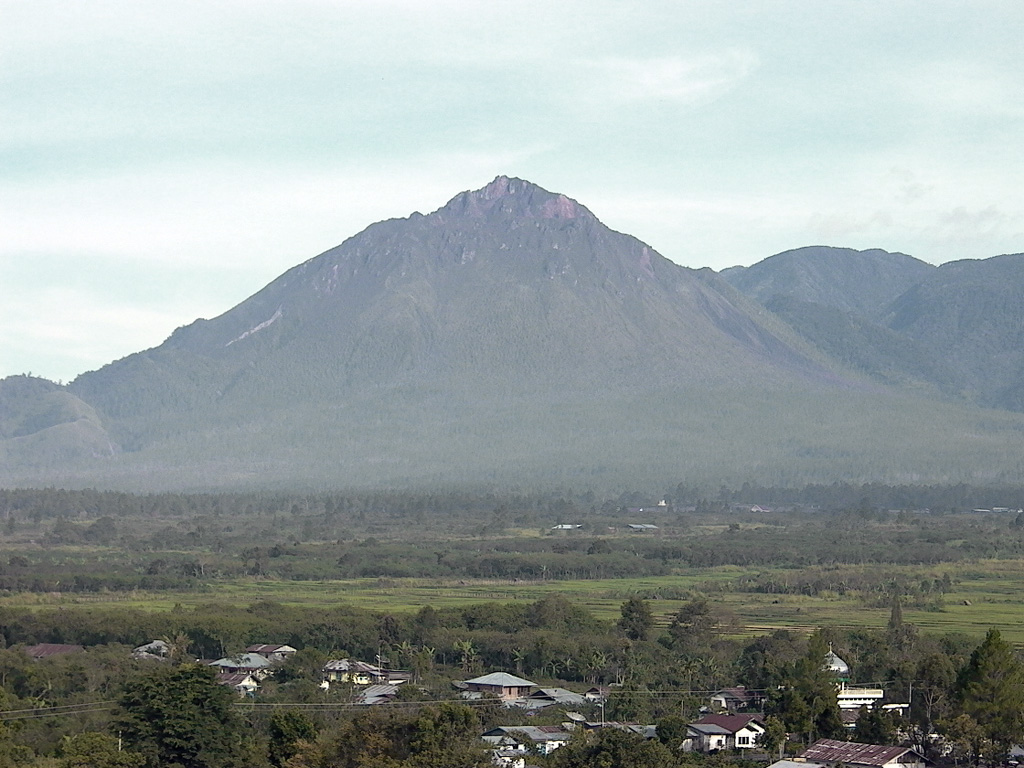
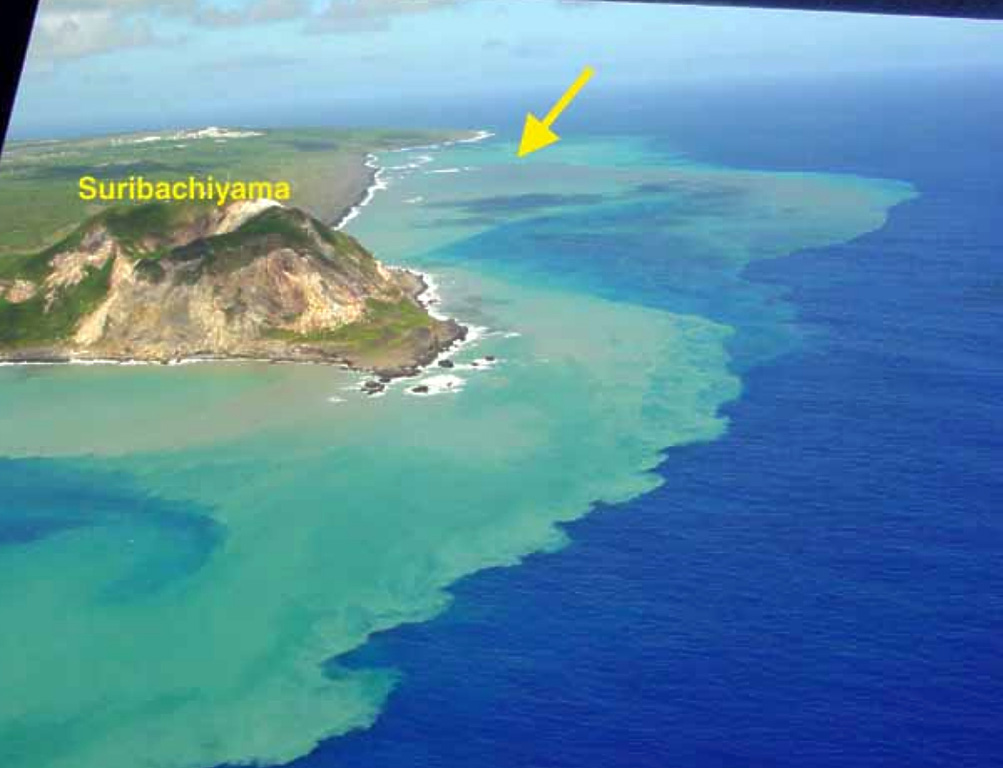 Ioto Ioto
Ogasawara Volcanic Arc
|
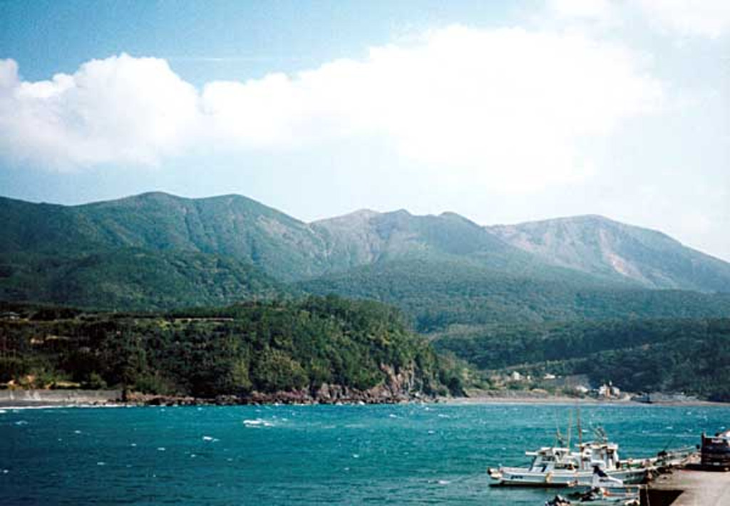
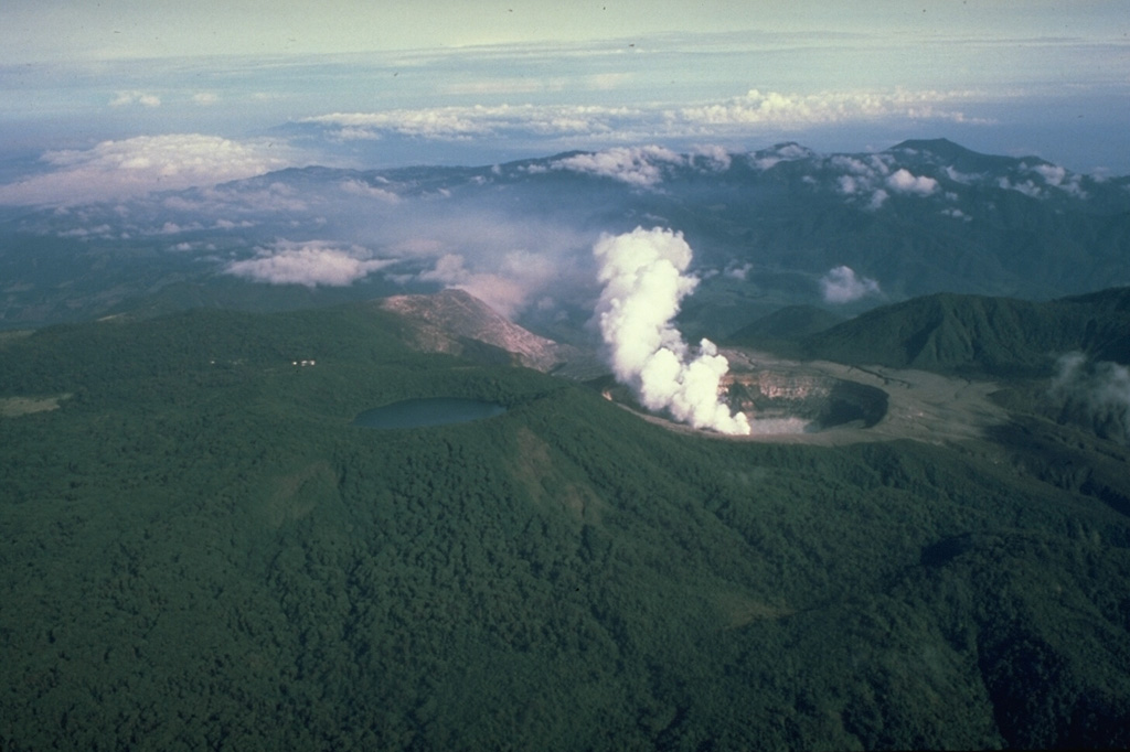
The Japan Meteorological Agency (JMA) reported that an eruption at Ioto (Iwo-jima) began at around 1914 on 1 September from a submarine vent off the W coast of the island. An eruption plume rose about 1 km above the surface of the water and had darker- and lighter-colored components. The eruption was ongoing at least through the next day; a webcam image captured at 0730 on 2 September showed a Surtseyan ejection of dark material above the water’s surface and a white steam-and-gas plume drifting downwind. The Japan Coast Guard reported bubbling water around the vents on 14 August, and JMA noted that both seismicity and inflation increased on 30 August. The last eruption occurred in February.
Sources: Japan Meteorological Agency (JMA), Japan Coast Guard
|
Kanlaon (Philippines) | 3 September-9 September 2025 | New Activity / Unrest
Cite this Report
|
 Kanlaon Kanlaon
Negros-Sulu Volcanic Arc
|
The Philippine Institute of Volcanology and Seismology (PHIVOLCS) reported continuing unrest and an ash emission at Kanlaon during 2-10 September. The seismic network recorded 0-7 daily volcanic earthquakes and daily sulfur dioxide emissions ranged from 762 to 1,922 tonnes per day. Gas-and-steam emissions of variable densities rose 75-700 m above the crater rim and drifted N, NW, and WSW. A period of diffuse ash emissions began at 1725 on 8 September and lasted about 55 minutes, producing low ash plumes that drifted WSW. At 0510 on 10 September an ash plume rose 600 m above the crater rim. The Alert Level remained at 2 (on a scale of 0-5); the public was warned to stay out of the 4-km-radius Permanent Danger Zone (PDZ) and pilots were advised to avoid flying close to the summit.
Source: Philippine Institute of Volcanology and Seismology (PHIVOLCS)
|
Karymsky (Russia) | 3 September-9 September 2025 | New Activity / Unrest
Cite this Report
|
 Karymsky Karymsky
Eastern Kamchatka Volcanic Arc
|
The Kamchatkan Volcanic Eruption Response Team (KVERT) reported that moderate activity continued at Karymsky during 28 August-4 September. A daily weak thermal anomaly was identified in satellite images. The Aviation Color Code remained at Orange (the third level on a four-color scale). Dates and times are provided in Coordinated Universal Time (UTC); specific events are indicated in local time where specified.
Source: Kamchatkan Volcanic Eruption Response Team (KVERT)
|
Lokon-Empung (Indonesia) | 3 September-9 September 2025 | New Activity / Unrest
Cite this Report
|
 Lokon-Empung Lokon-Empung
Sangihe Volcanic Arc
|
The Pusat Vulkanologi dan Mitigasi Bencana Geologi (PVMBG) reported continuing unrest at Lokon-Empung during 3-9 September. Seismicity continued to be elevated. Daily white steam-and-gas plumes rose as high as 100 m above the Tompaluan Crater rim and drifted in multiple directions. The plumes were characterized as white and gray on 4 September. According to news articles and PVMBG incandescence at the crater was visible in webcam images during 4-9 September. The Alert Level remained at 3 (on a scale of 1-4) and the public was warned to stay 2.5 km away from Tompaluan Crater.
Sources: Pusat Vulkanologi dan Mitigasi Bencana Geologi (PVMBG, also known as CVGHM), Antara News
|
Whakaari/White Island (New Zealand) | 3 September-9 September 2025 | New Activity / Unrest
Cite this Report
|
 Whakaari/White Island Whakaari/White Island
Taupo Volcanic Arc
|
GeoNet conducted an overflight at Whakaari/White Island a few days after ash plumes were observed in webcam views. During an overflight on 3 September scientists observed no ash in the steam-and-gas plumes rising from the active vents. Thin ashfall deposits from a brief eruption on 28 August were present on the island, though the active vent area was unchanged. Temperatures at the vents were around 164 degrees Celsius which was typical during periods of unrest. Measurements collected during overflights and from satellite data confirmed that gas output was steady and at levels consistent with minor activity. An area called Fumarole 0 on the S side of the main crater had dried out and an inclined vent was newly active. Several vents were active in the Fumarole 13/14 area on the N side of the main crater. The Volcanic Alert Level remained at 2 (on a scale of 0-5) and the Aviation Color Code remained at Yellow (the second lowest level on a four-color scale).
Source: GeoNet
|
Aira (Japan) | 3 September-9 September 2025 | Continuing ActivityCite this Report |
 Aira Aira
Ryukyu Volcanic Arc
|
The Japan Meteorological Agency (JMA) reported ongoing eruptive activity at Minamidake Crater (Aira Caldera’s Sakurajima volcano) during 1-8 September. Nightly crater incandescence was visible in webcam images. Sulfur dioxide emissions were characterized as slightly high, averaging 1,900 tons per day on 5 September. The Alert Level remained at 3 (on a 5-level scale), and the public was warned to be cautious within 2 km of both the Minimadake and Showa craters.
Source: Japan Meteorological Agency (JMA)
|
Bur ni Telong (Indonesia) | 3 September-9 September 2025 | Continuing ActivityCite this Report |
 Bur ni Telong Bur ni Telong
Sunda Volcanic Arc
|
The Pusat Vulkanologi dan Mitigasi Bencana Geologi (PVMBG) reported decreased seismicity at Bur ni Telong. Increases in both deep and shallow volcanic earthquakes were recorded in July and early August, though through late August only the number of deep volcanic earthquakes continued to be elevated. Seismicity decreased during 1-7 September. No emissions were observed. The Alert level was lowered to 1 (on a scale from 1 to 4) at 0900 on 8 September and the public was advised to not spend the night in the crater area and to avoid fumaroles and solfataras during cloudy or rainy weather.
Source: Pusat Vulkanologi dan Mitigasi Bencana Geologi (PVMBG, also known as CVGHM)
|
Dukono (Indonesia) | 3 September-9 September 2025 | Continuing ActivityCite this Report |
 Dukono Dukono
Halmahera Volcanic Arc
|
The Pusat Vulkanologi dan Mitigasi Bencana Geologi (PVMBG) reported that eruptive activity at Dukono continued during 27 August-2 September. White-and-gray gas-and-ash plumes rose as high as 700 m above the summit and drifted NW, W, and SW. Emissions were not visible on 6 September. The Alert Level remained at Level 2 (on a scale of 1-4) and the public was warned to stay 4 km away from the Malupang Warirang Crater.
Source: Pusat Vulkanologi dan Mitigasi Bencana Geologi (PVMBG, also known as CVGHM)
|
Great Sitkin (United States) | 3 September-9 September 2025 | Continuing ActivityCite this Report |
 Great Sitkin Great Sitkin
Aleutian Ridge Volcanic Arc
|
The Alaska Volcano Observatory (AVO) reported that slow lava effusion continued to feed a thick flow in Great Sitkin’s summit crater during 2-9 September. Satellite data indicated that the flow was advancing S, with some rockfalls occurring along the S and E margins. A field crew conducted an overflight of the volcano on 2 September and photographed the active lava flow. The SE half of the lava dome appeared to be inflating. Small daily earthquakes were detected by the seismic network, including signals probably caused by the small rockfalls. Weather clouds sometimes obscured satellite and webcam views; minor steam emissions from the lava dome were observed in webcam images during 3-4 September and elevated surface temperatures were identified in satellite data during 6-7 September. The Volcano Alert Level remained at Watch (the third level on a four-level scale) and the Aviation Color Code remained at Orange (the third color on a four-color scale).
Source: US Geological Survey Alaska Volcano Observatory (AVO)
|
Home Reef (Tonga) | 3 September-9 September 2025 | Continuing ActivityCite this Report |
 Home Reef Home Reef
Tofua Volcanic Arc
|
The Tonga Geological Services reported no indications of activity at Home Reef during 16 August-1 September. A comparison of satellite images from 11 and 28 August showed minor to no visible changes. Both images showed a diffuse gas plume rising from the crater area and discolored water around the island. There were yellow sulfur deposits in and around the main crater. The dimensions of the main vent crater and of the island were unchanged; the main vent crater was about 210 m N-S and 120 m E-W and the island measured 550 x 420 m. The Aviation Color Code remained at Yellow (the second lowest level on a four-level scale, the Maritime Alert Level remained at Orange (the third level on a four-level scale) with advice to stay at least 2 nautical miles (3.7 km) from the island, and the Alert Level for residents of Vava’u and Ha’apai remained at Green (the first level on a four-level scale).
Source: Tonga Geological Services, Government of Tonga
|
Ibu (Indonesia) | 3 September-9 September 2025 | Continuing ActivityCite this Report |
 Ibu Ibu
Halmahera Volcanic Arc
|
The Pusat Vulkanologi dan Mitigasi Bencana Geologi (PVMBG) reported that the eruption at Ibu continued during 3-9 September. Daily dense gray or white-and-gray ash plumes rose 400-1,000 m above the summit and drifted NW, W, and SW. Incandescence at the summit was visible in a few nighttime webcam images. The Alert Level remained at 2 (the second lowest level on a four-level scale) and the public was advised to stay 2 km away from the active crater and 3.5 km away from the N crater wall opening.
Source: Pusat Vulkanologi dan Mitigasi Bencana Geologi (PVMBG, also known as CVGHM)
|
Kilauea (United States) | 3 September-9 September 2025 | Continuing ActivityCite this Report |
 Kilauea Kilauea
Hawaiian-Emperor Hotspot Volcano Group
|
The Hawaiian Volcano Observatory (HVO) reported that the eruption within Kilauea’s Kaluapele summit caldera, characterized by episodic fountaining, incandescence, and intermittent spatter at vents with craters along the SW margin of Halema’uma’u Crater, continued at variable levels during 3-9 September. Patterns of tremor indicated that gas pistoning was likely occurring deeper within the vent and was characterized by low-frequency bursts every 1-8 minutes. Elevated levels of gas continued to be emitted from the vent area. Minor incandescence at the N vent and from areas on the lava-flow field were intermittently visible during 3-5 September. The Volcano Alert Level remained at Watch (the third level on a four-level scale) and the Aviation Color Code remained at Orange (the third color on a four-color scale).
Source: US Geological Survey Hawaiian Volcano Observatory (HVO)
|
Kirishimayama (Japan) | 3 September-9 September 2025 | Continuing ActivityCite this Report |
 Kirishimayama Kirishimayama
Ryukyu Volcanic Arc
|
The Japan Meteorological Agency (JMA) reported that activity continued at Shinmoedake (Shinmoe peak, a stratovolcano of the Kirishimayama volcano group) during 3-9 September. The number of volcanic earthquakes located beneath Shinmoedake, first detected in late October 2024, continued to be frequent; volcanic tremor was detected during 2-3 September. Eruptive events at 1127 and 1300 and a period of continuous ash emissions during 1330-1342 on 3 September produced ash plumes that rose as high as 2.3 km above the crater rim and drifted SW. Ash plumes from eruptive events at 1432 and 1556 later that day rose as high as 1.1 km above the crater rim and drifted SW. Ashfall reported in areas downwind, including in Kirishima City (21 km SW) and Miyakonojo City (30 km SE), obscured the lines on some roads. Continuous ash emissions during 0854-1000 on 5 September rose 100-200 m above the crater rim and drifted SE. At 0344 on 7 September an ash plume rose 100 m above the crater rim and drifted E. Continuous ash emissions during 2033-2231 on 7 September rose 100 m above the crater rim and drifted E. Fumarolic plumes rose as high as 10 m above the fissures on the W flank during 5-8 September. The Alert Level remained at 3 (on a 5-level scale) and the public was warned to exercise caution within 3 km from Shinmoedake Crater.
Source: Japan Meteorological Agency (JMA)
|
Krasheninnikov (Russia) | 3 September-9 September 2025 | Continuing ActivityCite this Report |
 Krasheninnikov Krasheninnikov
Eastern Kamchatka Volcanic Arc
|
The Kamchatkan Volcanic Eruption Response Team (KVERT) reported that the eruption at Krasheninnikov continued during 2-9 September. A daily thermal anomaly over the volcano was identified in satellite images. Dates and times are provided in Coordinated Universal Time (UTC); specific events are indicated in local time where specified.
Source: Kamchatkan Volcanic Eruption Response Team (KVERT)
|
Kuchinoerabujima (Japan) | 3 September-9 September 2025 | Continuing ActivityCite this Report |
 Kuchinoerabujima Kuchinoerabujima
Ryukyu Volcanic Arc
|
The Japan Meteorological Agency (JMA) reported that the number of shallow volcanic earthquakes at Kuchinoerabujima began to decline in July; they had been frequent since the beginning of April, with most epicenters located near Furudake Crater, and a few near Shindake Crater (just N of Furudake). No large-amplitude earthquakes were recorded. There were no notable changes to hydrothermal fields observed during 19-21 August. Sulfur dioxide gas emissions were at low levels, fluctuating between 20 and 70 tons per day, and no changes to white gas-and-steam emissions were observed. The Alert Level was lowered to 2 (on a scale of 1-5) at 1100 on 5 September and the public was warned to exercise caution within 1 km of both Shindake and Furudake craters and within 2 km W of Shindake Crater.
Source: Japan Meteorological Agency (JMA)
|
Lewotobi (Indonesia) | 3 September-9 September 2025 | Continuing ActivityCite this Report |
 Lewotobi Lewotobi
Sunda Volcanic Arc
|
The Pusat Vulkanologi dan Mitigasi Bencana Geologi (PVMBG) reported increased seismic activity and deformation at Lewotobi Laki-laki during 30 August-6 September. The seismic network recorded a significant increase in the number of harmonic tremor earthquakes and deep volcanic earthquakes during 30 August-4 September and a shallow volcanic earthquake was detected on 5 September. Tiltmeter data indicated slow inflation over that same time, while GNSS (Global Navigation Satellite System) data indicated deflation; the deformation data suggested that the activity was occurring at shallow levels. On 6 September a period of continuous tremor was detected, indicating rising magma near the surface. At 1000 the Alert level was raised to 4 (the highest level on a scale of 1-4) and the exclusion zone was increased to 6 km from the center of Laki-laki and 7 km in a semicircle clockwise from the SW to the NE. At 1806 that same day a gray ash plume rose 1 km above the crater rim and drifted NW, W, and SW. White plumes rose as high as 1 km above the crater rim and drifted in multiple directions on 8 September and were not visible on 9 September.
Source: Pusat Vulkanologi dan Mitigasi Bencana Geologi (PVMBG, also known as CVGHM)
|
Lewotolok (Indonesia) | 3 September-9 September 2025 | Continuing ActivityCite this Report |
 Lewotolok Lewotolok
Sunda Volcanic Arc
|
The Pusat Vulkanologi dan Mitigasi Bencana Geologi (PVMBG) reported that an eruption at Lewotolok was ongoing during 3-9 September. White-to-gray ash plumes rose 100-600 m above the summit of the cone and drifted W and NW on most days; white plumes rose 50 m above the summit and drifted W and NW on 7 September. Several nighttime webcam images showed Strombolian ejections of incandescent material above the cone and onto the flanks. The Alert Level remained at 3 (on a scale of 1-4) and the public was warned to stay 3 km away from the summit.
Source: Pusat Vulkanologi dan Mitigasi Bencana Geologi (PVMBG, also known as CVGHM)
|
Marapi (Indonesia) | 3 September-9 September 2025 | Continuing ActivityCite this Report |
 Marapi Marapi
Sunda Volcanic Arc
|
The Pusat Vulkanologi dan Mitigasi Bencana Geologi (PVMBG) reported that eruptive activity at Marapi (on Sumatra) continued during 3-9 September. An eruptive event was recorded on 4 September, but weather conditions prevented visual confirmation. A dense gray ash plume rose 1.2 m above the crater rim ana drifted NE on 7 September and a dense gray-to-white ash plumes rose 1 km above the crater rim and drifted E on 8 September. The Alert Level remained at 2 (on a scale of 1-4) and the public was warned to stay 3 km away from the active crater.
Source: Pusat Vulkanologi dan Mitigasi Bencana Geologi (PVMBG, also known as CVGHM)
|
Mayon (Philippines) | 3 September-9 September 2025 | Continuing ActivityCite this Report |
 Mayon Mayon
Eastern Philippine Volcanic Arc
|
The Philippine Institute of Volcanology and Seismology (PHIVOLCS) reported increased seismic activity at Mayon. During 0000-1730 on 6 September the seismic network recorded 26 volcanic earthquakes with local magnitudes of 0.4-2.7 which were located 5-10 km beneath the NE flank. Variable inflation had been detected at the NE sector since October 2024 and at the S and SW sectors since March 2025, based on continuous GPS, electronic tilt, and Electronic Distance Measurement (EDM) ground deformation data. Sulfur dioxide emissions remained near background levels, averaging 430 tonnes/day (t/d) in 2025, with the latest measurement of 609 t/d on 3 September. The Alert Level remained at 1 (on a 0-5 scale); the public was warned to stay out of the 6-km-radius Permanent Danger Zone (PDZ) and pilots were advised to avoid flying close to the summit.
Source: Philippine Institute of Volcanology and Seismology (PHIVOLCS)
|
Merapi (Indonesia) | 3 September-9 September 2025 | Continuing ActivityCite this Report |
 Merapi Merapi
Sunda Volcanic Arc
|
The Balai Penyelidikan dan Pengembangan Teknologi Kebencanaan Geologi (BPPTKG) reported that the eruption at Merapi (on Java) continued during 29 August-4 September. Earthquakes were less intense compared to the previous week. The SW lava dome produced nine lava avalanches that traveled as far as 1.9 km SW down the Bebeng drainage, 19 that traveled as far as 1.8 km SW down the Krasak drainage, and 39 that traveled as far as 2 km W down the Sat/Putih drainage. Small morphological changes to the SW lava dome resulted from lava effusion and minor collapses. The Alert Level remained at 3 (on a scale of 1-4), and the public was warned to stay 3-7 km away from the summit, based on location.
Source: Balai Penyelidikan dan Pengembangan Teknologi Kebencanaan Geologi (BPPTKG)
|
Poas (Costa Rica) | 3 September-9 September 2025 | Continuing ActivityCite this Report |
 Poas Poas
Central America Volcanic Arc
|
The Observatorio Vulcanológico y Sismológico de Costa Rica-Universidad Nacional (OVSICORI-UNA) reported continuing gas-and-steam emissions with occasional minor amounts of ash at Poás during 2-9 September. Weather conditions often obscured visual observations of the crater area. Gas emissions at Boca A continued to be hot, approaching 800 degrees Celsius. Variable incandescence at Boca A vent continued to be visible at night. The lake over Boca C continued to rise and was approaching the rim of Boca A. Small eruptive events were recorded at 1325 and 1332 on 3 September based on a slight increase in in the intensity of corresponding acoustic tremor; the events were not detected by the seismic network and not visually confirmed due to weather conditions. The events on 3 September also corresponded with increased sulfur dioxide emissions of around 1,500 tonnes per day (t/d) at 1325 and about 500 t/d at 1332. A low-energy eruptive event began at 1710 on 7 September and lasted about seven minutes based on infrasound data. The vent produced an ash emission, though weather conditions mostly obscured views, and there was intense rainfall in the afternoon of 7 September. An ash emission was visible in the late afternoon and sustained ash emissions occurred during 1900-2200. Sulfur dioxide emissions decreased from 600 tons per day (t/d) to 100 t/d during 6-9 September based on data from Differential Optical Absorption Spectroscopy (DOAS) and Multi-component Gas Analyzer System (Multi-GAS) stations.
A seismic event at 0336 on 9 September was either associated with the rupture of the wall separating Boca A and Boca C, causing water to flood Boca A, or from the interaction of water and high temperatures. Eruptive events were not immediately generated from the water flooding into Boca A but occurred several hours later; at 1048 an energetic explosion ejected ash and ballistics 300 m above the crater rim and generated an ash, steam, and gas plume that rose 500 m above the crater rim and drifted W. The Volcanic Alert Level remained at 2 (the second lowest level on a four-level scale) and the Aviation Color Code remained at Yellow (the second lowest color on a four-color scale).
Source: Observatorio Vulcanologico y Sismologico de Costa Rica-Universidad Nacional (OVSICORI-UNA)
|
Popocatepetl (Mexico) | 3 September-9 September 2025 | Continuing ActivityCite this Report |
 Popocatepetl Popocatepetl
Trans-Mexican Volcanic Arc
|
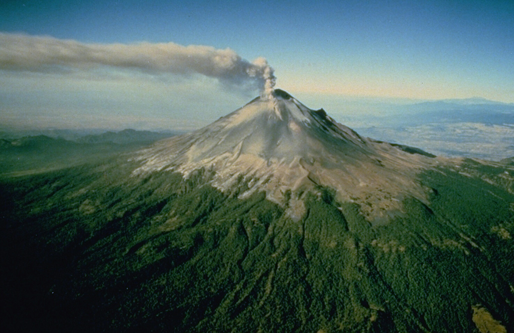
The Centro Nacional de Prevención de Desastres (CENAPRED) reported that eruptive activity continued at Popocatépetl during 12-19 August. The seismic network recorded 9-39 long-period events per day, accompanied by steam-and-gas emissions with occasional minor ash content. In addition, the seismic network recorded daily periods of low-amplitude tremor, characterized by harmonic and high-frequency signals, lasting from seven hours and 44 minutes to just over 14 hours. According to the Washington VAAC an ash plume visible in a webcam image at 2018 on 6 September rose to 6.4 km (21,000 ft) a.s.l., or as high as 1 km above the summit, and drifted S. Ash plumes identified in webcam and satellite images during 8-9 September rose 5.8-6.4 km (19,000-21,000 ft) a.s.l. and drifted W, WSW, and SW. The Alert Level remained at Yellow, Phase Two (the middle level on a three-color scale) and the public was warned to stay 12 km away from the crater.
Sources: Centro Nacional de Prevencion de Desastres (CENAPRED), Washington Volcanic Ash Advisory Center (VAAC)
|
Santa Maria (Guatemala) | 3 September-9 September 2025 | Continuing ActivityCite this Report |
 Santa Maria Santa Maria
Central America Volcanic Arc
|
The Instituto Nacional de Sismología, Vulcanología, Meteorología e Hidrología (INSIVUMEH) reported high levels of ongoing eruptive activity at Santa Maria’s Santiaguito dome complex during 2-9 September, with continuing lava extrusion at Caliente dome. Daily explosions, 1-3 per hour when reported, generated gas-and-ash plumes that rose as high as 1 km above the dome and drifted as far as 20 km W, WSW, and SW. Effusion of blocky lava produced incandescent block avalanches that descended mainly the W and SW flanks; the collapsed material occasionally produced short pyroclastic flows that reached the base of the cone. Incandescence was visible at Caliente dome mostly during dark hours. During the early afternoon of 3 September heavy rainfall generated a minor lahar in the Cabello de Ángel drainage (SSW) that carried blocks up to 3 m in diameter mixed with fine sediment, tree trunks, and branches. Another lahar descended the Tambor drainage (SSW) that carried blocks up to 1 m in diameter mixed with fine sediment, tree trunks, and branches. Both lahars were hot and had a sulfur odor. Ashfall was reported in local areas on several days downwind including San Marcos Palajunoj (8 km SW) and Loma Linda (7 km W).
Source: Instituto Nacional de Sismologia, Vulcanologia, Meteorologia, e Hidrologia (INSIVUMEH)
|
Semeru (Indonesia) | 3 September-9 September 2025 | Continuing ActivityCite this Report |
 Semeru Semeru
Sunda Volcanic Arc
|
The Pusat Vulkanologi dan Mitigasi Bencana Geologi (PVMBG) reported that activity continued at Semeru during 3-9 September, with multiple daily eruptive events recorded by the seismic network. White-and-gray or gray ash plumes rose 400-700 m above the summit and drifted in multiple direction on most days; emissions were not visible on 9 September. The Alert Level remained at 2 (the second lowest level on a scale of 1-4). The public was warned to stay at least 3 km away from the summit in all directions, 8 km from the summit to the SE, 500 m from the banks of the Kobokan drainage as far as 13 km from the summit, and to avoid other drainages including the Bang, Kembar, and Sat, due to lahar, avalanche, and pyroclastic flow hazards.
Source: Pusat Vulkanologi dan Mitigasi Bencana Geologi (PVMBG, also known as CVGHM)
|
Sheveluch (Russia) | 3 September-9 September 2025 | Continuing ActivityCite this Report |
 Sheveluch Sheveluch
Eastern Kamchatka Volcanic Arc
|
The Kamchatkan Volcanic Eruption Response Team (KVERT) reported continuing eruptive activity at Sheveluch’s “300 years of RAS” dome on the SW flank of Old Sheveluch and at the Young Sheveluch dome during 28 August-4 September. Thermal anomalies over the domes were identified in satellite images on 29 August and during 1-3 September; weather clouds obscured views on the other days. The Aviation Color Code remained at Orange (the second highest level on a four-color scale). Dates are based on UTC; specific events are in local time where noted.
Source: Kamchatkan Volcanic Eruption Response Team (KVERT)
|
Suwanosejima (Japan) | 3 September-9 September 2025 | Continuing ActivityCite this Report |
 Suwanosejima Suwanosejima
Ryukyu Volcanic Arc
|
The Japan Meteorological Agency (JMA) reported that eruptive activity at Suwanosejima's Ontake Crater continued during 1-8 September. Incandescence was observed nightly in webcam images. An explosion at 1047 on 1 September produced an ash plume that rose 1.8 km above the crater rim and drifted N. An eruptive event at 0516 on 2 September sent an ash plume 1.3 km above the crater rim that drifted NW, followed by a similar event the next day at 0833 on 3 September when a plume rose 1.2 km above the crater and drifted SW. Minor ashfall was reported in Toshima Village (3.5 km SSW) during the week. The Alert Level remained at 2 (the second level on a five-level scale) and the public was warned to be cautious within 1.5 km of the crater.
Source: Japan Meteorological Agency (JMA)
|
