
According to an order issued by the Municipality of Lipari that went into effect on 22 November, residents within three high-risk zones (with an exception for the Lentia village) on Vulcano were not allowed to stay overnight in their homes between the hours of 2300-0600 due to an increase in carbon dioxide emissions in area to the N of La Fossa Crater. Residents in a lower-risk zone were allowed to stay in their homes but not sleep on the first floor. In addition, non-residents were banned from visiting the island for 30 days except for essential workers. The Dipartimento della Protezione Civile maintained the Alert Level at Yellow (the second lowest level on a four-color scale).
Sources: Municipality of Lipari, Dipartimento della Protezione Civile
H2S, SO2, HF, HCl, and other gases tending to increase during 1998-99
Periodic inspections of Vulcano have indicated that the total output from the fumarolic field at the crater "La Fossa" started to decrease in 1995. However, an analysis of the chemical compositions of the gaseous phases conducted as a part of an overall evaluation of the volcanic system provides important volcanological details. Different trends observed between the fumaroles located on the rim and those inside the crater (see BGVN 22:11) indicate that the Fossa cone is affected by deformation, possibly the result of increased vapor pressure at depth. The chemical data from samples collected at the same locations during 1998 and 1999 (table 6) indicate similar trends of increasing magmatic gases. This could imply widespread opening of the system, which could affect the stability of the edifice.
Table 6. Chemical data measured at Vulcano, 1998-99. Courtesy of Marino Martini.
| Component | Crater Rim 1997 | Crater Rim 1998 | Crater Rim 1999 | Inside Crater 1997 | Inside Crater 1998 | Inside Crater 1999 |
| Temperature | 328°C | 320°C | 303°C | 426°C | 281°C | 379°C |
| H2O (vol) | 88.86 | 90.77 | 93.66 | 85.38 | 86.69 | 91.65 |
| CO2 (dry) | 92.37 | 90.57 | 86.91 | 97.13 | 96.54 | 91.95 |
| H2S | 3.10 | 3.41 | 6.54 | 0.40 | 0.26 | 1.25 |
| SO2 | 2.11 | 2.30 | 2.78 | 0.99 | 1.55 | 3.90 |
| HCl | 1.26 | 1.47 | 1.77 | 0.78 | 0.43 | 0.85 |
| HF | 0.46 | 0.42 | 0.66 | 0.03 | 0.08 | 0.13 |
| H2 | 0.12 | 0.18 | 0.22 | 0.05 | 0.18 | 0.08 |
| CO | 0.0005 | 0.0006 | 0.0002 | 0.0024 | 0.0114 | 0.0100 |
In addition to the data reported in table 6, temperature measurements taken along the N rim of Fossa crater some time during the period 2-16 July 1999 were reported by Claude Grandpey. The temperature in July was 340°C compared to ~410°C the previous April. Grandpey also reported stable temperatures (i.e., 95-100°C) at the fumaroles on the isthmus between Vulcano and Vulcanello.
Vulcano is located at the southern boundary of the Aeolian Islands, about 25 km from northern Sicily. It last erupted in 1888-90 when numerous meter-sized bombs and blocks fell in the area now occupied by the village of Vulcano Porto, which hosts thousands of tourists daily during the summer season. Vulcanello, the youngest part of Vulcano Island, began to form only ~2,100 years ago as an isolated island that later became connected with the main island. The latest activity at Vulcanello occurred in the 16th century when lava flows, now covered by large hotel complexes, were extruded.
Information Contacts: Marino Martini, Dipartimento di Scienze della Terra, Università di Firenze, Via La Pira 4, 50125, Firenze, Italy; Claude Grandpey, L'Association Volcanologique Europénne (LAVE), 7 rue de la Guadelopue, 75018 Paris, France.
2021: September
| October
| November
According to an order issued by the Municipality of Lipari that went into effect on 22 November, residents within three high-risk zones (with an exception for the Lentia village) on Vulcano were not allowed to stay overnight in their homes between the hours of 2300-0600 due to an increase in carbon dioxide emissions in area to the N of La Fossa Crater. Residents in a lower-risk zone were allowed to stay in their homes but not sleep on the first floor. In addition, non-residents were banned from visiting the island for 30 days except for essential workers. The Dipartimento della Protezione Civile maintained the Alert Level at Yellow (the second lowest level on a four-color scale).
Sources: Municipality of Lipari; Dipartimento della Protezione Civile
INGV continued to monitor elevated activity at Vulcano during 12-19 October. Scientists collected temperature, water chemistry, and gas-emissions data from four fumarolic vents located inside La Fossa Crater near the rim and from one vent near the beach. According to news articles, elevated levels of carbon dioxide impacted nearby residents in Porto Levante causing a few families to leave their homes on 13 October. Several residents had reported inexplicable illnesses and some deaths of domestic animals the previous week. On 14 October authorities restricted public access to the crater. The Dipartimento della Protezione Civile maintained the Alert Level at Yellow (the second lowest level on a four-color scale).
Sources: Sezione di Catania - Osservatorio Etneo (INGV); Dipartimento della Protezione Civile; la Repubblica; la Repubblica; la Repubblica
INGV reported that hydrothermal activity at Vulcano increased in July, and notably more in September. Specifically, temperatures of the fumaroles on the crater rim and on the inner flank had increased along with the amounts of carbon dioxide and sulfur dioxide in the emissions. The highest temperature of 340 degrees Celsius was along the rim. The temperature and salinity of groundwater measured near the base of La Fossa cone were both elevated, and outgassing from ground sites was noted. On 13 September the seismic network detected a significant increase in microseismcity linked to hydrothermal processes. Additionally, very-long-period events were also recorded for the first time in 15 years when instrumentation able to detect the signals was installed. Deformation on the N side of the cone was first identified in mid-August and totaled 1 cm of uplift by mid-September. The report stated that new seismic stations and instruments to measure carbon dioxide emissions had been added to the monitoring network, and a thermal camera pointing at the fumarolic field was planned. The Dipartimento della Protezione Civile raised the Alert Level to Yellow (the second lowest level on a four-color scale) on 1 October.
Sources: Sezione di Catania - Osservatorio Etneo (INGV); Dipartimento della Protezione Civile
Reports are organized chronologically and indexed below by Month/Year (Publication Volume:Number), and include a one-line summary. Click on the index link or scroll down to read the reports.
Microearthquake swarm and slight uplift
"Daily earthquake frequency in the Vulcano area showed, from 24 April, a significant increase (figure 1). Seismic energy may also be considered unusual even though magnitudes have not exceeded 2.5. Epicenters lay predominantly in the Gran Cratere area or very close to it (figure 2); focal depths were generally <1 km. The timing of event and energy distribution reveals the swarm character of the seismicity. Waveforms lead us to hypothesize that both degassing and fracturing phenomena occurred. A leveling survey carried out in May showed a slight uplift (1 cm) of the epicentral area with respect to the S part of the island."
 |
Figure 1. Daily frequency of local earthquakes recorded 1 January-30 May 1985 by the Vulcano Cratere seismic station on the N flank. Courtesy of IIV. |
 |
Figure 2. Epicenters of the seven highest energy earthquakes that occurred in the Vulcano area 24 April-30 May 1985. Courtesy of IIV. |
Further References. Frazzetta, G., Gillot, P.Y., La Volpe, L., and Sheridan, M.F., 1984, Volcanic hazards at fossa of Vulcano: Data from the last 6000 years: BV, v. 47, p. 105-125.
Falsaperla, S., and Neri, G., 1986, Seismic monitoring of volcanoes: Vulcano (southern Italy): Periodico di Mineralogia, v. 55, p. 143-152.
Information Contacts: S. Falsaperla and G. Neri, IIV.
New fracture system
"After the last explosive event, in 1888-90, activity has been mainly fumarolic emissions of varying intensity at the crater. A new fracture system, transverse to the main alignment along which the more recent activity had originated, opened during the last few months.
"No important seismic activity was detected at the same time, and the progressive spreading trend beginning in 1985 was not substantially modified. The rate of longitudinal opening (some meters/month), however, along with the well-defined magmatic character of the gaseous species emitted through these fractures, appear as a clear indication of an increasing pressure from beneath."
Information Contacts: M. Martini, Univ di Firenze.
Higher fumarole temperatures and changing gas chemistry
OV has regularly collected data on fumarole temperatures, gas chemistry, and radon emission at Vulcano. Since September 1987, the temperature of a fumarole (F5) on the crater rim has increased from 310 to 335°C. In December, a new vent near F5 had a temperature of 370°C. Measurements since then (through May 1988) do not show continued temperature increases, although values reached 415° near the bottom of the crater on 1 April. Chemical analyses of fumarolic fluids show clear variations in several gases with time. H2S, H2, H2O vapor, and the S/C ratio strongly increased (figure 3), while Cl and CO2 decreased significantly. Equilibrium temperatures calculated from the gas/water shift reaction (CO + H2O <-> CO2 + H2) do not show any variation with an average temperature of ~ 400°C. Measurements of water wells also show an increase in radon activity (figure 4).
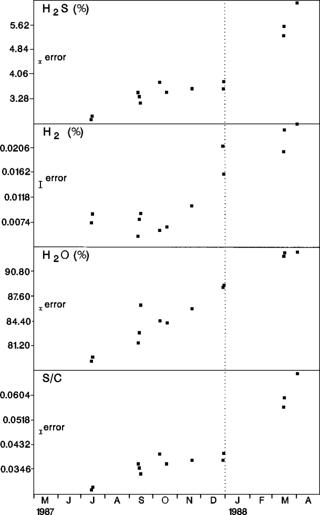 |
Figure 3. Percentages of H2S, H2, and H2O; and S/C ratio in gases from fumarole F5 on Vulcano's crater rim, July 1987-April 1988. |
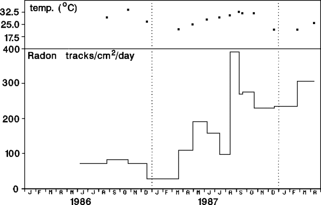 |
Figure 4. Temperature (top), and radon tracks/cm2/day (bottom), at a well (Pozzo Bambara) near Vulcano, 8 June 1986-11 April 1988. |
OV geologists believe that the variations could be explained by two main hypotheses: 1) An increase in permeability of the shallow system because of more fracturing (13:02); 2) An increase in heat migration from deeper to shallower reservoirs, buffered by water as indicated by the higher water vapor content of the collected gases.
On 21 April, a landslide occurred on the NE flank of the island. Visual estimates yield a total avalanche volume of <50,000 m3. OV geologists note that a very limited phreatic explosion cannot be excluded as a cause for the landslide.
Information Contacts: D. Tedesco, J.-P. Toutain, L. Bottiglieri, R. Pece, and G. Luongo, OV.
Fumarole temperature profiles
Geologists visited Vulcano on 25 and 30 October and 1, 7, and 8 November to obtain spatial and temporal surface temperature distributions (figure 5). Fumaroles typically formed linear zones of acid steam discharge. Transects of a zone extending 40 m somewhat radially along the N rim of Gran Cratere were surveyed.
 |
Figure 5. Apparent surface temperature profiles transverse to an elongated fumarolic zone on the N rim of Vulcano's Gran Cratere measured at 0930 (filled circles) and 1230 (open circles) on 8 November. Temperatures were recorded using a Minolta Cyclops 33 radiometer operating at [8-14 µm] wavelength. Each datum is the integrated temperature for the whole field of view of the radiometer, between 2.5 and 4.5 cm in diameter. The later survey shows warming of the downwind side of the zone by hot clouds of condensates blowing across the area. Courtesy of C. Oppenheimer and D. Rothery. |
Gas temperatures (recorded by a thermocouple) were stable during the visits. The highest temperature measured was 396°C, although surface temperatures above 300°C were uncommon and highly localized (<0.01 m2) near vents. Because sublimates were unstable above about 150°C, there was a gray sublimate-free belt within 5-40 cm of the vents, flanked on either side first by white ammonium chloride, then yellow sulfur sublimates.
Further Reference. Oppenheimer, C., and Rothery, D., 1991, Infrared monitoring of volcanoes by satellite: J. of the Geological Society, London, v. 148, p. 563-569.
Information Contacts: C. Oppenheimer and D. Rothery, Open Univ.
CO2 in soil increases
CO2 concentrations in soil near Vulcano's summit crater increased substantially between measurements in October 1987 and November 1988 (table 1), correlated with increased fumarolic activity. Changes in concentrations and flow rates of CO2 gas have been correlated to volcanic activity by Elskens, Tazieff, and Tonai (1969).
Table 1. CO2 soil concentrations near Vulcano's summit crater, in mole %. Equipment, sites, and the person making the measurements were all identical for both data sets.
| Location | October 1987 | November 1988 |
| Flat crater bottom | 0.1 | 60-80 |
| N trail from bottom of rim | 0.1-0.5 | 10-40 |
| W and N rims | 0.1 | 7-22 |
| S and E rims | 1.6 | 4-30 |
Reference. Elskens, I., Tazieff, H., and Tonai, F., 1969, investigations nouvelles sur les gaz volcaniques: BV, v. 32, no. 3, p. 523-575.
Information Contacts: R.X. Faivre Pierret, DPT/SPIN/LESI CEA CEN, Grenoble, France; F. Le Guern, CNRS, CFR, CEN, Saclay, France.
Fumaroles deposit sulfur
Geologists from Ruhr Univ visited Vulcano on 20 September and observed it from nearby Lipari Island on 19 and 21 September. During the afternoon of 19 September, strong gas emission occurred from the N part of Fossa Grande Crater, site of Vulcano's last eruption in 1888-1890. Gases were generally driven W by strong winds, but a white plume occasionally rose 300 m above the crater. Strong fumarolic activity occurred from numerous vents and fissures during the 20 September visit. Most of the activity was concentrated in the crater's N sector, but some occurred from the outer N flank and the inner S crater rim. Activity was most intense from a fissure that cut the crater rim along a roughly N-S trend. Just inside the crater, the fissure was up to 0.5 m wide and 1 m deep, with sharp edges coated with sulfur sublimates. Gases escaped with a hissing noise at the most active points. The volume of visible steam seemed to decrease during the afternoon, probably because of a decrease in humidity. Steam emission was still somewhat reduced when viewed from Lipari Island the next day.
During field studies 27-28 September and 3-4 October, Open Univ geologists noted that fumaroles seemed little changed from their previous visit in October-November 1988 (13:11). The fumarole fissure, ~ 40 m long, that crossed the N rim of the crater, was substantially deeper in places, perhaps from the loss of rock particles ejected by the pressurized gas flow. Gas temperatures along the fissure were generally about 275°C, with the highest value, 407°, at a vent on the crater's NE rim. Solid sulfur was abundant near fumaroles, as loose masses of yellow crystals, thin-walled tubules and cups containing drops of acid solution, and sulfur stalactites a few centimeters long within recessed vents. Liquid sulfur was also present, commonly as yellow, orange, or red droplets and dribbles, although one vent had produced a molten sulfur flow ~2 m long, and another contained a pool of liquid sulfur ~ 10 cm in diameter, with a temperature of 115.2°C.
Information Contacts: B. Behncke, Ruhr Univ, Germany; C. Oppenheimer, Open Univ.
High-temperature fumaroles; gas chemistry; small seismic swarms
Fumarolic activity at Vulcano remained at a very high level in 1989. The temperature of a fumarole (F5) on the crater rim (figure 6) has remained stable at 310 ± 5°C; more than 90 samples have been collected since July 1987. In contrast, a fumarole (FF) inside the crater showed very high temperatures, reaching a maximum of 550°C in August-September 1989, 100° hotter than in 1988. February 1990 temperatures were 515° and 312° at FF and F5 respectively.
 |
Figure 6. Map of Vulcano, showing locations of F5 and FF fumaroles. |
Major chemical species (H2O, CO2, H2S, and SO2) showed large variations in concentration (figure 7). 3He/4He ratios were very high for all crater fumaroles (~60% mantle-derived He), remaining stable during 1989 at ~ 7.5-8.0 x 10⁻⁶. The 13C/12C ratio followed a similar trend to that of CO2, with very wide oscillations from about d13C 0.00 to -2.20+. Geologists noted that the chemical and isotopic trends suggest mixing of different sources.
 |
Figure 7. Variations in concentrations of H2O (top), CO2, (center) and SO2 and H2S (bottom) at Vulcano's fumarole F5, 1987-90. Courtesy of OV. |
Seismic activity was monitored by a permanent network installed by IIV, and a digital mobile seismic network operated by OV since 1987. Seismicity was at a low level and characterized by low-energy earthquakes occurring in swarm sequences. On the basis of their wave shapes and spectral characteristics, the earthquakes were divided into "Volcano-tectonic" and "Volcanic" events (figure 8) using the classification of Latter (1981). Volcano-tectonic earthquakes outside the Fossa cone and around the island showed clear P and S phases, high frequency contents, and represented the most energetic events (M < 1.6). Volcanic-type events showed very regular wave trains that were sometimes sharply monochromatic, and were characterized by low dominant frequencies and an absence of clearly identifiable phases. Their energy reached 1011-1012 ergs and their magnitudes were negative. Particle motion analysis revealed the presence of Rayleigh and Rayleigh-like waves with a prograde rotation; the arrivals of these two phases followed one another during such earthquakes. Geologists interpreted these events, centered in the Fossa crater, as being related to fumarolic gas flow at shallow depth.
 |
Figure 8. Seismograms showing events classified as "Volcano-tectonic" (top) and "Volcanic" (bottom) at Vulcano. |
Reference. Latter, J.H., 1981, Volcanic earthquakes and their relationship to eruptions at Ruapehu and Ngāuruhoe volcanoes: JVGR, v. 9, p. 293-310.
Information Contacts: D. Tedesco, S. Vulcano, and G. Luongo, OV.
Continued fumarolic activity
A summit climb on 31 March revealed only minor changes since September 1989 (14:10). Gas emission continued from the fissure on the N rim, at high pressure from its 10-15-cm-wide central portion. Rocks up to 5 mm in diameter were re-ejected when thrown into the fissure's central section. The resulting gas plume rose 300-400 m during rainy weather on 3 April, but was considerably smaller at other times. Weak fumarolic activity was also occurring on the outer SE crater wall, and a new fumarole had formed on the NW flank.
Information Contacts: B. Behncke, Ruhr Univ.
High fumarole temperatures and geochemical changes; seismicity suggests complex fumarolic system
"OV geologists visited Vulcano island in recent months. Temperatures of the sampled crater fumaroles F5, F5AT, and FA (figure 9) were 300°, 420°, and 537°C respectively on 18 August. During two night inspections inside the crater, bright glow was discovered at all fumaroles up to 530°C and blue flames were discovered at some points in the fumarolic field, probably revealing burning of molten sulfur.
 |
Figure 9. Map of Vulcano showing the locations of fumaroles (F5, F5AT, and FA), and the seismic stations (CNW and CNE) used during the May 1990 microseismicity study. Courtesy of the Osservatorio Vesuviano. |
Geochemistry. "Several chemical variations have been observed since April 1990 in fluids sampled at F5 fumaroles. A sharp decrease in H2O content similar to that recorded in 1988 (see figure 7) has occurred. Consequently, CO2, SO2, N2, HCl, and HF increased in content. At the same time, the S/C ratio significantly decreased. Chemical variations seemed to follow the trend recorded in 1988. These data agree with an unpublished model by Tedesco et al. of possible mixing between shallow and deep fluids, continuously occurring in different proportions before gas escapes from fumarolic vents.
Geophysics. "A microseismicity study of Vulcano crater by the OV in the summer of 1988 revealed the presence of Rayleigh and Rayleigh-like waves with a prograde rotation (15:03). The analyzed earthquakes were low-frequency events, with energy up to 1012 ergs, showing phases not clearly identifiable on seismograms. Most scientists believe them to be related to gas flow in fumarolic conduits (Blot, 1971; Latter, 1971). Particle motion analysis revealed retrograde and prograde elliptical orbit phases that followed one another during such earthquakes (figures 10 and 11). This physical phenomenology was interpreted as due to propagation and reflection of tube waves in a fluid-filled conduit (White, 1983; Toksoz and Stewart, 1984; Hardage, 1985). According to such a model, the successive rotation inversions of particle motion would be generated from alternating downgoing and upgoing tube waves. The non-correlativity of phase arrivals among the seismic network stations suggested complex circulations discriminated by tube heights, because of the presence of several reflecting points (in fact seismographs operated at different altitudes on Vulcano island).
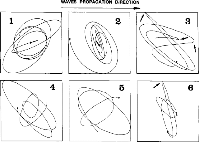 |
Figure 10. Particle motion on the vertical-radial plane (with respect to crater axes) derived from Vulcano seismogram in figure 11. Numbered frames correspond to seismogram segments and represent several seconds; arrows mark rotation inversions relating to phase arrivals. Courtesy of the OV. |
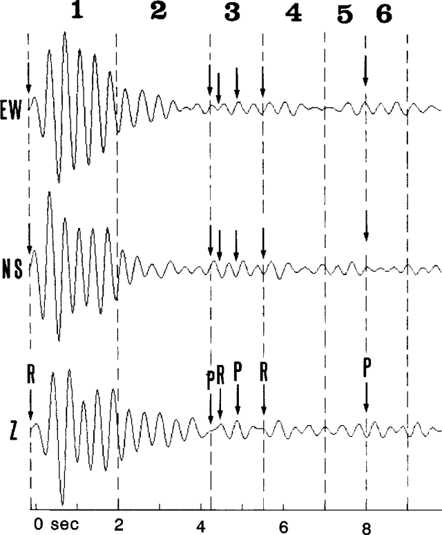 |
Figure 11. Filtered three-component signal of the Vulcano microearthquake analyzed in figure 10. Dotted lines discriminate temporal intervals (numbered frames in figure 10) for particle motion, and arrows mark arriving of retrograde and prograde phases. Courtesy of OV. |
"In May 1990, a survey was carried out to verify the possible presence of correlativity and synchrony of phase arrivals at two seismic stations placed at the same altitude on the top of the crater. Stations were installed at ~90° from each other with respect to the crater axes (figure 9). Notwithstanding the low activity level during the 2-week recording period, the few events analyzed show the same phenomenology observed on 1988 records. Unfortunately, the expected correlativity was absent. The negative result, not invalidating the proposed model, suggested a complex geometry of the tube-like source structure, such as non-vertical orientation."
References. Blot, C., 1971, Etude sismologique de Vulcano: Cahiers ORSTOM serie Géophysique, no. 11.
Hardage, B.A., 1985, Vertical seismic profiling, Part A: Principles, in Helbig, K., and Treitel, S., eds., Handbook of Geophysical Exploration: Geophysical Press, p. 71-95.
Latter, J.K., 1971, Near Surface seismicity of Vulcano, Aeolian Islands, Sicily: BV, v. 35, p. 117-126.
Toksoz, M.N., and Stewart, R.R., eds., 1984, Vertical seismic profiling, Part B: Advanced Concepts, in Helbig, K., and Treitel S., eds., Handbook of Geophysical Exploration: Geophysical Press, p. 256-313.
White, J.E., 1983, Underground sound: application of seismic waves: Elsevier, New York, p. 139-191.
Information Contacts: D. Tedesco, S. Vulcano, and G. Luongo, OV.
Fumarole temperatures increase
Observations at "La Fossa" crater in recent years have included changes in fumarole temperatures and chemical compositions, ground deformation, and opening of new fractures. Data collected since a systematic surveillance program began in 1977 have allowed geologists to identify different stages during which changing contributions of magmatic gases and water caused fluctuating fumarole outputs. The interaction of heat rising from depth with shallow aquifers has produced changes in water vaporization and pressure as the heat/water ratio varied.
Only minor crater activity occurred until 1987, probably because of the constraints imposed by a limited fracture system on the thermal input. Since then, a sharp change has been observed, with ground inflation and significant increases in the maximum temperature and water concentration of emitted fluids.
In 1990, a further increase in the maximum temperature (to 620°C) and decrease in water contents of fumarole fluids were interpreted as a consequence of increased heat flow, causing significant aquifer depletion (15:08).
The most recent (April 1991) observations indicate that fumarole temperatures are again increasing, and significant vaporization as well as new inflation can be expected. Geologists noted that the long-lasting instability of La Fossa's NW sector could result in some form of collapse that could create problems for the local community.
Further References. Falsaperla, S., Frazzetta, G., Neri, G., Nunnari, G., Velardita, R., and Villari, L., 1989, Volcano monitoring in the Aeolian Islands (southern Tyrrhenian Sea): the Lipari-Vulcano eruptive complex, in Latter, J.H., ed., Volcanic Hazards: Assessment and Monitoring: Springer-Verlag, p. 339-356.
Martini, M., 1989, The forecasting significance of chemical indicators in areas of quiescent volcanism: examples from Vulcano and Phlegrean Fields (Italy), in Latter, J.H., ed., Volcanic Hazards: Assessment and Monitoring: Springer-Verlag, p. 372-383.
Martini, M., Giannini, L., Buccianti, A., Prati, F., Legittimo, P.C., Iozelli, P., and Capaccioni, B., 1991, 1980-1990: Ten years of geochemical investigation at Phlegrean Fields (Italy): Journal of Volcanology and Geothermal Research, v. 48, p. 161-171.
Martini, M., Giannini, L., and Capaccioni, B., 1991, Geochemical and seismic precursors of volcanic activity: Acta Vulcanologia, v. 1, p. 7-11.
Martini, M., Giannini, L., and Capaccioni, B., 1991, The influence of water on chemical changes of fumarolic gases: different characters and their implications in forecasting volcanic activity: Acta Vulcanologia, v. 1, p. 13-16.
Information Contacts: M. Martini, Univ di Firenze.
Vigorous fumarolic activity
Vigorous fumarolic activity was continuing from the N rim of the historically active crater (Fossa Grande) and from thermal areas on the upper N flank during a visit on the afternoon of 18 March. Most of the fumaroles were concentrated along the N crater rim, inside the N part of the crater, and on the N flank of the wall of tephra built during Vulcano's last eruption, in 1888-90. The main fumarole field appears to have extended a short distance to the E along the N crater rim, where new vents had formed since Behncke's last visit in November 1990. A new linear zone of high-pressure gas emission has developed roughly parallel to the large fissure that formed after 1988 on the N crater wall. Fumarolic activity from scattered vents on the upper N flank seemed to have increased since November 1990, and a less-prominent thermal area on the outer SE flank included at least 7 weak fumarolic vents.
Intense hydrothermal alteration and erosional undercutting have occurred on the upper N flank, around the S rim of the 18th-century Forgia Vecchia craters. Extension cracks have appeared within a few meters of the steep N slope, and deep gullies extend toward the coastal town of Porto di Levante.
Information Contacts: B. Behncke, GEOMAR, Kiel.
Fumarole observations and temperatures from Gran Cratere
"Gran Cratere was visited on 7 and 11 October 1994 by Open Univ geologists and observations were made of the fumarole zone, which extends from the floor of the lower crater to the rim of the upper crater, and onto the NE outer crater flanks. On 7 October, temperatures of >500 fumaroles were measured (table 2) with a Minolta/Land Cyclops Compac 3 hand-held radiometer (8-14 mm). The only area within the fumarole zone not sampled was that extending from the rim of the lower crater to its floor. Because radiant temperatures have not been corrected for spectral emissivity, all are given as brightness temperatures.
Table 2. Summary of fumarole and fissure temperatures measured at Gran Cratere, Vulcano, 7 October 1994. The upper temperature range of the Compac 3 is given as 500°C by the manufacturer. Courtesy of A. Harris, Open Univ.
| Area | Temperature | Mean Temperature | Number of fumaroles |
| Upper crater NE rim: S half | 88.7-305°C | 161°C | 105 |
| Upper crater NE rim: N half | 93.3-449°C | 188°C | 45 |
| Fissures cutting the N end of upper crater rim fumarole zone | 134-345°C | 257°C | 64 |
| Upper crater inner flank: Upper slopes, S half | 107-315°C | 184°C | 56 |
| Upper crater inner flank: Upper slopes, N half | 92.7-334°C | 169°C | 98 |
| Upper crater inner flank: Lower slopes, S third | 112-362°C | 213°C | 36 |
| Upper crater inner flank: Lower slopes, middle third | 115-506°C* | 363°C | 39 |
| Upper crater inner flank: Lower slopes, N third | 117-485°C | 297°C | 39 |
| Bench between foot of the upper crater and the lower crater rim | 113-371°C | 222°C | 22 |
"Fumaroles along the crater rim are located in a sinuous 1-3 m wide fissure that runs along the NE crater rim for ~200 m. Within this zone, low-temperature (54-148°C) and medium-temperature (164-286°C) fumaroles dominate and sublimates are common. Maximum temperatures (305-449°C) came from fumaroles within gray rubble-filled depressions, which occurred less commonly along this fissure line. The crater rim fumaroles were bounded at the N end by a rubble-filled fissure, ~60 m long, which cuts the rim obliquely with a N-S trend and extends onto the outer and inner slopes of the crater. This fissure contains fumaroles at temperatures between 134 and 345°C (table 2). The upper slopes of the inner NE flank of the upper crater and S edge of the fumarole zone were dominated by low- to medium-temperature fumaroles, with less common high-temperature fumaroles in rubble-filled depressions and fissures. However, the lower slopes of the inner NE flank of the upper crater were dominated by an area (~70 x 15 m) of gray rubble and high-temperature fumaroles (211-507°C), with lower temperature fumaroles (60-191°C) and sublimates far less common. High temperatures were found in the middle and towards the N side of this area. During measurements there was constant discharge of gases from the fumaroles."
Information Contacts: A. Harris, Open Univ.
Fumaroles at Fossa Grande and Forgia Vecchia craters
During an 18 Apri visit by Boris Behncke to the Fossa Grande crater the most vigorous fumaroles were present on the N inner crater rim and near its bottom. The main focus of fumarolic activity had shifted notably from the crater rim towards its center since his March 1992 visit (BGVN 17:03). Some of the spectacular fissures on the outer N crater wall were inactive, but several large fumaroles had formed near the crater floor. Molten sulfur was present in many fumaroles on the crater rim. Fumarolic activity on the oversteepened S part of the 18th century Forgia Vecchia craters and on the upper SE slope of the cone has changed little since 1992. Fumaroles were also active at Gran Cratere in October 1994.
Information Contacts: Giada Giuntoli and Boris Behncke, GEOMAR Research Center, Dept. of Volcanology and Petrology, Christian-Albrechts-Universitat zu Kiel, Wischhofstr. 1-3, 24148 Kiel, Germany.
Fumarole observations and measurements
SVE members who visited Gran Cratere on the Fossa Cone on 21 May observed the fumarole zone that extends from the floor of the lower crater to the rim of the upper crater and onto the NE flanks of the outer crater. Fumarolic activity has remained steady for several months with maximum temperatures of 500-600°C. Although the E-W fissure inside the crater (near the fumarole area) still appeared to be moving, scientists at Palermo University reported no increased seismicity or inflation.
Periodic fumarole surveys made by Marino Martini within the "La Fossa" crater between April 1993 and April 1995 showed a significant decrease in temperatures. Fumarole emissions during this period exhibited increased H2O and CO2 gas with a corresponding decrease in volcanic gases (table 3). Marino suggested that the changes were caused by increased permeability, allowing additional shallow groundwater to dilute the fluids eventually emitted at the surface. Increased vapor pressure could affect the precarious stability of the NW slopes of the crater, a serious potential hazard.
Table 3. Fumarole temperatures and gas compositions at Vulcano, April 1993 and April 1995. Courtesy of Marino Martini.
| Component | April 1993 | April 1995 |
| Temperature | 635°C | 476°C |
| H2O vol. % | 88.80 | 90.93 |
| CO2 % dry gas | 88.96 | 96.25 |
| H2S | 1.72 | 0.82 |
| SO2 | 3.97 | 0.90 |
| HCl | 1.89 | 0.82 |
| HF | 0.29 | 0.12 |
| B | 0.035 | 0.040 |
| H2 | 1.30 | 0.21 |
| N2 | 1.35 | 0.64 |
| CO | 0.078 | 0.027 |
Information Contacts: Henry Gaudru, Societe Volcanologique Europeenne (SVE), C.P. 1 - 1211 Geneva 17, Switzerland; Marino Martini, Department of Earth Sciences, University of Florence, Via G. La Pira 4, 50121 Florence, Italy.
Fumarolic activity notably diminished from previous years
Fumarolic activity, vigorous in the late 1980s and through 1994, notably diminished in 1995 (BGVN 20:04 and 20:06). During observations in September, the steam and gas output of the most conspicuous fumaroles, at the N rim of the Fossa Grande crater, was back to pre-1985 levels, and no longer formed sizeable gas plumes. Some of the formerly most vigorous fumaroles and steaming cracks were no longer active. Strong gas emission still occurred from fumaroles in the oversteepened and unstable Forgia Vecchia area, below the N rim of the Fossa Grande, and hydrothermal alteration continued to weaken the rock. Several blocks of strongly altered rock with volumes of ~100-500 m3 each had already detached and subsided by 10-20 cm, and may fall. However, it was uncertain whether they would reach the S margin of the village below the Fossa cone. Fumarolic activity also continued from numerous places on the beach N of the "Faraglione" and on the low isthmus connecting Vulcanello to the main body of Vulcano island. During a visit to the western-most (and most recent) crater of Vulcanello on 13 September, no evidence of recent fumarolic activity was found in its NE part where intense fumarolic activity took place until the mid-19th century.
Information Contacts: Boris Behncke and Giada Giuntoli, Department of Volcanology and Petrology, GEOMAR, Wischhofstr. 1-3, 24148 Kiel, Germany.
Decrease in fumarole temperatures
The "La Fossa" crater was visited during 9-11 May by a group from the Federal Institute of Technology in Zurich. Fumarolic emissions were observed on the SW inner crater wall, on the outer N slope ~100 m below the crater rim, and on the NE outside flank about half way down from the rim towards the sea. During the night of 9-10 May, several new fissures, 2-3 m long and 2-5 cm wide, opened on the inner crater slopes. They formed as an extension of a major fissure reaching W from fumarole FF, concentric to the crater rim. Temperatures of gases emitted from these fissures ranged from 160 to 220°C. During the same night, pre-existing fissures widened by a few centimeters (
Fumarole temperatures were measured on the NE crater rim and on the inner crater flanks, but those from radial fractures in the inner crater were not measured. Maximum temperature observed was 507°C on an extension fissure of fumarole FF on the inner crater slopes (table 4). This compares to the maximum temperature of 552°C in the same period last year at the same location. Temperatures on the crater rim peaked at 326°C at fumarole F5 compared to 512°C last year. Temperatures of outlets situated at the edge of the slope from the inner crater to its floor reach a maximum of 435°C. Fumarole temperatures therefore showed decreasing trends, but maximum temperatures remained high. The decrease was strongest at the rim fumaroles.
Table 4. Measured temperatures at La Fossa Crater, Vulcano, in May 1995 and 1996. Fumaroles F0/F1 and F5 are located at the crater rim; FF, FA and the extension fissure occur in the inner crater. Courtesy of C. Wahrenberger.
| Fumarole | Max Temp 1-5 May 1995 | Max Temp 9-11 May 1996 |
| F0 | 369°C | 320°C |
| F1 | 302°C | 320°C |
| F5 | 512°C | 326°C |
| FF | 484°C | 435°C |
| FA | 474°C | 445°C |
| Extension fissure FF | 552°C | 507°C |
Temperature measurements were done using a Cr-Al Type K thermocouple at ~5 cm below the surface. All 1996 measurements were taken at the same locations as those made in 1995. Temperatures at each point were also taken on three successive days; deviations in 1996 were
Information Contacts: Christoph Wahrenberger, Terry M. Seward, and Volker Dietrich, Institute for Mineralogy and Petrography, Federal Institute of Technology, Sonneggstrasse 5, 8092 Zurich, Switzerland.
Fumarolic emissions during April from Fossa Grande
Fumarolic emissions observed by Boris Behncke during 24-30 April from the Fossa Grande crater appeared more voluminous and denser than during 1995-96. The main focus of the fumarolic activity was in the N-central part of the crater, but fumaroles also appeared more vigorous on the N crater rim.
Information Contacts: Boris Behncke, Istituto di Geologia e Geofisica, Palazzo delle Scienze, Corso Italia 55, 95129 Catania, Italy.
Trends in fumarolic gas composition during 1996-97
Periodic observations of the chemical composition of fumarolic gases have been made at Vulcano since 1977. Several fumaroles with different temperatures but similar chemical compositions were observed. Differing trends in fumarolic gas composition at different locations on Vulcano have been observed during 1996-97.
Table 5 shows the trend in chemical composition of gases emitted by fumaroles on the rim and inside the crater during 1996-97. For fumaroles on the rim, percentages of typical magmatic species such as SO2, H2, and CO increased during 1996-97; percentages decreased for fumaroles inside the crater. Scientists estimated that the magmatic system was opening on the rim and closing inside the crater. This evolution pattern revealed that the stability of the system was affected by deformation of the Fossa cone produced by increased vapor pressures at depth.
Table 5. Fumarolic gas composition (percentages) on the rim (A) and inside the crater (B) of Vulcano, 1996-97. Courtesy of M. Martini.
| Component | A (rim) 1996 | A (rim) 1997 | B (crater) 1996 | B (crater) 1997 |
| Temperature | 348°C | 328°C | 399°C | 426°C |
| H2O (vol.) | 84.41 | 88.86 | 81.50 | 85.38 |
| CO2 (dry) | 93.90 | 92.37 | 97.40 | 97.13 |
| H2S | 2.66 | 3.10 | 0.41 | 0.40 |
| SO2 | 1.46 | 2.11 | 1.11 | 0.99 |
| HCl | 0.97 | 1.26 | 0.54 | 0.78 |
| HF | 0.52 | 0.46 | 0.077 | 0.029 |
| B | 0.017 | 0.023 | 0.014 | 0.017 |
| NH4 | 0.010 | 0.010 | 0.006 | 0.017 |
| H2 | 0.041 | 0.121 | 0.081 | 0.048 |
| N2 | 0.525 | 0.547 | 0.580 | 0.513 |
| CO | 0.00047 | 0.00072 | 0.0038 | 0.0024 |
Correction: Boris Behncke (Istituto di Geologia e Geofisica at Università di Catania) noted that during a visit in late April 1997 (BGVN 22:07) steam emissions from the Fossa Grande crater appeared slightly more voluminous than during visits in 1995 and 1996. This statement may have created a false impression of renewed increase in fumarolic activity when it was actually due to the relative humidity of the air. Fieldwork by other scientists during spring 1997 revealed low fumarole temperatures and less abundant emissions. This was confirmed by Behncke during June-July and 10-12 October when fumarolic emissions were the lowest since 1989.
Information Contacts: Marino Martini, Dipartimento di Scienze della Terra, Università di Firenze, Via La Pira 4, 50125, Firenze, Italy; Boris Behncke, Istituto di Geologia e Geofisica, Universitá di Catania, Corso Italia 55, 95129 Catania, Italy.
H2S, SO2, HF, HCl, and other gases tending to increase during 1998-99
Periodic inspections of Vulcano have indicated that the total output from the fumarolic field at the crater "La Fossa" started to decrease in 1995. However, an analysis of the chemical compositions of the gaseous phases conducted as a part of an overall evaluation of the volcanic system provides important volcanological details. Different trends observed between the fumaroles located on the rim and those inside the crater (see BGVN 22:11) indicate that the Fossa cone is affected by deformation, possibly the result of increased vapor pressure at depth. The chemical data from samples collected at the same locations during 1998 and 1999 (table 6) indicate similar trends of increasing magmatic gases. This could imply widespread opening of the system, which could affect the stability of the edifice.
Table 6. Chemical data measured at Vulcano, 1998-99. Courtesy of Marino Martini.
| Component | Crater Rim 1997 | Crater Rim 1998 | Crater Rim 1999 | Inside Crater 1997 | Inside Crater 1998 | Inside Crater 1999 |
| Temperature | 328°C | 320°C | 303°C | 426°C | 281°C | 379°C |
| H2O (vol) | 88.86 | 90.77 | 93.66 | 85.38 | 86.69 | 91.65 |
| CO2 (dry) | 92.37 | 90.57 | 86.91 | 97.13 | 96.54 | 91.95 |
| H2S | 3.10 | 3.41 | 6.54 | 0.40 | 0.26 | 1.25 |
| SO2 | 2.11 | 2.30 | 2.78 | 0.99 | 1.55 | 3.90 |
| HCl | 1.26 | 1.47 | 1.77 | 0.78 | 0.43 | 0.85 |
| HF | 0.46 | 0.42 | 0.66 | 0.03 | 0.08 | 0.13 |
| H2 | 0.12 | 0.18 | 0.22 | 0.05 | 0.18 | 0.08 |
| CO | 0.0005 | 0.0006 | 0.0002 | 0.0024 | 0.0114 | 0.0100 |
In addition to the data reported in table 6, temperature measurements taken along the N rim of Fossa crater some time during the period 2-16 July 1999 were reported by Claude Grandpey. The temperature in July was 340°C compared to ~410°C the previous April. Grandpey also reported stable temperatures (i.e., 95-100°C) at the fumaroles on the isthmus between Vulcano and Vulcanello.
Vulcano is located at the southern boundary of the Aeolian Islands, about 25 km from northern Sicily. It last erupted in 1888-90 when numerous meter-sized bombs and blocks fell in the area now occupied by the village of Vulcano Porto, which hosts thousands of tourists daily during the summer season. Vulcanello, the youngest part of Vulcano Island, began to form only ~2,100 years ago as an isolated island that later became connected with the main island. The latest activity at Vulcanello occurred in the 16th century when lava flows, now covered by large hotel complexes, were extruded.
Information Contacts: Marino Martini, Dipartimento di Scienze della Terra, Università di Firenze, Via La Pira 4, 50125, Firenze, Italy; Claude Grandpey, L'Association Volcanologique Europénne (LAVE), 7 rue de la Guadelopue, 75018 Paris, France.
|
|
||||||||||||||||||||||||||
There is data available for 37 confirmed eruptive periods.
[ 1968 Jul 11 ] Discredited Eruption
BVE reported a phreatic eruption. Keller was on Vulcano at the time and reported that there was no eruption.
[ 1892 Dec 14 ] Uncertain Eruption
| Episode 1 | Eruption (Explosive / Effusive) | 5 km east of Vulcanello | |||||||||||||
|---|---|---|---|---|---|---|---|---|---|---|---|---|---|---|
| 1892 Dec 14 - Unknown | Evidence from Unknown | |||||||||||||
|
List of 1 Events for Episode 1 at 5 km east of Vulcanello
|
||||||||||||||
1888 Aug 2 - 1890 Mar 22 Confirmed Eruption (Explosive / Effusive) VEI: 3
| Episode 1 | Eruption (Explosive / Effusive) | Fossa | |||||||||||||||||||||||||||||||||||||||||||||||||||||||||||||||||||||||||
|---|---|---|---|---|---|---|---|---|---|---|---|---|---|---|---|---|---|---|---|---|---|---|---|---|---|---|---|---|---|---|---|---|---|---|---|---|---|---|---|---|---|---|---|---|---|---|---|---|---|---|---|---|---|---|---|---|---|---|---|---|---|---|---|---|---|---|---|---|---|---|---|---|---|---|
| 1888 Aug 2 - 1890 Mar 22 | Evidence from Observations: Reported | |||||||||||||||||||||||||||||||||||||||||||||||||||||||||||||||||||||||||
|
List of 13 Events for Episode 1 at Fossa
|
||||||||||||||||||||||||||||||||||||||||||||||||||||||||||||||||||||||||||
1886 Jan 5 ± 4 days Confirmed Eruption (Explosive / Effusive) VEI: 3
| Episode 1 | Eruption (Explosive / Effusive) | Fossa | ||||||||||||||||||
|---|---|---|---|---|---|---|---|---|---|---|---|---|---|---|---|---|---|---|---|
| 1886 Jan 5 ± 4 days - Unknown | Evidence from Observations: Reported | ||||||||||||||||||
|
List of 2 Events for Episode 1 at Fossa
|
|||||||||||||||||||
1873 Sep - 1879 Confirmed Eruption (Explosive / Effusive) VEI: 3
| Episode 1 | Eruption (Explosive / Effusive) | Fossa | |||||||||||||||||||||||||||||||||
|---|---|---|---|---|---|---|---|---|---|---|---|---|---|---|---|---|---|---|---|---|---|---|---|---|---|---|---|---|---|---|---|---|---|---|
| 1873 Sep - 1879 | Evidence from Observations: Reported | |||||||||||||||||||||||||||||||||
|
List of 5 Events for Episode 1 at Fossa
|
||||||||||||||||||||||||||||||||||
[ 1831 ] Uncertain Eruption
| Episode 1 | Eruption (Explosive / Effusive) | Fossa | ||||||||||||||||||
|---|---|---|---|---|---|---|---|---|---|---|---|---|---|---|---|---|---|---|---|
| 1831 - Unknown | Evidence from Unknown | ||||||||||||||||||
|
List of 2 Events for Episode 1 at Fossa
|
|||||||||||||||||||
[ 1822 - 1823 ] Uncertain Eruption
| Episode 1 | Eruption (Explosive / Effusive) | Fossa | ||||||||||||||||||
|---|---|---|---|---|---|---|---|---|---|---|---|---|---|---|---|---|---|---|---|
| 1822 - 1823 | Evidence from Unknown | ||||||||||||||||||
|
List of 2 Events for Episode 1 at Fossa
|
|||||||||||||||||||
[ 1812 ] Uncertain Eruption
| Episode 1 | Eruption (Explosive / Effusive) | Fossa | ||||||||||||||||||
|---|---|---|---|---|---|---|---|---|---|---|---|---|---|---|---|---|---|---|---|
| 1812 - Unknown | Evidence from Unknown | ||||||||||||||||||
|
List of 2 Events for Episode 1 at Fossa
|
|||||||||||||||||||
[ 1786 ] Uncertain Eruption
| Episode 1 | Eruption (Explosive / Effusive) | Fossa | ||||||||||||||||||||||||||||
|---|---|---|---|---|---|---|---|---|---|---|---|---|---|---|---|---|---|---|---|---|---|---|---|---|---|---|---|---|---|
| 1786 - Unknown | Evidence from Unknown | ||||||||||||||||||||||||||||
|
List of 4 Events for Episode 1 at Fossa
|
|||||||||||||||||||||||||||||
1780 Confirmed Eruption (Explosive / Effusive) VEI: 2
| Episode 1 | Eruption (Explosive / Effusive) | Fossa | ||||||||||||||||||
|---|---|---|---|---|---|---|---|---|---|---|---|---|---|---|---|---|---|---|---|
| 1780 - Unknown | Evidence from Observations: Reported | ||||||||||||||||||
|
List of 2 Events for Episode 1 at Fossa
|
|||||||||||||||||||
[ 1775 ] Uncertain Eruption
| Episode 1 | Eruption (Explosive / Effusive) | Fossa | |||||||||||||
|---|---|---|---|---|---|---|---|---|---|---|---|---|---|---|
| 1775 - Unknown | Evidence from Unknown | |||||||||||||
|
List of 1 Events for Episode 1 at Fossa
|
||||||||||||||
1771 Feb 17 - 1771 May Confirmed Eruption (Explosive / Effusive) VEI: 3
| Episode 1 | Eruption (Explosive / Effusive) | Fossa | ||||||||||||||||||||||||||||
|---|---|---|---|---|---|---|---|---|---|---|---|---|---|---|---|---|---|---|---|---|---|---|---|---|---|---|---|---|---|
| 1771 Feb 17 - 1771 May | Evidence from Observations: Reported | ||||||||||||||||||||||||||||
|
List of 4 Events for Episode 1 at Fossa
|
|||||||||||||||||||||||||||||
1731 - 1739 Confirmed Eruption (Explosive / Effusive) VEI: 3
| Episode 1 | Eruption (Explosive / Effusive) | Fossa | ||||||||||||||||||||||||||||||||||||||||||||||||
|---|---|---|---|---|---|---|---|---|---|---|---|---|---|---|---|---|---|---|---|---|---|---|---|---|---|---|---|---|---|---|---|---|---|---|---|---|---|---|---|---|---|---|---|---|---|---|---|---|---|
| 1731 - 1739 | Evidence from Observations: Reported | ||||||||||||||||||||||||||||||||||||||||||||||||
|
List of 8 Events for Episode 1 at Fossa
|
|||||||||||||||||||||||||||||||||||||||||||||||||
1727 Confirmed Eruption (Explosive / Effusive) VEI: 3
| Episode 1 | Eruption (Explosive / Effusive) | Forgia Vecchia II and Fossa | |||||||||||||||||||||||||||||||||||||||||||
|---|---|---|---|---|---|---|---|---|---|---|---|---|---|---|---|---|---|---|---|---|---|---|---|---|---|---|---|---|---|---|---|---|---|---|---|---|---|---|---|---|---|---|---|---|
| 1727 - Unknown | Evidence from Observations: Reported | |||||||||||||||||||||||||||||||||||||||||||
|
List of 7 Events for Episode 1 at Forgia Vecchia II and Fossa
|
||||||||||||||||||||||||||||||||||||||||||||
1688 Confirmed Eruption (Explosive / Effusive)
| Episode 1 | Eruption (Explosive / Effusive) | Fossa | |||||||||||||
|---|---|---|---|---|---|---|---|---|---|---|---|---|---|---|
| 1688 - Unknown | Evidence from Observations: Reported | |||||||||||||
|
List of 1 Events for Episode 1 at Fossa
|
||||||||||||||
1651 Confirmed Eruption (Explosive / Effusive)
| Episode 1 | Eruption (Explosive / Effusive) | Fossa | |||||||||||||
|---|---|---|---|---|---|---|---|---|---|---|---|---|---|---|
| 1651 - Unknown | Evidence from Observations: Reported | |||||||||||||
|
List of 1 Events for Episode 1 at Fossa
|
||||||||||||||
1631 Confirmed Eruption (Explosive / Effusive)
| Episode 1 | Eruption (Explosive / Effusive) | ||||||||||||||
|---|---|---|---|---|---|---|---|---|---|---|---|---|---|---|
| 1631 - Unknown | Evidence from Observations: Reported | |||||||||||||
|
List of 1 Events for Episode 1
|
||||||||||||||
1626 Mar - 1626 Apr Confirmed Eruption (Explosive / Effusive) VEI: 3
| Episode 1 | Eruption (Explosive / Effusive) | |||||||||||||||||||
|---|---|---|---|---|---|---|---|---|---|---|---|---|---|---|---|---|---|---|---|
| 1626 Mar - 1626 Apr | Evidence from Observations: Reported | ||||||||||||||||||
|
List of 2 Events for Episode 1
|
|||||||||||||||||||
1618 Confirmed Eruption (Explosive / Effusive)
| Episode 1 | Eruption (Explosive / Effusive) | ||||||||||||||
|---|---|---|---|---|---|---|---|---|---|---|---|---|---|---|
| 1618 - Unknown | Evidence from Observations: Reported | |||||||||||||
|
List of 1 Events for Episode 1
|
||||||||||||||
1550 Confirmed Eruption (Explosive / Effusive) VEI: 3
| Episode 1 | Eruption (Explosive / Effusive) | Vulcanello III | ||||||||||||||||||
|---|---|---|---|---|---|---|---|---|---|---|---|---|---|---|---|---|---|---|---|
| 1550 - Unknown | Evidence from Observations: Reported | ||||||||||||||||||
|
List of 2 Events for Episode 1 at Vulcanello III
|
|||||||||||||||||||
1444 Feb 4 Confirmed Eruption (Explosive / Effusive) VEI: 3
| Episode 1 | Eruption (Explosive / Effusive) | ||||||||||||||||||||||||
|---|---|---|---|---|---|---|---|---|---|---|---|---|---|---|---|---|---|---|---|---|---|---|---|---|
| 1444 Feb 4 - Unknown | Evidence from Observations: Reported | |||||||||||||||||||||||
|
List of 3 Events for Episode 1
|
||||||||||||||||||||||||
1230 ± 20 years Confirmed Eruption (Explosive / Effusive) VEI: 0
| Episode 1 | Eruption (Explosive / Effusive) | Fossa, Palizzi lava flow | ||||||||||||||||||
|---|---|---|---|---|---|---|---|---|---|---|---|---|---|---|---|---|---|---|---|
| 1230 ± 20 years - Unknown | Evidence from Correlation: Magnetism | ||||||||||||||||||
|
List of 2 Events for Episode 1 at Fossa, Palizzi lava flow
|
|||||||||||||||||||
1200 ± 75 years Confirmed Eruption (Explosive / Effusive) VEI: 2 (?)
| Episode 1 | Eruption (Explosive / Effusive) | Vulcanello | ||||||||||||||||||
|---|---|---|---|---|---|---|---|---|---|---|---|---|---|---|---|---|---|---|---|
| 1200 ± 75 years - Unknown | Evidence from Correlation: Magnetism | ||||||||||||||||||
|
List of 2 Events for Episode 1 at Vulcanello
|
|||||||||||||||||||
1040 ± 75 years Confirmed Eruption (Explosive / Effusive) VEI: 2 (?)
| Episode 1 | Eruption (Explosive / Effusive) | ||||||||||||||||||||||||
|---|---|---|---|---|---|---|---|---|---|---|---|---|---|---|---|---|---|---|---|---|---|---|---|---|
| 1040 ± 75 years - Unknown | Evidence from Correlation: Magnetism | |||||||||||||||||||||||
|
List of 3 Events for Episode 1
|
||||||||||||||||||||||||
0925 ± 25 years Confirmed Eruption (Explosive / Effusive) VEI: 3 (?)
| Episode 1 | Eruption (Explosive / Effusive) | |||||||||||||||||||
|---|---|---|---|---|---|---|---|---|---|---|---|---|---|---|---|---|---|---|---|
| 0925 ± 25 years - Unknown | Evidence from Observations: Reported | ||||||||||||||||||
|
List of 2 Events for Episode 1
|
|||||||||||||||||||
0729 Confirmed Eruption (Explosive / Effusive)
| Episode 1 | Eruption (Explosive / Effusive) | Fossa | |||||||||||||
|---|---|---|---|---|---|---|---|---|---|---|---|---|---|---|
| 0729 - Unknown | Evidence from Observations: Reported | |||||||||||||
|
List of 1 Events for Episode 1 at Fossa
|
||||||||||||||
0526 (?) Confirmed Eruption (Explosive / Effusive) VEI: 3
| Episode 1 | Eruption (Explosive / Effusive) | Fossa and Vulcanello III? | |||||||||||||||||||||||
|---|---|---|---|---|---|---|---|---|---|---|---|---|---|---|---|---|---|---|---|---|---|---|---|---|
| 0526 (?) - Unknown | Evidence from Observations: Reported | |||||||||||||||||||||||
|
List of 3 Events for Episode 1 at Fossa and Vulcanello III?
|
||||||||||||||||||||||||
0144 Confirmed Eruption (Explosive / Effusive)
| Episode 1 | Eruption (Explosive / Effusive) | Fossa | ||||||||||||||||||
|---|---|---|---|---|---|---|---|---|---|---|---|---|---|---|---|---|---|---|---|
| 0144 - Unknown | Evidence from Observations: Reported | ||||||||||||||||||
|
List of 2 Events for Episode 1 at Fossa
|
|||||||||||||||||||
0050 ± 50 years Confirmed Eruption (Explosive / Effusive)
| Episode 1 | Eruption (Explosive / Effusive) | Fossa | |||||||||||||
|---|---|---|---|---|---|---|---|---|---|---|---|---|---|---|
| 0050 ± 50 years - Unknown | Evidence from Observations: Reported | |||||||||||||
|
List of 1 Events for Episode 1 at Fossa
|
||||||||||||||
[ 0010 BCE ± 10 years ] Uncertain Eruption
| Episode 1 | Eruption (Explosive / Effusive) | Vulcanello | |||||||||||||
|---|---|---|---|---|---|---|---|---|---|---|---|---|---|---|
| 0010 BCE ± 10 years - Unknown | Evidence from Unknown | |||||||||||||
|
List of 1 Events for Episode 1 at Vulcanello
|
||||||||||||||
0024 BCE ± 5 years Confirmed Eruption (Explosive / Effusive)
| Episode 1 | Eruption (Explosive / Effusive) | Vulcanello ? | |||
|---|---|---|---|---|
| 0024 BCE ± 5 years - Unknown | Evidence from Observations: Reported | |||
[ 0043 BCE ] Discredited Eruption
CAVW lists a 43 BCE eruption, but Stothers and Rampino (1983) state that this is an erroneous report due to a listing of an eruption about 44 BCE by Kircher in 1678, who confused the eruption of Etna in 44 BCE with the nearly simultaneous 126 BCE eruptions of Etna and Vulcano.
0091 BCE Confirmed Eruption (Explosive / Effusive) VEI: 3 (?)
| Episode 1 | Eruption (Explosive / Effusive) | Vulcanello | ||||||||||||||||||
|---|---|---|---|---|---|---|---|---|---|---|---|---|---|---|---|---|---|---|---|
| 0091 BCE - Unknown | Evidence from Observations: Reported | ||||||||||||||||||
|
List of 2 Events for Episode 1 at Vulcanello
|
|||||||||||||||||||
0126 Jun BCE Confirmed Eruption (Explosive / Effusive)
| Episode 1 | Eruption (Explosive / Effusive) | Vulcanello | ||||||||||||||||||
|---|---|---|---|---|---|---|---|---|---|---|---|---|---|---|---|---|---|---|---|
| 0126 Jun BCE - Unknown | Evidence from Observations: Reported | ||||||||||||||||||
| Considerable volume was added to the island by an eruption in 126 BCE (Bullard, 1976); Sapper (1927) mentioned a nearby submarine eruption. Stothers and Rampino (1983) mentioned an eruption in June of 126 BCE that formed a new island and caused a tsunami. Arrighi et al. (2006) obtained three archeomagnetic dates averaging 1043 CE from lava flows of the Vulcanello I cone and argue that Vulcanello Island was formed at this time. The "birth" of Vulcanello is traditionally dated to 183 or 126 BCE (Strabo and Plinius writing quoted by De Fiore, 1922), although it is possible smaller islands formed at that time. Strabo's writing described a submarine eruption ("mud was seen spurting up from the sea, accompanied in many places by jets of flame. Then it solidified and formed rock"). A small islet emerged, on which sacrifice was offered to the gods by a Roman committee (Arrighi et al., 2006). | |||||||||||||||||||
|
List of 2 Events for Episode 1 at Vulcanello
|
|||||||||||||||||||
0150 BCE ± 300 years Confirmed Eruption (Explosive / Effusive)
| Episode 1 | Eruption (Explosive / Effusive) | |||||||||||||||||||
|---|---|---|---|---|---|---|---|---|---|---|---|---|---|---|---|---|---|---|---|
| 0150 BCE ± 300 years - Unknown | Evidence from Isotopic: Uranium-series | ||||||||||||||||||
|
List of 2 Events for Episode 1
|
|||||||||||||||||||
0183 BCE Confirmed Eruption (Explosive / Effusive) VEI: 4
| Episode 1 | Eruption (Explosive / Effusive) | Vulcanello | |||||||||||||||||||||||||||||||||
|---|---|---|---|---|---|---|---|---|---|---|---|---|---|---|---|---|---|---|---|---|---|---|---|---|---|---|---|---|---|---|---|---|---|---|
| 0183 BCE - Unknown | Evidence from Observations: Reported | |||||||||||||||||||||||||||||||||
|
List of 5 Events for Episode 1 at Vulcanello
|
||||||||||||||||||||||||||||||||||
0215 BCE Confirmed Eruption (Explosive / Effusive)
| Episode 1 | Eruption (Explosive / Effusive) | Offshore vent | |||
|---|---|---|---|---|
| 0215 BCE - Unknown | Evidence from Observations: Reported | |||
0300 BCE Confirmed Eruption (Explosive / Effusive) VEI: 2
| Episode 1 | Eruption (Explosive / Effusive) | Fossa | |||||||||||||||||||||||
|---|---|---|---|---|---|---|---|---|---|---|---|---|---|---|---|---|---|---|---|---|---|---|---|---|
| 0300 BCE - Unknown | Evidence from Observations: Reported | |||||||||||||||||||||||
|
List of 3 Events for Episode 1 at Fossa
|
||||||||||||||||||||||||
0360 BCE ± 10 years Confirmed Eruption (Explosive / Effusive) VEI: 2
| Episode 1 | Eruption (Explosive / Effusive) | Fossa | |||||||||||||||||||||||
|---|---|---|---|---|---|---|---|---|---|---|---|---|---|---|---|---|---|---|---|---|---|---|---|---|
| 0360 BCE ± 10 years - Unknown | Evidence from Observations: Reported | |||||||||||||||||||||||
|
List of 3 Events for Episode 1 at Fossa
|
||||||||||||||||||||||||
0475 BCE (?) Confirmed Eruption (Explosive / Effusive)
| Episode 1 | Eruption (Explosive / Effusive) | Fossa | ||||||||||||||||||
|---|---|---|---|---|---|---|---|---|---|---|---|---|---|---|---|---|---|---|---|
| 0475 BCE (?) - Unknown | Evidence from Observations: Reported | ||||||||||||||||||
|
List of 2 Events for Episode 1 at Fossa
|
|||||||||||||||||||
0950 BCE ± 500 years Confirmed Eruption (Explosive / Effusive) VEI: 0
| Episode 1 | Eruption (Explosive / Effusive) | Fossa | ||||||||||||||||||
|---|---|---|---|---|---|---|---|---|---|---|---|---|---|---|---|---|---|---|---|
| 0950 BCE ± 500 years - Unknown | Evidence from Isotopic: Uranium-series | ||||||||||||||||||
|
List of 2 Events for Episode 1 at Fossa
|
|||||||||||||||||||
1300 BCE (?) Confirmed Eruption (Explosive / Effusive) VEI: 3
| Episode 1 | Eruption (Explosive / Effusive) | Fossa | |||||||||||||||||||||||
|---|---|---|---|---|---|---|---|---|---|---|---|---|---|---|---|---|---|---|---|---|---|---|---|---|
| 1300 BCE (?) - Unknown | Evidence from Correlation: Tephrochronology | |||||||||||||||||||||||
|
List of 3 Events for Episode 1 at Fossa
|
||||||||||||||||||||||||
2650 BCE ± 1700 years Confirmed Eruption (Explosive / Effusive) VEI: 3
| Episode 1 | Eruption (Explosive / Effusive) | Fossa | |||||||||||||||||||||||||||||||||
|---|---|---|---|---|---|---|---|---|---|---|---|---|---|---|---|---|---|---|---|---|---|---|---|---|---|---|---|---|---|---|---|---|---|---|
| 2650 BCE ± 1700 years - Unknown | Evidence from Isotopic: K/Ar | |||||||||||||||||||||||||||||||||
|
List of 5 Events for Episode 1 at Fossa
|
||||||||||||||||||||||||||||||||||
3550 BCE ± 1300 years Confirmed Eruption (Explosive / Effusive) VEI: 0
| Episode 1 | Eruption (Explosive / Effusive) | Fossa, Punte Nere lava flow | ||||||||||||||||||
|---|---|---|---|---|---|---|---|---|---|---|---|---|---|---|---|---|---|---|---|
| 3550 BCE ± 1300 years - Unknown | Evidence from Isotopic: K/Ar | ||||||||||||||||||
|
List of 2 Events for Episode 1 at Fossa, Punte Nere lava flow
|
|||||||||||||||||||
6350 BCE ± 1600 years Confirmed Eruption (Explosive / Effusive)
| Episode 1 | Eruption (Explosive / Effusive) | Monte Saraceno tephra | |||||||||||||||||||||||
|---|---|---|---|---|---|---|---|---|---|---|---|---|---|---|---|---|---|---|---|---|---|---|---|---|
| 6350 BCE ± 1600 years - Unknown | Evidence from Isotopic: K/Ar | |||||||||||||||||||||||
|
List of 3 Events for Episode 1 at Monte Saraceno tephra
|
||||||||||||||||||||||||
6550 BCE (?) Confirmed Eruption (Explosive / Effusive)
| Episode 1 | Eruption (Explosive / Effusive) | NW side (Lentia) | |||||||||||||
|---|---|---|---|---|---|---|---|---|---|---|---|---|---|---|
| 6550 BCE (?) - Unknown | Evidence from Isotopic: K/Ar | |||||||||||||
|
List of 1 Events for Episode 1 at NW side (Lentia)
|
||||||||||||||
This compilation of synonyms and subsidiary features may not be comprehensive. Features are organized into four major categories: Cones, Craters, Domes, and Thermal Features. Synonyms of features appear indented below the primary name. In some cases additional feature type, elevation, or location details are provided.
Cones |
||||
| Feature Name | Feature Type | Elevation | Latitude | Longitude |
| Faraglione | Cone | |||
| Fossa, La | Tuff cone | 391 m | ||
| Rosso, Monte | Cone | 328 m | ||
| Saraceno, Monte | Cone | 481 m | ||
| Sommata, La | Cone | |||
| Vulcanello | Cone | 123 m | ||
Craters |
||||
| Feature Name | Feature Type | Elevation | Latitude | Longitude |
| Forgia Vecchia | Crater | 194 m | ||
| Fossa, Caldera della | Caldera | 481 m | ||
| Gran Cratere | Crater | 391 m | ||
| Piano, Caldera del | Caldera | |||
Domes |
||||
| Feature Name | Feature Type | Elevation | Latitude | Longitude |
| Lentia | Dome | 187 m | ||
Thermal |
||||
| Feature Name | Feature Type | Elevation | Latitude | Longitude |
| Acque Calde | Thermal | -6 m | ||
| Baia di Levante | Thermal | |||
| Fossa Grande | Thermal | 290 m | ||
| Gelso | Thermal | -2 m | ||
| Istmo | Thermal | |||
| La Roja | Thermal | |||
| Punta Conigliara | Thermal | -15 m | ||
 Fossa volcano, seen here from the small cone of Vulcanello to its north, is a 390-m-high tuff cone capped by a 500-m-wide crater. Like tuff rings, tuff cones form as a result of explosive eruptions involving water-magma interaction, but can be less violent, allowing volcanic ejecta to accumulate around the vent, thus forming smaller diameter, steep-sided cones.
 Fossa volcano, at the northern end of the island of Vulcano, has been active throughout the Holocene, and has been the source of most of the historical eruptions of Vulcano. Fossa is a composite volcano that was constructed within the 3-km-wide Caldera della Fossa (whose rim is visible at the upper right), the northernmost of a series of three overlapping calderas on the island. The summit crater of Fossa, seen here from the SE, is 500 m wide and about 100 m deep.
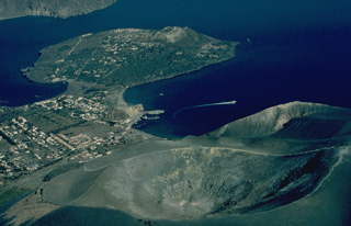 The peninsula of Vulcanello (upper left), at the northern end of the island of Vulcano, is the latest of a series of north-migrating eruptive centers on Vulcano. Its growth began in 183 BCE, when submarine eruptions formed an island. Eruptions eventually formed three cones up to 123-m high surrounded by lava flows that joined Vulcanello to the main island. The crater in the foreground is Fossa, the source of most historical eruptions of Vulcano.
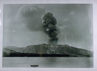 An eruption plume rises above Fossa cone on Vulcano in 1888 in this photo taken from a position offshore to the NE during the last historical eruption of the volcano. The eruption began on August 2, and persistant explosive activity, occasionally accompanied by minor pyroclastic surges, continued until March 22, 1890.
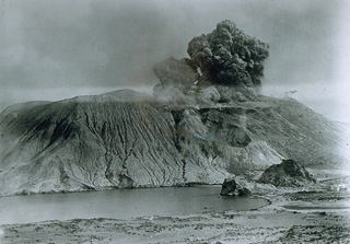 Vulcanian eruptions derive their name from the typical eruptive style of Vulcano, in Italy's Aeolian Islands. Vulcanian eruptions consist of phreatomagmatic explosions, which eject dark, ash-laden, cauliflower-shaped eruption columns. After the vent is cleared by the explosions, lava flows may issue from the crater or fissures on its flank. This photo, looking to the south, shows a vulcanian eruption in 1888 from Fossa cone on the island of Vulcano.
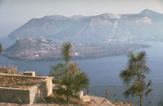 The island of Vulcano in Italy's Aeolian Islands is seen here from the volcano observatory on the island of Lipari to the north, with the volcanic peninsula of Vulcanello, initially formed in 183 BCE, in the foreground and Fossa cone in the background. Vulcano consists of at least three volcanic complexes, each of which is truncated by a small caldera. Volcanism has migrated to the north with Fossa cone being the dominant Holocene center. The latest eruption took place from 1888 to 1890.
 The summit crater of the Vulcano Fossa cone is seen here in May 2011. On the crater wall to the right is discoloration from geothermal activity consisting of fumaroles across a fracture zone. In 2010 the average measured temperature across the field was 190°C.
 The Fossa cone, formed within the Fossa caldera around 6,000 years ago, is seen here in May 2011. Eruptions there have produced lava flows that reach the base of the cone, pyroclastic surge deposits from phreatomagmatic eruptions, ashfall units, and ballistic ejecta.
The following 32 samples associated with this volcano can be found in the Smithsonian's NMNH Department of Mineral Sciences collections, and may be availble for research (contact the Rock and Ore Collections Manager). Catalog number links will open a window with more information.
| Catalog Number | Sample Description | Lava Source | Collection Date |
|---|---|---|---|
| NMNH 100093 | Rhyolite | -- | -- |
| NMNH 100094 | Andesite | VULCANELLO | -- |
| NMNH 100095 | Andesite | VULCANELLO | -- |
| NMNH 100096 | Andesite | VULCANELLO | -- |
| NMNH 100106 | Rhyolitic Obsidian | -- | -- |
| NMNH 100107 | Rhyolitic Obsidian | -- | -- |
| NMNH 100120 | Basalt | -- | -- |
| NMNH 100121 | Basalt | -- | -- |
| NMNH 101959 | Rhyolite Volcanic Bomb | -- | -- |
| NMNH 101960 | Rhyolite (?) | -- | -- |
| NMNH 101961 | Rhyolite | -- | -- |
| NMNH 101962 | Basalt | VULCANELLO | -- |
| NMNH 109077 | Lava | -- | -- |
| NMNH 109078 | Unidentified | -- | -- |
| NMNH 109079 | Volcanic Sublimate | -- | -- |
| NMNH 109080 | Sulfur | -- | -- |
| NMNH 113111-1 | Obsidian | -- | -- |
| NMNH 113111-2 | Obsidian | -- | -- |
| NMNH 113111-3 | Obsidian | -- | -- |
| NMNH 113111-4 | Volcanic Bomb | -- | -- |
| NMNH 113111-5 | Volcanic Bomb | -- | -- |
| NMNH 116260-1 | Sulfur-Bearing Rock | -- | -- |
| NMNH 116260-2 | Sulfur-Bearing Rock | -- | -- |
| NMNH 116260-3 | Sulfur-Bearing Rock | -- | -- |
| NMNH 116260-4 | Tuff | -- | -- |
| NMNH 60685 | Alum | -- | -- |
| NMNH 60783 | Volcanic Bomb | -- | -- |
| NMNH 60785 | Obsidian | -- | -- |
| NMNH 60786 | Lava | -- | -- |
| NMNH 73143 | Liparite | -- | -- |
| NMNH 73163 | Basalt | -- | -- |
| NMNH 95945-00 | Sulfur | -- | -- |
| Copernicus Browser | The Copernicus Browser replaced the Sentinel Hub Playground browser in 2023, to provide access to Earth observation archives from the Copernicus Data Space Ecosystem, the main distribution platform for data from the EU Copernicus missions. |
| MIROVA | Middle InfraRed Observation of Volcanic Activity (MIROVA) is a near real time volcanic hot-spot detection system based on the analysis of MODIS (Moderate Resolution Imaging Spectroradiometer) data. In particular, MIROVA uses the Middle InfraRed Radiation (MIR), measured over target volcanoes, in order to detect, locate and measure the heat radiation sourced from volcanic activity. |
| MODVOLC Thermal Alerts | Using infrared satellite Moderate Resolution Imaging Spectroradiometer (MODIS) data, scientists at the Hawai'i Institute of Geophysics and Planetology, University of Hawai'i, developed an automated system called MODVOLC to map thermal hot-spots in near real time. For each MODIS image, the algorithm automatically scans each 1 km pixel within it to check for high-temperature hot-spots. When one is found the date, time, location, and intensity are recorded. MODIS looks at every square km of the Earth every 48 hours, once during the day and once during the night, and the presence of two MODIS sensors in space allows at least four hot-spot observations every two days. Each day updated global maps are compiled to display the locations of all hot spots detected in the previous 24 hours. There is a drop-down list with volcano names which allow users to 'zoom-in' and examine the distribution of hot-spots at a variety of spatial scales. |
|
WOVOdat
Single Volcano View Temporal Evolution of Unrest Side by Side Volcanoes |
WOVOdat is a database of volcanic unrest; instrumentally and visually recorded changes in seismicity, ground deformation, gas emission, and other parameters from their normal baselines. It is sponsored by the World Organization of Volcano Observatories (WOVO) and presently hosted at the Earth Observatory of Singapore.
GVMID Data on Volcano Monitoring Infrastructure The Global Volcano Monitoring Infrastructure Database GVMID, is aimed at documenting and improving capabilities of volcano monitoring from the ground and space. GVMID should provide a snapshot and baseline view of the techniques and instrumentation that are in place at various volcanoes, which can be use by volcano observatories as reference to setup new monitoring system or improving networks at a specific volcano. These data will allow identification of what monitoring gaps exist, which can be then targeted by remote sensing infrastructure and future instrument deployments. |
| Volcanic Hazard Maps | The IAVCEI Commission on Volcanic Hazards and Risk has a Volcanic Hazard Maps database designed to serve as a resource for hazard mappers (or other interested parties) to explore how common issues in hazard map development have been addressed at different volcanoes, in different countries, for different hazards, and for different intended audiences. In addition to the comprehensive, searchable Volcanic Hazard Maps Database, this website contains information about diversity of volcanic hazard maps, illustrated using examples from the database. This site is for educational purposes related to volcanic hazard maps. Hazard maps found on this website should not be used for emergency purposes. For the most recent, official hazard map for a particular volcano, please seek out the proper institutional authorities on the matter. |
| IRIS seismic stations/networks | Incorporated Research Institutions for Seismology (IRIS) Data Services map showing the location of seismic stations from all available networks (permanent or temporary) within a radius of 0.18° (about 20 km at mid-latitudes) from the given location of Vulcano. Users can customize a variety of filters and options in the left panel. Note that if there are no stations are known the map will default to show the entire world with a "No data matched request" error notice. |
| UNAVCO GPS/GNSS stations | Geodetic Data Services map from UNAVCO showing the location of GPS/GNSS stations from all available networks (permanent or temporary) within a radius of 20 km from the given location of Vulcano. Users can customize the data search based on station or network names, location, and time window. Requires Adobe Flash Player. |
| DECADE Data | The DECADE portal, still in the developmental stage, serves as an example of the proposed interoperability between The Smithsonian Institution's Global Volcanism Program, the Mapping Gas Emissions (MaGa) Database, and the EarthChem Geochemical Portal. The Deep Earth Carbon Degassing (DECADE) initiative seeks to use new and established technologies to determine accurate global fluxes of volcanic CO2 to the atmosphere, but installing CO2 monitoring networks on 20 of the world's 150 most actively degassing volcanoes. The group uses related laboratory-based studies (direct gas sampling and analysis, melt inclusions) to provide new data for direct degassing of deep earth carbon to the atmosphere. |
| Large Eruptions of Vulcano | Information about large Quaternary eruptions (VEI >= 4) is cataloged in the Large Magnitude Explosive Volcanic Eruptions (LaMEVE) database of the Volcano Global Risk Identification and Analysis Project (VOGRIPA). |
| EarthChem | EarthChem develops and maintains databases, software, and services that support the preservation, discovery, access and analysis of geochemical data, and facilitate their integration with the broad array of other available earth science parameters. EarthChem is operated by a joint team of disciplinary scientists, data scientists, data managers and information technology developers who are part of the NSF-funded data facility Integrated Earth Data Applications (IEDA). IEDA is a collaborative effort of EarthChem and the Marine Geoscience Data System (MGDS). |

