


The Alaska Volcano Observatory (AVO) reported that slow lava effusion continued to feed a thick flow in Great Sitkin’s summit crater during 31 December 2025-7 January 2026. Seismicity was quiet and weather clouds often obscured satellite and webcam views. Weakly elevated surface temperatures were observed in satellite images during 30 December-3 January. The Volcano Alert Level remained at Watch (the third level on a four-level scale) and the Aviation Color Code remained at Orange (the third color on a four-color scale).
Source: US Geological Survey Alaska Volcano Observatory (AVO)
Slow lava effusion in summit crater continued during May-October 2023
Following weak phreatic explosions at Great Sitkin in June-August 2018 and June 2019, an ash explosion on 25 May 2021 preceded the growth of a lava dome in the summit crater starting in mid-July 2021. Continued lava effusion overtopped the summit crater wall; lava flowed down the N, S, and W flanks (BGVN 46:08, 47:05). This activity subsided during January-April 2022, although slow lava effusion, accompanied by minor steam-and-gas emissions and weak seismicity, continued through April 2023 (BGVN 48:05). Great Sitkin (figure 26), located in Alaska’s Aleutian Island chain, is monitored by the Alaska Volcano Observatory (AVO) using local seismic and infrasound sensors, satellite data, web cameras, and remote infrasound and lightning networks.
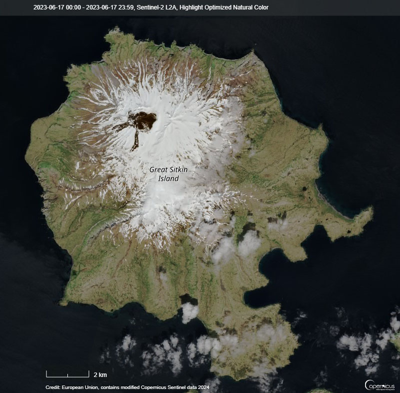 |
Figure 26. Sentinel-2 satellite image of Great Sitkin Island on 6 June 2023. The width of the dark lava-covered crater area is about 1.2 km. Image rendered with highlight-optimized natural color (bands 4, 3, 2). Courtesy of Copernicus Browser. |
According to AVO, the slow, persistent, thick lava effusion continued during May-October 2023, expanding E into glacial ice but remaining confined to the summit crater. This activity was accompanied by weak seismic activity, minor steam emissions, and slightly elevated temperatures consistent with cooling lava. Weather clouds frequently obscured visibility. During the first week of September, an AVO field geology team visited the volcano and sampled the lava flow, did aerial photography (figures 27 and 28) and thermal imaging surveys, and measured gas emissions. The team observed that the flows were warm and steaming (figure 29), moving about 1 m every 3-4 days.
 |
Figure 27. Aerial photo of Great Sitkin taken during a helicopter overflight on 1 September 2023, looking W at the active lava flows in the crater. The currently active lobe of the flow field is visible moving into the crater ice field on the lower left side of the image. Photo by Matt Loewen, courtesy of AVO. |
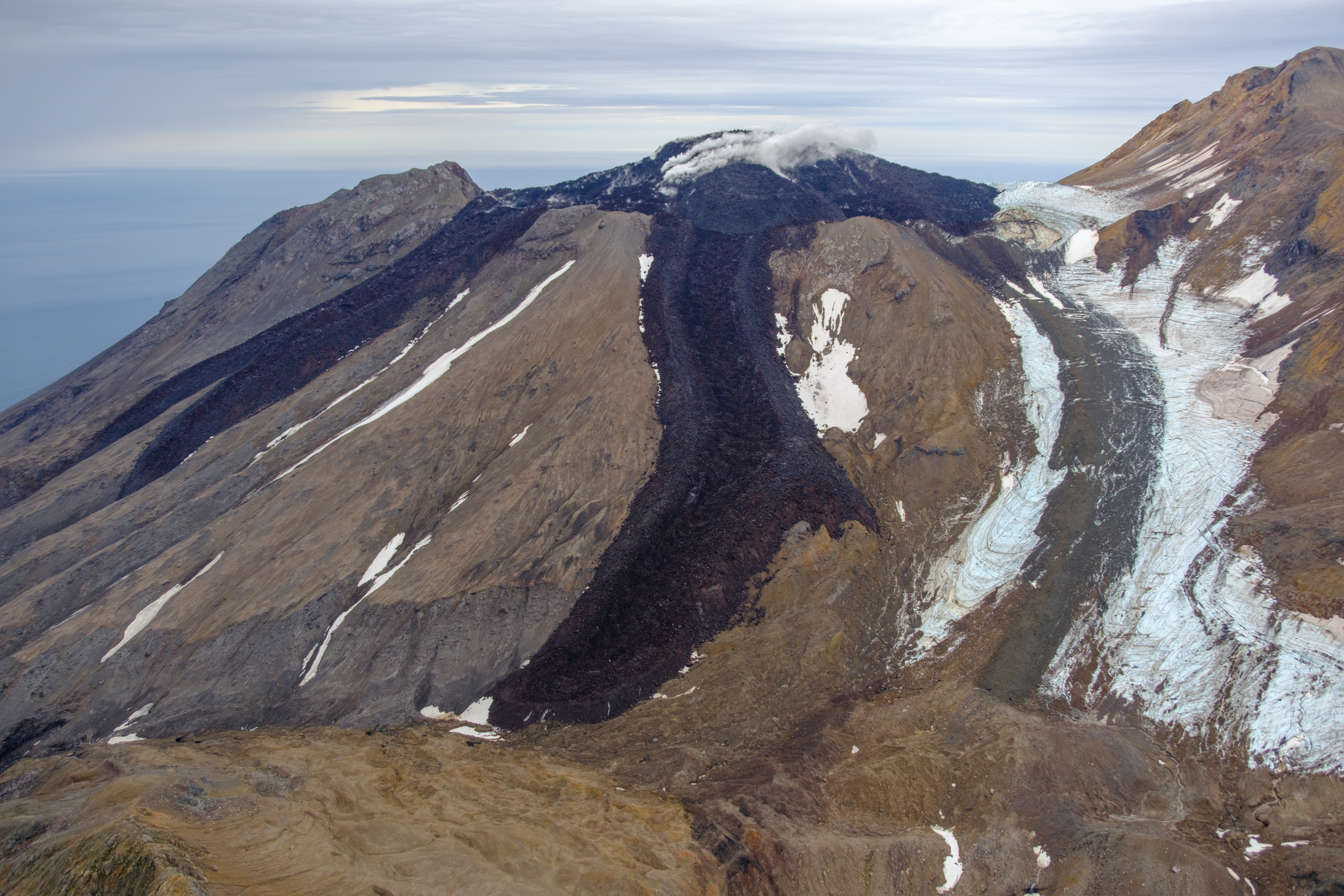 |
Figure 28. Aerial photo of Great Sitkin taken during a helicopter overflight on 3 September 2023, looking NE at the active lava flows in the crater. Photo by Matt Loewen, courtesy of AVO. |
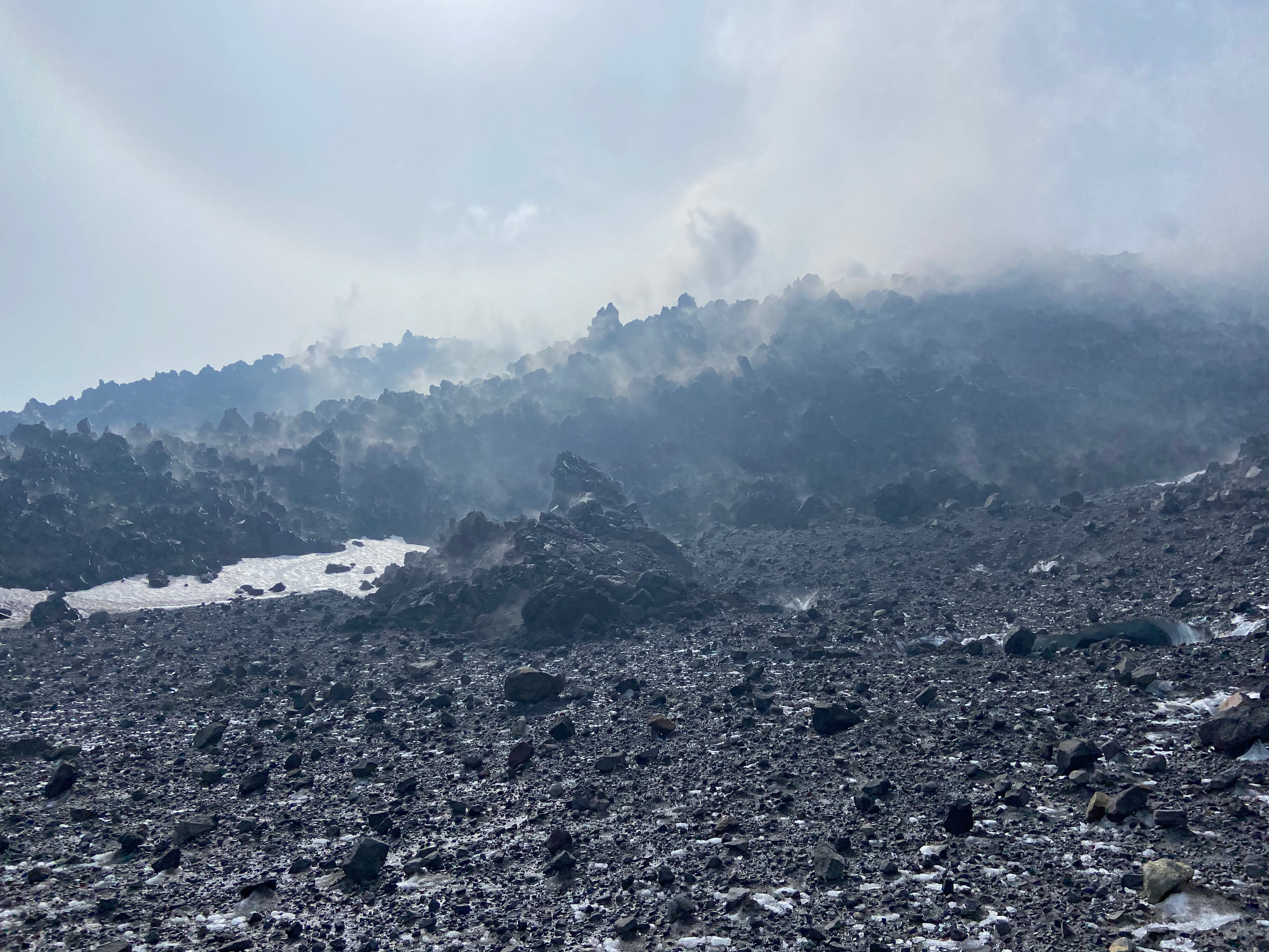 |
Figure 29. Ground photo of the active blocky lava flow field at Great Sitkin taken during fieldwork on 1 September 2023. Photo is looking towards the vent region and main degassing source on the lava flow. Photo by Matt Loewen, courtesy of AVO. |
Information Contacts: Alaska Volcano Observatory (AVO), a cooperative program of a) U.S. Geological Survey, 4200 University Drive, Anchorage, AK 99508-4667 USA (URL: https://avo.alaska.edu/), b) Geophysical Institute, University of Alaska, PO Box 757320, Fairbanks, AK 99775-7320, USA, and c) Alaska Division of Geological & Geophysical Surveys, 794 University Ave., Suite 200, Fairbanks, AK 99709, USA (URL: http://dggs.alaska.gov/); Copernicus Browser (URL: https://dataspace.copernicus.eu/browser).
2026: January
2025: January
| February
| March
| April
| May
| June
| July
| August
| September
| November
| December
2024: January
| February
| March
| April
| May
| June
| July
| August
| September
| October
| November
| December
2023: January
| February
| March
| April
| May
| June
| July
| August
| September
| October
| November
| December
2022: January
| February
| March
| April
| May
| June
| July
| August
| September
| October
| November
| December
2021: May
| July
| August
| September
| October
| November
| December
2020: February
| October
2019: February
| May
| June
| July
2018: January
| June
| August
2017: November
2002: May
The Alaska Volcano Observatory (AVO) reported that slow lava effusion continued to feed a thick flow in Great Sitkin’s summit crater during 31 December 2025-7 January 2026. Seismicity was quiet and weather clouds often obscured satellite and webcam views. Weakly elevated surface temperatures were observed in satellite images during 30 December-3 January. The Volcano Alert Level remained at Watch (the third level on a four-level scale) and the Aviation Color Code remained at Orange (the third color on a four-color scale).
Source: US Geological Survey Alaska Volcano Observatory (AVO)
The Alaska Volcano Observatory (AVO) reported that slow lava effusion continued to feed a thick flow in Great Sitkin’s summit crater during 23-30 December. Seismicity was quiet and weather clouds mostly obscured satellite and webcam views. The Volcano Alert Level remained at Watch (the third level on a four-level scale) and the Aviation Color Code remained at Orange (the third color on a four-color scale).
Source: US Geological Survey Alaska Volcano Observatory (AVO)
The Alaska Volcano Observatory (AVO) reported that slow lava effusion continued to feed a thick flow in Great Sitkin’s summit crater during 16-22 December. The dome continued to slowly inflate and there was minor advancement at the margins of the flow. Seismicity was low, though a data outage that began on 20 December degraded seismic monitoring. Elevated surface temperatures consistent with lava effusion were identified in satellite data daily or almost daily. The Volcano Alert Level remained at Watch (the third level on a four-level scale) and the Aviation Color Code remained at Orange (the third color on a four-color scale).
Source: US Geological Survey Alaska Volcano Observatory (AVO)
The Alaska Volcano Observatory (AVO) reported that slow lava effusion continued to feed a thick flow in Great Sitkin’s summit crater during 9-16 December. Small earthquakes were detected by the seismic network along with occasional rockfall signals. Elevated surface temperatures consistent with lava effusion were identified in satellite views during 9-10 and 12-16 December. Minor steaming from the lava flow was visible in clear webcam views during 14-15 December. Weather clouds sometimes obscured satellite and webcam views. The Volcano Alert Level remained at Watch (the third level on a four-level scale) and the Aviation Color Code remained at Orange (the third color on a four-color scale).
Source: US Geological Survey Alaska Volcano Observatory (AVO)
The Alaska Volcano Observatory (AVO) reported that slow lava effusion continued to feed a thick flow in Great Sitkin’s summit crater during 2-9 December. Small earthquakes were detected by the seismic network along with occasional rockfall signals. Elevated surface temperatures were identified in satellite views during 4-7 December. Weather clouds obscured satellite and webcam views. AVO noted that the rate of lava effusion appeared to be declining gradually. The Volcano Alert Level remained at Watch (the third level on a four-level scale) and the Aviation Color Code remained at Orange (the third color on a four-color scale).
Source: US Geological Survey Alaska Volcano Observatory (AVO)
The Alaska Volcano Observatory (AVO) reported that slow lava effusion continued to feed a thick flow in Great Sitkin’s summit crater during 26 November-2 December. Satellite data indicated that both the SW and SE parts of the flow margins had advanced during the previous week. Seismicity was low. Weather clouds obscured satellite and webcam views. The Volcano Alert Level remained at Watch (the third level on a four-level scale) and the Aviation Color Code remained at Orange (the third color on a four-color scale).
Source: US Geological Survey Alaska Volcano Observatory (AVO)
The Alaska Volcano Observatory (AVO) reported that slow lava effusion continued to feed a thick flow in Great Sitkin’s summit crater during 18-25 November. Satellite data indicated that both the SW and SE parts of the flow margins had advanced about 10 m during the previous week. Small daily earthquakes were detected by the seismic network. Weather clouds sometimes obscured satellite and webcam views, though elevated surface temperatures were identified in satellite views on 18 November. The Volcano Alert Level remained at Watch (the third level on a four-level scale) and the Aviation Color Code remained at Orange (the third color on a four-color scale).
Source: US Geological Survey Alaska Volcano Observatory (AVO)
The Alaska Volcano Observatory (AVO) reported that slow lava effusion continued to feed a thick flow in Great Sitkin’s summit crater during 12-18 November. Satellite data indicated that the SE part of the flow slightly inflated. The S part of the flow margin had advanced about 5 m during the previous week. Small daily earthquakes were detected by the seismic network along with rockfall signals. Weather clouds sometimes obscured satellite and webcam views, though elevated surface temperatures were identified in satellite views during 17-18 November. The Volcano Alert Level remained at Watch (the third level on a four-level scale) and the Aviation Color Code remained at Orange (the third color on a four-color scale).
Source: US Geological Survey Alaska Volcano Observatory (AVO)
The Alaska Volcano Observatory (AVO) reported that slow lava effusion continued to feed a thick flow in Great Sitkin’s summit crater during 24-29 September. Satellite data indicated that the SE part of the flow slightly inflated. Advancement was detected around the SW, S, and SE margins of the flow; the fastest moving part of the flow advanced at a rate of about 5 m per day. Small daily earthquakes were detected by the seismic network daily along with rockfall signals. Weather clouds often obscured satellite and webcam views, though elevated surface temperatures were identified in 29 September satellite views. The Volcano Alert Level remained at Watch (the third level on a four-level scale) and the Aviation Color Code remained at Orange (the third color on a four-color scale).
Source: US Geological Survey Alaska Volcano Observatory (AVO)
The Alaska Volcano Observatory (AVO) reported that slow lava effusion continued to feed a thick flow in Great Sitkin’s summit crater during 16-23 September. Satellite data indicated that the SE part of the flow slightly inflated at a rate of about 5 meters of surface motion per day, though the distal margin of the flow did not advance. Small earthquakes were detected by the seismic network daily or nearly daily. Weather clouds sometimes obscured satellite and webcam views; elevated surface temperatures were identified in satellite data during 21-22 September. Towards the end of the week radar satellite images showed advancement of the SW part of the lava flow and associated rockfalls at the flow’s margins. The Volcano Alert Level remained at Watch (the third level on a four-level scale) and the Aviation Color Code remained at Orange (the third color on a four-color scale).
Source: US Geological Survey Alaska Volcano Observatory (AVO)
The Alaska Volcano Observatory (AVO) reported that slow lava effusion continued to feed a thick flow in Great Sitkin’s summit crater during 9-16 September. Satellite data indicated that the flow was advancing at a rate of about 5 m per day near the vent, with some rockfalls occurring along the S and E margins. The SE half of the lava dome continued to slightly inflate. Small daily earthquakes were detected by the seismic network, including signals probably caused by the small rockfalls. Weather clouds sometimes obscured satellite and webcam views; elevated surface temperatures were identified in satellite data during 9-10 September. The Volcano Alert Level remained at Watch (the third level on a four-level scale) and the Aviation Color Code remained at Orange (the third color on a four-color scale).
Source: US Geological Survey Alaska Volcano Observatory (AVO)
The Alaska Volcano Observatory (AVO) reported that slow lava effusion continued to feed a thick flow in Great Sitkin’s summit crater during 2-9 September. Satellite data indicated that the flow was advancing S, with some rockfalls occurring along the S and E margins. A field crew conducted an overflight of the volcano on 2 September and photographed the active lava flow. The SE half of the lava dome appeared to be inflating. Small daily earthquakes were detected by the seismic network, including signals probably caused by the small rockfalls. Weather clouds sometimes obscured satellite and webcam views; minor steam emissions from the lava dome were observed in webcam images during 3-4 September and elevated surface temperatures were identified in satellite data during 6-7 September. The Volcano Alert Level remained at Watch (the third level on a four-level scale) and the Aviation Color Code remained at Orange (the third color on a four-color scale).
Source: US Geological Survey Alaska Volcano Observatory (AVO)
The Alaska Volcano Observatory (AVO) reported that slow lava effusion continued to feed a thick flow in Great Sitkin’s summit crater during 27 August-2 September. Satellite data indicated that the flow was advancing S, with some rockfalls occurring along the S and E margins. Small daily earthquakes were detected by the seismic network, including signals probably caused by the small rockfalls. Weather clouds mostly obscured satellite and webcam views; elevated surface temperatures were identified in satellite data during 27-28 August and 1-2 September. The Volcano Alert Level remained at Watch (the third level on a four-level scale) and the Aviation Color Code remained at Orange (the third color on a four-color scale).
Source: US Geological Survey Alaska Volcano Observatory (AVO)
The Alaska Volcano Observatory (AVO) reported that slow lava effusion continued to feed a thick flow in Great Sitkin’s summit crater during 19-26 August. Satellite data indicated that the flow was advancing S, with some rockfalls occurring along the S and E margins. Small daily earthquakes were detected by the seismic network, including signals probably caused by the small rockfalls. Weather clouds mostly obscured satellite and webcam views; clear conditions during 23-24 August showed elected surface temperatures in satellite data. The Volcano Alert Level remained at Watch (the third level on a four-level scale) and the Aviation Color Code remained at Orange (the third color on a four-color scale).
Source: US Geological Survey Alaska Volcano Observatory (AVO)
The Alaska Volcano Observatory (AVO) reported that slow lava effusion continued to feed a thick flow in Great Sitkin’s summit crater during 12-19 August. Satellite data indicated that the flow was advancing S, with some rockfalls occurring along the S and E margins. Small daily earthquakes were detected by the seismic network, including signals probably caused by the small rockfalls. Weather clouds mostly obscured satellite and webcam views; clear conditions during 13-14 August showed elected surface temperatures in satellite data and during 14-15 August a steam plume was visible in webcam images. The Volcano Alert Level remained at Watch (the third level on a four-level scale) and the Aviation Color Code remained at Orange (the third color on a four-color scale).
Source: US Geological Survey Alaska Volcano Observatory (AVO)
The Alaska Volcano Observatory (AVO) reported that slow lava effusion continued to feed a thick flow in Great Sitkin’s summit crater during 6-12 August. Small daily earthquakes were detected by the seismic network, including signals probably caused by small rockfalls from the steep flanks. Weather clouds mostly obscured satellite and webcam views; clear conditions during 9-10 August showed nothing unusual in webcam images. The Volcano Alert Level remained at Watch (the third level on a four-level scale) and the Aviation Color Code remained at Orange (the third color on a four-color scale).
Source: US Geological Survey Alaska Volcano Observatory (AVO)
The Alaska Volcano Observatory (AVO) reported that slow lava effusion continued to feed a thick flow in Great Sitkin’s summit crater during 30 July-5 August. Low-level seismicity continued with occasional small earthquakes and rockfall signals detected. On 1 August elevated surface temperatures were observed in satellite data, with occasional steam emissions seen in clear views. High-resolution satellite views showed minor advancement of the SW lava lobe over the past week, as well as ongoing minor inflation of the S portion of the lava dome. Clouds obscured all satellite and webcam views on 2-5 August. The Volcano Alert Level remained at Watch (the third level on a four-level scale) and the Aviation Color Code remained at Orange (the third color on a four-color scale).
Source: US Geological Survey Alaska Volcano Observatory (AVO)
The Alaska Volcano Observatory (AVO) reported that slow lava effusion continued to feed a thick flow in Great Sitkin’s summit crater during 23-29 July. Lava flow advancement was concentrated at the SW lobe, which advanced 5 m during 20-23 July and continued to inflate. Small daily earthquakes were detected by the seismic network, including signals probably caused by small rockfalls from the steep flanks. Elevated surface temperatures consistent with lava effusion were observed in clear satellite views during 22-23 and 25-28 July. Minor steaming at the flow was visible in both webcam and satellite images during 28-29 July. The Volcano Alert Level remained at Watch (the third level on a four-level scale) and the Aviation Color Code remained at Orange (the third color on a four-color scale).
Source: US Geological Survey Alaska Volcano Observatory (AVO)
The Alaska Volcano Observatory (AVO) reported that slow lava effusion continued to feed a thick flow in Great Sitkin’s summit crater during 16-22 July. Lava-flow advancement was concentrated at the SW lobe; a 16 July radar image showed 5 m of advancement and lobe inflation. Small daily earthquakes were detected by the seismic network, including signals probably caused by small rockfalls from the steep flanks. Elevated surface temperatures consistent with lava effusion were observed in clear satellite views during 16-18 and 21-22 July. The Volcano Alert Level remained at Watch (the third level on a four-level scale) and the Aviation Color Code remained at Orange (the third color on a four-color scale).
Source: US Geological Survey Alaska Volcano Observatory (AVO)
The Alaska Volcano Observatory (AVO) reported that slow lava effusion continued to feed a thick flow in Great Sitkin’s summit crater during 9-15 July. Lava-flow advancement was concentrated at the SW lobe. Small daily earthquakes were detected by the seismic network, including signals probably caused by small rockfalls from the steep flanks. Elevated surface temperatures consistent with lava effusion were observed in clear satellite views during the week. The Volcano Alert Level remained at Watch (the third level on a four-level scale) and the Aviation Color Code remained at Orange (the third color on a four-color scale).
Source: US Geological Survey Alaska Volcano Observatory (AVO)
The Alaska Volcano Observatory (AVO) reported that slow lava effusion continued to feed a thick flow in Great Sitkin’s summit crater during 2-8 July. Lava-flow advancement was concentrated at the SW and SE margins based on a 3 July radar image. Small daily earthquakes were detected by the seismic network, including signals probably caused by small rockfalls from the steep flanks. Slightly elevated surface temperatures consistent with lava effusion were observed in clear satellite views during 1-2 and 4-5 July. Diffuse steaming from the known active portions of the lava flow was observed in satellite images during 7-8 July. The Volcano Alert Level remained at Watch (the third level on a four-level scale) and the Aviation Color Code remained at Orange (the third color on a four-color scale).
Source: US Geological Survey Alaska Volcano Observatory (AVO)
The Alaska Volcano Observatory (AVO) reported that slow lava effusion continued to feed a thick flow in Great Sitkin’s summit crater during 25 June-1 July. Small daily earthquakes were detected by the seismic network, including signals probably caused by small rockfalls from the steep S and SE flanks. Slightly elevated surface temperatures consistent with lava effusion were occasionally observed in clear satellite views. Observers on a nearby ship saw a diffuse steam plume rising above the dome during 27-38 June. The Volcano Alert Level remained at Watch (the third level on a four-level scale) and the Aviation Color Code remained at Orange (the third color on a four-color scale).
Source: US Geological Survey Alaska Volcano Observatory (AVO)
The Alaska Volcano Observatory (AVO) reported that slow lava effusion continued to feed a thick flow in Great Sitkin’s summit crater during 18-24 June. Webcam and satellite views showed slight inflation of the dome near the vent area and rockfall deposits on the S and SE sides of the upper part of the dome. Small daily earthquakes were detected by the seismic network, including signals probably caused by small rockfalls from the growing summit lava dome. Minor steaming from the snow-free dome was visible in clear webcam views during 18-19 June. The Volcano Alert Level remained at Watch (the third level on a four-level scale) and the Aviation Color Code remained at Orange (the third color on a four-color scale).
Source: US Geological Survey Alaska Volcano Observatory (AVO)
The Alaska Volcano Observatory (AVO) reported that slow lava effusion continued to feed a thick lava flow in Great Sitkin’s summit crater during 11-17 June. The lava flow advanced primarily to the S from the vent. Small daily earthquakes were detected by the seismic network, including signals probably caused by small rockfalls from the growing lava dome. Weakly elevated surface temperatures consistent with lava effusion were occasionally identified through the clouds in satellite images. The Volcano Alert Level remained at Watch (the third level on a four-level scale) and the Aviation Color Code remained at Orange (the third color on a four-color scale).
Source: US Geological Survey Alaska Volcano Observatory (AVO)
The Alaska Volcano Observatory (AVO) reported that slow lava effusion continued to feed a thick flow in Great Sitkin’s summit crater during 4-10 June. The lava flow grew near the vent and advanced to the SE. Small daily earthquakes were detected by the seismic network, including signals probably caused by small rockfalls from the growing summit lava dome. Minor steaming and weakly elevated surface temperatures consistent with lava effusion were occasionally identified in satellite images. The Volcano Alert Level remained at Watch (the third level on a four-level scale) and the Aviation Color Code remained at Orange (the third color on a four-color scale).
Source: US Geological Survey Alaska Volcano Observatory (AVO)
The Alaska Volcano Observatory (AVO) reported that slow lava effusion continued to feed a thick flow in Great Sitkin’s summit crater during 28 May-3 June. Small daily earthquakes were detected by the seismic network. Weather clouds often obscured views of the volcano, though weakly elevated surface temperatures consistent with lava effusion were identified in satellite images on 29 May and 2 June and minor steaming was visible in satellite images on 30 May and 2 June. A 3 June radar image confirmed growth to the SE. The Volcano Alert Level remained at Watch (the third level on a four-level scale) and the Aviation Color Code remained at Orange (the third color on a four-color scale).
Source: US Geological Survey Alaska Volcano Observatory (AVO)
The Alaska Volcano Observatory (AVO) reported that slow lava effusion continued to feed a thick flow in Great Sitkin’s summit crater during 21-27 May; a 22 May radar image confirmed that lava was slowly advancing. Small daily earthquakes were detected by the seismic network. Weather clouds sometimes obscured views of the volcano. The Volcano Alert Level remained at Watch (the third level on a four-level scale) and the Aviation Color Code remained at Orange (the third color on a four-color scale).
Source: US Geological Survey Alaska Volcano Observatory (AVO)
The Alaska Volcano Observatory (AVO) reported that slow lava effusion continued to feed a thick flow in Great Sitkin’s summit crater during 14-20 May. Small daily earthquakes were detected by the seismic network. Weakly elevated surface temperatures consistent with lava effusion were observed in clear satellite views during 16-19 May and steaming from the active vent was observed during 17-18 May. Weather clouds sometimes obscured views of the volcano. A 20 May radar image confirmed that lava was slowly advancing NE. The Volcano Alert Level remained at Watch (the third level on a four-level scale) and the Aviation Color Code remained at Orange (the third color on a four-color scale).
Source: US Geological Survey Alaska Volcano Observatory (AVO)
The Alaska Volcano Observatory (AVO) reported that slow lava effusion continued to feed a thick flow in Great Sitkin’s summit crater during 7-13 May. Small daily earthquakes were detected by the seismic network. No unusual activity was observed in satellite and webcam views, though weather clouds often obscured views of the volcano. The Volcano Alert Level remained at Watch (the third level on a four-level scale) and the Aviation Color Code remained at Orange (the third color on a four-color scale).
Source: US Geological Survey Alaska Volcano Observatory (AVO)
The Alaska Volcano Observatory (AVO) reported that slow lava effusion continued to feed a thick flow in Great Sitkin’s summit crater during 29 April-6 May. Small daily earthquakes were detected by the seismic network. Slightly elevated temperatures were identified in a few satellite images during 30 April-1 May. Weather clouds often obscured satellite and webcam views of the volcano. The Volcano Alert Level remained at Watch (the third level on a four-level scale) and the Aviation Color Code remained at Orange (the third color on a four-color scale).
Source: US Geological Survey Alaska Volcano Observatory (AVO)
The Alaska Volcano Observatory (AVO) reported that slow lava effusion continued to feed a thick flow in Great Sitkin’s summit crater during 23-29 April. Small daily earthquakes were detected by the seismic network. Weather clouds often obscured satellite and webcam views of the volcano. The Volcano Alert Level remained at Watch (the third level on a four-level scale) and the Aviation Color Code remained at Orange (the third color on a four-color scale).
Source: US Geological Survey Alaska Volcano Observatory (AVO)
The Alaska Volcano Observatory (AVO) reported that slow lava effusion continued to feed a thick flow in Great Sitkin’s summit crater during 16-22 April. Small daily earthquakes were detected by the seismic network. Inflation of the lava flow and minor advancement at the E and SE margins were visible in radar data from 17 April. Minor steaming at the lava flow was visible on 21 April. Weather clouds often obscured views of the volcano. The Volcano Alert Level remained at Watch (the third level on a four-level scale) and the Aviation Color Code remained at Orange (the third color on a four-color scale).
Source: US Geological Survey Alaska Volcano Observatory (AVO)
The Alaska Volcano Observatory (AVO) reported that slow lava effusion continued to feed a thick flow in Great Sitkin’s summit crater during 9-15 April. Small daily earthquakes were detected by the seismic network. Steaming from the vent region and slightly elevated surface temperatures were detected in satellite and webcam images during 9-10 March. Weather clouds often obscured views of the volcano. The Volcano Alert Level remained at Watch (the third level on a four-level scale) and the Aviation Color Code remained at Orange (the third color on a four-color scale).
Source: US Geological Survey Alaska Volcano Observatory (AVO)
The Alaska Volcano Observatory (AVO) reported that slow lava effusion continued to feed a thick flow in Great Sitkin’s summit crater during 1-8 April. Small daily earthquakes were detected by the seismic network. Slightly elevated surface temperatures were observed in satellite data during 3-4 and 6-9 April. Weather clouds often obscured satellite and webcam views of the volcano. The Volcano Alert Level remained at Watch (the third level on a four-level scale) and the Aviation Color Code remained at Orange (the third color on a four-color scale).
Source: US Geological Survey Alaska Volcano Observatory (AVO)
The Alaska Volcano Observatory (AVO) reported that slow lava effusion continued to feed a thick flow in Great Sitkin’s summit crater during 26 March-1 April. Small daily earthquakes were detected by the seismic network. Slightly elevated surface temperatures were observed in satellite data during most of the week. Typical minor steaming from the vent region was visible in webcam images during 25-26 March and 30-31 March. The Volcano Alert Level remained at Watch (the third level on a four-level scale) and the Aviation Color Code remained at Orange (the third color on a four-color scale).
Source: US Geological Survey Alaska Volcano Observatory (AVO)
The Alaska Volcano Observatory (AVO) reported that slow lava effusion continued to feed a thick flow in Great Sitkin’s summit crater during 19-25 March. Small daily earthquakes were detected by the seismic network. No unusual activity was visible in mostly cloudy webcam and satellite images for most of the week. Steaming from the vent region and slightly elevated surface temperatures were detected in satellite and webcam views of the volcano during 23-24 March. The Volcano Alert Level remained at Watch (the third level on a four-level scale) and the Aviation Color Code remained at Orange (the third color on a four-color scale).
Source: US Geological Survey Alaska Volcano Observatory (AVO)
The Alaska Volcano Observatory (AVO) reported that slow lava effusion continued to feed a thick flow in Great Sitkin’s summit crater during 12-18 March. Small daily earthquakes were detected by the seismic network. Weather clouds often obscured satellite and webcam views of the volcano. Satellite images showed steaming at the lava flow during 16-17 March and lava advancement to the NE and E during 16-18 March. The Volcano Alert Level remained at Watch (the third level on a four-level scale) and the Aviation Color Code remained at Orange (the third color on a four-color scale).
Source: US Geological Survey Alaska Volcano Observatory (AVO)
The Alaska Volcano Observatory (AVO) reported that slow lava effusion continued to feed a thick flow in Great Sitkin’s summit crater during 5-11 March, confirmed by a 6 March radar image. Small daily earthquakes were detected by the seismic network. Weather clouds often obscured satellite and webcam views of the volcano. The Volcano Alert Level remained at Watch (the third level on a four-level scale) and the Aviation Color Code remained at Orange (the third color on a four-color scale).
Source: US Geological Survey Alaska Volcano Observatory (AVO)
The Alaska Volcano Observatory (AVO) reported that slow lava effusion continued to feed a thick flow in Great Sitkin’s summit crater, confirmed by a 26 February radar image. Small daily earthquakes were detected by the seismic network. Slightly elevated surface temperatures were observed in satellite data during 25-26 February and 28 February-1 March and typical minor steaming from the vent region was visible in webcam images on most days during the week. Weather clouds sometimes obscured views of the volcano. The Volcano Alert Level remained at Watch (the third level on a four-level scale) and the Aviation Color Code remained at Orange (the third color on a four-color scale).
Source: US Geological Survey Alaska Volcano Observatory (AVO)
The Alaska Volcano Observatory (AVO) reported that slow lava effusion continued to feed a thick lava flow in Great Sitkin’s summit crater, confirmed by a 21 February radar image. The lava flow advanced along the NNE margin. Small daily earthquakes were detected by the seismic network. Typical minor steaming from the vent region was detected in a satellite image on 21 February and slightly elevated surface temperatures observed in satellite data during 23-25 February. Weather clouds sometimes obscured views of the volcano. The Volcano Alert Level remained at Watch (the third level on a four-level scale) and the Aviation Color Code remained at Orange (the third color on a four-color scale).
Source: US Geological Survey Alaska Volcano Observatory (AVO)
The Alaska Volcano Observatory (AVO) reported that slow lava effusion continued to feed a thick lava flow in Great Sitkin’s summit crater, confirmed by a 10 February radar image. The lava flow advanced along the NNE margin. Small daily earthquakes were detected by the seismic network during 10-18 February. Weakly elevated surface temperatures were identified in satellite data during 15-18 February. Cloudy weather obscured satellite and webcam images during most of the week. The Volcano Alert Level remained at Watch (the third level on a four-level scale) and the Aviation Color Code remained at Orange (the third color on a four-color scale).
Source: US Geological Survey Alaska Volcano Observatory (AVO)
The Alaska Volcano Observatory (AVO) reported that slow lava effusion continued to feed a thick lava flow in Great Sitkin’s summit crater during 4-11 February. Cloudy weather prevented clear satellite and webcam images. Small earthquakes were detected during 10-11 February. The Volcano Alert Level remained at Watch (the third level on a four-level scale) and the Aviation Color Code remained at Orange (the third color on a four-color scale).
Source: US Geological Survey Alaska Volcano Observatory (AVO)
The Alaska Volcano Observatory (AVO) reported that slow lava effusion continued to feed a thick lava flow in Great Sitkin’s summit crater during 29 January-4 February. Cloudy satellite and webcam images prevented clear observations. The Volcano Alert Level remained at Watch (the third level on a four-level scale) and the Aviation Color Code remained at Orange (the third color on a four-color scale).
Source: US Geological Survey Alaska Volcano Observatory (AVO)
The Alaska Volcano Observatory (AVO) reported that slow lava effusion continued to feed a thick lava flow in Great Sitkin’s summit crater during 21-28 January. The local seismic network did not detect any small earthquakes on most or all days during the week. Cloudy satellite and webcam images prevented clear observations. The Volcano Alert Level remained at Watch (the third level on a four-level scale) and the Aviation Color Code remained at Orange (the third color on a four-color scale).
Source: US Geological Survey Alaska Volcano Observatory (AVO)
The Alaska Volcano Observatory (AVO) reported that slow lava effusion continued to feed a thick lava flow in Great Sitkin’s summit crater during 14-21 January. The local seismic network continued to detect small earthquakes associated with the ongoing eruption. Mostly cloudy satellite and webcam images prevented clear observations, though steaming from the lava flow was visible during 14-15 January. The Volcano Alert Level remained at Watch (the third level on a four-level scale) and the Aviation Color Code remained at Orange (the third color on a four-color scale).
Source: US Geological Survey Alaska Volcano Observatory (AVO)
The Alaska Volcano Observatory (AVO) reported that slow lava effusion continued to feed a thick lava flow in Great Sitkin’s summit crater during 7-14 January. The local seismic network continued to detect small earthquakes associated with the ongoing eruption. Nothing notable was identified in cloudy satellite and webcam images; though during the morning of 12 January diffuse steaming at the summit was identified in a satellite image. The Volcano Alert Level remained at Watch (the third level on a four-level scale) and the Aviation Color Code remained at Orange (the third color on a four-color scale).
Source: US Geological Survey Alaska Volcano Observatory (AVO)
The Alaska Volcano Observatory (AVO) reported that slow lava effusion continued to feed a thick lava flow in Great Sitkin’s summit crater during 31 December 2024-7 January 2025. The local seismic network continued to detect small earthquakes associated with the ongoing eruption. Nothing notable was identified in satellite and webcam images, though weather clouds sometimes obscured webcam and satellite views. Elevated surface temperatures at the summit were identified in satellite images during 31 December-2 January and 5-6 January, consistent with newly erupted lava. The Volcano Alert Level remained at Watch (the third level on a four-level scale) and the Aviation Color Code remained at Orange (the third color on a four-color scale).
Source: US Geological Survey Alaska Volcano Observatory (AVO)
The Alaska Volcano Observatory (AVO) reported that slow lava effusion continued to feed a thick lava flow in Great Sitkin’s summit crater during 17-31 December. The local seismic network continued to detect small earthquakes associated with the ongoing eruption. Nothing notable was identified in satellite and webcam images, though weather clouds sometimes obscured webcam and satellite views. Steam, warm temperatures, and snow-free areas at the summit were observed in satellite images during 17-18 December. Webcam and satellite images showed steaming at the summit during 20-22 December. Elevated surface temperatures were identified in satellite images during 23-24 and 28-29 December. The Volcano Alert Level remained at Watch (the third level on a four-level scale) and the Aviation Color Code remained at Orange (the third color on a four-color scale).
Source: US Geological Survey Alaska Volcano Observatory (AVO)
The Alaska Volcano Observatory (AVO) reported that slow lava effusion continued to feed a thick lava flow in Great Sitkin’s summit crater during 10-17 December. Minor lava flow advancement along the N margins had gradually filled the summit crater. The local seismic network continued to detect small earthquakes associated with the ongoing eruption. Nothing notable was identified in satellite and webcam images, though weather clouds occasionally obscured webcam and satellite views The Volcano Alert Level remained at Watch (the third level on a four-level scale) and the Aviation Color Code remained at Orange (the third color on a four-color scale).
Source: US Geological Survey Alaska Volcano Observatory (AVO)
The Alaska Volcano Observatory (AVO) reported that slow lava effusion continued to feed a thick lava flow in Great Sitkin’s summit crater during 3-10 December. Minor lava flow advancement along the N margins has gradually filled the summit crater. The local seismic network continued to detect small earthquakes associated with the ongoing eruption. Weather clouds obscured webcam and satellite views of the summit most of the week, though elevated surface temperatures were identified in satellite images during 3-4 December and minor steaming was visible in webcam images during 9-10 December. The Volcano Alert Level remained at Watch (the third level on a four-level scale) and the Aviation Color Code remained at Orange (the third color on a four-color scale).
Source: US Geological Survey Alaska Volcano Observatory (AVO)
The Alaska Volcano Observatory (AVO) reported that slow lava effusion continued to feed a thick lava flow in Great Sitkin’s summit crater during 26 November-3 December. The flow had filled most of the summit crater with minor advancement along the N margins. The local seismic network continued to detect small earthquakes associated with the ongoing eruption. Weather clouds obscured webcam and satellite views of the summit most of the week, though weakly elevated surface temperatures were identified in satellite images on 26 November and a small steam plume from the summit was visible in satellite images during 30 November-1 December. The Volcano Alert Level remained at Watch (the third level on a four-level scale) and the Aviation Color Code remained at Orange (the third color on a four-color scale).
Source: US Geological Survey Alaska Volcano Observatory (AVO)
The Alaska Volcano Observatory (AVO) reported that slow lava effusion continued to feed a thick lava flow in Great Sitkin’s summit crater during 18-26 November. The flow had filled most of the summit crater with minor advancement in the N part of the E lobe. The local seismic network continued to detect small earthquakes associated with the ongoing eruption. Weather clouds obscured webcam and satellite views of the summit most of the week, though elevated surface temperatures were identified in satellite images during 18-19 and 23-24 November. The Volcano Alert Level remained at Watch (the third level on a four-level scale) and the Aviation Color Code remained at Orange (the third color on a four-color scale).
Source: US Geological Survey Alaska Volcano Observatory (AVO)
The Alaska Volcano Observatory (AVO) reported that slow lava effusion continued to feed a thick lava flow in Great Sitkin’s summit crater during 13-19 November. The lava flow had filled most of the summit crater with minor advancement in the N part of the E lobe. The local seismic network continued to detect small earthquakes associated with the ongoing eruption. The last radar image, acquired on 14 November, confirmed ongoing effusion. Weather clouds obscured webcam and satellite views of the summit most of the week, though during 17-18 November elevated surface temperatures over the summit and diffuse steam plumes were identified in satellite images. The Volcano Alert Level remained at Watch (the third level on a four-level scale) and the Aviation Color Code remained at Orange (the third color on a four-color scale).
Source: US Geological Survey Alaska Volcano Observatory (AVO)
The Alaska Volcano Observatory (AVO) reported that slow lava effusion continued to feed a thick lava flow in Great Sitkin’s summit crater during 6-12 November. The lava flow had filled most of the summit crater with minor advancement in the N part of the E lobe. The local seismic network continued to detect small earthquakes associated with the ongoing eruption. The last radar image, acquired on 3 November, confirmed ongoing effusion. Slightly elevated surface temperatures were detected in satellite images that same day, but since then weather clouds obscured webcam and satellite views of the summit. The Volcano Alert Level remained at Watch (the third level on a four-level scale) and the Aviation Color Code remained at Orange (the third color on a four-color scale).
Source: US Geological Survey Alaska Volcano Observatory (AVO)
The Alaska Volcano Observatory (AVO) reported that slow lava effusion continued to feed a thick lava flow in Great Sitkin’s summit crater during 31 October-5 November. The lava flow had filled most of the summit crater with minor advancement in the northern part of the east lobe. The local seismic network continued to detect small earthquakes associated with the ongoing eruption. Weather clouds often obscured webcam and satellite views of the summit, but on clear days steaming and elevated surface temperatures were observed. The Volcano Alert Level remained at Watch (the third level on a four-level scale) and the Aviation Color Code remained at Orange (the third color on a four-color scale).
Source: US Geological Survey Alaska Volcano Observatory (AVO)
The Alaska Volcano Observatory (AVO) reported that slow lava effusion continued to feed a thick lava flow in Great Sitkin’s summit crater during 23-29 October. The lava flow had filled most of the summit crater with minor advancement in the N part of the E lobe. The local seismic network continued to detect small earthquakes associated with the ongoing eruption. Minor steaming from the lava flow was visible in webcam images on 28 October. Weather clouds often obscured webcam and satellite views of the summit. The Volcano Alert Level remained at Watch (the third level on a four-level scale) and the Aviation Color Code remained at Orange (the third color on a four-color scale).
Source: US Geological Survey Alaska Volcano Observatory (AVO)
The Alaska Volcano Observatory (AVO) reported that slow lava effusion continued to feed a thick lava flow in Great Sitkin’s summit crater during 16-22 October. The lava flow had filled most of the summit crater with minor advancement in the N part of the E lobe. The local seismic network continued to detect small earthquakes associated with the ongoing eruption. Weather clouds often obscured webcam and satellite views of the summit. The Volcano Alert Level remained at Watch (the third level on a four-level scale) and the Aviation Color Code remained at Orange (the third color on a four-color scale).
Source: US Geological Survey Alaska Volcano Observatory (AVO)
The Alaska Volcano Observatory (AVO) reported that slow lava effusion continued to feed a thick lava flow in Great Sitkin’s summit crater during 9-15 October. Continuing lava effusion was confirmed in satellite data on 12 October, by which time lava had filled most of the summit crater. The local seismic network continued to detect small earthquakes associated with the ongoing eruption. Weather clouds often obscured webcam and satellite views of the summit. The Volcano Alert Level remained at Watch (the third level on a four-level scale) and the Aviation Color Code remained at Orange (the third color on a four-color scale).
Source: US Geological Survey Alaska Volcano Observatory (AVO)
Alaska Volcano Observatory (AVO) reported that slow lava effusion continued to feed a thick lava flow in Great Sitkin’s summit crater during 2-8 October. The lava flow had filled most of the summit crater. The local seismic network continued to detect small earthquakes associated with the ongoing eruption. Weather clouds often obscured webcam and satellite views of the summit. The Volcano Alert Level remained at Watch (the third level on a four-level scale) and the Aviation Color Code remained at Orange (the third color on a four-color scale).
Source: US Geological Survey Alaska Volcano Observatory (AVO)
Alaska Volcano Observatory (AVO) reported that slow lava effusion continued to feed a thick lava flow in Great Sitkin’s summit crater during 24 September-1 October. The lava flow had filled most of the summit crater. The local seismic network continued to detect small earthquakes and other signals associated with the ongoing eruption. Weather clouds often obscured views of the summit. The Volcano Alert Level remained at Watch (the third level on a four-level scale) and the Aviation Color Code remained at Orange (the third color on a four-color scale).
Source: US Geological Survey Alaska Volcano Observatory (AVO)
Alaska Volcano Observatory (AVO) reported that slow lava effusion continued to feed a thick lava flow in Great Sitkin’s summit crater during 17-24 September. The lava flow had filled most of the summit crater. The local seismic network continued to detect small earthquakes and other signals associated with the ongoing eruption. Elevated surface temperatures over the active flow were identified in satellite data during17-19 September. Weather clouds obscured views of the summit during the second part of the week. The Volcano Alert Level remained at Watch (the third level on a four-level scale) and the Aviation Color Code remained at Orange (the third color on a four-color scale).
Source: US Geological Survey Alaska Volcano Observatory (AVO)
AVO reported that slow lava effusion continued to feed a thick lava flow in Great Sitkin’s summit crater during 10-17 September. Seismicity was low with few small daily earthquakes and rockfalls associated with the advancing E lobe. Elevated surface temperatures over the active flow were identified in satellite data on 11 September. Weather clouds often obscured views of the summit. The Volcano Alert Level remained at Watch (the third level on a four-level scale) and the Aviation Color Code remained at Orange (the third color on a four-color scale).
Source: US Geological Survey Alaska Volcano Observatory (AVO)
AVO reported that slow lava effusion continued to feed a thick lava flow in Great Sitkin’s summit crater during 4-10 September. Seismicity was low with few small daily earthquakes. Steam rising from the flow was visible in webcam views on 8 September. Weather clouds often obscured views of the summit. The Volcano Alert Level remained at Watch (the third level on a four-level scale) and the Aviation Color Code remained at Orange (the third color on a four-color scale).
Source: US Geological Survey Alaska Volcano Observatory (AVO)
AVO reported that slow lava effusion continued to feed a thick lava flow in Great Sitkin’s summit crater during 27 August-3 September. Seismicity was low with few small daily earthquakes. A satellite image on 29 August indicated that the flow advanced NE. Weakly elevated surface temperatures were detected in satellite data on 31 August. The Volcano Alert Level remained at Watch (the third level on a four-level scale) and the Aviation Color Code remained at Orange (the third color on a four-color scale).
Source: US Geological Survey Alaska Volcano Observatory (AVO)
AVO reported that slow lava effusion in Great Sitkin’s summit crater continued during 21-27 August. Seismicity was low with few small daily earthquakes. Nothing unusual was observed in satellite and webcam images throughout the week. Weakly elevated surface temperatures were detected in satellite data during 26-27 August, consistent with a cooling lava flow. The Volcano Alert Level remained at Watch (the third level on a four-level scale) and the Aviation Color Code remained at Orange (the third color on a four-color scale).
Source: US Geological Survey Alaska Volcano Observatory (AVO)
AVO reported that slow lava effusion in Great Sitkin’s summit crater continued during 13-20 August. Seismicity was low with few small daily earthquakes. Slightly elevated surface temperatures were identified in partly cloudy satellite views during 18-19 August. Weather clouds often obscured satellite and webcam views. The Volcano Alert Level remained at Watch (the third level on a four-level scale) and the Aviation Color Code remained at Orange (the third color on a four-color scale).
Source: US Geological Survey Alaska Volcano Observatory (AVO)
AVO reported that slow lava effusion in Great Sitkin’s summit crater continued during 6-13 August, particularly near the summit and to the ENE; continuing growth was confirmed by 6-7 August satellite images. Seismicity was low with few small daily earthquakes. Elevated surface temperatures were at moderate levels during 10-11 August and at weak levels during 11-13 August. Minor steaming and a diffuse gas plume were visible in webcam and satellites images during 11-13 August. The Volcano Alert Level remained at Watch (the third level on a four-level scale) and the Aviation Color Code remained at Orange (the third color on a four-color scale).
Source: US Geological Survey Alaska Volcano Observatory (AVO)
AVO reported that slow lava effusion in Great Sitkin’s summit crater continued during 31 July-6 August. The continued growth of the active flow was confirmed by satellite. Seismicity was low with few small daily earthquakes and rockfall signals. Weakly elevated surface temperatures and steam emissions from the growing dome were occasionally visible. Weather clouds often obscured or partially obscured satellite and webcam views. The Volcano Alert Level remained at Watch (the third level on a four-level scale) and the Aviation Color Code remained at Orange (the third color on a four-color scale).
Source: US Geological Survey Alaska Volcano Observatory (AVO)
AVO reported that slow lava effusion in Great Sitkin’s summit crater continued during 24-30 July; a 30 July radar image showed flow advancement to the E and S. Seismicity was low with few small daily earthquakes. Weakly elevated surface temperatures and steam emissions from the growing dome were visible in satellite images during 28-30 July. Weather clouds often obscured or partially obscured satellite and webcam views. The Volcano Alert Level remained at Watch (the third level on a four-level scale) and the Aviation Color Code remained at Orange (the third color on a four-color scale).
Source: US Geological Survey Alaska Volcano Observatory (AVO)
AVO reported that slow lava effusion in Great Sitkin’s summit crater was last confirmed in an 18 July radar image and that same day elevated surface temperatures were detected in satellite images; effusion likely continued during 19-23 July. The lava flow expanded E and S, overtopping older lava flows emplaced during 2022-2024. Lava blocks sometimes detached from the flow and descended the flow margins; the tumbling blocks were seismically detected. Small daily earthquakes beneath the volcano were recorded during 16-23 July. Weather conditions often obscured satellite and webcam views. The Volcano Alert Level remained at Watch (the third level on a four-level scale) and the Aviation Color Code remained at Orange (the third color on a four-color scale).
Source: US Geological Survey Alaska Volcano Observatory (AVO)
Alaska Volcano Observatory (AVO) reported that slow lava effusion in Great Sitkin’s summit crater likely continued during 10-16 July. Seismicity was low with few daily small earthquakes recorded by the seismic network. Daily clear webcam views showed minor steaming from the active lava flow, and on 15 July elevated surface temperatures were detected by satellite. The Volcano Alert Level remained at Watch (the third level on a four-level scale) and the Aviation Color Code remained at Orange (the third color on a four-color scale).
Source: US Geological Survey Alaska Volcano Observatory (AVO)
AVO reported that slow lava effusion in Great Sitkin’s summit crater was last confirmed in a 7 July radar image; effusion likely continued during 8-9 July. Seismicity was low during 3-9 July with few daily small earthquakes recorded by the seismic network. Weather clouds mostly obscured satellite and webcam views during most of the week. The Volcano Alert Level remained at Watch (the third level on a four-level scale) and the Aviation Color Code remained at Orange (the third color on a four-color scale).
Source: US Geological Survey Alaska Volcano Observatory (AVO)
AVO reported that slow lava effusion in Great Sitkin’s summit crater was last confirmed in a 26 June radar image; effusion likely continued during 27 June-2 July. Seismicity was low with few daily small earthquakes recorded during 28 June-1 July. Weather clouds obscured satellite and webcam views during most of the week; slightly elevated surface temperatures were detected in satellite images during 30 June-2 July, indicating continuing effusion. The Volcano Alert Level remained at Watch (the third level on a four-level scale) and the Aviation Color Code remained at Orange (the third color on a four-color scale).
Source: US Geological Survey Alaska Volcano Observatory (AVO)
AVO reported that slow lava effusion in Great Sitkin’s summit crater continued during 18-25 June. Seismicity was low with few daily small earthquakes. Minor steaming from the lava flow was visible in satellite images on 18 and 21 June. Slightly elevated surface temperatures at the summit were identified in satellite images during 22-24 June. Weather clouds sometimes obscured or partially obscured satellite and webcam views. The Volcano Alert Level remained at Watch (the third level on a four-level scale) and the Aviation Color Code remained at Orange (the third color on a four-color scale).
Source: US Geological Survey Alaska Volcano Observatory (AVO)
AVO reported that slow lava effusion in Great Sitkin’s summit crater continued during 12-18 June. Seismicity was low with few daily small earthquakes. Slightly elevated surface temperatures at the summit were identified in satellite images during 11-13 June. Weather clouds sometimes obscured or partially obscured satellite and webcam views. The Volcano Alert Level remained at Watch (the third level on a four-level scale) and the Aviation Color Code remained at Orange (the third color on a four-color scale).
Source: US Geological Survey Alaska Volcano Observatory (AVO)
AVO reported that slow lava effusion in Great Sitkin’s summit crater continued during 5-11 June. Seismicity was low with few daily small earthquakes. Slightly elevated surface temperatures at the summit were identified in satellite images during 4-6 June and diffuse steam emissions were visible in webcam images during 5-6 June. Weather clouds sometimes obscured satellite and webcam views. The Volcano Alert Level remained at Watch (the third level on a four-level scale) and the Aviation Color Code remained at Orange (the third color on a four-color scale).
Source: US Geological Survey Alaska Volcano Observatory (AVO)
AVO reported that slow lava effusion in Great Sitkin’s summit crater likely continued during 29 May-4 June. Seismicity was low with few daily small earthquakes. Weather clouds mostly obscured satellite and webcam views. Slightly elevated surface temperatures at the summit were identified in satellite images during 3-4 June. The Volcano Alert Level remained at Watch (the third level on a four-level scale) and the Aviation Color Code remained at Orange (the third color on a four-color scale).
Source: US Geological Survey Alaska Volcano Observatory (AVO)
AVO reported that slow lava effusion in Great Sitkin’s summit crater was last confirmed in a 22 May radar satellite image with continuing inflation over the vent and advancement of the NW lava lobe. Lava was filling in a crack just SW of the vent. Effusion likely continued during 23-28 May. Seismicity was low and characterized by small, long-period and volcano-tectonic earthquakes. Weather clouds fully or partly obscured satellite and webcam views on most days. The Volcano Alert Level remained at Watch (the third level on a four-level scale) and the Aviation Color Code remained at Orange (the third color on a four-color scale).
Source: US Geological Survey Alaska Volcano Observatory (AVO)
AVO reported that slow lava effusion in Great Sitkin’s summit crater likely continued during 15-21 May. Seismicity was low with daily, small, occasional earthquakes. The active portion of the lava flow was warm and snow-free, and steaming was visible in occasional clear satellite and webcam views; weather clouds sometimes prevented such views. The Volcano Alert Level remained at Watch (the third level on a four-level scale) and the Aviation Color Code remained at Orange (the third color on a four-color scale).
Source: US Geological Survey Alaska Volcano Observatory (AVO)
AVO reported that slow lava effusion in Great Sitkin’s summit crater likely continued during 8-14 May. Seismicity was low. Weather clouds fully or partly obscured satellite and webcam views. The active portion of the lava flow was warm and snow-free in partly-cloudy webcam views during 13-14 May.The Volcano Alert Level remained at Watch (the third level on a four-level scale) and the Aviation Color Code remained at Orange (the third color on a four-color scale).
Source: US Geological Survey Alaska Volcano Observatory (AVO)
AVO reported that slow lava effusion in Great Sitkin’s summit crater was last confirmed in a 30 April radar satellite image; effusion likely continued during 30 April-7 May. Seismicity was low. Weather clouds fully or partly obscured satellite and webcam views, though minor steaming from the vent area was observed in satellite images during 30 April-2 May. The Volcano Alert Level remained at Watch (the third level on a four-level scale) and the Aviation Color Code remained at Orange (the third color on a four-color scale).
Source: US Geological Survey Alaska Volcano Observatory (AVO)
AVO reported that slow lava effusion in Great Sitkin’s summit crater was last confirmed in a 21 April radar satellite image with continuing inflation over the vent and advancement of the NW lava lobe. Effusion likely continued during 24-30 April. Seismicity was low. Weather clouds fully or partly obscured satellite and webcam views, though weakly elevated surface temperatures were observed in satellite images during 26-27 April. The Volcano Alert Level remained at Watch (the third level on a four-level scale) and the Aviation Color Code remained at Orange (the third color on a four-color scale).
Source: US Geological Survey Alaska Volcano Observatory (AVO)
AVO reported that slow lava effusion continued in Great Sitkin’s summit crater during 17-23 April. Slightly elevated surface temperatures were identified in satellite images during 17-18 April. Seismicity was low with a few small daily earthquakes recorded by the seismic network. Weather clouds partly or mostly obscured satellite and webcam views during most of the week. The Volcano Alert Level remained at Watch (the third level on a four-level scale) and the Aviation Color Code remained at Orange (the third color on a four-color scale).
Source: US Geological Survey Alaska Volcano Observatory (AVO)
AVO reported that slow lava effusion in Great Sitkin’s summit crater was last confirmed in a 10 April radar satellite image with continuing inflation over the vent and advancement of the NW and E lava lobes. Effusion likely continued during 11-16 April. Seismicity was low with a few small daily earthquakes recorded by the seismic network. Weather clouds fully or partly obscured satellite and webcam views during some of the week. Possible weakly elevated surface temperatures were observed in satellite images during 15-16 April. The Volcano Alert Level remained at Watch (the third level on a four-level scale) and the Aviation Color Code remained at Orange (the third color on a four-color scale).
Source: US Geological Survey Alaska Volcano Observatory (AVO)
AVO reported that slow lava effusion continued in Great Sitkin’s summit crater during 3-9 April. Slightly elevated surface temperatures were identified in satellite images during 2-3 April. Seismicity was low with a few small daily earthquakes recorded by the seismic network; the network was not operational during 8-9 April. Weather clouds fully or partly obscured satellite and webcam views during most of the week. The Volcano Alert Level remained at Watch (the third level on a four-level scale) and the Aviation Color Code remained at Orange (the third color on a four-color scale).
Source: US Geological Survey Alaska Volcano Observatory (AVO)
AVO reported that slow lava effusion continued in Great Sitkin’s summit crater during 27 March-2 April. A white steam plume rose above the summit on 27 March; weather clouds obscured or partly obscured satellite and webcam views during most of the week. A radar satellite image acquired on 28 March showed advancement of the active NW lava flow and uplift of the center of the lava flow above the vent. The NW flow was warm and snow-free. Seismicity was low; 20 small earthquakes were recorded during 26-27 March and a few were detected during 1-2 April. The Volcano Alert Level remained at Watch (the third level on a four-level scale) and the Aviation Color Code remained at Orange (the third color on a four-color scale).
Source: US Geological Survey Alaska Volcano Observatory (AVO)
AVO reported that slow lava effusion continued in Great Sitkin’s summit crater during 20-26 March. Weather clouds obscured or partly obscured satellite and webcam views during most of the week. A radar satellite image acquired during 19-20 March showed advancement of the active NW lava flow and uplift of the center of the lava dome above the vent. Seismicity was low and a few small earthquakes were recorded each day. The Volcano Alert Level remained at Watch (the third level on a four-level scale) and the Aviation Color Code remained at Orange (the third color on a four-color scale).
Source: US Geological Survey Alaska Volcano Observatory (AVO)
AVO reported that slow lava effusion continued in Great Sitkin’s summit crater during 13-19 March. Weather clouds obscured or partly obscured satellite and webcam views during most of the week. A radar satellite image acquired during 17-18 March showed advancement of the active NW lava flow, movement at the E lava flow, and uplift of the center of the lava dome above the vent. Seismicity was low and a few small earthquakes were recorded during 18-19 March. The Volcano Alert Level remained at Watch (the third level on a four-level scale) and the Aviation Color Code remained at Orange (the third color on a four-color scale).
Source: US Geological Survey Alaska Volcano Observatory (AVO)
AVO reported that continuing slow lava effusion in Great Sitkin’s summit crater was last confirmed in a 9 March radar satellite image with continuing inflation over the vent and advancement of the NW lava flow; effusion likely continued during 10-12 March. Seismicity was low. Slightly elevated surface temperatures were identified in satellite images during 5-8 March. The Volcano Alert Level remained at Watch (the third level on a four-level scale) and the Aviation Color Code remained at Orange (the third color on a four-color scale).
Source: US Geological Survey Alaska Volcano Observatory (AVO)
AVO reported that slow lava effusion likely continued in Great Sitkin’s summit crater during 28 February-5 March. A few small daily volcanic earthquakes were recorded by the seismic network on most days. Weather clouds partly obscured satellite and webcam views during most of the week. The Volcano Alert Level remained at Watch (the third level on a four-level scale) and the Aviation Color Code remained at Orange (the third color on a four-color scale).
Source: US Geological Survey Alaska Volcano Observatory (AVO)
AVO reported that slow lava effusion continued in Great Sitkin’s summit crater during 21-27 February, confirmed by a 24 February satellite image. A few small volcanic earthquakes were recorded by the seismic network during 24-26 February. Weather clouds obscured satellite and webcam views during most of the week. The Volcano Alert Level remained at Watch (the third level on a four-level scale) and the Aviation Color Code remained at Orange (the third color on a four-color scale).
Source: US Geological Survey Alaska Volcano Observatory (AVO)
AVO reported that slow lava effusion likely continued at Great Sitkin during 13-20 February with growth concentrated at the center of the flow in the summit crater. Steam emissions were visible in satellite and webcam images during 14-15 February. A 15 February radar image showed inflation near the summit crater vent and a new lobe of lava advancing NW. A few small volcanic earthquakes were recorded by the seismic network on most days. Weather clouds obscured satellite and webcam views during most of the week. The Volcano Alert Level remained at Watch (the third level on a four-level scale) and the Aviation Color Code remained at Orange (the third color on a four-color scale).
Source: US Geological Survey Alaska Volcano Observatory (AVO)
AVO reported that slow lava effusion continued at Great Sitkin summit crater during 7-13 February. Few small volcanic earthquakes were recorded by the seismic network on most days, and low-frequency earthquakes (LFs) were recorded during 10-11 February. Weather clouds obscured satellite and webcam views during most of the week. The Volcano Alert Level remained at Watch (the third level on a four-level scale) and the Aviation Color Code remained at Orange (the third color on a four-color scale).
Source: US Geological Survey Alaska Volcano Observatory (AVO)
AVO reported that slow lava effusion continued at Great Sitkin during 31 January-6 February with growth concentrated at the center of the flow in the summit crater. A few small volcanic earthquakes were recorded by the seismic network each day. Weather clouds obscured satellite and webcam views during most of the week. The Volcano Alert Level remained at Watch (the third level on a four-level scale) and the Aviation Color Code remained at Orange (the third color on a four-color scale).
Source: US Geological Survey Alaska Volcano Observatory (AVO)
AVO reported that the eruption of lava at Great Sitkin’s summit lava dome continued during 24-30 January, confirmed by satellite data acquired during the week. Effusion was concentrated at the center of the dome with minimal advancement at the margins of the flow. The center of the dome uplifted and caused radial cracks; a new lobe of lava extruded from the northernmost crack and traveled 180 m NW of the vent by 24 January. Weakly elevated surface temperatures were identified in satellite data during 24-26 January. Cloudy weather sometimes prevented satellite views of the volcano. Local webcams and seismic data communications that were offline due to a storm-related power failure came back online on 28 January; infrequent, small volcanic earthquakes were detected during 29-30 January. The Volcano Alert Level remained at Watch (the third highest level on a four-level scale) and the Aviation Color Code remained at Orange (the third highest color on a four-color scale).
Source: US Geological Survey Alaska Volcano Observatory (AVO)
AVO reported that the eruption of lava at Great Sitkin’s summit lava dome continued during 16-23 January, confirmed by a few radar images acquired during the week. Effusion was concentrated at the center of the dome with minimal advancement at the margins of the flow. Weakly elevated surface temperatures were identified in satellite data during 16-18 January. Local webcams and seismic data communications were offline due to a storm-related power failure. The Volcano Alert Level remained at Watch (the third highest level on a four-level scale) and the Aviation Color Code remained at Orange (the third highest color on a four-color scale).
Source: US Geological Survey Alaska Volcano Observatory (AVO)
On 11 January AVO reported that a radar image of Great Sitkin showed that the thick flow in the summit crater continued to expand to the E and reached the N margin of an earlier flow; effusion likely continued during 12-16 January. Local webcams and seismic data communications were offline due to a storm-related power failure. No unusual activity was visible in mostly cloudy satellite images. Weakly elevated surface temperatures were identified in satellite data during 15-16 January. The Volcano Alert Level remained at Watch (the third level on a four-level scale) and the Aviation Color Code remained at Orange (the third color on a four-color scale).
Source: US Geological Survey Alaska Volcano Observatory (AVO)
AVO reported that a radar image of Great Sitkin showed continuing growth of a thick flow in the summit crater with expansion to the E; effusion likely continued during 3-9 January. Radial cracks around the central vent widened and pushed material 15 m N. Weather clouds often obscured views of the volcano. Seismicity was low, though beginning during 2-4 January web cameras and seismic data were offline due to a power failure. The Volcano Alert Level remained at Watch (the third level on a four-level scale) and the Aviation Color Code remained at Orange (the third color on a four-color scale).
Source: US Geological Survey Alaska Volcano Observatory (AVO)
AVO reported that a 24 December radar image of Great Sitkin showed continuing growth of a thick flow in the summit crater; effusion likely continued during 27 December 2023-2 January 2024. Weather clouds often obscured views of the volcano. Minor steaming from the active flow field was identified in a webcam images during a break in cloud cover during 31 December-1 January. Seismicity was low. The Volcano Alert Level remained at Watch (the third level on a four-level scale) and the Aviation Color Code remained at Orange (the third color on a four-color scale).
Source: US Geological Survey Alaska Volcano Observatory (AVO)
AVO reported that a 20 December radar image of Great Sitkin showed continuing growth of a thick flow in the summit crater; effusion likely continued during 20-26 December. Weather clouds often obscured views of the volcano. Minor steaming was identified in satellite data during 22-23 December. Elevated surface temperatures were identified in satellite data and minor steaming was seen in webcam images during 24-25 December. Seismicity was low. The Volcano Alert Level remained at Watch (the third level on a four-level scale) and the Aviation Color Code remained at Orange (the third color on a four-color scale).
Source: US Geological Survey Alaska Volcano Observatory (AVO)
AVO reported that an 11 December radar image of Great Sitkin showed continuing growth of a thick flow in the summit crater; effusion likely continued during 12-19 December. Weather clouds often obscured views of the volcano, though no notable activity was visible in a few clear webcam images on 15 December. Seismicity was low. The Volcano Alert Level remained at Watch (the third level on a four-level scale) and the Aviation Color Code remained at Orange (the third color on a four-color scale).
Source: US Geological Survey Alaska Volcano Observatory (AVO)
AVO reported that slow lava effusion continued at Great Sitkin during 6-12 December with a thick flow in the summit crater mainly expanding E. Seismicity was low. Weather clouds obscured views during most of the week. The Volcano Alert Level remained at Watch (the third level on a four-level scale) and the Aviation Color Code remained at Orange (the third color on a four-color scale).
Source: US Geological Survey Alaska Volcano Observatory (AVO)
AVO reported that slow lava effusion continued at the summit crater of Great Sitkin during 29 November-5 December. Seismicity was low. Satellite radar data during 29-30 November showed radial cracks on the lava flow surface due to local uplift of lava above the vent and indicated that lava continued to flow E towards the intra-crater glacier. Weakly elevated surface temperatures and steam emissions were possibly observed in satellite data and webcam images, respectively, during 1-2 December. Weather clouds on other days often blocked views of the summit. The Volcano Alert Level remained at Watch (the third level on a four-level scale) and the Aviation Color Code remained at Orange (the third color on a four-color scale).
Source: US Geological Survey Alaska Volcano Observatory (AVO)
AVO reported that slow lava effusion continued at Great Sitkin during 22-28 November characterized by a thick flow in the summit crater that mainly expanded E. Seismicity was low. Weakly elevated surface temperatures were identified in satellite imagery during 24-25 November. The Volcano Alert Level remained at Watch (the third level on a four-level scale) and the Aviation Color Code remained at Orange (the third color on a four-color scale).
Source: US Geological Survey Alaska Volcano Observatory (AVO)
AVO reported that slow lava effusion continued at Great Sitkin during 15-21 November, confirmed at least through 16 November by a radar image. The thick flow in the summit crater mainly expanded E. Seismicity was low. Steam emissions were visible in satellite and webcam images during 18-19 November. The Volcano Alert Level remained at Watch (the third level on a four-level scale) and the Aviation Color Code remained at Orange (the third color on a four-color scale).
Source: US Geological Survey Alaska Volcano Observatory (AVO)
AVO reported that slow lava effusion likely continued at Great Sitkin during 8-14 November. Views of the summit were obscured by weather clouds during most days; however, satellite radar observations on 8 November indicated continued surface growth concentrated on the E area of the summit lava flow. Seismicity was low with only a few local earthquakes recorded by the seismic network during the week. The Volcano Alert Level remained at Watch (the third level on a four-level scale) and the Aviation Color Code remained at Orange (the third color on a four-color scale).
Source: US Geological Survey Alaska Volcano Observatory (AVO)
AVO reported that slow lava effusion likely continued at Great Sitkin during 1-7 November, producing a thick flow in the summit crater that mainly expanded E. Seismicity was low with only a few earthquakes recorded by the seismic network during the week. Weakly elevated surface temperatures were identified in satellite data during 3-4 November. Weather clouds sometimes obscured views. The Volcano Alert Level remained at Watch (the third level on a four-level scale) and the Aviation Color Code remained at Orange (the third color on a four-color scale).
Source: US Geological Survey Alaska Volcano Observatory (AVO)
AVO reported that slow lava effusion likely continued at Great Sitkin during 25-31 October, producing a thick flow in the summit crater that mainly expanded E. Seismicity was characterized as low with only a few daily earthquakes recorded by the seismic network. Weakly elevated surface temperatures were identified in satellite data during 24-27 October, indicative of the eruption of lava. Weather clouds sometimes obscured views. The Volcano Alert Level remained at Watch (the third level on a four-level scale) and the Aviation Color Code remained at Orange (the third color on a four-color scale).
Source: US Geological Survey Alaska Volcano Observatory (AVO)
AVO reported that slow lava effusion at Great Sitkin was confirmed in satellite radar data on 17 October and likely continued during 18-24 October. A thick lava flow in the summit crater mainly expanded E. Seismicity was low and only a couple of earthquakes were detected during 17-19 October. Weather clouds sometimes obscured satellite and webcam views. The Volcano Alert Level remained at Watch (the third level on a four-level scale) and the Aviation Color Code remained at Orange (the third color on a four-color scale).
Source: US Geological Survey Alaska Volcano Observatory (AVO)
AVO reported that slow lava effusion likely continued at Great Sitkin during 10-17 October and was confirmed by radar data on 15 October. A thick flow in the summit crater mainly expanded E. Weakly elevated surface temperatures were identified in satellite data during 10-11 October. Seismicity was low and only a couple of earthquakes were detected during 15-16 October. Weather clouds often obscured satellite and webcam views. The Volcano Alert Level remained at Watch (the third level on a four-level scale) and the Aviation Color Code remained at Orange (the third color on a four-color scale).
Source: US Geological Survey Alaska Volcano Observatory (AVO)
AVO reported that slow lava effusion at Great Sitkin was confirmed by a radar image from 3 October and likely continued through 10 October. Seismicity was characterized as low, with only a few daily earthquakes recorded by the seismic network during 3-7 October. Weakly elevated surface temperatures were identified in satellite data during 8-10 October. Weather clouds sometimes obscured views. The Volcano Alert Level remained at Watch (the third level on a four-level scale) and the Aviation Color Code remained at Orange (the third color on a four-color scale).
Source: US Geological Survey Alaska Volcano Observatory (AVO)
AVO reported that slow lava effusion likely continued at Great Sitkin during 27 September-3 October, producing a thick flow in the summit crater that mainly expanded E. Seismicity was characterized as low with only a few daily earthquakes recorded by the seismic network. Weakly elevated surface temperatures were identified in satellite data during 2-3 October. Weather clouds sometimes obscured views. The Volcano Alert Level remained at Watch (the third level on a four-level scale) and the Aviation Color Code remained at Orange (the third color on a four-color scale).
Source: US Geological Survey Alaska Volcano Observatory (AVO)
AVO reported that slow lava effusion continued at Great Sitkin during 19-26 September, producing a thick flow in the summit crater that mainly expanded E. Seismicity was characterized as low with only a few daily earthquakes recorded by the seismic network during 24-25 September. Elevated surface temperatures and minor steaming were visible in webcam and satellite images on a few of the days; weather clouds sometimes obscured views. The Volcano Alert Level remained at Watch (the third level on a four-level scale) and the Aviation Color Code remained at Orange (the third color on a four-color scale).
Source: US Geological Survey Alaska Volcano Observatory (AVO)
AVO reported that slow lava effusion likely continued at Great Sitkin during 13-19 September, producing a thick flow in the summit crater that mainly expanded E. A few daily earthquakes were recorded by the seismic network and seismicity was characterized as low. Weather clouds often prevented satellite and webcam observations, though no activity was observed on a few of the days with partly cloudy weather. The Volcano Alert Level remained at Watch (the third level on a four-level scale) and the Aviation Color Code remained at Orange (the third color on a four-color scale).
Source: US Geological Survey Alaska Volcano Observatory (AVO)
AVO reported that slow lava effusion likely continued at Great Sitkin during 6-12 September, producing a thick flow in the summit crater that mainly expanded E. Seismicity was low; earthquakes were detected daily and were numerous during 6-7 September. Web camera images showed diffuse gas emissions rising from the summit during 6-7 September and weakly elevated surface temperatures were identified in satellite data during 6-7 and 10-11 September. Weather clouds often prevented satellite and webcam observations. The Volcano Alert Level remained at Watch (the third level on a four-level scale) and the Aviation Color Code remained at Orange (the third color on a four-color scale).
Source: US Geological Survey Alaska Volcano Observatory (AVO)
AVO reported that slow lava effusion continued at Great Sitkin during 30 August-5 September, producing a thick flow in the summit crater that expanded E, based on a satellite image from 30 August and fieldwork. Seismicity was low; two earthquakes were detected during 2-4 September and five were recorded during 4-5 September. An AVO field geology team visited the volcano on 1 September and sampled the lava flow, did airborne photography and thermal imaging surveys, and measured gas emissions. During a visit on 3 September the team observed that the flows were warm and steaming, moving about 1 m every 3-4 days. Weakly elevated surface temperatures were identified in satellite data during 4-5 September. The Volcano Alert Level remained at Watch (the third level on a four-level scale) and the Aviation Color Code remained at Orange (the third color on a four-color scale).
Source: US Geological Survey Alaska Volcano Observatory (AVO)
AVO reported that slow lava effusion continued at Great Sitkin during 23-29 August, producing a thick flow in the summit crater. Seismicity remained slightly elevated throughout the week. Weather clouds often obscured satellite and webcam views, though slightly elevated surface temperatures and steaming from the lava flow were visible during 22-23 August. Steaming from the flow was again visible on 28 August. The Volcano Alert Level remained at Watch (the third level on a four-level scale) and the Aviation Color Code remained at Orange (the third color on a four-color scale).
Source: US Geological Survey Alaska Volcano Observatory (AVO)
AVO reported that slow lava effusion likely continued at Great Sitkin during 16-22 August, producing a thick flow in the summit crater. Seismicity remained slightly elevated throughout the week. Weather clouds often obscured satellite and webcam views, though strongly elevated surface temperatures were visible during 21-22 August. The Volcano Alert Level remained at Watch (the third level on a four-level scale) and the Aviation Color Code remained at Orange (the third color on a four-color scale).
Source: US Geological Survey Alaska Volcano Observatory (AVO)
AVO reported that slow lava effusion continued at Great Sitkin during 9-15 August, producing a thick flow in the summit crater. The eastern lobe continued to advance into glacial ice surrounding the crater, causing the ice to deform and crack, based on a 10 August satellite image. Seismicity remained slightly elevated throughout the week. Weather clouds often obscured satellite and webcam views. The Volcano Alert Level remained at Watch (the third level on a four-level scale) and the Aviation Color Code remained at Orange (the third color on a four-color scale).
Source: US Geological Survey Alaska Volcano Observatory (AVO)
AVO reported that slow lava effusion continued at Great Sitkin during 1-8 August, producing a thick flow in the summit crater. The eastern lobe continued to advance into glacial ice surrounding the crater, causing the ice to deform and crack, based on a 1 August satellite image. Seismicity remained slightly elevated throughout the week. Weather clouds often obscured satellite and webcam views, though a clear image showed no unusual activity during 5-6 August and an image showed diffuse steaming from the lava surface during 6-7 August. The Volcano Alert Level remained at Watch (the third level on a four-level scale) and the Aviation Color Code remained at Orange (the third color on a four-color scale).
Source: US Geological Survey Alaska Volcano Observatory (AVO)
AVO reported that slow lava effusion continued at Great Sitkin during 26 July through 1 August, producing a thick lava flow in the summit crater. Seismicity remained slightly elevated throughout the week. Weather clouds often obscured satellite and webcam views, though a clear image from 29 July showed moderate steaming from the lava surface. During 27 and 29 July weakly elevated surface temperatures were observed in satellite data that was consistent with cooling lava. The Volcano Alert Level remained at Watch (the third level on a four-level scale) and the Aviation Color Code remained at Orange (the third color on a four-color scale).
Source: US Geological Survey Alaska Volcano Observatory (AVO)
AVO reported that slow lava effusion continued at Great Sitkin during 19-25 July, producing a thick lava flow in the summit crater. About 10-20 daily local earthquakes were recorded by the seismic network during 19-23 July, and about 20 low-frequency seismic events were detected during 21-22 July. Weather clouds often obscured satellite and webcam views, though a clear image from 19 July showed minor steaming from the lava surface and minimal change to the overall lava flow extent. Minor steaming was again visible in satellite images during 22-24 July. The Volcano Alert Level remained at Watch (the third level on a four-level scale) and the Aviation Color Code remained at Orange (the third color on a four-color scale).
Source: US Geological Survey Alaska Volcano Observatory (AVO)
AVO reported that slow lava effusion likely continued at Great Sitkin during 12-18 July; continuing effusion was last confirmed by satellite images on 8 July. Several daily local earthquakes were recorded by the seismic network. Weather clouds obscured satellite and webcam views. The Volcano Alert Level remained at Watch (the third level on a four-level scale) and the Aviation Color Code remained at Orange (the third color on a four-color scale).
Source: US Geological Survey Alaska Volcano Observatory (AVO)
AVO reported that slow lava effusion continued at Great Sitkin during 5-11 July. Several local earthquakes were recorded daily during 6-11 July. Minor degassing was observed in satellite data on 6 July and in webcam images during 10-11 July. Weather clouds obscured satellite and webcam views on other days. Elevated surface temperatures at the summit were identified in satellite images during 10-11 July. The Volcano Alert Level remained at Watch (the third level on a four-level scale) and the Aviation Color Code remained at Orange (the third color on a four-color scale).
Source: US Geological Survey Alaska Volcano Observatory (AVO)
AVO reported that slow lava effusion continued at Great Sitkin during 27 June-4 July. Periodic radar images confirmed that the flow field expanded to the east within the summit crater. Minor seismicity was ongoing, and a few daily small earthquakes were recorded. Elevated surface temperatures were identified in satellite images during 27-28 June and 1-2 July and minor steaming was visible in satellite and webcam views during 1-3 July; weather clouds sometimes obscured webcam and satellite views on the other days. The Volcano Alert Level remained at Watch (the second highest level on a four-level scale) and the Aviation Color Code remained at Orange (the second highest level on a four-color scale).
Source: US Geological Survey Alaska Volcano Observatory (AVO)
AVO reported that slow lava effusion likely continued at Great Sitkin during 20-26 June. Minor seismicity was ongoing, and a few small earthquakes were recorded during 25-26 June. Elevated surface temperatures were identified in satellite images during 20-21 June and minor steaming was visible in satellite and webcam views during 25-27 June; weather clouds sometimes obscured webcam and satellite views on the other days. The Volcano Alert Level remained at Watch (the second highest level on a four-level scale) and the Aviation Color Code remained at Orange (the second highest level on a four-color scale).
Source: US Geological Survey Alaska Volcano Observatory (AVO)
AVO reported that slow lava effusion continued at Great Sitkin during 14-20 June. The thick lava flow remained confined to the summit crater, and several small earthquakes were recorded daily. Elevated surface temperatures were observed during periods of clear satellite views during 16-17 June; weather clouds obscured webcam and satellite views on the other days. The Volcano Alert Level remained at Watch (the second highest level on a four-level scale) and the Aviation Color Code remained at Orange (the second highest level on a four-color scale).
Source: US Geological Survey Alaska Volcano Observatory (AVO)
AVO reported that slow lava effusion continued at Great Sitkin during 6-13 June, producing a thick lava flow confined to the summit crater. Seismicity remained low. Steam emissions were visible in satellite images during 7-8 June and slightly elevated surface temperatures were identified on 8 June; weather clouds prevented satellite and webcam observations on the other days. The Volcano Alert Level remained at Watch (the second highest level on a four-level scale) and the Aviation Color Code remained at Orange (the second highest level on a four-color scale).
Source: US Geological Survey Alaska Volcano Observatory (AVO)
AVO reported that slow lava effusion continued at Great Sitkin during 30 May-6 June producing a thick lava flow confined to the summit crater. Seismicity remained low; a few local earthquakes were recorded daily. Slightly elevated surface temperatures were identified in satellite images during 30-31 May and 3-4 June. Satellite data during 5-6 June confirmed that the flow was expanding E. The Volcano Alert Level remained at Watch (the second highest level on a four-level scale) and the Aviation Color Code remained at Orange (the second highest level on a four-color scale).
Source: US Geological Survey Alaska Volcano Observatory (AVO)
AVO reported that slow lava effusion continued at Great Sitkin during 23-30 May. A sequence of small low-frequency earthquakes was recorded for several hours on 23 May but did not result in any observed change in eruptive activity. Several small earthquakes were recorded daily during 24-27 May. No changes to the flow field were identified in satellite images acquired on 23, 27, or 28 May. The Volcano Alert Level remained at Watch (the second highest level on a four-level scale) and the Aviation Color Code remained at Orange (the second highest level on a four-color scale).
Source: US Geological Survey Alaska Volcano Observatory (AVO)
AVO reported that slow lava effusion continued at Great Sitkin during 16-23 May. Satellite data acquired on 16 May showed that the thick lava continued to expand towards the E but remained confined to the summit crater. Elevated surface temperatures were identified in satellite images during 18 and 21-23 May. Seismicity was low with some variations; five small earthquakes occurred during 19-20 May and small low-frequency earthquakes that began at 1000 on 23 May were ongoing at least through 1206. The Volcano Alert Level remained at Watch (the second highest level on a four-level scale) and the Aviation Color Code remained at Orange (the second highest level on a four-color scale).
Source: US Geological Survey Alaska Volcano Observatory (AVO)
AVO reported that lava likely continued to erupt at the summit of Great Sitkin during 9-16 May. Satellite data acquired on 11 May showed that the thick lava continued to expand towards the E but remained confined to the summit crater. Seismicity was low. Nothing significant was seen in satellite and webcam images during most of the week due to persistent weather clouds obscuring views. The Volcano Alert Level remained at Watch (the second highest level on a four-level scale) and the Aviation Color Code remained at Orange (the second highest level on a four-color scale).
Source: US Geological Survey Alaska Volcano Observatory (AVO)
AVO reported that lava continued to erupt at the summit of Great Sitkin during 2-9 May. Satellite data acquired on 5 May showed that the thick lava continued to expand towards the E but remained confined to the summit crater. Seismicity was low, and during 7-8 May only a few small events were detected. Nothing significant was seen in satellite and webcam images during most of the week, though sometimes weather clouds obscured views. The Volcano Alert Level remained at Watch (the second highest level on a four-level scale) and the Aviation Color Code remained at Orange (the second highest level on a four-color scale).
Source: US Geological Survey Alaska Volcano Observatory (AVO)
AVO reported that lava continued to slowly erupt at the summit of Great Sitkin during 26 April-2 May. Weather clouds obscured satellite and webcam views during most of the week. Seismicity was low, and during 27-28 April only a few small events were detected. Satellite data last acquired up to 24 April showed that the thick lava continued to expand toward the E and remained confined to the summit crater. The Volcano Alert Level remained at Watch (the second highest level on a four-level scale) and the Aviation Color Code remained at Orange (the second highest level on a four-color scale).
Source: US Geological Survey Alaska Volcano Observatory (AVO)
AVO reported that lava continued to slowly erupt at the summit of Great Sitkin during 19-25 April. Weather clouds often obscured satellite and webcam views during most of the week. Seismicity was low, and during 21-22 April only a few small events were detected. Satellite data last acquired on 14 April showed that the thick lava continued to expand towards the E and remained confined to the summit crater. The Volcano Alert Level remained at Watch (the second highest level on a four-level scale) and the Aviation Color Code remained at Orange (the second highest level on a four-color scale).
Source: US Geological Survey Alaska Volcano Observatory (AVO)
AVO reported that lava continued to slowly erupt at the summit of Great Sitkin during 11-17 April, producing a thick lava flow that expanded mostly to the E. Seismicity was low, and during 11-13 April only a few small events were detected. Elevated surface temperatures were identified in satellite images during 16-17 April, and steam emissions were visible in webcam views during 17-18 April. Weather clouds often obscured satellite and webcam views during most of the week. The Volcano Alert Level remained at Watch (the second highest level on a four-level scale) and the Aviation Color Code remained at Orange (the second highest color on a four-color scale).
Source: US Geological Survey Alaska Volcano Observatory (AVO)
AVO reported that lava likely continued to slowly effuse at the summit of Great Sitkin during 5-11 April, producing a thick lava flow. Seismicity was low, and during 9-10 April only a few events were detected. A satellite radar image on 2 April showed that the lava flow was mostly expanding to the E and slowly to the S into the summit crater ice field. Elevated surface temperatures were identified in satellite images during 4-6 April. Weather clouds obscured views during 7-10 April. The Volcano Alert Level remained at Watch (the second highest level on a four-level scale) and the Aviation Color Code remained at Orange (the second highest color on a four-color scale).
Source: US Geological Survey Alaska Volcano Observatory (AVO)
AVO reported that lava likely continued to slowly effuse at the summit of Great Sitkin during 29 March-4 April, producing a thick lava flow. Minor earthquakes and seismic events were noted during 1-2 April. The Volcano Alert Level remained at Watch (the second highest level on a four-level scale) and the Aviation Color Code remained at Orange (the second highest color on a four-color scale).
Source: US Geological Survey Alaska Volcano Observatory (AVO)
AVO reported that a 23 March satellite image confirmed that lava continued to slowly erupt at the summit of Great Sitkin, producing a thick lava flow. The flow advanced to the E and likely continued to be fed through 28 March. The Volcano Alert Level remained at Watch (the second highest level on a four-level scale) and the Aviation Color Code remained at Orange (the second highest color on a four-color scale).
Source: US Geological Survey Alaska Volcano Observatory (AVO)
AVO reported that eruptive activity at Great Sitkin continued during 15-21 March, characterized by the eruption of lava that was confined to the summit crater. Radar data from 20 March confirmed slow growth of the lava flow. The Volcano Alert Level remained at Watch (the second highest level on a four-level scale) and the Aviation Color Code remained at Orange (the second highest color on a four-color scale).
Source: US Geological Survey Alaska Volcano Observatory (AVO)
AVO reported that slow lava effusion at Great Sitkin likely continued during 8-14 March. Satellite images and web camera views were mostly cloudy, though elevated surface temperatures were identified in satellite images during 8-9 March. Seismicity was low. The Volcano Alert Level remained at Watch (the second highest level on a four-level scale) and the Aviation Color Code remained at Orange (the second highest level on a four-color scale).
Source: US Geological Survey Alaska Volcano Observatory (AVO)
AVO reported that slow lava effusion at Great Sitkin likely continued during 1-7 March. Satellite images and web camera views were cloudy. Seismicity was low. The Aviation Color Code and the Volcano Alert Level remained at Orange and Watch, respectively.
Source: US Geological Survey Alaska Volcano Observatory (AVO)
AVO reported that slow lava effusion at Great Sitkin was confirmed by recent satellite images. A radar image from 19 February showed advancement of the E lobe of the flow field. Additionally, a smaller lobe to the S was advancing towards the crater rim where lava previously spilled down the SW flank in 2021-2022. Lava effusion in the summit crater was visible in 24 and 26 February satellite images. Seismicity was very low 22-28 February with a few local earthquakes detected during 22-23 and 24-25 February. Weather cloud cover sometimes prevented webcam and satellite views. The Aviation Color Code and the Volcano Alert Level remained at Orange and Watch, respectively.
Source: US Geological Survey Alaska Volcano Observatory (AVO)
AVO reported that a 15 February satellite image confirmed continuing lava effusion at Great Sitkin and growth of the flow field to the E, though effusion likely continued through 20 February. Weather clouds often obscured satellite and webcam views; steam emissions were observed during 17-18 February and weakly elevated surface temperatures were identified in satellite images during 19-20 February. Seismicity was very low during 21-22 February with one small local earthquake detected. The Volcano Alert Level remained at Watch (the second highest level on a four-level scale) and the Aviation Color Code remained at Orange (the second highest level on a four-color scale).
Source: US Geological Survey Alaska Volcano Observatory (AVO)
AVO reported that a 6 February satellite image confirmed continuing lava effusion at Great Sitkin and growth of the flow field to the E; effusion likely continued during 7-14 February. Weather clouds often obscured satellite and webcam views, though steam emissions were observed during 8 and 11-12 February. Seismicity was low most of the week; a network outage began at 2120 on 12 February and prevented transmission of seismic data. The Volcano Alert Level remained at Watch (the second highest level on a four-level scale) and the Aviation Color Code remained at Orange (the second highest level on a four-color scale).
Source: US Geological Survey Alaska Volcano Observatory (AVO)
AVO reported that seismicity at Great Sitkin was low during 1-7 February. No activity was observed, though weather clouds obscured satellite and webcam views. The Volcano Alert Level remained at Watch (the second highest level on a four-level scale) and the Aviation Color Code remained at Orange (the second highest level on a four-color scale).
Source: US Geological Survey Alaska Volcano Observatory (AVO)
AVO reported that slightly elevated surface temperatures at Great Sitkin were identified in satellite images during 25-26 January. Seismicity was low during 25-31 January and a few small earthquakes recorded during 27-28 January. Satellite and webcam views were mostly cloudy. A 26 January radar image confirmed growth of the flow field to the E. The Volcano Alert Level remained at Watch (the second highest level on a four-level scale) and the Aviation Color Code remained at Orange (the second highest level on a four-color scale).
Source: US Geological Survey Alaska Volcano Observatory (AVO)
AVO reported that slightly elevated surface temperatures at Great Sitkin were identified in satellite images on 18 January, suggesting continuing lava effusion at a low rate primarily to the S and E. A few small earthquakes were detected on most days by the local seismic network. No activity was observed in mostly cloudy satellite and web camera images during 19-24 January. The Volcano Alert Level remained at Watch (the second highest level on a four-level scale) and the Aviation Color Code remained at Orange (the second highest level on a four-color scale).
Source: US Geological Survey Alaska Volcano Observatory (AVO)
AVO reported that radar images acquired on 13 and 15 January confirmed ongoing slow lava effusion at Great Sitkin; effusion likely continued through 17 January. Slightly elevated surface temperatures were identified in satellite images during 10-11 January and a few small earthquakes were detected on most days during 10-17 January. Weather clouds sometimes obscured satellite and webcam views. The Volcano Alert Level remained at Watch (the second highest level on a four-level scale) and the Aviation Color Code remained at Orange (the second highest level on a four-color scale).
Source: US Geological Survey Alaska Volcano Observatory (AVO)
AVO reported that slow lava effusion likely continued at Great Sitkin during 4-10 January, though weather clouds often obscured satellite and webcam views. A few small daily earthquakes were detected during 6-10 January and slightly elevated surface temperatures were identified in satellite images during 7-10 January. The Volcano Alert Level remained at Watch (the second highest level on a four-level scale) and the Aviation Color Code remained at Orange (the second highest level on a four-color scale).
Source: US Geological Survey Alaska Volcano Observatory (AVO)
AVO reported that slow lava effusion likely continued at Great Sitkin during 28 December 2022-3 January 2023, though weather clouds mostly obscured satellite and webcam views. In general, a few small daily local earthquakes were recorded, though there were many during 1-2 January. A large steam plume was seen rising from the lava flow on 29 December and slightly elevated surface temperatures were identified in satellite images during 2-3 January. The Volcano Alert Level remained at Watch (the second highest level on a four-level scale) and the Aviation Color Code remained at Orange (the second highest level on a four-color scale).
Source: US Geological Survey Alaska Volcano Observatory (AVO)
AVO reported that satellite data acquired on 22 December confirmed that the lava flow field at Great Sitkin was advancing E. Slow lava effusion likely continued during 23-27 December, though nothing significant was visible in sometimes cloudy satellite images or detected in seismic data. Elevated surface temperatures were identified in satellite images during 21-23 and 25-27 December. The Volcano Alert Level remained at Watch (the second highest level on a four-level scale) and the Aviation Color Code remained at Orange (the second highest level on a four-color scale).
Source: US Geological Survey Alaska Volcano Observatory (AVO)
AVO reported that slow lava effusion likely continued at Great Sitkin during 13-20 December, though satellite and webcam observations were mostly obscured by clouds. Nothing notable was observed in clear webcam and satellite views during 19-20 December. No significant seismic activity was detected. The Volcano Alert Level remained at Watch (the second highest level on a four-level scale) and the Aviation Color Code remained at Orange (the second highest level on a four-color scale).
Source: US Geological Survey Alaska Volcano Observatory (AVO)
AVO reported that slow lava effusion continued at Great Sitkin during 27 November-11 December based on satellite images. Cloud cover mostly prevented satellite and webcam observations during 7-12 December. Seismicity remained at low levels. The Volcano Alert Level remained at Watch (the second highest level on a four-level scale) and the Aviation Color Code remained at Orange (the second highest level on a four-color scale).
Source: US Geological Survey Alaska Volcano Observatory (AVO)
AVO reported that slow lava effusion continued at Great Sitkin during 30 Novmeber-6 December. Lobes of lava advanced an additional 25-30 m along the S edge of the flow field and about 15 m SE, based on 25 November satellite images. Cloud cover prevented satellite and webcam observations during 30 Novmeber-6 December. Seismicity remained at low levels. The Volcano Alert Level remained at Watch (the second highest level on a four-level scale) and the Aviation Color Code remained at Orange (the second highest level on a four-color scale).
Source: US Geological Survey Alaska Volcano Observatory (AVO)
AVO reported that slow lava effusion continued at Great Sitkin during 23-29 November and the flow field continued to grow. Elevated surface temperatures were identified in satellite images during 27-29 November. The Volcano Alert Level remained at Watch (the second highest level on a four-level scale) and the Aviation Color Code remained at Orange (the second highest level on a four-color scale).
Source: US Geological Survey Alaska Volcano Observatory (AVO)
AVO reported that slow lava effusion continued at Great Sitkin during 15-22 November and the flow field continued to grow. Flow lobes extended about 600 m E of the vent and about 430 m S. Seismicity was low, with the occasional detection of low-frequency earthquakes. Satellite and webcam images were often cloudy through the week. The Volcano Alert Level remained at Watch (the second highest level on a four-level scale) and the Aviation Color Code remained at Orange (the second highest level on a four-color scale).
Source: US Geological Survey Alaska Volcano Observatory (AVO)
AVO reported that slow lava effusion continued at Great Sitkin during 9-15 November and seismicity was low. Satellite images were often cloudy, though elevated surface temperatures were identified on 9, 13, and 15 November. The Volcano Alert Level remained at Watch (the second highest level on a four-level scale) and the Aviation Color Code remained at Orange (the second highest level on a four-color scale).
Source: US Geological Survey Alaska Volcano Observatory (AVO)
AVO reported that slow lava effusion continued at Great Sitkin during 2-8 November and seismicity was low. Satellite images were often cloudy, though elevated surface temperatures were identified almost daily. The flow field continued to grow, with lobes of lava extending more than 600 m E and around 430 m S. The Volcano Alert Level remained at Watch (the second highest level on a four-level scale) and the Aviation Color Code remained at Orange (the second highest level on a four-color scale).
Source: US Geological Survey Alaska Volcano Observatory (AVO)
AVO reported that seismicity at Great Sitkin was very low during 25 October-1 November and nothing significant was seen in partly cloudy satellite or web camera views. Lava effusion likely continued. The Volcano Alert Level remained at Watch (the second highest level on a four-level scale) and the Aviation Color Code remained at Orange (the second highest level on a four-color scale).
Source: US Geological Survey Alaska Volcano Observatory (AVO)
AVO reported that slow lava effusion continued at Great Sitkin during 19-25 October along with low levels of seismicity. Slightly elevated surface temperatures were identified in satellite images during 21-22 October. The Volcano Alert Level remained at Watch (the second highest level on a four-level scale) and the Aviation Color Code remained at Orange (the second highest level on a four-color scale).
Source: US Geological Survey Alaska Volcano Observatory (AVO)
AVO reported that slow lava effusion continued at Great Sitkin during 11-18 October. Satellite images were mostly cloudy, though continued slow growth of the flow field and steaming from a new flow margin were identified in satellite images on 12 October. Seismicity remained at low levels. The Volcano Alert Level remained at Watch (the second highest level on a four-level scale) and the Aviation Color Code remained at Orange (the second highest level on a four-color scale).
Source: US Geological Survey Alaska Volcano Observatory (AVO)
AVO reported that continuing slow lava effusion at Great Sitkin was confirmed by a 5 October satellite image and likely continued during 6-11 October. Seismicity remained at low levels, though it slightly increased during 5-6 October. Elevated surface temperatures were identified during 4-8 October; weather clouds prevented webcam and satellite views during 8-11 October. The Volcano Alert Level remained at Watch (the second highest level on a four-level scale) and the Aviation Color Code remained at Orange (the second highest level on a four-color scale).
Source: US Geological Survey Alaska Volcano Observatory (AVO)
AVO reported that continuing slow lava effusion at Great Sitkin was confirmed by a 27 September satellite image and likely continued during 28 September-4 October. Elevated surface temperatures were identified during 28-29 September; weather clouds often prevented webcam and satellite views during the rest of the week. Seismicity remained at low levels. The Volcano Alert Level remained at Watch (the second highest level on a four-level scale) and the Aviation Color Code remained at Orange (the second highest level on a four-color scale).
Source: US Geological Survey Alaska Volcano Observatory (AVO)
AVO reported that slow lava effusion at Great Sitkin likely continued during 20-27 September. Elevated surface temperatures were identified during 20-21 September; weather clouds often prevented webcam and satellite views during the rest of the week. A data outage that affected the local seismic network was resolved by 23 September. Seismicity was low during 24-25 September. The Aviation Color Code and the Volcano Alert Level remained at Orange and Watch, respectively.
Source: US Geological Survey Alaska Volcano Observatory (AVO)
AVO reported that slow lava effusion at Great Sitkin likely continued during 13-20 September, an analysis confirmed by clear satellite images during 13-15 September. Lava flowed outward from the vent area but flows at the margins did not advance. Minor steam emissions were also visible during 13-14 September and elevated surface temperatures were identified during 13-15 and 17-18 September. Weather cloud cover occasionally prevented webcam and satellite views. A data outage affected the local seismic network during 16-20 September, though no significant activity was detected on regional geophysical networks. The Aviation Color Code and the Volcano Alert Level remained at Orange and Watch, respectively.
Source: US Geological Survey Alaska Volcano Observatory (AVO)
AVO reported that slow lava effusion at Great Sitkin likely continued during 6-13 September, though weather cloud cover prevented visual confirmation with webcam and satellite images. Seismicity was very low. Weakly-elevated surface temperatures consistent with lava effusion in the summit crater were identified overnight during 12-13 September. The Aviation Color Code and the Volcano Alert Level remained at Orange and Watch, respectively.
Source: US Geological Survey Alaska Volcano Observatory (AVO)
AVO reported that slow lava effusion at Great Sitkin likely continued during 30 August-6 September with lava thickening over the vent and expanding outward; the lava flows did not advance. Minor steaming from the summit was observed during 30-31 August, and elevated surface temperatures were identified in satellite images during 2-5 September. Seismicity was very low. Weather clouds sometimes prevented satellite and webcam views. The Aviation Color Code and the Volcano Alert Level remained at Orange and Watch, respectively.
Source: US Geological Survey Alaska Volcano Observatory (AVO)
AVO reported that slow lava effusion at Great Sitkin probably continued during 24-30 August with lava around the vent likely thickening. Weather clouds often obscured satellite and webcam views during most of the week; elevated surface temperatures were occasionally visible. Seismicity was very low. The Aviation Color Code and the Volcano Alert Level remained at Orange and Watch, respectively.
Source: US Geological Survey Alaska Volcano Observatory (AVO)
AVO reported that slow lava effusion at Great Sitkin continued during 16-23 August; no changes to the flow margins were visible but the lava had deepened around the vent. Weather clouds often obscured satellite and webcam views during most of the week. Seismicity was low and occasional local earthquakes were recorded. The Aviation Color Code and the Volcano Alert Level remained at Orange and Watch, respectively.
Source: US Geological Survey Alaska Volcano Observatory (AVO)
AVO reported that slow lava effusion at Great Sitkin continued during 9-16 August; no changes to the flow margins were visible but the lava had deepened around the vent. Weather clouds often obscured satellite and webcam views during most of the week. Seismicity was low and occasional local earthquakes were recorded. Elevated surface temperatures were identified in satellite images on most days. The Aviation Color Code and the Volcano Alert Level remained at Orange and Watch, respectively.
Source: US Geological Survey Alaska Volcano Observatory (AVO)
AVO reported that slow lava effusion at Great Sitkin likely continued during 2-9 August; no changes to the flow lengths were visible but the lava had deepened around the vent. Weather clouds often obscured satellite and webcam views during most of the week, though no activity was visible when views were clear. Seismicity was low and occasional local earthquakes were recorded. Elevated surface temperatures were identified in satellite images during 5-9 August. The Aviation Color Code and the Volcano Alert Level remained at Orange and Watch, respectively.
Source: US Geological Survey Alaska Volcano Observatory (AVO)
AVO reported that slow lava effusion at Great Sitkin continued during 26 July-2 August. Weather clouds obscured satellite and webcam views during most of the week, though satellite radar data confirmed ongoing effusion; flows thickened but did not advance. Seismicity was low, and occasional local earthquakes were recorded. Steam emissions were visible in satellite and webcam images during 29-30 July. The Aviation Color Code and the Volcano Alert Level remained at Orange and Watch, respectively.
Source: US Geological Survey Alaska Volcano Observatory (AVO)
AVO reported that slow lava effusion at Great Sitkin continued during 19-26 July. Elevated surface temperatures were identified in satellite images during 19-20 July; weather clouds obscured satellite and webcam views during most of the rest of the week. Seismicity was low, and occasional local earthquakes were recorded. Steam emissions were visible in satellite images during 25-26 July. The Aviation Color Code and the Volcano Alert Level remained at Orange and Watch, respectively.
Source: US Geological Survey Alaska Volcano Observatory (AVO)
AVO reported that slow lava effusion at Great Sitkin continued during 12-19 July. Elevated surface temperatures were identified in satellite images on most days; weather clouds sometimes obscured satellite and webcam views. Seismicity was low, and occasional local earthquakes were recorded. The Aviation Color Code and the Volcano Alert Level remained at Orange and Watch, respectively.
Source: US Geological Survey Alaska Volcano Observatory (AVO)
AVO reported that the eruption at Great Sitkin continued during 6-12 July. Elevated surface temperatures were occasionally identified in satellite images; weather clouds sometimes obscured satellite and webcam views. Seismicity was low, and occasional local earthquakes were recorded. Sulfur dioxide emissions were possibly detected during 9-10 July. The Aviation Color Code and the Volcano Alert Level remained at Orange and Watch, respectively.
Source: US Geological Survey Alaska Volcano Observatory (AVO)
AVO reported that the eruption at Great Sitkin continued during 29 June-5 July. The lava-flow field grew slightly, expanding 15 m E. Elevated surface temperatures were occasionally identified in satellite images; weather clouds sometimes obscured satellite and webcam views. Seismicity was low. The Aviation Color Code and the Volcano Alert Level remained at Orange and Watch, respectively.
Source: US Geological Survey Alaska Volcano Observatory (AVO)
AVO reported that the eruption at Great Sitkin continued during 21-28 June. Elevated surface temperatures were identified in satellite images during 26-27 June; weather clouds obscured satellite and webcam views on the other days. Seismicity was low. The Aviation Color Code and the Volcano Alert Level remained at Orange and Watch, respectively.
Source: US Geological Survey Alaska Volcano Observatory (AVO)
AVO reported that the eruption at Great Sitkin continued during 8-14 June. Elevated surface temperatures were identified in satellite data almost daily, consistent with lava effusion; weather clouds sometimes obscured satellite and webcam views. Seismicity was low with several small local earthquakes detected by the seismic network. The Aviation Color Code and the Volcano Alert Level remained at Orange and Watch, respectively.
Source: US Geological Survey Alaska Volcano Observatory (AVO)
AVO reported that the eruption at Great Sitkin continued during 8-14 June. Elevated surface temperatures were identified in satellite data almost daily, consistent with lava effusion. Seismicity was low. The Aviation Color Code and the Volcano Alert Level remained at Orange and Watch, respectively.
Source: US Geological Survey Alaska Volcano Observatory (AVO)
AVO reported that the eruption at Great Sitkin continued during 31 May-7 June, though weather clouds sometimes hindered observations. Surface temperatures were occasionally identified in satellite data, consistent with lava effusion. A few small earthquakes were detected on a few of the days. The Aviation Color Code and the Volcano Alert Level remained at Orange and Watch, respectively.
Source: US Geological Survey Alaska Volcano Observatory (AVO)
AVO reported that the eruption at Great Sitkin continued during 24-31 May, though weather clouds sometimes hindered observations. Almost daily elevated surface temperatures were identified in satellite data, consistent with lava effusion, and satellite images during 28-29 May showed that the lava field had expanded. Steam emissions were occasionally visible. The Aviation Color Code and the Volcano Alert Level remained at Orange and Watch, respectively.
Source: US Geological Survey Alaska Volcano Observatory (AVO)
AVO reported that the eruption at Great Sitkin continued during 17-24 May. Almost daily elevated surface temperatures were identified in satellite data, consistent with lava effusion. Steam emissions were visible during 23-24 May. The Aviation Color Code and the Volcano Alert Level remained at Orange and Watch, respectively.
Source: US Geological Survey Alaska Volcano Observatory (AVO)
AVO reported that minor advancement of the lava flows at Great Sitkin indicated continuing slow lava effusion during 10-17 May. Daily elevated surface temperatures were identified in satellite data. The Aviation Color Code and the Volcano Alert Level remained at Orange and Watch, respectively.
Source: US Geological Survey Alaska Volcano Observatory (AVO)
AVO reported that slow lava effusion at Great Sitkin likely continued during 3-10 May; a 5 May satellite image showed that the S flank flow had advanced 15 m. Elevated surface temperatures were identified in satellite data during 6-10 May. The Aviation Color Code and the Volcano Alert Level remained at Orange and Watch, respectively.
Source: US Geological Survey Alaska Volcano Observatory (AVO)
AVO reported that slow lava effusion at Great Sitkin likely continued during 27 April-3 May; no significant seismic activity was detected and weather clouds obscured webcam and satellite views. The Aviation Color Code and the Volcano Alert Level remained at Orange and Watch, respectively.
Source: US Geological Survey Alaska Volcano Observatory (AVO)
AVO reported that slow lava effusion at Great Sitkin continued during 20-26 April, and very low seismicity persisted. The Aviation Color Code and the Volcano Alert Level remained at Orange and Watch, respectively.
Source: US Geological Survey Alaska Volcano Observatory (AVO)
AVO reported that slow lava effusion at Great Sitkin continued during 13-19 April, based on high-resolution satellite data. Weather clouds prevented visual observations on most days. Very low seismicity persisted. The Aviation Color Code and the Volcano Alert Level remained at Orange and Watch, respectively.
Source: US Geological Survey Alaska Volcano Observatory (AVO)
AVO reported that slow lava effusion at Great Sitkin continued during 5-12 April and very low seismicity persisted. The lava flows on the S, W, and N flanks had advanced up to 10 m during 2-8 April, and elevated surface temperatures identified in satellite images during 8-10 April indicated continuing effusion. Steaming from the vent and flow field was occasionally identified in satellite images. The Aviation Color Code and the Volcano Alert Level remained at Orange and Watch, respectively.
Source: US Geological Survey Alaska Volcano Observatory (AVO)
AVO reported that slow lava effusion at Great Sitkin continued during 30 March through 5 April and low seismicity persisted. Cloud cover prevented views of the volcano most of the week, but slow lava effusion continued; minor flow fronts advanced from the W and S lobes, as well as the E margin. The Aviation Color Code and the Volcano Alert Level remained at Orange and Watch, respectively.
Source: US Geological Survey Alaska Volcano Observatory (AVO)
AVO reported that slow lava effusion at Great Sitkin continued during 22-29 March and very low seismicity persisted. Cloud cover prevented views of the volcano most of the week; one satellite image acquired on 24 March showed slow expansion of the flow field. The Aviation Color Code and the Volcano Alert Level remained at Orange and Watch, respectively.
Source: US Geological Survey Alaska Volcano Observatory (AVO)
AVO reported that slow lava effusion at Great Sitkin continued during 15-22 March and very low seismicity persisted. Cloud cover prevented views of the volcano most of the week; slightly elevated surface temperatures were identified in satellite images during 20-21 March. The Aviation Color Code and the Volcano Alert Level remained at Orange and Watch, respectively.
Source: US Geological Survey Alaska Volcano Observatory (AVO)
AVO reported that slow lava effusion at Great Sitkin continued during 8-15 March and very low seismicity persisted. The rate of effusion slightly increased from 28 February to 11 March, based on radar data collected on those two dates; lava was extruded in all direction from the vent and the southern lobe advanced 20 m. Snow covered most of the flow except for the advancing fronts of the lava lobes and around the vent area. Elevated surface temperatures were periodically identified in satellite images. Minor steaming was visible in webcam images on 12 March. The steaming was dense and also visible in satellite images during 12-13 March. The Aviation Color Code and the Volcano Alert Level remained at Orange and Watch, respectively.
Source: US Geological Survey Alaska Volcano Observatory (AVO)
AVO reported that slow lava effusion at Great Sitkin likely continued during 2-8 March and very low seismicity persisted. Elevated surface temperatures were periodically identified in satellite images. A possible steam plume rising above the weather clouds was visible during 4-5 March. The Aviation Color Code and the Volcano Alert Level remained at Orange and Watch, respectively.
Source: US Geological Survey Alaska Volcano Observatory (AVO)
AVO reported that slow lava effusion at Great Sitkin likely continued during 23 February-1 March and very low seismicity persisted. Weakly elevated surface temperatures at the summit were detected during 25-28 February. The Aviation Color Code and the Volcano Alert Level remained at Orange and Watch, respectively.
Source: US Geological Survey Alaska Volcano Observatory (AVO)
AVO reported that slow lava effusion at Great Sitkin continued during 16-22 February, though cloudy conditions often prevented satellite and webcam views. Lava flows had continued to advance down the S, W, and N flanks, and were 1,050 m, 930 m, and 220 m long, respectively. Lava flows were also active on the SSW flank. Seismicity remained slightly above background levels, and a few, daily, small local earthquakes were recorded during 19-21 February. The Aviation Color Code and the Volcano Alert Level remained at Orange and Watch, respectively.
Source: US Geological Survey Alaska Volcano Observatory (AVO)
AVO reported that slow lava effusion at Great Sitkin continued during 9-15 February, though cloudy conditions often prevented satellite and webcam views. Seismicity remained slightly above background levels, and elevated surface temperatures were periodically identified in satellite images. A steam plume was occasionally visible in webcam images. The Aviation Color Code and the Volcano Alert Level remained at Orange and Watch, respectively.
Source: US Geological Survey Alaska Volcano Observatory (AVO)
AVO reported that slow lava effusion at Great Sitkin continued during 2-8 February, though cloudy conditions often prevented satellite and webcam views. Seismicity remained slightly elevated. The flow field expanded with up to 100 m of advancement of the S, W, and N flank lava flows. Elevated surface temperatures were periodically identified in satellite images. A steam plume was visible in webcam images during 5-6 February. The Aviation Color Code and the Volcano Alert Level remained at Orange and Watch, respectively.
Source: US Geological Survey Alaska Volcano Observatory (AVO)
AVO reported that slow lava effusion at Great Sitkin continued during 26 January-1 February, though cloudy conditions often prevented satellite and webcam views. Clearer satellite and webcam views during 30-31 January confirmed growth of the flow field, including the W and S lava flows. Elevated surface temperatures were identified in satellite images during 31 January-1 February. The Aviation Color Code and the Volcano Alert Level remained at Orange and Watch, respectively.
Source: US Geological Survey Alaska Volcano Observatory (AVO)
AVO reported that slow lava effusion at Great Sitkin likely continued during 18-25 January, and seismicity remained at very low levels. Elevated surface temperatures were identified in satellite data during 19-22 January. The Aviation Color Code and the Volcano Alert Level remained at Orange and Watch, respectively.
Source: US Geological Survey Alaska Volcano Observatory (AVO)
AVO reported that slow lava effusion at Great Sitkin continued during 12-18 January, though cloudy conditions prevented satellite and webcam confirmation. Seismicity was very low and small events were occasionally recorded. Steam emissions were observed in webcam views during 14-15 January. The Aviation Color Code and the Volcano Alert Level remained at Orange and Watch, respectively.
Source: US Geological Survey Alaska Volcano Observatory (AVO)
AVO reported that slow lava effusion at Great Sitkin probably continued during 5-11 January, though cloudy conditions prevented satellite and webcam confirmation. Seismicity was very low; several small seismic events were recorded during 9-10 January. The Aviation Color Code and the Volcano Alert Level remained at Orange and Watch, respectively.
Source: US Geological Survey Alaska Volcano Observatory (AVO)
AVO reported that slow lava effusion at Great Sitkin continued during 29 December 2021 to 4 January 2022 along with very low and persistent seismicity. Satellite images acquired on 29 December 2021 and 1 January 2022 showed that the lava flows on the W flanks had advanced. The Aviation Color Code and the Volcano Alert Level remained at Orange and Watch, respectively.
Source: US Geological Survey Alaska Volcano Observatory (AVO)
AVO reported that slow lava effusion at Great Sitkin continued during 21-28 December with advancing lava flows on the N, W, and S flanks. Very low seismicity persisted. Elevated surface temperatures at the summit were detected overnight during 21-24 and 26-27 December; weather clouds prevented observations during 25-26 December. The Aviation Color Code and the Volcano Alert Level remained at Orange and Watch, respectively.
Source: US Geological Survey Alaska Volcano Observatory (AVO)
AVO reported that slow lava effusion at Great Sitkin likely continued during 15-19 December and very low seismicity persisted. A radar image acquired during 14-15 December showed a growing flow field with lava lobes advancing down the N, W, and S flanks. Elevated surface temperatures at the summit were detected overnight during 15-16 and 18-19 December. The Aviation Color Code and the Volcano Alert Level remained at Orange and Watch, respectively.
Source: US Geological Survey Alaska Volcano Observatory (AVO)
AVO reported that slow lava effusion at Great Sitkin continued during 8-14 December and very low seismicity persisted. Elevated surface temperatures at the summit, that were sometimes intense, were detected overnight during 10-11 and 13-14 December. A radar image acquired during 12-13 December showed a growing flow field. The Aviation Color Code and the Volcano Alert Level remained at Orange and Watch, respectively.
Source: US Geological Survey Alaska Volcano Observatory (AVO)
AVO reported that slow lava effusion at Great Sitkin likely continued during 1-7 December. Elevated surface temperatures at the summit were periodically detected through the week. The Aviation Color Code and the Volcano Alert Level remained at Orange and Watch, respectively.
Source: US Geological Survey Alaska Volcano Observatory (AVO)
According to AVO satellite images acquired on 23 November showed that lava effusion at Great Sitkin continued, though at a low rate. Lava continued to fill the summit crater and the flows on the flanks advanced short distances. During 24-30 November seismicity remained slightly above background levels. Elevated surface temperatures were periodically detected. The Aviation Color Code and the Volcano Alert Level remained at Orange and Watch, respectively.
Source: US Geological Survey Alaska Volcano Observatory (AVO)
AVO reported that lava effusion at Great Sitkin had slowed or paused based on a 17 November satellite image that showed no advancement of the lava flows since 10 November. Seismicity remained elevated during 17-23 November and elevated surface temperatures were visible in occasionally clear satellite images. Steam emissions were sometimes visible in webcam images. The Aviation Color Code and the Volcano Alert Level remained at Orange and Watch, respectively.
Source: US Geological Survey Alaska Volcano Observatory (AVO)
AVO reported that lava effusion at Great Sitkin continued during 10-16 November. Elevated surface temperatures were visible in clear satellite images during 11 and 15-16 November. Two days later effusion was confirmed in satellite images; the N lava flow had not progressed but the W and S flank flows had advanced to 680 and 650 m, respectively. The Aviation Color Code and the Volcano Alert Level remained at Orange and Watch, respectively.
Source: US Geological Survey Alaska Volcano Observatory (AVO)
AVO reported that lava flows at Great Sitkin were approximately 680 m long on the W flank, 560 m long on the S flank, and 90 m long on the N flank by 30 October based on satellite images. Lava effusion probably continued during 3-9 November, though weather clouds prevented visual confirmation. Elevated surface temperatures were occasionally detected in satellite images during 2-3 and 5-6 November. Seismicity was low overall, though slightly increased during 6-7 November. The Aviation Color Code and the Volcano Alert Level remained at Orange and Watch, respectively.
Source: US Geological Survey Alaska Volcano Observatory (AVO)
AVO reported that lava flows on Great Sitkin’s S and W flanks were 600 m long by 27 October based on satellite images, and lava effusion likely continued during 27 October-2 November. Seismicity remained elevated and was characterized by small earthquakes consistent with ongoing lava flows. Elevated surface temperatures were occasionally detected in satellite images. The Aviation Color Code and the Volcano Alert Level remained at Orange and Watch, respectively.
Source: US Geological Survey Alaska Volcano Observatory (AVO)
AVO reported that lava effusion continued at Great Sitkin during 20-26 October. Lava advanced down the S and W flanks and were 500 m long by 20 October based on satellite images. Geophysical and web camera data streams returned back online during 22-23 October; seismicity remained slightly elevated and no explosive activity was recorded in both seismic and infrasound data through 26 October. Elevated surface temperatures were visible in satellite images during 25-26 October. The Aviation Color Code and the Volcano Alert Level remained at Orange and Watch, respectively.
Source: US Geological Survey Alaska Volcano Observatory (AVO)
AVO reported that lava effusion continued at Great Sitkin during 13-19 October. Seismicity remained elevated and was characterized by small earthquakes consistent with lava effusion, though an outage affected geophysical data streams during 16-18 October. Satellite images acquired on 11 October showed that lava filled more than half of the summit crater, flowing onto the S and W flanks, and had recently reached the N crater rim. Lava traveled 330 m down the S flank, 350 m down the W flank, descended small valleys, and in some areas, advanced over snow and ice. Blocks that had detached from the end of the W flow descended 450 m. The Aviation Color Code and the Volcano Alert Level remained at Orange and Watch, respectively.
Source: US Geological Survey Alaska Volcano Observatory (AVO)
AVO reported that lava effusion continued at Great Sitkin during 29 September-5 October. Seismicity remained elevated and was characterized by small earthquakes consistent with lava effusion. Elevated surface temperatures were detected in satellite images. By 3 October the dome had grown to 1,200 m E-W and 1,000 m N-S. Lava flows that continued to advance down the S and SW flanks were about 300-350 m long. The SW lobe was descending two drainages and produced hot avalanches that traveled 450 m downslope on top of a snow field. The Aviation Color Code and the Volcano Alert Level remained at Orange and Watch, respectively.
Source: US Geological Survey Alaska Volcano Observatory (AVO)
AVO reported that lava effusion continued at Great Sitkin during 22-28 September, though weather clouds sometimes prevented webcam and satellite views. Seismicity remained elevated and was characterized by small earthquakes consistent with lava effusion. By 24 September the dome had overtopped the S and W crater rims and flowed 305 m down the S flank and 195 m down the W flank. The dome was about 25 m thick and had grown to 1,170 m E to W and 925 m N to S in dimension. The Aviation Color Code and the Volcano Alert Level remained at Orange and Watch, respectively.
Source: US Geological Survey Alaska Volcano Observatory (AVO)
AVO reported that lava effusion continued at Great Sitkin during 15-21 September, though weather clouds often prevented webcam and satellite views. Seismicity remained elevated and was characterized by small earthquakes consistent with lava effusion. A radar image from 16 September indicated that the lava dome had grown to 1,130 m E-W and 910 m N-S, and was about 30 m thick. The edges of the dome touched the S and W rims of the crater. Elevated surface temperatures were identified in satellite data during 20-21 September. The Aviation Color Code and the Volcano Alert Level remained at Orange and Watch, respectively.
Source: US Geological Survey Alaska Volcano Observatory (AVO)
AVO reported that lava effusion continued at Great Sitkin during 7-14 September, though weather clouds often prevented webcam and satellite views. Seismicity remained elevated and was characterized by small earthquakes consistent with lava effusion. A radar image from 9 September indicated that the lava dome had grown to 1,100 m E to W and 860 m N to S, and was 25-30 m thick. Lava began to advance though a gap in the S rim of the summit crater. Elevated surface temperatures were visible in satellite data on 14 September. The Aviation Color Code and the Volcano Alert Level remained at Orange and Watch, respectively.
Source: US Geological Survey Alaska Volcano Observatory (AVO)
AVO reported that elevated surface temperatures at Great Sitkin and daily small earthquakes were detected during 31 August-7 September, consistent with the growing lava dome. Gas plumes were observed almost daily in satellite data. The Aviation Color Code and the Volcano Alert Level remained at Orange and Watch, respectively.
Source: US Geological Survey Alaska Volcano Observatory (AVO)
AVO reported that the lava dome at Great Sitkin continued to grow, reaching 880 m in diameter by 25 August and 1,090 m during 28-29 August. Elevated surface temperatures and small earthquakes were detected during 25-31 August, consistent with the growing dome. Daily steam-and-gas plumes were observed in satellite data and by local observers. The Aviation Color Code and the Volcano Alert Level remained at Orange and Watch, respectively.
Source: US Geological Survey Alaska Volcano Observatory (AVO)
AVO reported that the lava dome at Great Sitkin remained active during 17-24 August; satellite imagery showed changes from a diameter of 800 m on 17 August to 850-860 m throughout 18-21 August. Elevated surface temperatures and daily small earthquakes were consistent with an active dome. Gas-and-steam plumes were visible to local ground observers and in satellite imagery during 20-22 and 24 August. The Aviation Color Code and the Volcano Alert Level remained at Orange and Watch, respectively.
Source: US Geological Survey Alaska Volcano Observatory (AVO)
AVO reported that the lava dome at Great Sitkin continued to be active, growing in diameter from 250 m on 6 August, to 380 m three days later, and to 700 m by 16 August. Steam-and-gas plumes were periodically observed in webcam images, in satellite data, and by observers on the ground during 11-17 August. Elevated surface temperatures and small earthquakes detected daily were consistent with the growing dome. The Aviation Color Code and the Volcano Alert Level remained at Orange and Watch, respectively.
Source: US Geological Survey Alaska Volcano Observatory (AVO)
AVO reported that unrest continued at Great Sitkin during 4-10 August with elevated seismicity, elevated surface temperatures, and explosions associated with a growing lava dome. Numerous earthquakes and small explosions were recorded on local infrasound and seismic stations during 4-5 August. During the morning of 5 August observers reported possible low-level lava fountaining from the active vent; the activity was also visible from Adak Island. Throughout the same day a volcanic plume comprised mostly of gas and steam (and possibly ash) was visible in webcam images rising to 3 km (10,000 ft) a.s.l. By 6 August the lava dome had grown to 250 m in diameter and had an approximate volume of about 1 million cubic meters. AVO noted that most of the crater was full of lava erupted in 1974 and that the current lava covered only 4-5 percent of the total summit crater area. Elevated surface temperatures were identified in satellite images during 6-10 August, though weather clouds mostly prevented satellite and webcam views. The Aviation Color Code and the Volcano Alert Level remained at Orange and Watch, respectively.
Source: US Geological Survey Alaska Volcano Observatory (AVO)
AVO reported that unrest continued at Great Sitkin during 28 July-3 August. Seismicity remained elevated and a small swarm was recorded during 1-2 August. Elevated surface temperatures and a north-drifting steam plume were identified in satellite images during 27-28 July. Minor steam emissions were visible during 31 July-3 August. The circular lava dome in the crater had grown to 180 m in diameter based on measurements taken using a 3 August satellite image. The Aviation Color Code and the Volcano Alert Level remained at Orange and Watch, respectively.
Source: US Geological Survey Alaska Volcano Observatory (AVO)
AVO reported that a satellite image of Great Sitkin acquired at 0932 on 22 July showed a small area of uplift, about 50 m in diameter, and elevated surface temperatures associated with the feature. These observations suggested magma rising near the surface, prompting AVO to raise the Aviation Color Code and the Volcano Alert Level to Orange and Watch, respectively. Small earthquakes were recorded during 23-25 July. A 26 July satellite image confirmed that the feature was a lava dome, and that it had grown to 130 m in diameter. Seismic data suggested that the dome probably emerged sometime during 14-22 July.
Source: US Geological Survey Alaska Volcano Observatory (AVO)
On 27 May AVO reported that seismicity at Great Sitkin was low following a 25 May explosion, and satellite images showed minor steaming and slightly elevated surface temperatures. The Aviation Color Code and the Volcano Alert Level were lowered to Yellow and Advisory, respectively. Seismicity remained low through 1 June; moderately elevated surface temperatures were detected during 29-30 May.
Source: US Geological Survey Alaska Volcano Observatory (AVO)
An increase in local earthquake activity at Great Sitkin during 24-25 May prompted AVO to raise the Aviation Color Code to Orange and the Volcano Alert Level to Watch on 25 May. An explosive eruption began later that day at 2104; the Aviation Color Code and the Volcano Alert Level were raised to Red/Warning, respectively. The explosions lasted for 1-2 minutes and produced an ash plume rising to 4.6 km (15,000 ft) a.s.l. that was observed by local mariners. Witnesses 42 km away heard “a very loud explosion.” After the explosive period seismicity decreased and satellite image images showed a detached plume drifting E. Around mid-morning on 26 May AVO lowered the Aviation Color Code and the Volcano Alert Level to Orange/ Watch, respectively.
Source: US Geological Survey Alaska Volcano Observatory (AVO)
AVO reported that elevated surface temperatures at Great Sitkin had been identified in satellite images since January and had been increasing in frequency during the previous two months. A minor increase in seismicity began to be recorded on 9 May and volcanic gas emissions increased on 10 May. AVO raised the Aviation Color Code to Yellow and the Volcano Alert Level to Advisory on 12 May.
Source: US Geological Survey Alaska Volcano Observatory (AVO)
AVO reported that seismicity at Great Sitkin had decreased during the previous several months and had returned to background levels by 21 October. Additionally, eruptive activity or unusual surface temperatures had not been observed in clear satellite images. The Aviation Color Code was lowered to Green and the Volcano Alert Level was lowered to Normal.
Source: US Geological Survey Alaska Volcano Observatory (AVO)
AVO reported that seismicity at Great Sitkin had increased during the previous month and by 26 February was above background levels; the Aviation Color Code was raised to Yellow and the Volcano Alert Level was raised to Advisory. No eruptive activity was evident in geophysical or satellite data.
Source: US Geological Survey Alaska Volcano Observatory (AVO)
On 15 July AVO reported that seismicity at Great Sitkin had decreased to background levels during the past few weeks with no evidence of eruptive activity in geophysical or satellite data. The Aviation Color Code was lowered to Green and the Volcano Alert Level was lowered to Normal.
Source: US Geological Survey Alaska Volcano Observatory (AVO)
AVO reported that a small steam explosion at Great Sitkin was detected in seismic data at 1318 on 7 June. The Aviation Color Code remained at Yellow and the Volcano Alert Level remained at Advisory.
Source: US Geological Survey Alaska Volcano Observatory (AVO)
A small steam explosion at Great Sitkin was detected in seismic data at 2140 on 1 June, prompting AVO to raise the Aviation Color Code to Yellow and the Volcano Alert Level to Advisory. Low-level seismic activity was elevated just before and after the event.
Source: US Geological Survey Alaska Volcano Observatory (AVO)
On 25 February AVO reported that seismicity at Great Sitkin had decreased to background levels during the past month and there was no evidence of explosive activity. The Aviation Color Code was lowered to Green and the Volcano Alert Level was lowered to Normal.
Source: US Geological Survey Alaska Volcano Observatory (AVO)
AVO reported that a small phreatic explosion at Great Sitkin was recorded by the seismic network at 1105 on 11 August. The event was preceded by small local earthquakes. Cloudy satellite images prevented views of the volcano during 12-14 August. The Aviation Color Code remained at Yellow and the Volcano Alert Level remained at Advisory.
Source: US Geological Survey Alaska Volcano Observatory (AVO)
AVO reported that after the brief explosion at Great Sitkin on 10 June seismicity gradually declined to background levels. On 27 June AVO lowered the Volcano Alert Level to Normal and the Aviation Color Code to Green.
Source: US Geological Survey Alaska Volcano Observatory (AVO)
AVO reported continuing low-level unrest at Great Sitkin during 20-26 June; seismic activity remained at or near background levels. A recently analyzed satellite image acquired on 11 June, one day after short-duration explosive event was recorded, showed a minor ash deposit on the snow extending 2 km from a vent in the summit crater. The Aviation Color Code remained at Yellow and the Volcano Alert Level remained at Advisory.
Source: US Geological Survey Alaska Volcano Observatory (AVO)
AVO reported that satellite images captured after the short-lived steam explosion at Great Sitkin on 10 June indicated minor changes in the summit crater, characterized by possible new fumaroles in the N part of the main crater and slightly more vigorous steaming at pre-existing fumaroles. Seismicity declined to background levels during 15-16 June.
Source: US Geological Survey Alaska Volcano Observatory (AVO)
Seismicity at Great Sitkin was elevated during the previous five days, though at 1139 on 10 June a seismic signal indicating a possible short-lived steam explosion prompted AVO to raise the Aviation Color Code to Yellow and the Volcano Alert Level to Advisory. No infrasound signal associated with the event was detected, and no volcanic clouds rose about the meteorological cloud deck at 2.4 km (8,000 ft) a.s.l.
Source: US Geological Survey Alaska Volcano Observatory (AVO)
On 18 January AVO reported that seismicity at Great Sitkin had declined over the past two months to near background levels. In addition, no significant activity was observed in satellite data during this time period and no steam plumes were noted. AVO lowered the Aviation Color Code and Volcano Alert Level to Green/Normal.
Source: US Geological Survey Alaska Volcano Observatory (AVO)
AVO reported that during 28 November-5 December low-level unrest continued at Great Sitkin. Nothing noteworthy was identified in seismic data nor in partly cloudy to cloudy satellite images. The Aviation Color Code remained at Yellow and the Volcano Alert Level remained at Advisory.
Source: US Geological Survey Alaska Volcano Observatory (AVO)
Recent observations of a robust steam plume and a period of gradually increasing seismicity over several months at Great Sitkin prompted AVO to raise the Aviation Color Code to Yellow and the Volcano Alert Level to Advisory on 22 November. On 19 November local observers photographed a light-colored vapor plume rising about 300 m above the vent and drifting 15-20 km S. A satellite image acquired on 21 November showed steam continuously jetting from a small fumarole on the W side of the 1974 lava flow within the summit crater, and at least one area where snow and ice had been melted.
Seismicity had fluctuated but increased overall since July 2016, most notably in June 2017. The seismic activity was characterized by earthquakes less than M 1, and occurred either just below the summit or just offshore the NW cost of the island, 30 km below sea level. Possible explosion signals were recorded in seismic data on 10 January and 21 July 2017, but there were no confirmed emissions.
Source: US Geological Survey Alaska Volcano Observatory (AVO)
On 27 and 28 May, AVO recorded anomalous seismicity at Great Sitkin. The seismicity consisted of two periods of seismic tremor on 27 May (lasting for 20 and 55 minutes) and two earthquake swarms on 28 May (beginning at 0406 and 1328). The earthquake swarms each began with a relatively large event (ML (local magnitude) 2.2 and ML 4.3) followed by tens to hundreds of smaller aftershocks, most located 5-6 km SE of the crater at depths of 0-5 km. Both the tremor and the earthquake swarms represent significant changes from what is considered to be normal, "background" seismicity at Great Sitkin. However, aftershocks declined significantly overnight, and no tremor episodes were detected after the 27th. There were neither signs of surface volcanic activity on satellite imagery nor ground-level reports of anomalous activity. Great Sitkin remained at Concern Color Code Green.
Source: US Geological Survey Alaska Volcano Observatory (AVO)
Reports are organized chronologically and indexed below by Month/Year (Publication Volume:Number), and include a one-line summary. Click on the index link or scroll down to read the reports.
Explosive activity and light-colored plume
Card 1804 (22 February 1974) Explosive activity and light-colored plume
The following was cabled from the Geophysical Institute on 22 February 1974. "Explosive activity was observed at 1855 local time from Adak, 48 km WSW of Great Sitkin volcano. An earthquake originating at the volcano of Richter magnitude 2.6 occurred at the time of onset. An estimated 10,000-foot light-colored plume was reported over the summit at dusk. Since that time bad weather has obscured the island."
Information Contacts: J. Kienle and D.B. Stone, Geophysical Institute, University of Alaska, Fairbanks AK; Dale Glover, NOAA, Adak AK.
Lava dome still growing, overspilling crater rim
Card 1938 (30 September 1974) Lava dome still growing, overspilling crater rim
D. Glover reported that, on a helicopter inspection trip to the volcano on 22 February, he ". . . found that a large lava dome had been emplaced in the crater, with mostly steam and gas being emitted." Foul weather prevented observations on all but three occasions between then and 29 March. About one week after the eruption, he noted, through a high-power telescope, ". . . that the dome had been extruded a considerable extent, with some ash being emitted. Since then activity has decreased to steam and gas emissions."
In mid-September, her reported that he had ". . . only been able to observe Great Sitkin volcano by high-power telescope and a few times from aircraft. The lava dome appears to continue to extrude with minor lava flows spilling over the lip of the crater. The size of the dome is hard to estimate but it is probably close to 700 m in diameter and 200-300 m high. We have recently installed seismic instrumentation on the volcano but we have not noticed any unusual activity." In summary, it appears that, following the initial release of the pressure head of volatiles on 19 February a dome has been extruded in the caldera of Great Sitkin. The new dome appears to be about the size of that extruded in 1945. Further, the dome is still active, overspilling the lip of the caldera as it grows. The extrusion has been quiet, with little of no associated explosiveness.
Information Contacts: Dale Glover, NOAA Adak Observatory, FPO Seattle WA; Dan Shackleford, Villa Park CA.
Abnormal tremor and earthquake swarms in May 2002
On 27 and 28 May the Alaska Volcano Observatory (AVO) detected anomalous seismicity at Great Sitkin, a volcano located 1,895 km SW of Anchorage, Alaska. On 27 May two periods of seismic tremor lasted for 20 and 55 minutes and on 28 May earthquake swarms began at 0306 and 1228. The earthquake swarms each began with a relatively large event (ML 2.2 and ML 4.3) followed by tens to hundreds of smaller aftershocks, most located 5-6 km SE of the crater at depths of 0-5 km. Both the tremor and earthquake swarms represent significant changes from background seismicity at Great Sitkin. However, aftershocks declined significantly overnight, and seismicity returned to background levels with a lack of recorded tremor since 27 May. Satellite imagery showed no signs of surface volcanic activity, and no reports of anomalous activity were received by AVO.
Information Contacts: Tom Murray and John Eichelberger, Alaska Volcano Observatory (AVO) (URL: http://www.avo.alaska.edu/).
Small phreatic explosions in June and August 2018; ash deposit on snow near summit
Episodic recent and historic volcanic activity has been reported at Great Sitkin, located about 40 km NE of the community of Adak in the Aleutian Islands. Prior to the recent 2018 activity, the last confirmed eruption in 1974 produced at least one ash cloud that likely exceeded an altitude of 3 km (figures 1 and 2). This eruption extruded a lava dome that partially destroyed an existing dome from a 1945 eruption. Most recently, a small steam explosion was reported on 10 June 2018. In response, the Alaska Volcano Observatory (AVO) raised the Aviation Color Code (ACC) to Yellow (Advisory) from the previous Green (Normal).
 |
Figure 1. Eruption of Great Sitkin volcano in 1974. Photo taken from Adak Island, Alaska, located 40 km SW of the volcano. Photographer/Creator: Paul W. Roberts; courtesy of AVO/USGS (color corrected). |
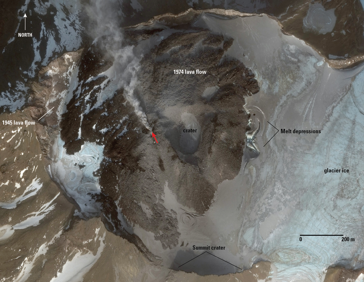 |
Figure 2. Worldview-3 satellite image of Great Sitkin on 21 November 2017 showing the crater, areas of 1974 and 1945 lava flows, and steam (indicated by the red arrow) from the reported seismic swarm and steam event ending in 2017. Photographer/Creator: Chris Waytomas; image courtesy of AVO/USGS. |
AVO had previously reported that a seismic swarm had been detected beginning in late July 2016 and continuing through December 2017. Steam from the crater was also observed during this time period, in late November 2017 (figure 2). The seismicity was characterized by earthquakes typically less than magnitude 1.0 and at depths from near the summit to 30 km below sea level. Most earthquakes were in one of two clusters, beneath the volcano's summit or just offshore the NW coast of the island. Possible explosion signals were observed in seismic data on 10 January and 21 July 2017, but no confirmed emissions were observed locally or detected in infrasound data or satellite imagery.
The most recent eruption at Great Sitkin produced a small steam explosion which was detected in seismic data at 1139 local time on 10 June 2018 (figure 3). The explosion was followed by seismic activity which began diminishing after 24 hours, and by 15-16 June had returned to background levels.
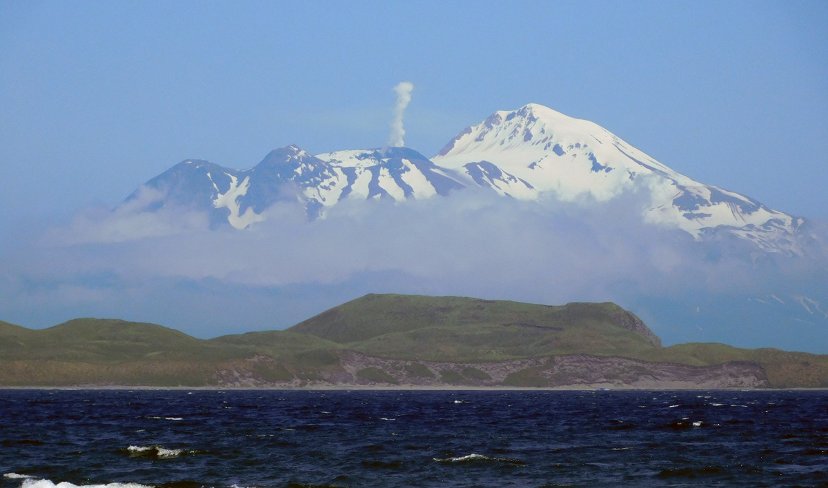 |
Figure 3. View of Great Sitkin steaming on 10 July 2018. Photographed from Adak Island, Alaska, approximately 40 km SW. Photo by Alain Beauparlant; image courtesy of AVO/USGS (color corrected). |
Due to heavy cloud cover on 10 June 2018, satellite views were obscured. Subsequent satellite data collected on 11 June showed an ash deposit on the surface of the snow extending to about 2 km SW from a vent in the summit crater (figure 4). Minor changes in the vicinity of the summit crater were observed from satellite data, including possible fumaroles north of the main crater. On 17 June an aerial photograph showed minor steaming at the vent (figure 5).
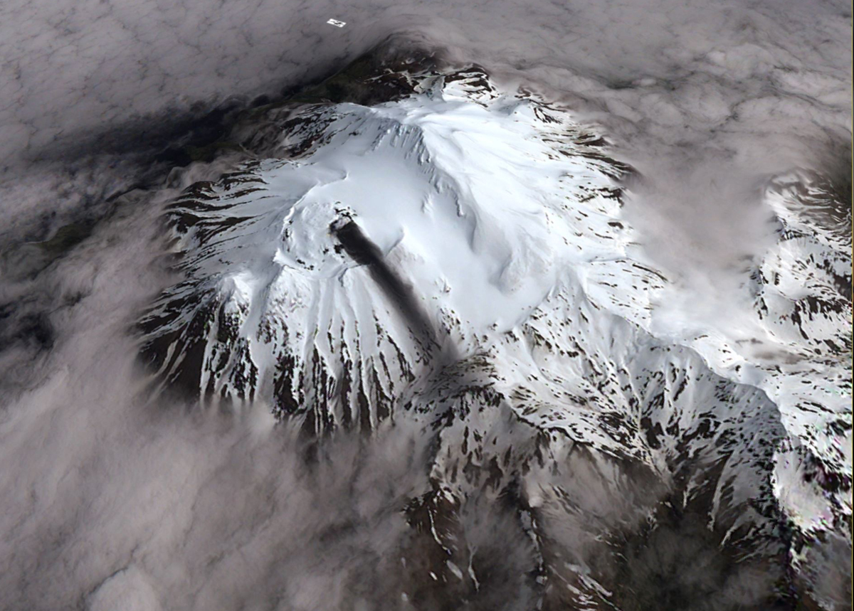 |
Figure 4. Satellite view of the Great Sitkin crater at 2300 UTC on 11 June 2018 showing an ash deposit extending for about 2 km to the SW. Ash was likely deposited during the brief explosion on 10 June 2018. Minor steaming from a vent through the 1974 lava flow is also visible in this image. View is from the southwest. Photographer/Creator: David Schneider; image courtesy of AVO/USGS. |
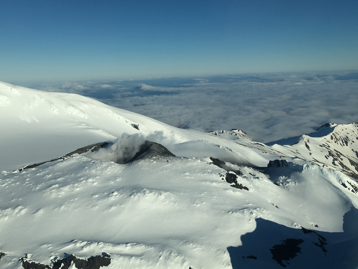 |
Figure 5. Aerial photo showing minor steaming at the summit of Great Sitkin, 17 June 2018. A small ash deposit extends SW from the vent. Photographer: Alaska Airlines Captain Dave Clum; image courtesy of AVO/USGS. |
Another small phreatic explosion was observed in seismic data at 1105 local time on 11 August. Small local earthquakes preceded the event but were not recorded following the explosion. The event is similar to three other phreatic explosions that have occurred over the past 2 years.
Information Contacts: Alaska Volcano Observatory (AVO), a cooperative program of a) U.S. Geological Survey, 4200 University Drive, Anchorage, AK 99508-4667 USA (URL: https://avo.alaska.edu/), b) Geophysical Institute, University of Alaska, PO Box 757320, Fairbanks, AK 99775-7320, USA, and c) Alaska Division of Geological & Geophysical Surveys, 794 University Ave., Suite 200, Fairbanks, AK 99709, USA (URL: http://dggs.alaska.gov/).
Small steam explosions in early June 2019
The Great Sitkin volcano is located about 40 km NE of Adak Island in the Aleutian Islands and has had a few short-lived eruptions over the past 100 years. Prior to the latest activity in early June 2019 described below, small phreatic explosions occurred in June and August 2018 (BGVN 43:09). An eruption in 1974 produced a lava dome in the center of the crater. The Alaska Volcano Observatory (AVO) is the primary source of information for this September 2018-June 2019 reporting period.
Low-level unrest occurred from September 2018 through February 2019 with slightly elevated seismic activity (figure 6). Small explosions were seismically detected by AVO on 30 October, 5 and 16 November, and 11 December 2018, but they were not seen in regional infrasound data and satellite data did not show an ash cloud.
On 1, 7, and 9 June 2019, AVO reported small steam explosions as well as slightly elevated seismic activity. Steam plumes and surficial evidence of an explosion were not observed during these events. On 18 June 2019 weakly elevated surface temperatures were recorded, field crews working on Adak observed some steam emissions, and a gas flight was conducted. Elevated concentrations of carbon dioxide detected above the lava dome were likely associated with the steam explosions earlier in the month (figures 7 and 8). From 23 June through the end of the month seismicity began to decline back to background levels.
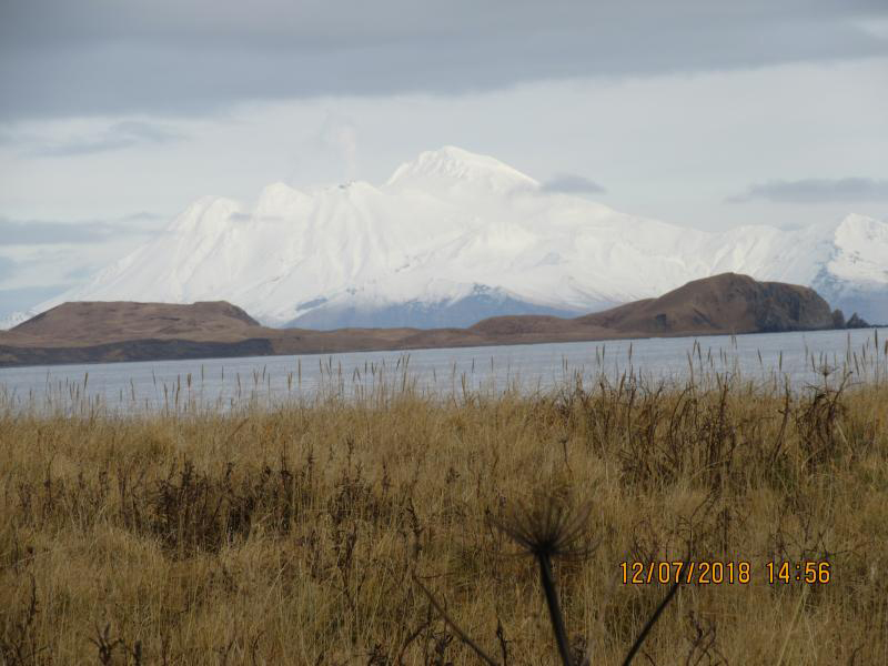 |
Figure 6. A steam plume was seen at the summit of Great Sitkin on 7 December 2018. Photo by Andy Lewis and Bob Boyd; courtesy of AVO/USGS. |
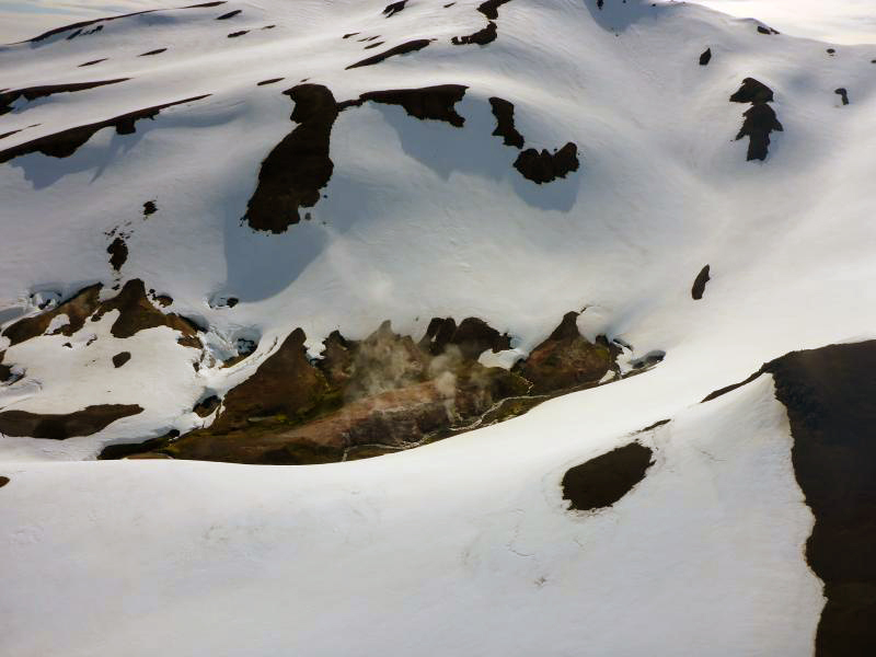 |
Figure 7. Some degassing was observed on the southern flank of the Great Sitkin during an overflight on 18 June 2019. Photo by Laura Clor; image courtesy of AVO/USGS. |
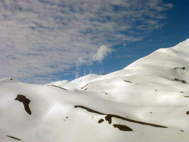 |
Figure 8. View of Great Sitkin with white plumes rising from the summit on 20 June 2019. Photo by Laura Clor, courtesy of AVO/USGS. |
Information Contacts: Alaska Volcano Observatory (AVO), a cooperative program of a) U.S. Geological Survey, 4200 University Drive, Anchorage, AK 99508-4667 USA (URL: https://avo.alaska.edu/), b) Geophysical Institute, University of Alaska, PO Box 757320, Fairbanks, AK 99775-7320, USA, and c) Alaska Division of Geological & Geophysical Surveys, 794 University Ave., Suite 200, Fairbanks, AK 99709, USA (URL: http://dggs.alaska.gov/).
Explosion on 25 May 2021 and new summit crater lava dome in July 2021
No major eruption has occurred at Great Sitkin since 1974, but intermittent steam emissions and small steam explosions, accompanied by slightly elevated seismicity, were observed during July 2016-December 2017, and most recently during June-December 2018 and in June 2019 (BGVN 43:09, 44:07). The volcano, located in the Aleutian Islands (figure 9) is monitored by the Alaska Volcano Observatory (AVO) using local real-time seismic and infrasound sensors, satellite data, web cameras, and remote infrasound and lightning networks. Events from July 2019 through July 2021 are summarized in this report.
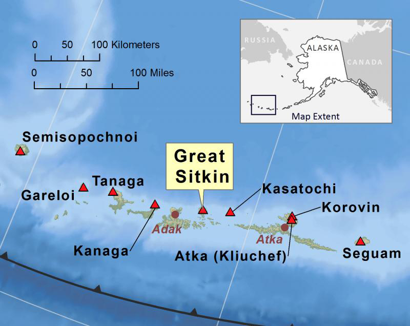 |
Figure 9. Location map showing Great Sitkin and other nearby volcanoes in the Aleutian Islands. Courtesy of AVO. |
On 15 July 2019, AVO reported that the seismicity recorded in June 2019 had decreased to background levels over the previous few weeks, with no evidence of eruptive activity in geophysical or satellite data. The Aviation Color Code (ACC) was lowered to Green and the Volcano Alert Level (VAL) was lowered to Normal. On 26 February 2020 AVO noted that seismicity had increased during the previous month, but by 21 October it had returned to background levels and no eruptive activity or unusual surface temperatures had been observed in satellite images. A Volcano Observatory Notice for Aviation on 13 May 2021 noted that elevated surface temperatures identified by AVO in satellite images since January had increased in frequency during the previous two months. A minor increase in seismicity began on 9 May and volcanic gas emissions increased on 10 May.
An increase in local earthquakes during 24-25 May prompted AVO to raise the ACC to Orange and the VAL to Watch. An explosive eruption began on 25 May at 2104; the ACC and the VAL were raised to Red/Warning, respectively. The explosions lasted for 1-2 minutes and produced an ash plume that rose to an altitude of 4.6 km (figures 10 and 11). Witnesses 42 km away heard “a very loud explosion.” After the explosive period, seismicity decreased and satellite image images showed a detached plume drifting E. Around mid-morning on 26 May, AVO lowered the ACC and VAL to Orange/Watch, respectively.
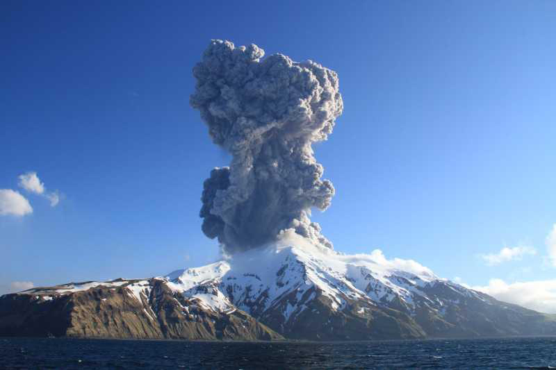 |
Figure 10. Eruption plume of Great Sitkin on 25 May 2021 at 2106 (local time) as seen from the RV Tiglax. Courtesy of Lauren Flynn (U.S. Fish and Wildlife Service). |
Seismicity was low on 27 May 2021 and satellite images showed only minor steaming along with slightly elevated surface temperatures. Seismicity remained low through 1 June; moderately elevated surface temperatures were detected during 29-30 May. Aerial images on 30 May and 6 June showed ash deposits from the 25 May explosion (figure 11).
 |
Figure 11. Two aerial images of the summit crater of Great Sitkin from different angles, one taken on 30 May 2021 at 1745 (top) and the other taken on 6 June 2021 (bottom). According to AVO, the black deposit in the summit crater is likely fresh ash deposits from the 25 May explosion. The black linear feature trailing down the flank in the middle foreground is a lahar (mudflow) deposit. Minor ashfall can be observed on the right flank. Courtesy of Steve Rhodes (AVO) (top) and Max Zelenevich (bottom). |
According to AVO, a satellite image acquired at 0932 on 22 July 2021 showed a small area of uplift, about 50 m in diameter, and elevated surface temperatures associated with this feature. A Sentinel-2 satellite image suggested that the elevated surface temperature had begun on 12 July or earlier (figure 12). A 26 July satellite image confirmed that the feature was a lava dome that it had grown to 130 m in diameter (figure 13). Seismic data suggested that the dome probably emerged sometime during 14-22 July. Unrest continued during 26-31 July, with small earthquakes but no explosive activity. Elevated surface temperatures were detected on 27 and 28 July, and on 28 July a steam plume was observed drifting N in satellite imagery.
 |
Figure 12. Sentinel-2 satellite image of Great Sitkin in false color (bands 12, 11, 4) on 12 July 2021, showing a hot spot in the summit crater with a gas emission. Courtesy of Sentinel Hub Playground. |
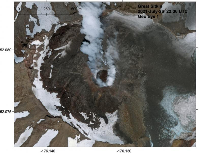 |
Figure 13. GeoEye-1 satellite image of Great Sitkin showing the new circular lava dome in the summit crater on 26 July 2021. Courtesy of AVO. |
Information Contacts: Alaska Volcano Observatory (AVO), a cooperative program of a) U.S. Geological Survey, 4200 University Drive, Anchorage, AK 99508-4667 USA (URL: https://avo.alaska.edu/), b) Geophysical Institute, University of Alaska, PO Box 757320, Fairbanks, AK 99775-7320, USA, and c) Alaska Division of Geological & Geophysical Surveys, 794 University Ave., Suite 200, Fairbanks, AK 99709, USA (URL: http://dggs.alaska.gov/); Sentinel Hub Playground (URL: https://www.sentinel-hub.com/explore/sentinel-playground).
Continuing dome growth and lava effusion through April 2022
Great Sitkin, in the Aleutian island arc, has had only a single ash explosion since 1974, on 25 May 2021. During mid-July 2021, a lava dome began to grow in the summit crater, accompanied by elevated surface temperatures (BGVN 46:08). The volcano is monitored by the Alaska Volcano Observatory (AVO) using local seismic and infrasound sensors, satellite data, web cameras, and remote infrasound and lightning networks. The current report summarizes activity during August 2021-April 2022, during which time the lava dome continued to grow and discharge lava.
AVO reported that unrest continued during the reporting period. During the first week of August 2021, the circular lava dome had grown to 180 m in diameter, based on measurements taken using a 3 August satellite image, and had an approximate volume of 1 million cubic meters. During the morning of 5 August observers on Adak Island, 30 km SW, reported possible low-level lava fountaining from the active vent (figure 14). Throughout August, the lava dome remained active, growing in diameter from 250 m on 6 August, to 380 m three days later, 700 m by 16 August, 850-860 m by 21 August, and 1,090 m by 29 August (figure 15). The growing dome fueled lava discharges, numerous small earthquakes, and weak explosions. In addition, steam-and-gas plumes and emissions were periodically observed (figure 3). Based on satellite images, the crater’s surface temperature remained elevated throughout the reporting period. Cloudy conditions often prevented webcam and satellite views.
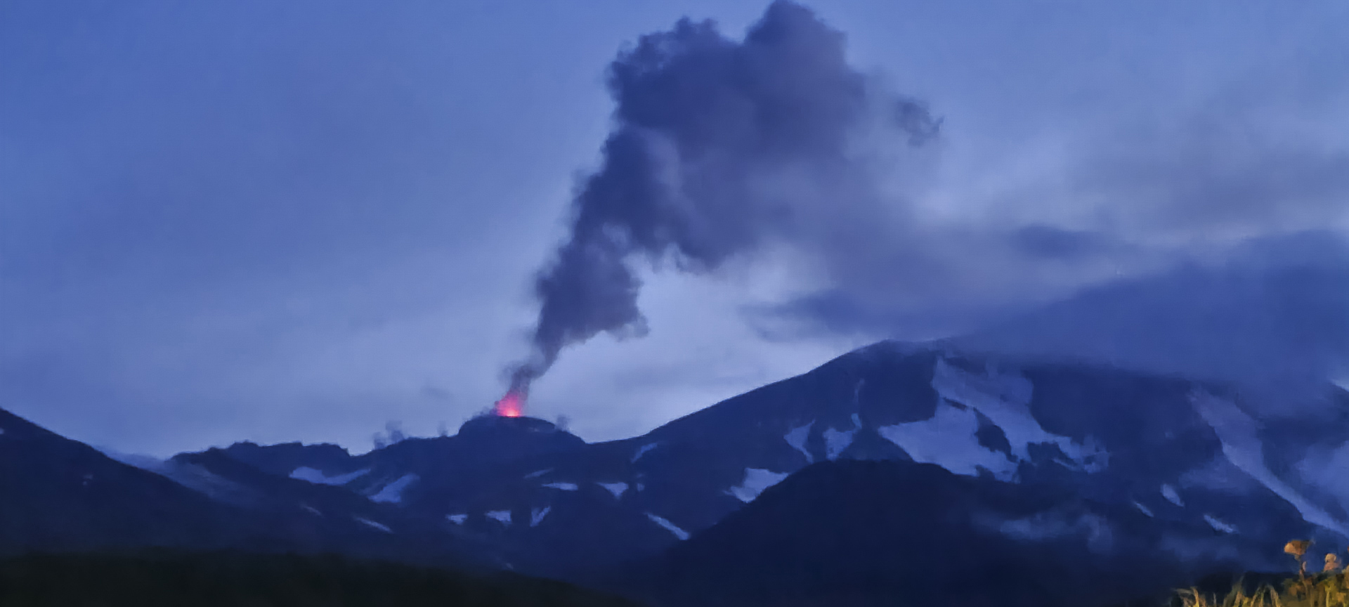 |
Figure 14. Photo of an active lava fountain at Great Sitkin at 0714 on 5 August 2021 as seen looking N from Adak Island. Photo by Peggy Kruse (AVO image 175201). |
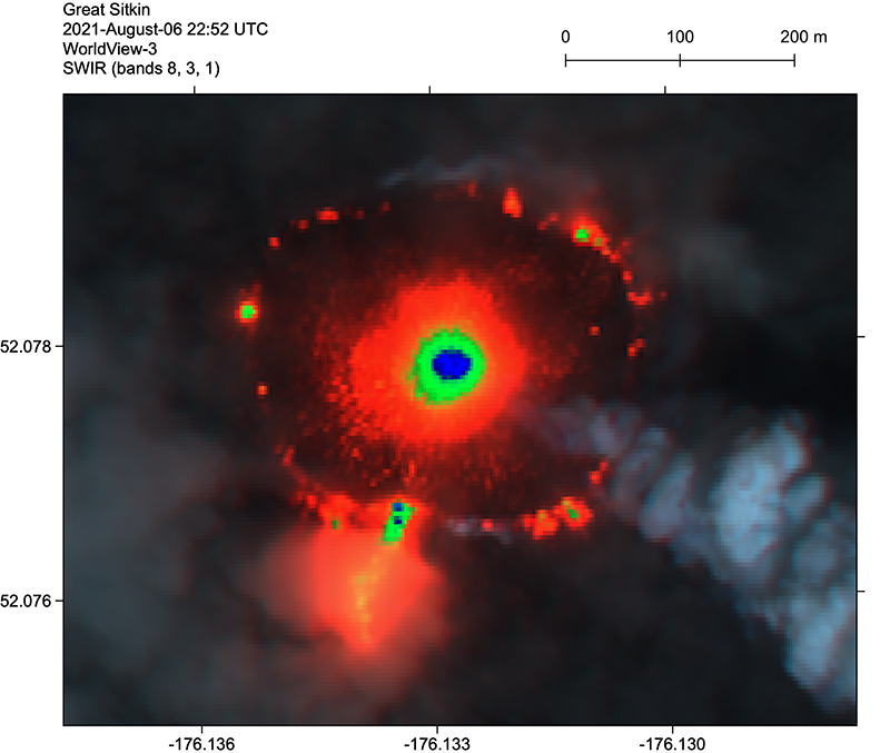 |
Figure 15. Lava dome growing on Great Sitkin on 6 August 2021, in a short-wave infrared (SWIR) false-color WorldView-3 satellite image. A lava tube breakout ~100 m long is visible through steam on the SSW margin. Courtesy of AVO (AVO image 175371). |
 |
Figure 16. Photo showing a steam plume rising from the dome at Great Sitkin at 0720 on 10 August 2021. Photo by Peggy Kruse (AVO image 175491). |
During September, seismicity remained elevated and was characterized by small earthquakes consistent with lava effusion. By mid-September, the edges of the dome touched the S and W rims of the crater, and lava began to advance though a gap in the S rim of the summit crater. By 24 September the dome had overtopped the S and W crater rims and lava flowed 305 m down the S flank and 195 m down the W flank. The dome was about 25 m thick and had grown to 1,170 m E to W and 925 m N to S in dimension.
By 3 October the dome had grown to 1,200 m E-W and 1,000 m N-S. Lava flows continued to advance down the S and SW flanks and were about 300-350 m long (figure 17). The SW lobe was descending two drainages and produced hot avalanches that traveled 450 m downslope on top of a snow field. Satellite images acquired on 11 October showed that lava filled more than half of the summit crater, flowing onto the S and W flanks, and had recently reached the N crater rim. Lava had traveled 330 m down the S flank, 350 m down the W flank, descended small valleys, and in some areas, advanced over snow and ice. Blocks that had detached from the end of the W flow descended 450 m. Analysis of satellite imagery on 25 October showed that the lava dome covered an area greater than 1 km2 and had overflowed the crater rim to the N, W, and S (figure 18). Elevated surface temperatures identified in satellite images during 25-26 October clearly showed the vent location (figure 19). By 30 October the lava had advanced about 680 m down the W flank, 560 m down the S flank, and 90 m down the N flank. During the latter part of October, seismicity remained slightly elevated and no explosions were recorded.
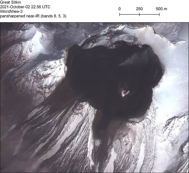 |
Figure 17. A pansharpened near-infrared WorldView-3 satellite image of Great Sitkin on 2 October 2021, showing lava flows and a small steam plume. Courtesy of AVO (AVO image 178461). |
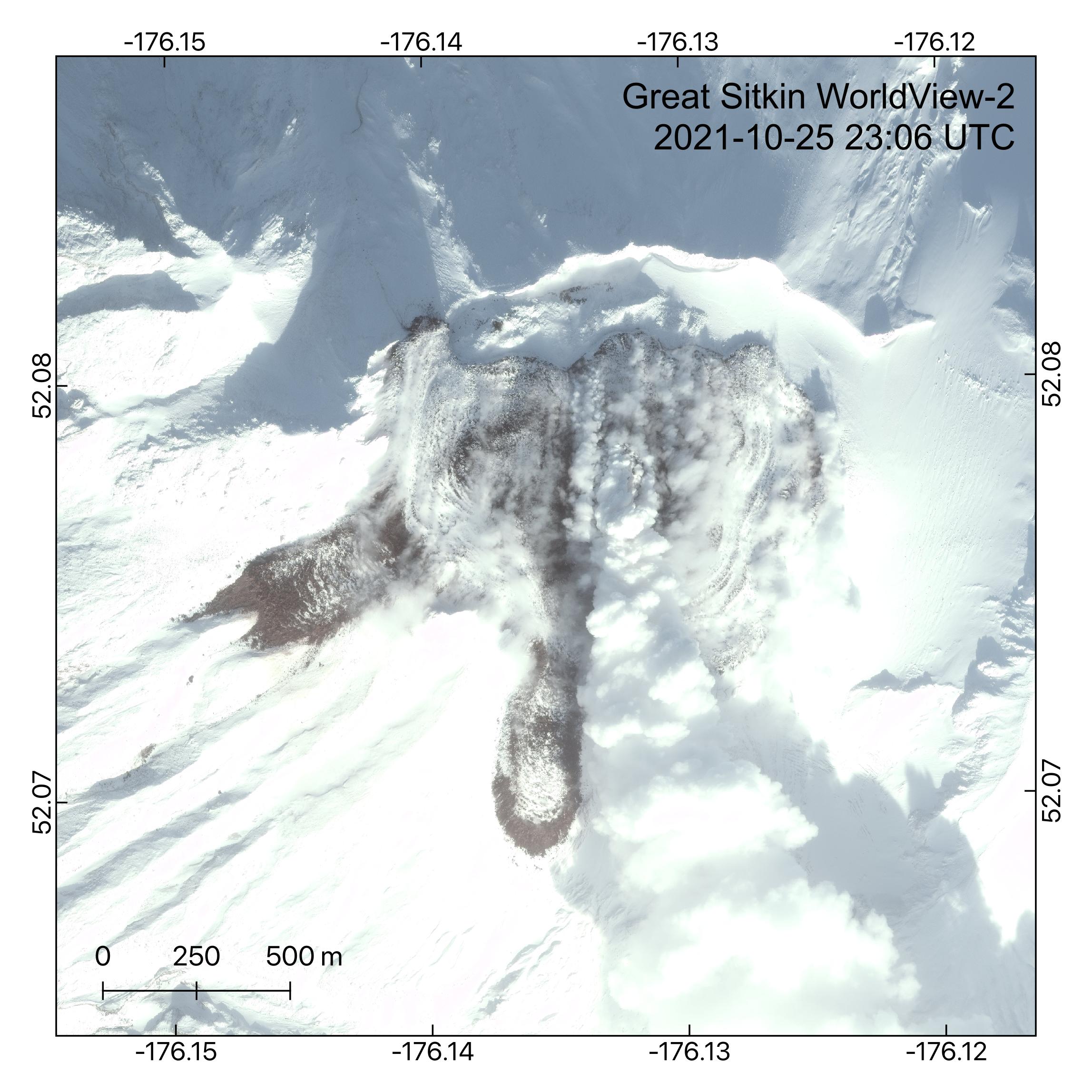 |
Figure 18. A visible WorldView-2 satellite image of Great Sitkin on 25 October 2021 shows the growing lava dome in the summit crater. At this point the dome covered an area greater than 1 km2 and had overflowed the crater rim to the N, W, and S. A steam plume can be seen extendings from the active vent region to the S. Courtesy of AVO (AVO image 178581). |
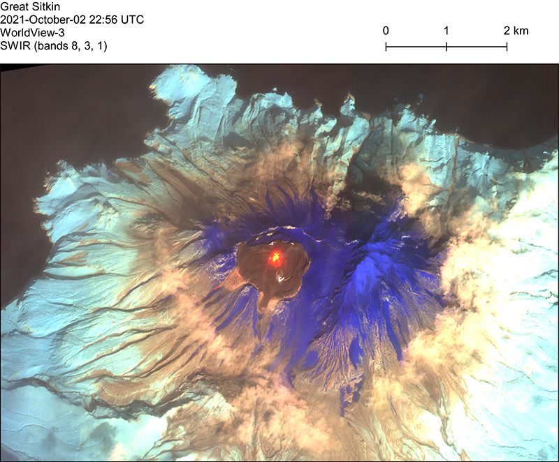 |
Figure 19. A short-wave infrared WorldView-3 satellite image of Great Sitkin on 25 October 2021. Red-orange areas represent high-temperature lava, purple is snow, light blue is vegetation, and browns to blacks are rock. Courtesy of AVO (AVO image 178481). |
By mid-November the lava flows on the N and W flanks had not progressed, but the S-flank flow had advanced to 650 m. According to AVO, satellite images acquired on 23 November showed that slow lava effusion continued. Lava continued to fill the summit crater and the flows on the flanks advanced short distances. During 24-30 November seismicity remained slightly above background levels. Elevated surface temperatures were periodically detected. Steam emissions were sometimes visible in webcam images. Slow lava effusion continued during December, and seismicity was very low, but persistent. A radar image acquired during 14-15 December showed a growing flow field with lava lobes advancing down the N, W, and S flanks. Crater surface temperatures remained elevated.
Based on AVO reports, activity continued to decrease during January-April 2022. Slow lava effusion continued during this period, along with very low but persistent seismicity (figure 20). Crater surface temperatures remained slightly elevated, and occasional steam emissions were observed. Lava flows continued to advance, and by mid-February lava flows had reached 1,050 m, 930 m, and 220 m down the S, W, and N flanks, respectively. Lava flows were also active on the SSW flank. An AVO report in March indicated that snow covered most of the flow except for the advancing fronts of the lava lobes and around the vent area. During the first week of April lava flows on the S, W, and N flanks advanced up to 10 m; elevated surface temperatures identified in satellite images during 8-10 April indicated continuing effusion. Steaming from the vent and flow field was occasionally seen in satellite images.
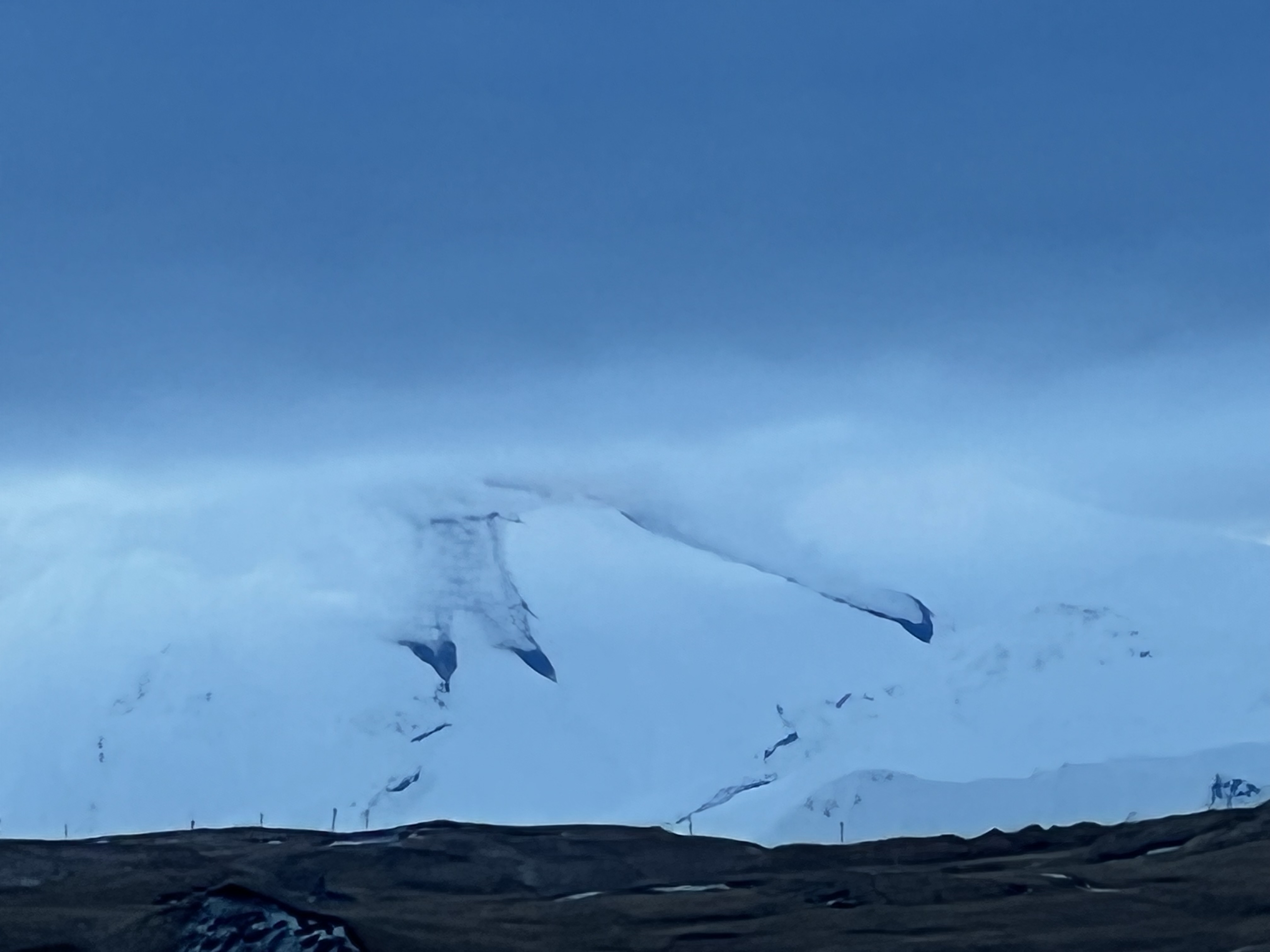 |
Figure 20. Photo of Great Sitkin taken from Adak Island on 14 January 2022 showing steam rising lava flows advancing through snow on the flanks. Photo by Steve Skeehan (AVO image 181451). |
Information Contacts: Alaska Volcano Observatory (AVO), a cooperative program of a) U.S. Geological Survey, 4200 University Drive, Anchorage, AK 99508-4667 USA (URL: https://avo.alaska.edu/), b) Geophysical Institute, University of Alaska, PO Box 757320, Fairbanks, AK 99775-7320, USA, and c) Alaska Division of Geological & Geophysical Surveys, 794 University Ave., Suite 200, Fairbanks, AK 99709, USA (URL: http://dggs.alaska.gov/); Sentinel Hub Playground (URL: https://www.sentinel-hub.com/explore/sentinel-playground); MIROVA (Middle InfraRed Observation of Volcanic Activity), a collaborative project between the Universities of Turin and Florence (Italy) supported by the Centre for Volcanic Risk of the Italian Civil Protection Department (URL: http://www.mirovaweb.it/); Hawai'i Institute of Geophysics and Planetology (HIGP) - MODVOLC Thermal Alerts System, School of Ocean and Earth Science and Technology (SOEST), Univ. of Hawai'i, 2525 Correa Road, Honolulu, HI 96822, USA (URL: http://modis.higp.hawaii.edu/).
Slow lava effusion continued during May-October 2022
After an ash explosion in 1974, the only confirmed volcanic activity at Great Sitkin through 2019 included small phreatic eruptions in June and August 2018 and June 2019, and an ash explosion on 25 May 2019 (BGVN 43:09, 44:07, 46:08). During mid-July 2021 a lava dome began to grow in the summit crater and effuse lava, which soon overtopped the summit crater wall and flowed down the N, S, and W flanks (BGVN 46:08, 47:05). This activity waned during January-April 2022, although slow lava effusion continued. The current report updates activity during May-October 2022. Great Sitkin, located in Alaska’s Aleutian Island chain, is monitored by the Alaska Volcano Observatory (AVO) using local seismic and infrasound sensors, satellite data, web cameras, and remote infrasound and lightning networks.
AVO reported that the slow lava effusion from a vent in the summit crater likely continued during May-October 2022 (figure 21). Satellite images showed that the flank flow had advanced 15 m S by the first week of May, and 15 m E by 1 July. During July through the first part of September the lava flow thickened around the vent in the summit crater, but did not advance. At the beginning of September the lava flow continued to thicken but also began to expand slowly within the summit crater, but not on the flanks; this slow expansion continued through October to the S and E. Consistent with the lava effusion, satellite data indicated that surface temperatures were elevated. During the reporting period, steam emissions were occasionally visible.
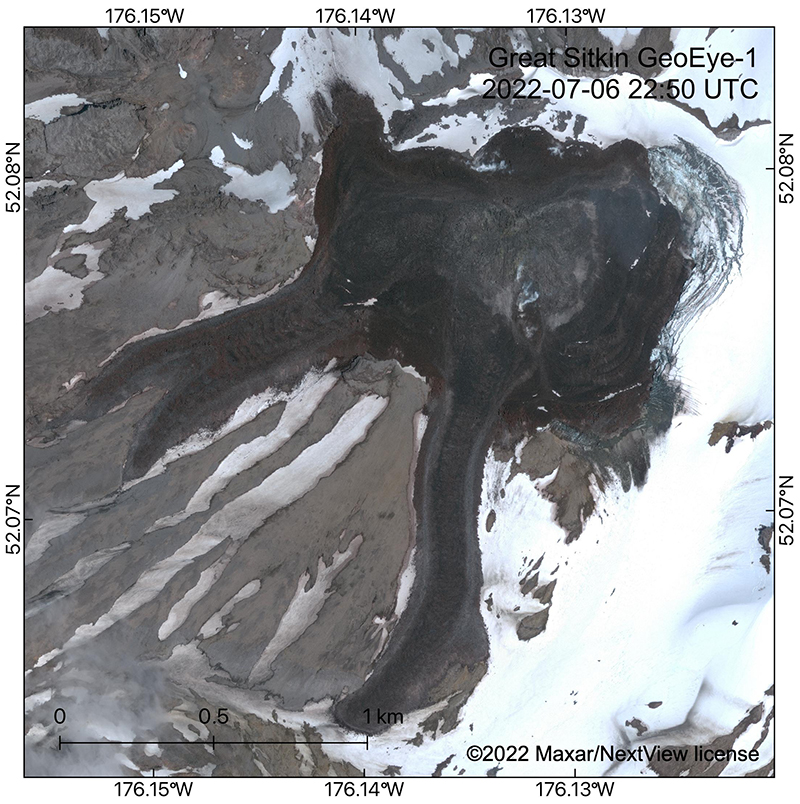 |
Figure 21. GeoEye-1 satellite image showing the lava flow field in Great Sitkin’s summit crater and upper flanks on 6 July 2022. The image shows that the slow lava effusion has flowed to the NE into the summit glacier, which is collapsing (see concentric curved crevasses) from melting due to lava interaction. Courtesy of Hannah Dietterich, AVO. |
Sentinel-2 infrared images confirmed that lava effusion continued through September 2022, with either one or two distinct hotspots (figure 22). Weather clouds obscured satellite observations on most viewing days. The MIROVA (Middle InfraRed Observation of Volcanic Activity) volcano hotspot detection system recorded seven brief discrete pulses of 4-7 hotspots each in the summit crater during May-October 2022 (figure 23).
 |
Figure 22. Sentinel-2 image of Great Sitkin showing two hotspots within the summit crater on 21 August 2022. Images taken with “Atmospheric penetration” rendering (bands 12, 11, 8A). Courtesy of Sentinel Hub Playground. |
 |
Figure 23. Thermal anomalies at Great Sitkin during the year ending 19 October 2022, seen on a MIROVA graph of log radiative power. A pattern of brief pulses of thermal anomalies are evident during May-October 2022. Courtesy of MIROVA. |
Seismic activity remained at low levels throughout; occasional local earthquakes were recorded. The Volcano Alert Level remained at Watch (the second highest level on a four-level scale) and the Aviation Color Code remained at Orange (the second highest level on a four-color scale).
Information Contacts: Alaska Volcano Observatory (AVO), a cooperative program of a) U.S. Geological Survey, 4200 University Drive, Anchorage, AK 99508-4667 USA (URL: https://avo.alaska.edu/), b) Geophysical Institute, University of Alaska, PO Box 757320, Fairbanks, AK 99775-7320, USA, and c) Alaska Division of Geological & Geophysical Surveys, 794 University Ave., Suite 200, Fairbanks, AK 99709, USA (URL: http://dggs.alaska.gov/); Sentinel Hub Playground (URL: https://www.sentinel-hub.com/explore/sentinel-playground); MIROVA (Middle InfraRed Observation of Volcanic Activity), a collaborative project between the Universities of Turin and Florence (Italy) supported by the Centre for Volcanic Risk of the Italian Civil Protection Department (URL: http://www.mirovaweb.it/).
Continued slow lava effusion in the summit crater during November 2022-April 2023
Following minor explosive activity at Great Sitkin in June-August 2018 and June 2019, the first eruptions since 1974, an ash explosion on 25 May 2021 preceded the growth of a lava dome in the summit crater starting in mid-July. Continued lava effusion overtopped the summit crater wall and flowed down the N, S, and W flanks (BGVN 46:08, 47:05). This activity waned during January-April 2022, although slow lava effusion continued through October 2022. Since 23 July 2021, the Volcano Alert Level has remained at Watch (the second highest on a four-level scale) and the Aviation Color Code remained at Orange (the second highest on a four-color scale). This volcano in the central Aleutian Islands is monitored by the Alaska Volcano Observatory (AVO) using local seismic and infrasound sensors, satellite data, web cameras, and remote infrasound and lightning networks.
AVO reported that slow lava effusion within the summit crater, centered about 1.5 km E of the peak and 300 m lower, continued during November 2022-April 2023. Weather clouds usually obscured satellite and webcam observations. Elevated surface temperatures were sometimes identified in satellite images, and occasional steam plumes were observed rising from the lava flow. Seismicity was low with occasional detection of weak earthquakes.
By the end of the first week of November (figure 24), the flow field had extended more than 600 m E and about 430 m S from the vent into the remaining crater icefield. By the end of November, satellite images showed that the lobes had advanced an additional 25-30 m along the S edge of the flow field and about 15 m SE. The E lobe continued to advance slowly during December-April, while a smaller lobe to the S advanced towards the crater rim, burying an earlier lava flow. A satellite radar image on 2 April showed that the lava flow was primarily expanding E and more slowly S into the summit crater ice field, as seen in visual imagery on 5 April (figure 25).
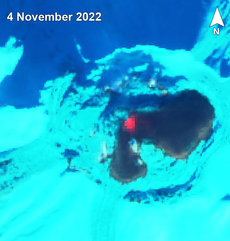 |
Figure 24. Sentinel-2 satellite image of Great Sitkin on 4 November 2022 showing a hotspot and cooled lava flows from July 2021-June 2022 in the summit crater; the peak is to the right. Image uses “Geology” rendering (bands 12, 4, 2). Courtesy of Sentinel Hub Playground. |
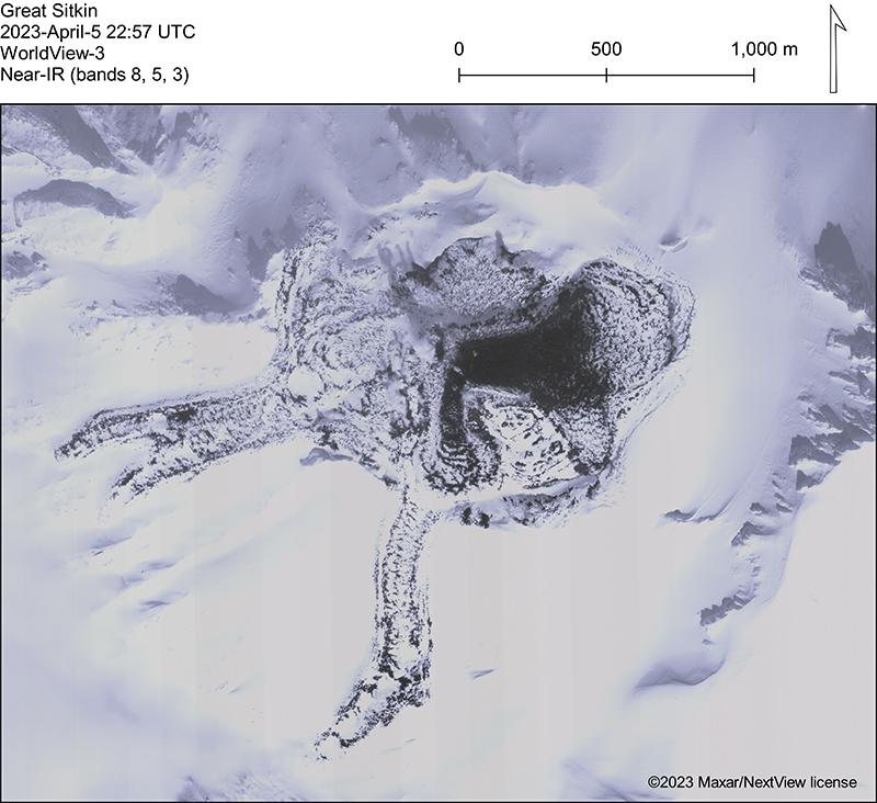 |
Figure 25. WorldView-3 near-IR satellite image of Great Sitkin on 5 April 2023. The lava flows from July 2021-June 2022 are partially snow-covered while the dark area is a more recent overtopping flow. Courtesy of Mathew Loewen, AVO. |
Information Contacts: Alaska Volcano Observatory (AVO), a cooperative program of a) U.S. Geological Survey, 4200 University Drive, Anchorage, AK 99508-4667 USA (URL: https://avo.alaska.edu/), b) Geophysical Institute, University of Alaska, PO Box 757320, Fairbanks, AK 99775-7320, USA, and c) Alaska Division of Geological & Geophysical Surveys, 794 University Ave., Suite 200, Fairbanks, AK 99709, USA (URL: http://dggs.alaska.gov/); Sentinel Hub Playground (URL: https://www.sentinel-hub.com/explore/sentinel-playground).
Slow lava effusion in summit crater continued during May-October 2023
Following weak phreatic explosions at Great Sitkin in June-August 2018 and June 2019, an ash explosion on 25 May 2021 preceded the growth of a lava dome in the summit crater starting in mid-July 2021. Continued lava effusion overtopped the summit crater wall; lava flowed down the N, S, and W flanks (BGVN 46:08, 47:05). This activity subsided during January-April 2022, although slow lava effusion, accompanied by minor steam-and-gas emissions and weak seismicity, continued through April 2023 (BGVN 48:05). Great Sitkin (figure 26), located in Alaska’s Aleutian Island chain, is monitored by the Alaska Volcano Observatory (AVO) using local seismic and infrasound sensors, satellite data, web cameras, and remote infrasound and lightning networks.
|
Figure 26. Sentinel-2 satellite image of Great Sitkin Island on 6 June 2023. The width of the dark lava-covered crater area is about 1.2 km. Image rendered with highlight-optimized natural color (bands 4, 3, 2). Courtesy of Copernicus Browser. |
According to AVO, the slow, persistent, thick lava effusion continued during May-October 2023, expanding E into glacial ice but remaining confined to the summit crater. This activity was accompanied by weak seismic activity, minor steam emissions, and slightly elevated temperatures consistent with cooling lava. Weather clouds frequently obscured visibility. During the first week of September, an AVO field geology team visited the volcano and sampled the lava flow, did aerial photography (figures 27 and 28) and thermal imaging surveys, and measured gas emissions. The team observed that the flows were warm and steaming (figure 29), moving about 1 m every 3-4 days.
|
Figure 27. Aerial photo of Great Sitkin taken during a helicopter overflight on 1 September 2023, looking W at the active lava flows in the crater. The currently active lobe of the flow field is visible moving into the crater ice field on the lower left side of the image. Photo by Matt Loewen, courtesy of AVO. |
|
Figure 28. Aerial photo of Great Sitkin taken during a helicopter overflight on 3 September 2023, looking NE at the active lava flows in the crater. Photo by Matt Loewen, courtesy of AVO. |
|
Figure 29. Ground photo of the active blocky lava flow field at Great Sitkin taken during fieldwork on 1 September 2023. Photo is looking towards the vent region and main degassing source on the lava flow. Photo by Matt Loewen, courtesy of AVO. |
Information Contacts: Alaska Volcano Observatory (AVO), a cooperative program of a) U.S. Geological Survey, 4200 University Drive, Anchorage, AK 99508-4667 USA (URL: https://avo.alaska.edu/), b) Geophysical Institute, University of Alaska, PO Box 757320, Fairbanks, AK 99775-7320, USA, and c) Alaska Division of Geological & Geophysical Surveys, 794 University Ave., Suite 200, Fairbanks, AK 99709, USA (URL: http://dggs.alaska.gov/); Copernicus Browser (URL: https://dataspace.copernicus.eu/browser).
|
|
||||||||||||||||||||||||||||
There is data available for 9 confirmed eruptive periods.
2021 May 25 - 2025 Dec 17 (continuing) Confirmed Eruption (Explosive / Effusive) VEI: 2
| Episode 1 | Eruption (Explosive / Effusive) | |||||||||||||||||||||||||||||||||||||||
|---|---|---|---|---|---|---|---|---|---|---|---|---|---|---|---|---|---|---|---|---|---|---|---|---|---|---|---|---|---|---|---|---|---|---|---|---|---|---|---|
| 2021 May 25 - 2025 Dec 17 (continuing) | Evidence from Observations: Reported | ||||||||||||||||||||||||||||||||||||||
| An explosive eruption began at 2104 on 25 May that lasted for 1-2 minutes and produced an ash plume rising to 4.6 km that was observed by local mariners. Witnesses 42 km away heard “a very loud explosion.” | |||||||||||||||||||||||||||||||||||||||
|
List of 6 Events for Episode 1
|
|||||||||||||||||||||||||||||||||||||||
2019 Jun 1 - 2019 Jun 7 Confirmed Eruption (Explosive / Effusive) VEI: 1
| Episode 1 | Eruption (Explosive / Effusive) | ||||||||||||||
|---|---|---|---|---|---|---|---|---|---|---|---|---|---|---|
| 2019 Jun 1 - 2019 Jun 7 | Evidence from Observations: Reported | |||||||||||||
|
List of 1 Events for Episode 1
|
||||||||||||||
2018 Jun 10 - 2018 Aug 11 Confirmed Eruption (Explosive / Effusive) VEI: 1
| Episode 1 | Eruption (Explosive / Effusive) | Summit crater | |||||||||||||||||||||||||||||||||||||||||||
|---|---|---|---|---|---|---|---|---|---|---|---|---|---|---|---|---|---|---|---|---|---|---|---|---|---|---|---|---|---|---|---|---|---|---|---|---|---|---|---|---|---|---|---|---|
| 2018 Jun 10 - 2018 Aug 11 | Evidence from Observations: Reported | |||||||||||||||||||||||||||||||||||||||||||
|
List of 7 Events for Episode 1 at Summit crater
|
||||||||||||||||||||||||||||||||||||||||||||
[ 1987 Mar 18 ] Uncertain Eruption
| Episode 1 | Eruption (Explosive / Effusive) | ||||||||||||||
|---|---|---|---|---|---|---|---|---|---|---|---|---|---|---|
| 1987 Mar 18 - Unknown | Evidence from Unknown | |||||||||||||
|
List of 1 Events for Episode 1
|
||||||||||||||
1974 Feb 19 - 1974 Sep 16 ± 15 days Confirmed Eruption (Explosive / Effusive) VEI: 2
| Episode 1 | Eruption (Explosive / Effusive) | |||||||||||||||||||||||||||||||||||||||
|---|---|---|---|---|---|---|---|---|---|---|---|---|---|---|---|---|---|---|---|---|---|---|---|---|---|---|---|---|---|---|---|---|---|---|---|---|---|---|---|
| 1974 Feb 19 - 1974 Sep 16 ± 15 days | Evidence from Observations: Reported | ||||||||||||||||||||||||||||||||||||||
|
List of 6 Events for Episode 1
|
|||||||||||||||||||||||||||||||||||||||
[ 1953 May 11 - 1953 May 14 ] Discredited Eruption
1950 Nov 5 - 1950 Nov 29 Confirmed Eruption (Explosive / Effusive)
| Episode 1 | Eruption (Explosive / Effusive) | ||||||||||||||||||||||||
|---|---|---|---|---|---|---|---|---|---|---|---|---|---|---|---|---|---|---|---|---|---|---|---|---|
| 1950 Nov 5 - 1950 Nov 29 | Evidence from Observations: Reported | |||||||||||||||||||||||
|
List of 3 Events for Episode 1
|
||||||||||||||||||||||||
1949 Dec 30 - 1950 Jan 7 Confirmed Eruption (Explosive / Effusive) VEI: 1
| Episode 1 | Eruption (Explosive / Effusive) | ||||||||||||||||||||||||
|---|---|---|---|---|---|---|---|---|---|---|---|---|---|---|---|---|---|---|---|---|---|---|---|---|
| 1949 Dec 30 - 1950 Jan 7 | Evidence from Observations: Reported | |||||||||||||||||||||||
|
List of 3 Events for Episode 1
|
||||||||||||||||||||||||
[ 1946 Aug 14 ] Uncertain Eruption
| Episode 1 | Eruption (Explosive / Effusive) | ||||||||||||||
|---|---|---|---|---|---|---|---|---|---|---|---|---|---|---|
| 1946 Aug 14 - Unknown | Evidence from Unknown | |||||||||||||
|
List of 1 Events for Episode 1
|
||||||||||||||
1945 Mar Confirmed Eruption (Explosive / Effusive) VEI: 2
| Episode 1 | Eruption (Explosive / Effusive) | ||||||||||||||||||||||||||||||||||
|---|---|---|---|---|---|---|---|---|---|---|---|---|---|---|---|---|---|---|---|---|---|---|---|---|---|---|---|---|---|---|---|---|---|---|
| 1945 Mar - Unknown | Evidence from Observations: Reported | |||||||||||||||||||||||||||||||||
|
List of 5 Events for Episode 1
|
||||||||||||||||||||||||||||||||||
1933 Nov Confirmed Eruption (Explosive / Effusive) VEI: 2
| Episode 1 | Eruption (Explosive / Effusive) | |||||||||||||||||||
|---|---|---|---|---|---|---|---|---|---|---|---|---|---|---|---|---|---|---|---|
| 1933 Nov - Unknown | Evidence from Observations: Reported | ||||||||||||||||||
|
List of 2 Events for Episode 1
|
|||||||||||||||||||
[ 1904 ] Uncertain Eruption
| Episode 1 | Eruption (Explosive / Effusive) | ||||||||||||||
|---|---|---|---|---|---|---|---|---|---|---|---|---|---|---|
| 1904 - Unknown | Evidence from Unknown | |||||||||||||
|
List of 1 Events for Episode 1
|
||||||||||||||
[ 1829 ] Uncertain Eruption
| Episode 1 | Eruption (Explosive / Effusive) | ||||||||||||||
|---|---|---|---|---|---|---|---|---|---|---|---|---|---|---|
| 1829 - Unknown | Evidence from Unknown | |||||||||||||
|
List of 1 Events for Episode 1
|
||||||||||||||
[ 1828 ] Uncertain Eruption
| Episode 1 | Eruption (Explosive / Effusive) | ||||||||||||||
|---|---|---|---|---|---|---|---|---|---|---|---|---|---|---|
| 1828 - Unknown | Evidence from Unknown | |||||||||||||
|
List of 1 Events for Episode 1
|
||||||||||||||
1792 May 26 ± 5 days Confirmed Eruption (Explosive / Effusive)
| Episode 1 | Eruption (Explosive / Effusive) | |||||||||||||||||||
|---|---|---|---|---|---|---|---|---|---|---|---|---|---|---|---|---|---|---|---|
| 1792 May 26 ± 5 days - Unknown | Evidence from Observations: Reported | ||||||||||||||||||
|
List of 2 Events for Episode 1
|
|||||||||||||||||||
[ 1784 ] Uncertain Eruption
| Episode 1 | Eruption (Explosive / Effusive) | ||||||||||||||
|---|---|---|---|---|---|---|---|---|---|---|---|---|---|---|
| 1784 - Unknown | Evidence from Unknown | |||||||||||||
|
List of 1 Events for Episode 1
|
||||||||||||||
[ 1760 ] Uncertain Eruption
| Episode 1 | Eruption (Explosive / Effusive) | ||||
|---|---|---|---|---|
| 1760 - Unknown | Evidence from Unknown | |||
This compilation of synonyms and subsidiary features may not be comprehensive. Features are organized into four major categories: Cones, Craters, Domes, and Thermal Features. Synonyms of features appear indented below the primary name. In some cases additional feature type, elevation, or location details are provided.
Synonyms |
| Great Sitchin | Sitchin | Chetkin | Belaya | Bolshoi Sitkin |
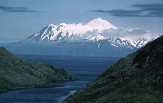 Great Sitkin in the Andreanof Islands is seen here from Finger Bay on Adak Island. The edifice was constructed within a caldera, part of which forms the high snow-covered peak to the right. The post-caldera cone contains a 0.8 x 1.2 km ice-filled summit crater. The rim forms the irregular summit on the left horizon. A lava dome 400-600 m wide was emplaced through a glacier in 1945.
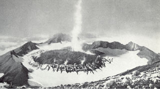 This September 1946 photo of Great Sitkin from the E rim of the summit crater shows a plume rising above a lava dome emplaced in the crater in March 1945. The fissures in the ice were produced as the dome grew through the summit glacier.
There are no samples for Great Sitkin in the Smithsonian's NMNH Department of Mineral Sciences Rock and Ore collection.
| Alaska Volcano Observatory (Link to Great Sitkin) | The Alaska Volcano Observatory (AVO) is a joint program of the U.S. Geological Survey (USGS), the Geophysical Institute of the University of Alaska Fairbanks (UAFGI), and the State of Alaska Division of Geological and Geophysical Surveys (ADGGS). AVO was formed in 1988, and uses federal, state, and university resources to monitor and study Alaska's hazardous volcanoes, to predict and record eruptive activity, and to mitigate volcanic hazards to life and property. |
| Copernicus Browser | The Copernicus Browser replaced the Sentinel Hub Playground browser in 2023, to provide access to Earth observation archives from the Copernicus Data Space Ecosystem, the main distribution platform for data from the EU Copernicus missions. |
| MIROVA | Middle InfraRed Observation of Volcanic Activity (MIROVA) is a near real time volcanic hot-spot detection system based on the analysis of MODIS (Moderate Resolution Imaging Spectroradiometer) data. In particular, MIROVA uses the Middle InfraRed Radiation (MIR), measured over target volcanoes, in order to detect, locate and measure the heat radiation sourced from volcanic activity. |
| MODVOLC Thermal Alerts | Using infrared satellite Moderate Resolution Imaging Spectroradiometer (MODIS) data, scientists at the Hawai'i Institute of Geophysics and Planetology, University of Hawai'i, developed an automated system called MODVOLC to map thermal hot-spots in near real time. For each MODIS image, the algorithm automatically scans each 1 km pixel within it to check for high-temperature hot-spots. When one is found the date, time, location, and intensity are recorded. MODIS looks at every square km of the Earth every 48 hours, once during the day and once during the night, and the presence of two MODIS sensors in space allows at least four hot-spot observations every two days. Each day updated global maps are compiled to display the locations of all hot spots detected in the previous 24 hours. There is a drop-down list with volcano names which allow users to 'zoom-in' and examine the distribution of hot-spots at a variety of spatial scales. |
|
WOVOdat
Single Volcano View Temporal Evolution of Unrest Side by Side Volcanoes |
WOVOdat is a database of volcanic unrest; instrumentally and visually recorded changes in seismicity, ground deformation, gas emission, and other parameters from their normal baselines. It is sponsored by the World Organization of Volcano Observatories (WOVO) and presently hosted at the Earth Observatory of Singapore.
GVMID Data on Volcano Monitoring Infrastructure The Global Volcano Monitoring Infrastructure Database GVMID, is aimed at documenting and improving capabilities of volcano monitoring from the ground and space. GVMID should provide a snapshot and baseline view of the techniques and instrumentation that are in place at various volcanoes, which can be use by volcano observatories as reference to setup new monitoring system or improving networks at a specific volcano. These data will allow identification of what monitoring gaps exist, which can be then targeted by remote sensing infrastructure and future instrument deployments. |
| Volcanic Hazard Maps | The IAVCEI Commission on Volcanic Hazards and Risk has a Volcanic Hazard Maps database designed to serve as a resource for hazard mappers (or other interested parties) to explore how common issues in hazard map development have been addressed at different volcanoes, in different countries, for different hazards, and for different intended audiences. In addition to the comprehensive, searchable Volcanic Hazard Maps Database, this website contains information about diversity of volcanic hazard maps, illustrated using examples from the database. This site is for educational purposes related to volcanic hazard maps. Hazard maps found on this website should not be used for emergency purposes. For the most recent, official hazard map for a particular volcano, please seek out the proper institutional authorities on the matter. |
| IRIS seismic stations/networks | Incorporated Research Institutions for Seismology (IRIS) Data Services map showing the location of seismic stations from all available networks (permanent or temporary) within a radius of 0.18° (about 20 km at mid-latitudes) from the given location of Great Sitkin. Users can customize a variety of filters and options in the left panel. Note that if there are no stations are known the map will default to show the entire world with a "No data matched request" error notice. |
| UNAVCO GPS/GNSS stations | Geodetic Data Services map from UNAVCO showing the location of GPS/GNSS stations from all available networks (permanent or temporary) within a radius of 20 km from the given location of Great Sitkin. Users can customize the data search based on station or network names, location, and time window. Requires Adobe Flash Player. |
| DECADE Data | The DECADE portal, still in the developmental stage, serves as an example of the proposed interoperability between The Smithsonian Institution's Global Volcanism Program, the Mapping Gas Emissions (MaGa) Database, and the EarthChem Geochemical Portal. The Deep Earth Carbon Degassing (DECADE) initiative seeks to use new and established technologies to determine accurate global fluxes of volcanic CO2 to the atmosphere, but installing CO2 monitoring networks on 20 of the world's 150 most actively degassing volcanoes. The group uses related laboratory-based studies (direct gas sampling and analysis, melt inclusions) to provide new data for direct degassing of deep earth carbon to the atmosphere. |
| Large Eruptions of Great Sitkin | Information about large Quaternary eruptions (VEI >= 4) is cataloged in the Large Magnitude Explosive Volcanic Eruptions (LaMEVE) database of the Volcano Global Risk Identification and Analysis Project (VOGRIPA). |
| EarthChem | EarthChem develops and maintains databases, software, and services that support the preservation, discovery, access and analysis of geochemical data, and facilitate their integration with the broad array of other available earth science parameters. EarthChem is operated by a joint team of disciplinary scientists, data scientists, data managers and information technology developers who are part of the NSF-funded data facility Integrated Earth Data Applications (IEDA). IEDA is a collaborative effort of EarthChem and the Marine Geoscience Data System (MGDS). |