The Global Volcanism Program has no activity reports available for Lago Yojoa.
The Global Volcanism Program has no Weekly Reports available for Lago Yojoa.
The Global Volcanism Program has no Bulletin Reports available for Lago Yojoa.
This compilation of synonyms and subsidiary features may not be comprehensive. Features are organized into four major categories: Cones, Craters, Domes, and Thermal Features. Synonyms of features appear indented below the primary name. In some cases additional feature type, elevation, or location details are provided.
Synonyms |
||||
| Lake Yojoa | ||||
Cones |
||||
| Feature Name | Feature Type | Elevation | Latitude | Longitude |
| Babilonia, Cerro | Stratovolcano | 1060 m | 14° 58' 46" N | 87° 58' 41" W |
| Copito, Cerro el | Cone | 768 m | 14° 57' 36" N | 88° 0' 41" W |
| Hoyo, Cerro el | Cone - Crater | 788 m | 14° 56' 40" N | 87° 58' 34" W |
|
|
||||||||||||||||||||||||||
There is data available for 2 confirmed Holocene eruptive periods.
7638 BCE ± 118 years Confirmed Eruption
| Episode 1 | Eruption | ||||
|---|---|---|---|---|
| 7638 BCE ± 118 years - Unknown | Evidence from Isotopic: 14C (calibrated) | |||
11073 BCE ± 173 years Confirmed Eruption
| Episode 1 | Eruption | ||||
|---|---|---|---|---|
| 11073 BCE ± 173 years - Unknown | Evidence from Isotopic: 14C (calibrated) | |||
There is no Deformation History data available for Lago Yojoa.
There is no Emissions History data available for Lago Yojoa.
 El Volcán is the oldest and most dissected of a group of pyroclastic cones north of Lake Yojoa. El Volcán lies at the SE end of the cluster of cones near the lake. The cone, now mantled by scoria from younger cones, fed a series of basaltic lava flows that underlie a flat valley to the SE (to the right of this photo).
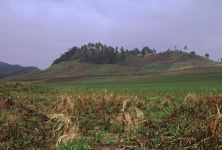 Cerro el Hoyo lies at the SE end of a subsidiary NW-SE-trending chain of pyroclastic cones of the Lake Yojoa volcanic field about 2 km NE of the lakeshore. The cones are surrounded by lava fields that are partially tholeiitic in composition, but mostly consist of trachytes, trachybasalts, and trachyandesites with large phenocrysts of sanadine and anorthoclase.
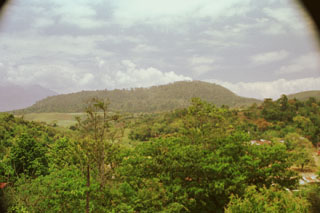 The SW-most of a chain of NE-trending cinder cones is the largest of a cluster of cones north of Lake Yojoa. This large cone was constructed at the intersection of two roughly orthogonal chains of young pyroclastic cones. The cones of the Lake Yojoa volcanic field were built along fissures; these parallel faults that also define the rectilinear shores of the lake and cut Cretaceous limestones on the west side of the lake.
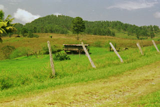
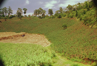 A large low-rimmed crater lies immediately WNW of Cerro el Hoyo. The floor of the crater has been planted with sugar cane, and other crops line the walls of the crater. The scale of the 1-km-wide crater is deceiving--note the barely visible truck and sugar cane workers on the crater floor at the left center.
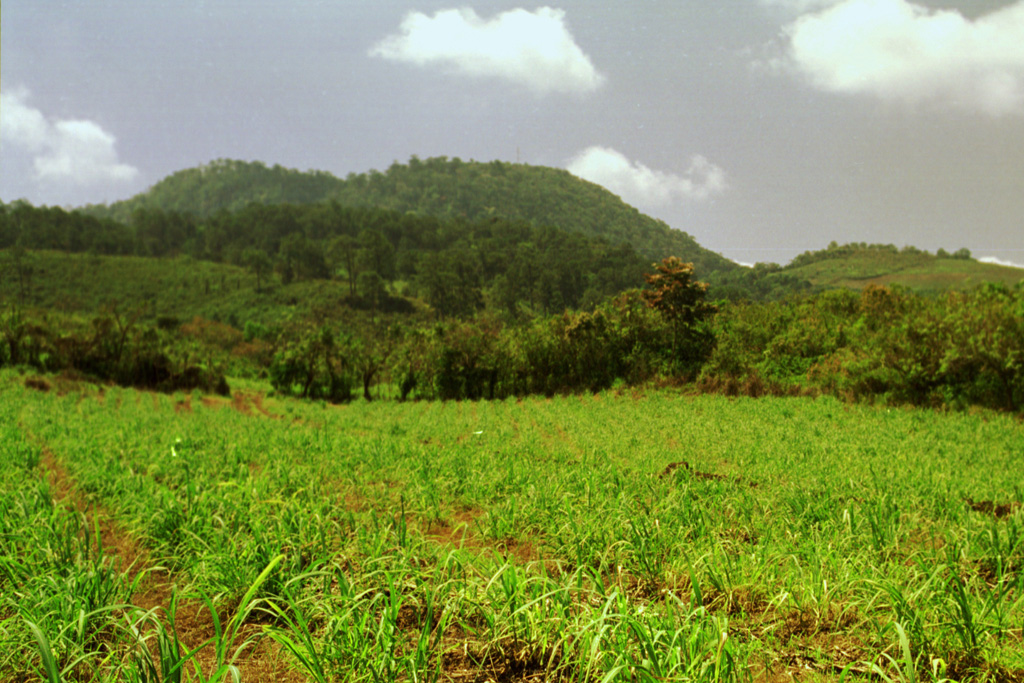
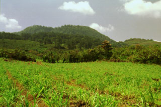 This eastern side of forested Cerro Babilonia cinder cone rises above fields north of Lake Yojoa in north-central Honduras. The 1090-m-high cone is the highest of a chain of Pleistocene-to-Holocene scoria cones at the northern end of the lake. The cones were constructed along orthogonal NW-SE- and NE-SW-trending lines and consist of basaltic scoria and agglutinate. The are typically 100-200 m in height and several contain well-preserved craters. Lava flows radiate in all directions from the cones.
 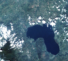 The Lake Yojoa volcanic field forms the entire northern shore of the 10 x 12 km lake, the largest in Honduras, in this International Space Station image with north to the upper left. Cretaceous limestones lie west of the lake, and Tertiary volcanic rocks to the east. Vents of the volcanic field, which extends to the top of the image, are concentrated along two NW- and NE-trending lines. The Lake Yojoa volcanic field has produced both tholeiitic and alkaline basaltic rocks.
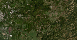 The Lake Yojoa volcanic field in Honduras is located along the northern shore of Lake Yojoa, shown in this October 2019 Planet Labs satellite image monthly mosaic (N is at the top; this image is approximately 12 km across). The field contains scoria and spatter cones and lava flows, with the Cerro el Hoyo in the bottom-center, to the W is the smaller Cerro el Copito cone on the other side of the larger unnamed crater, and Cerro Babilonia in the center of the top of the image.
Maps are not currently available due to technical issues.
The maps shown below have been scanned from the GVP map archives and include the volcano on this page. Clicking on the small images will load the full 300 dpi map. Very small-scale maps (such as world maps) are not included.
There are no samples for Lago Yojoa in the Smithsonian's NMNH Department of Mineral Sciences Rock and Ore collection.
| Copernicus Browser | The Copernicus Browser replaced the Sentinel Hub Playground browser in 2023, to provide access to Earth observation archives from the Copernicus Data Space Ecosystem, the main distribution platform for data from the EU Copernicus missions. |
| MIROVA | Middle InfraRed Observation of Volcanic Activity (MIROVA) is a near real time volcanic hot-spot detection system based on the analysis of MODIS (Moderate Resolution Imaging Spectroradiometer) data. In particular, MIROVA uses the Middle InfraRed Radiation (MIR), measured over target volcanoes, in order to detect, locate and measure the heat radiation sourced from volcanic activity. |
| MODVOLC Thermal Alerts | Using infrared satellite Moderate Resolution Imaging Spectroradiometer (MODIS) data, scientists at the Hawai'i Institute of Geophysics and Planetology, University of Hawai'i, developed an automated system called MODVOLC to map thermal hot-spots in near real time. For each MODIS image, the algorithm automatically scans each 1 km pixel within it to check for high-temperature hot-spots. When one is found the date, time, location, and intensity are recorded. MODIS looks at every square km of the Earth every 48 hours, once during the day and once during the night, and the presence of two MODIS sensors in space allows at least four hot-spot observations every two days. Each day updated global maps are compiled to display the locations of all hot spots detected in the previous 24 hours. There is a drop-down list with volcano names which allow users to 'zoom-in' and examine the distribution of hot-spots at a variety of spatial scales. |
|
WOVOdat
Single Volcano View Temporal Evolution of Unrest Side by Side Volcanoes |
WOVOdat is a database of volcanic unrest; instrumentally and visually recorded changes in seismicity, ground deformation, gas emission, and other parameters from their normal baselines. It is sponsored by the World Organization of Volcano Observatories (WOVO) and presently hosted at the Earth Observatory of Singapore.
GVMID Data on Volcano Monitoring Infrastructure The Global Volcano Monitoring Infrastructure Database GVMID, is aimed at documenting and improving capabilities of volcano monitoring from the ground and space. GVMID should provide a snapshot and baseline view of the techniques and instrumentation that are in place at various volcanoes, which can be use by volcano observatories as reference to setup new monitoring system or improving networks at a specific volcano. These data will allow identification of what monitoring gaps exist, which can be then targeted by remote sensing infrastructure and future instrument deployments. |
| Volcanic Hazard Maps | The IAVCEI Commission on Volcanic Hazards and Risk has a Volcanic Hazard Maps database designed to serve as a resource for hazard mappers (or other interested parties) to explore how common issues in hazard map development have been addressed at different volcanoes, in different countries, for different hazards, and for different intended audiences. In addition to the comprehensive, searchable Volcanic Hazard Maps Database, this website contains information about diversity of volcanic hazard maps, illustrated using examples from the database. This site is for educational purposes related to volcanic hazard maps. Hazard maps found on this website should not be used for emergency purposes. For the most recent, official hazard map for a particular volcano, please seek out the proper institutional authorities on the matter. |
| IRIS seismic stations/networks | Incorporated Research Institutions for Seismology (IRIS) Data Services map showing the location of seismic stations from all available networks (permanent or temporary) within a radius of 0.18° (about 20 km at mid-latitudes) from the given location of Lago Yojoa. Users can customize a variety of filters and options in the left panel. Note that if there are no stations are known the map will default to show the entire world with a "No data matched request" error notice. |
| UNAVCO GPS/GNSS stations | Geodetic Data Services map from UNAVCO showing the location of GPS/GNSS stations from all available networks (permanent or temporary) within a radius of 20 km from the given location of Lago Yojoa. Users can customize the data search based on station or network names, location, and time window. Requires Adobe Flash Player. |
| DECADE Data | The DECADE portal, still in the developmental stage, serves as an example of the proposed interoperability between The Smithsonian Institution's Global Volcanism Program, the Mapping Gas Emissions (MaGa) Database, and the EarthChem Geochemical Portal. The Deep Earth Carbon Degassing (DECADE) initiative seeks to use new and established technologies to determine accurate global fluxes of volcanic CO2 to the atmosphere, but installing CO2 monitoring networks on 20 of the world's 150 most actively degassing volcanoes. The group uses related laboratory-based studies (direct gas sampling and analysis, melt inclusions) to provide new data for direct degassing of deep earth carbon to the atmosphere. |
| Large Eruptions of Lago Yojoa | Information about large Quaternary eruptions (VEI >= 4) is cataloged in the Large Magnitude Explosive Volcanic Eruptions (LaMEVE) database of the Volcano Global Risk Identification and Analysis Project (VOGRIPA). |
| EarthChem | EarthChem develops and maintains databases, software, and services that support the preservation, discovery, access and analysis of geochemical data, and facilitate their integration with the broad array of other available earth science parameters. EarthChem is operated by a joint team of disciplinary scientists, data scientists, data managers and information technology developers who are part of the NSF-funded data facility Integrated Earth Data Applications (IEDA). IEDA is a collaborative effort of EarthChem and the Marine Geoscience Data System (MGDS). |

