Djibouti Volcanoes
A map display is currently under development.
Djibouti has 4 Holocene volcanoes. Note that as a scientific organization we provide these listings for informational purposes only, with no international legal or policy implications. Volcanoes will be included on this list if they are within the boundaries of a country, on a shared boundary or area, in a remote territory, or within a maritime Exclusive Economic Zone. Bolded volcanoes have erupted within the past 20 years. Suggestions and data updates are always welcome ().
| Volcano Name | Last Eruption | Volcanic Region | Primary Landform |
|---|---|---|---|
| Ardoukoba | 1978 CE | Afar Rift Volcanic Province | Cluster |
| Gufa | Unknown - Evidence Credible | Afar Rift Volcanic Province | Cluster |
| Manda-Inakir | 1928 CE | Afar Rift Volcanic Province | Cluster |
| Mousa Alli | Unknown - Evidence Credible | Afar Rift Volcanic Province | Composite |
Chronological listing of known Holocene eruptions (confirmed or uncertain) from volcanoes in Djibouti. Bolded eruptions indicate continuing activity.
| Volcano Name | Start Date | Stop Date | Certainty | VEI | Evidence |
|---|---|---|---|---|---|
| Ardoukoba | 1978 Nov 7 | 1978 Nov 14 | Confirmed | 1 | Observations: Reported |
| Manda-Inakir | 1928 Dec 31 ± 365 days | Unknown | Confirmed | 2 | Observations: Reported |
Djibouti has 1 Pleistocene volcanoes. Note that as a scientific organization we provide these listings for informational purposes only, with no international legal or policy implications. Volcanoes will be included on this list if they are within the boundaries of a country, on a shared boundary or area, in a remote territory, or within a maritime Exclusive Economic Zone. Suggestions and data updates are always welcome ().
| Volcano Name | Volcanic Region | Primary Landform |
|---|---|---|
| Babba'Olou | Afar Rift Volcanic Province | Composite |
There are 15 photos available for volcanoes in Djibouti.
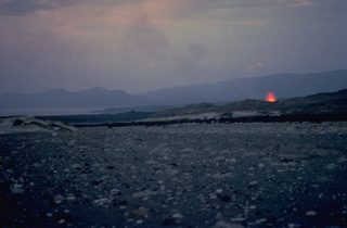 A lava fountain at the right rises from a 500-m-long fissure at Ardoukôba. This view looks from the NNW to the Ghoubbat al Kharab gulf of the Red Sea in the distance. About 25 fissures parallel to the NW-SE trend of the Ardoukôba Rift opened during the eruption, but eruptive activity was localized on a single rift. Lava flows from the 1978 eruption covered 3.2 km2 of the rift floor.
Copyrighted photo by Katia and Maurice Krafft, 1978.
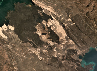
 The chain of pyroclastic cones and lava flows extending diagonally down from the upper-left portion of this Landsat image is the southern portion of the Mousa Alli volcanic complex. The flanks of its neighbor to the SW, Manda Inakir, are visible at the extreme lower left. Prominent faults at the right cut lava flows of the Pliocene-Pleistocene stratoid series of the Afar region.
NASA Landsat image, 1999 (courtesy of Hawaii Synergy Project, Univ. of Hawaii Institute of Geophysics & Planetology).
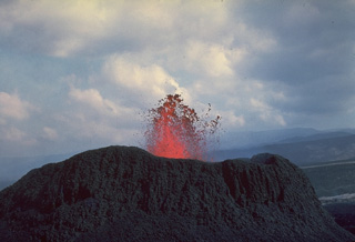 A small cinder cone ejects spatter during the first historical eruption of the Ardoukôba (Asal) Rift, which took place November 7-14, 1978. Lava fountaining occurred from a 500-m-long fissure. Several spatter cones and a cinder cone were formed along the fissure, which fed lava flows that covered about 3 km2 of the rift floor.
 Copyrighted photo by Katia and Maurice Krafft, 1978.
 The Ardoukôba (Asal) Rift in Djibouti, trending NW from the Red Sea, contains a broad area of youthful fissure vents between Lake Asal and the Ghoubbat al Kharab gulf. This view looks from the north towards the gulf. Regional faults of the Ardoukôba Rift trending NW-SE cut lava-flow fields. A cinder cone appears at the left, and a group of tuff cones lie at the upper right. The youngest lava flows cover lake sediments deposited 5300 years ago. An eruption in 1978 produced a small cinder cone and lava flows.
Copyrighted photo by Katia and Maurice Krafft, 1976.
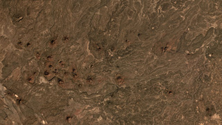 The Gufa volcanic field NE of Mousa Alli volcano extends from the Djibouti border (bottom left) into Eritrea, seen here in this December 2019 Planet Labs satellite image mosaic (N is at the top; this image is approximately 23 km across). Many scoria cones and lava flows are visible withing the broad field aligned in an E-W direction.
Satellite image courtesy of Planet Labs Inc., 2019 (https://www.planet.com/).
 The dark-colored lava flows extending diagonally across the center of this Landsat image were erupted from pyroclastic cones of Manda-Inakir volcano. These NNW-trending fissure vents and cones are located along the Ethiopia-Djibouti border and represent an uplifted mid-ocean ridge spreading center now exposed above sea level. An eruption in 1928 or 1929 at the SE end of the Manda-Inakir rift near the town of Korili (in Djibouti) produced the Kammourta cinder cone and a lava flow.
NASA Landsat image, 1999 (courtesy of Hawaii Synergy Project, Univ. of Hawaii Institute of Geophysics & Planetology).
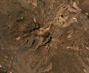 Mousa Alli is located on the border of Ethiopia, Eritrea, and Djibouti, and is seen here in this December 2019 Planet Labs satellite image mosaic (N is at the top; this image is approximately 21 km across). The main edifice in the center has undergone extensive erosion and there are scoria cones and lava flows on the SE and NW flanks.
Satellite image courtesy of Planet Labs Inc., 2019 (https://www.planet.com/).
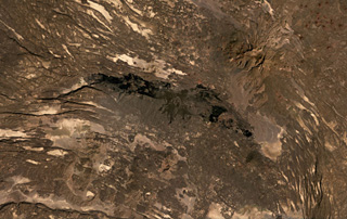 The roughly 40-km-long darker lava flows extending across the center of this December 2020 Planet Labs satellite image monthly mosaic (with N at the top) were produced by the western Manda portion of the Manda-Inakir complex and fill a graben formed through faulting. This complex represents a failed rift segment along the Ethiopia-Djibouti border. Mousa Alli is the edifice to the NE; this image is approximately 80 km across.
Satellite image courtesy of Planet Labs Inc., 2020 (https://www.planet.com/).
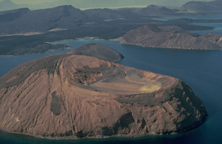 The three tuff cones of Kodda Ginni Koma (foreground), Ounda Ginna Koma (the small island in the center), and Baddi Koma (upper right) were formed when rising magma along the Ardoukoba Rift encountered waters of the Ghoubbat al Kharab gulf of the Red Sea. Fresh lava flows in the background were erupted from the parallel NW-SE-trending fissures of Ardoukôba volcano in the country of Djibouti. Tilted fault blocks in the background dip to the SW and NE, away from the center of the rift valley.
Copyrighted photo by Katia and Maurice Krafft, 1976.
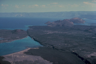
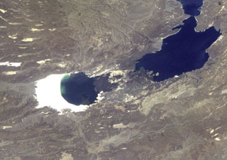 The Ardoukôba (Asal) Rift in the center of the photo lies in Djibouti and trends NW from the Red Sea. Ardoukoba contains a broad area of youthful fissure vents between Lake Asal (bounded by white saline deposits at the left) and the Ghoubbat al Kharab gulf (upper right). The most recent lava flows are younger than lake sediments deposited 5,300 years ago. The Ardoukôba fissure erupted in 1978, producing a small cinder cone and lava flows that covered part of the rift floor near the Red Sea.
NASA International Space Station image ISS004-E-11422, 1992 (http://eol.jsc.nasa.gov/).
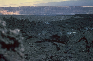 The dark aa lava flow in the foreground was produced during an eruption on the Arkdoukôba Rift November 7-14, 1978. This photo from the SW looks across the rift during the eruption and shows one of the regional NW-SE-trending faults of the rift in the background. Lava flows from the 1978 eruption covered about 3 km2 of the rift floor, primarily on the north side of the eruptive fissure.
Copyrighted photo by Katia and Maurice Krafft, 1978.
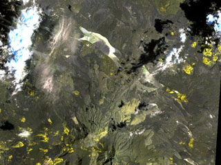
 Mousa Alli volcano dominates the right-hand side of this NASA Landsat image and is located on the border between Ethiopia, Eritrea, and Djibouti. This volcano is the most prominent topographic feature in this area and towers above its neighbor to the SW, Manda Inakir, visible at the lower left. Yellow-colored basaltic pyroclastic cones and associated lava flows occupy the SE and NW flanks.
NASA Landsat image, 1999 (courtesy of Hawaii Synergy Project, Univ. of Hawaii Institute of Geophysics & Planetology).
 The Ardoukôba Rift is in Djibouti at the NW end of Lake Ghoubet (lower right) and is shown in this October 2019 Planet Labs satellite image monthly mosaic (N is at the top; this image is approximately 11 km across). It contains lava flows from scoria and spatter cones, with recent deposits erupted in 1978.
Satellite image courtesy of Planet Labs Inc., 2019 (https://www.planet.com/).
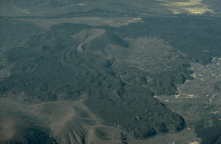 A lava flow with prominent flow levees issued from a breached cinder cone in the Mousa Alli volcanic complex. This large Holocene stratovolcano was constructed along the border between Ethiopia, Eritrea, and Djibouti and towers above its neighbor to the SW, Manda Inakir. Rhyolitic lava domes and lava flows are found in the summit region, which is truncated by a caldera.
Copyrighted photo by Katia and Maurice Krafft, 1976.
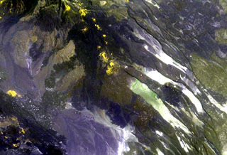
 The yellow-colored pyroclastic cones at the upper right lie along the western part of the Gufa volcanic field, which extends from the Djibouti border into Eritrea (upper right). These basaltic scoria cones and lava flows are aligned in an E-W direction NE of Mousa Alli volcano, a large stratovolcano that is visible at the bottom center of this NASA Landsat image. A second E-W-trending chain of cones, not visible in this image, is located to the north of the principal chain in Eritrea and fed long lava flows that descend in the direction of the Red Sea.
NASA Landsat image, 1999 (courtesy of Hawaii Synergy Project, Univ. of Hawaii Institute of Geophysics & Planetology).
This is a compilation of Djibouti volcano information sources, such as official monitoring or other government agencies.
| Volcanic Ash Advisory Center | |
|---|---|
| Toulouse Volcanic Ash Advisory Center (VAAC) Notices and Archive | |