Uganda Volcanoes
Uganda has 2 Holocene volcanoes. Note that as a scientific organization we provide these listings for informational purposes only, with no international legal or policy implications. Volcanoes will be included on this list if they are within the boundaries of a country, on a shared boundary or area, in a remote territory, or within a maritime Exclusive Economic Zone. Bolded volcanoes have erupted within the past 20 years. Suggestions and data updates are always welcome ().
| Volcano Name | Last Eruption | Volcanic Region | Primary Landform |
|---|---|---|---|
| Fort Portal Volcanic Field | 2120 BCE | Albertine Rift Volcanic Province | Cluster |
| Ndali-Kasenda Volcanic Field | Unknown - Evidence Uncertain | Albertine Rift Volcanic Province | Cluster |
Chronological listing of known Holocene eruptions (confirmed or uncertain) from volcanoes in Uganda. Bolded eruptions indicate continuing activity.
| Volcano Name | Start Date | Stop Date | Certainty | VEI | Evidence |
|---|---|---|---|---|---|
| Fort Portal Volcanic Field | 2120 BCE ± 100 years | Unknown | Confirmed | Isotopic: 14C (uncalibrated) | |
| Fort Portal Volcanic Field | 2750 BCE ± 75 years | Unknown | Confirmed | Isotopic: 14C (uncalibrated) |
Uganda has 7 Pleistocene volcanoes. Note that as a scientific organization we provide these listings for informational purposes only, with no international legal or policy implications. Volcanoes will be included on this list if they are within the boundaries of a country, on a shared boundary or area, in a remote territory, or within a maritime Exclusive Economic Zone. Suggestions and data updates are always welcome ().
| Volcano Name | Volcanic Region | Primary Landform |
|---|---|---|
| Bufumbira Volcanic Field | Albertine Rift Volcanic Province | Cluster |
| Bunyaruguru Volcanic Field | Albertine Rift Volcanic Province | Cluster |
| Gahinga | Albertine Rift Volcanic Province | Composite |
| Katunga | Albertine Rift Volcanic Province | Minor |
| Katwe-Kikorongo Volcanic Field | Albertine Rift Volcanic Province | Cluster |
| Muhavura | Albertine Rift Volcanic Province | Composite |
| Sabinyo | Albertine Rift Volcanic Province | Composite |
There are 11 photos available for volcanoes in Uganda.
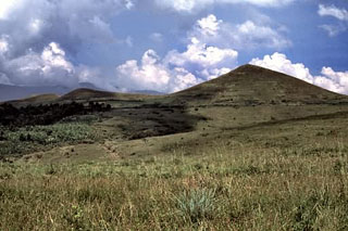
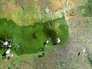 The forested Muhavura volcano (center) rises at the NE end of the Virunga Range. The Gahinga (Mgahinga) volcano, the smaller cone at left-center, is joined to Muhavura on the west by a broad saddle. Muhavura is stratovolcano with a small crater that has been recently active, but the age of its latest eruption is not known.
NASA Landsat image, 1999 (courtesy of Hawaii Synergy Project, Univ. of Hawaii Institute of Geophysics & Planetology).
 The Bufumbira volcanic field in SW Uganda contains numerous scoria cones including those shown in this August 2019 Planet Labs satellite mosaic (N at the top). The field is in the Virunga volcanic province in SW Uganda and covers approximately 320 km2 with Muhavura, Mgahinga, and Sabinyo along the southern boundary. Several of the scoria cones near the center of this image produced lava flows through the collapse of a flank, resulting in horseshoe-shaped edifices.
Satellite image courtesy of Planet Labs Inc., 2019 (https://www.planet.com/).
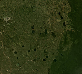
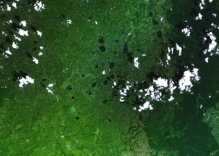
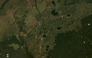 Lakes fill maars of the Bunyaruguru volcanic field, also known as the Kichwambe volcanic field, across this January 2019 Planet Labs satellite image mosaic (N at the top). The field contains over 130 craters and is located between Lake Albert and Lake Edward in Uganda.
Satellite image courtesy of Planet Labs Inc., 2019 (https://www.planet.com/).
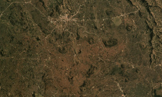
 Scoria cones of the Bufumbira volcanic field in SW Uganda (center) lie N of the large stratovolcanoes of the NE part of the Virunga Mountains. The roughly 40 scoria cones occur in clusters and were erupted along lineaments and are typically breached on one side by lava flows. The Bufumbira rocks are noted for their unusual ultrapotassic chemistry. Muhavura (center) and Sabinyo (left) stratovolcanoes are visible at the bottom of this Landsat image.
NASA Landsat image, 1999 (courtesy of Hawaii Synergy Project, Univ. of Hawaii Institute of Geophysics & Planetology).
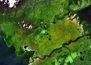 Lake-filled and dry maars of the Katwe-Kikorongo volcanic field are shown in the center of this NASA Landsat image (with N to the top). The volcanic field lies above the river channel connecting Lake Edward (lower left) with Lake George (upper right) in the Western Rift Valley of Uganda. Dark-colored Lake Katwe (lower left) is a shallow 3-km-long body of water that occupies two of three intersecting craters immediately NE of Lake Edward. Local folk tales suggest that volcanism in the Katwe-Kikorongo area has continued into historical times.
NASA Landsat 7 image (worldwind.arc.nasa.gov)
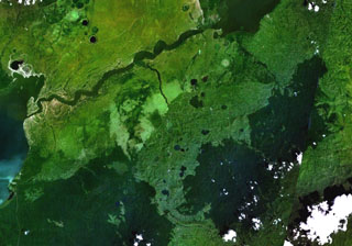
 The lakes visible in this April 2019 Planet Labs satellite image mosaic (N at the top) formed within craters of the Kyatwa volcanic field between Lake Albert and Lake Edward in Uganda.
Satellite image courtesy of Planet Labs Inc., 2019 (https://www.planet.com/).
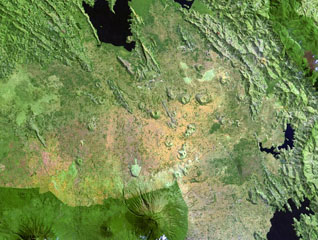
 These grass-covered tuff cones are among the many of the Fort Portal volcanic field in Uganda. The carbonatite lavas and tuffs were erupted from about 50 cones and maars, some of which now contain crater lakes.
 Photo by Nelson Eby (University of Massachusetts).
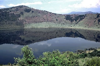 This lake-filled crater is part of the Katwe-Kikorongo volcanic field that stretches from the NE shore of Lake Edward to the western shore of Lake George. It is the most extensive of a series of volcanic fields in the Western Rift Valley of Uganda containing carbonatitic cones and maars, some of which contain lakes. Local stories suggest that volcanism in the area has continued into historical times.
Photo by Nelson Eby (University of Massachusetts).
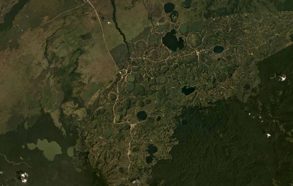
 Mostly lake-filled maars and tuff cones dot the center of this NASA Landsat image (with N to the top) of the Kyatwa volcanic field. The Kyatwa vents, also known as the Ndale volcanic field, occupy the Western Rift Valley, east of the Ruwenzori Mountains halfway between Lake Edward and Lake Albert. The Kyatwa tuff cones are part of a group of Pleistocene-to-recent volcanic fields in western Uganda.
NASA Landsat 7 image (worldwind.arc.nasa.gov)
 Maars of the Bunyaruguru volcanic field, also known as the Kichwambe volcanic field, blanket the center of this NASA Landsat image (with N to the top) of the E side of the Western Rift Valley. The Bunyaruguru field, lying south of the river channel connecting Lake Edward (left-center) and Lake George (top right), contains more than 130 craters, 27 of which contain lakes with water ranging from fresh to saline. Maars of the Katwe-Kikorongo volcanic field lie across the river channel at the upper left.
NASA Landsat 7 image (worldwind.arc.nasa.gov)
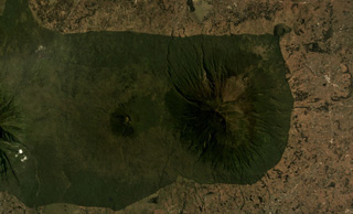 Muhavura is at the NE end of the Virunga volcanic range and is seen here in an August 2019 Planet Labs satellite image mosaic (N at the top). The summit is E of the image center, and W of that is the Gahinga flank cone. To the far W is the flank of Sabinyo.
Satellite image courtesy of Planet Labs Inc., 2019 (https://www.planet.com/).
This is a compilation of Uganda volcano information sources, such as official monitoring or other government agencies.
| Volcanic Ash Advisory Center |
|---|
| Toulouse Volcanic Ash Advisory Center (VAAC) Notices and Archive |