Keyword Collections | Keyword "sector collapse"
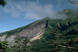 The most prominent feature on the upper SE flank of Ontakesan volcano is the headwall scarp of a volcanic landslide. The landslide occurred on 14 September 1984 with no associated eruptive activity. The resulting debris avalanche traveked 13 km down the Nigori and Otaki river valleys.
Photo by Lee Siebert, 1988 (Smithsonian Institution).
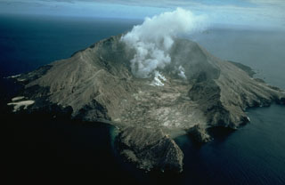 Steam rises from the crater of White Island (also called Whakaari), one of the most active volcanoes of New Zealand. The small, uninhabited 2 x 2.4-km-wide island lies 50 km NE of the North Island. Frequent small-to-moderate explosive eruptions have been recorded since 1826, and Maori legends record earlier eruptions. This view from the SE shows the two overlapping 0.4 x 1.2 km wide craters at the summit of the largely submerged volcano.
Copyrighted photo by Stephen O'Meara.
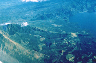 Collapses at the summit or flanks of volcanoes during major volcanic landslides can create large horseshoe-shaped craters that open in the direction of the landslide, like this 2.1 x 3.5 km crater at Iriga in the Philippines. It was produced by a massive landslide during the Holocene. The resulting debris avalanche traveled more than 10 km to the SE and flowed into Lake Buhi at the upper right. This view is from the south, with the summit to the left.
Photo by Chris Newhall (U.S. Geological Survey).
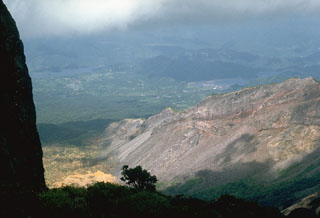 The steep topography at the right is the eastern rim of a scarp created by the 1888 collapse of Koandaisan, one of a group of cones forming Bandaisan. The two lakes in the distance, Onogawa (left) and Akimoto (right), formed after the resulting debris avalanche blocked river drainages. The caldera walls expose stratigraphy of pyroclastic deposits overlain by lava flows.
Photo by Lee Siebert, 1988 (Smithsonian Institution).
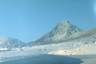 Kamen, seen here from the NE, is a steep-sided stratovolcano of largely Pleistocene age that rises immediately to the north of frequently active Bezymianny volcano (left). The summit of Kamen collapsed about 1,200 years ago, producing a massive debris avalanche to the east, and leaving the steep escarpment that forms the east face of the edifice.
Photo by E.Y. Zhdanova (courtesy of Oleg Volynets, Institute of Volcanology, Petropavlovsk).
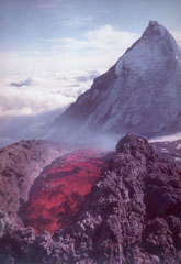 Lava extrudes from a vent on the SE flank of Klyuchevskoy volcano in 1988 with Kamen volcano in the background. Long-term activity at Klyuchevskoy has produced both explosive eruptions and lava effusion, taking place from vents at the summit and on the flanks. The steep eastern flank of Kamen resulted from collapse of the summit about 1,200 years ago, resulting in a massive debris avalanche that traveled approximately 30 km.
Photo courtesy of Anatolii Khrenov, 1988 (Institute of Volcanology, Petropavlovsk).
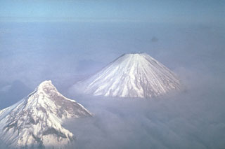 Two of Kamchatka's highest volcanoes rise above the clouds. Their differing morphologies reflect contrasting geologic histories. Construction of extensively eroded Kamen volcano (left) took place during the Pleistocene. It has been relatively inactive since. Its eastern (right) side was removed by a massive landslide about 1,200 years ago, leaving the steep escarpment. Symmetrical Klyuchevskoy, in contrast, is one of Kamchatka's youngest and most active volcanoes.
Photo by Yuri Doubik (Institute of Volcanology, Petropavlovsk).
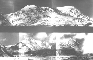 These paired photos show Sheveluch volcano from the south before (top) and after (bottom) a major eruption in 1964. A brief, but powerful eruption on 12 November 1964 resulted in collapse of the south summit of Sheveluch (Crater Top), forming a 1.5 x 3 km open crater seen in the bottom photo. A large debris avalanche swept to the south, after which a Plinian eruption with an ash plume 10-15 km high produced pumice fall and pumiceous pyroclastic flow deposits.
Photo courtesy of Yuri Doubik (Institute of Volcanology, Petropavlovsk).
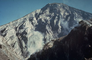 The interior of a stratovolcano is dramatically revealed in a 1-km-wide crater created on the SW flank of Guatemala's Santa María volcano during an eruption in 1902. The 1,200-m-high scarp exposes thin, light-colored lava flows that are interbedded with deposits of fragmented rock produced during growth of the volcano. The 1902 eruption was one of the world's largest during the 20th century.
Photo by Dick Stoiber, 1969 (Dartmouth College).
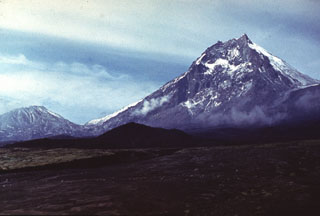 Kamen lies at the center of a N-S-trending chain of volcanoes, flanked by Bezymianny (left) and Klyuchevskoy. Kamen formed during the late Pleistocene and activity continued into the Holocene. A major flank collapse about 1,200-1,300 years ago removed much of the eastern side of the volcano, leaving the steep escarpment seen in this view.
Photo by Vera Ponomareva, 1975 (Institute of Volcanic Geology and Geochemistry, Petropavlovsk).
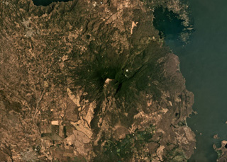 Two major flank-collapse scarps on the NE and SW sides of Mombacho are visible in this March 2019 Planet Labs satellite image monthly mosaic (N is at the top; this image is approximately 25 km across). The islands to the NE are part of the 56.8 km2 Las Isletas debris avalanche deposit; the 49.5 km2 El Crater debris avalanche deposit is to the S. The La Danta debris avalanche deposit is between the two on the SE flank and surrounding area.
Satellite image courtesy of Planet Labs Inc., 2019 (https://www.planet.com/).
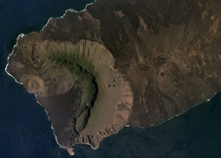 The western side of Volcán Ecuador has formed through caldera collapse and subsequent flank collapse, producing the caldera that opens towards the ocean in this March 2019 Planet Labs satellite image monthly mosaic (N is at the top; this image is approximately 13 km across). Within the caldera is the Cerro Grande tuff cone along the coast, a slump block along the SE caldera wall, and lava flows, as well as smaller vents. The East Rift is to the right in this image, towards Volcán Wolf out of view.
Satellite image courtesy of Planet Labs Inc., 2019 (https://www.planet.com/).
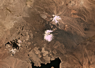 Parinacota is the larger of the two main edifices in this November 2019 Planet Labs satellite image monthly mosaic (N is at the top; this image is approximately 23 km across). With Pomerape to the NE, together they form the Nevados de Payachata group along the Chile-Bolivia border. The group of lakes to the SW formed within a debris avalanche deposit about 8,000 years ago that is more than 22 km long with a volume of 6 km3. The current cone formed over the resulting scarp and older edifice, and has a summit crater around 650 m wide. Lava flows are visible on all flanks, with some flows emplaced around the debris avalanche deposit hummocks.
Satellite image courtesy of Planet Labs Inc., 2019 (https://www.planet.com/).


