Aira (Japan) | 20 September-26 September 2023 | Continuing Activity Cite this Report Cite this Report |
 Aira Aira
Ryukyu Volcanic Arc
|
JMA reported ongoing activity at Minamidake Crater (Aira Caldera’s Sakurajima volcano) during 18-25 September and incandescence at the crater was observed nightly. Very small eruptive events were recorded during the week. Sulfur dioxide emissions averaged 1,800 tons per day on 19 September. The Alert Level remained at 3 (on a 5-level scale), and the public was warned to stay 2 km away from both craters.
Source: Japan Meteorological Agency (JMA)
|
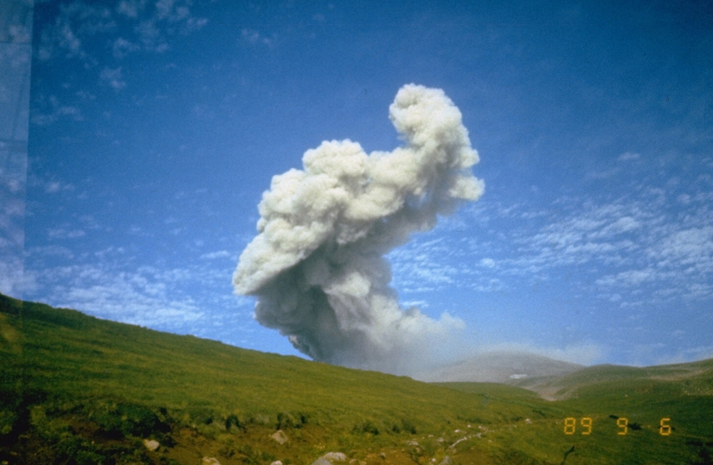
Ebeko (Russia) | 20 September-26 September 2023 | Continuing ActivityCite this Report |
 Ebeko Ebeko
Kuril Volcanic Arc
|
KVERT reported that moderate explosive activity at Ebeko was ongoing during 14-21 September. According to volcanologists in Severo-Kurilsk (Paramushir Island, about 7 km E), explosions during 14-18 September generated ash plumes that rose as high as 2.5 km (8,200 ft) a.s.l and drifted to the E. A thermal anomaly was identified in satellite images on 15 and 18 September; weather clouds obscured views on other days. The Aviation Color Code remained at Orange (the third level on a four-color scale). Dates are based on UTC times; specific events are in local time where noted.
Source: Kamchatkan Volcanic Eruption Response Team (KVERT)
|
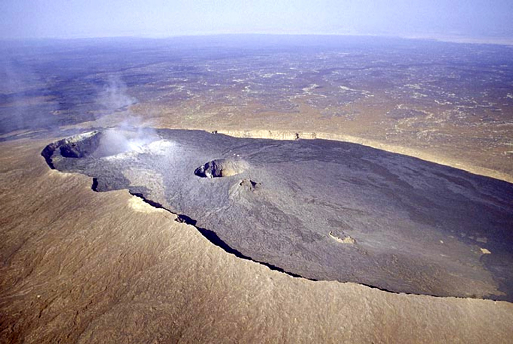
Erta Ale (Ethiopia) | 20 September-26 September 2023 | Continuing ActivityCite this Report |
 Erta Ale Erta Ale
Afar Rift Volcanic Province
|
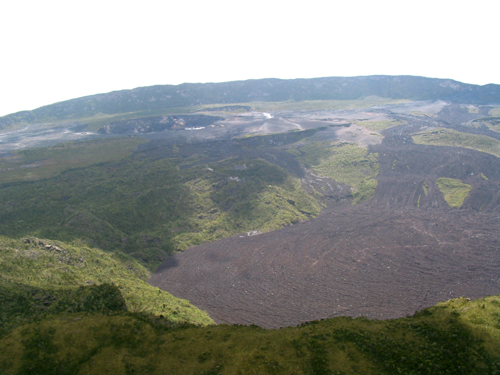
Two small thermal anomalies in Erta Ale’s S pit crater were identified in satellite images on 15 September. A 20 September image showed small anomalies in both the N and S pit craters, and a possible lava lake in the N pit crater that had mostly been crusted over. A large thermal anomaly in the SE part of the N pit crater was identified in a 25 September image. The anomaly suggested that lava had spilled over the SE rim of the crater and flowed short distances (possibly less than 400 m) E and SE.
Source: Sentinel Hub
|
Great Sitkin (United States) | 20 September-26 September 2023 | Continuing ActivityCite this Report |
 Great Sitkin Great Sitkin
Aleutian Ridge Volcanic Arc
|
AVO reported that slow lava effusion continued at Great Sitkin during 19-26 September, producing a thick flow in the summit crater that mainly expanded E. Seismicity was characterized as low with only a few daily earthquakes recorded by the seismic network during 24-25 September. Elevated surface temperatures and minor steaming were visible in webcam and satellite images on a few of the days; weather clouds sometimes obscured views. The Volcano Alert Level remained at Watch (the third level on a four-level scale) and the Aviation Color Code remained at Orange (the third color on a four-color scale).
Source: US Geological Survey Alaska Volcano Observatory (AVO)
|
Ibu (Indonesia) | 20 September-26 September 2023 | Continuing ActivityCite this Report |
 Ibu Ibu
Halmahera Volcanic Arc
|
PVMBG reported that Ibu continued to erupt during 20-26 September. Daily white-and-gray ash emissions of variable densities generally rose as high as 800 m above the summit and drifted NE, N, and W. At 0712 on 25 September a dense gray ash plume rose 1.5 km and drifted NE. The Alert Level remained at a 2 (the second highest level on a four-level scale), with the public advised to stay outside of the 2 km hazard zone and 3.5 km away from the N area of the active crater.
Source: Pusat Vulkanologi dan Mitigasi Bencana Geologi (PVMBG, also known as CVGHM)
|
Klyuchevskoy (Russia) | 20 September-26 September 2023 | Continuing ActivityCite this Report |
 Klyuchevskoy Klyuchevskoy
Eastern Kamchatka Volcanic Arc
|
KVERT reported that the explosive Strombolian eruption at Klyuchevskoy continued 14-21 September. A daily bright thermal anomaly was identified in satellite images. Lava fountaining fed flows that advanced down the Kozyrevsky drainage on the SE flank. Plumes of resuspended ash (deposited on the volcano’s N flanks from Sheveluch’s 10-13 April eruption) drifted 50 km E on 22 September, prompting KVERT to raise the Aviation Color Code to Orange (the third level on a four-color scale). The Aviation Color Code was lowered back to Yellow on 24 September; Strombolian activity continued to feed the lava flow. Dates are based on UTC times; specific events are in local time where noted.
Source: Kamchatkan Volcanic Eruption Response Team (KVERT)
|
Lewotolok (Indonesia) | 20 September-26 September 2023 | Continuing ActivityCite this Report |
 Lewotolok Lewotolok
Sunda Volcanic Arc
|
PVMBG reported that the eruption at Lewotolok continued during 20-26 September. White-and-gray plumes of variable densities rose as high as 800 m above the summit and drifted in multiple directions on all days except 25 September when only white plumes were visible. A webcam image captured incandescent material being ejected above the summit at 2346 on 23 September. The Alert Level remained at 2 (on a scale of 1-4) and the public was warned to stay at least 2 km away from the summit crater.
Source: Pusat Vulkanologi dan Mitigasi Bencana Geologi (PVMBG, also known as CVGHM)
|
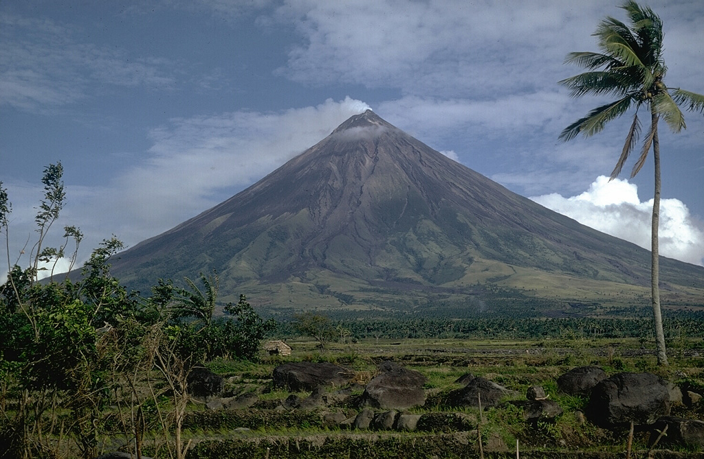
Mayon (Philippines) | 20 September-26 September 2023 | Continuing ActivityCite this Report |
 Mayon Mayon
Eastern Philippine Volcanic Arc
|
PHIVOLCS reported that the eruption at Mayon continued during 19-26 September. The lengths of the lava flow in the Mi-Isi (S), Bonga (SE), and Basud (E) drainages remained at 2.8 km, 3.4 km, and 1.1 km, respectively. Collapses at the lava dome and from the margins of the lava flows produced rockfalls and pyroclastic density currents (PDCs, or pyroclastic flows) that descended the flanks as far as 4 km. Each day seismic stations recorded 107-207 rockfall events, 0-6 PDC events, and 2-15 daily volcanic earthquakes. Sulfur dioxide emissions measured almost daily averaged between 868 and 1,507 tonnes per day, with the highest value recorded on 22 September. The Alert Level remained at 3 (on a 0-5 scale) and residents were reminded to stay away from the 6-km-radius Permanent Danger Zone (PDZ). PHIVOLCS recommended that civil aviation authorities advise pilots to avoid flying close to the summit.
Source: Philippine Institute of Volcanology and Seismology (PHIVOLCS)
|
Merapi (Indonesia) | 20 September-26 September 2023 | Continuing ActivityCite this Report |
 Merapi Merapi
Sunda Volcanic Arc
|
BPPTKG reported that the eruption at Merapi (on Java) continued during 15-21 September and seismicity remained at elevated levels. The SW lava dome produced a total of 148 lava avalanches that descended the S and SW flanks; two traveled as far as 1.3 km down the upper part of the Boyong drainage, 145 traveled as far as 2 km down the upper Bebeng drainage, and one traveled 1.4 km down the Sat/Putih drainage. Morphological changes to the SW lava dome were due to continuing collapses of material. The Alert Level remained at 3 (on a scale of 1-4), and the public was warned to stay 3-7 km away from the summit based on location.
Source: Balai Penyelidikan dan Pengembangan Teknologi Kebencanaan Geologi (BPPTKG)
|
Nyamulagira (DR Congo) | 20 September-26 September 2023 | Continuing ActivityCite this Report |
 Nyamulagira Nyamulagira
Albertine Rift Volcanic Province
|
The Observatoire Volcanologique de Goma (OVG) reported that activity at Nyamulagira continued at low levels during 17-24 September based on satellite images.
Source: Observatoire Volcanologique de Goma (OVG)
|
Nyiragongo (DR Congo) | 20 September-26 September 2023 | Continuing ActivityCite this Report |
 Nyiragongo Nyiragongo
Albertine Rift Volcanic Province
|
The Observatoire Volcanologique de Goma (OVG) reported that the activity at Nyiragongo continued during 17-24 September at a low level. A diffuse sulfur dioxide plume with an estimated mass of 20 tons was identified in satellite data on 25 September.
Source: Observatoire Volcanologique de Goma (OVG)
|
Popocatepetl (Mexico) | 20 September-26 September 2023 | Continuing ActivityCite this Report |
 Popocatepetl Popocatepetl
Trans-Mexican Volcanic Arc
|
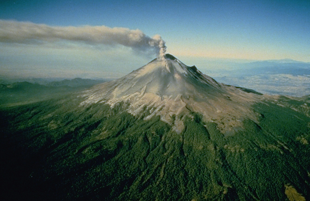
CENAPRED reported that eruptive activity continued at Popocatépetl during 19-26 September. Long-period events totaling 151-640 per day were accompanied by steam-and-gas plumes that sometimes contained minor amounts of ash. Periods of volcanic tremor were recorded almost daily, often characterized as low-amplitude and high-frequency, and each lasted 37-297 minutes. One to two volcano-tectonic earthquakes per day were recorded during 19-22 September and had magnitudes of 1.4-2.5. A moderate explosion was recorded at 1305 on 21 September and a minor one was recorded later that day at 1704. A minor explosion occurred at 0907 on 22 September. During the morning of 24 September ash plumes drifted over the municipalities of Yautepec (50 km WSW), Cuautla (43 km SW), Ayala (45 km SW), and Yecapixtla (31 km SW), and possibly Tlaltizapán and Tlaquiltenango in the state of Morelos. Minor ashfall was reported in the municipalities of Tetela del Volcán (20 km SW) and Tepalcingo during the morning of 25 September and in Villa de Ayala later that day; the municipalities were in the state of Morelos. The Alert Level remained at Yellow, Phase Two (the middle level on a three-color scale) and the public was warned to stay 12 km away from the crater.
Source: Centro Nacional de Prevencion de Desastres (CENAPRED)
|
Reventador (Ecuador) | 20 September-26 September 2023 | Continuing ActivityCite this Report |
 Reventador Reventador
Northern Andean Volcanic Arc
|
IG-EPN reported that the eruption at Reventador was ongoing during 19-26 September. Seismicity was characterized by 22-49 daily explosions, long-period earthquakes, volcano-tectonic events, harmonic tremor, and tremor associated with emissions. Several daily ash-and-gas plumes rose 200-1,000 m above the crater rim and drifted in multiple directions. Daily crater incandescence was visible during both overnight and morning hours. Incandescent material descended the flanks, mainly to the E and SE, traveling as far as 500 m from the summit. Incandescent material was sometimes ejected 200-300 m above the crater rim. Weather conditions sometimes prevented views of the volcano. Secretaría de Gestión de Riesgos maintained the Alert Level at Orange (the second highest level on a four-color scale).
Sources: Instituto Geofísico-Escuela Politécnica Nacional (IG-EPN), Secretaría de Gestión de Riesgos (SGR)
|
Sangay (Ecuador) | 20 September-26 September 2023 | Continuing ActivityCite this Report |
 Sangay Sangay
Northern Andean Volcanic Arc
|
IG-EPN reported a high level of eruptive activity at Sangay during 19-26 September, with seismic stations recording 311-641 daily explosions. Several daily ash-and-gas plumes rose as high as 2.6 km above the crater rim and drifted mainly NW, W, and SW, though during 25-26 September the plumes also drifted NNW. Webcam images showed incandescent material descending the SE flank as far as 1.8 km from the crater several times daily during overnight and early morning hours. Secretaría de Gestión de Riesgos maintained the Alert Level at Yellow (the second highest level on a four-color scale).
Sources: Instituto Geofísico-Escuela Politécnica Nacional (IG-EPN), Secretaría de Gestión de Riesgos (SGR)
|
Semeru (Indonesia) | 20 September-26 September 2023 | Continuing ActivityCite this Report |
 Semeru Semeru
Sunda Volcanic Arc
|
In a 23 September press release PVMBG noted that after pyroclastic flows occurred during 10-11 September activity at Semeru remained high; an average of 52 eruptive events per day were recorded during 11-23 September. Seismicity increased on 15 September. GPS monitoring stations recorded inflation at the volcano, originating from a source at a depth of 8 km, and substantial inflation was identified in satellite data on 16 September. White-and-gray or white-to-brown ash plumes generally rose 300-800 m above the summit and drifted N, NW, W, and SW during 20-21, 23, and 25-26 September. Plumes were notably higher on a few of the days, rising as high as 1 km above the summit at 0934 on 21 September and drifting N; at 0902, 0958, and 1042 on 25 September white-to-brown and darkish plumes rose as high as 1 km above the summit and drifted NW. The Alert Level remained at 3 (third highest on a scale of 1-4). The public was warned to stay at least 5 km away from the summit in all directions, 13 km from the summit to the SE, 500 m from the banks of the Kobokan drainage as far as 17 km from the summit, and to avoid other drainages including the Bang, Kembar, and Sat, due to lahar, avalanche, and pyroclastic flow hazards.
Source: Pusat Vulkanologi dan Mitigasi Bencana Geologi (PVMBG, also known as CVGHM)
|
Sheveluch (Russia) | 20 September-26 September 2023 | Continuing ActivityCite this Report |
 Sheveluch Sheveluch
Eastern Kamchatka Volcanic Arc
|
KVERT reported that the eruption at Sheveluch continued during 14-21 September. Thermal anomalies were identified in satellite images during 17-19 September; observations on other days were obscured by weather clouds. The Aviation Color Code remained at Orange (the third level on a four-color scale). Dates are based on UTC times; specific events are in local time where noted.
Source: Kamchatkan Volcanic Eruption Response Team (KVERT)
|
Shishaldin (United States) | 20 September-26 September 2023 | Continuing ActivityCite this Report |
 Shishaldin Shishaldin
Aleutian Ridge Volcanic Arc
|
AVO reported that the eruption at Shishaldin continued during 20-26 September with activity increasing during the week and culminating in a notable eruption during 24-25 September. Seismicity remained elevated during 19-22 September, with tremor and small earthquakes detected by the seismic network. Elevated surface temperatures were identified in satellite images. Minor steaming and small volcanic debris flows on the upper flanks were visible in webcam images on 20 September, a small ash deposit on the upper flank was visible in images the next day.
Seismic tremor increased significantly during 22-23 September. Regional infrasound sensors suggested that low-level eruptive activity was likely occurring within the summit crater by around 1800 on 23 September. Even though seismicity was at high levels, strongly elevated surface temperatures indicating lava at the surface were absent and no ash emissions were detected, though weather clouds at 0.6-4.6 km a.s.l. obscured views. At 0025 on 24 September AVO noted that seismicity was continuing at high levels and nearly continuous small infrasound signals had begun to be detected, likely from low-level eruptive activity. Strongly elevated surface temperatures were identified in satellite images at least by 0900 and persisted throughout the day; the higher temperatures along with infrasound and seismic data were consistent with lava erupting at the summit. Highly elevated surface temperatures detected at around 1700 suggested the start of more vigorous lava fountaining. Beginning at around 1800 low-level ash emissions rose to altitudes less than 4.6 km (15,000 ft) a.s.l. and quickly dissipated. At around midnight seismic data indicated that lava flows were active on the N flank, and lava fountaining over the crater rim was visible during early morning hours on 25 September. At 0540 a significant ash plume began to rise from the summit prompting AVO to raise the Aviation Color Code to Red (the highest color on a four-color scale) and the Volcano Alert Level to Warning (the highest level on a four-level scale). The ash cloud produced lightning, quickly rose to 14 km (45,000 ft) a.s.l., and drifted E along the Alaska Peninsula. Seismicity dropped rapidly to near-background levels at around 0600. The ash plume detached from the summit at around 0700 and drifted ESE at an altitude of 11.6 km (38,000 ft) a.s.l. Ash emissions continued until about 0820, rising to 6.1-7.6 km (20,000-25,000 ft) a.s.l. Small explosions at the vent area continued to be detected in infrasound data. At noon the Volcano Alert Level was lowered to Watch and the Aviation Color Code was lowered to Orange. Trace to minor amounts of ashfall were reported by the communities of False Pass, King Cove, Cold Bay, and Sand Point.
Source: US Geological Survey Alaska Volcano Observatory (AVO)
|
Stromboli (Italy) | 20 September-26 September 2023 | Continuing ActivityCite this Report |
 Stromboli Stromboli
Aeolian Volcanic Arc
|
INGV reported that eruptive activity continued at Stromboli during 18-24 September. Webcam images showed Strombolian activity at three vents in Area N (two at N1 and one at N2), within the upper part of the Sciara del Fuoco, and from three vents in Area C-S (South-Central Crater) in the crater terrace. Explosions of variable intensities that occurred at a rate of 8-12 per hour at Area N2 ejected mainly coarse material (bombs and lapilli), sometimes mixed with ash, up to 150 m above the vents. Spattering occurred at N1 and was intense on 24 September. High-intensity explosions in sector S2 (Area C-S) averaged 6-8 per hour from the vents, ejecting a mix of coarse material as high as 150 m. Material was deposited in a wide area along the crater terrace. The Dipartimento della Protezione Civile maintained the Alert Level at Yellow (the second lowest level on a four-level scale).
Sources: Sezione di Catania - Osservatorio Etneo (INGV), Dipartimento della Protezione Civile
|
Suwanosejima (Japan) | 20 September-26 September 2023 | Continuing ActivityCite this Report |
 Suwanosejima Suwanosejima
Ryukyu Volcanic Arc
|
JMA reported that the eruption at Suwanosejima's Ontake Crater continued during 18-25 September. Eruptive events produced plumes that rose as high as 1.9 km above the crater rim and ejected blocks as far as 300 m from the crater. Crater incandescence was visible nightly. The Alert Level remained at 2 (on a 5-level scale) and the public was warned to stay at least 1 km away from the crater.
Source: Japan Meteorological Agency (JMA)
|
Taal (Philippines) | 20 September-26 September 2023 | Continuing ActivityCite this Report |
 Taal Taal
Luzon Volcanic Arc
|
PHIVOLCS reported ongoing unrest at Taal during 19-26 September. Upwelling gasses and hot fluids in the lake were visible during daily observations. Daily emissions of gas-and-steam rose from Main Crater Lake as high as 3 km and drifted in multiple directions. During 19-22 September there were 2-6 daily periods of volcanic tremor recorded by the seismic network, ranging from 4 minutes long to nearly 10 hours; no earthquakes were recorded during the rest of the week. Vog was reported almost daily, though conditions on 21 September prompted PHIVOLCS to issue a special notice. Starting at around 1230 on 21 September vog was present over Taal Lake. Sulfur dioxide emissions averaged 4,569 tonnes per day and a large sulfur dioxide cloud was identified in satellite images drifting W. PHIVOLCS noted that vog had been affecting the Taal region since the first week of September. The Alert Level remained at 1 (on a scale of 0-5), and PHIVOLCS reminded the public that the entire Taal Volcano Island was a Permanent Danger Zone (PDZ).
Source: Philippine Institute of Volcanology and Seismology (PHIVOLCS)
|
Ulawun (Papua New Guinea) | 20 September-26 September 2023 | Continuing ActivityCite this Report |
 Ulawun Ulawun
Bismarck Volcanic Arc
|
Rabaul Volcano Observatory (RVO) reported that diffuse white emissions occasionally rose from the active vent at Ulawun’s summit crater from 1430 on 19 September through most of 25 September. Weather conditions sometimes prevented visual observations. Seismicity was characterized as low during the beginning of the reporting period, dominated by low-level, continuous volcanic tremors that were punctuated by occasional, small, low-frequency, volcanic events. The pattern of seismicity changed just before 1000 on 22 September with the emergence of very distinct, low-frequency volcanic earthquakes and short-duration, sub-continuous, volcanic tremors with increased amplitudes.
The amplitude of the continuous volcanic tremor fluctuated but slowly rose overall until about 1300 on 25 September when the increase became rapid. At around 1739 on 25 September a 4-5-km tall, white-to-pale-gray plume and minor incandescence at the summit vent were visible in webcam images. The incandescence intensified as the evening grew darker. The plume did not change and no ashfall was reported, suggesting low ash content. The incandescence intensified and became distinct in total darkness by 1830. Incandescent lava fragments around the summit crater area and a possible small lava flow on the upper N flank were visible; rumbling and roaring sounds were heard. The eruption was over by 2000. RSAM values peaked at 6,000 during the eruption; at the end of the activity seismicity decreased rapidly and was characterized by low levels of volcanic tremor. The Alert Level remained at Stage 1 (the lowest level on the four-level scale).
Source: Rabaul Volcano Observatory (RVO)
|

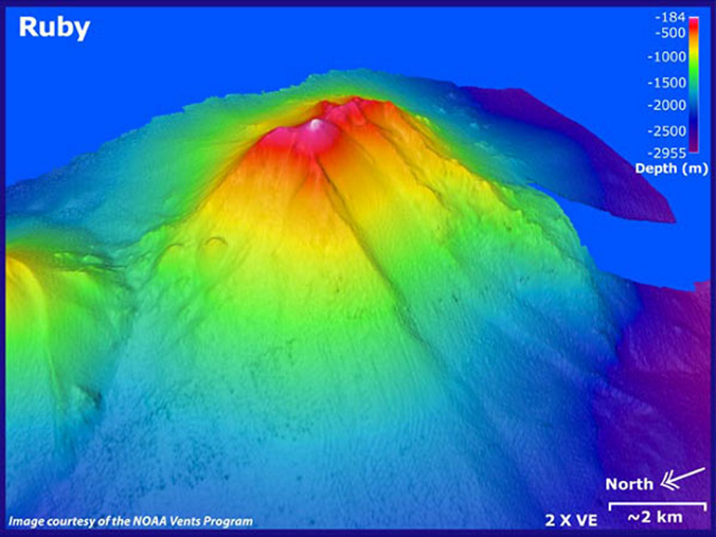 Ruby
Ruby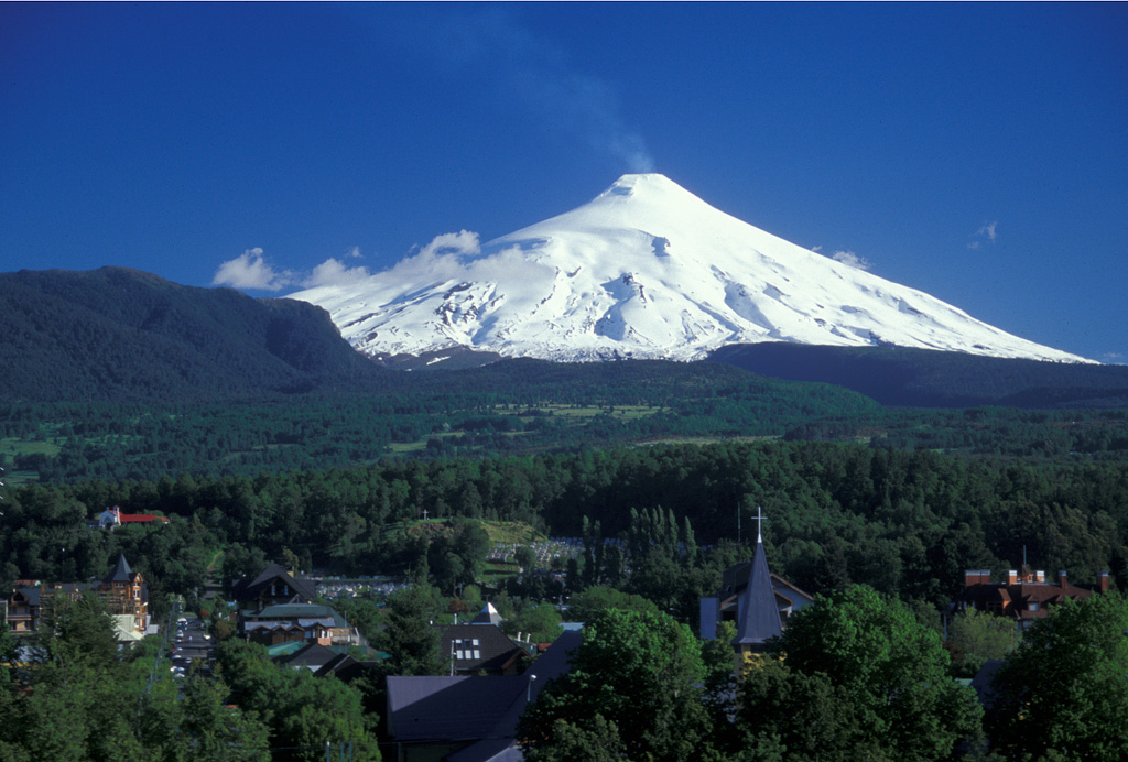 Villarrica