Satellite data showed an area of discolored water in the vicinity of the submarine Lateiki volcano drifting about 1.2 km SW on 20 July. Weather clouds obscured part of the area.
Source: Copernicus
Eruption 13-22 October 2019 creates new island, which disappears by mid-January 2020
Lateiki (Metis Shoal) is one of several submarine and island volcanoes on the W side of the Tonga trench in the South Pacific. It has produced ephemeral islands multiple times since the first confirmed activity in the mid-19th century. Two eruptions, in 1967 and 1979, produced islands that survived for a few months before eroding beneath the surface. An eruption in 1995 produced a larger island that persisted, possibly until a new eruption in mid-October 2019 destroyed it and built a new short-lived island. Information was provided by the Ministry of Lands, Survey and Natural Resources of the Government of the Kingdom of Tonga, and from satellite information and news sources.
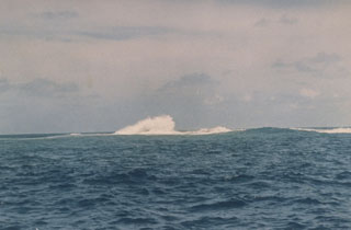
Review of eruptions during 1967-1995. The first reported 20th century eruption at this location was observed by sailors beginning on 12 December 1967 (CSLP 02-67); incandescent ejecta rose several hundred meters into the air and "steam and smoke" rose at least 1,000 m from the ocean surface. The eruption created a small island that was reported to be a few tens of meters high, and a few thousand meters in length and width. Eruptive activity appeared to end in early January 1968, and the island quickly eroded beneath the surface by the end of February (figure 6). When observed in April 1968 the island was gone, with only plumes of yellowish water in the area of the former island.
 |
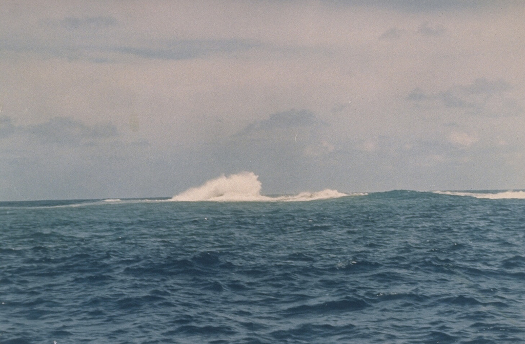
Figure 6. Waves break over Lateiki on 19 February 1968, more than a month after the end of a submarine eruption that began in December 1967 and produced a short-lived island. Photo by Charles Lundquist, 1968 (Smithsonian Astrophysical Observatory). |
A large steam plume and ejecta were observed on 19 June 1979, along with a "growing area of tephra" around the site with a diameter of 16 km by the end of June (SEAN 04:06). Geologists visited the site in mid-July and at that time the island was about 300 m long, 120 m wide, and 15 m high, composed of tephra ranging in size from ash to large bombs (SEAN 04:07); ash emissions were still occurring from the E side of the island. It was determined that the new island was located about 1 km E of the 1967-68 island. By early October 1979 the island had nearly disappeared beneath the ocean surface.
A new eruption was first observed on 6 June 1995. A new island appeared above the waves as a growing lava dome on 12 June (BGVN 20:06). Numerous ash plumes rose hundreds of meters and dissipated downwind. By late June an elliptical dome, about 300 x 250 m in size and 50 m high, had stopped growing. The new island it formed was composed of hardened lava and not the tuff cones of earlier islands (figure 7) according to visitors to the island; pumice was not observed. An overflight of the area in December 2006 showed that an island was still present (figure 8), possibly from the June 1995 eruption. Sentinel-2 satellite imagery confirming the presence of Lateiki Island and discolored water was clearly recorded multiple times between 2015 and 2019. This suggests that the island created in 1995 could have lasted for more than 20 years (figure 9).
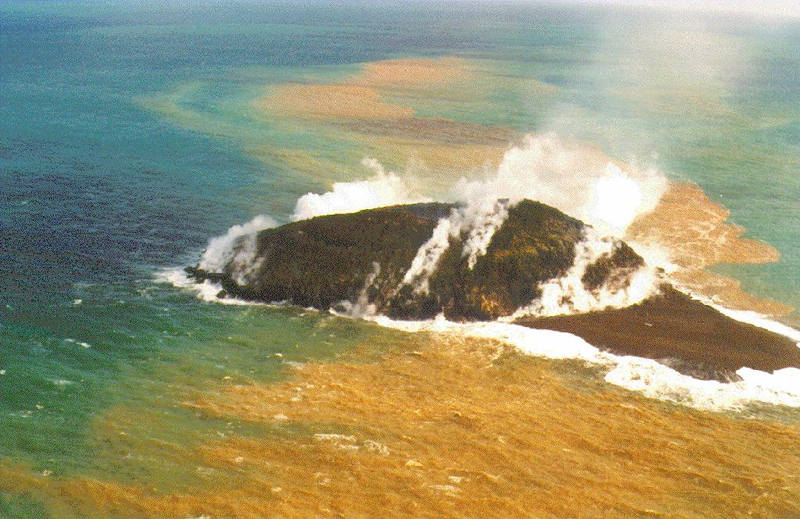 |
Figure 7. An aerial view during the 1995 eruption of Lateiki forming a lava dome. Courtesy of the Government of the Kingdom of Tonga. |
 |
Figure 8. Lateiki Island as seen on 7 December 2006; possibly part of the island that formed in 1995. Courtesy of the Government of the Kingdom of Tonga and the Royal New Zealand Air Force. |
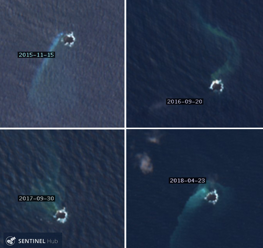 |
Figure 9. Sentinel-2 satellite imagery confirmed the existence of an island present from 2015 through 2019 with little changes to its shape. This suggests that the island created in 1995 could have lasted for more than 20 years. Courtesy of Sentinel Hub Playground. |
New eruption in October 2019. The Kingdom of Tonga reported a new eruption at Lateiki on 13 October 2019, first noted by a ship at 0800 on 14 October. NASA satellite imagery confirmed the eruption taking place that day (figure 10). The following morning a pilot from Real Tonga Airlines photographed the steam plume and reported a plume height of 4.6-5.2 km altitude (figure 11). The Wellington VAAC issued an aviation advisory report noting the pilot's observation of steam, but no ash plume was visible in satellite imagery. They issued a second report on 22 October of a similar steam plume reported by a pilot at 3.7 km altitude. The MODVOLC thermal alert system recorded three thermal alerts from Lateiki, one each on 18, 20, and 22 October 2019.
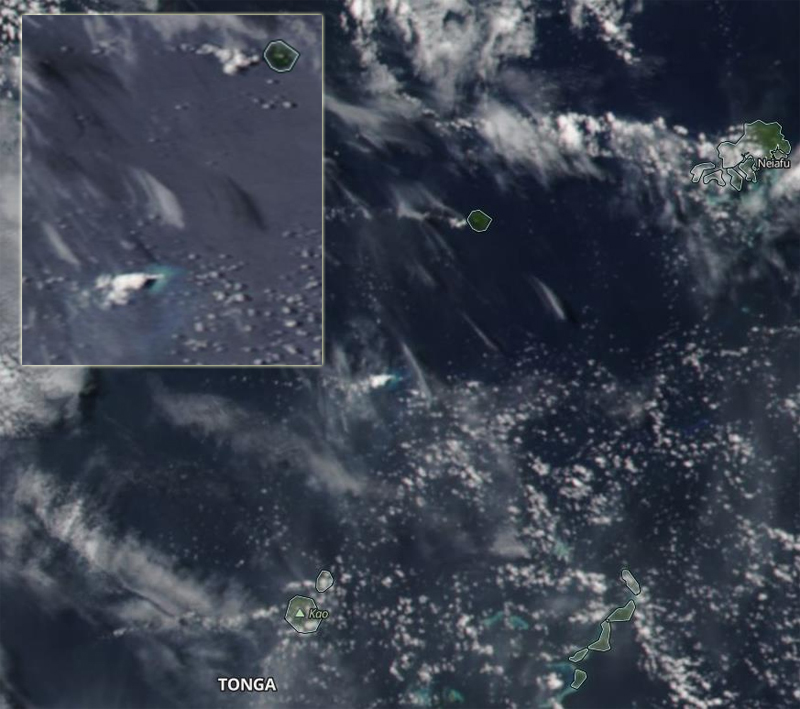 |
Figure 10. NASA's Worldview Aqua/MODIS satellite imagery taken on 14 October 2019 over the Ha'apai and Vava'u region of Tonga showing the new eruption at Lateiki. Neiafu, Vava'u, is at the top right and Tofua and Kao islands are at the bottom left. The inset shows a closeup of Late Island at the top right and a white steam plume rising from Lateiki. Courtesy of the Government of the Kingdom of Tonga and NASA Worldview. |
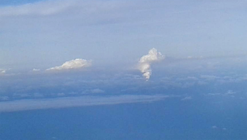 |
Figure 11. Real Tonga Airline's Captain Samuela Folaumoetu'I photographed a large steam plume rising from Lateiki on the morning of 15 October 2019. Courtesy of the Government of the Kingdom of Tonga. |
The first satellite image of the eruption on 15 October 2019 showed activity over a large area, much bigger than the preexisting island that was visible on 10 October (figure 12). Although the eruption produced a steam plume that drifted several tens of kilometers SW and strong incandescent activity, no ash plume was visible, similar to reports of dense steam with little ash during the 1968 and 1979 eruptions (figure 13). Strong incandescence and a dense steam plume were still present on 20 October (figure 14).
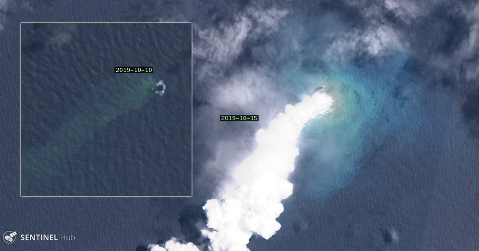 |
Figure 12. The first satellite image of the eruption of Lateiki on 15 October 2019 showed activity over a large area, much bigger than the preexisting island that was visible on 10 October (inset). The two images are the same scale; the island was about 100 m in diameter before the eruption. Image uses Natural Color Rendering (bands 4, 3, 2). Courtesy of Sentinel Hub Playground. |
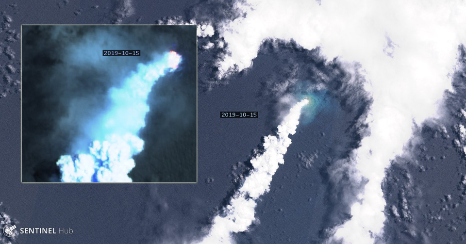 |
Figure 13. The steam plume from Lateiki on 15 October 2019 drifted more than 20 km SE from the volcano. A strong thermal anomaly from incandescent activity was present in the atmospheric penetration rendering (bands 12, 11, 8a) closeup of the same image (inset). Courtesy of Sentinel Hub Playground. |
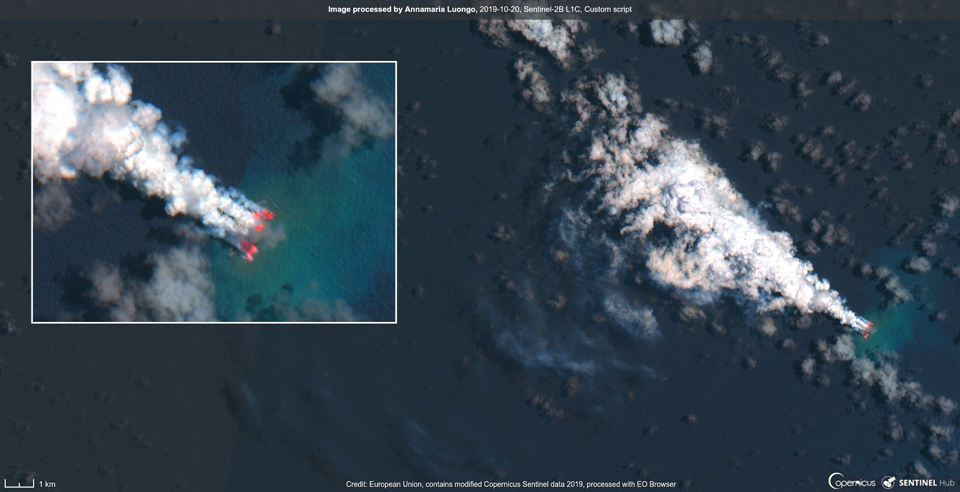 |
Figure 14. A dense plume of steam drifted NW from Lateiki on 20 October 2019, and a strong thermal signal (inset) indicated ongoing explosive activity. Courtesy of Annamaria Luongo and Sentinel Hub Playground. |
A clear satellite image on 30 October 2019 revealed an island estimated to be about 100 m wide and 400 m long, according to geologist Taaniela Kula of the Tonga Geological Service of the Ministry of Lands, Survey and Natural Resources as reported by a local news source (Matangitonga). There was no obvious fumarolic steam activity from the surface, but a plume of greenish brown seawater swirled away from the island towards the NE (figure 15). In a comparison of the location of the old Lateiki island with the new one in satellite images, it was clear that the new island was located as far as 250 m to the NW (figure 16) on 30 October. Over the course of the next few weeks, the island's size decreased significantly; by 19 November, it was perhaps one-quarter the size it had been at the end of October. Lateiki Island continued to diminish during December 2019 and January 2020, and by mid-month only traces of discolored sea water were visible beneath the waves over the eruption site (figure 17).
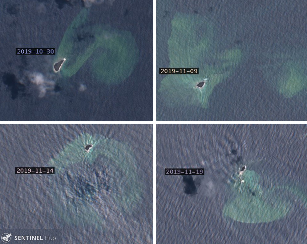 |
Figure 15. The new Lateiki Island was clearly visible on 30 October 2019 (top left), as was greenish-blue discoloration in the surrounding waters. It was estimated to be about 100 m wide and 400 m long that day. Its size decreased significantly over subsequent weeks; ten days later (top right) it was about half the size and two weeks later, on 14 November 2019 (bottom left), it was about one-third its original size. By 19 November (bottom right) only a fraction of the island remained. Greenish discolored water continued to be visible around the volcano. Courtesy of Sentinel Hub Playground. |
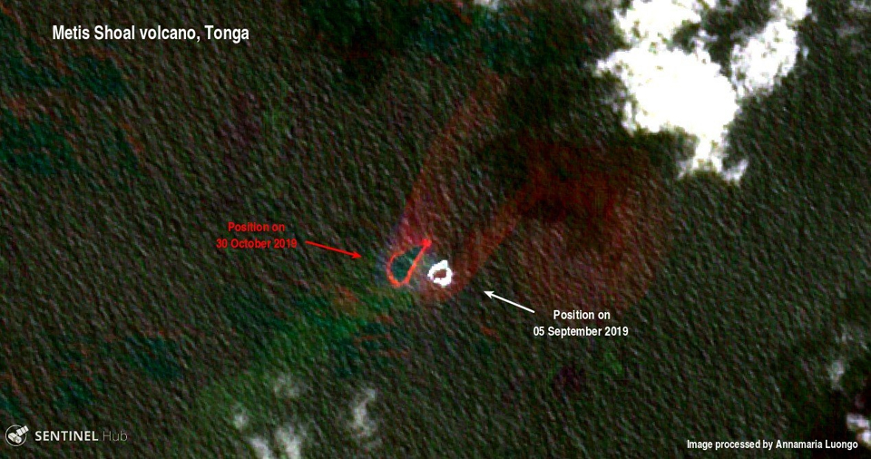 |
Figure 16. The location of the new Lateiki Island (Metis Shoal), shown here on 30 October 2019 in red, was a few hundred meters to the NW of the old position recorded on 5 September 2019 (in white). Courtesy of Annamaria Luongo and Sentinel Hub Playground. |
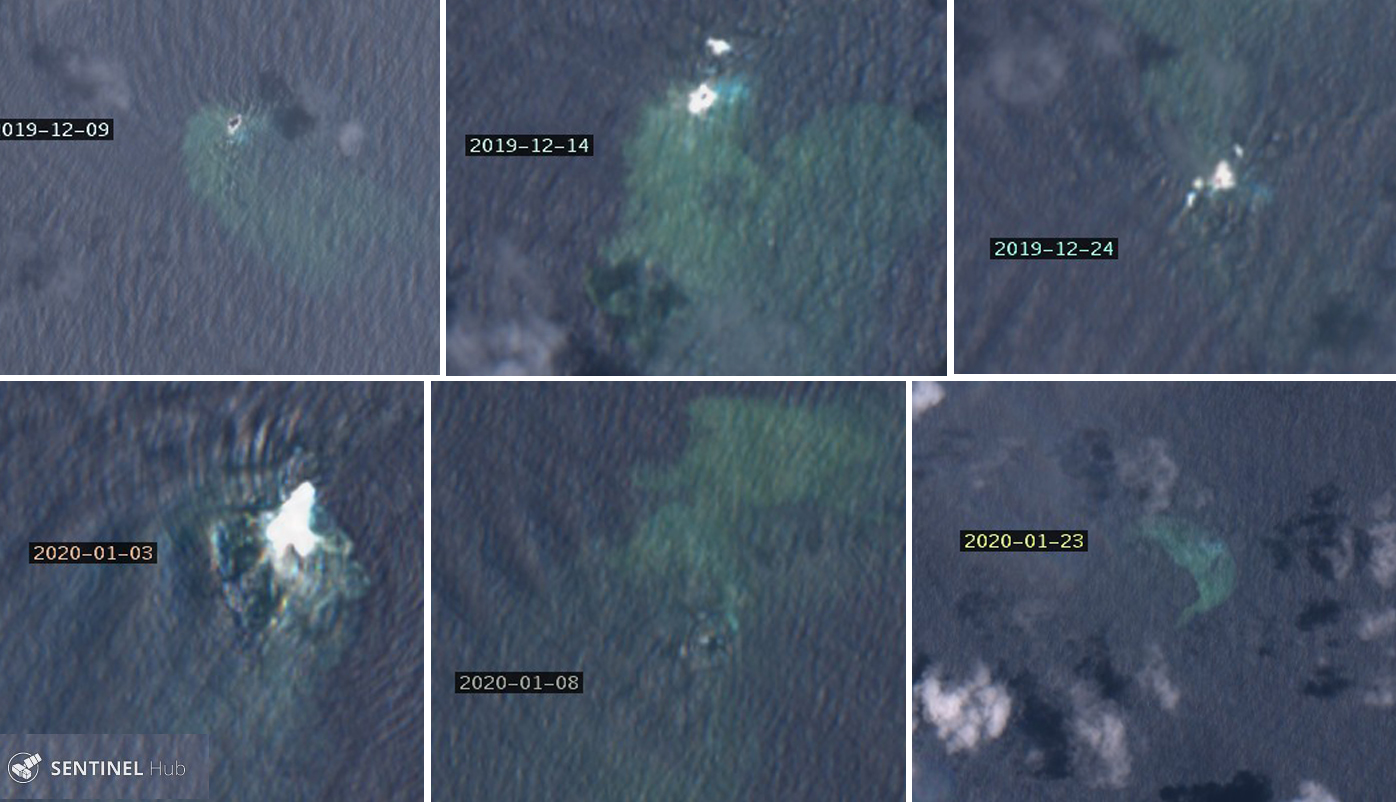 |
Figure 17. Lateiki Island disappeared beneath the waves in early January 2020, though plumes of discolored water continued to be observed later in the month. Courtesy of Sentinel Hub Playground. |
Information Contacts: Government of the Kingdom of Tonga, PO Box 5, Nuku'alofa, Tonga (URL: http://www.gov.to/ ); Royal New Zealand Air Force (URL: http://www.airforce.mil.nz/); NASA Worldview (URL: https://worldview.earthdata.nasa.gov/); Hawai'i Institute of Geophysics and Planetology (HIGP) - MODVOLC Thermal Alerts System, School of Ocean and Earth Science and Technology (SOEST), Univ. of Hawai'i, 2525 Correa Road, Honolulu, HI 96822, USA (URL: http://modis.higp.hawaii.edu/); Sentinel Hub Playground (URL: https://www.sentinel-hub.com/explore/sentinel-playground); Annamaria Luongo, Brussels, Belgium (Twitter: @annamaria_84, URL: https://twitter.com/annamaria_84 ); Taaniela Kula, Tonga Geological Service, Ministry of Lands, Survey and Natural Resources; Matangi Tonga Online (URL: https://matangitonga.to/2019/11/06/eruption-lateiki).
2024: April
| June
| July
2019: October
| November
2006: October
Satellite data showed an area of discolored water in the vicinity of the submarine Lateiki volcano drifting about 1.2 km SW on 20 July. Weather clouds obscured part of the area.
Source: Copernicus
Satellite data showed an area of yellowish-green discolored water in the vicinity of the submarine Lateiki volcano on 25 and 30 June. The area of discolored water on 30 June was narrow and drifted about 7 km ENE before dissipating.
Source: Copernicus
Satellite data showed an area of yellowish-green discolored water in the vicinity of the submarine Lateiki volcano on 26 April. The area of discolored water was narrow and drifted about 2 km SE and curved to the W, becoming more diffuse, and extending another 8.5 km before dissipating.
Source: Copernicus
Satellite data showed an area of yellowish-green discolored water that was about 5 km long in the N-S direction and about 3 km in the E-W direction, in the vicinity of the submarine Lateiki volcano on 21 April. A more diffuse plume of discolored water extended another ~12 km WNW before dissipating.
Source: Copernicus
Satellite images showed that the mid-October eruption at Lateiki (Metis Shoal) had formed a new and larger island, but by 14 November it had eroded to a size similar to the pre-eruptive size.
Source: Simon Carn
GeoNet reported that by 1 November the eruption at Metis Shoal (Lateiki) had formed an elongated island, with no visible evidence of the old 1995 dome. According to a news article the new island is about 100 m wide and 400 m long, and had emerged at a location 120 m away from the former island. The article noted that the eruption had ceased.
Sources: GeoNet; Matangi Tonga Online
The Wellington VAAC reported that on 22 October pilots observed intermittent white plumes rising from Metis Shoal (Lateiki) to 3.7 km (12,000 ft) a.s.l. There was no ash signature in the plumes.
Source: Wellington Volcanic Ash Advisory Center (VAAC)
According to news articles the Tonga Geological Services Office of the Ministry of Lands and Natural Resources stated that several observations indicating a possible eruption at Metis Shoal, also known as Lateiki, were reported during 13-15 October. Real Tonga pilots flying between Tongatapu and Vava'u observed the intermittent plumes rising to 4.6-5.2 km (15,000-17,000 ft) a.s.l. and drifting N on 15 October. Ash in the plumes was not identifiable according to the Wellington VAAC.
Sources: Wellington Volcanic Ash Advisory Center (VAAC); Matangi Tonga Online; Matangi Tonga Online
Further information obtained regarding the floating pumice rafts between Tonga and Fiji indicated that the source was Metis Shoal. Mariners in the region were being informed of this activity in early September via "Rag of the Air" radio broadcasts from Fiji. The earliest report found to this point comes from a boat with callsign KB1LSY, noting that "thick pumice" slowed them for 30 minutes during the early morning hours of 28 August as they were approaching the northern islands of the Lau Group in Fiji, about 500 km NW of Metis Shoal. By 15 October yachts sailing between Tonga and Fiji reported no remaining pumice.
Sources: KB1LSY Crew; Encore II Crew; Bob McDavitt's Pacific Weathergrams
Reports are organized chronologically and indexed below by Month/Year (Publication Volume:Number), and include a one-line summary. Click on the index link or scroll down to read the reports.
Submarine eruption breaks the surface on 12 December 1967, building new island
Notification Report (02 January 1968)
Ship reported sighting eruption at 3 a.m. on 12 December 1967. Undersea volcanic eruption building itself above the surface. By January 6th, island had built itself to be 150 feet high and one mile long. no scientific investigation being conducted to date.
The following reports are ordered by report number with the date of the activity in brackets. The date the report was issued is in parentheses.
Information Report 1/1a [12 December 1967] (02 January/21 February 1968) Lava fountains and tephra ejections; plume rising over 1.2 km
Violent eruption throwing lava 1,000 feet into the air with steam and smoke billowing to 4,000 feet and higher. Island is half a mile wide and 100 feet high. Reported from the deck of the Tufoa, 13 miles from eruption.
Flames leaping above horizon. We were 17 miles away. We altered course toward glow. As we approached we saw lumps of lava being hurled into the sky. We went only to about 10 miles from the eruption. It was very spectacular with flames and lava fountaining to about 1,000 feet. The night was clear and clouds of white smoke were quite visible at about 3,000 feet. There was no noise but we could see the flames about two hours after we left the area. We sent out a report to any ships in the vicinity.
Information Report 2 [13 December 1967] (02 January 1968) Continuous intense activity
Continuous violent activity which has increased in intensity, eruptions approximately 90 seconds apart. Report from the deck of the Hifofua, 15 miles away.
Information Contacts:
Notification Report (02 January 1968) Sidney Galler, SI; Washington Post (14 December 1967); Science News (6 January 1968); Tonga Chronicle (15 December 1967).
Information Report 1/1a [12 December 1967] (02 January/21 February 1968) M. Grey, 1st Officer of the Tufoa, Nukualofa, Tonga Islands.
Information Report 2 [13 December 1967] (02 January 1968) Captain Olsen, Captain of the Hifofua, Nukualofa, Tonga Islands.
Activity decreases and island erodes below ocean surface by late February
Information Report 3 [14 December 1967] (01 February 1968) Steady growth of island continues
Spectacular smoke cloud billowing thousands of feet in the air. Steady formation of new island as hundreds of tons of rock are thrown 400-500 feet in the air. Report made from aircraft chartered by the King of Tonga.
Information Report 4/4a [14 December 1967] (02 January/18 February 1968) Explosions and ash plumes; ejecta rising no higher than 90 m
Explosions were throwing rocks and steam clouds straight up in the air to a height of 400-500 feet. They were carrying smoke to the west and up to a height of 2,500 feet. Smoke clouds were over one mile long. Report made by pilot of airline charter aircraft that flew over volcano on second day of eruption.
Flew at about 300 feet. No material from eruption was going any higher than 300 feet. The rocks stuck up about 50 feet. No whirlwinds or similar phenomena were noted. No lightning or unusual static was noted. No other shoals were noticed in the area. Report of personal interview by Dr. Charles Lundquist.
Information Report 5 [25 January 1968] (02 February 1968) Activity declines in late January
Activity reduced scale with rocky outcrops over half-mile area.
Information Report 6 [28 January 1968] (03 February 1968) Sulfur emissions from low rocky island
Area now low elevation very rocky island one mile long and half mile wide. No eruption, but emitting sulfur fumes.
Information Report 7 [02 February 1968] (12 February 1968) Minor emissions but no eruptive activity
Volcanic activity subdued. It ended about three weeks ago. Some smoke is still coming out. Island is now about one-half mile in diameter. It is possible to land a boat on the island.
Information Report 8 [11 December 1967] (05 February 1968) Frequent smoke and steam bursts seen
Smoke and steam at 20-30-second intervals; initial spurts to 500 feet. Smoke rising to 5,000-8,000 feet. Observed at distance of 70 miles. Weather clear. Location of eruption is 0.7 miles N of Metis Shoal. Ship report to Oceanographic Office.
Information Report 9 [11 December 1967] (09 February 1968) Eruptions reported by U.S. Navy ship
Volcanic eruptions have been reported in following positions by USS Fox at 110402Z and CCGD Fourteen at 111841Z: 1) 19°00' S, 171°00' W; 2) 19°15' S, 171°51' W; 3) 19°10'30" S, 174°51'36" W.
Information Report 10 [20 February 1968] (21 February 1968) Island has eroded below the ocean surface
Metis island gone. Recent volcanic rocks collected from shoal.
Information Report 11 [12 December 1967] (21 February 1968) Small island sighted
Relying on sight and radar estimate island 200 feet high and one mile long. Report from deck of Tufoa, 12 miles from eruption.
Information Report 12 [13 December 1967] (21 February 1968) Seismicity detected; no tsunami reported
There appeared to be seismic activity in the area about 2,900 miles SW of Hawaii. There were no immediate indications that a tidal wave [tsunami] had been generated.
Information Report 13 [13 December 1967] (21 February 1968) Island-building analysis
A lava flow did not occur, but lava pillars built up as the cool water hardened it. Once the lava could flow above sea level it hardened into rock. Below this the lava was inclined to break up into scoria and lava cones. The time the newly formed island stays depends on how long the eruption goes on.
Information Report 14 [14 December 1967] (21 February 1968) Continued intense activity; large block ejections
Volcanic blasts continued to spew rocks and steam. Steam belching about 300 feet high and in the center of the smoke and steam were spurts of red flame. There were some big rocks and they were making huge splashes as they fell into the sea. The island was almost entirely obscured by clouds of steam and it was difficult to estimate its size. It is solid rock and well above the surface, about 50 feet high. It was a spectacular sight.
Reported by the air crew of two Royal New Zealand Air Force Orions which flew around the volcanic island for 45 minutes on the afternoon of 14 December 1967. The aircraft circled the island at 700 feet.
Information Report 15 [19 February 1968] (26 February 1968) Island now submerged to a depth of 1-2 m
Island is now submerged. Very high breakers on subsurface rocks. Collected stones at depth of 4 or 5 feet. Black stones on sand bottom. All smal stones moving in currents, back and forth. Saw at least one large black stone about 10 feet by 10 feet horizontal cross-section. Recovered suitcase full of recent lava for analysis. Report on visit to Metis Shoal on 19-20 February 1968; diver was Inoke Fisi of Matuku Island.
Information Report 16 [01 January 1968] (18 February 1968) Plume and floating tephra seen during overflight
Flew around the Metis Island on way from American Samoa to Tonga. There was a long trail of clouds and active eruption at the time. The material coming up was dark. No incandescence or lightning was seen. On the ocean much tephra was floating downwind. Saw rocks sticking up, perhaps more than in photos. Report from personal interview with Charles Lundquist.
Information Report 17 [01 February 1968] (26 February 1968) Water washing across island; minor emissions
Observations before 1 February 1968: Thought cone had built up and that water was no longer reaching vent. Then there seemed to be clear explosions with little steam. Observations on 1 February 1968: Island one-half mile in diameter with jagged rocks and water washing across. Smoke (sulfur) and steam.
Information Contacts:
Information Report 3 [14 December 1967] (01 February 1968) J. Riechelmann, Tonga Chronicle, Nukualofa, Tongatapu, Tonga Islands.
Information Report 4/4a [14 December 1967] (02 January/18 February 1968) Captain Sharer, Fiji Airways Ltd., Nandi, Fiji Islands.
Information Report 5 [25 January 1968] (02 February 1968) J. Riechelmann, Tonga Chronicle, Nukualofa, Tonga Islands.
Information Report 6 [28 January 1968] (03 February 1968) British Consulate, Nukualofa, Tonga Islands.
Information Report 7 [02 February 1968] (12 February 1968) J. Riechelmann, Tonga Chronicle, Nukualofa, Tonga Islands.
Information Report 8 [11 December 1967] (05 February 1968) Mr. Binney, U.S. Navy Oceanographic Office.
Information Report 9 [11 December 1967] (09 February 1968) U.S. Naval Hydrographic Office, HYDROPACK No. 2444-67, issued 161822Z Dec 67.
Information Report 10 [20 February 1968] (21 February 1968) Charles Lundquist, Smithsonian Astrophysical Observatory (in Nukualofa, Tonga Islands).
Information Report 11 [12 December 1967] (21 February 1968) Captain Bennett, Captain of the Tufoa, Nukualofa, Tonga Islands.
Information Report 12 [13 December 1967] (21 February 1968) Lt. Cdr. James Midgely, U.S. Coast and Geodetic Survey, Honolulu.
Information Report 13 [13 December 1967] (21 February 1968) James Healy, New Zealand Geological Survey, Rotorua, New Zealand.
Information Report 14 [14 December 1967] (21 February 1968) Flight Lt. P.K. Simpson, No. 5 Maritime Squadron, Royal New Zealand Air Force, Aukland, New Zealand.
Information Report 15 [19 February 1968] (26 February 1968) Charles Lundquist, Smithsonian Astrophysical Observatory, Cambridge, MA, USA.
Information Report 16 [01 January 1968] (18 February 1968) Penisiami Tupouniua, Nukualofa, Tonga Islands.
Information Report 17 [01 February 1968] (26 February 1968) C.H. Hill-Willis, Captain of the Aoniu, Nukualofa, Tonga Islands.
Observations from December 1967 through April 1968
Information Report 18 [31 December 1967] (16 April 1968) Frequent ejections building island in December 1967
Observations made from aircraft at distance of 1-2 miles from eruption at height of 500 feet.
Observations on 24 December 1967. A solid cloud of white steam with a definite black core of lava rock was ejected. Frequency of ejections: about every 20-30 seconds. Height of eruption cloud: 2,000 feet. Length of cloud: approximately 1 mile. Color of eruption cloud: white with darker core of the ejecta. Ejecta was being thrown to a height of about 300-400 feet. The island was made of low black volcanic sand and was about 1/4-1/2 mile long, about 100-150 yards wide, and 50 feet high. Island was a low black sandy shoal with an increasing area of yellow water downwind as sulfurous spoil was deposited.
Observations on 31 December 1967. The island has grown considerably . . . . [Maximum island size was reached about two weeks later.] By this date the solid eruptions had ceased and by late January the island was receeding.
Information Report 19 [20 January 1968] (17 April 1968) Plume and island observations, 19 December-20 January
Observations made from the ship "Aoniu." There was no lightning and very little cloud on any of the three occasions. No water spouts were observed. No electrical disturbance was noted on our broadcast receivers.
Observations on 19 December 1967. The island was 1/3 of a mile long and approximately 80 feet high. It was erupting from a single cone at intervals of roughly 3 minutes with steam vapor rising to some 8,000 feet; the first 5,000 feet was rising strongly and vertical and then the wind took effect and drifted it away to the NNW.
Observations on 28 December 1967. Volcanic action still taking place but at irregular intervals. Smoke instead of steam was rising to 8,000 feet plus. The island did not appear to have increased in size.
Observations on 20 January 1968. An exposed reef of about 1/2 mile in extent with a strong smell of sulfur premeating the atmosphere.
Apparently this disturbance was a great attraction to fish as both tuna and albacore appeared in the area for a period of about a month. They are not there now (17 April 1968).
Information Report 20 [08 January 1968] (17 April 1968) Incandescent ejecta building island on 11 December
Observations were made from the ship "Tufoa."
Observations at 0840 GMT on 11 December 1967. Vessel obtained a very sharp radar echo at a distance of 13 miles which could of course be due to electrical static discharge on turbulent steam clouds ascending with considerable velocity above the island. At the closest approach of 9 miles the volcanic eruption had the appearance of an incandescent island about 1/2 mile long and 150 feet high, glowing cherry red at constant intensity. Above this island a dense pillar of steam and smoke ascended to 3,000 feet and at approximately 1-minute intervals molten lava of boulders in irregular parabolic arcs were observed being ejected to a height of 1,000 feet.
Observations on 8 January 1968. Radar indicated only a small island almost awash and no volcanic activity was observed.
Information Report 21 (29 April 1968) Eruption ends in late December 1967; island gone by mid-February 1968
Observations on 24 Dec 1967, 31 Dec 1967, 7 Jan 1968, 31 Jan 1968, late Feb 1968, 21 April 1968.
"The island, generally kidney-shaped at its best, lay with its longitudinal axis approximately E-W. Steam clouds on that day, 31 December, were blowing in a direction of about 200 degrees true, the surface wind was from the NNE. The island was at a maximum size by about the 7th of Jan 68.
"On Sunday, Dec 24th, violent eruptions were taking place. By Sunday, Dec 31st, these eruptions appeared to have reduced considerably, although still actively steaming. By Sunday, Jan 7th 1968, volcanic activity appeared to have ceased, although steam was still evident. By Sunday, 31 Jan 68, all activity had ceased, volcanic and steaming.
"I would estimate that the island disappeared in the first or the second week of February. By late February I observed the sea washing over the island completely, but with waves first breaking on the edges. The appearance from 8,000 feet was mainly black volcanic sand and rock."
Information Report 22 (29 April 1968) Observations of the submerged island in April 1968
Observation of the island beneath the sea made at 8,000 feet at 2120 hours on April 21st, 1968.
"The island appears to have sunk even more. The sea was calm and the island completely covered without any appearance of breaking waves (it was about low water at Tonga). The color looked more like yellow sand as opposed to black sand, mentioned earlier. The water around about had a definite yellow tinge, suggesting a sulphur content. The coloring effects gave an impression of a discharge in the sea. The size of the island (beneath the sea) was roughly 100 yards across and circular in form.
"Note: The estimate of the height of the island by Flt. Lt. Simpson of the RNZAF compares with my own estimate - 50 feet. But we both appear to be wide of the mark compared with the crew of MV Tofua. Their estimate of 100-200 feet is probably a better one, when judged from the horizontal."
Information Contacts:
Information Report 18 [31 December 1967] (16 April 1968) T.M. Holmes, Polynesian Airlines Ltd., Western Samoa.
Information Report 19 [20 January 1968] (17 April 1968) C.H. Hill-WIllis, Captain of the MV Aoniu, Nukualofa, Tonga Islands.
Information Report 20 [08 January 1968] (17 April 1968) Peter Bennett, Union Steam Ship Company, Auckland, New Zealand.
Information Report 21 (29 April 1968) T.M. Holmes, Polynesian Airlines Ltd., Western Samoa.
Information Report 22 (29 April 1968) T.M. Holmes, Polynesian Airlines Ltd., Western Samoa.
Details of 14 December 1967 observation flight
Information Report 23/23a [14 December 1967] (18 May 1968) Details of 14 December 1967 observation flight
On 14 December 1967, two Orion aircraft of No. 5 Squadron, Royal New Zealand Air Force, flew around Metis Shoal for approximately 30 minutes. The position of the volcano was recorded as 19°09'S, 174°50'W. The recorded weather in the area was scattered to broken strato-cumulus, base 1,500', tops 7,000', with a marked wind shear and temperature inversion at 7,000'. Surface wind was from 090°T, at 13 knots with a light westerly at 10,000'. The smoke and steam from the volcano reached the inversion some 5-10 miles downwind.
At the site of the eruption an island had formed and it was vigorously estimated to be 20-40 feet high and as much as 150-300 yards long. At the eastern (upwind) extremity of the island was a crater guessed to be 10-20 yards across. Its shape was circular with dark gray lips. Inside the gray soon changed to a dark cherry red, becoming brighter and more orange with increasing depth. These details were observed only momentarily when for a few seconds the smoke cleared about the crater. During this brief period the gases shooting from the crater mouth were seen to be clear and transparent. Generally both the crater and island were obscured by smoke and steam.
The aircraft flew underneath the smoke trail at a height of 600' perhaps 4 miles from the site of the eruption. Numerous spots of a thin grayish material up to 1/4" across were deposited on the windscreen and a strong sulfurous smell was noticed.
Lumps of dark-colored matter were being flung several hundred feet into the air. They seemed to be ejected at intervals of 10-20 seconds and they splashed into the sea in all directions out to a distance of 250 yards. This matter was clearly visible from 1/2 to 1 mile away. Occasionally a much larger piece (perhaps 2 or 3 feet across) would be seen to rise to a height of 100-200 feet.
The sea water around the volcano was colored an emerald green streaked with brown. This discoloration extended several hundred yards upwind and 7 nautical miles on a bearing of 240°T from the island.
Information Contacts: D. Rishworth, DSIR, Rotorua, New Zealand.
Large areas of pumice sighted between the Tonga and Fiji islands
A large body of floating pumice was first reported on 10 May by a Soviet vessel, in the area from 17.80-18°S and 176.45-176.67°W. On 14 May, a U.S. Naval Research Laboratory aircraft flew over continuous 30-45 m-wide patches of dirty rust-brown pumice from 17-17.45°S and 174.13-177.60°W. Four days later, the same aircraft flew over Late Island (18.810°S, 174.65°W), last reported to erupt in 1854. White material, apparently ash, covered the cone, and streaks of pumice extended back to the island from the main body of the raft [but see 4:12].
While enroute from Nandi, Fiji NE to Apia, Western Samoa on 22 May, Captain Gallagher of Polynesian Airlines observed pumice extending about 30 km SE from 16.2°S, 178.38°W. On the 24th, Captain Gallagher again observed pumice, in large areas at about 15.8°S, 177.5°W. An Air Pacific plane flew over pumice that extended about 25 km N-S and about 45 km E-W from 16.37°S, 177.63°W on 28 May.
Captain F. R. Sutherland of Polynesian Airlines reported pumice between about 15.58°S, 176.50°W and 16.10°S, 178.18°W on 30 May, as he flew SW from Apia to Nandi. He first saw several long, thin, mustard-brown streaks, then the pumice became more concentrated. The largest area of pumice, about 5 x 1 km, extended NW-SE and tapered to the SE.
During the afternoon of 4 June, Fijian naval vessels collected samples of the pumice from just inside the Tonga entrance to Vanua Balavu (17.3°S, 178.9°W), an island of the Lau Group about 135 km ESE of Vanua Levu, one of the two main Fiji islands. Pumice fragments in this area were greenish-gray, ranged from 2.5-500 cm across, and carried coarse barnacles 0.5-0.7 cm long. There have been no reports of pumice washing ashore at any location but the samples were collected within the reef surrounding Vanua Balavu.
The rate of drift of the pumice is estimated by Ronald Richmond at about 3 km/day, to the NW. Its source was apparently Late Island (see above), but residents of nearby islands in the Tonga chain did not report an eruption. A thick, odorless haze covering the Tonga and Fiji Islands early in the week beginning 6 May reduced visibility to 3 km or less in Nandi, Fiji. Such haze is very unusual in this area and may have been caused by volcanic activity. On 10 May, what appears to be a volcanic plume could be seen on NOAA weather satellite imagery, drifting SE from about 18°S, 174°W between 1200 and 2100-2200, when the source of the plume was cut off. However, an earlier eruption must be postulated as the source for at least some of the pumice, given the sighting on 10 May.
Information Contacts: R. Richmond, Mineral Resources Dept., Fiji; Capt. Gallagher and T. Sutherland, Polynesian Airlines; N. Cherkis, US Naval Research Lab; A. Krueger, NOAA.
Pumice continues westward drift; source unknown
The pumice . . . continued to drift in a generally westward direction in June. In mid-June, patches of pumice were reported near Vanua Balavu, Katafaga, and Yacata, small islands at the N end of the Lau Ridge (figure 1). The pumice at Yacata formed a strip 5 km long but only about 5 m wide. Large quantities of pumice were seen during the same period around Late Island (18.81°S, 174.65°W), about 400 km ESE of the Lau Group.
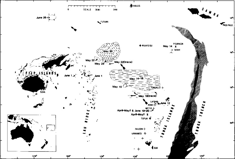 |
Figure 1. Map showing the distribution of floating pumice between Tonga and Fiji, and the locations of volcanic activity in Tonga, May-June 1979. Historically active volcanic centers are indicated by crosses. Stippled zones delineate water < 1 km deep. Trench depths > 6 and 8 km are indicated by diagonal and cross-ruled patterns. Original map by T. Simkin adapted by Woodhall (1979). |
The source of the pumice remains uncertain. In mid-May, streaks of pumice extended back to Late Island from the main raft and the island's cone was covered with white material, which was thought to be fresh ash (04:05). However, activity has been reported at three other sites along the Tonga Arc in May and June.
A Tongan vessel reported a strong eruption between 0700 and 1200 on 19 June at 19.18°S, 174.83°W, in the area of Metis Shoal, a frequently active submarine volcano that last erupted December 1967-January 1968. The vessel's crew observed a mushroom cloud climbing to about 1.5 km and saw the sea steaming. At about the same time, the MV Niuvakai (enroute from Auckland, New Zealand to Samoa) passed Metis Shoal, reporting an eruption column a little less than 200 m high at 0754. Captain Robert Jones of Air Tonga flew over Metis Shoal late the next morning and saw rocks ejected to about 150 m altitude as water boiled vigorously around the center of the eruption. During subsequent flights, Captain Jones observed a growing area of tephra, either an island or a mass of floating pumice, around the eruption site. He estimated its diameter at 3 km on 21 June, 8 km on 22 June, and 16 km on 24 June.
Many moderate seismic events, most shallow, occur each month in the Tonga Arc. Events, in table 1, recorded by the worldwide seismic net (WWSSN) between late April and early June, had epicenters near one of the reported eruption sites. Data are from the USGS-NEIS, published in their Preliminary Determination of Epicenters.
Table 1. Events recorded by WWSSN between late April and early June 1979 with epicenters near one of the reported eruption sites. Data are from the USGS-NEIS, published in their Preliminary Determination of Epicenters.
| Date | Time (GMT) | Magnitude | Latitude | Longitude | Focus Depth | Number of Stations |
| 28 Apr 1979 | 0054 | 5.7 | 18.136°S | 174.855°W | shallow | 93 |
| 28 Apr 1979 | 0303 | 5.2 | 19.252°S | 175.669°W | 244 km | 101 |
| 29 Apr 1979 | 0851 | 4.7 | 15.906°S | 173.046°W | shallow | 33 |
| 06 May 1979 | 0907 | -- | 15.932°S | 173.882°W | shallow | 25 |
| 12 May 1979 | 2332 | 4.2 | 16.347°S | 174.325°W | 282 km | 8 |
| 28 May 1979 | 0003 | 5.3 | 17.512°S | 175.187°W | 274 km | 81 |
| 30 May 1979 | 1645 | 5.1 | 15.390°S | 173.174°W | shallow | 39 |
| 01 Jun 1979 | 0210 | 5.0 | 15.398°S | 173.180°W | shallow | 69 |
| 01 Jun 1979 | 2057 | 4.7 | 20.340°S | 173.799°W | shallow | 38 |
A research vessel, carrying geologists from Fiji and Tonga, left Fiji on 3 July. Each of the reported eruption sites along the Tonga Arc will be investigated and pumice floating in the area will be sampled.
Many moderate seismic events, most shallow, occure each month in the Tonga Arc. Nine events between 28 April and 1 June had epicenters near one of the reported eruption sites (table 1).
Further Reference. Woodhall, D., 1979, Cruise of the R.V. Bulikula to Investigate Recent Volcanic Activity in Tonga, July 11-18, 1979; Fiji Ministry of Lands & Mineral Resources, Mineral Resources Division Report 14.
Information Contacts: R. Richmond, Mineral Resources Dept., Fiji; J. Latter, DSIR, Wellington; S. Tongilava, Lands Survey and Natural Resources, Tonga; R. Jones, Air Tonga; USGS/NEIS, Denver; AP
New island grows to 15 m high in mid-July
Geologists aboard the RV Bulikula inspected the volcanoes along the Tonga Arc between 3 and 21 July. A new island, named Late Iki, had formed above Metis Shoal at 19.18°S, 174.85°W, site of strong activity in June. The new island, comprised of tephra ranging in size from ash to large bombs, was ~300 m long, 120 m wide, and 15 m high in mid-July. Emission of hot ash continued from the E end of the island.
Short-lived islands were also formed over Metis Shoal during the eruptions of 1858 and 1967-8. The position determined (by satellite navigation) for the new island is approximately 1 km E of the one formed in 1967-68 (Melson and others, 1970). That island, estimated to have been 700 x 100 m and 15 m high, was eroded away within a month of the eruption's end.
No new pumice was being ejected by any of the volcanoes along the Tonga Arc.
Reference. Melson, W., Jarosewich, E., and Lundquist, C., 1970, Volcanic eruption at Metis Shoal, Tonga, 1967-1968, description and petrology: Smithsonian Contributions to the Earth Sciences, no. 4, 18 p.
Information Contacts: R. Richmond, Mineral Resources Dept., Fiji.
Fumarolic activity on the island during August, pumice washes ashore 1,150 km NW away
Some fumarolic activity continued to take place during August on Late Iki. Geologists do not expect the island to persist for more than a few months. Reports from Rotuma Island (12.5°S, 177.08°E, about 1,150 km NW of Late Iki) state that a thick blanket of pumice washed up on the S side of the island in mid-August. Fish that jumped out of the sea and landed on the pumice were unable to return to the water. No other reports of pumice have been received by the Fiji Mineral Resources Department in August.
Information Contacts: R. Richmond, Mineral Resources Dept., Fiji.
Pumice sighted in Solomons and New Hebrides
Floating pumice, presumably from the recent island-forming eruption of Metis Shoal, was reported at two widely separated locations during October. On 6 October, Samuel Iko, aboard the MV Independence, observed a blanket of pumice floating between the islands of Guadalcanal, the Florida Group, and Malaita (Solomon Islands), with the greatest concentration at about 9.5°S, 160.5°E, approximately 3,000 km WNW of Metis Shoal. Other reports indicated that pumice washed ashore at Marau, an islet at 8.5°S, 159.5°E, as the raft moved southward through the Solomons.
On 25 October, John Carney sighted dark friable pumice on the beach on the S coast of Efate Island, New Hebrides (17.8°S, 168.5°E), about 1,850 km W of Metis Shoal. This is the first known observation of pumice from Metis Shoal in Vanuatu. The last observations of Late Iki, the island that formed over Metis Shoal, were made in early October. At that time, the island had nearly disappeared beneath the ocean's surface.
Information Contacts: D. Tuni, Ministry of Natural Resources, Solomon Islands; J. Carney, A. MacFarlane, Geological Survey, Vanuatu; R. Richmond, Mineral Resources Dept., Fiji.
Additional information on eruptions and pumice drift
Most of the reported eruption sites were investigated during the 11-18 July cruise of the Fijian research vessel RV Bulikula. Deni Tuni reported that pumice arrived at the following Solomon Islands locations (figure 2) on the following dates: Malaita and the N and E shores of Santa Isabel, 1 October; Indispensable Strait and Guadalcanal, 6 October; Savo and the Russells, 18 October; and the SW shore of Rennell, 13 November.
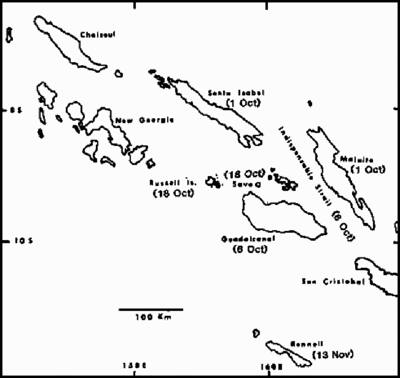 |
Figure 2. Sketch map of the Solomon Islands, showing locations and dates of pumice arrivals from Metis Shoal eruption, October-November 1979. |
Information Contacts: D. Woodhall and R. Richmond, Mineral Resources Dept., Fiji; D. Tuni, Ministry of Natural Resources, Solomon Islands.
Eruption builds new island
On 6 June the Hydrographic Office in Tonga notified the New Zealand Hydrographic Office that an eruption was in progress at Metis Shoal (figure 3). The NZ Hydrographic Office then issued a Long Range Navigation Warning to all shipping. The ship Obtfriesland reported the shoal in eruption while passing on 9 June at 1050. At least five volcanic ash aircraft advisories were issued by the Wellington Volcanic Ash Advisory Center on 12-13 June. The notices stated that the eruption began early on 12 June, apparently the time of the first plume report by an aircraft. Ash was reported up to 18-24 km. Drift directions of the plume changed in each notice, with estimated speeds of 28-46 km/hour.
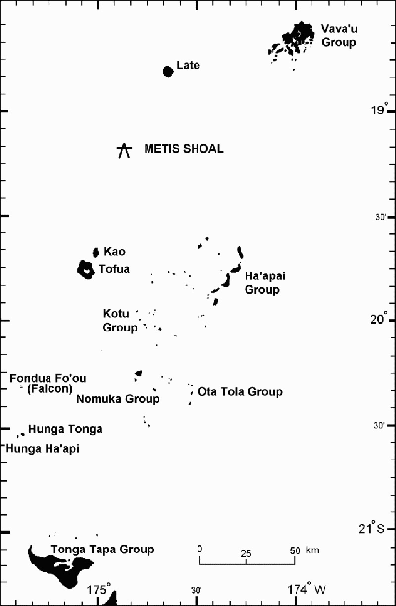 |
Figure 3. Map of the Tonga Islands, showing the island groups and location of Metis Shoal, which re-emerged as an island in June 1995. |
An island breached the surface ~12 June, but the growth of a lava dome above sea level was first observed on 14 June. A video taken on 14 June by a local tour operator (Allan Bowe), ~400-500 m away from the new island, was widely distributed by television news organizations. The video narrator noted that the water around the boat was discolored green. Based on the video and photographs, Brad Scott estimated that the dome was ~30 m high with a diameter of 150-180 m. The volume of the lava dome was estimated at ~1 x 10⁶ m3, giving a daily extrusion rate of ~1 x 10⁵ m3.
Ash-laden eruptions seen on the video discharged from two sources. The first was directed NW, apparently from the dome wall. The second generated stronger explosions vertically from the dome center to heights of 300-500 m. The NNE face of the dome was steaming vigorously from what appeared to be parallel vertical sources, probably fractures in the advancing flow front. The steam plume, originating from the N and S sides of the dome, was rising 500-800 m before being blown downwind for several kilometers.
By 20 June the lava dome was 240 x 280 m in size (67,200 m2) and ~54 m above sea level; the next day it was an estimated 200-500 m across and 50-80 m high. The volume of the dome was estimated at ~2.8 x 10⁶ m3, three times that on 14 June. The daily extrusion rate during 14-21 June was ~4 x 10⁶ m3, a 4-fold increase over the 6-14 June period.
During 20-21 June a white steam plume rose as high as 1-2 km, and occasional small explosions produced ash columns to ~500 m. The active vent was in the SE corner of the island. On the evening of 20 June, the growing NE front of the dome was incandescent, and some observers reported that the summit was pulsing 3-5 m vertically. A small lobe was extruded onto the top of the dome and the NE front of the dome was active. Phreatic explosions occurred at the flow front. The dome changed overnight on 20-21 June, moving downward and NE. The steep-sided lava dome split and subsided between 21 and 25 June. Another aviation volcanic ash advisory on 21 June noted a report of ash below 24 km in the vicinity of the volcano drifting SE at ~18-19 km/hour.
On 23 June the Tongan government asked the New Zealand government for advice on the eruption. As a result, Brad Scott (IGNS) joined a Royal New Zealand Air Force maritime patrol flight on 25 June. He reported that by 25 June the elliptical dome, ~300 x 250 m, elongate NNE, and ~50 m high, had stopped growing.Trending NW was a raised platform ~150 x 80 m, and 2-3 m above sea level. The lobe formerly on top of the dome had been displaced ~40-50 m NE and was lower than the highest point, which then stood on the S side. Blue fume emissions from a depression in the central part of the dome indicated a high SO2 content. A circular lobe of lava to the NE overlay a strongly ribbed flow front. Zones of discolored water (yellow-brown) extending outward from the volcano apparently represented submarine fumarolic discharge.
Scott traveled on a tugboat near the island on 28 June. Steam emissions had decreased appreciably since 21 June, but the dome profile appeared unchanged since the 25th, indicating a significant decline in the eruption rate. Assuming a diameter of 280 m and a height of 43 m on 28 June, the erupted volume was calculated to be ~3 x 10⁶ m3. No pumice has been observed, in contrast with past eruptions. The 1967 and 1979 events erupted dacitic pumice and formed low-angle tuff cones, which were soon eroded away. The current lava dome appeared solid in late June, and may resist erosion for some time.
Two other eruption locations reported by aircraft were investigated, but nothing was found; those sites were apparently the aircraft locations at the time of the observations. The Tongan government was advised to place a restricted access zone around the island, and was briefed about acid rain/fume, explosive outbursts, dome collapse, and the formation of further shoals.
Metis Shoal is located in the Tonga Islands about halfway between Kao and Late, ~50 km NNE of Kao (figure 3). Eight previous episodes of activity are known since 1851; new islands were created on at least three (1858, 1967, and 1979), and possibly five, of those occasions. The 1967-68 island appeared around 11 December 1967, and had submerged again by 19 February 1968 (Melson and others, 1970). In 1979, large pumice rafts were first seen in May between Tonga and Fiji. Metis was seen in strong eruption in June, with ash emission in July, and fumarolic activity in August. The island, named Late Iki by the Tongan government, disappeared in October 1979 (SEAN 04:05-04:08, 04:10, and 04:12; see Woodhall, 1979, for more details).
References. Melson, W.G., Jarosewich, E., and Lundquist, C.A., 1970, Volcanic eruption at Metis Shoal, Tonga, 1967-1968: description and petrology: Smithsonian Institution Press, Smithsonian Contributions to the Earth Sciences, no. 4, 18 p.
Woodhall, D., 1979, Cruise of the R.V. Balikula to investigate recent volcanic activity in Tonga, July 11-18, 1979: Fiji Ministry of Lands & Mineral Resources, Mineral Resources Division Report 14, 13 p.
Information Contacts: Brad Scott, Volcano Surveillance Manager, Institute of Geological & Nuclear Sciences, New Zealand; Bureau of Meteorology, Northern Territory Regional Office, POB 735, Darwin NT 0801, Australia.
Island present in December 2006; discolored water
On 7 December 2006 the Royal New Zealand Air Force (RNZAF) flew over the Home Reef and Metis Shoal area of Tonga at the request of volcanologists from the Institute of Geological & Nuclear Sciences (IGNS). At that time an island was present (figure 4), but it is not known if this is a remnant of the island built in 1995 (BGVN 20:06) or the result of later undocumented eruptions. Areas of discolored water were present adjacent to the island, the result of either erosion or fumarolic activity. Discolored water extending about 5 km SW from the location of the island was also observed in an Aqua MODIS satellite image taken on 15 September 2005 (figure 5).
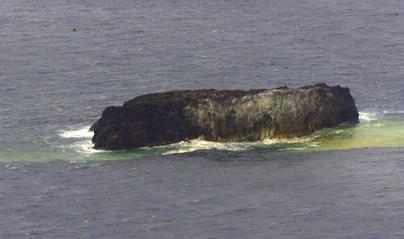 |
Figure 4. Photograph of Metis Shoal, 7 December 2006. Courtesy of the RNZAF and IGNS. |
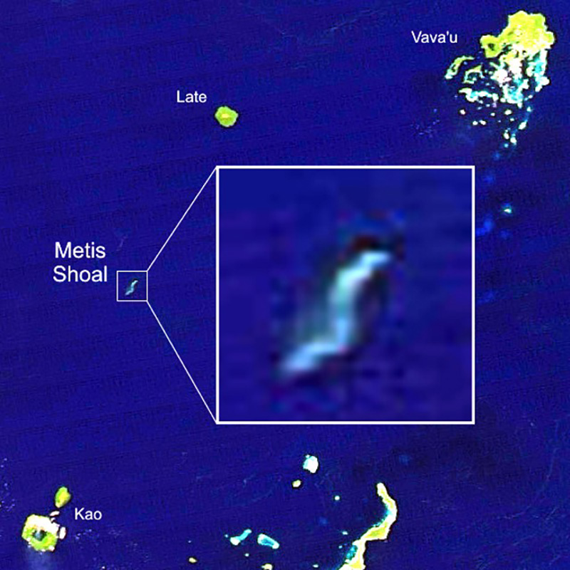 |
Figure 5. Satellite image (Aqua MODIS) from 15 September 2005 showing discolored water extending about 5 km SW from Metis Shoal. Image has been color-adjusted to enhance water discoloration. Base image courtesy of NASA Earth Observatory. |
Information Contacts: Brad Scott, Institute of Geological & Nuclear Sciences (IGNS), Wairakei Research Centre, PO Box 2000, Taupo, New Zealand (URL: http://www.geonet.org.nz/, http://www.gns.cri.nz/); NASA Earth Observatory (URL: http://earthobservatory.nasa.gov/).
Eruption 13-22 October 2019 creates new island, which disappears by mid-January 2020
Lateiki (Metis Shoal) is one of several submarine and island volcanoes on the W side of the Tonga trench in the South Pacific. It has produced ephemeral islands multiple times since the first confirmed activity in the mid-19th century. Two eruptions, in 1967 and 1979, produced islands that survived for a few months before eroding beneath the surface. An eruption in 1995 produced a larger island that persisted, possibly until a new eruption in mid-October 2019 destroyed it and built a new short-lived island. Information was provided by the Ministry of Lands, Survey and Natural Resources of the Government of the Kingdom of Tonga, and from satellite information and news sources.
Review of eruptions during 1967-1995. The first reported 20th century eruption at this location was observed by sailors beginning on 12 December 1967 (CSLP 02-67); incandescent ejecta rose several hundred meters into the air and "steam and smoke" rose at least 1,000 m from the ocean surface. The eruption created a small island that was reported to be a few tens of meters high, and a few thousand meters in length and width. Eruptive activity appeared to end in early January 1968, and the island quickly eroded beneath the surface by the end of February (figure 6). When observed in April 1968 the island was gone, with only plumes of yellowish water in the area of the former island.
|
Figure 6. Waves break over Lateiki on 19 February 1968, more than a month after the end of a submarine eruption that began in December 1967 and produced a short-lived island. Photo by Charles Lundquist, 1968 (Smithsonian Astrophysical Observatory). |
A large steam plume and ejecta were observed on 19 June 1979, along with a "growing area of tephra" around the site with a diameter of 16 km by the end of June (SEAN 04:06). Geologists visited the site in mid-July and at that time the island was about 300 m long, 120 m wide, and 15 m high, composed of tephra ranging in size from ash to large bombs (SEAN 04:07); ash emissions were still occurring from the E side of the island. It was determined that the new island was located about 1 km E of the 1967-68 island. By early October 1979 the island had nearly disappeared beneath the ocean surface.
A new eruption was first observed on 6 June 1995. A new island appeared above the waves as a growing lava dome on 12 June (BGVN 20:06). Numerous ash plumes rose hundreds of meters and dissipated downwind. By late June an elliptical dome, about 300 x 250 m in size and 50 m high, had stopped growing. The new island it formed was composed of hardened lava and not the tuff cones of earlier islands (figure 7) according to visitors to the island; pumice was not observed. An overflight of the area in December 2006 showed that an island was still present (figure 8), possibly from the June 1995 eruption. Sentinel-2 satellite imagery confirming the presence of Lateiki Island and discolored water was clearly recorded multiple times between 2015 and 2019. This suggests that the island created in 1995 could have lasted for more than 20 years (figure 9).
|
Figure 7. An aerial view during the 1995 eruption of Lateiki forming a lava dome. Courtesy of the Government of the Kingdom of Tonga. |
|
Figure 8. Lateiki Island as seen on 7 December 2006; possibly part of the island that formed in 1995. Courtesy of the Government of the Kingdom of Tonga and the Royal New Zealand Air Force. |
|
Figure 9. Sentinel-2 satellite imagery confirmed the existence of an island present from 2015 through 2019 with little changes to its shape. This suggests that the island created in 1995 could have lasted for more than 20 years. Courtesy of Sentinel Hub Playground. |
New eruption in October 2019. The Kingdom of Tonga reported a new eruption at Lateiki on 13 October 2019, first noted by a ship at 0800 on 14 October. NASA satellite imagery confirmed the eruption taking place that day (figure 10). The following morning a pilot from Real Tonga Airlines photographed the steam plume and reported a plume height of 4.6-5.2 km altitude (figure 11). The Wellington VAAC issued an aviation advisory report noting the pilot's observation of steam, but no ash plume was visible in satellite imagery. They issued a second report on 22 October of a similar steam plume reported by a pilot at 3.7 km altitude. The MODVOLC thermal alert system recorded three thermal alerts from Lateiki, one each on 18, 20, and 22 October 2019.
|
Figure 10. NASA's Worldview Aqua/MODIS satellite imagery taken on 14 October 2019 over the Ha'apai and Vava'u region of Tonga showing the new eruption at Lateiki. Neiafu, Vava'u, is at the top right and Tofua and Kao islands are at the bottom left. The inset shows a closeup of Late Island at the top right and a white steam plume rising from Lateiki. Courtesy of the Government of the Kingdom of Tonga and NASA Worldview. |
|
Figure 11. Real Tonga Airline's Captain Samuela Folaumoetu'I photographed a large steam plume rising from Lateiki on the morning of 15 October 2019. Courtesy of the Government of the Kingdom of Tonga. |
The first satellite image of the eruption on 15 October 2019 showed activity over a large area, much bigger than the preexisting island that was visible on 10 October (figure 12). Although the eruption produced a steam plume that drifted several tens of kilometers SW and strong incandescent activity, no ash plume was visible, similar to reports of dense steam with little ash during the 1968 and 1979 eruptions (figure 13). Strong incandescence and a dense steam plume were still present on 20 October (figure 14).
|
Figure 12. The first satellite image of the eruption of Lateiki on 15 October 2019 showed activity over a large area, much bigger than the preexisting island that was visible on 10 October (inset). The two images are the same scale; the island was about 100 m in diameter before the eruption. Image uses Natural Color Rendering (bands 4, 3, 2). Courtesy of Sentinel Hub Playground. |
|
Figure 13. The steam plume from Lateiki on 15 October 2019 drifted more than 20 km SE from the volcano. A strong thermal anomaly from incandescent activity was present in the atmospheric penetration rendering (bands 12, 11, 8a) closeup of the same image (inset). Courtesy of Sentinel Hub Playground. |
|
Figure 14. A dense plume of steam drifted NW from Lateiki on 20 October 2019, and a strong thermal signal (inset) indicated ongoing explosive activity. Courtesy of Annamaria Luongo and Sentinel Hub Playground. |
A clear satellite image on 30 October 2019 revealed an island estimated to be about 100 m wide and 400 m long, according to geologist Taaniela Kula of the Tonga Geological Service of the Ministry of Lands, Survey and Natural Resources as reported by a local news source (Matangitonga). There was no obvious fumarolic steam activity from the surface, but a plume of greenish brown seawater swirled away from the island towards the NE (figure 15). In a comparison of the location of the old Lateiki island with the new one in satellite images, it was clear that the new island was located as far as 250 m to the NW (figure 16) on 30 October. Over the course of the next few weeks, the island's size decreased significantly; by 19 November, it was perhaps one-quarter the size it had been at the end of October. Lateiki Island continued to diminish during December 2019 and January 2020, and by mid-month only traces of discolored sea water were visible beneath the waves over the eruption site (figure 17).
|
Figure 15. The new Lateiki Island was clearly visible on 30 October 2019 (top left), as was greenish-blue discoloration in the surrounding waters. It was estimated to be about 100 m wide and 400 m long that day. Its size decreased significantly over subsequent weeks; ten days later (top right) it was about half the size and two weeks later, on 14 November 2019 (bottom left), it was about one-third its original size. By 19 November (bottom right) only a fraction of the island remained. Greenish discolored water continued to be visible around the volcano. Courtesy of Sentinel Hub Playground. |
|
Figure 16. The location of the new Lateiki Island (Metis Shoal), shown here on 30 October 2019 in red, was a few hundred meters to the NW of the old position recorded on 5 September 2019 (in white). Courtesy of Annamaria Luongo and Sentinel Hub Playground. |
|
Figure 17. Lateiki Island disappeared beneath the waves in early January 2020, though plumes of discolored water continued to be observed later in the month. Courtesy of Sentinel Hub Playground. |
Information Contacts: Government of the Kingdom of Tonga, PO Box 5, Nuku'alofa, Tonga (URL: http://www.gov.to/ ); Royal New Zealand Air Force (URL: http://www.airforce.mil.nz/); NASA Worldview (URL: https://worldview.earthdata.nasa.gov/); Hawai'i Institute of Geophysics and Planetology (HIGP) - MODVOLC Thermal Alerts System, School of Ocean and Earth Science and Technology (SOEST), Univ. of Hawai'i, 2525 Correa Road, Honolulu, HI 96822, USA (URL: http://modis.higp.hawaii.edu/); Sentinel Hub Playground (URL: https://www.sentinel-hub.com/explore/sentinel-playground); Annamaria Luongo, Brussels, Belgium (Twitter: @annamaria_84, URL: https://twitter.com/annamaria_84 ); Taaniela Kula, Tonga Geological Service, Ministry of Lands, Survey and Natural Resources; Matangi Tonga Online (URL: https://matangitonga.to/2019/11/06/eruption-lateiki).
|
|
||||||||||||||||||||||||||
There is data available for 10 confirmed eruptive periods.
2019 Oct 13 - 2019 Oct 22 Confirmed Eruption (Explosive / Effusive) VEI: 1
| Episode 1 | Eruption (Explosive / Effusive) | |||||||||||||||||||
|---|---|---|---|---|---|---|---|---|---|---|---|---|---|---|---|---|---|---|---|
| 2019 Oct 13 - 2019 Oct 22 | Evidence from Observations: Reported | ||||||||||||||||||
|
List of 2 Events for Episode 1
|
|||||||||||||||||||
1995 Jun 6 - 1995 Jun 23 ± 2 days Confirmed Eruption (Explosive / Effusive) VEI: 2
| Episode 1 | Eruption (Explosive / Effusive) | ||||||||||||||||||||||||||||||||||
|---|---|---|---|---|---|---|---|---|---|---|---|---|---|---|---|---|---|---|---|---|---|---|---|---|---|---|---|---|---|---|---|---|---|---|
| 1995 Jun 6 - 1995 Jun 23 ± 2 days | Evidence from Observations: Reported | |||||||||||||||||||||||||||||||||
| On 6 June 1995 an eruption was reported; ash eruptions (to 2.4 km altitude) were first reported on 12 June, when an island breached the surface. Growth of a lava dome was first seen on the 14th, reaching 280 m wide and a height of 43 m above sea level by 21-25 June, when the eruption ended. No pumice was observed. | ||||||||||||||||||||||||||||||||||
|
List of 5 Events for Episode 1
|
||||||||||||||||||||||||||||||||||
1991 Jun 24 (on or before) Confirmed Eruption (Explosive / Effusive) VEI: 0
| Episode 1 | Eruption (Explosive / Effusive) | |||||||||||||||||||
|---|---|---|---|---|---|---|---|---|---|---|---|---|---|---|---|---|---|---|---|
| 1991 Jun 24 (on or before) - Unknown | Evidence from Observations: Reported | ||||||||||||||||||
| A pumice raft on 24 June 1991 extended a few kilometers N and NE before dissipating (Taylor, 2003). In January 1992 pumice rafts were reported in Fuji that had living barnacles estimated to be between 15-25 weeks old. There had also been unconfirmed pilot reports of floating pumice in the Fiji Islands in October and November 1990, although pilots report this is a fairly common phenomena, and investigation has shown that some of these represent redistribution of pumice from older eruptions. | |||||||||||||||||||
|
List of 2 Events for Episode 1
|
|||||||||||||||||||
1979 May 10 (on or before) - 1979 Jul 21 (on or after) Confirmed Eruption (Explosive / Effusive) VEI: 2
| Episode 1 | Eruption (Explosive / Effusive) | |||||||||||||||||||||||||||||||||||||||
|---|---|---|---|---|---|---|---|---|---|---|---|---|---|---|---|---|---|---|---|---|---|---|---|---|---|---|---|---|---|---|---|---|---|---|---|---|---|---|---|
| 1979 May 10 (on or before) - 1979 Jul 21 (on or after) | Evidence from Observations: Reported | ||||||||||||||||||||||||||||||||||||||
| Large dacitic pumice rafts were first seen on 10 May 1979 between Tonga and Fiji, probably from Metis Shoal, seen in strong eruption (1.5 km cloud) during 19-20 June. A new island was formed, about 120 x 300 m and 15 m high in mid-July. Ash emission continued during a 3-21 July visit by a Russian research vessel. Fumarolic activity only was reported in August, and the island was almost gone by October (SEAN). | |||||||||||||||||||||||||||||||||||||||
|
List of 6 Events for Episode 1
|
|||||||||||||||||||||||||||||||||||||||
1967 Dec 11 (on or before) - 1968 Jan 4 ± 4 days Confirmed Eruption (Explosive / Effusive) VEI: 2
| Episode 1 | Eruption (Explosive / Effusive) | |||||||||||||||||||||||||||||||||||||||||||||||||
|---|---|---|---|---|---|---|---|---|---|---|---|---|---|---|---|---|---|---|---|---|---|---|---|---|---|---|---|---|---|---|---|---|---|---|---|---|---|---|---|---|---|---|---|---|---|---|---|---|---|
| 1967 Dec 11 (on or before) - 1968 Jan 4 ± 4 days | Evidence from Observations: Reported | ||||||||||||||||||||||||||||||||||||||||||||||||
| Subaerial eruptions were first reported on 11 December 1967. with ash clouds and glowing material ejected above an incandescent island. The island, elongated E-W, reached a maximum size of ~100 x 700 m and ~15 m high by 7 January 1968, when the eruption had ceased. The last observation prior to 7 January was on 31 December, when eruptive activity was continuing. By 19 February the new dacitic tuff cone had been eroded below sea level. | |||||||||||||||||||||||||||||||||||||||||||||||||
|
List of 8 Events for Episode 1
|
|||||||||||||||||||||||||||||||||||||||||||||||||
[ 1894 (in or before) ] Uncertain Eruption
| Episode 1 | Eruption (Explosive / Effusive) | |||||||||||||||||||
|---|---|---|---|---|---|---|---|---|---|---|---|---|---|---|---|---|---|---|---|
| 1894 (in or before) - Unknown | Evidence from Unknown | ||||||||||||||||||
| CAVW attributes an 1894 eruption to von Wolff (1929). Sapper (1917) notes that Mercalli reported an eruption in the area a few years before 1894; Thomson (1926) does not mention this event. Phillips (1898) was in Tonga in 1894, but did not visit "Metis Rock," citing another source who indicated the island was about 30 m wide and 6 m high. CAVW assigns the latter report to 1889; Scott (1995, pers. comm.) attributes it to 1894, and suggests that the 1886 island lasted at least 8 years. | |||||||||||||||||||
|
List of 2 Events for Episode 1
|
|||||||||||||||||||
1886 Confirmed Eruption (Explosive / Effusive) VEI: 2
| Episode 1 | Eruption (Explosive / Effusive) | ||||||||||||||||||||||||
|---|---|---|---|---|---|---|---|---|---|---|---|---|---|---|---|---|---|---|---|---|---|---|---|---|
| 1886 - Unknown | Evidence from Observations: Reported | |||||||||||||||||||||||
| Phillips (1898) reported Metis Island to have erupted in 1886. CAVW and Scott (1995, pers. comm.) interpret this as a submarine island-forming eruption. Baker (in a paper read 30 November 1885) reported the island to be about 400 feet (~120 m) high, suggesting that an island existed prior to the 1886 eruption. | ||||||||||||||||||||||||
|
List of 3 Events for Episode 1
|
||||||||||||||||||||||||
1878 Apr (on or before) Confirmed Eruption (Explosive / Effusive) VEI: 2
| Episode 1 | Eruption (Explosive / Effusive) | ||||||||||||||||||||||||
|---|---|---|---|---|---|---|---|---|---|---|---|---|---|---|---|---|---|---|---|---|---|---|---|---|
| 1878 Apr (on or before) - Unknown | Evidence from Observations: Reported | |||||||||||||||||||||||
| On 16 April 1878 the H.M.S. Sapphire found an island about 180 m wide and 35 m high, apparently covered with sulfur, and issuing "white smoke" (Sapper, 1917; Thomson, 1926). In 1875 an 8-m-high rock had been reported. CAVW and Scott (1995, pers. comm.) interpret the 1878 report as a submarine island-forming eruption. Scott notes a statement by Lister that Metis Island formed a few years before Falcon Island (which formed in 1885), a possible reference to the 1878 eruption. | ||||||||||||||||||||||||
|
List of 3 Events for Episode 1
|
||||||||||||||||||||||||
1858 Confirmed Eruption (Explosive / Effusive) VEI: 2
| Episode 1 | Eruption (Explosive / Effusive) | ||||||||||||||||||||||||
|---|---|---|---|---|---|---|---|---|---|---|---|---|---|---|---|---|---|---|---|---|---|---|---|---|
| 1858 - Unknown | Evidence from Observations: Reported | |||||||||||||||||||||||
| Baker (1885) notes that Wesley Rock (Metis Shoal) formed in 1858. The island may have lasted until the next eruption in 1878; an eroded 8-m-high rock was reported in 1875 by the German ship "Metis". | ||||||||||||||||||||||||
|
List of 3 Events for Episode 1
|
||||||||||||||||||||||||
[ 1852 ] Uncertain Eruption
| Episode 1 | Eruption (Explosive / Effusive) | ||||||||||||||
|---|---|---|---|---|---|---|---|---|---|---|---|---|---|---|
| 1852 - Unknown | Evidence from Unknown | |||||||||||||
| CAVW interprets a statement by Phillips (1898) that in 1852 "a volcano, or the indications of one, had been perceived about halfway between the islands of Kao and Lette: and about twelve months previously smoke had been seen issuing from the surface of the sea" as referring to submarine eruptions in 1851 and 1852. Thomson (1926) interprets this report in a table listing eruptions in the New Zealand to Tonga region (p. 369) as indicating an eruption in 1851, but not 1852. Scott (1995, pers. comm.) suggested that the 1851 eruption could have continued until 1852. | ||||||||||||||
|
List of 1 Events for Episode 1
|
||||||||||||||
1851 Confirmed Eruption (Explosive / Effusive) VEI: 0
| Episode 1 | Eruption (Explosive / Effusive) | ||||||||||||||||||||||||
|---|---|---|---|---|---|---|---|---|---|---|---|---|---|---|---|---|---|---|---|---|---|---|---|---|
| 1851 - Unknown | Evidence from Observations: Reported | |||||||||||||||||||||||
| "Smoke" was seen issuing from the sea 12 months before an observation in 1852 (Phillips, 1898). | ||||||||||||||||||||||||
|
List of 3 Events for Episode 1
|
||||||||||||||||||||||||
1781 (in or before) Confirmed Eruption (Explosive / Effusive) VEI: 2 (?)
| Episode 1 | Eruption (Explosive / Effusive) | |||||||||||||||||||
|---|---|---|---|---|---|---|---|---|---|---|---|---|---|---|---|---|---|---|---|
| 1781 (in or before) - Unknown | Evidence from Observations: Reported | ||||||||||||||||||
| An island, perhaps not in eruption, was present in 1781 and was subsequently eroded away (Taylor, 2003). Ephemeral islands are soon eroded by waves, suggesting that an island-forming eruption may have occurred not long before. | |||||||||||||||||||
|
List of 2 Events for Episode 1
|
|||||||||||||||||||
This compilation of synonyms and subsidiary features may not be comprehensive. Features are organized into four major categories: Cones, Craters, Domes, and Thermal Features. Synonyms of features appear indented below the primary name. In some cases additional feature type, elevation, or location details are provided.
Synonyms |
| Maurelle Island of 1781 (?) | Wesley Rock | Fonuafooa | Kahekahe Tangata | Metis Shoal |
The following 5 samples associated with this volcano can be found in the Smithsonian's NMNH Department of Mineral Sciences collections, and may be availble for research (contact the Rock and Ore Collections Manager). Catalog number links will open a window with more information.
| Catalog Number | Sample Description | Lava Source | Collection Date |
|---|---|---|---|
| NMNH 111108 | Lava | -- | -- |
| NMNH 111108-A | Lava | -- | -- |
| NMNH 111108-B | Lava | -- | -- |
| NMNH 111108-C | Lava | -- | -- |
| NMNH 111108-D | Lava | -- | -- |
| Copernicus Browser | The Copernicus Browser replaced the Sentinel Hub Playground browser in 2023, to provide access to Earth observation archives from the Copernicus Data Space Ecosystem, the main distribution platform for data from the EU Copernicus missions. |
| MIROVA | Middle InfraRed Observation of Volcanic Activity (MIROVA) is a near real time volcanic hot-spot detection system based on the analysis of MODIS (Moderate Resolution Imaging Spectroradiometer) data. In particular, MIROVA uses the Middle InfraRed Radiation (MIR), measured over target volcanoes, in order to detect, locate and measure the heat radiation sourced from volcanic activity. |
| MODVOLC Thermal Alerts | Using infrared satellite Moderate Resolution Imaging Spectroradiometer (MODIS) data, scientists at the Hawai'i Institute of Geophysics and Planetology, University of Hawai'i, developed an automated system called MODVOLC to map thermal hot-spots in near real time. For each MODIS image, the algorithm automatically scans each 1 km pixel within it to check for high-temperature hot-spots. When one is found the date, time, location, and intensity are recorded. MODIS looks at every square km of the Earth every 48 hours, once during the day and once during the night, and the presence of two MODIS sensors in space allows at least four hot-spot observations every two days. Each day updated global maps are compiled to display the locations of all hot spots detected in the previous 24 hours. There is a drop-down list with volcano names which allow users to 'zoom-in' and examine the distribution of hot-spots at a variety of spatial scales. |
|
WOVOdat
Single Volcano View Temporal Evolution of Unrest Side by Side Volcanoes |
WOVOdat is a database of volcanic unrest; instrumentally and visually recorded changes in seismicity, ground deformation, gas emission, and other parameters from their normal baselines. It is sponsored by the World Organization of Volcano Observatories (WOVO) and presently hosted at the Earth Observatory of Singapore.
GVMID Data on Volcano Monitoring Infrastructure The Global Volcano Monitoring Infrastructure Database GVMID, is aimed at documenting and improving capabilities of volcano monitoring from the ground and space. GVMID should provide a snapshot and baseline view of the techniques and instrumentation that are in place at various volcanoes, which can be use by volcano observatories as reference to setup new monitoring system or improving networks at a specific volcano. These data will allow identification of what monitoring gaps exist, which can be then targeted by remote sensing infrastructure and future instrument deployments. |
| Volcanic Hazard Maps | The IAVCEI Commission on Volcanic Hazards and Risk has a Volcanic Hazard Maps database designed to serve as a resource for hazard mappers (or other interested parties) to explore how common issues in hazard map development have been addressed at different volcanoes, in different countries, for different hazards, and for different intended audiences. In addition to the comprehensive, searchable Volcanic Hazard Maps Database, this website contains information about diversity of volcanic hazard maps, illustrated using examples from the database. This site is for educational purposes related to volcanic hazard maps. Hazard maps found on this website should not be used for emergency purposes. For the most recent, official hazard map for a particular volcano, please seek out the proper institutional authorities on the matter. |
| IRIS seismic stations/networks | Incorporated Research Institutions for Seismology (IRIS) Data Services map showing the location of seismic stations from all available networks (permanent or temporary) within a radius of 0.18° (about 20 km at mid-latitudes) from the given location of Lateiki. Users can customize a variety of filters and options in the left panel. Note that if there are no stations are known the map will default to show the entire world with a "No data matched request" error notice. |
| UNAVCO GPS/GNSS stations | Geodetic Data Services map from UNAVCO showing the location of GPS/GNSS stations from all available networks (permanent or temporary) within a radius of 20 km from the given location of Lateiki. Users can customize the data search based on station or network names, location, and time window. Requires Adobe Flash Player. |
| DECADE Data | The DECADE portal, still in the developmental stage, serves as an example of the proposed interoperability between The Smithsonian Institution's Global Volcanism Program, the Mapping Gas Emissions (MaGa) Database, and the EarthChem Geochemical Portal. The Deep Earth Carbon Degassing (DECADE) initiative seeks to use new and established technologies to determine accurate global fluxes of volcanic CO2 to the atmosphere, but installing CO2 monitoring networks on 20 of the world's 150 most actively degassing volcanoes. The group uses related laboratory-based studies (direct gas sampling and analysis, melt inclusions) to provide new data for direct degassing of deep earth carbon to the atmosphere. |
| Large Eruptions of Lateiki | Information about large Quaternary eruptions (VEI >= 4) is cataloged in the Large Magnitude Explosive Volcanic Eruptions (LaMEVE) database of the Volcano Global Risk Identification and Analysis Project (VOGRIPA). |
| EarthChem | EarthChem develops and maintains databases, software, and services that support the preservation, discovery, access and analysis of geochemical data, and facilitate their integration with the broad array of other available earth science parameters. EarthChem is operated by a joint team of disciplinary scientists, data scientists, data managers and information technology developers who are part of the NSF-funded data facility Integrated Earth Data Applications (IEDA). IEDA is a collaborative effort of EarthChem and the Marine Geoscience Data System (MGDS). |


 Waves break over Metis Shoal on 19 February 1968, more than a month after the end of a submarine eruption that began in December 1967 and produced an ephemeral island. Metis Shoal has produced a series of small islands during eruptions observed since the mid-19th century. An eruption in 1995 produced a lava dome that built up to 43 m above sea level.