JMA reported that on 21 April the number of volcanic earthquakes at Yugama crater (Kusatsu-Shiranesan complex) increased and deformation was also recorded. The Alert Level for the crater area was raised to 2 (on a 5-level scale) the next day. Deformation slowed on 23 April. Seismicity decreased on 23 April though continued to be somewhat elevated, and low-frequency events were recorded on 24 April. No surficial changes were noted during an overflight on 26 April.
Source: Japan Meteorological Agency (JMA)
Phreatic explosion at Motoshiranesan cone on 23 January 2018 results in one fatality and several injuries
The large Kusatsu-Shiranesan volcanic complex comprises three overlapping pyroclastic cones and numerous summit craters; it is located about 150 km NW of Tokyo in the Gunma Prefecture of central Japan. Intermittent short-lived historic activity has been reported from the northernmost Shiranesan cone since the beginning of the 19th century. An explosion at the southernmost Motoshiranesan cone in January 2018 resulted in one fatality and several injuries. Information about the event was gathered from the Japan Meteorological Agency (JMA) and various news sources.
Summary of activity during 1976-2014. Small phreatic explosions in the Mizugama and Yugama craters at the northernmost part of the Kusatsu-Shiranesan volcanic complex occurred in 1976, 1982, and 1983 (figure 14). Larger ash-bearing explosions in November and December 1983 sent tephra 30-40 km to communities downwind to the SE from the Yugama and adjacent Karagama craters on the Shiranesan cone. Intermittent increases in seismic activity near the Yugama crater coincided with water discoloration in the crater lake, and possible ejections of debris from hydrothermal activity in 1989 and 1996. Increased hydrothermal activity was noted on the N flank of Yugama during 2013-2014. Seismic swarms, deformation, thermal, and fumarolic activity increased briefly during early June 2014 in the area around the Yugama crater lake, but no eruption was observed. In late June 2014, JMA reported dying vegetation in a forested area 3 km SW of the Motoshiranesan summit area.
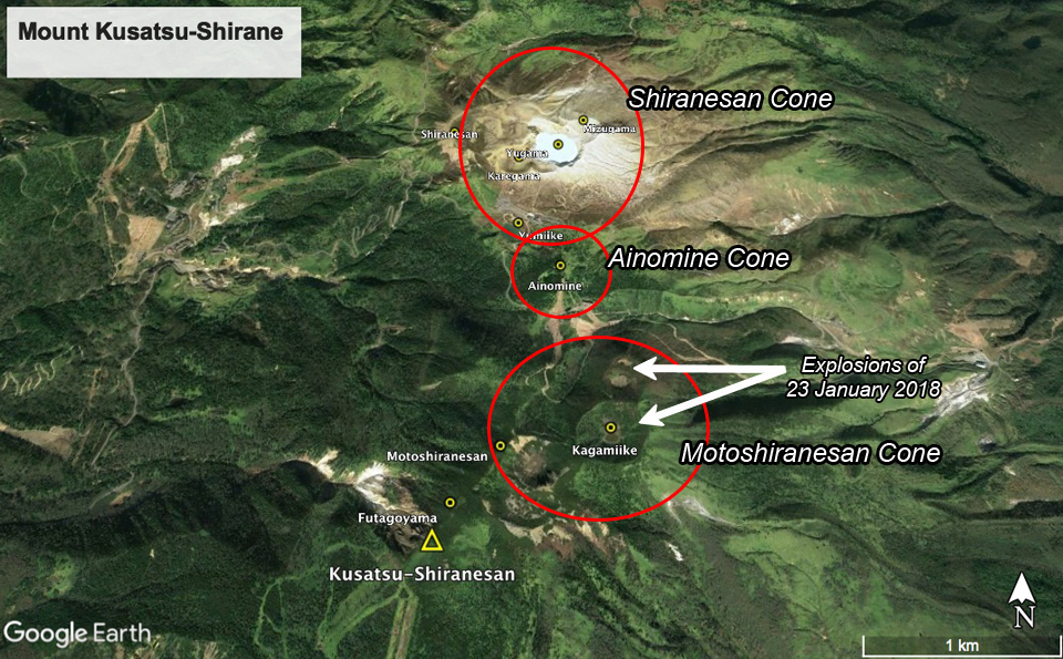 |
Figure 14. Subfeatures of the Kusatsu-Shiranesan volcanic complex as seen in Google Earth imagery, looking N. The northernmost bleached area includes the historically active Yugama, Mizugama, and Karagama craters, part of the Shiranesan cone. In the center of the complex is the Ainomine cone which has a ski area on the S flank. The southernmost edifice is the Motoshiranesan cone which has multiple craters at its summit, including Kagamiike or "Mirror pond". The explosions of 23 January 2018 occurred at Kagamiike and the adjacent crater to the N, in area referred to by JMA as Honkonoyama. Courtesy of Google Earth. |
Activity during 2014-2017. Seismicity remained elevated from March to mid-August 2014 around the Yugama crater area. Ground deformation data suggested inflation between March 2014 and April 2015 in that area. Field surveys conducted on 4-5 and 10-11 November 2014 indicated fumarolic areas on the N and NE flanks of the Mizugama crater, but no other significant activity. Short-lived increases in seismicity were observed during January-February 2015. A field survey in May 2015 confirmed ongoing thermal activity on the N and NE wall of the Yugama crater, and the N and NE flank of the Mizugama crater. A small-amplitude, 2-minute-long tremor during late June 2015 was the first since January 2013; it was not accompanied by eruptive activity. The fumarolic activity on the N wall of the Yugama Crater was higher during a field survey in October 2015 than in had been the previous May.
Thermal activity was ongoing at Yugama and Mizugama craters during 2015-2017 along with intermittent fumarolic activity in the same general area, but no significant seismicity was reported. By June 2017 the decrease in the concentration of components derived from high-temperature volcanic gas in the lake, and the stable low-level seismicity in the area, led JMA to lower the warning level from 2 to 1 (on a 5 level scale) on 7 June 2017; they noted that the thermal activity continued around the Yugama crater throughout the rest of the year (figures 15-17).
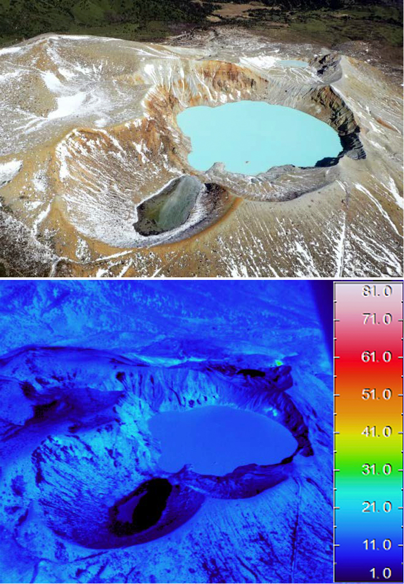 |
Figure 15. A minor thermal anomaly persisted inside the NE crater wall at Yagama Crater at Kusatsu-Shiranesan throughout 2015-2017. Both visual (upper) and thermal (lower) images were taken during an overflight on 1 November 2017. View is to the north. Courtesy of JMA (Volcanic activity monthly report, Kusatsu-Shirane, November 2017). |
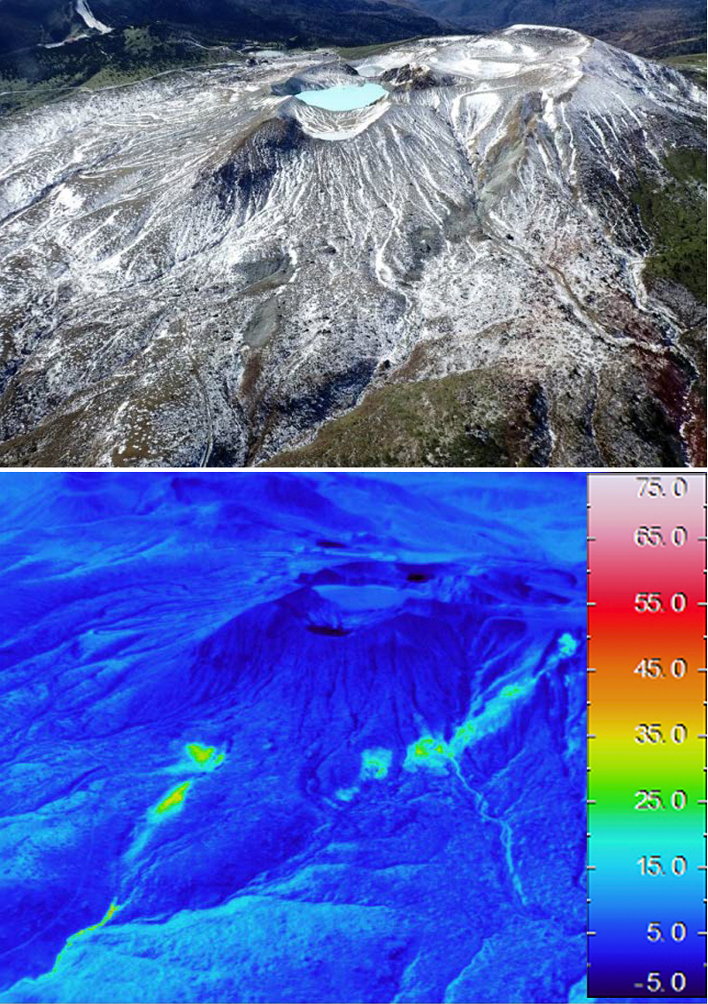 |
Figure 16. Thermal anomalies persisted on the N and NE flank of the Mizugama crater at Kusatsu-Shiranesan during 2015-2017. These visual (upper) and thermal (lower) images were captured on 1 November 2017. Courtesy of JMA (Volcanic activity monthly report, Kusatsu-Shirane, November 2017). |
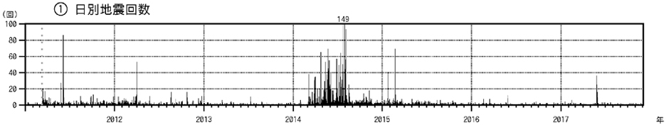 |
Figure 17. Daily earthquake frequency at Kusatsu-Shiranesan during 1 January 2011-30 November 2017. Although earthquake counts temporarily increased during March-August 2014 and in January and February 2015, no eruptive activity was reported. Courtesy of JMA (Volcanic activity monthly report, Kusatsu-Shirane, November 2017). |
Activity during January-March 2018. JMA reported that at 0959 on 23 January 2018 an eruption began at Kusatsu-Shiranesan coincident with the onset of volcanic tremor which prompted JMA to raise the Alert Level to 3 (on a scale of 1-5); there had been no prior indications of an impending eruption. Skiers at the popular Kusatsu Kokusai ski resort, located on the Ainomine cone, took video showing a plume of tephra and ejected bombs rising from vents around the Kagamiiki and adjacent crater at the summit of the Motoshiranesan cone (see Information Contacts for Mainichi for video link). Motoshiranesan is immediately adjacent S of the Ainomine cone and about 2 km SSE of the Yagama Crater on the Shiranesan cone where all previous historical activity had been reported (figures 14 and 18).
 |
Figure 18. Locations and images of the active vents at Kusatsu-Shiranesan during the eruptive event of 23 January 2018. Upper left: View is looking W at the Motoshiranesan summit craters. The crater with the pond in Box 1 is Kagamiike (yellow Japanese characters). Boxes 1 and 2 in the upper left photo are enlarged in the lower photos. Upper right topographic map shows the locations in red of the three vents. The upper red line and dot correspond to the vents shown in the lower right box 2. The lower red bar on the topographic map (near the small pond) corresponds to the vent shown in the lower left image as box 1. Courtesy of JMA (Volcanic activity monthly report, Kusatsu-Shirane, January 2018). |
Photos and video posted in news articles showed tephra shooting tens of meters into the air, drifting E, and blanketing the nearby hillside (figure 19); JMA noted ashfall in Nakanojo-machi, in the Gunma Prefecture, about 8 km E. Tephra hit a gondola, shattering glass and injuring four skiers (figure 20). Material fell through the roof of a lodge, where about 100 people had already been evacuated. Ground Self-Defense Force troops were engaging in ski training at the time of the event; one member died from the impact of large tephra blocks, and seven others were injured.
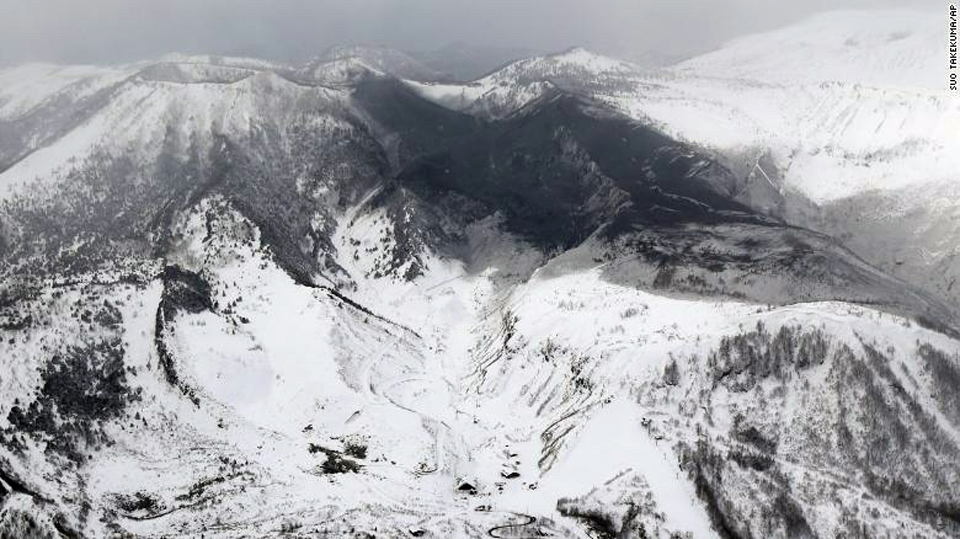 |
Figure 19. Tephra from Mount Kusatsu-Shiranesan covers the N flank of the Motoshiranesan cone and much of the Ainomine cone in this view to the W taken on 23 January 2018. Photo by Suo Takeuma, AP, courtesy of CNN (Japanese man killed by falling rocks after volcano erupts at ski resort, 23 January 2018). |
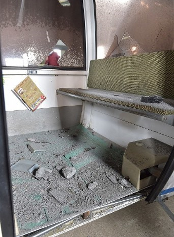 |
Figure 20. Fist-sized tephra blocks and ash ejected from the eruption of Mount Kusatsu-Shiranesan cover the floor of a damaged gondola at the Kusatsu Kokusai Ski Resort on 24 January 2018, courtesy of The Mainichi Japan (Damaged ski resort gondolas show the power of Gunma Pref. volcanic eruption, 25 January 2018). |
The following day, on 24 January 2018, JMA noted that volcanic earthquakes were numerous but decreasing in number, and two 2-3-minute-long periods of volcanic tremor were detected at 1015 and 1049. Minor but elevated seismicity continued through 30 January, punctuated by periods of tremor. The largest fissure where the eruption occurred was oriented E-W, located just inside the N rim of the northernmost crater at the Motoshiranesan summit (figure 21). Kenji Nogami, a professor at the Tokyo Institute of Technology, confirmed that the event appeared to have been "a typical phreatic eruption" (Japan Times).
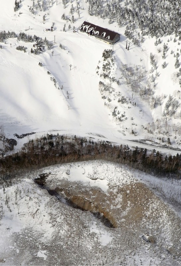 |
Figure 21. The largest fissure vent active in the 23 January 2018 explosion at Kusatsu-Shiranesan was still surrounded by ash and tephra when photographed during an overflight on 28 January 2018. The summit ropeway station of the ski area is at the image top just NW of the explosion vent. Courtesy of The Mainichi (Visitor traffic plunges in Kusatsu hot spring resort after deadly eruptions, 30 January 2018). |
The Tokyo Volcanic Ash Advisory Center issued a single volcanic ash advisory on 23 January indicating a possible eruption, but it was not identifiable from satellite data. Observations made on 14 February 2018 confirmed the presence of the vents in the Kagamiike and adjacent crater, but there was no evidence of thermal activity and little fumarolic activity in the area (figure 22). Seismicity decreased steadily after the explosion on 23 January 2018 through the end of March 2018 and no further activity was reported (figure 23).
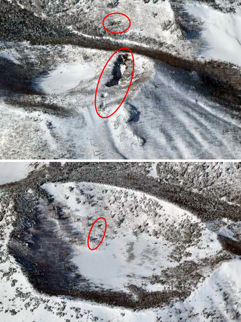 |
Figure 22. Vents from the 23 January 2018 eruption at Kusatsu-Shiranesan were still visible at the craters on 14 February 2014 during a helicopter overflight by JMA. The upper image, looking W, shows the large vent at the N side of the crater immediately N of the Kagamiike crater, as well as a smaller vent located to the W on the E flank of the adjacent slope. The lower image shows two smaller vents on the inner wall of the adjacent Kagamiike crater. Courtesy of JMA (Volcanic activity monthly report, Kusatsu-Shirane, February 2018). |
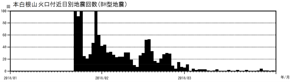 |
Figure 23. Seismicity decreased steadily at Kusatsu-Shiranesan after the explosion on 23 January 2018. Graph shows the number of daily seismic events during 1 January-31 March 2018. Courtesy of JMA (Volcanic activity monthly report, Kusatsu-Shirane, March 2018). |
Information Contacts: Japan Meteorological Agency (JMA), Otemachi, 1-3-4, Chiyoda-ku Tokyo 100-8122, Japan (URL: http://www.jma.go.jp/jma/indexe.html); The Mainichi (URL: http://mainichi.jp/english/, eruption video URL-https://mainichi.jp/movie/video/?id=121708141#cxrecs_s); The Japan Times (URL: https://www.japantimes.co.jp/); Cable News Network (CNN), Turner Broadcasting System, Inc. (URL: http://www.cnn.com/).
2018: January
| February
| March
| April
2014: June
| July
| August
| September
| December
JMA reported that on 21 April the number of volcanic earthquakes at Yugama crater (Kusatsu-Shiranesan complex) increased and deformation was also recorded. The Alert Level for the crater area was raised to 2 (on a 5-level scale) the next day. Deformation slowed on 23 April. Seismicity decreased on 23 April though continued to be somewhat elevated, and low-frequency events were recorded on 24 April. No surficial changes were noted during an overflight on 26 April.
Source: Japan Meteorological Agency (JMA)
On 16 March JMA lowered the Alert Level for the Kusatsu-Shiranesan complex to 2 (on a 5-level scale) noting that the number of volcanic earthquakes had gradually declined since the 23 January eruption; seismicity remained elevated.
Source: Japan Meteorological Agency (JMA)
JMA reported that during 26 February-5 March the number of volcanic earthquakes recorded at the Kusatsu-Shiranesan complex remained elevated. The Alert Level remained at 3 (on a 5-level scale).
Source: Japan Meteorological Agency (JMA)
JMA reported that after the 23 January eruption near Motoshiranesan (the highest peak belonging to the Kusatsu-Shiranesan complex) seismicity, characterized by volcanic earthquakes and tremor, was elevated; it decreased the next day. Minor but elevated seismicity continued through 30 January, punctuated by periods of tremor. The eruption occurred from a fissure oriented E-W, located just inside the N rim of the northernmost Kagamiike Kitahi craters. JMA noted no juvenile material in the eruption deposits. The Alert Level remained at 3 (on a 5-level scale).
Sources: Japan Meteorological Agency (JMA); The Mainichi Daily News
JMA reported that at 0959 on 23 January an eruption began at Kusatsu-Shiranesan coincident with the onset of volcanic tremor; there were no indications of an impending eruption. The Alert Level was raised to 3 (on a scale of 1-5). Skiers at the popular ski resort Kusatsu Kokusai took video showing a plume of tephra and ejected bombs rising from a vent on the Motoshiranesan edifice, about 2 km SSE of Yagama Crater on Shiranesan (where all previous historical activity has been). The eruption also caused what appeared to be an avalanche. Photos and video posted in news articles showed tephra drifting E and blanketing the nearby hillside; JMA noted ashfall in Nakanojo-machi, in the Gunma Prefecture. Tephra hit a gondola, shattering glass and injuring four skiers. Material crashed through the roof of a lodge, where about 100 people had already been evacuated. Ground Self-Defense Force troops were engaging in ski training at the time of the event; one member died and seven others were injured. Emergency responders gathered at the Sanroku Station to assist. On 24 January JMA noted that volcanic earthquakes were numerous but decreasing in number, and two 2-3-minute-long periods of volcanic tremor were detected at 1015 and 1049.
Sources: Japan Meteorological Agency (JMA); The Japan Times
During 5-12 December JMA maintained Alert Level 2 for Kusatsu-Shiranesan due to continued unrest. GPS measurements indicated inflation, although thermal anomalies had been absent since July. Volcanic earthquakes continued at a low level and tremor was absent.
Source: Japan Meteorological Agency (JMA)
During 5-12 September JMA maintained Alert Level 2 for Kusatsu-Shiranesan due to continued unrest. GPS measurements indicated inflation, although thermal anomalies had been absent since July. Volcanic earthquakes continued at a low level (a maximum of 3 per day) and tremor was absent.
Source: Japan Meteorological Agency (JMA)
During 29 August-5 September JMA maintained Alert Level 2 for Kusatsu-Shiranesan due to continued unrest. GPS measurements indicated inflation, although thermal anomalies had been absent since July. Volcanic earthquakes continued at a low level (0-5 per day) and tremor has not been detected.
Source: Japan Meteorological Agency (JMA)
On 27-29 August, JMA reported continuing volcanic earthquakes at Kusatsu-Shiranesan’s crater, although they had decreased from early August and tremor was absent. The Alert Level remains at 2 (on a scale of 1-5).
Source: Japan Meteorological Agency (JMA)
On 20-22 August JMA reported volcanic earthquakes continuing at Kusatsu-Shiranesan’s crater, although decreased from early August and tremor was absent. The Alert Level remains at 2 (on a scale of 1-5).
Source: Japan Meteorological Agency (JMA)
JMA reported that during 8-15 August volcanic earthquakes continued at Kusatsu-Shiranesan’s crater, although they had decreased from early August and tremor was absent. The Alert Level remains at 2 (on a scale of 1-5).
Source: Japan Meteorological Agency (JMA)
On 6-8 August, JMA reported volcanic earthquakes continue at Kusatsu-Shiranesan’s crater, although decreased from early August and tremor was absent. The Alert Level remains at 2 (on a scale of 1-5).
Source: Japan Meteorological Agency (JMA)
On 5 August, JMA reported a notable increase of volcanic earthquakes at Kusatsu-Shiranesan’s crater, although tremor was absent. The Alert Level remains at 2 (on a scale of 1-5).
Source: Japan Meteorological Agency (JMA)
JMA reported that deformation of Kusatsu-Shiranesan’s crater and the elevated temperatures which began earlier in March, continued during 25-30 June. This activity has been focused in the area immediately of N of Mizugama crater. Some seismicity was also reported, although tremor was absent. The Alert Level remains at 2 (on a scale of 1-5).
Source: Japan Meteorological Agency (JMA)
JMA reported that anomalous temperatures and deformation of Kusatsu-Shirane’s crater, which began earlier in March, continued during 13-20 June. This activity has been focused in the area immediately of N of Mizugama crater. Elevated seismicity was also reported, although tremor was absent. The Alert Level was raised to 2 (on a scale of 1-5).
Source: Japan Meteorological Agency (JMA) via the Volcano Research Center
Reports are organized chronologically and indexed below by Month/Year (Publication Volume:Number), and include a one-line summary. Click on the index link or scroll down to read the reports.
Small eruption from Mizugama Crater
[JMA notes that a small eruption from Mizugama Crater occurred at about 1800 on 2 March 1976. A new crater 50 m in diameter and 10 m deep was formed in the NE part of Mizugama Crater.]
Information Contacts: Japan Meteorological Agency, Tokyo.
Three people killed by hydrogen sulfide
[On 3 August] a high school teacher and two students were overcome and killed by H2S, which is emitted in considerable quantities [from fumaroles on the NW side of Motoshirane-san, 2 km SSW of Yugama Crater]. The gas had concentrated in a bowl-shaped area during a light rain on a nearly windless day.
Further Reference. Ossaka, J., and others, 1980, Variation of chemical composition in volcanic gases and waters at Kusatsu-Shirane volcano and its activity in 1976: BV, v. 43.
Information Contacts: JMA, Tokyo.
Phreatic explosion; volcanic tremor
A brief phreatic explosion from three vents on 26 October ejected a dark column that rose 100 m above the lakes in two summit craters, Yugama and Karagama (figure 1). Onset time of the explosion was uncertain, but the seismograph at the Maebashi District Meteorological Observatory, 1.1 km NE of Yugama, began to record volcanic tremor with an amplitude of 0.2 µm at 0855. Gray plumes were recognized at 0905. The tremor gradually increased in amplitude and peaked about an hour after onset.
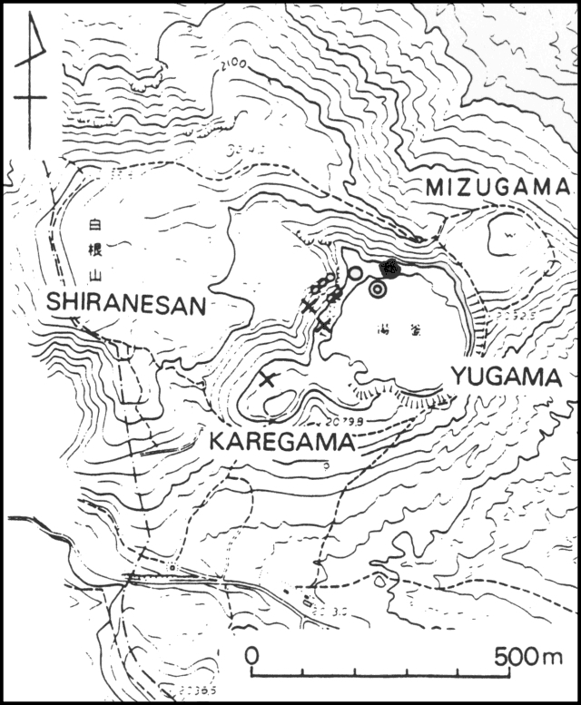 |
Figure 1. Map of the summit region of Kusatsu-Shirane. Small circles indicate fumaroles; the other marks represent vents active since the 27 October 1982 eruption. An 'x' indicates an emission point of the 26 October 1982 eruption plume. The large open circle is Pit No. 6; the concentric circles are Pit No. 7. The solid circle is a new pit that formed on 13 November. Pits No. 2 and 3 (not shown) are on the W inner wall of Yugama. Courtesy of JMA. |
Activity at Karagama ended at 0920, only 15 minutes after it was first recognized, and at 0930 activity at Yugama was reduced to white vapor emission (which ended the next day). Volcanic tremor, however, continued at peak levels for a few hours then gradually weakened, ceasing at 0124 on 30 October. A swarm of volcanic earthquakes lasting 5 hours was recorded on 26-27 October, and there was another minor swarm on [27] October.
JMA reported that a strong wind carried ash from as far as 3 km to the SE; ash was 1 mm thick on the crater rim. Tokiko Tiba reported a maximum of 3 cm of ash in the summit area. The total volume of ejecta was estimated to be 2,800-3,400 tons. No damage was reported. As of 2 November no further eruptions had been reported, and fumarolic activity in Yugama had declined. . . .
Information Contacts: T. Tiba, National Science Museum, Tokyo; JMA, Tokyo.
Lake temperatures measured after explosion
Temperatures measured in the lake in Yugama Crater for 6 days following the 26 October explosion [were: 14°C on 26 October, 46°C on 27 October, 55°C on 28 October, 56°C on 29 October, 48°C on 30 October, and 39°C on 31 October.]
Information Contacts: Y. Sawada, Meteorological Research Institute, Ibaragi; D. Shackelford, CA.
Volcanic tremor, phreatic explosion
At 0538 on 29 December, after 64 days of quiescence, a phreatic explosion from the pit formed in the 26 October explosion ejected a gray plume that rose about 300 m above the rim of Yugama Crater. The plume was 700 m above the rim by 1300, then suddenly declined about 1500. The seismograph at the Maebashi District Meteorological Observatory, 1.1 km NE of Yugama, began to record volcanic tremor 46 minutes before the explosion. Maximum amplitude was 2.1 µm. Tremor ended at 1538, but resumed at 1900 and continued until 1500 the next day. Ash traveled as far as 4 km, mainly NE. Scattered blocks and ejecta carried by spraying water were observed around the pit, including clay material on 30 December. No damage was reported. As of 5 January, no further explosions had been reported, but tremor had been continuous since 2 January.
Information Contacts: JMA, Tokyo.
Small phreatic explosion; harmonic tremor
. . . Local seismicity had declined after the December activity, but increased in early January (see table 1), when 91 volcanic earthquakes and 44 tremor events were recorded. After mid-January no tremor events were recorded, but the number of volcanic earthquakes was greater than background level in early March.
At 0459 on 9 March the seismograph at Maebashi District Meteorological Observatory recorded a swarm of volcanic earthquakes that lasted only a few minutes. JMA scientists noted that these earthquakes were similar in wave form to those recorded during previous eruptions. . . . In April, activity was limited to occasional white vapor ejections. On 10 April, one vapor plume rose to 60 m above Yugama Crater. Volcanic tremor, possibly accompanied by vapor ejections, was observed 9-12 and 19-20 April.
Information Contacts: JMA, Tokyo.
9 March activity was only seismic
Tokyo Institute of Technology personnel visited the volcano on 12 March to investigate a report of a small phreatic explosion from Pit No. 7 on 9 March [originally reported in 8:4]. A brief swarm of volcanic earthquakes had been recorded at 0459 that day at the Maebashi District Meteorological Observatory. The Institute team found no fresh ash. Although ash was reported to have fallen on the frozen crater lake, another observer said that the lake was not frozen on 9 March. The team concluded that the 9 March activity had been only seismic.
Information Contacts: JMA, Tokyo.
Small plume emitted; volcanic tremor; A-type events
On 26 July a small phreatic explosion occurred at the NW rim of Yugama Crater, at the volcano's summit. JMA personnel observed the eruption, at Pit No. 6, formed during the 26 October phreatic explosion and the site of a similar explosion on 29 December. Volcanic tremor (amplitude 0.2-0.3 µm) started at 1031. About 1110, the dominant frequency of the tremor decreased and white vapor was ejected. Volcanic rumbling intensified at 1140; about 1/3 of the crater lake was covered with ash by 1150. Accompanied by strong rumbling, a dark plume was ejected at [1204]; it had risen above the crater rim by [1212]. Volcanic tremor returned to a higher frequency at 1213, but shifted back to lower frequency about 20 minutes later. Emission of a white vapor plume that rose to about 100 m above the pit was continuous in the afternoon. Volcanic tremor ended at 1720. The plume weakened suddenly at 1730.
Local seismicity had been at a high level since last autumn. Seismographs recorded 209 volcanic earthquakes in June and 227 in July. On 22 July, swarms of A-type earthquakes occurred. After the 26 July eruptive episode, seismicity declined slightly but remained above background level.
Information Contacts: JMA, Tokyo; T. Tiba, National Science Museum, Tokyo.
Explosions eject large tephra
UPI reported that thunderous explosions ejected tephra on 13 November at 1144. [Blocks fell a few hundred meters from the vent; original press reports of a more distant fall of large tephra were incorrect.] Tephra [reached a town] (Nakanojo) 40 km SE of the volcano. A "secondary" eruption occurred 25 minutes later. No injuries were reported.
Information Contacts: UPI.
Summit explosions and seismicity
Summit explosions from Kusatsu-Shirane occurred on 13 November and 21 December. Precursory seismic activity began with a large-amplitude discrete event on 2 November. Tremor was continuous between 0700 and 2000 on the 10th. Stronger tremor was recorded at 1722 on the 12th. Its mean amplitude on the seismograph, initially 1.9 µm, gradually increased to more than 5.0 µm at 2000, when the wave form of the tremor became similar to one that had accompanied a mud at Aso Volcano. Tremor gradually declined during the early morning of 13 November.
Explosions occurred 13 November at 1144 and 1208 from small vents (Pits No. 6 and 7) on Yugama Crater's [N] wall and a new pit that appeared about 50 m E of Pit No. 6. [During a 22 December inspection] Tokyo Institute of Technology personnel found that a [45] cm-wide, 45 m-long fissure on the N wall of the adjoining Karagama Crater had also ejected ash. JMA noted that the line extending SW from Pit No. 6 across Karagama Crater's N wall has been active since the eruption of October 1982.
Lapilli were scattered as much as 600-700 m S of Yugama. Ash was carried 30 km downwind although most fell into the lake in Yugama Crater. The second explosion was accompanied by a ground shock of intensity III (JMA Scale) at the rest area 700 m S of Yugama. Signals from the seismograph at the Maebashi District Meteorological Observatory stopped immediately after this explosion. A field survey revealed that [blocks] had made many craters 1-3 m in diameter and 50 cm deep on the upper SE outer slope of Yugama. The buried seismograph cable seemed to have been cut by one of these [blocks].
Seismic activity increased again 18-19 December, when 32 and 31 discrete events were recorded. After a brief period of activity from 0954-1007 on the 21st, continuous tremor resumed at 1022. The tremor, accompanied by some large discrete events, saturated the seismograph from 1035-1105, then gradually declined, ending at 1220.
A Kusatsu town employee working S of Yugama first noticed the sound of vapor emission at 1010; 20 minutes later he observed a dark plume containing mud and lapilli rising 300 m above the crater rim. Ash traveled 400-500 m SE, darkening frozen Yugama Lake. Eruptive activity began to decline about 1100. Tokyo Institute of Technology personnel found that the eruption sites were Pits No. 2 and 3 on the W inner wall of Yugama. A small amount of ash was also ejected from the fissure in Karagama Crater that was active in November.
Information Contacts: JMA, Tokyo.
1983 activity summarized
1983 activity is summarized in table 1; locations are on figure 1.
Table 1. Seismic activity at Kusatsu-Shirane, 1983. Courtesy of JMA.
| Month | Discrete Seismic Events | Continuous Tremor | Remarks |
| Jan 1983 | Observed swarms | Observed | Rumbling at the summit. |
| Mar 1983 | Observed swarms | -- | Increased fumarolic activity at Pit No. 2. |
| Apr 1983 | -- | Observed | White plumes from Pits No. 2, No. 7, and a fumarole on the N inner wall of Yugama; N edge of frozen Yugama lake melted. |
| Jun 1983 | Observed swarms | -- | -- |
| Jul 1983 | Observed swarms | Almost at noise level | Small eruption at Pit No. 6, NW wall of Yugama, on 26 July; small amount of ash. |
| Nov 1983 | Observed swarms | Observed during eruptive activity | Explosive eruption at NW inner wall of Yugama and at Karagama on 13 Nov; a larger amount of ejecta. |
| Dec 1983 | Observed swarms | Observed during eruptive activity | -- |
Further Reference. The 1982-1983 eruptions of Kusatsu-Shirane volcano, in XIX IUGG General Assembly, 1987, Report on volcanic activities and volcanological studies in Japan for the period from 1983 to 1986, p. 5-8.
Information Contacts: JMA, Tokyo.
Increase in microearthquakes since 1984
Monthly frequency of microearthquakes recorded at the volcano reached 96 in June, the highest since the active phase of 1982-84. A gradual increase in seismicity began last year (figure 2).
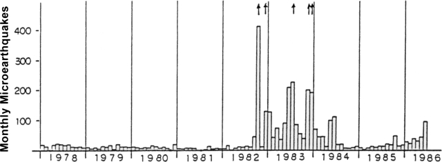 |
Figure 2. Monthly seismicity at Kusatsu-Shirane, 1978-86. Arrows indicate five eruptions in 1982 and 1983. |
Information Contacts: JMA.
Earthquakes increase to five times monthly average
Many small volcanic earthquakes were recorded 14-19 October by the seismograph 1 km NE of Yugama, the largest of the three crater lakes. The monthly total of volcanic earthquakes reached 114, compared to the monthly average of less than 20. Seismic activity declined to a low level after 22 October. Epicenters were estimated to be several hundred meters E of Yugama. JMA's Mobile Volcanological Observation Team established two additional seismographs and began 10 days of observation on 18 October. No significant changes in fumarolic activity were observed during field surveys on 23 and 26 October.
A phreatic explosion from Yugama crater ejected 20-cm blocks to 600-700 m from the crater lake on 13 November 1983. Small phreatic explosions occurred from Yugama and Karegama (the E crater lake) on 26 July and 21 December 1983.
Information Contacts: JMA.
Seismicity during September-October 1988; tremor in January 1989 associated with phreatic emissions
[Ida and others (1989) report that swarm-like seismicity began at the end of September 1988 and continued through October, with most located events centered SE of Mizugama crater. Hypocenters remained in the same area during the following period, but focal depths shallowed and episodic volcanic tremor became more frequent. Continuous volcanic tremor began suddenly on 6 January 1989 and lasted for almost 24 hours. The tremor was associated with emission of steam or water from the NW part of Yugama Crater, which distributed a small amount of ash over the crater lake.]
Reference. Ida, Y., Osada, N., Sawada, M., Koyama, E., and Kagiyama, T., 1989, Seismological Study Based on Recently Installed Permanent Stations and a Small Eruptive Event on January 6, 1989 at Kusatsu-Shirane Volcano: Bulletin of the Earthquake Research Institute, University of Tokyo, v. 64, p. 325-345 (in Japanese with English abstract and figure captions).
Information Contacts:
Highest amplitude tremor since 1982-83 activity, but no eruption
Volcanic tremor began at about 1445 on 27 January and continued through 1 February. The largest amplitude was about 0.2 µm. A field survey on 2 February found no new ash deposition around the crater. Water discoloration in Yugama crater lake was observed as usual.
Volcanic tremor resumed at 0019 on 12 February and continued until 0417 the next day. Additional tremor episodes occurred on 18 and 24 February. Amplitudes of 1.3 µm on 18 January and 1.1 µm on 24 February were the highest recorded since the last eruption in 1982-83. The number of discrete volcanic earthquakes also increased between 17 February and 7 March.
Information Contacts: JMA
Seismicity remains high; high-amplitude tremor continues
Seismic activity remained at the highest levels since the 1982-83 eruptive period. The daily number of earthquakes has remained high since increased seismicity began in mid-February (figure 3). The number and amplitude of tremor episodes also remained high with one in January, six in February, two in April, and nine in May. Water discoloration in Yugama crater lake, first noted in February, was usually evident through May (during 13 of 19 visits January-May).
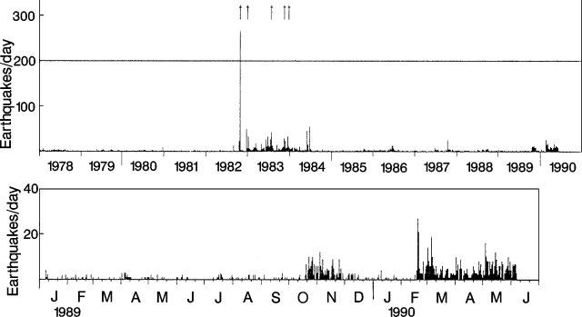 |
Figure 3. Daily number of recorded earthquakes at Kusatsu-Shirane, 1978-June 1990. Arrows mark eruptions. Courtesy of JMA. |
Information Contacts: JMA
Continued vigorous seismicity
The number of volcanic earthquakes persisted at a high level as of early July. Six volcanic tremor episodes were recorded in June. No eruption occurred and fumarolic activity in and around the active crater rim has remained unchanged.
Information Contacts: JMA.
More frequent volcanic earthquakes and tremor
The number of volcanic earthquakes . . . remained at high levels as of 8 August, with 212 earthquakes in June and [243] in July. Twelve volcanic tremor episodes were recorded by the seismograph 1.1 km NE of Yugama Crater.
Information Contacts: JMA.
Seismicity remains strong
During August, 171 earthquakes . . . and 35 tremor episodes . . . were recorded. Tremor amplitude ranged from 0.0 to 1.3 [µm].
Information Contacts: JMA.
Seismicity remains strong
Seismicity has remained at high levels . . . . During September, 184 earthquakes . . . and 44 volcanic tremor episodes . . . were recorded. Tremor amplitude also decreased from as much as 1.3 µm in August to 0.1-0.5 µm in September.
Information Contacts: JMA.
Continued high seismicity but no surface changes
Seismicity has remained at high levels... (figure 4). During October, 213 earthquakes (up from 184 in September) and 29 tremor episodes... were recorded. Tremor amplitudes were similar to previous months. Earthquakes were centered 1 km E of... Yugama Crater. Seismicity remained similar as of 14 November. No changes in surface activity were observed.
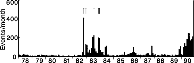 |
Figure 4. Monthly number of earthquakes at Kusatsu-Shirane, January 1978-October 1990. Arrows at top of figure mark eruptions. Courtesy of JMA. |
Information Contacts: JMA.
Strong seismicity continues but no surface changes
Seismicity has remained at high levels since February (figure 4). During November, 117 earthquakes and 27 volcanic tremor episodes were recorded . . . . Seismicity remained similar in early December. No changes in surface activity were observed.
Information Contacts: JMA.
Continued vigorous seismicity
Seismicity has remained at high levels since mid-February. During December, [101] earthquakes . . . and 11 tremor episodes . . . were recorded.
Information Contacts: JMA.
Continued seismicity but no change in surface activity
Seismicity has remained at high levels since February 1990. During January, 92 earthquakes and 24 volcanic tremor episodes were recorded . . . . No changes in surface activity were observed. Similar activity was noted in early February.
Information Contacts: JMA.
Continued seismicity but no surface changes
Earthquakes and tremor activity continued at levels similar to previous months. No changes in surface activity were observed.
Information Contacts: JMA.
Brief peak in seismicity
Seismicity continued at high levels through mid-April, after [131] recorded earthquakes and 11 tremor episodes in March. A sharp, brief increase in seismicity on 9 March (42 recorded earthquakes), prompted the JMA to issue a notice ("Extra Volcanic Information"), the first since August. No changes in surface activity were observed.
Information Contacts: JMA.
Continued seismicity
In April, seismicity remained similar to previous months, with a total of 110 earthquakes and one tremor episode recorded... (figure 5). No surface activity was observed.
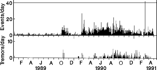 |
Figure 5. Daily number of recorded earthquakes (top) and tremor episodes (bottom) at Kusatsu-Shirane, January 1989-April 1991. Courtesy of JMA. |
Information Contacts: JMA.
Minor hydrothermal ejection in Yu-gama crater
According to Kusatsu-Shirane Volcano Observatory (Tokyo Institute of Technology), at 1044 on 7 February geophysical changes occurred. A hydrophone submerged in Yu-gama pond recorded large amplitude sound waves and a meter registered water-level changes. Observers on 14 and 24 February saw discolored water near the NW part of the pond's surface and pieces of broken ice, 20-30 cm in size, along the shore. Therefore, on 7 February, a small magnitude ejection might have occurred at the pond. When a similar phenomenon was last observed, 6 January 1989, it was ascribed to hydrothermal activity.
Information Contacts: Volcanological Division, Japan Meteorological Agency, 1-3-4 Ote-machi, Chiyoda-ku, Tokyo 100, Japan
Seismic activity increases
According to the Kusatsu-Shirane Volcano Observatory, Tokyo Institute of Technology, many small earthquakes were detected near the vent on 8 July.
Information Contacts: Volcanological Division, Japan Meteorological Agency, 1-3-4 Ote-machi, Chiyoda-ku, Tokyo 100, Japan
Minor tremor and small earthquakes during 2011-2012
On 7 February 1996, hydrophone data and water level changes suggested that a small hydrothermal ejection may have occurred at Kusatsu-Shirane (also known as Kusatsu-Shiranesan) at Yugama crater's pond (BGVN 21:02). Several months later, on 8 July, numerous small earthquakes were detected by the Kusatsu-Shirane Volcano Observatory (BGVN 21:07). The volcano is about 150 km NW of Tokyo (figures 6 and 7; also refer to the sketch map in figure 1, SEAN 07:10). This report summarizes seismicity between May 2011 and February 2013 based on available reports from the Japan Meteorological Agency (JMA).
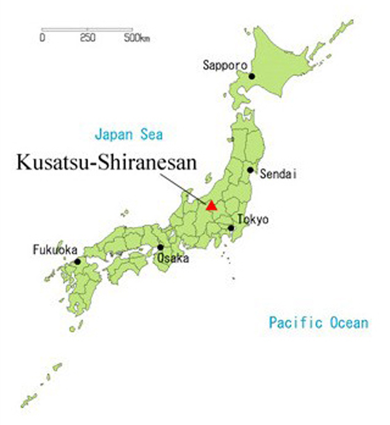 |
Figure 6. A sketch map showing the location of Kusatsu-Shirane (Kusatsu-Shiranesan) in Honsho, Japan. Courtesy of JMA. |
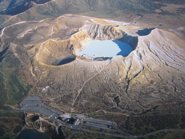 |
Figure 7. An aerial photo of Kusatsu-Shirane, as viewed from the S. The photo, taken on 29 May 2008, shows the overlapping pyroclastic cones and two of the three crater lakes. Courtesy of Flickr user rangaku1976. |
On 27 May 2011, tremor was detected at Kusatsu-Shirane; no further information was provided. During 5-7 June 2011, an elevated number of microearthquakes with low amplitude occurred around Yugama crater (the main crater). No volcanic tremor or significant deformation was detected during this time. Thereafter, activity gradually diminished to background levels.
Field surveys during 27-29 June and 12-13 July 2011 revealed that elevated thermal anomalies persisted inside Yugama crater's N flank, the N fumarole area, and the slope located N to NE of Mizunuma crater. Ground temperatures around fumaroles remained high.
On 18 July 2011, a short period of tremor (duration 2.5 min) was detected. No change in fumarole activity was observed.
On 10 August 2011, an aerial survey was conducted in cooperation with Gunma prefecture. The survey found that the distribution of thermal anomalies and fumaroles in Yugama crater and the N fumarole area had not changed.
During 16-18 August, an elevated number of microearthquakes with low amplitude occurred near and to the S of Yugama crater. Significant deformation was not detected. Seismicity remained at background levels during the other days in August. High temperatures persisted on the N flank inside the main crater.
A field survey on 8 March 2012 found that the high temperatures on the N slope of Mizugama crater and the N fumarole area were the same as those found during a previous survey conducted during 27-29 June 2011. Very weak steam plumes at the N fumarole area of Yugama were sometimes observed by a camera at Okuyamada, though bad weather and mechanical trouble prevented their observation for long periods. The ground temperature in the fumarole area NE of Yugama crater remained elevated since its rapid rise in May 2009, despite occasional fluctuations.
According to JMA, the occurrence of small amplitude volcanic earthquakes occasionally increased during March 2012. The hypocenters were located just beneath the S part of Yugama crater. No tremor or significant crustal change was noted in GPS data.
During 1-2 April 2012, seismicity increased slightly, then subsided. No tremor, change in fumarole activity, or crustal change was observed, and no further reports have been issued on activity at Kusatsu-Shirane as of February 2013.
Information Contacts: Japan Meteorological Agency (JMA), Otemachi, 1-3-4, Chiyoda-ku Tokyo 100-8122, Japan (URL: http://www.jma.go.jp/); rangaku1976, Flickr (URL: http://www.flickr.com/photos/rangaku1976/).
Seismicity, deformation, and hydrothermal emissions during 2013-2014
Although no eruption ensued, the Japan Meteorological Agency (JMA) reported that the Alert Level for Kusatsu-Shirane was increased on 3 June 2014 from Level 1 (Normal) to Level 2 (Near-crater warning). Concern rose owing to elevated seismicity including shallow earthquakes within a few kilometers of the surface, deformation, elevated temperatures, and more. Many of the anomalies centered at or near Yugama, the largest of the three crater lakes within the volcanic complex (figures 8 and 9). Snow melted associated with fumaroles adjacent Yugama. Yugama lake was the scene of discolored water and floating sulfur on at least two occasions during 2013-2014. Seismicity rose in March 2014; ground deformation, in April 2014; and ground temperatures, in May 2014. Volcanic tremor was absent during this reporting period of February 2013-July 2014.
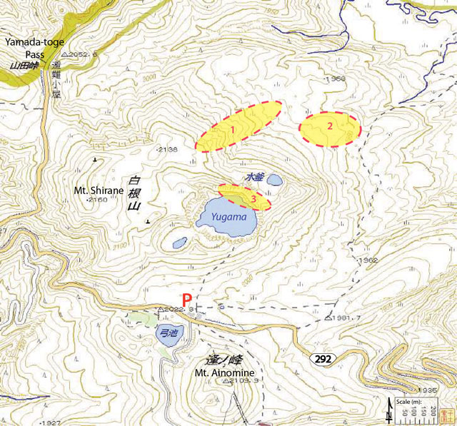 |
Figure 8. Annotated topographic map covering Kusatsu-Shirane and the surrounding area. Circled areas correspond to three fumarolic fields: 1, N-flank fumaroles (see figure 9); 2, NE-flank fumaroles (where typically the highest temperatures were measured from the three sites); and 3, the NNE shoreline of Yugama crater lake. Area 3 was also monitored by a web camera (maintained by Tokyo Institute of Technology). The Kusatsu-Shirane visitor center is located near the red letter P. Courtesy of JMA. |
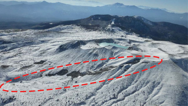 |
Figure 9. The N-flank fumarolic region (labeled 1 in figure 8) of Kusatsu-Shirane seen at 1058 on 5 December 2013 looking S. This is an aerial photo taken from ~2,440 m altitude. Snow had melted in some areas within the dashed red ellipse. The crater lake in the middle ground is Yugama. Courtesy of JMA. |
Activity during February-December 2013. JMA maintained Alert Level 1 through 2013 and fumarolic activity continued at a low level from the three zones (see figure 8). Temperatures measured with an infrared camera were typically less than 40°C. On 17 March 2013, JMA reported an increase in the number of small volcanic earthquakes with epicenters near the Yugama crater lake. Seismicity dropped back down to normal levels during April-September, and thermal activity continued at low levels.
JMA reported that seismicity was temporarily elevated in October 2013 in the area between Yugama crater lake and the Yamada-toge Pass (figure 10). Hypocentral depths were within 4 km of the surface, relatively shallow compared with previous months.
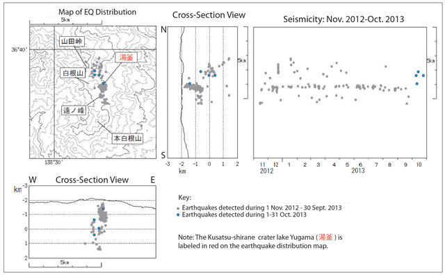 |
Figure 10. Map of earthquakes located during November 2012-October 2013. Earthquakes from October 2013 are highlighted in blue, indicating that seismicity was located between the crater lake named Yugama (labled with red symbols) and a pass named Yamada-toge (~2 km NW of Yugama crater lake). Earthquake depths were within 4 km of the surface. Courtesy of JMA. |
Aerial observations on 5 December 2013 determined that Yugama crater lake had two areas of cloudy water and, in one location, floating sulfur was visible on the lake surface. Figure 11 shows a photo of the lake with areas sketched in to show the approximate extent and location of where cloudy water and floating sulfur were found. Similar observations were made later, on 22 April 2014, when a cloudy area was noted during an overflight.
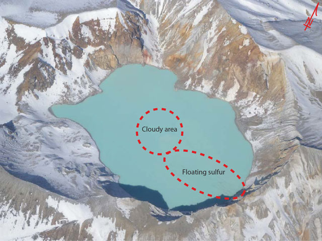 |
Figure 11. Locations of where discoloration was observed within Kusatsu-Shirane's crater lake, Yugama, are marked on this aerial photo taken on 5 December 2013. A cloudy area as well as sulfur debris was noted. Courtesy of JMA. |
Elevated seismicity during March-July 2014. During January-February 2014, up to 7 earthquakes occurred per day. An abrupt increase in seismicity was observed on 6 and 7 March 2014 when 10 and ~40 earthquakes per day respectively were recorded (figure 12). These earthquakes were centered within the area of Yugama. The note at the bottom explains the symbols refering to lake Yugama and Mount Ainomine to the lake's S. Earthquake depths were within 5 km of the surface and very clustered with few outliers (~2 earthquakes) located slightly deeper and further S. Seismicity subsided on 8 and 9 March, but during the following days, seismicity increased again and thereafter persisted for a few months. No other changes were detected from the area; diffuse white plumes continued to rise from the fumarolic zones.
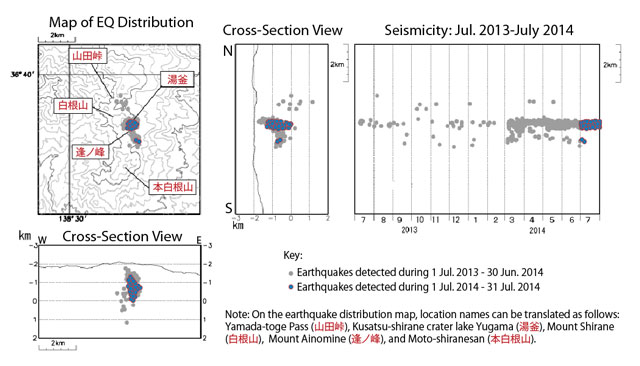 |
Figure 12. Map and cross sections showing seismicity at Kusatsu-Shirane during 1 July 2013 through 31 July 2014. Courtesy of JMA. |
Beginning in April, the GPS network registered an inflation trend across the Yugama crater region. Small-amplitude seismicity increased periodically during April-May. Ongoing magnetic surveys determined an increase in regional temperatures in May, but JMA cautioned that this characteristic was likely independent of the thermal emissions monitored at the fumarolic sites. Temperatures from the fumarolic sites had not changed significantly.
On 3 June, JMA raised the Alert Level from 1 to 2 (on a scale of 1-5) due to the ongoing seismicity, anomalous temperatures from magnetic surveys, and deformation. Gas emissions from the fumarolic sites, monitored by Tokyo Institute of Technology, changed in unspecified ways on 3 June. Warnings were announced for the immediate area of Yugama crater lake; the area within 1 km of the lake was potentially at risk if a small eruption occurred, particularly a gas explosion accompanied by ballistics. JMA recommended that no one enter the area and for any visitors to be mindful of gas hazards that could persist in low-lying areas (dense gases could collect within small valleys).
On 22 June, JMA reported the appearance of damaged vegetation; trees were dying in a forested area 3 km SW of Motoshiranesan cinder cone (location is the S-most labeled feature on the maps of figures 10 and 12). Note that Motoshiranesan is the highest peak belonging to the Kusatsu-Shirane complex (Hayakawa and others, 1981). An aerial survey was conducted on 23 June and observers noted that the affected area was ~10 m2. White vapor emissions with volcanic gas odors were noted and measurements from an infrared camera determined a maximum temperature of ~40°C. JMA reported that there was no apparent link between these changes and the ongoing seismicity.
In July, JMA maintained Alert Level 2 and reported that elevated seismicity continued, although tremor was not detected. More than 80 earthquakes were detected from the Yugama crater lake area on 24 and 31 July (figure 13). Fluctuations in deformation occurred and magnetic surveys indicated that regional temperatures were leveling off. Infrared camera data determined that no significant changes were occurring at the fumarolic sites. Gas emissions measured continued to suggest changes in the volcanic system.
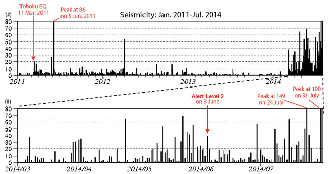 |
Figure 13. For Kusatsu-Shirane, the daily number of earthquakes recorded during July 2013-July 2014. Earthquakes increased abruptly in March 2014. Two months later, JMA raised the Alert Level from 1 to 2 due to persistent unrest (see text). Note that earthquake counts exceeded the y-axis on three occasions: 5 June 2011 (86 earthquakes), 24 July 2014 (149 earthquakes), and 31 July 2014 (100 earthquakes). Courtesy of JMA. |
Reference: Hayakawa, Y., Aramaki, S., Shimozuru, D., and Ossaka, J., 1981, Kusatsu-Shirane Volcano, in Aramaki, S., ed., Field Excursion Guide to Fuji, Asama, Kusatsu-Shirane, and Nantai Volcanoes: Volcanological Society of Japan, International Association of Volcanology and Chemistry of the Earth's Interior, p. 49-63.
Information Contacts: Japan Meteorological Agency (JMA), Otemachi, 1 3 4, Chiyoda-ku Tokyo 100-8122, Japan (URL: http://www.jma.go.jp/).
Phreatic explosion at Motoshiranesan cone on 23 January 2018 results in one fatality and several injuries
The large Kusatsu-Shiranesan volcanic complex comprises three overlapping pyroclastic cones and numerous summit craters; it is located about 150 km NW of Tokyo in the Gunma Prefecture of central Japan. Intermittent short-lived historic activity has been reported from the northernmost Shiranesan cone since the beginning of the 19th century. An explosion at the southernmost Motoshiranesan cone in January 2018 resulted in one fatality and several injuries. Information about the event was gathered from the Japan Meteorological Agency (JMA) and various news sources.
Summary of activity during 1976-2014. Small phreatic explosions in the Mizugama and Yugama craters at the northernmost part of the Kusatsu-Shiranesan volcanic complex occurred in 1976, 1982, and 1983 (figure 14). Larger ash-bearing explosions in November and December 1983 sent tephra 30-40 km to communities downwind to the SE from the Yugama and adjacent Karagama craters on the Shiranesan cone. Intermittent increases in seismic activity near the Yugama crater coincided with water discoloration in the crater lake, and possible ejections of debris from hydrothermal activity in 1989 and 1996. Increased hydrothermal activity was noted on the N flank of Yugama during 2013-2014. Seismic swarms, deformation, thermal, and fumarolic activity increased briefly during early June 2014 in the area around the Yugama crater lake, but no eruption was observed. In late June 2014, JMA reported dying vegetation in a forested area 3 km SW of the Motoshiranesan summit area.
|
Figure 14. Subfeatures of the Kusatsu-Shiranesan volcanic complex as seen in Google Earth imagery, looking N. The northernmost bleached area includes the historically active Yugama, Mizugama, and Karagama craters, part of the Shiranesan cone. In the center of the complex is the Ainomine cone which has a ski area on the S flank. The southernmost edifice is the Motoshiranesan cone which has multiple craters at its summit, including Kagamiike or "Mirror pond". The explosions of 23 January 2018 occurred at Kagamiike and the adjacent crater to the N, in area referred to by JMA as Honkonoyama. Courtesy of Google Earth. |
Activity during 2014-2017. Seismicity remained elevated from March to mid-August 2014 around the Yugama crater area. Ground deformation data suggested inflation between March 2014 and April 2015 in that area. Field surveys conducted on 4-5 and 10-11 November 2014 indicated fumarolic areas on the N and NE flanks of the Mizugama crater, but no other significant activity. Short-lived increases in seismicity were observed during January-February 2015. A field survey in May 2015 confirmed ongoing thermal activity on the N and NE wall of the Yugama crater, and the N and NE flank of the Mizugama crater. A small-amplitude, 2-minute-long tremor during late June 2015 was the first since January 2013; it was not accompanied by eruptive activity. The fumarolic activity on the N wall of the Yugama Crater was higher during a field survey in October 2015 than in had been the previous May.
Thermal activity was ongoing at Yugama and Mizugama craters during 2015-2017 along with intermittent fumarolic activity in the same general area, but no significant seismicity was reported. By June 2017 the decrease in the concentration of components derived from high-temperature volcanic gas in the lake, and the stable low-level seismicity in the area, led JMA to lower the warning level from 2 to 1 (on a 5 level scale) on 7 June 2017; they noted that the thermal activity continued around the Yugama crater throughout the rest of the year (figures 15-17).
|
Figure 15. A minor thermal anomaly persisted inside the NE crater wall at Yagama Crater at Kusatsu-Shiranesan throughout 2015-2017. Both visual (upper) and thermal (lower) images were taken during an overflight on 1 November 2017. View is to the north. Courtesy of JMA (Volcanic activity monthly report, Kusatsu-Shirane, November 2017). |
|
Figure 16. Thermal anomalies persisted on the N and NE flank of the Mizugama crater at Kusatsu-Shiranesan during 2015-2017. These visual (upper) and thermal (lower) images were captured on 1 November 2017. Courtesy of JMA (Volcanic activity monthly report, Kusatsu-Shirane, November 2017). |
|
Figure 17. Daily earthquake frequency at Kusatsu-Shiranesan during 1 January 2011-30 November 2017. Although earthquake counts temporarily increased during March-August 2014 and in January and February 2015, no eruptive activity was reported. Courtesy of JMA (Volcanic activity monthly report, Kusatsu-Shirane, November 2017). |
Activity during January-March 2018. JMA reported that at 0959 on 23 January 2018 an eruption began at Kusatsu-Shiranesan coincident with the onset of volcanic tremor which prompted JMA to raise the Alert Level to 3 (on a scale of 1-5); there had been no prior indications of an impending eruption. Skiers at the popular Kusatsu Kokusai ski resort, located on the Ainomine cone, took video showing a plume of tephra and ejected bombs rising from vents around the Kagamiiki and adjacent crater at the summit of the Motoshiranesan cone (see Information Contacts for Mainichi for video link). Motoshiranesan is immediately adjacent S of the Ainomine cone and about 2 km SSE of the Yagama Crater on the Shiranesan cone where all previous historical activity had been reported (figures 14 and 18).
|
Figure 18. Locations and images of the active vents at Kusatsu-Shiranesan during the eruptive event of 23 January 2018. Upper left: View is looking W at the Motoshiranesan summit craters. The crater with the pond in Box 1 is Kagamiike (yellow Japanese characters). Boxes 1 and 2 in the upper left photo are enlarged in the lower photos. Upper right topographic map shows the locations in red of the three vents. The upper red line and dot correspond to the vents shown in the lower right box 2. The lower red bar on the topographic map (near the small pond) corresponds to the vent shown in the lower left image as box 1. Courtesy of JMA (Volcanic activity monthly report, Kusatsu-Shirane, January 2018). |
Photos and video posted in news articles showed tephra shooting tens of meters into the air, drifting E, and blanketing the nearby hillside (figure 19); JMA noted ashfall in Nakanojo-machi, in the Gunma Prefecture, about 8 km E. Tephra hit a gondola, shattering glass and injuring four skiers (figure 20). Material fell through the roof of a lodge, where about 100 people had already been evacuated. Ground Self-Defense Force troops were engaging in ski training at the time of the event; one member died from the impact of large tephra blocks, and seven others were injured.
|
Figure 19. Tephra from Mount Kusatsu-Shiranesan covers the N flank of the Motoshiranesan cone and much of the Ainomine cone in this view to the W taken on 23 January 2018. Photo by Suo Takeuma, AP, courtesy of CNN (Japanese man killed by falling rocks after volcano erupts at ski resort, 23 January 2018). |
|
Figure 20. Fist-sized tephra blocks and ash ejected from the eruption of Mount Kusatsu-Shiranesan cover the floor of a damaged gondola at the Kusatsu Kokusai Ski Resort on 24 January 2018, courtesy of The Mainichi Japan (Damaged ski resort gondolas show the power of Gunma Pref. volcanic eruption, 25 January 2018). |
The following day, on 24 January 2018, JMA noted that volcanic earthquakes were numerous but decreasing in number, and two 2-3-minute-long periods of volcanic tremor were detected at 1015 and 1049. Minor but elevated seismicity continued through 30 January, punctuated by periods of tremor. The largest fissure where the eruption occurred was oriented E-W, located just inside the N rim of the northernmost crater at the Motoshiranesan summit (figure 21). Kenji Nogami, a professor at the Tokyo Institute of Technology, confirmed that the event appeared to have been "a typical phreatic eruption" (Japan Times).
|
Figure 21. The largest fissure vent active in the 23 January 2018 explosion at Kusatsu-Shiranesan was still surrounded by ash and tephra when photographed during an overflight on 28 January 2018. The summit ropeway station of the ski area is at the image top just NW of the explosion vent. Courtesy of The Mainichi (Visitor traffic plunges in Kusatsu hot spring resort after deadly eruptions, 30 January 2018). |
The Tokyo Volcanic Ash Advisory Center issued a single volcanic ash advisory on 23 January indicating a possible eruption, but it was not identifiable from satellite data. Observations made on 14 February 2018 confirmed the presence of the vents in the Kagamiike and adjacent crater, but there was no evidence of thermal activity and little fumarolic activity in the area (figure 22). Seismicity decreased steadily after the explosion on 23 January 2018 through the end of March 2018 and no further activity was reported (figure 23).
|
Figure 22. Vents from the 23 January 2018 eruption at Kusatsu-Shiranesan were still visible at the craters on 14 February 2014 during a helicopter overflight by JMA. The upper image, looking W, shows the large vent at the N side of the crater immediately N of the Kagamiike crater, as well as a smaller vent located to the W on the E flank of the adjacent slope. The lower image shows two smaller vents on the inner wall of the adjacent Kagamiike crater. Courtesy of JMA (Volcanic activity monthly report, Kusatsu-Shirane, February 2018). |
|
Figure 23. Seismicity decreased steadily at Kusatsu-Shiranesan after the explosion on 23 January 2018. Graph shows the number of daily seismic events during 1 January-31 March 2018. Courtesy of JMA (Volcanic activity monthly report, Kusatsu-Shirane, March 2018). |
Information Contacts: Japan Meteorological Agency (JMA), Otemachi, 1-3-4, Chiyoda-ku Tokyo 100-8122, Japan (URL: http://www.jma.go.jp/jma/indexe.html); The Mainichi (URL: http://mainichi.jp/english/, eruption video URL-https://mainichi.jp/movie/video/?id=121708141#cxrecs_s); The Japan Times (URL: https://www.japantimes.co.jp/); Cable News Network (CNN), Turner Broadcasting System, Inc. (URL: http://www.cnn.com/).
|
|
||||||||||||||||||||||||||
There is data available for 28 confirmed Holocene eruptive periods.
2018 Jan 23 - 2018 Jan 23 Confirmed Eruption (Explosive / Effusive) VEI: 1 (?)
| Episode 1 | Eruption (Explosive / Effusive) | Motoshiranesan | |||||||||||||||||||||||||||||||||||||||||||||||||||||||||||||||||||||||||||||||
|---|---|---|---|---|---|---|---|---|---|---|---|---|---|---|---|---|---|---|---|---|---|---|---|---|---|---|---|---|---|---|---|---|---|---|---|---|---|---|---|---|---|---|---|---|---|---|---|---|---|---|---|---|---|---|---|---|---|---|---|---|---|---|---|---|---|---|---|---|---|---|---|---|---|---|---|---|---|---|---|---|
| 2018 Jan 23 - 2018 Jan 23 | Evidence from Observations: Reported | |||||||||||||||||||||||||||||||||||||||||||||||||||||||||||||||||||||||||||||||
|
List of 14 Events for Episode 1 at Motoshiranesan
|
||||||||||||||||||||||||||||||||||||||||||||||||||||||||||||||||||||||||||||||||
[ 1989 Jan 6 - 1989 Jan 6 ] Uncertain Eruption
| Episode 1 | Eruption (Explosive / Effusive) | NW part of Yu-gama | ||||||||||||||||||||||||||||||||||
|---|---|---|---|---|---|---|---|---|---|---|---|---|---|---|---|---|---|---|---|---|---|---|---|---|---|---|---|---|---|---|---|---|---|---|---|
| 1989 Jan 6 - 1989 Jan 6 | Evidence from Unknown | ||||||||||||||||||||||||||||||||||
|
List of 5 Events for Episode 1 at NW part of Yu-gama
|
|||||||||||||||||||||||||||||||||||
1983 Jul 26 - 1983 Dec 21 Confirmed Eruption (Explosive / Effusive) VEI: 1
| Episode 1 | Eruption (Explosive / Effusive) | Yu-gama, Kara-gama | |||||||||||||||||||||||||||||||||||||||||||||||||
|---|---|---|---|---|---|---|---|---|---|---|---|---|---|---|---|---|---|---|---|---|---|---|---|---|---|---|---|---|---|---|---|---|---|---|---|---|---|---|---|---|---|---|---|---|---|---|---|---|---|---|
| 1983 Jul 26 - 1983 Dec 21 | Evidence from Observations: Reported | |||||||||||||||||||||||||||||||||||||||||||||||||
|
List of 8 Events for Episode 1 at Yu-gama, Kara-gama
|
||||||||||||||||||||||||||||||||||||||||||||||||||
1982 Oct 26 - 1982 Dec 29 Confirmed Eruption (Explosive / Effusive) VEI: 1
| Episode 1 | Eruption (Explosive / Effusive) | Kara-gama, Yu-gama | |||||||||||||||||||||||||||||||||||||||||||||||||||||||||||
|---|---|---|---|---|---|---|---|---|---|---|---|---|---|---|---|---|---|---|---|---|---|---|---|---|---|---|---|---|---|---|---|---|---|---|---|---|---|---|---|---|---|---|---|---|---|---|---|---|---|---|---|---|---|---|---|---|---|---|---|---|
| 1982 Oct 26 - 1982 Dec 29 | Evidence from Observations: Reported | |||||||||||||||||||||||||||||||||||||||||||||||||||||||||||
|
List of 10 Events for Episode 1 at Kara-gama, Yu-gama
|
||||||||||||||||||||||||||||||||||||||||||||||||||||||||||||
1976 Mar 2 - 1976 Mar 2 Confirmed Eruption (Explosive / Effusive) VEI: 1
| Episode 1 | Eruption (Explosive / Effusive) | NE corner of Mizu-gama Crater | |||||||||||||||||||||||||||||||||||||||||||||||||
|---|---|---|---|---|---|---|---|---|---|---|---|---|---|---|---|---|---|---|---|---|---|---|---|---|---|---|---|---|---|---|---|---|---|---|---|---|---|---|---|---|---|---|---|---|---|---|---|---|---|---|
| 1976 Mar 2 - 1976 Mar 2 | Evidence from Observations: Reported | |||||||||||||||||||||||||||||||||||||||||||||||||
|
List of 8 Events for Episode 1 at NE corner of Mizu-gama Crater
|
||||||||||||||||||||||||||||||||||||||||||||||||||
1958 Dec 31 ± 365 days Confirmed Eruption (Explosive / Effusive) VEI: 1
| Episode 1 | Eruption (Explosive / Effusive) | Yu-gama | ||||||||||||||||||||||||
|---|---|---|---|---|---|---|---|---|---|---|---|---|---|---|---|---|---|---|---|---|---|---|---|---|---|
| 1958 Dec 31 ± 365 days - Unknown | Evidence from Observations: Reported | ||||||||||||||||||||||||
|
List of 3 Events for Episode 1 at Yu-gama
|
|||||||||||||||||||||||||
1942 Feb 2 Confirmed Eruption (Explosive / Effusive) VEI: 1
| Episode 1 | Eruption (Explosive / Effusive) | Fissure east and south of Yu-gama | |||||||||||||||||||||||||||||
|---|---|---|---|---|---|---|---|---|---|---|---|---|---|---|---|---|---|---|---|---|---|---|---|---|---|---|---|---|---|---|
| 1942 Feb 2 - Unknown | Evidence from Observations: Reported | |||||||||||||||||||||||||||||
|
List of 4 Events for Episode 1 at Fissure east and south of Yu-gama
|
||||||||||||||||||||||||||||||
1941 Jan 19 - 1941 Jan 19 Confirmed Eruption (Explosive / Effusive) VEI: 1 (?)
| Episode 1 | Eruption (Explosive / Effusive) | ||||||||||||||||||||
|---|---|---|---|---|---|---|---|---|---|---|---|---|---|---|---|---|---|---|---|---|
| 1941 Jan 19 - 1941 Jan 19 | Evidence from Observations: Reported | |||||||||||||||||||
|
List of 2 Events for Episode 1
|
||||||||||||||||||||
1940 Apr 7 - 1940 Sep 13 Confirmed Eruption (Explosive / Effusive) VEI: 1 (?)
| Episode 1 | Eruption (Explosive / Effusive) | ||||||||||||||||||||
|---|---|---|---|---|---|---|---|---|---|---|---|---|---|---|---|---|---|---|---|---|
| 1940 Apr 7 - 1940 Sep 13 | Evidence from Observations: Reported | |||||||||||||||||||
|
List of 2 Events for Episode 1
|
||||||||||||||||||||
1939 Feb (?) - 1939 Aug 28 (?) Confirmed Eruption (Explosive / Effusive) VEI: 1
| Episode 1 | Eruption (Explosive / Effusive) | Yu-gama | ||||||||||||||||||||||||
|---|---|---|---|---|---|---|---|---|---|---|---|---|---|---|---|---|---|---|---|---|---|---|---|---|---|
| 1939 Feb (?) - 1939 Aug 28 (?) | Evidence from Observations: Reported | ||||||||||||||||||||||||
|
List of 3 Events for Episode 1 at Yu-gama
|
|||||||||||||||||||||||||
1938 Jul 17 (?) - 1938 Oct 5 (?) Confirmed Eruption (Explosive / Effusive) VEI: 1
| Episode 1 | Eruption (Explosive / Effusive) | Yu-gama | ||||||||||||||||||||||||
|---|---|---|---|---|---|---|---|---|---|---|---|---|---|---|---|---|---|---|---|---|---|---|---|---|---|
| 1938 Jul 17 (?) - 1938 Oct 5 (?) | Evidence from Observations: Reported | ||||||||||||||||||||||||
|
List of 3 Events for Episode 1 at Yu-gama
|
|||||||||||||||||||||||||
1937 Nov 27 - 1938 Feb 16 (?) Confirmed Eruption (Explosive / Effusive) VEI: 1
| Episode 1 | Eruption (Explosive / Effusive) | Yu-gama | ||||||||||||||||||||||||
|---|---|---|---|---|---|---|---|---|---|---|---|---|---|---|---|---|---|---|---|---|---|---|---|---|---|
| 1937 Nov 27 - 1938 Feb 16 (?) | Evidence from Observations: Reported | ||||||||||||||||||||||||
|
List of 3 Events for Episode 1 at Yu-gama
|
|||||||||||||||||||||||||
1934 Confirmed Eruption (Explosive / Effusive) VEI: 2
| Episode 1 | Eruption (Explosive / Effusive) | |||||||||||||||||||||||||
|---|---|---|---|---|---|---|---|---|---|---|---|---|---|---|---|---|---|---|---|---|---|---|---|---|---|
| 1934 - Unknown | Evidence from Observations: Reported | ||||||||||||||||||||||||
|
List of 3 Events for Episode 1
|
|||||||||||||||||||||||||
[ 1933 ] Uncertain Eruption
| Episode 1 | Eruption (Explosive / Effusive) | |||||||||||||||
|---|---|---|---|---|---|---|---|---|---|---|---|---|---|---|---|
| 1933 - Unknown | Evidence from Unknown | ||||||||||||||
|
List of 1 Events for Episode 1
|
|||||||||||||||
1932 Oct 1 - 1932 Nov Confirmed Eruption (Explosive / Effusive) VEI: 3
| Episode 1 | Eruption (Explosive / Effusive) | NE part of Yu-gama, SE outer rim | ||||||||||||||||||||||||||||||||||||||||||||
|---|---|---|---|---|---|---|---|---|---|---|---|---|---|---|---|---|---|---|---|---|---|---|---|---|---|---|---|---|---|---|---|---|---|---|---|---|---|---|---|---|---|---|---|---|---|
| 1932 Oct 1 - 1932 Nov | Evidence from Observations: Reported | ||||||||||||||||||||||||||||||||||||||||||||
|
List of 7 Events for Episode 1 at NE part of Yu-gama, SE outer rim
|
|||||||||||||||||||||||||||||||||||||||||||||
1927 Dec 29 - 1927 Dec 31 Confirmed Eruption (Explosive / Effusive) VEI: 2
| Episode 1 | Eruption (Explosive / Effusive) | N Yu-gama & S outer rim (in 1927, not 1928) | ||||||||||||||||||||||||
|---|---|---|---|---|---|---|---|---|---|---|---|---|---|---|---|---|---|---|---|---|---|---|---|---|---|
| 1927 Dec 29 - 1927 Dec 31 | Evidence from Observations: Reported | ||||||||||||||||||||||||
|
List of 3 Events for Episode 1 at N Yu-gama & S outer rim (in 1927, not 1928)
|
|||||||||||||||||||||||||
1925 Jan 22 (?) - 1925 Jan 30 Confirmed Eruption (Explosive / Effusive) VEI: 2
| Episode 1 | Eruption (Explosive / Effusive) | Northern part of Yu-gama | ||||||||||||||||||||||||||||||||||
|---|---|---|---|---|---|---|---|---|---|---|---|---|---|---|---|---|---|---|---|---|---|---|---|---|---|---|---|---|---|---|---|---|---|---|---|
| 1925 Jan 22 (?) - 1925 Jan 30 | Evidence from Observations: Reported | ||||||||||||||||||||||||||||||||||
|
List of 5 Events for Episode 1 at Northern part of Yu-gama
|
|||||||||||||||||||||||||||||||||||
1905 Oct - 1905 Oct Confirmed Eruption (Explosive / Effusive) VEI: 2
| Episode 1 | Eruption (Explosive / Effusive) | Yu-gama | ||||||||||||||||||||||||
|---|---|---|---|---|---|---|---|---|---|---|---|---|---|---|---|---|---|---|---|---|---|---|---|---|---|
| 1905 Oct - 1905 Oct | Evidence from Observations: Reported | ||||||||||||||||||||||||
|
List of 3 Events for Episode 1 at Yu-gama
|
|||||||||||||||||||||||||
[ 1903 ] Uncertain Eruption
| Episode 1 | Eruption (Explosive / Effusive) | ||||
|---|---|---|---|---|
| 1903 - Unknown | Evidence from Unknown | |||
1902 Jul 15 - 1902 Sep 24 Confirmed Eruption (Explosive / Effusive) VEI: 1
| Episode 1 | Eruption (Explosive / Effusive) | North side of Yumi-ike | |||||||||||||||||||||||||||||
|---|---|---|---|---|---|---|---|---|---|---|---|---|---|---|---|---|---|---|---|---|---|---|---|---|---|---|---|---|---|---|
| 1902 Jul 15 - 1902 Sep 24 | Evidence from Observations: Reported | |||||||||||||||||||||||||||||
|
List of 4 Events for Episode 1 at North side of Yumi-ike
|
||||||||||||||||||||||||||||||
1900 Oct 1 - 1900 Oct 1 Confirmed Eruption (Explosive / Effusive) VEI: 1
| Episode 1 | Eruption (Explosive / Effusive) | NE part of Yu-gama | |||||||||||||||||||
|---|---|---|---|---|---|---|---|---|---|---|---|---|---|---|---|---|---|---|---|---|
| 1900 Oct 1 - 1900 Oct 1 | Evidence from Observations: Reported | |||||||||||||||||||
|
List of 2 Events for Episode 1 at NE part of Yu-gama
|
||||||||||||||||||||
1897 Jul 8 - 1897 Aug 16 Confirmed Eruption (Explosive / Effusive) VEI: 2
| Episode 1 | Eruption (Explosive / Effusive) | NE part of Yu-gama | |||||||||||||||||||||||||||||||||||||||
|---|---|---|---|---|---|---|---|---|---|---|---|---|---|---|---|---|---|---|---|---|---|---|---|---|---|---|---|---|---|---|---|---|---|---|---|---|---|---|---|---|
| 1897 Jul 8 - 1897 Aug 16 | Evidence from Observations: Reported | |||||||||||||||||||||||||||||||||||||||
|
List of 6 Events for Episode 1 at NE part of Yu-gama
|
||||||||||||||||||||||||||||||||||||||||
1882 Aug 6 - 1882 Aug 16 (on or after) Confirmed Eruption (Explosive / Effusive) VEI: 2
| Episode 1 | Eruption (Explosive / Effusive) | Yu-gama, NE end of Kara-gama | |||||||||||||||||||||||||||||||||||||||
|---|---|---|---|---|---|---|---|---|---|---|---|---|---|---|---|---|---|---|---|---|---|---|---|---|---|---|---|---|---|---|---|---|---|---|---|---|---|---|---|---|
| 1882 Aug 6 - 1882 Aug 16 (on or after) | Evidence from Observations: Reported | |||||||||||||||||||||||||||||||||||||||
|
List of 6 Events for Episode 1 at Yu-gama, NE end of Kara-gama
|
||||||||||||||||||||||||||||||||||||||||
1805 Confirmed Eruption (Explosive / Effusive) VEI: 2
| Episode 1 | Eruption (Explosive / Effusive) | Yu-gama | ||||||||||||||||||||||||
|---|---|---|---|---|---|---|---|---|---|---|---|---|---|---|---|---|---|---|---|---|---|---|---|---|---|
| 1805 - Unknown | Evidence from Observations: Reported | ||||||||||||||||||||||||
|
List of 3 Events for Episode 1 at Yu-gama
|
|||||||||||||||||||||||||
1470 ± 150 years Confirmed Eruption (Explosive / Effusive)
| Episode 1 | Eruption (Explosive / Effusive) | |||||||||||||||||||||||||
|---|---|---|---|---|---|---|---|---|---|---|---|---|---|---|---|---|---|---|---|---|---|---|---|---|---|
| 1470 ± 150 years - Unknown | Evidence from Isotopic: 14C (uncalibrated) | ||||||||||||||||||||||||
|
List of 3 Events for Episode 1
|
|||||||||||||||||||||||||
0050 (?) Confirmed Eruption (Explosive / Effusive) VEI: 2
| Episode 1 | Eruption (Explosive / Effusive) | Yu-gama, Tephra layer 13.7D | |||||||||||||||||||
|---|---|---|---|---|---|---|---|---|---|---|---|---|---|---|---|---|---|---|---|---|
| 0050 (?) - Unknown | Evidence from Correlation: Tephrochronology | |||||||||||||||||||
|
List of 2 Events for Episode 1 at Yu-gama, Tephra layer 13.7D
|
||||||||||||||||||||
0550 BCE (?) Confirmed Eruption (Explosive / Effusive) VEI: 3
| Episode 1 | Eruption (Explosive / Effusive) | Yu-gama, Tephra layer 13D | |||||||||||||||||||
|---|---|---|---|---|---|---|---|---|---|---|---|---|---|---|---|---|---|---|---|---|
| 0550 BCE (?) - Unknown | Evidence from Correlation: Tephrochronology | |||||||||||||||||||
|
List of 2 Events for Episode 1 at Yu-gama, Tephra layer 13D
|
||||||||||||||||||||
1120 BCE ± 150 years Confirmed Eruption (Explosive / Effusive) VEI: 4
| Episode 1 | Eruption (Explosive / Effusive) | Moto-Shirane | ||||||||||||||||||||||||||||||||||
|---|---|---|---|---|---|---|---|---|---|---|---|---|---|---|---|---|---|---|---|---|---|---|---|---|---|---|---|---|---|---|---|---|---|---|---|
| 1120 BCE ± 150 years - Unknown | Evidence from Isotopic: 14C (uncalibrated) | ||||||||||||||||||||||||||||||||||
|
List of 5 Events for Episode 1 at Moto-Shirane
|
|||||||||||||||||||||||||||||||||||
3750 BCE (?) Confirmed Eruption (Explosive / Effusive) VEI: 2
| Episode 1 | Eruption (Explosive / Effusive) | Shirane | |||||||||||||||||||||||||||||
|---|---|---|---|---|---|---|---|---|---|---|---|---|---|---|---|---|---|---|---|---|---|---|---|---|---|---|---|---|---|---|
| 3750 BCE (?) - Unknown | Evidence from Isotopic: 14C (calibrated) | |||||||||||||||||||||||||||||
|
List of 4 Events for Episode 1 at Shirane
|
||||||||||||||||||||||||||||||
6270 BCE ± 200 years Confirmed Eruption (Explosive / Effusive)
| Episode 1 | Eruption (Explosive / Effusive) | |||||||||||||||||||||||||
|---|---|---|---|---|---|---|---|---|---|---|---|---|---|---|---|---|---|---|---|---|---|---|---|---|---|
| 6270 BCE ± 200 years - Unknown | Evidence from Isotopic: 14C (uncalibrated) | ||||||||||||||||||||||||
|
List of 3 Events for Episode 1
|
|||||||||||||||||||||||||
6550 BCE (?) Confirmed Eruption (Explosive / Effusive) VEI: 3
| Episode 1 | Eruption (Explosive / Effusive) | Shirane | |||||||||||||||||||||||||||||
|---|---|---|---|---|---|---|---|---|---|---|---|---|---|---|---|---|---|---|---|---|---|---|---|---|---|---|---|---|---|---|
| 6550 BCE (?) - Unknown | Evidence from Isotopic: 14C (calibrated) | |||||||||||||||||||||||||||||
|
List of 4 Events for Episode 1 at Shirane
|
||||||||||||||||||||||||||||||
This compilation of synonyms and subsidiary features may not be comprehensive. Features are organized into four major categories: Cones, Craters, Domes, and Thermal Features. Synonyms of features appear indented below the primary name. In some cases additional feature type, elevation, or location details are provided.
Synonyms |
||||
| Kusatu-Sirane | Kusatsu-Shirane | ||||
Cones |
||||
| Feature Name | Feature Type | Elevation | Latitude | Longitude |
| Ainomine | Cone | 2112 m | 36° 38' 3.00" N | 138° 32' 9.00" E |
| Motoshiranesan | Cone | 2174 m | 36° 37' 23.00" N | 138° 31' 54.00" E |
| Shiranesan | Cone | 2161 m | 36° 38' 38.00" N | 138° 31' 40.00" E |
Craters |
||||
| Feature Name | Feature Type | Elevation | Latitude | Longitude |
| Kagamiike | Crater | 2062 m | 36° 37' 26.00" N | 138° 32' 20.00" E |
| Karegama | Crater | 2048 m | 36° 38' 31.00" N | 138° 31' 59.00" E |
| Mizugama | Crater | 2060 m | 36° 38' 41.00" N | 138° 32' 18.00" E |
| Yugama | Crater | 2037 m | 36° 38' 35.00" N | 138° 32' 9.00" E |
| Yumiike | Maar | 2010 m | 36° 38' 12.00" N | 138° 31' 57.00" E |
Domes |
||||
| Feature Name | Feature Type | Elevation | Latitude | Longitude |
| Futagoyama | Dome | 2152 m | 36° 37' 11.00" N | 138° 31' 45.00" E |
Thermal |
||||
| Feature Name | Feature Type | Elevation | Latitude | Longitude |
| Bandaiko Hot Springs | Hot Spring | |||
| Jinetsu Hot Springs | Hot Spring | |||
| Jizo Hot Springs | Hot Spring | |||
| Jyobu Hot Springs | Hot Spring | |||
| Kagusa Hot Springs | Hot Spring | |||
| Karabuki | Thermal | |||
| Kitagawa | Thermal | |||
| Manza Hot Springs | Hot Spring | |||
| Sainokawara Hot Springs | Hot Spring | |||
| Sesshogawara | Thermal | |||
| Shakunage Hot Springs | Hot Spring | |||
| Shirahata Hot Springs | Hot Spring | |||
| Shiranezawa | Thermal | |||
| Tachibana Hot Springs | Hot Spring | |||
| Yubatake Hot Springs | Hot Spring | |||
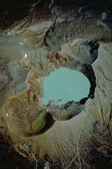 A near-vertical 1981 aerial photo looks down on the summit craters of Kusatsu-Shirane volcano, with NE at the top of the photo. Three partially overlapping craters form the summit. Kara-gama is at the bottom, the lake-filled Yu-gama at the center, and Mizu-gama at the top. Eruptions, mostly consisting of small-to-moderate phreatic explosions, have occurred from all three craters during historical time, with Yu-gama being the most active. Prior to an eruption in 1882, Mizu-gama and Yu-gama contained clear lakes with vegetated shores.
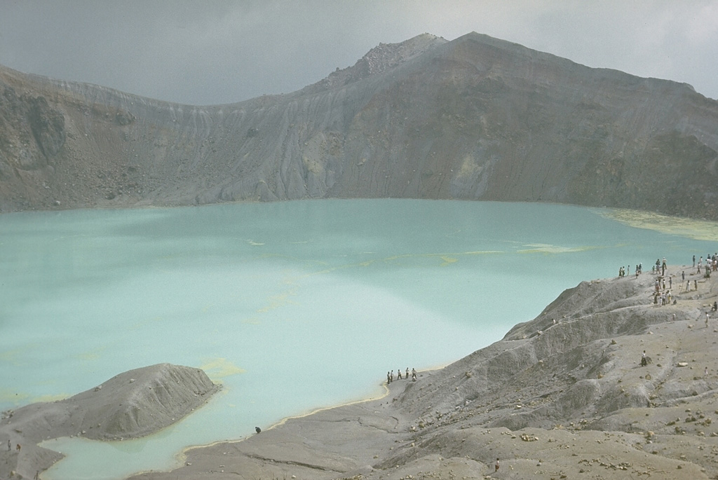
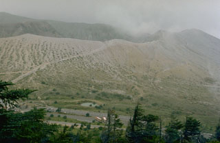 The crater rim of Kusatsu-Shiranesan is seen here from the top of a flank cone to its S. The slopes of the cone are kept largely unvegetated by frequent phreatic explosions from three overlapping craters. Eruptions have been recorded since the early 19th century.
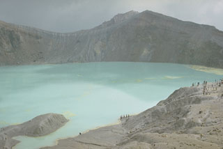 The summit of Kusatsu-Shiranesan contains three craters with the largest, Yugama, holding the turquoise lake shown here. Rafts of yellow sulfur float on the surface of the acidic lake. This 1977 view looks across the lake from the SW-most crater (Karagama) to the NE-most crater (Mizugama), located beyond the notch to the left. Small-to-moderate phreatic explosions have been recorded from all three craters since the 1800s.
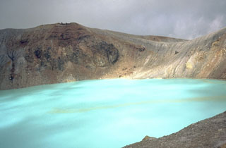 The turquoise waters of Yugama, one of three craters at the summit of Japan's Kusatsu-Shirane volcano, are a popular tourist destination. Yellow rafts of sulfur float on the surface of the acidic lake, which prior to an eruption in 1882, was clear with forested walls. Frequent phreatic explosions have occurred from Yugama and the two other summit craters during historical time. This 1981 photo was taken from the south crater rim.
The following 3 samples associated with this volcano can be found in the Smithsonian's NMNH Department of Mineral Sciences collections, and may be availble for research (contact the Rock and Ore Collections Manager). Catalog number links will open a window with more information.
| Catalog Number | Sample Description | Lava Source | Collection Date |
|---|---|---|---|
| NMNH 113867 | Augite Andesite | -- | -- |
| NMNH 113868 | Augite Andesite | -- | -- |
| NMNH 149513-00 | Minamiite | -- | -- |
| Copernicus Browser | The Copernicus Browser replaced the Sentinel Hub Playground browser in 2023, to provide access to Earth observation archives from the Copernicus Data Space Ecosystem, the main distribution platform for data from the EU Copernicus missions. |
| MIROVA | Middle InfraRed Observation of Volcanic Activity (MIROVA) is a near real time volcanic hot-spot detection system based on the analysis of MODIS (Moderate Resolution Imaging Spectroradiometer) data. In particular, MIROVA uses the Middle InfraRed Radiation (MIR), measured over target volcanoes, in order to detect, locate and measure the heat radiation sourced from volcanic activity. |
| MODVOLC Thermal Alerts | Using infrared satellite Moderate Resolution Imaging Spectroradiometer (MODIS) data, scientists at the Hawai'i Institute of Geophysics and Planetology, University of Hawai'i, developed an automated system called MODVOLC to map thermal hot-spots in near real time. For each MODIS image, the algorithm automatically scans each 1 km pixel within it to check for high-temperature hot-spots. When one is found the date, time, location, and intensity are recorded. MODIS looks at every square km of the Earth every 48 hours, once during the day and once during the night, and the presence of two MODIS sensors in space allows at least four hot-spot observations every two days. Each day updated global maps are compiled to display the locations of all hot spots detected in the previous 24 hours. There is a drop-down list with volcano names which allow users to 'zoom-in' and examine the distribution of hot-spots at a variety of spatial scales. |
|
WOVOdat
Single Volcano View Temporal Evolution of Unrest Side by Side Volcanoes |
WOVOdat is a database of volcanic unrest; instrumentally and visually recorded changes in seismicity, ground deformation, gas emission, and other parameters from their normal baselines. It is sponsored by the World Organization of Volcano Observatories (WOVO) and presently hosted at the Earth Observatory of Singapore.
GVMID Data on Volcano Monitoring Infrastructure The Global Volcano Monitoring Infrastructure Database GVMID, is aimed at documenting and improving capabilities of volcano monitoring from the ground and space. GVMID should provide a snapshot and baseline view of the techniques and instrumentation that are in place at various volcanoes, which can be use by volcano observatories as reference to setup new monitoring system or improving networks at a specific volcano. These data will allow identification of what monitoring gaps exist, which can be then targeted by remote sensing infrastructure and future instrument deployments. |
| Volcanic Hazard Maps | The IAVCEI Commission on Volcanic Hazards and Risk has a Volcanic Hazard Maps database designed to serve as a resource for hazard mappers (or other interested parties) to explore how common issues in hazard map development have been addressed at different volcanoes, in different countries, for different hazards, and for different intended audiences. In addition to the comprehensive, searchable Volcanic Hazard Maps Database, this website contains information about diversity of volcanic hazard maps, illustrated using examples from the database. This site is for educational purposes related to volcanic hazard maps. Hazard maps found on this website should not be used for emergency purposes. For the most recent, official hazard map for a particular volcano, please seek out the proper institutional authorities on the matter. |
| IRIS seismic stations/networks | Incorporated Research Institutions for Seismology (IRIS) Data Services map showing the location of seismic stations from all available networks (permanent or temporary) within a radius of 0.18° (about 20 km at mid-latitudes) from the given location of Kusatsu-Shiranesan. Users can customize a variety of filters and options in the left panel. Note that if there are no stations are known the map will default to show the entire world with a "No data matched request" error notice. |
| UNAVCO GPS/GNSS stations | Geodetic Data Services map from UNAVCO showing the location of GPS/GNSS stations from all available networks (permanent or temporary) within a radius of 20 km from the given location of Kusatsu-Shiranesan. Users can customize the data search based on station or network names, location, and time window. Requires Adobe Flash Player. |
| DECADE Data | The DECADE portal, still in the developmental stage, serves as an example of the proposed interoperability between The Smithsonian Institution's Global Volcanism Program, the Mapping Gas Emissions (MaGa) Database, and the EarthChem Geochemical Portal. The Deep Earth Carbon Degassing (DECADE) initiative seeks to use new and established technologies to determine accurate global fluxes of volcanic CO2 to the atmosphere, but installing CO2 monitoring networks on 20 of the world's 150 most actively degassing volcanoes. The group uses related laboratory-based studies (direct gas sampling and analysis, melt inclusions) to provide new data for direct degassing of deep earth carbon to the atmosphere. |
| Large Eruptions of Kusatsu-Shiranesan | Information about large Quaternary eruptions (VEI >= 4) is cataloged in the Large Magnitude Explosive Volcanic Eruptions (LaMEVE) database of the Volcano Global Risk Identification and Analysis Project (VOGRIPA). |
| EarthChem | EarthChem develops and maintains databases, software, and services that support the preservation, discovery, access and analysis of geochemical data, and facilitate their integration with the broad array of other available earth science parameters. EarthChem is operated by a joint team of disciplinary scientists, data scientists, data managers and information technology developers who are part of the NSF-funded data facility Integrated Earth Data Applications (IEDA). IEDA is a collaborative effort of EarthChem and the Marine Geoscience Data System (MGDS). |

