The Yellowstone Volcano Observatory (YVO) reported that a small hydrothermal eruption occurred at Black Diamond Pool, in Yellowstone’s Biscuit Basin thermal area, at 2018 on 3 July based on webcam images. The Volcano Alert Level remained at Normal (the lowest level on a four-level scale) and the Aviation Color Code remained at Green (the lowest color on a four-color scale).
Source: Yellowstone Volcano Observatory (YVO)
Second largest recorded earthquake swarm during January-February 2010
Monthly updates from the Yellowstone Volcano Observatory (YVO) summarize seismic activity (table 1) and ground deformation at Yellowstone caldera. Earthquake activity remained at low levels during the majority of the reporting interval (November 2006 through February 2010). There were several earthquake swarms during this time, including significant events in December 2008-January 2009 and January-February 2010. The early 2010 events comprised the second largest earthquake swarm recorded at Yellowstone, second only to the fall 1985 swarm (BGVN 17:03). The swarm that began in December 2008 was the third largest swarm recorded.
Table 1. Seismic data for Yellowstone organized by month, including the number of recorded earthquakes, the largest magnitude recorded, and earthquake swarm information. Note the large swarms during December 2008-January 2009 and during January-February 2010. Data courtesy of the USGS.
| Month | Number of earthquakes | Largest magnitude | Earthquake swarms dates (number of events) |
| Nov 2006 | 87 | 2.7 on 04 Nov | 04-07 Nov (47) |
| Dec 2006 | 36 | 2.0 on 16 Dec | -- |
| Jan 2007 | 93 | 2.8 on 30 Jan | -- |
| Feb 2007 | 113 | 2.9 on 27 Feb | 27-28 Feb (5); 13-22 Feb (59) |
| Mar 2007 | 63 | 2.3 on 21 Mar | 11 on 1 Mar |
| Apr 2007 | 53 | 2.1 on 22 Apr | -- |
| May 2007 | 59 | 2.7 on 01 May | 01 May (14) |
| Jun 2007 | 73 | 1.5 on 27 Jun | 20 June (26) |
| Jul 2007 | 80 | 2.2 on 26 Jul | -- |
| Aug 2007 | 74 | 2.8 on 03 Aug | 19-21 Aug ("small" event) |
| Sep 2007 | 54 | 2.3 on 10 Sep | -- |
| Oct 2007 | 34 | 2.1 on 17 Oct | -- |
| Nov 2007 | 69 | 2.9 on 04 Nov | -- |
| Dec 2007 | 184 | 3.6 on 30 Dec | 18-21 Dec (48) |
| Jan 2008 | 263 | 3.7 on 09 Jan | 09 Jan (124); 25-26 Jan (32) |
| Feb 2008 | 130 | 2.4 on 03 Feb | 03 Feb (47) |
| Mar 2008 | 147 | 4.2 on 25 Mar | 11-16 Mar (73); 21-22 Mar (17) |
| Apr 2008 | 70 | 1.7 on 17 Apr | -- |
| May 2008 | 99 | 2.3 on 18 May | 04-14 May (37) |
| Jun 2008 | 79 | 2.7 on 04 Jun | 04-08 Jun (27) |
| Jul 2008 | 185 | 2.5 on 31 Jul | 28-31 Jul (132) |
| Aug 2008 | 146 | 2.3 on 31 Aug | 01-05 Aug (52); 03-07 Aug (28); 07-08 Aug (32) |
| Sep 2008 | 62 | 2.9 on 25 Sep | 25 Sep (19) |
| Oct 2008 | 46 | 2.4 on 05 Oct | -- |
| Nov 2008 | 166 | 2.7 on 23 Nov | 23-29 Nov (77) |
| Dec 2008 | ~500 | 3.9 on 27 Dec | 27 Dec-05 Jan (~813) |
| Jan 2009 | 315 | 3.5 on 02 Jan | 09-12 Jan (35) |
| Feb 2009 | 51 | 2.1 on 19 Feb | -- |
| Mar 2009 | 66 | 2.4 on 03 Mar | -- |
| Apr 2009 | 242 | 2.7 on 28 Apr | 13-18 Apr (62); 17-25 Apr (111); 29 Apr (19) |
| May 2009 | 133 | 3.0 on 25 May | 25 May (68) |
| Jun 2009 | 77 | 3.3 on 30 Jun | 30 Jun (25) |
| Jul 2009 | 98 | 2.7 on 08 Jul | 01-03 Jul (12) |
| Aug 2009 | 86 | 2.1 on 14 Aug | 08-12 Aug (29) |
| Sep 2009 | 177 | 2.3 on 20 Sep | 12-17 Sep (39); 13-18 Sep (66) |
| Oct 2009 | 218 | 2.5 on 15 Oct | 12-23 Oct (138) |
| Nov 2009 | 69 | 3.1 on 09 Nov | -- |
| Dec 2009 | 70 | 2.2 on 18 Dec | -- |
| Jan 2010 | 1620 | 3.8 on 20 Jan | 17 Jan-25 Feb (1,809) |
| Feb 2010 | 244 | 3.1 on 02 Feb | -- |
Earthquake swarm, December 2008-January 2009. An earthquake swarm from 26 December 2008 to 5 January 2009 was centered beneath the N end of Yellowstone Lake. The event consisted of ~ 900 earthquakes with magnitudes ranging up to 3.9; 19 events had magnitudes greater than 3.0, while 141 had magnitudes between 2.0 and 2.9.
Earthquake swarm, January-February 2010. The January-February 2010 earthquake swarm was centered about 16 km NW of Old Faithful, on the NW edge of the caldera. The event began with a few small earthquakes on 15 January and began to intensify on 17 January. A 3.7 magnitude earthquake was recorded at 2301 on 20 January, followed by a magnitude 3.8 event at 2316. The events were felt throughout the park and surrounding communities in Wyoming, Montana, and Idaho. By 25 February, YVO had recorded a total of 1,809 earthquakes, with 14 reaching magnitudes of over 3.0 and 136 with magnitudes between 2.0 and 2.9. By the end of February activity had returned to background levels.
The University of Utah Seismology Research Group stated that the total seismic energy released by all the earthquakes in this swarm corresponded to one earthquake with an approximate magnitude of 4.4. YVO emphasized that while this was an unusually large event, it did not indicate premonitory volcanic or hydrothermal activity. Rather, the swarm earthquakes were likely the result of slip on pre-existing faults.
Information Contacts: Yellowstone Volcano Observatory, U.S. Geological Survey, 345 Middlefield Road, Menlo Park, CA 94025, USA (URL: http://volcanoes.usgs.gov/yvo/).
The Yellowstone Volcano Observatory (YVO) reported that a small hydrothermal eruption occurred at Black Diamond Pool, in Yellowstone’s Biscuit Basin thermal area, at 2018 on 3 July based on webcam images. The Volcano Alert Level remained at Normal (the lowest level on a four-level scale) and the Aviation Color Code remained at Green (the lowest color on a four-color scale).
Source: Yellowstone Volcano Observatory (YVO)
The Yellowstone Volcano Observatory (YVO) reported that a small hydrothermal explosion occurred at Black Diamond Pool, in Yellowstone’s Biscuit Basin thermal area, at 2039 on 31 May. An analysis of the periodic webcam images (taken every 15 minutes) revealed changes at the pool that same evening; the nature and timing of the changes was not reported. The event was the first at Black Diamond Pool that had been captured on video since the hydrothermal explosion on 23 July 2024, though there was evidence from other monitoring data and eyewitnesses that sporadic eruptions had occurred several times since that event. The Volcano Alert Level remained at Normal (the lowest level on a four-level scale) and the Aviation Color Code remained at Green (the lowest color on a four-color scale).
Source: Yellowstone Volcano Observatory (YVO)
The Yellowstone Volcano Observatory (YVO) reported that on 23 July a hydrothermal explosion occurred at Yellowstone’s Black Diamond Pool in the Biscuit Basin thermal area. The explosion ejected a plume of water, mud, and rock fragments 120-180 m high and NE towards Firehole River. Some ejected boulders were more than a meter in diameter. A section of the boardwalk to the S of the pool was notably damaged. The area, including the parking lot and boardwalks, was closed to visitors after the explosion. Hydrothermal explosions are relatively common in Yellowstone; on average, there are a few of varying sizes somewhere in the park each year, often in the backcountry where they may go unnoticed. The Volcano Alert Level remained at Normal (the lowest level on a four-level scale) and the Aviation Color Code remained at Green (the lowest color on a four-color scale).
Source: Yellowstone Volcano Observatory (YVO)
The Yellowstone Volcano Observatory (YVO) reported that at around 1000 on 23 July a small hydrothermal explosion occurred in Yellowstone’s Biscuit Basin thermal area, located about 3.5 km NW of Old Faithful. The explosion likely originated near Black Diamond Pool and was recorded by visitors that were on the nearby boardwalk. Ejecta from the explosion damaged the boardwalk; no injuries were reported. Biscuit Basin, including the parking lot and boardwalks, were temporary closed for visitor safety. YVO noted that the explosion did not reflect activity within volcanic system, which remained at normal background levels of activity, and was not caused by magma rising towards the surface. Hydrothermal explosions are relatively common in Yellowstone. The Volcano Alert Level remained at Normal (the lowest level on a four-level scale) and the Aviation Color Code remained at Green (the lowest color on a four-color scale).
Source: Yellowstone Volcano Observatory (YVO)
Reports are organized chronologically and indexed below by Month/Year (Publication Volume:Number), and include a one-line summary. Click on the index link or scroll down to read the reports.
Shallow steam explosion destroys geyser
The following is from Roderick Hutchinson. "At approximately 1440 on 5 September, Porkchop Geyser in the Norris Geyser Basin (roughly 44.7°N, 110.7°W) of Yellowstone National Park was destroyed by a shallow steam explosion. Eight visitors witnessed its water-steam mixture eruption column reach an estimated height of 20-30 m from its normal 6-9 m shortly before the whole siliceous sinter formation suddenly blew up. In 'just a few seconds' it threw sinter blocks out in a fan-like manner, mainly to the N and S, rupturing the geyser's vent, hot water basin, and surrounding sinter sheet platform. Maximum range of ejecta was 66.1 m S, 43.4 m N, 31.5 m W, and only 25.6 m E toward the boardwalk. An ejecta rim 1-1.4 m high, 13.9 m long on a N-S axis, and 11.7 m wide was formed around a newly created boiling spring. Much of its volume consisted of large sheets or plates of moderate to dense siliceous sinter buckled loose from the floor of the thermal basin and thrust vertically or overturned. The largest sinter block cast out had dimensions of 1.88 x 1.23 x 0.75 m. Within the ejecta rim, a new hot spring, supersaturated with silica, has emerged and is currently 5.5 x 4.0 m across and 3.23 m deep.
"Porkchop Geyser was a small unnamed spring, notable at least as early as 1927, because of its exceptionally high contents of Cl and SiO2; it remained unnamed until 1961, when it was informally called Dr. More's Porkchop by Donald E. White of the USGS, and later shortened to Porkchop Geyser. The name was derived from the shape of the geyser's pool. Porkchop normally had a slightly surging non-opalescent discharge; rarely, a geyser eruption 3-5 m high emptied its pool. Beginning in late Mar 1985, it started erupting as a perpetual spouter from an empty crater through its 2'3.5 cm triangular vent. Over the last 4 years, the geyser's eruption column was of sufficient velocity to be atomized into a fine spray that during winter formed ice cones > 7 m high and produced an eruption roar audible up to 2 km away.
"The destruction of Porkchop Geyser coincided with and was probably triggered by an annual widespread thermal disturbance in the Norris Geyser Basin. These hydrothermal events are characterized by briefly increased water and gas discharge, increased turbidity, extreme fluctuations in surface temperatures, alteration of geyser eruptive patterns, and in some years also include the creation of new thermal features. These disturbances have been observed nearly every year since 1971 when more detailed record keeping began."
Further References. Dzurisin, D., and Yamashita, K., 1987, Vertical surface displacements at Yellowstone Caldera, Wyoming, 1976-1986: JGR, v. 92, p. 13,753-13,766.
Smith, R.B., Reilinger, R., Meertens, C., Hollis, J., Holdahl, S., Dzurisin, D., Gross, W., and Klingele, E., 1989, What's moving at Yellowstone?; the 1987 crustal deformation survey from GPS, leveling, precision gravity, and trilateration: EOS, v. 70, p. 113, 119, 123-125.
Information Contacts: Roderick A. Hutchinson, Yellowstone National Park.
Strong new thermal activity
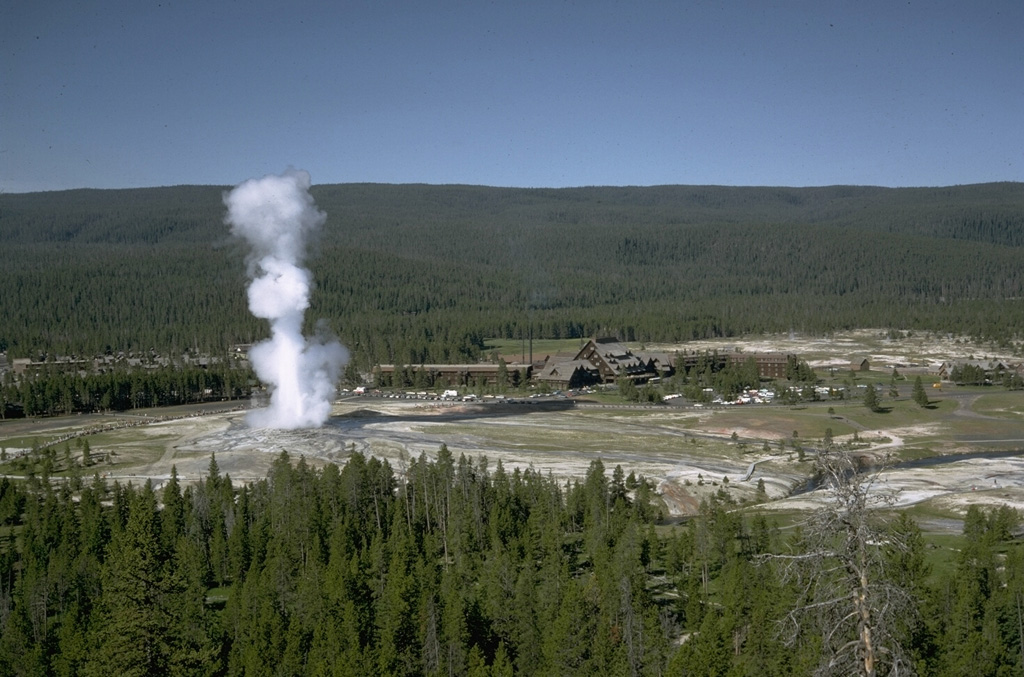
In 1985, a new superheated fumarole formed on the upper E margin of the Mushpots thermal area, which lies on the E side of the caldera associated with the youngest of Yellowstone's three cycles of voluminous rhyolitic volcanism, 0.6 million years ago. The presence of vegetation and the limited extent of bare thermal ground indicated that heat flow near the site of the new fumarole had been moderate to low for at least the previous 15 years. Interviews with park personnel strongly suggested that activity began about 3 July 1985. The steam cloud from the vent may have inspired a false report of smoke from the area, but the vent was not discovered until 5 October 1986, during fieldwork by C. Craig-Hunter and Roderick Hutchinson. At that time, the fumarole's transparent dry-steam jet was directed upslope N35°W at an approximate angle of 21°. A small, reddish-brown, iron-stained cone of hydrothermally altered sand-sized material had grown ~ 0.5 m above the uphill side of the rectangular 1.35 x 1.9-m vent, which dipped at an angle under the lower S rim. Just below the fumarole, on the floor of an old thermal zone, were numerous new or recently enlarged, small, steaming, thermal and mud pot vents, covering an area ~ 10 m in diameter. Sulfate and/or yellow elemental sulfur deposits covered most of the area and nearby slopes to the W, SW, and NW. A second area of new or rejuvenated thermal vents was also discovered in the drainage to the south.
Many trees had been killed in line with the fumarole's directed plume and around the margins of the old thermal zone. Mature trees as much as 87 cm in diameter were snapped off at ground level or uprooted, and tops were broken on other trees 40 m from the rim of the old thermal zone (54 m from the fumarole). A narrow zone of hydrothermally altered white chips of glacial till was found among the toppled trees up to 40 m from the thermal zone rim. These ejecta were 6 cm deep on the rim in 1986.
Geologists returned on 12 February 1987, after a nearby Univ of Utah seismograph . . . detected an isolated episode resembling volcanic tremor. The fumarole's temperature had increased (figure 1) and more elemental sulfur and iron sulfates had been deposited in the old thermal zone, but no other changes were evident. Since then, a biannual survey has been conducted in the area.
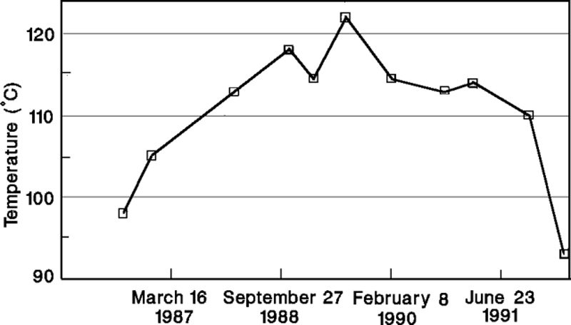 |
Figure 1. Temperatures measured at Mushpot Fumarole, Yellowstone National Park, 5 October 1986-28 March 1992. Courtesy of R. Hutchinson. |
During fieldwork on 28 March 1992, a quiet cloud of wet, 93°C vapor filled the 1985 fumarole's vent. However, less than 30 m downslope (S), on the E margin of the old thermal zone's floor, the ground was shaking violently with the formation and growth of a new mud pot. Bursts of thick, viscous mud were typically doming to 2 m and occasionally to 5 m in diameter before exploding to 3-6 m height. Each explosion shook the ground in all directions. Branches of thermally killed trees shook 50 m away, the ground was visibly moving 8-10 m from the rim, and within 4 m of the rim was behaving like pudding, with violent shaking causing surface oscillations of 1-2 cm. During 90 minutes of observations, the surface area of the mud pot increased by ~ 50%, to an estimated 11 x 7 m. It had a depth of at least 2 m. The minimal amount of ejected mud surrounding the crater and the intense shaking suggested that development of the mud pot had begun within the last 24 hours.
Information Contacts: Roderick A. Hutchinson, Yellowstone National Park.
New mud volcano, minor mud flow, and associated thermal features
On the SW flank of Sour Creek resurgent dome W of Astringent Creek in the 0.6 Ma Yellowstone caldera, is an extensive, unnamed acid sulfate hydrothermal system (figures 2 and 3). Surface expression of the ~3 km2 thermal area consists of discontinuous high temperature altered ground, turbid springs, pools, seeps, fumaroles, mud pots, a large gas- and sulfur-rich acid lake, and numerous sublimated sulfur mound deposits interspersed among low-temperature forest-covered ground.
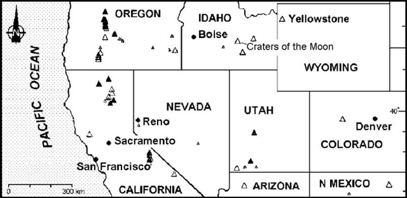 |
Figure 2. Index map of the western United States showing the location of Yellowstone Caldera. |
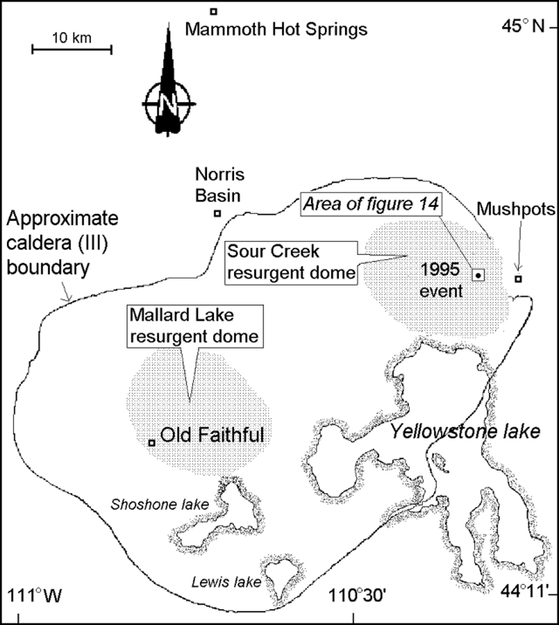 |
Figure 3. Sketch map of Yellowstone Caldera indicating the location of the recent thermal features described in this and an earlier report. |
During early 1990, a significant rise in temperature in the upper NW end of the hydrothermal system began killing old-growth pine trees. Within a year, a new super-heated fumarole emerged, blanketing the downed trees and roots with a layer of hydrothermally altered coarse sand from a directed blast to the N.
The temperature and volume of dry steam venting from the deep "shaft-like" vent steadily increased over the next three years, with the temperature reaching a maximum of 104.3°C on 8 October 1994, ~11°C higher than the local boiling point. The dynamic activity of the fumarole and surrounding hot ground was only monitored about twice a year over the three years following its 1990 inception due to its remote location and restricted access.
A similar progression was previously seen during 1985 in an area ~4.5 km to the E. This area, the upper E margin of the Mushpots thermal area, sits on the W flanks of Pelican Cone (BGVN 17:03). The progression went from new hot ground and dying mature forests, to the vigorous breakout of a dry, super-heated fumarole with progressively hotter temperatures over time, followed by sudden emergence of a large and violent mud volcano. Both the 1985 and recent thermal features had similar fluid compositions.
During 1992-94 the unnamed thermal area W of Astringent Creek developed a series of seven large craters that evolved as the Mushpots thermal area did in 1985. The craters were progressively younger towards the SW, ending at the site of the current new hot ground and fumarole (figure 4). In December 1993, National Park Service research geologist R. Hutchinson predicted that the newest superheated fumarole would soon evolve into a large mud volcano.
 |
Figure 4. Sketch map (scale approximate) showing the surface expression of an unnamed thermal area W of Astringent Creek in Yellowstone Caldera. Coordinates for map's center are at about 44°38'06"N, 110°16'44"W. Courtesy of R. Hutchinson. |
As a part of routine monitoring, the thermal area W of Astringent Creek was inspected on 7 June 1995. The former 104.3°C fumarole was replaced by a large vigorous mud pot with ejecta extensively scattered around it. In addition, two new smaller roaring fumaroles at or slightly above boiling point, three new moderate-sized churning caldrons (pits containing hot, agitated aqueous fluids), numerous smaller muddy pools, collapse pits, and frying-pan springs (audibly degassing springs) were apparent then. Extensive areas of unstable quicksand-like saturated ground made up of scalding mud were found under the fallen trees. Some regions were heavily encrusted with sulfate minerals or sulfur crystals; others were covered by baked organic matter on the pine forest's floor.
Extending NW from the largest parasitic churning caldron, below the new mud volcano crater, was a spectacular white kaoline clay mud flow (figure 4, dark shading and arrow showing flow direction). It spread rapidly to reach an average width of 13.8 m in the first 55 meters of its length in dead forest grove and eventually terminated 114 m from its source on the open, acid thermal-basin floor.
The relative freshness of the ejected mud and incorporated semi-coarse sandy material indicated that the super-heated fumarole transformed into the powerful mud volcano between mid-April and mid-May. The distribution of large mud bombs suggested that their trajectories reached 20-30 m above the crater rim. Ejecta were seen along the following compass bearings with the stated maximum distances from the crater: N, 13.6 m; E, 30.2 m; S, 25.4 m; and W, 12.1 m.
When visited on both 7 June and 9 September, the mud volcano still continued to throw mud 0.5-1.5 m high from dozens of points around the crater floor. The mud volcano crater was 13.5-m long, 11.3-m wide, and 3.9-4.9 m deep. A conservative estimate of the crater volume was 315 m3. The total area covered by the ejecta and crater was ~2,100 m2. In the SW quarter of the crater a large, slightly elevated projection was visible with an arcuate line of dry, white, probably super-heated fumarole vents.
The largest parasitic caldron had numerous points of ebullition in its irregularly shaped pool (maximum dimensions of 10.8 x 7.9 m), with a water level 0.7-1.4 m below the former forest floor. The churning water was near boiling, opaque, light tan in color, and partially covered with brown organic-rich foam derived from cooked plant material.
Each of the caldrons were interpreted as being parasitic to the mud volcano crater because they appeared to have evolved shortly after the initial fumarole collapse and then subsequently drained much of its fluids. This relationship seems to have rapidly lowered the crater floor, preventing the accumulation of a thick ejecta cone on the crater rim.
The mud volcano crater, parasitic features, vents, and the associated hot ground remain extremely dangerous and unstable. Additional alterations in the creation of new or enlarged springs, and perhaps even another mud volcano crater are anticipated. With respect to geologic hazards, the acid sulfate thermal area should be checked again in the near future. Photographs were taken on 7 June.
The Yellowstone Plateau volcanic field developed through three volcanic cycles spanning two million years and included some of the world's largest known eruptions. Eruption of the > 2,500 km3 Huckleberry Ridge Tuff ~2.1 million years ago (Ma) created a caldera more than 75 km long. The Mesa Falls Tuff erupted around 1.3 Ma, forming the 25-km-wide Island Park Caldera at the first caldera's W end. A 0.6 Ma eruption deposited the 1,000 km3 Lava Creek Tuff and associated caldera collapse created the rest of the present 45 x 75 km caldera (figure 3). Resurgent doming then occurred; voluminous (1,000 km3) intercaldera rhyolitic lava flows were erupted between 150,000 and 70,000 years ago. Phreatic eruptions produced local tephra layers during the early Holocene. Distinctive geysers, mud pots, hot springs, and other hydrothermal features within Yellowstone caldera helped lead to the establishment of the National Park in 1872.
Information Contacts: Roderick A. Hutchinson, National Park Service, P.O. Box 168, Yellowstone National Park, Wyoming 82190, USA.
Earthquake swarm during June along mapped faults
A series of earthquake swarms began along the NW edge of Yellowstone National Park on the evening of 13 June 1999. Between 13 and 22 June over 630 earthquakes were recorded in a region ~13 km NE of the town of West Yellowstone, Montana and ~5 km SE of Grayling Creek Junction, Montana. The largest of the earthquakes, M 3.5, occurred at 1038 on 16 June. No residents reported noticing the earthquakes. The activity was located along mapped faults that extend eastward from the S end of 1959 Hebgen Lake rupture (the 7.5 magnitude Hebgen Lake earthquake was the largest in the history of the Intermountain region). Earthquake swarms are common in Yellowstone, but this was the largest since June 1997. That swarm also occurred along the NW edge of the park, the area that historically records the most persistent swarms. The most extensive recorded earthquake swarm occurred ~10 km SE of the June activity over a period of several months in 1985 and 1986.
Seismicity in the Yellowstone region is recorded by 22 University of Utah Seismograph Stations and two Global Positioning System stations. The telemetered surveillance system provides coverage for both earthquakes and ground movement related to volcanic or earthquake activity. The project is conducted cooperatively with the U.S. Geological Survey Volcano Hazards Program and the National Park Service.
As discussed by Robert B. Smith on his web pages at the University of Utah, Yellowstone National Park is located on a hotspot within the North American Plate; its three calderas are the most recent in a string that extends to the SW across Idaho. Dubbed "The Restless Giant" for its geological instability, Yellowstone could one day have another major eruption like the one that formed its youngest caldera 600,000 years ago. Symptoms include numerous earthquakes (most too small to be felt), uplift and subsidence of the ground surface, and persistent hydrothermal activity. The current rates of seismicity, ground deformation, and hydrothermal activity at Yellowstone, although high by most geologic standards, are probably typical of long time periods between eruptions and therefore not a reason for immediate concern. Scientists from the U.S. Geological Survey and the University of Utah are studying the Yellowstone region to assess the potential hazards from future earthquakes and eruptions and to provide warning if the current level of unrest should intensify.
Information Contacts: U.S. Geological Survey, Cascades Volcano Observatory, 5400 MacArthur Blvd., Vancouver, WA 98661 USA (URL: https://volcanoes.usgs.gov/observatories/cvo/); Michael Finley, Tom Deutch, and Anne Deutch, National Park Service, P.O. Box 168, Yellowstone, WY 82190 USA (URL: https://www.nps.gov/yell/); Robert B. Smith, Department of Geology and Geophysics, 135 S. 1460 East, Room 702, University of Utah, Salt Lake City, UT 84112 USA.
On 2 May powerful Steamboat geyser discharged over 190 m3 of water
Yellowstone's Norris basin (White and others, 1988) includes the powerful but erratic Steamboat geyser. Steamboat suddenly ejected a vigorous plume of boiling water and steam on the morning of 2 May 2000. For 9 years prior to this-since 2 October 1991-it ejected only modest water discharges to heights under 20 m. This report discusses the basic observations surrounding the outburst, the minimum volume of the water discharged, and some collateral changes seen at neighboring Cistern Spring.
Shaken campers. Around 0700, National Park Service (NPS) employee Bob Lindstrom stopped at Norris to investigate an anomalously tall vapor column. Two park visitors, who had spent the night sleeping in their camper pickup truck in the otherwise deserted Norris parking area (figure 5), told him that they were abruptly awakened about 0500. The campers had felt the ground trembling as their truck started rocking, an effect they mistook for an earthquake. Frightened, they initially drove away, but upon looking back they saw a huge vapor plume and returned to Norris.
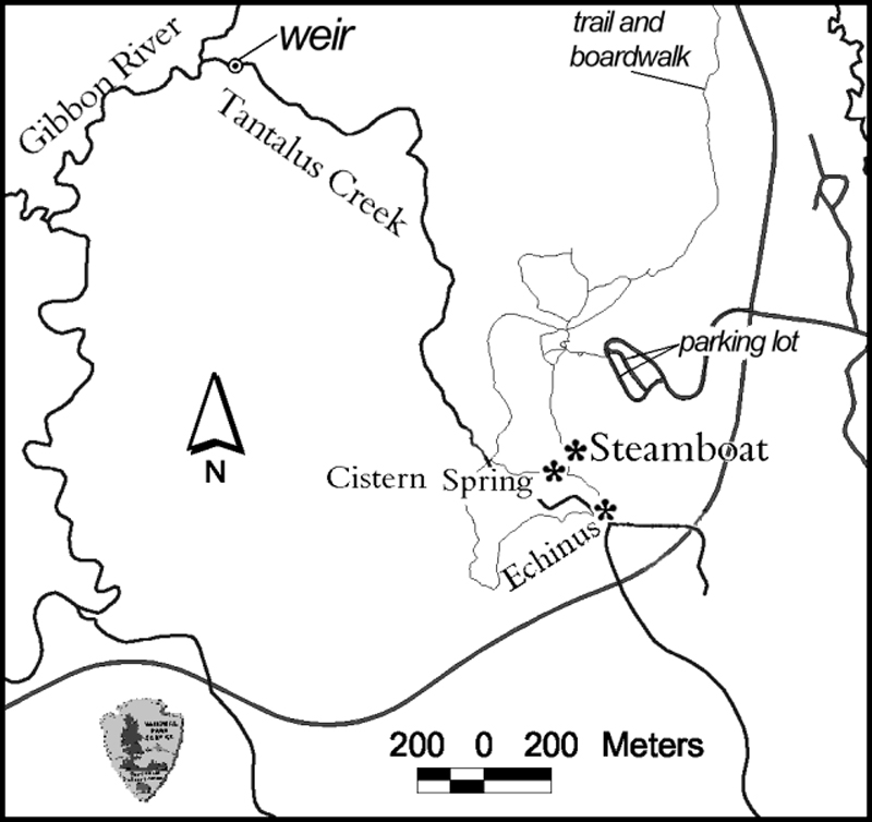 |
Figure 5. A map of Yellowstone's Norris basin showing the location of Steamboat and Echinus geysers, and Cistern Spring. The map also illustrates the parking lot where the campers spent the night of 1-2 May 2000, and the location of the instrumented weir used to estimate the runoff from Steamboat geyser's abnormally large discharge on 2 May. The map was provided by the Spatial Analysis Center, Yellowstone National Park. |
By 0700 when Lindstrom arrived, a wet mist enveloped most of the area around Steamboat geyser; it appeared as local rainfall, even though elsewhere the sky remained blue. The subfreezing air temperature caused ice to form where water fell on the boardwalks running out to the geysers. Discharging steam emitted a jet-engine-like roar. Steamboat was in full steam phase, with a vapor plume then approximately 150 m tall. Although the campers took early photos not yet available to the Park, other photos were taken during the steam phase of the outburst (figure 6). The loud roaring associated with the steam phase continued unabated through at least 0800 and other sources said noises remained audible at 1100 on 2 May. According to Paul Strasser, the outburst left rocks and sand on atop the bridge over the eastern runoff channel at the base of the hill.
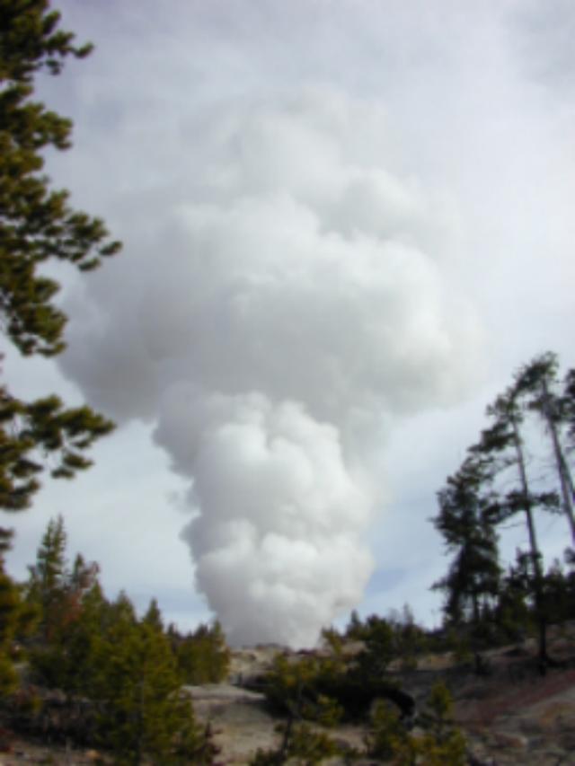 |
Figure 6. A photo showing the steam-dominated secondary phase of the large 2 May discharge from Yellowstone's Steamboat geyser. More photos of the steam phase are available at the web site given below. The exact time of the photo and the location of the photographer remain unreported. National Park Service photo by Tom Cawley. |
Water runoff. To study changes in the Norris basin, for the past 12 years Irving Friedman has monitored the output of a small creek that drains the basin, ~2 km from Steamboat and Echinus geysers (Tantalus creek, figure 5). His efforts have been substantively aided by NPS support and collaboration in addition to help from a cadre of volunteers.
Tantalus creek's discharge gets measured at a small dam with a notch of known dimension (a weir). The height of the water passing through the weir relates to the stream discharge. The water height gets measured by a float gauge similar to those in automobile fuel tanks. The float's position gets recorded every 10 minutes by a data logger. The 10-minute sampling rate means that the instrumentation can only be expected to reflect behavior with periods over 20 minutes; signal processing theory suggests shorter processes can be aliased (i.e., biased leading to misleading results). Since each of the outburst's two phases each lasted over an hour, the sampling interval appears to have been adequate to describe the two phases.
As shown on figure 7, the 1 and 2 May weir data show runoff changing in a long-period cycle somewhat over 20 hours in length, with the Steamboat peak on 2 May superimposed on or near the peak of this long-period cycle. Similar long-period runoff cycles occur often in the weir data, but their cause has not been identified.
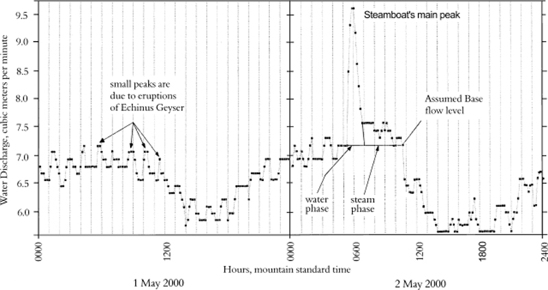 |
Figure 7. A plot showing the time-series of water discharge from Yellowstone's Norris basin on 1 and 2 May as measured at the weir. The position of the weir's float gauge was recorded every 10 minutes. Courtesy of Irving Friedman. |
The weir data on 1 May and during parts of 2 May showed the typical behavior seen in the basin, in this case with Echinus runoff producing repeated peaks with a range of 0.5-1.7 hours and a mean of ~1.1 hours. Ignoring the interval where the Echinus data became masked by the much larger Steamboat peak, the weir data on 2 May was similarly dominated by Echinus runoff; in this case showing peaks with a range of 0.5-3 hours and a mean of ~1.1 hours.
The strong 2 May discharge at Steamboat furnished runoff that arrived at the weir at about 0520 (figure 7). Friedman estimated that the travel time for water from Steamboat to the measuring weir to be about 20 to 30 minutes, so the outburst must have occurred at about 0500. Within the limitations of the instrumental data at the weir, the discharge reached its apex at 0600.
The water phase of the outburst lasted 40 to 60 minutes, reaching a recorded peak discharge rate of ~10 m3 per minute.
The total amount of water discharged during the outburst can be calculated, giving a minimum estimate of the discharge during the outburst. The calculation was made using the area under the curve from the assumed base flow (figure 7).
In addition, figure 7 shows how Friedman broke the Steamboat outburst into a water-dominated phase and a later steam-dominated phase. For the water phase, the weir discharged ~150 m3 (150,000 Liters); for the steam-phase, ~36 m3 (36,000 ,. In addition to the measured runoff, a large, but unknown amount of steam and condensate escaped into the atmosphere; other losses included water stored in places such as soil, ponded on the surface, etc.
Friedman also discusses several representative day-long intervals of weir data, such as 21 September 1998, a day when small but regular peaks of ~0.4 m3/s occurred almost hourly, caused by the outbursts at Echinus geyser. Similar, though less regular patterns persisted in some of the later data. Unfortunately, an electrical connection corroded and broke electrical continuity, halting data collection during the interval early February-May 1999.
During this interval without instrumental record, changes occurred at Norris: a) approximately 1 km from Echinus a new thermal area emerged; b) Echinus's period between outbursts became less regular; and c) the outbursts varied in duration and size, sometimes becoming absent from the record. It is possible that this emergent thermal area robbed Echinus of some of its water and heat. How or whether this helped drive Steamboat towards its 2 May outburst remains uncertain.
Collateral observations. NPS literature states that Cistern Spring's water supply has been closely associated with Steamboat geyser: "When Steamboat erupts, Cistern Spring slowly drains." This pattern prevailed in the 2 May outburst. At 1100 on 2 May the surface water in Cistern Spring was ~8 cm below overflow. By 1900 on 2 May, it had dropped by 1.2 m. By 0900 on 3 May, Cistern Spring was empty; a photo around that time showed Steamboat's continuing steam phase with a plume tens of meters tall.
In reporting recent geyser news on the Geyser Observation and Study Association (GOSA) web page, Paul Strasser noted that eight days prior to the minor outbursts, water gushed mainly from Steamboat's S vent, but occasionally gushed at its N vent, a pattern similar to the mode of activity seen last year. Strasser also noted some possible precursory effects. After the outburst, visitors allegedly told NPS staff that on 29 and 30 April they had seen water from both vents reaching 12-18 m high and felt a larger outburst might start.
Naturalist John Tebby told Strasser that on 1 May he saw the minor discharges starting from both of Steamboat's vents, but only to ~2 m high; a modest amount of runoff came from the S vent. He was only in the vicinity for a short time. Intriguingly, Cistern Spring was then in heavy boil to depths of 15-20 cm, apparently having heated up.
Background. The following comes from GOSA's descriptive list of Yellowstone's 182 geysers: "Steamboat Geyser is currently the tallest geyser in the world. Its major eruptions [discharges] can soar to nearly 400 feet [120 m]. Unfortunately, its major eruptions [discharges] are rare and erratic. Intervals between majors have ranged from 4 days to 50 years. More common is its minor activity that consists of splashes or small discharges every few minutes. This minor play can reach 30 feet [9 m] or more."
"Steamboat is a cone-type geyser erupting [discharging] from two main vents. The water phase of a major eruption [outburst] lasts from 3 to 20 minutes and is followed by an extremely loud steam phase that can continue for another 12 hours. The water phase emits a large amount of water. The aftermath of which can easily be seen around the geyser . . . [sound intensity] of the steam phase has been described as painful . . . [audible] miles away."
According to the Yellowstone Public Affairs office, Steamboat was dormant from 1911-1961. In recent years, Steamboat has had major discharges in 1989 (three events), 1990 (one event), and 1991 (one event).
Strasser discusses how during 1982-84 Steamboat produced numerous short-interval minor discharges, whereas during 1979 only one outburst took place. Strasser and others (1989) cite more references than shown here.
References. Whittlesey, Lee, 2000, Full steam ahead: Steamboat Geyser erupts!: The Buffalo Chip (a Yellowstone National Park employee resource-management newsletter) (Spring, 2000).
Strasser, P., Strasser, S., and Pulliam, B., 1989, Investigations of patterns of minor behavior of Steamboat geyser, 1982-1984: Geyer Observation and Study Association Transactions, v. 2, p. 43-70 (see GOSA website).
White, D.E., Hutchinson, R.A., and Smith, T.E.C., 1988, The geology and remarkable thermal activity of Norris Geyser Basin, Yellowstone National Park, Wyoming: U.S. Geological Survey Professional Paper 1456, U.S. Government Printing Office.
Information Contacts: Bob Lindstrom and Ann Rodman, Yellowstone National Park, Wyoming 82190 USA; Irving Friedman, U.S. Geological Survey, P.O. Box 25046, MS 963, Denver, CO 80225 USA; Geyser Observation and Study Association (GOSA), care of Janet & Udo Freund, 39237 Yellowstone St., Palmdale, CA 93551 USA (URL: http://www.geyserstudy.org/).
Geyser basin heats up, affecting thermal features
Yellowstone National Park press releases indicated unusual hydrothermal activity at the Norris geyser basin in the NW-central portion of the Park. A press release on 22 July 2003 announced that high ground temperatures and increased thermal activity had resulted in the temporary closure of a portion of the Back Basin.
The press release noted "Norris is the hottest and most seismically active geyser basin in Yellowstone. Recent activity in the Norris geyser basin has included formation of new mud pots, an eruption of Porkchop geyser (dormant since 1989), the draining of several geysers, creating steam vents and significantly increased measured ground temperatures (up to 200°F [93°C]). Additional observations include vegetation dying due to thermal activity and the changing of several geysers' eruption intervals. Vixen geyser has become more frequent and Echinus geyser has become more regular."
A press release on 7 August advised of a hydrothermal monitoring program by the Yellowstone Volcano Observatory to begin at Norris geyser basin. The Observatory is a collaborative partnership between the US Geological Survey, the University of Utah, and Yellowstone National Park. It was deploying a temporary network of seismographs, Global Positioning System receivers, and temperature loggers. Goals included identification of hydrothermal steam sources, the relationship of the behavior of Norris geyser basin to the general seismicity, and locating crustal deformation in the caldera.
Information Contacts: Yellowstone Volcano Observatory, a cooperative arrangement that includesRobert L. Christiansen, U.S. Geological Survey, 345 Middlefield Road, Menlo Park, CA 94025; Robert B. Smith, Department of Geology and Geophysics, University of Utah, Salt Lake City, Utah 84112 USA; Henry Heasler, National Park Service, P.O. Box 168, Yellowstone National Park, WY 82190-0168 USA; and others (URL: https://volcanoes.usgs.gov/observatories/yvo/).
Low seismicity; ongoing ground-surface deformation
According to the Yellowstone Volcano Observatory (YVO), during February 2006 there was relatively low seismicity, with 82 reported earthquakes in the region. The largest of these was on 25 February, M 3.1, located near the N caldera rim (~ 10 km SSW of Canyon Junction). None of these earthquakes were reported as felt. Our previous report discussed elevated temperatures of the ground and increased hydrothermal effects at Norris hot springs in 2003 (BGVN 28:07). Norris also represents a frequent epicentral area for earthquakes inside the caldera. In 2002, for example, there were more than 2,350 earthquakes detected at Yellowstone, including over 500 triggered by the November 2002, M 7.9 Denali earthquake. Seismicity during April 2005-April 2006 was comparatively low. Figure 8 plots quarterly earthquakes (≥ M 1.5) during 1974-2004 on a histogram. Figure 9 depicts earthquake swarms during 1985, 1995, and 2004.
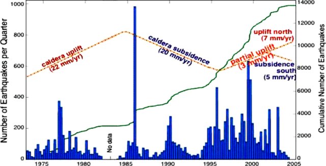 |
Figure 8. A plot of recorded earthquakes (≥ M 1.5) at Yellowstone from 1974 through 2004 (bars, left-hand scale: each bar represents the sum of the earthquakes of stated size per quarter (~ 90 days)). The curving solid line shows the cumulative number of earthquakes for the thirty-year period (right-hand scale). Estimates of mean caldera uplift and subsidence are shown as a dashed-and-dotted line with no scale. Note that this figure stopped in 2004 and does not depict some of the stronger deformation seen in radar and later GPS data (discussed below). Courtesy of YVO (after a figure by Waite and Smith, 2002). |
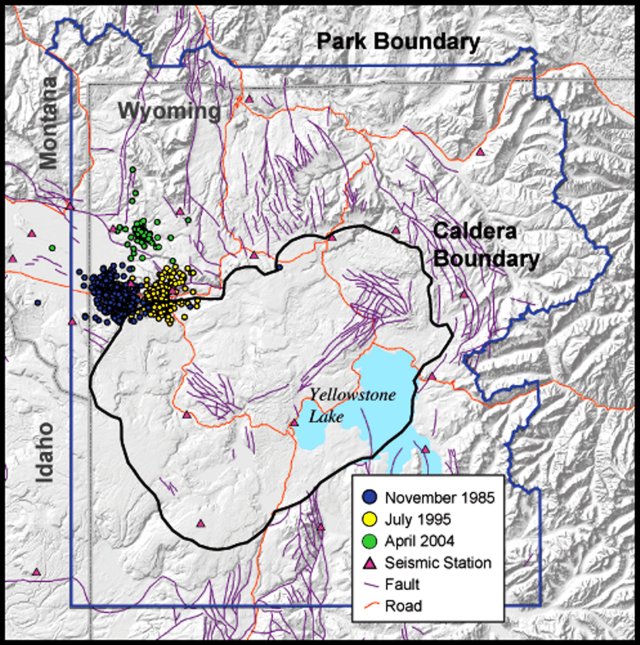 |
Figure 9. A map of Yellowstone caldera and National Park with circles indicating located earthquakes (≥ M 1.5) from the swarm of 1985 (westerly cluster), 1995 (easterly cluster with substantial events inside the caldera), and 2004 (smaller cluster to the N of the other two). Courtesy of YVO. |
Satellite radar created an interferogram of the caldera region (basically, a depiction of the vertical offset determined by satellite radar during 1996-2000). The interferogram portrayed vertical displacement as a large bull's-eye shape (figure 10), and indicated 12.5 cm of uplift centered in the northern portion of the caldera ~ 25 km NW of Yellowstone Lake.
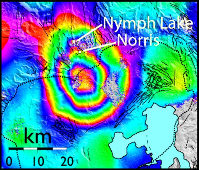 |
Figure 10. A radar interferogram of the Yellowstone caldera region (after Wicks and others, 1998; 2006). This image of vertical ground deformation was created using data from several satellite passes during 1996 through 2000. The image shows 12.5 cm of uplift centered within the northern end of Yellowstone caldera (black dotted line), about 10 km S of Norris hot springs. Each full spectrum of color (from red to purple) represents ~ 28 mm of uplift. The area of uplift is approximately 35 km x 40 km in size. Courtesy of YVO-USGS. |
In response to increased heat and steam emissions in parts of Norris geyser basin, a temporary, five-station GPS network was installed in that area in 2003. The network was installed by a UNAVCO engineer, University of Utah students and faculty, and National Park Service scientists as part of a monitoring effort by YVO. Permanent station NRWY currently resides there (figure 11).
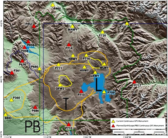 |
Figure 11. GPS stations at Yellowstone caldera, including those both existing (light triangles) and planned (dark triangles). The irregular loops near stations OFW2 and WLWY outline the two active resurgent domes within the 0.64 million-year-old Yellowstone caldera (the Mallard Lake dome and the Sour Creek dome, to the W and E, respectively). The figure also includes Yellowstone caldera topographic margins (T), Yellowstone Lake (L), the National Park boundary (PB), and some state boundaries. Courtesy of YVO-USGS. |
Movement near the N end of Yellowstone Lake was measured by GPS at station LKWY during 1997 to late 2005 (figure 12). The N-S movement (top panel) shown in the past year consisted of displacement of 10-15 mm southward. This N-S movement was somewhat stronger and more protracted than in the earlier parts of the GPS data. The E-W movement (middle panel) was comparatively steady and unbroken over the past 6 years or more, directed westward. Over the past 9 years, the overall E-W motion was ~ 15 mm westward. The vertical motion (lower panel) was negative (subsidence) during 1997 to mid-2004. After that, station LKWY moved sharply upward, rising ~ 80 mm in the last year and a half. Caldera systems frequently undergo ground displacements similar to those observed at Yellowstone without progressing to eruptive activity.
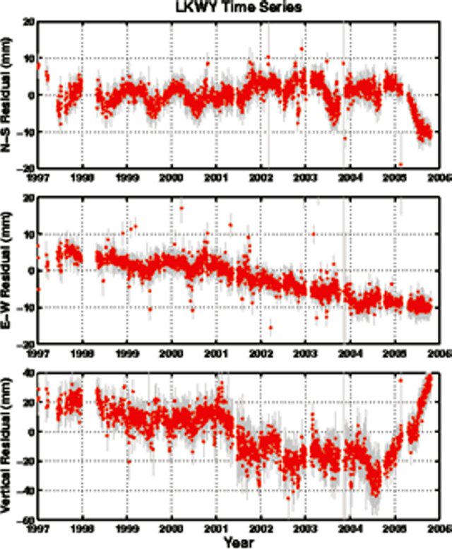 |
Figure 12. Relative movement of GPS station LKWY (located in the central part of the caldera, at the N end of Yellowstone Lake) recorded during 1997 to late 2005. The top panel shows N-S movement, the middle, E-W movement, and the bottom, vertical movement. During 2001-2004 station LKSY moved downward (subsided) on the order of 20 mm. After mid-2004, LKWY moved upward ~ 80 mm. Courtesy of YVO-USGS. |
Much of the history of older calderas that preceded Yellowstone are buried in the subsurface to the W, and a drilling proposal for that region is under development. "Hotspot," the Snake River Scientific Drilling Project, announced an inter-disciplinary workshop with that goal, to be held 18-21 May 2006 and focused on issues central to a new intermediate-depth drilling program in the Snake River Plain of S Idaho, USA. That region provides a record of inferred mantle plume volcanism in an intra-continental setting. Because it is young and tectonically undisturbed, the complete record of volcanic activity can be sampled only by drilling. The preliminary plan was to drill and core 4-6 holes along the axis of the E and W Snake River Plain.
References. Wicks, C., Thatcher, W., and Dzurisin, D., 1998, Migration of fluids beneath Yellowstone Caldera inferred from satellite radar interferometry: Science, v. 282, p. 458-462.
Wicks, C., Thatcher, W., Dzurisin, D., and Svarc, J., 2006 (in press), Uplift, thermal unrest, and magma intrusion at Yellowstone Caldera, observed with InSAR: Nature.
Waite, G.P., and Smith, R.B.,
Information Contacts: Yellowstone Volcano Observatory, a cooperative arrangement that includesJacob B. Lowenstern, U.S. Geological Survey, 345 Middlefield Road, Menlo Park, CA 94025, USA; Robert B. Smith, Department of Geology and Geophysics, University of Utah, Salt Lake City, UT 84112, USA; Henry Heasler, National Park Service, P.O. Box 168, Yellowstone National Park, WY 82190-0168, USA (URL: http://volcanoes.usgs.gov/yvo/).
Second largest recorded earthquake swarm during January-February 2010
Monthly updates from the Yellowstone Volcano Observatory (YVO) summarize seismic activity (table 1) and ground deformation at Yellowstone caldera. Earthquake activity remained at low levels during the majority of the reporting interval (November 2006 through February 2010). There were several earthquake swarms during this time, including significant events in December 2008-January 2009 and January-February 2010. The early 2010 events comprised the second largest earthquake swarm recorded at Yellowstone, second only to the fall 1985 swarm (BGVN 17:03). The swarm that began in December 2008 was the third largest swarm recorded.
Table 1. Seismic data for Yellowstone organized by month, including the number of recorded earthquakes, the largest magnitude recorded, and earthquake swarm information. Note the large swarms during December 2008-January 2009 and during January-February 2010. Data courtesy of the USGS.
| Month | Number of earthquakes | Largest magnitude | Earthquake swarms dates (number of events) |
| Nov 2006 | 87 | 2.7 on 04 Nov | 04-07 Nov (47) |
| Dec 2006 | 36 | 2.0 on 16 Dec | -- |
| Jan 2007 | 93 | 2.8 on 30 Jan | -- |
| Feb 2007 | 113 | 2.9 on 27 Feb | 27-28 Feb (5); 13-22 Feb (59) |
| Mar 2007 | 63 | 2.3 on 21 Mar | 11 on 1 Mar |
| Apr 2007 | 53 | 2.1 on 22 Apr | -- |
| May 2007 | 59 | 2.7 on 01 May | 01 May (14) |
| Jun 2007 | 73 | 1.5 on 27 Jun | 20 June (26) |
| Jul 2007 | 80 | 2.2 on 26 Jul | -- |
| Aug 2007 | 74 | 2.8 on 03 Aug | 19-21 Aug ("small" event) |
| Sep 2007 | 54 | 2.3 on 10 Sep | -- |
| Oct 2007 | 34 | 2.1 on 17 Oct | -- |
| Nov 2007 | 69 | 2.9 on 04 Nov | -- |
| Dec 2007 | 184 | 3.6 on 30 Dec | 18-21 Dec (48) |
| Jan 2008 | 263 | 3.7 on 09 Jan | 09 Jan (124); 25-26 Jan (32) |
| Feb 2008 | 130 | 2.4 on 03 Feb | 03 Feb (47) |
| Mar 2008 | 147 | 4.2 on 25 Mar | 11-16 Mar (73); 21-22 Mar (17) |
| Apr 2008 | 70 | 1.7 on 17 Apr | -- |
| May 2008 | 99 | 2.3 on 18 May | 04-14 May (37) |
| Jun 2008 | 79 | 2.7 on 04 Jun | 04-08 Jun (27) |
| Jul 2008 | 185 | 2.5 on 31 Jul | 28-31 Jul (132) |
| Aug 2008 | 146 | 2.3 on 31 Aug | 01-05 Aug (52); 03-07 Aug (28); 07-08 Aug (32) |
| Sep 2008 | 62 | 2.9 on 25 Sep | 25 Sep (19) |
| Oct 2008 | 46 | 2.4 on 05 Oct | -- |
| Nov 2008 | 166 | 2.7 on 23 Nov | 23-29 Nov (77) |
| Dec 2008 | ~500 | 3.9 on 27 Dec | 27 Dec-05 Jan (~813) |
| Jan 2009 | 315 | 3.5 on 02 Jan | 09-12 Jan (35) |
| Feb 2009 | 51 | 2.1 on 19 Feb | -- |
| Mar 2009 | 66 | 2.4 on 03 Mar | -- |
| Apr 2009 | 242 | 2.7 on 28 Apr | 13-18 Apr (62); 17-25 Apr (111); 29 Apr (19) |
| May 2009 | 133 | 3.0 on 25 May | 25 May (68) |
| Jun 2009 | 77 | 3.3 on 30 Jun | 30 Jun (25) |
| Jul 2009 | 98 | 2.7 on 08 Jul | 01-03 Jul (12) |
| Aug 2009 | 86 | 2.1 on 14 Aug | 08-12 Aug (29) |
| Sep 2009 | 177 | 2.3 on 20 Sep | 12-17 Sep (39); 13-18 Sep (66) |
| Oct 2009 | 218 | 2.5 on 15 Oct | 12-23 Oct (138) |
| Nov 2009 | 69 | 3.1 on 09 Nov | -- |
| Dec 2009 | 70 | 2.2 on 18 Dec | -- |
| Jan 2010 | 1620 | 3.8 on 20 Jan | 17 Jan-25 Feb (1,809) |
| Feb 2010 | 244 | 3.1 on 02 Feb | -- |
Earthquake swarm, December 2008-January 2009. An earthquake swarm from 26 December 2008 to 5 January 2009 was centered beneath the N end of Yellowstone Lake. The event consisted of ~ 900 earthquakes with magnitudes ranging up to 3.9; 19 events had magnitudes greater than 3.0, while 141 had magnitudes between 2.0 and 2.9.
Earthquake swarm, January-February 2010. The January-February 2010 earthquake swarm was centered about 16 km NW of Old Faithful, on the NW edge of the caldera. The event began with a few small earthquakes on 15 January and began to intensify on 17 January. A 3.7 magnitude earthquake was recorded at 2301 on 20 January, followed by a magnitude 3.8 event at 2316. The events were felt throughout the park and surrounding communities in Wyoming, Montana, and Idaho. By 25 February, YVO had recorded a total of 1,809 earthquakes, with 14 reaching magnitudes of over 3.0 and 136 with magnitudes between 2.0 and 2.9. By the end of February activity had returned to background levels.
The University of Utah Seismology Research Group stated that the total seismic energy released by all the earthquakes in this swarm corresponded to one earthquake with an approximate magnitude of 4.4. YVO emphasized that while this was an unusually large event, it did not indicate premonitory volcanic or hydrothermal activity. Rather, the swarm earthquakes were likely the result of slip on pre-existing faults.
Information Contacts: Yellowstone Volcano Observatory, U.S. Geological Survey, 345 Middlefield Road, Menlo Park, CA 94025, USA (URL: http://volcanoes.usgs.gov/yvo/).
|
|
||||||||||||||||||||||||||||
The Global Volcanism Program is not aware of any Holocene eruptions from Yellowstone. If this volcano has had large eruptions (VEI >= 4) prior to 12,000 years ago, information might be found on the Yellowstone page in the LaMEVE (Large Magnitude Explosive Volcanic Eruptions) database, a part of the Volcano Global Risk Identification and Analysis Project (VOGRIPA).
This compilation of synonyms and subsidiary features may not be comprehensive. Features are organized into four major categories: Cones, Craters, Domes, and Thermal Features. Synonyms of features appear indented below the primary name. In some cases additional feature type, elevation, or location details are provided.
Synonyms |
||||
| Yellowstone Plateau | ||||
Craters |
||||
| Feature Name | Feature Type | Elevation | Latitude | Longitude |
| Duck Lake | Crater | 2374 m | 44° 25' 0.00" N | 110° 35' 0.00" W |
| Elliott's Crater | Crater | |||
| Fern Lake | Crater | 2513 m | 44° 41' 0.00" N | 110° 16' 0.00" W |
| Henrys Fork | Pleistocene caldera | |||
| Indian Pond | Crater | |||
| Island Park | Pleistocene caldera | 2390 m | 44° 15' 0.00" N | 111° 15' 0.00" W |
| Mary Bay | Crater | 2360 m | 44° 33' 0.00" N | 110° 19' 0.00" W |
| Pocket Basin | Crater | |||
| Squaw Lake | Crater | 2360 m | 44° 33' 29.00" N | 110° 19' 30.00" W |
| Turbid Lake | Crater | 2390 m | 44° 33' 0.00" N | 110° 16' 0.00" W |
| West Thumb | Pleistocene caldera | |||
Domes |
||||
| Feature Name | Feature Type | Elevation | Latitude | Longitude |
| Elk Butte | Dome | |||
| Gibbon Hill | Dome | |||
| Lookout Butte | Dome | |||
| Mallard Lake | Dome | |||
| Osborne Butte | Dome | |||
| Silver Lake | Dome | |||
| Sour Creek | Dome | |||
| Warm River Butte | Dome | |||
| Willow Park | Dome | |||
Thermal |
||||
| Feature Name | Feature Type | Elevation | Latitude | Longitude |
| Heart Lake | Thermal | 44° 17' 31.00" N | 110° 30' 0.00" W | |
| Lower Geyser Basin | Geyser | 44° 32' 31.00" N | 110° 50' 0.00" W | |
| Mammoth Hot Springs
White Mountain Hot Springs |
Hot Spring | 44° 59' 0.00" N | 110° 41' 31.00" W | |
| Norris Geyser Basin | Geyser | 44° 43' 0.00" N | 110° 42' 0.00" W | |
| Shoshone Geyser Basin | Geyser | 44° 22' 0.00" N | 110° 48' 29.00" W | |
| Upper Geyser Basin | Geyser | 44° 28' 30.00" N | 110° 50' 0.00" W | |
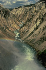 The brilliant hues of the Grand Canyon of the Yellowstone are cut through hydrothermally altered rhyolitic lava flows erupted within Yellowstone caldera. The Yellowstone volcanic field was created during three volcanic cycles over the past 2 million years, each culminating in a voluminous explosive eruption creating a large caldera. Yellowstone's impressive array of hot springs and geysers, part of the most vigorous hydrothermal system in the world, is evidence of a still-active magmatic system.
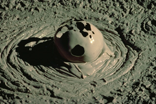 Gas escaping from a mudpot at Yellowstone creates an ephemeral spherical bubble. Mudpots form in hydrothermal systems where the gas phase dominates the thermal system in areas of intense, clay-rich hydrothermal alteration.
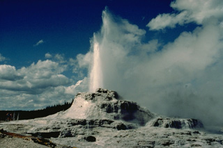 Castle Geyser in Yellowstone's Upper Geyser Basin erupts from a 4-m-high, 12-m-wide sinter mound. Eruptions of Castle Geyser are typically sustained for an hour or more.
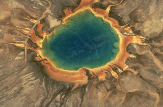 Grand Prismatic Spring, the largest of the geothermal pools in Yellowstone National Park, is 90 m across. The hot pool lies at the top of a broad, low mound formed by deposition of silica at its margins. Overflow channels radiate away from the pool. The colorful rings around the hot-spring pool are formed by algae and other organisms that are temperature dependent. The highest temperature organisms (70-73 degrees Centigrade) are white. Lower-temperature organisms grade to light yellow, orange, red, and then dark green.
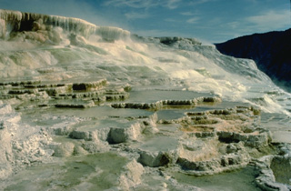 The dramatic travertine terraces of Mammoth Hot Springs in NW Yellowstone are formed by redeposition of dissolved limestone rock underlying the Mammoth area that is carried in solution in hot spring waters. Changes in hot spring passageways can produce very rapid changes in terrace morphology.
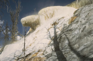 The terraces of Mammoth Hot Springs in NW Yellowstone consist of shallow pools with ledges draped with ribbons of travertine. Rapid deposition encroaches on nearby forests and can produce changes visible within a period of weeks.
 An eruption of Old Faithful, perhaps the world's best known geyser, rises above Yellowstone's Upper Geyser Basin. Old Faithful is a periodic geyser, with eruptions to heights of about 40 m at intervals of 30 to 100 minutes. Old Faithful Lodge to the right provides a rustic backdrop to the Upper Geyser Basin, which contains more geysers than are known altogether in the rest of the world. The forested ridge in the background is underlain by massive post-caldera rhyolitic lava flows of the Madison Plateau.
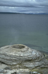 The West Thumb Geyser Basin at the SW end of Yellowstone Lake contains thermal features, such as this sinter mound, both above and below the lake shore. The West Thumb embayment of Yellowstone Lake is a smaller caldera that formed as a result of an explosive eruption during a period of mainly lava-producing eruptions during the past 150,000 years.
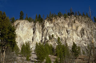 The thick cliffs are composed of massive ash-flow deposits of the Lava Creek Tuff, erupted about 640,000 years ago. Eruption of the 1000 cu km Lava Creek Tuff resulted in the formation of the present 45 x 85 km wide caldera, the latest of three large calderas formed at Yellowstone during the past 2 million years.
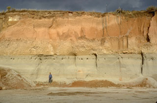 The Mesa Falls Tuff is exposed in a quarry wall near Ashton, Idaho that shows light-colored airfall and pyroclastic-surge deposits overlain by orange-colored pyroclastic-flow deposits. The 280 cu km Mesa Falls Tuff, deposited about 1.3 million years ago during the second of Yellowstone's three largest eruptions, resulted in the formation of the 16-km-wide Henrys Fork caldera west of Yellowstone National Park.
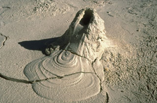 A small mudpot vent in Pocket Basin at the north end of Yellowstone's Lower Geyser Basin produced this intriguing feature that mimics a spatter cone that issued a lava flow. Mudpots form in areas of intense, clay-rich hydrothermal alteration where the thermal system is dominated by gases.
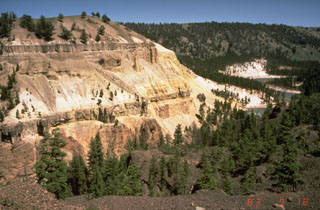 The two dark horizontal bands in the cliff on the left near Tower Junction in NE Yellowstone are lava flows that display prominent columnar jointing. The base of the cliff exposes volcanic materials of the Absaroka Formation. The light-colored rocks between the basaltic lava flows are stream-gravel sediments. The top of the hill consists of lake sediments.
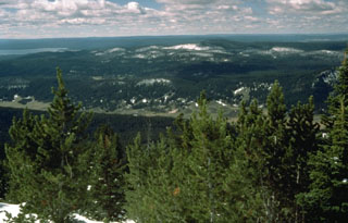 The tip of Yellowstone Lake is seen at the upper left from Pelican Cone near the NE rim of Yellowstone caldera. The forested, snow-capped peaks in the center are rocks of the Sour Creek resurgent dome, an area of uplifted and faulted post-caldera rocks.
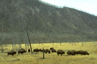 Bison graze in a meadow along the Madison River in front of rocks of the massive West Yellowstone lava flow that are visible in the cliff behind them as a result of the 1988 Yellowstone fires.
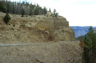 A roadcut at Golden Gate, north of Mammoth, cuts through the Huckleberry Ridge Tuff, the deposit produced by the gigantic eruption that created Yellowstone's first caldera about 2 million years ago. The 2500 cu km Huckleberry Tuff, one of the world's largest Quaternary eruptions, consists of welded tuffs and voluminous airfall deposits found as far away as southern California. The eruption created the 75-km-wide Island Park caldera, which extends from SE-Idaho into central Yellowstone.
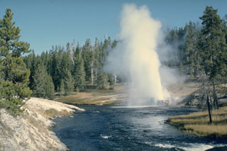 Riverside Geyser in the Upper Geyser Basin is the most regular of Yellowstone's geysers. About every six hours it ejects a 25-m-high inclined jet from a small vent hole on the east bank of the Firehole River 2 km downstream from Old Faithful.
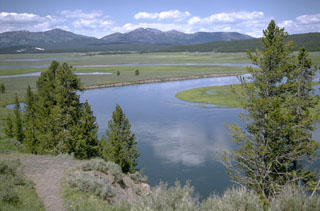 The Yellowstone River slowly meanders through the Hayden Valley, which is underlain by glacial lake sediments capping thick lava flows on the floor of Yellowstone caldera. Mount Washburn, in the center background, is part of an ancient Absaroka volcano that predates the caldera. The northern margin of the Yellowstone caldera lies at the base of the mountain range.
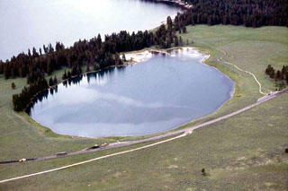 The 500-m-wide Indian Pond hydrothermal explosion crater immediately north of the NE shore of Yellowstone Lake formed about 3350 years ago. Deposits from this eruption extend 3 km from the crater and are up to 3-4 m thick. Yellowstone Lake is seen at the top, with the highway leading to Cody at the bottom in this aerial view from the NE.
The following 1256 samples associated with this volcano can be found in the Smithsonian's NMNH Department of Mineral Sciences collections, and may be availble for research (contact the Rock and Ore Collections Manager). Catalog number links will open a window with more information.
| Catalog Number | Sample Description | Lava Source | Collection Date |
|---|---|---|---|
| NMNH 10569 | Obsidian | -- | -- |
| NMNH 10570 | Hyalo Liparite | -- | -- |
| NMNH 10574-1 | Hyalo Liparite | -- | -- |
| NMNH 10574-2 | Hyalo Liparite | -- | -- |
| NMNH 111123-23 | Siliceous Sinter | -- | -- |
| NMNH 111123-62 | Lithoidite | -- | -- |
| NMNH 111123-63 | Liparite | -- | -- |
| NMNH 111123-94 | Diorite | -- | -- |
| NMNH 116281 | Glassy Tuff | -- | -- |
| NMNH 116282 | Perlite | -- | -- |
| NMNH 28913 | Obsidian | -- | -- |
| NMNH 28914 | Hyalo Liparite | -- | -- |
| NMNH 28917 | Hyalo Liparite | -- | -- |
| NMNH 28921 | Hyalo Liparite | -- | -- |
| NMNH 28923 | Hyalo Liparite | -- | -- |
| NMNH 28975 | Hyalo Liparite | -- | -- |
| NMNH 29106 | Hyalo Liparite | -- | -- |
| NMNH 62041-1 | Obsidian | -- | -- |
| NMNH 62041-2 | Obsidian | -- | -- |
| NMNH 72854 | Obsidian | -- | -- |
| NMNH 72854-1 | Obsidian | -- | -- |
| NMNH 72854-2 | Obsidian | -- | -- |
| NMNH 72855 | Obsidian | -- | -- |
| NMNH 74116 | Obsidian | -- | -- |
| NMNH 88788 | Obsidian | -- | -- |
| NMNH 88788 | Obsidian | -- | -- |
| NMNH 88788-1 | Obsidian | -- | -- |
| NMNH 88788-2 | Obsidian | -- | -- |
| NMNH 88788-3 | Obsidian | -- | -- |
| NMNH 91322-100 | Kersantite | -- | -- |
| NMNH 91322-102 | Dacite | -- | -- |
| NMNH 91322-1024 | Andesite | -- | -- |
| NMNH 91322-1025 | Andesite Volcanic Ash | -- | -- |
| NMNH 91322-1026 | Andesite Volcanic Ash | -- | -- |
| NMNH 91322-1027 | Trachytic Rhyolite | -- | -- |
| NMNH 91322-1028 | Trachytic Rhyolite | -- | -- |
| NMNH 91322-1031 | Trachytic Rhyolite | -- | -- |
| NMNH 91322-1032 | Andesite | -- | -- |
| NMNH 91322-1038 | Andesite | -- | -- |
| NMNH 91322-1041 | Basalt | -- | -- |
| NMNH 91322-1043 | Basalt | -- | -- |
| NMNH 91322-105 | Dacite | -- | -- |
| NMNH 91322-1051 | Volcanic Ash | -- | -- |
| NMNH 91322-106 | Dacite | -- | -- |
| NMNH 91322-1087 | Breccia | -- | -- |
| NMNH 91322-1126 | Basalt | -- | -- |
| NMNH 91322-1127 | Shoshonite | -- | -- |
| NMNH 91322-1129 | Basalt | -- | -- |
| NMNH 91322-1130 | Basalt | -- | -- |
| NMNH 91322-1131 | Shoshonite | -- | -- |
| NMNH 91322-1132 | Basalt | -- | -- |
| NMNH 91322-1133 | Basalt | -- | -- |
| NMNH 91322-1135 | Shoshonite | -- | -- |
| NMNH 91322-1136 | Shoshonite | -- | -- |
| NMNH 91322-1137 | Shoshonite | -- | -- |
| NMNH 91322-1138 | Basalt | -- | -- |
| NMNH 91322-1139 | Basalt | -- | -- |
| NMNH 91322-1140 | Basalt | -- | -- |
| NMNH 91322-1141 | Basalt | -- | -- |
| NMNH 91322-1143 | Shoshonite | -- | -- |
| NMNH 91322-1145 | Basalt | -- | -- |
| NMNH 91322-1147 | Shoshonite | -- | -- |
| NMNH 91322-1150 | Basalt | -- | -- |
| NMNH 91322-1151 | Absarokite | -- | -- |
| NMNH 91322-1152 | Basalt | -- | -- |
| NMNH 91322-1153 | Shoshonite | -- | -- |
| NMNH 91322-1155 | Shoshonite | -- | -- |
| NMNH 91322-1157 | Andesite | -- | -- |
| NMNH 91322-1158 | Unidentified | -- | -- |
| NMNH 91322-1159 | Unidentified | -- | -- |
| NMNH 91322-1160 | Breccia | -- | -- |
| NMNH 91322-1161 | Andesite | -- | -- |
| NMNH 91322-1165 | Copper | -- | -- |
| NMNH 91322-1170 | Andesite | -- | -- |
| NMNH 91322-1224 | Chalcedony | -- | -- |
| NMNH 91322-1232 | Basalt | -- | -- |
| NMNH 91322-1241 | Basalt Glass | -- | -- |
| NMNH 91322-1245 | Unidentified | -- | -- |
| NMNH 91322-1252 | Basalt | -- | -- |
| NMNH 91322-1260 | Basalt | -- | -- |
| NMNH 91322-1277 | Absarokite | -- | -- |
| NMNH 91322-1282 | Absarokite | -- | -- |
| NMNH 91322-1283 | Basalt | -- | -- |
| NMNH 91322-1296 | Banakite | -- | -- |
| NMNH 91322-1302 | Banakite | -- | -- |
| NMNH 91322-1303 | Basalt | -- | -- |
| NMNH 91322-1304 | Basalt | -- | -- |
| NMNH 91322-1306 | Absarokite | -- | -- |
| NMNH 91322-1307 | Absarokite | -- | -- |
| NMNH 91322-1308 | Absarokite | -- | -- |
| NMNH 91322-1309 | Banakite | -- | -- |
| NMNH 91322-1313 | Basalt | -- | -- |
| NMNH 91322-1314 | Basalt | -- | -- |
| NMNH 91322-1316 | Shoshonite | -- | -- |
| NMNH 91322-1317 | Andesite | -- | -- |
| NMNH 91322-1318 | Shoshonite | -- | -- |
| NMNH 91322-1319 | Andesite | -- | -- |
| NMNH 91322-132 | Andesite | -- | -- |
| NMNH 91322-1324 | Basalt | -- | -- |
| NMNH 91322-1325 | Basalt | -- | -- |
| NMNH 91322-1328 | Shoshonite | -- | -- |
| NMNH 91322-134 | Andesite | -- | -- |
| NMNH 91322-1343 | Basalt | -- | -- |
| NMNH 91322-1344 | Shoshonite | -- | -- |
| NMNH 91322-1353 | Basalt | -- | -- |
| NMNH 91322-1354 | Shoshonite | -- | -- |
| NMNH 91322-1359 | Andesite | -- | -- |
| NMNH 91322-136 | Andesite | -- | -- |
| NMNH 91322-1361 | Andesite | -- | -- |
| NMNH 91322-1367 | Andesite | -- | -- |
| NMNH 91322-1368 | Andesite | -- | -- |
| NMNH 91322-1369 | Andesite | -- | -- |
| NMNH 91322-1372 | Andesite | -- | -- |
| NMNH 91322-1377 | Andesite | -- | -- |
| NMNH 91322-1378 | Andesite | -- | -- |
| NMNH 91322-1381 | Andesite | -- | -- |
| NMNH 91322-1383 | Gabbro | -- | -- |
| NMNH 91322-1384 | Andesite | -- | -- |
| NMNH 91322-1385 | Andesite | -- | -- |
| NMNH 91322-1386 | Andesite | -- | -- |
| NMNH 91322-1387 | Diorite | -- | -- |
| NMNH 91322-1388 | Gabbro | -- | -- |
| NMNH 91322-1389 | Gabbro | -- | -- |
| NMNH 91322-1390 | Gabbro | -- | -- |
| NMNH 91322-1391 | Gabbro | -- | -- |
| NMNH 91322-1392 | Gabbro | -- | -- |
| NMNH 91322-1393 | Gabbro | -- | -- |
| NMNH 91322-1394 | Gabbro | -- | -- |
| NMNH 91322-1395 | Gabbro | -- | -- |
| NMNH 91322-1396 | Dioritic Gabbro | -- | -- |
| NMNH 91322-1397 | Gabbro | -- | -- |
| NMNH 91322-1398 | Gabbro | -- | -- |
| NMNH 91322-1399 | Dioritic Gabbro | -- | -- |
| NMNH 91322-140 | Andesite | -- | -- |
| NMNH 91322-1400 | Gabbro | -- | -- |
| NMNH 91322-1401 | Andesite | -- | -- |
| NMNH 91322-1405 | Gabbro | -- | -- |
| NMNH 91322-1407 | Gabbro | -- | -- |
| NMNH 91322-1408 | Andesite | -- | -- |
| NMNH 91322-1411 | Diorite | -- | -- |
| NMNH 91322-1412 | Diorite | -- | -- |
| NMNH 91322-1413 | Diorite | -- | -- |
| NMNH 91322-1414 | Diorite | -- | -- |
| NMNH 91322-1418 | Andesite | -- | -- |
| NMNH 91322-1419 | Gabbro | -- | -- |
| NMNH 91322-1420 | Gabbro | -- | -- |
| NMNH 91322-1421 | Gabbro | -- | -- |
| NMNH 91322-1422 | Dike Rock | -- | -- |
| NMNH 91322-1423 | Diorite | -- | -- |
| NMNH 91322-1424 | Aplite | -- | -- |
| NMNH 91322-1425 | Diorite | -- | -- |
| NMNH 91322-1427 | Diorite | -- | -- |
| NMNH 91322-1428 | Diorite | -- | -- |
| NMNH 91322-1429 | Diorite | -- | -- |
| NMNH 91322-1430 | Gabbro | -- | -- |
| NMNH 91322-1431 | Gabbro | -- | -- |
| NMNH 91322-1436 | Gabbro | -- | -- |
| NMNH 91322-1437 | Diorite | -- | -- |
| NMNH 91322-1442 | Monzonite | -- | -- |
| NMNH 91322-1447 | Monzonite | -- | -- |
| NMNH 91322-1448 | Basalt | -- | -- |
| NMNH 91322-1449 | Basalt | -- | -- |
| NMNH 91322-1455 | Banakite-Shoshonite | -- | -- |
| NMNH 91322-1457 | Shoshonite | -- | -- |
| NMNH 91322-1459 | Basalt | -- | -- |
| NMNH 91322-146 | Andesite | -- | -- |
| NMNH 91322-1460 | Banakite | -- | -- |
| NMNH 91322-1462 | Shoshonite | -- | -- |
| NMNH 91322-1463 | Andesite | -- | -- |
| NMNH 91322-1466 | Banakite | -- | -- |
| NMNH 91322-1467 | Banakite | -- | -- |
| NMNH 91322-1468 | Shoshonite-Banakite | -- | -- |
| NMNH 91322-1469 | Banakite | -- | -- |
| NMNH 91322-147 | Andesite | -- | -- |
| NMNH 91322-1470 | Basalt | -- | -- |
| NMNH 91322-1471 | Basalt | -- | -- |
| NMNH 91322-1472 | Basalt | -- | -- |
| NMNH 91322-1473 | Breccia | -- | -- |
| NMNH 91322-1474 | Shoshonite | -- | -- |
| NMNH 91322-1475 | Shoshonite | -- | -- |
| NMNH 91322-1476 | Shoshonite | -- | -- |
| NMNH 91322-1477 | Basalt | -- | -- |
| NMNH 91322-1478 | Andesite | -- | -- |
| NMNH 91322-1479 | Andesite | -- | -- |
| NMNH 91322-148 | Andesite | -- | -- |
| NMNH 91322-1480 | Breccia | -- | -- |
| NMNH 91322-1481 | Andesite | -- | -- |
| NMNH 91322-1482 | Andesite | -- | -- |
| NMNH 91322-1483 | Andesite | -- | -- |
| NMNH 91322-1484 | Breccia | -- | -- |
| NMNH 91322-1485 | Andesite | -- | -- |
| NMNH 91322-1486 | Breccia | -- | -- |
| NMNH 91322-1487 | Breccia | -- | -- |
| NMNH 91322-1492 | Andesite | -- | -- |
| NMNH 91322-1497 | Andesite | -- | -- |
| NMNH 91322-1498 | Andesite | -- | -- |
| NMNH 91322-1499 | Andesite | -- | -- |
| NMNH 91322-1500 | Andesite | -- | -- |
| NMNH 91322-1504 | Andesite | -- | -- |
| NMNH 91322-1505 | Andesite Volcanic Ash | -- | -- |
| NMNH 91322-1506 | Andesite | -- | -- |
| NMNH 91322-1507 | Andesite | -- | -- |
| NMNH 91322-1509 | Andesite | -- | -- |
| NMNH 91322-151 | Andesite | -- | -- |
| NMNH 91322-1510 | Dacite | -- | -- |
| NMNH 91322-1511 | Andesite | -- | -- |
| NMNH 91322-1512 | Andesite | -- | -- |
| NMNH 91322-1513 | Andesite | -- | -- |
| NMNH 91322-1514 | Andesite | -- | -- |
| NMNH 91322-1515 | Andesite | -- | -- |
| NMNH 91322-1516 | Andesite | -- | -- |
| NMNH 91322-1521 | Andesite | -- | -- |
| NMNH 91322-1522 | Andesite | -- | -- |
| NMNH 91322-1523 | Tuff | -- | -- |
| NMNH 91322-1524 | Andesite | -- | -- |
| NMNH 91322-1525 | Andesite | -- | -- |
| NMNH 91322-1526 | Basalt | -- | -- |
| NMNH 91322-1527 | Basalt | -- | -- |
| NMNH 91322-1528 | Breccia | -- | -- |
| NMNH 91322-1529 | Breccia | -- | -- |
| NMNH 91322-1530 | Andesite | -- | -- |
| NMNH 91322-1532 | Andesite | -- | -- |
| NMNH 91322-1533 | Andesite | -- | -- |
| NMNH 91322-1534 | Andesite | -- | -- |
| NMNH 91322-1535 | Andesite | -- | -- |
| NMNH 91322-1536 | Granite | -- | -- |
| NMNH 91322-1538 | Andesite | -- | -- |
| NMNH 91322-1539 | Andesite | -- | -- |
| NMNH 91322-1540 | Andesite | -- | -- |
| NMNH 91322-1541 | Andesite | -- | -- |
| NMNH 91322-1542 | Andesite | -- | -- |
| NMNH 91322-1543 | Andesite | -- | -- |
| NMNH 91322-1545 | Andesite | -- | -- |
| NMNH 91322-1546 | Dacite | -- | -- |
| NMNH 91322-1547 | Andesite | -- | -- |
| NMNH 91322-1548 | Andesite | -- | -- |
| NMNH 91322-1549 | Andesite | -- | -- |
| NMNH 91322-1550 | Diorite | -- | -- |
| NMNH 91322-1551 | Diorite | -- | -- |
| NMNH 91322-1552 | Diorite | -- | -- |
| NMNH 91322-1553 | Diorite | -- | -- |
| NMNH 91322-1554 | Diorite | -- | -- |
| NMNH 91322-1555 | Diorite | -- | -- |
| NMNH 91322-1556 | Andesite | -- | -- |
| NMNH 91322-1557 | Andesite | -- | -- |
| NMNH 91322-1558 | Andesite | -- | -- |
| NMNH 91322-1559 | Andesite | -- | -- |
| NMNH 91322-1560 | Andesite | -- | -- |
| NMNH 91322-1561 | Andesite | -- | -- |
| NMNH 91322-1562 | Andesite | -- | -- |
| NMNH 91322-1563 | Andesite | -- | -- |
| NMNH 91322-1564 | Andesite | -- | -- |
| NMNH 91322-1565 | Andesite | -- | -- |
| NMNH 91322-1566 | Andesite | -- | -- |
| NMNH 91322-1567 | Andesite | -- | -- |
| NMNH 91322-1568 | Andesite | -- | -- |
| NMNH 91322-1569 | Basalt | -- | -- |
| NMNH 91322-1570 | Andesite | -- | -- |
| NMNH 91322-1571 | Andesite | -- | -- |
| NMNH 91322-1572 | Andesite | -- | -- |
| NMNH 91322-1573 | Andesite | -- | -- |
| NMNH 91322-1574 | Andesite | -- | -- |
| NMNH 91322-1575 | Andesite | -- | -- |
| NMNH 91322-1576 | Andesite | -- | -- |
| NMNH 91322-1577 | Andesite | -- | -- |
| NMNH 91322-1578 | Granite | -- | -- |
| NMNH 91322-1579 | Andesite | -- | -- |
| NMNH 91322-1580 | Andesite | -- | -- |
| NMNH 91322-1581 | Andesite | -- | -- |
| NMNH 91322-1582 | Andesite | -- | -- |
| NMNH 91322-1583 | Andesite | -- | -- |
| NMNH 91322-1584 | Andesite | -- | -- |
| NMNH 91322-1585 | Andesite | -- | -- |
| NMNH 91322-1586 | Andesite | -- | -- |
| NMNH 91322-1587 | Andesite | -- | -- |
| NMNH 91322-1588 | Andesite | -- | -- |
| NMNH 91322-1589 | Andesite | -- | -- |
| NMNH 91322-1590 | Andesite | -- | -- |
| NMNH 91322-1591 | Andesite | -- | -- |
| NMNH 91322-1592 | Andesite | -- | -- |
| NMNH 91322-1594 | Andesite | -- | -- |
| NMNH 91322-1595 | Andesite | -- | -- |
| NMNH 91322-1596 | Andesite | -- | -- |
| NMNH 91322-1597 | Andesite | -- | -- |
| NMNH 91322-1598 | Andesite | -- | -- |
| NMNH 91322-1599 | Andesite | -- | -- |
| NMNH 91322-1600 | Andesite | -- | -- |
| NMNH 91322-1601 | Andesite | -- | -- |
| NMNH 91322-1602 | Andesite | -- | -- |
| NMNH 91322-1603 | Andesite | -- | -- |
| NMNH 91322-1604 | Andesite | -- | -- |
| NMNH 91322-1605 | Andesite | -- | -- |
| NMNH 91322-1606 | Andesite | -- | -- |
| NMNH 91322-1607 | Andesite | -- | -- |
| NMNH 91322-1608 | Andesite | -- | -- |
| NMNH 91322-1609 | Andesite | -- | -- |
| NMNH 91322-1610 | Andesite | -- | -- |
| NMNH 91322-1611 | Andesite | -- | -- |
| NMNH 91322-1612 | Andesite | -- | -- |
| NMNH 91322-1613 | Andesite | -- | -- |
| NMNH 91322-1614 | Andesite | -- | -- |
| NMNH 91322-1615 | Andesite | -- | -- |
| NMNH 91322-1616 | Andesite | -- | -- |
| NMNH 91322-1617 | Absarokite | -- | -- |
| NMNH 91322-1618 | Absarokite | -- | -- |
| NMNH 91322-1619 | Basalt | -- | -- |
| NMNH 91322-162 | Andesite | -- | -- |
| NMNH 91322-1623 | Breccia | -- | -- |
| NMNH 91322-1624 | Absarokite | -- | -- |
| NMNH 91322-1625 | Breccia | -- | -- |
| NMNH 91322-1626 | Breccia | -- | -- |
| NMNH 91322-1627 | Breccia | -- | -- |
| NMNH 91322-1628 | Breccia | -- | -- |
| NMNH 91322-1629 | Breccia | -- | -- |
| NMNH 91322-1630 | Andesite | -- | -- |
| NMNH 91322-1631 | Breccia | -- | -- |
| NMNH 91322-1632 | Andesite | -- | -- |
| NMNH 91322-1633 | Andesite | -- | -- |
| NMNH 91322-1634 | Andesite | -- | -- |
| NMNH 91322-1635 | Andesite | -- | -- |
| NMNH 91322-1637 | Dacite | -- | -- |
| NMNH 91322-1638 | Basalt | -- | -- |
| NMNH 91322-1639 | Andesite | -- | -- |
| NMNH 91322-164 | Andesite | -- | -- |
| NMNH 91322-1641 | Andesite | -- | -- |
| NMNH 91322-1642 | Andesite | -- | -- |
| NMNH 91322-1643 | Banakite | -- | -- |
| NMNH 91322-1645 | Banakite | -- | -- |
| NMNH 91322-1646 | Banakite | -- | -- |
| NMNH 91322-1647 | Shoshonite | -- | -- |
| NMNH 91322-1648 | Shoshonite | -- | -- |
| NMNH 91322-1649 | Shoshonite | -- | -- |
| NMNH 91322-1650 | Rhyolite Tuff | -- | -- |
| NMNH 91322-1651 | Shoshonite | -- | -- |
| NMNH 91322-1652 | Andesite | -- | -- |
| NMNH 91322-1653 | Andesite | -- | -- |
| NMNH 91322-1654 | Andesite | -- | -- |
| NMNH 91322-1655 | Andesite | -- | -- |
| NMNH 91322-1656 | Breccia | -- | -- |
| NMNH 91322-1657 | Andesite | -- | -- |
| NMNH 91322-1658 | Andesite | -- | -- |
| NMNH 91322-1659 | Andesite | -- | -- |
| NMNH 91322-1660 | Andesite | -- | -- |
| NMNH 91322-1661 | Andesite | -- | -- |
| NMNH 91322-1662 | Andesite | -- | -- |
| NMNH 91322-1663 | Andesite | -- | -- |
| NMNH 91322-1664 | Andesite | -- | -- |
| NMNH 91322-1665 | Andesite | -- | -- |
| NMNH 91322-1666 | Andesite | -- | -- |
| NMNH 91322-1667 | Andesite | -- | -- |
| NMNH 91322-1668 | Basalt | -- | -- |
| NMNH 91322-1669 | Basalt | -- | -- |
| NMNH 91322-167 | Andesite | -- | -- |
| NMNH 91322-1670 | Andesite | -- | -- |
| NMNH 91322-1671 | Basaltic Andesite | -- | -- |
| NMNH 91322-1672 | Andesite | -- | -- |
| NMNH 91322-1673 | Andesite | -- | -- |
| NMNH 91322-1674 | Andesite | -- | -- |
| NMNH 91322-1675 | Andesite | -- | -- |
| NMNH 91322-1676 | Basaltic Andesite | -- | -- |
| NMNH 91322-1679 | Basaltic Andesite | -- | -- |
| NMNH 91322-168 | Dacite | -- | -- |
| NMNH 91322-1680 | Basalt | -- | -- |
| NMNH 91322-1681 | Andesite | -- | -- |
| NMNH 91322-1682 | Andesite | -- | -- |
| NMNH 91322-1683 | Andesite | -- | -- |
| NMNH 91322-1684 | Andesite | -- | -- |
| NMNH 91322-169 | Dacite | -- | -- |
| NMNH 91322-1697 | Basalt | -- | -- |
| NMNH 91322-1698 | Absarokite | -- | -- |
| NMNH 91322-1699 | Banakite | -- | -- |
| NMNH 91322-170 | Andesite | -- | -- |
| NMNH 91322-1702 | Basalt | -- | -- |
| NMNH 91322-1703 | Basalt | -- | -- |
| NMNH 91322-1714 | Shoshonite | -- | -- |
| NMNH 91322-1715 | Shoshonite | -- | -- |
| NMNH 91322-1716 | Shoshonite | -- | -- |
| NMNH 91322-1717 | Shoshonite | -- | -- |
| NMNH 91322-1718 | Shoshonite | -- | -- |
| NMNH 91322-1719 | Absarokite | -- | -- |
| NMNH 91322-1720 | Absarokite | -- | -- |
| NMNH 91322-1721 | Basalt | -- | -- |
| NMNH 91322-1722 | Basalt | -- | -- |
| NMNH 91322-1723 | Rhyolite Tuff | -- | -- |
| NMNH 91322-1724 | Shoshonite | -- | -- |
| NMNH 91322-1725 | Andesite | -- | -- |
| NMNH 91322-1726 | Andesite | -- | -- |
| NMNH 91322-1727 | Andesite | -- | -- |
| NMNH 91322-1728 | Andesite | -- | -- |
| NMNH 91322-1729 | Andesite | -- | -- |
| NMNH 91322-1730 | Andesite | -- | -- |
| NMNH 91322-1731 | Shoshonite | -- | -- |
| NMNH 91322-1734 | Basalt | -- | -- |
| NMNH 91322-1735 | Basalt | -- | -- |
| NMNH 91322-1736 | Andesite | -- | -- |
| NMNH 91322-1739 | Basalt | -- | -- |
| NMNH 91322-1743 | Absarokite | -- | -- |
| NMNH 91322-1745 | Absarokite | -- | -- |
| NMNH 91322-1747 | Breccia | -- | -- |
| NMNH 91322-1748 | Basalt | -- | -- |
| NMNH 91322-1749 | Basalt | -- | -- |
| NMNH 91322-1750 | Breccia | -- | -- |
| NMNH 91322-1751 | Absarokite | -- | -- |
| NMNH 91322-1754 | Dacite | -- | -- |
| NMNH 91322-1757 | Basalt | -- | -- |
| NMNH 91322-1758 | Basalt | -- | -- |
| NMNH 91322-1759 | Basalt | -- | -- |
| NMNH 91322-1760 | Basalt | -- | -- |
| NMNH 91322-1761 | Basalt | -- | -- |
| NMNH 91322-1762 | Rhyolite | -- | -- |
| NMNH 91322-1769 | Rhyolite | -- | -- |
| NMNH 91322-1775 | Rhyolite | -- | -- |
| NMNH 91322-1776 | Rhyolite | -- | -- |
| NMNH 91322-1796 | Basalt (?) | -- | -- |
| NMNH 91322-1802 | Rhyolite | -- | -- |
| NMNH 91322-1804 | Rhyolite | -- | -- |
| NMNH 91322-1815 | Rhyolite | -- | -- |
| NMNH 91322-1816 | Rhyolite | -- | -- |
| NMNH 91322-1818 | Rhyolite | -- | -- |
| NMNH 91322-1819 | Rhyolite | -- | -- |
| NMNH 91322-182 | Andesite | -- | -- |
| NMNH 91322-1820 | Rhyolite | -- | -- |
| NMNH 91322-1834 | Obsidian | -- | -- |
| NMNH 91322-1834 | Obsidian | -- | -- |
| NMNH 91322-1835 | Obsidian | -- | -- |
| NMNH 91322-1835 | Obsidian | -- | -- |
| NMNH 91322-1838 | Obsidian | -- | -- |
| NMNH 91322-184 | Andesite | -- | -- |
| NMNH 91322-185 | Andesite | -- | -- |
| NMNH 91322-1851 | Rhyolite | -- | -- |
| NMNH 91322-1852 | Rhyolite | -- | -- |
| NMNH 91322-1853 | Rhyolite | -- | -- |
| NMNH 91322-1855 | Rhyolite | -- | -- |
| NMNH 91322-1856 | Rhyolite | -- | -- |
| NMNH 91322-1857 | Rhyolite | -- | -- |
| NMNH 91322-1858 | Rhyolite | -- | -- |
| NMNH 91322-1859 | Rhyolite | -- | -- |
| NMNH 91322-1860 | Rhyolite | -- | -- |
| NMNH 91322-1862 | Rhyolite | -- | -- |
| NMNH 91322-1864 | Obsidian | -- | -- |
| NMNH 91322-1864 | Obsidian | -- | -- |
| NMNH 91322-1865 | Obsidian | -- | -- |
| NMNH 91322-1866 | Rhyolitic Pumice | -- | -- |
| NMNH 91322-1867 | Rhyolite | -- | -- |
| NMNH 91322-1868 | Rhyolite | -- | -- |
| NMNH 91322-1869 | Rhyolite | -- | -- |
| NMNH 91322-1870 | Rhyolite | -- | -- |
| NMNH 91322-1871 | Rhyolite | -- | -- |
| NMNH 91322-1872 | Rhyolite | -- | -- |
| NMNH 91322-1873 | Rhyolite | -- | -- |
| NMNH 91322-1874 | Rhyolite | -- | -- |
| NMNH 91322-1875 | Rhyolite | -- | -- |
| NMNH 91322-1876 | Rhyolite | -- | -- |
| NMNH 91322-1877 | Rhyolite | -- | -- |
| NMNH 91322-1878 | Rhyolite | -- | -- |
| NMNH 91322-1879 | Rhyolite | -- | -- |
| NMNH 91322-188 | Andesite | -- | -- |
| NMNH 91322-1882 | Rhyolite | -- | -- |
| NMNH 91322-1883 | Rhyolite | -- | -- |
| NMNH 91322-1884 | Rhyolite | -- | -- |
| NMNH 91322-1885 | Rhyolite | -- | -- |
| NMNH 91322-1887 | Rhyolite | -- | -- |
| NMNH 91322-1888 | Rhyolite | -- | -- |
| NMNH 91322-1889 | Rhyolite | -- | -- |
| NMNH 91322-189 | Andesite | -- | -- |
| NMNH 91322-1890 | Rhyolite | -- | -- |
| NMNH 91322-1891 | Rhyolite | -- | -- |
| NMNH 91322-1892 | Tuff | -- | -- |
| NMNH 91322-190 | Andesite | -- | -- |
| NMNH 91322-1904 | Rhyolite | -- | -- |
| NMNH 91322-1905 | Rhyolite | -- | -- |
| NMNH 91322-1909 | Rhyolite | -- | -- |
| NMNH 91322-191 | Andesite | -- | -- |
| NMNH 91322-1916 | Rhyolite | -- | -- |
| NMNH 91322-1920 | Rhyolite | -- | -- |
| NMNH 91322-1922 | Rhyolite | -- | -- |
| NMNH 91322-1923 | Rhyolite | -- | -- |
| NMNH 91322-1924 | Rhyolite | -- | -- |
| NMNH 91322-1926 | Rhyolite | -- | -- |
| NMNH 91322-1933 | Rhyolite | -- | -- |
| NMNH 91322-1934 | Rhyolite | -- | -- |
| NMNH 91322-1935 | Rhyolite | -- | -- |
| NMNH 91322-1936 | Rhyolite | -- | -- |
| NMNH 91322-1937 | Rhyolite | -- | -- |
| NMNH 91322-1939 | Rhyolite | -- | -- |
| NMNH 91322-1940 | Rhyolite | -- | -- |
| NMNH 91322-1941 | Rhyolite | -- | -- |
| NMNH 91322-1942 | Rhyolite | -- | -- |
| NMNH 91322-1945 | Rhyolite | -- | -- |
| NMNH 91322-1946 | Rhyolite | -- | -- |
| NMNH 91322-1948 | Rhyolite | -- | -- |
| NMNH 91322-1949 | Rhyolite | -- | -- |
| NMNH 91322-195 | Andesite | -- | -- |
| NMNH 91322-1950 | Obsidian | -- | -- |
| NMNH 91322-1950 | Rhyolite | -- | -- |
| NMNH 91322-1951 | Obsidian | -- | -- |
| NMNH 91322-1951 | Rhyolite | -- | -- |
| NMNH 91322-1952 | Rhyolite | -- | -- |
| NMNH 91322-1953 | Rhyolite | -- | -- |
| NMNH 91322-1954 | Rhyolite | -- | -- |
| NMNH 91322-1955 | Rhyolite | -- | -- |
| NMNH 91322-1956 | Rhyolite | -- | -- |
| NMNH 91322-1957 | Rhyolite | -- | -- |
| NMNH 91322-1958 | Welded Tuff | -- | -- |
| NMNH 91322-1959 | Rhyolite | -- | -- |
| NMNH 91322-1960 | Rhyolite | -- | -- |
| NMNH 91322-1961 | Rhyolite | -- | -- |
| NMNH 91322-1964 | Rhyolite | -- | -- |
| NMNH 91322-1966 | Rhyolite | -- | -- |
| NMNH 91322-1967 | Rhyolite | -- | -- |
| NMNH 91322-1968 | Obsidian | -- | -- |
| NMNH 91322-1969 | Obsidian | -- | -- |
| NMNH 91322-197 | Andesite | -- | -- |
| NMNH 91322-1971 | Rhyolite | -- | -- |
| NMNH 91322-1972 | Rhyolite | -- | -- |
| NMNH 91322-1973 | Rhyolite | -- | -- |
| NMNH 91322-1976 | Obsidian | -- | -- |
| NMNH 91322-1978 | Obsidian | -- | -- |
| NMNH 91322-1978 | Obsidian | -- | -- |
| NMNH 91322-198 | Andesite | -- | -- |
| NMNH 91322-1980 | Rhyolite | -- | -- |
| NMNH 91322-1984 | Rhyolite | -- | -- |
| NMNH 91322-1986 | Rhyolite | -- | -- |
| NMNH 91322-1987 | Rhyolite | -- | -- |
| NMNH 91322-1988 | Rhyolite | -- | -- |
| NMNH 91322-1989 | Rhyolite | -- | -- |
| NMNH 91322-1994 | Rhyolite | -- | -- |
| NMNH 91322-1995 | Rhyolite | -- | -- |
| NMNH 91322-1996 | Rhyolite | -- | -- |
| NMNH 91322-1997 | Rhyolite | -- | -- |
| NMNH 91322-1998 | Rhyolite | -- | -- |
| NMNH 91322-2003 | Rhyolite | -- | -- |
| NMNH 91322-2004 | Rhyolite | -- | -- |
| NMNH 91322-201 | Andesite | -- | -- |
| NMNH 91322-2013 | Rhyolitic Pumice | -- | -- |
| NMNH 91322-2014 | Rhyolite | -- | -- |
| NMNH 91322-2015 | Rhyolitic Pumice | -- | -- |
| NMNH 91322-2016 | Rhyolite | -- | -- |
| NMNH 91322-2017 | Rhyolite | -- | -- |
| NMNH 91322-2018 | Rhyolite | -- | -- |
| NMNH 91322-2019 | Rhyolite | -- | -- |
| NMNH 91322-2020 | Rhyolite | -- | -- |
| NMNH 91322-2023 | Rhyolite | -- | -- |
| NMNH 91322-2024 | Rhyolite | -- | -- |
| NMNH 91322-2029 | Rhyolite | -- | -- |
| NMNH 91322-2048 | Rhyolite | -- | -- |
| NMNH 91322-2049 | Rhyolite | -- | -- |
| NMNH 91322-2050 | Rhyolite | -- | -- |
| NMNH 91322-2050 | Rhyolite | -- | -- |
| NMNH 91322-2051 | Rhyolite | -- | -- |
| NMNH 91322-2052 | Rhyolite | -- | -- |
| NMNH 91322-2056 | Obsidian | -- | -- |
| NMNH 91322-2056 | Obsidian | -- | -- |
| NMNH 91322-2058 | Rhyolitic Pumice | -- | -- |
| NMNH 91322-2059 | Rhyolite | -- | -- |
| NMNH 91322-2060 | Rhyolite | -- | -- |
| NMNH 91322-2061 | Rhyolite | -- | -- |
| NMNH 91322-2062 | Rhyolite | -- | -- |
| NMNH 91322-2063 | Rhyolite | -- | -- |
| NMNH 91322-2064 | Rhyolite | -- | -- |
| NMNH 91322-2066 | Obsidian | -- | -- |
| NMNH 91322-2067 | Rhyolite | -- | -- |
| NMNH 91322-2068 | Obsidian | -- | -- |
| NMNH 91322-2070 | Perlite | -- | -- |
| NMNH 91322-2070 | Rhyolite | -- | -- |
| NMNH 91322-2071 | Rhyolite | -- | -- |
| NMNH 91322-2072 | Rhyolite | -- | -- |
| NMNH 91322-2073 | Obsidian | -- | -- |
| NMNH 91322-2080 | Rhyolite | -- | -- |
| NMNH 91322-2081 | Rhyolite | -- | -- |
| NMNH 91322-2082 | Rhyolite Sandstone | -- | -- |
| NMNH 91322-2083 | Rhyolitic Pumice | -- | -- |
| NMNH 91322-2084 | Rhyolitic Pumice | -- | -- |
| NMNH 91322-2085 | Rhyolitic Pumice | -- | -- |
| NMNH 91322-2086 | Rhyolite | -- | -- |
| NMNH 91322-2087 | Rhyolite | -- | -- |
| NMNH 91322-2088 | Rhyolite | -- | -- |
| NMNH 91322-2089 | Rhyolite | -- | -- |
| NMNH 91322-2090 | Rhyolite | -- | -- |
| NMNH 91322-2092 | Rhyolite | -- | -- |
| NMNH 91322-2093 | Rhyolite | -- | -- |
| NMNH 91322-2102 | Rhyolite | -- | -- |
| NMNH 91322-2121 | Rhyolite | -- | -- |
| NMNH 91322-213 | Andesite | -- | -- |
| NMNH 91322-2135 | Rhyolite | -- | -- |
| NMNH 91322-2137 | Rhyolite | -- | -- |
| NMNH 91322-2138 | Rhyolite | -- | -- |
| NMNH 91322-214 | Andesite | -- | -- |
| NMNH 91322-2141 | Rhyolite | -- | -- |
| NMNH 91322-2142 | Rhyolite | -- | -- |
| NMNH 91322-2143 | Rhyolite | -- | -- |
| NMNH 91322-2145 | Rhyolite | -- | -- |
| NMNH 91322-2146 | Rhyolite | -- | -- |
| NMNH 91322-2147 | Rhyolite | -- | -- |
| NMNH 91322-2148 | Rhyolite | -- | -- |
| NMNH 91322-2149 | Rhyolite | -- | -- |
| NMNH 91322-2155 | Rhyolite | -- | -- |
| NMNH 91322-2157 | Rhyolite | -- | -- |
| NMNH 91322-2158 | Rhyolite | -- | -- |
| NMNH 91322-216 | Andesite | -- | -- |
| NMNH 91322-2160 | Rhyolite | -- | -- |
| NMNH 91322-2161 | Rhyolite | -- | -- |
| NMNH 91322-2164 | Obsidian | -- | -- |
| NMNH 91322-2164 | Obsidian | -- | -- |
| NMNH 91322-2166 | Rhyolite | -- | -- |
| NMNH 91322-2167 | Rhyolite | -- | -- |
| NMNH 91322-2168 | Obsidian | -- | -- |
| NMNH 91322-2170 | Obsidian | -- | -- |
| NMNH 91322-2172 | Obsidian | -- | -- |
| NMNH 91322-2174 | Obsidian | -- | -- |
| NMNH 91322-2180 | Obsidian | -- | -- |
| NMNH 91322-2184 | Obsidian | -- | -- |
| NMNH 91322-2184 | Obsidian | -- | -- |
| NMNH 91322-2185 | Obsidian | -- | -- |
| NMNH 91322-2186 | Obsidian | -- | -- |
| NMNH 91322-2187 | Obsidian | -- | -- |
| NMNH 91322-2187 | Obsidian | -- | -- |
| NMNH 91322-2188 | Obsidian | -- | -- |
| NMNH 91322-2189 | Obsidian | -- | -- |
| NMNH 91322-2189 | Obsidian | -- | -- |
| NMNH 91322-2192 | Obsidian | -- | -- |
| NMNH 91322-2192 | Obsidian | -- | -- |
| NMNH 91322-2193 | Obsidian | -- | -- |
| NMNH 91322-2194 | Obsidian | -- | -- |
| NMNH 91322-2197 | Obsidian | -- | -- |
| NMNH 91322-2198 | Obsidian | -- | -- |
| NMNH 91322-2198 | Obsidian | -- | -- |
| NMNH 91322-2210 | Obsidian | -- | -- |
| NMNH 91322-2215 | Obsidian | -- | -- |
| NMNH 91322-222 | Andesite | -- | -- |
| NMNH 91322-2220 | Obsidian | -- | -- |
| NMNH 91322-2235 | Obsidian | -- | -- |
| NMNH 91322-225 | Andesite | -- | -- |
| NMNH 91322-2253 | Rhyolite | -- | -- |
| NMNH 91322-2254 | Obsidian | -- | -- |
| NMNH 91322-2255 | Obsidian | -- | -- |
| NMNH 91322-2262 | Rhyolite | -- | -- |
| NMNH 91322-2266 | Rhyolite | -- | -- |
| NMNH 91322-2269 | Rhyolite | -- | -- |
| NMNH 91322-2273 | Rhyolite | -- | -- |
| NMNH 91322-2274 | Rhyolite | -- | -- |
| NMNH 91322-2275 | Rhyolite | -- | -- |
| NMNH 91322-2276 | Rhyolite | -- | -- |
| NMNH 91322-2277 | Rhyolite | -- | -- |
| NMNH 91322-2278 | Rhyolite | -- | -- |
| NMNH 91322-2279 | Rhyolite | -- | -- |
| NMNH 91322-228 | Andesite | -- | -- |
| NMNH 91322-2280 | Obsidian | -- | -- |
| NMNH 91322-2282 | Igneous Rock | -- | -- |
| NMNH 91322-2283 | Obsidian | -- | -- |
| NMNH 91322-2290 | Obsidian | -- | -- |
| NMNH 91322-2292 | Obsidian | -- | -- |
| NMNH 91322-2294 | Igneous Rock | -- | -- |
| NMNH 91322-2295 | Obsidian | -- | -- |
| NMNH 91322-2296 | Obsidian | -- | -- |
| NMNH 91322-2297 | Andesite | -- | -- |
| NMNH 91322-2298 | Rhyolite | -- | -- |
| NMNH 91322-2299 | Rhyolite | -- | -- |
| NMNH 91322-2300 | Rhyolite | -- | -- |
| NMNH 91322-232 | Andesite | -- | -- |
| NMNH 91322-233 | Andesite | -- | -- |
| NMNH 91322-234 | Andesite | -- | -- |
| NMNH 91322-235 | Andesite | -- | -- |
| NMNH 91322-236 | Andesite | -- | -- |
| NMNH 91322-237 | Andesite | -- | -- |
| NMNH 91322-238 | Andesite | -- | -- |
| NMNH 91322-239 | Andesite | -- | -- |
| NMNH 91322-240 | Andesite | -- | -- |
| NMNH 91322-241 | Andesite | -- | -- |
| NMNH 91322-242 | Andesite | -- | -- |
| NMNH 91322-243 | Andesite | -- | -- |
| NMNH 91322-244 | Andesite | -- | -- |
| NMNH 91322-245 | Andesite | -- | -- |
| NMNH 91322-246 | Andesite | -- | -- |
| NMNH 91322-247 | Andesite | -- | -- |
| NMNH 91322-248 | Diorite | -- | -- |
| NMNH 91322-249 | Andesite | -- | -- |
| NMNH 91322-250 | Andesite | -- | -- |
| NMNH 91322-251 | Andesite | -- | -- |
| NMNH 91322-252 | Andesite | -- | -- |
| NMNH 91322-253 | Andesite | -- | -- |
| NMNH 91322-254 | Andesite | -- | -- |
| NMNH 91322-255 | Andesite | -- | -- |
| NMNH 91322-256 | Andesite | -- | -- |
| NMNH 91322-257 | Andesite | -- | -- |
| NMNH 91322-258 | Andesite | -- | -- |
| NMNH 91322-259 | Dacite | -- | -- |
| NMNH 91322-260 | Dacite | -- | -- |
| NMNH 91322-261 | Dacite | -- | -- |
| NMNH 91322-262 | Dacite | -- | -- |
| NMNH 91322-263 | Dacite | -- | -- |
| NMNH 91322-264 | Dacite | -- | -- |
| NMNH 91322-265 | Dacite | -- | -- |
| NMNH 91322-266 | Diorite | -- | -- |
| NMNH 91322-267 | Diorite | -- | -- |
| NMNH 91322-268 | Diorite | -- | -- |
| NMNH 91322-269 | Diorite | -- | -- |
| NMNH 91322-270 | Diorite | -- | -- |
| NMNH 91322-271 | Diorite | -- | -- |
| NMNH 91322-272 | Diorite | -- | -- |
| NMNH 91322-273 | Diorite | -- | -- |
| NMNH 91322-274 | Diorite | -- | -- |
| NMNH 91322-275 | Diorite | -- | -- |
| NMNH 91322-276 | Diorite | -- | -- |
| NMNH 91322-277 | Diorite | -- | -- |
| NMNH 91322-278 | Diorite | -- | -- |
| NMNH 91322-279 | Diorite | -- | -- |
| NMNH 91322-280 | Diorite | -- | -- |
| NMNH 91322-281 | Diorite | -- | -- |
| NMNH 91322-282 | Diorite | -- | -- |
| NMNH 91322-283 | Diorite | -- | -- |
| NMNH 91322-284 | Diorite | -- | -- |
| NMNH 91322-285 | Diorite | -- | -- |
| NMNH 91322-286 | Diorite | -- | -- |
| NMNH 91322-288 | Diorite | -- | -- |
| NMNH 91322-289 | Diorite | -- | -- |
| NMNH 91322-290 | Diorite | -- | -- |
| NMNH 91322-291 | Diorite | -- | -- |
| NMNH 91322-294 | Diorite | -- | -- |
| NMNH 91322-295 | Diorite | -- | -- |
| NMNH 91322-296 | Diorite | -- | -- |
| NMNH 91322-297 | Diorite | -- | -- |
| NMNH 91322-298 | Diorite | -- | -- |
| NMNH 91322-299 | Diorite | -- | -- |
| NMNH 91322-300 | Diorite | -- | -- |
| NMNH 91322-301 | Diorite | -- | -- |
| NMNH 91322-302 | Diorite | -- | -- |
| NMNH 91322-303 | Diorite | -- | -- |
| NMNH 91322-304 | Diorite | -- | -- |
| NMNH 91322-305 | Diorite | -- | -- |
| NMNH 91322-306 | Diorite | -- | -- |
| NMNH 91322-307 | Diorite | -- | -- |
| NMNH 91322-308 | Sandstone | -- | -- |
| NMNH 91322-3089 | Igneous Rock | -- | -- |
| NMNH 91322-309 | Diorite | -- | -- |
| NMNH 91322-310 | Diorite | -- | -- |
| NMNH 91322-3101 | Gneiss | -- | -- |
| NMNH 91322-3102 | Quartzite | -- | -- |
| NMNH 91322-3103 | Quartzite | -- | -- |
| NMNH 91322-3104 | Sandstone | -- | -- |
| NMNH 91322-3106 | Limestone | -- | -- |
| NMNH 91322-3107 | Limestone | -- | -- |
| NMNH 91322-3108 | Limestone | -- | -- |
| NMNH 91322-3109 | Limestone | -- | -- |
| NMNH 91322-311 | Diorite | -- | -- |
| NMNH 91322-3110 | Limestone | -- | -- |
| NMNH 91322-3111 | Limestone | -- | -- |
| NMNH 91322-3112 | Limestone | -- | -- |
| NMNH 91322-3113 | Limestone | -- | -- |
| NMNH 91322-3114 | Ferruginous Limestone | -- | -- |
| NMNH 91322-3115 | Ferruginous Limestone | -- | -- |
| NMNH 91322-3116 | Shale | -- | -- |
| NMNH 91322-3117 | Limestone | -- | -- |
| NMNH 91322-3118 | Limestone | -- | -- |
| NMNH 91322-3119 | Limestone | -- | -- |
| NMNH 91322-312 | Diorite | -- | -- |
| NMNH 91322-3120 | Limestone | -- | -- |
| NMNH 91322-3121 | Limestone | -- | -- |
| NMNH 91322-3122 | Limestone | -- | -- |
| NMNH 91322-3123 | Shale | -- | -- |
| NMNH 91322-3124 | Limestone | -- | -- |
| NMNH 91322-3125 | Shale | -- | -- |
| NMNH 91322-3126 | Limestone | -- | -- |
| NMNH 91322-3127 | Limestone | -- | -- |
| NMNH 91322-3128 | Limestone | -- | -- |
| NMNH 91322-3129 | Limestone | -- | -- |
| NMNH 91322-313 | Diorite | -- | -- |
| NMNH 91322-3130 | Limestone | -- | -- |
| NMNH 91322-3131 | Limestone | -- | -- |
| NMNH 91322-3132 | Limestone | -- | -- |
| NMNH 91322-3133 | Limestone | -- | -- |
| NMNH 91322-3134 | Limestone | -- | -- |
| NMNH 91322-3135 | Limestone | -- | -- |
| NMNH 91322-3136 | Limestone | -- | -- |
| NMNH 91322-3137 | Limestone | -- | -- |
| NMNH 91322-3138 | Cherty Limestone | -- | -- |
| NMNH 91322-3139 | Cherty Limestone | -- | -- |
| NMNH 91322-314 | Diorite | -- | -- |
| NMNH 91322-3140 | Cherty Limestone | -- | -- |
| NMNH 91322-3141 | Limestone | -- | -- |
| NMNH 91322-3142 | Argillaceous Limestone | -- | -- |
| NMNH 91322-3143 | Fossiliferous Limestone | -- | -- |
| NMNH 91322-3144 | Argillaceous Limestone | -- | -- |
| NMNH 91322-3145 | Limestone | -- | -- |
| NMNH 91322-3146 | Limestone | -- | -- |
| NMNH 91322-3147 | Limestone | -- | -- |
| NMNH 91322-3148 | Limestone | -- | -- |
| NMNH 91322-3149 | Limestone | -- | -- |
| NMNH 91322-315 | Diorite | -- | -- |
| NMNH 91322-3150 | Limestone | -- | -- |
| NMNH 91322-3151 | Limestone | -- | -- |
| NMNH 91322-3152 | Limestone | -- | -- |
| NMNH 91322-3153 | Limestone | -- | -- |
| NMNH 91322-3154 | Quartzite | -- | -- |
| NMNH 91322-3155 | Quartzite | -- | -- |
| NMNH 91322-3156 | Quartzite | -- | -- |
| NMNH 91322-3157 | Slate | -- | -- |
| NMNH 91322-3158 | Limestone | -- | -- |
| NMNH 91322-3159 | Limestone | -- | -- |
| NMNH 91322-316 | Diorite | -- | -- |
| NMNH 91322-3160 | Limestone | -- | -- |
| NMNH 91322-3161 | Unidentified | -- | -- |
| NMNH 91322-3162 | Limestone | -- | -- |
| NMNH 91322-3163 | Limestone | -- | -- |
| NMNH 91322-3164 | Shale | -- | -- |
| NMNH 91322-3165 | Shale | -- | -- |
| NMNH 91322-3166 | Shale | -- | -- |
| NMNH 91322-3167 | Limestone | -- | -- |
| NMNH 91322-3168 | Limestone | -- | -- |
| NMNH 91322-3169 | Sandstone | -- | -- |
| NMNH 91322-317 | Diorite | -- | -- |
| NMNH 91322-3170 | Limestone | -- | -- |
| NMNH 91322-3171 | Oolitic Limestone | -- | -- |
| NMNH 91322-3172 | Sandstone | -- | -- |
| NMNH 91322-3173 | Limestone | -- | -- |
| NMNH 91322-3174 | Limestone | -- | -- |
| NMNH 91322-3175 | Quartzite | -- | -- |
| NMNH 91322-3176 | Quartzite | -- | -- |
| NMNH 91322-3177 | Limestone | -- | -- |
| NMNH 91322-3178 | Sandstone | -- | -- |
| NMNH 91322-3179 | Calcareous Sandstone | -- | -- |
| NMNH 91322-318 | Diorite | -- | -- |
| NMNH 91322-3180 | Arenaceous Limestone | -- | -- |
| NMNH 91322-3181 | Shale | -- | -- |
| NMNH 91322-3182 | Limestone | -- | -- |
| NMNH 91322-3183 | Sandstone | -- | -- |
| NMNH 91322-3184 | Calcareous Sandstone | -- | -- |
| NMNH 91322-3185 | Calcareous Sandstone | -- | -- |
| NMNH 91322-3186 | Calcareous Sandstone | -- | -- |
| NMNH 91322-3187 | Conglomerate | -- | -- |
| NMNH 91322-3188 | Sandstone | -- | -- |
| NMNH 91322-3189 | Sandstone | -- | -- |
| NMNH 91322-319 | Diorite | -- | -- |
| NMNH 91322-3190 | Sandstone | -- | -- |
| NMNH 91322-3191 | Arenaceous Limestone | -- | -- |
| NMNH 91322-3192 | Argillaceous Sandstone | -- | -- |
| NMNH 91322-3193 | Calcareous Sandstone | -- | -- |
| NMNH 91322-3194 | Sandstone | -- | -- |
| NMNH 91322-3195 | Argillaceous Sandstone | -- | -- |
| NMNH 91322-3196 | Carbonaceous Sandstone | -- | -- |
| NMNH 91322-3197 | Ferruginous Sandstone | -- | -- |
| NMNH 91322-3198 | Carbonaceous Shale | -- | -- |
| NMNH 91322-3199 | Siliceous Shale | -- | -- |
| NMNH 91322-320 | Diorite | -- | -- |
| NMNH 91322-3200 | Ferruginous Shale | -- | -- |
| NMNH 91322-3201 | Siliceous Shale | -- | -- |
| NMNH 91322-3202 | Siliceous Shale | -- | -- |
| NMNH 91322-3203 | Siliceous Shale | -- | -- |
| NMNH 91322-3204 | Siliceous Shale | -- | -- |
| NMNH 91322-3205 | Quartzite | -- | -- |
| NMNH 91322-3206 | Quartzite | -- | -- |
| NMNH 91322-321 | Diorite | -- | -- |
| NMNH 91322-322 | Diorite | -- | -- |
| NMNH 91322-323 | Diorite | -- | -- |
| NMNH 91322-326 | Diorite | -- | -- |
| NMNH 91322-3260 | Igneous Rock | -- | -- |
| NMNH 91322-328 | Diorite | -- | -- |
| NMNH 91322-329 | Diorite | -- | -- |
| NMNH 91322-330 | Diorite | -- | -- |
| NMNH 91322-331 | Diorite | -- | -- |
| NMNH 91322-332 | Diorite | -- | -- |
| NMNH 91322-333 | Diorite | -- | -- |
| NMNH 91322-334 | Diorite | -- | -- |
| NMNH 91322-3357 | Clay Concretion | -- | -- |
| NMNH 91322-3453 | Diorite | -- | -- |
| NMNH 91322-356 | Andesite | -- | -- |
| NMNH 91322-357 | Andesite | -- | -- |
| NMNH 91322-359 | Andesite | -- | -- |
| NMNH 91322-360 | Andesite | -- | -- |
| NMNH 91322-361 | Andesite | -- | -- |
| NMNH 91322-362 | Andesite | -- | -- |
| NMNH 91322-363 | Andesite | -- | -- |
| NMNH 91322-365 | Andesite | -- | -- |
| NMNH 91322-3698 | Diorite | -- | -- |
| NMNH 91322-3699 | Andesite | -- | -- |
| NMNH 91322-3700 | Basalt | -- | -- |
| NMNH 91322-3701 | Absarokite | -- | -- |
| NMNH 91322-3702 | Basalt | -- | -- |
| NMNH 91322-3703 | Basalt | -- | -- |
| NMNH 91322-3704 | Mud | -- | -- |
| NMNH 91322-3705 | Diorite | -- | -- |
| NMNH 91322-3706 | Andesite | -- | -- |
| NMNH 91322-3707 | Absarokite | -- | -- |
| NMNH 91322-3708 | Andesite | -- | -- |
| NMNH 91322-3709 | Basalt | -- | -- |
| NMNH 91322-3710 | Absarokite | -- | -- |
| NMNH 91322-3711 | Absarokite | -- | -- |
| NMNH 91322-3712 | Andesite | -- | -- |
| NMNH 91322-3713 | Diorite | -- | -- |
| NMNH 91322-3714 | Absarokite | -- | -- |
| NMNH 91322-3715 | Absarokite | -- | -- |
| NMNH 91322-3716 | Shoshonite | -- | -- |
| NMNH 91322-3717 | Basalt | -- | -- |
| NMNH 91322-3718 | Absarokite | -- | -- |
| NMNH 91322-3719 | Diorite | -- | -- |
| NMNH 91322-3720 | Feldspar | -- | -- |
| NMNH 91322-3721 | Banakite | -- | -- |
| NMNH 91322-3722 | Basalt | -- | -- |
| NMNH 91322-3723 | Banakite | -- | -- |
| NMNH 91322-3724 | Banakite | -- | -- |
| NMNH 91322-3725 | Absarokite | -- | -- |
| NMNH 91322-3726 | Basalt | -- | -- |
| NMNH 91322-3727 | Dike Rock | -- | -- |
| NMNH 91322-3728 | Dike Rock | -- | -- |
| NMNH 91322-3729 | Dike Rock | -- | -- |
| NMNH 91322-3730 | Banakite (?) | -- | -- |
| NMNH 91322-3731 | Basalt (?) | -- | -- |
| NMNH 91322-3732 | Breccia | -- | -- |
| NMNH 91322-3733 | Syenite | -- | -- |
| NMNH 91322-3734 | Syenite | -- | -- |
| NMNH 91322-3735 | Basalt | -- | -- |
| NMNH 91322-3736 | Absarokite | -- | -- |
| NMNH 91322-3737 | Syenite | -- | -- |
| NMNH 91322-3738 | Syenite | -- | -- |
| NMNH 91322-3739 | Syenite | -- | -- |
| NMNH 91322-3740 | Breccia | -- | -- |
| NMNH 91322-3741 | Syenite | -- | -- |
| NMNH 91322-3742 | Syenite | -- | -- |
| NMNH 91322-3743 | Syenite | -- | -- |
| NMNH 91322-3744 | Syenite | -- | -- |
| NMNH 91322-3745 | Breccia | -- | -- |
| NMNH 91322-3746 | Syenite | -- | -- |
| NMNH 91322-379 | Basalt | -- | -- |
| NMNH 91322-381 | Absarokite | -- | -- |
| NMNH 91322-385 | Andesite | -- | -- |
| NMNH 91322-386 | Andesite | -- | -- |
| NMNH 91322-387 | Andesite | -- | -- |
| NMNH 91322-388 | Andesite | -- | -- |
| NMNH 91322-390 | Andesite | -- | -- |
| NMNH 91322-391 | Andesite | -- | -- |
| NMNH 91322-392 | Andesite | -- | -- |
| NMNH 91322-393 | Andesite | -- | -- |
| NMNH 91322-394 | Andesite | -- | -- |
| NMNH 91322-395 | Andesite | -- | -- |
| NMNH 91322-396 | Andesite | -- | -- |
| NMNH 91322-397 | Andesite | -- | -- |
| NMNH 91322-398 | Andesite | -- | -- |
| NMNH 91322-399 | Unidentified | -- | -- |
| NMNH 91322-400 | Andesite | -- | -- |
| NMNH 91322-401 | Andesite | -- | -- |
| NMNH 91322-402 | Andesite | -- | -- |
| NMNH 91322-403 | Basalt | -- | -- |
| NMNH 91322-404 | Andesite | -- | -- |
| NMNH 91322-405 | Andesite | -- | -- |
| NMNH 91322-406 | Andesite | -- | -- |
| NMNH 91322-407 | Andesite | -- | -- |
| NMNH 91322-409 | Andesite | -- | -- |
| NMNH 91322-410 | Andesite | -- | -- |
| NMNH 91322-411 | Andesite | -- | -- |
| NMNH 91322-412 | Andesite | -- | -- |
| NMNH 91322-413 | Andesite | -- | -- |
| NMNH 91322-414 | Andesite | -- | -- |
| NMNH 91322-415 | Andesite | -- | -- |
| NMNH 91322-416 | Andesite | -- | -- |
| NMNH 91322-417 | Basalt | -- | -- |
| NMNH 91322-418 | Andesite | -- | -- |
| NMNH 91322-419 | Andesite | -- | -- |
| NMNH 91322-420 | Andesite | -- | -- |
| NMNH 91322-421 | Andesite | -- | -- |
| NMNH 91322-422 | Andesite | -- | -- |
| NMNH 91322-423 | Andesite | -- | -- |
| NMNH 91322-424 | Andesite | -- | -- |
| NMNH 91322-425 | Andesite | -- | -- |
| NMNH 91322-426 | Andesite | -- | -- |
| NMNH 91322-427 | Andesite | -- | -- |
| NMNH 91322-428 | Andesite | -- | -- |
| NMNH 91322-429 | Andesite | -- | -- |
| NMNH 91322-430 | Andesite | -- | -- |
| NMNH 91322-431 | Andesite | -- | -- |
| NMNH 91322-432 | Andesite | -- | -- |
| NMNH 91322-433 | Andesite | -- | -- |
| NMNH 91322-434 | Andesite | -- | -- |
| NMNH 91322-436 | Andesite | -- | -- |
| NMNH 91322-437 | Andesite | -- | -- |
| NMNH 91322-439 | Andesite | -- | -- |
| NMNH 91322-440 | Andesite | -- | -- |
| NMNH 91322-441 | Andesite | -- | -- |
| NMNH 91322-442 | Andesite | -- | -- |
| NMNH 91322-443 | Andesite | -- | -- |
| NMNH 91322-445 | Andesite | -- | -- |
| NMNH 91322-446 | Andesite | -- | -- |
| NMNH 91322-447 | Andesite | -- | -- |
| NMNH 91322-448 | Andesite | -- | -- |
| NMNH 91322-449 | Andesite | -- | -- |
| NMNH 91322-450 | Andesite | -- | -- |
| NMNH 91322-451 | Andesite | -- | -- |
| NMNH 91322-452 | Andesite | -- | -- |
| NMNH 91322-453 | Andesite | -- | -- |
| NMNH 91322-454 | Andesite | -- | -- |
| NMNH 91322-455 | Andesite | -- | -- |
| NMNH 91322-456 | Andesite | -- | -- |
| NMNH 91322-457 | Andesite | -- | -- |
| NMNH 91322-458 | Andesite | -- | -- |
| NMNH 91322-459 | Andesite | -- | -- |
| NMNH 91322-460 | Andesite | -- | -- |
| NMNH 91322-461 | Andesite | -- | -- |
| NMNH 91322-462 | Andesite | -- | -- |
| NMNH 91322-463 | Andesite | -- | -- |
| NMNH 91322-464 | Andesite | -- | -- |
| NMNH 91322-465 | Andesite | -- | -- |
| NMNH 91322-466 | Andesite | -- | -- |
| NMNH 91322-467 | Andesite | -- | -- |
| NMNH 91322-468 | Andesite | -- | -- |
| NMNH 91322-469 | Andesite | -- | -- |
| NMNH 91322-470 | Andesite | -- | -- |
| NMNH 91322-471 | Andesite | -- | -- |
| NMNH 91322-472 | Andesite | -- | -- |
| NMNH 91322-473 | Andesite | -- | -- |
| NMNH 91322-474 | Andesite | -- | -- |
| NMNH 91322-475 | Andesite | -- | -- |
| NMNH 91322-476 | Andesite | -- | -- |
| NMNH 91322-477 | Andesite | -- | -- |
| NMNH 91322-478 | Andesite | -- | -- |
| NMNH 91322-479 | Andesite | -- | -- |
| NMNH 91322-480 | Andesite | -- | -- |
| NMNH 91322-481 | Andesite | -- | -- |
| NMNH 91322-482 | Andesite | -- | -- |
| NMNH 91322-484 | Andesite | -- | -- |
| NMNH 91322-485 | Andesite | -- | -- |
| NMNH 91322-486 | Andesite | -- | -- |
| NMNH 91322-487 | Andesite | -- | -- |
| NMNH 91322-488 | Andesite | -- | -- |
| NMNH 91322-489 | Andesite | -- | -- |
| NMNH 91322-490 | Andesite | -- | -- |
| NMNH 91322-491 | Andesite | -- | -- |
| NMNH 91322-492 | Andesite | -- | -- |
| NMNH 91322-493 | Andesite | -- | -- |
| NMNH 91322-494 | Andesite | -- | -- |
| NMNH 91322-495 | Andesite | -- | -- |
| NMNH 91322-496 | Andesite | -- | -- |
| NMNH 91322-497 | Andesite | -- | -- |
| NMNH 91322-498 | Dacite | -- | -- |
| NMNH 91322-499 | Dacite | -- | -- |
| NMNH 91322-500 | Dacite | -- | -- |
| NMNH 91322-5000 | Perlite | -- | -- |
| NMNH 91322-5001 | Rhyolite | -- | -- |
| NMNH 91322-5002 | Rhyolite | -- | -- |
| NMNH 91322-5003 | Unidentified | -- | -- |
| NMNH 91322-5004 | Unidentified | -- | -- |
| NMNH 91322-5005 | Unidentified | -- | -- |
| NMNH 91322-5006 | Unidentified | -- | -- |
| NMNH 91322-5007 | Unidentified | -- | -- |
| NMNH 91322-5008 | Rhyolite | -- | -- |
| NMNH 91322-5009 | Unidentified | -- | -- |
| NMNH 91322-501 | Dacite | -- | -- |
| NMNH 91322-5010 | Unidentified | -- | -- |
| NMNH 91322-5011 | Perlite | -- | -- |
| NMNH 91322-5012 | Unidentified | -- | -- |
| NMNH 91322-5013 | Unidentified | -- | -- |
| NMNH 91322-5014 | Rhyolite | -- | -- |
| NMNH 91322-5015 | Rhyolite | -- | -- |
| NMNH 91322-5016 | Unidentified | -- | -- |
| NMNH 91322-5017 | Rhyolite | -- | -- |
| NMNH 91322-5018 | Unidentified | -- | -- |
| NMNH 91322-5019 | Rhyolite | -- | -- |
| NMNH 91322-502 | Dacite | -- | -- |
| NMNH 91322-5020 | Rhyolite | -- | -- |
| NMNH 91322-5021 | Unidentified | -- | -- |
| NMNH 91322-5022 | Unidentified | -- | -- |
| NMNH 91322-5023 | Unidentified | -- | -- |
| NMNH 91322-5024 | Unidentified | -- | -- |
| NMNH 91322-5025 | Andesite | -- | -- |
| NMNH 91322-5026 | Dike Rock | -- | -- |
| NMNH 91322-5027 | Dike Rock | -- | -- |
| NMNH 91322-5028 | Unidentified | -- | -- |
| NMNH 91322-5029 | Unidentified | -- | -- |
| NMNH 91322-503 | Dacite | -- | -- |
| NMNH 91322-5030 | Unidentified | -- | -- |
| NMNH 91322-5031 | Andesite | -- | -- |
| NMNH 91322-5032 | Unidentified | -- | -- |
| NMNH 91322-5033 | Unidentified | -- | -- |
| NMNH 91322-5034 | Unidentified | -- | -- |
| NMNH 91322-5035 | Unidentified | -- | -- |
| NMNH 91322-5036 | Unidentified | -- | -- |
| NMNH 91322-5037 | Unidentified | -- | -- |
| NMNH 91322-5038 | Unidentified | -- | -- |
| NMNH 91322-5039 | Andesite | -- | -- |
| NMNH 91322-504 | Dacite | -- | -- |
| NMNH 91322-5040 | Unidentified | -- | -- |
| NMNH 91322-5041 | Unidentified | -- | -- |
| NMNH 91322-5042 | Unidentified | -- | -- |
| NMNH 91322-5043 | Unidentified | -- | -- |
| NMNH 91322-5044 | Unidentified | -- | -- |
| NMNH 91322-5045 | Unidentified | -- | -- |
| NMNH 91322-5046 | Unidentified | -- | -- |
| NMNH 91322-5047 | Rhyolite | -- | -- |
| NMNH 91322-5048 | Unidentified | -- | -- |
| NMNH 91322-5049 | Basalt | -- | -- |
| NMNH 91322-505 | Dacite | -- | -- |
| NMNH 91322-5050 | Rhyolite | -- | -- |
| NMNH 91322-5051 | Obsidian | -- | -- |
| NMNH 91322-5052 | Unidentified | -- | -- |
| NMNH 91322-5053 | Unidentified | -- | -- |
| NMNH 91322-5054 | Sandstone | -- | -- |
| NMNH 91322-5055 | Unidentified | -- | -- |
| NMNH 91322-5056 | Rhyolite | -- | -- |
| NMNH 91322-5057 | Unidentified | -- | -- |
| NMNH 91322-5058 | Basalt | -- | -- |
| NMNH 91322-5059 | Basalt | -- | -- |
| NMNH 91322-506 | Dacite | -- | -- |
| NMNH 91322-5060 | Basalt | -- | -- |
| NMNH 91322-5061 | Unidentified | -- | -- |
| NMNH 91322-5062 | Unidentified | -- | -- |
| NMNH 91322-5063 | Unidentified | -- | -- |
| NMNH 91322-5064 | Unidentified | -- | -- |
| NMNH 91322-5065 | Unidentified | -- | -- |
| NMNH 91322-5066 | Unidentified | -- | -- |
| NMNH 91322-5067 | Unidentified | -- | -- |
| NMNH 91322-5068 | Unidentified | -- | -- |
| NMNH 91322-5069 | Unidentified | -- | -- |
| NMNH 91322-507 | Dacite | -- | -- |
| NMNH 91322-5070 | Unidentified | -- | -- |
| NMNH 91322-5071 | Unidentified | -- | -- |
| NMNH 91322-5072 | Unidentified | -- | -- |
| NMNH 91322-5073 | Andesite | -- | -- |
| NMNH 91322-5074 | Unidentified | -- | -- |
| NMNH 91322-5075 | Dike Rock | -- | -- |
| NMNH 91322-5076 | Unidentified | -- | -- |
| NMNH 91322-5077 | Unidentified | -- | -- |
| NMNH 91322-5078 | Dike Rock | -- | -- |
| NMNH 91322-5079 | Unidentified | -- | -- |
| NMNH 91322-508 | Dacite | -- | -- |
| NMNH 91322-5080 | Unidentified | -- | -- |
| NMNH 91322-5081 | Unidentified | -- | -- |
| NMNH 91322-5082 | Unidentified | -- | -- |
| NMNH 91322-5083 | Unidentified | -- | -- |
| NMNH 91322-5084 | Rhyolite | -- | -- |
| NMNH 91322-5085 | Rhyolite | -- | -- |
| NMNH 91322-5086 | Rhyolite | -- | -- |
| NMNH 91322-5087 | Unidentified | -- | -- |
| NMNH 91322-5088 | Unidentified | -- | -- |
| NMNH 91322-5089 | Unidentified | -- | -- |
| NMNH 91322-509 | Dacite | -- | -- |
| NMNH 91322-5090 | Perlite | -- | -- |
| NMNH 91322-5091 | Rhyolite | -- | -- |
| NMNH 91322-5092 | Unidentified | -- | -- |
| NMNH 91322-5093 | Unidentified | -- | -- |
| NMNH 91322-5094 | Unidentified | -- | -- |
| NMNH 91322-5095 | Rhyolite | -- | -- |
| NMNH 91322-5096 | Rhyolite | -- | -- |
| NMNH 91322-5097 | Unidentified | -- | -- |
| NMNH 91322-51 | Breccia | -- | -- |
| NMNH 91322-510 | Dacite | -- | -- |
| NMNH 91322-511 | Dacite | -- | -- |
| NMNH 91322-512 | Dacite | -- | -- |
| NMNH 91322-513 | Dacite | -- | -- |
| NMNH 91322-514 | Dacite | -- | -- |
| NMNH 91322-515 | Dacite | -- | -- |
| NMNH 91322-516 | Dacite | -- | -- |
| NMNH 91322-517 | Dacite | -- | -- |
| NMNH 91322-518 | Dacite | -- | -- |
| NMNH 91322-519 | Dacite | -- | -- |
| NMNH 91322-520 | Dacite | -- | -- |
| NMNH 91322-521 | Dacite | -- | -- |
| NMNH 91322-522 | Dacite | -- | -- |
| NMNH 91322-523 | Dacite | -- | -- |
| NMNH 91322-524 | Dacite | -- | -- |
| NMNH 91322-525 | Dacite | -- | -- |
| NMNH 91322-526 | Dacite | -- | -- |
| NMNH 91322-527 | Dacite | -- | -- |
| NMNH 91322-543 | Andesite | -- | -- |
| NMNH 91322-55 | Andesite | -- | -- |
| NMNH 91322-56 | Andesite | -- | -- |
| NMNH 91322-57 | Andesite | -- | -- |
| NMNH 91322-578 | Shoshonite | -- | -- |
| NMNH 91322-579 | Shoshonite | -- | -- |
| NMNH 91322-580 | Shoshonite | -- | -- |
| NMNH 91322-582 | Basalt | -- | -- |
| NMNH 91322-584 | Basalt | -- | -- |
| NMNH 91322-586 | Basalt | -- | -- |
| NMNH 91322-587 | Basalt | -- | -- |
| NMNH 91322-588 | Basalt | -- | -- |
| NMNH 91322-589 | Basalt | -- | -- |
| NMNH 91322-591 | Basalt | -- | -- |
| NMNH 91322-593 | Basalt | -- | -- |
| NMNH 91322-594 | Basalt | -- | -- |
| NMNH 91322-596 | Basalt | -- | -- |
| NMNH 91322-597 | Basalt | -- | -- |
| NMNH 91322-598 | Basalt | -- | -- |
| NMNH 91322-599 | Basalt | -- | -- |
| NMNH 91322-60 | Andesite | -- | -- |
| NMNH 91322-602 | Basalt | -- | -- |
| NMNH 91322-603 | Basalt | -- | -- |
| NMNH 91322-605 | Basalt | -- | -- |
| NMNH 91322-606 | Basalt | -- | -- |
| NMNH 91322-607 | Basalt | -- | -- |
| NMNH 91322-609 | Basalt | -- | -- |
| NMNH 91322-61 | Andesite | -- | -- |
| NMNH 91322-610 | Basalt | -- | -- |
| NMNH 91322-611 | Basalt | -- | -- |
| NMNH 91322-612 | Basalt | -- | -- |
| NMNH 91322-613 | Basalt | -- | -- |
| NMNH 91322-614 | Basalt | -- | -- |
| NMNH 91322-615 | Basalt | -- | -- |
| NMNH 91322-616 | Basalt | -- | -- |
| NMNH 91322-618 | Basalt | -- | -- |
| NMNH 91322-619 | Basalt | -- | -- |
| NMNH 91322-62 | Andesite | -- | -- |
| NMNH 91322-620 | Basalt | -- | -- |
| NMNH 91322-621 | Basalt | -- | -- |
| NMNH 91322-622 | Basalt | -- | -- |
| NMNH 91322-623 | Basalt | -- | -- |
| NMNH 91322-624 | Basalt | -- | -- |
| NMNH 91322-625 | Basalt | -- | -- |
| NMNH 91322-626 | Basalt | -- | -- |
| NMNH 91322-627 | Basalt | -- | -- |
| NMNH 91322-63 | Andesite | -- | -- |
| NMNH 91322-632 | Basalt | -- | -- |
| NMNH 91322-634 | Basalt | -- | -- |
| NMNH 91322-636 | Basalt | -- | -- |
| NMNH 91322-637 | Basalt | -- | -- |
| NMNH 91322-638 | Basalt | -- | -- |
| NMNH 91322-639 | Basalt | -- | -- |
| NMNH 91322-652 | Basalt | -- | -- |
| NMNH 91322-653 | Basalt | -- | -- |
| NMNH 91322-654 | Basalt | -- | -- |
| NMNH 91322-655 | Basalt | -- | -- |
| NMNH 91322-658 | Basalt | -- | -- |
| NMNH 91322-66 | Andesite | -- | -- |
| NMNH 91322-660 | Basalt | -- | -- |
| NMNH 91322-661 | Basalt | -- | -- |
| NMNH 91322-662 | Basalt | -- | -- |
| NMNH 91322-663 | Basalt | -- | -- |
| NMNH 91322-666 | Basalt | -- | -- |
| NMNH 91322-67 | Limestone | -- | -- |
| NMNH 91322-670 | Rhyolite | -- | -- |
| NMNH 91322-671 | Basalt | -- | -- |
| NMNH 91322-679 | Trachytic Rhyolite | -- | -- |
| NMNH 91322-68 | Andesite | -- | -- |
| NMNH 91322-683 | Trachytic Rhyolite | -- | -- |
| NMNH 91322-684 | Trachytic Rhyolite | -- | -- |
| NMNH 91322-69 | Andesite | -- | -- |
| NMNH 91322-70 | Andesite | -- | -- |
| NMNH 91322-71 | Andesite | -- | -- |
| NMNH 91322-72 | Andesite | -- | -- |
| NMNH 91322-73 | Andesite | -- | -- |
| NMNH 91322-732 | Andesite | -- | -- |
| NMNH 91322-76 | Andesite | -- | -- |
| NMNH 91322-77 | Dacite | -- | -- |
| NMNH 91322-80 | Dacite | -- | -- |
| NMNH 91322-81 | Dacite | -- | -- |
| NMNH 91322-82 | Dacite | -- | -- |
| NMNH 91322-83 | Dacite | -- | -- |
| NMNH 91322-84 | Dacite | -- | -- |
| NMNH 91322-86 | Dacite | -- | -- |
| NMNH 91322-87 | Dacite | -- | -- |
| NMNH 91322-88 | Dacite | -- | -- |
| NMNH 91322-90 | Dacite | -- | -- |
| NMNH 91322-93 | Dacite | -- | -- |
| NMNH 91322-94 | Dacite | -- | -- |
| NMNH 91322-95 | Dacite | -- | -- |
| NMNH 91322-96 | Dacite | -- | -- |
| NMNH 91322-97 | Dacite | -- | -- |
| NMNH 91322-98 | Dacite | -- | -- |
| NMNH 91322-981 | Basalt | -- | -- |
| NMNH 95680 | Obsidian | -- | -- |
| Copernicus Browser | The Copernicus Browser replaced the Sentinel Hub Playground browser in 2023, to provide access to Earth observation archives from the Copernicus Data Space Ecosystem, the main distribution platform for data from the EU Copernicus missions. |
|
WOVOdat
Single Volcano View Temporal Evolution of Unrest Side by Side Volcanoes |
WOVOdat is a database of volcanic unrest; instrumentally and visually recorded changes in seismicity, ground deformation, gas emission, and other parameters from their normal baselines. It is sponsored by the World Organization of Volcano Observatories (WOVO) and presently hosted at the Earth Observatory of Singapore.
GVMID Data on Volcano Monitoring Infrastructure The Global Volcano Monitoring Infrastructure Database GVMID, is aimed at documenting and improving capabilities of volcano monitoring from the ground and space. GVMID should provide a snapshot and baseline view of the techniques and instrumentation that are in place at various volcanoes, which can be use by volcano observatories as reference to setup new monitoring system or improving networks at a specific volcano. These data will allow identification of what monitoring gaps exist, which can be then targeted by remote sensing infrastructure and future instrument deployments. |
| IRIS seismic stations/networks | Incorporated Research Institutions for Seismology (IRIS) Data Services map showing the location of seismic stations from all available networks (permanent or temporary) within a radius of 0.18° (about 20 km at mid-latitudes) from the given location of Yellowstone. Users can customize a variety of filters and options in the left panel. Note that if there are no stations are known the map will default to show the entire world with a "No data matched request" error notice. |
| UNAVCO GPS/GNSS stations | Geodetic Data Services map from UNAVCO showing the location of GPS/GNSS stations from all available networks (permanent or temporary) within a radius of 20 km from the given location of Yellowstone. Users can customize the data search based on station or network names, location, and time window. Requires Adobe Flash Player. |
| Large Eruptions of Yellowstone | Information about large Quaternary eruptions (VEI >= 4) is cataloged in the Large Magnitude Explosive Volcanic Eruptions (LaMEVE) database of the Volcano Global Risk Identification and Analysis Project (VOGRIPA). |
| EarthChem | EarthChem develops and maintains databases, software, and services that support the preservation, discovery, access and analysis of geochemical data, and facilitate their integration with the broad array of other available earth science parameters. EarthChem is operated by a joint team of disciplinary scientists, data scientists, data managers and information technology developers who are part of the NSF-funded data facility Integrated Earth Data Applications (IEDA). IEDA is a collaborative effort of EarthChem and the Marine Geoscience Data System (MGDS). |

