China Volcanoes
China has 10 Holocene volcanoes. Note that as a scientific organization we provide these listings for informational purposes only, with no international legal or policy implications. Volcanoes will be included on this list if they are within the boundaries of a country, on a shared boundary or area, in a remote territory, or within a maritime Exclusive Economic Zone. Bolded volcanoes have erupted within the past 20 years. Suggestions and data updates are always welcome ().
| Volcano Name | Last Eruption | Volcanic Region | Primary Landform |
|---|---|---|---|
| Arxan-Chaihe | 0 CE | Central East Asia Volcanic Province | Cluster |
| Ashikule Volcanic Field | 1951 CE | Kunlun Fault Volcano Group | Cluster |
| Changbaishan | 1903 CE | Central East Asia Volcanic Province | Composite |
| Hainan Volcanic Field | 1933 CE | Southeast Asia Volcanic Province | Cluster |
| Honggeertu | Unknown - Evidence Uncertain | Central East Asia Volcanic Province | Cluster |
| Jingpohu | 520 BCE | Central East Asia Volcanic Province | Cluster |
| Keluo Group | Unknown - Evidence Credible | Central East Asia Volcanic Province | Cluster |
| Longgang Group | 350 CE | Central East Asia Volcanic Province | Cluster |
| Tengchong | 5750 BCE | Southeast Asia Volcanic Province | Cluster |
| Wudalianchi | 1776 CE | Central East Asia Volcanic Province | Cluster |
Chronological listing of known Holocene eruptions (confirmed or uncertain) from volcanoes in China. Bolded eruptions indicate continuing activity.
| Volcano Name | Start Date | Stop Date | Certainty | VEI | Evidence |
|---|---|---|---|---|---|
| Ashikule Volcanic Field | 1951 May 27 | Unknown | Confirmed | 2 | Observations: Reported |
| Hainan Volcanic Field | 1933 Jun 26 ± 4 days | 1933 Jul 8 (on or after) | Confirmed | Observations: Reported | |
| Changbaishan | 1903 Apr 15 ± 45 days | Unknown | Confirmed | Observations: Reported | |
| Changbaishan | 1898 | Unknown | Confirmed | 2 | Observations: Reported |
| Hainan Volcanic Field | 1883 | Unknown | Confirmed | Observations: Reported | |
| Ashikule Volcanic Field | [1850 ± 50 years] | [Unknown] | Uncertain | ||
| Wudalianchi | 1776 | Unknown | Confirmed | 2 | Observations: Reported |
| Wudalianchi | 1720 Jan 14 | 1721 Jun | Confirmed | 3 | Observations: Reported |
| Changbaishan | 1702 Jun 9 | Unknown | Confirmed | Observations: Reported | |
| Changbaishan | 1668 Jun | Unknown | Confirmed | Observations: Reported | |
| Tengchong | [1609] | [Unknown] | Uncertain | ||
| Changbaishan | [1597 Oct 6] | [Unknown] | Uncertain | ||
| Changbaishan | [1413] | [Unknown] | Uncertain | ||
| Changbaishan | 0946 Nov 15 ± 45 days | Unknown | Confirmed | 6 | Isotopic: 14C (calibrated) |
| Longgang Group | 0350 (?) | Unknown | Confirmed | Isotopic: 14C (uncalibrated) | |
| Arxan-Chaihe | 0000 ± 150 years | Unknown | Confirmed | Isotopic: 14C (uncalibrated) | |
| Changbaishan | 0180 BCE ± 80 years | Unknown | Confirmed | 4 | Isotopic: 14C (uncalibrated) |
| Jingpohu | 0520 BCE ± 100 years | Unknown | Confirmed | Isotopic: 14C (uncalibrated) | |
| Changbaishan | [1000 BCE (?)] | [Unknown] | Uncertain | ||
| Jingpohu | 1540 BCE ± 150 years | Unknown | Confirmed | Isotopic: 14C (uncalibrated) | |
| Changbaishan | 2155 BCE ± 90 years | Unknown | Confirmed | 4 | Isotopic: 14C (uncalibrated) |
| Jingpohu | 3550 BCE (?) | Unknown | Confirmed | Isotopic: 14C (uncalibrated) | |
| Tengchong | 5750 BCE ± 1000 years | Unknown | Confirmed | Isotopic: Uranium-series |
China has 27 Pleistocene volcanoes. Note that as a scientific organization we provide these listings for informational purposes only, with no international legal or policy implications. Volcanoes will be included on this list if they are within the boundaries of a country, on a shared boundary or area, in a remote territory, or within a maritime Exclusive Economic Zone. Suggestions and data updates are always welcome ().
| Volcano Name | Volcanic Region | Primary Landform |
|---|---|---|
| Chifeng | Central East Asia Volcanic Province | Unknown |
| Dalainuoer | Central East Asia Volcanic Province | Cluster |
| Datong-Fengzen | Central East Asia Volcanic Province | Cluster |
| Dunhua | Central East Asia Volcanic Province | Unknown |
| Erkeshan | Central East Asia Volcanic Province | Minor |
| Fanjiatung Group | Central East Asia Volcanic Province | Minor |
| Gaojianshi | Southeast Asia Volcanic Province | Unknown |
| Heibei Plain | Central East Asia Volcanic Province | Unknown |
| Huixian | Central East Asia Volcanic Province | Unknown |
| Jianghui Group | Central East Asia Volcanic Province | Minor |
| Jianshan | Central East Asia Volcanic Province | Shield |
| Kuandian | Central East Asia Volcanic Province | Minor |
| Leizhou Bandao | Southeast Asia Volcanic Province | Cluster |
| Longhai | Central East Asia Volcanic Province | Unknown |
| Nuomin | Central East Asia Volcanic Province | Cluster |
| Nushan | Central East Asia Volcanic Province | Minor |
| Taihangshanlu | Central East Asia Volcanic Province | Unknown |
| Tangy'n | Central East Asia Volcanic Province | Unknown |
| Unnamed | Central East Asia Volcanic Province | Unknown |
| Unnamed | Central East Asia Volcanic Province | Unknown |
| Unnamed | Central East Asia Volcanic Province | Unknown |
| Unnamed | Kunlun Fault Volcano Group | Cluster |
| Unnamed | Kunlun Fault Volcano Group | Unknown |
| Unnamed | Central East Asia Volcanic Province | Unknown |
| Weizhoudao | Southeast Asia Volcanic Province | Shield |
| Yichuan | Central East Asia Volcanic Province | Cluster |
| Yitong Group | Central East Asia Volcanic Province | Minor |
There are 16 photos available for volcanoes in China.
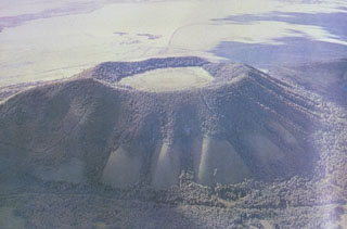
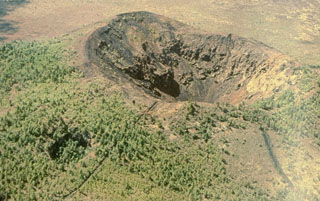 Laoheishan is one of two scoria cones that formed during the 1719-21 eruption of the Wudalianchi volcanic field and contains a 350-m-wide, 145-m-deep summit crater. A smaller vegetated crater on the NE flank can be seen to the lower left. Laoheishan formed a large portion of an extensive lava field that surrounds it and Huoshaoshan, the other scoria cone that formed during the eruption.
Photo courtesy of Jim Whitford-Stark, Sul Ross State University, Texas (published in Feng et al., 1979).
 Recent lava flows surround the Laoheishan scoria cone, one of which formed during 1719-21. Four radial fissures, two of which are seen in this view from the north, were the source of most of the 1719-21 Shilong lava flows, which cover a 65 km2 area surrounding Laoheishan and the Huoshaoshan scoria cone to the NE. The dominantly pahoehoe lava flows, many of which were tube-fed, blocked local drainages and formed several small lakes at the eastern and northern margins of the lava field.
Photo courtesy of Jim Whitford-Stark, Sul Ross State University, Texas (published in Feng et al., 1979).
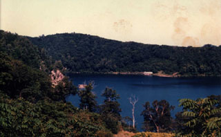
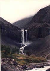
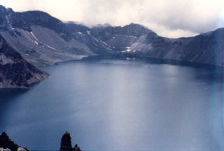 Lake Tianchi occupies the 5-km-wide, 850-m-deep summit caldera of Changbaishan, which straddles the China/Korea border. The volcano is also known as Baitoushan and by the Korean names of Baegdu or P'aektu-san. This view looks from the northern rim on the Chinese side towards the SE caldera wall on the Korean side. One of the world's largest known Holocene explosive eruptions took place from Changbaishan about 1000 CE, depositing tephra as far away as northern Japan.
Photo by Xiang Liu, 1983 (Changchun University).
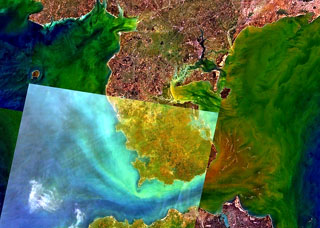
 The Leizhou Bandao volcanic field covers much of the southern part of the Leizhou Peninsula. The field contains many scoria cones, with some in the area shown in this December 2020 Planet Labs satellite image monthly mosaic (N is at the top; this image is approximately 23 km across). The field is the northern portion of the Qionglei volcano group.
Satellite image courtesy of Planet Labs Inc., 2020 (https://www.planet.com/).
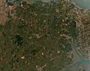
 The Leizhou Bandao volcanic field covers much of the southern (orange-brown colored) part of the Leizhou Peninsula, across the Qiongzhou strait north of Hainan Dao Island (bottom). Leizhou Bandao is the northern part of the Qionglei volcano group, a 7300 km2 basaltic-to-basanitic plateau that covers the southern Leizhou (Liuchow) Peninsula and extends across a broad area of northern Hainan Dao. Another area of Pleistocene-Holocene volcanism lies at the greenish area at the northern end of the peninsula, west of Zhanjiang City.
 NASA Landsat 7 image (worldwind.arc.nasa.gov)
 The Pleistocene Nangelaqiushan scoria cone contains a 500-m-wide flat-bottomed crater, is one of many cones forming the Wudalianchi volcanic field in Manchuria, NE China. The cones show a preferred alignment along three parallel NE-SW trends. The Wudalianchi volcanic field was named for five scenic lakes dammed by lava flows during a 1719-21 eruption, which formed two new scoria cones and produced a 65 km2 lava field.
Photo courtesy of Jim Whitford-Stark, Sul Ross State University, Texas (published in Feng et al., 1979).
 Sanjiaolongwan is a 1-km-wide early Pleistocene maar of the Longgang volcanic field. This massive volcanic field covers 1,700 km2 in the Jilin Province of NE China, west of Changbaishan volcano, and contains lava flows, more than 150 Quaternary scoria cones, and tuff rings.
 Photo by Xiang Liu, 1983 (Changchun University).
 Water draining from Tianchi lake plunges over a mid-Pleistocene trachytic lava flow near the caldera rim on the upper N flank of Changbaishan (Baitoushan) volcano.
Photo by Xiang Lui, 1983 (Changchun University).
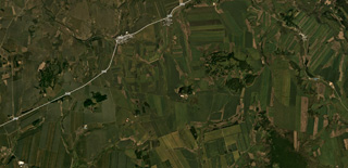
 Several cones and craters of the Honggeertu volcanic field in the Nei Mongol Province are shown across this August 2019 Planet Labs satellite image monthly mosaic (N is at the top; this image is approximately 11 km across). The cones are across a NE-SW trend and several have summit craters up to 200 m in diameter.
Satellite image courtesy of Planet Labs Inc., 2019 (https://www.planet.com/).
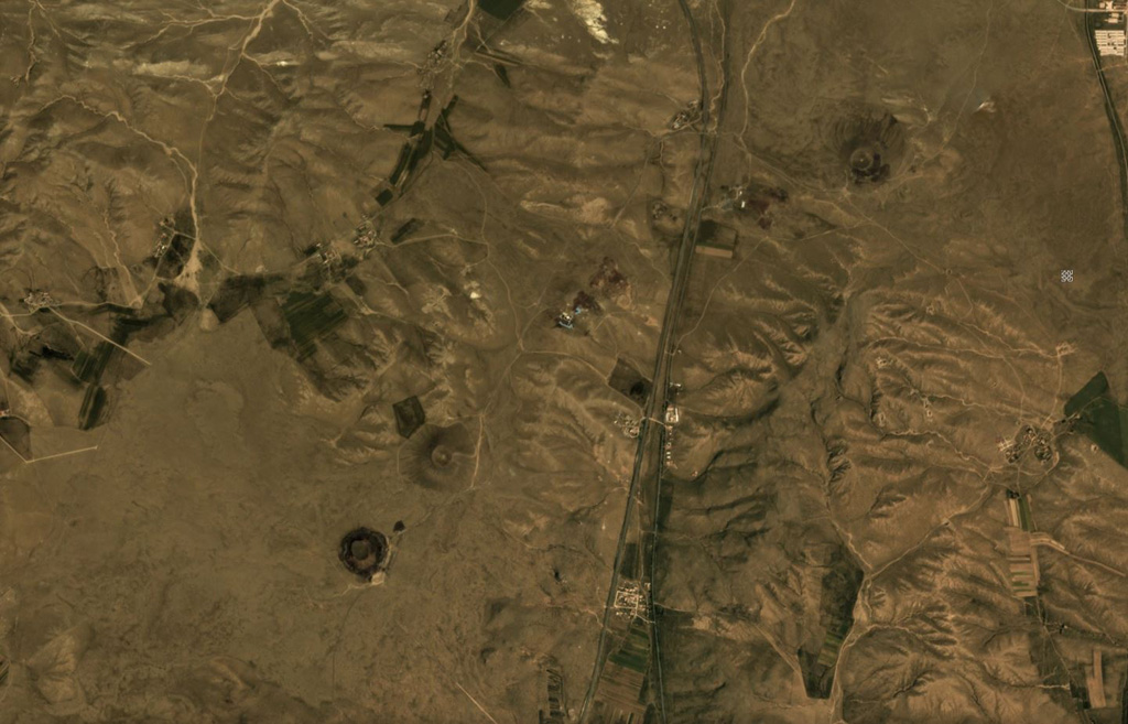
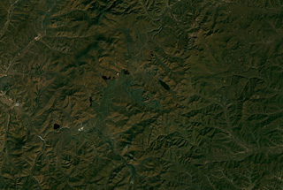 The Arxan-Chaihe volcanic field covers around 2,000 km2 with at least 47 identified vents, some of which can be seen in a NE-SW trend through the center of this September 2019 Planet Labs satellite image monthly mosaic (N is at the top; this image is approximately 69 km across). As well as eruptions producing spatter cones and lava flows, there are phreatomagmatic vents and fissure-controlled vents.
Satellite image courtesy of Planet Labs Inc., 2018 (https://www.planet.com/).
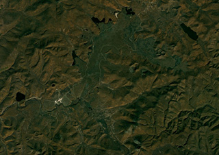 A portion of the Arxan-Chaihe volcanic field spanning approximately 32 km across is shown in this September 2018 Planet Labs satellite image monthly mosaic (N is at the top; this image is approximately 32 km across). There is a NE-SW trend of scoria cones, craters, and maars across the image, including Aershan just north of Tianchizhen town (in the western side of the image), the smaller Dichi lake to the E, the larger Shihaopendi complex crater near the center of this image, and Yanshan and Gaoshan NE of there.
Satellite image courtesy of Planet Labs Inc., 2018 (https://www.planet.com/).
 Several cones of the Keluo Group are shown in this September 2019 Planet Labs satellite image monthly mosaic (N is at the top; this image is approximately 22 km across). The volcanic field is located in NE China, and is NW of the Wudalianchi volcanic field.
Satellite image courtesy of Planet Labs Inc., 2018 (https://www.planet.com/).
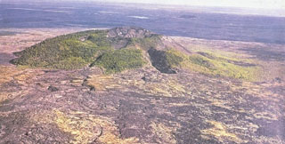
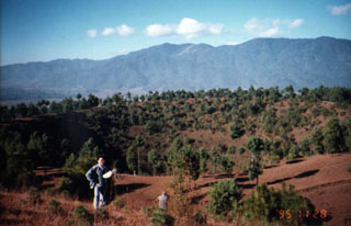 A geologist stands at the rim of a crater in the Tengchong Volcanic Field, with Ailuo Mountain in the background to the W. The youngest eruptions from the Tengchong field, which surrounds the city of Tengchong, produced olivine basalts and basaltic andesites.
Photo by Liu Xiang, 1995 (Changchun University).
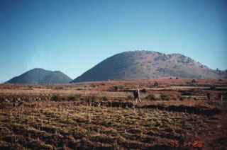 Two of the many scoria cones of the Tengchong Volcanic Field rise above cultivated lands in southern China near the border of Myanmar. Volcanism in this 600 km2 volcanic field took place during five periods ranging from the early Pliocene to the late Holocene. An explosive eruption took place at the northern cone of Dayingshan in 1609. The area is the site of active geothermal fields.
Photo by Liu Xiang, 1995 (Changchun University).
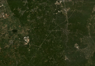 The Hainan Volcanic Field in China contains around 58 identified cones, craters, and maars, some of which are visible in this November 2020 Planet Labs satellite image monthly mosaic (N is at the top; this image is approximately 14 km across). The Leihuling cone with a roughly 300-m-diameter crater is to the SW of the S21 Zhongxian expressway that runs through the center of the image.
Satellite image courtesy of Planet Labs Inc., 2020 (https://www.planet.com/).
 The Kunlun Volcanic Group in NW Tibet contains at least 70 cones. The cone just above the center of this image is the Ashi cone, which erupted lava across 33 km2 in 1951. Other cones are visible in the Ashikule Basin, the relatively flat area across this image.
Satellite image courtesy of Planet Labs Inc., 2019 (https://www.planet.com/).
This is a compilation of China volcano information sources, such as official monitoring or other government agencies.
| Volcano Observatories |
|---|
| National Volcano Monitoring Network of China |
| Additional Information Sources |
|---|
| The Chinese Academy of Sciences (CAS) |
| Volcanic Ash Advisory Center |
|---|
| Tokyo Volcanic Ash Advisory Center (VAAC) |
| - Tokyo VAAC Notices and Archive |