Yemen Volcanoes
Yemen has 10 Holocene volcanoes. Note that as a scientific organization we provide these listings for informational purposes only, with no international legal or policy implications. Volcanoes will be included on this list if they are within the boundaries of a country, on a shared boundary or area, in a remote territory, or within a maritime Exclusive Economic Zone. Bolded volcanoes have erupted within the past 20 years. Suggestions and data updates are always welcome ().
| Volcano Name | Last Eruption | Volcanic Region | Primary Landform |
|---|---|---|---|
| Harra of Arhab | 500 CE | Southwest Arabia Volcanic Province | Cluster |
| Balhaf-Bir Ali Volcanic Field | Unknown - Evidence Credible | Southwest Arabia Volcanic Province | Cluster |
| Bir Borhut | Unknown - Evidence Uncertain | Southwest Arabia Volcanic Province | Cluster |
| Harras of Dhamar | Unknown - Eruption Observed | Southwest Arabia Volcanic Province | Cluster |
| Hanish | Unknown - Evidence Credible | Red Sea Rift Volcanic Province | Shield |
| Jabal Haylan | 1200 BCE | Southwest Arabia Volcanic Province | Cluster |
| Harra Es- Sawad | 1253 CE | Southwest Arabia Volcanic Province | Cluster |
| Jebel at Tair | 2008 CE | Red Sea Rift Volcanic Province | Composite |
| Zubair Group | 2013 CE | Red Sea Rift Volcanic Province | Shield |
| Zukur | Unknown - Evidence Credible | Red Sea Rift Volcanic Province | Shield |
Chronological listing of known Holocene eruptions (confirmed or uncertain) from volcanoes in Yemen. Bolded eruptions indicate continuing activity.
| Volcano Name | Start Date | Stop Date | Certainty | VEI | Evidence |
|---|---|---|---|---|---|
| Zubair Group | 2013 Sep 28 | 2013 Nov 20 | Confirmed | 2 | Observations: Reported |
| Zubair Group | 2011 Dec 18 | 2012 Jan 12 | Confirmed | 2 | Observations: Reported |
| Jebel at Tair | 2007 Sep 30 | 2008 Jun 16 (?) ± 15 days | Confirmed | 3 | Observations: Reported |
| Harras of Dhamar | [1937] | [Unknown] | Uncertain | ||
| Jebel at Tair | 1883 | Unknown | Confirmed | 2 | Observations: Reported |
| Jebel at Tair | 1863 | Unknown | Confirmed | 2 | Observations: Reported |
| Zubair Group | [1846 Aug 14] | [Unknown] | Uncertain | ||
| Jebel at Tair | 1833 Dec 31 ± 365 days | Unknown | Confirmed | 2 | Observations: Reported |
| Zubair Group | 1824 | Unknown | Confirmed | 2 | Observations: Reported |
| Jebel at Tair | 1750 ± 50 years | Unknown | Confirmed | 2 | Observations: Reported |
| Harra Es- Sawad | 1253 | Unknown | Confirmed | 3 | Observations: Reported |
| Bir Borhut | [0950 (?)] | [Unknown] | Uncertain | ||
| Harra of Arhab | 0500 ± 100 years | Unknown | Confirmed | 0 | Observations: Reported |
| Harra of Arhab | 0200 (in or after) | Unknown | Confirmed | 2 | Correlation: Anthropology |
| Jabal Haylan | 1200 BCE (in or after) | Unknown | Confirmed | 0 | Correlation: Anthropology |
Yemen has 0 Pleistocene volcanoes. Note that as a scientific organization we provide these listings for informational purposes only, with no international legal or policy implications. Volcanoes will be included on this list if they are within the boundaries of a country, on a shared boundary or area, in a remote territory, or within a maritime Exclusive Economic Zone. Suggestions and data updates are always welcome ().
There are 15 photos available for volcanoes in Yemen.
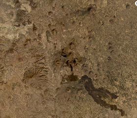
 The Bir Borhut volcanic field in southern Yemen is shown in this December 2019 Planet Labs satellite image monthly mosaic (N is at the top; this image is approximately 26 km across). The At-Tabâb maar is SE of the lava field along the coastline next to a tuff ring. Cones have formed throughout the darker lava field.
Satellite image courtesy of Planet Labs Inc., 2019 (https://www.planet.com/).
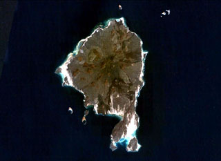 Zukur (Zugar), the northernmost large island of the Zukur-Hanish island group in the southern Red Sea, is seen in this NASA Landsat image (with north to the top). Numerous young basaltic spatter cones were the source of pahoehoe lava flows. Products of phreatic eruptions at Zukur form small islands, such as Shark and Near Islands off the SW coast of Zukur. Vents on Zukur are aligned along a NE-SW trend, as seen on the peninsula at the southern tip of the island.
NASA Landsat 7 image (worldwind.arc.nasa.gov)
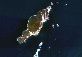
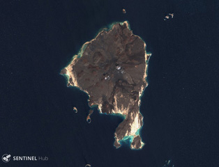 Zukur is the northern and larger island within the Zukur-Hanish island group in the southern Red Sea, seen here in this 3 December 2019 Sentinel-2 satellite image (N is at the top). Scoria cones are visible in this image, along with darker lava flows in the N, NE, and S. The island is approximately 12 km in the E-W direction.
Satellite image courtesy of Copernicus Sentinel Data, 2019.
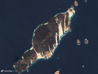 The 18-km-long island of Hanish is seen in this 3 December 2019 Sentinel-2 satellite image (N is at the top). Scoria cones and tuff cones are visible along with lava flows that have reached the coasts on all sides of the island. This island has formed during explosive phreatic eruptions with magma-water interactions, and magmatic eruptions producing lava flows. This island is approximately 18 km in the NE-SW direction.
Satellite image courtesy of Copernicus Sentinel Data, 2019.
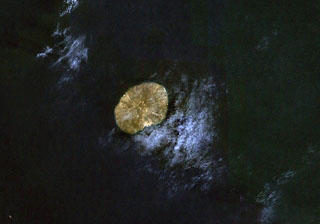 The small, oval-shaped island in this NASA Landsat image (with north to the top) is Jebel at Tair. This 3-km-wide island is the emergent summit of a stratovolcano that rises from a 1,200 m depth in the south-central Red Sea. Youthful lava flows from a steep-sided central vent, Jebel Duchan, cover most of the island. The island is of Holocene age, and explosive eruptions were reported in the 18th and 19th centuries.
NASA Landsat 7 image (worldwind.arc.nasa.gov)
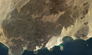
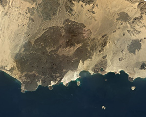
 The 500 km2 Balhaf-Bir Ali Volcanic Field in south Yemen is shown in this February 2020 Planet Labs satellite image monthly mosaic (N is at the top; this image is approximately 45 km across). The field largely comprises lava flows and spatter and scoria cones, tuff rings, and the At-Tabâb maar with a crater lake along the shoreline. The Balhaf cone is the darker area to the S with the cross-roads just below it, and the darker area in the northern part of the field is the Jabal Ba Masha’ib.
Satellite image courtesy of Planet Labs Inc., 2020 (https://www.planet.com/).
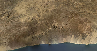
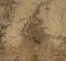
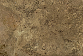 The Harras of Dhamar volcanic field is shown in this December 2019 Planet Labs satellite image monthly mosaic (N is at the top; this image is approximately 51 km across). The field contains many scoria cones and associated lava flows, with some older obsidian lava flows. Many of the cones have amphitheater-shaped craters due to flank collapse or rafting.
Satellite image courtesy of Planet Labs Inc., 2019 (https://www.planet.com/).
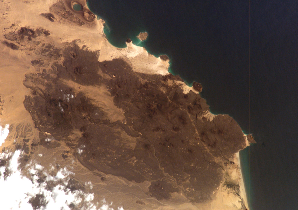
 The Bir Borhut volcanic field in southern Yemen is shown in this December 2019 Planet Labs satellite image monthly mosaic (N is at the top; this image is approximately 104 km across). The field contains scoria cones, tuff rings and cones, mars, and lava flows. The At-Tabâb maar is SE of the lava field along the coastline.
Satellite image courtesy of Planet Labs Inc., 2019 (https://www.planet.com/).
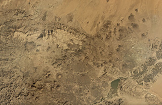
 The Harra es-Sawâd (or Shuqra) volcanic field covers an area nearly 100 km across the Southern Yemen along the Gulf of Aden, shown in this December 2019 Planet Labs satellite image monthly mosaic (N is at the top; this image is approximately 104 km across). There are around 100 identified cones, and a lava field that covers an area of 40 x 95 km.
Satellite image courtesy of Planet Labs Inc., 2019 (https://www.planet.com/).
 The 1,500 km2 Harra of Arhab volcanic field is shown down the center of this December 2019 Planet Labs satellite image monthly mosaic (N is at the top; this image is approximately 76 km across). Approximately 60 cones are throughout the field; recent, darker lava flows are visible near the center of this image.
Satellite image courtesy of Planet Labs Inc., 2019 (https://www.planet.com/).
 The 20-km-long island of Hanish is seen in this composite NASA Landsat image (with north to the top). Alignment of vents along a prominent NE-SW trend gives the island its elongated shape. Short lava flows reached the coast on both sides of the island, including a very youthful flow prominent on the NW coast. Initial phreatic eruptions were followed by the formation of basaltic tuff and spatter cones that produced fluid lava flows. Suyul Hanish Island lies at the bottom center, and other offshore island lie along the regional NE-SW trend.
NASA Landsat 7 image (worldwind.arc.nasa.gov)
 Part of the 1,500 km2 Harra of Arhab volcanic field is shown in this December 2019 Planet Labs satellite image monthly mosaic (N is at the top; this image is approximately 20 km across). Lava flows from recent eruptions of Kaulet Hattab and Jabal Zebib cones are darker, with the later producing the nearly 9-km-long lava flow to the south. Many of the scoria cones underwent flank collapse or rafting during eruptions and have horseshoe-shaped craters as a result.
Satellite image courtesy of Planet Labs Inc., 2019 (https://www.planet.com/).
 The Jabal Haylan volcanic field comprises scoria cones and tuff rings and associated lava flows across a 75-km-long area, with a portion of the field shown in this Planet Labs satellite image monthly mosaic (N is at the top; this image is approximately 52 km across). The chain crosses a NW-SE-trending fault that with visible offset in this image. Many of the cones and rings have experienced flank collapse, rafting, or erosion, leaving amphitheater-shaped craters. Some tuff rings appear to have lava domes that have formed within the crater.
Satellite image courtesy of Planet Labs Inc., 2019 (https://www.planet.com/).
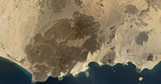
 The Harra of Bal Haf volcanic field fills much of this NASA International Space Station image taken along the Gulf of Aden in southern Yemen (N to the bottom left). Dark-colored lava fields cover much of the volcanic field and create an irregular shoreline. One basaltic flow may be of historical age. Two large tuff cones are visible along the coast at the upper left, one of which is lake filled.
NASA International Space Station image ISS006-E-5153, 2002 (http://eol.jsc.nasa.gov/).
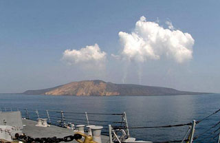 Plumes are visible from the eruption of Jebel at Tair rise above the volcano as seen from the U.S. Navy vessel USS Bainbridge on 2 October 2007, two days after the start of the eruption. The small, 3-km-wide island rises from a 1,200 m depth in the south-central Red Sea. Jebel at Tair (one of many variations of the name, including Djebel Teyr, Jabal at Tayr, and Jibbel Tir) is the northernmost known Holocene volcano in the Red Sea. Historical eruptions date back to the 18th century.
Photo by Vincent J. Street, 2007 (U.S. Navy).
This is a compilation of Yemen volcano information sources, such as official monitoring or other government agencies.
| Volcanic Ash Advisory Center |
|---|
| Toulouse Volcanic Ash Advisory Center (VAAC) Notices and Archive |