Theme Collections | Landsat Imagery
Theme collections are galleries not specifically related to volcanic hazards, processes, research, types, or features. This includes subjects such as different satellite platforms, astronaut photos from the Space Shuttle, specific photographers, or other special collections.
Image Gallery for Landsat Imagery
Since 1972, the joint NASA / U.S. Geological Survey Landsat series of Earth Observation satellites have continuously acquired images of the Earth’s land surface, providing uninterrupted data to help land managers and policymakers make informed decisions about natural resources and the environment. The satellites have collected more than 8 million scenes of the planet, and have been freely available to the public since 2008. The Global Volcanism Program has obtained Landsat imagery of many volcanoes, mainly in cases where no other photos are present in the image collection. There are 157 images available.
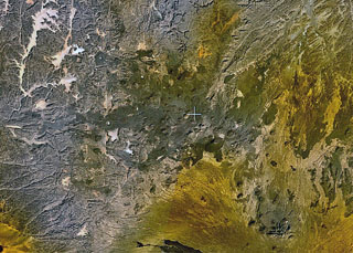
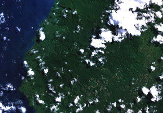
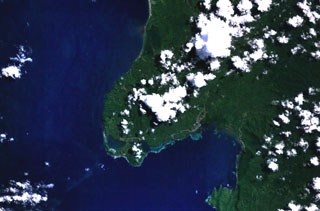
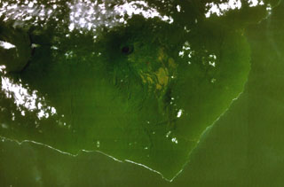
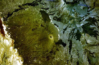
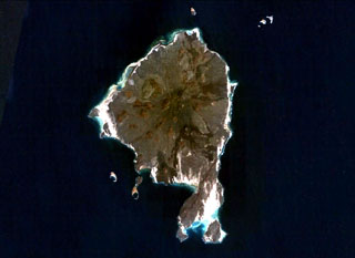
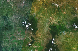
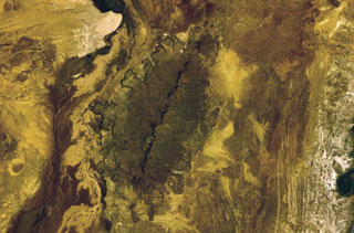
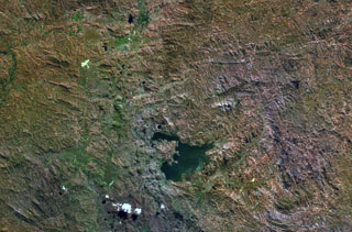
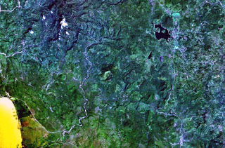
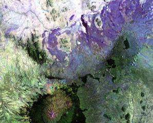
 The lower of the two small peninsulas at the lower right is Punta Púlpito, a Pleistocene obsidian dome dated at about 0.5 million years. The dome juts into the Gulf of California (right) in this NASA Landsat image with north to the top and lies east of the southern end of Bahía Concepción (upper left). The Saquicismunde geothermal area lies near the dome, and the larger Los Volcanes geothermal area, which lies along the coast about 5 km south of Punta el Púlpito, contains 18 fumaroles.
NASA Landsat 7 image (worldwind.arc.nasa.gov)
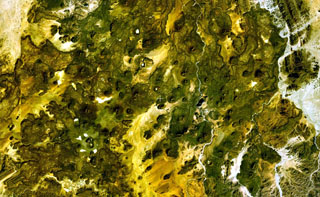
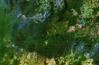
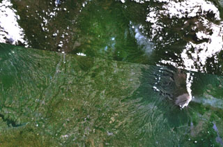
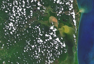
 The Leizhou Bandao volcanic field covers much of the southern (orange-brown colored) part of the Leizhou Peninsula, across the Qiongzhou strait north of Hainan Dao Island (bottom). Leizhou Bandao is the northern part of the Qionglei volcano group, a 7300 km2 basaltic-to-basanitic plateau that covers the southern Leizhou (Liuchow) Peninsula and extends across a broad area of northern Hainan Dao. Another area of Pleistocene-Holocene volcanism lies at the greenish area at the northern end of the peninsula, west of Zhanjiang City.
 NASA Landsat 7 image (worldwind.arc.nasa.gov)
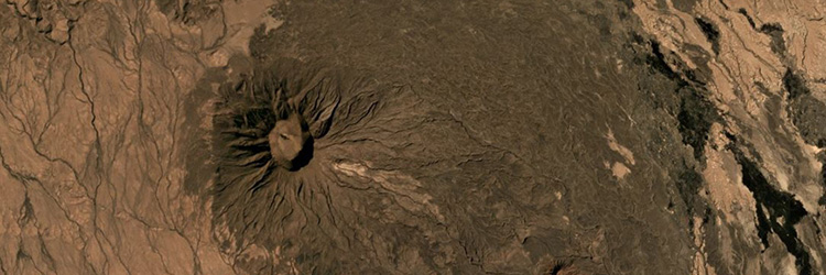
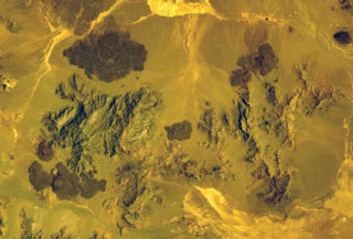
 Small scoria cones and lava flows of the Tarso Tôh volcanic field can be seen in the large darker-brown area at the center of this NASA Landsat image. This Pleistocene-to-Holocene volcanic field in the Tibesti Range of Chad covers a 30 x 80 km area and contains 150 scoria cones and two maars. Basaltic lava flows at Tarso Tôh were erupted over a basement of Precambrian schists and Paleozoic sandstones. The black lava flows at the very bottom-center are distal lava flows from Tarso Toussidé volcano.
NASA Landsat 7 image (worldwind.arc.nasa.gov)
 This NASA Landsat false-color image shows small scoria cones and lava flows of the Manzaz volcanic field in the Hoggar (Ahaggar) volcanic district of Algeria. The volcanic field covers an area of 1,500 km2, overlying Precambrian metamorphic and plutonic rocks of the Tuareg shield. The youngest volcanoes rest on Neolithic terraces and are of Holocene age.
NASA Landsat 7 image (worldwind.arc.nasa.gov)
 The bluish-gray area at the center of this NASA Landsat image and areas at the upper right are part of the massive Atakor volcanic field. These volcanics cover an area of 2,150 km2 and includes lava domes and abundant basaltic scoria cones and lava flows. Historical pottery has been found within lava flows in the Tahifet area, and oral traditions of the Tuareg people also suggest that eruptions were witnessed. The prominent lineament at the far left is the Inter-terrane Pan-African shear zone.
NASA Landsat 7 image (worldwind.arc.nasa.gov)
 The dark-green and bluish-gray areas extending across this NASA Landsat false-color image depict the elongated, E-W-trending Tahalra volcanic field, which covers an area of about 1,800 km2 in the Hoggar Province of southern Algeria. About 100 small basaltic cones formed during the Pliocene and Pleistocene, and the most recent activity during the late-Pleistocene and Holocene, produced about 20 maars and cones along the northern margin of the volcanic field.
NASA Landsat 7 image (worldwind.arc.nasa.gov)
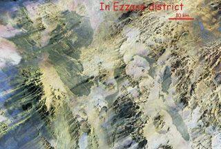 This NASA Landsat Thematic Mapper mosaic shows the In Ezzane volcanic field along the border region of Algeria and Niger. The In Ezzane volcanic field, with lava fields appearing blue-gray in this image, covers about 500 km2 at the eastern end of Hoggar (Ahaggar) volcanic province. This poorly known and isolated volcanic field erupted through basement rocks at the western end of the Saharan meta-craton.
NASA Landsat Thematic Mapper mosaic by Jean-Paul Liégeois (Africa Museum, Belgium).
 The 1,800 km2 Miocene and Quaternary Harrat al Birk volcanic field extends diagonally across the center of this NASA Landsat image along the Red Sea coast. Dark-colored areas are lava fields and yellowish areas mark scoria cones and deposits. Scoria cones occur throughout the field, and a few outlying cones lie E of the main lava field.
 NASA Landsat image, 2003 (USGS).
 The small grayish area at the center of this NASA Landsat image is a lava flow from the Silver Lake cinder cone. Lava flows from the cone dammed up drainages, forming two small black-colored lakes, Silver Lake and Arthur Lake. Another small dark-colored lake at the lower right, south of the two large elongated light-colored areas, was formed when lava flows from the Buckhorn Lake cinder cone blocked a stream valley.
NASA Landsat 7 image (worldwind.arc.nasa.gov)
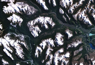
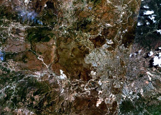
 The glacier-capped Nevado de Chachani volcanic complex lies immediately north of the city of Arequipa. The central part of the 6057-m-high complex contains multiple vents along an arcuate line. Pleistocene lava domes form the glacier-covered northern end of the complex in this NASA image. A prominent lava-flow complex at the bottom-center part of the image with fresh-looking flow levees was erupted from the 8-km-wide lava shield of Pampa de Palacio of late-Pleistocene to possibly Holocene age.
NASA Landsat 7 image (worldwind.arc.nasa.gov)
 The valley cutting diagonally across the center of this NASA Landsat image (with north to the top) is a tributary of the Río Murta (left) that is partly floored by basaltic lava flows. The Río Ibáñez cuts across the top of the image. The flows were emplaced, partly subglacially, in valleys carved by glaciers in granitic rocks of the North Patagonian Batholith in the southern Andes. The columnar-jointed lava flows of Pleistocene to perhaps Holocene age include pillow lavas, lava tubes, and subglacial and sublacustral deposits.
 NASA Landsat 7 image (worldwind.arc.nasa.gov)
 Forested volcanoes of the Sulu Range occupy the center of this NASA Landsat image (N is to the top) of west-central New Britain. This group of partially overlapping small volcanoes and lava domes off Bangula Bay reaches heights of about 600 m. Mount Karai, also known as Mount Ruckenberg, lies on the NE side of the geochemically diverse, basaltic-to-rhyolitic complex. Kaiamu maar forms the peninsula extending about 1 km into Bangula Bay at the NW side of the Sulu Range.
NASA Landsat7 image (worldwind.arc.nasa.gov)
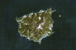
 The small dark-green area below the center of this NASA Landsat image of NW Sumatra (with north to the top) is Imun volcano. This cone of uncertain age lies south of the renowned large caldera containing Lake Toba (top).
NASA Landsat 7 image (worldwind.arc.nasa.gov)
 Two cinder cones with circular craters are located above the center of this NASA Landsat image of northern Halmahera Island (with north to the top). The cones lie between Galela Lake and Galela Bay (upper right), with the town of Galela on its shore. Tarakan Lamo (on the east side of the lake) and Tarakan Itji (to the NW of Tarakan Lamo) have well-formed summit craters 800 and 500 m in diameter and 160 and 125 m deep, respectively.
 NASA Landsat 7 image (worldwind.arc.nasa.gov)
 The twin caldera complex of Todoko-Ranu appears in this NASA Landsat image of western Halmahera Island (with north to the top). Todoko caldera (the circular feature just left of center) lies SW of nested calderas at Ranu, the northern of which contains a lake, faintly visible above the clouds above and to the right of the center of the image. No historical eruptions have been reported from the complex, but fumaroles and hot springs are present, and youthful-looking lava flows have reached the sea.
NASA Landsat 7 image (worldwind.arc.nasa.gov)
 The Jailolo volcanic complex (center) forms a roughly 10-km-long peninsula west of Jailolo Bay (bottom-right) in this NASA Landsat image (with north to the top). Jailolo stratovolcano in the center of the complex is flanked by small calderas to the west and SW. Kailupa cone forms the east side of the small island off the southern coast of the peninsula. Hot mudflows were reported from Jailolo volcano shortly prior to 1883, but no eruptions are known during historical time.
 NASA Landsat 7 image (worldwind.arc.nasa.gov)
 Clouds cap the top of the 5-km-wide island of Moti (left-center), also known as Motir. This island is located north of Makian (bottom-left) and south of Mare (top-left) in this NASA Landsat image. Moti lies along a N-S-trending chain of islands off the western coast of Halmahera Island (right). The truncated, conical island of Moti is surrounded by coral reefs, and contains a crater on its SSW side.
 NASA Landsat 7 image (worldwind.arc.nasa.gov)
 The small island of Mare (left-center) lies between Tidore (top-center) and Moti (bottom-center) volcanoes in this NASA Landsat image (with north to the top). Mare is one of a chain of volcanic islands off the western coast of Halmahera Island (right). The 2 x 3 km island is elongated in a NE-SW direction, and a large breached crater is located off the SW tip of the island.
 NASA Landsat 7 image (worldwind.arc.nasa.gov)
 Quaternary basaltic lava flows are visible in this NASA Landsat image (N to the top) of SE Iran. The lava flows are part of unnamed volcanic field between Taftan and Bazman volcanoes. Preserved cones and craters were erupted among a group of Cretaceous limestone peaks.
NASA Landsat 7 image (worldwind.arc.nasa.gov)
 The Segererua and Rusarus Plateaus, right of the center of this NASA Landsat image (with north to the top) contain a large number of late-Pleistocene to Holocene basaltic cones, lava flows, and maars. The Milgris River cuts across the top of the image, and Merille River lies just below the center of the image. Other vents lie east of the Kauro River (bottom center). Plateau basalts are also visible at the right-center.
NASA Landsat 7 image (worldwind.arc.nasa.gov)
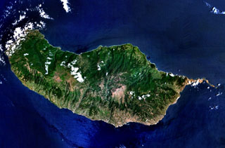 The 90-km-long island of Madeira is seen in this NASA Landsat image (with north to the top). Construction of the volcano along E-W-trending rift zones was followed by a period of extensive erosion and possible edifice collapse. The capital city of Funchal lies along the SE coast, east of a large caldera that extends to the southern coast. Late-stage eruptions were scattered throughout the island, although the youngest activity took place along the west-central crest of the island, on the Paul da Serra plateau near the cloud near the center of this image.
 NASA Landsat 7 image (worldwind.arc.nasa.gov)
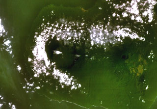 A broad caldera, partially surrounded by clouds left of center, cuts the summit of San Carlos volcano. This a basaltic shield volcano forms the toe on the SW side of boot-shaped Bioko (Fernando Poo) Island. This NASA Landsat view (with north to the top) also shows neighboring San Joaquin volcano, with its smaller lake-filled caldera, at the right.
NASA Landsat 7 image (worldwind.arc.nasa.gov)
 A dark-colored lake partially fills a small caldera (top-center) occupying the summit of San Joaquin volcano in this NASA Landsat view with north to the top. This basaltic shield volcano, also known as Pico Biao, lies on the SE side of Bioko (Fernando Poo) Island in the Gulf of Guinea. Part of the broad summit caldera of neighboring San Carlos volcano can be seen at the left.
NASA Landsat 7 image (worldwind.arc.nasa.gov)
 Yangudi volcano contains an elliptical summit caldera that lies near the center of this NASA Landsat image (with north to the top). Very recent scoria cones and lava flows form the dark-colored areas south and north of Yangudi along graben faults. Numerous NNE-SSW-trending faults parallel the Ethiopian Rift.
NASA Landsat 7 image (worldwind.arc.nasa.gov)
 A caldera 4 x 5 km wide cuts the summit of Adwa volcano above the center of this NASA Landsat image with N to the top. This prominent volcano (also known as Aabida, Amoissa, or Dabita) is in the southern Afar area immediately E of Ayelu volcano, which lies above and to the left of the westernmost flank lava flow. These prominent young basaltic lava flows were erupted from vents on the W, E, and S flanks of Adwa volcano and overlap a sedimentary plain to the SE.
NASA Landsat 7 image (worldwind.arc.nasa.gov)
 The dark-colored area cutting across the center of this NASA Landsat image (with north to the top) is a series of basaltic lava flows erupted from fissure vents at Hertali. These flows lie at the S end of the Awash Plain, about 50 km NNE of Dofen volcano. The youthful morphology of the flows suggests a late Pleistocene to Holocene age. Numerous NNE-SSW-trending fissures of the Ethiopian Rift are visible.
NASA Landsat 7 image (worldwind.arc.nasa.gov)
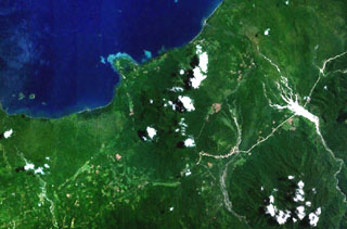
 The densely forested Tepi basaltic shield volcano lies about 300 km west of the Ethiopian Rift in southern Ethiopia. A small crater near the center of this NASA Landsat image (with north to the top) is one of many features on this broad volcano. Lava flows have traveled down pre-existing valleys, and there are active hot springs. The smoke plume at the right is from a vegetation fire.
NASA Landsat 7 image (worldwind.arc.nasa.gov)
 The prominent peak near the center of this NASA Landsat image (with north to the top) is Ale Bagu, also known as Ummuna. This elongated stratovolcano is the highest of the Erta Ale Range volcanoes. The main crater is the 750 x 450 m feature prominent in this image. The light-colored Roram Plain lies at the lower left, and lava flows from Hayli Gubbi volcano are visible at the right.
NASA Landsat 7 image (worldwind.arc.nasa.gov)
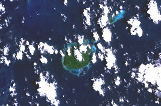
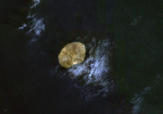 The small, oval-shaped island in this NASA Landsat image (with north to the top) is Jebel at Tair. This 3-km-wide island is the emergent summit of a stratovolcano that rises from a 1,200 m depth in the south-central Red Sea. Youthful lava flows from a steep-sided central vent, Jebel Duchan, cover most of the island. The island is of Holocene age, and explosive eruptions were reported in the 18th and 19th centuries.
NASA Landsat 7 image (worldwind.arc.nasa.gov)
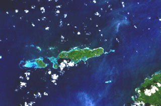
 The 20-km-long island of Hanish is seen in this composite NASA Landsat image (with north to the top). Alignment of vents along a prominent NE-SW trend gives the island its elongated shape. Short lava flows reached the coast on both sides of the island, including a very youthful flow prominent on the NW coast. Initial phreatic eruptions were followed by the formation of basaltic tuff and spatter cones that produced fluid lava flows. Suyul Hanish Island lies at the bottom center, and other offshore island lie along the regional NE-SW trend.
NASA Landsat 7 image (worldwind.arc.nasa.gov)
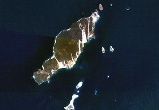
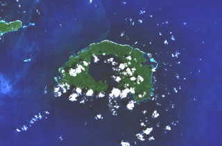
 Zukur (Zugar), the northernmost large island of the Zukur-Hanish island group in the southern Red Sea, is seen in this NASA Landsat image (with north to the top). Numerous young basaltic spatter cones were the source of pahoehoe lava flows. Products of phreatic eruptions at Zukur form small islands, such as Shark and Near Islands off the SW coast of Zukur. Vents on Zukur are aligned along a NE-SW trend, as seen on the peninsula at the southern tip of the island.
NASA Landsat 7 image (worldwind.arc.nasa.gov)
 The small, circular light-green area just left of the river in this NASA Landsat image (with north to the top) is Musuan volcano. This andesitic-to-dacitic lava dome and tuff cone, also known as Calayo, rises more than 600 m above flat farmland in the province of Bukidnon in central Mindanao Island in the southern Philippines.
NASA Landsat 7 image (worldwind.arc.nasa.gov)
 The broad depression above the center of this composite NASA Landsat image of Papua New Guinea (with north to the top) is Crater Mountain. Although this arcuate chain of peaks 3000 m or more in height is extensively eroded, steep-sided valleys to the north and east are floored by lava flows and other young volcanic features. The Purari River cuts across the bottom of the image, and the smaller Pio River parallels it to the north, south of Crater Mountain.
 NASA Landsat 7 image (worldwind.arc.nasa.gov)
 Kendang volcano is the partially cloud-covered dark green area at the right-center of this composite NASA Landsat image of central Java (with north to the top). The stratovolcano contains major geothermal areas. The latest eruptions produced a very young rhyolitic lava dome and obsidian lava flows. Kendang lies immediately north of Papandayan volcano (the cloud-covered area at the bottom right-center) and SE of Wayang-Windu volcano (the elongated dark-green area at the upper left-center).
NASA Landsat 7 image (worldwind.arc.nasa.gov)
 The forested Gunung Malabar stratovolcano is the dark-green, partially cloud-covered area (left-center) in this composite NASA Landsat image of western Java (with north to the top). Malabar lies immediately south of the major city of Bandung, partially visible at the top left. The broad, 2343-m-high basaltic-andesite Malabar volcano rises north of Wayang-Windu lava dome (the elongated dark-green area), west of Kawah Kamojang and Guntur volcanoes (right-center), and NW of Kendang volcano (bottom right-center).
NASA Landsat 7 image (worldwind.arc.nasa.gov)
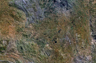
 The Malang Plain, in the center of this NASA Landsat composite image (with north to the top) of eastern Java contains a group of nine ash cones, maars, and volcanic plugs. These volcanic centers lie in a broad valley between the Tengger caldera (upper right), Semeru volcano (lower right), and Kawi-Butak volcano, in the clouds at the upper left. Some of these may be partly parasitic to Tengger Caldera, although others have no clear connection to any specific eruption center and are situated on a distinct N-S zone of tectonic weakness.
 NASA Landsat 7 image (worldwind.arc.nasa.gov)
 Bukit Amasing (Amasing Hill) is the largest and NW-most of a group of three small andesitic volcanoes located just above the center of this NASA Landsat image (with north to the top). These volcanoes lie along a NW-SE line in central Bacan Island. Two smaller volcanoes, Cakasuanggi and Dua Saudara, were constructed to the SE, north of the metamorphic complex of the Sibela Mountains, the cloud-covered massif at the bottom center. Other young volcanoes of the Bibinoi group lie at the SE peninsula of Bacan Island (lower right).
NASA Landsat 7 image (worldwind.arc.nasa.gov)
 Gunung Tigalalu is located at the northern end of elongated Kayoa Island (center), which straddles the equator and is the southernmost of a chain of small volcanic islands off the western coast of Halmahera Island (out of view to the right). North is to the top in this NASA Landsat image. Tigalalu forms a N-S-trending volcanic ridge at the north end of the island, part of which is flanked by coral limestones.
 NASA Landsat 7 image (worldwind.arc.nasa.gov)
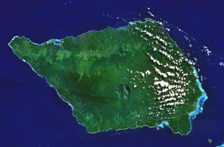 Savai'i, the largest and highest of the Samoan islands, is shown in this NASA Landsat image (N is to the top). The 75-km-long island consists of a shield volcano constructed along a WNW-ESE-trending rift zone that splits into two rifts on the E side of the island. The broad crest contains numerous scoria cones, some of which were the source of historical eruptions that produced lava flows that reached the sea.
NASA Landsat 7 image (worldwind.arc.nasa.gov)
 The peninsula in the center of this NASA Landsat image (with north to the top) forms the SE tip of Bacan Island, west of the southern tip of Halmahera. Bukit Bibinoi (Bibinoi Hill) is the largest and SE-most of a group of three andesitic Holocene stratovolcanoes located along a NW-SE line on the peninsula. The smaller Songsu and Lansa volcanoes straddle a narrow isthmus (left center) separating the peninsula from the Sibela Mountains metamorphic complex to the NW.
 NASA Landsat 7 image (worldwind.arc.nasa.gov)
 Two circular craters lie along an E-W trend on the summit ridge of Tendürek Dagi shield volcano in this NASA Landsat composite image (with north to the top). The higher western cone is capped by a steep-walled crater, and the flatter eastern crater contains a lake. Late-stage activity formed trachytic lava domes and flows as well as basaltic pahoehoe flows that extend 10-20 km N and S.
NASA Landsat 7 image (worldwind.arc.nasa.gov)
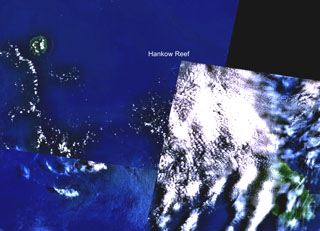 Hankow Reef is partially truncated just below the upper left corner of the cloud-covered portion of this NASA Landsat composite image (with north to the top). The possible existence of a now-submerged volcano named Yomba off the coast of Papua New Guinea is inferred from oral tradition and is considered to likely be at the location of Hankow Reef. The reef lies SE of Bagabag Island (upper left) and NW of Long Island, the larger island at the lower right. Crown Island lies beneath the cloud cover between Long Island and Hankow Reef.
NASA Landsat 7 image (worldwind.arc.nasa.gov)
 Three lake-filled maars occupy the center of this NASA Landsat composite image (with N to the top). Active hot springs and fumaroles are located in this area.
NASA Landsat 7 image (worldwind.arc.nasa.gov)
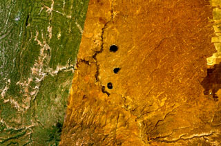
 A group of scoria cones and basaltic lava flows at Tosa Sucha lies near the northern shore of Lake Chamo, the greenish lake at the bottom-center portion of this NASA Landsat image (with north to the top). The cones occupy a faulted area between Lake Chamo and the southern end of yellowish Lake Abaya. Some cones form islands in Lake Chamo.
 NASA Landsat 7 image (worldwind.arc.nasa.gov)
 Cuernos del Diablo is a small 1862-m-high partially glacially eroded basaltic stratovolcano. The volcano (not clearly seen in this NASA Landsat image with north to the top) is located about 30 km east of the elongated N-S trending Reloncavi fjord (far left), near the headwaters of the river extending diagonally to the center of the image from the lower left. Numerous satellitic pyroclastic cones and associated basaltic lava flows were formed during the Holocene, some which may have historical in age, though eruptions were not recorded.
NASA Landsat 7 image (worldwind.arc.nasa.gov)
 The Dawson Straits, seen in this NASA Landsat image, is located between eastern Fergusson Island (upper left) and northwestern Normanby Island (lower left) in the D'Entrecasteaux island group. The area contains a volcanic field with several young volcanic centers that erupted rhyolitic obsidian flows. Mount Oiau is located on the narrow peninsula (left center) forming the southernmost point on Fergusson Island. A large crater is visible on Dobu Island, southeast of Oiau. Young volcanic rocks are also found on Sanaroa Island (upper right).
NASA Landsat 7 image (worldwind.arc.nasa.gov)
 The circular, 5.5-km-wide island of Baluan (center) in the Admiralty Islands lies SE of Manus Island and across the St. Andrew Strait from Lou and Tuluman islands (out of view to the N). This Pleistocene volcano has a large summit crater and several flank vents. In contrast to its neighboring islands to the N, Baluan has erupted basaltic rather than rhyolitic rocks. The Pam Islands to the NE are visible at the upper right in this NASA Landsat image (N is to the top).
NASA Landsat 7 image (worldwind.arc.nasa.gov)
 A cluster of basaltic volcanoes forms the Mundua Islands, N of New Britain. The largest volcanic center is formed by the western tip of the 7-km-wide Mundua Island and the arcuate Wingoru Island immediately to the west. The crater is flooded by the sea through narrow channels on the N and S sides. Small cones can be seen on the E side of Mundua. The W tip of Garove Island is visible at the lower right in this NASA Landsat image.
NASA Landsat 7 image (worldwind.arc.nasa.gov)
 The most prominent feature of Garove Island, located N of New Britain, is a 5-km-wide caldera that is flooded by the sea through a narrow breach on the S side of the island, forming Johann Albrecht harbor. Satellite cones formed along the NE and SW coasts of the 12-km-wide island. No historical eruptions are known from Garove (also known as Vitu, or Witu), but the preservation of fresh lava flow structures on the NW coast suggests an age as young as a few hundred years. The E tip of Mundua Island is visible at the upper left.
NASA Landsat 7 image (worldwind.arc.nasa.gov)
 A large area of Holocene cinder cones and lava flows lies immediately east and south of Zway Lake (bottom) and forms islands along its eastern shore in this NASA Landsat mosaic (with north to the top). Faulting along the East Zway segment of the Wonji Fault Belt is seen cutting horizontally across the bottom of the image. The dark-colored Alutu volcanic complex lies the lower left. The 15 x 30 km wide Zway (also spelled Zwai, Zeway, or Ziway) lake occupies the central Ethiopian Rift.
NASA Landsat 7 image (worldwind.arc.nasa.gov)
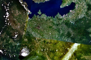
 Ulreung stratovolcano forms a small 10-km-wide island about 100 km E of the central Korean Peninsula. The island, seen in this NASA Landsat image (with north to the top) is a tourist destination from the Korean mainland. Ulreung was the site of a major explosive eruption at the beginning of the Holocene that produced pyroclastic flows and deposited ash in central Honshu.
NASA Landsat 7 image (worldwind.arc.nasa.gov)
 Muria volcano forms the broad Muria Peninsula along the northern coast of central Java in this NASA Landsat mosaic (N is to the top). This volcano lies well north of the main volcanic chain in Java. It is largely Pleistocene in age and has deeply eroded flanks. The summit contains several large N-S-trending craters, some containing lava domes. The most recent eruptive activity at Muria produced three maars on the SE and NE flanks and a lava flow from a SE-flank vent that entered one of the maars.
NASA Landsat 7 image (worldwind.arc.nasa.gov)
 Tambora volcano on Indonesia's Sumbawa Island produced of the world's largest historical eruption in April 1815. This NASA Landsat mosaic shows the 6-km-wide caldera at the top of the 2,850-m-high summit. Pyroclastic flows during the 1815 eruption reached the sea on all sides of the 60-km-wide volcanic peninsula, and the ejection of large amounts of volcanic gas (aerosols) caused world-wide temperature declines in 1815 and 1816.
NASA Landsat 7 image (worldwind.arc.nasa.gov)
 The 15-km-long island of Pantelleria is constructed above a drowned continental rift in the Strait of Sicily. Part of the mostly buried arcuate rims of two large Pleistocene calderas are seen in this NASA Landsat image (with N to the top). The SE rims of the calderas form the two dark-colored lines at the lower right part of the island, below and to the right of the forested Monte Grande and Monte Gibele volcanoes. Monte Gibele, with its circular summit crater, was constructed in the southern part of the younger Cinque Denti caldera.
NASA Landsat 7 image (worldwind.arc.nasa.gov)
 The fissure-controlled Korath Range is an isolated group of tuff cones and lava flows in southern Ethiopia that were erupted along the Turkana Rift. The lava flows traveled up to about 5 km with visible lobate margins, most prominently on the W flanks.
NASA Landsat 7 image (worldwind.arc.nasa.gov)
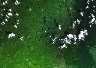 Mostly lake-filled maars and tuff cones dot the center of this NASA Landsat image (with N to the top) of the Kyatwa volcanic field. The Kyatwa vents, also known as the Ndale volcanic field, occupy the Western Rift Valley, east of the Ruwenzori Mountains halfway between Lake Edward and Lake Albert. The Kyatwa tuff cones are part of a group of Pleistocene-to-recent volcanic fields in western Uganda.
NASA Landsat 7 image (worldwind.arc.nasa.gov)
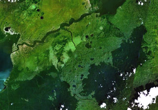 Maars of the Bunyaruguru volcanic field, also known as the Kichwambe volcanic field, blanket the center of this NASA Landsat image (with N to the top) of the E side of the Western Rift Valley. The Bunyaruguru field, lying south of the river channel connecting Lake Edward (left-center) and Lake George (top right), contains more than 130 craters, 27 of which contain lakes with water ranging from fresh to saline. Maars of the Katwe-Kikorongo volcanic field lie across the river channel at the upper left.
NASA Landsat 7 image (worldwind.arc.nasa.gov)
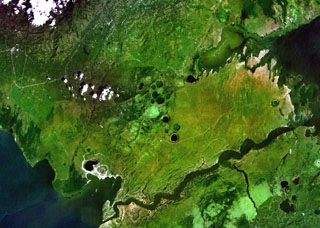 Lake-filled and dry maars of the Katwe-Kikorongo volcanic field are shown in the center of this NASA Landsat image (with N to the top). The volcanic field lies above the river channel connecting Lake Edward (lower left) with Lake George (upper right) in the Western Rift Valley of Uganda. Dark-colored Lake Katwe (lower left) is a shallow 3-km-long body of water that occupies two of three intersecting craters immediately NE of Lake Edward. Local folk tales suggest that volcanism in the Katwe-Kikorongo area has continued into historical times.
NASA Landsat 7 image (worldwind.arc.nasa.gov)
 The volcano near the center of this NASA Landsat image (with north to the top) is El Pedregal, the most prominent Quaternary volcano in the highlands of central Honduras. This low-angle basaltic shield volcano was constructed on a high plateau of Miocene ignimbrites immediately west of the capital city of Tegucigalpa, which covers much of the lower-right quadrant of this image. Isolated remnants of basaltic lava flows from El Pedregal and separate vents occur over broad areas to the west and NW.
NASA Landsat 7 image (worldwind.arc.nasa.gov)
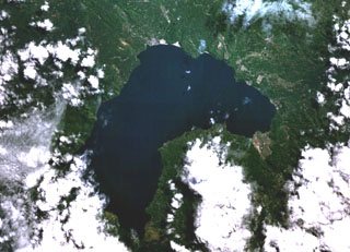
 Toba is Earth's largest Quaternary caldera and is partially filled by Lake Toba, seen here in a NASA Landsat satellite image (N is to the top). The 35 x 100 km caldera formed during four major ignimbrite-forming eruptions in the Pleistocene, the latest of which occurred about 74,000 years ago. The large island of Samosir is an uplifted resurgent dome.
 NASA Landsat 7 image (worldwind.arc.nasa.gov)
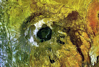 The central caldera of Suswa, the southernmost caldera of the Kenya rift, contains a 5-km-wide caldera. Construction of an early shield volcano was followed by eruption of voluminous pyroclastic flows and lava flows that accompanied formation of the caldera. The latest eruptions have originated from vents that have issued still-unvegetated lava flows that may be only a century or so old. N is to the top in this NASA Landsat image.
NASA Landsat 7 image (worldwind.arc.nasa.gov)
 The Ankaratra volcanic field in central Madagascar consists of lava domes, fissure vents, scoria cones, and maars. The volcanic field is one of the largest on the island and covers a 100-km-long area in central Madagascar. Hot springs occur at Ranomafana. N is at the top in this NASA Landsat image.
NASA Landsat 7 image (worldwind.arc.nasa.gov)
 The Itasy volcanic field in central Madagascar lies W of Lake Itasy (lower center) and consists of a N-S-trending chain of scoria cones, lava domes, and maars. Several small dark-colored, lake-filled maars can be seen in the NASA Landsat image (N to the top), one of which lies just above the NW arm of Lake Itasy. Early eruptions producing trachytic lava domes and basanitic lava flows were followed by the effusion of trachytic lava flows and recent Vulcanian eruptions. Mild seismicity and hot spring activity continue at Itasy.
NASA Landsat 7 image (worldwind.arc.nasa.gov)
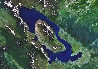
 Lake Ranau partially fills the 8 x 13 km Ranau caldera. A morphologically young post-caldera stratovolcano, Gunung Semuning, its summit obscured by clouds below the bottom center lake shore in this NASA Landsat image (N is to the top), was constructed within the SE side of the caldera to a height of more than 1,600 m above the caldera lake surface. The age of the most recent eruptions at Ranau are not known, but fish kills and the smell of sulfur in the late 19th and early 20th centuries may have been related to eruptions within the lake.
NASA Landsat 7 image (worldwind.arc.nasa.gov)
 The right side of the relatively cloud-free area at the center of this NASA Landsat image (with north to top) contains the Quezaltepeque volcanic field. A series of youthful lava flows was erupted from vents along a N-S-trending fault cutting through Tertiary pyroclastic rocks about 5 km south of the town of Quezaltepeque. The northern end of Lake Güija along the Guatemala/El Salvador border is at the bottom of the image, and the city of Chiquimula is at the top center. The fault-controlled Río Motagua valley is at the upper left.
NASA Landsat 7 image (worldwind.arc.nasa.gov)
 The area NW of the town of Estelí (bottom-center) and east of the prominent fault-bound valley at the left contains sparsely vegetated lava flows of the Estelí volcanic field. The flows were mostly erupted from fissure vents located in valleys in the northern interior highlands of Nicaragua between the town of Estelí and the border with Honduras.
 NASA Landsat 7 image (worldwind.arc.nasa.gov)
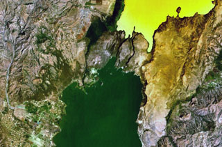
 The small circular volcano at the center of this NASA Landsat image east (right) of the Río Pacora (left of center) is Cerro el Ciguatepe. This volcano lies in the Nicaraguan interior highlands, east of yellow-colored Lake Managua (lower left). A prominent breach can be seen in the SW wall of the well-preserved 1.5-km-wide crater. A small lava flow extends a short distance beyond the base of the cone through the breach, and a blocky plug dome was emplaced in the center of the crater. The dark-colored lake at the upper right is Laguna Moyua.
 NASA Landsat 7 image (worldwind.arc.nasa.gov)
 Volcán Azul (Volcán Blue) consists of three youthful cinder cones on the jungle-covered Atlantic coastal plain of Nicaragua. The cones are located at the lower left, west of Pearl Lagoon (right-center) and south of both the Río Grande de Matagalpa (which flows from the upper left to form the small point north of Pearl Lagoon) and the Río Curinhuás (left-center), which flows into the northern end of the lagoon. The three cones, each of which have well-defined, steep-walled craters, were first noted by geologists during an aerial overflight in the 1960s.
 NASA Landsat 7 image (worldwind.arc.nasa.gov)
 The small stratovolcano surrounded by an apron of lava flows in the center of this NASA Landsat image (with north to the top) is Cochiquito volcano. The alkaline basaltic volcano has eight satellitic cones and lies near the junction of the Río Barrancas (cutting diagonally across the image from the upper left) and the Río Grande (right-center). Lava flows from the Sillanegra pyroclastic cone complex can be seen across the Río Grande below and to the right of Cochiquito.
NASA Landsat 7 image (worldwind.arc.nasa.gov)
 Tromen (center) is a 3978-m-high youthful Argentinian stratovolcano that lies at the northern end of an elongated volcanic massif. The summit of Tromen is cut by two overlapping 3.5-km-wide calderas, visible south of the snow-dappled summit cone in this NASA Landsat view (with north to the top). The youngest lava flows at Tromen originated from north-flanks vents and produced the dark-colored lava flows that blanket the north and NE sides of the andesitic-to-dacitic volcano.
 NASA Landsat 7 image (worldwind.arc.nasa.gov)
 The broad NE-SW-trending Nyambeni Hills shield volcano cuts diagonally across this NASA Landsat image from the center to the upper right. It is located NE of the eroded Pleistocene Mount Kenya volcano (lower left) and is capped by numerous phonolitic lava domes and basaltic cones and lava flows. The basaltic scoria cones are the youngest features of Nyambeni Hills volcano and are clustered in a NE-trending belt along the crest of the shield and in N-S-trending areas on its flanks.
NASA Landsat image, 1999 (courtesy of Hawaii Synergy Project, Univ. of Hawaii Institute of Geophysics & Planetology).
 Lava flows of the southern side of the Dofan volcanic massif are seen NW of a bend in the Hauash River at the top of this NASA Landsat image. The stratovolcano, known as the "smoking mountain," rises above the Awash plain in the northern Main Ethiopian Rift. Numerous cinder cones dot the flanks of the dominantly rhyolitic volcano. A dark-colored lava flow at the extreme top-center of the image originated from the younger northern cones, which have well-preserved morphologies and display strong fumarolic activity.
NASA Landsat image, 1999 (courtesy of Hawaii Synergy Project, Univ. of Hawaii Institute of Geophysics & Planetology).
 The yellow-colored pyroclastic cones at the upper right lie along the western part of the Gufa volcanic field, which extends from the Djibouti border into Eritrea (upper right). These basaltic scoria cones and lava flows are aligned in an E-W direction NE of Mousa Alli volcano, a large stratovolcano that is visible at the bottom center of this NASA Landsat image. A second E-W-trending chain of cones, not visible in this image, is located to the north of the principal chain in Eritrea and fed long lava flows that descend in the direction of the Red Sea.
NASA Landsat image, 1999 (courtesy of Hawaii Synergy Project, Univ. of Hawaii Institute of Geophysics & Planetology).
 Mousa Alli volcano dominates the right-hand side of this NASA Landsat image and is located on the border between Ethiopia, Eritrea, and Djibouti. This volcano is the most prominent topographic feature in this area and towers above its neighbor to the SW, Manda Inakir, visible at the lower left. Yellow-colored basaltic pyroclastic cones and associated lava flows occupy the SE and NW flanks.
NASA Landsat image, 1999 (courtesy of Hawaii Synergy Project, Univ. of Hawaii Institute of Geophysics & Planetology).
 The dark-colored lava flows extending diagonally across the center of this Landsat image were erupted from pyroclastic cones of Manda-Inakir volcano. These NNW-trending fissure vents and cones are located along the Ethiopia-Djibouti border and represent an uplifted mid-ocean ridge spreading center now exposed above sea level. An eruption in 1928 or 1929 at the SE end of the Manda-Inakir rift near the town of Korili (in Djibouti) produced the Kammourta cinder cone and a lava flow.
NASA Landsat image, 1999 (courtesy of Hawaii Synergy Project, Univ. of Hawaii Institute of Geophysics & Planetology).
 The Tat Ali volcanic massif extends across the right-hand side of this NASA Landsat image, east of Lake Afrera (center). This basaltic-to-pantelleritic shield volcano displays an elongated central depression partially filled by recent basaltic lava flows. The dark-colored flows at the upper right were erupted from fissures at the northern end of the Tat Ali complex. Borawli volcano lies at the right-center, between Tat Ali and Lake Afrera (also known as Lake Giulietti), and the lava flows at the upper left are from the flanks of the Hayli Dubbi complex.
NASA Landsat image, 1999 (courtesy of Hawaii Synergy Project, Univ. of Hawaii Institute of Geophysics & Planetology).
 Asavyo volcano, near the center of this NASA Landsat image, is the SW-most of three large silicic stratovolcanoes of uncertain age constructed along a NE-SW-trending line in the Danakil horst. Basaltic lava flows blanket the flanks of Asavyo, which merge into the Mogorros plains to the south. The caldera at the bottom right-center is Oyma volcano, Mallahle volcano lies beneath the clouds at the top center, and Sorkale volcano occupies the circular dark-colored area at the upper right.
NASA Landsat image, 1999 (courtesy of Hawaii Synergy Project, Univ. of Hawaii Institute of Geophysics & Planetology).
 The roughly 1-km-wide caldera is located at the western side of the dark-colored lava field, at the summit of Sork Ale volcano (at the center of this NASA Landsat image, N is at the top). This stratovolcano, also known as Asdaga, is located perpendicular to the orientation of three larger stratovolcanoes trending NE-SW at the southern end of the Danakil Alps. The ages of recent eruptions are not certain.
NASA Landsat image, 1999 (courtesy of Hawaii Synergy Project, Univ. of Hawaii Institute of Geophysics & Planetology).
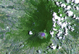 Kanlaon is the most active volcano of the central Philippines and the highest point on the island of Negros, lies at the southern end of the summit ridge and overlooks a 15 km2 caldera to the N. Five major vents are aligned NNE within the smaller active crater. Eruptions recorded since 1866 have typically consisted of small-to-moderate phreatic explosions that produce minor ashfalls near the volcano.
NASA Landsat image, 2003 (courtesy of Hawaii Synergy Project, Univ. of Hawaii Institute of Geophysics & Planetology).
 Scoria cones of the Bufumbira volcanic field in SW Uganda (center) lie N of the large stratovolcanoes of the NE part of the Virunga Mountains. The roughly 40 scoria cones occur in clusters and were erupted along lineaments and are typically breached on one side by lava flows. The Bufumbira rocks are noted for their unusual ultrapotassic chemistry. Muhavura (center) and Sabinyo (left) stratovolcanoes are visible at the bottom of this Landsat image.
NASA Landsat image, 1999 (courtesy of Hawaii Synergy Project, Univ. of Hawaii Institute of Geophysics & Planetology).
 The Karisimbi volcanic complex (center) includes a symmetrical, peaked summit flanked to the SE by the 2-km-wide Branca caldera, which is filled by viscous lava flows and two craters. The smaller Muntango crater is located S of the summit. A broad lava plain composed of flows erupted within the caldera and along a chain of parasitic cones, extends SW. Eroded Mikeno volcano is at the upper left and Visoke volcano at the upper right of this Landsat image.
NASA Landsat image, 1999 (courtesy of Hawaii Synergy Project, Univ. of Hawaii Institute of Geophysics & Planetology).
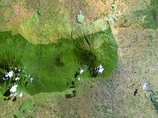 The forested Muhavura volcano (center) rises at the NE end of the Virunga Range. The Gahinga (Mgahinga) volcano, the smaller cone at left-center, is joined to Muhavura on the west by a broad saddle. Muhavura is stratovolcano with a small crater that has been recently active, but the age of its latest eruption is not known.
NASA Landsat image, 1999 (courtesy of Hawaii Synergy Project, Univ. of Hawaii Institute of Geophysics & Planetology).
 The chain of pyroclastic cones and lava flows extending diagonally down from the upper-left portion of this Landsat image is the southern portion of the Mousa Alli volcanic complex. The flanks of its neighbor to the SW, Manda Inakir, are visible at the extreme lower left. Prominent faults at the right cut lava flows of the Pliocene-Pleistocene stratoid series of the Afar region.
NASA Landsat image, 1999 (courtesy of Hawaii Synergy Project, Univ. of Hawaii Institute of Geophysics & Planetology).
 Dabbayra (center), the westernmost volcano of the Afar depression, lies near the edge of the Ethiopian escarpment. In contrast to structural trends in other parts of Afar, Dabbayra (also known as Bar-Ali) consists of a basaltic shield volcano elongated in an ENE-WSW direction. The only silicic volcanic rocks are a NNW-trending line of lava domes and lava flows near the crest of the volcano
NASA Landsat image, 1999 (courtesy of Hawaii Synergy Project, Univ. of Hawaii Institute of Geophysics & Planetology).
 Dabbahu (also known as Boina or Moina) is a young volcanic massif (center) in the Afar depression SSW of the Alayta massif. Pantellerite obsidian flows, lava domes, and pumice cones form the summit and upper flanks of the volcano. Late-stage basaltic fissure eruptions occurred at the NW base of the volcano (upper left) and numerous fumaroles are located in the central part of the massif.
 NASA Landsat image, 1999 (courtesy of Hawaii Synergy Project, Univ. of Hawaii Institute of Geophysics & Planetology).
 Alayta shield volcano (left-center) covers an area of 2,700 km2 in the western Danakil depression. A series of recent craters is aligned along the NNW-trending axis. The Alayta lava field (center dark area) was erupted from N-S-trending fissures along the E side of the volcano and reaches the W flank of Afderà volcano, immediately S of Lake Guilietti (Lake Afrera) at the upper right-center.
NASA Landsat image, 1999 (courtesy of Hawaii Synergy Project, Univ. of Hawaii Institute of Geophysics & Planetology).
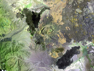 The Ma Alalta stratovolcano (center), also known as Pierre Pruvost, is located W of the Danakil depression. There are two elongate, nested summit calderas, 6 km and 4 km wide in the long direction. Young basaltic lava flows were erupted on the NW, SE, and E flanks of the volcano, and young pantellerite obsidian domes and lava flows were erupted on the S flank.
NASA Landsat image, 1999 (courtesy of Hawaii Synergy Project, Univ. of Hawaii Institute of Geophysics & Planetology).
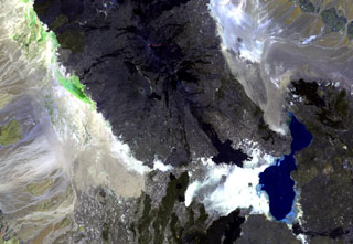 Ale Bagu, also known as Ummuna, is an elongate stratovolcano (left center) located SW of Erta Ale, the volcano at the top-center showing a small orange lava lake. In contrast to other volcanoes of the Erta Ale Range, Ale Bagu is mantled by basaltic pyroclastic rocks. The main crater is a steep-walled, 750 x 450 m depression. Trachytic lava flows occupy the crater floor and silicic lavas from the axial regional fissure extend to the NW and SE. Lake Giulietti (also known as Lake Afrera) is at the lower right.
NASA Landsat image, 1999 (courtesy of Hawaii Synergy Project, Univ. of Hawaii Institute of Geophysics & Planetology).
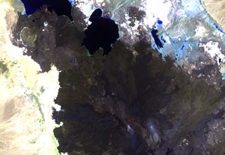 The summit region of Alu volcano is located left of the center of this Landsat image, south of Lake Bakili (top center). Alu lies SE of Gada Ale volcano (upper left), which rises above the western shore of the lake, and NW of Dalafilla volcano (bottom center). Fissure vents west of the horst have fed silicic lava flows, and other fissures to the south have produced voluminous basaltic lava flows that extend north as far as Lake Bakili.
NASA Landsat image, 1999 (courtesy of Hawaii Synergy Project, Univ. of Hawaii Institute of Geophysics & Planetology).
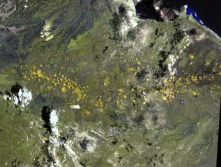 The long chain of pyroclastic cones and lava flows extending E-W across this Landsat image is the Assab volcanic field near the Red Sea coast in southern Eritrea. This spectacular range of basaltic cinder cones and associated lava flows covers a 55 x 90 km area, and flows reached the Red Sea along a broad front. The vents were constructed along a broad E-W-trending line that extends to the coastal city of Assab, out of view to right.
NASA Landsat image, 1999 (courtesy of Hawaii Synergy Project, Univ. of Hawaii Institute of Geophysics & Planetology).
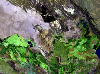 The brownish-colored Borawli complex (center) consists of a group of rhyolitic lava domes on the floor of the southern Kali Plain. Dark-colored, youthful looking basaltic lava flows (top) were erupted from fissures north of the dome complex, one of several volcanic features in Ethiopia named Borawli. The edge of Uddummi lake is visible at the lower right.
NASA Landsat image, 1999 (courtesy of Hawaii Synergy Project, Univ. of Hawaii Institute of Geophysics & Planetology).
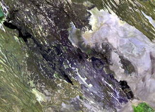 The Manda Hararo complex, which extends diagonally from the NW to SE across this Landsat image, represents an uplifted segment of a mid-ocean ridge spreading center. The complex is 105 x 20-30 km in size, and consists of small basaltic shield volcanoes and abundant fissure-fed lava flows. The dominant part of the complex lies to the south, where the Gumatmali-Gablaytu fissure system is located.
NASA Landsat image, 1999 (courtesy of Hawaii Synergy Project, Univ. of Hawaii Institute of Geophysics & Planetology).
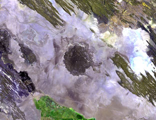 The dark-colored circular area in the center of this Landsat image is the small Holocene Kurub shield volcano. Kurub lies in the Saha Plain, SE of the Manda Hararo complex, the southern margin of which is visible at the far left. Initial subaqueous activity occurred along NNW-trending fissures cutting the basaltic volcano. Fumarolic activity observed in the 1930s was not seen during field work in the 1970s.
NASA Landsat image, 1999 (courtesy of Hawaii Synergy Project, Univ. of Hawaii Institute of Geophysics & Planetology).
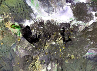 Gabillema is located along the axis of the Addado graben. The summit of the volcano lies below and to the left of the center of this Landsat image. Rhyolitic lava domes are on the flanks of the volcano and a 5 x 17 km basaltic lava field covers the Ado Bad Plain (Ado Lake) N of the volcano, originating from a broad area of fissure vents and spatter cones on the N side.
NASA Landsat image, 1999 (courtesy of Hawaii Synergy Project, Univ. of Hawaii Institute of Geophysics & Planetology).
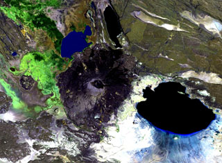 Dama Ali is a broad shield volcano that rises above the NW shore of Lake Abhe (right) at the S end of the Kalo Plain and was the most likely source of an eruption reported to have occurred in 1631. Nested circular craters are located at the summit and an arcuate chain of rhyolitic lava domes can be seen on the N, W, and S flanks. Major fumarolic activity occurs in the summit crater and abundant hot springs occur on the volcano.
NASA Landsat image, 1999 (courtesy of Hawaii Synergy Project, Univ. of Hawaii Institute of Geophysics & Planetology).
 An area of Holocene basaltic cones and lava flows is located along the Main Ethiopian Rift at Beru, between Fentale (upper right) and Kone (Gariboldi) volcanoes (lower left). The lake at the lower right is Metahara, whose northern shore is formed by a young lava flow from a flank vent at Fentale.
NASA Landsat image, 1999 (courtesy of Hawaii Synergy Project, Univ. of Hawaii Institute of Geophysics & Planetology).
 The Bishoftu volcanic field is a chain of lake-filled maars (dark-colored in this Landsat image), tuff cones, and scoria cones, lies along the Ethiopian Rift Valley. The city of Debre Zeit (left-center) lies between two maars, the irregular-shaped Lake Hora and the circular Lake Bishoftu. The Haro Maja tuff ring and its neighbor to the west, lake-filled Kilole maar (upper right), are offset to the east.
NASA Landsat image, 1999 (courtesy of Hawaii Synergy Project, Univ. of Hawaii Institute of Geophysics & Planetology).
 A large unnamed area of young basaltic lava flows and a possible small cinder cone is located on the floor of the Ethiopian Rift Valley SW of Tullu Moje volcano, which produced the dark-colored obsidian lava flow at the top-center of this Landsat image. The basaltic flows occupy a NE-SW-trending zone near the active eastern margin of the rift valley, NE of Lake Zwai (lower left) and NW of the 4,000-m-high Pleistocene Ch'llalo (Cilallo) volcano (lower right).
NASA Landsat image, 1999 (courtesy of Hawaii Synergy Project, Univ. of Hawaii Institute of Geophysics & Planetology).
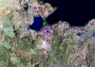 Vents of the northern part of the Olkaria volcanic complex are visible immediately S of Lake Naivasha (upper right). It comprises up to 80 individual rhyolitic centers, many of which are visible in this Landsat image. The youngest known eruption has a radiocarbon age of about 180 years. Fumarolic activity occurs at the Njorowa Gorge and at the Orengingnai and Orkaria (Olgaria) pumice cones.
NASA Landsat image, 1999 (courtesy of Hawaii Synergy Project, Univ. of Hawaii Institute of Geophysics & Planetology).
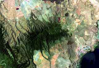 Vegetated Eburru volcano (center) is elongated perpendicular to the Gregory Rift NW of Lake Naivasha (lower right). The E-W-trending main edifice is eroded, but young craters cut the E part of the summit ridge and probably-Holocene rhyolitic domes occur on the E flank. Extensive fumarolic activity occurs at scoria cones and craters constructed along faults cutting the massif. Lava flows of the Elmenteita Badlands are visible at the top-center portion of this Landsat image.
NASA Landsat image, 1999 (courtesy of Hawaii Synergy Project, Univ. of Hawaii Institute of Geophysics & Planetology).
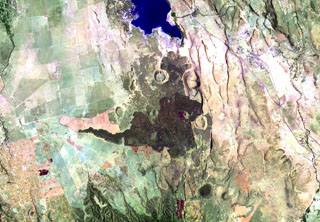 Prominent dark lava flows (center) erupted from vents in the Elmenteita Badlands, located between Lake Elmenteita (top) and Eburru volcano, the flanks of which appear at the bottom of this Landsat image. Cones and lava flows of varying ages are visible, some of which post-date the 10,000-year-old high-stand of Lake Elmenteita and are of Holocene age.
NASA Landsat image, 1999 (courtesy of Hawaii Synergy Project, Univ. of Hawaii Institute of Geophysics & Planetology).
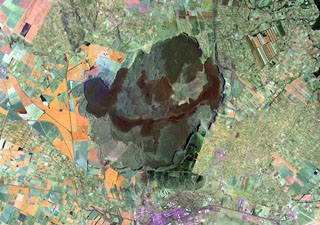 Farmlands occupy the flanks of Menengai shield volcano on the floor of the East African Rift. A major explosive eruption about 8,000 years ago resulted in formation of the 12 x 8 km wide caldera seen in this Landsat image. More than 70 post-caldera lava flows cover the caldera floor, the youngest of which may be only a few hundred years old. Most lava flows erupted from vents near the center of the caldera and ponded against the caldera walls. The city of Nakuru lies at the bottom of the image, south of the caldera.
NASA Landsat image, 1999 (courtesy of Hawaii Synergy Project, Univ. of Hawaii Institute of Geophysics & Planetology).
 Poorly known Latukan volcano (right of center) lies in the middle of a chain of young E-W-trending volcanoes in NW Mindanao, SE of Lake Lanao (out of view to the upper left). Latukan is flanked on the west by Makaturing volcano (left-center) and closely on the east by the historically active Ragang volcano.
 NASA Landsat image, 2003 (courtesy of Hawaii Synergy Project, Univ. of Hawaii Institute of Geophysics & Planetology).
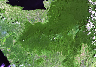 Several prominent pyroclastic cones are visible on the flanks of Makaturing volcano (left of center), located NE of Illana Bay (lower left) and south of Lake Lanao (upper left) at the west end of a chain of volcanoes in central Mindanao. Eruptions from this volcanic chain have variously been attributed to Makaturing and the historically active Ragang.
NASA Landsat image, 2003 (courtesy of Hawaii Synergy Project, Univ. of Hawaii Institute of Geophysics & Planetology).
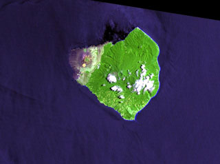 Mount Babuyan is the youngest of five Pleistocene-to-Holocene volcanic centers on the island of Babuyan Claro. The largest edifice is the active Mt. Pangasun (Babuyan Claro), with two summit craters 300 and 400 m in diameter. Both Babuyan Claro and Smith volcanoes have apparently been active in historical time, although which volcano produced the eruptions is not certain.
NASA Landsat image, 2000 (courtesy of Hawaii Synergy Project, Univ. of Hawaii Institute of Geophysics & Planetology).
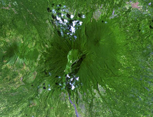 The large 2-km-wide, 600-m-deep crater that extends down the SSW flank of Banahaw contained a crater lake until 1730, when it drained, producing lahars. The smaller San Cristóbal and Banáhao de Lucban have formed on the W and E flanks, respectively. Andesite-to-dacite lava domes formed on the flanks of Banahaw and San Cristobal.
NASA Landsat image, 2002 (courtesy of Hawaii Synergy Project, Univ. of Hawaii Institute of Geophysics & Planetology).
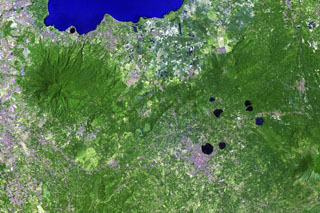 Lake-filled maars are common features of the San Pablo Volcanic Field at the southern end of the large Laguna de Bay (top). The monogenetic volcanic field contains a group of 42 scoria cones and 36 maars, the youngest of which contain deep lakes. The largest maar in this Landsat image is 1.2-km-wide Sampaloc Lake, immediately N of the city of San Pablo. Local legends suggest that this maar formed about 500-700 years ago. The forested volcano to the left is Maquiling.
NASA Landsat image, 2002 (courtesy of Hawaii Synergy Project, Univ. of Hawaii Institute of Geophysics & Planetology).
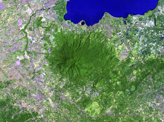 The forested Maquiling volcano (center) rises south of Laguna de Bay (top) and is the highest point of the San Pablo volcanic field. It has a deep crater whose floor is 480 m below its N rim and several cones, maars, and numerous thermal areas at its northern base, and other maars and scoria cones of the San Pablo volcanic field lie to the E. The prominent dark-colored maar along the shore of Laguna de Bay north of Maquiling is Alligator Lake.
NASA Landsat image, 2002 (courtesy of Hawaii Synergy Project, Univ. of Hawaii Institute of Geophysics & Planetology).
 This Landsat image shows the forested Labo lies between the Ragay Gulf (lower left) and Pacific Ocean (top) at the NW end of the Bicol Peninsula in SE Luzon. It is surrounded by numerous lava domes. Eruptive activity ceased during the Pleistocene, but thermal activity in the form of hot and warm springs continues.
NASA Landsat image, 2000 (courtesy of Hawaii Synergy Project, Univ. of Hawaii Institute of Geophysics & Planetology).
 The deeply eroded, forested Mandalagan volcano on northern Negros Island contains a highly altered domed structure. The Bago River at the bottom of the image cuts across the lowlands between Mandalagan and Kanlaon volcano, whose vegetated flanks are visible at the bottom center.
NASA Landsat image, 2003 (courtesy of Hawaii Synergy Project, Univ. of Hawaii Institute of Geophysics & Planetology).
 Matutum rises above farmlands in southern Mindanao. A well-preserved 320-m-wide and 120-m-deep crater has a densely forested floor. Widespread pyroclastic flow deposits surround the volcano.
 NASA Landsat image, 2000 (courtesy of Hawaii Synergy Project, Univ. of Hawaii Institute of Geophysics & Planetology).
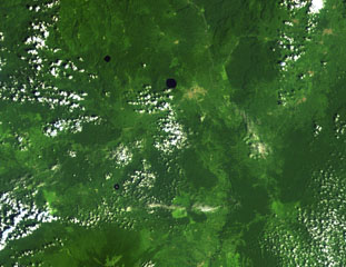 Three lake-filled maars dot the Tombel Graben between Mount Cameroon (lower left) and lava flows from Manengouba volcano (top). The Mungo River runs from N to S across the right side of this Landsat image. The largest maar, Barombi Mbo, lies just west of the brown-colored area of the town of Kumba, and Barombi Koto is at the lower left. A large number of scoria cones, including the young cone of Le Djungo (Mont Pelé) dot the 10-20 km wide graben.
NASA Landsat image, 1999 (courtesy of Hawaii Synergy Project, Univ. of Hawaii Institute of Geophysics & Planetology).
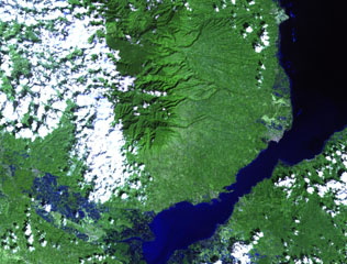 The forested Malindang stratovolcano (center) is located on the western margin of Iligan Bay in north-central Mindanao. The volcano contains a small summit caldera and legends discuss a large eruption. Reports of increased activity in 1991 at the time of tectonic earthquakes prompted widespread evacuations, but an eruption did not occur.
NASA Landsat image, 2002 (courtesy of Hawaii Synergy Project, Univ. of Hawaii Institute of Geophysics & Planetology).
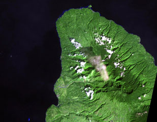 Balatukan (also known as Balatocan) is located in north-central Luzon, along this peninsula SE of Camiguin Island. There are active fumaroles, but it is extensively eroded and the age of its latest eruption is not known.
NASA Landsat image, 2002 (courtesy of Hawaii Synergy Project, Univ. of Hawaii Institute of Geophysics & Planetology).
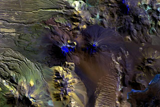 Multiple craters truncate the summit of Láscar volcano (left of center), and prominent lava flow levees are visible on its western flank. To the east is the symmetrical cone of Láscar's higher twin volcano, Aguas Caliente (right of center), with its smaller circular summit crater that contains a shallow lake. The most recent activity at this E-W-trending volcanic chain originated from Láscar volcano and continued into historical time.
NASA Landsat image, 1999 (courtesy of Hawaii Synergy Project, Univ. of Hawaii Institute of Geophysics & Planetology).
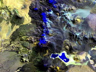 The N-S-trending chain of andesitic-dacitic volcanoes along the Chile-Bolivia border just left of the center of this Landsat image is the Sairecábur-Escalante volcanic massif. Snow-covered areas are blue in this image of the chain, which contains at least 10 postglacial centers. A massive lava flow extends to the west, and a youthful flow traveled SE from Curinquinca volcano at the NE side of the chain. Laguna Verde is the left-hand lake at the bottom, NE of dark-colored Licancabur volcano; Juriques volcano to its right has a pronounced summit crater.
NASA Landsat image, 1999 (courtesy of Hawaii Synergy Project, Univ. of Hawaii Institute of Geophysics & Planetology).
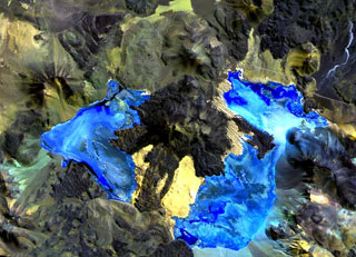 Caichinque volcano forms a topographic high dividing lakes of Salar Capur (left) from Salar Talar (right). More than a half dozen vents produced andesitic-to-dacitic lava flows, with young flows descending to the NE and SE from the 4450-m-high summit. One prominent flow traveled 6 km to the east, forming two lobes extending into the Salar Talar. Other youthful looking flows traveled to the west, forming lobes extending into Salar Capur, and SSW, dividing the two salars.
 NASA Landsat image, 1999 (courtesy of Hawaii Synergy Project, Univ. of Hawaii Institute of Geophysics & Planetology).
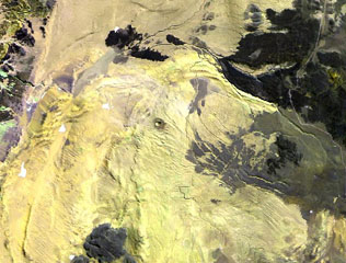 The small dot near the center of this Landsat image is the Cerro Tujle maar (also known as Cerro Tucle or Cerro Tugle). The Holocene maar has a 60-m-deep crater and is surrounded by a dark-colored ejecta blanket. The maar is located SE of the Salar de Atacama, north of Cerro Toloncha.
 NASA Landsat image, 1999 (courtesy of Hawaii Synergy Project, Univ. of Hawaii Institute of Geophysics & Planetology).
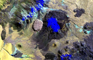 The youthful-looking rhyolitic lava dome, Cerro la Torta (left of center), lies at its western foot of Cerros de Tocorpuri (or Volcán Tocorpuri), a stratovolcano complex on the Chile-Bolivia border. The circular, roughly 5 cu km Cerro la Torta has a flat-topped surface with wrinkled flow ridges and terminates in steep, talus-covered margins about 150 m high. The dome has a youthful appearance, but its age is not precisely known. Snow cover in this Landsat view is deep blue.
 NASA Landsat image, 1999 (courtesy of Hawaii Synergy Project, Univ. of Hawaii Institute of Geophysics & Planetology).
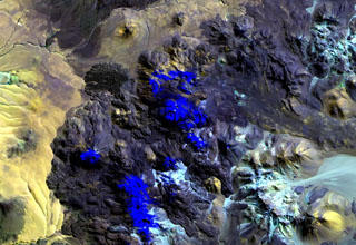 Putana volcano, also known as Jorgencal or Machuca, lies in the center of this Landsat image. Snow-covered areas are deep blue in this image of the N-S-trending volcanic complex, which covers an area of 600 km2. The main edifice consists of accumulated postglacial dacitic lava domes and flows mantling an older pre-Holocene volcano. The youngest basaltic andesite lava flows are viscous and rarely extend more than 3 km. The prominent fan-shaped lava flow at the upper left originated from a flank vent.
NASA Landsat image, 1999 (courtesy of Hawaii Synergy Project, Univ. of Hawaii Institute of Geophysics & Planetology).
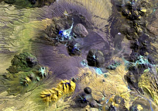 Erosional furrows cut outflow sheets of Pleistocene ignimbrites of the Purico Complex that were erupted from a postulated 10 x 20 km ring fracture. The light-colored dome at the top center is Pleistocene in age, but the youngest lava domes, Cerro Chascón de Purico (center) and Cerro Aspero (the small dome at the bottom center) are of Pleistocene-Holocene age. The dacitic-to-andesitic Macon stratovolcano of Holocene age lies at the SW end of the complex (far left-center). The Guayaques volcanic chain lies at the upper right.
NASA Landsat image, 1999 (courtesy of Hawaii Synergy Project, Univ. of Hawaii Institute of Geophysics & Planetology).
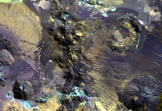 The irregular 10-km-long N-S-trending chain just left of the center of this Landsat image is Cerros de Guayaques. These rhyodacitic lava domes straddle the Chile-Bolivia border. The 10-km-long chain is located immediately east of the Purico pyroclastic shield, part of which is visible on the left side of the image. A well-defined summit crater was the source of the largest lava flows, which form the lobate flows that extend 3 km to the SW. There are no records of historical activity from Guayaques volcano.
 NASA Landsat image, 1999 (courtesy of Hawaii Synergy Project, Univ. of Hawaii Institute of Geophysics & Planetology).
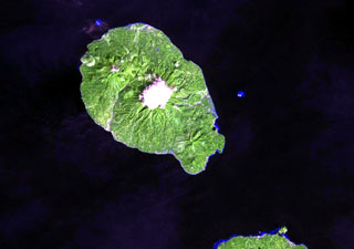 Camiguin Island, just off the coast of north-central Mindanao Island (lower right), consists of four overlapping cones. Cloud-covered Mt. Mambajao forms the high point of the island. The youngest volcano, Hibok-Hibok (also known as Catarman) at the NW end of the island, has been historically active. Major eruptions during 1871-75 and 1948-53 formed flank lava domes at Hibok-Hibok and produced pyroclastic flows that devastated coastal villages.
NASA Landsat image, 2002 (courtesy of Hawaii Synergy Project, Univ. of Hawaii Institute of Geophysics & Planetology).
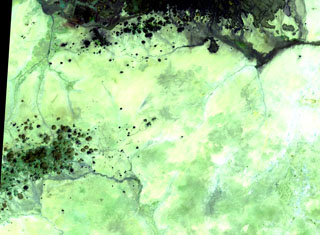 The scattered cones of the Kutum basaltic volcanic field (lower left) in the northern Dafur area of western Sudan are located SW of the larger Meidob volcanic field (top). As with other Saharan volcanic fields, Kutum (also known as the Tagabo Hills) contains very well-preserved cones, lava flows, and craters, although their ages are not well constrained.
NASA Landsat image, 1999 (courtesy of Hawaii Synergy Project, Univ. of Hawaii Institute of Geophysics & Planetology).
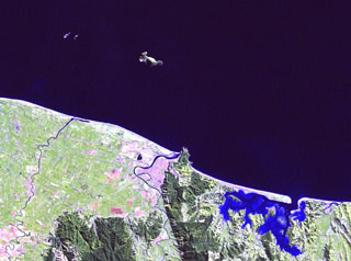 Moutohora (Whale) Island is the elongated island 11 km offshore from the city of Whakatane in the center of this Landsat image. The central dome complex on the 15 x 5 km wide island is about 350 m high and flanked by two lava domes, Pa Hill Dome (also known as West Dome) at the NW tip of the island and East Dome at the opposite end. Eruptive activity ceased during the Pleistocene but thermal activity continues. Rurima Rocks and Moutoko Island lie WNW, and the large bay at the lower right is Ohiwa Harbour.
NASA Landsat image, 2000 (courtesy of Hawaii Synergy Project, Univ. of Hawaii Institute of Geophysics & Planetology).
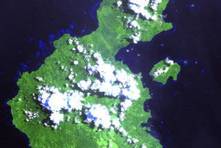 The Garua (Talasea) Harbour volcanic field (upper right center) consists of a group of mostly rhyolitic lava domes and ash cones that ring the harbor on the west and form Garua Island (right center) to the east. Active hot springs ring the shores of Garua Harbour, including a large group of boiling pools, fumaroles, and mudpots located near the Talasea Government Station on the south shore of the bay, directly opposite the western tip of Garua Island.
NASA Landsat image, 2000 (courtesy of Hawaii Synergy Project, Univ. of Hawaii Institute of Geophysics & Planetology).
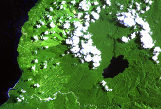 Lake Hargy (lower right) lies in the SE corner of the 10 x 12 km wide Hargy caldera. The Lobu River drains the lake through a notch in the northern caldera rim. The post-caldera cone of Galloseulo lies beneath the large cloud bank in the center of the image, about halfway from the lake to the Bismarck Sea. The Toiru River cuts across the bottom of the image. Small eruptions have taken place at Galloseulo over the past 7,000 years, the last occurring about 1,000 years ago.
NASA Landsat image, 2000 (courtesy of Hawaii Synergy Project, Univ. of Hawaii Institute of Geophysics & Planetology).
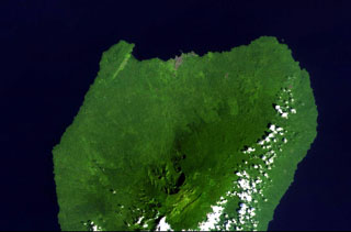 Santa Isabel volcano occupies the northern end of Bioko (Fernando Poo) Island in this NASA Landsat view with north to the upper left. A large escarpment cuts the northern side of the 3,007-m-high volcano, whose summit is cut by regional NE-SW-trending faults. Numerous scoria cones are present, many of which lie along the same tectonic trend. Santa Isabel is the only Bioko Island volcano with reported historical eruptions, although they are poorly documented. The brown area along the northern coast is the capital city of Malabo.
NASA Landsat image, 1999 (courtesy of Hawaii Synergy Project, Univ. of Hawaii Institute of Geophysics & Planetology).
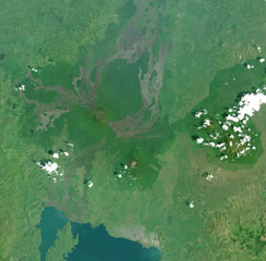 This Landsat image shows a portion of the East African Rift north of Lake Kivu (bottom), with N to the upper left. Unvegetated lava flows descend from vents on the summit and flanks, some reaching the shores of Lake Kivu. The forested volcano below and to the right is Nyiragongo, a volcano that frequently contains an active lava lake. Lava flows from flank fissures in 2002 cut across the city of Goma (the light-colored area at the right-hand side of the lake).
NASA Landsat image, 2001 (courtesy of Simon Carn, TOMS Volcanic Emissions Group, Univ. Maryland, Baltimore County).
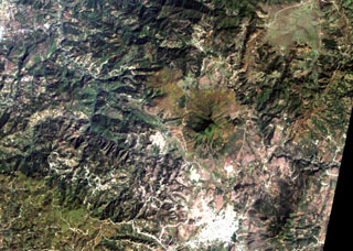 The smooth-textured area displaying a radial drainage pattern at the right-center is Jumay volcano in SE Guatemala. The volcano was constructed near the contact between Tertiary volcanic rocks on the south and Paleozoic metamorphic rocks on the north. The 2176-m-high volcano lies immediately north of the large city of Jalapa (the light-colored area at the bottom right).
NASA Landsat image, 2000 (courtesy of Loren Siebert, University of Akron).
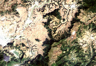 The triangular dark-green area (top-center) is the Cuxliquel lava-dome complex, lying within a semi-arcuate depression near the city of Totonicapán (upper right). The small green circle below and to the right of the larger dome complex is Cerro de Oro, a small symmetrical lava dome. The Río Samalá traces an arcuate path around the Quaternary dome complex beginning on its SE side (center) and progressing around to the north and then to the SW (bottom left). The white-colored area (left-center margin) is the city of Quetzaltenango.
NASA Landsat image, 2000 (courtesy of Loren Siebert, University of Akron).
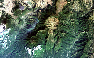 The light-colored, furrowed area at the top-center is the 4-km-wide, 600-m-deep Tzanjuyub caldera, which is breached to the south by the Río Masa. At the SW side of the Pleistocene caldera is Volcán Zunil, which is connected by an irregular ridge to Volcán Santo Tomás, a large eroded stratovolcano above the clouds at the bottom of the image. Santa María volcano (far left-center) lies across the Río Samalá to the east. Solfataras and thermal springs are located on the west side of the ridge between Santo Tomás and Zunil.
NASA Landsat image, 2000 (courtesy of Loren Siebert, University of Akron).
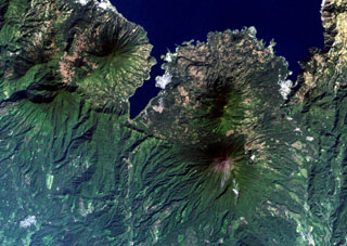 The 6-km-long, dagger-like Santiago Bay on Lake Atitlán is constrained by lava flows from San Pedro (upper left) and Tolimán (right-center) volcanoes. Young lava flows entering the lake, in particular those from Tolimán, have created a very irregular shoreline. The unvegetated summit of Atitlán volcano, the youngest post-caldera stratovolcano, lies south of Tolimán. Part of the southern margin of the Atitlán III caldera, which lies below the summit of Atitlán volcano, is offset along faults just south of the tip of Santiago Bay.
NASA Landsat image, 2000 (courtesy of Loren Siebert, University of Akron).
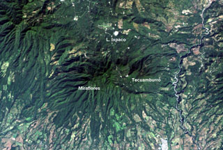 The Tecuamburro volcanic complex has a diverse history. Collapse of the ancestral Pleistocene Miraflores edifice underwent collapse, producing an avalanche deposit that traveled across the Río los Esclavos (right) and forming a large horseshoe-shaped crater open to the east. The modern Tecuamburro complex, consisting of four lava domes, was constructed within this scarp. The Laguna Ixpaco crater was created about 2,900 years ago within the much larger Pleistocene Chupadero crater.
NASA Landsat image, 2000 (courtesy of Loren Siebert, University of Akron).
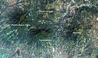 Four large Pleistocene volcanic complexes are visible in this Landsat image of southern Guatemala, with the Pacific coastal plain at the bottom. Minor activity at Tecuamburro volcano continued into the Holocene at Laguna Ixpaco, the small circular white dot a little more than half-way between the Tecuamburro and Piedra Grande labels. The Río los Esclavos extends from the upper right, cutting between Tecuamburro and Ixhuatán volcanoes.
NASA Landsat image, 2000 (courtesy of Loren Siebert, University of Akron).
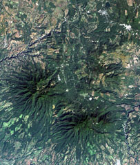 The top-center portion of this Landsat image consists of topographically indistinct Piedra Grande, a cluster of faulted, heavily eroded andesitic stratovolcanoes. The Piedra Grande complex lies between the NW-trending Jalpatagua Fault, which cuts diagonally through the city of Barbarena (the small white area at the upper right), and Tecuamburro volcano (lower right). The vent area of Piedra Grande lies within 4-km-wide, nested depressions open to the east, NE of the more prominent forested Puebla Nuevo Viñas volcano (left center).
 NASA Landsat image, 2000 (courtesy of Loren Siebert, University of Akron).
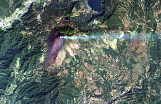 A volcanic plume extends to the east from MacKenney crater at Pacaya volcano in this December 8, 2000 Landsat image. The unvegetated modern cone was constructed within a scarp (visible south of the summit) left by a major edifice collapse at Pacaya volcano about 1100 years ago. The avalanche swept 25 km down the Río Metapa drainage (lower left) to the Pacific coastal plain. Pacaya was constructed near the southern rim of Amatitlán caldera, partially filled by Lake Amatitlán at the top right.
NASA Landsat image, 2000 (courtesy of Loren Siebert, University of Akron).
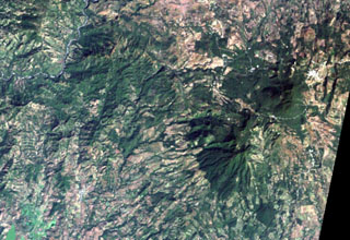 The large forested area at the middle right is the 1662-m-high Moyuta volcanic complex, its summit composed of a series of overlapping andesitic lava domes. The small white-colored area above and to the right of the dome complex is the city of Moyuta, which lies at an altitude of nearly 1300 m. Moyuta is the easternmost of the chain of large stratovolcanoes stretching across the Guatemalan Highlands.
NASA Landsat image, 2000 (courtesy of Loren Siebert, University of Akron).
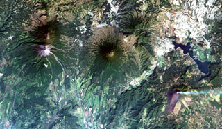 Guatemala's capital city (upper right) is flanked by four major stratovolcanoes and a large caldera. Steaming Pacaya volcano (lower right) was constructed near the southern rim of the partially lake-filled Amatitlán caldera, whose major late-Pleistocene silicic eruptions have produced thick pyroclastic-flow deposits exposed around Guatemala City. Conical Agua volcano (center) is a prominent landmark from the city, and the paired volcanoes of Acatenango and Fuego (left) lie to the west.
NASA Landsat image, 2000 (courtesy of Loren Siebert, University of Akron).
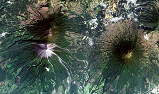 The historical city of Antigua Guatemala (top-right margin) is surrounded by three major stratovolcanoes in this Landsat view with north to the upper right. Dark-colored Acatenango volcano (upper left) and the unvegetated summit of Fuego volcano lie SW of the city, and Agua volcano (right-center) lies south. No historical eruptions from Agua are known, although mudflows in 1541 caused the abandonment of Ciudad Vieja, the previous capital city of Guatemala. Barrancas radiating SE from Fuego are light-colored from deposits of historical eruptions.
 NASA Landsat image, 2000 (courtesy of Loren Siebert, University of Akron).
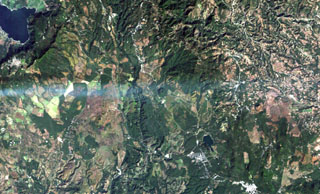 A volcanic plume from Pacaya volcano extends eastward from the left to Cerro Redondo, a small symmetrical cinder cone in the center of the image. This cone is one of the youngest features of the Cuilapa-Barbarena volcanic field, a cluster of about 70 Quaternary cinder cones located near the cities of Cuilapa and Barbarena (lower right) and in areas to the north and west. The cones were constructed where the NW-SE-trending Jalpatagua Fault intersects the southern margin of the Miocene Santa Rosa de Lima caldera.
NASA Landsat image, 2000 (courtesy of Loren Siebert, University of Akron).
 One of the most prominent topographic features of SE Guatemala is the figure-8-shaped double caldera of Ayarza volcano. Both calderas were formed within several thousand years of each other during major rhyolitic explosive eruptions in the late Pleistocene, about 27,000 years ago (eastern caldera) and 23,000 years ago (the larger western caldera). Formation of the older caldera was accompanied by the eruption of the chemically mixed pumices of the "Mixta" unit. The city of San Rafael las Flores, 6 km to the NE, is at the upper left.
 NASA Landsat image, 2000 (courtesy of Loren Siebert, University of Akron).
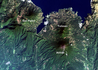 Lake Atitlán fills the northern part of the Atitlán caldera complex. The caldera formed in three stages: Atitlán I caldera about 11 million years ago (Ma), Atitlán II caldera about 8 Ma, and Atitlán III caldera about 84,000 years ago. The southern margin of the first caldera lies near the southern shore of the 18-km-wide lake, San Pedro and Tolimán volcanoes were constructed over the southern margin of the second caldera, and Atitlán over the third.
NASA Landsat image, 2000 (courtesy of Loren Siebert, University of Akron).
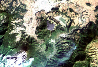 The arcuate area at the top center below the light-colored city of Quetzaltenango is the Almolonga volcanic complex. An arcuate series of lava domes outlines the northern part of the complex, while the unvegetated area to the south is the 1818 lava flow from Cerro Quemado volcano, the youngest of the Almolonga complex. Almolonga is located along the Zunil fault zone, which extends diagonally SW along the Río Samalá (bottom-center). The furrowed 1902 crater of Santa María volcano lies at the lower left.
NASA Landsat image, 2000 (courtesy of Loren Siebert, University of Akron).
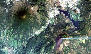 Steaming Pacaya volcano (lower right) lies across a valley from symmetrical Agua volcano (upper left). Pacaya was constructed near the southern margin of Amatitlán caldera, whose SE rim lies near the right-center margin. The 14 x 16 km wide caldera was formed during a series of major silicic explosive eruptions between about 300,000 and 23,000 years ago. The irregular margins of Lake Amatitlán are constrained on the SW side by post-caldera lava domes. The outskirts of Guatemala City lie at the upper right.
NASA Landsat image, 2000 (courtesy of Loren Siebert, University of Akron).
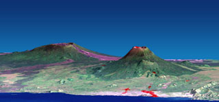 This combined NASA Landsat and Shuttle Radar Topography Mission image shows Nyamuragira (left) and Nyiragongo (right) volcanoes rising north of Lake Kivu in the East African Rift Valley. Red areas on Nyiragongo mark the locations of January 2002 flank-vent lava flows, some of which descended through the city of Goma into Lake Kivu. Historical lavas descend from Nyamuragira shield volcano, some of which also reached the lake. Both volcanoes are truncated by small calderas.
NASA Landsat and SRTM image, 2002.
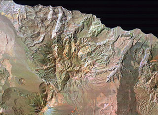 El Aguajito caldera is located along the Gulf of California immediately NE of Tres Vírgenes volcano (lower left) and NW of La Reforma caldera (partially visible at the right). The approximately 10-km-wide caldera covers the broad dissected area from Tres Vírgenes to the sea. The rim of the mid-Pleistocene caldera is not exposed, but an arcuate line of andesitic-to-rhyolitic lava domes lies along its northern margin. Hot springs are located along the southern caldera margin in the linear NW-trending valley between the caldera and Tres Vírgenes.
NASA Landsat image (processed by Brian Hausback, UC Sacramento).
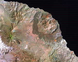 Three major Quaternary volcanic complexes are visible in this Landsat satellite image of Baja California. The N-S-trending Las Vírgenes volcanic complex to the left consists of three stratovolcanoes that are progressively younger towards the south. The 10-km-wide La Reforma caldera along the Gulf of California coast to the right displays darker andesite flanks and a resurgent dome in the center. The extensively eroded El Aguajito caldera has indistinct margins but the large resurgent dome forms the roughly circular eroded hills west of La Reforma.
NASA Landsat image (processed by Brian Hausback, UC Sacramento).
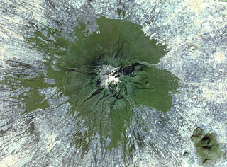 Farmlands surround La Malinche volcano NE of the city of Puebla in this 1999 Landsat satellite image (N is at the top; this image is approximately 30 km across). Deep erosional gullies have formed down the flanks, and the 1.5-km-diameter late-Pleistocene Xalapasco maar complex is on the lower ENE Flank about 11 km from the summit.
 NASA Landsat satellite image, 1999 (courtesy of Loren Siebert, University of Akron).
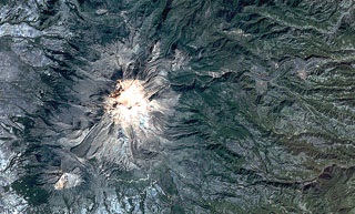 Pico de Orizaba (Volcán Citlaltépetl) formed on the margin of the Altiplano and has substantially higher relief on its eastern (right) side. Debris avalanches and lahars produced by edifice collapse have swept down the eastern flanks onto the coastal plain. A lava flow with lateral levees is visible on the lower SW flank below the summit. The eroded peak to the lower left beyond the lava flow terminus is Sierra Negra, the southernmost peak of the Cofre de Perote-Orizaba volcanic chain.
NASA Landsat satellite image, 1999 (courtesy of Loren Siebert, University of Akron).
 This view of the Serdán-Oriental basin covers about 38 km in a N-S (vertical) direction. The circular peak at the upper center, partially surrounded by young lava flows from Los Humeros caldera, is Cerro Pizarro lava dome. The lake-filled maar to the SSE across the light-colored dry lake basin is Alchichica maar. The erosionally ribbed flanks of Cerro Xalapaxco tuff cone and Cerro Pinto lava dome lie to the SW, and the large forested peaks at the bottom are the the twin Las Derrumbadas lava domes.
NASA Landsat satellite image, 1999 (courtesy of Loren Siebert, University of Akron).
 The fresh-looking lava flows at the top of the image were erupted from Los Humeros caldera (just out of view to the north). The basaltic and andesitic lava flows extend up to about 15 km from the caldera rim. The flows have not been dated precisely, but are younger than 20,000 years and could in part be of Holocene age. The Tepeyahualco (left) and Limón (right) lava flows bracket circular 3100-m-high Cerro Pizarro lava dome (right center), the northernmost feature of the Serdán-Oriental volcanic field.
 NASA Landsat satellite image, 1999 (courtesy of Loren Siebert, University of Akron).
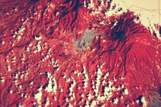 This false-color Landsat image shows two large Quaternary volcanoes in western Panamá. Barú volcano is at the upper right below the cloud cover, and Volcán Colorado lies at the top center. Virtually the entire lower left quadrant of the image is underlain by debris avalanche deposits produced by collapse of these two volcanoes, which left large scarps opening widely towards the W and SW. The light-colored area west of Barú consists of pyroclastic flow and lahar deposits related to lava dome growth.
NASA Landsat satellite image (courtesy of Kathleen Johnson, University of New Orleans).
 The irregular reddish area in the center of this false-color LANDSAT image is the Tenango lava flow. It was erupted about 8500 years ago from an E-W-trending fracture that also passes through Nevado de Toluca volcano, whose flanks appear at the left. The basaltic-andesite Tenango flow forms a prominent isolated mesa on which the fortified city of Teotenango with its many pyramids and courts was built by the Matlatzinca people about 1000 BCE. The Tenango flow lies at the far western end of the Chichinautzin volcanic field of central México.
 NASA Landsat image by Michael Abrams, 1996 (courtesy of José Macías, Universidad Nacional Autónoma de México).
 This false-color infrared image shows orange-colored Nyiragongo volcano at the left (north). The crater of the flank cone of Baruta can be seen to the left of the 1-km-wide summit crater. Darker-colored lava flows that mostly erupted from flank fissures extend south (right) to Lake Kivu, and several prominent orange-colored SW-flank scoria cones are visible.
NASA Landsat image, 1994.
 This Landsat thematic mapper image was acquired on 28 August 1986, as Augustine produced a powerful explosive eruption. An 11-km-high ash plume rises from the summit crater to the top of the false-color image. The red area in this false-color image is a hot pyroclastic flow deposit down the north flank. Snow and ice show up as shades of blue and vegetated areas along the coast are green. The dark areas descending the flanks are the paths of lahars and cooled pyroclastic flows.
NASA Landsat image, 1990.
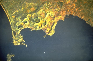 A Landsat satellite image shows the Campi Flegrei caldera north of the Bay of Naples. The 13-km-wide caldera, immediately west of the city of Naples (upper right), was created following massive explosive eruptions about 34,000 and 12,000 years ago. Subsequent eruptions formed numerous craters and cones within the caldera and along its margins. The most recent eruption created the Monte Nuovo tuff cone in 1538.
NASA Landsat image, 1984.