Keyword Collections | Keyword "rift zone"
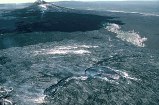 This 13 January 1987 view from the east shows the principal vents of the current eruption on Kīlauea's East Rift Zone, taken four years after the start of the eruption. The Pu‘u ‘Ō‘ō scoria cone to the left formed during the early stages of the eruption. Kūpaianaha to the lower right contains an actively convecting lava lake in this photo. The linear extension in the center foreground is at the head of a lava tube system, which insulated lava flows that reached the coast.
Photo by J. D. Griggs, 1987 (U.S. Geological Survey).
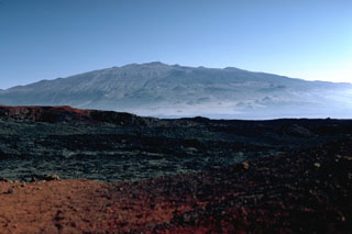 Mauna Kea is seen here from the north along the broad Mauna Loa NE rift zone. The scoria cones that formed during recent eruptions give the volcano an irregular profile.
Photo by Lee Siebert, 1987 (Smithsonian Institution).
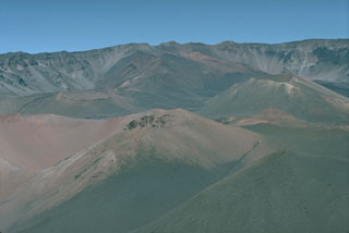 Kamoa o Pele (left) and Pu’u o Maui (right) are two of a group of young scoria cones along the southwest rift zone within the Haleakalā crater, seen here looking westward towards the Haleakalā summit.
Photo by Lee Siebert, 1987 (Smithsonian Institution).
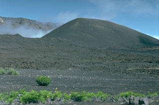 Pu’u o Maui is the largest of a group of scoria cones erupted along a rift zone that passes across Haleakalā crater, with the western crater rim to the upper left. The large summit crater formed through erosion and collapse events.
Photo by Lee Siebert, 1987 (Smithsonian Institution).
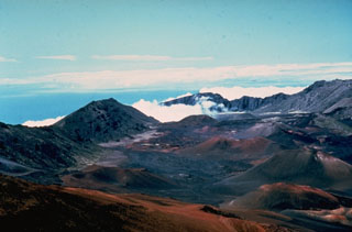 The summit of Haleakalā on the island of Maui contains a large crater that opens towards the ENE. It formed by the erosion of two large valleys that eventually coalesced, along with collapse events. This view to the NE from near the summit shows the Ko’olau Gap in the distance and scoria cones on the crater floor from eruptions along a major rift zone that extends across the summit from the SW to eastern coasts.
Photo by Dick Stoiber, 1976 (Dartmouth College).
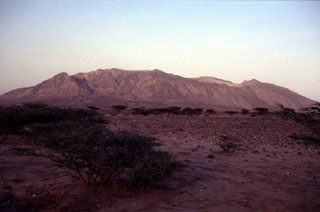 The elongated Alid volcano, which sits on the axis of the Danakil spreading center, is seen here from the W. Most of the flanks of the volcano in this view are composed of dipping rhyolitic lava flows; the light-colored area along the right skyline is rhyolitic pumice. The summit of the volcano is elongated in an E-W direction and contains a 1 x 1.5 km wide, 100-m-deep crater at the western end. Vast lava fields originating from fissure vents in the Alid graben extend to the NW and SE of the volcano. Vigorous fumarolic activity continues at Alid.
Photo by Wendell Duffield, 1996 (U.S. Geological Survey).
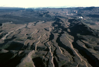 This north-looking view along fissures cutting Iceland's Krafla volcano illustrates crustal spreading processes where the Mid-Atlantic Ridge rises above sea level. The prominent horst-and-graben structures seen here are the result of repeated episodes of extensional rifting during which crustal blocks moved east and west, perpendicular to the line of faults. A period of pronounced crustal rifting occurred from 1975 to 1984, accompanied by nine small fissure eruptions. Steam can be seen in the upper left, rising above an active eruptive fissure in this September 1984 photo.
Photo by Michael Ryan, 1984 (U.S. Geological Survey).
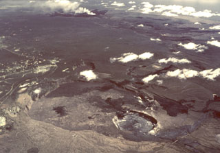 An aerial view in 1985 looks from Kīlauea caldera in the foreground down the East Rift Zone to the Puʻuʻōʻō vent producing a gas plume in the background. The Hawaiian Volcano Observatory lies at the lower left on the western rim of Kīlauea's 5-km-wide summit caldera with the inner Halema’uma’u crater to the lower right. Lava flows cover the floor of the summit caldera and can be seen extending downslope from multiple vents along the rift zone, including the dark-colored most recent flows erupted beginning in 1983 from the Kupaianaha vent.
Photo by J. D. Griggs, 1985 (U.S. Geological Survey).
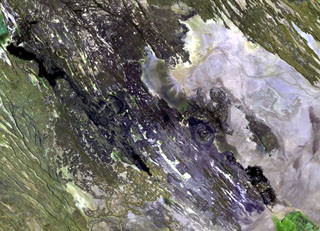 The Manda Hararo complex, which extends diagonally from the NW to SE across this Landsat image, represents an uplifted segment of a mid-ocean ridge spreading center. The complex is 105 x 20-30 km in size, and consists of small basaltic shield volcanoes and abundant fissure-fed lava flows. The dominant part of the complex lies to the south, where the Gumatmali-Gablaytu fissure system is located.
NASA Landsat image, 1999 (courtesy of Hawaii Synergy Project, Univ. of Hawaii Institute of Geophysics & Planetology).
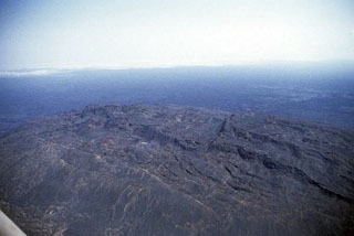 The summit region of Alu volcano is primarily composed of older basaltic lava flows. Major fumarolic activity is located on the numerous parallel faults, some of which have scarps up to 100 m high. Fissure vents west of the horst have fed silicic lava flows, and other fissures to the south have produced voluminous basaltic lava flows that extend north as far as Lake Bakili.
Photo by Richard Roscoe, 2002.
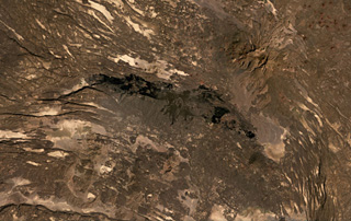 The roughly 40-km-long darker lava flows extending across the center of this December 2020 Planet Labs satellite image monthly mosaic (with N at the top) were produced by the western Manda portion of the Manda-Inakir complex and fill a graben formed through faulting. This complex represents a failed rift segment along the Ethiopia-Djibouti border. Mousa Alli is the edifice to the NE; this image is approximately 80 km across.
Satellite image courtesy of Planet Labs Inc., 2020 (https://www.planet.com/).
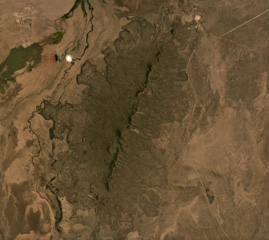 The Korath Range is the northernmost volcano of the Turkana rift in southern Ethiopia/northern Kenya. The central lineament of cones and craters has produced lava flows out to around 6 km from the vents. This September 2019 Planet Labs satellite image monthly mosaic shows the lobate flow margins and lateral flow levees and margins (N is at the top; this image is approximately 20 km across).
Satellite image courtesy of Planet Labs Inc., 2019 (https://www.planet.com/).
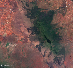 The Chyulu Hills volcanic field in southern Kenya covers an area of over 2,800 km2 and is located around 150 km E of the southern Kenya Rift Valley. More recent activity has occurred in the southern part of the field, containing a 50-km-long main central ridge with numerous cones and craters seen here in this 3 February 2019 Sentinel-2 satellite image (N at the top).
Satellite image courtesy of Copernicus Sentinel Data, 2019.
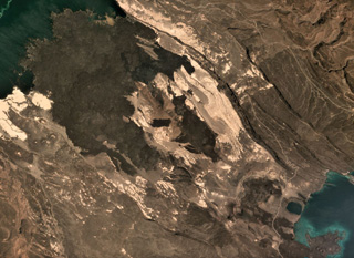 The Ardoukôba Rift is in Djibouti at the NW end of Lake Ghoubet (lower right) and is shown in this October 2019 Planet Labs satellite image monthly mosaic (N is at the top; this image is approximately 11 km across). It contains lava flows from scoria and spatter cones, with recent deposits erupted in 1978.
Satellite image courtesy of Planet Labs Inc., 2019 (https://www.planet.com/).
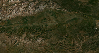 Beyond the NW tip of Lake Baikal is the Tunkin (or Tunka) Depression volcanic field, shown in this September 2019 Planet Labs satellite image monthly mosaic (N is at the top; this image is approximately 170 km across). The field is the surface manifestation of a rift zone and contains five main groups of scoria cones and lava flows that were produced during the late-Pleistocene to Holocene.
Satellite image courtesy of Planet Labs Inc., 2019 (https://www.planet.com/).
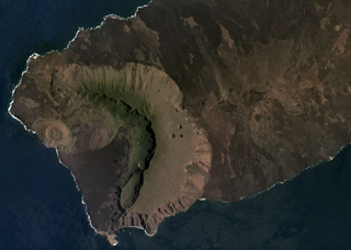 The western side of Volcán Ecuador has formed through caldera collapse and subsequent flank collapse, producing the caldera that opens towards the ocean in this March 2019 Planet Labs satellite image monthly mosaic (N is at the top; this image is approximately 13 km across). Within the caldera is the Cerro Grande tuff cone along the coast, a slump block along the SE caldera wall, and lava flows, as well as smaller vents. The East Rift is to the right in this image, towards Volcán Wolf out of view.
Satellite image courtesy of Planet Labs Inc., 2019 (https://www.planet.com/).
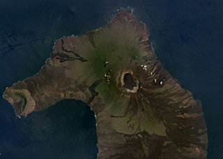 The 700-m-deep summit caldera of the Volcán Wolf shield volcano on Isabela Island, Galapagos Islands, is near the center of this March 2019 Planet Labs satellite image monthly mosaic (N is at the top; this image is approximately 50 km across). Lava flows have erupted from radial and circumferential fissures from the summit to the lower flanks. Volcán Ecuador and its East Rift zone forms the western peninsula, and the northern flank of Volcán Darwin is to the south.
Satellite image courtesy of Planet Labs Inc., 2019 (https://www.planet.com/).
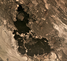 Scoria cones and lava flows of the Manda Gargori rift are seen across this December 2019 Planet Labs satellite image monthly mosaic (N is at the top; this image is approximately 9.5 km across).The rift is one of the younger segments in the Red Sea area and NW-SE trending faults are visible through the image. Ridges of older lava flows are visible between the lighter-colored sediment. A tuff ring is visible south of the younger lavas.
Satellite image courtesy of Planet Labs Inc., 2019 (https://www.planet.com/).


