Aira (Japan) | 9 November-15 November 2022 | Continuing Activity Cite this Report Cite this Report |
 Aira Aira
Ryukyu Volcanic Arc
|
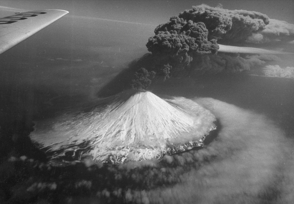
JMA reported ongoing eruptive activity at Minamidake Crater (at Aira Caldera’s Sakurajima volcano) and nighttime crater incandescence during 9-15 November. An eruptive event at 2130 on 10 November generated an eruption plume that rose to 1 km above the crater rim. An explosion at 2010 on 15 November produced an ash plume that rose 600 m above the crater and drifted SE. Seven volcanic earthquakes were detected. The Alert Level remained at 3 (on a 5-level scale), and residents were warned to stay 2 km away from the crater.
Source: Japan Meteorological Agency (JMA)
|
Alaid (Russia) | 9 November-15 November 2022 | Continuing ActivityCite this Report |
 Alaid Alaid
Kuril Volcanic Arc
|
KVERT reported that the eruption at Alaid was ongoing during 3-10 November. A weak thermal anomaly was identified in satellite images on 3, 6, and 8-9 November; the volcano was obscured by clouds the other days of the week. On 10 November, KVERT reported that the eruptive activity was gradually decreasing. The Aviation Color Code remained at Orange (the second highest level on a four-color scale). Dates are based on UTC times; specific events are in local time where noted.
Source: Kamchatkan Volcanic Eruption Response Team (KVERT)
|
Bezymianny (Russia) | 9 November-15 November 2022 | Continuing ActivityCite this Report |
 Bezymianny Bezymianny
Eastern Kamchatka Volcanic Arc
|
KVERT reported that during 3-10 November a daily thermal anomaly over Bezymianny was identified in satellite images. Strong fumarolic activity was visible, the lava dome continued to grow and was sometimes incandescent at night, and occasional collapses from the dome produced avalanches of hot material. The Aviation Color Code remained at Yellow (the second lowest level on a four-color scale). Dates are based on UTC times; specific events are in local time where noted.
Source: Kamchatkan Volcanic Eruption Response Team (KVERT)
|
Dukono (Indonesia) | 9 November-15 November 2022 | Continuing ActivityCite this Report |
 Dukono Dukono
Halmahera Volcanic Arc
|
PVMBG reported that daily white-and-gray gas-and-steam plumes from Dukono rose as high as 800 m above the summit and drifted NE, E, and S during 9-15 November. The Darwin VAAC reported a continuous ash plume that rose to 2.1 km altitude and extended E on 11 November, based on satellite imagery. A discrete ash plume on 14 November rose to 10.7 km altitude and drifted SW. In addition, a strong hotspot and sulfur dioxide signal was observed in satellite imagery. On the same day, a continuous ash plume rose to 2.1-2.4 km altitude and drifted NE, which persisted through 15 November. The Alert Level remained at 2 (on a scale of 1-4), and the public was warned to remain outside of the 2-km exclusion zone.
Sources: Pusat Vulkanologi dan Mitigasi Bencana Geologi (PVMBG, also known as CVGHM), Darwin Volcanic Ash Advisory Centre (VAAC)
|
Ebeko (Russia) | 9 November-15 November 2022 | Continuing ActivityCite this Report |
 Ebeko Ebeko
Kuril Volcanic Arc
|
KVERT reported that moderate activity at Ebeko was ongoing. According to volcanologists in Severo-Kurilsk (Paramushir Island, about 7 km E) explosions on 4, 5, 7, and 9 November generated ash plumes that rose to 2.2-3.1 km altitude and drifted in E, NE, and N directions. Ashfall was reported at Severo-Kurilsk on 7 November. A thermal anomaly was identified in satellite images on 4 November; the volcano was covered by clouds the other days of the week. The Aviation Color Code remained at Orange (the second highest level on a four-color scale). Dates are based on UTC times; specific events are in local time where noted.
Source: Kamchatkan Volcanic Eruption Response Team (KVERT)
|
Fuego (Guatemala) | 9 November-15 November 2022 | Continuing ActivityCite this Report |
 Fuego Fuego
Central America Volcanic Arc
|
INSIVUMEH reported that 5-12 explosions per hour were recorded at Fuego during 9-15 November, generating daily ash plumes that rose as high as 4.5-4.8 km above the crater rim. The ash plumes drifted as far as 10-15 km S, SE, E, NE, SW, and W, causing fine ashfall in areas downwind, including Panimaché I and II (8 km SW), Morelia (9 km SW), La Asunción, La Rochela, Ceilán, San Andrés Osuna, El Rodeo, Ceylén, Santa Sofía (12 km SW), El Porvenir (8 km ENE), Finca Palo Verde, Sangre de Cristo (8 km WSW), and Yepocapa (8 km NW). The explosions generated weak and moderate rumbling that vibrated the roofs and windows of nearby houses. Daily block avalanches descended the Seca (W), Taniluyá (SW), Ceniza (SSW), Trinidad (S), Las Lajas (SE), Honda, Santa Teresa, and El Jute (ESE) drainages, often reaching vegetated areas. The avalanches uplifted fine material 200 m high that dispersed to the S and SW. Explosions ejected incandescent material as high as 400 m above the summit. Weak crater incandescence was observed accompanied by gas-and-steam emissions. On 9 November lahars were generated in the Las Lajas and Ceniza drainages, which carried branches, tree trunks, and blocks 30 cm to 1.5 m in diameter.
Source: Instituto Nacional de Sismologia, Vulcanologia, Meteorologia, e Hidrologia (INSIVUMEH)
|
Great Sitkin (United States) | 9 November-15 November 2022 | Continuing ActivityCite this Report |
 Great Sitkin Great Sitkin
Aleutian Ridge Volcanic Arc
|
AVO reported that slow lava effusion continued at Great Sitkin during 9-15 November and seismicity was low. Satellite images were often cloudy, though elevated surface temperatures were identified on 9, 13, and 15 November. The Volcano Alert Level remained at Watch (the second highest level on a four-level scale) and the Aviation Color Code remained at Orange (the second highest level on a four-color scale).
Source: US Geological Survey Alaska Volcano Observatory (AVO)
|
Heard (Australia) | 9 November-15 November 2022 | Continuing ActivityCite this Report |
 Heard Heard
Kerguelen Hotspot Volcano Group
|
Satellite images of Heard Island’s Big Ben volcano showed thermal anomalies of varying intensity over Mawson Peak (the summit area) and on the NW flank on 9 and 14 November. Weather clouds prevented views of the volcano for the rest of the month. The thermal anomaly on 9 November consisted of three pixels that trended NE-SW from the summit. The activity on 14 November was visible as a larger anomaly over a vent or multiple vents about less than 1 km NW of the peak.
Source: Sentinel Hub
|
Ibu (Indonesia) | 9 November-15 November 2022 | Continuing ActivityCite this Report |
 Ibu Ibu
Halmahera Volcanic Arc
|
PVMBG reported that the eruption at Ibu continued during 9-15 November. Daily white and gray gas-and-steam emissions rose 200-1,000 m above the summit and drifted S, SW, and NW. On 11 November similar emissions rose as high as 1.5 km above the summit and drifted SW and NW. The Darwin VAAC reported that discrete ash emissions rose to 2.1 km altitude and drifted W on 13 November. A possible weak thermal anomaly was observed in satellite imagery. On 15 November a hotspot was visible, accompanied by multiple ash emissions that rose to 2.7 km altitude and drifted NE. The Alert Level remained at a 2 (on a scale of 1-4), and the public was warned to stay at least 2 km away from the active crater and 3.5 km away on the N side.
Sources: Pusat Vulkanologi dan Mitigasi Bencana Geologi (PVMBG, also known as CVGHM), Darwin Volcanic Ash Advisory Centre (VAAC)
|
Karangetang (Indonesia) | 9 November-15 November 2022 | Continuing ActivityCite this Report |
 Karangetang Karangetang
Sangihe Volcanic Arc
|
Incandescence from Karangetang’s S crater on 9 November and from both the N and S craters on 14 November was visible in satellite images. PVMBG reported that daily white emissions rose generally 50-150 m above the summit, but sometimes as high as 200 m. The Alert Level remained at 2 (on a scale of 1-4).
Sources: Pusat Vulkanologi dan Mitigasi Bencana Geologi (PVMBG, also known as CVGHM), Sentinel Hub
|
Karymsky (Russia) | 9 November-15 November 2022 | Continuing ActivityCite this Report |
 Karymsky Karymsky
Eastern Kamchatka Volcanic Arc
|
KVERT reported that a thermal anomaly at Karymsky was identified in satellite images on 4 and 9 November. Gas-and-steam emissions persisted. The Aviation Color Code remained at Yellow (the second lowest level on a four-color scale). Dates are based on UTC times; specific events are in local time where noted.
Source: Kamchatkan Volcanic Eruption Response Team (KVERT)
|
Kerinci (Indonesia) | 9 November-15 November 2022 | Continuing ActivityCite this Report |
 Kerinci Kerinci
Sunda Volcanic Arc
|
PVMBG reported that diffuse white-and-brown plumes from Kerinci rose as high as 150 m above the summit and drifted W during 9-15 November. The Aviation Color Code remained at Orange (the second highest level on a four-color scale). The Alert Level remained at 2 (on a scale of 1-4), and the public was warned to remain outside of the 3-km exclusion zone.
Source: Pusat Vulkanologi dan Mitigasi Bencana Geologi (PVMBG, also known as CVGHM)
|
Kilauea (United States) | 9 November-15 November 2022 | Continuing ActivityCite this Report |
 Kilauea Kilauea
Hawaiian-Emperor Hotspot Volcano Group
|
HVO reported that lava continued to effuse from a vent in the lower W wall of Kilauea’s Halema`uma`u Crater during 9-15 November, entering the lava lake and flowing onto the crater floor. On 9 November the sulfur dioxide emission rate was 600 tonnes per day (t/d). The active part of the lake remained at a steady level all week. The Aviation Color Code and the Volcano Alert Level remained at Orange and Watch, respectively.
Source: US Geological Survey Hawaiian Volcano Observatory (HVO)
|
Krakatau (Indonesia) | 9 November-15 November 2022 | Continuing ActivityCite this Report |
 Krakatau Krakatau
Sunda Volcanic Arc
|
PVMBG reported that multiple ash plumes were visible in webcam images rising from Anak Krakatau during 11 and 14 November. Dense gray ash plumes rose as high as 200 m above the summit and drifted NE at 1047 and at 2343 on 11 November. On 14 November at 0933 ash plumes rose 300 m above the summit and drifted E. Daily white gas-and-steam emissions rose 25-300 m above the summit and drifted generally E and NE. The Alert Level remained at 3 (on a scale of 1-4), and the public was warned to stay at least 5 km away from the crater.
Source: Pusat Vulkanologi dan Mitigasi Bencana Geologi (PVMBG, also known as CVGHM)
|
Manam (Papua New Guinea) | 9 November-15 November 2022 | Continuing ActivityCite this Report |
 Manam Manam
Bismarck Volcanic Arc
|
The Darwin VAAC reported that on 14 November an ash plume from Manam rose to 2.1 km (7,000 ft) a.s.l. and drifted W based on RVO webcam images.
Source: Darwin Volcanic Ash Advisory Centre (VAAC)
|
Mauna Loa (United States) | 9 November-15 November 2022 | Continuing ActivityCite this Report |
 Mauna Loa Mauna Loa
Hawaiian-Emperor Hotspot Volcano Group
|
HVO reported continuing unrest at Mauna Loa during 9-15 November. The seismic network detected 27-74 daily small-magnitude (below M 3) earthquakes 2-5 km beneath Mokua’weoweo caldera and 6-8 km beneath the upper NW flank of Mauna Loa. An M 3.6 earthquake occurred NW of the summit on 9 November at 0621. Data from Global Positioning System (GPS) instruments at the summit and flanks showed continuing inflation, though data from tiltmeters at the summit did not show significant surface deformation over the past week. The Volcano Alert Level remained at Advisory (the second lowest level on a four-level scale) and the Aviation Color Code remained at Yellow (the second lowest level on a four-color scale).
Source: US Geological Survey Hawaiian Volcano Observatory (HVO)
|
Mayon (Philippines) | 9 November-15 November 2022 | Continuing ActivityCite this Report |
 Mayon Mayon
Eastern Philippine Volcanic Arc
|
PHIVOLCS reported that white gas-and-steam plumes from Mayon crept downslope and drifted generally W during 9-15 November. Sulfur dioxide emissions averaged 276 per day on 3 November. Faint crater incandescence was observed at night during 9-12 November. Five volcanic earthquakes were detected during 10-13 November. Electronic Distance Measuring (EDM), precise leveling, continuous GPS, and electronic tilt monitoring data showed that the volcano had been slightly inflated, especially on the NW and SE flanks, since 2020. The Alert Level remained at 2 (on a 0-5 scale) and the public was reminded to stay outside of the 6-km-radius Permanent Danger Zone.
Source: Philippine Institute of Volcanology and Seismology (PHIVOLCS)
|
Merapi (Indonesia) | 9 November-15 November 2022 | Continuing ActivityCite this Report |
 Merapi Merapi
Sunda Volcanic Arc
|
BPPTKG reported that the eruption at Merapi continued during 9-15 November and seismicity remained at high levels. Cloudy often prevented clear visuals of the summit. A seismogram detected a pyroclastic flow at 0905 on 11 November that lasted 135 seconds; it descended 1 km down the Boyong drainage (SW), though webcam images were cloudy. A second pyroclastic flow occurred at 1208 on the same day, lasting 104 seconds and descending 1 km down the Boyong drainage (SW). On 12 November a lava avalanche traveled as far as 800 m down the SW flank. Two lava avalanches were observed descending the SW for 1.5 km on 15 November. The Alert Level remained at 3 (on a scale of 1-4), and the public was warned to stay 3-7 km away from the summit based on location.
Source: Balai Penyelidikan dan Pengembangan Teknologi Kebencanaan Geologi (BPPTKG)
|
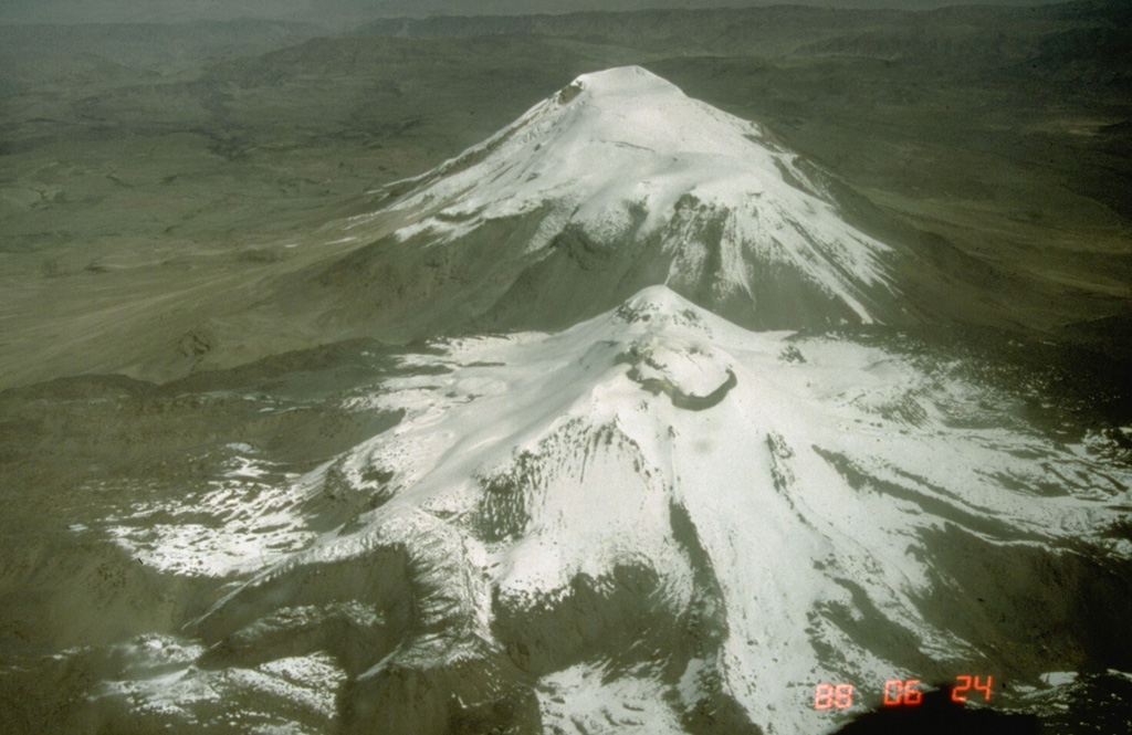
Nevado del Ruiz (Colombia) | 9 November-15 November 2022 | Continuing ActivityCite this Report |
 Nevado del Ruiz Nevado del Ruiz
Northern Andean Volcanic Arc
|
Servicio Geológico Colombiano’s (SGC) reported that during 8-14 November seismicity associated with rock fracturing at Nevado del Ruiz increased in number and energy compared to the previous week. Some of the signals were associated with gas-and-ash emissions. The hypocenters were located 0.6-7 km deep. The largest event was an M 3.1 that was recorded at 0225 on 10 November at a depth of 3.6 km below the crater and 2.7 km SW of the crater. The Washington VAAC reported ash plumes that rose to 6.4-7.3 km altitude (21,000-24,000 ft) and drifted S and SE on 11 November, based on satellite and webcam images. During 13-14 November ash plumes rose to 6.7 km altitude (22,000 ft) and drifted NE based on satellite and webcam images. Several low-to-moderate thermal anomalies in Arenas Crater were identified in satellite images. Gas-and-steam plumes (mainly sulfur dioxide) continued to be emitted, rising as high as 1.8 km above the summit on 8 November and drifting NW, SW, SE, and NE. The Alert Level remained at 3 (Yellow; the second lowest level on a four-color scale).
Sources: Servicio Geológico Colombiano (SGC), Washington Volcanic Ash Advisory Center (VAAC)
|
Pavlof (United States) | 9 November-15 November 2022 | Continuing ActivityCite this Report |
 Pavlof Pavlof
Aleutian Ridge Volcanic Arc
|
AVO reported that a minor eruption at a vent on Pavlof’s upper E flank was ongoing during 9-15 November and nearly continuous seismic tremor was recorded. Multiple explosions were detected almost daily in seismic and infrasound data. Elevated surface temperatures were seen in cloudy satellite images during 10 and 12-15 November. Clear webcam images taken on 12 and 15 November showed a lava flow and ash deposits on the upper flanks, though due to cloudy conditions earlier in the week the timing of these events is uncertain. Nighttime crater incandescence was visible in webcam images on 14 and 15 November. The Volcano Alert Level remained at Watch (the second highest level on a four-level scale) and the Aviation Color Code remained at Orange (the second highest level on a four-color scale).
Source: US Geological Survey Alaska Volcano Observatory (AVO)
|
Popocatepetl (Mexico) | 9 November-15 November 2022 | Continuing ActivityCite this Report |
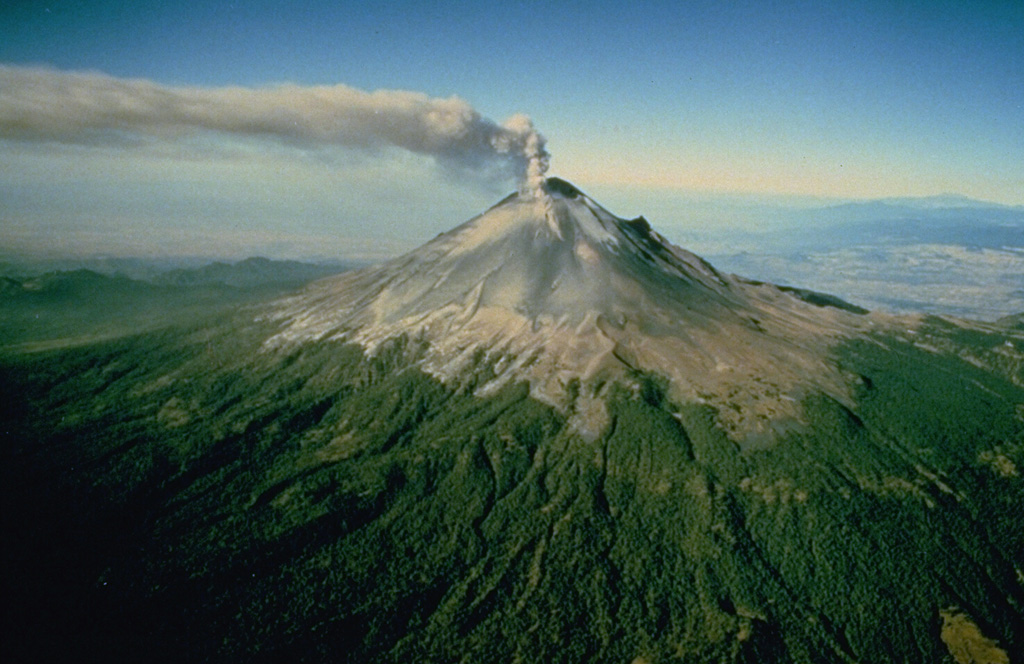 Popocatepetl Popocatepetl
Trans-Mexican Volcanic Arc
|
CENAPRED reported that there were 39-108 steam-and-gas emissions, sometimes containing minor amounts of ash, rising from Popocatépetl each day during 9-15 November. Weather clouds often prevented visual observations of activity. The seismic network recorded daily periods of tremor lasting from 33 minutes to 302 minutes. According to the Washington VAAC, daily ash plumes rose to 5.8-7.6 km altitude (19,000-25,000 ft) and drifted SW, S, SE, and E. Four minor explosions were detected at 1337, 1625, 1629, and 2026 on 10 November. Another four minor explosions were detected at 0141, 1109, 1223, and 1519 on 11 November. Three minor explosions were recorded at 0919, 1933, and 2057 on 12 November. Three minor explosions were detected at 1302 on 13 November, and four minor explosions at 0131, 0615, 1459, and 2330 on 14 November. A minor explosion was also detected at 0710 on 15 November. A total of five volcano-tectonic earthquakes were recorded on 11 and 12 November. Light ashfall was reported in Tochimilco, Puebla on 10 November. The Alert Level remained at Yellow, Phase Two (the middle level on a three-color scale).
Sources: Centro Nacional de Prevencion de Desastres (CENAPRED), Washington Volcanic Ash Advisory Center (VAAC)
|
Reventador (Ecuador) | 9 November-15 November 2022 | Continuing ActivityCite this Report |
 Reventador Reventador
Northern Andean Volcanic Arc
|
IG described the ongoing eruption at Reventador as moderate during 9-15 November. Daily seismicity was characterized by 18-47 explosions, 22-45 long-period earthquakes, and 2-18 signals that indicated emissions. During 9-12 November there were also 1-4 periods of daily harmonic tremor. Gas, steam, and ash plumes, observed almost daily with webcams or reported by the Washington VAAC, rose as high as 1.3 km above the summit and drifted S, W, SW, N, and NW. Crater incandescence was occasionally visible at night and the lava flow on the NE flank was active. Sulfur dioxide emissions averaged 22, 20.2, and 174.9 tons per day on 9, 11, and 12 November, respectively. An incandescent avalanche was visible on the N flank during the night of 9 November; by 10 November it had traveled to 800 m below the crater.
Source: Instituto Geofísico-Escuela Politécnica Nacional (IG-EPN)
|
Sabancaya (Peru) | 9 November-15 November 2022 | Continuing ActivityCite this Report |
 Sabancaya Sabancaya
Central Andean Volcanic Arc
|
Instituto Geofísico del Perú (IGP) reported moderate levels of activity at Sabancaya during 7-13 November with a daily average of 33 explosions. Gas-and-ash plumes rose as high as 3 km above the summit and drifted S, E, and NE. As many as five thermal anomalies originating from the lava dome in the summit crater were identified in satellite data. Minor inflation continued to be detected near Hualca Hualca (4 km N). The Alert Level remained at Orange (the second highest level on a four-color scale) and the public were warned to stay outside of a 12-km radius.
Source: Instituto Geofísico del Perú (IGP)
|
Sangay (Ecuador) | 9 November-15 November 2022 | Continuing ActivityCite this Report |
 Sangay Sangay
Northern Andean Volcanic Arc
|
IG reported a high level of activity at Sangay during 9-15 November, which included daily explosions, volcanic tremor, and gas-and-steam emissions. Incandescence at the summit was periodically visible at night. Daily ash-and-gas plumes were identified in either or both IG webcam images and satellite images according to the Washington VAAC. Plumes generally rose as high as 1.8 m above the volcano and drifted SW, W, S, N, and NW. Moderate ashfall was reported in Zuñac on 9 November. During 10-14 November an incandescent avalanche was observed descending the SE flank during the night.
Source: Instituto Geofísico-Escuela Politécnica Nacional (IG-EPN)
|
Santa Maria (Guatemala) | 9 November-15 November 2022 | Continuing ActivityCite this Report |
 Santa Maria Santa Maria
Central America Volcanic Arc
|
INSIVUMEH reported that nighttime incandescence was observed in the crater of Santa María’s Santiaguito lava-dome complex during 9-15 November. The lava flows continued to descend the San Isidro and El Tambor drainages, as well as the S flank. Block-and-ash avalanches from the dome, and from the middle and front of the lava flows, descended the W, SW, and S flanks. Fine ash fell on the perimeter of the volcano. Moderate gas-and-steam plumes rose as high as 500-700 m above the dome complex that extended 3-6 km E, SE, S, SW, and W.
Source: Instituto Nacional de Sismologia, Vulcanologia, Meteorologia, e Hidrologia (INSIVUMEH)
|
Semeru (Indonesia) | 9 November-15 November 2022 | Continuing ActivityCite this Report |
 Semeru Semeru
Sunda Volcanic Arc
|
PVMBG reported that the eruption at Semeru continued during 9-15 November. A pyroclastic flow was observed descending the SE flank as far as 4.5 km at 1550 on 9 November. The event also generated a white-gray ash plume that rose 1.5 km above the summit and drifted NE. On 14 November an ash plume rose to 3.9 km altitude and drifted SW, according to the Darwin VAAC. White gas-and-steam emissions rose 100-1,000 m above the summit and drifted N, NE, S, and SW. The Alert Level remained at 3 (on a scale of 1-4). The public was warned to stay at least 5 km away from the summit, and 500 m from Kobokan drainages within 17 km of the summit, along with other drainages originating on Semeru, including the Bang, Kembar, and Sat, due to lahar, avalanche, and pyroclastic flow hazards.
Source: Pusat Vulkanologi dan Mitigasi Bencana Geologi (PVMBG, also known as CVGHM)
|
Sheveluch (Russia) | 9 November-15 November 2022 | Continuing ActivityCite this Report |
 Sheveluch Sheveluch
Eastern Kamchatka Volcanic Arc
|
KVERT reported that the ongoing eruption at Sheveluch during 3-10 November was generally characterized by explosions, hot avalanches, lava-dome extrusion, and strong fumarolic activity. A daily thermal anomaly was identified in satellite images. Collapses generated hot avalanches and ash plumes that drifted 400 km N, NE, and E during 5-7 November. The Aviation Color Code remained at Orange (the second highest level on a four-color scale). Dates are based on UTC times; specific events are in local time where noted.
Source: Kamchatkan Volcanic Eruption Response Team (KVERT)
|
Suwanosejima (Japan) | 9 November-15 November 2022 | Continuing ActivityCite this Report |
 Suwanosejima Suwanosejima
Ryukyu Volcanic Arc
|
JMA reported that the eruption at Suwanosejima's Ontake Crater continued during 9-15 November and crater incandescence was visible nightly. An explosion at 2238 on 11 November produced an eruption plume that rose 1.6 km above the crater rim. Ash plumes during 15 November rose 1-1.3 km above the crater and drifted SE. The Alert Level remained at 3 (on a 5-level scale), and residents were warned to stay 2 km away from the crater.
Source: Japan Meteorological Agency (JMA)
|

 Ahyi
Ahyi Ambae
Ambae Kavachi
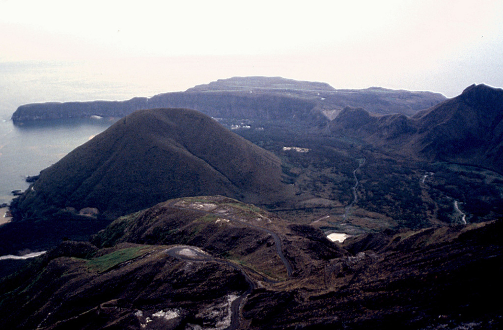 Kikai
Kikai