Ahyi (United States) | 18 January-24 January 2023 | Continuing Activity Cite this Report Cite this Report |
 Ahyi Ahyi
Mariana Volcanic Arc
|
Unrest at Ahyi Seamount was occasionally detected during 17-24 January. Pressure sensors on Wake Island, 2,270 km E of Ahyi Seamount, detected one small signal during 22-23 January. No activity was observed in mostly cloudy satellite images. The Aviation Color Code remained at Yellow (the second lowest level on a four-color scale) and the Volcano Alert Level remained at Advisory (the second lowest level on a four-level scale).
Source: US Geological Survey
|
Aira (Japan) | 18 January-24 January 2023 | Continuing ActivityCite this Report |
 Aira Aira
Ryukyu Volcanic Arc
|
JMA reported ongoing eruptive activity at Minamidake Crater (at Aira Caldera’s Sakurajima volcano) during 14-23 January. Crater incandescence was visible nightly. An explosion at 1215 on 18 January produced an ash plume that rose 1.4 km above the crater rim and ejected blocks as far as 1.1 km. Sulfur dioxide emissions were high at 1,400 tons per day. An explosion at 0659 on 19 January generated an ash plume that rose 1.3 km and ejected blocks 600-900 m and an explosion at 0307 on 21 January generated an ash plume that rose 1.6 km and ejected blocks as far as 1.1 km. Occasional very small eruptive events were recorded during 21-22 January. The Alert Level remained at 3 (on a 5-level scale), and residents were warned to stay 2 km away from the crater.
Source: Japan Meteorological Agency (JMA)
|
Cotopaxi (Ecuador) | 18 January-24 January 2023 | Continuing ActivityCite this Report |
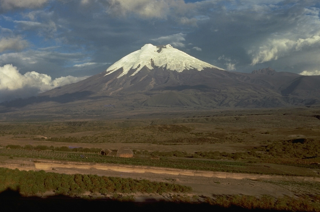 Cotopaxi Cotopaxi
Northern Andean Volcanic Arc
|
IG reported that the eruption at Cotopaxi continued during 18-24 January, characterized by daily emissions of steam, gas, and ash. The plumes were visible in webcam images and reported by the Washington VAAC, though sometimes weather conditions prevented observations. They rose as high as 2 km and drifted in various directions and caused ashfall in Chillos (33 km SW), Langualó, San Isidro Alto (20 km SW), and San Agustín del Callo (18 km WSW) during 17-18 January and in San Isidro Alto, Chillos and Langualó Chico during 18-19 January. Servicio Nacional de Gestión de Riesgos y Emergencias (SNGRE) maintained the Alert Level at Yellow (the second lowest level on a four-color scale).
Source: Instituto Geofísico-Escuela Politécnica Nacional (IG-EPN)
|
Ebeko (Russia) | 18 January-24 January 2023 | Continuing ActivityCite this Report |
 Ebeko Ebeko
Kuril Volcanic Arc
|
KVERT reported that moderate activity at Ebeko was ongoing during 12-19 January. According to volcanologists in Severo-Kurilsk (Paramushir Island, about 7 km E) explosions on 13 January generated ash plumes that rose as high as 3 km (10,000 ft) a.s.l. and drifted SE. A thermal anomaly was identified in satellite images on 13 and 16 January. The Aviation Color Code remained at Orange (the second highest level on a four-color scale). Dates are based on UTC times; specific events are in local time where noted.
Source: Kamchatkan Volcanic Eruption Response Team (KVERT)
|
Etna (Italy) | 18 January-24 January 2023 | Continuing ActivityCite this Report |
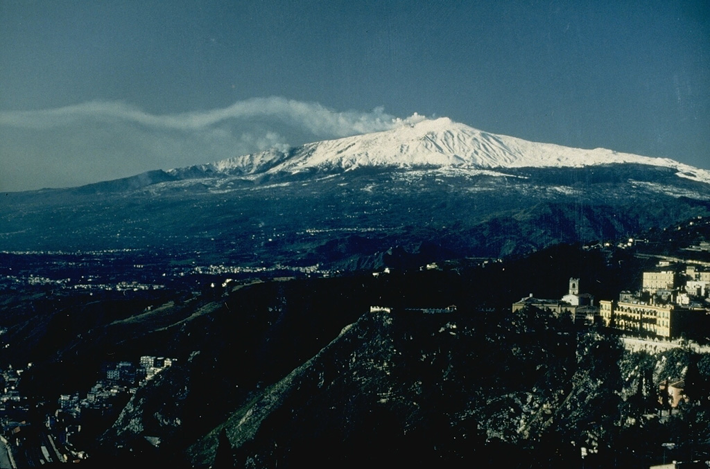 Etna Etna
Sicily Volcanic Province
|
INGV reported that the vents at the NE base of Etna’s SE Crater, in the Valle del Leone at about 2,800 m elevation, continued to feed lava flows during 16-22 January, though the rate notably fluctuated. Lava effusion progressively decreased during 16-17 January and had possibly ceased by the late afternoon of 17 January. Effusion restarted in the early hours of 18 January, generating two lava flows. One of the flows traveled NE along the W edge of the lava field, and the other traveled E onto the steep W wall of Valle del Bove, reaching the base of the wall on 20 January. The effusion rate decreased on 21 January and the again increased during the evening. Late on 22 January a new lava flow descended the Valle del Bove, almost reaching the base of the W wall at around 2,200 m elevation.
Source: Sezione di Catania - Osservatorio Etneo (INGV)
|
Great Sitkin (United States) | 18 January-24 January 2023 | Continuing ActivityCite this Report |
 Great Sitkin Great Sitkin
Aleutian Ridge Volcanic Arc
|
AVO reported that slightly elevated surface temperatures at Great Sitkin were identified in satellite images on 18 January, suggesting continuing lava effusion at a low rate primarily to the S and E. A few small earthquakes were detected on most days by the local seismic network. No activity was observed in mostly cloudy satellite and web camera images during 19-24 January. The Volcano Alert Level remained at Watch (the second highest level on a four-level scale) and the Aviation Color Code remained at Orange (the second highest level on a four-color scale).
Source: US Geological Survey Alaska Volcano Observatory (AVO)
|
Ibu (Indonesia) | 18 January-24 January 2023 | Continuing ActivityCite this Report |
 Ibu Ibu
Halmahera Volcanic Arc
|
PVMBG reported that the eruption at Ibu continued during 17-24 January. Daily white-and-gray plumes of variable densities rose 200-1,000 m above the summit and drifted in multiple directions. The Alert Level remained at a 2 (on a scale of 1-4), and the public was warned to stay at least 2 km away from the active crater and 3.5 km away on the N side.
Source: Pusat Vulkanologi dan Mitigasi Bencana Geologi (PVMBG, also known as CVGHM)
|
Krakatau (Indonesia) | 18 January-24 January 2023 | Continuing ActivityCite this Report |
 Krakatau Krakatau
Sunda Volcanic Arc
|
PVMBG reported that the eruption at Anak Krakatau intensified at the end of the week during 17-23 January. White steam-and-gas plumes rose as high as 200 m above the summit and drifted NE, E, and S. Strombolian activity was visible in webcam images at 0041, 0043, and 0450 on 23 January. At 0607 and 0701 dense gray ash plumes rose 300 m above summit and drifted E. At 0758, 0759, 0808, and 0928 dense gray-to-black ash plumes rose 200-500 m and drifted SE. Webcam photos showed progressively intensifying Strombolian activity at 1919, 1958, and 2113 on 24 January. A dense gray ash plume rose 300 m and drifted E at 1957. The Alert Level remained at 3 (on a scale of 1-4), and the public was warned to stay at least 5 km away from the crater.
Source: Pusat Vulkanologi dan Mitigasi Bencana Geologi (PVMBG, also known as CVGHM)
|
Lascar (Chile) | 18 January-24 January 2023 | Continuing ActivityCite this Report |
 Lascar Lascar
Central Andean Volcanic Arc
|
SERNAGEOMIN reported that after the 19 December 2022 eruption at Láscar, activity levels had returned to baseline. During 1-15 January sulfur dioxide emissions detected by a Differential Absorption Optical Spectroscopy (DOAS) instrument located 6 km ESE of the crater measured an average value of around 483 tonnes per day, with a maximum value of 881 tonnes per day on 13 January. These values were at normal levels. Occasional low-level thermal anomalies were identified in satellite images and corresponded to passive degassing from the vents in the summit crater. The maximum height of white gas plumes was 1.4 km above the crater rim, recorded on 11 January. On 19 January the Alert Level was lowered to Green (the lowest level on a four-color scale) and the public were warned to stay at least 700 m away from the crater. ONEMI reported that a “Preventive Early Warning” was declared for San Pedro de Atacama (70 km NW).
Sources: Servicio Nacional de Geología y Minería (SERNAGEOMIN), Oficina Nacional de Emergencia-Ministerio del Interior (ONEMI)
|
Lewotolok (Indonesia) | 18 January-24 January 2023 | Continuing ActivityCite this Report |
 Lewotolok Lewotolok
Sunda Volcanic Arc
|
PVMBG reported that the eruption at Lewotolok was ongoing during 17-24 January. Nighttime webcam images captured almost daily showed incandescent material being ejected above the summit crater. White steam-and-gas plumes were visible on most days rising as high has 250 m above the summit. Emissions during 18-20 January were white-and-gray and rose as high as 400 m and drifted NE and E. The Alert Level remained at 2 (on a scale of 1-4) and the public was warned to stay 2 km away from the summit crater.
Source: Pusat Vulkanologi dan Mitigasi Bencana Geologi (PVMBG, also known as CVGHM)
|
Merapi (Indonesia) | 18 January-24 January 2023 | Continuing ActivityCite this Report |
 Merapi Merapi
Sunda Volcanic Arc
|
BPPTKG reported that the eruption at Merapi continued during 12-19 January and seismicity remained at high levels. The SW lava dome produced three lava avalanches that traveled as far as 1.2 km down the SW flank (upstream in the Kali Bebeng drainage). Avalanche sounds were heard on six occasions. No significant morphological changes to the central and SW lava domes were evident in webcam images. The Alert Level remained at 3 (on a scale of 1-4), and the public was warned to stay 3-7 km away from the summit based on location.
Source: Balai Penyelidikan dan Pengembangan Teknologi Kebencanaan Geologi (BPPTKG)
|
Nevado del Ruiz (Colombia) | 18 January-24 January 2023 | Continuing ActivityCite this Report |
 Nevado del Ruiz Nevado del Ruiz
Northern Andean Volcanic Arc
|
Servicio Geológico Colombiano (SGC) reported that at 0710 on 23 January an ash cloud rose from Nevado del Ruiz and drifted NW, causing ashfall in the municipality of Manizales (27 km NW). The ash emission occurred simultaneously with a seismic signal that indicated moving fluids within the volcano’s conduit. The Alert Level remained at 3 (Yellow; the second lowest level on a four-color scale).
Source: Servicio Geológico Colombiano (SGC)
|
Pavlof (United States) | 18 January-24 January 2023 | Continuing ActivityCite this Report |
 Pavlof Pavlof
Aleutian Ridge Volcanic Arc
|
AVO reported that the eruption at Pavlof has ended. No explosions had been detected since [7 December] and seismicity had decreased to background levels. Weakly elevated surface temperatures and minor steaming from the recently active vent continue to be observed intermittently in satellite and webcam images, consistent with the cooling of previously erupted lava. On 19 January AVO lowered the Volcano Alert Level to Normal (the lowest level on a four-level scale) and the Aviation Color Code to Green (the lowest level on a four-color scale).
Source: US Geological Survey Alaska Volcano Observatory (AVO)
|
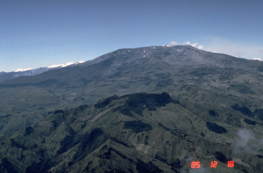
Popocatepetl (Mexico) | 18 January-24 January 2023 | Continuing ActivityCite this Report |
 Popocatepetl Popocatepetl
Trans-Mexican Volcanic Arc
|
CENAPRED reported that there were 94-206 steam-and-gas emissions, sometimes containing ash, rising from Popocatépetl each day during 17-24 January. The plumes drifted N, NE, and N. Minor ashfall was reported in the municipalities of Domingo Arenas, San Nicolas de los Ranchos, Santiago Xalizintla, in the town of San Mateo Ozolco in Calpan, state of Puebla and in the municipalities of Tlaxcala and Papalotla, state of Tlaxcala on 17 January. On 21 January an ash plume rose as high as 3 km and drifted NNE and one minor explosion was detected. Four explosions were recorded during 21-22 January and six were recorded during 23-24 January. The Alert Level remained at Yellow, Phase Two (the middle level on a three-color scale).
Source: Centro Nacional de Prevencion de Desastres (CENAPRED)
|
Reventador (Ecuador) | 18 January-24 January 2023 | Continuing ActivityCite this Report |
 Reventador Reventador
Northern Andean Volcanic Arc
|
IG described the ongoing eruption at Reventador as moderate during 17-24 January. Daily seismicity was characterized by explosions, long-period earthquakes, periods of harmonic tremor, and signals that indicated emissions. The daily count of explosions ranged from 22-96; seismic data transmission was interrupted during 22-23 January. Although weather clouds often prevented observations of the summit, daily gas, steam, and ash plumes were observed in IG webcam images and described in Washington VAAC volcanic activity notifications almost daily. The plumes rose as high as 2.2 km above the volcano and drifted in multiple directions. Crater incandescence was visible nightly and incandescent blocks were ejected onto the flanks sometimes in all directions; incandescent blocks were also visible rolling as far as 800 m down the flanks. Servicio Nacional de Gestión de Riesgos y Emergencias (SNGRE) maintained the Alert Level at Orange (the second highest level on a four-color scale).
Sources: Instituto Geofísico-Escuela Politécnica Nacional (IG-EPN), Servicio Nacional de Gestión de Riesgos y Emergencias (SNGRE)
|
Sangay (Ecuador) | 18 January-24 January 2023 | Continuing ActivityCite this Report |
 Sangay Sangay
Northern Andean Volcanic Arc
|
IG reported a high level of activity at Sangay during 17-24 January, which included daily explosions, long-period earthquakes, and gas, steam, and ash emissions. The daily count of explosions ranged from 53-122, though seismic data transmission was sometimes interrupted. Almost daily gas, steam, and ash plumes were either observed in IG webcam images or described in Washington VAAC volcanic activity notifications; weather clouds often prevented observations of the summit. The plumes rose as high as 1.5 km above the volcano and drifted in multiple directions. Multiple thermal anomalies were identified in satellite images on most days. Crater incandescence from the crater and from material on the SE flank was visible at night during 21-22 January. Servicio Nacional de Gestión de Riesgos y Emergencias (SNGRE) maintained the Alert Level at Yellow (the second lowest level on a four-color scale).
Sources: Instituto Geofísico-Escuela Politécnica Nacional (IG-EPN), Servicio Nacional de Gestión de Riesgos y Emergencias (SNGRE)
|
Semeru (Indonesia) | 18 January-24 January 2023 | Continuing ActivityCite this Report |
 Semeru Semeru
Sunda Volcanic Arc
|
PVMBG reported that the eruption at Semeru continued during 17-24 January. Daily dense white-and-gray ash plumes generally rose 500-800 m above the summit and drifted N, NE, SE, and S. Ash plumes rose as high as 1 km and drifted SE at 0628 on 19 January. The Alert Level remained at 3 (on a scale of 1-4). The public was warned to stay at least 5 km away from the summit, and 500 m from Kobokan drainages within 17 km of the summit, along with other drainages originating on Semeru, including the Bang, Kembar, and Sat, due to lahar, avalanche, and pyroclastic flow hazards.
Source: Pusat Vulkanologi dan Mitigasi Bencana Geologi (PVMBG, also known as CVGHM)
|
Sheveluch (Russia) | 18 January-24 January 2023 | Continuing ActivityCite this Report |
 Sheveluch Sheveluch
Eastern Kamchatka Volcanic Arc
|
KVERT reported that the ongoing eruption at Sheveluch during 12-19 January was generally characterized by explosions, hot avalanches, lava-dome extrusion, and strong fumarolic activity. A daily thermal anomaly was identified in satellite images. Explosions on 19 January produced ash plumes that were identified in satellite images rising as high as 10 km (32,800 ft) a.s.l. and drifting W at 1240 local time. KVERT raised the Aviation Color Code to Red (the highest level on a four-color scale). In a Volcano Observatory Notice for Aviation (VONA) posted at 1635 local time KVERT noted that no additional plumes were identified in satellite images. The Aviation Color Code was lowered to Orange. Dates are based on UTC times; specific events are in local time where noted.
Source: Kamchatkan Volcanic Eruption Response Team (KVERT)
|
Stromboli (Italy) | 18 January-24 January 2023 | Continuing ActivityCite this Report |
 Stromboli Stromboli
Aeolian Volcanic Arc
|
INGV reported that both explosive and effusive activity at Stromboli occurred during 23-29 January at four vents in Area N, within the upper part of the Sciara del Fuoco, and at two vents in the Area C-S (South-Central Crater area) in the crater terrace area. Explosions at vents N1 and N2 in Area N were variable in intensity and ejected coarse material (bombs and lapilli) 80-150 m at a rate of 4-6 explosions per hour. Intense spattering occasionally occurred at N2 vents. Explosive activity at the Central-South area (CS) ejected fine-to-coarse material as high as 150 m above the vent at a rate of 6-7 explosions per hour during 23-27 January; the rate decreased to less than one event per hour the rest of the week.
At 1419 on 24 January lava overflowed vents in the N2 area after a period of intense spattering. The lava flowed partially down the Sciara del Fuoco, and by the next morning, they were cooling. A major explosion began at 1007 on 30 January that lasted three minutes long. Coarse pyroclastic material was ejected several hundred meters high and was deposited on the crater terrace and the upper parts of the Sciara del Fuoco. An ash cloud quickly dispersed to the S.
Source: Sezione di Catania - Osservatorio Etneo (INGV)
|
Suwanosejima (Japan) | 18 January-24 January 2023 | Continuing ActivityCite this Report |
 Suwanosejima Suwanosejima
Ryukyu Volcanic Arc
|
JMA reported that the eruption at Suwanosejima's Ontake Crater continued during 16-23 January. No explosions were recorded, though eruption plumes rose as high as 1.2 km above the crater rim and blocks were ejected as far as 300 m from the vent. Ashfall was occasionally reported in Toshima village (3.5 km SSW). JMA noted that the number of explosions began decreasing in mid-October 2022 and the last explosion was recorded on 16 November. Additionally, plume heights had occasionally risen higher than 2 km above the crater rim during October-November 2022, but starting in December the heights had generally been at or below 1 km. Other data had also indicated low levels of activity; the probability of material being ejected more than 1 km away from the crater had decreased. The Alert Level was lowered to 2 (on a 5-level scale) on 24 January, and residents were warned to stay 1 km away from the crater.
Source: Japan Meteorological Agency (JMA)
|
Villarrica (Chile) | 18 January-24 January 2023 | Continuing ActivityCite this Report |
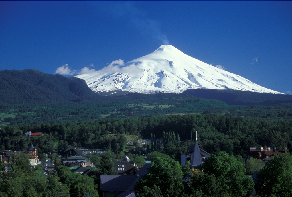 Villarrica Villarrica
Southern Andean Volcanic Arc
|
SERNAGEOMIN reported that the eruption at Villarrica was ongoing during 17-24 January. Daily minor Strombolian explosions from a vent on the crater floor ejected incandescent material that generally rose as high as 100 m above the crater rim and fell back down in and around the crater. On 19 January POVI noted that lava was ejected as high as 140 m above the crater rim and onto the W and SW flanks. Explosion noises were heard on 19 and 22 January in areas within a radius of 10 km. The Alert Level remained at Yellow (the second lowest level on a four-color scale). ONEMI maintained the Alert Level at Yellow (the middle level on a three-color scale) for the municipalities of Villarrica, Pucón (16 km N), Curarrehue, and the commune of Panguipulli.
Sources: Servicio Nacional de Geología y Minería (SERNAGEOMIN), Oficina Nacional de Emergencia-Ministerio del Interior (ONEMI), Proyecto Observación Villarrica Internet (POVI)
|
Whakaari/White Island (New Zealand) | 18 January-24 January 2023 | Continuing ActivityCite this Report |
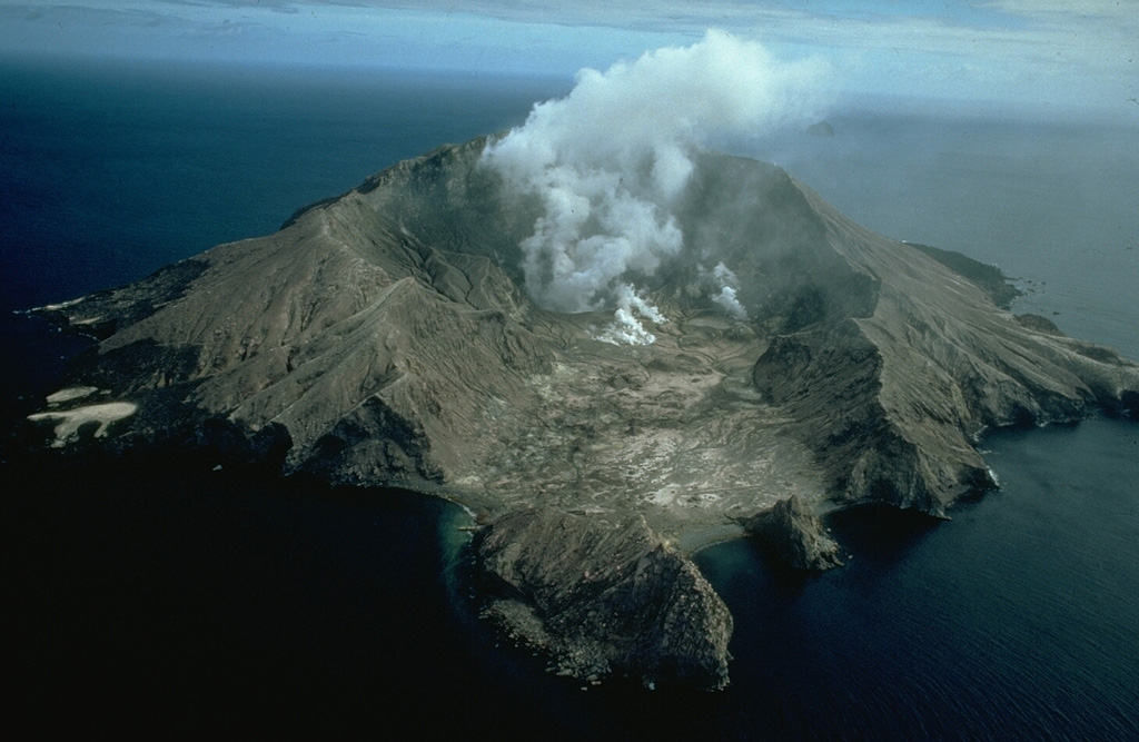 Whakaari/White Island Whakaari/White Island
Taupo Volcanic Arc
|
On 24 January GeoNet reported continuing unrest at Whakaari/White Island characterized by minor-to-moderate gas-and-steam emissions and low levels of gas. The activity was confirmed during an overflight on 16 January. Sulfur dioxide gas emissions were low, averaging around 33 tonnes per day, and carbon dioxide emissions were moderate, averaging around 705 tonnes per day; the gas levels had declined compared to the 6 December 2022 measurements. No notable changes to the lake were visible aside from minor fluctuations of the lake level. No signs of ash emissions or other eruptive activity were observed. The Aviation Color Code remained at Yellow (the second lowest level on a four-color scale) and the Volcanic Alert Level remained at 2 (on a scale of 0-5).
Source: GeoNet
|

 Dieng Volcanic Complex
 Kilauea
 Marapi
 Semisopochnoi