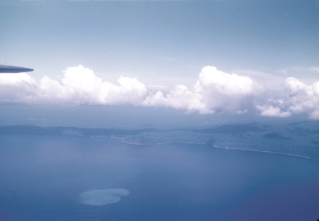
Aira (Japan) | 30 August-5 September 2023 | Continuing Activity Cite this Report Cite this Report |
 Aira Aira
Ryukyu Volcanic Arc
|
JMA reported ongoing activity at both Minamidake Crater and Showa Crater (Aira Caldera’s Sakurajima volcano) during 28 August-4 September. Incandescence at Minamidake was observed nightly. An explosion at 0640 on 31 August from the same crater ejected large blocks 400 m away and likely produced a plume that was obscured by weather clouds. Very small eruptive events continued to be detected during the rest of the week. A very small eruption at Showa Crater was also recorded on 4 September. The Alert Level remained at 3 (on a 5-level scale), and the public was warned to stay 2 km away from both craters.
Source: Japan Meteorological Agency (JMA)
|
Dukono (Indonesia) | 30 August-5 September 2023 | Continuing ActivityCite this Report |
 Dukono Dukono
Halmahera Volcanic Arc
|
PVMBG reported that the eruption at Dukono was ongoing during 30 August-4 September. Dense white-and-gray plumes rose as high as 400 m above the summit and drifted E, NW, and W during 31 August and 2-5 September; weather conditions sometimes prevented views. The Alert Level remained at Level 2 (on a scale of 1-4), and the public was warned to remain outside of the 2-km exclusion zone.
Source: Pusat Vulkanologi dan Mitigasi Bencana Geologi (PVMBG, also known as CVGHM)
|
East Epi (Vanuatu) | 30 August-5 September 2023 | Continuing ActivityCite this Report |
 East Epi East Epi
Vanuatu Volcanic Arc
|
On 31 August the Vanuatu Meteorology and Geo-Hazards Department (VMGD) reported that minor unrest continued at Epi. Volcanic seismicity was sustained, though no surficial activity was observed. The Alert Level remained at 1 (on a scale of 0-5) and the public was warned to stay outside of the Danger Zone, defined as a 2-km radius around the active vent.
Source: Vanuatu Meteorology and Geohazards Department (VMGD)
|
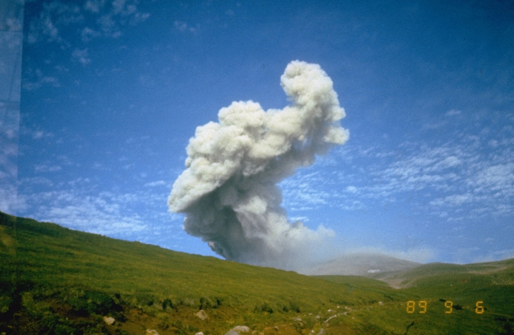
Ebeko (Russia) | 30 August-5 September 2023 | Continuing ActivityCite this Report |
 Ebeko Ebeko
Kuril Volcanic Arc
|
KVERT reported that moderate explosive activity at Ebeko was ongoing during 24-31 August. According to volcanologists in Severo-Kurilsk (Paramushir Island, about 7 km E), explosions during 27-31 August generated ash plumes that rose as high as 3.5 km (11,500 ft) a.s.l and drifted to the E and SE. A thermal anomaly was identified in satellite images during 27 and 29-30 August; weather clouds obscured views on other days. The Aviation Color Code remained at Orange (the third level on a four-color scale). Dates are based on UTC times; specific events are in local time where noted.
Source: Kamchatkan Volcanic Eruption Response Team (KVERT)
|
Great Sitkin (United States) | 30 August-5 September 2023 | Continuing ActivityCite this Report |
 Great Sitkin Great Sitkin
Aleutian Ridge Volcanic Arc
|
AVO reported that slow lava effusion continued at Great Sitkin during 30 August-5 September, producing a thick flow in the summit crater that expanded E, based on a satellite image from 30 August and fieldwork. Seismicity was low; two earthquakes were detected during 2-4 September and five were recorded during 4-5 September. An AVO field geology team visited the volcano on 1 September and sampled the lava flow, did airborne photography and thermal imaging surveys, and measured gas emissions. During a visit on 3 September the team observed that the flows were warm and steaming, moving about 1 m every 3-4 days. Weakly elevated surface temperatures were identified in satellite data during 4-5 September. The Volcano Alert Level remained at Watch (the third level on a four-level scale) and the Aviation Color Code remained at Orange (the third color on a four-color scale).
Source: US Geological Survey Alaska Volcano Observatory (AVO)
|
Ibu (Indonesia) | 30 August-5 September 2023 | Continuing ActivityCite this Report |
 Ibu Ibu
Halmahera Volcanic Arc
|
PVMBG reported that Ibu continued to erupt during 30 August-4 September. Daily white-and-gray ash emissions generally rose as high as 800 m above the summit and drifted E, NE, N, and SW. Gray ash plumes rose as high as 1.5 km on 31 August that drifted N and NE, and as high as 1 km on 5 September and drifted W and NW. The Alert Level remained at a 2 (the second highest level on a four-level scale), and the public was advised to stay outside of the 2 km hazard zone, and to stay 3.5 km away from the N area of the active crater.
Source: Pusat Vulkanologi dan Mitigasi Bencana Geologi (PVMBG, also known as CVGHM)
|
Karangetang (Indonesia) | 30 August-5 September 2023 | Continuing ActivityCite this Report |
 Karangetang Karangetang
Sangihe Volcanic Arc
|
PVMBG reported that dense white gas-and-steam plumes from Karangetang were visible daily rising as high as 200 m and drifting multiple directions during 30 August-5 September. Weather clouds sometimes prevented views of the summit. According to news articles, incandescent lava avalanches from Main Crater (S crater) traveled as far as 1.5 km down the Batuawang and Kahetang drainages and as far as 1 km down the Batang, Timbelang, and West Beha drainages. Incandescence at the S and N craters continued to be visible. The Alert Level remained at 3 (on a scale of 1-4) and the public were advised to stay 2.5 km away from Main Crater with an extension to 3.5 km on the S and SE flanks.
Sources: Pusat Vulkanologi dan Mitigasi Bencana Geologi (PVMBG, also known as CVGHM), Antara News, Antara News, Antara News, Antara News
|
Klyuchevskoy (Russia) | 30 August-5 September 2023 | Continuing ActivityCite this Report |
 Klyuchevskoy Klyuchevskoy
Eastern Kamchatka Volcanic Arc
|
KVERT reported that the explosive Strombolian eruption at Klyuchevskoy continued during 24-31 August and a daily bright thermal anomaly was identified in satellite images. A plume of ash resuspended by strong winds drifted 95 km E at 3-3.5 km (10,000-11,500 ft) a.s.l., prompting KVERT to raise the Aviation Color Code to Orange (the third level on a four-color scale) at 1240 on 4 September, local time. By 1940 the plume had drifted as far as 170 km E, remining at the same altitudes; the Aviation Color Code was lowered back to Yellow at 1954 (local time). The Aviation Color Code was again raised to Orange for a few hours, during 1532-1808 local time on 5 September, due to plumes of resuspended ash drifting 120 km ENE. KVERT noted that Strombolian activity continued, feeding a lava flow that advanced down the Kozyrevsky drainage on the SW flank. Dates are based on UTC times; specific events are in local time where noted.
Source: Kamchatkan Volcanic Eruption Response Team (KVERT)
|
Lewotolok (Indonesia) | 30 August-5 September 2023 | Continuing ActivityCite this Report |
 Lewotolok Lewotolok
Sunda Volcanic Arc
|
PVMBG reported that the eruption at Lewotolok continued during 30 August-5 September. Almost daily white steam-and-gas plumes rose as high as 700 m above the summit and drifted W and NW. White-and-gray ash plumes rose as high as 700 m and drifted E, SW, and W on 1 September. A Volcano Observatory Notices for Aviation (VONA) described an ash plume rising 500 m and drifting SE on 3 September; a webcam image showed incandescent material at the crater and on the upper flank. The Alert Level remained at 2 (on a scale of 1-4) and the public was warned to stay at least 2 km away from the summit crater.
Source: Pusat Vulkanologi dan Mitigasi Bencana Geologi (PVMBG, also known as CVGHM)
|
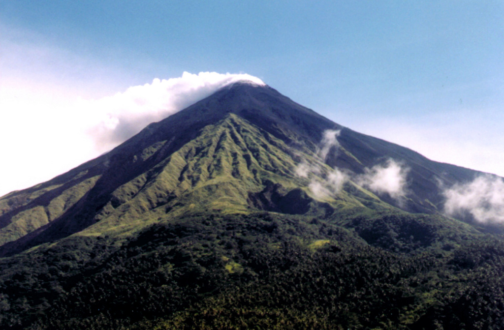
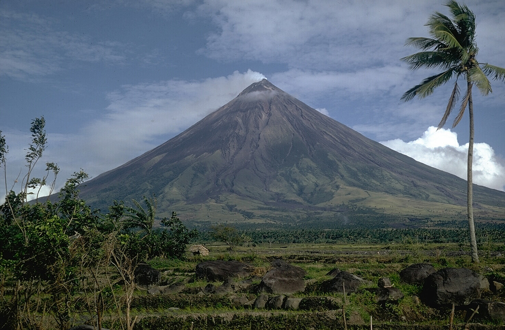
Mayon (Philippines) | 30 August-5 September 2023 | Continuing ActivityCite this Report |
 Mayon Mayon
Eastern Philippine Volcanic Arc
|
PHIVOLCS reported that the eruption at Mayon continued during 30 August-5 September, with slow lava effusion from the summit crater feeding flows on the S, SE, and E flanks. The lengths of the lava flow in the Mi-Isi (S), Bonga (SE), and Basud (E) drainages remained at 2.8 km, 3.4 km, and 1.1 km, respectively. Collapses at the lava dome and from the lava flows produced incandescent rockfalls and pyroclastic density currents (PDCs, or pyroclastic flows) that descended the three drainages as far as 4 km. Each day seismic stations recorded 115-196 rockfall events and 1-6 PDC events. There were 2-37 daily volcanic earthquakes; those totals included three tremor events, each with durations of 1-38 minutes, during 1-2 September. Sulfur dioxide emissions were measured on a few days and averaged between 1,673 and 2,247 tonnes per day, with the highest value recorded on 3 September. The Alert Level remained at 3 (on a 0-5 scale) and residents were reminded to stay away from the 6-km-radius Permanent Danger Zone (PDZ). PHIVOLCS recommended that civil aviation authorities advise pilots to avoid flying close to the summit.
Source: Philippine Institute of Volcanology and Seismology (PHIVOLCS)
|
Merapi (Indonesia) | 30 August-5 September 2023 | Continuing ActivityCite this Report |
 Merapi Merapi
Sunda Volcanic Arc
|
BPPTKG reported that the eruption at Merapi (on Java) continued during 25-31 August and seismicity remained at elevated levels. The SW lava dome produced a total of 118 lava avalanches that descended the S and SW flanks; two traveled as far as 1 km down the upper part of the Boyong drainage, 115 traveled as far as 2.3 km down the upper Bebeng drainage, and one traveled 500 m down the Senowo drainage. Morphological changes to the SW lava dome were due to continuing collapses of material. No changes were observed at the dome in the main crater. The Alert Level remained at 3 (on a scale of 1-4), and the public was warned to stay 3-7 km away from the summit based on location.
Source: Balai Penyelidikan dan Pengembangan Teknologi Kebencanaan Geologi (BPPTKG)
|
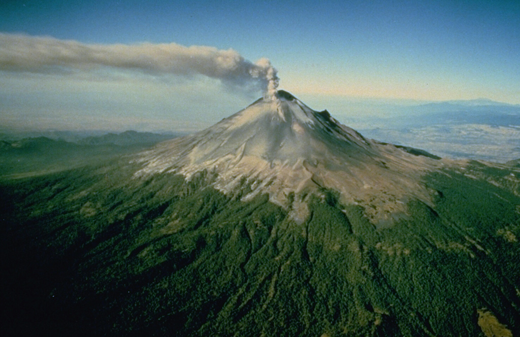
Popocatepetl (Mexico) | 30 August-5 September 2023 | Continuing ActivityCite this Report |
 Popocatepetl Popocatepetl
Trans-Mexican Volcanic Arc
|
CENAPRED reported that eruptive activity continued at Popocatépetl during 29 August-4 September. Long-period events totaling 30-99 per day were accompanied by steam-and-gas plumes that sometimes contained minor amounts of ash. Periods of volcanic tremor (20-389 minutes) were recorded daily; low- to medium-amplitude, high-frequency tremor during 31 August-2 September was accompanied by continuous gas-and-steam emissions that contained minor amounts of ash, rose 1-2 km above the crater rim, and drifted WSW. A few volcano-tectonic earthquakes were recorded during 30 August-1 September. Minor and moderate explosions were recorded at 1848 on 30 August, at 0032, 1614, and 1702 on 31 August, at 1524 and 1755 on 1 September, at 0442, 0720, 2221 on 3 September, at 1745 on 4 September, and at 0758, 0859, and 1000 on 5 September. Ashfall was reported in Ozumba (18 km W), Atlautla (16 km W), Tepetlixpa (21 km W), and Ecatzingo (15 km SW) in the State of México and in Cuernavaca (65 km WSW), Temixco (67 km WSW), Huitzilac (67 km W), Tepoztlán (49 km W), and Jiutepec (59 km SW) in the State of Morelos on 1 and 5 September. The Alert Level remained at Yellow, Phase Two (the middle level on a three-color scale) and the public was warned to stay 12 km away from the crater.
Source: Centro Nacional de Prevencion de Desastres (CENAPRED)
|
Reventador (Ecuador) | 30 August-5 September 2023 | Continuing ActivityCite this Report |
 Reventador Reventador
Northern Andean Volcanic Arc
|
IG-EPN reported that the eruption at Reventador was ongoing during 29 August-5 September. Seismicity was characterized by 23-48 daily explosions, long-period earthquakes, volcano-tectonic events, harmonic tremor, and tremor associated with emissions. Crater incandescence was visible overnight during 29 August-3 September; incandescent material was sometimes ejected onto the flanks and then descended as far as 500 m. Daily ash-and-gas plumes rose 600-1,000 m above the crater rim and drifted NW, W, and SW. Weather conditions sometimes prevented views of the volcano. Secretaría de Gestión de Riesgos maintained the Alert Level at Orange (the second highest level on a four-color scale).
Sources: Instituto Geofísico-Escuela Politécnica Nacional (IG-EPN), Secretaría de Gestión de Riesgos (SGR)
|
Rincon de la Vieja (Costa Rica) | 30 August-5 September 2023 | Continuing ActivityCite this Report |
 Rincon de la Vieja Rincon de la Vieja
Central America Volcanic Arc
|
OVSICORI-UNA reported that small phreatic events and gas-and-steam emissions continued at Rincón de la Vieja during 29 August-5 September. Three small eruptive events generated steam-and-gas plumes that rose 2-3 km above the crater rim during 28-29 August. Multiple events produced steam-and-gas plumes during 30-31 August. At 1526 on 1 September an eruptive event generated a steam-and-gas plume that rose 2 km above the crater rim and ejected material onto the flanks. Small events were detected in infrasound data during 2-3 September. At 1251 on 4 September a steam-and-gas plume that rose 1 km above the crater rim and drifted W. The Alert Level remained at Level 3, Orange, the third level on a four-level scale.
Source: Observatorio Vulcanologico y Sismologico de Costa Rica-Universidad Nacional (OVSICORI-UNA)
|
Sangay (Ecuador) | 30 August-5 September 2023 | Continuing ActivityCite this Report |
 Sangay Sangay
Northern Andean Volcanic Arc
|
IG-EPN reported a high level of eruptive activity at Sangay during 29 August-5 September, with seismic stations recording 355-723 daily explosions. Nightly webcam images showed incandescent material at the crater, explosions ejecting material above the crater, and incandescent material descending the SE flank as far as 1.8 km. Several ash-and-gas plumes rose as high as 2 km above the crater rim and drifted mainly SW and W each day except for 1 September, when weather clouds prevented views. Secretaría de Gestión de Riesgos maintained the Alert Level at Yellow (the second highest level on a four-color scale).
Sources: Instituto Geofísico-Escuela Politécnica Nacional (IG-EPN), Secretaría de Gestión de Riesgos (SGR)
|
Semeru (Indonesia) | 30 August-5 September 2023 | Continuing ActivityCite this Report |
 Semeru Semeru
Sunda Volcanic Arc
|
PVMBG reported that eruptive activity continued at Semeru during 30 August-5 September. At 0843 and 0916 on 30 August dense gray-to-white ash plumes rose 500-800 m above the summit and drifted NW and SW, respectively. White gas-and-steam emissions rose as high as 100 m above the summit and drifted in variable directions during 1-3 September; weather clouds sometimes hindered views. The Alert Level remained at 3 (third highest on a scale of 1-4). The public was warned to stay at least 5 km away from the summit in all directions, 13 km from the summit to the SE, 500 m from the banks of the Kobokan drainage as far as 17 km from the summit, and to avoid other drainages including the Bang, Kembar, and Sat, due to lahar, avalanche, and pyroclastic flow hazards.
Source: Pusat Vulkanologi dan Mitigasi Bencana Geologi (PVMBG, also known as CVGHM)
|
Sheveluch (Russia) | 30 August-5 September 2023 | Continuing ActivityCite this Report |
 Sheveluch Sheveluch
Eastern Kamchatka Volcanic Arc
|
KVERT reported that the eruption at Sheveluch continued during 24-31 August. Intense fumarolic activity was visible at the active dome, and daily thermal anomalies were identified in satellite images. A plume of resuspended ash drifted 650 km SE during 30-31 August. Plumes of resuspended ash drifted 110 km E at altitudes of 2.5-3 (8,200-10,000 ft) a.s.l. on 4 September. The Aviation Color Code remained at Orange (the third level on a four-color scale). Dates are based on UTC times; specific events are in local time where noted.
Source: Kamchatkan Volcanic Eruption Response Team (KVERT)
|
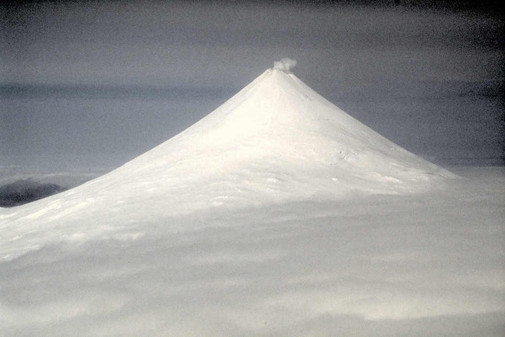
Shishaldin (United States) | 30 August-5 September 2023 | Continuing ActivityCite this Report |
 Shishaldin Shishaldin
Aleutian Ridge Volcanic Arc
|
AVO reported that the eruption at Shishaldin continued during 30 August-5 September. Weather conditions sometimes prevented observations. Daily, small, repetitive explosions were recorded in seismic and infrasound data, though high winds occasionally masked the signals. Elevated surface temperatures at the summit were identified in satellite data on most days. Hot deposits on the NE flank, emplaced during 25-26 August, were visible in a 1 September satellite image, along with steam emissions obscuring the summit vent. Possible incandescence at the summit was visible in nighttime webcam images during 3-4 September, and small steam emissions were visible in daytime images.
Seismicity began to gradually increase at around 0300 on 5 September and activity escalated around 0830. A pilot in the vicinity of the volcano reported an ash plume at about 7.6 km (25,000 ft) a.s.l. at 0842 that was continuing to rise. The ash plume was large and may have risen as high as 9.7 km (32,000 ft) a.s.l. and drifted SSE based on satellite images. AVO raised the Aviation Color Code to Red (the highest color on a four-color scale) and the Volcano Alert Level to Warning (the highest level on a four-level scale) at 0901. Seismic amplitude decreased rapidly at around 1100, and remained low, and the altitude of ash emissions observed in satellite images also decreased to an estimated 4.5 km (15,000 ft) a.s.l. By 1200 the lower-altitude portion of the ash plume had drifted 125 km E. Significant ash emissions ended by 1330 based on webcam images. At 1440 AVO lowered the Aviation Color Code to Orange and the Volcano Alert Level to Watch. This event marks the ninth period of elevated eruptive activity resulting in significant ash emissions and mass flows of volcanic debris on the volcano's flanks since the onset of the current eruption.
Source: US Geological Survey Alaska Volcano Observatory (AVO)
|
Suretamatai (Vanuatu) | 30 August-5 September 2023 | Continuing ActivityCite this Report |
 Suretamatai Suretamatai
Vanuatu Volcanic Arc
|
On 31 August the Vanuatu Meteorology and Geohazards Department (VMGD) reported that activity at Suretamatai continued at a level of “minor unrest.” No notable volcanic emissions were identified in the most recent satellite data, though steam emissions from areas around the cone and the Sulphur River continued to be locally observed. The public was reminded that the danger zone was near the cone and the Sulphur River, though the risk to the public was low.
Source: Vanuatu Meteorology and Geohazards Department (VMGD)
|
Suwanosejima (Japan) | 30 August-5 September 2023 | Continuing ActivityCite this Report |
 Suwanosejima Suwanosejima
Ryukyu Volcanic Arc
|
JMA reported that the eruption at Suwanosejima's Ontake Crater continued during 28 August-4 September. Eruptive events produced volcanic plumes that rose as high as 700 m above the crater rim. An eruptive event at 1949 on 4 September produced an ash plume that rose 1 km above the crater rim and drifted SW. The Alert Level remained at 2 (on a 5-level scale) and the public was warned to stay at least 1 km away from the crater.
Source: Japan Meteorological Agency (JMA)
|
Ubinas (Peru) | 30 August-5 September 2023 | Continuing ActivityCite this Report |
 Ubinas Ubinas
Central Andean Volcanic Arc
|
Instituto Geofísico del Perú (IGP) reported that the eruption at Ubinas continued during 28 August-3 September. There were daily averages of 78 volcano-tectonic earthquakes indicating rock fracturing and 42 long-period earthquakes signifying the movement of gas and magma. In addition, seismic signals associated with ash emissions were recorded for an average of 30 minutes per day, with a maximum of 1 hour on 3 September. Webcams recorded ash-and-gas emissions rising as high as 600 m above the crater rim and drifting as far as 5 km E and SE during 28 August-4 September. The Alert Level remained at Orange (the third level on a four-color scale) and the public was warned to stay 4 km away from the crater.
Source: Instituto Geofísico del Perú (IGP)
|
Yasur (Vanuatu) | 30 August-5 September 2023 | Continuing ActivityCite this Report |
 Yasur Yasur
Vanuatu Volcanic Arc
|
On 31 August the Vanuatu Meteorology and Geohazards Department (VMGD) reported that activity at Yasur continued at a high level of “major unrest,” as defined by the Alert Level 2 status (the middle level on a scale of 0-4). Recent satellite observations indicated an increase in steam, gas, and ash emissions from the summit crater. Explosions continued, with some ejecting bombs that landed back in and around the crater. The public was reminded to not enter the restricted area within 600 m around the boundaries of the Permanent Exclusion Zone, defined by Danger Zone A on the hazard map.
Source: Vanuatu Meteorology and Geohazards Department (VMGD)
|

 Villarrica