Japan Meteorological Agency (JMA) reported increased unrest at Iwatesan. Data from instrumentation detecting deformation indicated inflation centered in deeper parts of the volcano beginning in February. The frequency of volcanic earthquakes had been somewhat high since April 2020, although the number of small volcanic earthquakes located near Kurokurayama began increasing in May and further increased in late July. Results in INSAR imagery collected on 26 September revealed very shallow inflation near Ojigokudani (erosional caldera to the W). At 1500 on 2 October the Alert level was raised to 2 (the second lowest level on a 1-5 scale) prompting access restrictions around the crater; the public was warned that an eruption could affect an area within a 2 km radius of the crater.
Source: Japan Meteorological Agency (JMA)
Tremor event and earthquake swarm on 12 November 1999
At 1800 on 18 October 1999, the National Coordination Committee for Prediction of Volcanic Eruptions reported that the volcano's fumarolic area had expanded and the amount of steam had increased in the western part of Iwate volcano. New fumaroles have been observed since May on the N slopes of Mts. Ubakura-yama and Kurokura-yama and in the western stream of Ojigokudani (inside the erosion caldera). This fumarolic activity has intermittently increased since July, and ground temperatures between Mts. Kurokura-yama and Ubakura-yama also increased with time. Analyses of fumarolic gas collected between Ojigokudani and Mt. Ubakura-yama in August and October revealed a magmatic component. Although GPS measurements showed the end of the elongation trend observed since July, relatively large volcanic earthquakes occurred during May and June. Deep-seated (~30 km depth) low-frequency earthquakes, relatively deep-seated (6-13 km depth) low-frequency earthquakes, and shallow high-frequency earthquakes occurred under the eastern cone of Iwate. However, the overall level of seismicity has decreased compared to 1998 (figure 5).
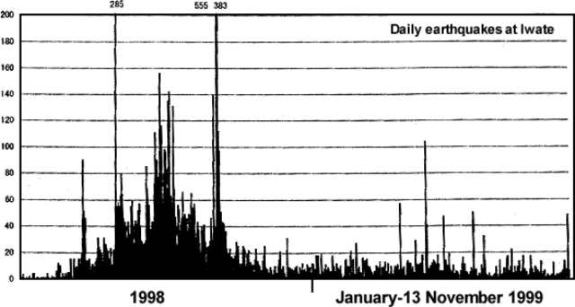 |
Figure 5. Daily numbers of earthquakes at Iwate (recorded at the Matsukawa station) during 1 January 1998-13 November 1999. Courtesy of JMA. |
On the evening of 12 November JMA issued a Volcano Advisory on Iwate after a 4-minute volcanic tremor (M 2.1) saturated local instruments starting at 2054. The event hypocenter was located 2-3 km below the Ubakura-yama and Kurokura-yama areas of western Iwate (figure 6). An earthquake swarm continued for 2 hours after the tremor event at a rate of 16-20 events/hour. Inspection from the air the following day did not show any major change in fumarolic activity or any deposition of new volcanic ash.
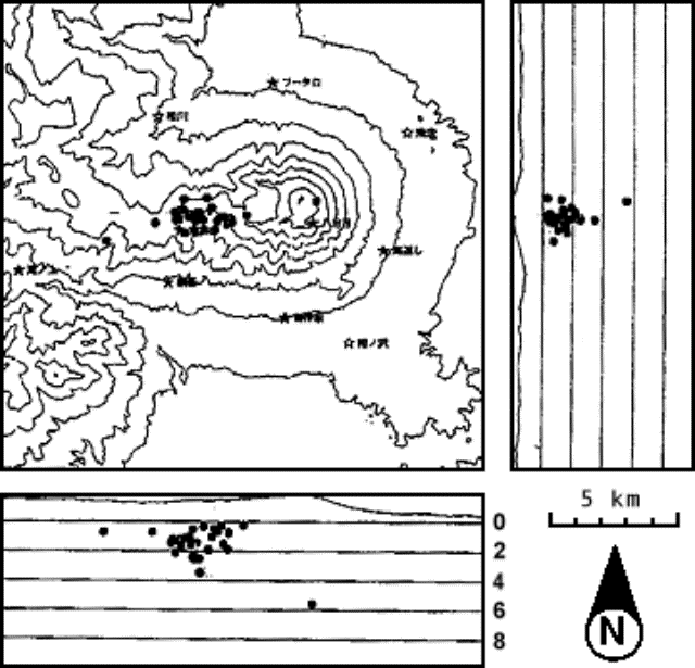 |
Figure 6. Hypocenters of earthquakes under the western section of Iwate during 11-12 November 1999. Courtesy of JMA. |
On the evening of 16 November, the extended National Coordination Committee for Prediction of Volcanic Eruptions met in the city of Morioka, Iwate Prefecture, to review the events that occurred on the 12th. They noted that the tremor was similar in shape, amplitude, and duration to one (M 2.4) that occurred on 10 July 1999; hence it was considered likely that the two events occurred in the same place. Changes detected in tilt- and strain-meters located on the flank during the tremor were probably caused by subsurface ground faulting or fluid movement. After the tremor, however, no subsequent changes were observed. Neither the GPS-based, N-S traverse distance across the volcano nor the fumarole temperatures in the Ubakura-yama to Kurokura-yama region changed before or after the event. Fumarolic activity in western Iwate had increased since May as had the number of shallow earthquakes in the Ojigokudani area (erosion caldera). The tremor event on 12 November suggested a continuing possibility of a phreatic explosions in western Iwate.
Information Contacts: Kazuo Sekine, Sendai District Meteorological Observatory, Japan Meteorological Agency, 1-3-15 Gorin, Miyagino-ku, Sendai 983, Japan; Hiroyuki Hamaguchi, Faculty of Science, Tohoku University, Sendai 980-8578 Japan (URL: http://www.sci.tohoku.ac.jp/); Setsuya Nakada, Volcano Research Center, ERI, University of Tokyo, Yayoi 1-1-1, Bunkyo-ku, Tokyo 113, Japan (URL: http://www.eri.u-tokyo.ac.jp/VRC/index_E.html); Jun-ichi Hirabayashi, Kusatsu-Shirane Volcano Observatory, Tokyo Institute of Technology, Kusatsu, Agatsuma-gun, Gunma 377-17 Japan.
2024: October
Japan Meteorological Agency (JMA) reported increased unrest at Iwatesan. Data from instrumentation detecting deformation indicated inflation centered in deeper parts of the volcano beginning in February. The frequency of volcanic earthquakes had been somewhat high since April 2020, although the number of small volcanic earthquakes located near Kurokurayama began increasing in May and further increased in late July. Results in INSAR imagery collected on 26 September revealed very shallow inflation near Ojigokudani (erosional caldera to the W). At 1500 on 2 October the Alert level was raised to 2 (the second lowest level on a 1-5 scale) prompting access restrictions around the crater; the public was warned that an eruption could affect an area within a 2 km radius of the crater.
Source: Japan Meteorological Agency (JMA)
Reports are organized chronologically and indexed below by Month/Year (Publication Volume:Number), and include a one-line summary. Click on the index link or scroll down to read the reports.
Tremor and low-frequency earthquakes
Between 0019 and 0105 on 15 September, Tohoku University seismometers near Iwate volcano registered intermittent small-amplitude volcanic tremors and low-frequency earthquakes. Four low-frequency earthquakes had epicenters 2 km E of the summit at ~8 km depths.
Information Contacts: Volcanological Division, Seismological and Volcanological Department, Japan Meteorological Agency (JMA), 1-3-4 Ote-machi, Chiyoda-ku, Tokyo 100 Japan.
Short tremor episode
Tohoku University seismometers near Iwate volcano continued to register tremor (BGVN 20:09). Beginning at 0009 on 20th October, the tremor lasted ~25 minutes.
Information Contacts: Volcanological Division, Seismological and Volcanological Department, Japan Meteorological Agency (JMA), 1-3-4 Ote-machi, Chiyoda-ku, Tokyo 100 Japan.
Small-amplitude tremor
On 13, 24, and 29 January small-amplitude volcanic tremors occurred. Such tremors were previously observed on 20 October 1995.
Information Contacts: Japan Meteorological Agency (JMA), Volcanological Division, Seismological and Volcanological Department, 1-3-4 Ote-machi, Chiyoda-ku, Tokyo 100, Japan.
Volcanic tremor registered again on 4 March
Small-amplitude volcanic tremor was detected on 4 March. Tremor was last registered on three days in January 1996 (BGVN 21:02) and once in October 1995.
Information Contacts: Japan Meteorological Agency (JMA), Volcanological Division, Seismological and Volcanological Department, 1-3-4 Ote-machi, Chiyoda-ku, Tokyo 100, Japan.
Small-amplitude volcanic tremor
Small-amplitude volcanic tremor was detected on 12 May. Tremor was last reported on 4 March (BGVN 21:03), and previously in January and October 1995.
Information Contacts: Japan Meteorological Agency (JMA), Volcanological Division, Seismological and Volcanological Department, 1-3-4 Ote-machi, Chiyoda-ku, Tokyo 100, Japan.
Volcanic tremor
On 10, 11, 12, and 17 June, small-amplitude volcanic tremors were detected. According to reports from the Observation Center for Prediction of Earthquakes and Volcanic Eruptions, Tohoku University, there were also shallow volcanic microearthquakes beneath Iwate on 7 and 27 June, and on 2 and 6 July. Tremor was previously reported on 4 March and 12 May 1996 (BGVN 21:03 and 21:05), and in September and October 1995 (BGVN 20:09 and 20:10).
Information Contacts: Volcanological Division, Japan Meteorological Agency, 1-3-4 Ote-machi, Chiyoda-ku, Tokyo 100, Japan
A M 1.9 earthquake at 3 km depth
On 25 August a M 1.9 earthquake was recorded 3 km beneath the top of Iwate. This was considered a remarkable event in this region.
Information Contacts: Volcanological Division, Japan Meteorological Agency (JMA), 1-3-4 Ote-machi, Chiyoda-ku, Tokyo 100, Japan.
Microearthquakes and tremor
On 11 September, 2 October, and 24 and 25 November, shallow volcanic microearthquakes were recorded below Iwate. On 12 September and 11 October small-amplitude volcanic tremors were observed.
Information Contacts: Volcanological Division, Japan Meteorological Agency (JMA), 1-3-4 Ote-machi, Chiyoda-ku, Tokyo 100, Japan.
Rising earthquake counts during January-May
According to the Japan Meteorological Agency (JMA), high seismicity (figure 1) and strong deformation began at Iwate in March and remained high in early May. In the first week of May, 30-80 volcanic earthquakes registered per day at the Matsukawa observation site (5 km NW of the summit). Rising monthly earthquake totals during January-May are listed in table 1. On 29 April, 285 earthquakes occurred; the strongest recorded was M 2.7. Tiltmeter and volumetric strain meters disclosed large changes at around 1500. On 7 May, a M 3.3 earthquake occurred at 0300.
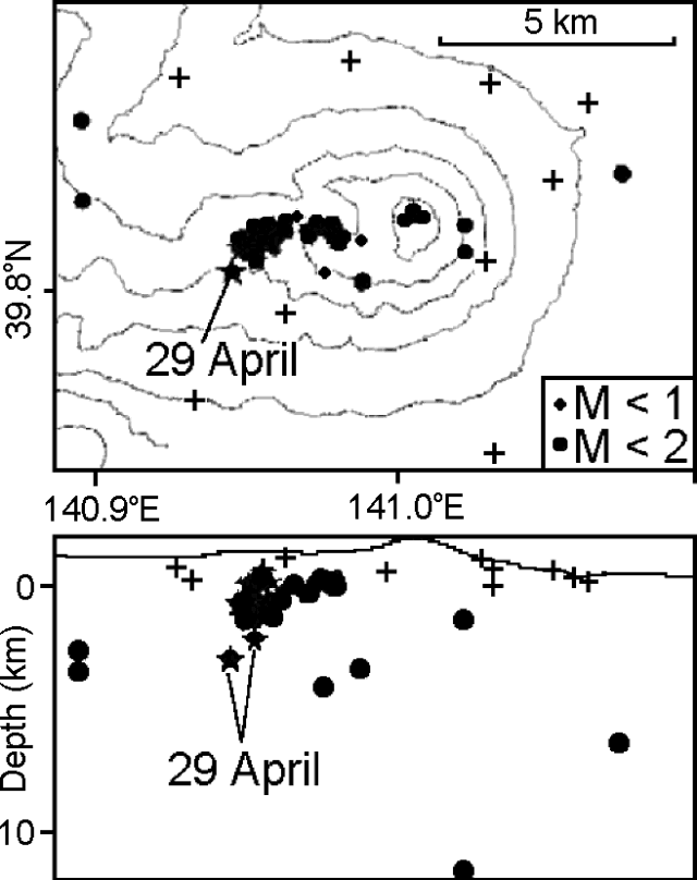 |
Figure 1. Map view of volcanic earthquake locations at Iwate during 27 March-29 April (top) and a W-E cross-section showing earthquake depths (bottom). Tohoku University's instrument observation sites (crosses) are projected onto the line of cross section, explaining why some appear to lie in the subsurface. Courtesy of Tohoku University. |
Table 1. Monthly earthquake counts at Iwate during January-May 1998. Courtesy of JMA.
| Month | Earthquakes |
| Jan 1998 | 22 |
| Feb 1998 | 68 |
| Mar 1998 | 424 |
| Apr 1998 | 764 |
| May 1998 (as of 1600 on 7 May) | 364 |
A GPS survey revealed N-S extension of the volcanic cone during February-May. The 29-km line between two observation sites N and S of the summit began to extend in February; the rate of movement accelerated in late April. By early May, the extension totaled 2 cm. A 1 May air survey revealed no anomalies on or around the summit area.
Information Contacts: Volcanological Division, Seismological and Volcanological Department, 1-3-4 Ote-machi, Japan Meteorological Agency (JMA), Chiyoda-ku, Tokyo 100, Japan; Volcano Research Center, Earthquake Research Institute (ERI), University of Tokyo, Yayoi 1-1-1, Bunkyo-ku, Tokyo 113, Japan; Noritake Nishide, Sendai District Meteorological Observatory, Japan Meteorological Agency, 1-3-15 Gorin, Miyagino-ku, Sendai 983, Japan; Hiroyuki Hamaguchi, Faculty of Science, Tohuku University, Sendai 980-77, Japan; Takashi Tada, Geographical Survey Institute, Tsukuba-shi, Ibaraki, Japan.
Monthly seismicity increases; volcanic history
A pattern of high seismicity but low deformation that began at Iwate in March (BGVN 23:04) continued through June and July. The following also discusses Iwate's history (as reported to JMA and Tohoku University), and details of recent hazards.
Seismicity. According to reports issued by the Japan Meteorological Agency (JMA), monthly totals of volcanic earthquake events recorded at the Matsukawa observation site of Tohoku University increased progressively: 424 in March, 764 in April, 1,283 in May, and 1,806 in June. Seismicity during 1-17 July totalled 1,116 events (figure 2).
 |
Figure 2. Numbers of earthquakes and tremors at Iwate recorded at the Matsukawa observation site at Tohoku University, 1-17 July 1998. Data courtesy of JMA. |
Low-frequency earthquakes occurred at 2124 on 23 June, and 0915 and 1037 on 24 June. A few minutes of volcanic tremor was observed at 0519 and 0701 on 24 June, and at 0754 on 25 June. Earthquake swarms below Nishi-Iwate continued to increase. (The place names Nishi- and Higashi-Iwate refer to West- and East-Iwate, respectively.) Further tremor took place at 1005 and 1642 on 27 June, and 1741 and 1759 on 28 June. Sixteen low-frequency earthquakes took place between the latter two events. Researchers at Tohoku University located these earthquakes at ~2 km SE of the summit of Higashi-Iwate at a depth of 8 km below sea level. This was close to where GPS surveys found a pressure source for crustal deformation. A swarm of low-frequency earthquake and tremor events occurred here in 1995, and it is just S of the craters of the 1732 (Yakebashiri) lava flow. Epicenters of high-frequency earthquakes were also located beneath Nishi-Iwate.
On the morning of 10 July, felt earthquakes occurred W of Iwate Volcano. Four minutes of large-amplitude tremor began at 0829 followed by a volcanic earthquake of M 2.5 at 0831. No surface phenomena were reported. Epicenters for seven earthquakes that morning were located at 3-5 km depth about 5 km west of Nishi-Iwate.
Epicenters of volcanic earthquake swarms under Nishi-Iwate migrated gradually to the W during May-June. New events occurred to the W of the swarms in July. Recent GPS measurements indicated that the source of deformation was located W of Iwate, in an area where no activity had occurred during the past 30,000 years. Although the degree of movement at stations remote from the volcano had become smaller since May, movement at stations closer to the volcano continued. Researchers believe that the source of deformation approached the surface, but they did not determine its depth.
Deformation surveys. Strain and tiltmeters at observation sites recorded little change since March. According to a field survey during 16-18 June, a fumarolic area in Nishi-Iwate seems to have been more active recently, since the fumarole temperature had increased. GPS surveys showed a steady and continuous lengthening between S and N sites of the volcano: a baseline of 9 km underwent a 5-cm extension in the last 5 months. Based on these results, volcanologists suspected a W-E dike intrusion at around 10 km below the summit of Higashi-Iwate, as opposed to just below Nishi-Iwate as indicated by earthquake swarms.
A geodetic measurement team from five Japanese national universities started a leveling survey at the E and S bases of Iwate Volcano on 17 July. The survey lines cover 19 km N-S and 15 km E-W.
History. Based on his recent field survey, Nobuo Doi, a geologist with Geothermal Engineering Co. Ltd., summarized Iwate's eruptive history. He concluded that Iwate began ~700,000 years ago. After the formation of a large cone (Nishi-Iwate), the eruption center migrated eastwards to Higashi-Iwate. Iwate collapsed to form debris avalanches seven times in the past 230,000 years; the most recent collapse took place sometime during the interval 915-1686 CE.
During a large collapse ~6,000 years ago, a mass of debris rushed NE but subsequent topographic constraints redirected debris SSE. The debris followed the Kitakami River reaching the present site of Morioka City (population 235,000). The episode left a large scar open to the NE on Higashi-Iwate's summit.
The present peak of Higashi-Iwate grew within this scar but it left part of the scar visible on its W side. During the last 6,000 years, magmatic eruptions occurred frequently; scoria eruptions have occurred more than 11 times. Lavas and pyroclastics younger than 6,000 years occur in the NE sector of Higashi-Iwate.
The 1686-87 CE eruption started with a pyroclastic surge; this was followed by scoria emission, a mudflow, a second pyroclastic surge, and it ended with a phreatic phase. In 1732, basaltic andesite lava flowed 2.5 km. Small explosions took place during 1934-35.
At Nishi-Iwate more than four phreatic eruptions have occurred in the past 7,500 years. The latest eruption here was phreatic and took place at O-Jigokudani ("large valley of hell") in 1919; an associated mudflow descended NNW.
Hazards. Authorities in two towns and villages near Iwate closed the mountain to climbers on 26 June because of the likelihood of phreatic explosions at Nishi-Iwate.
According to a local newspaper (Iwate Nippo), a new hazard map was expected to be ready for distribution on 22 July, incorporating aspects of volcanology, disaster-protection, and Sabo engineering. The scenario assumes a phreatic eruption on the W side, perhaps as large as one at Nishi-Iwate that occurred 3,200 years ago. The presumed disaster areas would be subjected to both ashfalls and lahars. A theoretical 10-cm-thick ash deposit would occur in resort areas N and S of the volcano extending to 5 km from the possible eruption site, but the researchers postulated a lack of serious damage to buildings.
Information Contacts: Nishide Noritake, Volcanological Division, Japan Meteorological Agency (JMA), 1-3-4 Ote-machi, Chiyoda-ku, Tokyo 100, Japan (URL: http://www.jma.go.jp/); Volcano Research Center, Earthquake Research Institute (ERI), University of Tokyo, Yayoi 1-1-1, Bunkyo-ku, Tokyo 113, Japan; Nobuo Doi, Geothermal Engineering Co. Ltd., Japan.
Nearby M 6.2 earthquake on 3 September, but volcano still slumbering
A strong earthquake occurred 10 km SW of the summit of Iwate volcano at 1658 on 3 September. The Richter magnitude was 6.1 and the depth ~7 km. The mechanism was E-W compression on a reverse fault. A N-S-trending surface rupture appeared, despite the event's non-extreme magnitude. The aftershock area resulting from the earthquake differed from typical earthquakes on Iwate and the relationship between the earthquake and the volcano, if any, is not understood. This was the largest earthquake since August 1996 when a M 5.9 tremor struck.
A 3 September Reuters news article mentioned that a powerful earthquake took place, centered in the ski resort area of Shizukuishi, a mountainous region near Iwate volcano. The report claimed the epicenter was 5 km underground and police said that the event slightly injured at least nine people.
Information Contacts: Yukio Hayakawa, Faculty of Education, Gunma University, Aramaki, Maebashi 371, Japan; Reuters Limited, 1700 Broadway, New York, NY 10019 USA (URL: http://www.reuters.com/).
Seismic crisis ends on 3 November
Subsequent to the 3 September earthquake (BGVN 23:09), seismicity was low. Except for a few days, the number of tremors during October was <10/day, about the same level as in February-March 1998. The last tremor was observed on 3 November. This implies that the volcanic seismicity crisis (BGVN 23:09) has ended.
Information Contacts: Yukio Hayakawa, Faculty of Education, Gunma University, Aramaki, Maebashi 371, Japan.
A M 3.6 tectonic earthquake in September preceded ongoing seismic swarms
A large tectonic earthquake near Iwate on 3 September 1998 (BGVN 23:09) was followed by elevated rates of seismicity and ground deformation that declined in subsequent months (figure 3). In late 1998 volcanic tremor was recorded up to ten times per month and earthquakes around the Moho discontinuity occurred >10 times per month.
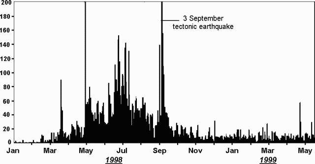 |
Figure 3. Daily numbers of earthquakes at Iwate (recorded at the Matsukawa station) during 1 January 1998-14 May 1999. Courtesy JMA. |
At 1909 on 22 May 1999, a M 3.6 earthquake occurred around the W edge of Nishi-Iwate. The earthquake was followed 8 minutes later by another of M 2.2. These volcanic earthquakes were the largest of a swarm centered at 3-6 km depth. No episodes of tremor were observed and no surface manifestations were detected by video monitoring or during a helicopter flight.
The National Coordination Committee for Prediction of Volcanic Eruption said that the largest earthquakes in the swarm occurred in the W region of the volcano, where shallow (5-10 km in depth) low-frequency volcanic earthquakes had been increasing (figure 4). They also observed that deep (~30 km in depth) low-frequency earthquakes had been occurring regularly with some minor increases and decreases in frequency. GPS observation showed relatively low but steady ground-deformation in the western region of the volcano. Gas measurement showed an increase in below-ground temperature and also indicated the gas chemistry had become more magmatic since September 1998. Their conclusion was that Iwate was showing a slight increase in activity.
 |
Figure 4. Hypocenters of earthquakes around Iwate during 1 April-13 May 1999. Courtesy JMA. |
Information Contacts: Hiroyuki Hamaguchi, Faculty of Science, Tohoku University, Sendai 980, Japan; Kazuo Sekine, Sendai District Meteorological Observatory, Japan Meteorological Agency, 1-3-15 Gorin, Miyagino-ku, Sendai 983, Japan; Volcano Research Center, Earthquake Research Institute (ERI), University of Tokyo, Yayoi 1-1-1, Bunkyo-ku, Tokyo 113, Japan (URL: http://www.eri.u-tokyo.ac.jp/VRC/index_E.html).
Tremor event and earthquake swarm on 12 November 1999
At 1800 on 18 October 1999, the National Coordination Committee for Prediction of Volcanic Eruptions reported that the volcano's fumarolic area had expanded and the amount of steam had increased in the western part of Iwate volcano. New fumaroles have been observed since May on the N slopes of Mts. Ubakura-yama and Kurokura-yama and in the western stream of Ojigokudani (inside the erosion caldera). This fumarolic activity has intermittently increased since July, and ground temperatures between Mts. Kurokura-yama and Ubakura-yama also increased with time. Analyses of fumarolic gas collected between Ojigokudani and Mt. Ubakura-yama in August and October revealed a magmatic component. Although GPS measurements showed the end of the elongation trend observed since July, relatively large volcanic earthquakes occurred during May and June. Deep-seated (~30 km depth) low-frequency earthquakes, relatively deep-seated (6-13 km depth) low-frequency earthquakes, and shallow high-frequency earthquakes occurred under the eastern cone of Iwate. However, the overall level of seismicity has decreased compared to 1998 (figure 5).
|
Figure 5. Daily numbers of earthquakes at Iwate (recorded at the Matsukawa station) during 1 January 1998-13 November 1999. Courtesy of JMA. |
On the evening of 12 November JMA issued a Volcano Advisory on Iwate after a 4-minute volcanic tremor (M 2.1) saturated local instruments starting at 2054. The event hypocenter was located 2-3 km below the Ubakura-yama and Kurokura-yama areas of western Iwate (figure 6). An earthquake swarm continued for 2 hours after the tremor event at a rate of 16-20 events/hour. Inspection from the air the following day did not show any major change in fumarolic activity or any deposition of new volcanic ash.
|
Figure 6. Hypocenters of earthquakes under the western section of Iwate during 11-12 November 1999. Courtesy of JMA. |
On the evening of 16 November, the extended National Coordination Committee for Prediction of Volcanic Eruptions met in the city of Morioka, Iwate Prefecture, to review the events that occurred on the 12th. They noted that the tremor was similar in shape, amplitude, and duration to one (M 2.4) that occurred on 10 July 1999; hence it was considered likely that the two events occurred in the same place. Changes detected in tilt- and strain-meters located on the flank during the tremor were probably caused by subsurface ground faulting or fluid movement. After the tremor, however, no subsequent changes were observed. Neither the GPS-based, N-S traverse distance across the volcano nor the fumarole temperatures in the Ubakura-yama to Kurokura-yama region changed before or after the event. Fumarolic activity in western Iwate had increased since May as had the number of shallow earthquakes in the Ojigokudani area (erosion caldera). The tremor event on 12 November suggested a continuing possibility of a phreatic explosions in western Iwate.
Information Contacts: Kazuo Sekine, Sendai District Meteorological Observatory, Japan Meteorological Agency, 1-3-15 Gorin, Miyagino-ku, Sendai 983, Japan; Hiroyuki Hamaguchi, Faculty of Science, Tohoku University, Sendai 980-8578 Japan (URL: http://www.sci.tohoku.ac.jp/); Setsuya Nakada, Volcano Research Center, ERI, University of Tokyo, Yayoi 1-1-1, Bunkyo-ku, Tokyo 113, Japan (URL: http://www.eri.u-tokyo.ac.jp/VRC/index_E.html); Jun-ichi Hirabayashi, Kusatsu-Shirane Volcano Observatory, Tokyo Institute of Technology, Kusatsu, Agatsuma-gun, Gunma 377-17 Japan.
|
|
||||||||||||||||||||||||||
There is data available for 26 confirmed Holocene eruptive periods.
[ 1934 Jul - 1935 ] Uncertain Eruption
| Episode 1 | Eruption (Explosive / Effusive) | ||||||||||||||||||||
|---|---|---|---|---|---|---|---|---|---|---|---|---|---|---|---|---|---|---|---|---|
| 1934 Jul - 1935 | Evidence from Unknown | |||||||||||||||||||
|
List of 2 Events for Episode 1
|
||||||||||||||||||||
1919 Jul 15 (?) - 1919 Jul 15 (?) Confirmed Eruption (Explosive / Effusive) VEI: 1
| Episode 1 | Eruption (Explosive / Effusive) | W side of Onigajo caldera (O-jigokudani) | ||||||||||||||||||||||||||||||||||
|---|---|---|---|---|---|---|---|---|---|---|---|---|---|---|---|---|---|---|---|---|---|---|---|---|---|---|---|---|---|---|---|---|---|---|---|
| 1919 Jul 15 (?) - 1919 Jul 15 (?) | Evidence from Observations: Reported | ||||||||||||||||||||||||||||||||||
|
List of 5 Events for Episode 1 at W side of Onigajo caldera (O-jigokudani)
|
|||||||||||||||||||||||||||||||||||
[ 1823 ] Discredited Eruption
1732 Jan 22 - 1732 Oct (?) Confirmed Eruption (Explosive / Effusive) VEI: 2
| Episode 1 | Eruption (Explosive / Effusive) | NE flank of Yakushi-dake | ||||||||||||||||||||||||||||||||||
|---|---|---|---|---|---|---|---|---|---|---|---|---|---|---|---|---|---|---|---|---|---|---|---|---|---|---|---|---|---|---|---|---|---|---|---|
| 1732 Jan 22 - 1732 Oct (?) | Evidence from Observations: Reported | ||||||||||||||||||||||||||||||||||
|
List of 5 Events for Episode 1 at NE flank of Yakushi-dake
|
|||||||||||||||||||||||||||||||||||
[ 1719 Feb (?) ] Discredited Eruption
[ 1689 Jun 22 ] Uncertain Eruption
| Episode 1 | Eruption (Explosive / Effusive) | |||||||||||||||||||||||||
|---|---|---|---|---|---|---|---|---|---|---|---|---|---|---|---|---|---|---|---|---|---|---|---|---|---|
| 1689 Jun 22 - Unknown | Evidence from Unknown | ||||||||||||||||||||||||
|
List of 3 Events for Episode 1
|
|||||||||||||||||||||||||
[ 1687 Apr 14 - 1687 Jul ] Uncertain Eruption
| Episode 1 | Eruption (Explosive / Effusive) | |||||||||||||||||||||||||||||||||||
|---|---|---|---|---|---|---|---|---|---|---|---|---|---|---|---|---|---|---|---|---|---|---|---|---|---|---|---|---|---|---|---|---|---|---|---|
| 1687 Apr 14 - 1687 Jul | Evidence from Unknown | ||||||||||||||||||||||||||||||||||
|
List of 5 Events for Episode 1
|
|||||||||||||||||||||||||||||||||||
1686 Mar 26 - 1686 Mar 27 Confirmed Eruption (Explosive / Effusive) VEI: 3
| Episode 1 | Eruption (Explosive / Effusive) | ||||||||||||||||||||||||||||||||||||||||||||||||||||||||||||
|---|---|---|---|---|---|---|---|---|---|---|---|---|---|---|---|---|---|---|---|---|---|---|---|---|---|---|---|---|---|---|---|---|---|---|---|---|---|---|---|---|---|---|---|---|---|---|---|---|---|---|---|---|---|---|---|---|---|---|---|---|
| 1686 Mar 26 - 1686 Mar 27 | Evidence from Observations: Reported | |||||||||||||||||||||||||||||||||||||||||||||||||||||||||||
|
List of 10 Events for Episode 1
|
||||||||||||||||||||||||||||||||||||||||||||||||||||||||||||
1450 ± 100 years Confirmed Eruption (Explosive / Effusive)
| Episode 1 | Eruption (Explosive / Effusive) | Nishi-Iwate and Higashi-Iwate | |||||||||||||||||||
|---|---|---|---|---|---|---|---|---|---|---|---|---|---|---|---|---|---|---|---|---|
| 1450 ± 100 years - Unknown | Evidence from Isotopic: 14C (uncalibrated) | |||||||||||||||||||
|
List of 2 Events for Episode 1 at Nishi-Iwate and Higashi-Iwate
|
||||||||||||||||||||
1300 ± 50 years Confirmed Eruption (Explosive / Effusive) VEI: 3
| Episode 1 | Eruption (Explosive / Effusive) | Higashi-Iwate (Myoko-dake) | ||||||||||||||||||||||||||||||||||
|---|---|---|---|---|---|---|---|---|---|---|---|---|---|---|---|---|---|---|---|---|---|---|---|---|---|---|---|---|---|---|---|---|---|---|---|
| 1300 ± 50 years - Unknown | Evidence from Correlation: Tephrochronology | ||||||||||||||||||||||||||||||||||
|
List of 5 Events for Episode 1 at Higashi-Iwate (Myoko-dake)
|
|||||||||||||||||||||||||||||||||||
0150 (?) Confirmed Eruption (Explosive / Effusive)
| Episode 1 | Eruption (Explosive / Effusive) | Higashi-Iwate | |||||||||||||||||||
|---|---|---|---|---|---|---|---|---|---|---|---|---|---|---|---|---|---|---|---|---|
| 0150 (?) - Unknown | Evidence from Isotopic: 14C (uncalibrated) | |||||||||||||||||||
|
List of 2 Events for Episode 1 at Higashi-Iwate
|
||||||||||||||||||||
0350 BCE (?) Confirmed Eruption (Explosive / Effusive)
| Episode 1 | Eruption (Explosive / Effusive) | Higashi-Iwate | |||||||||||||||||||
|---|---|---|---|---|---|---|---|---|---|---|---|---|---|---|---|---|---|---|---|---|
| 0350 BCE (?) - Unknown | Evidence from Isotopic: 14C (uncalibrated) | |||||||||||||||||||
|
List of 2 Events for Episode 1 at Higashi-Iwate
|
||||||||||||||||||||
0450 BCE (?) Confirmed Eruption (Explosive / Effusive)
| Episode 1 | Eruption (Explosive / Effusive) | Nishi-Iwate (O-jigokudani area) | ||||||||||||||
|---|---|---|---|---|---|---|---|---|---|---|---|---|---|---|---|
| 0450 BCE (?) - Unknown | Evidence from Isotopic: 14C (calibrated) | ||||||||||||||
|
List of 1 Events for Episode 1 at Nishi-Iwate (O-jigokudani area)
|
|||||||||||||||
1150 BCE (?) Confirmed Eruption (Explosive / Effusive)
| Episode 1 | Eruption (Explosive / Effusive) | Nishi-Iwate | |||||||||||||||||||||||||||||
|---|---|---|---|---|---|---|---|---|---|---|---|---|---|---|---|---|---|---|---|---|---|---|---|---|---|---|---|---|---|---|
| 1150 BCE (?) - Unknown | Evidence from Isotopic: 14C (uncalibrated) | |||||||||||||||||||||||||||||
|
List of 4 Events for Episode 1 at Nishi-Iwate
|
||||||||||||||||||||||||||||||
1250 BCE (?) Confirmed Eruption (Explosive / Effusive) VEI: 3
| Episode 1 | Eruption (Explosive / Effusive) | Higashi-Iwate | |||||||||||||||||||||||||||||
|---|---|---|---|---|---|---|---|---|---|---|---|---|---|---|---|---|---|---|---|---|---|---|---|---|---|---|---|---|---|---|
| 1250 BCE (?) - Unknown | Evidence from Isotopic: 14C (calibrated) | |||||||||||||||||||||||||||||
|
List of 4 Events for Episode 1 at Higashi-Iwate
|
||||||||||||||||||||||||||||||
1500 BCE ± 300 years Confirmed Eruption (Explosive / Effusive)
| Episode 1 | Eruption (Explosive / Effusive) | Higashi-Iwate | ||||||||||||||||||||||||
|---|---|---|---|---|---|---|---|---|---|---|---|---|---|---|---|---|---|---|---|---|---|---|---|---|---|
| 1500 BCE ± 300 years - Unknown | Evidence from Correlation: Tephrochronology | ||||||||||||||||||||||||
|
List of 3 Events for Episode 1 at Higashi-Iwate
|
|||||||||||||||||||||||||
1650 BCE (?) Confirmed Eruption (Explosive / Effusive)
| Episode 1 | Eruption (Explosive / Effusive) | Nishi-Iwate (O-jigokudani area) | ||||||||||||||
|---|---|---|---|---|---|---|---|---|---|---|---|---|---|---|---|
| 1650 BCE (?) - Unknown | Evidence from Isotopic: 14C (calibrated) | ||||||||||||||
|
List of 1 Events for Episode 1 at Nishi-Iwate (O-jigokudani area)
|
|||||||||||||||
2000 BCE (?) Confirmed Eruption (Explosive / Effusive)
| Episode 1 | Eruption (Explosive / Effusive) | Nishi-yama | |||||||||||||||||||
|---|---|---|---|---|---|---|---|---|---|---|---|---|---|---|---|---|---|---|---|---|
| 2000 BCE (?) - Unknown | Evidence from Isotopic: 14C (calibrated) | |||||||||||||||||||
|
List of 2 Events for Episode 1 at Nishi-yama
|
||||||||||||||||||||
2050 BCE ± 200 years Confirmed Eruption (Explosive / Effusive)
| Episode 1 | Eruption (Explosive / Effusive) | Higashi-Iwate, W5 tephra | ||||||||||||||||||||||||
|---|---|---|---|---|---|---|---|---|---|---|---|---|---|---|---|---|---|---|---|---|---|---|---|---|---|
| 2050 BCE ± 200 years - Unknown | Evidence from Isotopic: 14C (calibrated) | ||||||||||||||||||||||||
|
List of 3 Events for Episode 1 at Higashi-Iwate, W5 tephra
|
|||||||||||||||||||||||||
2700 BCE ± 200 years Confirmed Eruption (Explosive / Effusive)
| Episode 1 | Eruption (Explosive / Effusive) | Higashi-Iwate, W6a-d tephras | |||||||||||||||||||
|---|---|---|---|---|---|---|---|---|---|---|---|---|---|---|---|---|---|---|---|---|
| 2700 BCE ± 200 years - Unknown | Evidence from Correlation: Tephrochronology | |||||||||||||||||||
|
List of 2 Events for Episode 1 at Higashi-Iwate, W6a-d tephras
|
||||||||||||||||||||
2950 BCE ± 50 years Confirmed Eruption (Explosive / Effusive)
| Episode 1 | Eruption (Explosive / Effusive) | Nishi-Iwate, PHD5 tephra | |||||||||||||||||||
|---|---|---|---|---|---|---|---|---|---|---|---|---|---|---|---|---|---|---|---|---|
| 2950 BCE ± 50 years - Unknown | Evidence from Isotopic: 14C (calibrated) | |||||||||||||||||||
|
List of 2 Events for Episode 1 at Nishi-Iwate, PHD5 tephra
|
||||||||||||||||||||
3050 BCE (?) Confirmed Eruption (Explosive / Effusive)
| Episode 1 | Eruption (Explosive / Effusive) | Higashi-Iwate | |||||||||||||||||||
|---|---|---|---|---|---|---|---|---|---|---|---|---|---|---|---|---|---|---|---|---|
| 3050 BCE (?) - Unknown | Evidence from Isotopic: 14C (uncalibrated) | |||||||||||||||||||
|
List of 2 Events for Episode 1 at Higashi-Iwate
|
||||||||||||||||||||
3250 BCE ± 500 years Confirmed Eruption (Explosive / Effusive) VEI: 0
| Episode 1 | Eruption (Explosive / Effusive) | ||||||||||||||||||||
|---|---|---|---|---|---|---|---|---|---|---|---|---|---|---|---|---|---|---|---|---|
| 3250 BCE ± 500 years - Unknown | Evidence from Correlation: Tephrochronology | |||||||||||||||||||
|
List of 2 Events for Episode 1
|
||||||||||||||||||||
3750 BCE ± 100 years Confirmed Eruption (Explosive / Effusive)
| Episode 1 | Eruption (Explosive / Effusive) | Higashi-Iwate | ||||||||||||||||||||||||
|---|---|---|---|---|---|---|---|---|---|---|---|---|---|---|---|---|---|---|---|---|---|---|---|---|---|
| 3750 BCE ± 100 years - Unknown | Evidence from Correlation: Tephrochronology | ||||||||||||||||||||||||
|
List of 3 Events for Episode 1 at Higashi-Iwate
|
|||||||||||||||||||||||||
4350 BCE ± 500 years Confirmed Eruption (Explosive / Effusive)
| Episode 1 | Eruption (Explosive / Effusive) | Higashi-Iwate | |||||||||||||||||||
|---|---|---|---|---|---|---|---|---|---|---|---|---|---|---|---|---|---|---|---|---|
| 4350 BCE ± 500 years - Unknown | Evidence from Correlation: Tephrochronology | |||||||||||||||||||
|
List of 2 Events for Episode 1 at Higashi-Iwate
|
||||||||||||||||||||
4450 BCE ± 500 years Confirmed Eruption (Explosive / Effusive) VEI: 0
| Episode 1 | Eruption (Explosive / Effusive) | Higashi-Iwate | |||||||||||||||||||
|---|---|---|---|---|---|---|---|---|---|---|---|---|---|---|---|---|---|---|---|---|
| 4450 BCE ± 500 years - Unknown | Evidence from Correlation: Tephrochronology | |||||||||||||||||||
|
List of 2 Events for Episode 1 at Higashi-Iwate
|
||||||||||||||||||||
4850 BCE ± 50 years Confirmed Eruption (Explosive / Effusive)
| Episode 1 | Eruption (Explosive / Effusive) | Nishi-Iwate, PHD6 tephra | |||||||||||||||||||
|---|---|---|---|---|---|---|---|---|---|---|---|---|---|---|---|---|---|---|---|---|
| 4850 BCE ± 50 years - Unknown | Evidence from Isotopic: 14C (calibrated) | |||||||||||||||||||
|
List of 2 Events for Episode 1 at Nishi-Iwate, PHD6 tephra
|
||||||||||||||||||||
4900 BCE ± 100 years Confirmed Eruption (Explosive / Effusive)
| Episode 1 | Eruption (Explosive / Effusive) | Higashi-Iwate | |||||||||||||||||||||||||||||
|---|---|---|---|---|---|---|---|---|---|---|---|---|---|---|---|---|---|---|---|---|---|---|---|---|---|---|---|---|---|---|
| 4900 BCE ± 100 years - Unknown | Evidence from Isotopic: 14C (calibrated) | |||||||||||||||||||||||||||||
|
List of 4 Events for Episode 1 at Higashi-Iwate
|
||||||||||||||||||||||||||||||
5650 BCE ± 50 years Confirmed Eruption (Explosive / Effusive)
| Episode 1 | Eruption (Explosive / Effusive) | Nishi-Iwate, PHD7 tephra | |||||||||||||||||||
|---|---|---|---|---|---|---|---|---|---|---|---|---|---|---|---|---|---|---|---|---|
| 5650 BCE ± 50 years - Unknown | Evidence from Isotopic: 14C (calibrated) | |||||||||||||||||||
|
List of 2 Events for Episode 1 at Nishi-Iwate, PHD7 tephra
|
||||||||||||||||||||
6300 BCE ± 100 years Confirmed Eruption (Explosive / Effusive)
| Episode 1 | Eruption (Explosive / Effusive) | Nishi-Iwate, PHD8 tephra | |||||||||||||||||||||||||||||
|---|---|---|---|---|---|---|---|---|---|---|---|---|---|---|---|---|---|---|---|---|---|---|---|---|---|---|---|---|---|---|
| 6300 BCE ± 100 years - Unknown | Evidence from Isotopic: 14C (calibrated) | |||||||||||||||||||||||||||||
|
List of 4 Events for Episode 1 at Nishi-Iwate, PHD8 tephra
|
||||||||||||||||||||||||||||||
6450 BCE ± 1600 years Confirmed Eruption (Explosive / Effusive)
| Episode 1 | Eruption (Explosive / Effusive) | |||||||||||||||
|---|---|---|---|---|---|---|---|---|---|---|---|---|---|---|---|
| 6450 BCE ± 1600 years - Unknown | Evidence from Correlation: Tephrochronology | ||||||||||||||
|
List of 1 Events for Episode 1
|
|||||||||||||||
This compilation of synonyms and subsidiary features may not be comprehensive. Features are organized into four major categories: Cones, Craters, Domes, and Thermal Features. Synonyms of features appear indented below the primary name. In some cases additional feature type, elevation, or location details are provided.
Synonyms |
||||
| Ganju-san | Nambu-fuji | Iwate-fuji | Ganzyu-san | Iwate-Huzi | Nambu-Huzi | Iwate | ||||
Cones |
||||
| Feature Name | Feature Type | Elevation | Latitude | Longitude |
| Higashi-Iwate | Stratovolcano | 2041 m | 39° 50' 59.00" N | 141° 0' 16.00" E |
| Inukura-yama | Stratovolcano | 1408 m | ||
| Mitsuishi-yama
Mituisi-yama |
Stratovolcano | |||
| Myoko-dake | Stratovolcano | 2000 m | ||
| Nishi-Iwate | Stratovolcano | |||
| Onigajo
Onigazyo |
Stratovolcano | 1706 m | ||
| Ubakura-yama | Stratovolcano | 1517 m | ||
| Yakushi-dake | Stratovolcano | 2041 m | 39° 50' 59.00" N | 141° 0' 16.00" E |
Craters |
||||
| Feature Name | Feature Type | Elevation | Latitude | Longitude |
| Ohachi
Ohati |
Crater | |||
| Okama | Crater | |||
| Omuro | Crater | |||
| Onashiroko | Crater | |||
Thermal |
||||
| Feature Name | Feature Type | Elevation | Latitude | Longitude |
| Amikake Spa | Thermal | |||
| Matsukawa Spa | Thermal | |||
| Ojigoku
Ozigoku |
Thermal | |||
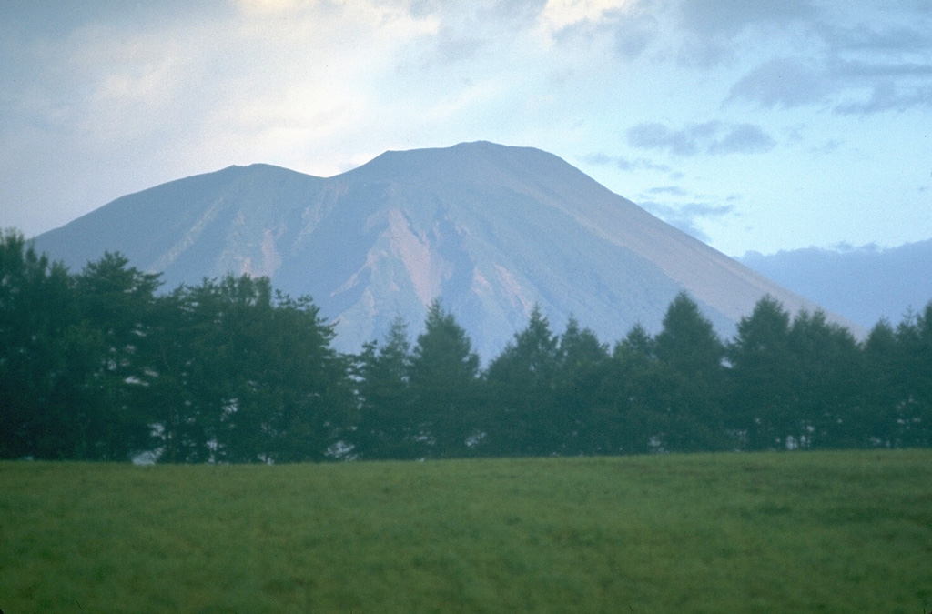
 Yakushidake (right) forms the summit of Iwatesan, and is a younger cone that was constructed over the eastern rim of NishiIwate caldera, the left-hand peak in this view from the SE. Eruptions have been recorded since the 17th century, mostly from the 500-m-wide summit crater and flank vents.
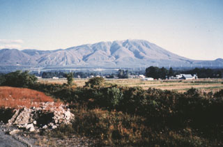 Iwatesan on Japan's northern island of Honshu, seen from the SW. The extensively-dissected Onigajo volcano forms the older, western part of Iwate and is truncated by the 1.8 x 3 km Nishi-Iwate caldera. The smoother slopes at the right are formed by ejecta from the younger Yakushidake cone, which was constructed on the eastern rim of the caldera.
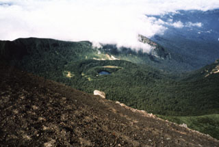 The NishiIwate caldera of Iwatesan is seen here from the summit of Yakushidake, a cone on the eastern caldera rim. Onoshiroko lake fills the Okama crater in the center of the caldera.
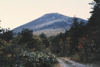 Yakushidake cone is the youngest feature of Iwatesan, viewed here from the N. A lava flow erupted from a NE-flank vent in 1719 CE.
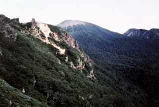 Yakushidake (center) is the summit cone of Iwatesan and was constructed at the eastern end of the 1.8 x 3 km NishiIwate caldera. The N and S caldera rims form the ridges to the left and right, respectively. Both Yakushidake and a cone in the western caldera have been active in historical time.
 The unvegetated Yakebashiri lava flow descended the NE flank of the Yakushidake summit cone of Iwate volcano in 1719 CE. This is the youngest lava flow from Iwate, erupting from a vent on the upper NE flank. It traveled down to about the 550 m elevation, 3.5 km from the vent.
The following 2 samples associated with this volcano can be found in the Smithsonian's NMNH Department of Mineral Sciences collections, and may be availble for research (contact the Rock and Ore Collections Manager). Catalog number links will open a window with more information.
| Catalog Number | Sample Description | Lava Source | Collection Date |
|---|---|---|---|
| NMNH 112964 | Hypersthene Andesite | OKAMA CRATER | -- |
| NMNH 112964 | Hypersthene Andesite | OKAMA CRATER | -- |
| Copernicus Browser | The Copernicus Browser replaced the Sentinel Hub Playground browser in 2023, to provide access to Earth observation archives from the Copernicus Data Space Ecosystem, the main distribution platform for data from the EU Copernicus missions. |
| MIROVA | Middle InfraRed Observation of Volcanic Activity (MIROVA) is a near real time volcanic hot-spot detection system based on the analysis of MODIS (Moderate Resolution Imaging Spectroradiometer) data. In particular, MIROVA uses the Middle InfraRed Radiation (MIR), measured over target volcanoes, in order to detect, locate and measure the heat radiation sourced from volcanic activity. |
| MODVOLC Thermal Alerts | Using infrared satellite Moderate Resolution Imaging Spectroradiometer (MODIS) data, scientists at the Hawai'i Institute of Geophysics and Planetology, University of Hawai'i, developed an automated system called MODVOLC to map thermal hot-spots in near real time. For each MODIS image, the algorithm automatically scans each 1 km pixel within it to check for high-temperature hot-spots. When one is found the date, time, location, and intensity are recorded. MODIS looks at every square km of the Earth every 48 hours, once during the day and once during the night, and the presence of two MODIS sensors in space allows at least four hot-spot observations every two days. Each day updated global maps are compiled to display the locations of all hot spots detected in the previous 24 hours. There is a drop-down list with volcano names which allow users to 'zoom-in' and examine the distribution of hot-spots at a variety of spatial scales. |
|
WOVOdat
Single Volcano View Temporal Evolution of Unrest Side by Side Volcanoes |
WOVOdat is a database of volcanic unrest; instrumentally and visually recorded changes in seismicity, ground deformation, gas emission, and other parameters from their normal baselines. It is sponsored by the World Organization of Volcano Observatories (WOVO) and presently hosted at the Earth Observatory of Singapore.
GVMID Data on Volcano Monitoring Infrastructure The Global Volcano Monitoring Infrastructure Database GVMID, is aimed at documenting and improving capabilities of volcano monitoring from the ground and space. GVMID should provide a snapshot and baseline view of the techniques and instrumentation that are in place at various volcanoes, which can be use by volcano observatories as reference to setup new monitoring system or improving networks at a specific volcano. These data will allow identification of what monitoring gaps exist, which can be then targeted by remote sensing infrastructure and future instrument deployments. |
| Volcanic Hazard Maps | The IAVCEI Commission on Volcanic Hazards and Risk has a Volcanic Hazard Maps database designed to serve as a resource for hazard mappers (or other interested parties) to explore how common issues in hazard map development have been addressed at different volcanoes, in different countries, for different hazards, and for different intended audiences. In addition to the comprehensive, searchable Volcanic Hazard Maps Database, this website contains information about diversity of volcanic hazard maps, illustrated using examples from the database. This site is for educational purposes related to volcanic hazard maps. Hazard maps found on this website should not be used for emergency purposes. For the most recent, official hazard map for a particular volcano, please seek out the proper institutional authorities on the matter. |
| IRIS seismic stations/networks | Incorporated Research Institutions for Seismology (IRIS) Data Services map showing the location of seismic stations from all available networks (permanent or temporary) within a radius of 0.18° (about 20 km at mid-latitudes) from the given location of Iwatesan. Users can customize a variety of filters and options in the left panel. Note that if there are no stations are known the map will default to show the entire world with a "No data matched request" error notice. |
| UNAVCO GPS/GNSS stations | Geodetic Data Services map from UNAVCO showing the location of GPS/GNSS stations from all available networks (permanent or temporary) within a radius of 20 km from the given location of Iwatesan. Users can customize the data search based on station or network names, location, and time window. Requires Adobe Flash Player. |
| DECADE Data | The DECADE portal, still in the developmental stage, serves as an example of the proposed interoperability between The Smithsonian Institution's Global Volcanism Program, the Mapping Gas Emissions (MaGa) Database, and the EarthChem Geochemical Portal. The Deep Earth Carbon Degassing (DECADE) initiative seeks to use new and established technologies to determine accurate global fluxes of volcanic CO2 to the atmosphere, but installing CO2 monitoring networks on 20 of the world's 150 most actively degassing volcanoes. The group uses related laboratory-based studies (direct gas sampling and analysis, melt inclusions) to provide new data for direct degassing of deep earth carbon to the atmosphere. |
| Large Eruptions of Iwatesan | Information about large Quaternary eruptions (VEI >= 4) is cataloged in the Large Magnitude Explosive Volcanic Eruptions (LaMEVE) database of the Volcano Global Risk Identification and Analysis Project (VOGRIPA). |
| EarthChem | EarthChem develops and maintains databases, software, and services that support the preservation, discovery, access and analysis of geochemical data, and facilitate their integration with the broad array of other available earth science parameters. EarthChem is operated by a joint team of disciplinary scientists, data scientists, data managers and information technology developers who are part of the NSF-funded data facility Integrated Earth Data Applications (IEDA). IEDA is a collaborative effort of EarthChem and the Marine Geoscience Data System (MGDS). |

