

AVO reported that volcanic activity at Gareloi had decreased during the previous few weeks and that, although small earthquakes continue to be recorded, the current activity was at background levels. At 1150 on 5 March the Volcano Alert Level was lowered to Normal (the lowest level on a four-level scale) and the Aviation Color Code was lowered to Green (the lowest color on a four-color scale).
Source: US Geological Survey Alaska Volcano Observatory (AVO)
Pilot report of plume on 27 September
On 27 September the Aviation Weather Unit in Alaska received a pilot report of a minor eruption of ash and steam at Gareloi. The plume reportedly rose to 1,500 m altitude but was not visible on infrared satellite imagery suggesting it may have not ascended that high. As late as 5 December AVO had learned of no further sightings of activity at Gareloi.
Information Contacts: NOAA/NESDIS Satellite Analysis Branch (SAB), Room 401, 5200 Auth Road, Camp Springs, MD 20746, USA; Alaska Volcano Observatory (AVO), a cooperative program of a) U.S. Geological Survey, 4200 University Drive, Anchorage, AK 99508-4667, USA (URL: http://www.avo.alaska.edu/), b) Geophysical Institute, University of Alaska, PO Box 757320, Fairbanks, AK 99775-7320, USA, and c) Alaska Division of Geological & Geophysical Surveys, 794 University Ave., Suite 200, Fairbanks, AK 99709, USA.
2024: February
2021: March
| May
| June
| July
AVO reported that volcanic activity at Gareloi had decreased during the previous few weeks and that, although small earthquakes continue to be recorded, the current activity was at background levels. At 1150 on 5 March the Volcano Alert Level was lowered to Normal (the lowest level on a four-level scale) and the Aviation Color Code was lowered to Green (the lowest color on a four-color scale).
Source: US Geological Survey Alaska Volcano Observatory (AVO)
AVO reported that unrest continued at Gareloi during 14-20 February. Seismicity remained elevated and was characterized by volcanic earthquakes and semi-continuous tremor, though after 16 February levels began to decline and only periods of seismic tremor were reported. Minor steaming was identified in webcam and satellite images on 14 February. The Volcano Alert Level remained at Advisory (the second lowest level on a four-level scale) and the Aviation Color Code remained at Yellow (the second lowest color on a four-color scale).
Source: US Geological Survey Alaska Volcano Observatory (AVO)
AVO raised the Volcano Alert Level for Gareloi to Advisory (the second level on a four-level scale) and the Aviation Color Code to Yellow (the second color on a four-color scale) at 1310 on 12 February due to increased seismic activity. Seismic unrest began at 0915 on 12 February; the local seismic network recorded ongoing tremor during 12-13 February. Persistent degassing activity from a fumarole field located on the S crater continued. No additional surficial activity was observed in partly cloudy satellite and webcam images.
Source: US Geological Survey Alaska Volcano Observatory (AVO)
AVO reported that the elevated seismicity first detected at Gareloi in May had continued through June and then declined to background levels. On 28 July the Aviation Color Code was lowered to Green and the Volcano Alert Level was lowered to Normal.
Source: US Geological Survey Alaska Volcano Observatory (AVO)
AVO reported that a minor increase in seismicity was first detected at Gareloi on 19 May. Beginning on 27 May the rate and size of small volcanic earthquakes increased and was sustained at that level. On 8 June AVO raised the Aviation Color Code to Yellow and the Volcano Alert Level to Advisory based on seismicity rising above baseline levels. Sulfur dioxide emissions had been identified in satellite images the past week, though they were consistent with measurements recorded in previous years. No other changes were evident in satellite or webcam views.
Source: US Geological Survey Alaska Volcano Observatory (AVO)
On 27 May AVO changed the Aviation Color Code and Volcano Alert Level for Gareloi to Green and Normal, respectively, reflecting that communication with seismic stations had been re-established, allowing for the location of earthquakes and detection of unrest.
Source: US Geological Survey Alaska Volcano Observatory (AVO)
AVO reported that a loss of operation and communication with all seismic stations on Gareloi was likely due to snow cover. Both the Aviation Color Code and the Volcano Alert Level were changed to Unassigned, reflecting the lack of this data to detect unrest. The observatory noted that regional infrasound networks, lightning detection, and satellite images will be used to monitor and detected unrest.
Source: US Geological Survey Alaska Volcano Observatory (AVO)
Reports are organized chronologically and indexed below by Month/Year (Publication Volume:Number), and include a one-line summary. Click on the index link or scroll down to read the reports.
Tephra cloud from summit crater
During an overflight on 8 August, USN pilot Edwin Beech saw vapor rising to about 1 km above the summit crater. The next day, a Northwest Orient Airlines pilot observed a steam and ash column that reached 10.5 km altitude and was blown NNW, away from inhabited areas. Poor weather obscured the summit for the next several days, although large eruption columns would have been visible above the cloud layer from passing aircraft.
On 13 August, USN pilots were able to see the top 300 m of the volcano. A light gray eruption cloud that appeared to originate from the NE quadrant of the summit crater rose to about 2.5 km altitude (1 km above the summit), depositing ash to the NW. Both Lt. Beech and David Evans, who operates the USGS seismic station on nearby Adak Island, felt that the summit area had changed significantly during the eruption.
By 23-24 August, the activity had declined to weak vapor emission. No lava flows have been observed. Gareloi's last reported eruption was in January 1952.
Information Contacts: T. Miller, USGS, Anchorage; Lt. E. Beech, U.S. Navy, Adak Island; D. Evans, USGS, Adak Island.
Renewed ash emission to six kilometers
USAF pilot Jerry Nelson observed renewed activity from Gareloi during an overflight on 17 September. As he approached the volcano at about 1600, he saw a slight wisp of vapor that grew rapidly into a dark brown ash-rich column reaching about 6 km altitude. The eruption column, which appeared to originate from the E side of the summit crater, drifted slightly N or NW. The activity was visible until Nelson left the area about 10 minutes later.
Information Contacts: T. Miller, USGS, Anchorage AK; J. Nelson, U.S. Air Force, Travis AFB, CA.
Aircraft samples stratospheric plume
On 10 and 11 August, SO2 from a fresh volcanic plume was detected from a research aircraft (flown by NASA under contract from the U.S. Department of Energy) at 19.2 km altitude just S of Anchorage Alaska.
Imagery returned 8 August at 1010 by the NOAA 6 satellite shows a high-altitude plume appearing to originate from the vicinity of Gareloi. Using a drift rate of 30 km/hour, Los Alamos National Laboratory (LANL) personnel calculated that the eruption that produced this plume had probably ended about 10 hours earlier. Later visual and infrared images show the plume moving toward the Anchorage area, about 2,000 km from Gareloi, at a rate that could have brought it to the sampling area by 10 August. The eruption column seen emerging from Gareloi 9 August by a commercial pilot was also present on satellite images, but clearly was not large enough and did not reach a high enough altitude to have been the source of the material sampled 10-11 August. Wind conditions also preclude the 7 August eruption clouds from Mt. St. Helens as a source for SO2 in the Anchorage area at this time.
Further Reference. Sedlacek, W.A., Mroz, E.J., and Heiken, G., 1981, Stratospheric sulfate from the Gareloi eruption, 1980: contribution to the "ambient" aerosol by a poorly documented volcanic eruption: Geophysical Research Letters, v. 8, p. 761-764.
Information Contacts: W. Sedlacek, G. Heiken, and E. Mroz, LANL.
Large plume seen on satellite imagery
Infrared imagery from the NOAA 7 polar orbiting satellite 15 January at 1402 showed an apparent eruption cloud blowing E from the vicinity of Gareloi (figure 1). Analysis of this image yielded a cloud top temperature of -36°C, indicating an altitude of 7-9 km. No eruption clouds were present on images the two previous days and the following day, nor was any activity evident on imagery 24 January, or 3 and 11 February. No ashfall was reported on Adak Island (130 km to the E) or Shemya Island (500 km to the WNW). Navy pilots plan to photograph Gareloi in the near future, for comparison with photos taken during and after its August-September 1980 eruption.
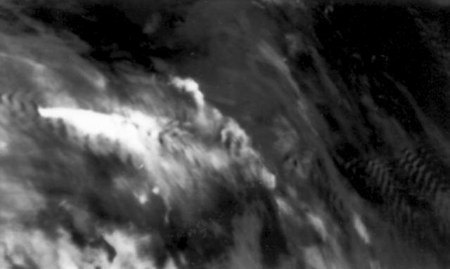 |
Figure 1. Infrared image returned 15 January 1982 at 1402 by the NOAA 7 polar orbiting satellite. A bright white plume, at left-center, drifts ESE. Dark ripples near the plume and at right-center indicate the position of islands in the Aleutian chain. |
The seismic network on Adak Island recorded an mb 3.2-3.3 earthquake on 15 January at 0521. No unique hypocenter can be determined for this event, but one of the two possible solutions places it directly under Gareloi. This shock was substantially larger than the mb 2.6 event that accompanied the February 1974 eruption of Great Sitkin, which produced a 3-km plume. Additional events were recorded the following week that may also be centered in the vicinity of Gareloi. An infrasound array at College, Alaska (about 2,200 km NE of Gareloi) recorded no acoustic wave associated with the eruption.
Information Contacts: J. Kienle, Univ. of Alaska; S. Billington, NOAA/CIRES, Univ. of Colorado; P. Mutschlecner, LANL.
Narrow steaming flow-like feature
On 4 September 1987 at 1500, flight engineer George Wooliver (Reeve Aleutian Airways) observed a narrow flow-like feature that had descended the E flank, from the N crater rim at 1,500 m elevation to at least 1,100 m. A thick cloud cover obscured it below that level. Steam was rising as much as 100 m above the flow feature along its entire visible length. Steaming from the crater appeared more vigorous than usual.
Information Contacts: J. Reeder, ADGGS.
Pilot report of plume on 27 September
On 27 September the Aviation Weather Unit in Alaska received a pilot report of a minor eruption of ash and steam at Gareloi. The plume reportedly rose to 1,500 m altitude but was not visible on infrared satellite imagery suggesting it may have not ascended that high. As late as 5 December AVO had learned of no further sightings of activity at Gareloi.
Information Contacts: NOAA/NESDIS Satellite Analysis Branch (SAB), Room 401, 5200 Auth Road, Camp Springs, MD 20746, USA; Alaska Volcano Observatory (AVO), a cooperative program of a) U.S. Geological Survey, 4200 University Drive, Anchorage, AK 99508-4667, USA (URL: http://www.avo.alaska.edu/), b) Geophysical Institute, University of Alaska, PO Box 757320, Fairbanks, AK 99775-7320, USA, and c) Alaska Division of Geological & Geophysical Surveys, 794 University Ave., Suite 200, Fairbanks, AK 99709, USA.
|
|
||||||||||||||||||||||||||
There is data available for 12 confirmed Holocene eruptive periods.
[ 1996 Sep 27 ] Uncertain Eruption
| Episode 1 | Eruption (Explosive / Effusive) | |||||||||||||||||||||||||
|---|---|---|---|---|---|---|---|---|---|---|---|---|---|---|---|---|---|---|---|---|---|---|---|---|---|
| 1996 Sep 27 - Unknown | Evidence from Unknown | ||||||||||||||||||||||||
|
List of 3 Events for Episode 1
|
|||||||||||||||||||||||||
1989 Aug 17 - 1989 Aug 17 Confirmed Eruption (Explosive / Effusive) VEI: 1
| Episode 1 | Eruption (Explosive / Effusive) | ||||||||||||||||||||
|---|---|---|---|---|---|---|---|---|---|---|---|---|---|---|---|---|---|---|---|---|
| 1989 Aug 17 - 1989 Aug 17 | Evidence from Observations: Reported | |||||||||||||||||||
| As described by AVO, from Reeder (1992): "At 1430 on August 17, 1989, Evan Klett of the U.S. Fish and Wildlife observed from the Reeve Aleutian Airways Inc. 727 Boeing Jet, flying from Shemay Island to Adak Island, a grayish to black tephra plume that was about 700 m above the northern near summit crater of Gareloi volcano. The plume covered the top of the 400 m by 260 m near summit crater, which prevented Evan from seeing into the crater. The tephra plume was definitely originating from the summit crater." | ||||||||||||||||||||
|
List of 2 Events for Episode 1
|
||||||||||||||||||||
1987 Aug 30 ± 5 days - 1987 Sep 4 (on or before) Confirmed Eruption (Explosive / Effusive) VEI: 1 (?)
| Episode 1 | Eruption (Explosive / Effusive) | N crater rim, E flank | ||||||||||||||||||||||||
|---|---|---|---|---|---|---|---|---|---|---|---|---|---|---|---|---|---|---|---|---|---|---|---|---|---|
| 1987 Aug 30 ± 5 days - 1987 Sep 4 (on or before) | Evidence from Observations: Reported | ||||||||||||||||||||||||
| On 4 September 1987 at 1500, flight engineer George Wooliver (Reeve Aleutian Airways) observed a narrow flow-like feature that had descended the E flank, from the N crater rim at 1,500 m elevation to at least 1,100 m. A thick cloud cover obscured it below that level. Steam was rising as much as 100 m above the flow feature along its entire visible length, and steaming from the crater appeared more vigorous than usual (SEAN 12:08). Although this may have been a pyroclastic density current, later photos published by AVO showed 1980s era lava flows. | |||||||||||||||||||||||||
|
List of 3 Events for Episode 1 at N crater rim, E flank
|
|||||||||||||||||||||||||
1982 Jan 15 - 1982 Jan 15 Confirmed Eruption (Explosive / Effusive) VEI: 3
| Episode 1 | Eruption (Explosive / Effusive) | ||||||||||||||||||||||||||||||
|---|---|---|---|---|---|---|---|---|---|---|---|---|---|---|---|---|---|---|---|---|---|---|---|---|---|---|---|---|---|---|
| 1982 Jan 15 - 1982 Jan 15 | Evidence from Observations: Reported | |||||||||||||||||||||||||||||
|
List of 4 Events for Episode 1
|
||||||||||||||||||||||||||||||
1980 Aug 7 - 1980 Sep 17 Confirmed Eruption (Explosive / Effusive) VEI: 3 (?)
| Episode 1 | Eruption (Explosive / Effusive) | |||||||||||||||||||||||||
|---|---|---|---|---|---|---|---|---|---|---|---|---|---|---|---|---|---|---|---|---|---|---|---|---|---|
| 1980 Aug 7 - 1980 Sep 17 | Evidence from Observations: Reported | ||||||||||||||||||||||||
|
List of 3 Events for Episode 1
|
|||||||||||||||||||||||||
1952 Jan 17 Confirmed Eruption (Explosive / Effusive) VEI: 2 (?)
| Episode 1 | Eruption (Explosive / Effusive) | ||||||||||||||||||||
|---|---|---|---|---|---|---|---|---|---|---|---|---|---|---|---|---|---|---|---|---|
| 1952 Jan 17 - Unknown | Evidence from Observations: Reported | |||||||||||||||||||
|
List of 2 Events for Episode 1
|
||||||||||||||||||||
1950 Jul 2 ± 182 days - 1951 Jul 2 ± 182 days Confirmed Eruption (Explosive / Effusive) VEI: 1
| Episode 1 | Eruption (Explosive / Effusive) | |||||||||||||||||||||||||
|---|---|---|---|---|---|---|---|---|---|---|---|---|---|---|---|---|---|---|---|---|---|---|---|---|---|
| 1950 Jul 2 ± 182 days - 1951 Jul 2 ± 182 days | Evidence from Observations: Reported | ||||||||||||||||||||||||
|
List of 3 Events for Episode 1
|
|||||||||||||||||||||||||
1929 Apr - 1930 Confirmed Eruption (Explosive / Effusive) VEI: 3
| Episode 1 | Eruption (Explosive / Effusive) | SE flank fissure (near summit to sea) | ||||||||||||||||||||||||||||||||||||||||||||||||||||||||||||||||
|---|---|---|---|---|---|---|---|---|---|---|---|---|---|---|---|---|---|---|---|---|---|---|---|---|---|---|---|---|---|---|---|---|---|---|---|---|---|---|---|---|---|---|---|---|---|---|---|---|---|---|---|---|---|---|---|---|---|---|---|---|---|---|---|---|---|
| 1929 Apr - 1930 | Evidence from Observations: Reported | ||||||||||||||||||||||||||||||||||||||||||||||||||||||||||||||||
|
List of 11 Events for Episode 1 at SE flank fissure (near summit to sea)
|
|||||||||||||||||||||||||||||||||||||||||||||||||||||||||||||||||
[ 1927 ] Uncertain Eruption
| Episode 1 | Eruption (Explosive / Effusive) | |||||||||||||||
|---|---|---|---|---|---|---|---|---|---|---|---|---|---|---|---|
| 1927 - Unknown | Evidence from Unknown | ||||||||||||||
|
List of 1 Events for Episode 1
|
|||||||||||||||
1922 Confirmed Eruption (Explosive / Effusive) VEI: 3
| Episode 1 | Eruption (Explosive / Effusive) | ||||||||||||||||||||
|---|---|---|---|---|---|---|---|---|---|---|---|---|---|---|---|---|---|---|---|---|
| 1922 - Unknown | Evidence from Observations: Reported | |||||||||||||||||||
|
List of 2 Events for Episode 1
|
||||||||||||||||||||
1873 Confirmed Eruption (Explosive / Effusive) VEI: 2 (?)
| Episode 1 | Eruption (Explosive / Effusive) | |||||||||||||||
|---|---|---|---|---|---|---|---|---|---|---|---|---|---|---|---|
| 1873 - Unknown | Evidence from Observations: Reported | ||||||||||||||
|
List of 1 Events for Episode 1
|
|||||||||||||||
[ 1828 - 1829 ] Uncertain Eruption
| Episode 1 | Eruption (Explosive / Effusive) | ||||||||||||||||||||
|---|---|---|---|---|---|---|---|---|---|---|---|---|---|---|---|---|---|---|---|---|
| 1828 - 1829 | Evidence from Unknown | |||||||||||||||||||
|
List of 2 Events for Episode 1
|
||||||||||||||||||||
1792 Confirmed Eruption (Explosive / Effusive) VEI: 2
| Episode 1 | Eruption (Explosive / Effusive) | |||||||||||||||||||||||||
|---|---|---|---|---|---|---|---|---|---|---|---|---|---|---|---|---|---|---|---|---|---|---|---|---|---|
| 1792 - Unknown | Evidence from Observations: Reported | ||||||||||||||||||||||||
|
List of 3 Events for Episode 1
|
|||||||||||||||||||||||||
1791 Confirmed Eruption (Explosive / Effusive) VEI: 2
| Episode 1 | Eruption (Explosive / Effusive) | ||||||||||||||||||||
|---|---|---|---|---|---|---|---|---|---|---|---|---|---|---|---|---|---|---|---|---|
| 1791 - Unknown | Evidence from Observations: Reported | |||||||||||||||||||
|
List of 2 Events for Episode 1
|
||||||||||||||||||||
1790 Confirmed Eruption (Explosive / Effusive) VEI: 2
| Episode 1 | Eruption (Explosive / Effusive) | ||||||||||||||||||||
|---|---|---|---|---|---|---|---|---|---|---|---|---|---|---|---|---|---|---|---|---|
| 1790 - Unknown | Evidence from Observations: Reported | |||||||||||||||||||
|
List of 2 Events for Episode 1
|
||||||||||||||||||||
[ 1760 ] Uncertain Eruption
| Episode 1 | Eruption (Explosive / Effusive) | |||||||||||||||
|---|---|---|---|---|---|---|---|---|---|---|---|---|---|---|---|
| 1760 - Unknown | Evidence from Unknown | ||||||||||||||
|
List of 1 Events for Episode 1
|
|||||||||||||||
This compilation of synonyms and subsidiary features may not be comprehensive. Features are organized into four major categories: Cones, Craters, Domes, and Thermal Features. Synonyms of features appear indented below the primary name. In some cases additional feature type, elevation, or location details are provided.
Synonyms |
| Anangusik | Burning Volcano |
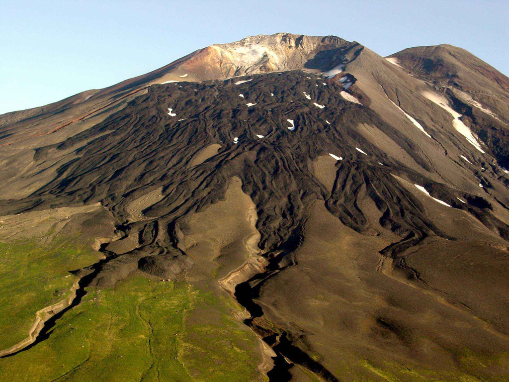
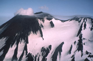 Two peaks form the summit ridge of Gareloi. The active NE-most crater (left) forms the high point of the island. A SE-trending 4-km-long fissure formed during an eruption in 1929, extends from the summit (right) to the sea and contains 13 vents. Phreatic explosions were followed by the ejection of pumice, lapilli, scoria, and lithics, as well as by the emission of four short lava flows.
 Gareloi in the western Aleutian Islands is seen here from the S. This photo shows lava flows with clear levees from a 1980s eruption. The 8 x 10 km diameter Gareloi Island consists of a stratovolcano with two peaks and a SE-trending fissure that formed during a 1929 eruption and extends to the sea.
The following 35 samples associated with this volcano can be found in the Smithsonian's NMNH Department of Mineral Sciences collections, and may be availble for research (contact the Rock and Ore Collections Manager). Catalog number links will open a window with more information.
| Catalog Number | Sample Description | Lava Source | Collection Date |
|---|---|---|---|
| NMNH 118210-1 | Lapilli tephra | -- | 17 Sep 2015 |
| NMNH 118210-10 | Picrite | -- | 17 Sep 2015 |
| NMNH 118210-11 | Lapilli tephra | -- | 17 Sep 2015 |
| NMNH 118210-12 | Lapilli tephra | -- | 17 Sep 2015 |
| NMNH 118210-13 | Volcanic Ash | -- | 17 Sep 2015 |
| NMNH 118210-14 | Lapilli tephra | -- | 17 Sep 2015 |
| NMNH 118210-15 | Coarse ash | -- | 17 Sep 2015 |
| NMNH 118210-16 | Lapilli tephra | -- | 18 Sep 2015 |
| NMNH 118210-17 | Lapilli tephra | -- | 18 Sep 2015 |
| NMNH 118210-18 | Lapilli tephra | -- | 18 Sep 2015 |
| NMNH 118210-19 | Coarse ash | -- | 18 Sep 2015 |
| NMNH 118210-2 | Volcanic Ash | -- | 17 Sep 2015 |
| NMNH 118210-20 | Coarse ash | -- | 18 Sep 2015 |
| NMNH 118210-21 | Scoriaceous agglutinate | -- | 19 Sep 2015 |
| NMNH 118210-22 | Scoriaceous Basalt | -- | 19 Sep 2015 |
| NMNH 118210-23 | Ash; Scoria | -- | 19 Sep 2015 |
| NMNH 118210-24 | Basalt | -- | 19 Sep 2015 |
| NMNH 118210-25 | Volcanic Ash | -- | 19 Sep 2015 |
| NMNH 118210-26 | Lapilli tephra | -- | 19 Sep 2015 |
| NMNH 118210-27 | Lapilli tephra | -- | 19 Sep 2015 |
| NMNH 118210-28 | Lapilli tephra | -- | 19 Sep 2015 |
| NMNH 118210-29 | Lapilli tephra | -- | 19 Sep 2015 |
| NMNH 118210-3 | Lapilli tephra | -- | 17 Sep 2015 |
| NMNH 118210-30 | Coarse ash | -- | 19 Sep 2015 |
| NMNH 118210-31 | Coarse ash | -- | 19 Sep 2015 |
| NMNH 118210-32 | Lapilli tephra | -- | 19 Sep 2015 |
| NMNH 118210-33 | Lapilli tephra | -- | 19 Sep 2015 |
| NMNH 118210-34 | Lapilli tephra | -- | 17 Sep 2015 |
| NMNH 118210-35 | Basalt | -- | 17 Sep 2015 |
| NMNH 118210-4 | Tephra | -- | 17 Sep 2015 |
| NMNH 118210-5 | Lapilli tephra | -- | 17 Sep 2015 |
| NMNH 118210-6 | Volcanic Ash | -- | 17 Sep 2015 |
| NMNH 118210-7 | Lapilli tephra | -- | 17 Sep 2015 |
| NMNH 118210-8 | Fine ash | -- | 17 Sep 2015 |
| NMNH 118210-9 | Fine ash | -- | 17 Sep 2015 |
| Alaska Volcano Observatory (Link to Gareloi) | The Alaska Volcano Observatory (AVO) is a joint program of the U.S. Geological Survey (USGS), the Geophysical Institute of the University of Alaska Fairbanks (UAFGI), and the State of Alaska Division of Geological and Geophysical Surveys (ADGGS). AVO was formed in 1988, and uses federal, state, and university resources to monitor and study Alaska's hazardous volcanoes, to predict and record eruptive activity, and to mitigate volcanic hazards to life and property. |
| Copernicus Browser | The Copernicus Browser replaced the Sentinel Hub Playground browser in 2023, to provide access to Earth observation archives from the Copernicus Data Space Ecosystem, the main distribution platform for data from the EU Copernicus missions. |
| MIROVA | Middle InfraRed Observation of Volcanic Activity (MIROVA) is a near real time volcanic hot-spot detection system based on the analysis of MODIS (Moderate Resolution Imaging Spectroradiometer) data. In particular, MIROVA uses the Middle InfraRed Radiation (MIR), measured over target volcanoes, in order to detect, locate and measure the heat radiation sourced from volcanic activity. |
| MODVOLC Thermal Alerts | Using infrared satellite Moderate Resolution Imaging Spectroradiometer (MODIS) data, scientists at the Hawai'i Institute of Geophysics and Planetology, University of Hawai'i, developed an automated system called MODVOLC to map thermal hot-spots in near real time. For each MODIS image, the algorithm automatically scans each 1 km pixel within it to check for high-temperature hot-spots. When one is found the date, time, location, and intensity are recorded. MODIS looks at every square km of the Earth every 48 hours, once during the day and once during the night, and the presence of two MODIS sensors in space allows at least four hot-spot observations every two days. Each day updated global maps are compiled to display the locations of all hot spots detected in the previous 24 hours. There is a drop-down list with volcano names which allow users to 'zoom-in' and examine the distribution of hot-spots at a variety of spatial scales. |
|
WOVOdat
Single Volcano View Temporal Evolution of Unrest Side by Side Volcanoes |
WOVOdat is a database of volcanic unrest; instrumentally and visually recorded changes in seismicity, ground deformation, gas emission, and other parameters from their normal baselines. It is sponsored by the World Organization of Volcano Observatories (WOVO) and presently hosted at the Earth Observatory of Singapore.
GVMID Data on Volcano Monitoring Infrastructure The Global Volcano Monitoring Infrastructure Database GVMID, is aimed at documenting and improving capabilities of volcano monitoring from the ground and space. GVMID should provide a snapshot and baseline view of the techniques and instrumentation that are in place at various volcanoes, which can be use by volcano observatories as reference to setup new monitoring system or improving networks at a specific volcano. These data will allow identification of what monitoring gaps exist, which can be then targeted by remote sensing infrastructure and future instrument deployments. |
| Volcanic Hazard Maps | The IAVCEI Commission on Volcanic Hazards and Risk has a Volcanic Hazard Maps database designed to serve as a resource for hazard mappers (or other interested parties) to explore how common issues in hazard map development have been addressed at different volcanoes, in different countries, for different hazards, and for different intended audiences. In addition to the comprehensive, searchable Volcanic Hazard Maps Database, this website contains information about diversity of volcanic hazard maps, illustrated using examples from the database. This site is for educational purposes related to volcanic hazard maps. Hazard maps found on this website should not be used for emergency purposes. For the most recent, official hazard map for a particular volcano, please seek out the proper institutional authorities on the matter. |
| IRIS seismic stations/networks | Incorporated Research Institutions for Seismology (IRIS) Data Services map showing the location of seismic stations from all available networks (permanent or temporary) within a radius of 0.18° (about 20 km at mid-latitudes) from the given location of Gareloi. Users can customize a variety of filters and options in the left panel. Note that if there are no stations are known the map will default to show the entire world with a "No data matched request" error notice. |
| UNAVCO GPS/GNSS stations | Geodetic Data Services map from UNAVCO showing the location of GPS/GNSS stations from all available networks (permanent or temporary) within a radius of 20 km from the given location of Gareloi. Users can customize the data search based on station or network names, location, and time window. Requires Adobe Flash Player. |
| DECADE Data | The DECADE portal, still in the developmental stage, serves as an example of the proposed interoperability between The Smithsonian Institution's Global Volcanism Program, the Mapping Gas Emissions (MaGa) Database, and the EarthChem Geochemical Portal. The Deep Earth Carbon Degassing (DECADE) initiative seeks to use new and established technologies to determine accurate global fluxes of volcanic CO2 to the atmosphere, but installing CO2 monitoring networks on 20 of the world's 150 most actively degassing volcanoes. The group uses related laboratory-based studies (direct gas sampling and analysis, melt inclusions) to provide new data for direct degassing of deep earth carbon to the atmosphere. |
| Large Eruptions of Gareloi | Information about large Quaternary eruptions (VEI >= 4) is cataloged in the Large Magnitude Explosive Volcanic Eruptions (LaMEVE) database of the Volcano Global Risk Identification and Analysis Project (VOGRIPA). |
| EarthChem | EarthChem develops and maintains databases, software, and services that support the preservation, discovery, access and analysis of geochemical data, and facilitate their integration with the broad array of other available earth science parameters. EarthChem is operated by a joint team of disciplinary scientists, data scientists, data managers and information technology developers who are part of the NSF-funded data facility Integrated Earth Data Applications (IEDA). IEDA is a collaborative effort of EarthChem and the Marine Geoscience Data System (MGDS). |