

The Global Volcanism Program has no activity reports available for Pavlof Sister.
The Global Volcanism Program has no Weekly Reports available for Pavlof Sister.
The Global Volcanism Program has no Bulletin Reports available for Pavlof Sister.
The Global Volcanism Program has no synonyms or subfeatures listed for Pavlof Sister.
|
|
||||||||||||||||||||||||||
The Global Volcanism Program is not aware of any Holocene eruptions from Pavlof Sister. If this volcano has had large eruptions (VEI >= 4) prior to 10,000 years ago, information might be found on the Pavlof Sister page in the LaMEVE (Large Magnitude Explosive Volcanic Eruptions) database, a part of the Volcano Global Risk Identification and Analysis Project (VOGRIPA).
There is no Deformation History data available for Pavlof Sister.
There is no Emissions History data available for Pavlof Sister.
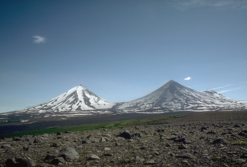
 The twin volcanoes of Pavlof (left) and Pavlof Sister (right) rise above a sea of clouds on the southern Alaska Peninsula. The two conical stratovolcanoes are constructed on the same NE-SW line as Little Pavlof, a flank cone in the left center of this 1978 view from the SW. Pavlof, its NE slopes darkened by ash, is the most active volcano of the Aleutian arc. Ash-free Pavlof Sister is somewhat more glacially dissected than Pavlof and has had only one historical eruption.
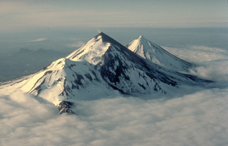
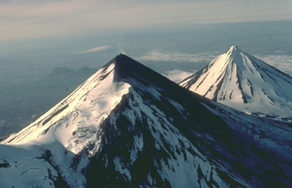 The twin volcanoes of Pavlof (left) and Pavlof Sister (right) are prominent landmarks on the southern Alaska Peninsula. The summits of the two conical stratovolcanoes are only 5 km apart. This 1978 view from the SW shows a steam plume rising from the 2519-m summit of Pavlof, the most active volcano of the Aleutian arc. Pavlof Sister, somewhat more eroded than Pavlof, has had only a single historical eruption, in the 18th century.
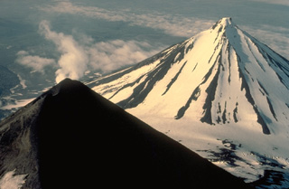 A steam plume rises from the summit of Pavlof volcano, whose upper slopes are snow-free as a result of its frequent eruptions. More-extensive glacial dissection of Pavlof Sister volcano (upper right) has produced a series of parasol-ribbed ridges that radiate from the summit. Only one historical eruption is known from Pavlof Sister.
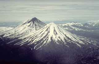 Pavlof Sister (center) and Pavlof (upper left) are twin stratovolcanoes whose summits are only 5 km apart. A low saddle about 1100-m high separates the conical volcanoes. They are the most prominent features along a NE-SW-trending line of vents that extends from Emmons Lake caldera, which is behind 2519-m Pavlof volcano in this view from the NE, to 2142-m Pavlof Sister volcano.
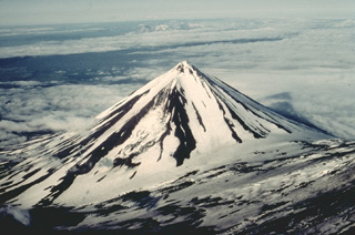 Pavlof Sister is a symmetrical stratovolcano that forms a twin volcano with Pavlof volcano, whose lower flank forms the slope at the lower right in this view from the SW. Despite its youthful profile, Pavlof Sister has had only one historical eruption, which began in 1762. Glacial dissection has produced a series of parasol-ribbed ridges that radiate from the 2142-m, sharp-peaked summit.
 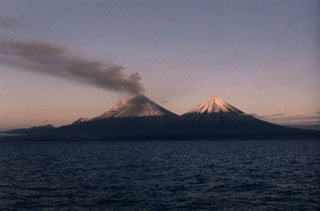 An ash plume disperses to the south in mid-July 1986, three months after the start of an eruption of Pavlof that lasted nearly 2.5 years. This photo was taken from the west on a fishing boat in Pavlof Bay, with Pavlof Sister to the right. The 1986-88 eruption produced intermittent ashfall and lava flows from two vents near the summit, one halfway down the SE flank, and another 600 m below the summit on the NE flank. Lava flows traveled to the N, NE, SE, ESE, and SSE, the latter to within 600 m of the Pavlof Bay shoreline.
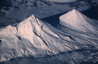 Pavlof (left) and Pavlof Sister (right) are shown in this 20 January 1987 view from the SW. Small steam plumes rise along the length of a lava flow descending a valley on the SE (right) flank of Pavlof. Recent snowfall covers ashfall that was frequently deposited on its slopes. This eruption began with explosive activity on 16 April 1986 and continued until 13 August 1988. Lava flows traveled down the N, NE, SE, ESE, and SSE flanks, the latter reaching to within 600 m of Pavlof Bay.
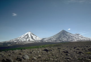 The summits of Pavlof Sister (left) and Pavlof (right) rise above a roughly 1,100-m-elevation saddle. They are viewed here in 1975 from lowlands to the NW. Pavlof is darkened by recent ash deposition and has been the source of frequent eruptions in historical time. Little Pavlof, a cone on the right flank of Pavlof, was also constructed along a line of vents trending NE from Emmons Lake caldera.
 Pavlof, rising above low plains to its NW, is one of Alaska's most active volcanoes. It is part of a NNE-SSW-trending line of volcanoes near the tip of the Alaskan Peninsula. Little Pavlof is the small cone on the right horizon. The low saddle to the left separates Pavlof from Pavlof Sister, whose lower flanks are seen to the far left.
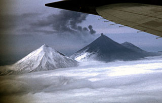 A small ash plume rises from the summit crater of Pavlof volcano on 28 May 1960 as the detached plume from an earlier explosion drifts away to the east. Ash deposits are visible on the flanks in this view from the north. Mild ash eruptions took place from about 1960 to 1963, especially during July 1962 to June 1963. The peak to the left is Pavlof Sister, and Little Pavlof forms the smaller peak to the right of Pavlof.
Maps are not currently available due to technical issues.
The maps shown below have been scanned from the GVP map archives and include the volcano on this page. Clicking on the small images will load the full 300 dpi map. Very small-scale maps (such as world maps) are not included.
There are no samples for Pavlof Sister in the Smithsonian's NMNH Department of Mineral Sciences Rock and Ore collection.
| Alaska Volcano Observatory (Link to Pavlof Sister) | The Alaska Volcano Observatory (AVO) is a joint program of the U.S. Geological Survey (USGS), the Geophysical Institute of the University of Alaska Fairbanks (UAFGI), and the State of Alaska Division of Geological and Geophysical Surveys (ADGGS). AVO was formed in 1988, and uses federal, state, and university resources to monitor and study Alaska's hazardous volcanoes, to predict and record eruptive activity, and to mitigate volcanic hazards to life and property. |
| Copernicus Browser | The Copernicus Browser replaced the Sentinel Hub Playground browser in 2023, to provide access to Earth observation archives from the Copernicus Data Space Ecosystem, the main distribution platform for data from the EU Copernicus missions. |
| MIROVA | Middle InfraRed Observation of Volcanic Activity (MIROVA) is a near real time volcanic hot-spot detection system based on the analysis of MODIS (Moderate Resolution Imaging Spectroradiometer) data. In particular, MIROVA uses the Middle InfraRed Radiation (MIR), measured over target volcanoes, in order to detect, locate and measure the heat radiation sourced from volcanic activity. |
| MODVOLC Thermal Alerts | Using infrared satellite Moderate Resolution Imaging Spectroradiometer (MODIS) data, scientists at the Hawai'i Institute of Geophysics and Planetology, University of Hawai'i, developed an automated system called MODVOLC to map thermal hot-spots in near real time. For each MODIS image, the algorithm automatically scans each 1 km pixel within it to check for high-temperature hot-spots. When one is found the date, time, location, and intensity are recorded. MODIS looks at every square km of the Earth every 48 hours, once during the day and once during the night, and the presence of two MODIS sensors in space allows at least four hot-spot observations every two days. Each day updated global maps are compiled to display the locations of all hot spots detected in the previous 24 hours. There is a drop-down list with volcano names which allow users to 'zoom-in' and examine the distribution of hot-spots at a variety of spatial scales. |
|
WOVOdat
Single Volcano View Temporal Evolution of Unrest Side by Side Volcanoes |
WOVOdat is a database of volcanic unrest; instrumentally and visually recorded changes in seismicity, ground deformation, gas emission, and other parameters from their normal baselines. It is sponsored by the World Organization of Volcano Observatories (WOVO) and presently hosted at the Earth Observatory of Singapore.
GVMID Data on Volcano Monitoring Infrastructure The Global Volcano Monitoring Infrastructure Database GVMID, is aimed at documenting and improving capabilities of volcano monitoring from the ground and space. GVMID should provide a snapshot and baseline view of the techniques and instrumentation that are in place at various volcanoes, which can be use by volcano observatories as reference to setup new monitoring system or improving networks at a specific volcano. These data will allow identification of what monitoring gaps exist, which can be then targeted by remote sensing infrastructure and future instrument deployments. |
| Volcanic Hazard Maps | The IAVCEI Commission on Volcanic Hazards and Risk has a Volcanic Hazard Maps database designed to serve as a resource for hazard mappers (or other interested parties) to explore how common issues in hazard map development have been addressed at different volcanoes, in different countries, for different hazards, and for different intended audiences. In addition to the comprehensive, searchable Volcanic Hazard Maps Database, this website contains information about diversity of volcanic hazard maps, illustrated using examples from the database. This site is for educational purposes related to volcanic hazard maps. Hazard maps found on this website should not be used for emergency purposes. For the most recent, official hazard map for a particular volcano, please seek out the proper institutional authorities on the matter. |
| IRIS seismic stations/networks | Incorporated Research Institutions for Seismology (IRIS) Data Services map showing the location of seismic stations from all available networks (permanent or temporary) within a radius of 0.18° (about 20 km at mid-latitudes) from the given location of Pavlof Sister. Users can customize a variety of filters and options in the left panel. Note that if there are no stations are known the map will default to show the entire world with a "No data matched request" error notice. |
| UNAVCO GPS/GNSS stations | Geodetic Data Services map from UNAVCO showing the location of GPS/GNSS stations from all available networks (permanent or temporary) within a radius of 20 km from the given location of Pavlof Sister. Users can customize the data search based on station or network names, location, and time window. Requires Adobe Flash Player. |
| DECADE Data | The DECADE portal, still in the developmental stage, serves as an example of the proposed interoperability between The Smithsonian Institution's Global Volcanism Program, the Mapping Gas Emissions (MaGa) Database, and the EarthChem Geochemical Portal. The Deep Earth Carbon Degassing (DECADE) initiative seeks to use new and established technologies to determine accurate global fluxes of volcanic CO2 to the atmosphere, but installing CO2 monitoring networks on 20 of the world's 150 most actively degassing volcanoes. The group uses related laboratory-based studies (direct gas sampling and analysis, melt inclusions) to provide new data for direct degassing of deep earth carbon to the atmosphere. |
| Large Eruptions of Pavlof Sister | Information about large Quaternary eruptions (VEI >= 4) is cataloged in the Large Magnitude Explosive Volcanic Eruptions (LaMEVE) database of the Volcano Global Risk Identification and Analysis Project (VOGRIPA). |
| EarthChem | EarthChem develops and maintains databases, software, and services that support the preservation, discovery, access and analysis of geochemical data, and facilitate their integration with the broad array of other available earth science parameters. EarthChem is operated by a joint team of disciplinary scientists, data scientists, data managers and information technology developers who are part of the NSF-funded data facility Integrated Earth Data Applications (IEDA). IEDA is a collaborative effort of EarthChem and the Marine Geoscience Data System (MGDS). |