Fumaroles active 35 years ago now emitting water vapor at 86°C
Izalco's summit crater was visited to examine the fumarole field that was the site of many geochemical and mineralogical studies in the 1960's and 1970's. The remaining fumaroles consist only of water vapor with a maximum temperature of 86°C.
Volcan de Izalco originated in 1770 A.D. on the S flank of Santa Ana volcano. Frequent Strombolian eruptions from the volcano, known as the "Lighthouse of Central America," produced a 650-m-high stratovolcano within 200 years.
Information Contacts: Alain Bernard, BRUGEL, Université Libre de Bruxelles 160/02 50, Ave. Roosevelt, 1050 Brussels, Belgium.
The Global Volcanism Program has no Weekly Reports available for Izalco.
Reports are organized chronologically and indexed below by Month/Year (Publication Volume:Number), and include a one-line summary. Click on the index link or scroll down to read the reports.
Thermal anomaly detected in 1973
Card 1792 (07 February 1974) Thermal anomaly detected in 1973
Remote infrared thermal patterns have been measured on the northeast flank . . . four times since December 1969. The sensor station is on Cerro Cerde at a distance of 1,100 m from Izalco. On 7 July 1973, a thermal anomaly appeared near the summit in a region that had been thermally inactive in earlie infrared studies. The anomaly stretched downslope about 50 m and covered an area about 1,000 m2. The highest of the anomalous apparent surface etemperatures was 15°C, 2° above ambient. Data just processed from the 24 November 1973 observations show the anomaly expanded to the east to cover about 5,000 m2. The most intense apparent surface temperatures occur in the same spot as the earlier pattern and register 19°C, 8° above ambient. The anomaly was intensified. The appearance and intensification of a thermal anomaly at Izalco indicates a change in the thermal regime of the volcano. The temperatures of the summit fumaroles were not unusually high in December 1973. The concentration of intermediate-depth earthquakes just south of Izalco was unusually high for the period 1971-72, as compared to 1967-70. Geophysical observations of these anomalous events are continuing.
Izalco last erupted in October-November 1966, with a lava flow from its south flank. Prior to that it had undergone intermittent lava and pyroclastic eruptions from 1770 to 1956, building up a composite cone 650 m above its base.
Information Contacts: Richard Birnie, Harvard University, Cambridge, MA; Ian Lange, Department of Geology, University of Montana, Missoula, MT; R. E. Stoiber, Department of Earth Sciences, Dartmouth College, Hanover, NH.
Strong fumarolic activity around the summit crater
During fieldwork on Santa Ana volcano in February, increased steaming was observed at the summit of Izalco relative to levels of previous years. Strong fumarolic activity occurred along the entire circumference of the 250-m-wide summit crater, with the exception of the NE side facing Cerro Verde. Activity was most vigorous at a vent on the N side of the crater floor, but was also strong along much of the inner rim of the crater and along its outer flanks. Steaming was observed over broad areas on the outer southern flanks to ~50 m below the rim, and on the W flank immediately N of a shoulder of the cone at ~1,800 m elevation, roughly 150 m below the summit. Activity had earlier been noticed to have increased in November 1998 following Hurricane Mitch. Most of the steaming was water vapor, and the increased activity was attributed to saturation of the still-warm cone by heavy rains accompanying the hurricane.
Information Contacts: Carlos Pullinger, Calle Padres Aguilar 448, Colonia Escalon, San Salvador, El Salvador; Demetrio Escobar, Centro de Investigaciones Geotecnicas (CIG), Final Blvd. Venezuela y calle a La Chacra, Apdo. Postal 109, San Salvador, El Salvador; Lee Siebert and Paul Kimberly, Global Volcanism Program, Smithsonian Institution.
Fumaroles active 35 years ago now emitting water vapor at 86°C
Izalco's summit crater was visited to examine the fumarole field that was the site of many geochemical and mineralogical studies in the 1960's and 1970's. The remaining fumaroles consist only of water vapor with a maximum temperature of 86°C.
Volcan de Izalco originated in 1770 A.D. on the S flank of Santa Ana volcano. Frequent Strombolian eruptions from the volcano, known as the "Lighthouse of Central America," produced a 650-m-high stratovolcano within 200 years.
Information Contacts: Alain Bernard, BRUGEL, Université Libre de Bruxelles 160/02 50, Ave. Roosevelt, 1050 Brussels, Belgium.
|
|
||||||||||||||||||||||||||||
There is data available for 51 confirmed eruptive periods.
1966 Oct 28 - 1966 Nov 16 ± 15 days Confirmed Eruption (Explosive / Effusive) VEI: 0
| Episode 1 | Eruption (Explosive / Effusive) | SSE flank (550 m below summit) | ||||||||||||||||||
|---|---|---|---|---|---|---|---|---|---|---|---|---|---|---|---|---|---|---|---|
| 1966 Oct 28 - 1966 Nov 16 ± 15 days | Evidence from Observations: Reported | ||||||||||||||||||
|
List of 2 Events for Episode 1 at SSE flank (550 m below summit)
|
|||||||||||||||||||
1948 Nov 4 - 1957 Dec 1 ± 30 days Confirmed Eruption (Explosive / Effusive) VEI: 3
| Episode 1 | Eruption (Explosive / Effusive) | Summit, SW and NE flanks | ||||||||||||||||||||||||||||||||||||||||||||||||||||||||||||||||||||
|---|---|---|---|---|---|---|---|---|---|---|---|---|---|---|---|---|---|---|---|---|---|---|---|---|---|---|---|---|---|---|---|---|---|---|---|---|---|---|---|---|---|---|---|---|---|---|---|---|---|---|---|---|---|---|---|---|---|---|---|---|---|---|---|---|---|---|---|---|---|
| 1948 Nov 4 - 1957 Dec 1 ± 30 days | Evidence from Observations: Reported | ||||||||||||||||||||||||||||||||||||||||||||||||||||||||||||||||||||
|
List of 12 Events for Episode 1 at Summit, SW and NE flanks
|
|||||||||||||||||||||||||||||||||||||||||||||||||||||||||||||||||||||
1939 Feb - 1948 Feb Confirmed Eruption (Explosive / Effusive) VEI: 2
| Episode 1 | Eruption (Explosive / Effusive) | Summit and SSE flank | ||||||||||||||||||||||||||||
|---|---|---|---|---|---|---|---|---|---|---|---|---|---|---|---|---|---|---|---|---|---|---|---|---|---|---|---|---|---|
| 1939 Feb - 1948 Feb | Evidence from Observations: Reported | ||||||||||||||||||||||||||||
|
List of 4 Events for Episode 1 at Summit and SSE flank
|
|||||||||||||||||||||||||||||
1937 (?) - 1938 (?) Confirmed Eruption (Explosive / Effusive) VEI: 2 (?)
| Episode 1 | Eruption (Explosive / Effusive) | ||||||||||||||||||||||||
|---|---|---|---|---|---|---|---|---|---|---|---|---|---|---|---|---|---|---|---|---|---|---|---|---|
| 1937 (?) - 1938 (?) | Evidence from Observations: Reported | |||||||||||||||||||||||
|
List of 3 Events for Episode 1
|
||||||||||||||||||||||||
1933 Nov 30 - 1934 Jan 12 (on or after) Confirmed Eruption (Explosive / Effusive) VEI: 2
| Episode 1 | Eruption (Explosive / Effusive) | |||||||||||||||||||||||||||||
|---|---|---|---|---|---|---|---|---|---|---|---|---|---|---|---|---|---|---|---|---|---|---|---|---|---|---|---|---|---|
| 1933 Nov 30 - 1934 Jan 12 (on or after) | Evidence from Observations: Reported | ||||||||||||||||||||||||||||
|
List of 4 Events for Episode 1
|
|||||||||||||||||||||||||||||
1931 Mar 31 ± 90 days Confirmed Eruption (Explosive / Effusive) VEI: 2
| Episode 1 | Eruption (Explosive / Effusive) | ||||||||||||||||||||||||
|---|---|---|---|---|---|---|---|---|---|---|---|---|---|---|---|---|---|---|---|---|---|---|---|---|
| 1931 Mar 31 ± 90 days - Unknown | Evidence from Observations: Reported | |||||||||||||||||||||||
|
List of 3 Events for Episode 1
|
||||||||||||||||||||||||
1930 Apr Confirmed Eruption (Explosive / Effusive) VEI: 0
| Episode 1 | Eruption (Explosive / Effusive) | Outer slope of eastern summit crater | ||||||||||||||||||
|---|---|---|---|---|---|---|---|---|---|---|---|---|---|---|---|---|---|---|---|
| 1930 Apr - Unknown | Evidence from Observations: Reported | ||||||||||||||||||
|
List of 2 Events for Episode 1 at Outer slope of eastern summit crater
|
|||||||||||||||||||
1927 - 1928 (?) Confirmed Eruption (Explosive / Effusive) VEI: 2
| Episode 1 | Eruption (Explosive / Effusive) | |||||||||||||||||||
|---|---|---|---|---|---|---|---|---|---|---|---|---|---|---|---|---|---|---|---|
| 1927 - 1928 (?) | Evidence from Observations: Reported | ||||||||||||||||||
|
List of 2 Events for Episode 1
|
|||||||||||||||||||
1925 Dec 26 - 1927 Jan Confirmed Eruption (Explosive / Effusive) VEI: 3 (?)
| Episode 1 | Eruption (Explosive / Effusive) | ||||||||||||||||||||||||||||||||||||||||||||||||||||||
|---|---|---|---|---|---|---|---|---|---|---|---|---|---|---|---|---|---|---|---|---|---|---|---|---|---|---|---|---|---|---|---|---|---|---|---|---|---|---|---|---|---|---|---|---|---|---|---|---|---|---|---|---|---|---|
| 1925 Dec 26 - 1927 Jan | Evidence from Observations: Reported | |||||||||||||||||||||||||||||||||||||||||||||||||||||
|
List of 9 Events for Episode 1
|
||||||||||||||||||||||||||||||||||||||||||||||||||||||
1924 Mar Confirmed Eruption (Explosive / Effusive) VEI: 2
| Episode 1 | Eruption (Explosive / Effusive) | |||||||||||||||||||
|---|---|---|---|---|---|---|---|---|---|---|---|---|---|---|---|---|---|---|---|
| 1924 Mar - Unknown | Evidence from Observations: Reported | ||||||||||||||||||
|
List of 2 Events for Episode 1
|
|||||||||||||||||||
1920 Oct 29 - 1921 Apr 10 Confirmed Eruption (Explosive / Effusive) VEI: 2
| Episode 1 | Eruption (Explosive / Effusive) | SE flank | |||||||||||||||||||||||
|---|---|---|---|---|---|---|---|---|---|---|---|---|---|---|---|---|---|---|---|---|---|---|---|---|
| 1920 Oct 29 - 1921 Apr 10 | Evidence from Observations: Reported | |||||||||||||||||||||||
|
List of 3 Events for Episode 1 at SE flank
|
||||||||||||||||||||||||
1912 Jan 16 - 1916 Jan 26 Confirmed Eruption (Explosive / Effusive) VEI: 2
| Episode 1 | Eruption (Explosive / Effusive) | Summit and NE flank | |||||||||||||||||||||||||||||||||||||||||||
|---|---|---|---|---|---|---|---|---|---|---|---|---|---|---|---|---|---|---|---|---|---|---|---|---|---|---|---|---|---|---|---|---|---|---|---|---|---|---|---|---|---|---|---|---|
| 1912 Jan 16 - 1916 Jan 26 | Evidence from Observations: Reported | |||||||||||||||||||||||||||||||||||||||||||
|
List of 7 Events for Episode 1 at Summit and NE flank
|
||||||||||||||||||||||||||||||||||||||||||||
1903 Nov - 1905 Mar Confirmed Eruption (Explosive / Effusive) VEI: 2
| Episode 1 | Eruption (Explosive / Effusive) | Summit and east flank | ||||||||||||||||||||||||||||||||||||||
|---|---|---|---|---|---|---|---|---|---|---|---|---|---|---|---|---|---|---|---|---|---|---|---|---|---|---|---|---|---|---|---|---|---|---|---|---|---|---|---|
| 1903 Nov - 1905 Mar | Evidence from Observations: Reported | ||||||||||||||||||||||||||||||||||||||
|
List of 6 Events for Episode 1 at Summit and east flank
|
|||||||||||||||||||||||||||||||||||||||
1902 May 10 - 1902 Dec 30 Confirmed Eruption (Explosive / Effusive) VEI: 2
| Episode 1 | Eruption (Explosive / Effusive) | Summit and NE flank | ||||||||||||||||||||||||||||
|---|---|---|---|---|---|---|---|---|---|---|---|---|---|---|---|---|---|---|---|---|---|---|---|---|---|---|---|---|---|
| 1902 May 10 - 1902 Dec 30 | Evidence from Observations: Reported | ||||||||||||||||||||||||||||
|
List of 4 Events for Episode 1 at Summit and NE flank
|
|||||||||||||||||||||||||||||
1899 Dec 31 - 1900 Mar Confirmed Eruption (Explosive / Effusive) VEI: 2
| Episode 1 | Eruption (Explosive / Effusive) | |||||||||||||||||||
|---|---|---|---|---|---|---|---|---|---|---|---|---|---|---|---|---|---|---|---|
| 1899 Dec 31 - 1900 Mar | Evidence from Observations: Reported | ||||||||||||||||||
|
List of 2 Events for Episode 1
|
|||||||||||||||||||
1891 - 1898 Jul Confirmed Eruption (Explosive / Effusive) VEI: 2
| Episode 1 | Eruption (Explosive / Effusive) | ||||||||||||||||||||||||
|---|---|---|---|---|---|---|---|---|---|---|---|---|---|---|---|---|---|---|---|---|---|---|---|---|
| 1891 - 1898 Jul | Evidence from Observations: Reported | |||||||||||||||||||||||
|
List of 3 Events for Episode 1
|
||||||||||||||||||||||||
1890 Mar 26 ± 5 days - 1890 Apr 20 Confirmed Eruption (Explosive / Effusive) VEI: 0
| Episode 1 | Eruption (Explosive / Effusive) | Summit and upper east flank | |||||||||||||||||||||||
|---|---|---|---|---|---|---|---|---|---|---|---|---|---|---|---|---|---|---|---|---|---|---|---|---|
| 1890 Mar 26 ± 5 days - 1890 Apr 20 | Evidence from Observations: Reported | |||||||||||||||||||||||
|
List of 3 Events for Episode 1 at Summit and upper east flank
|
||||||||||||||||||||||||
1887 - 1889 Confirmed Eruption (Explosive / Effusive) VEI: 2
| Episode 1 | Eruption (Explosive / Effusive) | ||||||||||||||||||||||||
|---|---|---|---|---|---|---|---|---|---|---|---|---|---|---|---|---|---|---|---|---|---|---|---|---|
| 1887 - 1889 | Evidence from Observations: Reported | |||||||||||||||||||||||
|
List of 3 Events for Episode 1
|
||||||||||||||||||||||||
1885 Confirmed Eruption (Explosive / Effusive) VEI: 2
| Episode 1 | Eruption (Explosive / Effusive) | ||||||||||||||||||||||||
|---|---|---|---|---|---|---|---|---|---|---|---|---|---|---|---|---|---|---|---|---|---|---|---|---|
| 1885 - Unknown | Evidence from Observations: Reported | |||||||||||||||||||||||
|
List of 3 Events for Episode 1
|
||||||||||||||||||||||||
1884 Mar 9 - 1884 Mar 10 Confirmed Eruption (Explosive / Effusive) VEI: 2
| Episode 1 | Eruption (Explosive / Effusive) | ||||||||||||||||||||||||||||||||||
|---|---|---|---|---|---|---|---|---|---|---|---|---|---|---|---|---|---|---|---|---|---|---|---|---|---|---|---|---|---|---|---|---|---|---|
| 1884 Mar 9 - 1884 Mar 10 | Evidence from Observations: Reported | |||||||||||||||||||||||||||||||||
|
List of 5 Events for Episode 1
|
||||||||||||||||||||||||||||||||||
1883 Sep 5 ± 4 days - 1883 Nov 13 Confirmed Eruption (Explosive / Effusive) VEI: 2
| Episode 1 | Eruption (Explosive / Effusive) | |||||||||||||||||||
|---|---|---|---|---|---|---|---|---|---|---|---|---|---|---|---|---|---|---|---|
| 1883 Sep 5 ± 4 days - 1883 Nov 13 | Evidence from Observations: Reported | ||||||||||||||||||
|
List of 2 Events for Episode 1
|
|||||||||||||||||||
1882 Jul 12 Confirmed Eruption (Explosive / Effusive) VEI: 2
| Episode 1 | Eruption (Explosive / Effusive) | |||||||||||||||||||
|---|---|---|---|---|---|---|---|---|---|---|---|---|---|---|---|---|---|---|---|
| 1882 Jul 12 - Unknown | Evidence from Observations: Reported | ||||||||||||||||||
|
List of 2 Events for Episode 1
|
|||||||||||||||||||
1881 Jan 1 Confirmed Eruption (Explosive / Effusive) VEI: 0
| Episode 1 | Eruption (Explosive / Effusive) | |||||||||||||||||||
|---|---|---|---|---|---|---|---|---|---|---|---|---|---|---|---|---|---|---|---|
| 1881 Jan 1 - Unknown | Evidence from Observations: Reported | ||||||||||||||||||
|
List of 2 Events for Episode 1
|
|||||||||||||||||||
1879 Dec 25 - 1880 Mar Confirmed Eruption (Explosive / Effusive) VEI: 2
| Episode 1 | Eruption (Explosive / Effusive) | ||||||||||||||||||||||||
|---|---|---|---|---|---|---|---|---|---|---|---|---|---|---|---|---|---|---|---|---|---|---|---|---|
| 1879 Dec 25 - 1880 Mar | Evidence from Observations: Reported | |||||||||||||||||||||||
|
List of 3 Events for Episode 1
|
||||||||||||||||||||||||
1878 Confirmed Eruption (Explosive / Effusive)
| Episode 1 | Eruption (Explosive / Effusive) | ||||
|---|---|---|---|---|
| 1878 - Unknown | Evidence from Observations: Reported | |||
[ 1874 - 1875 ] Uncertain Eruption
| Episode 1 | Eruption (Explosive / Effusive) | ||||
|---|---|---|---|---|
| 1874 - 1875 | Evidence from Unknown | |||
1872 Dec - 1873 Mar 19 (on or after) Confirmed Eruption (Explosive / Effusive) VEI: 2
| Episode 1 | Eruption (Explosive / Effusive) | ||||||||||||||||||||||||
|---|---|---|---|---|---|---|---|---|---|---|---|---|---|---|---|---|---|---|---|---|---|---|---|---|
| 1872 Dec - 1873 Mar 19 (on or after) | Evidence from Observations: Reported | |||||||||||||||||||||||
|
List of 3 Events for Episode 1
|
||||||||||||||||||||||||
[ 1870 May 19 ] Uncertain Eruption
| Episode 1 | Eruption (Explosive / Effusive) | ||||||||||||||||||||||||
|---|---|---|---|---|---|---|---|---|---|---|---|---|---|---|---|---|---|---|---|---|---|---|---|---|
| 1870 May 19 - Unknown | Evidence from Unknown | |||||||||||||||||||||||
|
List of 3 Events for Episode 1
|
||||||||||||||||||||||||
1869 Mar 1 (?) - 1869 Jun 18 (on or after) Confirmed Eruption (Explosive / Effusive) VEI: 2
| Episode 1 | Eruption (Explosive / Effusive) | Summit and east flank | |||||||||||||||||||||||||||||||||||||||||||
|---|---|---|---|---|---|---|---|---|---|---|---|---|---|---|---|---|---|---|---|---|---|---|---|---|---|---|---|---|---|---|---|---|---|---|---|---|---|---|---|---|---|---|---|---|
| 1869 Mar 1 (?) - 1869 Jun 18 (on or after) | Evidence from Observations: Reported | |||||||||||||||||||||||||||||||||||||||||||
|
List of 7 Events for Episode 1 at Summit and east flank
|
||||||||||||||||||||||||||||||||||||||||||||
1868 Feb 16 - 1868 Feb 17 Confirmed Eruption (Explosive / Effusive) VEI: 2
| Episode 1 | Eruption (Explosive / Effusive) | |||||||||||||||||||
|---|---|---|---|---|---|---|---|---|---|---|---|---|---|---|---|---|---|---|---|
| 1868 Feb 16 - 1868 Feb 17 | Evidence from Observations: Reported | ||||||||||||||||||
|
List of 2 Events for Episode 1
|
|||||||||||||||||||
1867 Apr - 1867 Aug Confirmed Eruption (Explosive / Effusive) VEI: 2
| Episode 1 | Eruption (Explosive / Effusive) | ||||||||||||||||||||||||
|---|---|---|---|---|---|---|---|---|---|---|---|---|---|---|---|---|---|---|---|---|---|---|---|---|
| 1867 Apr - 1867 Aug | Evidence from Observations: Reported | |||||||||||||||||||||||
|
List of 3 Events for Episode 1
|
||||||||||||||||||||||||
1866 Apr 27 - 1866 Aug 15 ± 5 days Confirmed Eruption (Explosive / Effusive) VEI: 2
| Episode 1 | Eruption (Explosive / Effusive) | ||||||||||||||||||||||||
|---|---|---|---|---|---|---|---|---|---|---|---|---|---|---|---|---|---|---|---|---|---|---|---|---|
| 1866 Apr 27 - 1866 Aug 15 ± 5 days | Evidence from Observations: Reported | |||||||||||||||||||||||
|
List of 3 Events for Episode 1
|
||||||||||||||||||||||||
1864 May 15 ± 2 days - 1865 Jun 15 ± 5 days Confirmed Eruption (Explosive / Effusive) VEI: 2
| Episode 1 | Eruption (Explosive / Effusive) | Summit and NE flank | |||||||||||||||||||||||||||||||||
|---|---|---|---|---|---|---|---|---|---|---|---|---|---|---|---|---|---|---|---|---|---|---|---|---|---|---|---|---|---|---|---|---|---|---|
| 1864 May 15 ± 2 days - 1865 Jun 15 ± 5 days | Evidence from Observations: Reported | |||||||||||||||||||||||||||||||||
|
List of 5 Events for Episode 1 at Summit and NE flank
|
||||||||||||||||||||||||||||||||||
1863 Confirmed Eruption (Explosive / Effusive) VEI: 0
| Episode 1 | Eruption (Explosive / Effusive) | |||||||||||||||||||
|---|---|---|---|---|---|---|---|---|---|---|---|---|---|---|---|---|---|---|---|
| 1863 - Unknown | Evidence from Observations: Reported | ||||||||||||||||||
|
List of 2 Events for Episode 1
|
|||||||||||||||||||
1859 Dec 8 - 1860 Jan 22 Confirmed Eruption (Explosive / Effusive) VEI: 0
| Episode 1 | Eruption (Explosive / Effusive) | ||||||||||||||||||||||||
|---|---|---|---|---|---|---|---|---|---|---|---|---|---|---|---|---|---|---|---|---|---|---|---|---|
| 1859 Dec 8 - 1860 Jan 22 | Evidence from Observations: Reported | |||||||||||||||||||||||
|
List of 3 Events for Episode 1
|
||||||||||||||||||||||||
1858 Feb 6 - 1859 Jul Confirmed Eruption (Explosive / Effusive) VEI: 2
| Episode 1 | Eruption (Explosive / Effusive) | ||||||||||||||||||||||||
|---|---|---|---|---|---|---|---|---|---|---|---|---|---|---|---|---|---|---|---|---|---|---|---|---|
| 1858 Feb 6 - 1859 Jul | Evidence from Observations: Reported | |||||||||||||||||||||||
|
List of 3 Events for Episode 1
|
||||||||||||||||||||||||
1857 Feb 15 - 1857 Feb 19 (on or after) Confirmed Eruption (Explosive / Effusive) VEI: 2
| Episode 1 | Eruption (Explosive / Effusive) | |||||||||||||||||||||||||||||
|---|---|---|---|---|---|---|---|---|---|---|---|---|---|---|---|---|---|---|---|---|---|---|---|---|---|---|---|---|---|
| 1857 Feb 15 - 1857 Feb 19 (on or after) | Evidence from Observations: Reported | ||||||||||||||||||||||||||||
|
List of 4 Events for Episode 1
|
|||||||||||||||||||||||||||||
1856 May 24 - 1856 Sep 1 ± 1 days Confirmed Eruption (Explosive / Effusive) VEI: 2
| Episode 1 | Eruption (Explosive / Effusive) | Summit and south flank | |||||||||||||||||||||||||||||||||||||||||||
|---|---|---|---|---|---|---|---|---|---|---|---|---|---|---|---|---|---|---|---|---|---|---|---|---|---|---|---|---|---|---|---|---|---|---|---|---|---|---|---|---|---|---|---|---|
| 1856 May 24 - 1856 Sep 1 ± 1 days | Evidence from Observations: Reported | |||||||||||||||||||||||||||||||||||||||||||
|
List of 7 Events for Episode 1 at Summit and south flank
|
||||||||||||||||||||||||||||||||||||||||||||
1854 May 13 - 1854 Jun 8 Confirmed Eruption (Explosive / Effusive) VEI: 2
| Episode 1 | Eruption (Explosive / Effusive) | ||||||||||||||||||||||||
|---|---|---|---|---|---|---|---|---|---|---|---|---|---|---|---|---|---|---|---|---|---|---|---|---|
| 1854 May 13 - 1854 Jun 8 | Evidence from Observations: Reported | |||||||||||||||||||||||
|
List of 3 Events for Episode 1
|
||||||||||||||||||||||||
1850 Confirmed Eruption (Explosive / Effusive) VEI: 2
| Episode 1 | Eruption (Explosive / Effusive) | ||||||||||||||||||||||||
|---|---|---|---|---|---|---|---|---|---|---|---|---|---|---|---|---|---|---|---|---|---|---|---|---|
| 1850 - Unknown | Evidence from Observations: Reported | |||||||||||||||||||||||
|
List of 3 Events for Episode 1
|
||||||||||||||||||||||||
1844 Jun - 1844 Oct Confirmed Eruption (Explosive / Effusive) VEI: 2
| Episode 1 | Eruption (Explosive / Effusive) | ||||||||||||||||||||||||
|---|---|---|---|---|---|---|---|---|---|---|---|---|---|---|---|---|---|---|---|---|---|---|---|---|
| 1844 Jun - 1844 Oct | Evidence from Observations: Reported | |||||||||||||||||||||||
|
List of 3 Events for Episode 1
|
||||||||||||||||||||||||
1842 Confirmed Eruption (Explosive / Effusive) VEI: 2
| Episode 1 | Eruption (Explosive / Effusive) | |||||||||||||||||||
|---|---|---|---|---|---|---|---|---|---|---|---|---|---|---|---|---|---|---|---|
| 1842 - Unknown | Evidence from Observations: Reported | ||||||||||||||||||
|
List of 2 Events for Episode 1
|
|||||||||||||||||||
1838 - 1840 Confirmed Eruption (Explosive / Effusive) VEI: 2
| Episode 1 | Eruption (Explosive / Effusive) | |||||||||||||||||||||||||||||||||||||||
|---|---|---|---|---|---|---|---|---|---|---|---|---|---|---|---|---|---|---|---|---|---|---|---|---|---|---|---|---|---|---|---|---|---|---|---|---|---|---|---|
| 1838 - 1840 | Evidence from Observations: Reported | ||||||||||||||||||||||||||||||||||||||
|
List of 6 Events for Episode 1
|
|||||||||||||||||||||||||||||||||||||||
1836 Confirmed Eruption (Explosive / Effusive) VEI: 2
| Episode 1 | Eruption (Explosive / Effusive) | |||||||||||||||||||
|---|---|---|---|---|---|---|---|---|---|---|---|---|---|---|---|---|---|---|---|
| 1836 - Unknown | Evidence from Observations: Reported | ||||||||||||||||||
|
List of 2 Events for Episode 1
|
|||||||||||||||||||
1825 Confirmed Eruption (Explosive / Effusive) VEI: 2
| Episode 1 | Eruption (Explosive / Effusive) | ||||||||||||||||||||||||
|---|---|---|---|---|---|---|---|---|---|---|---|---|---|---|---|---|---|---|---|---|---|---|---|---|
| 1825 - Unknown | Evidence from Observations: Reported | |||||||||||||||||||||||
|
List of 3 Events for Episode 1
|
||||||||||||||||||||||||
1817 Confirmed Eruption (Explosive / Effusive) VEI: 2
| Episode 1 | Eruption (Explosive / Effusive) | |||||||||||||||||||
|---|---|---|---|---|---|---|---|---|---|---|---|---|---|---|---|---|---|---|---|
| 1817 - Unknown | Evidence from Observations: Reported | ||||||||||||||||||
|
List of 2 Events for Episode 1
|
|||||||||||||||||||
1805 - 1807 Confirmed Eruption (Explosive / Effusive) VEI: 2
| Episode 1 | Eruption (Explosive / Effusive) | |||||||||||||||||||
|---|---|---|---|---|---|---|---|---|---|---|---|---|---|---|---|---|---|---|---|
| 1805 - 1807 | Evidence from Observations: Reported | ||||||||||||||||||
|
List of 2 Events for Episode 1
|
|||||||||||||||||||
1802 - 1803 Confirmed Eruption (Explosive / Effusive) VEI: 2
| Episode 1 | Eruption (Explosive / Effusive) | |||||||||||||||||||||||||||||
|---|---|---|---|---|---|---|---|---|---|---|---|---|---|---|---|---|---|---|---|---|---|---|---|---|---|---|---|---|---|
| 1802 - 1803 | Evidence from Observations: Reported | ||||||||||||||||||||||||||||
|
List of 4 Events for Episode 1
|
|||||||||||||||||||||||||||||
1798 Apr Confirmed Eruption (Explosive / Effusive) VEI: 2
| Episode 1 | Eruption (Explosive / Effusive) | ||||||||||||||||||||||||||||||||||
|---|---|---|---|---|---|---|---|---|---|---|---|---|---|---|---|---|---|---|---|---|---|---|---|---|---|---|---|---|---|---|---|---|---|---|
| 1798 Apr - Unknown | Evidence from Observations: Reported | |||||||||||||||||||||||||||||||||
|
List of 5 Events for Episode 1
|
||||||||||||||||||||||||||||||||||
1793 Mar 29 - 1793 Sep Confirmed Eruption (Explosive / Effusive) VEI: 2
| Episode 1 | Eruption (Explosive / Effusive) | |||||||||||||||||||||||||||||
|---|---|---|---|---|---|---|---|---|---|---|---|---|---|---|---|---|---|---|---|---|---|---|---|---|---|---|---|---|---|
| 1793 Mar 29 - 1793 Sep | Evidence from Observations: Reported | ||||||||||||||||||||||||||||
|
List of 4 Events for Episode 1
|
|||||||||||||||||||||||||||||
1783 Jul (?) Confirmed Eruption (Explosive / Effusive) VEI: 0
| Episode 1 | Eruption (Explosive / Effusive) | |||||||||||||||||||||||||||||
|---|---|---|---|---|---|---|---|---|---|---|---|---|---|---|---|---|---|---|---|---|---|---|---|---|---|---|---|---|---|
| 1783 Jul (?) - Unknown | Evidence from Observations: Reported | ||||||||||||||||||||||||||||
|
List of 4 Events for Episode 1
|
|||||||||||||||||||||||||||||
1772 (?) Confirmed Eruption (Explosive / Effusive) VEI: 2
| Episode 1 | Eruption (Explosive / Effusive) | |||||||||||||||||||
|---|---|---|---|---|---|---|---|---|---|---|---|---|---|---|---|---|---|---|---|
| 1772 (?) - Unknown | Evidence from Observations: Reported | ||||||||||||||||||
|
List of 2 Events for Episode 1
|
|||||||||||||||||||
1770 Feb 23 Confirmed Eruption (Explosive / Effusive) VEI: 2
| Episode 1 | Eruption (Explosive / Effusive) | ||||||||||||||||||||||||||||||||||||||||||||
|---|---|---|---|---|---|---|---|---|---|---|---|---|---|---|---|---|---|---|---|---|---|---|---|---|---|---|---|---|---|---|---|---|---|---|---|---|---|---|---|---|---|---|---|---|
| 1770 Feb 23 - Unknown | Evidence from Observations: Reported | |||||||||||||||||||||||||||||||||||||||||||
|
List of 7 Events for Episode 1
|
||||||||||||||||||||||||||||||||||||||||||||
[ 1636 ] Discredited Eruption
This compilation of synonyms and subsidiary features may not be comprehensive. Features are organized into four major categories: Cones, Craters, Domes, and Thermal Features. Synonyms of features appear indented below the primary name. In some cases additional feature type, elevation, or location details are provided.
Synonyms |
| Faro, El |
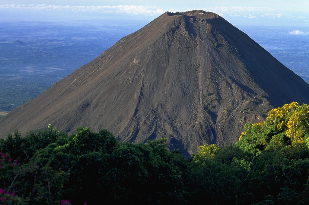
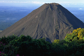 Volcán de Izalco is seen here from the north, on the southern flank of Santa Ana. It began erupting in 1770 CE and frequent Strombolian eruptions produced a steep-sided, 650-m-high stratovolcano over a 200-year period. Izalco was one of the most frequently active volcanoes in Central America, producing ejecta and lava flows from both summit and flank vents.
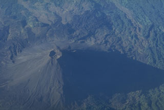 This aerial view shows Izalco with south at the top of the photo. The cone was constructed during frequent eruptions over a two-century period beginning in 1770. Strombolian eruptions from the summit crater were sometimes accompanied by lava flows that traveled down the flank to the south, extending as far as 7 km from the summit.
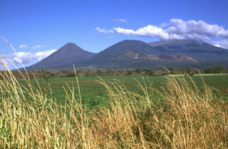 The broad Santa Ana volcano is to the right, with Izalco volcano to the left in this NW-looking view from the Zapotitán basin. The cone in the center is Cerro Verde, and the smaller, low-profile scoria cone below it is Cerro Marcelino. Historical eruptions have occurred from the summit crater of Santa Ana and flank cones such as Cerro Marcelino to the SE. Izalco formed in 1770, and the saddle between Izalco and Cerro Verde increased 100 m in height in the century after 1866.
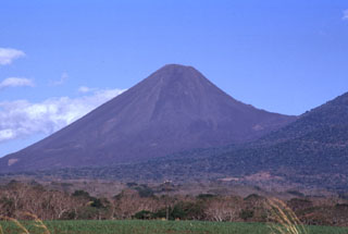 Volcán Izalco is one of El Salvador's most well-known volcanoes. It rises more than 1 km above its southern base (left) and 300 m above the saddle between it and Cerro Verde, a flank cone on Santa Ana (right). Since Izalco began erupting in 1770, the summit grew about 650 m above its original vent on the flank of Santa Ana volcano.
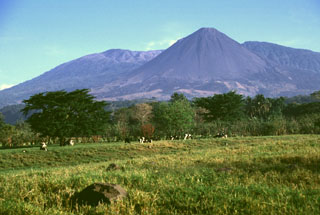 Izalco volcano was once known as the "Lighthouse of the Pacific" for its persistent incandescent nighttime eruptions. It was constructed on the southern flank of Santa Ana, whose broad summit is to the left. To the right is Cerro Verde, a scoria cone on the SE Santa Ana flank. Lava flows at the base if Izalco from both summit and flank vents and extend out to 7 km.
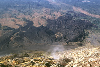 A lava flow field on the SW flank of Izalco is seen here from its summit. Levees define distinct flows of the lava field, which extends up to about 7 km from the summit. Most of the flows seen here were emplaced prior to 1954. Gas rises from fumaroles near the summit.
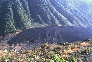 The lava flows with levees in the center of the photo were extruded from a vent on the NE flank of Izalco beginning in 1955. This lava extrusion took place during an almost continuous period of Strombolian activity from November 1948 until the end of 1957. Periods of lava effusion took place July 1950, September-November 1952, October 1954, intermittently in 1955, November 1956, and January 1957. The eruption tapered off in late 1957 and was over by the end of the year.
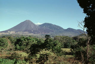 Izalco has been one of El Salvador's most active volcanoes during historical time. More than 50 eruptions took place since it began to erupt in 1770, many lasting several years to about a decade in duration. Eruptions took place both from the summit craters and from flank vents. Unvegetated lava flows are seen here on the SE flank below Cerro Verde (center) and El Conejal and El Astillero (right).
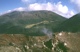 Santa Ana rises beyond the Izalco summit crater, which began erupting in 1770 on the northern Santa Ana flank. Fumarolic activity continues at Izalco, producing the faint steam plume in the right foreground, but has diminished considerably since the 200-year-long eruptive period ended in 1966. A complex of four nested craters gives the summit of Santa Ana a flat profile. The flank of Cerro Verde is seen to the right.
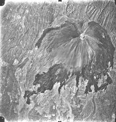 A vertical aerial photo shows the unvegetated slopes and dark-colored lava flows of Volcán de Izalco, El Salvador's youngest volcano. It originated in 1770 CE on the southern flank of Santa Ana volcano, whose summit lies to the north (top). Steep-sided, 650-m-high Izalco stratovolcano is truncated by a 250-m-wide crater. The flanks of Izalco consist primarily of pyroclastic material erupted from the summit crater; lava flows mostly originated from vents on the lower flanks and were deflected southward by the slopes of Santa Ana volcano.
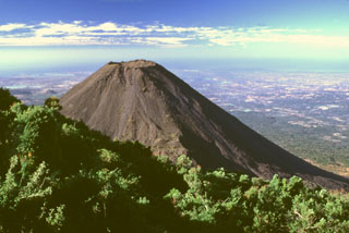 The flanks of Izalco volcano contrast with the vegetated Cerro Verde in the foreground. Izalco rises about 300 m above the saddle separating it from Cerro Verde. This view shows the Pacific Ocean 40 km to the south with much of the area between underlain by deposits associated with a late-Pleistocene Santa Ana debris avalanche.
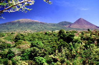 Three peaks of the Santa Ana massif can be seen from the highway between Sonsonate and San Salvador. The summit of Santa Ana volcano is to the left, the unvegetated Izalco volcano is to the right, and between them is Cerro Verde.
 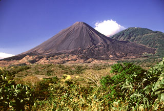 A lava flow field is at the base of Izalco composed of flows that mostly erupted from flank vents. They were deflected by the flank of Santa Ana and extend as far as about 7 km from the Izalco summit. The vegetated Cerro Verde scoria cone is to the right and is part of a trend of cones and vents that erupted SE of Santa Ana.
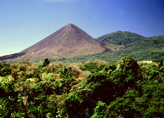 Izalco grew to its present height during a 200-year period since it began erupting in 1770 at an elevation of about 1,300 m on the flank of Santa Ana. Intermittent Strombolian eruptions and the effusion of dominantly basaltic andesite lava flows built up the volcano so that by the year 1866 the summit was at 1,825 m elevation, by 1866 it was at 1,825 m, by 1892 it was at 1,885 m, by 1951 it was at 1,900 m, by 1953 it was at 1,935, and by 1956 it was at 1,965 m.
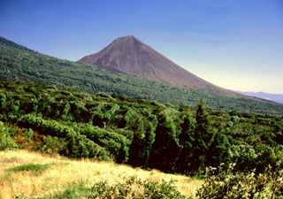 Izalco towers above the western flanks of Santa Ana, which are covered in coffee crops. Izalco erupted in a cornfield on the southern flanks of Santa Ana in 1770 and grew 650 m above the vent over the following two centuries. Despite its proximity to Santa Ana, Izalco lavas are distinctly higher in aluminum, calcium, and strontium. Recent eruptions of Izalco are more similar to Santa Ana than earlier ones.
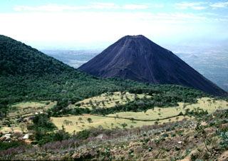 Izalco volcano rises beyond the Cerro Verde flank to the left, as seen from the trail to the summit of Santa Ana. Hotel de la Montaña was constructed at the summit of Cerro Verde to provide a view of the Izalco erupting, which occurred frequently since 1770. By the time the hotel was completed, the eruption of Izalco had ended.
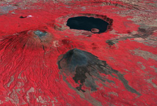 This false-color oblique DEM overlain by a thermal infrared ASTER image shows Santa Ana volcano (middle left), Izalco volcano (center), and the roughly 5.5 x 6 km Coatepeque caldera lake from the SW. The summit of Santa Ana has series of nested craters, and a NW-SE-trending fissure across the edifice. Lava flows were recently emplaced across the southern flanks of Izalco. The grayish area at the far upper left is the city of Santa Ana, El Salvador.
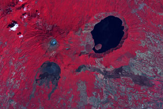 The summit crater complex of Santa Ana volcano with its small light-bluish crater lake is visible at the left-center in this false-color ASTER satellite image (N is to the top; this image is approximately 30 km across). The lake-filled Coatepeque caldera is east of Santa Ana, and Izalco volcano with its lava flows are to the south. A fissure was the source of an eruption in 1722 CE from a scoria cone (center) on the SE flank that produced the lava flow across the image to the lower right.
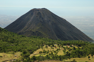 Izalco is seen here looking S from the summit of Santa Ana in 2011. The forested flank of Cerro Verde, a cone of Santa Ana, is visible on the left.
The following 9 samples associated with this volcano can be found in the Smithsonian's NMNH Department of Mineral Sciences collections, and may be availble for research (contact the Rock and Ore Collections Manager). Catalog number links will open a window with more information.
| Catalog Number | Sample Description | Lava Source | Collection Date |
|---|---|---|---|
| NMNH 144942-00 | Stoiberite | -- | -- |
| NMNH 145722-00 | Stoiberite | -- | -- |
| NMNH 160385-00 | Bannermanite | -- | -- |
| NMNH 160387-00 | Fingerite | -- | -- |
| NMNH 163183-00 | Mcbirneyite | -- | -- |
| NMNH 164270-00 | Blossite | -- | -- |
| NMNH 164470-00 | Lyonsite | -- | -- |
| NMNH 165494-00 | Howardevansite | -- | -- |
| NMNH 165495-00 | Howardevansite | -- | -- |
| Copernicus Browser | The Copernicus Browser replaced the Sentinel Hub Playground browser in 2023, to provide access to Earth observation archives from the Copernicus Data Space Ecosystem, the main distribution platform for data from the EU Copernicus missions. |
| MIROVA | Middle InfraRed Observation of Volcanic Activity (MIROVA) is a near real time volcanic hot-spot detection system based on the analysis of MODIS (Moderate Resolution Imaging Spectroradiometer) data. In particular, MIROVA uses the Middle InfraRed Radiation (MIR), measured over target volcanoes, in order to detect, locate and measure the heat radiation sourced from volcanic activity. |
| MODVOLC Thermal Alerts | Using infrared satellite Moderate Resolution Imaging Spectroradiometer (MODIS) data, scientists at the Hawai'i Institute of Geophysics and Planetology, University of Hawai'i, developed an automated system called MODVOLC to map thermal hot-spots in near real time. For each MODIS image, the algorithm automatically scans each 1 km pixel within it to check for high-temperature hot-spots. When one is found the date, time, location, and intensity are recorded. MODIS looks at every square km of the Earth every 48 hours, once during the day and once during the night, and the presence of two MODIS sensors in space allows at least four hot-spot observations every two days. Each day updated global maps are compiled to display the locations of all hot spots detected in the previous 24 hours. There is a drop-down list with volcano names which allow users to 'zoom-in' and examine the distribution of hot-spots at a variety of spatial scales. |
|
WOVOdat
Single Volcano View Temporal Evolution of Unrest Side by Side Volcanoes |
WOVOdat is a database of volcanic unrest; instrumentally and visually recorded changes in seismicity, ground deformation, gas emission, and other parameters from their normal baselines. It is sponsored by the World Organization of Volcano Observatories (WOVO) and presently hosted at the Earth Observatory of Singapore.
GVMID Data on Volcano Monitoring Infrastructure The Global Volcano Monitoring Infrastructure Database GVMID, is aimed at documenting and improving capabilities of volcano monitoring from the ground and space. GVMID should provide a snapshot and baseline view of the techniques and instrumentation that are in place at various volcanoes, which can be use by volcano observatories as reference to setup new monitoring system or improving networks at a specific volcano. These data will allow identification of what monitoring gaps exist, which can be then targeted by remote sensing infrastructure and future instrument deployments. |
| Volcanic Hazard Maps | The IAVCEI Commission on Volcanic Hazards and Risk has a Volcanic Hazard Maps database designed to serve as a resource for hazard mappers (or other interested parties) to explore how common issues in hazard map development have been addressed at different volcanoes, in different countries, for different hazards, and for different intended audiences. In addition to the comprehensive, searchable Volcanic Hazard Maps Database, this website contains information about diversity of volcanic hazard maps, illustrated using examples from the database. This site is for educational purposes related to volcanic hazard maps. Hazard maps found on this website should not be used for emergency purposes. For the most recent, official hazard map for a particular volcano, please seek out the proper institutional authorities on the matter. |
| IRIS seismic stations/networks | Incorporated Research Institutions for Seismology (IRIS) Data Services map showing the location of seismic stations from all available networks (permanent or temporary) within a radius of 0.18° (about 20 km at mid-latitudes) from the given location of Izalco. Users can customize a variety of filters and options in the left panel. Note that if there are no stations are known the map will default to show the entire world with a "No data matched request" error notice. |
| UNAVCO GPS/GNSS stations | Geodetic Data Services map from UNAVCO showing the location of GPS/GNSS stations from all available networks (permanent or temporary) within a radius of 20 km from the given location of Izalco. Users can customize the data search based on station or network names, location, and time window. Requires Adobe Flash Player. |
| DECADE Data | The DECADE portal, still in the developmental stage, serves as an example of the proposed interoperability between The Smithsonian Institution's Global Volcanism Program, the Mapping Gas Emissions (MaGa) Database, and the EarthChem Geochemical Portal. The Deep Earth Carbon Degassing (DECADE) initiative seeks to use new and established technologies to determine accurate global fluxes of volcanic CO2 to the atmosphere, but installing CO2 monitoring networks on 20 of the world's 150 most actively degassing volcanoes. The group uses related laboratory-based studies (direct gas sampling and analysis, melt inclusions) to provide new data for direct degassing of deep earth carbon to the atmosphere. |
| Large Eruptions of Izalco | Information about large Quaternary eruptions (VEI >= 4) is cataloged in the Large Magnitude Explosive Volcanic Eruptions (LaMEVE) database of the Volcano Global Risk Identification and Analysis Project (VOGRIPA). |
| EarthChem | EarthChem develops and maintains databases, software, and services that support the preservation, discovery, access and analysis of geochemical data, and facilitate their integration with the broad array of other available earth science parameters. EarthChem is operated by a joint team of disciplinary scientists, data scientists, data managers and information technology developers who are part of the NSF-funded data facility Integrated Earth Data Applications (IEDA). IEDA is a collaborative effort of EarthChem and the Marine Geoscience Data System (MGDS). |

