
OVSICORI-UNA reported continuing gas-and-steam emissions rose from vents Boca A and Boca B on the crater floor of Poás. Ash ceased to be detected in the emissions at some point during 16-17 April but was again present during 22-23 April.
Source: Observatorio Vulcanologico y Sismologico de Costa Rica-Universidad Nacional (OVSICORI-UNA)
Phreatic explosion on 6 April 2022 generates small plume and deposition in the lake
Activity at Poás is characterized by frequent geyser-like phreatic explosions and weak gas-and-ash-emissions, with an intermittent hot acidic lake in the summit crater. A series of phreatic explosions during April-September 2019 sometimes caused ashfall in nearby communities, and incandescence was sometimes observed at night (BGVN 44:10). The volcano is monitored by the Observatorio Vulcanologico Sismologica de Costa Rica-Universidad Nacional (OVSICORI-UNA). This report summarizes activity from October 2019 through April 2022, based on OVSICORI-UNA reports.
Seismic activity was low during October 2019-March 2022, and no deformation was recorded. The level of the acidic lake remained high, with levels slowly rising between October 2019 and December 2021, but more stable during January-April 2022. The annual bulletin for 2020 indicated that the lake temperature ranged from 43 to 55°C, with pH values between -0.2 and 0.3. Several reports during 2022 indicated that lake temperatures ranged from 35 to 41°C, with pH values between 0.18 and 0.37. Low-temperature fumaroles remained active within the lake and on terraces in the E and NE areas of the active crater. The main fumarole on the NE wall of the crater, named “Fumarola Naranja” (Orange Fumarole), produced strong degassing sounds. According to the 18 March 2022 report, seismicity was at an intermediate level with around 100 events per day (compared to 50 when low or 200 when high), with LP earthquakes.
OVSICORI-UNA reported that at 0242 on 6 April 2022 a phreatic explosion lasting three minutes was detected at Fumarola Naranja, generating a plume that rose 500 m above the crater. The event caused a small landslide that modified the vent. Some of the material from the landslide was deposited in a narrow strip extending about 140 m into the lake. Stirred sediment was visibly moving in convection cells, turning the lake water from a pale green to a uniform milky gray color (figure 131). The fumarolic vents at the E part of the crater and the underwater vent in the S part of the lake continued vigorous activity at least through 19 April.
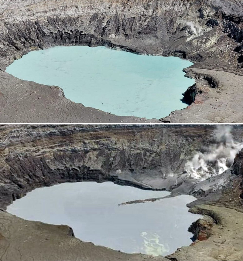 |
Figure 131. Webcam photos of the crater lake at Poás just before the 6 April 2022 explosion (top) and just after (bottom), showing that the lake color changed and a narrow debris strip extending into the lake was deposited after the explosion. Courtesy of OVSICORI-UNA. |
On 17 April a gas monitoring station in Coronado measured an increased concentration of sulfur dioxide aerosols, between 8.5 and 17.6 micrograms of gas per cubic meter of ambient air, and some residents reported respiratory discomfort such as sneezing, coughing, and shortness of breath. OVSICORI-UNA’s 29 April bulletin indicated that, subsequent to the 6 April event, several new landslides and small hydrothermal explosions occurred in the vertical wall that had collapsed during the 6 April event. Seismic activity and gas ratios remained stable.
Information Contacts: Observatorio Vulcanologico Sismologica de Costa Rica-Universidad Nacional (OVSICORI-UNA), Apartado 86-3000, Heredia, Costa Rica (URL: http://www.ovsicori.una.ac.cr/).
2024: January
| February
| March
| April
2023: August
| December
2022: March
| April
| September
2019: February
| March
| April
| May
| June
| August
| September
2017: April
| May
| June
| July
| August
| September
| November
2016: June
| July
2014: February
| March
| June
| September
| October
| November
2013: May
2012: June
| October
2011: February
| May
| July
| August
| November
| December
2010: February
| October
| December
2009: January
| December
2008: January
2007: September
2006: March
| April
| September
| October
2005: February
OVSICORI-UNA reported continuing gas-and-steam emissions rose from vents Boca A and Boca B on the crater floor of Poás. Ash ceased to be detected in the emissions at some point during 16-17 April but was again present during 22-23 April.
Source: Observatorio Vulcanologico y Sismologico de Costa Rica-Universidad Nacional (OVSICORI-UNA)
OVSICORI-UNA reported continuing emissions and eruptive activity at Poás during 10-16 April. Vents on the nearly dry crater floor emitted plumes of gas and steam on 10 April and the number of phreatic events began to increase. Starting at around 0600 on 11 April ash was present in emissions rising from Boca C. The plumes rose 500 m and drifted SW and S and residents in Naranjo (17 km WSW), Palmares (27 km SW), and Atenas (32 km SW) reported a sulfur odor. Eruptive events were not detected in seismic or infrasound data on 13 April. A small explosion at 2025 on 14 April produced a pulse of incandescence and an ash emission that rose less than 300 m. Emissions containing diffuse ash continued at least through the morning of 15 April.
Source: Observatorio Vulcanologico y Sismologico de Costa Rica-Universidad Nacional (OVSICORI-UNA)
OVSICORI-UNA reported continuing emissions at Poás during 3-9 April. Vents on the nearly dry crater floor vigorously emitted plumes of gas and steam; ash was present in the plumes during 3-5 April and absent on the rest of the days. The plumes rose a few hundred meters above the crater rim and mainly drifted W, SW, and S and were often detected downwind in residential areas of Heredia and El Valle Central. Incandescence was visible from Boca A and Boca C during 3-4 April, and at Boca A during 4-5 April. A sulfur odor was reported in Heredia and El Valle Central during 3-4 April and in Sarchí on 9 April. Weather conditions sometimes prevented visual observations.
Source: Observatorio Vulcanologico y Sismologico de Costa Rica-Universidad Nacional (OVSICORI-UNA)
OVSICORI-UNA reported increasing activity at Poás. During 22-25 March sulfur dioxide gas emissions were as high as 277 tons based on satellite data and characterized as significant. Parque Nacional Volcán Poás officials and residents to the W reported health impacts from the emissions including headaches, nausea, nose bleeding, and irritations of eyes, nose, mouth, and skin. On 25 March an infrared camera recorded a fumarolic vent temperature of 302 degrees Celsius and glowing pink-purple-blue flames were visible.
Vigorous emissions of gas, steam, and sediments from fumarolic vents on the nearly dry crater floor persisted during 25-28 March; activity intensified on 29 March and remained elevated through 2 April. Seismic and infrasound signals associated with the loud discharge of the emissions through the vent structures were near-continuous. During 27-30 March numerous small phreatic eruptive events from the central part of the crater floor ejected water and sediment that mostly fell back onto the crater floor. Sulfur odors were reported in areas downwind, including Sucre San Carlos (23 km WNW), Zarcero, Grecia (16 km SW), Sabana Redonda (9 km S), San Pedro de Poás (14 km S), Monte de la Cruz (22 km SE), San Rafael, and San Isidro de Heredia (28 km SE); health impacts continued to be noted. On 29 March a vent on the N part of the crater floor completely dried up and two explosive eruptive events were recorded that same day. Ash was sporadically emitted from the vents during 29-30 March and fine ash fell in areas to the W including Sarchí (18 km SW), Grecia, Naranjo (17 km WSW), San Ramón de Alajuela (30 km WSW), Palmares (27 km SW), and Atenas. The ash content of the emissions increased on 31 March and sulfur odors were recorded in additional towns to the W, SW, and S, including Ron Ron, Sarchí, Tacares, Naranjo, Palmares, Tacares, Alajuela (20 km S), Guácima (27 km S), Garita (27 km SSW), San Ramón, and Tambor, Turrucares (28 km SSW), Atenas, Carrillo de Poás (19 km S), Santa Rosa de Poás (11 km S), Santa Bárbara (18 km SSE), and San Isidro. The emissions were not dense during 31 March-1 April and the plumes stayed low around the elevation of the volcano (2.4 km a.s.l.). On 1 April satellite data showed that 714 tons of sulfur dioxide gas was detected, representing a significant increase and the highest recorded value since a period of elevated activity during 2017-2019. Residents continued to report sulfur dioxide odors and minor ashfall during 1-2 April.
Source: Observatorio Vulcanologico y Sismologico de Costa Rica-Universidad Nacional (OVSICORI-UNA)
OVSICORI-UNA reported that about 900 small phreatic eruptions at Poás were recorded by the seismic network and often visually observed during 4 March to around 0800 on 8 March; no additional eruptions were recorded at least through 12 March. The small eruptive events ejected material no higher than 50 m. The water at the bottom of the crater had almost disappeared leaving a couple of muddy water puddles. Boca C remained underwater and frequently bubbled. Weak incandescence from sulfur combustion at Boca A (SW part of crater floor) was frequently observed at night. Gas-and-steam emissions rose from the vents and caused a sulfur odor in the vicinity of the volcano during the earlier part of the week.
Source: Observatorio Vulcanologico y Sismologico de Costa Rica-Universidad Nacional (OVSICORI-UNA)
OVSICORI-UNA reported that small, frequent phreatic eruptions at Poás continued during 6-13 February. Data from the monitoring network indicated that 50-600 phreatic explosive events per day were occurring, but only a few events ejected material more than 100 m. At 0107 on 6 February an eruptive event generated a column that rose at least 300 m above the crater. At 1221 on 8 February an event generated a column of steam-and-ash that rose 200 m above the crater, and a gas-and-steam column that rose over 1 km.
Source: Observatorio Vulcanologico y Sismologico de Costa Rica-Universidad Nacional (OVSICORI-UNA)
OVSICORI-UNA reported that small, frequent phreatic eruptions at Poás continued during 30 January-6 February. Data from the monitoring network indicated that around 600 events per day were occurring, though most of the events did not eject material more than 50 m high, and only a few ejected material more than 100 m. At 0712 on 4 February a phreatic eruption produced a plume of steam, sediments, and water that rose 200 m. The report noted that small eruptive events were occurring at a rate of 20-25 events per hour before the 0712 event, ceased afterwards, and then resumed to a rate of about 20 events per hour. On 6 February incandescence at the vent was visible in webcam images and was attributed to the combustion of native sulfur. This phenomenon was last visible in 2019.
Source: Observatorio Vulcanologico y Sismologico de Costa Rica-Universidad Nacional (OVSICORI-UNA)
OVSICORI-UNA reported that at 0546 on 25 January a small phreatic eruption at Poás produced a steam plume that rose more than 500 m high and drifted W. The event produced the tallest plume recorded since 30 September 2019. According to the Comisión Nacional de Prevención de Riesgos y Atención de Emergencias (CNE) the event resulted in the restriction of the number of people that can be on the viewing platform to 56 at a time and visitors were required to wear hardhats. At 1437 on 26 January a more significant phreatic eruption ejected material 300 m above the lake’s surface and produced a gas-and-steam plume that rose 700 m high. During 26-27 January near constant degassing manifested as bubbling in the lake was observed.
Sources: Observatorio Vulcanologico y Sismologico de Costa Rica-Universidad Nacional (OVSICORI-UNA); Comisión Nacional de Prevención de Riesgos y Atención de Emergencias (CNE)
OVSICORI-UNA reported that small phreatic eruptions at Poás continued to be observed during 8-16 January. Phreatic eruptions were recorded daily, ejecting sediment no more than 200 m above the lake’s surface and producing steam-and-gas plumes that rose no higher than 500 m. In a special report OVSICORI-UNA noted that both gas-and-steam emissions and seismicity began to increase during the second half of 2023. The lake level had been decreasing since October 2023 and eruptive events became more frequent and energetic in December; a phreatic eruption at 2051 on 11 January was the largest event recorded during December 2023-January 2024.
Source: Observatorio Vulcanologico y Sismologico de Costa Rica-Universidad Nacional (OVSICORI-UNA)
OVSICORI-UNA reported that small phreatic eruptions at Poás continued to be observed. Phreatic eruptions at 1922 and 1926 on 25 December and at 0235 on 26 December ejected material 50 m above the lake surface. At 1535 on 27 December a small phreatic event ejected a plume of water and sediment 100 m above the lake and produced a steam-and-gas plume that rose 500 m. Events recorded at 0117 on 29 December, as well as at 0500, 1034, and 1530 on 30 December, ejected sediment, water, and gas no higher than 200 m above the lake.
Source: Observatorio Vulcanologico y Sismologico de Costa Rica-Universidad Nacional (OVSICORI-UNA)
OVSICORI-UNA reported that at 0646 on 16 December a small phreatic eruption at Poás ejected material 20 m above the lake’s surface and produced a steam plume that rose 200 m. Additionally, two small eruptions were recorded at 1436 on 17 December and 0022 on 18 December.
Source: Observatorio Vulcanologico y Sismologico de Costa Rica-Universidad Nacional (OVSICORI-UNA)
OVSICORI-UNA reported that fumarolic degassing and lake convection at Poás were visible during 9-15 August. A small phreatic eruption at the center of the lake ejected material 5 m above the lake at 0842 on 11 August.
Source: Observatorio Vulcanologico y Sismologico de Costa Rica-Universidad Nacional (OVSICORI-UNA)
OVSICORI-UNA reported that a small phreatic eruption at Poás occurred at 0153 on 2 August at the W part of the crater lake, ejecting material about 20 m above the water. At 1655 on 5 August a phreatic eruption from three areas of the lake ejected sediment and steam 50-100 m above the lake. At least two eruptive pulses were seen. Fumarolic degassing and lake convection were visible during 2-8 August.
Source: Observatorio Vulcanologico y Sismologico de Costa Rica-Universidad Nacional (OVSICORI-UNA)
On 9 September OVSICORI-UNA reported that activity at Poás had increased since mid-August, characterized by notably increased seismicity. Seismic signals consisted of tremors with variable amplitudes and durations, prolonged harmonic tremors, and some long-period earthquakes with magnitudes greater than those recorded during 2022; there was no increase in low-frequency earthquakes. The energy of the seismicity had also dramatically increased in the previous few days. Sulfur dioxide emissions around the crater were mainly stable at 100 tons per day, though on a few occasions the concentrations were higher; about 300 tons per day was recorded during 17-18 August and higher than 500 tons per day was recorded on 2 September. The volume of water in Boca A lake had significantly increased during August 2021-September 2022, stabilizing at 1.4 million cubic meters between July and September with minor variations measured from week to week. Convection cells in the lake were more active and a new one formed in the N part of the lake (over the Boca C vent) since mid-August. OVSICORI-UNA stated that these data indicated disturbances to the shallow (less than 2 km) hydrothermal system and did not reflect an influx of magma. Fumarolic degassing and lake convection continued during 9-13 September.
Source: Observatorio Vulcanologico y Sismologico de Costa Rica-Universidad Nacional (OVSICORI-UNA)
OVSICORI-UNA reported that submarine fumaroles in the S part of Poás’s Boca A lake and subaerial fumaroles along the E margins continued to produce low-temperature gas emissions during 13-19 April. The lake water continued to convect, and was light gray in color, since the phreatic explosion that had occurred on 6 April at “Orange Fumarola” located in a fumarolic field along the inner N crater wall. For a period of time on 17 April a gas monitoring station in Coronado measured a higher concentration of sulfur dioxide aerosols, between 8.5 and 17.6 micrograms of gas per cubic meter of ambient air, which was higher than the daily average of 6.7. Some residents reported respiratory discomfort such as sneezing, coughing, and shortness of breath.
Source: Observatorio Vulcanologico y Sismologico de Costa Rica-Universidad Nacional (OVSICORI-UNA)
OVSICORI-UNA reported that on 6 April at 0240 a phreatic explosion from a vent called “Orange Fumarola” located in a fumarolic field along the inner N crater wall at Poás generated a plume that rose 500 m above the crater rim. Activity lasted for three minutes. The event caused a small landslide that modified the vent. Some of the material from the landslide was deposited in a narrow strip about 100 m into the Boca A lake. Stirred sediment was visibly moving in convection cells, turning the lake water from green to a uniform milky gray color as the sediment mixed into the water. Subaerial fumarolic vents at the E and S parts of the lake more vigorously emitted gasses following the event and remained at that level at least through 12 April. Convection in the lake also continued. OVSICORI-UNA noted that satellite data acquired the day before the explosion showed a total of 500 tons of sulfur dioxide released from both Poás and Turrialba.
Source: Observatorio Vulcanologico y Sismologico de Costa Rica-Universidad Nacional (OVSICORI-UNA)
OVSICORI-UNA reported that on 6 April at 0242 a phreatic explosion was detected at the N wall crater wall at Poás, generating a plume that rose 500 m above the crater. Activity lasted for three minutes.
Source: Observatorio Vulcanologico y Sismologico de Costa Rica-Universidad Nacional (OVSICORI-UNA)
OVSICORI-UNA reported that during 16-26 September sulfur dioxide emissions from Poás drifted W and NE, causing a sulfur odor in Alajuela, Heredia, San José, and Cartago. Acidic rain was recorded at the official’s house in the Poás Volcano National Park (PNVP) on 23 September and at Universidad Nacional Costa Rica (UNA) in Heredia on 26 September. At 0540 on 30 September a five-minute-long phreatic eruption ejected sediment, and produced a plume that rose 2 km above the crater rim and drifted SW. Ashfall and a sulfur odor was reported in Trojas de Sarchi and Grecia. Officials closed the PNVP because of the eruption and ongoing elevated seismicity; the park remained closed the next day.
Sources: Observatorio Vulcanologico y Sismologico de Costa Rica-Universidad Nacional (OVSICORI-UNA); Tico Times
OVSICORI-UNA reported that at 2059 on 22 September an eruptive event at Poás generated a plume that rose 3 km above the crater rim and drifted NE. During 22-23 September eruption plumes rose 1 km.
Source: Observatorio Vulcanologico y Sismologico de Costa Rica-Universidad Nacional (OVSICORI-UNA)
OVSICORI-UNA reported that an eruptive event from vent A (Boca Roja) at Poás generated a 1-km-high plume of steam, gas, and fine particulates at 0650 on 17 August. The event was preceded by an increase in tremor amplitude starting at 0500 that same day.
Source: Observatorio Vulcanologico y Sismologico de Costa Rica-Universidad Nacional (OVSICORI-UNA)
On 21 June OVSICORI-UNA reported that small, frequent phreatic eruptions from vent A (Boca Roja) were visible during good viewing conditions at Poás ejecting material less than 10 m high.
Source: Observatorio Vulcanologico y Sismologico de Costa Rica-Universidad Nacional (OVSICORI-UNA)
OVSICORI-UNA reported that on 12 June small geyser-like eruptions at Poás ejected material less than 50 m high at a rate of about once per hour. At 0604 on 18 June an eruption that lasted about six minutes produced a plume of unknown height due to weather conditions. Residents reportedly heard several loud noises during 0610-0615 and observed an eruption plume rising from the crater. Ash fell in Cajón (12 km SW), San Luis de Grecia (11 km SW), Los Ángeles, San Miguel, San Isidro (28 km SE), and San Roque (23 km SSE). Whitish ash deposits surrounding the crater, especially on the W and S sectors, were visible in webcam images.
Source: Observatorio Vulcanologico y Sismologico de Costa Rica-Universidad Nacional (OVSICORI-UNA)
OVSICORI-UNA reported that multiple phreatic eruptions at Poás recorded during 29 May-1 June produced plumes that rose as high as 500 m above the vent.
Source: Observatorio Vulcanologico y Sismologico de Costa Rica-Universidad Nacional (OVSICORI-UNA)
OVSICORI-UNA reported a period of continuous emissions from Poás during 30 April-1 May with plumes rising 300 m above the crater rim and drifting SW. Ash emissions were visible for a few hours on 30 April, and incandescence was visible at night.
Source: Observatorio Vulcanologico y Sismologico de Costa Rica-Universidad Nacional (OVSICORI-UNA)
OVSICORI-UNA reported that on 24 April a very diffuse ash emission rose from Poás. Incandescence from vent A (Boca Roja) was sometimes visible during 24 and 27-28 April.
Source: Observatorio Vulcanologico y Sismologico de Costa Rica-Universidad Nacional (OVSICORI-UNA)
OVSICORI-UNA reported that on 18 March an event at Poás produced a plume with minor ash content that rose 200 m above the crater rim.
Source: Observatorio Vulcanologico y Sismologico de Costa Rica-Universidad Nacional (OVSICORI-UNA)
OVSICORI-UNA reported that, although weather conditions often prevented visual observations of Poás during 7-8 and 10 March, gas plumes sometimes containing ash were observed rising as high as 500 m above the crater rim and drifting SW. A sulfur odor and ashfall were reported in Naranjo and Grecia (16 km SW).
Source: Observatorio Vulcanologico y Sismologico de Costa Rica-Universidad Nacional (OVSICORI-UNA)
OVSICORI-UNA reported that during 23-26 February seismicity at Poás was dominated by low-frequency events. Robust gas emissions rose from four fumarolic vents in the area previously covered by a lake, though the most vigorous emissions originated from vent A (Boca Roja). Minor incandescence from vent A was sometimes visible at night. A sulfur odor was reported in areas downwind including Naranjo, Zarcero, and Grecia (16 km SW). Particles of molten sulfur were included in ash deposits collected in Naranjo. Ashfall was reported in Canoas de Alajuela on 26 February.
Source: Observatorio Vulcanologico y Sismologico de Costa Rica-Universidad Nacional (OVSICORI-UNA)
OVSICORI-UNA reported that since 8 February almost continuous emissions of gas has been recorded at Poás, with plumes rising as high as 1 km and drifting mainly SW. During 13-14 February the emissions contained ash; gas-and-ash plumes drifted SW, impacting areas downwind including Naranjo, Zarcero, and Grecia (16 km SW). Gas-and-ash emissions rose from the crater on 15 February, and gas emissions were recorded on 18 February.
Source: Observatorio Vulcanologico y Sismologico de Costa Rica-Universidad Nacional (OVSICORI-UNA)
OVSICORI-UNA reported that seismic and infrasound data indicated multiple events at Poás during 7-8 February. On 8 February events were centered at vent A (Boca Roja) and produced plumes that rose no higher than 200 m and drifted SW. A sulfur dioxide odor was reported in areas downwind including San Jose de Naranjo, Grecia (16 km SW), Poás, Sarchá, Naranjo, and Atenas (32 km SW). Incandescence in the crater began to be visible at 0151 on 11 February. Passive ash emissions rose 200 m and drifted SW.
Source: Observatorio Vulcanologico y Sismologico de Costa Rica-Universidad Nacional (OVSICORI-UNA)
OVSICORI-UNA reported that an event at Poás at 0915 on 6 November generated a plume that rose 300 m above the crater rim.
Source: Observatorio Vulcanologico y Sismologico de Costa Rica-Universidad Nacional (OVSICORI-UNA)
OVSICORI-UNA reported that an event at Poás at 0820 on 13 September generated plume that rose 300 m above the crater rim.
Source: Observatorio Vulcanologico y Sismologico de Costa Rica-Universidad Nacional (OVSICORI-UNA)
OVSICORI-UNA reported that events at Poás at 0920 and 0930 on 24 August and at 0945 on 29 August generated plumes that rose 500-600 m above the crater rim.
Source: Observatorio Vulcanologico y Sismologico de Costa Rica-Universidad Nacional (OVSICORI-UNA)
OVSICORI-UNA reported that an event at Poás at 1517 on 22 August generated a plume that rose 300 m above the crater rim.
Source: Observatorio Vulcanologico y Sismologico de Costa Rica-Universidad Nacional (OVSICORI-UNA)
OVSICORI-UNA reported that during 11-14 August seismicity at Poás was characterized by low-amplitude tremor, some volcano-tectonic earthquakes, and high-frequency signals indicating gas emissions. Weather clouds mostly prevented visual observations.
Source: Observatorio Vulcanologico y Sismologico de Costa Rica-Universidad Nacional (OVSICORI-UNA)
On 3 August OVSICORI-UNA reported that plumes of magmatic gases, water vapor, and aerosols continued to rise from Poás’s vent A (Boca Roja), and plumes of water vapor and abundant yellow particles of native sulfur were emitted from vent B (Boca Azufrada). Plumes rose as high as 1 km above the vents and drifted SSW. Incandescence from the bottom of the crater was recorded at night by the webcams. Recent measurements indicated that sulfur dioxide was emitted at a rate of 1,000-1,500 tons per day, which were values similar to those measured in the first months of 2017, before the phreato-magmatic eruptions of April and May. Gas plumes continued to rise from the vents and drift SW and NW at least through 8 August.
Source: Observatorio Vulcanologico y Sismologico de Costa Rica-Universidad Nacional (OVSICORI-UNA)
OVSICORI-UNA reported that on 1 August an event at Poás passively produced a plume that rose 500 m above the crater.
Source: Observatorio Vulcanologico y Sismologico de Costa Rica-Universidad Nacional (OVSICORI-UNA)
OVSICORI-UNA reported that during 19-24 July plumes of magmatic gases, water vapor, and aerosols were emitted from Poás’s vent A (Boca Roja), and plumes of gases, water vapor, and abundant yellow particles of native sulfur rose from vent B (Boca Azufrada). Plumes rose 300-500 m above the vents and drifted W and SW.
Source: Observatorio Vulcanologico y Sismologico de Costa Rica-Universidad Nacional (OVSICORI-UNA)
OVSICORI-UNA reported that during 12-17July gas plumes that rose as high as 1 km above Poás’s vents A (Boca Roja) and B (Boca Azufrada) drifted SW and NW.
Source: Observatorio Vulcanologico y Sismologico de Costa Rica-Universidad Nacional (OVSICORI-UNA)
OVSICORI-UNA reported that during 4-9 July plumes of magmatic gases, water vapor, and aerosols rose 200-600 m above Poás’s vents A (Boca Roja) and B (Boca Azufrada). Minor incandescence from the bottom of the crater was observed during 4-5 July, and a strong sulfur odor was reported in some areas of Alajuela and Heredia. During 5-7 July grayish-red ash emissions rose intermittently from vent A, and on 7 July a loud “jet” sound was noted in Mirador. A strong sulfur odor and minor ashfall was reported in some areas of Alajuela. An event at 1450 on 10 July generated a plume that rose 300 m.
Source: Observatorio Vulcanologico y Sismologico de Costa Rica-Universidad Nacional (OVSICORI-UNA)
OVSICORI-UNA reported low-to-moderate-amplitude tremor with occasional periods of high-frequency volcano-tectonic events detected at Poás during 28-29 June. Webcams recorded intense incandescence at night from the bottom of the crater. A sulfur odor was noted in San Rafael de Poás and Vara Blanca. An event at 1115 on 19 June generated a plume that rose 1 km above the vents. An event at 1450 may have generated a plume, but poor visibility did not allow for confirmation. During 1-4 July frequent but small Strombolian activity ejected incandescent material that fell around vent “A” (Boca Roja). Plumes of water vapor, magmatic gases, and particulates rose at most 500 m from the vents.
Source: Observatorio Vulcanologico y Sismologico de Costa Rica-Universidad Nacional (OVSICORI-UNA)
OVSICORI-UNA reported low-amplitude tremor with occasional periods of low-amplitude long-period events detected at Poás during 20-25 June. Plumes of reddish-colored ash, water vapor, and magmatic gases were recorded rising as high as 500 m above two vents during 20-21 June. Magmatic gases and water vapor plumes rose as high as 1 km above the vents the rest of the period.
Source: Observatorio Vulcanologico y Sismologico de Costa Rica-Universidad Nacional (OVSICORI-UNA)
OVSICORI-UNA reported that during 13-15 June gas emissions from Poás rose no higher than 500 m above the crater rim and drifted N. During breaks in weather, observers near the crater on 16 June noted ash emissions rising less than 1 km above the crater rim and drifting N. Ash emissions from events at 1340 on 18 June, and 1100 and 1350 on 20 June, rose less than 1 km.
Source: Observatorio Vulcanologico y Sismologico de Costa Rica-Universidad Nacional (OVSICORI-UNA)
OVSICORI-UNA reported that during 7-13 June seismicity at Poás was characterized by low-amplitude tremor, discrete volcano-tectonic events, low-frequency events, and some periods of small long-period events with low amplitude. During 7-8 June the webcam recorded strong emissions of water vapor, magmatic gases, and particulates. A sulfur odor was reported in Alajuela, San Ramon, and Barva, and incandescence in the area of the crater was recorded at night. OVSICORI-UNA noted that during 8-9 June a plume of water vapor, magmatic gases, and particulates rose from two vents; the lake had evaporated and exposed the vents. A minor sulfur odor was reported on the campus of the Universidad Nacional in Heredia. Events at 1610 and 1750 on 11 June generated plumes that rose 300 and 600 m above the crater, respectively. Plumes from the vents rose 1 km during 12-13 June. A sulfur odor was noted in Quesada, Santa Ana, San José de Alajuela, and San Juanillo Naranjo.
Source: Observatorio Vulcanologico y Sismologico de Costa Rica-Universidad Nacional (OVSICORI-UNA)
OVSICORI-UNA reported that tremor amplitude at Poás fluctuated from low to medium levels during 30-31 May, often associated with the vigor of emissions of water vapor, magmatic gases, and material from vents. An event at 1200 on 2 June generated a plume consisting of water vapor, gases, and minor amounts of ash that rose 600 m above the crater. Another event recorded at 1353 could not be confirmed visually due to weather conditions. An event at 0858 on 6 June generated a plume that rose 1 km.
Source: Observatorio Vulcanologico y Sismologico de Costa Rica-Universidad Nacional (OVSICORI-UNA)
OVSICORI-UNA reported that tremor amplitude at Poás fluctuated between low and high levels during 23-30 May, often corresponding to the vigor of emissions of water vapor, magmatic gases, and material from fumarolic vents. During 25-26 May ashfall was reported in some communities around the volcano. Low magnitude volcano-tectonic earthquakes and small phreatic eruptions were recorded sporadically during 27-30 May.
Source: Observatorio Vulcanologico y Sismologico de Costa Rica-Universidad Nacional (OVSICORI-UNA)
OVSICORI-UNA reported that tremor levels at Poás were at low-to-moderate levels during 17-21 May and at higher levels during 22-23 May. Low-amplitude long-period earthquakes were recorded on 19 May, and some low-frequency and volcano-tectonic events were detected during 21-22 May. Plumes consisted mainly of gas and water vapor, but sometimes included solid material, and rose no more than 1 km above the vent.
Source: Observatorio Vulcanologico y Sismologico de Costa Rica-Universidad Nacional (OVSICORI-UNA)
OVSICORI-UNA noted ash emissions at Poás on 10 May. Gas emissions were measured by an instrument mounted on a drone, revealing a gas plume rich in sulfur dioxide and low in carbon dioxide. During 10-11 May tremor amplitude was variable but low, and several volcano-tectonic events were detected. During 11-13 May tremor was constant, and volcano-tectonic and long-period events were detected; the seismicity possibly indicated small eruptions. Deformation was high, with vertical inflation of 3 cm since February.
Source: Observatorio Vulcanologico y Sismologico de Costa Rica-Universidad Nacional (OVSICORI-UNA)
OVSICORI-UNA reported that an eruption at Poás was detected at 1724 on 6 May though poor visibility prevented visual confirmation of the event. During 6-7 May volcano-tectonic and long-period earthquakes were detected, as well as moderate-amplitude tremor.
Source: Observatorio Vulcanologico y Sismologico de Costa Rica-Universidad Nacional (OVSICORI-UNA)
OVSICORI-UNA reported that during 30 April-1 May seismicity at Poás was characterized by volcano-tectonic events, long-period events, and low-amplitude tremor. A larger event was recorded at 0621 on 1 May, though there was no other confirmation of an eruption.
Source: Observatorio Vulcanologico y Sismologico de Costa Rica-Universidad Nacional (OVSICORI-UNA)
OVSICORI-UNA reported that on 20 April a dense water vapor plume rose from a vent in the newly-forming pyroclastic cone at the site of the old dome in the hot lake at Poás. Gas flux increased from 1,000 tons/day (t/d) on 13 April to 2,500 t/d on 20 April. During 20-22 April Strombolian activity ejected tephra that fell around the vent within a 300-m radius. Gas-and-ash plumes rose 200 m above the vent. The Red Cross of Grecia reported ashfall in Alajuela, Fraijanes, San Miguel, Carbonal, Cajón, San Francisco, San Roque, and San Juan Norte de Poás. Events at 1316 and 1603 on 22 April produced plumes of unknown height. Several more eruptive events were recorded that day; an event at 2212 was very intense, ejecting bombs large distances. An event at 1215 on 23 April generated a plume of unknown height.
Source: Observatorio Vulcanologico y Sismologico de Costa Rica-Universidad Nacional (OVSICORI-UNA)
OVSICORI-UNA reported that a strong 40-minute phreatic eruption from an area in between the lava dome and the hot lake at Poás was recorded on 12 April starting at 1830. An eruption column consisting of water, altered rocks, sediments, and gases was produced; the height of the column could not be determined due to poor visibility. Ash fell around the crater and to the NW in Bajos del Toro. A water-level increase of 2 m in the Desague River, with headwaters at the S part of the crater, was noted. According to news articles the National Emergency Committee (CNE) evacuated residents living near the Desague River. The Poás Volcano National Park closed the next day.
At 1546 on 13 April an eight-minute-long eruption produced a plume that rose 500 m above the crater rim. The event rendered a webcam on the N rim inoperable. Events at 0758 (strong) and 1055 on 14 April generated plumes of an unknown height. A 10-minute-long event which began at 0810 on 15 April again produced a plume of unknown height. Frequent (2-3 events per hour) small short-lived phreatic eruptions were recorded by seismographs during 15-16 April. A plume that rose 500 m followed an eruption at 0946 on 16 April. Later that day, at 1350, an event generated a plume that rose 1 km. A news article reported that boulders as large as 2 m in diameter fell in an area 30 m away from a tourist trail, breaking a water pipe. Rocks also damaged fences and concrete floors in viewing areas. Small, frequent, and short-lived phreatic eruptions continued to be recorded through 18 April. A video posted by a news outlet showed an explosion ejecting incandescent material.
Sources: Observatorio Vulcanologico y Sismologico de Costa Rica-Universidad Nacional (OVSICORI-UNA); Tico Times; Tico Times; The Costa Rica Star; The Costa Rica Star
OVSICORI-UNA reported that a small phreatic eruption from the hot lake at Poás recorded at 0819 on 25 July ejected material 50 m above the crater lake’s surface.
Source: Observatorio Vulcanologico y Sismologico de Costa Rica-Universidad Nacional (OVSICORI-UNA)
According to news articles, phreatic explosions from the hot lake at Poás occurred multiple times in June. Explosions at 0900 on 5 June, 1854 on 13 June, and 1952 on 14 June ejected water and steam many meters above the lake’s surface. Three small explosions, lasting about five seconds each based on the seismic signals, occurred during 0600-0603 on 18 June and ejected water, steam, and debris no more than 50 m above the lake’s surface. Phreatic explosions were also registered on 19 June.
Sources: Prensa Libre; Prensa Latina
On 13 November OVSICORI-UNA reported a drastic decrease in temperature and gas flow from vents around the lava dome on the S edge of the hot lake at Poás. In addition incandescence from the dome was no longer visible, activity from fumaroles in the lake had decreased, and the lake water changed from greenish to milky. Phreatic eruptions had not occurred since late October.
Source: Observatorio Vulcanologico y Sismologico de Costa Rica-Universidad Nacional (OVSICORI-UNA)
OVSICORI-UNA reported that a 1.5-minute-long phreatic eruption from the hot lake at Poás was recorded on 13 October starting at 0858. The event ejected material over 250 m from the crater lake, causing ashfall on the lookout area and visitor’s center. The phreatic eruptions in August and October were the most energetic events of the year.
Source: Observatorio Vulcanologico y Sismologico de Costa Rica-Universidad Nacional (OVSICORI-UNA)
OVSICORI-UNA reported that a strong phreatic eruption from the hot lake at Poás was recorded at 1745 on 8 October. The event lasted one minute and ejected material over 250 m above the crater lake’s surface. The seismic record indicated that it was the most energetic event so far in 2014.
Source: Observatorio Vulcanologico y Sismologico de Costa Rica-Universidad Nacional (OVSICORI-UNA)
OVSICORI-UNA reported that three consecutive phreatic eruptions occurred within the crater lake of Poás on 27 August, each within 2 minutes of the previous one. One explosion generated a plume up to 200 m above the surface of the lake. Based on seismic energy released, this event was similar to the eruption on 1 June, one of the largest of the year which partially destroyed a gas-measuring station.
OVSICORI-UNA noted that phreatic eruptions from Poás tended to occur impulsively, have short durations (within 5-10 seconds), and frequently lack precursory activity.
Source: Observatorio Vulcanologico y Sismologico de Costa Rica-Universidad Nacional (OVSICORI-UNA)
OVSICORI-UNA reported that a phreatic eruption from Poás was recorded at 1008 on 20 June. The explosion generated a plume 200 m above the crater lake. The plume was mainly water vapor with entrained lake sediments (which contained sulfur precipitates and altered rocks). Other gases such as SO2, H2S, HCL, HF, and others were also included.
This was the second phreatic explosion to occur in June. There was no visual record of that event, but routine inspections by the National Park staff on 2 June determined that during the night, there had been a large explosion evidenced by significant fall deposits around the crater lake shoreline. A solar panel had also been damaged by falling rocks associated with that explosion. Seismicity suggests indicated explosive signatures at 1954 on 1 June.
On 18 June, observatory staff noted that between 1000 and 1343, small phreatic eruptions were occurring within the lake. One of these explosions released a strong sulfur smell and large waves. The water temperature was recorded at 44.6°C with a pH of -0.49.
Source: Observatorio Vulcanologico y Sismologico de Costa Rica-Universidad Nacional (OVSICORI-UNA)
OVSICORI-UNA reported that a strong phreatic eruption from Poás was recorded at 1532 on 30 March. The explosion ejected water, steam, gases, sediment, and fragments of altered rock 150 m above the crater lake’s surface. The report noted several small phreatic eruptions that ejected material less than 50 m high, as well as large gas bubbles and vapor in the middle of the lake, during February and March.
Source: Observatorio Vulcanologico y Sismologico de Costa Rica-Universidad Nacional (OVSICORI-UNA)
OVSICORI-UNA reported that at 0800 on 25 February officials at the Parque Nacional Volcán Poás noted that the gray crater lake had convection cells and weak fumarolic activity at the S edge of the lake around a cryptodome. At 1203 a strong phreatic explosion from Poás was recorded by webcams at the N end of the lake. The explosion ejected water, steam, gas, sediment, and rock fragments over 400 m above the lake's surface. Most of the material fell back into the lake, and onto the W, N, and E parts of the crater walls. Fumarolic activity around the cryptodome and lake convection both increased after the explosion.
Source: Observatorio Vulcanologico y Sismologico de Costa Rica-Universidad Nacional (OVSICORI-UNA)
OVSICORI-UNA reported that during May temperatures of the cryptodome at Poás were high enough to produce nighttime incandescence. Maximum temperatures of 575 and 450 degrees Celsius were recorded on 8 and 30 May, respectively. Activity of the lake was very similar to that reported for May 2012, characterized by sporadic phreatic eruptions and a slow decline in the water level. On 8 May 2013 the water level was 0.5 m below the level measured on 8 May 2012. Phreatic eruptions occurred at 1100 on 1 May, at 1700 on 8 May, and at 1125 and 1510 on 28 May. Fumarolic activity was variable.
During the early morning hours on 2 and 3 June, residents reported a gas plume rising 1 km above the crater floor. OVSICORI-UNA noted that recent plumes were high-temperature (450-575 degrees Celsius) and rich in sulfur dioxide, giving the plumes a bluish-white color.
Source: Observatorio Vulcanologico y Sismologico de Costa Rica-Universidad Nacional (OVSICORI-UNA)
OVSICORI-UNA reported that a phreatic eruption at Poás was recorded at 1120 on 27 October. A phreatic eruption later that day (at 1757) ejected water, sulfur-rich sediments, and rock fragments out of the lake. The ejecta landed on the S and SW edges of the crater floor. According to a news article, local residents heard a loud rumble at about 0100 on 28 October; a phreatic eruption ejected sediment 500 m above the lake, and produced ashfall several hundreds of meters away.
Sources: Tico Times; Observatorio Vulcanologico y Sismologico de Costa Rica-Universidad Nacional (OVSICORI-UNA)
OVSICORI-UNA reported that phreatic eruptions at Poás occurred on 6, 15, 20 and 26 May. The eruption on 15 May was preceded by about 6 hours of very-low amplitude harmonic tremor. Administrators of the Poás Volcano National Park witnessed the eruption and reported that sediment, water, rock fragments, and plumes were ejected 500 m above the lake surface. The level of the lake dropped ~0.9 m between 8 and 29 May.
Source: Observatorio Vulcanologico y Sismologico de Costa Rica-Universidad Nacional (OVSICORI-UNA)
OVSICORI-UNA reported that fieldwork at Poás on 16 December showed new geyser activity from a vent on the N flank of the lava dome that formed in 2011. A water-and-mud fountain rose 5-6 m high, flowed into the lake, and built a terrace along the S shore. Gas-and-steam plumes rose from the lava dome.
Source: Observatorio Vulcanologico y Sismologico de Costa Rica-Universidad Nacional (OVSICORI-UNA)
OVSICORI-UNA reported that during October fumarolic activity at Poás continued with bluish gas plumes rising from the lava dome; plumes rose more than 1 km and were reported by residents in Valle Central. Towards the end of the month, the fumarolic activity as well as incandescence from the lava dome decreased. The new craters at the N base of the dome united into a crater that was 25 m long and 7-10 m wide. Phreatic activity continued to occur from Laguna Caliente, the summit lake. The lake was 55 degrees Celsius, and the level had risen 22 cm between 14 September and 27 October.
Source: Observatorio Vulcanologico y Sismologico de Costa Rica-Universidad Nacional (OVSICORI-UNA)
On 31 August OVSICORI-UNA reported that since mid-July incandescence was visible during the day on the lava dome of Poás, which had not occurred since 1981, and was the result of changes in activity that had started several months before. OVSICORI-UNA speculated that the changes could be either from recent magma intrusion or a change in the hydrothermal plumbing system and noted the need to further analyze data from seismic, deformation, geochemical, and field measurements.
Source: Observatorio Vulcanologico y Sismologico de Costa Rica-Universidad Nacional (OVSICORI-UNA)
OVSICORI-UNA reported that on 23 July a group of observatory scientists visited Poás to document changes that had occurred there during the previous weeks. They noted that the subtle, semicircular scarp observed a few months earlier had rapidly progressed to a sharp scarp on the SE shore of Laguna Caliente. The 60-m-wide, 2.5-m-high scarp degassed and geyser activity was observed on the W end, next to the steaming lake. In an area about 40 m above the surface of the lake where there were fractured rocks and vigorous gas venting, incandescence emanated from the lava dome and a temperature of 670 degrees Celsius was measured.
Source: Observatorio Vulcanologico y Sismologico de Costa Rica-Universidad Nacional (OVSICORI-UNA)
According to a news article, a team of geologists and volcanologists from the Universidad de Costa Rica (UCR) visited Poás on 25 May and observed 18 phreatic eruptions from Laguna Caliente (the summit lake) in a three-hour period.
Source: Inside Costa Rica
OVSICORI-UNA reported that during April sporadic phreatic eruptions occurred from the central part of Laguna Caliente, a summit lake of Poás. Gas plumes rose a few meters to several tens of meters above the lake surface. Solid dark material ejected from the lake fell back into it, causing small surges. The temperature of the lava dome was 560 degrees Celsius at accessible areas. Bluish fumarolic plumes rose from the dome; a gas plume rose 1 km and drifted NE, E, and SE.
Source: Observatorio Vulcanologico y Sismologico de Costa Rica-Universidad Nacional (OVSICORI-UNA)
OVSICORI-UNA reported that on 2 February a small phreatic eruption occurred from the central part of Laguna Caliente, a summit lake of Poás. Solid dark material was ejected 6 m high and fell back into the lake. Before, during, and after the eruption a concentric area of the lake surface about 15 m in diameter was disturbed by a convecting cell. Bubbles of gas rose from the agitated area and upwelling sediments were observed.
Source: Observatorio Vulcanologico y Sismologico de Costa Rica-Universidad Nacional (OVSICORI-UNA)
OVSICORI-UNA reported that during November several phreatic eruptions from the central part of Laguna Caliente, a summit lake of Poás, ejected material that fell back into the lake, occasionally producing small waves. Dark-colored gas plumes rose a few meters to several tens of meters above the lake surface. The temperature of the lava dome was 630 degrees Celsius at accessible areas. Fumarolic plumes from the dome rose 1 km and drifted W and SW. Some foliage on the SW flank, about 3.5 km from the crater, showed signs of damage from gases.
Source: Observatorio Vulcanologico y Sismologico de Costa Rica-Universidad Nacional (OVSICORI-UNA)
OVSICORI-UNA reported that during September several phreatic eruptions from the central part of Laguna Caliente, a summit lake of Poás, ejected material that fell back into the lake. Gas plumes rose a few meters to several tens of meters above the water surface. The temperature of the lava dome was 810 degrees Celsius at accessible areas.
Source: Observatorio Vulcanologico y Sismologico de Costa Rica-Universidad Nacional (OVSICORI-UNA)
OVSICORI-UNA reported that on 23 February a phreatic eruption from Laguna Caliente, a summit lake of Poás, ejected gray and sulfur-scented sediment onto the southern flanks. The event was seen by a scientist collecting samples in the low part of the crater and by visitors at the viewpoint area. Seismographs showed no precursory signals.
Source: Observatorio Vulcanologico y Sismologico de Costa Rica-Universidad Nacional (OVSICORI-UNA)
OVSICORI-UNA reported that on 25 December a phreatic eruption from Laguna Caliente, a summit lake of Poás, was seen by visitors standing at a viewpoint to the S of the crater. Lake water mixed with sediment and blocks was ejected 550-600 m above Laguna Caliente and fell in the vicinity of the lake, within the crater. The amount of steam emitted from lava-dome fumaroles, at the S edge of the lake, increased subsequent to the eruption.
Source: Observatorio Vulcanologico y Sismologico de Costa Rica-Universidad Nacional (OVSICORI-UNA)
OVSICORI-UNA reported that on 8 January an M 6.2 earthquake occurred about 10 km E of Poás at a depth of 6 km. About 20 people were killed and dozens were missing due to faulting and landslides.
Scientists performing geophysical measurements at the crater on 8 January observed numerous landslides and rockfalls from the inner walls around the active crater, and in the N sector of the main crater. New fractures opened on the E rim and fumarolic activity, from a pyroclastic dome S of the lake in the active crater, increased. Over 1,500 aftershocks were recorded during 8-9 January. On 12 January, scientists observed the rise of black sediment in the crater lake, and a phreatic eruption that ejected sediment and water about 15 m in height, within the crater. The area of the eruption was about 50 m in diameter.
Source: Observatorio Vulcanologico y Sismologico de Costa Rica-Universidad Nacional (OVSICORI-UNA)
According to a news article, an eruption of volcanic material and gases from Poás rose to an altitude of 2.9 km (9,500 ft) a.s.l. on 13 January. The article also stated that a report from OVSICORI-UNA on 22 January revealed that an eruption of gas propelled material that did not fall beyond the cone. Authorities evacuated 20 people in the vicinity of the eruption.
Source: La Nacion
OVSICORI-UNA reported that during August, Laguna Caliente, a summit lake of Poás, was greenish-gray in color, exhibited convection cells in the lake's center, and contained dark gray floating particles. Subaqueous fumaroles at the center of the lake released gases that spread and covered the entire surface of the lake. The level of the lake had dropped 59 cm with respect to its level in July, and it had a temperature of 58 degrees Celsius. Fumarolic activity from a pyroclastic cone produced gas plumes that rose 400 m above the floor of the crater. Points of gas discharge were noted from the N and NW crater walls, the terrace, and the NE edge of the crater. Fumaroles in contact with the lake and the NE wall produced sulfur particles that floated in the lake. Emissions from the SE and NE crater walls were very low in volume.
Source: Observatorio Vulcanologico y Sismologico de Costa Rica-Universidad Nacional (OVSICORI-UNA)
OVSICORI-UNA reported that during September, Laguna Caliente, a summit lake of Poás, was mostly gray in color and produced gas columns that reached the crater rim. The level of the lake had dropped 5 cm with respect to August measurements and had a temperature of 46 degrees Celsius. On 25 October, a phreatic eruption produced a plume that drifted 12 km SW of the crater. Fumarolic activity from a pyroclastic cone on the floor of the crater produced gas plumes that drifted W and SW. New points of gas discharge were noted from the crater floor, the SE and NE crater walls, the N terrace, and the NE edge of the crater.
Source: Observatorio Vulcanologico y Sismologico de Costa Rica-Universidad Nacional (OVSICORI-UNA)
On 26 September at least two phreatic eruptions occurred at Poás. One during the night of 25 September reached a height of at least 350 m above the warm acid lake, depositing rock fragments, mud, and water in the southern part of the inner crater and outside the western part of the crater. Material ejected that night reached Trojas de Sarchí, almost 10 km SW. A smaller eruption on the morning of 26 September was limited to the area of the lake, and formed green-yellow semicircular zones of mud and sulfur up to 75 m in diameter.
Source: Red Sismologica Nacional (RSN: UCR-ICE), Universidad de Costa Rica and Instituto Costarricense de Electricidad
OVSICORI-UNA reported that during August, Laguna Caliente, a summit lake of Poás, was gray in color and produced gas columns that reached the crater rim. The level of the lake had dropped 47 cm with respect to July measurements and had a temperature of 41 degrees Celsius. Fumarolic activity from a pyroclastic cone on the floor of the crater produced gas plumes that drifted W and SW. New points of gas discharge were noted from the crater floor, the SE and NE crater walls, the N terrace, and the NE edge of the crater.
Source: Observatorio Vulcanologico y Sismologico de Costa Rica-Universidad Nacional (OVSICORI-UNA)
On 1 April, clear weather allowed OVSICORI-UNA staff to visit Poás for the first time since explosions occurred during 24-26 March. They confirmed that Laguna Caliente at the volcano's summit had widened, and that sediments and blocks from the lake's bottom and surrounding walls were ejected during the explosions. The lava dome's (or pyroclastic cone's) N wall was greatly fractured and a 40 x 7 x 8 m segment of the wall was gone. In addition, a 40 x 4 x 6 m chunk of the SE wall of the lake was missing and must have been destroyed during the explosions. They also found that the lake was light gray due to large quantities of suspended sediments, had a temperature of 54 degrees Celsius, had a pH of 0.63, and the lake level had decreased in comparison to the level before the explosions.
Source: Observatorio Vulcanologico y Sismologico de Costa Rica-Universidad Nacional (OVSICORI-UNA)
Following phreatic eruptions that began at Poás on 24 March, seismicity decreased at the volcano by 27 March. In addition, harmonic tremor that was recorded during the heightened activity ceased. As of the 27th, no significant deformation was recorded at the volcano and abundant evaporation continued at Caliente Lake.
Source: Observatorio Vulcanologico y Sismologico de Costa Rica-Universidad Nacional (OVSICORI-UNA)
On 24 March around noon, small phreatic eruptions began at Poás. The eruptions originated from the bottom of the volcano's Caliente Lake. Witnesses described a sudden emission of water and sediments S of the lake. Roaring was heard in a nearby tourist area and weak earthquakes were felt.
OVSICORI-UNA visited the E side of the volcano on 25 March and confirmed that water, blocks, and sediments from the bottom of the lake had been ejected. Several dozens of impact craters were seen with diameters between 15 and 60 cm, extending E as far as 700 m. Blocks were found that ranged in diameter from a few to 50 cm wide. During 22-27 March, harmonic tremor was recorded. On the 27th, there was a reduction in seismicity and it returned to normal levels. No deformation was measured at the volcano. A news article reported that the area around the volcano was closed to visitors. Poás last erupted in 1994.
Sources: Observatorio Vulcanologico y Sismologico de Costa Rica-Universidad Nacional (OVSICORI-UNA); Prensa Latina
A field team from OVSICORI-UNA visited Poás on 25 January and found that the level of the volcano's hot acidic crater lake had risen in comparison to the previous month. Intense and sustained rainfall during the previous months caused the water level to increase by ~4 m. The area of the lake increased by ~20%. Flooding occurred in relatively flat areas to the N, E, and SE. Water reached about 150 m towards the SE of the lake. Scattered fumaroles and hot spots at the N base of the lava dome were flooded. Increased steaming was visible from the National Park. The lake temperature remained at 22 degrees C, with hot spots near the rim reaching up to 80 degrees C. OVSICORI-UNA noted that in the past an increase in lake level during a rainy period has been followed by a decrease during the drier months of February to April.
Source: Observatorio Vulcanologico y Sismologico de Costa Rica-Universidad Nacional (OVSICORI-UNA)
Reports are organized chronologically and indexed below by Month/Year (Publication Volume:Number), and include a one-line summary. Click on the index link or scroll down to read the reports.
Ash eruptions during mid-May
Card 0529 (6 May 1969) Vapor plume on 3 May rises 5,000 feet
"Observatory reported [vapor eruption at 0600 on 3 May] from Poás rising approximately 5,000 feet [1,500 m] over crater."
Card 0540 (13 May 1969) Eruption on 13 May; strong earthquake
According to press reports there was a significant eruption at Poás at 0820, 13 May. This was confirmed by the Office of Civil Defense. Descriptions range from vapor and steam to clouds of black smoke.
At approximately the same time a strong earthquake occurred in the NW provinces of Costa Rica. The earthquake was felt in San Ramon, Pensas Blaanchas, Puntarenas, Liberia and registered on seismographic equipment at Arenal. No reports of damage and unable so far to ascertain whether the quake was recorded on local seismograph equipment.
The following parameters of the Costa Rican earthquake, following a smaller foreshock, were received from the Coast & Geodetic Survey in Rockville, Maryland: Date, 13 May 1969; Time, 141632 GMT; Location, Epicenter 10°N 86°W near Costa Rican coast, 140 miles west of San José; Magnitude, 6.5 Richter scale (provisional); no reports of damage as yet.
Card 0548 (19 May 1969) Ash eruptions during 13-15 May
The following was received by cable. "Sources confirm black smoke, probably ash eruption, from Poás approximately 0820, 13 May. Earth shakes felt in San José area at 1900 and 2030 on 13 May, another at 0100 on 14 May. Eruptions on 15 May reported as follows: 0600 Poás, 12,000 ft. MSL; 0610 Arenal, 2,000 ft. ALL; 0640 Poás, 1,000 ft. ALL; 0700 Arenal, 1,500 ft. ALL.
Earthquake reported between 1800 and 1830 on 14 May also felt in Puerto Limón. 0600 eruption from Poás reported from neighboring town as 'dark smoke'."
Card 0552 (22 May 1969) Continuous vapor emission from main crater on 19 May
The following report from Rodrigo Saenz R. was received by cable on 21 May 1969. "Following observatoins at Poás on 19 May 1969: Poás shows increase in fumarolic activity. A continuous vapor emission is taking place at main crater (only place with activity) which, for what can be seen of it, is full of water. Small surges (or explosions) take place within crater. These surges carry small amounts of material to height of approximately 30 m. Material does not spread out when falling either because it is too coarse or too wet. The event counter set at almost one half the gain and operating at 50 percent output registered 22 movements in 1 hour and 24 minutes. Surges were observed at following hours C.R. time: 1221, 1256, 1300, 1303, 1314, 1325, 1329, 1331, and 1340."
Information Contacts:
Card 0529 (06 May 1969) Richard Berg, American Embassy, San José, Costa Rica.
Card 0540 (13 May 1969) Richard Berg, American Embassy, San José, Costa Rica.
Card 0548 (19 May 1969) Richard Berg, American Embassy, San José, Costa Rica.
Card 0552 (22 May 1969) Richard Berg, American Embassy, San José, Costa Rica.
Gases and pyroclastic materials emitted through the crater lake
Card 0568 (04 June 1969) Gases and pyroclastic materials emitted through the crater lake
The following is from a cable received 2329 on 3 June. "Saenz and Emboff spent 3 hours at Poás 30 May. Observed pulsating emissions through crater lake of gases and pyroclastic materials up to 50-80 feet [15-24 m] above surface occurring on average every 6-7 minutes. Event counter registered 10 events in first two hours with gain almost all way down. Later on counter registered nine events in 19 minutes which observers visually related to above emissions. Emboff observed "considerable black smoke" extending approximately 1,000 feet [300 m] up from Poás at 0615 on 3 June which dissipated after 15 minutes.
Information Contacts: Richard Berg, American Embassy, San José, Costa Rica.
Eruption produces large white cloud, but products remained within crater
Card 1451 (28 September 1972) Eruption produces large white cloud, but products remained within crater
The eruption took place at 0600 local time on 21 June 1972. It was heard clearly by observers 2 km away, sounding similar to a prolonged thunder clap, but much sharper than a normal one. A white cloud rose immediately to a height of 3 km and one observer reported seeing large erupted objects, certainly rocks, about 0.5 km in the air above the edge of the crater. The products of the eruption were found only within the crater - a large amount of gray ash and dust and a great many rocks, many large in size, including a rectangular one about 1.5 x 0.5 x 1 m.
After the main eruption occurred there were two more very small ones, one at 0800, the other at 1000. They caused the rising of the central part of the lake, which is found in the crater, ~2 m above its surroundings which then fell back causing large waves to wash the sides of the lake. For the remainder of the day, there was intense fumarolic activity accompanied by a low roaring sound and noises similar to rifle shots at varying intervals. Fumarolic activity has continued higher than usual up to the present time. The color of the lake, before a beautiful turquoise, changed to a dark gray and has remained so since. From observations of the crater, we believe that at the time of the eruption two jets of water were thrown out, for in two locations the sides of the crater seem more washed than in others. Although the eruption had only a local effect, residents of the area claim it to be one of the biggest (referring mainly to the large cloud) that they have seen since the early 1950's. San José experienced a fairly strong earth tremor that same day at 1230.
Information Contacts: Rodrigo Saenz R., Direccion de Geologia, Minas, y Petrologia, San José, Costa Rica; Alan Moore, Peace Corps Volunteer, Ministerio de Agricultura y Ganaderia, San Jose, Costa Rica.
News reports of intense activity not confirmed
The news media reported that Poás was "intensely active" on the morning of 23 July, but Rodrigo Sáenz reported that there is no evidence to support this. He is not aware of any recent activity at the volcano, but noted that some minor activity could have taken place.
Information Contacts: R. Sáenz R., Dirección de Geología, Minas, y Petroleo.
Eruption covers a large area on the flanks of the volcano with mud
Local Civil Defense officials reported that Poás erupted early in the week of 18 December, for the first time in 1977. A column of water, ash, and mud was ejected, rose more than 1 km above the vent, then fell on the flanks of the volcano, covering a large area with mud.
Information Contacts: Sercano Broadcast Network.
Small phreatic explosions April-May and September-October
The following is from Boletín de Vulcanología nos. 1 and 2.
Two periods of increased activity have been observed at Poás since February 1978, one in April and May, the other beginning in late September. Ejection of sulfur-rich gray clouds of ash and mud to a height that fluctuated between 5 and 100 m began on 10 April and continued through May. Nine to 50 eruptions occurred per day at intervals of 5-30 minutes. Ejecta fell within the crater or nearby.
Activity was confined to steady gas emission from June until late September. On 22 September explosions resumed, somewhat larger than those of April and May. Gray ash and mud columns were thrown 40-300 m above two vents, one in the center of the crater lake, the other at its S end. Explosions were somewhat less frequent than in April and May; there were up to 30/day at 10- to 45-minute intervals. Much of the ejecta fell within the crater but Volcanology Section personnel visiting Poás on 4 October observed ash deposits averaging 15 cm thick on the E side of the crater. The deposits also contained fine- and medium-grained lapilli and blocks of various sizes. The crater lake, occasionally turquoise green in the past, was entirely gray, and its level had dropped about 3 m, as compared to a 0.5-m drop during the April-May activity. Block ejection and landsliding had produced a vertical wall at the S end of the lake by 4 October.
The following average crater lake temperatures were recorded: 22 March, 50°C; 8 June, 56°C; 27 June, 48°C; 8 September, 58°C; 4 October, 70°C.
Information Contacts: J. Barquero H., Univ. Nacional, Heredia.
Small phreatic eruptions end
The following information is from Boletín de Vulcanología no. 3.
The period of mud and tephra ejection that began 22 September 1978 declined in November and ended in December. Eruption columns, containing ash and small lapilli (up to 0.4 cm), did not exceed 25 m in height during November, and only sporadic very small eruptions occurred in December.
The temperature of the crater lake water fell from 70°C on 4 October to 50°C on 7 December, and decreased further, to 40°C, in February. Fumarolic activity from the central dome continued, with vapor temperatures ranging from 60 to 90°C during both the December and February visits.
Information Contacts: J. Barquero H., Univ. Nacional, Heredia.
Small phreatic explosions resume
Small phreatic explosions from the crater lake resumed in September after about 9 months of quiet. Water and tephra formed frequent mushroom- or pine-tree-shaped clouds that rose 15-300 m. Tephra fall was confined to the crater lake. Vapor emission was continuous, occurring in about equal quantities from the lake and the N wall of the central "dome" [the eroded cone from the 1953-55 eruption at the S end of the lake].
On 29 November, personnel from the Volcanology Project, National University, descended into the crater. Explosions, accompanied by strong noise, occurred at 20-minute intervals. The mean lake temperature had risen to 65°C, from 30-40°C in August. Some morphological changes had taken place, for which the Volcanology Project personnel suggested two causes: the force of the explosions had dislodged material from the crater walls, especially at the S coast of the lake, and tephra fall into the lake produced wave surges, which caused landslides when they struck the crater walls. The level of the lake had risen about 2 m because of heavy rainfall.
Information Contacts: J. Barquero H., Univ. Nacional, Heredia.
Small steam explosions continue; September-October activity described
Boletín de Vulcanología no. 6 of the Institute of Volcanology provided the following.
A resurgence of phreatic activity began on 8 September. Poás National Park personnel reported that a pine-tree-shaped eruption column containing tephra and a large quantity of water rose about 400 m, before falling back into the crater lake. Only fumarolic activity was observed 9-14 September. From 15 September until the end of the month, up to 10 small phreatic explosions occurred per day, ejecting material to only 15-50 m above the lake surface.
Geysering to heights of 150 m continued through October. Ejecta fell back into the lake or onto the beach at the E end of the crater. On 9 October, volcanologists measured an average lake water temperature of 60°C, and temperatures of 80-90°C on the central "dome." The lake level had risen. During the volcanologists' visit, ejections of water and tephra took place from the central part of the lake. Eruption columns rose a maximum of 300 m in November, and December activity was similar.
The following is from Guillermo Avila. Steam clouds produced by explosions from the crater lake reached heights of 100 m or less in January. The mottled brown color of the lake indicated the presence of active fumaroles on the lake bottom. Water samples from the lake are being chemically analyzed.
Further Reference. Francis, P.W., Thorpe, R.S., Brown, G.C., and Glasscock, J., 1980, Pyroclastic sulfur eruption at Poás volcano, Costa Rica: Nature, v. 283, p. 754-756.
Information Contacts: J. Barquero H., Univ. Nacional, Heredia; G. Avila, ICE.
Phreatic explosions end
The following is from Boletín de Vulcanología no. 7.
By January, the small phreatic explosions that began in September 1979 had ended. Activity in January and February was limited to emission of gases with a strong sulfur odor from the N wall of the central "dome." Fumarole temperatures ranged from 56 to 95°C. Mean lake water temperature dropped from 65°C in November 1979 to 55°C in January and 50°C in February. The lake was gray with green patches in January, but had turned to a turquoise color in February. The water level dropped about 30 cm between the January and February surveys.
Information Contacts: J. Barquero H., Univ. Nacional, Heredia.
Phreatic explosions
Fumarolic activity continued during August and early September. Sulfurous vapors emitted under pressure from the N wall of the dome in the crater lake rose noisily in an almost continuous column about 200 m high. The lake color was turquoise green. Temperatures registered 40°C in the N part of the lake, 45°C in the S part near the "dome," and 70-90°C in accessible fumaroles on the dome.
On [12] September at 0950 an explosion from the S part of the lake (near the "dome") produced a 250-m-high column of lake water laden with ash, sand, and small blocks rich in mineralized sulfur. The ejecta fell back into the lake and onto the E shore where they covered an area of 50 m2. A landslide that originated from the NE part of the "dome," the area of greatest fumarole activity, deposited debris in the lake and changed the morphology of the E sector of the crater.
The initial activity was followed by similar explosions throughout September and October [but see 06:03 and 06:05]. Institute of Volcanology scientists had predicted resumption of phreatic activity from the thermal behavior of the lake, which had been similar to the pattern observed before previous such eruptions. Temperatures declined slightly in October, to 40°C in the NE part of the lake from 45°C in September, and to 45°C in the SE sector (near the September explosion site) from 50°C in September. Temperatures of the accessible fumaroles on the dome continued to oscillate between 70 and 90°C in September and October.
Information Contacts: J. Barquero H., Univ. Nacional, Heredia.
Explosions; incandescence on dome
Activity at Poás had increased, with explosions observed [12] September and 26 December 1980. As of mid-March, ICE and the Univ. Nacional were keeping the volcano under continuous observation. The temperature of the "dome" in the crater lake was 650-750°C and some red areas were seen along fissures in the dome. Lake water temperatures were 50°C, similar to temperatures in the fall of 1980. The pH of the lake had decreased to 0.1. Fumaroles emitted large quantities of water vapor and SO2. Many landslides had occurred in the walls of the main crater.
Information Contacts: G. Avila, ICE; J. Barquero H., Univ. Nacional, Heredia.
Incandescence observed
About dawn on 26 December 1980, an explosion from the S portion of the crater lake ejected ash, small blocks, and hot water that rose above the level of the crater rim (~320 m above the lake surface). This was the first such activity since a similar explosion on [12] September from the same area, near the wall of the "dome" in which fumarolic activity has been concentrated. Both the volume of vapor emitted and the amount of SO2 and other toxic gases in the vapor have increased since mid-1980, forcing the use of gas masks near the fumaroles. In mid-January 1981, Parque Nacional Poás employee Geiner Chacón reported seeing incandescence during the night in the N wall of the "dome." In February, volcanologists descended to the "dome" and observed incandescent areas, estimating temperatures of 700-800°C from their color. Significant quantities of sulfur had been deposited, some of which had been melted and turned a yellow-orange color by the heat. Many landslides had occurred in the crater walls, forming talus slopes at their base. The incandescence was continuing as of late May.
Further Reference. Barquero-H., J., 1998, Volcan Poas: San Jose, Costa Rica, 42 p.
Information Contacts: J. Barquero H., Univ. Nacional, Heredia.
Medium-to-high temperature gases collected
Between 14 June and 11 July, personnel from PIRPSEV, CNRS, and the volcano observation section of IPG sampled and analyzed medium-to-high temperature gases from Poás (table 1). Maximum gas temperatures measured were 940°C.
Table 1. Analytical means of 28 gas samples from Poás (dry, HCl excluded).
| Gas | Mean Amount |
| SO2 | 55.79% |
| CO2 | 26.06% |
| H2 | 17.90% |
| H2S | 0.52% |
| N2 | 1.98% in air |
| CO | 0.24% |
| CH4 | 84.3 ppm |
| He | 52 ppm |
| COS | 25.8 ppm |
Information Contacts: H. Delorme, Univ. de Paris; J.L. Cheminée, IPG, Paris.
Incandescent fissures; steam explosions; harmonic tremor and shallow discrete events
In January 1981, incandescent fissures were observed for the first time in the eroded cone that formed during the 1953-55 eruption. Although the hottest fissures were inaccessible, geologists measured temperatures of 875°C on the cone in February. Between March and June, maximum temperatures generally oscillated between 950 and 1,000°C, although a temperature of 1,020°C was recorded on 28 April. New fissures formed, widened, and grew hotter; on the E part of the cone, a fissure that on 4 March was 2 cm wide and had a temperature of 350°C, had by 19 April heated to 910°C, and on 28 June was 20 cm wide and had reached 940°C. Fumaroles reappeared in an area on the S portion of the cone where they had died out in 1979. Lake water temperatures increased from 43°C on 19 April to 51°C on 17 June. Lake level lowered 1.3 m between January and June; such lowerings are typical early in the year, but are usually reversed by rains in May.
Vapor emission was continuous and the more vigorous activity was occasionally visible from the area surrounding the volcano. The larger vapor emissions were typically accompanied by weak rumbling that could be heard only from within the crater. On 4 May a vapor column originating in the fumarolic area of the cone reached an estimated height of 2 km.
A seismograph was installed at Poás on 19 March. Through May, the instrument recorded harmonic tremor at frequencies of 3-4 Hz for a few minutes to a few hours daily; discrete events caused by internal rupturing; signals produced by degassing; explosion events accompanying vapor eruptions; very shallow (~1 km deep) B-type earthquakes; and a very few A-type earthquakes centered at depths of 1-10 km. An inverse relationship was evident between the daily duration of harmonic tremor and the daily number of discrete earthquakes, a phenomenon that had also been observed at Arenal in 1975 (T. Matsumoto, personal communication).
Information Contacts: J. Barquero H. and E. Malavassi R., Univ. Nacional, Heredia; J. L. Cheminée, IPG, Paris; H. Delorme, Univ. de Paris; G. Avila and F. Guendel, ICE; T. Matsumoto, Univ. of Texas, Austin.
Bright incandescence seen in cracks; large white plume
A large white vapor plume was continuously emitted from the eroded cone at the S end of the crater lake. SO2 emission rates measured by COSPEC were at average to high levels. Bright orange-red incandescence was visible in cracks within 20 cm of the surface. Temperatures of up to 873°C were measured in these cracks. The crater lake had a temperature of 40°C and abundant sulfur bubbles were floating on its surface.
Information Contacts: R. Stoiber, S. Williams, H.R. Naslund, J.B. Gemmell, and D. Sussman, Dartmouth College, USA; E. Malavassi R. and J. Barquero H., Univ. Nacional, Heredia.
Continued high temperatures and incandescence at the cone
High temperatures and incandescence continued to be observed through April at the eroded cone at the S end of the crater lake. Water temperatures in the crater lake remained relatively high (see table 3).
Information Contacts: J. Barquero H., Univ. Nacional, Heredia.
Maximum fumarole temperatures have declined
"The volcano has cooled over the past year, with maximum fumarole temperatures on the cone of 575°C. Only very dull, brown incandescence could be occasionally seen, whereas one year ago bright red was seen easily. Water temperature was 41°C and the pH approximately 0. COSPEC measurements of SO2 flux suggest levels very far below the approximately 800 metric tons/day measured in February 1982 by Casadevall and others (1984). A portable seismograph indicated very little seismic activity in two days of recording in November."
Reference. Casadevall, T., Rose, W.I. Jr., Fuller, W., Hunt, W., Hart, M., Moyers, J., Woods, D., Chuan, R., and Friend, J., 1984, Sulfur dioxide and particles in quiescent volcanic plumes from Poás, Arenal, and Colima volcanoes, Costa Rica and México: JGR, v. 89, no. D6, p. 9633-9641.
Information Contacts: R. Stoiber, S. Williams, H.R. Naslund, C. Connor, J. Prosser, and J.B. Gemmell, Dartmouth College; E. Malavassi R. and J. Barquero H., Univ. Nacional, Heredia.
Fumarolic activity; temperature measurements
Fumarolic activity continued in the eroded cone at the S end of the crater lake, with temperatures ranging from 652 to 873°C. Temperatures were also measured in the hot crater lake. Landslides continued from the N wall of the eroded cone.
Information Contacts: J. Barquero H., E. Malavassi R., Univ. Nacional, Heredia.
Temperature and gas data
Between 5 and 20 December 1982, a team from PIRPSEV (CNRS) and a volcanological team from the Universidad Nacional de Costa Rica sampled gases from Poás (table 2). The gas temperatures have been variable but generally decreasing: 940°C in June 1981, about 870°C between January and April 1982, about 790°C between April and November 1982, and 731°C on 17 December 1982. Since June 1981, twenty measurements have been collected from the control fissure with the aid of a silica rod of new design: the decrease in temperature at the end of the rod being only 10%. Since December 1981, the ratio S/C appeared to have stabilized at approximately 3, a higher value than in other available data.
Table 2. Average values of gases sampled at Poás, 1981-82. Late-1982 sampling was by a team from PIRPSEV (CNRS) and a volcanological team from the Universidad Nacional de Costa Rica.
| Gas | Jan 1982 | Mar 1982 | Dec 1982 |
| SO2 % | 66.4 | 59.8 | 66.1 |
| CO2 % | 20.11 | 20.9 | 21.8 |
| H2S % | 0.02 | 0 | 0.246 |
| CO % | 0.265 | 0.160 | 0.180 |
| CH4 % | -- | -- | -- |
| H2 % | 13.1 | 13.5 | 11.5 |
| He ppm | 128 | 40 | 38 |
Information Contacts: J. Cheminée, IPG, Paris, M. Javoy, H. Delorme, Univ. de Paris.
Fumarole and crater lake temperatures higher
A fissure extending from the E side across the summit of the eroded cone at the S end of the crater lake emitted gases that were hotter in late March than several months earlier. On 22 March, Jerry Prosser measured a temperature of 800°C on the side of the cone and 890°C at the summit. Cheminée and others had reported variable but generally falling temperatures between June 1981 (940°C) and December 1982 (731°C). Prosser also noted that the crater lake was consistently warmer than 60°C, its highest temperature since just prior to the 1978 eruption.
Information Contacts: J. Prosser, Dartmouth College.
Fumarole and crater lake temperatures increase
Fumarolic activity continued from the eroded cone formed during the 1953-55 eruption. Fumarole and crater lake temperatures generally increased through the 5-month period (see table 3). The water level in the lake has dropped 5 m during the current dry season. The lake's pH was 0.2.
Information Contacts: J. Barquero H. and J. de Dios Segura, Univ. Nacional, Heredia.
Strong continuous gas emission
Fumarolic activity continued with strong continuous gas emission from the eroded cone (table 4). The crater lake remained hot (table 3) and the water level descended about 10 m.
Further Reference. Barquero, J., 1983, Termometría de la fumarola del Volcán Poás: Boletín de Vulcanología, no. 13, p. 11-12.
Information Contacts: J. Barquero H., E. Fernández S., Univ. Nacional, Heredia.
Fumarole temperatures decrease
Fumarolic activity continued with vigorous gas emission, but temperatures declined at a fumarole on the eroded cone (see table 3).
Information Contacts: J. Barquero H., E. Fernández S., Univ. Nacional, Heredia.
Fumaroles active, but temperatures lower
"Dartmouth geologists visited Poás on 6 and 10 December. Extensive fumarolic activity continued. Fumaroles had lower temperatures than measured on previous trips, not exceeding 525°C. Lake water sampled 100 m NW of the fumarole bank had a temperature of 36°C and a pH of 0.22 at the surface, and a temperature of 38°C and a pH of 0.08 at 4 m depth."
Information Contacts: B. Barreiro, H.R. Naslund, R. Stoiber, P. Turner, Dartmouth College.
Fumarole temperatures drop
Activity was characterized by the emission of gas from fumaroles on the eroded 1953-55 cone. Fumarole temperatures continued to drop, while crater lake temperature remained constant (table 3).
Table 3. Temperatures (in °C) measured in a fissure on the E side of the eroded 1953-55 cone and in the crater lake, January 1982-October 1985.
| Date | Fumarole Temperature | Crater Lake Temperature | Lake Water pH |
| Jan 1982 | 860 | 47 | -- |
| Feb 1982 | 883 | 48 | -- |
| Mar 1982 | 887 | 47 | -- |
| Apr 1982 | 873 | 50 | -- |
| Dec 1982 | 731 | 40 | -- |
| Jan 1983 | 753 | 56 | -- |
| Feb 1983 | 732 | 60 | -- |
| Mar 1983 | 780 | 60 | -- |
| Apr 1983 | 818 | 60 | -- |
| May 1983 | 832 | 57 | 0.06 |
| Jun 1983 | 834 | 57 | 0.1 |
| Jul 1983 | 822 | 57 | 0.2 |
| Aug 1983 | 806 | 58 | 0.2 |
| Sep 1983 | 810 | 58 | 0.3 |
| Oct 1983 | 801 | 60 | 0.6 |
| Nov 1983 | 750 | 58 | -- |
| Dec 1983 | 750 | 56 | 0.07 |
| Jan 1984 | 690 | 51 | 0.7 |
| Feb 1984 | 650 | 51 | -- |
| Mar 1984 | 570 | 54 | 0.7 |
| Apr 1984 | 570 | 49 | -- |
| May 1984 | 586 | 50 | -- |
| Jun 1984 | 603 | 50 | -- |
| Jul 1984 | 602 | 48 | -- |
| Aug 1984 | 530 | 48 | -- |
| Sep 1984 | 500 | 50 | -- |
| Oct 1984 | 490 | 48 | -- |
| Nov 1984 | 510 | 48 | -- |
| Dec 1984 | 515 | 48 | -- |
| Jan 1985 | 550 | 44 | -- |
| Feb 1985 | 560 | 44 | -- |
| Mar 1985 | 584 | 44 | -- |
| Apr 1985 | 568 | 44 | -- |
| May 1985 | 490 | 44 | -- |
| Jun 1985 | 420 | 48 | -- |
| Jul 1985 | 316 | 46 | -- |
| Aug 1985 | 295 | 45 | -- |
| Sep 1985 | 294 | 45 | -- |
| Oct 1985 | 310 | 45 | -- |
Information Contacts: J. Barquero H. and E. Fernández S., Univ. Nacional, Heredia.
Fumarole temperatures decrease
Fumarolic activity continued, with constant gas emission. Fumarole temperatures have dropped substantially since early 1985 (table 3).
Information Contacts: J. Barquero H., E. Fernández S., Univ. Nacional, Heredia.
Geyser-like eruptions; crater lake lowers; new fractures
Geyser-like phreatic eruptions, the first since September 1980, resumed in June. The crater lake had been relatively quiet and the eroded 1953-55 [dome] in the lake had been gradually cooling for the past several years. The eruptions, from the W part of the crater lake, ejected columns of water and sediments that typically rose to about 30 m height, then fell back into the lake, generating a wave surge. The eruptions were followed by vapor column emission. Sporadic activity continued in July and August. On 1 July, three phreatic eruptions were observed, with ejecta from the last, at 1130, reaching 75 m above the lake. Three more phreatic episodes were seen on 14 August (at 0845, 1120, and 1225), with the second only producing a small bubble. On 19 August, three explosions and another small bubble were observed (at 0958, 1133, 1210, and 1358). Witnesses of the second and third explosions reported that a mud and vapor column rose suddenly from the center of the lake without any apparent premonitory activity. The column ejection was accompanied by a loud noise that increased as the ejecta fell back, causing 1-m waves that eroded sediments at the shore.
During the first 8 months of 1987, fumarole temperatures averaged 540°C at the top of the 1953-55 [dome] and 800°C on its W flank. Temperatures had dropped from more than 800°C in late 1983 to around 300°C in mid-1985. Fumaroles were less vigorous than last year. Crater lake temperature varied, but increased from 58°C in January to 70°C in June; pH was 0-0.5. The lake level has continued to fall, exposing three terraces of gray, water-saturated sediment since January, and dropping about 2 m in the past 6 months. Concentric fractures have developed along the shore, particularly on the E and NE sides (striking N-S and NW-SE respectively). Landslides have occurred on the E wall of the crater and on the 1953-55 [dome].
Information Contacts: J. Barquero, OVSICORI; R. Barquero and Guillermo Alvarado, ICE; G. Soto and Luis D. Morales, Sección de Sismología, Vulcanología, y Exploración Geofísica, Escuela Centroamericana de Geología, Univ de Costa Rica, San José, Costa Rica.
Phreatic activity continues
Phreatic activity, which has been occurring for the past several months from Thermomineral Lagoon [generally called Crater Lake] in the active crater, continued through November. Activity, such as on 17 November between 2000 and 2030, was characterized by geyser-like eruptions and small bubbles that were observed about every 5 minutes from 21 sites around the lagoon. On 27 November, phreatic eruptions were recorded frequently during 1-2-hour periods, separated by 40-50-minute periods of quiet.
Information Contacts: Guillermo Alvarado I., Sección Sismología e Ing. Sísmica, Departamento de Geología, Instituto Costarricense de Electricidad (ICE).
Explosions from crater lake
Geologists from the Instituto Costarricense de Electricidad (ICE) and the Open University visited the volcano several times in January. ICE geologists reported that phreatic explosions from the center of the crater lake were generally small, sending silt-rich material to less than 10 m height. Explosions were occasionally laterally directed. A few ejected dark gray, mud-rich, cypressoid columns to 50 m above the lake, without premonitory activity. There was some tendency for explosions to occur in groups of two to 3 about 1 minute apart, separated from other explosions by 5 minutes or more. On 20 January, Open University geologists saw geyser-like eruptions every 10-30 minutes that reached 40 m height. Columns emerged from more than one point near the center of the lake. The explosions were occasionally laterally directed, as on 25 January at about 1300, when a large quantity of water was thrown onto the W crater wall, generating small mudflows and flash floods that passed S of the 1953-55 [dome] (figure 1). Shallow seismicity has been recorded by the Poás station (VPS) of the Red Sismológica Nacional.
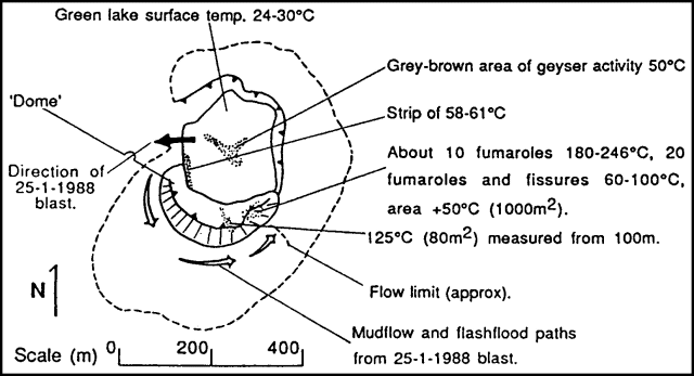 |
Figure 1. Sketch map of the crater of Poás in January 1988, prepared by Open University geologists. Their infrared radiometer temperatures are shown, with the area scanned in parentheses. Temperatures were taken with an infrared radiometer measuring surface brightness temperature in the 8-14 µm range with emissivity set at 1. |
Water temperatures at the surface of the dark green crater lake reached 61-63°C below the W flank of the 1953-55 [dome]. Fumarole temperatures measured by ICE personnel on the [dome] were about 400°C. Terraces formed from sedimentary precipitates (travertine and sulfur) had been eroded away. Lake level had dropped markedly since 1987. The parallel fractures on the E and NE edges of the lake showed small displacements. Other parallel fractures between the edge of the [dome] and the lake were sites of more vigorous fumarolic activity.
Information Contacts: Sergio Moro Castro, ICE; B. van Wyk de Vries, H. Rymer, and G.C. Brown, Open Univ.
Phreatic explosions continue from crater lake
Small phreatic eruptions from the hot crater lake remained frequent in early April, and fumarolic activity was continuing. Magnitude 5.1 and 5.5 earthquakes centered roughly 100 km SW and 175 km SSE on 2 and 11 March had no apparent effect on volcanic activity.
Information Contacts: Guillermo Alvarado I., ICE.
Strong phreatic explosions deposit acidic mud and sulfur
Activity in the hot crater lake has been increasing since phreatic eruptions resumed in June 1987. In August 1987, eruptions occurred about every 45-60 minutes. By January 1988 activity was characterized by series of 2-3 individual eruptions, separated from each other by approximately 1 minute and from other eruption series by five or more minutes.
Park guards reported that residents of Poásito, 5 km SE of the crater, described a fall of "ash" on 9 April at about 0300 that stained plastic and plant leaves. Another large explosion at 0725 emitted a vapor plume estimated at 2 km height and dropped acidic sulfur-rich mud on visitors, cars, and plants at the tourist overlook. Observations on 13 April showed that plants were stained with mud and some were burned; leaves on some plants were completely burned, particularly the new shoots. Impacts of the very moist mud droplets were submillimeter-sized with a mean density of 14/cm2 (for the two eruptions). Around the hot lake there was a spray of pale yellow sulfur pyroclastics, kidney-shaped or like grease spots, with mean diameters of 0.5-1 mm and maximum lengths of 2 cm. The shapes of the pyroclastics indicated that the sulfur was molten when ejected. This material reached 10 m E of the E edge of the lake, some 50 m onto the N meseta, and carpeted the NW and W walls to about 150 m height (figure 2), suggesting a directed blast toward the W. A quick and preliminary analysis of seismograms from Poás station did not show a notable increase in seismicity, nor events that could be clearly associated with the phreatic explosions.
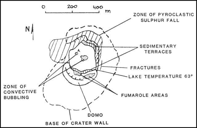 |
Figure 2. Sketch map of the crater of Poás on 13 April 1988. Courtesy of G. Soto. |
The temperature of the lake was 65°C and its pH was 0.45 on 11 April. A fumarole on the remnant of the 1953-5 [dome] had a temperature of 298°C on its upper part, while 587°C was registered W of it. Park guards reported continuous and persistent headaches without irritation of mucous membranes (eyes, mouth, respiratory system), effects commonly experienced at the edge of the lake. These effects correspond to those of CO, CO2, and H2S (Faivre-Pierret and Le Guern, 1983) but the gas discharge from the fumaroles and its concentration in the air have not been measured.
In late April, mud eruptions occurred an average of once every 3 minutes. The lake color had changed slightly to yellowish green from dark green in January. The N-S-trending fractures in the E wall of the lake had generated small rockfalls that came to rest on the terrace sediments. The temperature of the SE edge of the lake, beside the remnant of the 1953-5 [dome] (figure 2) was 63°C, similar to that of January. In the NW part of the lake (point A on figure 2) convective bubbling occurred every 15-60 seconds. Some of the bubbling episodes brought sediment to the surface, coloring the water gray, as well as a yellowish sulfurous scum. Mud plumes were ejected from point A and the center of the lake an average of about once every 3 minutes, generally to estimated heights of 5-10 m, with the highest to 60-100 m.
Reference. Faivre-Pierret, R., and Le Guern, F., 1983, Health risks linked with inhalation of volcanic gases and aerosols, in Tazieff, H., and Sabroux, J.C., eds., Forecasting Volcanic Events: Elsevier, Amsterdam, p. 69-81.
Information Contacts: G. Soto, Univ de Costa Rica (UCR); Guillermo Alvarado, ICE; J. Barquero and E. Fernández, OVSICORI.
Continued minor phreatic activity from crater lake
Strong explosions in April ejected acidic sulfur-rich mud onto the crater rim. Laboratory studies of the sulfurous droplets showed that they were liquid when they fell, and had melting points between 112 and 120°C. According to park guards, there have not been large eruptions like those of April and May for some time.
When geologists visited the volcano on 30 June, geyser-like phreatic activity was continuing, ejecting muddy plumes every 2-3 minutes. Plume heights were predominantly less than 15 m, with maximum observed heights of 80 m. There were frequent sequences of continuous plumes lasting 45 seconds. Most of the plumes were pine-tree shaped but some showed a broad cauliflower form. The strongest explosions originated dispersive seismic signals, without an initial explosive phase.
Since mid-April, three new sites of convective bubbling had formed (C, D, and E on figure 3). From these, bubbles with sediment were intermittently ejected, and on occasion, small mud plumes. The most intense activity was from site E. The level of the hot lake continued to descend, revealing a wide littoral crescent formed by terraces of precipitated sediment. These sediments were thixotropic, making measurements of lake level and temperature difficult. Fractures on the E edge of the lake had openings of up to 25 cm, and facilitated rockfalls into the lake.
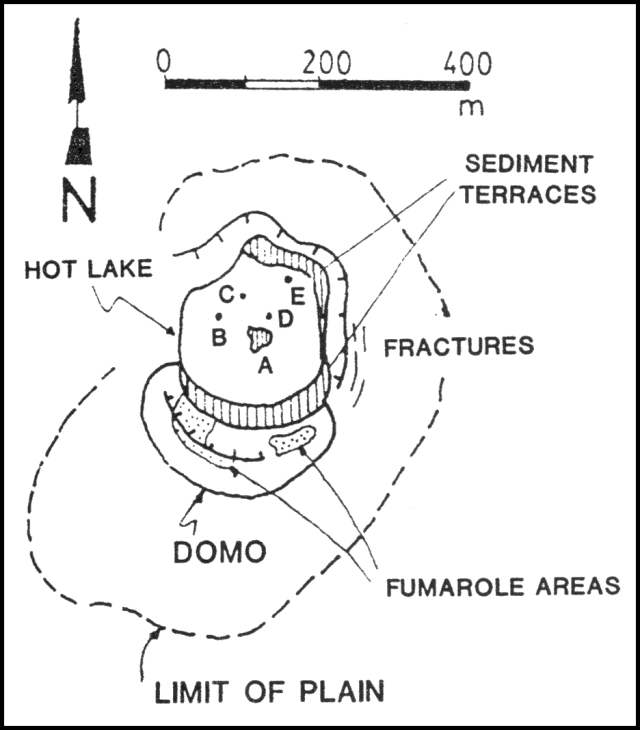 |
Figure 3. Map by Gerardo Soto of the crater at Poás on 30 June 1988, showing the remnant of the 1953-55 [dome] and hot lake. Point A marks the source of the primary mud plumes, and B-E the sites of convective bubbling and secondary plume production. |
Information Contacts: G. Soto, UCR.
Phreatic explosions subside to convective bubbling
Since mid-April, the level of the crater lake has dropped ~1-1.5 m, reducing its diameter by 20 m and revealing terraces of thixotropic sediment. The lake was bright yellow, presumably from suspended sulfur. Six zones of continuous convective bubbling lifted plumes of dark to light brownish-gray mud 1-10 m above the lake surface. This activity, concentrated on the N side of the lake, has declined from the strong phreatic explosions that ejected acidic mud and sulfur during April. Bombs and lapilli composed of relatively pure crystalline sulfur, ejected during explosions between April and June, were found on the southern terraces. Geologists noted that the change from periodic explosions to continuous convective bubbling may be due to a decrease in hydrostatic pressure with lowering lake-level rather than an increase of energy into the lake. The eroded 1953-55 [dome] slipped slightly towards the lake along fractures, but fumarolic activity was unchanged.
Information Contacts: G. Soto and Héctor Flores, UCR; W. Melson, SI.
Continued phreatic activity; inflation
Phreatic eruptions continued in August from four sites in the crater lake. The strongest eruptions were from the center of the lake, ejecting plumes that were typically ~50 m high. Some were larger, as on 12 August, when a plume rose 200 m. The average lake temperature was 65°C, reaching 100°C near the eruption sites. Chemical analysis of the lake water indicated an increase in its sulfate and chloride content; pH remained at 0.5. The level of the lake continued to descend. Temperatures of fumaroles on the remnants of the 1953-55 [dome] had declined to 379°C from as much as 587°C in April. Measurements on 17 August show 34 µrad of inflation on the S flank of the crater since 28 June. A N-S line across the crater lengthened 84 mm between 6 July and 18 August.
In July, the acidity of the air around the crater caused eye and respiratory discomfort to tourists. Plants were also affected and the impact of acid rain, from Poás fume, has been noted as far as 8 km SW of the crater.
Information Contacts: J. Barquero, E. Fernández, and R. Van der Laat, OVSICORI.
Phreatic activity from crater lake
Activity in the hot crater lake has remained vigorous since the onset of geyser-type phreatic explosions in June 1987. The postulated mechanism of activity is shown schematically in figures 4 and 5. During the first half of August 1988, plumes containing mud were ejected at intervals of 3 minutes, reaching 30 m above the lake surface. Activity occurred from three sites in the lake, but remained strongest at the central vent (figure 6). The explosions were accompanied by strong noise and emission of gas that was generally blown W by the wind. Geyser-type activity was almost continuous during the second half of August and the first week of September, with black mud plumes rising 5-10 m. During the rest of the month, plumes rose as much as 25 m. Heavy rainfall caused small changes in lake level during September. A rockfall occurred in mid-September on the NE edge of the lake, facilitated by concentric fractures. The rockfall scar had a maximum diameter of 30 m, was 15 m high, and 25 m wide.
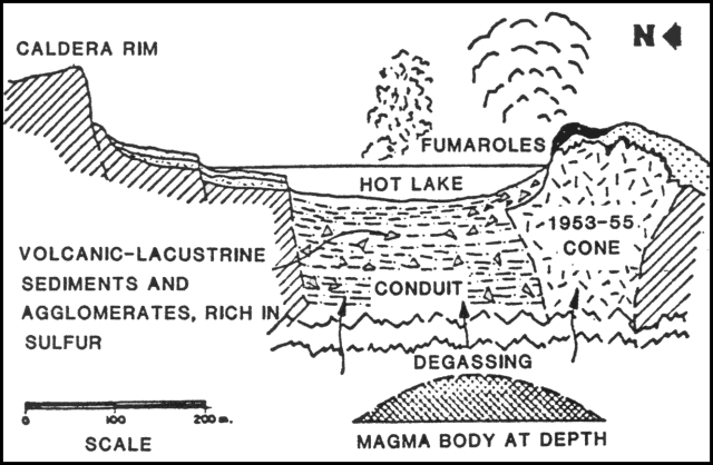 |
Figure 4. Schematic cross-section of the main crater at Poás, showing a degassing magma body at depth with gases rising through a zone of volcanic debris and lake sediments into the crater lake. Courtesy of the Escuela de Geología, Univ de Costa Rica. |
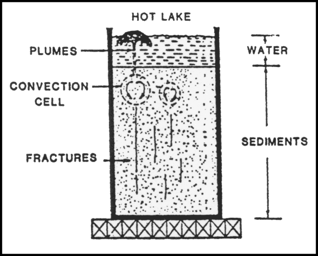 |
Figure 5. Schematic cross-section of the crater lake at Poás and its underlying sediments. One of the shallow convective cells feeds a phreatic plume. Courtesy of the Escuela de Geología, Univ de Costa Rica. |
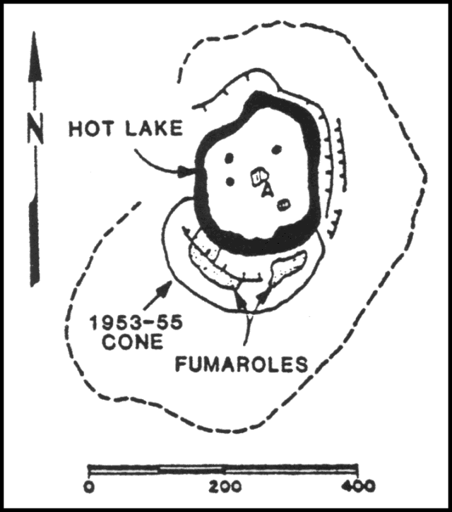 |
Figure 6. Sketch map of the main crater at Poás based on observations in August 1988. The 1953-55 [dome] and its fumaroles (stippled) are on the S side of the hot crater lake. Sedimentary terraces (shaded) ring the lake and zones of convective bubbling within the lake are shown. Courtesy of the Escuela de Geología, Univ de Costa Rica. |
Vapor ejected by the phreatic explosions caused acid rain within the crater, and irritated mucous membranes of people at the overlook. Water in Lake Botos, SE of the crater, has acidified slightly. The lake supplies water to the visitor center at Volcán Poás National Park, where pH of piped water was 4.5-4.8. Fumaroles on the remnants of the 1953-55 [dome] showed high concentrations of H2S and water vapor, moderate amounts of CO2 and H2, and little Cl2 (data from a Drager gas detector). The temperature on the [dome] was about 500°C. Seismic records from Poás volcano station (VPS) have not shown significant changes in the past 6 months. Tens of B-type earthquakes were recorded daily, while A-type events were scarce, confirming the shallow character of the activity.
Information Contacts: G. Soto, UCR; Seccion Sismologia e Ing. Sismica, ICE; Rodrigo Saenz and E. Fernández, OVSICORI-UNA.
Crater lake activity continues
Geologists visited Poás on 2 November and observed activity similar to that of previous months. Mud plumes rose 2-3 m from three sites near the center of the crater lake. Intense convective bubbling occurred at multiple points in the lake. No explosions were observed. Since September, the level of the lake had dropped ~1 m and its diameter had decreased, leaving a growing sedimentary terrace. Fumarolic activity continued on the summit and N edge of of the 1953-55 [dome]. Several tens of volcanic earthquakes were recorded daily, predominantly B-type events.
Acid vapor produced by the activity was blown W by strong dry-season trade winds, away from the overlook area. Plants inside the crater, around the overlook, and SE toward Lake Botos sprouted leaves without acid burns, in contrast to earlier leaves that had burned edges. The pH of drinking water in the Visitors Center, supplied from Lake Botos, had risen since September to 5.0-5.5, indicating lower ambient acidity.
Park guards have experienced coughing, sneezing, itching of eyes and skin, and stomach problems because of the acid. The effects are transitory and have not caused them permanent damage (Dra. Y. Soto, personal communication). According to the park guards, birds that had been absent from the summit area in recent months have returned and can be heard singing, demonstrating a decrease in ambient acidity. Dead birds had been seen in the crater near the 1953-55 [dome] in January.
Information Contacts: G. Soto, Univ de Costa Rica (UCR), San José.
H2S emission kills plants; crater lake recedes rapidly
The crater lake has continued to recede and by February 1989 its level was ~12 m lower than on 24 June. During fieldwork on 7 February, the lake was bubbling vigorously and had a temperature of 85°C. Suspended sediment gave it a gray-black color; filtered lake water was yellow-green. Areas of higher heat flow and/or more intense fumarolic activity were indicated by mud plumes >1 m high. Geyser-type eruptions were not observed, and reportedly ended in October. Blocks of altered scoria that approached 3 x 2 x 1.5 m floated on the lake surface, tracing the paths of convection currents (figure 7).
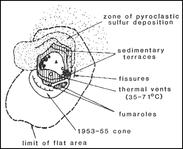 |
Figure 7. Sketch map of the main crater at Poás, January-February 1989, courtesy of Guillermo Alvarado. A: source of mud plumes in the crater lake; B: zone of floating scoria blocks; C: pyroclastic sulfur cones. |
Temperatures of fumaroles on the 1953-55 [dome] decreased from 200-275°C in October 1988 to 64-94°C in February 1989. Fumaroles on lake sediment terraces vented directly into the atmosphere or mixed with water draining from the surrounding crater walls. Hot pools in streams (temperatures 35-71°C) and small mud pots formed and disappeared. The pools were often coated with a layer of precipitated dark green sulfur. Fumaroles on the exposed lake bottom were no hotter than 94°C. They emitted large quantities of H2S, changing the composition of the crater gas plume, which was blown W and SW by strong winds. Reports from SW-flank towns (Grecia, Sarchi, and Naranjo; 17, 18, and 19 km from the crater) indicated that the plume has become more toxic, burning trees and plants closer to the volcano and leaving them dead or dying. Vegetation was damaged in forests, grassland, and some agricultural land, principally in the towns of San Luis and Trojas de Grecia, 11 km SW of the crater. Residents of those towns suffered from eye and throat irritation. Fogs reportedly coated cars and houses with fine sulfur particles, similar to coatings that affected a rain gauge in the crater downwind of the plume. During periods of higher lake level, the H2S had emerged into the lake where it was oxidized to sulfur and H2SO4, so less had reached the atmosphere.
Park personnel reported small explosions during the afternoon of 3 February and at about 0700 on 6 February. The cause of the explosions may have been venting from two small pyroclastic cones composed entirely of sulfur. The larger of the two cones was ~1 m high, and they were separated by a large hole that was the site of vigorous fumarolic activity. Particles of bright yellow pyroclastic sulfur covered ~500 m2 on the NE part of the crater floor.
January 1989 seismicity was the most active of the past 2 years (figure 8). The number of events averaged 307/day at Red Sismológico Nacional station VPS-2, roughly 1 km NW of the lake. The bulk of the events were of low frequency with depths that did not exceed 1 km.
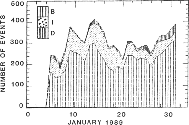 |
Figure 8. Number of seismic events/day of types B, I, and D, January 1989, recorded at Red Sismológico Nacional Station VPS-2, roughly 1 km NW of the crater lake. January totals for event types: B, 5977; I, 1878; D, 394; A, 8. Courtesy of Guillermo Alvarado. |
Information Contacts: Gary Rowe and Susan Brantley, Pennsylvania State Univ, USA; José Francisco Fernández, Chemistry Laboratory, Instituto Costarricense de Electricidad, San José, Costa Rica; Mario Fernández and Luis Diego Morales, Univ de Costa Rica, San José, Costa Rica; R. Barquero and Guillermo Alvarado, ICE; J. Barquero and E. Fernández, OVSICORI.
Crater lake continues to shrink
The crater lake has continued to shrink, and by the end of February, the cumulative decrease in depth was estimated at 30 m. The lake was only 10-15 m deep and its diameter was 100-125 m (figure 9). Seven dessication terraces surrounded the lake, which was colored gray by solutes and suspended mud. The lake contained multiple centers of convective bubbling. Mud plumes were rarely ejected, some with small blocks that fell back into the lake. On the N shore and in the south-center of the lake there were small mud/sulfur cones with fumaroles. Fumarolic activity on the 1953-55 [dome] had declined, with only a few vents remaining on the summit; most were on the N flank of the [dome], toward the lake. Their temperature was at about the boiling point of water at that elevation, approximately 95°C. February seismic events, mostly B-types, totaled 8,639 through the 22nd, for a daily mean of 392 (figure 10).
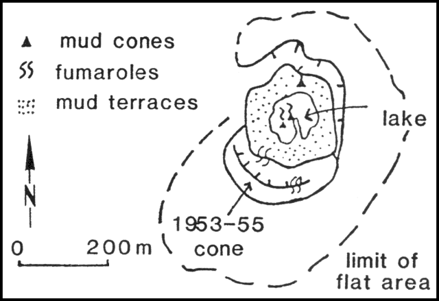 |
Figure 9. Sketch map of the crater lake and 1953-55 [dome] at Poás, February 1989. Courtesy of G. Soto and Mario Fernández. |
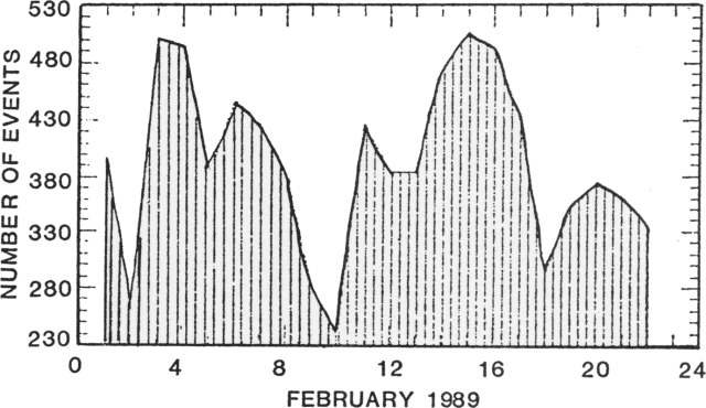 |
Figure 10. Daily recorded seismic events at Poás, February 1989. Courtesy of G. Soto and Mario Fernández. |
[The following was inadvertently omitted from the original 14:02 report.]
On 12 February 1989, geologists from Italy (M. Martini, L. Giannini, M. Paolieri, and F. Prati), the Univ Nacional (J. Barquero), and the Instituto Costarricense de Electricidad (J. Fernández) collected gas samples from fumaroles on the almost dry lake bottom within the active crater, and from a residual boiling pond. Analysis of gas samples yielded the following values (in mole %): CO2, 79.5; H2S, 5.0; H2, 0.2; CO, 0.0004. The pond had high concentrations of sulfuric and hydrochloric acid. The Italian geologists noted that these values suggest an important contribution from a shallow degassing magma body, probably responsible for the collapse of the pre-existing [dome] and for the fracturing of the lake bottom that facilitated the disappearance of the lake.
Information Contacts: G. Soto and Mario Fernández, Univ de Costa Rica, San José; M. Martini, Univ di Firenze, Italy.
Crater lake shrinks; gases cause illness and damage plants
The level of the crater lake continued to descend, dropping another 2 m in March for a cumulative decline of about 32 m since early 1987 (figures 11 and 12). Phreatic (geyser-type) eruptions were sporadic and generally no more than 10 m high, although ejecta reached heights of 60 m on 12 February and 50 m on 2 April. Lake water was colored muddy gray by suspended sediment, and convective bubbling was continuous. At the beginning of March, movement of rafts of floating sediment illustrated convective trajectories within the lake. Rafts were not seen in the middle of the month, although there was some thick floating sediment. By the end of March, no floating material was evident. The temperature of the lake water averaged 82°C.
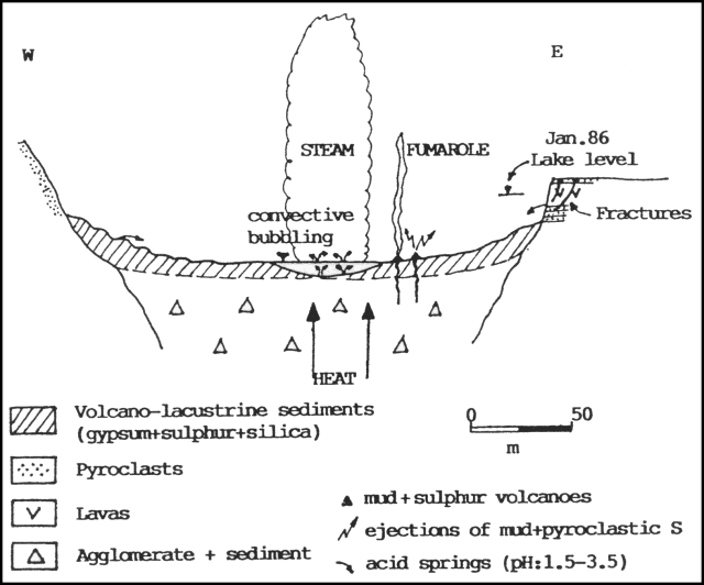 |
Figure 11. W-E diagrammatic cross-section of the crater at Poás illustrating March 1989 activity. Courtesy of Gerardo Soto. |
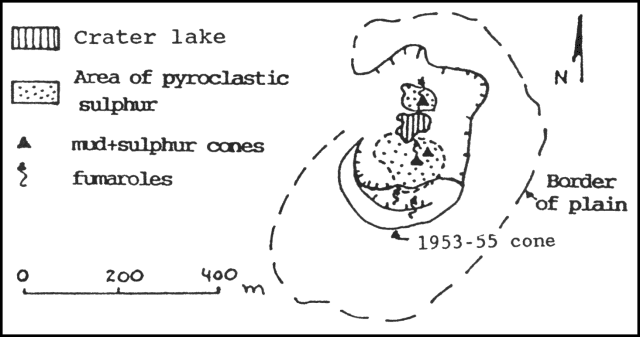 |
Figure 12. Sketch map of the crater at Poás in March 1989. Courtesy of Gerardo Soto. |
Small sulfur cones had formed on sedimentary terraces at the SE edge of the lake, constantly ejecting sprays of mud and pyroclastic sulfur that carpeted the surrounding area. Some had collapsed, forming craters that continuously emitted gas. The most active made a sound like a jet aircraft. Some of the cones were topped by chimney-like structures ~1 m high, made of sulfur. Two small sulfur cones had also developed on the lake's NE edge, venting gases with a mean temperature of 98°C.
Fumarolic activity on the 1953-55 [dome] was weak and located at the summit and N side, with temperatures varying between 59°C and 91°C. The temperature of fumaroles W of the [dome] was 95°C.
Prevailing winds carried volcanic gases W and SW of the crater, damaging vegetation and causing health problems for residents. Towns to 10 km SW of the crater (such as San Luis Cajón de Grecia) were impacted. Coffee has been the crop most affected, with preliminary calculations of losses reaching about $500,000. Trees (cypress, jaul, and eucalyptus) and grass were burned by acid rain. The inhabitants of towns as far as Trojas de Valverde Vega (11 km WSW of the crater) and San Pedro Poás (14 km SW) suffered health problems including eye and respiratory irritation and allergies. Consequently, local health facilities have had an increase in patients.
Since mid-January, a telemetering seismic station near the summit (POA2) has registered an average of 300 B-type events/day. Volcanic microseismicity declined in March compared to February, but remained higher than in 1988. Between 1 and 29 March, 6,726 events were recorded, an average of 232/day. The most active day was the 18th, when 346 shocks were detected (figure 13). Most were B-types, some with dispersive trains. Only three A-types were recorded during the month. Partial reoccupation of a level line indicated that 25 µrad of deflation had accumulated between October 1988 and March 1989. The horizontal distance across the crater did not show significant changes.
 |
Figure 13. Number of local seismic events/day recorded by the Red Sismológica Nacional, March 1989. Courtesy of G. Soto. |
Geologists from the Univ de Costa Rica noted that the thermal activity formerly concentrated at the 1953-55 [dome] (between 1980 and 1987) has moved to the lake. They suggested two possible causes: (1) the fracture zone that controls thermal energy release has changed position; or (2) magma is rising below the lake, causing greater heat flow, and could lead to an eruptive event.
Information Contacts: J. Barquero, OVSICORI; G. Soto, Mario Fernández, and Héctor Flores, UCR.
Crater lake gone; explosions and molten sulfur ponds
Until mid-April, thermal activity remained similar to that observed in March, with boiling mud springs and vigorous fumaroles in the crater lake, which has been shrinking since early 1987. Two ponds of molten sulfur (115°C) have persisted since 16 March at the former site of small sulfur and mud cones 50 m SE of the center of the inner crater (figure 14). Small pyroclastic sulfur cones surrounded the lakes, collapsing occasionally.
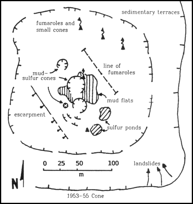 |
Figure 14. Sketch map of the inner crater at Poás and its features, April 1989. Courtesy of Gerardo Soto. |
On 12 April, the crater lake was convecting vigorously, but shallow areas were visible. The lake level dropped about 2 m during the following week, and by 19 April only a few small mud pools remained. The characteristic geyser-type phreatic activity through the crater lake changed 18-19 April with the lake's near disappearance. Cypressoid vertical columns continuously rose about 25 m above the former center of the lake and began to build a mud/pyroclastic cone. On 19 April, small bursts of gas and mud that contained sulfur particles emerged through the mud surface to heights of about 10 m, rarely to 25-30 m. Steaming was continuous. Activity had increased slightly the next day, but magnetometer traverses that passed about 100 m from the active area showed no changes since the last measurements on 3 April. Phreatic bursts reached about 50 m height on 21 April. Using a thermocouple, Jorge Barquero measured a liquid temperature of 116°C in one of the sulfur ponds. On 22 April at around 1000, a dark mushroom-shaped column developed, convecting to 200-300 m height. Fine mud, sulfur, and burning gases (possibly hydrogen) were ejected until 1032. Fine yellow material fell on the W side of the inner crater [see also 14:05]. Ejection of lithic material stopped suddenly and the plume reverted to its normal white color. About 15 minutes later, continuous geysering of dark sediment and gas was observed for 2-3 minutes. Clouds obscured the summit at 1130. At 2100, after weather had cleared, the base of the plume was suddenly illuminated by a pink-orange light for about 2 minutes. No sounds were audible other than those accompanying the continuing phreatic activity. The light stopped suddenly and was thought to have been generated by burning gases.
During observations on 23 April, a thick white plume coalesced from numerous vents, two of which were discharging a mixture of white condensed steam and yellow sulfur. Dark cypressoid plumes were emitted every few seconds. At least one vent continuously discharged fine dark material. At 0717, a pink-orange light was again seen at the base of a continuous white plume on the SW side of the crater bottom. The light remained visible for 2.5 minutes, and geologists believed that it was generated by burning gases. A brightness temperature of 158°C was recorded (with an 8-14 micrometer bandpass infrared thermometer), but the measurement was made from almost 1 km distance and geologists suspected that the temperature was probably several hundred degrees higher. Phreatic activity from at least six of the vents expelled blocks to about 50 m height and occasionally to 100 m or more, generally vertically but sometimes obliquely. Most of the ejecta fell within 10-20 m of the vents, building cones to about 10 m height with funnel-shaped craters up to 5 m in diameter. The ejecta appeared dry and included blocks more than 20 cm across. Radiant temperatures of dark plumes were only about 80°C as measured from about 150 m away. Activity occasionally reached a level at which at least one of the six or more phreatic vents was erupting at a given time. Booming noises and sounds like a jet engine were occasionally heard. From nearer the vents, sounds like pistol shots were audible.
The two ponds of dark brown, very fluid, bubbling liquid, apparently sulfur, were about 50 cm below the former crater lake floor in steep-sided pits. One, roughly elliptical, was about 20 m across, while the other was dumbbell-shaped and about 10 m long. A terrace of solid sulfur had developed at the edge of the liquid, and the sides and rims of the pits were coated by bright yellow sulfur sublimates. A moderate amount of visible condensate rose from their surfaces and the smell of SO2 was strong. No surface burning was evident. Blocks of pale-colored altered rock (probably former lake sediments) floated on the sulfur ponds, suggesting a density substantially above 1 g/cm3. Remnants of the former crater lake had a maximum surface infrared radiometer temperature of 97°C.
Four geologists (G. Alvarado, M. Fernández, G. Soto, and D. Stevenson) descended to the bottom of the inner crater on 25 April. The activity had built at least three new cones, aligned with the sulfur ponds along a N30°W trend. The cones, 10-12 m high, were continuously active, emitting vertical columns of mud, sulfur, gases, and rocks to 30-70 m (occasionally 100 m) height for some seconds. Optical radiometer temperatures of the plumes were 75-90°C. Lesser thermal features (fumaroles, small hot lakes, and boiling mud springs) were found around the periphery of the cones. A small fault scarp, parallel to the line of cones, cut the sediments. The faulting was interpreted as the result of subsidence caused by the removal of the eruptive products, and a decrease in the internal pore pressure of the subsurface hydrothermal regime. At noon, the geologists were surprised by (but escaped unscathed from) a sudden eruption of sulfur, mud, and gases (some burning) that formed a thick vertical column nearly 400 m high, with a minimum radiometer temperature of 459°C. Sulfur and mud fell on the W wall of the crater and over the rim (toward Cerro Pelón). Other similar eruptions deposited greenish-gray mud within the crater.
The column from a larger eruption on 28 April between 0500 and 0600 reached an estimated height of 1.5-2 km and dropped fine mud to 2.5 km S of the source [see also 14:05]. The next day, the central mud cone (which had reached about 20 m height) ejected vertical columns of mud and sulfur to 200 m height. The small SW mud cone was in nearly continuous activity, emitting brown-gray lithic ash that was carried W by the wind. The gases were sulfurous, strongly yellow- and orange-colored, and rose in a vertical convective column to 350 m height. Eruptive characteristics were similar on 30 April and 1 May, but with columns to 1-1.5 km high on the 1st. The wind carried the fine lithic ash and mud toward the W onto various towns (including Bajos de Toro, Zarcero, and Sarchí).
Activity decreased 2 and 3 May. On the 3rd, ash was measured on the crater rim, reaching 1 mm thickness at point A (figure 15) and 2 mm at point B. Particles reached medium-grained ash size and were lithic, dominantly mud/clay granules of sulfide/sulfate sediments with a high percentage of solutes.
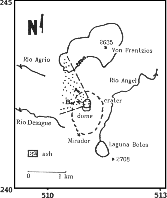 |
Figure 15. Distribution of ash at Poás, and sites where thicknesses were measured 3 May 1989. Sketch and data from G. Soto. |
Seismicity has visibly declined. Volcanic earthquakes totaled 4,240 in April, for a mean of 141/day (figure 16). Seismicity continued to be dominated by B-type events, although their number had decreased. The most significant change was the appearance of tremor episodes with durations of 4-10 minutes. The change in seismic pattern was interpreted by Morales et al. (1988) as the change from magma-water interaction in a medium that is not open (B-type signals) to one that is partially open (continuous train of B-type signals or tremors).
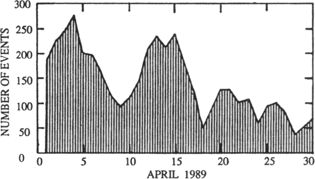 |
Figure 16. Number of seismic events recorded/day at Poás by the Red Sismológica Nacional, April 1989. Courtesy of Mario Fernández. |
Reference. Morales, L.D., Soley, J.F., Alvarado, G.E., Borgia, A., and Soto, G., 1988, análisise espectral de algunas señales sísmicas y su relación con la actividad de los volcanes Arenal y Poás, Costa Rica: Boletín del Observatorio Vulcanológico del Arenal, año 1, no. 2, p. 1-25.
Information Contacts: G. Soto, Mario Fernández, and Héctor Flores, UCR; Guillermo Alvarado, R. Barquero, and Ileana Boschini, ICE; David Stevenson and C.M.M. Oppenheimer, Open Univ.
Ash emission, then rains produce new lake; gas chemistry
The crater lake, which had been shrinking since early 1987, disappeared by 19 April. After the lake's disappearance, columns of mud rose 10-350 m, building a cone that was 15 m high and contained seven active vents by 26 April. The vigorous 22 April explosive activity deposited lake sediments 600 m to the W. The explosion at dawn on the 28th, directed toward the S, again deposited lake sediments, to 2 km from the rim of the inner crater. Material on the bottom of the crater continued to dry, and emission of lithic ash began during the night of 30 April. Winds carried ash W and SW, where it fell on the towns of Toro Amarillo, Palmira (16.5 km W), Zarcero (18 km W), and Sarchí (18 km SW). Similar eruptions continued through the day on 1 May. A fumarole W of the 1953-55 [dome] had a temperature of 95°C on 26 April. The number of long-period events recorded by Univ Nacional seismic instruments declined in April to a mean of 218/day (through 26 April; figure 17). The events were of low frequency (1-2 Hz) and very shallow. Low-frequency (1.75 Hz) tremor began to appear on seismic records 19 April.
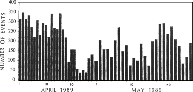 |
Figure 17. Number of local seismic events/day recorded at Poás by the Univ Nacional, 1-26 April and 1-26 May, 1989. |
Similar activity continued into May. Emissions of gas and ash (composed of old lake sediments) from various vents were continuous. The largest gas/ash emissions occurred from the mud cone that had formed in the center of the crater. Winds generally carried ash toward the W and SW [see also 14:06]. With the onset of the rainy season in mid-May, the bottom of the crater was covered with water, forming a new lake. Mud eruptions again dominated the activity, depositing ejecta within the crater. Small ash eruptions continued only from one point on the W side of the crater. On 25 May, a phreatic eruption destroyed the mud cone, depositing debris outside the crater. Through the end of the month, activity was confined to small mud eruptions, reaching about 5 m height, and continuous gas emission affected towns W and SW of Poás. As of 26 May, Univ Nacional seismic instruments had recorded a mean of 175 events/day during the month (figure 17). Amplitudes oscillated between 10 and 30 mm, with frequencies of 1.5-3.0 Hz. Volcanic tremor amplitude was generally 4-5 mm with a frequency of 1-1.5 Hz, but sometimes reached 10 mm amplitude and 2.5 Hz.
Information Contacts: J. Barquero, E. Fernández, and V. Barboza, OVSICORI.
Rains partly refill crater lake; intense gas emission
During the first 12 days of May, activity remained similar to that at the end of April. Gas emission was intense, and ejections of mud and lithic ash fed plumes that reached maximum heights of 1.5-2 km above the crater floor. Individual ash ejections lasted for more than an hour. Trade winds generally carried ash clouds toward the WSW. Various towns reported ashfalls, including Atenas, 32 km SW (on 9 May). Some ashfalls also occurred on the ENE and S flanks. On the rim, roughly 300 m W of the center of the crater (point F on figure 18) 5 mm of new ash was measured on 7 May and 60 mm on the 12th. The ash was composed of hydrothermally altered lithic fragments, soluble mud, and sulfur. The maximum measured grain size was 1.5 mm, and 80% of the ash volume was composed of fragments between 0.075 and 0.25 mm.
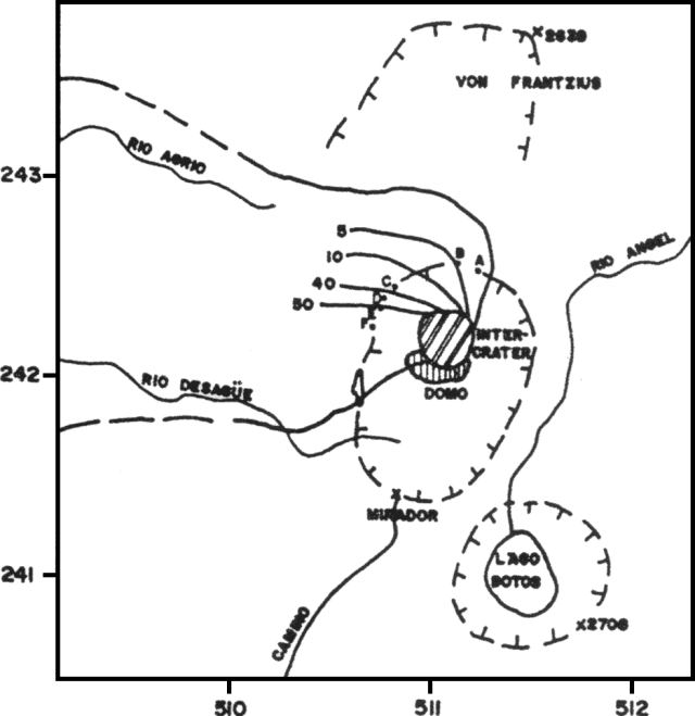 |
Figure 18. Sketch map of Poás showing ash isopachs as of 12 May. Grid spacing is 1 km. Thicknesses of ash at each collection point: A, 3 mm; B, 5 mm; C, 13-20 mm; D, 42 mm; E, 50 mm; F, 60 mm. Courtesy of Gerardo Soto. |
Gases were dominated by water vapor from the aquifer beneath the crater, and included SO2, H2S, and (possibly) hydrogen. Sulfur sublimates were deposited around fumarolic vents, and some of the sulfur burned, forming SO2. Flames from the combustion of sulfur (and perhaps hydrogen) were intense above some vents. In the center of the area formerly occupied by the crater lake, two primary pyroclastic mud cones (and various smaller neighboring cones) had been growing since mid-April, reaching maximum heights of 25 m despite frequent collapses. In the SE part of the crater, there was a molten, bubbling, sulfur lake and sulfur had flowed across the muddy crater floor. Fumaroles emitted sulfurous gases and a mud-sulfur cone was growing. The crater's NE quadrant included a vigorous fumarole that emitted sulfur-rich gas with a jet-aircraft sound, and deposited sulfur sublimates.
With the onset of the rainy season in mid-May, water started to accumulate in the former crater lake, reaching a depth of about 2 m by early June. Eruptive activity began to decline noticeably on 13 May. By the last week of May, the central cones had collapsed and been reworked by convective bubbling. Nevertheless, emission of water vapor and sulfur gases, some burning, continued at the end of the month. Bubbling was vigorous in the muddy zones on the crater floor, but no mud columns were ejected nor were there ash eruptions. The former site of the sulfur lake was occupied by a muddy area and a fumarole producing sulfur sublimates that burned with red-orange flames. Bubbling mud and intense evaporation were found in the active zone in the NE part of the crater. A zone of weak fumaroles and sulfur sublimates was present on the wall and NE side of the inner crater. Activity on the remnants of the 1953-55 [dome] remained stable through June, with low-temperature fumaroles depositing sulfur, gypsum, other minerals, and clays.
Intense gas emission (dominated by water vapor, with SO2 and H2S) continued in June from the crater lake. The lake remained about 2 m deep through the month. Its inner zone was muddy and showed continuous convective bubbling, while its periphery was emerald green with a pH <= 0.5, fed by multiple surface springs of about pH 2.0. There were five principal hot areas in the lake's inner zone, three in the N area, one in the center, and one to the SE. The NE site showed intense fumarolic activity and had constructed a small mud-sulfur cone that contained an orange-brown lake of molten sulfur and boiling mud. The central N site included small cones with mud/sulfur spines. Fumarolic activity and a mud rampart had developed at the SE site. At the other hot areas, intense convection of muddy water generated waves. Small emissions of muddy ash occurred within the crater, including one on 23 June at 1845 that produced a column hundreds of meters high. Other explosions occurred between 28 June and 2 July.
Substantial changes have been noted in volcanic seismicity. The characteristic B-type shallow (<500 m depth) signals declined in May but increased again in June.
During the first 30 days of May, 2,247 seismic events were recorded, a daily mean of about 75 (figure 19), down from 141/day in April. June's average was similar (1,904 events in the first 27 days, a mean of 71/day) but the number of earthquakes increased sharply after lower activity during the month's first week. Geologists noted that tremor or volcanic noise has become common at Poás, probably resulting from continuous degassing in a partially open conduit. Origins looked like those of B-type signals and the activity could represent continuous trains of B-type events. A-type shocks, of volcano-tectonic origin, had preliminary locations near the crater, with magnitudes <1.
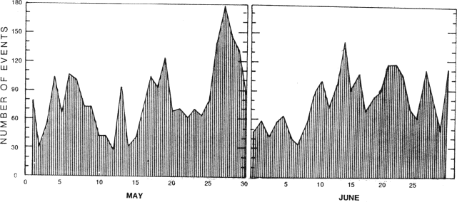 |
Figure 19. Number of seismic events/day at Poás, 1-30 May and 1-27 June, 1989. Courtesy of Mario Fernández. |
Information Contacts: Gerardo J. Soto, Guillermo E. Alvarado, Mario Fernández, and Héctor Flores, UCR.
Strong fumaroles in crater lake; seismicity increases
July activity was similar to that of June. The level of the crater lake had lowered about 1 m. Intense sulfur-rich fumarolic activity occurred from four principal vents within the lake, three on the N side and one in the SE. Sulfur cones had grown at the N-central and SE vents, small sulfur flows had emerged from the NE vent, and lakes of molten brownish orange sulfur were present at other sites. Pyroclastic sulfur and sublimates carpeted the bottom of the crater lake. Bubblings of mud occurred throughout the lake from fumaroles below its surface. Activity on the 1953-55 [dome] remained unchanged, characterized by low-temperature fumaroles.
The number of microseismic events recorded at the nearby Red Sismológica Nacional station VPS-2 increased in July, totaling 3,442 through the 26th, a mean of 132/day (figure 20). Seismicity was dominated by B-type shocks, with some well-defined tremor episodes and four very low-magnitude A-type events. The most active day was 21 July, with 221 volcanic microearthquakes.
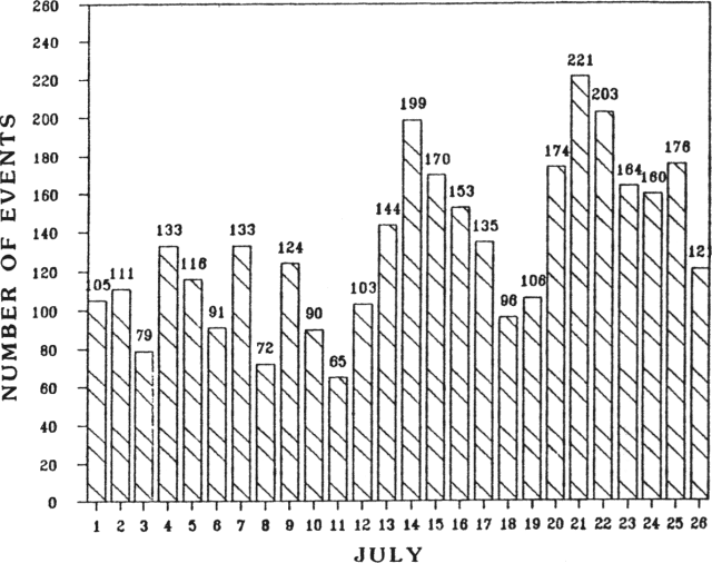 |
Figure 20. Number of seismic events/day at Poás, recorded by Red Sismológica Nacional station VPS-2, July 1989. Courtesy of G. Soto. |
Information Contacts: Gerardo J. Soto, Mario Fernández, and Héctor Flores, UCR.
Sulfur flows and acid rain; earthquakes and tremor
Emission of sulfurous gases from the hot crater lake remained continuous through August. Winds carried the gases mainly W and SW, producing acid rain that has continued to burn flank vegetation. The lake level remained low, fluctuating with changes in the relative amounts of evaporation and loss through fumarole emissions vs. rainfall and recondensation of fumarolic water. Temperatures oscillated between 80° and 86°C and pH was 0-0.5. On the N side of the lake were a field of sulfur and mud cones, fumaroles that made jet-engine sounds, sulfur lakes, and castle-like structures of cones and spines. The sulfur lake on the NE side had produced numerous brilliant yellow sulfur flows that were up to 30 m long, a few meters wide, and a few centimeters thick. More viscous greenish-yellow sulfur/mud flows had pahoehoe morphologies. At the lake's SE end, there were mud and sulfur springs, mud/sulfur/sulfate cones, and fumaroles that discharged gases (dominantly water vapor with a sulfurous component) with small audible explosions. Fumarole temperatures of 120°C were measured at some of the mud/sulfur cones. The outer portion of the lake was blue-green, but suspended mud generated by continuous bubbling from tens of small fumaroles on the lake bottom colored the lake's inner portion gray.
The Univ Nacional continued to record low-frequency (1.5-3.2 Hz) shocks with amplitudes of 4-30 mm, some higher frequency (A-type) events, and occasional low-frequency (1.5-3 Hz) harmonic tremor episodes of 2.5-5 mm amplitude (figure 21). The number of events recorded by Red Sismológica Nacional station VPS-2 increased from an average of 143/day in July to 195/day for the first 29 days of August. Univ Nacional seismic stations recorded slightly more events (daily means of 127 in June, 159 in July, and 235 in August) but showed similar trends.
 |
Figure 21. Daily hours of tremor (solid bars) and number of seismic events (striped bars), June-July (left) and August 1989 (right). Note the different horizontal scales. Courtesy of the Observatorio Vulcanológico y Sismológico de Costa Rica. |
Information Contacts: J. Barquero, E. Fernández, and V. Barboza, OVSICORI; G. Soto, Mario Fernández, and Héctor Flores, UCR.
Continued thermal activity; seismicity increases slightly
Gas emission from the hot crater lake continued without major changes. The lake's level rose about 1.5 m after heavy rains. Fields of sulfur cones (with castle-like forms), mud springs, and fumaroles were still present on the N and SE sides of the lake. Sulfur deposition formed a yellow scum on the lake.
Volcanic microseismicity recorded by Red Sismológica station VPS-2 increased to a daily mean of 241 for the first 26 days of September (figure 22). Geologists attributed the seismicity to conversion of water from the aquifer below the volcano to vapor bubbles.
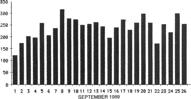 |
Figure 22. Number of seismic events/day recorded by Red Sismológica station VPS-2, 1-26 September 1989. Courtesy of Mario Fernández A. |
Information Contacts: G. Soto, Mario Fernández, and Héctor Flores, Univ de Costa Rica.
Continued thermal activity from crater lake; sulfur flows
Thermal activity continued, with the same characteristics as in previous months. The level of the hot crater lake varied. Its water contained a high concentration of mud and sulfur as yellow scum in suspension. Thixotropic mud on the surrounding terraces maintained temperatures of 30-40°C. Small fumaroles around the lake had a maximum temperature of 92°C. The hot area in the SE quadrant persisted, with mud and sulfur cones, patches of mud, and fumaroles (figure 23, top). All of the N sector contained castle-like features and cones of mud and sulfur, while a molten sulfur lake was the source of occasional flows several meters long and a few centimeters thick (figure 23, center and bottom). Fumaroles on the remnants of the 1953-55 [dome] emitted water-dominated vapor in equilibrium with the surrounding atmosphere; temperatures varied between 60° and 92°C. Volcanic microseismicity totaled 4,163 events for a daily mean of 278 during the 15 days that station VPS-2 was operational (figure 24). Almost 500 microearthquakes were recorded on the 2nd.
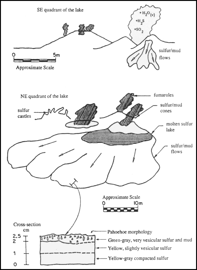 |
Figure 23. Sketch by Gerardo Soto of the SE (top) and NE (center) quadrants of the hot crater lake at Poás, showing gas emission, a molten sulfur lake, sulfur/mud flows, and various morphologic features. A cross-section of one of the sulfur/mud flows is shown at bottom. |
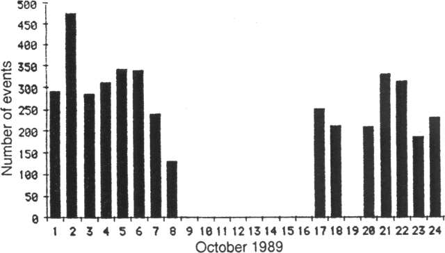 |
Figure 24. Number of seismic events/day recorded 1-8, 17-18, and 20-24 October 1989 by station VPS-2. Courtesy of Mario Fernández. |
Information Contacts: G. Soto, Mario Fernández, and Héctor Flores, Univ de Costa Rica.
Mud plumes from crater lake; more frequent earthquakes
November activity remained similar to that of previous months, with some changes in the hot crater lake. The hot areas in the N and SE parts of the lake remained as boiling mud springs. In the middle of the lake, mud plumes intermittently rose about 2 m, persisting for about 15 seconds. At the end of the month, the cones and castle-like features of mud were no longer visible, probably destroyed by the surges associated with the plumes. Activity on the remnants of the 1953-55 [dome] remained stable. Temperatures of about 66°C were measured on the top of the [dome], and about 87°C on its N flank.
Volcanic microseismicity totaled 8,366 events in 28 days, for a daily mean of 299. The largest number of events, 417, occurred on the 26th, and the smallest, about 200, on the 19th. Small increases have been recorded in each month since June. All of the seismicity was of low frequency; no A-type events were detected.
Information Contacts: G. Soto, Mario Fernández, and Héctor Flores, Univ de Costa Rica.
Phreatic eruptions from small remaining crater lake; small liquid sulfur pools; low-frequency seismicity
The level of the crater lake descended 1.5 m between November 1989 and January 1990. Its mean temperature was about 80°C and mean pH was 0.5. Degassing was continuous, and winds carried gases toward the W and SW flanks. Ejecta from phreatic eruptions reached 50 m height before falling back into the lake. Seismicity remained at low frequency (<3 Hz), with 9,434 recorded events in November (314/day), 10,164 in December (328/day), and 5,115 through 21 January (243/day) (figure 25). Geologists attributed the shallow, low-frequency seismicity to the volcano's continued degassing. Fumarolic activity continued on the remnants of the 1953-55 dome.
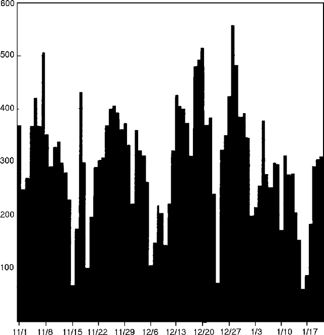 |
Figure 25. Number of recorded seismic events/day at Poás, 1 November 1989-21 January 1990. Courtesy of the Observatorio Vulcanológico y Sismológico de Costa Rica. |
Geologists visited the volcano on 12 January. The roughly circular crater lake was about 75 m in diameter and appeared to be only a few meters deep. Its water was grayish-green, had a high concentration of mud, and contained small pools and ribbons of yellow or green liquid sulfur. Water temperature was 77°C. Vigorous boiling occurred at three sites associated with occasional geyser activity; one geyser event ejected lake water to 45 m height. Dense gas plumes and thin concentric bands of liquid sulfur were also associated with the boiling zones.
Information Contacts: E. Fernández, E. Duarte, V. Barboza, J. Barquero, and J. Bravo, OVSICORI; S. Halsor, Wilkes Univ; C. Chesner, Eastern Illinois Univ.
Intermittent geyser-like activity and sulfur emission from shrinking crater lake
February activity was characterized by intermittent geyser-type phreatic eruptions from the center of the hot crater lake, reaching maximum heights of 2-3 m. Sulfur emissions from a vent in the NE part of the lake coated the crater wall, coloring it light yellow. The crater lake has been enriched in sediments transported by surface erosion. As evaporation has exceeded input from precipitation, the level of the lake has continued to fall.
Seismicity increased slightly in February. A total of 9,460 events were recorded the first 27 days of the month, a mean of 350/day. Most of the events were B-type, with some A-type shocks and brief tremor episodes.
Information Contacts: Mario Fernández and Hector Flores, Univ de Costa Rica.
Continued phreatic activity and sulfur emission; crater lake shrink
March activity. Continuous gas emission persisted in March. Gases were carried W and SW by prevailing winds, with major impact on the vegetation, infrastructure, and health of the inhabitants of that area. Winds sometimes changed, carrying gas toward the S and SE where other residents were affected.
Water level in the crater lake had dropped, leaving isolated pools around a central remnant lake from which most of the activity occurred. Activity included continuous bubbling, small geyser-like eruptions, and intense gas emission (primarily water vapor). Two shallow ponds to the SE were 5-10 m in diameter with a mean temperature of 80°C. On the NE side there were three shallow molten sulfur ponds with a mean temperature of 160°C. In the N part of the crater the most vigorous fumarole emitted orange gas, probably produced by combustion of sulfur, and fine sulfur particles. The gas temperature was about 400°C and a reddish flame was sometimes observed at the base of the gas column.
A permanent seismic station (POA2) continued to record B-type events, with a mean of 337/day in March (figure 26). An A-type earthquake was felt at MM II, 7 km WNW of the summit (in Bajos del Toro) on 8 March at 0239. A series of A-type shocks began to be recorded on 25 March (figure 27). Inhabitants of flank towns, including Poásito (5.5 km SE of the summit), Fraijanes (7 km SSE), and San Pedro de Poás (13.5 km S) felt a M 2.5 earthquake on 1 April at 0204 that was centered 5 km NE of the active crater at 5 km depth. A second felt event, on 2 April at 0215, was centered 6 km SW of the crater at 15 km depth, and had a magnitude of 3.1.
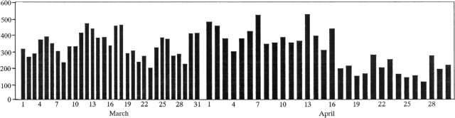 |
Figure 26. Number of low-frequency earthquakes recorded at Poás, March-April 1990. March data courtesy of J. Barquero; April data courtesy of G. Soto. |
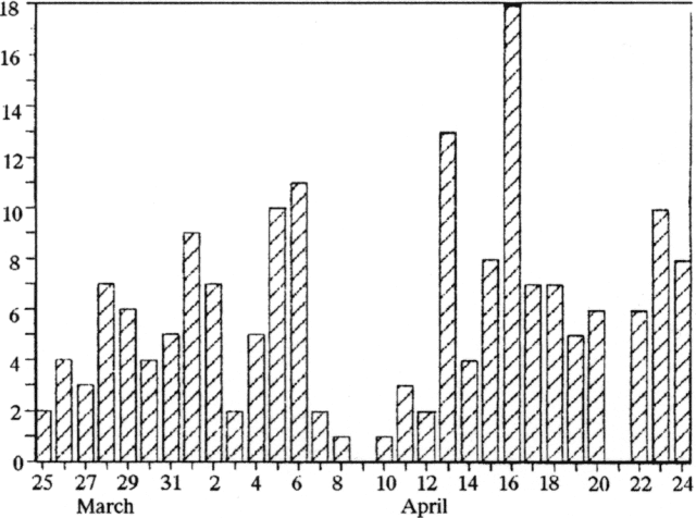 |
Figure 27. Number of A-type earthquakes recorded at Poás, 25 March-24 April 1990. Courtesy of G. Soto. |
Hazel Rymer noted that the March 1990 crater lake was comparable to the lake in April 1989, having apparently evaporated to a low level more rapidly during the 1990 dry season. The base of the mud volcanoes, <1 m above lake level, was 2,282.650 m above sea level on 18 March 1989, while the 30 March 1990 lake level was at 2,278.853 m (elevations tied to a flank benchmark). The location of the hot sulfur lakes, observed last year prior to the ash eruption, was occupied by a vigorous vent, continuously jetting a mixture of sulfurous gases. In early April 1990, boiling mud pools occupied the remainder of the former lake area.
April activity. By the beginning of April, lake level had dropped 4 m since December 1989, shrinking to a small pool in the center of the former lake, where minor phreatic eruptions occurred. Numerous fissures continually emitted gases; at some sites, combustion of sulfur produced flames. By the 18th, the lake's cumulative descent had reached 7 m and it was nearly dry, leaving areas of mud with occasional bubbling caused by the discharge of fumaroles in the bottom of the crater. In addition to activity on the SE part of the crater floor, decsribed in detail below, hot fumaroles were also found in the NE part of the former lake bed (figure 28). The principal fumarole in this area had a vent 2-3 m in diameter. Sprays of very pure yellow sulfur were emitted, as were bluish SO2 and water vapor. The gases were expelled under high pressure with a jet aircraft sound, and burned with yellow-orange flames. At the beginning of the month, temperature (190°C with an infrared thermometer), sound level, and pressure were less than on the 18th, when activity was stronger with temperatures to 793°C. Since 17 April, the vigorous discharge has caused vibrations felt inside the crater and registered by the summit seismic station (VPS-2). The fumarole ejected evaporitic sediments to 75 m height, and similar activity continued through the end of the month. On the 1953-55 dome, fumaroles emitted gas dominated by water, and precipitated sulfur and sulfates. Maximum fumarole temperature (measured by thermocouple) was 90.3°C.
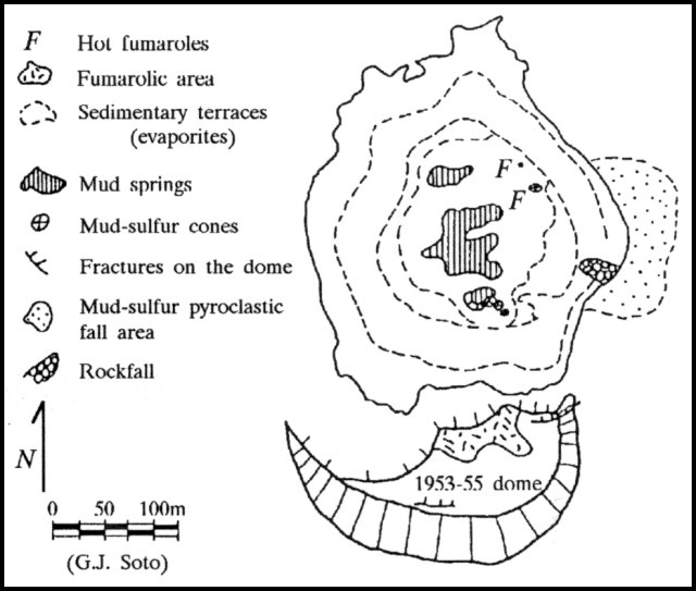 |
Figure 28. Sketch map of the active crater at Poás, 18 April 1990. Courtesy of G. Soto. |
Gases, carrying sediments because of the dryer lake bottom, were carried mainly W and SW, affecting coffee farms, pastures, and especially forests. The inhabitants of various towns, including San Luis (about 13 km SSE of the summit), Cajón, and San Miguel de Grecia (~11 km SW of the summit), suffered health problems, principally with the respiratory tract, vision, and skin allergies. From the night of 26 April through the following day, a wind change concentrated gases strongly in the Parque Nacional del Poás area and toward the SE flank, affecting strawberry crops.
Seismic activity changed substantially from the previous month. Recorded events dropped from 9,460 in March to 9,190 in April. Of these, 9,026 were of low frequency and 159 were volcano-tectonic or A-type. The latter averaged 5/day, a substantial increase. Volcanic tremor also occurred during April, manifested as prolonged vibration of the edifice caused by gases emerging from fumaroles at high pressure.
12 April fieldwork. G. Soto and Clive Oppenheimer climbed into the crater on 12 April at about noon. Bubbling mud pools occupied positions very similar to those of sulfur ponds seen on the SE part of the crater floor in April 1989. Nearly continuous geysering of mud and clumps of solid sulfur was depositing a ring around one of the mud pools. Columns of material ejected in the SE part of the crater reached 10-15 m height, and temperatures measured by an infrared thermometer were between 70 and 100°C. A vent at the NE fumarole site produced a gentle roar and a blue-tinged turbulent plume of gases with pink-orange flames, just visible in daylight, at its base. The plume intermittently stopped burning, turned a thick bright yellow color for a few minutes, then re-ignited and returned to its previous color.
By 0900 the next day, a small dull-yellow sulfur cone had grown at the site of the previous day's geyser-like eruptions. The cone was 2.2 m high with a basal diameter of about 6 m and a crater 2 m across. Small bursts of coagulated, rather plastic sulfur mixed with some silicate occurred at about 1-second intervals, sending ejecta to about 3 m above the rim. A warm, white, acid, vapor cloud was continuously emitted from the crater. The maximum temperature measured by a thermocouple pushed into the substrate at the summit was 97.6°C; when thrown over the rim, the highest measured temperature was 96°C. The crater was filled to within about 0.75 m of the rim with various-sized pellets of somewhat malleable sulfur mixed with silicate, appearing fluidized from agitation in the upward gas stream. Some of the crudely spherical pellets, collected from the sides and base of the cone, were up to 4 cm in diameter. In cross section, they revealed accretionary shells of aggregated sulfur crystals and minor clay alternating with gray clay-rich layers. Shortly before 1130, the vent appeared to become more confined, and the crater was quickly filled by a growing sub-cone. Within minutes, it grew above the old crater rim, forming a perfect cone 3.5-4 m high. A constant spray of sulfur up to 10 m high issued from a narrow vent at the cone's apex for about 30 minutes, dispersing a fine layer to about 15 m downwind. The conduit was often momentarily blocked before being cleared by a slightly stronger gas burst. The continuous ejection of material also built other cones, a few meters high and rich in pyroclastic sulfur, which periodically collapsed and recycled their contents.
29 April fieldwork. When geologists returned to the volcano on 29 April at about 1245, a convecting grayish-white plume, combined from numerous individual vents, was rising to more than 300 m, accompanied by a continuous roar, like a distant jet aircraft, from the center of the crater floor. Moist drops of acid mud fell from the plume, and appeared to form a thin veneer on the inner crater. Three recent cones, presumably of sulfur, on the SE part of the crater floor were also coated with mud and only weakly fuming, with bright yellow sulfur deposited around their conduits. One was irregularly erupting yellowish sulfur. To the NW, small gas eruptions ejected dark clouds of lake sediment, forming a line or cluster of several wide cones. Fumarolic vents varied in color from bright yellow, to different shades of gray, to white. Some had a pronounced tinge of bluish haze. The NE vent, which had been burning on 12 April, was considerably quieter, but a nearby vent was producing a strong plume with pink-orange flames clearly visible at its base. The plume changed color to yellow when combustion ceased; re-ignition was accompanied by a roaring sound. Bright flames also licked the steep inner walls and rim of the remnants of a small cone nearby. A peak thermocouple temperature of 662°C was recorded with the probe in the flames. The origin of the cone was uncertain, although samples of pink-gray ash were collected nearby. At about 1445, a brief, more powerful eruption occurred from the center of the former lake floor. The plume, presumably of non-juvenile material (lake sediments) rose roughly 50 m and produced a hail of blocks that fell noisily to the muddy crater floor.
The next day at 0700, nearly constant eruptions of gas, yellow-tinged apparently dry ash, and blocks, continued from several vents around the center of the crater. Some fresh sulfur had been erupted over one of the old sulfur cones at the SE site. The activity was similar to that observed in the same region in April 1989. At roughly hourly intervals, considerably more powerful activity ejected thick cauliflowering columns of dark ash, accompanied by blocks trailing white vapor above the level of the 1953-55 dome. The episodes lasted 30-50 seconds. There was no evidence that the ash was juvenile, although no samples were obtained. Two gas eruptions were observed at previously inactive sites. The first, at about 0800, occurred very near one of the active phreatic cones. Gas bubbles burst noisily through mud, hurling expanding shells of mud spatter. A similar but much briefer episode occurred 40 m away at about 0810, near the first set of lake sediment terraces. It left a crudely horseshoe-shaped scar in the mud, and a gray fluidized mudflow moved toward the center of the crater. Another strong eruption was seen at 0944, shortly before geologists left the crater, producing a plume that rose to an estimated height of 100 m.
Gravity data. The following is from Hazel Rymer. "Five years of continuous gravity increases at crater-bottom stations, from March 1985 to March 1989, have been recorded by Open University geophysicists. Since 1987, we have also had good elevation control at these stations and have recorded minor deflation. The maximum changes, >200 microGal increases at stations on the 1953 dome, were accompanied by 30 cm deflation (March 1987-March 1989). Gravity variations were similar elsewhere on the crater floor, but elevation changes were less than 6 cm. These data are interpreted in terms of small dendritic magma intrusions and loss of magmatic gas from beneath the lake area (Rymer and Brown, 1987). Evidence to support this model comes from detailed analysis of the energy budget of the crater lake. While gravity increased gradually from 1985 to 1989, the power output through the lake area jumped in 1986 from a fairly steady 190 MW to about 300 MW, maintained to the present. Thus, steady gravity increase was associated with a sustained power output since the stepped increase in 1986.
"Microgravity and elevation data collected by Open Univ geophysicists and Earthwatch volunteers between 19 and 30 March 1990 revealed gravity decreases of about 50 microGal at crater bottom stations with elevations unchanged from 1989 to within 2 cm."
Reference. Rymer, H. and Brown, G., 1987, Gravity changes as a precursor to volcanic eruption of Poás volcano: Nature, v. 342, p. 902-905.
Information Contacts: J. Barquero, E. Fernández, and V. Barboza, OVSICORI; Hazel Rymer and C.M.M. Oppenheimer, Open Univ; G. Soto and R. Barquero, ICE; Mario Fernández, UCR.
Strong gas emissions but phreatic activity decreases; small lake and mud/sulfur cones in crater
May activity was less intense than in April, but similar to that of previous months. Strong gas emissions occurred from fumaroles in the crater and there were at least two mud eruptions that reached heights of several hundred meters, one at roughly 0800 on 4 May, the other on 8 May. ... The crater lake had shrunk substantially, to a small feature, several centimeters deep, that fluctuated slightly with changes in rainfall recharge. Lake temperatures were >72°C (measured by infrared thermometer) and small hot springs around the lake had temperatures of 85°C. Small cold springs from the E wall of the crater had pH values of 1.5. Fumaroles on the 1953-55 dome emitted gas (91 ± 1°C), primarily water vapor, and precipitated sulfur.
The most vigorous fumaroles were in the NE, SE, and NW parts of the crater (figures 29 and 30). The latter formed a NNE-SSW line of mud/sulfur cones that grew during the climax of activity at the end of April. In mid-May, the southernmost fumarole had a diameter of 5 m and the emitted gases were burning (the exothermic reactions required temperatures much greater than 230°C). On 30 May flames were not visible, but there was intense intermittent fumarolic activity at this and other vents.
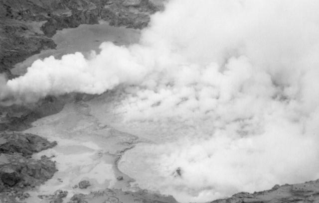 |
Figure 29. View of the active crater at Poás on 23 May 1990, looking roughly N from the 1953-55 dome. Courtesy of Rafael Barquero. |
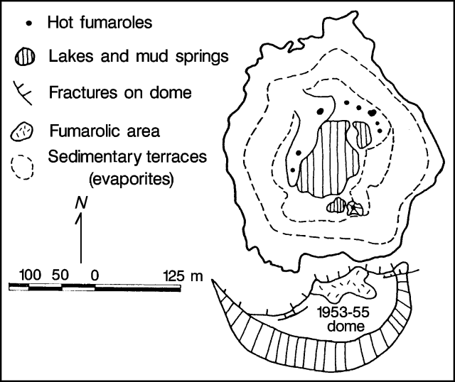 |
Figure 30. Sketch map by G. Soto of the active crater at Poás, 30 May 1990. |
In the SE part of the lake there were collapsed cones with peripheral boiling mud springs and fumaroles (temperatures at 90-100°C) precipitating sulfur. On 16 May a squat, subconical structure with multiple fumaroles was noted (115°C), but no longer existed 2 days later, having been reclaimed by the boiling mud springs in the lake. The greatest activity occurred in the NE part of the lake. Mud/sulfur cones were periodically constructed and destroyed in the middle of a group of fumaroles and boiling springs. Emissions were rich in sprays of elemental sulfur or sulfur-colored oxides as well as water vapor. In mid-May, several of the NE cones ejected elongate blebs of mud to 20 m height, but this behavior was not observed at the end of the month. At least one of the NE fumaroles emitted gases at high pressure, making a jet aircraft sound. On 30 May, the most active fumarole was located against the sedimentary terrace and had a diameter of 2 m.
Park guards reported the occurrence of eye and respiratory irritation during changes in wind direction that caused acid volcanic gases to blow S towards the tourist center and overlook. Guards have recommended that tourists spend only short periods of time at the overlook and in the park during these periods. During extreme conditions guards have evacuated the site. Continued degassing at the volcano had a major impact on vegetation on the W and SW flanks, and on the health and the living conditions of local residents. The Costa Rican goverment declared a local state of emergency.
No unusual seismic activity occurred in May. The Univ Nacional reported that the number of low-frequency (B-type) events averaged 325 daily, similar to March (337/day) and April (301/day). There continued to be very few high-frequency (A-type) events, averaging 3 daily with magnitudes
 |
Figure 31. Number of A-type earthquakes recorded at Poás by the Univ Nacional, May 1990. |
Information Contacts: R. Barquero and G. Soto, ICE; Mario Fernandez and Hector Flores, UCR; E. Fernández, J. Barquero, and V. Barboza, OVSICORI.
Vigorous fumarolic activity but no phreatic explosions; seismicity decreases
Activity at Poás remained low during June, with small explosions and ejections of mud from individual fumaroles but none of the mud eruptions observed in prior months. The small lake at the center of the crater was composed of boiling mud pots fed by subsurface fumarolic activity. There were only minor fluctuations in lake level. Sulfur was precipitated throughout the crater, forming a surface layer on the lake, and was observed to form a floating mat of sediment in early June. Around the periphery of the lake were 3 centers of fumarolic activity, to the NE, NW, and SE (figure 32). The SE group was characterized by boiling mud springs, fumaroles, mud/sulfur cones, and yellow to pale green sulfur flows. One of the NE fumaroles emitted yellow gases (predominantly native sulfur, water vapor, and other sulfur species) at high pressure, producing a jet engine noise. Flames were occasionally seen emerging from the fumarole. Small, occasionally audible, explosions from the NW fumaroles ejected blebs of mud and sulfur, and small blocks to 20 m height. Fumaroles on the N part of the 1953-55 dome had maximum temperatures of 91.5°C. The gas cloud principally traveled W and SW, and continued to cause intense acid rain on the flanks of the volcano.
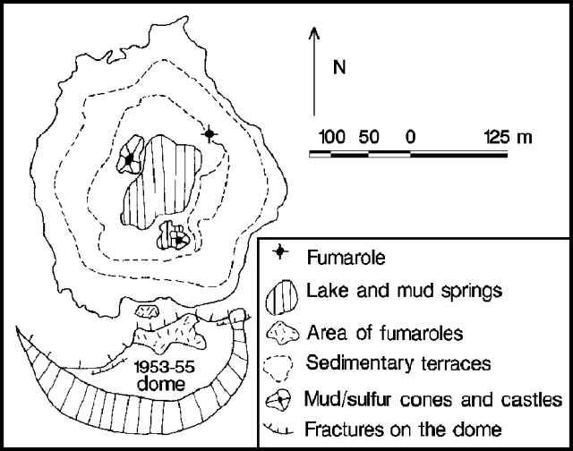 |
Figure 32. Sketch map by G. Soto of the active crater at Poás, 21 June 1990. |
The Univ de Costa Rica recorded an average of 192 low-frequency (B-type) earthquakes/day and a total of four high-frequency (A-type) earthquakes during the first 12 days of June. These were lower levels than previous months (337 B-type earthquakes/day in March, 301/day in April, and 325/day in May; there were 3 A-type earthquakes/day in May).
Information Contacts: G. Soto, ICE; Mario Fernández and Hector Flores, UCR.
Continued strong fumarolic activity but no phreatic explosions
Strong fumarolic activity continued essentially unchanged during July, but no phreatic explosions were reported. The crater lake, rich in bubbling mud and covered with a fine sulfur scum to the S, remained at low levels. It was fed by hot (44-93°C), bubbling springs and had a measured temperature of 88.7°C. Cold springs located at the base of the crater walls had temperatures of 20-25°C.
The three groups of fumaroles within the crater noted in recent months remained active. The fumaroles NE of the lake emitted gas rich in sulfur and produced little noise. To the NW and SE there were fumaroles, small mud/sulfur domes, and sulfur pools. The more energetic sulfur pools in the SE group ejected concentric pellets (up to 5 cm in diameter) that built sulfur cones, and produced small flows of sulfur-rich mud. The fumaroles N of the 1953-55 dome had temperatures of 81.8-88.6°C and fumaroles on the dome had temperatures of up to 91.5°C.
On 19 July there was a group of 14 small-moderate earthquakes (seven between M 2.3 and 3.6) centered 4-8 km SW of Poás. The majority occurred during a 1-hour period between 1750 and 1850. The earthquakes were believed to be related to a local fault.
Although guards did not evacuate the park on 4 and 8 May (as [originally] stated in 15:05), in recent months they have occasionally recommended that tourists leave when wind changes caused the highly acidic plume to blow in the direction of the overlook and tourist center.
Information Contacts: G. Soto and R. Barquero, ICE; H. Flores, UCR; J. Barquero, OVSICORI; José Manuel Cartín, Director, Parque Nacional Volcán Poás, Costa Rica.
Continued fumarolic activity
Fumarolic activity continued within the small crater lake, concentrated at the three fumarole groups (to the SE, NE, and NW). Extensive sulfur exhalation and precipitation continued. The strongest activity was noted in the NW group of fumaroles, which formed an E-W-trending line. One of the fumaroles produced emissions of primarily SO2 gas, while others produced a jet aircraft sound, and two had orange flames. Temperatures of fumaroles on the top of the 1953-55 dome, S of the crater lake, were stable at <92.5°C.
Information Contacts: G. Soto, ICE.
Crater lake dries up; fumarolic activity and acid rain damage continue
Strong fumarolic activity continued at the base of the crater. During August, the level of the crater lake continued to drop despite heavy rainfall. By 13 September the lake was almost dry, with the exception of small puddles of bubbling mud. The lake temperature remained near 85°C in August and September. At least 30 fumarolic vents were visible, emitting steam, sulfur spray, and SO2; several emitted flames, and others produced a jet engine sound. A pool of boiling mud (137°C in August) remained in the SE part of the lake. Intense rainfall on 13-14 September caused a temporary recharge of the crater lake and the destruction of some small mud/sulfur cones. Subsequent heavy evaporation produced white steam columns that were seen as far away as San José (30 km SSW). During September, small slumps were observed on the E wall of the inner crater, in the vicinity of a large number of cold, acid springs. Fumaroles on the top of the 1953-55 dome had temperatures of up to 93.9°C.
Acid rain continued on the SW flank, damaging crops and causing health problems. During a change in wind direction to the S and SE on 27 August, discomfort and strong sulfur odors were reported to 30 km from the crater. The ambient pH was 4.2 at the crater overlook and 4.75 at Cerro Pelón (2 km SW of the crater).
Seismicity at Poás was dominated by low-frequency earthquakes. The Univ Nacional recorded [daily averages of] 260 low-frequency earthquakes in June, 299 in July, and 222 in August (figure 33). A total of 185 high-frequency earthquakes, with magnitudes oscillating from 1.7 to 2.9 and depths <8 km, were recorded in August. On 19 July a swarm of 15 high-frequency earthquakes occurred. The events had magnitudes ranging from 2.3 to 2.9 (some felt by local residents) and were centered 5-8 km from the crater at depths of 4.6-7.3 km. Medium- and high-frequency tremor increased in August, with episodes of continuous tremor up to 48 hours long.
 |
Figure 33. Number of low-frequency (top) and high-frequency (bottom) earthquakes recorded at Poás by the Universidad Nacional, June-August 1990. |
Information Contacts: G. Soto and R. Barquero, ICE; J. Barquero, E. Fernández, and V. Barboza, OVSICORI.
Fumarolic activity and seismicity continue; minor inflation
Vigorous fumarolic activity continued during October. The crater lake level, which had been dropping during August and September, rose 2 m due to heavy rainfall, but began to fall again at the end of the month. Fumarolic activity within the lake remained similar to previous months; in the SE part of the lake, a small pool of sulfur remained visible. Temperatures of up to 80°C were recorded in the crater lake, 17°C in the peripheral cold water springs, and 91°C from the 1953-55 dome fumaroles. On 13 September, rain water had a pH of 2.7 at the dome and 3.2 at the crater rim.
Daily averages of 250 low-frequency earthquakes (<2.5 Hz) were recorded, similar to levels in May. A maximum of 373 events was recorded 28 October (figure 34). High-frequency earthquakes were rare. Only three were locatable (M 2.2-2.6), the largest felt by local residents. Short tremor episodes (<6 hour durations), less frequent than in August and September, were also occasionally recorded.
 |
Figure 34. Number of earthquakes/day recorded at Poás by the Univ Nacional, October 1990. |
Periodic S radial inflation was measured in 1990 through early November (figure 35); the general trend was one of minor inflation relative to the 1989 baseline. Inflation in April-May coincided with eruptions of sediment from the bottom of the lake. Deformation measurements by EDM (1 km S of the crater) registered several different inflationary peaks that geologists believed were influenced by local disturbances such as subsoil water or changes in temperature.
 |
Figure 35. Dry tilt (top) and electronic tilt (bottom) measurements at Poás, January-October 1990. Courtesy of the Univ Nacional. |
Information Contacts: J. Barquero, V. Barboza, E. Fernández, and R. van der Laat, OVSICORI; G. Soto and R. Barquero, ICE.
Continued fumarolic activity
Fumarolic activity continued during November, with the greatest activity concentrated in the SE and N parts of the yellow-green crater lake. Fumaroles created mud pots, and small sprays of mud and sulfur constructed cones within the lake. The temperature of the lake oscillated between 61 and 85°C (maximum 80°C in October), and lake level was relatively high due to heavy rainfall. Hot springs at the periphery of the lake had temperatures of 40°C, cold springs at the edge of the crater were 16°C, and fumaroles on the 1953-55 dome were 90°C.
Information Contacts: G. Soto and R. Barquero, ICE.
Decreased fumarolic activity as lake water covers vents; sesimicity increases
Crater lake level rose through mid-December (from rainfall), covering many fumaroles and hiding their degassing. By 4 January, however, the lake had dropped 70 cm from its high point on 19 December. Degassing, with bubbling mud and sulfur, was again visible at the SE fumarole zone within the lake. The approximate diameter of the lake was 150 m, and the color changed from yellowish green to sky blue, with yellow areas of floating sulfur scum. Temperatures of 67.6°C (2 December), 64°C (19 December), and 64.7°C (4 January) were measured from the E and SE lake shores (separate measurements by Univ Nacional scientists yielded an average lake temperature of 68°C during December and January). Springs had temperatures of 16°C and 20-22°C at the E and SE base of the inner crater walls, respectively. The dome fumaroles had a temperature of 91°C.
The atmospheric plume produced by fumarolic activity was reduced from those of previous months, reflecting decreases in fumarolic activity on the dome and in the crater lake. The effects of acid rain had diminished and some regrowth of vegetation had occurred. A pH of 5.5 was measured on a water sample collected adjacent to the crater.
During December, 2,000 low-frequency earthquakes were recorded. Seismicity increased during January, with 5,294 events recorded by the 29th.
Information Contacts: G. Soto and R. Barquero, ICE; Mario Fernández and Wilfredo Rojas, UCR; J. Barquero and E. Fernández, OVSICORI.
Phreatic eruptions resume from lake floor; frequent earthquakes and tremor
On 6 March, phreatic eruptions of mud and water, last reported 8 May 1990, resumed. The ejections reached an average height of 10 m and appeared to be a nearly continuous fountain of material when observed 11 March. Crater lake level continued to drop during February (the maximum lake depth was estimated to be 3 m on 13 February). The average lake water temperature was 70°C, similar to values from December and January. Mud pots and fumaroles were visible on the edges and within the lake, the strongest producing "jet engine" sounds. Dome fumarole temperatures of 40-90°C were measured.
SO2 fluxes averaging 90 ± 30 (1 ) t/d, with a range of 50-160 t/d, were measured by COSPEC on 13 February. These values are similar to SO2 fluxes measured in late 1982. Residents on the SW and S flanks of the volcano reported sulfur odors.
ICE recorded 4353 microearthquakes 1-26 February (an average of 162 events/day; figure 36). Univ Nacional recorded a daily average of 246 earthquakes in February, most with low frequencies (1.5-2.5 Hz). The daily total increased to an average of 323 events during the first 7 days of March. The month's largest local earthquake (M 2.1) occurred on 11 February, 3.4 km E of the crater, at a depth of 18.4 km. A total of 29 hours of low-frequency tremor (the most since October 1990) was recorded in February.
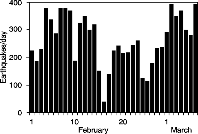 |
Figure 36. Daily number of earthquakes at Poás, 1 February-7 March 1991. Courtesy of Rafael Barquero and Mario Fernández. |
Further Reference. Andres, R.J., Barquero, J., and Rose, W.I., 1992, New measurements of SO2 flux at Poás volcano, Costa Rica: Journal of Volcanology and Geothermal Research, v. 49, p. 175-177.
Information Contacts: J. Barquero, OVSICORI; R. Barquero, ICE; M. Fernández, UCR; R.J. Andres and K. Kogler, Michigan Technological Univ, USA.
Crater lake dries up again; increase in seismicity and rainwater acidity
Vigorous, sulfur-rich thermal activity, punctuated by occasional phreatic explosions, has continued for many years at Poás. Its crater lake has been shrinking since early 1987, with only small remnants remaining at the ends of the 1989 and 1990 dry seasons.
Gas emission continued from various points on the crater floor in March. The lake had completely dried up, and part of the lake bottom subsided, producing a morphology of tilted blocks with fissures and craters emitting large quantities of gas. Some of the fumaroles had burning sulfur and others ejected small amounts of sediments, depositing them on the W crater wall. The gas plume was carried W and SW of the volcano, where residents reported a sulfurous odor. Measurements of rainwater pH, 2.5 km SW of the crater (Cerro Pelón), showed a decrease from 4.65 in February to 3.25 in March.
Seismicity increased in March to a daily average of 272 low-frequency earthquakes and a monthly total of 25 high-frequency earthquakes. The highest levels of seismicity occurred on 29-31 March, when up to 400 earthquakes were recorded/day.
Information Contacts: E. Fernández, J. Barquero, and V. Barboza, OVSICORI.
Increased gas emission; continued seismicity
Gas emission increased in April. Fumaroles burned sulfur, produced loud jet-engine noises, and ejected small amounts of gray sediment that covered the W base of the crater. Acid rain continued to be a problem on the W flank of the volcano; rainwater pH was 3.4 at Cerro Pelón (2.5 km SW).
Seismicity levels in April were similar to March, with an average of 266 low-frequency earthquakes recorded/day (average frequency 2.2 Hz) and a monthly total of 26 high-frequency events (figure 37). Low-frequency tremor was recorded up to 22 hours/day on 20-21 April.
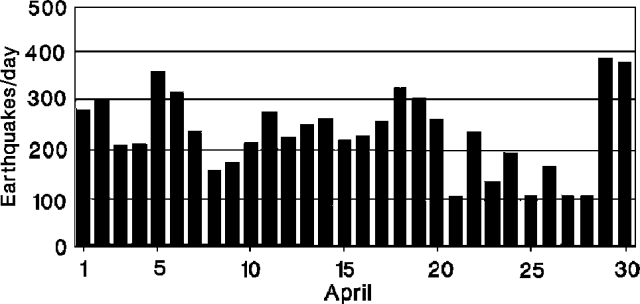 |
Figure 37. Daily number of recorded earthquakes at Poás, April 1991. Courtesy of OVSICORI. |
Information Contacts: E. Fernández, V. Barboza, and J. Barquero, OVSICORI.
Strong gas emission; rain adds water to nearly dry crater lake
Strong sulfur-gas emission continued from crater fumaroles in May. The crater lake, nearly dry since March, began to refill during the third week of May because of increased rainfall. Small pools coalesced to cover the entire crater floor, and warm mud was frequently ejected to several meters height from the center of the lake. The largest fumarole was in the crater's N sector, and other smaller ones were in the W and SE. Microseismicity decreased at the end of May and the volcano was considered by geologists to have returned to normal rainy season conditions. A new network of five digital seismometers was installed near the volcano by a joint RSN-French group.
Information Contacts: R. Barquero, ICE.
Continued gas emission; harmonic tremor
Gas emission continued from crater fumaroles (60-95°C) in June. The crater lake temperature was 73°C, similar to December-February values, while lake depth increased to 3 m, coinciding with heavy rainfall. Medium-frequency (2.5 Hz) harmonic tremor was recorded 6-17 June, occurring up to 24 hours/day (figure 38). Seismicity was dominantly low-frequency.
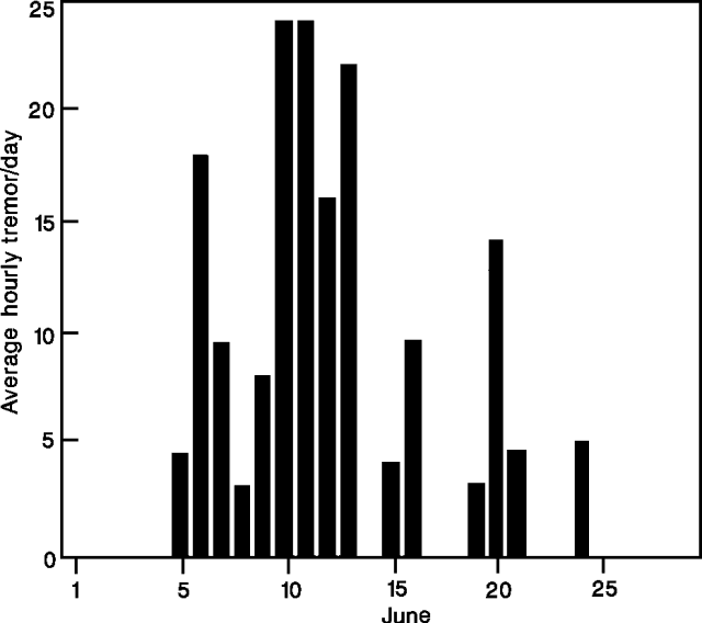 |
Figure 38. Hours/day of tremor recorded at Poás by the Univ Nacional, June 1991. |
Information Contacts: J. Barquero, E. Fernández, V. Barboza, R. Van der Laat, and E. Malavassi, OVSICORI; R. Barquero, G. Alvarado, M. Fernández, H. Flores, and S. Paniagua, ICE.
Continued degassing; seismicity
An average of 239 microearthquakes, with a maximum of 485 (3 July), were recorded daily in July (figure 39), at a station 2 km SW of the crater. Of these, 29 were identified as A- and B-type earthquakes. Seismic frequencies ranged from 1.4 to 2.6 Hz. A total of 41 hours of continuous and discrete semi-harmonic tremor episodes were recorded, with durations of up to 6 hours.
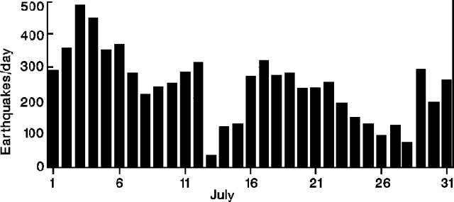 |
Figure 39. Daily number of earthquakes at Poás, July 1991. Courtesy of the Univ Nacional. |
The crater lake's average temperature was 63°C. Fumaroles were covered as the lake level continued to rise. Area residents sporadically reported a sulfurous odor.
Information Contacts: J. Barquero, E. Fernández, V. Barboza, and J. Brenes, OVSICORI.
Crater lake rises, covering fumaroles; low-frequency seismicity
In August, the crater lake grew to cover all crater fumaroles, while fumarolic activity continued at levels considered "normal" for the volcano. The yearly total of recorded microearthquakes (almost all of low frequency) exceeded 32,500 by the end of the month (figure 40), a decrease from 1990.
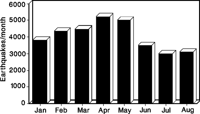 |
Figure 40. Monthly number of earthquakes at Poás, January-August 1991. Courtesy of ICE. |
Information Contacts: R. Barquero and G. Soto, ICE; M. Fernández, H. Flores, and S. Paniagua, UCR.
Small explosions and gas emission from crater lake; continued seismicity
The level of crater lake water, bright yellow and 71°C, decreased in September, despite continuation of the rainy season. Phreatic explosions in the central part of the lake ejected water to a height of 2 m. Steam and gas rose nearly continuously, creating small plumes that were carried W and SW by wind. A strong sulfur smell and respiratory difficulties were reported by park rangers on 22-23 September. The gas plume rose vertically during calm conditions the morning of 23 September, and was visible >10 km away from the Central Valley.
A daily average of 262 low-frequency (<2.5 Hz) earthquakes was recorded in September, with the highest levels of activity on the 21st-22nd. Low- and medium-frequency tremor episodes were recorded, with maximum durations of 2 hours.
Information Contacts: J. Barquero, E. Fernández, V. Barboza, and J. Brenes, OVSICORI.
Continued fumarolic activity; lake level drops
Fumarolic activity in the yellowish-green crater lake continued through October, and mats of sulfur were observed floating on the water's surface. In September, strong bubbling was observed in the N- and NW-central parts of the lake, which was at 76.3°C with a pH <0.5. Lake measurements on 16 October indicated that the lake level had fallen 15 cm since 18 September, despite continued rains; water temperature was 74.4°C. Fumaroles on the 1953-55 dome ranged to 90.6°C in September and 88.4°C in October.
Information Contacts: R. Barquero and G. Soto, ICE.
Phreatic explosions end; sulfur emission from crater lake
The crater lake remained quiet in November. The water level rose 1.2 m relative to October, and had a temperature of 70°C. Evaporation at the lake surface remained strong and clots of sulfur dotted the turquoise-green water. Small columns of gas were carried W and SW. Fumaroles on the 1953-55 dome had temperatures of 90°C.
Information Contacts: E. Fernández and J. Barquero, OVSICORI.
Gas emission from crater lake
The water level of the sky blue to green crater lake increased at least 3 m in November-December, before dropping 1.2 m in January. Intermittent streams that fed the lake in December were no longer visible in January, and a layer of yellow sediments was exposed by the lake's retreat. Large gas clouds rose from the crater lake and were carried SW-W. Phreatic explosions, last seen in [September 1991], were not observed in December or January. The temperature of the lake remained fairly constant (around 70°C; ICE), although some measurements suggested a slight increase from December to January (64 to 67°C; OVSICORI), and the pH was <0.01 (ICE). Dome fumaroles had temperatures of up to 87°C in January, similar to November (90°C).
A total of 4,343 low-frequency earthquakes were recorded in January, with a daily average of 197 (down from 262/day in September when there were sporadic phreatic explosions). No high-frequency events or tremor episodes were recorded.
Information Contacts: E. Fernández, V. Barboza, and J. Barquero, OVSICORI; G. Soto and R. Barquero, ICE.
Continued gas emission and small phreatic eruptions from crater lake
Gas emission continued in February and occasional small phreatic eruptions were observed. The level of the crater lake decreased for the second consecutive month, and water temperature was 67°C, similar to January. A total of 5,027 low-frequency earthquakes was recorded in February (at station POA3, 2.5 km SW of the crater), with a daily average of 219. No tremor or high-frequency earthquakes were recorded. Long-base dry-tilt measurements 1 km S of the crater on 26 February showed changes of <5 µrad, similar to measurements in 1991.
Information Contacts: E. Fernández, J. Barquero, V. Barboza, and R. Van der Laat, OVSICORI.
Small phreatic eruptions; acid rain and mist cause damage on flanks; continued seismicity
Small phreatic explosions, observed in the crater lake in February, were concentrated in March at mud pots exposed by the continued decline in lake water level. Lake temperature measurements oscillated between 65 and 75°C. Gas emission continued, producing plumes that rose to >1 km and extended W and SW. Residents on the W and SW flanks reported that acid rain and mist affected vision, caused skin rashes, and damaged agricultural areas. On average, 237 earthquakes were recorded daily in March (at station POA2, 2.7 km SW of the crater), with a maximum of 398 on 4 March. A M 2.5 earthquake was recorded at 0652 on 3 March, centered 3.5 W of the crater at 7 km depth.
Information Contacts: E. Fernández, J. Barquero, and V. Barboza, OVSICORI.
Stronger gas emission; crater lake level falls
The crater lake's water level dropped approximately 8 m between January and 7 April, revealing sediments (gypsum, amorphous silica, and sulfur) and numerous mud pots around its edges. The lake was emerald green, with a temperature of 77°C (7 April). Emissions from fumaroles in the lake increased in April, producing jet-engine sounds audible at the tourist overlook, and a 1-km-high plume. Fumaroles on the dome S of the lake had temperatures of <83.5°C. The increase in emissions was reflected in an increase in the effects of acid rain, which damaged trees in the national park, and coffee plantations, cypress trees, and pasture beyond the park boundaries. Residents on the W and SW flanks reported sulfur odors, and skin and eye irritation. A daily average of 250 low-frequency earthquakes was recorded in April (at the UNA station POA2, 2.7 km SW).
Information Contacts: E. Fernández, J. Barquero, and V. Barboza, OVSCIORI; G. Soto and R. Barquero, ICE.
Thermal activity in crater lake feeds 1-km plume; frequent earthquakes and occasional tremor
Fumarolic activity continued in the crater lake in May, producing a continuous 1-km-high plume. Residents of the S and SW flanks reported sulfur odors. A total of 7,085 low-frequency earthquakes was recorded in May (at station POA2, 2.7 km SW), with a daily average of 229, compared to 250/day in April. Medium-frequency tremor was recorded sporadically. Twelve volcano-tectonic earthquakes were recorded in May, with a M 2.5 event centered 7 km ESE of the crater, at 7.5 km depth, on 18 May.
Information Contacts: E. Fernández, J. Barquero, and V. Barboza, OVSICORI.
Vigorous gas emission in and around crater lake; continued seismicity
Water level in the crater lake had dropped at least 3 m since April, shrinking it substantially by early June (figure 41). Its color was lime green to sky blue, and the temperature in accessible areas reached 85.8°C. Numerous cones and miniature mud volcanoes were visible within the lake. The nine main fumaroles emitted water vapor with yellowish and bluish gases (sulfur and SO2). Bluish gases and orange flames, probably caused by combustion of sulfur, emerged from the northernmost fumarole. The fumaroles to the SE occurred among collapsed sulfur-and-mud cones, as in the past 3 years.
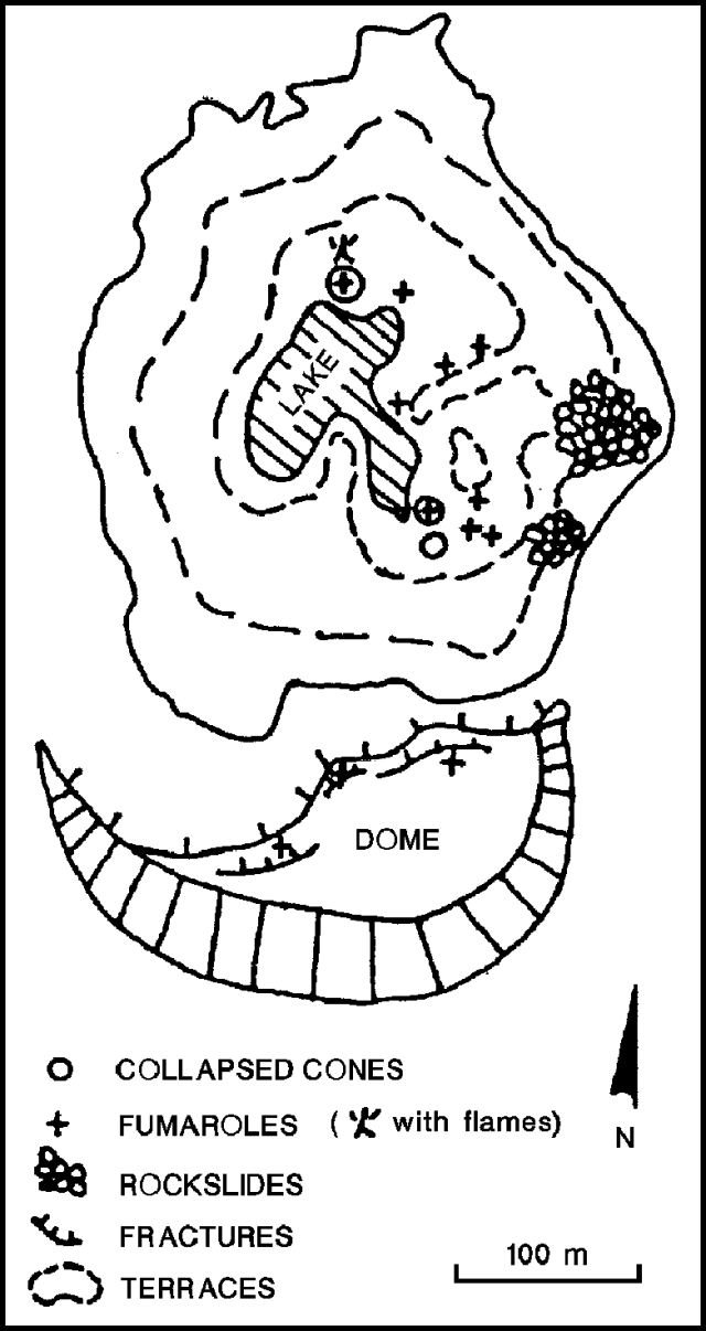 |
Figure 41. Sketch map of the crater at Poás, 10 June 1992. Courtesy of the Instituto Costarricense de Electricidad. |
As the rainy season began, fumaroles exposed by the shrinkage of the crater lake were covered by water. The resulting continuous phreatic activity produced plumes 1-2 m high. As the lake rose, it cooled to 64-73°C, with a pH of 1.1. Weak fumarolic activity continued on the 1953-55 dome, with a maximum measured temperature of 89°C and a condensate pH of 4.4.
A daily average of 200 low-frequency events and 24 A-B-type (medium-frequency) events were recorded 2.7 km SW of the summit (by station POA2) in June (figure 42). Highest seismicity was on 2 June.
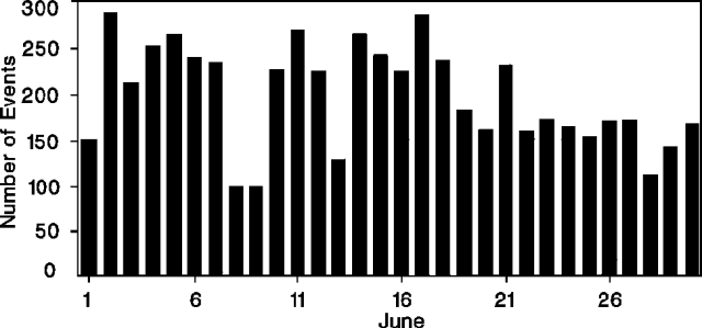 |
Figure 42. Daily number of seismic events recorded at a station (POA2) 2.7 km SW of the summit of Poás, June 1992. Courtesy of the Univ Nacional. |
Information Contacts: E. Fernández, J. Barquero, and V. Barboza, OVSCIORI; G. Soto, ICE; M. Fernández, UCR.
Fumarolic activity; frequent seismicity; crater lake fills
The crater lake continued to grow in July, covering some terraces on its SE side. Water temperature was 70°C and pH was 1.5. Fumarolic activity continued in the central and N parts of the crater. Sporadic bubbling occurred from some points in the SE and near the center of the crater. The seismic station (POA2) 2.7 km SW of the main crater registered an average of 170 low-frequency events per day in July, and a total of 18 medium- to high-frequency events classified as A-B because they had characteristics of both types. June values were slightly higher.
Information Contacts: E. Fernández, J. Barquero, and V. Barboza, OVSCIORI.
Vigorous thermal activity; crater lake rises
The level of the crater lake continued to rise, and was 1-2 m higher during 11 August fieldwork by Instituto Costarricense de Electricidad (ICE) geologists than it had been in June. Its color ranged from lime green to turquoise to sky-blue. Bubbling was observed in the central, N, and NE parts of the lake on 11 August, feeding columns <1 m high and generating waves. Boiling mud/sulfur springs on the SE side of the lake had temperatures of 95.3°C. The maximum measured lake temperature in August was 75°C; pH was 1.3. Fumaroles in the N part of the lake had temperatures of 95°C and a condensate pH of 1.8. Temperatures of fumaroles on the 1953-55 dome varied between 62 and 81°C.
UNA recorded an average of 163 low-frequency events/day, with a maximum of 289 on 31 August. At 1,242 that day, a M 2.2 earthquake occurred 8 km NE of the active crater at 16 km depth. Tremor at frequencies of 1-2.5 Hz occurred sporadically, for periods of 1-2 minutes.
Information Contacts: G. Soto and R. Barquero, ICE; E. Fernández, J. Barquero, and V. Barboza, OVSICORI.
Degassing continues in and around crater lake
The level of the crater lake was 30 cm lower in September than in August. Lake temperature dropped slightly to about 70°C, pH rose to 1.8, and its color remained green. Degassing continued from fumaroles in the N part of the crater. Active cones on the E side ejected sulfur. The maximum temperature measured at fumaroles on the 1953-55 dome was 80.5°C.
The total of 4,905 low-frequency events recorded by UNA was similar to August, with the daily average remaining at 163. An additional 37 medium- to high-frequency events were recorded, plus 5 hours of low-frequency tremor at irregular intervals.
Information Contacts: E. Fernández, J. Barquero, and V. Barboza, OVSICORI; G. Soto and R. Barquero, ICE.
Strong thermal activity in and around crater lake
The level of the crater lake remained unchanged in October. Lake temperature was 75°C, 5° warmer than in September, and pH was 1.4, about the same as in August. Columns produced by small phreatic eruptions from the center of the lake rose no more than 2 m. The terraces on the N side of the lake included at least five very active cones and fumarolic vents; others were found in the hot area on the SE side. Fumarolic activity N and NW of the lake was audible from the overlook. Residents of the S, SW, and W flanks reported a sulfur odor on some days.
Information Contacts: G. Soto and R. Barquero, ICE; E. Fernández, J. Barquero, and V. Barboza, OVSCIORI.
Strong thermal activity in and around crater lake
Summit rainfall caused variations in the level of the crater lake, which was lower in November and early December than in September and October, and below its level of the same time last year. Shrinkage of the lake exposed molten-sulfur deposits on its SE and N sides. Nearly continuous phreatic activity in the center of the lake sent material to 1-2 m height. The most active fumaroles were in an area of terraces N of the lake. Temperatures of the most accessible vents reached 129°C. Gas columns rose 500 m above the crater floor and were carried by the wind onto the W and SW flanks, where residents reported sulfur odors and scorched grasses. The lake temperature varied between 75 and 80°C in November, with a pH of 1.4. On 4 December, the lake color was yellow-green to sky-blue and its maximum measured temperature was 67°C. Fumarole temperatures on the 1953-55 dome did not exceed 85°C.
Information Contacts: G. Soto and R. Barquero, ICE; E. Fernández and J. Barquero, OVSCIORI.
Vigorous gas emission; rising crater lake covers terraces and fumaroles
The level of the turquoise-green crater lake rose, covering terraces of sulfur and mud on its SE, NE, and NW sides. Lake temperature was 70°C, and pH was 1.3. Fumaroles remained active on small islands in the lake, producing gas columns that rose 500 m above the crater floor and were carried W and SW by prevailing winds. Continuous noise from the fumaroles was audible from the overlook on the crater rim. Vents in the center of the lake that had produced small phreatic eruptions have disappeared. A light-gray terrace in the NW part of the lake generated sporadic phreatic activity that ejected material to 1-2 m height.
Information Contacts: E. Fernández and J. Barquero, OVSCIORI.
Gradual deflation; active fumaroles; fumarole gas analyses reported
Gas plumes rose to 500 m above the crater lake in January. Fumaroles remained active in the N and NW part of the crater. Noise from some fumaroles was audible from the overlook. Phreatic eruptions ejected material to 1-2 m above two sulfur terraces that had formed in the SE part of the lake. The lake's temperature was 65°C, its pH was 1.3, and its surface was 50 cm lower in January than in December.
The nearest dry-tilt station (1 km from the crater) has shown a general tendency toward slow deflation (6.4 µrad/year) since 1982. Measurements began on the distance-measuring network that covers the active crater in 1989. Minor expansion was detected in 1989 and in December 1990, but no significant changes have been evident since then.
On 19 November 1992, Marino Martini, Franco Prati, and Erick Fernández collected gas samples from a fumarole (table 4). An apparent equilibrium temperature of 368°C was calculated, similar to the 390°C obtained in 1989, suggesting a substantially constant rate of magmatic degassing with some fluctuations caused by rainwater.
Table 4. Analysis of gases collected at Poás and Irazú, November 1992. Percentages shown are for dry gas. Poás: 19 November 1992; sample included 88.46 volume % water; temperature 118°C. Irazú: 21 November 1992; sample included 89.54 volume % water; temperature 93°C. Courtesy of M. Martini.
| Gas | Irazú | Poás |
| CO2 | 98.91 | 42.40 |
| SO2 | -- | 34.16 |
| H2S | 0.80 | 11.62 |
| HCl | 0.37 | 11.27 |
| HF | 0.0064 | 0.26 |
| H2 | 0.87 | 0.26 |
| CO | 0.0001 | 0.0003 |
| N2 | 1.03 | 0.027 |
| B | 0.0041 | 0.0056 |
Information Contacts: E. Fernández, J. Barquero, R. Van der Laat, F. de Obadía, T. Marino, and R. Sáenz, OVSICORI; M. Martini, Univ di Firenze, Italy.
Fumarolic activity continues
Fumarolic activity continued in the N part of the crater lake with gas columns that rose 500 m. The most active fumaroles inside the crater were generally located on terraces near the N side of the lake and produced sounds like an airplane. There were six fewer hot mud and sulfur springs in the thermal area on the SE side of the lake. Phreatic eruptions from areas SE and N of the lake ejected material to 1 m height. Dome fumarole temperatures in February were 80-89°C. A fumarole on the N side of the lake had a temperature of 90°C, and the gas condensate had a pH of 1.7. The turquoise-green lake was more yellow near the shore because of sulfur deposition. Lake temperature was 70-75°C, and the pH ranged from near zero to 1.1 in February. The lake surface has decreased 50 cm since January.
Information Contacts: G. Soto and R. Barquero, ICE; E. Fernández and J. Barquero, OVSICORI.
Gas columns to 500 m; gradual deflation
Fumarolic activity in the N part of the crater lake continued as gas columns rose 500 m, one of them producing a jet-like noise that could be heard at the observation site, 1 km S of the active crater. The turquoise-green lake had a temperature of 67°C and contained floating patches of sulfur. Plumes to 1 m rose from sporadic phreatic eruptions in the central and SE portions of the lake.
During March, the seismic station 2.5 km SW of the main crater recorded 4,825 low-frequency events, an average of 156 events/day (figure 43). An earthquake of M 2.3, located 6 km SW of the main crater at 9 km depth, occurred on 25 March at 0813 GMT.
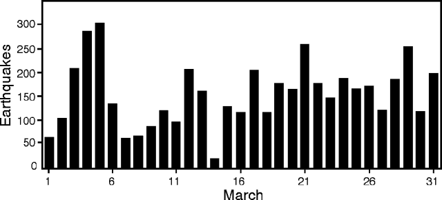 |
Figure 43. Seismic events/day recorded 2.5 km SW of the main crater of Poás, March 1993. Courtesy of OVSICORI. |
A precise level line running 1.8 km S down the main edifice from the observation site showed possible deflation since June 1992. Measurements at a dry-tilt site also indicated deflation. EDM measurements to the inner cone have not significantly changed since January 1991.
Information Contacts: E. Fernández, J. Barquero, V. Barboza, T. Marino, R. Van der Laat, F. de Obaldía, and R. Sáenz, OVSICORI.
Fumarolic activity continues; lake level drops
Fumarolic activity in the N part of the crater lake continued in April as gas columns rose to 500 m. One fumarole produced a jet-like sound, audible from an observation site 1 km S. Almost constant phreatic eruptions produced 1-2-m-high plumes in a light-green area near the center of the lake. The lake level dropped 1 m during April.
A seismograph located 2.7 km SW of the active crater recorded 4,115 low-frequency events (2-2.5 Hz) during April (figure 44). The highest daily total of the month was 319 on 5 April.
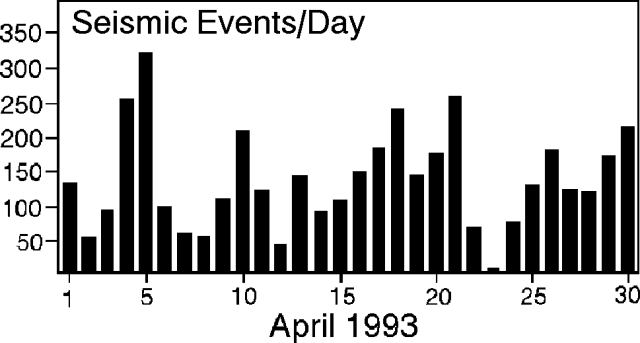 |
Figure 44. Seismic events/day recorded 2.7 km SW of the main crater of Poás, April 1993. Courtesy of OVSICORI. |
Information Contacts: E. Fernández, J. Barquero, V. Barboza, and W. Jimenez, OVSICORI.
Increased fumarolic activity; small phreatic events stopped by lake level rise
Fumarolic activity increased during the first half of May as gas columns rose 500 m above the crater rim. Sulfur odors were reported by residents S, SW, and W of the summit. In the first half of May, bubbling ponds of mud and water in the NE and SE parts of the hot lake had temperatures up to 91°C. The lake was yellow-green with a maximum temperature of 71.5°C. Phreatic eruptions to heights of 1-2 m occurred from the center of the lake in early May, but stopped when the lake level rose 1 m following the start of the rainy season. The rise in lake level covered the small bubbling mud puddles. The temperature of the turquoise-green lake was 63°C in late May. Fumarolic activity, with strong jet-like sounds, continued in the N and SE parts of the lake. The temperature of the dome fumaroles in May was 80°C, similar to that measured in February. Plants in the area continue to be affected by local acidity.
Deformation measurements 16 April to 17 May indicated very slow changes. Deflation was <8.3 µrad along two leveling lines radial to the crater (1-1.8 km S). Distances across the crater showed no significant changes. A seismic station 2.7 km SW of the main crater recorded 4,700 low-frequency events (<2.5 Hz) in May, an average of 152/day. Seismicity for the month peaked on 7 May and slowly declined to a low on 23 May (figure 45). There were 21 middle-frequency events (2.5-3 Hz) recorded, with the highest daily total on 10 May. Volcanic tremor recorded 19 and 23 May had frequencies of 1.3-2.0 Hz, with amplitudes of 2-5 mm.
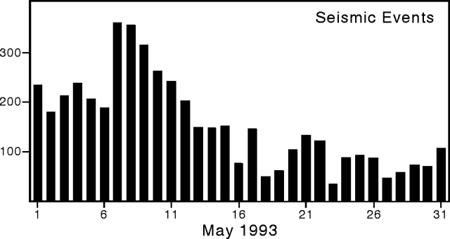 |
Figure 45. Daily low-frequency seismicity recorded 2.7 km SW of the main crater of Poás, May 1993. Courtesy of OVSICORI. |
Information Contacts: E. Fernández, J. Barquero, F. de Obaldía, T. Marino, R. Van Der Laat, V. Barboza, and R. Saenz, OVSICORI; G. Soto, ICE.
Fumarolic activity continues; phreatic eruptions resume
Fumarolic activity continued in the N and NW parts of the crater lake, with loud gas emissions sounding like a jet engine audible from an observation site 1 km S. Gas columns rose >500 m above the lake. Lake level has dropped 1.5 m since May, and the lake temperature was measured as 65°C. Lake color varied from gray to emerald-green or turquoise-green. Sporadic bubbles formed in the center of the lake, and there were frequent phreatic eruptions to 2 m in the NW part of the lake. Gas emissions from the intracrater cone had decreased to a temperature of 89°C, and small landslides had traveled toward the lake from the N side. Fumaroles along terraces on the N side of the lake had temperatures of 113-142°C; fumaroles on the dome were <80°C.
The seismic station 2 km SW of the crater registered 3,844 low-frequency (<2.5 Hz) events in June, an average of 129 events/day; the highest daily total was on 30 June (212). There were also three medium-frequency (2.5-3 Hz) events registered in June.
Information Contacts: E. Fernández, J. Barquero, and V. Barboza, OVSICORI; G. Soto, ICE.
Ongoing minor activity in crater lake; seismicity remains moderate
Fumarolic activity continued at Poás on the N and NW sides of the 200-m-diameter lake in the active crater. Conditions at Poás have remained similar since last reported in June 1993. As before, localized fumarolic activity within the lake center exhibited both constant bubbling, and occasional geysering that reached as high as several meters above the lake surface. Escaping gases made strong jet-like sounds in June but these had clearly diminished by August. The bulk of the lake was turquoise green and had a temperature of 64°C.
During September the seismic station POA2, located 2.7 km SW of the main crater, registered a total of 3,865 low-frequency events. This was similar to levels of the past several months, and reflects a decrease from just over 6,000 events registered in January and February 1993 (figure 46).
Information Contacts: E. Fernández, J. Barquero, R. Van der Laat, F. de Obaldia, T. Marino, V. Barboza, and R. Sáenz, OVSICORI; G. Soto, ICE.
Seismicity increases in late October
The number of low-frequency earthquakes at Poás suddenly increased in October, reaching 6,821 events (an average of ~220 events/day), the maximum recorded in any month this year, and up from the ~3,600-4,000 events seen in the previous 4 months. The daily record of seismicity at Poás showed a clear increase in the number of events toward the end of the month.
The 200-m-diameter crater lake at Poás exhibited ongoing fumarolic activity similar to previous months, but the level of audible noise produced by the fumaroles declined. For October, investigators described the lake color as pale green to turquoise-green. During the previous two months the lake surface rose tens of centimeters.
Information Contacts: E. Fernández, J. Barquero, R. Van der Laat, F. de Obaldia, T. Marino, V. Barboza, and R. Sáenz, OVSICORI; G. Soto, ICE.
Low-frequency earthquakes rise to highest levels of year, weak inflation
Although October had the highest number of low-frequency earthquakes of any month thus far in 1993, November had still more (figure 46). The daily records of seismicity in October and November were dissimilar. Both months had a background near 100 events/day, but for October strong peaks in the record only became common in the last week. The November record looked more erratic, peaks took place every few days. In October peaks rose to 300-375 events/day; in November they rose higher, to 300-450 events/day.
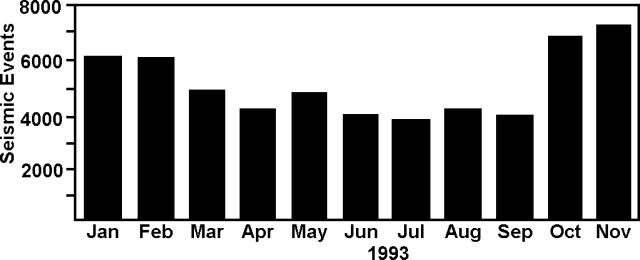 |
Figure 46. Seismic events at Poás received at a station 2.7 km SW of the active crater (POA2), January-November 1993. Courtesy of OVSICORI. |
The surface of the northernmost crater lake at Poás rose 50 cm in November. This 200-m diameter crater lake also had subaqueous fumaroles. In November some of the fumaroles were in the NE part of the lake, and others bubbled constantly in the lake's center. The turquoise-green lake water contains suspended clouds of sulfur. Its temperature dropped slightly, from 63°C in late May to 60°C in November. Temperatures in the early-1980's were in the range 40-60°C. From 5 August to 26 October the deformation circuit around the active crater lengthened an average of 15 ppm.
Information Contacts: E. Fernández, J. Barquero, R. Van der Laat, F. de Obaldia, T. Marino, V. Barboza, and R. Sáenz, OVSICORI.
Seismicity drops, no deformation
During January the 200-m-diameter, northerly crater lake continued to emit steam in a column <100 m tall. The lake level descended 50 cm compared to December 1993; it still remained pale-green to turquoise-green with suspended clouds of sulfur, and in the NW part of the lake, it contained isolated subaqueous fumaroles. OVSICORI reported lake temperature as 60°C, down slightly from the 64°C they measured in September. ICE reported that in January fumarole temperatures on the dome reached up to 81°C.
The number of earthquakes dropped about 20-30% in December and January compared to October and November (figure 47). For the interval January 1993 through January 1994, insignificant tilt and deformation took place, although a slow deflation was noted over the course of 1993.
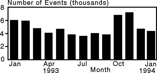 |
Figure 47. Seismic events at Poás received at station POA2, 2.7 km SW of the active crater, January 1993-January 1994. Courtesy of OVSICORI. |
Information Contacts: E. Fernández, J. Barquero, R. Van der Laat, F. de Obaldia, T. Marino, V. Barboza, and R. Sáenz, OVSICORI; G. Soto, G. Alvarado, and F. Arias, ICE; H. Flores, UCR.
Fumarolic and phreatic activity from N crater lake
Escaping gases in the 200-m-diameter, northernmost crater lake at Poás continued to bubble, gush, and geyser, and they produced weak phreatic eruptions through the lake surface. In March, subaqueous fumaroles in the SE emitted small bubbles, but those in the lake center produced phreatic eruptions that drove through the lake surface and reached several meters in height. The lake was dark green in color and 50.5°C; its level had subsided 60 cm with respect to the level in January, leaving a yellow strandline along the banks. A gas cloud or plume frequently rose 500 m above the lake surface, damaging vegetation at several locations near the active crater.
The seismic station adjacent the active crater (POA2) registered 7,118 low-frequency events and 114 moderate-frequency events during March, the most active month so far this year. On the most seismically active day of the month, 16 March, 436 seismic events took place.
Information Contacts: G. Soto, G. Alvarado, and F. Arias, ICE; E. Fernández, J. Barquero, R. Van der Laat, F. de Obaldia, T. Marino, V. Barboza, and R. Sáenz, OVSICORI.
Two minor eruptions eject sediments
In the active, northernmost crater at Poás, the water in the lake dropped several meters since January, almost drying towards the end of April. Fumaroles prevail on the lake bottom, chiefly in the central and northern parts of the crater. Escaping gases were audible from Cerro Pelón, 2 km SW. Gas columns rose up to 1 km above the crater floor and were carried by the wind toward the W and SW flanks. Residents of several nearby settlements reported sulfur smells and the quantity of gas released to the atmosphere appeared to have increased. Near the end of April, two small phreatic eruptions took place.
Park Rangers reported that on the night of 25 April Poás vented a gray-to-clear colored emission containing old lake-floor sediments. The emitted sediments were found over a significant area on the volcano, and reached both Cerro Pelón and the hut at the park entrance on the S. On 30 April the volcano again released a similar emission. Tourists who encountered it left the area rapidly. They came in contact with strong sulfurous gases and suffered from coughs and irritated skin and eyes. Repeated degassing has caused new damage to both cultivated and wild vegetation in and outside the park (last month's report only mentioned damage to local vegetation). The apparent increase in sub-aerial (rather than sub-aqueous) degassing has translated to an increase in the acidity on material deposited at a network of collector sites around the volcano.
In April the local seismic station (POA2, located 2.5 km SW of the active crater) registered a total of 6,919 events, almost as many as the previous month, which had the highest total so far this year. The majority of these events were of low frequency, although 30 were of medium frequency. During the last 8 days of the month there arrived consistent, low-frequency (below 2 Hz), background tremor with peak-to-peak amplitudes of 2-4 mm.
The above-described emissions of lake sediment on 25 and 30 April were accompanied by two different sorts of seismic signals. The first emission was associated with inferred near-surface noise; the second, with a 3.5-4.5 Hz signal of 135-seconds duration and 4-6 mm peak-to-peak amplitude.
Information Contacts: E. Fernández, J. Barquero, V. Barboza, and W. Jiménez, OVSICORI; G. Soto, G. Alvarado, and F. Arias, ICE; H. Flores, UCR.
Northern crater lake nearly dry; gases cause environmental damage
In May, gases from the shrunken and nearly dry lake, Laguna Caliente, continued to present an environmental problem. Dry weather and persistent eruptive activity led to a decrease in the level of both the lake and surrounding groundwater. The retreat of the lake had reached the point that it appeared nearly dry in March, but fumarolic degassing persisted from a number of locations on the crater floor (figure 48). In the absence of abundant water, volcanic gases vented more directly into the atmosphere, causing fumaroles to degas more vigorously and sometimes even to resemble low-energy explosions.
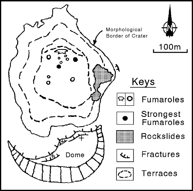 |
Figure 48. The active crater at Poás in late May 1994. Original sketch provided by G.J. Soto of ICE. |
Volcanic gas concentrations have risen in the area adjacent to the National Park (SE, S, SW, and W of the main crater); residents in its vicinity have reported a "strong sulfur smell." These odors forced the Park to close on 26-27 May and at least once in June. They were particularly strong at dawn, and some emissions had yellow and bluish colors. Acidic rainfall also increased such that economic losses since 1988 were on the order of several million dollars (US). Areas of loss encompassed timber, crops, machinery, grazing land, livestock, habitations, and human health. Health complaints have included nausea and coughing, and irritated throat, eyes, and skin.
In contrast, the fumaroles located on the S part of the crater toward the dome appeared comparatively unchanged. They had stable temperatures (89°C) and continued to emit steam-rich components.
ICE reported that microseismicity at Poás has mainly consisted of low-frequency events located beneath the crater lake. From last January through May 1994 the microseismicity has doubled.
OVSICORI reported that during May, station POA2 (located 2.5 km SW of the active crater) registered a total of 5,228 low-frequency events (figure 49). POA2 registered medium-frequency events (99), and high-frequency events (9). POA2 also registered continuous low-frequency tremor with peak-to-peak amplitude slightly under 3 mm, at times reaching 5 mm. The tremor signal was strong in the frequency range 2.0-3.2 Hz (figure 50). The highest seismicity took place on 25 and 31 May, the lowest, 15 May, a day that still received continuous tremor.
 |
Figure 49. Poás seismicity for January-May 1994. Courtesy of OVSICORI. |
 |
Figure 50. Poás tremor beginning at 1343 GMT, 16 May 1994 (top) and spectral analysis of the tremor (bottom). Amplitudes are arbitrary. Courtesy of OVSICORI. |
Compared with the month of April, low-frequency seismicity decreased 13%, medium-frequency increased 76%, and the high-frequency remained about the same. In May, the number of hours of tremor increased—coincident with the above mentioned rise in the vigor of fumarolic activity. On 18 May a M 2.5 earthquake took place at a depth of 15 km centered 3.3 km NE of the active crater. During April and May there was no significant deviation in deformation.
Information Contacts: G. Soto, G. Alvarado, and F. Arias, ICE; H. Flores, UCR; E. Fernández, J. Barquero, V. Barboza, and W. Jiménez, OVSICORI.
Weak ashfalls of fine evaporitic sediments and continuous tremor on 5 days
The lake in the active crater remained dry or nearly dry during June despite two months of rainfall. On the S and SW parts of the lake floor there appeared new fumaroles equal in size to those in the W and NW. Some fumaroles were yellow and reddish in color. A strong level of degassing continued, creating columns that rose to over a kilometer above the lake floor. Escaping gases caused jetting sounds heard from the crater overlook. During June, the wind predominantly carried the gases toward the W and SW, but occasionally to the S as well. The acidity of the windblown gases caused damage to local vegetation.
At 1800 on 3 June, witnesses watched a phreatic eruption column grow 2-km tall over about a 10-minute interval. The dark gray column attained a mushroom-shape. The next day, fine non-juvenile ash was found along the E border of the crater (at Laguna Botos, the hut at the National Park entrance, and on Cerro Pélon).
On 17 June, the S lake area had the morphology of a shallow pan. This area constantly bubbled and ejected phreatic clouds that rose up to 20-m height. A week later, however, activity at this active vent area ceased. A decrease in the lake level on 23 June exposed a gray deposit and blocks displaced by the previous pheatic eruption.
La Nacion newspaper reported that on 8 July a weak ashfall affected some villages at the southwestern foot of the volcano. ICE researchers described the material as fine evaporitic sediments formed by desiccation of the lake during an abnormal dry season last year. ICE researchers also reported the temperatures of steam-rich fumaroles on the dome up to 89°C.
Intermediate-frequency (type AB) earthquakes at Poás grew in June, averaging roughly 10x the background seen earlier in the year (figure 51). Some equipment failures took place in early June, but available data indicated that low-frequency seismicity (figure 52) averaged 228 events/day, giving a projected tally of 6,840 events for the month. This is close to the number of low-frequency events seen in March and April, the most seismically active months of the year. During June, tremor duration was highly variable, but on 5 days tremor took place continuously and on six other days it prevailed for >18 hours/day (figure 52). Tremor had amplitudes of >4 mm, but during the intervals 9-17 and 23-29 June it attained amplitudes >5 mm and fell in the 1.3-2.5 Hz range.
 |
Figure 51. Intermediate-frequency seismicity at Poás, 1994. Courtesy of OVSICORI. |
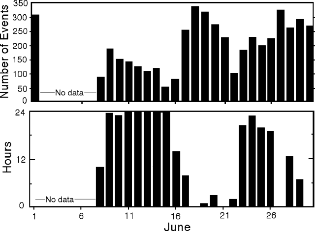 |
Figure 52. Low-frequency seismicity (top) and tremor duration (bottom) at Poás, June 1994. Courtesy of OVSICORI. |
Poás, one of the most active volcanoes of Costa Rica, is broad and well-vegetated, with a summit area containing three craters. Several months ago two of these craters held lakes. One lake still persists and contains clear water. The other lake was colored and occupied the active crater, but it has recently receded. Disappearance of the lake in the active crater appears to be associated with increased eruptions and sub-aerial emissions of harmful acidic gases.
Information Contacts: E. Fernández, J. Barquero, R. Van der Laat, F. de Obaldia, T. Marino, V. Barboza, and R. Sáenz, OVSICORI; G. Soto, G. Alvarado, and F. Arias, ICE; H. Flores, UCR.
Ashfall SW of the summit covers 56 km2
Despite roughly 3 months of rainy weather, the colorful northernmost crater lake that evaporated this past year remained nearly dry, venting became alarmingly noisy, and in the interval from 9 July to 5 August the volcano produced a series of ash falls. These falls were carried to the SW and covered a roughly 56 km2 area.
Increased vigor of fumaroles has led to vapor columns reaching >1 km above the lake floor; the columns were blown to the W and SW. Some of the columns were red to orange in color, presumably due to combustion of sulfur. In the recent past the most vigorous fumaroles were located near the former lake's center. These fumaroles diminished in size; during July the ones located SW of the former lake were of greatest importance.
On 21 July, a fumarole S of the former lake generated a white-colored column; thermocouple measurements of the fumarole revealed a 495°C temperature. The highest pressure fumarole, also located S of the former lake, emitted a red- to orange-colored plume. Continuously jetted gases contained entrained sediment. These escaping gases had a temperature of 515°C, measured with a pyrometer aimed toward the vent. Other fumaroles issued sporadic sediment and colored gases; temperature at the dome was 81°C. ICE and ECG reported jetting gases thrusting to 350 m above the crater floor and then rising convectively to 1 km. Using infrared thermometry, temperatures as high as 700°C were measured in the S-vent area.
Ash was erupted on the night of 9 July and into the morning of 10 July. Continued reports of ash fall came from San Miguel Arriba, Trojas, San Luis de Grecia, Cajon, and Porvenir de Sarchi (figure 53). These reports continued for 2 days; later, mapping and compilation led to an ash distribution map for this and later eruptions in July (figure 53). Blocks were principally limited to the crater area, fine ash covered much of the summit area, and the finest ash blew as far as about 15 km. The fumaroles ejecting lake sediment continued to grow, and ejected ash with blocks. Such events were noted seven times in late July (24, 25, 27, 28, 29, and twice on 30 July). In general, the strongest ash eruptions were accompanied by loud jet-like noises.
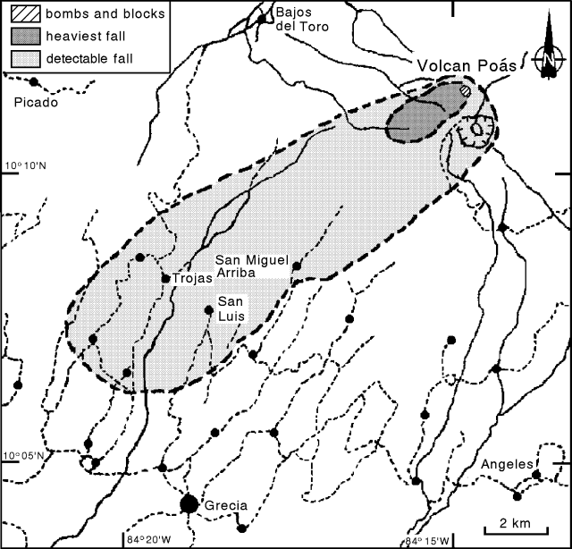 |
Figure 53. Distribution of ash from Poás during July 1994. Scale is approximate; roads indicated by dashed lines, rivers by solid lines, and settlements by dots. Courtesy of OVSICORI-UNA. |
OVSICORI-UNA reported July seismicity from station POA2 (2.5 km SW of the active crater) in terms of several types of events (figure 54). In July, a total of 4,994 events took place. Starting on 26 July several high-frequency (volcano-tectonic) earthquakes took place each day.
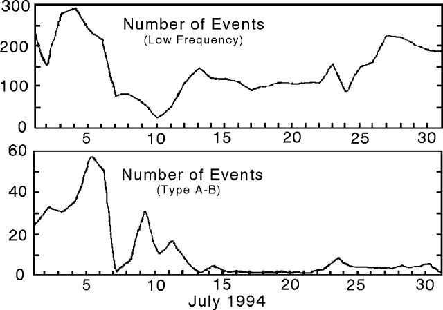 |
Figure 54. Poás seismicity for July 1994. Courtesy of OVSICORI-UNA. |
The amount of deformation on two distance-measurement lines has, since 1973, shown a tendency toward contraction, amounting to about 0.7 and 1.8 ppm/month, respectively. Between 24 June and 5 July both lines suddenly contracted about 19 ppm. From 22 July until the end of the month there were no further significant changes. Back in the interval between 8 March and 12 May a component of two leveling lines deflated slightly (10 µrad). During the last re-occupation of the leveling lines, which took place at the end of July, one line 2 km S of the active crater had inflated by about 17 µrad.
The increased degassing has led to a variety of health and environmental problems. Crops and soils have been damaged. Residents on the W and SW flanks continue to report irritations to the throat, skin, and eyes when gases and ash enter their communities.
On the morning of 22 August an American Airlines flight reported an eruption cloud to ~6 km. Visibility over Poás was poor due to thunder storms to the E and clouds in its vicinity; satellite imagery was unable to detect the plume. Jorge Barquero described this plume as consisting of vapor and gas. A plume on the previous day reached to about 2 km above the vent; heights of these plumes were highly dependant on local wind conditions. As of 22 August, no confirmed ash-bearing plumes had erupted since 5 August.
Information Contacts: E. Fernández, J. Barquero, V. Barboza, R. Van der Laat, F. de Obaldia, and T. Marino, OVSICORI; G. Soto, G. Alvarado, and F. Arias, ICE; M. Mora, C. Ramirez, and G. Peraldo, UCR.
Phreatic and fumarolic activity; block-and-ash eruptions
Phreatic and strong fumarolic activity between 20 July and 5 August formed a pan-like structure in the bottom of the inner lake (figure 55). Following heavy rainfall on the summit area, this structure was filled with water and mud. In the active crater, fumaroles on the S and SE sides of the lake disappeared during August, and block-and-ash eruptions formed a new small crater. The majority of the blocks fell onto the crater floor, the largest seen was 1.2 m in diameter. These eruptions ceased 5 August, but smaller gas-column discharges followed, to heights of 600 m above the lake. These discharges were noteworthy because they were rich in sulfur particulates.
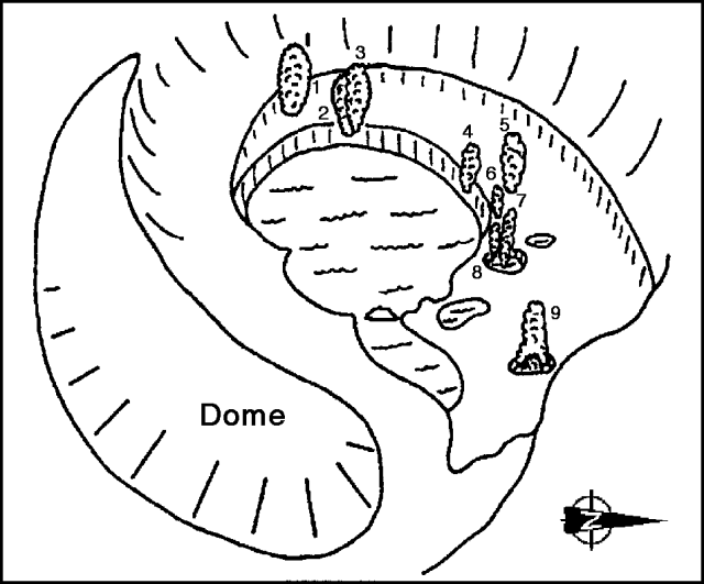 |
Figure 55. Perspective sketch looking W showing the active crater at Poás, mid-late August 1994. The dome is on the left, and the water-filled pan-like depression in the center is surrounded by active fumaroles (1-8) and a boiling mudpot (9). There is no scale, but the crater opening (rim-to-rim) is on the order of a kilometer across. Courtesy of Mauricio Mora, UCR. |
The lake in the active crater rose 1.5 m in September, covering some fumaroles. The 60°C lake was gray, muddy-looking, and clouded with suspended sulfur. Fringed by mud pots, the lake occupied the pan-like structure formed during earlier phreatic and strong fumarolic activity. Owing to the lake's rise, fumaroles in its center appeared isolated; the fumaroles to the N, NW, and W generally maintained steam columns rising ~600 m above the crater. The sound produced resembled steam escaping from a pressure-release valve when heard from the overlook.
Fumaroles on the dome were unchanged in August and September. Fumarolic activity remained strong through late September in several locations on the crater bottom, including boiling mudpots. At the beginning of September the W fumarole converted into a pan-shaped source vent constantly releasing gas and phreatic emissions to heights of 5 m. In mid-September a new fumarole appeared on the W fringe of this source vent with a moderate gas output. Toward the end of the month the gas released at the source vent decreased.
During August and September, OVSICORI-UNA recorded 3,639 and 1,524 low-frequency events, respectively. Compared to tremor duration in August (97 hours), tremor duration in September increased by 42% (to 138 hours). August tremor amplitude was 4-11 mm, with a frequency range centered around 2.3 Hz. September tremor amplitude was 3-9 mm, its frequency range was largely 1.4-2.3 Hz. In addition, a contant, deep noise source (1-3 mm amplitude) was noted during August.
On 23 September seismic instruments recorded a swarm of 11 events, of which 10 were felt by the inhabitants close to the volcano. Four of these events were located (table 5). The located events had magnitudes between 2.1 and 3.0 and epicenters in the W sectors of the volcano. Deformation measurements showed an expansion of 14 ppm during the last week of September. The localized change was found along one of the measured lines inside the crater. Outside the crater there were no significant changes. Radial inclination at the summit was very low on the two precision leveling lines. The dry tilt meters also lacked significant changes.
Table 5. Four located Poás earthquakes that occurred in the swarm on 23 September 1994. Courtesy of OVSICORI-UNA.
| Date | Time (UTC) | Magnitude | Depth (km) | Distance from the active crater |
| 23 Sep 1994 | 0126 | 3.0 | 5.4 | 2.8 km WNW |
| 23 Sep 1994 | 0134 | 2.5 | 6.7 | 2.5 km W |
| 23 Sep 1994 | 0138 | 2.4 | 7.5 | 7.5 km NW |
| 23 Sep 1994 | 0220 | 2.1 | 4.0 | 7 km SW |
Acidic atmospheric conditions were discussed for 1986-90 in an unpublished report by Fernandez and Barquero (1990). During this interval the active crater lake at Poás progressively rose in temperature from ~30 to 90°C. Compared to 1986, the lake's water also increased in dissolved sulfur (2- to 3.5-fold), chlorine (7-fold), and fluorine (~10-fold). Prevailing winds generally carried acidic gases S and SW. Measurements of total wet and dry deposition taken at both the crater rim overlook (El Mirador) and 2.3 km SW of the crater during 1986-90 indicated pH values as low as 3.5-4.1. Acidic rain disrupted strawberry, dairy, and coffee farms (2 x 10⁴ m2 severely damaged), affecting 681 farmers. It also disturbed the trees in several reforestation projects, where losses reached 95%. Farm equipment rusted rapidly. At the time of the report, studies failed to clearly demonstrate health problems, although local inhabitants complained of respiratory, skin, and eye irritations. The National Park and villages adjacent to Poás sustained damage, especially to building roofs. Areas significantly affected by the acidic atmospheric conditions reached over 24.5 ha (245,000 m2). The report cited four references to Poás work, including a paper by Brown and others (1989) proposing that ". . . crater-lake and fumarole discharge variations may well occur before significant signals on seismic and tilt networks are detected."
They further stated that ". . . maintained power output and/or low water supply could culminate in a dramatic change in activity, possibly with devastating results." A final note makes this case by example: "After continued evaporation through the dry season, Poás lake disappeared in late April 1989 accompanied by several days of continuous phreatic geysering. A dry steam/'ash' plume . . . was erupted to 200 m height on 25 April; from 30 April to early May a continuous plume reached 2 km in height with fallout over 200 km2."
References. Brown, G., Rymer, H., Dowden, J., Kapadia, P., Stevenson, D., Barquero, J., and Morales, L.D., 1989, Energy budget analysis for Poás crater lake: implications for predicting volcanic activity: Nature, v. 339, no. 6223, p. 370-72.
Fernandez, E., and Barquero, J., 1990, Erupciones de gases y sus consecuencias en el volcan Poás, Costa Rica [Eruption of gases and their consequences at Poás volcano], Costa Rica: Observatorio Vulcanologico y Sismologico de Costa Rica, Univ Nacional, Heredia, Costa Rica, 4 p.
Information Contacts: E. Fernandez, J. Barquero, V. Barboza, R. Van der Laat, T. Marino, F. de Obaldia, and L. Carvajal, OVSICORI-UNA; G. Soto, W. Taylor, F. Arias, G. Alvarado, and R. Barquero, ICE; M. Mora, UCR.
Heavy rain refilling lake; 100-m-high gas columns
Heavy rains caused the nearly dry crater lake to rise 1.8 m with respect to the level in September, filling it enough so that the diameter reached about 180 m. A pan-like structure on the crater floor became covered by silt and pale-green 60°C lake water. In October, a zone of boiling water was located at a site in the NW quadrant of the crater, outside the lake. The zone produced tiny (1- to 2-m high) phreatic eruptions and modest (<100-m high) gas columns. Fumaroles on the dome appeared unchanged. During October, low-frequency seismic events at Poás totaled 3,630 (see table 6).
Information Contacts: E. Fernández, J. Barquero, and V. Barboza Moreira, OVSICORI-UNA; G. Soto and F. Arias, ICE; M. Mora, UCR.
Slow deflation and low-to-moderate seismicity
Fumarolic activity continued at Poás in the re-established crater lake. OVSICORI reported the lake level remained the same in both October and November. ICE reported that due to heavy rains in November the lake had attained a diameter of ~220 m and its surface reached 8 m above the minimum level seen in August.
The turquoise-green colored lake hosted subaqueous fumarolic activity, leading to bubbling and minor phreatic eruption columns to 100 m height. In the NE part of the lake there existed a spot with sporadic phreatic eruptions. These reached 1-m height and had a dark-gray color. The area adjacent to the crater continues to recuperate from acidic conditions found earlier this year.
Results from the OVSICORI seismic system appear in table 6. The day of the month with the greatest number of seismic events was 7 November. Compared to earlier in 1994, the number of seismic events in November was low to moderate.
Deformation, measured by dry-tilt, failed to show significant changes in November. The four distance-measuring lines inside and across the active crater showed changes of less than 8 ppm in a deflationary direction. The two precision leveling lines at the summit changed less than 6 and 12 µrad. These leveling-line changes were interpreted as tending toward slow deflation after a brief pulse of inflation registered during the eruptive activity of August 1994.
Information Contacts: E. Fernández, J. Barquero, R. Van der Laat, F. de Obaldia, T. Marino, V. Barboza, and R. Sáenz, OVSICORI; G. Soto, G. Alvarado, and F. Arias, ICE.
Seismicity low; bubbling fumaroles disappear
OVSICORI reported that during December the re-established lake in the active crater remained turquoise-green in color, had a temperature of 40°C, and had risen 2 m with respect to its level in October.
In December, the bubbling gases previously emitted from the NW part of the lake ceased. Evaporating gases rose about 50 m above the lake surface; in addition, some gases emanated from the dome.
During December, the Poás seismometer (2.7 km SW of the active crater) registered the following number of events: low frequency (< 2 Hz), 2,539; medium frequency (2.1-3.0 Hz), 14; and high frequency (> 3 Hz), 2. Low-frequency seismicity for December appears in figure 56. With respect to the previous two months, December seismicity dropped in the low- to mid-ranges, but it remained about the same for the high-frequency events. With respect to all months during the year (1994), December seismicity in all three frequency ranges was near the minimum (see table 6).
 |
Figure 56. Poás low-frequency seismicity for December 1994 (from station POA2). Courtesy of OVSICORI-UNA. |
Information Contacts: E. Fernández, J. Barquero, R. Van der Laat, F. de Obaldia, T. Marino, V. Barboza, and R. Sáenz, OVSICORI.
January seismicity highest in five months
Fumarolic activity continued at Poás in the reestablished crater lake. OVSICORI-UNA reported that in January the lake had a temperature of 50°C, a turquoise-green color, and its level dropped by 40 cm with respect to December. During January evaporative clouds rose to as high as 50 m above the lake. The N part of the dome continued to slide. No significant changes were registered by study of either leveling lines, dry tilt, or the distance measuring network over the crater surface.
During January, low- and medium-frequency earthquakes took place more often than in the five previous months (table 6). As partly summarized in 19:11, during 1994 low-frequency earthquakes peaked in March (7,118 events), medium-frequency earthquakes peaked in June (556 events), and high-frequency earthquakes peaked in August (31 events). The greatest number of seismic events took place on 12 January in the low-frequency range, and on 16 January in the medium-frequency range (figure 57).
Table 6. Poás seismic data, January 1994-August 1995 (from the station POA2, located 2.7 km SW of the active crater). Frequency ranges are as follows: low (<2 Hz), medium (2.1-3.0 Hz), high (>3 Hz). Courtesy of OVSICORI-UNA.
| Month | Low-frequency | Medium-frequency | High-frequency | Hours of Tremor |
| Jan 1994 | 4,040 | 94 | 0 | -- |
| Feb 1994 | 4,786 | 59 | 0 | -- |
| Mar 1994 | 7,118 | 114 | 0 | -- |
| Apr 1994 | 6,916 | 23 | 7 | -- |
| May 1994 | 5,336 | 99 | 9 | -- |
| Jun 1994 | 5,472 | 556 | 1 | -- |
| Jul 1994 | 4,994 | 374 | 15 | -- |
| Aug 1994 | 3,639 | 102 | 31 | -- |
| Sep 1994 | 1,524 | 31 | 24 | -- |
| Oct 1994 | 3,630 | 88 | 0 | -- |
| Nov 1994 | 3,563 | 91 | 1 | -- |
| Dec 1994 | 2,539 | 14 | 2 | -- |
| Jan 1995 | 4,347 | 198 | 0 | 0 |
| Feb 1995 | 4,710 | 207 | 20 | 0 |
| Mar 1995 | 6,881 | 113 | 1 | 0 |
| Apr 1995 | 5,798 | 367 | 2 | 11 |
| May 1995 | 3,142 | 715 | 0 | 5 |
| Jun 1995 | 2,258 | 322 | 28 | 0 |
| Jul 1995 | -- | -- | -- | -- |
| Aug 1995 | 5,486 | 165 | 0 | 9 |
 |
Figure 57. Low- and medium-frequency earthquakes at Poás during January 1995. Courtesy of OVSICORI-UNA. |
Information Contacts: Erick Fernández, Jorge Barquero, Rodolfo Van der Laat, Franklin de Obaldia, Tomás Marino, Vilma Barboza, and Rodrigo Sáenz, Observatorio Vulcanológico y Sismológico de Costa Rica, Universidad Nacional (OVSICORI-UNA), Apartado 86-3000, Heredia, Costa Rica; Gerardo J. Soto, Oficina de Sismología y Vulcanología, Departamento de Geología, Instituto Costarricense de Electricidad (ICE), Apartado 10032-1000, San José, Costa Rica.
Continued moderate seismicity, but no tremor; lake rise
During February the green-turquoise colored lake rose to its December 1994 level. The lake contained clouds of suspended sulfur, and had a temperature of 47°C. Lake evaporation caused minor steam clouds (columns <50 m tall); in the S part of the lake constant bubbling took place with sporadic gushing of water.
During February seismic station POA2 (located 2.7 km SW of the principal crater) registered 4,937 earthquakes (high, medium, and low-frequency events combined). This was the largest number of earthquakes since July 1994. It followed a low of 2,555 earthquakes in December 1994 and previous highs of ~7,000 earthquakes in March and April 1994. Although up to 200-300 hours of tremor took place during mid-1994, in February 1995 less than an hour of tremor was registered. Events of high frequency (above 3 Hz) took place 20 times, a comparatively high number for Poás.
Information Contacts: E. Fernández, V. Barboza, and J. Barquero, OVSICORI; G. Soto, ICE.
Two new hot springs; moderate number of earthquakes and tremor
Fumarolic activity continued at Poás in the active, northern crater lake. OVSICORI-UNA reported the lake level rose 50 cm in April with respect to March. When observed in April, the lake appeared light green and had a temperature of 41°C. On small areas along the lake's NW and W shore, small bubbles escaped continually. A low (less than 50-m tall) steam cloud hovered over the lake.
On the lake's SW terrace there were two new intermittent springs (74°C and 64°C) that were light-gray in color, presumably caused by suspended sediment. On the S terrace, fumaroles continued to emit gases and on the SW side there appeared a new fumarole with a 74°C temperature. The pyroclastic cone gave off gas that had a 89°C temperature.
Low-frequency seismicity at Poás in April declined by about 15% compared to March (table 6). Tremor began on about 8 March and the monthly duration reached 11 hours, more than the past few months but significantly less than the tens or hundreds of hours recorded during the months of May-September 1994.
Information Contacts: Erick Fernandez, Vilma Barboza, and Jorge Barquero, Observatorio Vulcanologico y Sismologico de Costa Rica, Universidad Nacional (OVSICORI-UNA); Gerardo J. Soto, Oficina de Sismologia y Vulcanologia del Arenal y Miravalles: OSIVAM; Instituto Costarricense de Electricidad (ICE); Mauricio Mora, Escuela Centroamericana de Geologia, Universidad de Costa Rica.
New fumaroles and hot springs, both with temperatures up to 97°C
Fumarolic degassing and weak bubbling continued in the crater lake; during May and June evaporative steam clouds hovered as high as 50 to perhaps 100 m above the lake. OVSICORI-UNA reported that in May and June the lake had temperatures of 43 and 39°C, respectively, a sky blue color, and its level dropped by 1 m each month with respect to the level in April.
On the terrace SW and W of the crater lake, two nascent springs appeared in May with 95 and 97°C temperatures. The springs looked dark--the color of black coffee--an effect presumably induced by suspended sediment. In June these springs contained small rising bubbles, and the descent of the lake surface exposed a former subaqueous fumarole to direct view. Its temperature was 95°C.
During May, new fumaroles also appeared on the S and SW crater walls; they had 90-97°C temperatures, gave off minor columns of gases, and contained freshly sublimated sulfur. Continued reports from Park Guards mentioned that when the wind blows S, residents smell sulfur. Various other fumaroles remained active, for example on the S and SW shores of the lake, and from the pyroclastic cone (84°C in May, and 81-91°C in June). The N crater wall continued to slide into the crater lake.
Low-frequency seismic activity in May and June totalled 3,857 and 2,580 events, respectively. The day with the largest number of events in the two month interval was 4 May: 201 events. On 19-20 May several intervals of continuous tremor (at 1.8-1.9 Hz, 6-8 mm amplitude) prevailed for a total of 3 hours.
Only a small change in inclination took place during May (<10 µrad, located near the summit). No other significant change affected either the inclination network or the network of surveyed distances to the summit and active crater.
Information Contacts: E. Fernandez, R. Van der Laat, F. de Obaldia, T. Marino, V. Barboza, W. Jimenez and R. Saenz, OVSICORI-UNA; Mauricio Mora, Escuela Centroamericana de Geologia, Universidad de Costa Rica; G.J. Soto, ICE.
Crater lake rises and continues bubbling along shorelines
The volcano's sky-blue colored crater lake remained high, with sulfur stains and a temperature of 39°C. Bubbling at sites along the NW and S shores each had about equal intensity. A new fumarole appeared on the E terrace near the crater wall, producing a 50-m-high gas column. Fumaroles along the S and SE crater walls had temperatures of 94-96°C, and produced gas columns to <50 m height. Winds blew sulfur smells to the park's entrance gate.
Information Contacts: E. Fernandez, R. Van der Laat, F. de Obaldia, T. Marino, V. Barboza, W. Jimenez, and R. Saenz, Observatorio Vulcanologico y Sismologico de Costa Rica, Universidad Nacional (OVSICORI-UNA), Apdo. 86-3000, Heredia, Costa Rica; Mauricio Mora, Escuela Centroamericana de Geologia, Universidad de Costa Rica; Gerardo J. Soto, Observatorio Sismologico y Vulcanologico del Arenal y Miravalles (OSIVAM), Instituto Costarricense de Electricidad (ICE), Apdo. 10032-1000, San Jose, Costa Rica.
Elevated seismicity and continued fumarolic activity within the N crater
During August, the level of the sky blue lake within the N crater climbed 1.5 m with respect to its position in June. The lake's temperature was 37.5°C. Fumaroles on the W lake terrace generated gas columns <50 m high; those on the NW lakeshore continued their constant bubbling. The gases escaping from the pyroclastic cone had an 89°C temperature. Fumaroles on the S and SW crater walls had 94°C and 96°C temperatures and produced columns reaching over 50 m high. When the wind blew towards the S, Rangers at the park entry station smelled sulfur.
Poás was very active in terms of both moderate- to low-frequency earthquakes and tremor. There were 5,651 seismic events in August, predominantly low-frequency (table 6). Both medium- and high-frequency events prevailed when seismicity peaked on 25 August with 312 events.
August can be compared to the 17 other months where data were available during 1994-95 (table 6). The number of low-frequency events was fourth largest in August 1995. The largest value for the 1994-1995 interval was 7,119 events (March 1994). Tremor in August 1995 took place for 9 hours; this compares with high values seen in April 1995 (11 hours) and June 1994 (307 hours).
Information Contacts: E. Fernandez, E. Duarte, R. Saenz, W. Jimenez, and V. Barboza, Observatorio Vulcanologico y Sismologico de Costa Rica, Universidad Nacional (OVSICORI-UNA).
Over 9,000 seismic events in September, most of them low-frequency; no tilt
During September, 9,144 seismic events took place, the most for any month in 1994 or thus far in 1995. These events were predominantly low-frequency (8,854 events, figure 58);
 |
Figure 58. Low-frequency seismicity at Poás, January-September 1995. Data were collected at station POA2 located 2.7 km SW of the active crater. Courtesy of OVSICORI-UNA. |
The level of the sky blue lake within the N crater climbed 0.6 m in September with respect to August. The lake's temperature was 34°C. Fumaroles on the W lake terrace increased their output, but they only generated gas columns <50 m high. Although weaker than these fumaroles, two new fumaroles appeared on the terrace to the NW and SW of the lake. Other new fumaroles were seen along the N wall of the pyroclastic cone; fumarolic gases discharging from the cone reached 93°C. Constant bubbling continued to issue from points in the central and W lake. The fumarolic area on the SW and S wall maintained a 90-95°C temperature and discharged gas columns that rose as high as 100 m. Mass wasting of unstable hydrothermally altered rocks in this area covered some fumarolic vents and opened new ones.
Information Contacts: E. Fernandez, E. Duarte, R. Saenz, W. Jimenez, and V. Barboza, Observatorio Vulcanologico y Sismologico de Costa Rica, Universidad Nacional (OVSICORI-UNA), Apartado 86-3000, Heredia, Costa Rica.
High seismicity
During October, tremor at Poás reached 101 hours; the last time tremor rose over 12 hours/month was May-September 1994, an interval when tremor ranged between 49 and 307 hours/month. The number of minor earthquakes, which were predominantly of low frequency, continued to climb during the month of October, reaching 9,838 events. This was a value ~8% larger than the total for September, the previous month with the most seismic activity in 1995.
The crater lake has risen consistently: by ~5 m during June-October (ICE), and by ~30 cm in the last month (OVSICORI-UNA). During October 1995, the fumarole on the W terrace appeared to have decreased its emissions compared to recent months (< 50-m-high steam plumes), and others on the lake's NW and SW sides also had diminished output. Fumaroles on the S and SW crater wall produced steam columns reaching 100 m tall. During October, bubbling in the lake still continued. During October OVSICORI-UNA scientists measured the temperatures at several sites: pyroclastic cone, 93°C; fumaroles on the S and SW sides of the crater, 95-97°C; the lake in the inactive crater (Lake Botos), 15°C; and the lake in the active crater, 30°C.
Head scarps of landslides that emanate from the dome and flow toward the lake displayed ongoing mass wasting; ICE workers mentioned that this mass wasting may have been triggered by recent heavy rains. In addition, ICE reported that on 17 September (at 0548) a M 3.9 earthquake struck; it had a depth of 5 km and an epicenter 1.6 km SW of the main crater. At the summit, the earthquake's intensity was MM III-IV.
Information Contacts: E. Fernandez, E. Duarte, and V. Barboza, Observatorio Vulcanologico y Sismologico de Costa Rica, Universidad Nacional (OVSICORI-UNA); Mauricio Mora, Escuela Centroamericana de Geologia, Universidad de Costa Rica; G.J. Soto, Oficina de Sismologia y Vulcanologia del Arenal y Miravalles: OSIVAM, Instituto Costarricense de Electricidad (ICE).
Fumarolic and seismic activity
The surface of the sky-blue crater lake rose in November (20 cm higher than October); the lake's temperature was 26°C. A vigorous subaqueous fumarole appeared adjacent the lake's S shore. The W-terrace fumarole emitted yellow, sulfur-rich gases and particles; other fumaroles located on the NW-SW terrace emitted only low amounts of gases. Measured fumarole temperatures were in the range 94-96°C along the S and SE crater, an area that produced 100-m-tall gas columns. Gases escaping the pyroclastic cone had temperatures of 93°C.
During 1-22 November the local seismic station recorded 5,146 events (predominantly of low-frequency), significantly fewer than the number seen in the two previous months (figure 59).
 |
Figure 59. Poás seismicity for January-November 1995 recorded at station POA2 (2.7 km SW of the active crater). Courtesy of OVSICORI-UNA. |
Information Contacts: E. Fernandez, E. Duarte, R. Saenz, W. Jimenez, and V. Barboza, Observatorio Vulcanologico y Sismologico de Costa Rica, Universidad Nacional (OVSICORI-UNA).
Seismically active with new fumaroles and some cross-crater deformation
When visited during January, the surface of the turquoise-green crater lake had risen 45 cm with respect to its December level. At the dome's N margin a small bubbling spring discharged relatively clear water. Lake water measured at the shoreline near the spring had a temperature of 29°C and on the N shore, a temperature of 27°C. The ongoing collapse of the N wall continued, as did reports of sulfur odors at the park entrance station, ~1 km away. Within the crater a small landslide had partially covered the W terrace and local fumaroles there, but fumaroles had migrated to the NW terrace where escaping gases made loud noises. SW-terrace fumaroles also remained active.
The SE-SW portion of the crater wall contained new fumaroles. These chiefly had temperatures of 73-91°C, with the maximum fumarole temperature, 94°C, found along the S wall. During the January visit, the intracrater cone displayed an increased number of gas emission points. Although the majority were inaccessible, gas columns emanating from the crater margins gave temperatures of 94°C.
During 1995, two distance-survey lines across the active crater underwent an expansion of 19.5 ppm. During the same interval, the distance-survey network outside the crater and the tilt network both lacked significant changes.
During December 1995 and January 1996, the total number of seismic events was relatively high, 5,960 and 4,187, respectively (figure 60). These events were predominantly of low frequency. During December and January, tremor registered for a total of 259 and 6 hours, respectively.
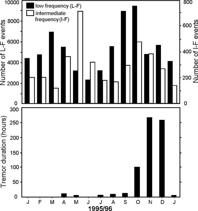 |
Figure 60. The monthly number of seismic events (top) and hours of tremor (bottom) at Poás for January 1995-January 1996. The December 1995 data were adjusted because the local seismic station (poa2, 2.7 km SW of the active crater) did not operate on the 16th-21st of the month. Frequency designations are as follows: intermediate (medium), 2.0-3.0 Hz; and low, |
Information Contacts: Rodolfo Van der Laat, Vilma Barboza, Erick Fernández, Jorge Barquero, Franklin de Obaldia, Tomás Marino, and Rodrigo Sáenz, Observatorio Vulcanológico y Sismológico de Costa Rica, Universidad Nacional (OVSICORI-UNA).
Seismicity decreased roughly 10-fold since October 1995
During a February visit, the temperature of the turquoise-green crater lake was 26°C and its surface had risen 2 m with respect to its January level. Except that this lake-level rise had covered some active fumaroles, their behavior was similar to previous months. Fumaroles on the SE, S, and SW sides of the crater had temperatures of 93-95°C. One fumarole along the lake's W shore had migrated upward along a crack.
When visited during March, the lake appeared sky blue in color, its surface had dropped by 0.5 m compared to the previous month, and the water temperature was 30°C. Fumaroles, their gas emission rates, and temperatures were similar to previous months. A distance survey across the crater found that a 21 ppm/year expansion had occurred since mid-1995. At a spot adjacent to the lake, the survey found an 18 mm contraction since October 1995.
The pyroclastic cone, the major source of gas emission, discharged plumes 200-400 m high. Where accessible the temperatures of the emitted gases were around 94°C; gas emissions sounded like releases from a pressure valve, particularly those venting along the inaccessible N wall.
February and March seismicity consisted of a total 1,100 and 983 events, respectively, the majority being low frequency. This was a roughly 10-fold decrease since a peak in October 1995. Tremor duration was <10 hours, down from over 250 hours in November and December 1995.
Information Contacts: Erick Fernández, Elicer Duarte, Vilma Barboza, Rodolfo Van der Laat, and Enrique Hernandez, Observatorio Vulcanológico y Sismológico de Costa Rica, Universidad Nacional (OVSICORI-UNA); Gerardo J. Soto, Oficina de Sismología y Vulcanología, Departamento de Geología, Instituto Costarricense de Electricidad (ICE).
N crater lake at 10-year high; water temperature increases; phreatic explosion on 8 April
When observed by visiting scientists on 11-13 March, the lake in the active N crater was at its highest level since 1986, with a depth estimated at 50 m. The lake's color was pale green, its measured temperature, 32°C, and pH, 1.5.
The scientists noted three areas of fumarolic activity in the active crater with the strongest concentrated on the 1953-55 cone immediately S of the lake. Most of this activity was located on the NW side of the cone near lake level; in this area, high-pressure degassing exited from an E-W oriented fracture ~10 m above the lake's surface. These fumaroles have appeared since the beginning of 1996. Low-pressure fumaroles were also observed on the eastern top of the dome, with gas exiting through small cracks and crevices. Maximum temperatures were 93°C, suggesting that these were boiling-point fumaroles.
A second set of at least five individual fumaroles above the lake's W edge within the inner crater began appearing at the end of 1995, with the most recent one, which displayed the highest gas pressure, forming in March 1996. A third set of fumaroles had been observed since April 1995 in the crater's S area where the trail begins ascending to the Mirador; these had low pressure. Temperatures did not exceed 93°C, again indicating boiling-point fumaroles.
Microgravity measurements made in the crater area showed a continuation in the trend of increased gravity on the N crater floor and a new pattern of decreased gravity (~100 µgal in two years) on the S crater floor.
When visited by OVSCICORI-UNA scientists during April and May the surface of the light-gray crater lake had risen 0.4 and 96 cm, respectively, compared to March. The lake's temperature recently increased: in April it was 36°C and in May, 42°C (compared to 26°C in February and 30°C in March). As is typical, fumaroles clustered near the pyroclastic cone. Their temperatures measured 94°C during April and May; however, the most vigorously degassing zones were inaccessible. Some of these degassing zones continued to make loud noises and their condensed gases formed plumes that rose to 500 m above the crater floor. On the SE, S, and SW walls, maximum fumarole temperatures ranged between 91 and 94°C.
In addition to suspended sulfur and constant bubbling seen in the lake, small landslide deposits were noted leading into the lake from the crater walls. Park guards reported that when the wind blew to the S, visitors suffered from coughs and irritated eyes and skin. New fumaroles appeared along the E crater wall, coincident with high-frequency earthquakes and increased steam output at the pyroclastic cone.
Except for signals associated with a small phreatic eruption, seismic station POA2 registered relative quiet during April: 651 total earthquakes, 24 mid-frequency earthquakes, 17 high-frequency earthquakes, and four hours of tremor. During May POA2 registered 1,243 earthquakes, 29 mid-frequency earthquakes, 21 high-frequency earthquakes, and six hours of tremor. Some of the latter signals during May were correlated with increased fumarolic activity and the appearance of new fumaroles in the active crater.
On the morning of 8 April a low-frequency signal lasting for 223 seconds coincided with an eruption. Fieldwork on 12 April disclosed that the eruption had thrown blocks S to SW of the dome. The blocks had dimensions of up to 35 x 45 cm; in an area N of the lake, the diameter of some blocks reached 80 cm. The N, W, and SW walls of the lake were coated with light gray material ejected from the lake floor. Much of the same material fell back into the lake. Insubstantial deformation was seen during April and May.
Information Contacts: Erick Fernández, Elicer Duarte, Vilma Barboza, Rodolfo Van der Laat, and Enrique Hernandez, Observatorio Vulcanológico y Sismológico de Costa Rica, Universidad Nacional (OVSICORI-UNA), Apartado 86-3000, Heredia, Costa Rica; Hazel Rymer and Mark Davies, Dept. of Earth Sciences, The Open University, Milton Keynes MK7 6AA, United Kingdom; John Stix, Dora Knez, Glyn Williams-Jones, and Alexandre Beaulieu, Dept. de Geologie, Universite de Montreal, Montreal, Quebec, H3C 3J7, Canada; Nicki Stevens, Dept. of Geography, University of Reading, Reading RG2 2AB, United Kingdom.
Moderate seismicity during June
During June the lake at Poás had a greenish-turquoise color, a temperature of 44°C, and bubbled constantly from points on its S, SW, and W sides. A gas plume rose to between 400 and 500 m. Small rockfalls continued along the crater's N and W walls and gas escape rates in the latter area appeared low. The main source of fumarolic discharge came from the pyroclastic cone; at an accessible point on this region the temperature measured 94°C. Fumaroles on the SE, S, and SW walls maintained temperatures of 90-95°C.
OVSCICORI-UNA reported that June seismicity totalled 2,043 events, chiefly of low frequency. During June, totals for medium- and high-frequency events were 115 and 11, respectively. The low-frequency events occurred 20-157 times/day, with the highest number of events at mid-month. The high- and medium-frequency events also both peaked mid-month (with daily highs of about 3 and 13 events, respectively). The peak in high-frequency daily events took place on the 15th and coincided with the appearance of new fumaroles in the active crater.
Mauricio Mora (UCR) described six months of seismicity at Poás (table 7). A seismic peak in January was characterized by harmonic tremor and low-frequency events (both below 2 Hz). Tremor decreased during the first half of the year but a small peak in seismicity appeared in June. Mora also discussed January-June activity in the three primary areas of fumaroles, including: 1) the S crater wall, which appeared to be growing SW (91°C); 2) the dome and crater's S border, which issued plumes to 30 m height (~90°C); and 3) the crater's W border, which in March was covered by a landslide of hydrothermally altered wall rock.
Table 7. Number of low-frequency and A-type seismic events at Poás (recorded at station VPS2, 1 km SW of the active crater), January-June 1996. Courtesy of Mauricio Mora.
| Month | Low-frequency events | A-type events |
| Jan 1996 | 4,475 | -- |
| Feb 1996 | 1,651 | 2 |
| Mar 1996 | 1,800 | -- |
| Apr 1996 | 1,214 | -- |
| May 1996 | 1,721 | 4 |
| Jun 1996 | 2,994 | 6 |
Information Contacts: Erick Fernández, Elicer Duarte, Vilma Barboza, Rodolfo Van der Laat, and Enrique Hernandez, Observatorio Vulcanológico y Sismológico de Costa Rica, Universidad Nacional (OVSICORI-UNA), Apartado 86-3000, Heredia, Costa Rica; Gerardo J. Soto, Guillermo E. Alvarado, and Francisco (Chico) Arias, Oficina de Sismología y Vulcanología, Departamento de Geología, Instituto Costarricense de Electricidad (ICE), Apartado 10032-1000, San José, Costa Rica; Mauricio Mora F., Sección de Sismologia, Volcanologia y Exploración Geofisica, Escuala Centroamericana de Geología, Universidad de Costa Rica, Apdo. 35-2060, San José, Costa Rica
Steaming but seismically quiet; hurricane rains add to lake
During July and August the crater lake's water appeared turquoise green; its temperature was generally 35°C. The surface of the crater lake dropped 64 cm during July and then rose 26 cm during August. Rains from Hurricane César on 27-28 July caused the lake to rise 14 cm and to cool by 1°C.
Constant bubbling continued in July on the lake's S and SW shores adjacent to the pyroclastic cone. During August, however, the bubbling decreased and then stopped. The cone contains many moderate-volume fumaroles and although landslides off the crater walls occasionally bury them, new ones appear. Steam emissions sent plumes ~500 m high and made loud pressure-cooker-like noises audible from the overlook; where accessible during July and August the gases had respective temperatures of 91-93 and 94-95°C. Fumaroles along the SE, S, and SW walls had temperatures of 57-93°C. They generally gave off low volumes of gases.
Tremor and seismicity were both relatively low after January 1996 compared to 1994-95 (figure 61). In accord with these seismic data, a survey of the crater and summit distance network failed to disclose any new changes during July.
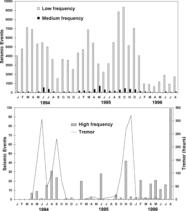 |
Figure 61. Poás seismicity for 1994-August 1996 as registered at station POA2, 2.7 km SW of the active crater. December 1995 had three days without data; consequently, the sum for the month was scaled up and plotted assuming the rate of generated events remained constant. Courtesy of OVSCICORI-UNA. |
Information Contacts: E. Fernández, E. Duarte, V. Barboza, R. Van der Laat, E. Hernandez, M. Martinez, and R. Sáenz, Observatorio Vulcanológico y Sismológico de Costa Rica, Universidad Nacional (OVSICORI-UNA).
Fumarolic columns rise 500 m above the crater floor
During the four-month interval of September-December 1996 OVSCICORI-UNA reported the following N crater lake temperatures: 40, 35, 31, and 29°C, respectively. There were also fluctuations in the N crater lake's surface height. Defining a lake surface height increase with respect to the height in August as positive (+), during the four-month interval the progressive shifts were as follows: +13 cm, -54 cm, -31 cm, and +144 cm. Figures 62 and 63 show temperature and pH for the N crater lake and some chemical data for rainfall during the first eleven months of 1996.
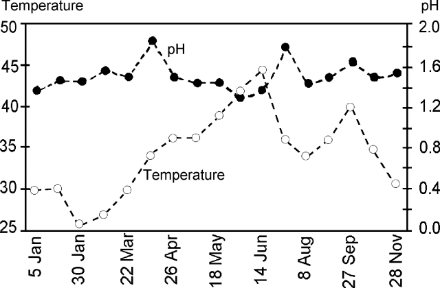 |
Figure 62. The pH and temperature of the N crater lake at Poás. Data points show discrete values taken at the date shown. Courtesy of OVSICORI-UNA. |
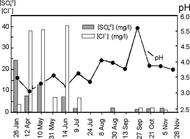 |
Figure 63. The chemistry of rainwater falling on Cerro Pelon at Poás. The ion concentration (for SO2+4 and Cl- in mg/liter) and pH (± 0.5 units) during the interval 26 January-28 November. Bars and points show discrete values taken at the date shown. Courtesy of OVSICORI-UNA. |
Also during September-October, the accessible fumaroles on the pyroclastic cone maintained a maximum temperature of 93-94°C. Gas columns in the interval rose 500 m above the crater floor.
The number of low-frequency Poás earthquakes registered as follows: 2,351 (September), 2,043 (October), 1,704 (November, adjusted because of 14 days without data). December earthquakes have not yet been reported.
September contained the largest number of earthquakes recorded in any month in 1996. Low-frequency tremor, not seen since May, appeared for ~8 hours in September, also the most seen up to that point in 1996. Continuing the trend, tremor occurred for 28 hours during October. No tremor was recorded in November. For comparison, tremor had reached over 300 hours in December 1995.
Deformation during August and September 1996 was very low. Two lines in the sector S of the crater contracted by an average of ~5 mm (2-3 ppm), a shift considered insignificant. Although electronic tilt measurements were absent for August-September, two leveling lines along the crater's S border have lacked significant tilt since 1995.
Information Contacts: E. Fernández, E. Duarte, V. Barboza, R. Van der Laat, E. Hernandez, M. Martinez, and R. Sáenz, Observatorio Vulcanológico y Sismológico de Costa Rica, Universidad Nacional (OVSICORI-UNA).
Relatively stable but seismically active
Periodic visits revealed that the crater lake level changed as follows compared to December 1996: January, a 31 cm decrease; February, a 55 cm decrease; and March, an 88 cm decrease. Lake-water temperatures during January, February, and March measured 32, 30, and 29°C, respectively. A pH of 1.7 was measured in March. During January-March constant bubbling took place on the lake's S and SW shores. During January and February one fumarole remained noisy; as late as March those on the SE, S, and SW remained at 91- 93°C. The migration of fumaroles was noted in March. Fumarolic gases emitted from the accessible parts of the pyroclastic cone had temperatures of 92°C (January) and 92-93°C (February). Temperatures were not reported for March. During January-March, steam clouds rose 400 m above the crater floor.
Scientists collected acid rain at Cerro Pelón on five days during 7 January-10 March. The respective SO4 and Cl ion concentrations ranged between ~5 and 12 mg/liter, and 1 and 6 mg/liter; pH ranged between 3.5 and 4.5.
A seismic swarm on 31 January consisted of 47 primarily low-frequency earthquakes; some occurred3.0 Hz), 0-99. During the same interval, monthly tremor prevailed for 0-28 hours, peaking in October 1996.
 |
Figure 64. Poás seismicity (at frequencies below 2 Hz) recorded 2.7 km SW of the active crater (station POA2), March 1996 to March 1997. Courtesy of OVSICORI-UNA. |
During January, both the distance network and dry-tilt readings at the summit remained stable. As of March, the three deformation lines across the crater and one external radial line had shown no significant changes during 1997. Another line, from the S side of the overlook (mirador) to the crater bottom, detected a cumulative contraction of 119 ppm/year. This contraction may have come from adjustments due to shallow phreatic venting and an increase in the crater lake's height. Changes in the inclinometer network were not considered significant.
Information Contacts: E. Fernández, E. Duarte, V. Barboza, R. Van der Laat, E. Hernandez, M. Martinez, and R. Sáenz, Observatorio Vulcanológico y Sismológico de Costa Rica, Universidad Nacional (OVSICORI-UNA).
Number of monthly earthquakes high in April, lower in May
During April, fumarolic degassing and weak bubbling continued in the 29°C, green-turquoise-colored crater lake. On the N crater floor there appeared a new 80-m-long fracture with fumaroles depositing sulfur; weakly escaping gases there had temperatures of 94°C. The same temperature was measured at the accessible part of the pyroclastic cone, and other fumaroles reached temperatures of 92-93°C. A steam plume rose 300 m above the crater floor.
April seismicity increased to 2,532 events (2,192 low-frequency and 339 medium-frequency). Only one month in the previous year had more events: during January 1996 there were 4,045 events. The high seismicity was not sustained, May 1997 earthquakes only numbered 1,020. In conjunction with medium-frequency earthquakes, people watching the volcano noticed new fumaroles. The distance net showed no significant changes during 1997.
Information Contacts: E. Fernandez, R. Van der Laat, F. de Obaldia, T. Marino, V. Barboza, W. Jimenez, R. Saenz, E. Duarte, M. Martinez, E. Hernandez, and F. Vega, Observatorio Vulcanologico y Sismologico de Costa Rica, Universidad Nacional (OVSICORI-UNA).
June-November earthquakes; thermally stable fumaroles
This report focuses on June-November 1997 but includes histograms of monthly earthquake counts for the period January-November (figures 65 and 66). On these plots, earthquakes are grouped into three frequencies. ... Tremor was absent at Poás during November 1996 through October 1997; during November 1997 tremor prevailed for 22 hours. The previous high was in October 1996 (28 hours).
 |
Figure 65. Monthly count of low-frequency earthquakes ( |
 |
Figure 66. Monthly counts of medium- and high-frequency earthquakes detected at Poás during January-November 1997. Courtesy of OVSICORI-UNA. |
Compared to its level in May, the lake surface in the northernmost crater rose during June-November. The greenish-turquoise lake's temperatures were as follows: June, 32°C; July, 31°C; September, 35°C; October, 34°C; November, 35°C. Deformation measurements in June disclosed no significant change.
During June-November a fumarole on the N terrace had a temperature of 91-92°C; sulfur was deposited at this fumarole even though gas emissions appeared low. During June-July, and again in October, colorless gas columns were conspicuous above the pyroclastic cone in the crater's center; the columns rose 300 m above the crater floor. Later, during September and November, these columns rose ~400 m. During June-September, escaping steam made a loud noise that was audible from the crater rim; during June-November, at a point where scientists could gain access, the steam's temperature remained at 92-93°C.
Information Contacts: E. Fernandez, R. Van der Laat, F. de Obaldia, T. Marino, V. Barboza, W. Jimenez, R. Saenz, E. Duarte, M. Martinez, E. Hernandez, and F. Vega, Observatorio Vulcanologico y Sismologico de Costa Rica, Universidad Nacional (OVSICORI-UNA).
Fumarolic vigor, tremor, and earthquakes high during February
Poás monthly reports from OVSICORI-UNA since November 1997, and as recently as March, have noted that its N crater lake has remained turquoise green and continued to host rafts of suspended sulfur. The lake's surface normally sits at ~2,300 m elevation. Although during 1997 the lake's surface reached a high stand, it descended during early 1998, dropping 3 m due to lack of rain. Mauricio Mora Fernandez provided plots of the lake water's pH, temperature, sulfate, and chlorine for the past several years (figures 67 and 68). Fernandez also reported that during February 1998 fumarolic activity continued in five areas within the active crater (figure 69). During April, he found a sixth fumarolic area on the dome's N slope.
 |
Figure 67. Water pH and temperature measured in the N crater lake at Poás (right- and left-hand scales, respectively), 1993 to early 1998. The time scale is not linear. OVSICORI-UNA staff collected the lake geochemistry data. Courtesy of M. Mora Fernandez. |
 |
Figure 68. Aqueous sulfate and chlorine in the N crater lake at Poás, 1993 to early 1998. Time scale is not linear. OVSICORI-UNA staff collected the lake geochemistry data. Courtesy of M. Mora Fernandez. |
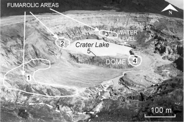 |
Figure 69. The active crater at Poás viewed from the S. Numbers 1-5 correspond to areas with fumaroles active during February 1998; a sixth area, located N of the dome (on the side away from the view, not labeled), became active in April 1998. Courtesy of M. Fernandez. |
Area 1, the fumarolic field located at the crater's S end, became active in May 1995 and remained comparatively stable thermally until at least March. During 1997-early 1998, the field extended S, SW, and W within the larger crater. During February 1998, the area's average temperature remained constant at ~92°C; during April, it attained 93°C. Steam and high concentrations of SO2 and Cl gas escaped from the fumaroles; sulfur crystals were deposited around the vents. Mora noted that in the time since the fumaroles appeared, hydrothermal alteration became more rapid and reduced competency of the rock, leading up to two landslides in the area.
In area 2, the field W of the crater lake, a large landslide occurred during February. It took place at a spot where hydrothermal alteration resulted from three fumaroles that sent white gas plumes dominantly toward the SW. More fumaroles sprung up in this field during April.
In area 3, the field at the lake's N end, new fumaroles appeared during roughly the second half of 1997. These continued without important changes through April 1998; their emissions were white and not very vigorous.
In area 4, a field on the dome's E slope, small fumaroles produced white plumes. The emissions were not vigorous but their average February-April temperatures were 92-93°C. Some new fumaroles noted in this area during April had temperatures averaging 93°C.
In areas 5 and 6, fields located respectively on the dome's E and N slopes, vigorous fumaroles gave off mainly white plumes. During April, area 5 plumes had temperatures of 92°C and ascended to tens of meters before dispersing. Area 6, which became active in April, gave off plumes that covered the nearby slope with sulfur deposits.
OVSICORI-UNA reported that the pyroclastic cone in the crater discharged a plume that during January rose 400 m above the crater rim. They also noted that during February the rain collection network located around the active crater yielded samples with increased acidity. During this same month, residents 5.5 km SE of the crater reported occasional sulfur odors.
Seismic data from an OVSICORI-UNA station 2.7 km SW of the active crater revealed a noticeable rise in the duration of tremor during February and March 1998. Tremor generally occurred in discontinuous episodes, although one episode on 21 February carried on for 2.5 hours. Also, an anomalously large number of low-frequency earthquakes took place during February 1998 (figure 70)—a count of this magnitude was last seen in January 1996. In contrast, medium and high frequency earthquakes were not particularly abundant in February or March 1998 (figure 70). Many of the low-frequency earthquakes were attributed to continuous degassing.
 |
Figure 70. Seismicity at Poás during January 1997-March 1998. Number of low-frequency earthquakes and hours of tremor (top); number of high- and medium-frequency earthquakes (bottom). Note that the scales are different. Courtesy of OVSICORI-UNA. |
Information Contacts: E. Fernandez, V. Barboza, R. Van der Laat, R. Saenz, E. Duarte, E. Malavassi, T. Marino, M. Martinez, and E. Hernandez, Observatorio Vulcanologico y Sismologico de Costa Rica, Universidad Nacional (OVSICORI-UNA), Apartado 86-3000, Heredia, Costa Rica; Mauricio Mora Fernandez, Sección de Sismologia, Vulcanologia y Exploración Geofisica, Escuela Centroamericana de Geología, Universidad de Costa Rica, P.O. Box 35-2060, San José, Costa Rica.
Gas plumes to 500 m high; modest seismicity during March-May
As in the recent past, fumaroles remained active during April-June. Temperatures in the active turquoise-green-colored lake measured 36-37°C, continuing near the low for a 6-year period.
Temperatures measured at the accessible part of the pyroclastic cone remained at 94°C during April-June. These fumaroles provided the main sources of degassing, and noise from escaping gases was audible at the overlook (Mirador). Also, during April-June, the temperatures of weak fumaroles on the S and SW crater walls were 93-94°C. Some new points of weak fumarolic emission appeared during April on the cone's upper NE wall; other weak fumaroles with temperatures of 93°C appeared during May on the lake's N terrace. During June, at a crack in this terrace new fumaroles developed, as they also did on the pyroclastic cone, appearing at the same time that several high- and medium-frequency earthquakes took place.
During April-June gas plumes rose 400-500 m above the crater floor; winds predominantly towards the W and SW flanks occasionally also carried strong, irritating sulfurous odors over the S flank where they were noted by tourists and park rangers.
In the May OVSICORI-UNA report, attention was called to continued bubbling along the lake's S and SW shorelines, a process referred to in earlier reports. Also noted was mass wasting of a terraced area towards the crater lake. During June an upper portion of the pyroclastic cone continued cracking and collapsing into the crater lake.
Although both the earthquake counts and tremor durations for March-May were generally moderate to low, the tremor duration was significant because it had remained absent for all but one month in 1997 (November, when it prevailed for 22 hours). In comparison, looking at 1998 tremor durations for January through June, tremor prevailed for between 0.46 and 55 hours, but during each of the latter 3 months it occurred forBGVN23:03).
Table 8. Poás earthquakes and tremor registered at station POA2 (2.7 km SW of the active crater), April-June 1998. Courtesy of OVSICORI-UNA.
| Month | Seismic events | Tremor hours |
| Apr 1998 | 1,057 | 1.2 |
| May 1998 | 501 | 0.46 |
| Jun 1998 | 724 | 2.5 |
Information Contacts: E. Fernandez, V. Barboza, E. Duarte, R. Saenz, E. Malavassi, M. Martinez, and Rodolfo Van der Laat, Observatorio Vulcanologico y Sismologico de Costa Rica, Universidad Nacional (OVSICORI-UNA), Apartado 86-3000, Heredia, Costa Rica.
Noisy degassing continues
During July, the turquoise-green crater lake at Poás had a temperature of 34°C. This temperature is close to those of the recent past, although during 1993-98 the lake's temperature varied significantly, from 25°C to 70°C. Between February and July 1998 the crater lake's surface dropped 1.6 m. As late as 30 July the lake's volume was 1.3 x 10⁶ m3. Gases noisily escaping from the pyroclastic cone (the dominant fumarolic area), formed columns reaching 500 and 600 m in height. Fumaroles on the S flank had measured temperatures of 92°C; those on the N terrace, 93°C; and those on the lake's S and SW shores, up to 94°C.
Changes in pH, Cl, and SO4 have been measured during the past 5 years. During 1993-94 the active crater lake's pH values were near 0; during 1996 they shifted upwards, and since then pH values have remained between 1 and 2. As recently as July 1998, the trends in pH, Cl, and SO4 have remained relatively consistent and followed the moderately constrained paths established during the past several years.
Since last reported on (BGVN 23:03), seismicity decreased several-fold. February established the monthly high for 1998 for both low- and medium-frequency earthquakes (2,718 and 75 events, respectively) and tremor duration (55 hours). During June and July, respectively, low-frequency earthquakes occurred 704 and 861 times; medium-frequency earthquakes took place seven times and one time; and tremor lasted for 2 and 3.5 hours.
Information Contacts: E. Fernández, V. Barboza, M. Martinez, E. Duarte, R. Van der Laat, E. Hernández, and T. Marino, Observatorio Vulcanologico y Sismologico de Costa Rica, Universidad Nacional (OVSICORI-UNA).
Relative seismic quiet; fumarole in the N crater remains active
This report covers late 1998 through March 1999. During this time, the terrace SE of the active crater lake continued to slide. The active crater lake, the northernmost of the two summit lakes, remained sky-blue to green-turquoise in color. The pyroclastic cone within the active crater remained the principal source of fumarolic outgassing, sometimes giving off plumes that rose 500 m and during November occasionally reaching 500-600 m. OVSICORI-UNA noted that fumaroles alongside the cone typically had temperatures up to 93°C. They found identical maximum temperatures at fumaroles along the crater walls and on the terrace N of the active crater lake. However, in September 1998, Wendy Perez Fernandez reported hotter temperatures (elevated by 19°C) and greater than usual fumarolic vigor.
Seismicity during January 1998-March 1999 was dominated on the OVSICORI-UNA system by low-frequency events. They occurred in largest number during early 1998 with the highest number recorded (during February 1998) consisting of 2,718 events. A substantial decrease in low-frequency events occurred during late 1998 and early 1999 with the lowest number recorded (during January 1999) consisting of 381 events. Tremor duration followed roughly similar patterns: the maxima (during February 1998) consisted of 55 hours. Tremor was absent for the four months after November 1998.
Scientists measured the comparatively clear waters of the southernmost, less-active lake (Laguna Botos). During January 1995 through 21 September 1998 they recorded rises in both temperature (from ~14°C in 1995 to ~28°C in 1998) and pH (from ~4 in 1995 to ~6 in 1998). Sulfate ion, although highly variable, also tended to climb during the four-year interval. Chloride ion concentrations decreased (from ~4 down to ~1 ppm).
Information Contacts: E. Fernández, V. Barboza, M. Martinez, E. Duarte, R. Sáenz, E. Malavassi, R. Van der Laat, E. Hernández, and T. Marino, Observatorio Vulcanologico y Sismologico de Costa Rica, Universidad Nacional (OVSICORI-UNA).
Strong drop in tremor duration and mid-frequency earthquakes in early 1998
Seismicity registered at station POA2, located 2.8 km SW of the active crater, has declined since early 1998 (figures 71 and 72). Since then, gas columns continued to reach altitudes between 500 and 600 m above the floor of the crater as they had during the interval of greater seismicity. The pyroclastic cone remained the focus of fumarolic activity. The crater's W, E, and SE walls continued to slip into the lake. The lake maintained a constant bubbling on its S and SE edges. The active lake's color varied considerably; for example, at various times during April 1999, the ~32°C lake water appeared green, turquoise, or light blue. In November 1998, the lake appeared greenish turquoise and had a temperature of 29°C.
 |
Figure 71. Low-frequency earthquakes at Poás each month during January 1998-May 1999. Courtesy of OVSICORI-UNA. |
 |
Figure 72. Monthly earthquakes of medium- and high-frequency (number of events on y-axis scale) at Poás and the tremor duration (in hours on y-axis scale). The plot covers the interval January 1998-February 1999. Courtesy of OVSICORI-UNA. |
Information Contacts: E. Fernandez, V. Barboza, E. Duarte, R. Saenz, E. Malavassi, M. Martinez, and R. Van der Laat, T. Marino, and E. Hernandez, Observatorio Vulcanologico y Sismologico de Costa Rica, Universidad Nacional (OVSICORI-UNA), Apartado 86-3000, Heredia, Costa Rica; Wendy Perez Fernandez, Seccion de Seismologia, Vulcanologia y Exploracion Geofisica, Escuela Centroamericana de Geologia, Universidad de Costa Rica, POB 35-2060, San Jose, Costa Rica.
Conspicuous plumes and abundant low-frequency earthquakes in late 1999
Comparative quiet continued at Poás; however, in addition to the fumarolic degassing often seen, seismicity was relatively high during the reporting period, June 1999-January 2000, when low-frequency earthquakes typically registered over 4,000 times per month (table 9). For comparison, a relative high in 1999 occurred in May when low-frequency events occurred ~1,400 times, and during a high in January 1998, when there were over 2,500 events. On 18 July 1999 an MR 3.1 earthquake occurred with 6 km focal depth and an epicenter 5 km NW of the active crater.
Table 9. A summary of seismic, temperature, and lake height data for Poás during July 1999-January 2000. Lake heights are with respect to the previous month and positive upwards (rising lake levels). The stated temperature for the pyroclastic cone's degassing refers to the value at an accessible point where the measurements are taken regularly. The seismic station POA2 lies 2.8 km SW of the active crater. "NR" indicates information absent and not reported. Courtesy of OVSICORI-UNA.
| Month | Low-frequency earthquakes | Mid-frequency earthquakes | Total earthquakes | Crater lake temperature | Surface elevation change of crater lake |
| Jun 1999 | 2,571 | -- | -- | -- | -- |
| Jul 1999 | 2,996 | 64 | 3,061 | 32°C | -47 cm |
| Aug 1999 | 4,548 | 184 | 4,736 | 37°C | -32 cm |
| Sep 1999 | 5,264 | 274 | 5,542 | 40°C | -- |
| Oct 1999 | 4,743 | 190 | 4,987 | 38°C | -- |
| Nov 1999 | 4,142 | 221 | 4,393 | 33°C | 101 cm |
| Dec 1999 | 4,278 | 405 | 4,679 | 35°C | 156 cm |
| Jan 2000 | -- | -- | low | 40°C | ~140 cm |
Tremor, which was seldom reported in 1999, took place for less than about 0.5 hours a day during October-November 1999. In contrast, tremor averaged only 0.1 hours a day during December 1999. In contrast, tremor durations of 20 to 70 hours were common in early 1998. Also appearing in the month of October 1999 were 5 unusual low-frequency events in conjunction with tremor; these low-frequency earthquakes had periods of 40-175 seconds.
During August -October, the pyroclastic cone's degassing led to unusually high plumes reaching 0.7 to 2 km above the crater floor. December plume heights ranged between 0.7 and 1 km. Some of the hottest temperatures were measured near the pyroclastic cone: up to 95°C during December-January and often over 92°C when reported during other months in late 1999.
Information Contacts: E. Fernandez, E. Duarte, V. Barboza, R. Sáenz, E. Malavassi, R. Van der Laat, T. Marino, J. Barquero, and E. Hernández, Observatorio Vulcanologico y Sismologico de Costa Rica, Universidad Nacional (OVSICORI-UNA), Apartado 86-3000, Heredia, Costa Rica.
Fumarolic activity and increased seismicity during January-June 2000
The crater lake at Poás continued to bubble during January-June 2000, but activity remained chiefly either fumarolic (related to mass wasting) or seismic. Station POA2, located 2.8 km SW of the active crater, recorded the monthly seismic activity.
During January, the W flank of the volcano continued to slide toward the lake, and part of the terrace also continued collapsing toward the lake. Water in the prominent pyroclastic cone located in the crater's central area had a temperature of 95°C. Major pressure release and gas emission occurred in the N part of the cone. The fumaroles of the SSW crater flank disappeared, while those to the W remained with a temperature of 89°C. The fumaroles of the NNE terrace were at 94°C, depositing sulfur and emitting relatively small amounts of gas. New fumaroles on the crater floor had temperatures of 40 and 85°C.
The majority of fumaroles on the SSW flank disappeared in February. The upper part of the cone continued to crack and new fumaroles appeared with characteristic sulfur deposits. In February their temperatures were approximately 95°C, and on 16 March another measurement indicated heating up to 188°C. The thermal feature of the E flank had a temperature of 66°C and the feature on the NE flank was 89°C. The fumarolic activity on the NNE terrace remained at the same temperature and activity level.
In March the lake remained a turquoise color with particles of sulfur on the surface. Lake temperature was in the range of 35-41°C. At the end of March bubbling in the central part of the lake recommenced. The SE and E terrace continued collapsing toward the lake, as did the NNE flank of the pyroclastic cone. From that cone gas columns rose to 700 m over the point of origin and were carried by winds toward the W and SW flank.
In April the SSW edge and the central part of the crater lake continued to bubble. Small landslides traveled down the W flank toward the lake and there were fumaroles with low gas emission. The fumaroles on the NE and SSW flanks of the cone disappeared. The fumaroles concentrated on the NNE flank of the cone produced columns of gas that reached 500 m and blew W and SE. The E-flank fumaroles maintained a temperature of 95°C. Medium and high frequency earthquakes continued, and new fumaroles appeared inside of the main crater and the pyroclastic cone.
In May bubbling continued on the SSE border and in the central part of the crater lake. Bubbling occurred and a temperature of 40°C was measured on the NE shore of the lake at various points. A fumarole appeared on the NE side of the lake with minimal gas emission. The W flank of the cone continued to produce slides toward the lake. The E and SE terrace continued to collapse inwardly, as did as the NE flank of the pyroclastic cone. The NE-flank fumaroles released a moderate level of gas emissions. Points of major pressure release on the NNE flank continued to produce gas columns that reached altitudes up to 700 m over the crater floor and were carried by winds toward the W and SE. On the NE terrace new fumaroles appeared with low gas emission and sulfur deposition. The fumaroles of the NNE terrace maintained a temperature of 94°C with a level of emission that increased gradually. The back of the active crater continued to gradually inflate, while EDM lines of leveling and the dry inclinometers of the S flank did not show significant deformational changes. During 9 and 14 May, three earthquakes occurred ~6 km SW of the active crater with Richter magnitudes of 2.2 - 3.2 and depths of 1- 3 km. The increase in seismicity (table 10) during May 2000 coincided with the appearance of new fumaroles and high levels of emission from them.
Table 10. Summary of earthquakes at Poás during January to June 2000. Courtesy of OVSICORI-UNA.
| Month | Low-frequency | Mid-frequency | Volcano-tectonic | Total |
| Jan 2000 | -- | -- | -- | -- |
| Feb 2000 | 3,282 | 151 | -- | 3,437 |
| Mar 2000 | 8,235 | 438 | -- | 8,698 |
| Apr 2000 | 280 (daily) | 594 | -- | 8,491 |
| May 2000 | 339 (daily) | 872 | 27 | 11,448 |
| Jun 2000 | 9,365 | 428 | 11 | 9,817 |
During June the SSE, NE, and central surfaces of the crater lake bubbled. The SE and NE terraces continued to collapse toward the lake as did the NNE flank of the pyroclastic cone. At the cone columns of gases reached altitudes up to 600 m, and were carried by winds toward the W and SW. On 28 June an earthquake of M 4.0 occurred 100 km beneath the volcano. The earthquake was felt in the Central Valley and Puntarenas 50 km to the SW.
Information Contacts: Observatorio Vulcanologico y Sismologico de Costa Rica, Universidad Nacional (OVSICORI-UNA), Apartado 86-3000, Heredia, Costa Rica.
Fluctuating water level in crater lake; variable fumarole activity
During July 2000 through August 2001, the level of the crater lake fluctuated ten's of centimeters. The color of the lake was generally blue, with sulfur particles floating on the surface. The crater-lake temperature varied between 24 and 35°C. Bubbling continued in the S, SW, NE, and central parts of the lake. A convection cell was observed in the central part of the lake during August-October 2000. During the reporting interval, the following areas showed movement toward the crater lake; the W wall, E, NW, and SW terrace, and NE, N, and NW sides of the pyroclastic cone.
Most fumarolic activity was concentrated in the pyroclastic cone area, with gas columns reaching heights of 300-500 m on the crater floor and blowing chiefly towards the W and SW flanks during July through May 2001. During May 2001, the points of greater gas pressure were in the N wall of the dome. During July 2001, a fumarole appeared in the NE wall with sulfur deposition.
Temperatures of fumaroles ranged between 87 and 111°C, and the typically reported-on access points were 92-94°C. During September 2000, relatively new fumaroles at the NE terrace (94°C) continued to deposit sulfurous sublimates that began accumulating during the previous month. During March 2001 fumarolic activity remained vigorous in the dome and towards the NE and E on the foot of the walls. Thermal sources of these fumaroles were 92-94°C. During May 2001, new fumaroles continued to appear on the floor and the E and NE walls, with sulfur deposition and increasing gas emissions. During May 2001, the fumarole of the N terrace had a temperature of 110°C. During June 2001, vigorous steaming from fumaroles in the area of the lake formed some plumes 100 m tall.
On 28 June, an M 4 earthquake registered by instruments in the Central Valley and Puntarenas area was centered 100 km beneath the volcano. The earthquake was attributed to regional subduction tectonics, but influenced the volcano's seismic and fumarolic activity. On 29 August an M 3 earthquake was registered at a depth of 5.5 km and located 1.7 km SW of the active crater.
The geodetic network lacked significant evidence of deformation during July-August 2000. The 35 hours of low-frequency tremor registered during March 2001 mainly occurred during 1-3 March. These medium and high frequency earthquakes continued to be associated with the appearance of new fumaroles within the main crater and the pyroclastic cone. A summary of earthquakes at Poás during July 2000 to August 2001 is shown in table 11.
Table 11. Summary of seismicity at Poás during July 2000 to August 2001. All columns represent cumulative monthly totals except for the first data column, which shows daily averages of reported low-frequency earthquakes (the predominant type registered). In cases where the seismometer failed to work for a portion of a month, the monthly sum was scaled up and presented assuming the rate of generated events remained constant. Missing months indicate that no data were available. LF indicates low-frequency earthquakes. Paired AB-type earthquakes arrived closely spaced in time. Courtesy of OVSICORI-UNA.
| Month | Daily average LF earthquakes (1.5-2.3 Hz) | AB-type (medium frequency) | AB-type double events | Tremor duration | VT | Monthly total |
| Jul 2000 | 163 | 77 | 2 | 32 minutes | 7 | 5,146 |
| Aug 2000 | 210 | 27 | 242 | 120 minutes | 55 | 6,880 |
| Sep 2000 | 300 | 371 | 21 | 73 minutes | 20 | 9,427 |
| Mar 2001 | 239 | 319 | -- | 35 hours | 2 | 7,742 |
| May 2001 | 277 | 530 | 13 | 7 hours | 41 | 9,154 |
| Jul 2001 | 230 | 238 | -- | -- | -- | 7,390 |
| Aug 2001 | 166 | 128 | -- | -- | -- | 5,286 |
During July and August 2001 modest portions of the crater wall were unstable. During August the collapse of a portion of the E wall mobilized an unusual amount of material towards the bottom of the crater (figure 73). The collapse has been associated with the cracks and permanent fumarolic action weakening the E part of the crater.
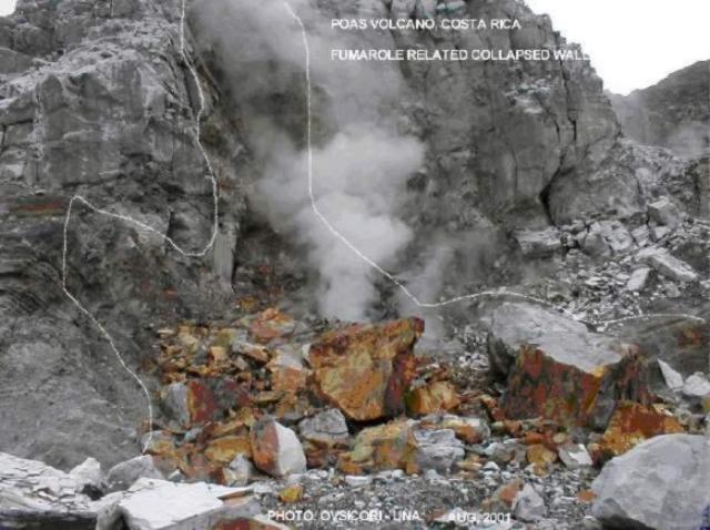 |
Figure 73. Photo of a collapsed portion of the E wall at Poás, August 2001. Lines show where the rock detached from the sub-vertical wall and where the loosened rock came to rest. The affected part of the wall was cracked and fumarolically altered. Courtesy OVSICORI-UNA. |
General References. Casertano, L., Borgia, A., Cigolini, C., Morales, L.D., Montero, W., Gómez, M., and Fernández, J.F., 1985, Investigaciones geofísicas y caracteristicas geoquímicas de las aguas hidrotermales: Volcán Poás, Costa Rica: Geofísica Internacional, v. 24, p. 315-332.
Prosser, J., 1985, Geology and medium-term temporal magmatic variation found at the summit region of Poás volcano, Costa Rica: Boletín de Vulcanología, n. 15, p. 21-39.
Information Contacts: Observatorio Vulcanologico y Sismologico de Costa Rica, Universidad Nacional (OVSICORI-UNA), Apartado 86-3000, Heredia, Costa Rica.
Hydrothermally active repose continues through 2002
This report concerns Poás during the interval September 2001 through December 2002. It draws on both a set of extensive half-year reports from UCR-ICE (Mora, 2001a, b; 2002) and monthly OVSICORI-UNA reports (available on the web, and sometimes prepared with co-authors Orlando Vaselli and Franco Tassi). OVSICORI-UNA reports were absent for November and December 2001.
Poás was non-eruptive during the reporting interval. The key focus of activity remains the main crater and its fumaroles, and its low-pH, variably colored lake. That lake is sometimes called Laguna Caliente or el Poás, but more frequently in past issues of the Bulletin simply described with terms like the active lake, lake in the active crater, hot lake, etc. During the reporting interval the active lake repeatedly changed pH, color, and temperature. As in the past, Laguna Caliente contained some thermally active zones, sometimes displaying up-welling water, bubbles, and zones of native sulfur. Lake Botos lies in a crater S of the active one. It remained inactive.
The origin and terminology for the main crater's dome or pyroclastic cone remains controversial; both terms are used in this report, congruent with those favored by the authors of summarized reports and included photos. Whatever its name or origin, this feature supports especially active fumaroles, and is frequently masked by steam.
Observers at the crater noted acoustical noise from vigorous degassing. Again, as typical, monthly reports consistently mentioned variable secondary fumarolic activity and occasional mass-wasting along the crater walls. Seismicity, including tremor, continued and is mentioned below, but it will be discussed more comprehensively in a later report.
UCR-ICE observations. Mora (2001b and 2002) included an overview photo of Poás (figure 74). Those reports also included numerous other photos of fumaroles and mass wasting, most of which are not shown here. Some pronounced arcuate cracks associated with mass wasting along the NE side of the lake were thought possibly related to changes in lake level and pore pressure (figure 75). A shot of the steaming dome appears as figure 76.
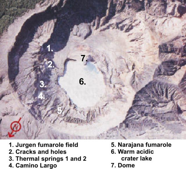 |
Figure 74. A vertical or sub-vertical aerial photo taken of the summit at Poás, with N toward the bottom left. Numbers on the photo refer to locations named on the key. As an approximate scale, the lake is ~ 200-300 m in diameter. This was taken from figures in Mora (2001a and b, and 2002) that had several other photos around the margin. Construction lines originally across this photo have been removed here, with some resulting loss and local misrepresentation of what must have been present on the original photo. Courtesy of UCR-ICE (after Mora 2001b and 2002). |
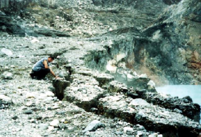 |
Figure 75. Laguna Caliente, the hot lake at Poás (lower right) lies within a crater bounded by unstable cliffs. This photo shows part of the lake's NE margin. The person in this scene stands on a substantial though eroding terrace and inspects arcuate cracks (circumferential faults) in unstable material along the crater rim. Some of these cracks reached 40 cm wide. Landslide deposits from failures along this and other cliff faces were mentioned frequently in reports. Courtesy of UCR-ICE (from Mora 2001a). |
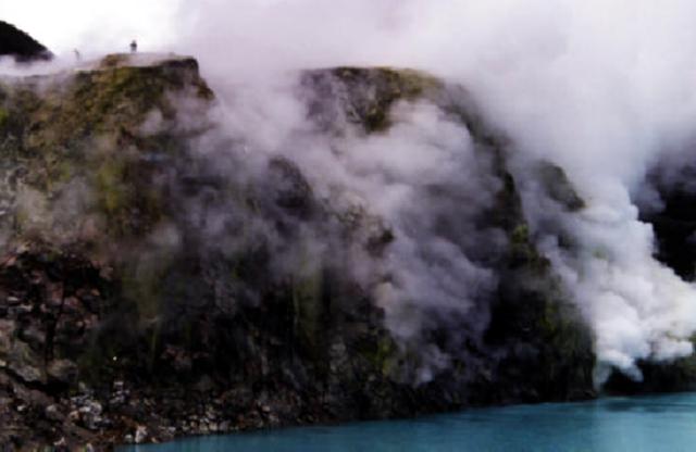 |
Figure 76. The N face of the dome (or pyroclastic cone) at Poás rises from the lake and supports strong fumaroles. This photo was taken looking S. Scientists partially visible atop the dome were walking to fumaroles where they measured gas temperatures and pH. Courtesy of UCR-ICE (from Mora, 2001). |
Mora (2001a, b and 2002) collected and presented considerable data on Laguna Caliente, and we include several available plots. Lake temperature and pH during 2001-2 appears as figure 77; precipitation and lake level for most of 2002, as figure 78.
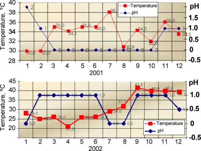 |
Figure 77. For Laguna Caliente at Poás, plots showing temperature and pH versus month during (top) 2001 and (bottom) 2002. The various scales are unequal. The two-year peak temperature measured 41.5°C in September 2002. The lowest pH measured ~ 0 during March-October 2001 and during January, July, and August 2002. (After Mora, 2001b and 2002). |
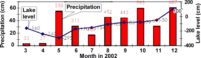 |
Figure 78. For Laguna Caliente at Poás, a plot showing precipitation and lake-surface level versus month during March-December 2002. The location where the precipitation measurements were taken was unstated. Values shown on the plot are in millimeters (After Mora, 2002). |
Mora (2002) reported March-December 2002 precipitation ranging from 33 to 607 mm per month (figure 78). The lake's variable surface heights during March-December 2002 deviated from an established (arbitrary) datum (zero point), from which heights ranged from ~ 400 mm below the datum to ~ 100 mm above it. During this interval the lake's high stand occurred in December; it then covered the border of the lowest N terrace. The lowest stand for the interval occurred during May. During this time interval the variables of precipitation and lake height appeared to lack consistent correlation.
OVSICORI-UNA observations. During late 2001 and through 2002, low-frequency earthquakes continued to dominate the record, with OVSICORI-UNA reporting ~ 500 events per day on 8 September, but more typically 100-300 events per day. In addition during this interval instruments typically recorded several hours of tremor per month. During some months of the reporting interval, medium- and high-frequency earthquakes continued to occur in conjunction with new fumaroles appearing in the active crater.
The OVSICORI-UNA report discussing September 2002 noted that tremor rose slightly, prevailing for ~ 5 hours on each of several days. Long-period earthquakes numbered more than 100 per day, and typically 300-450 per day. Medium-frequency earthquakes occurred much less often, their numbers approaching ~ 20 per day on several days, and more typically fewer than 10 per day.
During the last half of 2002 the lake's water temperature rose above 30°C, attaining 39°C during September-December 2002. Lowered air temperatures in late 2002, particularly in November 2002, led to condensate forming over the lake's surface and rising to accumulate in larger, optically dense clouds (figure 79).
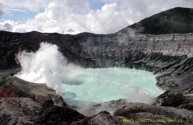 |
Figure 79. Conspicuous condensate hung over the active crater lake at Poás during late 2002. The condensate stemmed from warm lake temperatures (~ 39°C) combined with cooler ambient air temperatures. At the time of this photo (November 2002) the lake was light green in color. Courtesy of OVSICORI-UNA. |
References. Mora, R., 2002, Informe anual de la actividad de la Cordillera Volcánica Central, 2002, Costa Rica (proofed and revised by Alvarado, G., Fernández, M., Mora, M., Paniagua S., and Ramírez, C.): Universidad de Costa Rica, Red Sismológica Nacional, UCR-ICE, Sección de Sismología, Vulcanologíay Exploración Geofísica (published June 2003 as mini-CD Rom with PDF files).
Mora, R., 2001a, Informe semestral de la actividad de la Cordillera Volcánica Central, Enero-Junio 2001, Costa Rica: Universidad de Costa Rica, Red Sismológica Nacional, UCR-ICE, Sección de Sismología, Vulcanologíay Exploración Geofísica (published November 2001 as mini-CD Rom with PDF files).
Mora, R., 2001b, Informe semestral de la actividad de la Cordillera Volcánica Central, Julio-Diciembre 2001, Costa Rica (proofed and revised by Alvarado, G., Fernández, M., Montero, W., and Ramírez, C.): Universidad de Costa Rica, Red Sismológica Nacional, UCR-ICE, Sección de Sismología, Vulcanologíay Exploración Geofísica (published 6 May 2001 as mini-CD Rom with PDF files).
Information Contacts: R. Mora (Amador), C. Ramírez, and M. Fernández, Universidad de Costa Rica, Laboratorio de Sismologia, Vulcanología y Exploración Geofisica, Aptdo. 560-2300, Curridabat, San José, Costa Rica; E. Fernández, E. Duarte, E. Malavassi, R. Sáenz, V. Barboza, R. Van der Laat, T. Marino, E. Hernández, and F. Chavarría, Observatorio Vulcanológico y Sismológico de Costa Rica (OVSICORI-UNA); Jorge Barquero and Wendy Sáenz, Laboratorio de Química de la Atmósfera (LAQAT), Depto. de Química, Universidad Nacional, Heredia, Costa Rica; María Martínez (at both affiliations above); Orlando Vaselli and Franco Tassi, Department of Earth Sciences, University of Florence, Via La Pira 4, 50121 Florence, Italy.
Small phreatic eruption on 24 March 2006, the first since 1994
Poás was last reported on in BGVN 28:09, covering the period from September 2001 to December 2002. The focus of activity at Poás during that time was the main crater and its fumaroles, and its low-pH, variably colored lake.
A field team from Observatorio Vulcanológico y Sismológico de Costa Rica, Universidad Nacional (OVSICORI-UNA) visited Poás on 25 January 2006 and found that the level of the volcano's hot acidic crater lake had risen in comparison to the previous month. Sustained rainfall during the previous months caused the water level to rise by ~ 4 m. The area of the lake increased by ~ 20%. Flooding occurred in relatively flat areas to the N, E, and SE. The shoreline extended about 150 m toward the SE. Scattered fumaroles and hot spots at the N base of the lava dome were flooded. Increased steaming was visible from the National Park. The average lake temperature remained at 22°C, with hot spots near the rim reaching up to 80°C. OVSICORI-UNA staff noted that in the past an increase in lake level during a rainy period has been followed by a decrease during the drier months of February to April.
On 24 March 2006 around noon, the first eruptions since 1994 began at Poás. The small, phreatic eruptions originated from the bottom of the volcano's Caliente Lake and dispersed mud, gas, and acid rain toward the S and SW parts of the crater. Witnesses described a sudden emission of water and sediments S of the lake. Roaring was heard in a nearby tourist area and weak earthquakes were felt. The strongest eruption occurred on the night of 24 March, when ejected volcanic material reached 200 m high and acid rain showered park headquarters, located 800 m S of the crater. During 25 March at least 8 eruptions took place. Due to the likelihood of more explosions the local National Emergencies Agency temporarily closed the park.
OVSICORI-UNA staff visited the E side of the volcano on 25 March and confirmed that water, blocks, and sediments from the bottom of the lake had been ejected. Several dozens of impact craters were seen with diameters between 15 and 60 cm, extending E as far as 700 m (figure 80). During 22-27 March, harmonic tremor was recorded. On the 27th, there was a reduction in seismicity and it returned to normal levels. No deformation was measured at the volcano. A news article reported that the area around the volcano was closed to visitors.
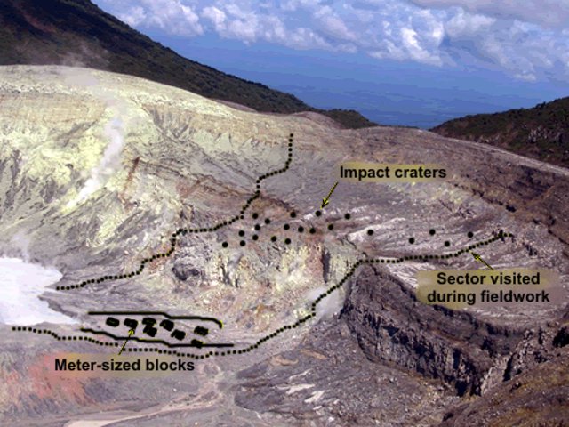 |
Figure 80. Photo of the E side of Poás, annotated with observations made by OVSICORI-UNA staff. Impact craters ranged in size from a few cm to 70 cm; blocks ranged from a few cm to 50 cm and were scattered randomly over the area investigated. Blocks of fine-grained lake sediments were also observed and collected. The material collected was interpreted as pre-existent solid material from the bottom of the lake that has been heavily altered by the action of hot acidic fluids during the last 12 years. Photo courtesy of Eliecer Duarte Gonzalez, OVSICORI-UNA. |
Following the eruptions that began on 24 March, seismicity at Poás decreased by 27 March and harmonic tremor that was recorded during the heightened activity ceased.
On 1 April 2006, OVSICORI-UNA staff visited Caliente Lake and its surroundings. During this visit the widening of the lake perimeter was confirmed as well as the emplacement of lake sediments and pre-existent blocks from both the bottom of the lake and its walls. Fracturing of the dome's N wall was also confirmed. The lake temperature was 54°C, with a pH of 0.63. The water was light gray due to the great quantity of suspended sediments. The park surrounding the volcano was reopened on 1 April.
Information Contacts: Eliecer Duarte Gonzalez, Observatorio Vulcanológico y Sismológico de Costa Rica, Universidad Nacional (OVSICORI-UNA), Apartado 86-3000, Heredia, Costa Rica. (URL: http://www.ovsicori.una.ac.cr/); Rafael Barquero, Red Sismiológica Nacional, Sección de Sismología, Vulcanología y Exploración Geofisica, Escuela Centroamericana de Geología, Universidad de Costa Rica, Aptdo. 560-2300, Curridabat, San José, Costa Rica.
Minor phreatic eruptions on 25-26 September 2006
At least two phreatic eruptions took place at the crater lake in the main crater at Poás volcano on 25-26 September 2006. Prior to the eruption, the warm hyper-acid crater lake (figure 81 (A)) was a weak turquoise color. It later turned milky gray.
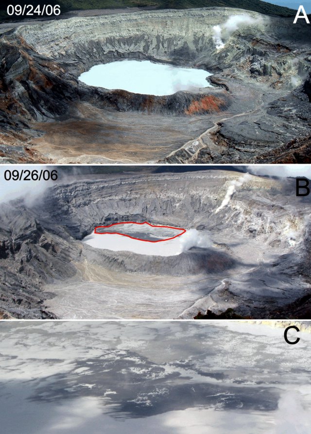 |
Figure 81. Three photos depicting changes in the active crater at Poás during late September 2006. A) The scene looking into the crater on 24 September. B) The deposit left by the minor, subaqueous events of 26 September, which left a raft of scum floating on the lake's surface. C) A closer look at the material left floating on the lake after the minor eruption on the 26th. Courtesy of Red Sismologica Nacional (RSN: UCR-ICE). |
The first eruption, during the night of 25 September, sent material to a height of at least 350 m above the crater lake. It deposited hydrothermally altered rock fragments, mud, and water in the S sector of the inner crater and outside the W part of the crater. Mud was found deposited ~ 500 m from the main crater. Sulfur chunks up to 35 cm in diameter and rock, including old pieces of andesite, failed to travel father than the confines of the crater. Ash erupted the night of 25 September reached ~ 10 km SW (to Trojas de Sarchí).
Observers noted another, smaller, minor eruption at 1038 on 26 September. That eruption had effects limited to the area of the crater lake (figure 81 (B)), where it formed spots of black and green-yellow mud and sulfur spread across a zone up to 75 m long. The process was interpreted to correspond with material coming from subaquatic pools of molten sulfur rising to the lake surface (figure 81 (C)).
A visit into the crater on the 27th determined the lake temperature and pH, 45°C and 0, respectively. The visitors also measured the temperatures of fumaroles ( > 95°C) and an orange fumarole, over 200°C. Samples of lake water and erupted mud were obtained.
Information Contacts: Raul Mora and Carlos Ramírez, Red Sismologica Nacional (RSN: UCR-ICE); Universidad de Costa Rica, Escuela Centroamericana de Geología, Instituto Costarricense de Electricidad, Apto 35-2060, Ciudad Universitaria Rodrigo Facio, San José, Costa Rica (URL: http://rsn.ucr.ac.cr/).
Additional information on eruption of 25-26 September 2006
Minor phreatic eruptions occurred during 25-26 September 2006 (BGVN 31:08). This report provides more information compiled by the Observatorio Vulcanologico y Sismologico de Costa Rica-Universidad Nacional (OVSICORI-UNA). At the beginning of September, the level of the lake had dropped 5 cm from that of early August, it was light gray in color with sulfur particles floating on the surface, and the temperature was 41° C. On 21 September, the lake had a milky, light blue color.
On 25 September at 2148, seismic station POA2 (2.7 km SW of the active crater) registered a high-frequency signal. The phreatic event that caused the signal ejected a column of fine materials (lake sediments) that were blown SW to a distance of 12 km from the crater. Afterwards the lake color was a darker gray with dark particles floating on the surface; the temperature was 46°C.
New points of fumarolic activity appeared in the SE and NE walls and in the floor of the crater with deposition of sulfur and gas discharge. The temperatures in these areas fluctuated between 90 and 108°C, with gas columns that reached the edge of the crater. Existing cracks in the crater terrace and the NE edge of the crater continued to widen with gas discharge and sulfur-rich sublimate deposition.
Information Contacts: Observatorio Vulcanologico Sismologica de Costa Rica-Universidad Nacional (OVSICORI-UNA), Apartado 86-3000, Heredia, Costa Rica. (URL: http://www.ovsicori.una.ac.cr/).
Many fumaroles active; small phreatic emission from crater lake in December 2006
The last Bulletin report on Poás provided information on the phreatic eruption on 25-26 September 2006 (BGVN 32:07). This report discusses continuing hydrothermal variations and one minor phreatic eruption (to 30 m above the crater lake) during October 2006 through September 2007. The pyroclastic cone continued fumarolic activity issuing columns of gases that reached 300 to 400 m above the crater. Information for this report were provided by the Observatorio Vulcanologico y Sismologico de Costa Rica-Universidad Nacional (OVSICORI-UNA).
Crater lake. During the period October 2006 through September 2007, Laguna Caliente the active crater lake of Poás volcano, displayed a greenish-gray color with convection cells in the center and temperatures ranging from 41 to 58 °C. As depicted in table 12, between 5 and 12 October 2006, the temperature and level of the lake increased suddenly suggesting a greater heat flow into the lake. By late October, the temperature decreased slightly and the level of the lake began to fall. Overall, the lake level fell 6.45 m from September 2006 through August 2007, and then stabilized. Often gases originating from the bottom of the lake produced a ring of dark gray material 80 m in diameter floating at the center of the lake. In the NE wall at the lake level, fumaroles produced yellowish particles that floated on the lake.
Table 12. For Poás, the temperature of Laguna Caliente and changes in lake level from September 2006 through September 2007. Courtesy OVSICORI-UNA.
| Date | Lake temperature | Relative elevation change in lake surface |
| Sep 2006 | 41°C | -- |
| 05 Oct 2006 | 46°C | -- |
| 12 Oct 2006 | 55°C | + 0.43 m |
| 27 Oct 2006 | 53°C | - 0.46 m |
| Nov 2006 | 48°C | - 0.33 m |
| Dec 2006 | 48°C | -- |
| Jan 2007 | -- | -- |
| Feb 2007 | 48°C | - 0.70 m |
| Mar 2007 | 49°C | - 1.11 m |
| Apr 2007 | 51°C | - 1.18 m |
| May 2007 | 27°C | - 1.45 m |
| Jun 2007 | 58°C | - 1.58 m |
| Jul 2007 | 57°C | - 0.15 m |
| Aug 2007 | 58°C | - 0.59 m |
| Sep 2007 | 56°C | + 0.08 m |
Small phreatic eruption. According to reports of a park ranger, a phreatic eruption occurred at 1230 on 16 December 2006. The eruption reached a height of 30 m and the erupted material fell back into the lake.
Fumaroles. In October 2006 the fumaroles of the N terrace emitted columns of gases and deposits of sulfur forming a small dome. One fumarole produced a whistling noise and had temperature of 144°C. By February 2007, the fumarole cooled to 124°C but continued building a small sulfur cone (figure 82). Sulfur depositions continued through September 2007 when the fumarole closed. Table 13 depicts fumarole temperatures through September 2007.
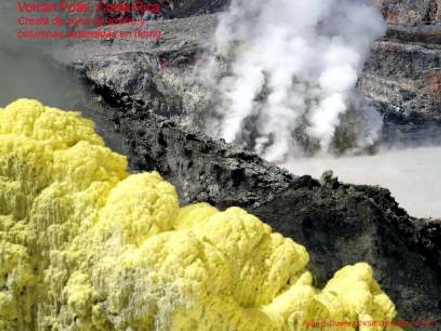 |
Figure 82. Fumarolic activity at Poás formed a sulfur cone during late 2006 and into 2007. This shot shows the upper part of the sulfur cone in the left foreground. Parts of the steaming pyroclastic cone and adjacent crater lake appear in the background. Courtesy of OVSICORI-UNA. |
Table 13. Temperature of N terrace fumarole at Poás depositing sulfur during October 2006 through September 2007. Courtesy OVSICORI-UNA.
| Date | Temperature |
| Oct 2006 | 144°C |
| Nov 2006 | 143°C |
| Dec 2006 | -- |
| Jan 2007 | -- |
| Feb 2007 | 124°C |
| Mar 2007 | 118°C |
| Apr 2007 | 116°C |
| May 2007 | 110°C |
| Jun 2007 | 117°C |
| Jul 2007 | 108°C |
| Aug 2007 | 108°C |
| Sep 2007 | 67°C |
On the SE and NW walls, hot springs with gas temperatures between 89°C and 94°C also deposited sulfur. By March 2007, the hot springs had largely dried and only two gave off very low volume emissions with a temperature of ~55°C. Throughout the reporting period, cracks on the intermediate terrace and on the NE edge of the crater widened with new points of gases appearing and deposition of sulfurous material. By February 2007, emission levels began to diminish, and they continued diminishing through September. Fumarole gas temperatures in this area remained steady at near 94° C.
Information Contacts: E. Fernández, E. Duarte, W. Sáenz, V. Barboza, M. Martinez, E. Malavassi, and R. Sáenz, Observatorio Vulcanologico Sismologica de Costa Rica-Universidad Nacional (OVSICORI-UNA), Apartado 86-3000, Heredia, Costa Rica (URL: http://www.ovsicori.una.ac.cr/).
Small phreatic eruption from crater lake on 13 January 2008
A small phreatic eruption took place from the crater lake at Poás (figure 83) on 13 January 2008. Various changes such as the loss of fumaroles and minor mass wasting have also occurred at the intracrater dome. The 13 January eruption was described in a report by Eliecer Duarte of the Observatorio Vulcanologico Sismologica de Costa Rica-Universidad Nacional (OVSICORI-UNA). Our previous report discussed September 2006-September 2007 and noted hydrothermal variations and a minor phreatic eruption (BGVN 32:09).
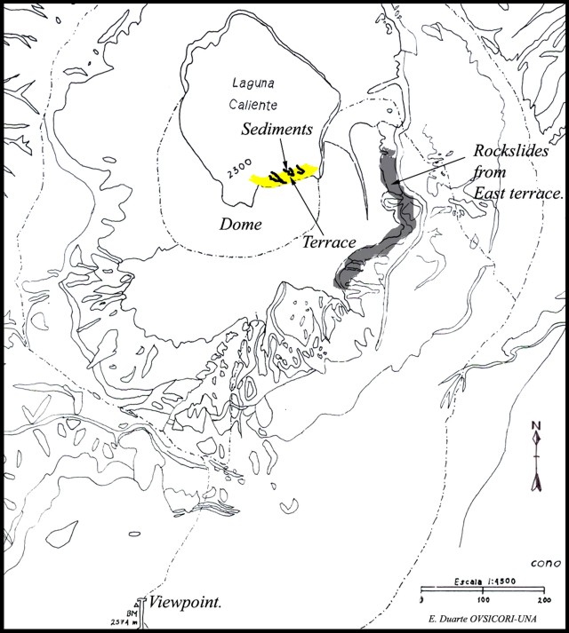 |
Figure 83. Topographic map of Poás and environs emphasizing the crater lake, scene of a 13 January phreatic eruption. Note the dome and the area labeled 'terrace' on its margin. Map by E. Duarte, OVSICORI-UNA. |
A small phreatic eruption occurred at 0900 on 13 January from the hot, acidic Laguna Caliente. Carlos Cordero, a park ranger who witnessed the event, indicated that the event ejected water and sediments from the lake's center to a height of ~ 200 m. This material mainly fell back into the lake, changing its color from a dark green to an intense white (figure 84). The event was also seen by a group of tourists who watched from the main viewpoint ~ 1 km S of the lake. The eye-witness report emphasized the calm conditions of the lake and dome before the eruption.
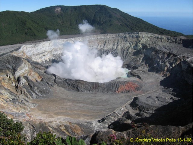 |
Figure 84. A picture of the active crater of Poás taken a short time after the phreatic eruption had ended and the main column had collapsed on 13 January 2008. The dome is in front of the steam-covered lake. The shot was captured by park ranger Carlos Cordero who stood at the main viewpoint S of the lake. Courtesy of OVSICORI-UNA. |
Post-eruption inspection of the crater by OVSICORI staff revealed that the explosion left a 1.5-m-wide band of sediment up to 10 cm thick along the entire rim of the lake (figure 85). Some sediment also extended about 8 m from the shore at the S rim, near the terrace of the dome. The deposits, clearly debris from the lake bottom, included many shining crystals; larger clasts were absent. After the expulsion, water flowing back into the lake seemingly scoured or removed some sediment.
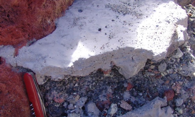 |
Figure 85. A remnant of the dried and solidified sediments expelled during the 13 January eruption at Poás. The sediments, fine grained and light in color, appeared to have come directly from the bottom of the crater lake. Note pocket knife for scale. Courtesy of OVSICORI-UNA. |
During a visit of OVSICORI staff, the lake's color changed over about a 3-hour period as a result of gas expulsion. The rapid degassing of thick columns of toxic gases obscured visibility of the other side of the lake. Compared to measurements at the end of November 2007, the lake's temperature had dropped (to 45°C) and the water level had risen 1.5 m.
The OVSICORI's staff also found a small landslide (8 x 20 m) on the dome's N face (figure 86). They described the landslide as a chaotic deposit of heavily altered angular blocks in a gray matrix that had been altered by hydrothermal activity. A slurry of yellowish materials reached the edge of the lake. Based on field evidence, the team concluded that the small landslide took place immediately after the emission of sediments.
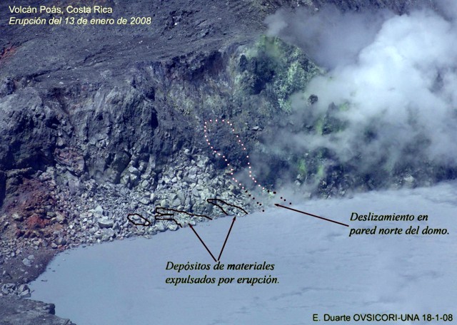 |
Figure 86. This 18 January photo of the crater lake, shoreline, and adjacent dome at Poás, indicates the location of several small areas where 13 January deposits still remained. In addition, a small portion of the dome had detached and moved downslope in a minor landslide that reached the lake. Courtesy of OVSICORI-UNA. |
Figure 87 shows a photo of the dome's steep E cliff face. Fumaroles had recently ceased emerging. Cracks and crevices on top of that terrace were also rapidly widening as joint blocks detach.
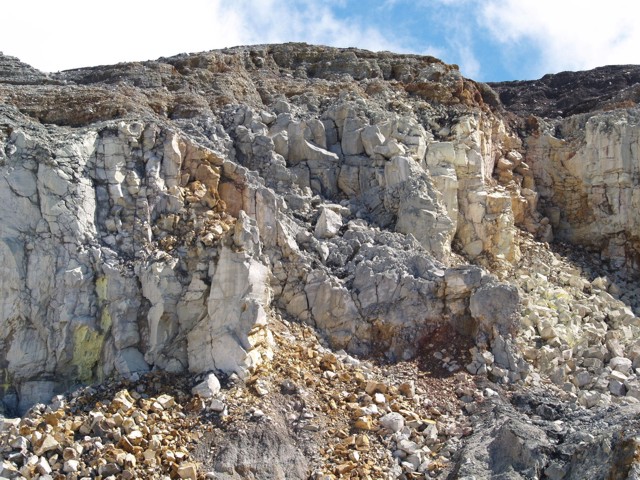 |
Figure 87. A photo of the E wall of the dome at Poás, a zone of active slope failure. In this area previously active springs and fumaroles had recently disappeared leaving only native sulfur deposits at the mouth of former fumaroles. At the foot of the cliff lies a terrace of debris from mass wasting. Courtesy of OVSICORI-UNA. |
Information Contacts: E. Duarte and E. Fernández, Observatorio Vulcanologico Sismologica de Costa Rica-Universidad Nacional (OVSICORI-UNA), Apartado 86-3000, Heredia, Costa Rica (URL: http://www.ovsicori.una.ac.cr/).
Fatalities from a large nearby earthquake; slides and minor eruption in crater
On 8 January 2009, at 1321, the M 6.2 Chinchona earthquake shook Poás volcano, killing 23 people and injuring 100 in nearby communities. Another seven people were missing. A reported 1,087 houses were destroyed or damaged, with level VII damage on the Modified Mercalli intensity scale. The epicenter (figure 88) was on the Vara Blanca Fault at the village of Vara Blanca, 6-10 km E of Poás. Over 1,500 aftershocks were recorded during 8-9 January. Eruptive activity did not increase around that time, although a small phreatic eruption took place on 12 January. As of early March 2009, no thermal alerts had been detected by MODVOLC.
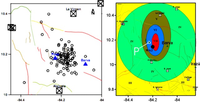 |
Figure 88. (left) Earthquake epicenters at Poás on 7-8 January 2009. (right) Mapping of the 8 January 2009 earthquake's Modified Mercalli intensity. Poás (P) was in region VI just W of the center of the intensity VII region and NW of the main-shock's epicenter (heavy dot). Both maps courtesy of the University of Costa Rica. |
The morning before the earthquake volcanologists from the Observatorio Vulcanologico Sismologica de Costa Rica-Universidad Nacional (OVSICORI-UNA) and the University of New Mexico had entered the crater to sample fumaroles and the lake. The lake color at that time was a light blue-gray with yellow rings of sulfur 30-m wide that sank within minutes. The lake temperature was 52°C with a pH of 0. A 1-m-thick gas layer hovered over the lake surface. Fumarolic activity from an area S of the crater lake had increased, with a plume rising 150 m (figure 89).
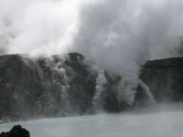 |
Figure 89. The acidic lake and degassing dome at Poás as seen on 8 January 2009. Courtesy of Univ. of Costa Rica and Univ. of New Mexico. |
The earthquake triggered significant landslides from the crater walls (figure 90), destroying part of the access trail to the bottom of the crater. There was a distinct shift in the color of the ground surface in many places where mass wasting had occurred. The older surface was commonly gray, whereas the freshly mobile material appeared in shades of brown to ochre. Rockslides carried blocks over a meter in size (figure 91) down the N and E crater walls. The volcanologists were able to escape the crater at the end of the day through the SSW wall ascending toward Botos lake.
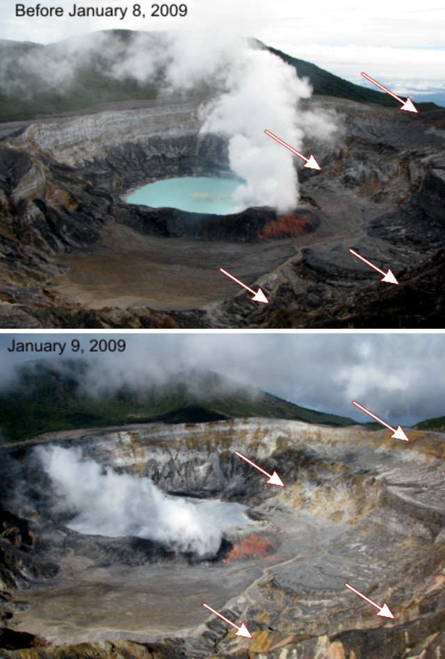 |
Figure 90. Poás crater before, and the day after, the earthquake of 8 January 2009. Arrows show zones where rockslides ultimately took place on the E crater walls. Courtesy of Univ. of Costa Rica and Univ. of New Mexico. |
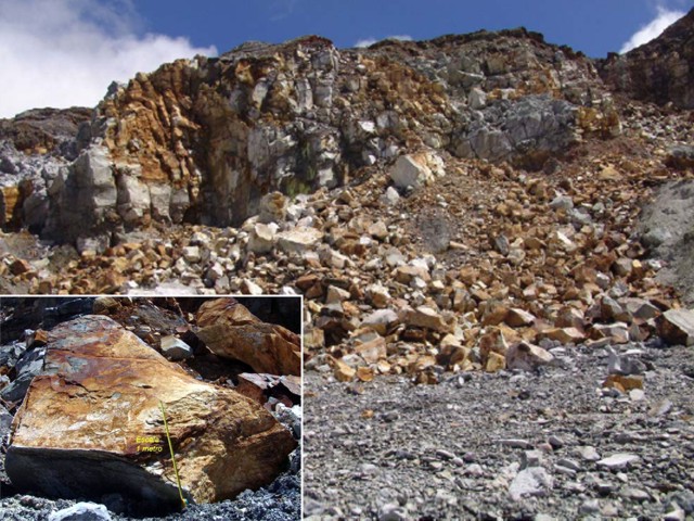 |
Figure 91. Photo of the east terrace that partially collapsed as the result of the 8 January 2009 earthquake. Many of these blocks were over a meter in diameter (inset) . Freshly exposed surfaces had ochre to brown to rust colors. Courtesy of OVSICRI-UNA. |
On 12 January 2009, scientists observed rising black sediment in the crater lake. A small phreatic eruption from a 50-m-diameter area at the center of the lake ejected sediment and water about 15 m high. Small phreatic eruptions had also been reported on 16 December 2006 and 13 January 2008 (BGVN 32:09 and 32:12).
On 11 February, a month after the earthquake, OVSICORI officials who visited the volcano saw abundant concentric-shaped landslides along the crater walls. According to Eliecer Duarte and others, the landslides numbered in the hundreds and ranged greatly in size. Gravitationally unstable areas were the most affected, but many other rockslides occurred along walls previously thought to be stable. A previously unstable area, E and near the lake, collapsed almost completely, burying a fumarolic area that had been active for about nine years. Vigorous degassing returned to the dome, and vapor covered the hot lake. Compared to recent years, fumarolic activity from the dome appeared stronger and more sustained.
Information Contacts: E. Duarte, E. Fernández, T. Marino, R. Mora, and C. Ramirez, Observatorio Vulcanologico Sismologica de Costa Rica-Universidad Nacional (OVSICORI-UNA), Apartado 86-3000, Heredia, Costa Rica (URL: http://www.ovsicori.una.ac.cr/); Tobias Fischer, Maarten de Moor, Kareen Prade, Danielle Lord, and Jody Weikart, University of New Mexico, Department of Earth and Planetary Sciences, Northrop Hall, 200 Yale Blvd. NE, Albuquerque, NM 87131, USA.
Occasional minor phreatic eruptions during December 2009-November 2010
This report discusses the behavior of Poás during January 2009-February 2011. Several minor phreatic eruptions occurred, and fumaroles on the dome at times had temperatures over 800°C (figures 92 and 93). As reported earlier (BGVN 34:01), earthquakes on 8 January 2009 caused a number of significant landslides and destruction; a phreatic eruption occurred on 12 January 2009.
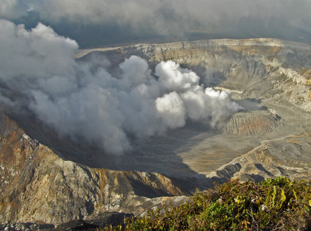 |
Figure 92. Photo of phreatic eruption in Poás crater on 25 December 2009 looking N. Note the great quantity of steam emitted from the dome located on the lake's S border. Some dome fumarolic temperatures were in excess of 800°C during February and April 2010. Courtesy of OVSICOR-UNA. |
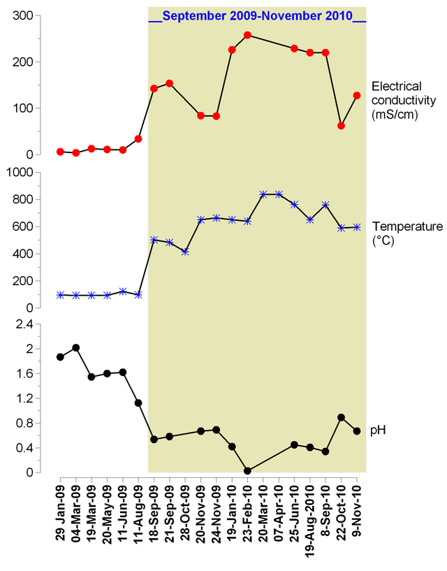 |
Figure 93. For Poás, a graph plotting results of tests during 25 January 2009 to 9 November 2010 on fumarolic emissions and their condensates at the dome. Tests consisted of electrical conductivity, maximum emission temperature, and pH. On 7 April 2010, a maximum fumarole temperature reached ~840°C. Several weeks before, conductivity had peaked and pH had reached a minimum. Taken from OVSICORI-UNA report of December 2010. |
According to the Observatorio Vulcanologico y Sismologico de Costa Rica-Universidad Nacional (OVSICORI-UNA), seismic data indicated that a phreatic eruption from Laguna Caliente, one of two summit lakes at Poás, occurred on 21 March 2009, the first one since 12 January 2009. Observation shortly after the March phreatic eruption revealed that water in Laguna Caliente was gray and measured 49°C. Convection cells disturbed in the steaming lake's central area. There was continuous bubbling along the crater's SW wall. Fumarolic activity at the N crater wall had a temperature of 93°C and emitted constant steam that rose up to 400 m above the crater floor. One of the fumaroles produced a noise similar to steam escaping from a safety valve.
In November, OVSICORI-UNA reported several phreatic eruptions from the central part of Laguna Caliente. They ejected material that fell back into the lake, occasionally producing small waves. Dark-colored gas plumes rose a few meters to several ten's of meters above the lake surface. The temperature of the lava dome was 630°C at accessible areas. Fumarolic plumes from the dome rose 1 km and drifted W and SW. Some foliage on the SW flank ~3.5 km from the crater showed signs of gas damage.
Another phreatic eruption was observed on 25 December 2009. Steam and lake water mixed with sediment and blocks were ejected 550-600 m above Laguna Caliente and fell in the vicinity of the lake, within the crater. The amount of steam emitted from lava-dome fumaroles at the S edge of the lake increased subsequent to the eruption (figure 92), and the smell of H2S was strong.
OVSICORI-UNA reported another phreatic eruption from Laguna Caliente on 23 February 2010. The eruption ejected gray and sulfur-smelling sediment onto the southern flanks. The event was seen by a scientist collecting samples in the low part of the crater and by visitors at the viewpoint area. Seismographs showed no precursory signals.
An observation of the Laguna Caliente in April 2010 noted that the water temperature was 48°C and that the water level in the lake had decreased 28 cm between 7 and 27 April 2010. The area of fumarolic activity was also noted to have increased. Two new fumaroles emerged in the N wall. They produced sulfur deposits and bluish gas emissions (temperature ~838°C) that rose ~1 km above the crater floor.
In September 2010, the temperature of the lava dome was 810°C at accessible areas. OVSICORI-UNA reported that several phreatic eruptions occurred from the central part of the lake and again, ejected material fell back into the lake and gas plumes rose up to ~100 m above the water surface.
OVSICORI-UNA reported that in November 2010 several phreatic eruptions occurred; plumes from the eruptions rose ~1 km and drifted W and SW. Some foliage on the SW flank ~3.5 km from the crater showed signs of gas damage. By this time, the temperature of the lava dome had declined to ~630°C.
According to OVSICORI-UNA, a small phreatic eruption occurred from the central part of Laguna Caliente on 2 February 2011. Solid dark material was ejected 6 m and fell back into the lake. Before, during, and after the eruption, a concentric area of the lake surface ~15 m in diameter was disturbed by a convecting cell. Bubbles of gas rose from the agitated area, and upwelling sediments were observed.
Information Contacts: Observatorio Vulcanologico Sismologica de Costa Rica-Universidad Nacional (OVSICORI-UNA), Apartado 86-3000, Heredia, Costa Rica (URL: http://www.ovsicori.una.ac.cr/).
Photos of phreatic eruptions from acid lake; surrounding vegetation damaged by gases
Occasional, typically minor phreatic eruptions occurred at Poás through at least early February 2011 (BGVN 35:12). They emerged from the active crater lake, Lago Caliente. The Observatorio Vulcanologico y Sismologico de Costa Rica-Universidad Nacional (OVSICORI-UNA) illuminated intervals of phreatic eruptions and relations on the chemistry of Lago Caliente's waters over a period of more than 30 years (figure 94). This report includes photos of phreatic eruptions in 2009, 2010, and early 2011, and reviews events through March 2011.
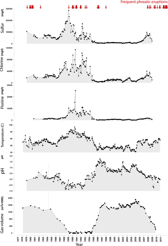 |
Figure 94. Plots of the sulfur, chlorine, and fluorine concentrations, as well as the temperature, pH, and gas volumes in the Lago Caliente waters at Poás, with respect to time. The data on the time axis extends from early 1978 to late 2009. Arrows along the top indicate periods with frequent phreatic eruptions. Notice the low pH, often well below pH 1.5. Courtesy of OVSICORI-UNA. |
Volcanic gases and associated condensate and rainfall led to increasing areal extent and degree of damage to vegetation in nearby areas. In studying the Lago Caliente's waters, Martinez and others (2011) found in solution a variety of oxo-anions of sulfur called polythionates (SnO6-2, where n can be 20 or larger), which they found to vary in concentration from undetectable to 8,000 mg/L. They considered polythionates to be "highly relevant for monitoring purposes at Poás, in particular because they may signal impending phreatic eruptions."
More on the 25 December 2009 phreatic eruption. A previous report (BGVN 35:12) discussed a phreatic eruption on 25 December 2009 but some further comments are worth adding. As previously noted (BGVN 35:12), "Steam and lake water mixed with sediment and blocks were ejected 550-600 m above Laguna Caliente and fell in the vicinity of the lake, within the crater." No mention was previously made of a 24 December 2009 phreatic eruption discussed by OVSICORI-UNA. It took place in the morning at 0808 and all erupted material fell back in the crater.
Photos taken on 25 December 2009 and recently posted on the Picasa website have come to our attention. The four photos on figure 95 come from a set of nine taken from the S rim. The earliest of the set depict a very tranquil lake with steaming at or near the dome (not shown here). The next photo, taken 129 seconds after that tranquil scene, portrays the advancing eruption (figure 95a). The subsequent two photos (figure 95b and c) captured the interval closest to the peak of the eruptive vigor.
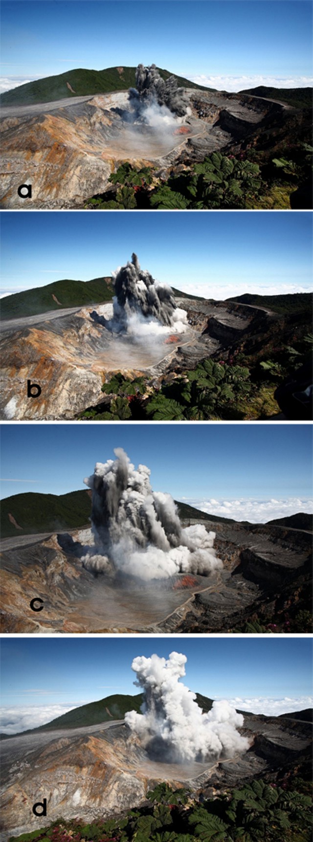 |
Figure 95. Four sequential photos taken looking N at Poás of a phreatic eruption from the center of Lago Caliente on 25 December 2009. The time intervals between the four photos was as follows: photos (a) to (b), 5 sec; photos (b) to (c), 5 sec; and photos (c) to (d), 11 sec. Photo descriptions below: (a) The earliest available photo of the eruption cloud, which, based on the next photo in this set, was clearly still emerging energetically. It advanced with the leading portions of the plume chiefly dark. At the plume's base, white steam clouds mask the lake. (b and c) The shots taken closest to the maximum point of the eruption's thrust phase, with dark material still conspicuous. White tufts expanded and began to cap most of the advancing jets. The clouds engulfing the base of the plume now contain more discolored zones. (d) As the plume evolves and the vigorous exhalative part of the eruption ends or wanes, a steam-rich cloud envelops the eruption cloud. Note the gray-colored rain falling out of the plume. Taken from Cindy and JM's Gallery (undated) on the Picasa photo sharing website (see References and Information Contacts below). |
An exact assessment of the photos is complicated by several factors. There were shifts in the focal length of the lens (documented in camera metadata found on the website). Also, in detail, the camera's time record indicated 0252 hrs, clearly incorrect for this daylight scene. That problem is reconciled by a photo featured in the OVSICORI-UNA report, which showed a plume photo by another photographer at a stage nearly identical to figure 95b and the text indicated the eruption occurred at 0952 hrs local time.
An email response from Cindy Doire provided these comments about witnessing the phreatic eruption.
"We arrived at the volcano early in the morning. We were one of the first to arrive that day. Our group and a few other tourists were looking at it and NOTHING was happening. The people finished looking and started leaving that spot. It was just about 4 of us still there, when suddenly the volcano started to erupt. There was NO warning at all. Even the rangers were surprised. At the beginning, white steam (gas?) shot up, then black rock and dirt started exploding out. I believe that everything that shot up, fell back into the crater . . . the gas could be smelled and was strong . . .."
In an email to GVP regarding the 25 December 2009 eruption, Eliecer Duarte commented: "It seems that this [25 December 2009] eruption opened a more permanent vent at the bottom of the lake. Since that event the frequency of phreatic ones increased and remained like this for [a] year and a half. We still have dozens of smaller ones daily.
More on crater degassing. Field visits during 2010 and 2011 allowed scientists to see the expanding effects of Poás volcanic gases on vegetation (figures 96 and 97). Dry conditions resulted in winds carrying the gases considerable distances from the volcano. The area most affected was an elongate zone downwind of the active crater and extending ~4 km SW. Figure 97 portrays transitional zones with intermediate effects.
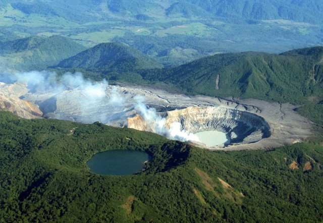 |
Figure 96. A commercial airline pilot and amateur photographer took this and other photos of Poás on 28 April 2010. The active crater and its discolored lake (Lago Caliente) reside at the right-hand side of this shot. It is part of an elongate zone of barren rock stretching ~4 km across the otherwise lushly vegetated landscape. As is typical, the plume's orientation on this day lies directly over the barren zone. From "Len" (undated), (see Reference below). |
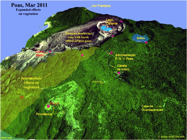 |
Figure 97. Oblique view highlighting the area to the S of Poás (note volcano's crater lakes, including the active "Lago Caliente") On color versions of this figure, the pink rhombuses show sites for collecting acid rain. Providencia is shown in the lower left. The crater lake at upper right, "Botos" is ~0.5 km across in the long direction but the scale on this image varies with distance towards the foreground. Courtesy E. Duarte, OVSICORI-UNA. |
Starting just beyond the elongate zone of harsh effects, the areas of discolored vegetation had increased impact and areal extent. One such impacted area was a nature preserve called Providencia, which is seen in figure 97 to the left of Poás. Farther from the volcano lies Cerro Pelón (2.5 km distance and direction SW of the crater) , which also showed the effects of chemical burning from volcanic gases (figure 97).
In the past, activity centers have migrated within the crater. OVSICORI-UNA reported that, for at least the past year (ending March 2011), the points of degassing have been concentrated in the hot crater lake and dome (figure 98). The emanating steam and gases, often carried by wind, have affected areas up to several hundred meters around the crater (figures 96-98).
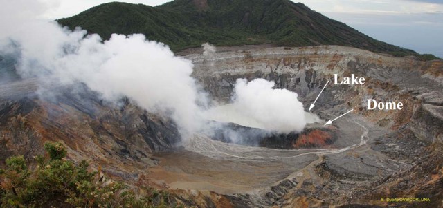 |
Figure 98. The active crater at Poás, showing pronounced steam release both from fractures in the dome as well as from the lake's surface. Conditions like this (with more or less steam) often prevailed in recent times (including just a few seconds prior to the eruption sequence shown in figure 95). The crater lake (Lago Caliente) rests behind (N of) the dome and steam clouds. Courtesy E. Duarte, OVSICORI-UNA. |
OVSICORI-UNA reported that through at least March 2011 small phreatic eruptions occurred daily at Lago Caliente. These eruptions sometimes only reached the lake's surface, but at other times reached a few meters above the lake, and occasionally, tens of meters above the lake. The majority of the erupted sediments fell back into the lake. The fine sediments sometimes remained suspended in the lake water and caused its gray color. The majority of eruptions occurred in the central part of the crater, with a few originating slightly more to the N or S of the center. Because of the phreatic activity and high temperature of the lake (57°C), strong evaporation occurred and plumes traveled long distances in the wind (figure 99).
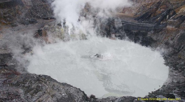 |
Figure 99. At Poás, a phreatic eruption at Lago Caliente reaching several meters high, in a manner typical of daily activity during recent months. View from the active crater's N side (opposite the viewpoint). Photo taken sometime in January 2011. Courtesy E. Duarte, OVSICORI-UNA. |
A comparison of vegetation in the area between Cerro Pelón and Providencia (designated "F1" in figure 97) made during August 2010 to January 2011 found that most plant species were resistant at certain levels of acidification. However, when their tolerance thresholds were reached, the affected species decayed quickly and were sometimes unable to recover. Certain species, including eucalyptus, pine, alder, and cypress, were particularly sensitive to the volcanic gases. Minor effects from gases were observed on Cypress trees as far as 9 km SW of the emission source. OVSICORI-UNA reports contained several photos showing more details on the effects of acidic gases on vegetation. One of their later reports, from April 2011, discussed ongoing phreatic eruptions and dome temperature of 560°C.
References. Cindy and JM's Gallery, undated, "Poas volcano eruption, December 25th, 2009" [9 photos] Picassa (URL: https://picasaweb.google.com/cjmdoire); [includes camera-related metadata].
Len (Barfbag), undated, "Wednesday, April 28, 2010, Mt Poas, Costa Rica" ; in Viewsfrom the left seat, A look at the airline world ... ride along in the cockpit (URL: http://viewsfromtheleftseat.blogspot.com/2010/04/mt-poas-costa-rica.html)
Martínez, M., van Bergen, M.J., Fernández, E., and Takano, B., 2011, Polythionates monitoring at the acid crater lake of Poás Volcano, IAVCEI-COMMISSION OF VOLCANIC LAKES, CVL7 Workshop, Costa Rica, 10-19 March 2010, Online Abstracts volume (May 2011), p. 12 (URL: http://www.ulb.ac.be/sciences/cvl/)
Information Contacts: E. Duarte and E. Fernández, Observatorio Vulcanologico Sismologica de Costa Rica-Universidad Nacional (OVSICORI-UNA), Apartado 86-3000, Heredia, Costa Rica (URL: http://www.ovsicori.una.ac.cr/); Cindy Doire (address withheld by request).
Decreasing number of phreatic eruptions after 2011 through 2013
In an activity report on 31 August 2011, the Observatorio Vulcanologico y Sismologico de Costa Rica-Universidad Nacional (OVSICORI-UNA) indicated that Poás had experienced intense phreatic activity between 2006 and mid-2011. In June 2011, however, the frequency of eruptions began to decrease dramatically. The report also indicated that Laguna Caliente, the hot, acid crater lake on the northern summit, had shrunk by about 94 percent between 2006 and mid-2011; during this same period, the lake's pH had decreased from 1.22 to minus 0.72 and its water temperature had increased from 32°C to 62°C. One explosion, on 25 December 2009, apparently opened a more permanent vent at the crater lake's bottom. On the S edge of the lake is a dome (that OVSICORI-UNA sometimes in their reports refers to as a "cryptodome"), where frequent, intense degassing has occurred. The lake exhibits vigorous convective activity, and acid rain is frequently observed.
Our previous report (BGVN 36:04) discussed activity through February 2011. This report presents activity between that date and 31 December 2013. Figure 100 indicates the location of the volcano in Costa Rica. A photo of the active crater and surrounding area is shown in figure 101.
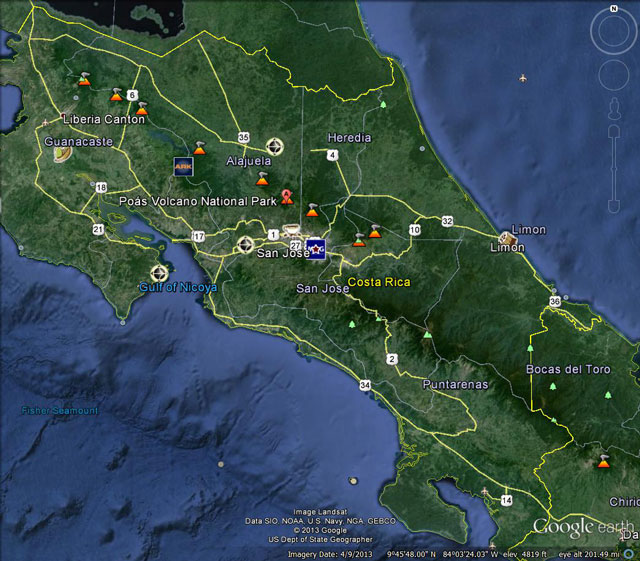 |
Figure 100. A Google map of Costa Rica showing the location of Poás. Courtesy of Google Maps. |
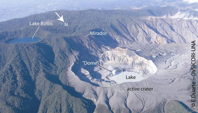 |
Figure 101. Aerial photo of the active crater with the hot acid lake and dome ("cryptodome"), taken on 27 February 2011. Also, Lake Botos, a cold lake that fills an inactive crater, can also be seen S of the active crater. Courtesy of OVSICORI-UNA (E. Duarte). |
Activity in 2011. An OVSICORI-UNA activity report from November 2011 and an annual 2012 summary indicated that the temperature of the dome had increased dramatically during early 2011 as the result of super-heated gas released through the dome. The temperature, measured by thermocouple, peaked in August 2011 at 890°C, and then decreased steadily thereafter through at least the end of 2012, when the temperature was about 100°C. In early 2011, incandescence could be seen at night; however, during June-September, it could also be seen during the day. This phenomenon had not occurred since 1981. OVSICORI-UNA speculated that the changes could be either from a recent magma intrusion or a change in the hydrothermal plumbing system.
A news article (Inside Costa Rica) reported that a team of geologists and volcanologists from the Universidad de Costa Rica visited Poás on 25 May 2011 and observed 18 phreatic explosions from Laguna Caliente during a three-hour period. According to the article, the volcano normally produced 1-2 explosions per day.
On 23 July 2011, OVSICORI-UNA scientists visited Poás to document changes during the previous weeks. They observed fumaroles with vigorous bluish emissions in the fractured rock about 40 m above the lake surface. Those emissions produced incandescence observable during the daylight. The emission temperature was 670°C at the dome's mid-wall. A separate report noted that the temperatures at the dome were unusually high, in the range of 700-890°C between June and October 2011. Scientists noted that on the SE shore of Laguna Caliente, a subtle, semicircular scarp observed a few months earlier had rapidly progressed to a sharp scarp. The 60-m-wide, 2.5-m-high scarp was degassing and geyser activity was observed on the W end, next to the lake.
OVSICORI-UNA visited the volcano again on 8 September 2011, and observed that two newly formed cavities at the N base of the dome had merged into a crater that was 25 m long and 7-10 m wide. The scientists also found incandescence reflected in the gas plume about 80 m from the edge of the lake to near the top N edge of the dome (figure 102 and 103). OVSICORI-UNA reported that a new fumarole had appeared on the crater during August-September 2011.
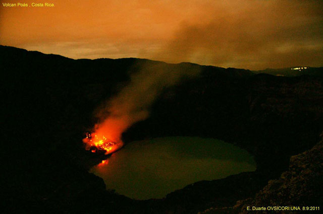 |
Figure 102. Night view from the larger caldera's E side on 8 September 2011, showing degassing and incandescence reflecting in the gas plume. The lights in the upper right of the photo are from a community about 15 km W from the volcano. Courtesy of OVSICORI-UNA (E. Duarte). |
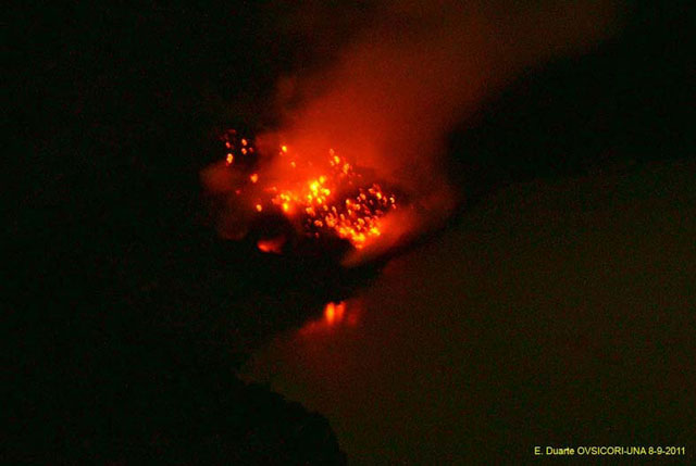 |
Figure 103. Night view (at 1800) showing Poás' incandescence on the dome and fumarolic activity. Photo taken from the E on 8 September 2011. Courtesy of OVSICORI-UNA. |
According to OVSICORI-UNA, fumarolic activity continued during October 2011, with bluish gas plumes rising more than 1 km from the dome. Toward the end of the month, the fumarolic activity as well as incandescence from the dome had decreased. Phreatic activity continued. The lake temperature was 55°C and the level had risen 22 cm between 14 September and 27 October 2011.
OVSICORI-UNA reported that during fieldwork on 16 December 2011 scientists observed new geyser activity from a vent that had formed earlier in 2011 on the dome's N flank. A water-and-mud fountain rose 5-6 m high and flowed into the lake, resulting in a terrace along the S shore. Gas-and-steam plumes rose from the dome.
Activity in 2012. According to OVSICORI-UNA, at least 44-47 phreatic explosions were observed in 2012, either by the rangers of the Parque Nacional Volcán Poás (Poás Volcano National Park) or in seismic recordings. The number per month for the year ranged from 0 (in September) to 10 (in October). Sometimes these explosions were characterized by large bubbles of gas and liquid, under 500 m high. For example, during May 2012, eruptions occurred on 6, 15, 20 and 26 May. The eruption on 15 May was preceded by about 6 hours of very low amplitude harmonic tremor. Administrators at the National Park witnessed the explosion and reported that sediment, water, rock fragments, and plumes were ejected ~500 m above the lake surface. The lake level dropped ~0.9 m between 8 and 29 May, while the water temperature was steady during this period at ~48°C. Dome fumarole temperatures decreased during 2012, from ~700°C to ~100°C.
OVSICORI reported that higher amplitude, more frequent phreatic eruptions occurred in October 2012, especially during 18-27 October. Two phreatic explosions occurred on 27 October 2012. One of them ejected water, sulfur-rich sediments, and rock fragments onto the S and SW edges of the crater floor. According to a news article (The Tico Times), local residents heard a loud rumble at about 0100 on 28 October; a phreatic explosion ejected sediment 500 m above the lake, and produced ashfall several hundred meters away.
Between January and October 2012, the lake level decreased about 4 m; in November and December, the lake level rose by the same amount due to the high precipitation common at this time of year. Strong rainfall in November eroded the N flank of the dome.
Seismicity remained stable in 2012, with less than 200 daily earthquakes, mostly shallow low-frequency events. During 2012, the number of volcano-tectonic earthquakes remained low. The only significant seismicity occurred during 5-7 September, following the 5 September Nicoya earthquake (Mw 7.4) in the NW part of Costa Rica.
Activity in 2013. According to OVSICORI-UNA's annual report for 2013, seismic activity remained stable, with 10-150 earthquakes daily. Isolated small magnitude, shallow, volcano-tectonic earthquakes also occurred. Tremors were recorded infrequently and were of short duration. Hybrid earthquakes with large amplitudes (up to 3 cm2 reduced displacement) began in September, peaked in October, and fell in November.
In March 2013, OVSICORI-UNA began to measure the concentration of CO2, SO2, and H2S, using a portable multi-gas station provided by Italy's Istituto Nazionale di Geofisica e Vulcanologia (National Institute of Geophysics and Volcanology, INGV). In April 2013 the SO2 emission, as measured by a portable DOAS (Differential Optical Absorption Spectroscopy), was 120 /-30 metric tons per day.
In 2013, the dome temperature rose from 100°C in January to values above 500° C during the middle of the year, resulting in incandescence observed at night during May 2013. For example, maximum temperatures of 575°C and 450°C were recorded on 8 and 30 May, respectively. Later in the year, temperatures decreased to as low as 200°C in October, before rising somewhat again. Before 2013, a thermocouple was used to measure temperatures; thereafter, both a thermocouple and a remote infrared camera were used.
Lake activity in 2013 was very similar to that reported for 2012, again characterized by sporadic phreatic eruptions (figure 104). The number of eruptions per month ranged from 4 (March, April, July) to 9 (May, October). The water level remained relatively constant at 4 m until about June-August when it decreased to as low as about 1.5 m, before rising again. During 2013, no significant change in water temperature (about 45-50°C) or pH (0-0.3) was noted, similar to measurements in 2012. For example, the lake temperature was about 46°C on 8 May 2013 and 48°C on 8 May 2012. The pH was 0.03 on 8 May 2013, compared to 0.07 on 8 May 2012.
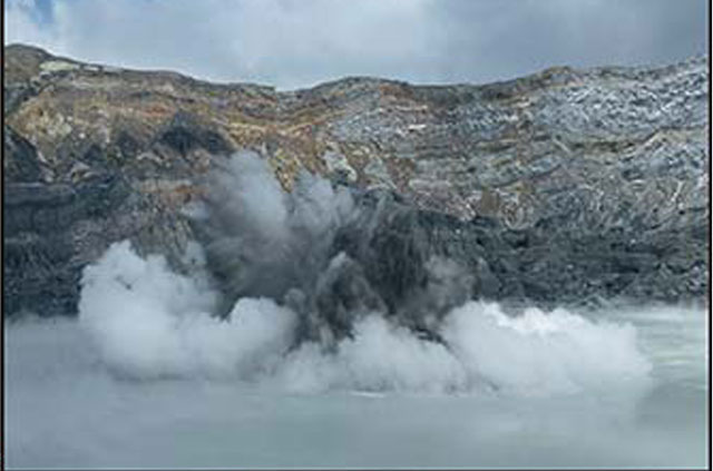 |
Figure 104. Photo of phreatic eruption from Poás' Laguna Caliente on 20 August 2013. Courtesy of OVSICORI-UNA (G. Durán). |
During 2013, rainfall was substantially less acidic, reflecting a decrease in the release of gases and heat through the active crater. Fumarolic activity was variable.
During the early morning hours on 2 and 3 June, residents reported a gas plume rising 1 km above the crater floor. OVSICORI-UNA observed that recent plumes had been hot (450-575°C) and rich in sulfur dioxide, giving the plumes a bluish-white color.
Information Contacts: Observatorio Vulcanologico y Sismologico de Costa Rica-Universidad Nacional (OVSICORI-UNA), Apartado 86-3000, Heredia, Costa Rica (URL: http://www.ovsicori.una.ac.cr/); Inside Costa Rica (URL: http://www.insidecostarica.com/); The Tico Times (URL: http://www.ticotimes.net/).
Numerous phreatic explosions from the lake into mid-October 2014
Activity at Costa Rica's Poás Volcano, located about 35 km NW of the country's capital, San Jose, is characterized by intermittent phreatic explosions from its "ultra-acid" Laguna Caliente that cause geyser-like eruptions of crater lake water and sediment. Scientists from Observatorio Vulcanológico y Sismológico de Costa Rica, Universidad Nacional (OVSICORI-UNA) have been regularly monitoring the volcano for over 40 years, measuring numerous characteristics including: seismicity, geochemistry, temperature variations of fumaroles, SO2 and CO2 emissions around the crater, deformation, and the geochemistry, temperature and pH variations of the lake. Many details of that data are discussed in their monthly reports; highlights from the reports for 2014 are summarized here.
OVSICORI-UNA scientists have observed that Poás has exhibited, over the last half century, cycles of phreatic eruptions that last for approximately 6-10 years before a period of relative calm. These phreatic eruptions are characterized by sudden explosions from the lake as a result of the abrupt expansion of steam and magmatic gases that accumulate in the underlying hydrothermal system. The eruptions eject superheated steam and gas, molten sulfur, lake sediments, and altered rock fragments around the lake. Most of the explosions are small, reaching heights above the surface of the lake of tens of meters. However, some reach 100-400 m and spread debris around the edges of the crater. The release of steam and magmatic gases from beneath the lake also causes vigorous convection in the lake, and frequent color changes of the lake from gray-green to bright turquoise related to changing redox conditions in the lake. The lake level shows annual changes on the order of 3-5 m caused by variations in hydrothermal activity and seasonal weather. Lake chemistry, pH and temperature show complex interrelated variations. The current activity cycle began in March 2005 with strong underwater fumarolic activity, and the start of phreatic eruptions in March 2006.
Large phreatic explosions occurred several times in 2014; the largest explosions occurred in February, May, June, August, and October. Seismic activity peaked in April with over 500 daily seismic events; periods of heightened activity with greater than 100 daily events occurred several times during the year, decreasing in late October to a few tens of events per day. Fumarole temperatures were highly variable, fluctuating every few months between 200 and 600°C. The lake level dropped several meters in the first half of the year with an accompanying increase in temperature and drop in pH. These trends reversed for the second half of the year. Decreased underwater emissions in December caused a bright turquoise lake color and less convective and explosive activity at year's end.
Phreatic eruptions. Large explosions on 24 and 25 February ejected water, steam, gas, sediment, and rock fragments over 400 m above the lake's surface; most of the material fell back into the lake, but some landed on the W, N, and E parts of the crater walls (figure 105). In March there were 14 small eruptions recorded, with the biggest occurring on 30 March, but many other even smaller events were observed by the webcam as bubbles bursting on the surface of the lake. In spite of a large increase in seismicity in April, only 12 small phreatic explosions were recorded. Fifteen events occurred in the lake during May. The smaller explosions rose to heights of 10-30 meters, but eruptions that exceeded 100 meters high occurred on 3, 13, 19, and 24 May (>300 m).
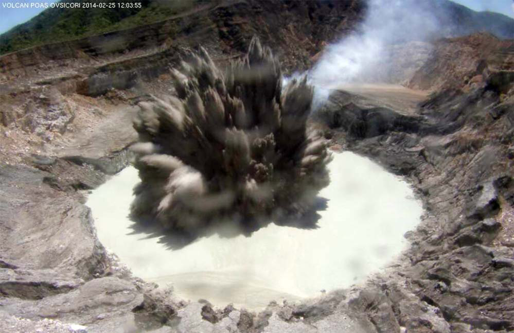 |
Figure 105. Phreatic eruption in the highly-acidic crater lake of Poás volcano on 25 February 2014. The white plume behind the explosion is steam and gas emitting from "el domo", a dome on the S side of the lake. Image captured by the webcam located on the northern edge of the crater, administered by OVSICORI-UNA and donated by the Office of Foreign Disaster Assistance of the United States Agency for International Development (USAID/OFDA/LAC). Courtesy of OVSICORI-UNA (February 2014, Estado de los Volcanes de Costa Rica). |
In the last days of May 2014 several interesting events were observed at the crater. On 28 May at night, the MULTIGAS detection system that monitors the composition of volcanic gases in real time recorded saturation signals of several gas sensors, indicating a significant release of magmatic gases into the atmosphere. On the morning of 29 May around 0717 residents in Pueblo Nuevo de Zarcero (9 km NNW) reported observing a vigorous plume of gas and steam rising above the summit. That same morning OVSICORI-UNA volcanologists were doing routine work in the crater and witnessed four small phreatic eruptions no more than 50 m high and strong degassing from the dome on the south side of the lake (also sometimes referred to as a "cryptodome" by OVSICORI-UNA).
Two large explosions and eight smaller ones were recorded in June. The largest, on 1 June at 1954, was not discovered until the next day. Poás Volcano National Park Staff reported abundant material deposited around the edge of the lake after a routine inspection on 2 June. Rock fragments ejected by this explosion hit the permanent OVSICORI-UNA MULTIGAS system, damaging the solar panel and breaking the transmitting antenna. On 20 June 2014 at 1008 another eruption produced a column that reached approximately 200 m above the lake surface (figure 106).
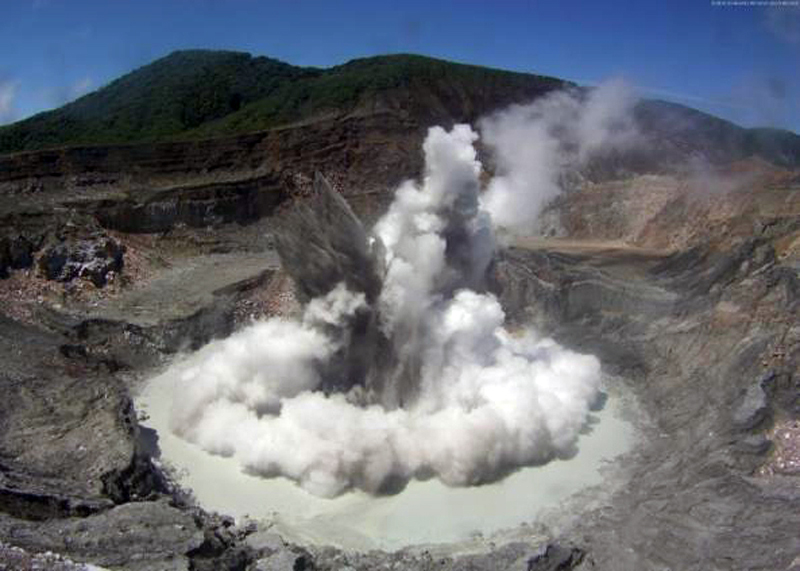 |
Figure 106. Phreatic eruption at Poás on 20 June 2014 at 1008 local time captured by the web camera of OVSICORI-UNA. Courtesy of OVSICORI-UNA (June 2014, Estado de los Volcanes de Costa Rica). |
In July, there were frequent small eruptions (averaging two per day) that reached heights 30-50 m above the lake, and only one moderate eruption, on 31 July. The biggest eruption recorded during August occurred on 27 August and sent a column of debris over 200 meters high. This eruption consisted of four separate explosions that occurred within a short time interval.
Two large eruptions, on 8 and 13 October, were the last explosions of the year. They sent material over 250 m into the air, and caused ashfall on the lookout area visitor's center. The second explosion also sent caustic plumes downwind that led to the evacuation of the National Park and restricted access for 10 days. The eruption of 8 October was the largest of the year, while the eruption of 13 October was the most complex as it consisted of at least four discrete events in less than two minutes. Following these explosions, there was a decrease in temperature of both the fumaroles and the lake, a considerable reduction in seismic activity, a marked decrease in gas flow in the fumaroles of the dome, and a noticeable reduction in the convective activity of underwater fumaroles in the lake.
Seismicity. Seismicity varied significantly throughout 2014 (figure 107). At the beginning of the year the number of daily events were similar to those from the end of 2013, less than 50/day. After the large explosions of 24-25 February, seismicity increased to over 100 events per day, and peaked on 5 April with more than 500 daily events. An unusual seismic swarm E of the active crater was recorded on 17 May. The largest earthquake registered was a M 1.8, and was 6 km deep. The numbers of seismic events decreased in May, and spiked up again in June to between 100 and 200 daily events before decreasing to less than 30 events per day in July.
 |
Figure 107. Number of volcanic earthquakes recorded daily at Poás volcano during 2014. The asterisks show phreatic eruptions; on several occasions multiple eruptions occurred in one day. Courtesy of OVISCORI-UNA (December 2014 Estado de los Volcanes de Costa Rica 2014 Annual Report). |
Seismic values increased slightly toward the end of August, but dropped to very low levels in September. The seismic activity increased almost exponentially between early and mid-October from an average of less than 10 events per day (early October) to more than 100 events per day (figure 107), and then fell rapidly again towards the end of the month. This last spike of seismicity in 2014 occurred between 6 and 13 October when three moderate eruptions were recorded. Seismic activity at the volcano declined significantly after the last major eruption on 13 October. After this, several medium-amplitude tremors were recorded, along with a few low-frequency (LF) events with larger than normal amplitudes. Both the large and middle amplitude earthquakes were reported with decreasing frequency during November and December.
Fumarole temperatures. "El domo" is a domed area on the S side of the crater lake composed of highly altered rocks. It is a tuff ring formed during phreatomagmatic activity between 1953 and 1955. The dome has been a site of persistent fumarolic degassing for the last 200 years.
Fumarole temperatures gradually increased after May 2008, reaching maximum values of around 900°C between July and October 2011 (figure 108). This was followed by a decrease to values around 100°C between late 2012 and early 2013. From 2013 through 2014 fumarole temperatures recorded sharp fluctuations, but always remained above 200°C.
 |
Figure 108. Evolution of the temperature of the fumaroles from the dome of Poás between 1 May 2011 and 1 January 2015. Measurements were made directly with a thermocouple as well as remotely with an FLIR SC660 thermal camera. Courtesy of OVSICORI-UNA (December 2014, Estado de los Volcanes de Costa Rica 2014 Annual Report). |
At the beginning of 2014, the temperature of the fumaroles were high, around 600°C, and decreased to around 200°C by the end of June. Temperatures increased again in July 2014 to values close to 500°C. Incandescence around the dome from these high temperatures was observed from 3 July to mid-August 2014 in night images from the webcam.
From 23 October through the end of 2014, the dome fumaroles exhibited a drastic decrease in temperature and gas flow. This change was preceded by a sharp and sudden release of high temperature magmatic gases in a combustion event that generated a flash of light (figure 109) in the N section of the dome near the surface of the lake. This flash of light lasted for 2:24 minutes and was the result of spontaneous combustion of the magmatic gases at high temperatures in contact with atmospheric oxygen, generating exothermic chemical reactions that released energy as heat and light. After this event, the flow of gases through the dome decreased substantially compared with the observed flows earlier in the year.
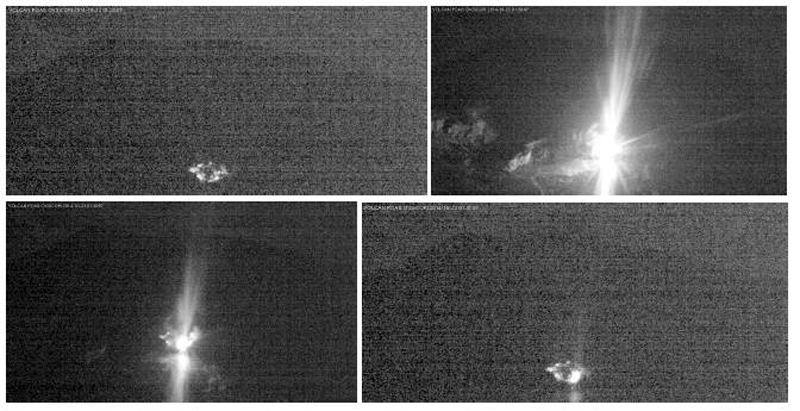 |
Figure 109. A strong and sudden release of magmatic gases at Poás in a combustion "flash" at the dome was recorded on 23 October 2014 between 0130 and 0132 local time (within 2 minutes and 24 seconds) The webcam is located on the northern edge of the active crater. The combustion gases at high temperatures generated exothermic chemical reactions that released energy as heat and light. The light shines in the plume of steam and gas and is reflected on the surface of the lake. Courtesy of OVSICORI-UNA (November 2014, Estado de los Volcanes de Costa Rica 2014 Annual Report). |
Lake convection, temperature, level and pH. A schematic cross section of the lake by OVSICORI-UNA scientists shows the relationship between the lake and the underlying magmatic-hydrothermal system (figure 110). This model explains the dramatic phreatic explosions, and extreme temperature and pH variations that are common in the lake from continuously occurring water-gas-rock interactions.
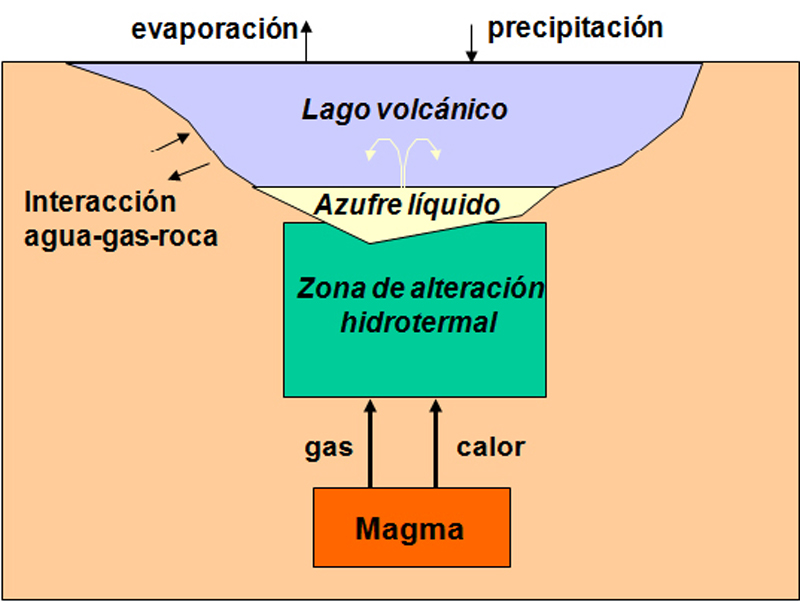 |
Figure 110. Simplified schematic cross section of the surface of the hydrothermal system of Poás. The pale blue is the crater lake, underlain in yellow by liquid sulfur. Underneath the sulfur is the zone of hydrothermal alteration (in green) over the magma chamber (in orange). Courtesy of OVISCORI-UNA (November 2014, Estado de los Volcanes de Costa Rica 2014 Annual Report). |
Laguna Caliente has been recognized as having one of the lowest pH's of any lake in the world; its pH dropped during June and July 2014 to near-record low levels not seen since 2012 (figure 111). Significant variations in the lake level occur over time as well. The lake level dropped over 3 m between January and April 2014 (figure 112). This very low level was possibly due to increased heat under the lake (figure 110), which would increase the evaporation rate and explain the increase in temperature and acidity (figure 111). In addition, the possible increase in gas supply could explain the frequent small phreatic eruptions in April (figure 107).
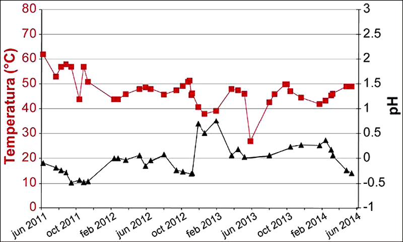 |
Figure 111. Evolution of the temperature and pH of the Laguna Caliente at Poás volcano from June 2011 through May 2014, measured on site. Image courtesy of OVISCORI-UNA, (May 2014, Estado de los Volcanes de Costa Rica). |
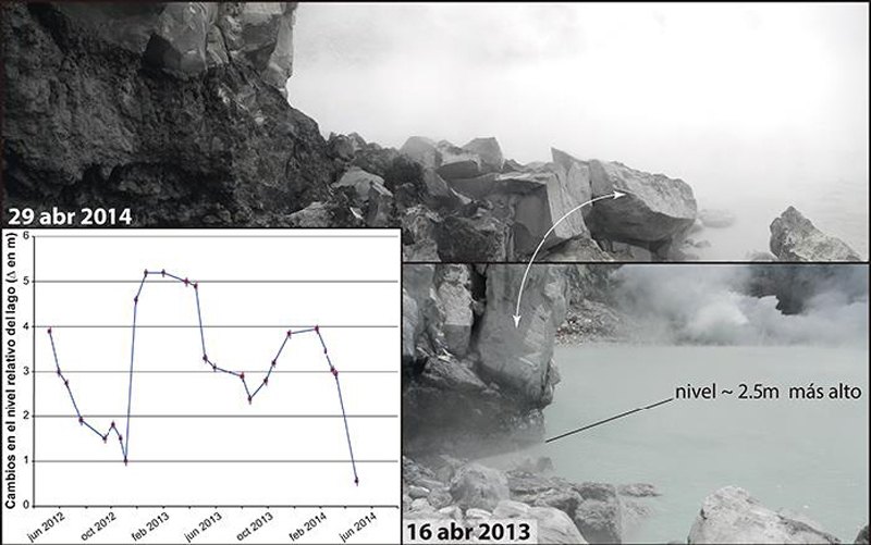 |
Figure 112. Evolution of the relative level of the lake at Poás. Compare the level in photographs taken between April 2013 and April 2014 (Photos: G.Avard). Courtesy of OVSICORI-UNA, (April 2014, Estado de los Volcanes de Costa Rica). |
On 4 May, a sudden bubbling and strong convection was observed in the central part of the lake. The abrupt rise of fluid brought a substantial amount of viscous molten sulfur to the surface of the lake. The molten sulfur temporarily covered almost the entire lake surface. This sulfur rise was preceded by short-duration tremors a few days earlier, on 26 April. Several additional times during the year molten sulfur was observed on the surface of the lake. The active convection of the lake was imaged by thermal camera on 27 June and revealed numerous convection cells and molten sulfur (figure 113).
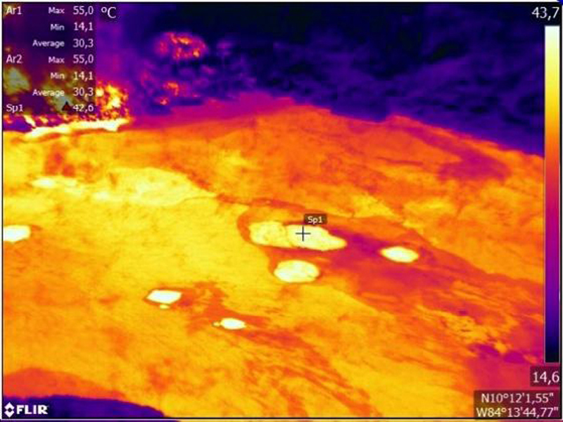 |
Figure 113. This infrared image of the lake on 27 June 2014 shows lake surface temperature gradients at Poás caused by convection cells generated by underwater fumaroles (circular white spots) and the presence of molten sulfur floating on the lake surface. Courtesy of OVSICORI-UNA, (June 2014, Estado de los Volcanes de Costa Rica). |
The lake also changes color as a function of convective activity. The color change is indicative of a change in the redox conditions of the acidic water such that the iron is stabilized in its reduced form Fe2+ in acidic waters that are rich in sulfur and colloidal silica, which in turn suggests a significant decrease in the injection of sulfur dioxide, SO2, into the lake.
In July, the lake showed signs of another significant increase in acidity as a result of an injection of fresh magmatic fluids into the hydrothermal system that feeds the lake and the fumaroles at the dome. In particular, on 13 July a large amount of molten sulfur, evaporation, and vigorous convection with multiple cells distributed over the lake surface was observed (figure 114).
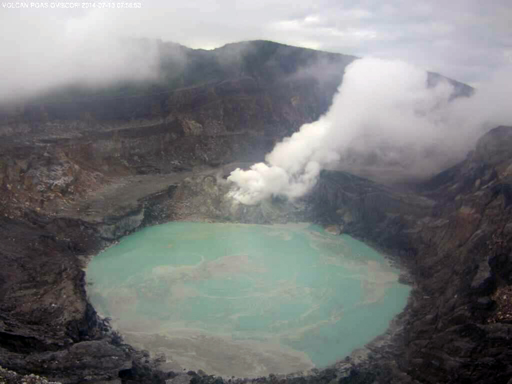 |
Figure 114. Poás volcano on 13 July 2014 at 0756. Note the large amount of molten sulfur and fine silicic materials floating in the gray-green lake due to the vigor with which the underwater fumaroles discharged from the underground hydrothermal system into the lake. Fumaroles from the dome are visible behind the lake. The webcam on the northern edge of the crater is managed by OVSICORI-UNA and donated by USAID/OFDA/LAC United States. Courtesy of OVISCORI-UNA (July 2014, Estado de los Volcanes de Costa Rica). |
In September the lake level rose about 50 cm due to high rainfall typical of the rainy season (figure 115). In spite of this, the temperature and acidity of the lake remained high at 50°C and pH = -0.22 (figure 115).
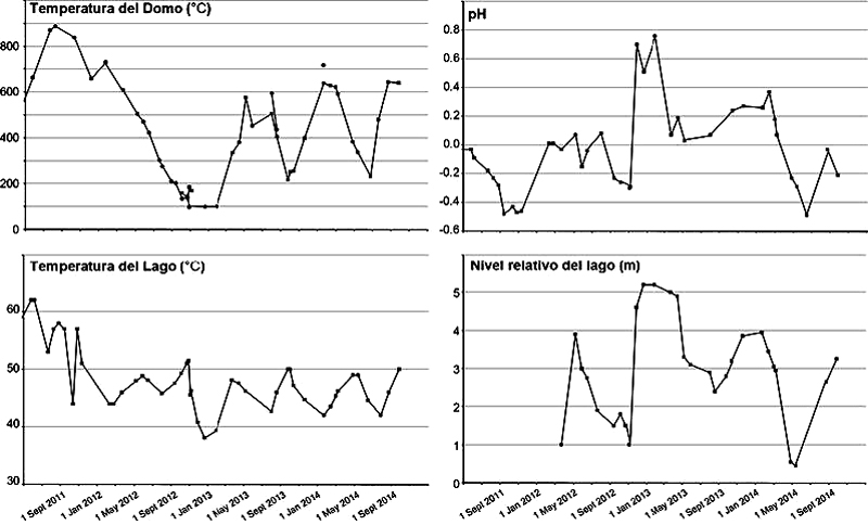 |
Figure 115. Detail of the evolution of temperature of fumaroles (upper left), pH of the lake (upper right), temperature of the lake (lower left), and the lake level (lower right) at Poás from September 2011 through September 2014. Courtesy of OVSICORI-UNA, (September 2014, Estado de los Volcanes de Costa Rica). |
By the end of October, activity in the lake had dropped significantly, with fewer eruptions, less elemental sulfur observed on the surface of the lake, a greener color of the lake indicative of less convection, and a drop in the lake's temperature (figure 116, third graph from top). A remote lake temperature measurement was performed on 11 November with FLIR infrared thermographer T650sc provided to OVSICORI-UNA by Termogram S.A. for field testing. The apparent maximum temperature in the lake was 43°C at a distance from the lake of approximately 400 m, indicating a significant drop in temperature from October (figure 116, third graph). In late November, a significant decrease was also observed in acidity, temperature, and injection of sulfur-rich magmatic gases as compared with previous months (figure 116).
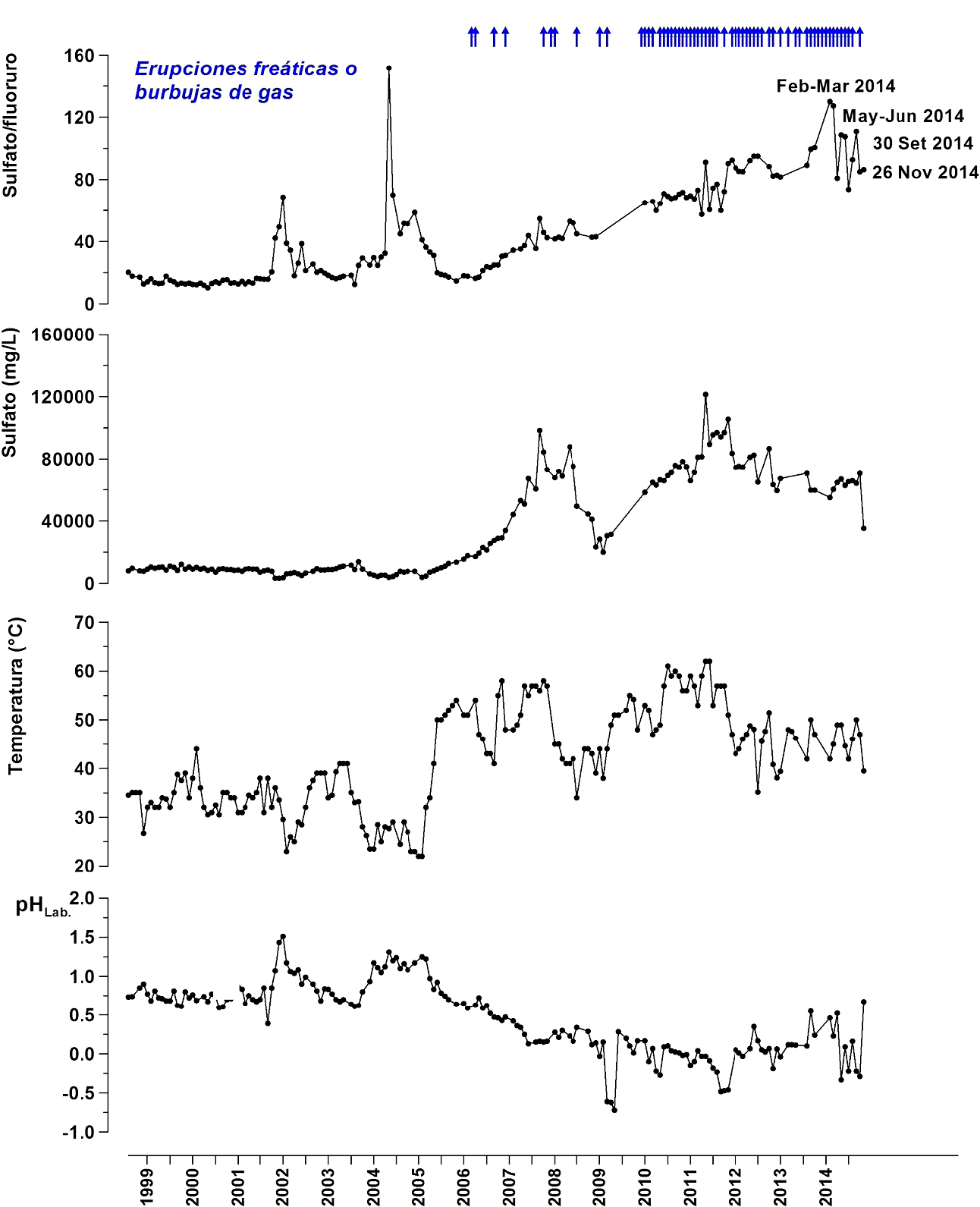 |
Figure 116. Data from the Poás crater lake showing monthly variations of sulfate versus fluoride ratios (top), concentration of sulfate (second graph), temperature (third graph), and acidity (pH) (bottom graph) between 1999 and 26 November 2014. Note that the peaks on the sulfate/fluoride ratio in 2014 coincided with times of the larger eruptions observed this year. The arrows at the top of the graph indicate episodes of substantial phreatic eruptions or gas releases across the lake. The sharp fluctuations in the graphs are due to changes in the nature of the magmatic hydrothermal system that feeds the lake and the dome fumaroles. Courtesy of Volcanic Geochemistry Laboratory, Dr. Eduardo Rojas Malavassi, OVSICORI-UNA (December 2014, Estado de los Volcanes de Costa Rica, 2014 Annual Report). |
Long-term changes in the proportions of dissolved ions (sulfate/fluoride) derived from the hydrolysis of volatile magmatic components (SO2 and HF), have shown a systematic increase in the amount of sulfur gases that are injected from the magmatic-hydrothermal system into the lake and fumaroles of the dome since 2006 (figure 116, top graph). In 2014, the sulfate/fluoride ratios peaked at values greater than 100 in periods during the times of more energetic phreatic eruptions (February-March 2014, May-June 2014, and September-October 2014) (figure 116, top graph).
Between late October and December, the lake showed a dramatic and unusual color change from greenish gray to bright turquoise indicating a marked decrease in the rate of emission of volatile magmatic gases through the underwater fumaroles (figure 117). Between November and December the lake volume also increased from high amounts of rainfall. The combination of iron ions, sulfur, and colloidal silica suspended in the water results in the bright turquoise color.
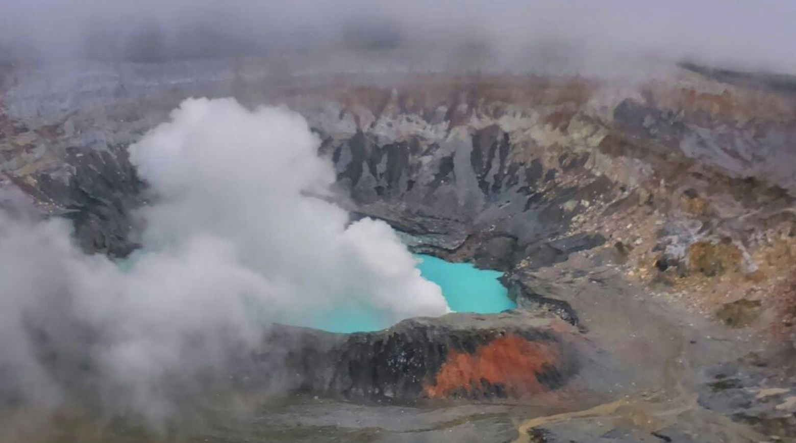 |
Figure 117. View of Lago Caliente on 19 December 2014 from the visitors viewpoint on the southern edge of the crater at Poás. Note the unusual bright turquoise color of the lake indicating a decreased rate of emission of volatiles (primarily SO2) from the underwater fumaroles. Photo credit: Patry Cartín. Courtesy of OVSICORI-UNA (December 2014, Estado de los Volcanes de Costa Rica, 2014 Annual Report). |
Information Contacts: Observatorio Vulcanologico Sismologica de Costa Rica-Universidad Nacional (OVSICORI-UNA), Apartado 86-3000, Heredia, Costa Rica (URL: http://www.ovsicori.una.ac.cr/).
Phreatic explosions from the crater lake in June-August 2016
Poás is characterized by intermittent explosions from its hot crater lake. Several occurred in 2014 (BGVN 40:11). This report covers activity from 1 January 2015 through February 2017. There were no reports of activity during 2015 through May 2016. Phreatic eruptions were recorded between 5 June and 16 August 2016.
According to news articles (La Prensa Libre, Prensa Latina), phreatic explosions from the hot crater lake occurred multiple times in June 2016. Explosions at 0900 on 5 June, at 1854 on 13 June, and at 1952 on 14 June ejected water and steam many meters above the lake's surface. Three small explosions, lasting about five seconds each based on the seismic signals, occurred during 0600-0603 on 18 June and ejected water, steam, and debris no more than 50 m above the lake's surface. Phreatic explosions were also registered on 19 June.
According to the Observatorio Vulcanologico y Sismologico de Costa Rica-Universidad Nacional (OVSICORI-UNA), a small phreatic explosion from the lake was recorded at 0819 on 25 July 2016. The explosion ejected material 50 m above the lake surface.
News accounts (Q Costa Rica, La Prensa Libre) reported that at 1409 local time on 16 August 2016 an explosion sent a column of gas to a height of 100 m above the crater; the activity lasted 2 minutes. An OVSICORI-UNA video of this explosion was posted in the news articles.
Information Contacts: Observatorio Vulcanologico Sismologica de Costa Rica-Universidad Nacional (OVSICORI-UNA), Apartado 86-3000, Heredia, Costa Rica (URL: http://www.ovsicori.una.ac.cr/); La Prensa Libre (URL: https://www.laprensalibre.cr/); Prensa Latina (URL: http://www.plenglish.com/); Q Costa Rica News (URL: http://qcostarica.com/).
Increase in phreatic and phreato-magmatic explosions during April through August 2017
Recent activity at Poás has been characterized by intermittent phreatic explosions from the hyperacid lake (figure 118). Explosions were noted in June-August 2016 (BGVN 42:03), but there were no reports explosions since then through March 2017. This report summarizes activity from April 2017 through March 2018. During this period, activity increased substantially during April-August 2017 and thereafter waned. No explosions were reported during 7 November 2017-31 March 2018. Information below was primarily drawn from reports issued by the Observatorio Vulcanologico Sismologica de Costa Rica-Universidad Nacional (OVSICORI-UNA).
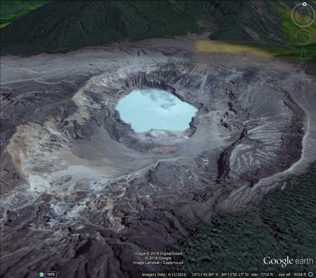 |
Figure 118. Landsat imagery of Poás taken 11 April 2016. Courtesy of Digital Globe and Google Earth. |
Activity during April 2017. According to OVSICORI-UNA, activity increased substantially at the beginning of 2017, with significant increases in seismicity, steam-and-gas emissions, and surface deformation. Seismicity included numerous long-period (LP) earthquakes, more than 200 daily events between the end of March and the beginning of April, and weak explosions since 30 March. Deformation was characterized by inflation, with a vertical increase of more than 1 cm in a three-month period and an increase of 3 mm horizontally between two sites S and N of the crater separated by 1,570 m.
Gas emissions dramatically shifted toward a more magmatic composition, particularly after 30 March. Sulfur dioxide measurements on 4 April were about an order of magnitude greater than those on 28 March (~180 ± 65 tonnes/day (t/d) vs. ~19 ± 8 t/d), with the dome contributing 25% and the lake 75% of the flow. The increased flow was accompanied by the emergence of new fumaroles that may have contributed to the warming of the lake (which went from 35 to 40°C in just one week). In April, the lake quickly changed from a milky green color to a milky gray color, which suggested that emissions of magmatic gases from vents beneath the lake may have increased. The dome is on the S side of the crater lake and was formed during phreatomagmatic activity between 1953 and 1955; it has been a site of persistent fumarolic degassing for the last 200 years.
OVSICORI-UNA reported that a strong 40-minute phreatic explosion from an area between the lava dome and the hot lake occurred on 12 April 2017, starting at 1830. A plume of steam, altered rocks, sediments, and gases was produced; the height of the column could not be determined due to poor visibility. Ash fell around the crater and in Bajos del Toro (7 km WNW). The water level in the Desague River, with headwaters at the S part of the crater, increased by 2 m. According to news articles (Tico Times, The Costa Rica Star), the National Emergency Commission evacuated residents living near the river. The Poás Volcano National Park closed the next day and has remained closed through March 2018.
On 13 April, at 1546, an eight-minute-long explosion produced a plume that rose 500 m above the crater rim. The event rendered a webcam on the N rim inoperable. Explosions at 0758 (strong) and 1055 on 14 April generated plumes that rose to an undetermined height.
A 10-minute-long event that began at 0810 on 15 April again produced a plume of unknown height. Frequent (2-3 events per hour) small, short-lived, phreatic explosions were recorded by seismographs during 15-16 April. A plume that rose 500 m followed an explosion at 0946 on 16 April. Later that day, at 1350, an event generated a plume that rose 1 km. A news article (The Costa Rica Star) reported that boulders as large as 2 m in diameter fell in an area 30 m away from a tourist trail, breaking a water pipe. Rocks also damaged fences and concrete floors in viewing areas. Small, frequent, and short-lived phreatic explosions continued to be recorded through 18 April. A video posted by a news outlet (The Costa Rica Star) showed an explosion ejecting incandescent material.
According to OVSICORI-UNA, on 20 April a dense steam plume rose from a vent in the newly-forming pyroclastic cone at the site of the old dome in the hot lake. Sulfur dioxide levels increased from 1,000 t/d on 13 April to 2,500 t/d on 20 April. During 20-22 April Strombolian activity ejected tephra that fell around the vent within a 300-m radius. Gas-and-ash plumes rose 200 m above the vent. The Cruz Roja (Red Cross) in Grecia reported ashfall in Alajuela (20 km S), Fraijanes (8 km SE), San Miguel (40 km SSE), Carbonal (8.5 km SSW), Cajón (11 km SSW), San Francisco, San Roque (23 km SSE), and San Juan Norte de Poás (8.5 km S). Explosions at 1316 and 1603 on 22 April produced plumes of unknown height. Several more explosions were recorded that day; an event at 2212 was very intense, ejecting bombs large distances. An event at 1215 on 23 April generated a plume of unknown height.
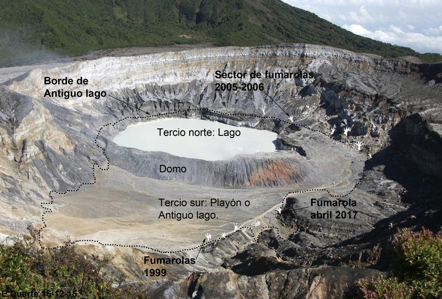 |
Figure 119. Photo showing location of the acid lake and dome at Poás during or after April 2017. The dotted line follows the outline of the great lake that covered the entire bottom of the caldera during the first half of the last century. Courtesy of OVSICORI-UNA. Borde de Antiguo lago is "Edge of the Ancient Lake"; Tercio norte: Lago is "north third of the lake"; domo is "dome"; Tercio sur: Playón o Angiguo lago is "South Tercio: Playón or Angiguo lake; Fumarola abril 2017 is "fumarole in April 2017; sector de fumarolas 2005-2006 is "sector of fumaroles 2005-226. Courtesy of OVSICORI-UNA (El Domo y el Lago Caliente en el Volcán Poás: Estructuras Básicas para Comprender las Erupciones Actuales. Nota técnica: 16 de abril de 2017). |
Activity during May 2017. OVSICORI-UNA reported that large explosions were seismically recorded at 0621 on 1 May and at 1724 on 6 May, though poor visibility prevented visual confirmation of the events. On 10 May, ash emissions were observed. Gas emissions were measured by an instrument mounted on a drone, revealing a gas plume rich in sulfur dioxide and low in carbon dioxide. Deformation was high, with vertical inflation of 3 cm since February.
During 17-23 May, plumes consisted mainly of gas and steam, sometimes including solid material, that rose no more than 1 km above the vent. During 25-26 May, ashfall was reported in some communities around the volcano. Small phreatic explosions were recorded sporadically during 27-30 May.
Activity during June 2017. An explosion reported by OVSICORI-UNA at 1200 on 2 June generated a plume consisting of steam, gases, and minor amounts of ash that rose 600 m above the crater. Another event recorded at 1353 could not be confirmed visually due to weather conditions. An event at 0858 on 6 June generated a plume that rose 1 km.
During 7-8 June, the webcam recorded strong emissions of steam, magmatic gases, and particulates. A sulfur odor was reported in Alajuela, San Ramon (24 km WSW), and Barva (23 km SSE), and incandescence in the area of the crater was recorded at night. OVSICORI-UNA noted that during 8-9 June, a plume of steam, magmatic gases, and particulates rose from two vents; the lake had evaporated and exposed the vents. A minor sulfur odor was reported on the campus of the Universidad Nacional in Heredia. Explosions at 1610 and 1750 on 11 June generated plumes that rose 300 and 600 m above the crater, respectively. Plumes from the vents rose 1 km during 12-13 June. A sulfur odor was noted in Quesada (26 km ENE), Santa Ana (30 km SSE), San José de Alajuela, and San Juanillo Naranjo.
Gas emissions during 13-15 June rose no higher than 500 m above the crater rim and drifted N. During breaks in weather, observers near the crater on 16 June noted ash emissions rising less than 1 km above the crater rim and drifting N. Ash emissions from events at 1340 on 18 June, and 1100 and 1350 on 20 June, rose less than 1 km.
During 20-25 June, plumes of reddish-colored ash, water vapor, and magmatic gases were recorded rising as high as 500 m above two vents during 20-21 June. Magmatic gases and steam plumes rose as high as 1 km above the vents the rest of the period.
Webcams recorded intense incandescence at night during 28-29 June from the bottom of the crater. A sulfur odor was noted in San Rafael de Poás (12 km SSW) and Vara Blanca (10 km ESE). An event at 1115 on 19 June generated a plume that rose 1 km above the vents. An event at 1450 may have generated a plume, but poor visibility did not allow for confirmation.
Activity during July-December 2017. According to OVSICORI-UNA, frequent, but weak Strombolian activity during 1-4 July ejected incandescent material that fell around vent A (Boca Roja). Plumes of steam, magmatic gases, and particulates rose at most 500 m from the vents.
During 4-9 July, plumes of steam, magmatic gases, and aerosols rose 200-600 m above vents A (Boca Roja) and B (Boca Azufrada). Minor incandescence from the bottom of the crater was observed during 4-5 July, and a strong sulfur odor was reported in some areas of Alajuela and Heredia. During 5-7 July, grayish-red ash emissions rose intermittently from vent A, and on 7 July a loud "jet" sound was noted in Mirador. A strong sulfur odor and minor ashfall was reported in some areas of Alajuela. An event at 1450 on 10 July generated a plume that rose 300 m.
OVSICORI-UNA reported that during 12-17 July, gas plumes rose as high as 1 km above vents A and B and drifted SW and NW. From 19 through 24 July plumes of steam, magmatic gases, and aerosols were emitted from vent A, and plumes of steam, gases, and abundant yellow particles of native sulfur rose from vent B. Plumes rose 300-500 m above the vents and drifted W and SW.
On 1 August an event passively produced a plume that rose 500 m above the crater. Incandescence from the bottom of the crater was recorded at night by the webcams. Sulfur dioxide was emitted at a rate of 1,000-1,500 t/d. Activity on 3 August was similar to that in July, except that plumes rose as high as 1 km above the vents. Gas plumes continued to rise from the vents and drift SW and NW at least through 8 August. OVSICORI-UNA reported additional explosions on 22 August (1517 local), 24 August (0920 and 0930), 29 August (0945), 13 September (0820), and 6 November (0915) that rose 300-600 m above the crater rim.
Seismicity. During May and June, some volcano-tectonic (VT) and LP earthquakes were recorded, and tremor levels generally ranged from low-to-moderate amplitude, although higher tremor levels were sometimes detected during 22-30 May. The tremor amplitude often corresponded to the vigor of emissions of steam, magmatic gases, and material from fumarolic vents. Seismic activity was not identified after 30 June, except for a single report that indicated that during 11-14 August seismographs detected low-amplitude tremor, some VT earthquakes, and high-frequency signals indicating gas emissions.
Information Contacts: Observatorio Vulcanologico Sismologica de Costa Rica-Universidad Nacional (OVSICORI-UNA), Apartado 86-3000, Heredia, Costa Rica (URL: http://www.ovsicori.una.ac.cr/); National Emergency Commission (CNE) (Comisión Nacional de Prevención de Riesgos y Atención de Emergencias (CNE) (URL: http://www.cne.go.cr); Tico Times (URL: http://www.ticotimes.net/); The Costa Rica Star (URL: https://news.co.cr/).
Frequent changes at the crater lake throughout 2018
After an eruption in April 2017, the hot acidic lake of Poás volcano has been in a state of frequent change, with a fluctuating or absent crater lake and other crater changes. During 2018 low-level activity was dominated by hydrothermal vents and degassing. The crater lake was variable, with changes in water level and complete drying of the lake several times. Seismicity was variable with some periods of increased seismicity, deformation was variable but slight, and gas levels fluctuated through the year (figure 120).
 |
Figure 120. Typical situation in the Poás crater and gas data from 2018. Left: The bottom of the dry crater in March 2018 (top) and hydrothermal activity at the bottom of the crater in May 2018 (bottom). Right: Time series graphs showing the maximum concentration of SO2, ratio of SO2/CO2, and the ratio of H2S/SO2 measured at the Poás volcano by the permanent MultiGAS station. The variations are associated with the presence of the lake and with seismicity. Courtesy of OVSICORI-UNA (2018 annual bulletin). |
Hydrothermal activity took place during January, with associated low-level gas emissions, and seismicity that reduced later in the month. At the beginning of January the crater lake was absent. After an increase in hydrothermal activity, the lake returned between 18-20 January (figure 121). The lake was measured to be 54°C on 22 January (on the eastern edge) and had a milky blue color with abundant degassing. Temperatures at actively degassing vents reached 97°C. Fumaroles with abundant yellow sulfur deposits were measured to be 160°C (figure 122).
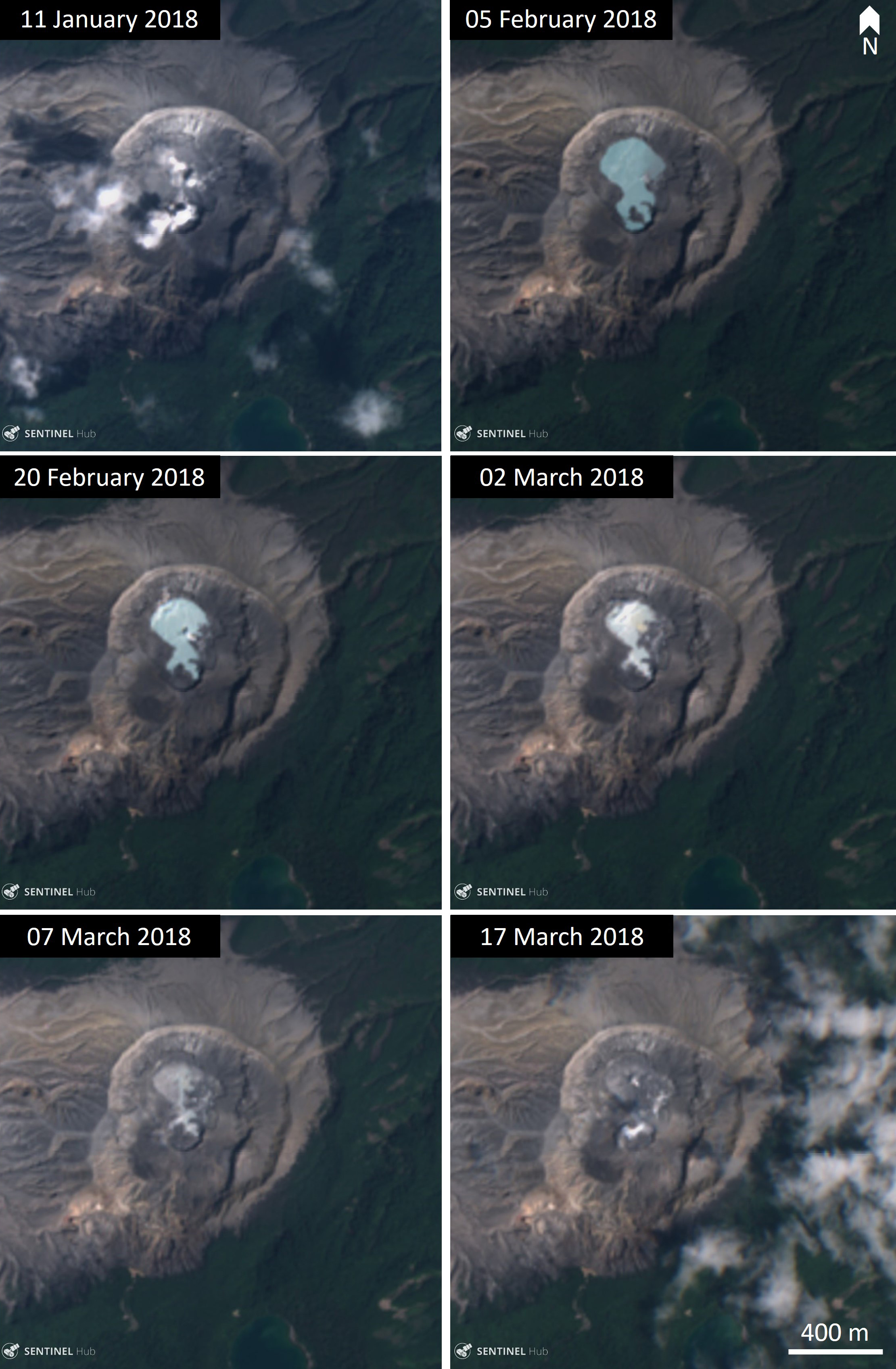 |
Figure 121. Changes to the Poás crater lake from January through March 2018. The level of water in the crater varies through time and the lake drained in January and March. Images courtesy of Sentinel Hub Playground. |
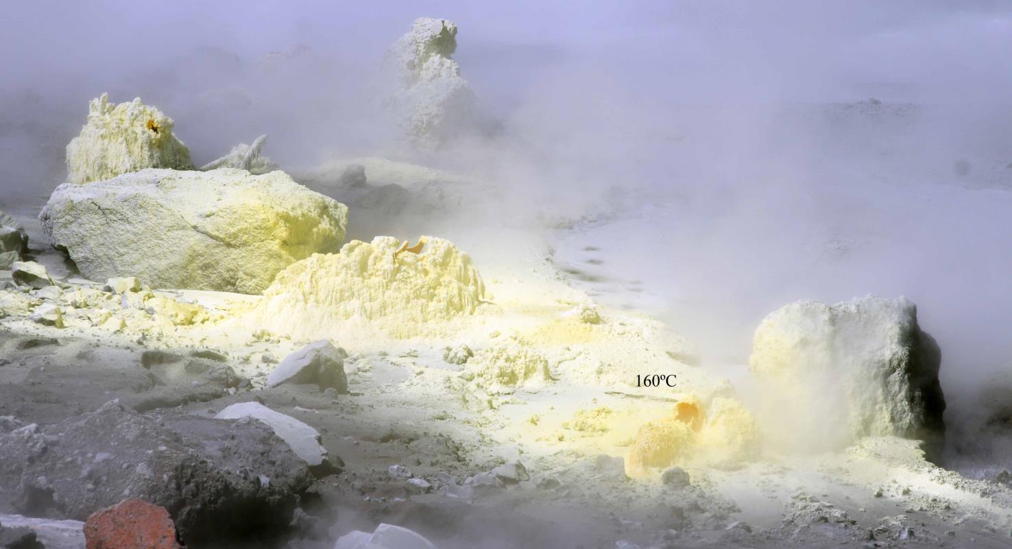 |
Figure 122. Active fumaroles within the Poás crater, east of the lake. Yellow sulfur deposits and active degassing are visible. The fumaroles had a temperature of 160°C on 22 January 2018 when this photograph was taken. Courtesy of OVSICORI-UNA (22 January 2018 field report). |
During February, activity remained low with fluctuating levels of CO2, SO2, and seismicity; the level of the lake also fluctuated. Activity remained shallow and related to the hydrothermal system with no magmatic activity. During March the seismicity decreased, coinciding with the disappearance of the crater lake during the March-May dry season. During April there was no change observed at the crater, and gas and seismicity continued to fluctuate within normal levels. Background activity and normal fluctuations continued through May until a phreatic (steam) eruption occurred on 25 May, producing a small gray plume and a larger white steam-and-gas plume (figure 123).
 |
Figure 123. A phreatic (steam) explosion on 25 May 2018 at the active Poás crater. Courtesy of OVSICORI-UNA (20 December 2018 report). |
In June there was an increase in activity on the crater floor with increased submarine degassing and an increase in the lake water level. A high flow of SO2 (approximately 500 tons per day) was measured on 22 June. The measured level of SO2 was higher on 27 June, at 1,500 tons per day.
Gas emissions, deformation, and seismicity continued with fluctuations through July and August, with a decrease in SO2 around 30 July. Underwater fumaroles continued to be active. A milky-blue crater lake was present throughout this time (figure 124). During September, seismicity was described as highly variable and the crater lake was present (figure 125). Increased seismicity around 8 October coincided with slight inflation at the surface with an increase in activity through to 16 October. Gas emissions remained variable throughout September and October. A slight increase in seismicity occurred in early November and declined again by 19 November, with all other activity variable and within normal levels.
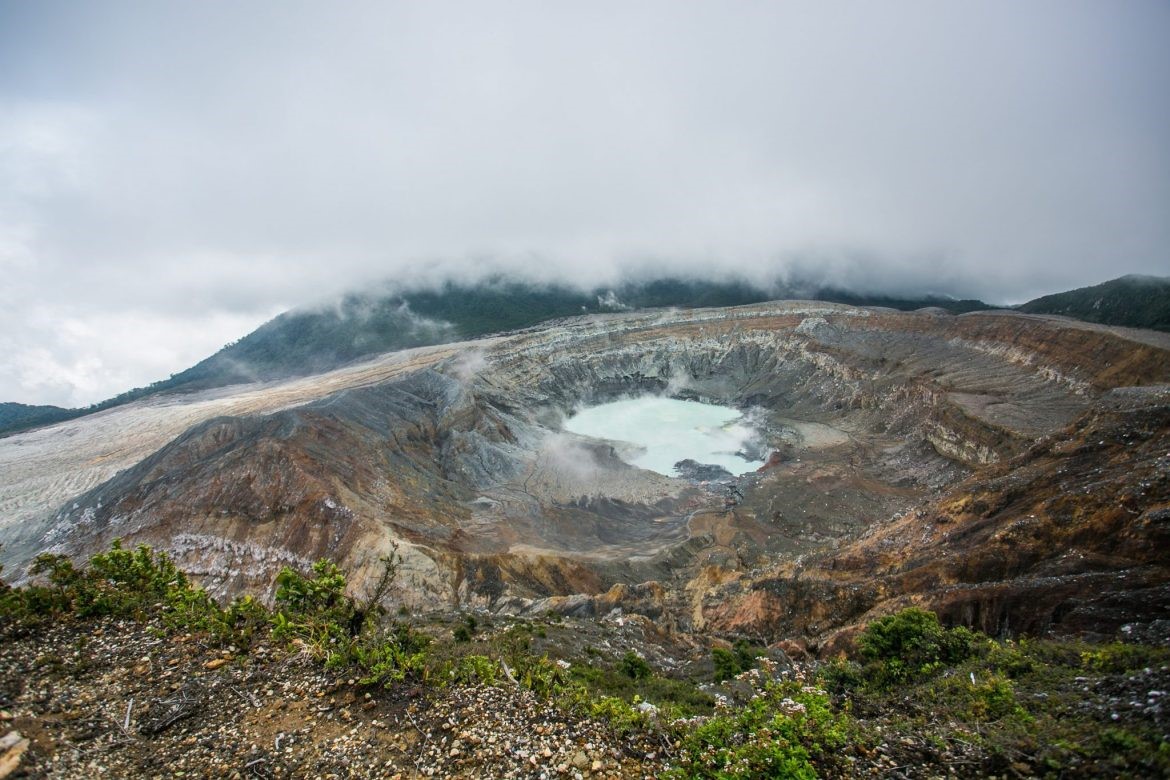 |
Figure 124. The Caliente crater at Poás with a blue crater lake on 28 August 2018. Courtesy of Costa Rica Gobierno del Bicentenario. |
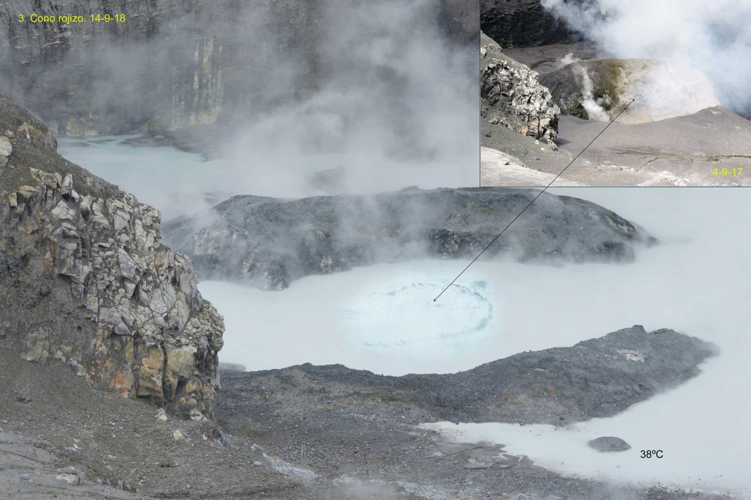 |
Figure 125. The partially-flooded Poás crater with a blue 38°C lake on 14 September 2018. The black arrow points to convection in the water from a flooded vent, with the insert photo showing a vent on the dry crater floor on 4 September 2017. Courtesy of OVSICORI-UNA (14 September 2018 report). |
During December phreatic activity was observed at hydrothermal vents on the 19th (four events) and 20th (three events) that ejected water-saturated material up to 30 m above the vent accompanied by strong degassing and steam plumes. On 20 December it was observed that the lake level had dropped by 1 m and the lake was divided into two bodies of water, Boca A and Boca C. There were also changes in the crater lake color. Starting at the beginning of the month, the lake progressively changed from blue to green, especially visible on 8 December (figures 126, 127, and 128).
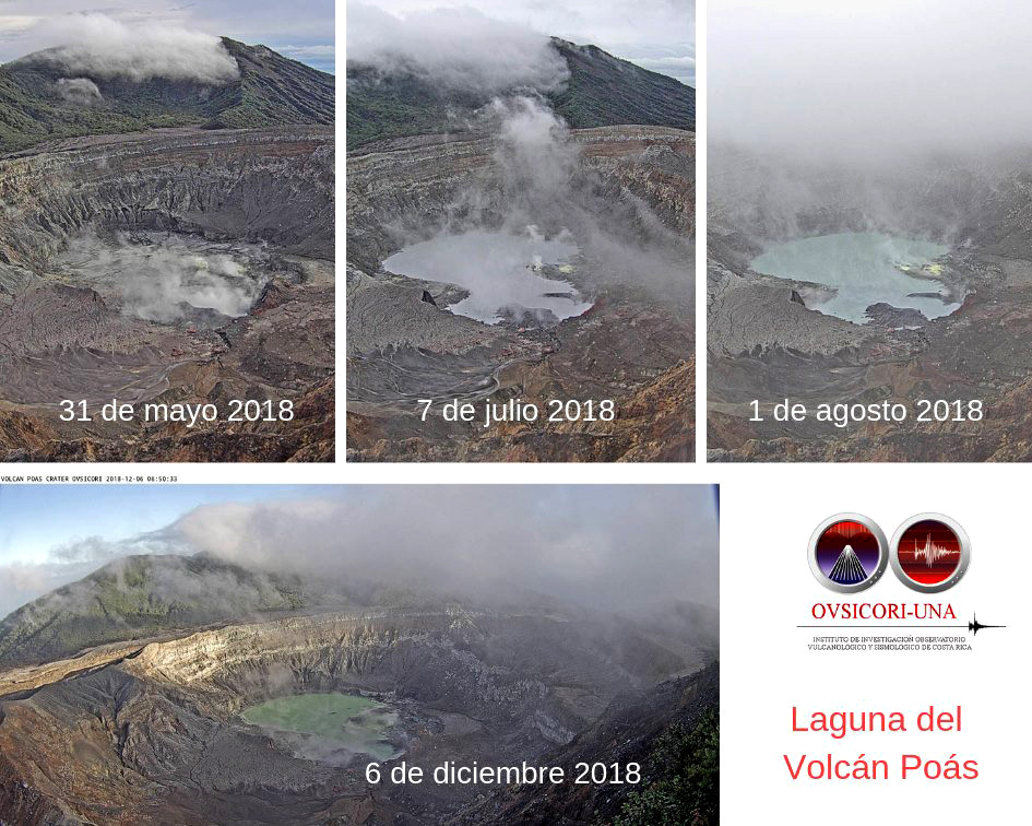 |
Figure 126. Photos of the Poás crater lake showing the nearly-dry lakebed on 31 May, a blue lake on 7 July and 1 August, and a green lake on 6 December 2018. The change in the color of the water is due to the chemical composition of the lake including silica, iron, and sulfur, reflecting different wavelengths of light. Courtesy of OVSICORI-UNA. |
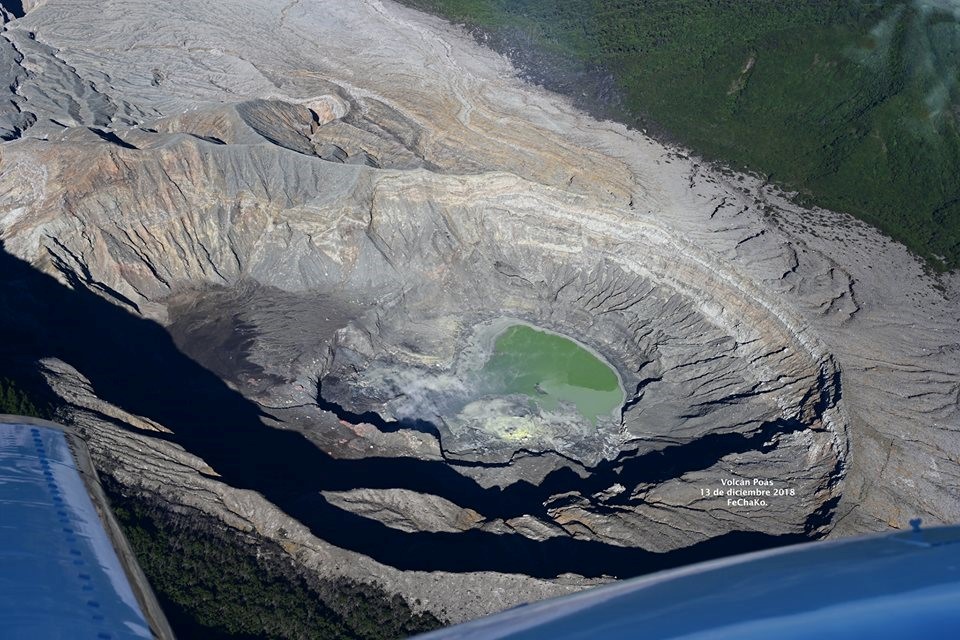 |
Figure 127. A view of the green crater lake with reduced water levels at Poás on 13 December 2018. Photo by Federico Chavarría-Kopper courtesy of OVSICORI-UNA. |
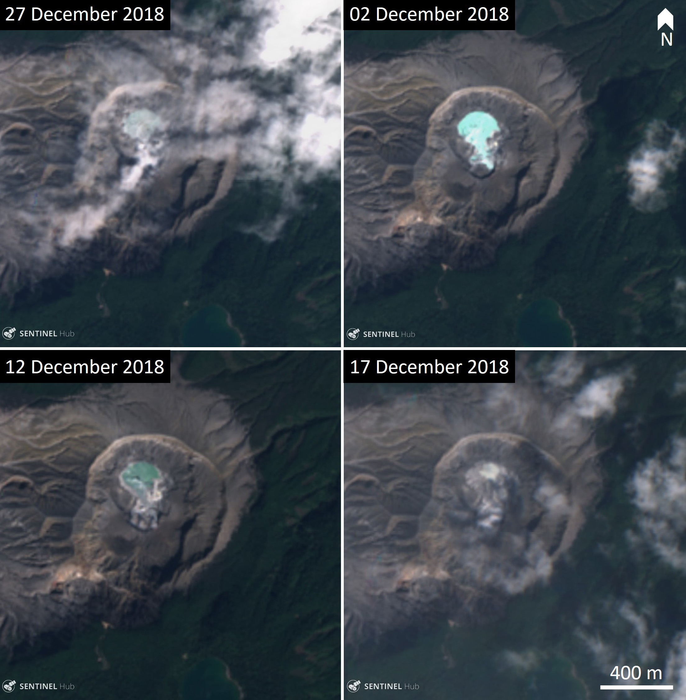 |
Figure 128. The changing crater lake of Poás volcano in December 2018. In one month the crater had a turquoise lake, a green lake, and was dry with no lake. Images courtesy of Sentinel Hub Playground. |
Information Contacts: Observatorio Vulcanologico Sismologica de Costa Rica-Universidad Nacional (OVSICORI-UNA), Apartado 86-3000, Heredia, Costa Rica (URL: http://www.ovsicori.una.ac.cr/); Sentinel Hub Playground (URL: https://www.sentinel-hub.com/explore/sentinel-playground); Costa Rica Gobierno del Bicentenario, Official Website - Presidency of the Republic of Costa Rica, Zapote, San José, Costa Rica (URL: https://presidencia.go.cr/comunicados/2018/08/29-de-agosto-presidente-alvarado-dara-banderazo-de-reapertura-del-volcan-poas/).
Weak ash emissions and disappearance of the crater lake
Weak activity at Poás during 2018 was dominated by hydrothermal degassing and a hot acid crater lake that had dried several times (BGVN 44:01). The current report characterizes activity between 1 January and 30 April 2019 and is based upon weekly reports by the Observatorio Vulcanologico Sismologica de Costa Rica-Universidad Nacional (OVSICORI-UNA).
According to OVSICORI-UNA, phreatic explosions that began on 19 December 2018 continued through at least mid-January, reaching a peak on 15 January, and then decreasing. Seismicity decreased to background levels, although long-period (LP) earthquakes and, until 16 January, continuous tremor were detected. No deformation was recorded. The SO2/CO2 gas ratio increased until at least 8 January, but decreased after 13 January. The SO2 flow was variable, and measured less than 50 t/d between two explosions and more than 500 t/d during an explosion. Gas emission was vigorous in the absence of water. By the end of January 2019 the lake had disappeared and explosions had stopped. Although tremor had ceased, daily low-amplitude LPs (up to 300/day) continued. SO2 levels were variable, increasing through 13 January and decreasing thereafter; on 25 January it was about 1,000 t/d.
On 7 February 2019 frequent infrasound pulses were associated with the ejection of ballistics and ash emissions that rose no higher than 200 m. Heightened activity stopped on 9 February. During this period the H2S/SO2 ratio increased to a peak on 9 February before decreasing. On 10 February there were SO2 odors reported in areas downwind including San Jose de Naranjo, Grecia (16 km SW), Poás, Sarchá, Naranjo, and Atenas (32 km SW). Incandescence was visible on 11 February. In the morning, a passive and continuous emission of ash occurred without an associated seismic signal. Throughout this period no deformation was observed, no juvenile material was found, and there was no sign of deep magmatic intrusion.
OVSICORI-UNA reported that since 8 February an almost continuous gas emission rose as high as 1 km and drifted mainly SW. During 13-14 February the emissions contained ash; gas-and-ash plumes drifted SW, affecting areas downwind including Naranjo, Zarcero, and Grecia (16 km SW). Gas-and-ash emissions rose from the crater on 15 February, and gas emissions were recorded on 18 February. By mid-February, explosive activity had decreased, although ash emissions continued, unaccompanied by any seismic signal, until ceasing at the end of February.
During 23-26 February seismicity was dominated by low-frequency events. Robust gas emissions rose from four fumarolic vents in the area previously covered by a lake, though the most vigorous emissions originated from vent A (Boca Roja). Minor incandescence from vent A was sometimes visible at night. A sulfur odor was reported in areas downwind including Naranjo, Zarcero, and Grecia (16 km SW). Particles of sulfur were included in ash deposits collected in Naranjo. Ashfall was reported in Canoas de Alajuela on 26 February.
Non-explosive ash emissions resumed during 7-9 March. Although weather conditions often prevented visual observations during 7-8 and 10 March, gas plumes sometimes containing ash rose as high as 500 m above the crater rim and drifting SW. A sulfur odor and ashfall were reported in Naranjo and Grecia. Additional ash emissions were observed on 13 and 18 March, associated with weak tremor but no explosions. The emission on 18 March produced a plume with minor ash content that rose 200 m above the crater rim; after 18 March yellow pulses were observed. Incandescence was observed beginning 21 March (figure 129).
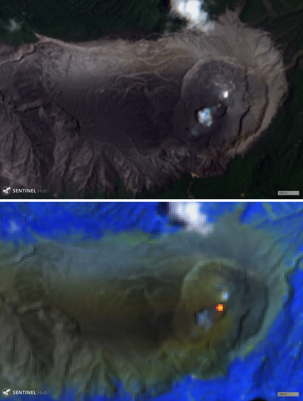 |
Figure 129. The active crater at Poás exhibited a thermal anomaly on 22 March 2019, seen here in Sentinel-2 L1C imagery. Top image is natural color (bands 4, 3, 2) and the bottom image is atmospheric penetration (bands 12, 11, 8A). Scale bar is 200 m. Courtesy of Sentinel Hub Playground. |
By the beginning of April, the geodesy network had measured a slight tendency towards inflation and extension, but his decreased by the end of April. Toward the end of April very diffuse ash emissions from the crater's bottom were observed, along with a weak incandescence visible on several days; the emissions had ceased by 30 April. Seismicity was stable, with about 150 LP earthquakes/day, infrequent volcano-tectonic earthquakes, and normal background tremor. The SO2/CO2 and H2S/SO2 ratios fell after the ash emission of 30 April. At the end of April, the crater remained without a lake and with slight incandescence.
Information Contacts: Observatorio Vulcanologico Sismologica de Costa Rica-Universidad Nacional (OVSICORI-UNA), Apartado 86-3000, Heredia, Costa Rica (URL: http://www.ovsicori.una.ac.cr/); Sentinel Hub Playground (URL: https://www.sentinel-hub.com/explore/sentinel-playground).
Occasional phreatic explosions continue through September 2019
Activity at Poás is characterized by weak phreatic explosions and gas-and-ash-emissions, with a hot acid lake that occasionally disappears (BGVN 44:05). During the current reporting period of May-September 2019, this weak activity continued. The volcano is monitored by the Observatorio Vulcanologico Sismologica de Costa Rica-Universidad Nacional (OVSICORI-UNA), and most of the material below comes from their weekly bulletins (Boletin Semanal Vulcanologia).
According to OVSICORI-UNA, a period of continuous emissions occurred during 30 April-1 May with plumes rising 300 m above the crater rim and drifting SW. Ash emissions were visible for a few hours on 30 April, and incandescence was visible at night. OVSICORI-UNA did not report any additional phreatic explosions in May until daily phreatic, geyser-type explosions were observed between 29 May and 1 June, which reached approximately 100 m above the vent. A phreatic explosion on 10 June reached approximately 20-30 m in height, and frequent small phreatic explosions (heights below 20 m) were reported through 16 June.
OVSICORI-UNA reported that on 12 June small geyser-like explosions ejected material less than 50 m high at a rate of about once per hour. At 0604 on 18 June an explosion that lasted about six minutes produced a plume of unknown height. Residents reportedly heard several loud noises during 0610-0615 and observed a plume rising from the crater. Ash fell in Cajón (12 km SW), San Luis de Grecia (11 km SW), Los Ángeles, San Miguel de Grecia (11 km SW), San Isidro (28 km SE), and San Roque (23 km SSE). Whitish ash deposits surrounding the crater, especially on the W and S sectors, were visible in webcam images. On 21 June frequent small phreatic explosions from vent A (Boca Roja) were visible during good viewing conditions ejecting material less than 10 m high.
No additional phreatic activity was reported by OVSICORI-UNA during rest of June or July. The small crater lake was still present on 5 July when visible in satellite imagery and as seen by visitors (figure 130), During the first part of August geyser-like explosions occurred on several days, and reached a maximum height of 50 m. This activity culminated on 17 August with about 30 explosions/day from the vent (Boca Roja). At least one event at 0650 on that day generated a 1-km-high plume of steam, gas, and fine particles. By 26 August, the geyser-type activity had ceased. Geyser-type phreatic explosions resumed on 12 September, reaching a maximum height of 30 m. The number of explosions increased up to 10-15 events/hour and then became continuous for a short time. A phreatic explosion occurred on 22 September at 2059 that generated a plume that rose 3 km above the crater rim and drifted NE. During 22-23 September explosions generated plumes that rose 1 km.
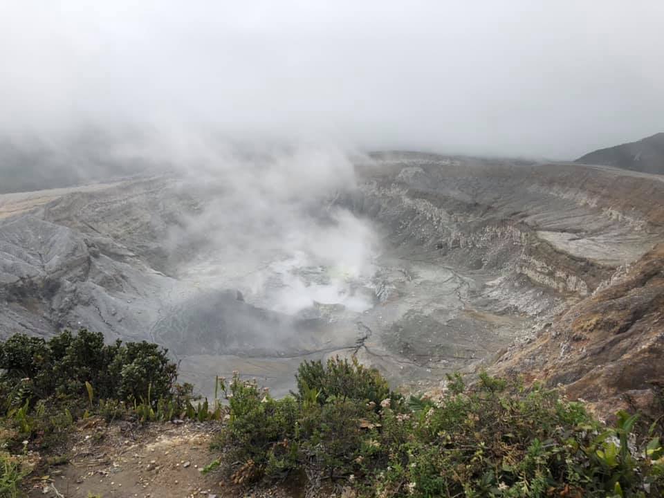 |
Figure 130. View of the Poás crater on 5 July 2019. The volcano is surrounded by cloud-cover, and there is some steam rising from the crater lake. Photo by Sheila DeForest (Creative Commons BY-SA license). |
According to OVSICORI-UNA, during 16-26 September sulfur dioxide emissions drifted W and NE, causing a sulfur odor in Alajuela, Heredia, San José, and Cartago. Acidic rain was recorded at an official's house in the Poás Volcano National Park (PNVP) on 23 September and at the Universidad Nacional Costa Rica (UNA) in Heredia (23 km SE) on 26 September. On 30 September, at 0540, a 5-minute long phreatic explosion ejected sediment, and produced a plume that rose 2 km above the crater rim and drifted SW. Ashfall and a sulfur odor was reported in Trojas de Sarchi (10 km SW) and Grecia (16 km SSW). Officials closed the PNVP because of the eruption and ongoing elevated seismicity; the park remained closed the next day.
During the first week of August, strong evaporation had reduced the intracrater lake significantly, and by mid-September, the lake had disappeared. At the end of September, however, some water had begun to accumulate again.
General monitoring data. During April and May, OVSICORI-UNA took few gas measurements due to an unfavorable wind direction. An SO2 measurement during the first part of June was between 100 and 200 t/d. Flux remained low through July, with low SO2/CO2 ratios, and high H2S/SO2 ratios, which OVSICORI-UNA stated were consistent with water infiltration. At the end of July, SO2 concentrations significantly increased to 300-800 t/d, with H2S disappearing and the CO2/SO2 ratio declining, with some fluctuations. Levels remained high through most of August, but had decreased to about 300 t/d by the end of the month. They rose again in September, with fluctuations, and on 29 September were measured at about 1,000 t/d before falling to between 300-400 t/d.
According to OVSICORI-UNA weekly reports, seismicity was relatively low during the reporting period, with a few VTs and LPs and normal background tremor. No significant deformation occurred, except for some deflation in June and July.
Information Contacts: Observatorio Vulcanologico Sismologica de Costa Rica-Universidad Nacional (OVSICORI-UNA), Apartado 86-3000, Heredia, Costa Rica (URL: http://www.ovsicori.una.ac.cr/); Sentinel Hub Playground (URL: https://www.sentinel-hub.com/explore/sentinel-playground); Sheila DeForest (URL: https://www.facebook.com/sheila.deforest).
Phreatic explosion on 6 April 2022 generates small plume and deposition in the lake
Activity at Poás is characterized by frequent geyser-like phreatic explosions and weak gas-and-ash-emissions, with an intermittent hot acidic lake in the summit crater. A series of phreatic explosions during April-September 2019 sometimes caused ashfall in nearby communities, and incandescence was sometimes observed at night (BGVN 44:10). The volcano is monitored by the Observatorio Vulcanologico Sismologica de Costa Rica-Universidad Nacional (OVSICORI-UNA). This report summarizes activity from October 2019 through April 2022, based on OVSICORI-UNA reports.
Seismic activity was low during October 2019-March 2022, and no deformation was recorded. The level of the acidic lake remained high, with levels slowly rising between October 2019 and December 2021, but more stable during January-April 2022. The annual bulletin for 2020 indicated that the lake temperature ranged from 43 to 55°C, with pH values between -0.2 and 0.3. Several reports during 2022 indicated that lake temperatures ranged from 35 to 41°C, with pH values between 0.18 and 0.37. Low-temperature fumaroles remained active within the lake and on terraces in the E and NE areas of the active crater. The main fumarole on the NE wall of the crater, named “Fumarola Naranja” (Orange Fumarole), produced strong degassing sounds. According to the 18 March 2022 report, seismicity was at an intermediate level with around 100 events per day (compared to 50 when low or 200 when high), with LP earthquakes.
OVSICORI-UNA reported that at 0242 on 6 April 2022 a phreatic explosion lasting three minutes was detected at Fumarola Naranja, generating a plume that rose 500 m above the crater. The event caused a small landslide that modified the vent. Some of the material from the landslide was deposited in a narrow strip extending about 140 m into the lake. Stirred sediment was visibly moving in convection cells, turning the lake water from a pale green to a uniform milky gray color (figure 131). The fumarolic vents at the E part of the crater and the underwater vent in the S part of the lake continued vigorous activity at least through 19 April.
|
Figure 131. Webcam photos of the crater lake at Poás just before the 6 April 2022 explosion (top) and just after (bottom), showing that the lake color changed and a narrow debris strip extending into the lake was deposited after the explosion. Courtesy of OVSICORI-UNA. |
On 17 April a gas monitoring station in Coronado measured an increased concentration of sulfur dioxide aerosols, between 8.5 and 17.6 micrograms of gas per cubic meter of ambient air, and some residents reported respiratory discomfort such as sneezing, coughing, and shortness of breath. OVSICORI-UNA’s 29 April bulletin indicated that, subsequent to the 6 April event, several new landslides and small hydrothermal explosions occurred in the vertical wall that had collapsed during the 6 April event. Seismic activity and gas ratios remained stable.
Information Contacts: Observatorio Vulcanologico Sismologica de Costa Rica-Universidad Nacional (OVSICORI-UNA), Apartado 86-3000, Heredia, Costa Rica (URL: http://www.ovsicori.una.ac.cr/).
This compilation of synonyms and subsidiary features may not be comprehensive. Features are organized into four major categories: Cones, Craters, Domes, and Thermal Features. Synonyms of features appear indented below the primary name. In some cases additional feature type, elevation, or location details are provided.
Synonyms |
||||
| Votos, Los | Agua Fría, Laguna de | Chibuzú | Botos, Los | Puas | Puás | Púas | ||||
Cones |
||||
| Feature Name | Feature Type | Elevation | Latitude | Longitude |
|
Botos
Votos |
Stratovolcano | 2697 m | 10° 11' 12" N | 84° 13' 24" W |
|
Congo, Cerro
Cariblanco |
Stratovolcano | 2010 m | 10° 15' 16" N | 84° 13' 39" W |
| Sabana Redonda | Cone | |||
| von Frantzius | Stratovolcano | 2627 m | 10° 12' 45" N | 84° 13' 36" W |
Craters |
||||
| Feature Name | Feature Type | Elevation | Latitude | Longitude |
| Caliente, Laguna | Crater | 2340 m | 10° 11' 49" N | 84° 13' 52" W |
|
Hule
Lake Congo Bosque Alegre |
Maar | 780 m | 10° 18' 0" N | 84° 12' 50" W |
|
Río Cuarto, Laguna
Misterios, Laguna de los Misterio, del Kooper Yurro Hondo, Laguna de Río Hondo, Laguna de |
Maar | 377 m | 10° 21' 23" N | 84° 13' 1" W |
|
|
||||||||||||||||||||||||
There is data available for 61 confirmed Holocene eruptive periods.
2023 Dec 1 - 2024 Apr 19 (continuing) Confirmed Eruption
| Episode 1 | Eruption Episode | ||||
|---|---|---|---|---|
| 2023 Dec 1 - 2024 Apr 19 (continuing) | Evidence from Observations: Reported | |||
2023 Aug 2 - 2023 Aug 11 Confirmed Eruption
| Episode 1 | Eruption Episode | ||||
|---|---|---|---|---|
| 2023 Aug 2 - 2023 Aug 11 | Evidence from Observations: Reported | |||
2022 Apr 6 - 2022 Apr 6 Confirmed Eruption Max VEI: 1
| Episode 1 | Phreatic Episode | Crater lake - Fumarola Naranja | |||||||||||||||||||
|---|---|---|---|---|---|---|---|---|---|---|---|---|---|---|---|---|---|---|---|---|
| 2022 Apr 6 - 2022 Apr 6 | Evidence from Observations: Reported | |||||||||||||||||||
| OVSICORI-UNA reported that on 6 April at 0240 a phreatic explosion from a vent called “Orange Fumarola” located in a fumarolic field along the inner N crater wall generated a plume that rose 500 m above the crater rim. Activity lasted for three minutes. The event caused a small landslide that modified the vent. Some of the material from the landslide was deposited in a narrow strip about 100 m into the Boca A lake. | ||||||||||||||||||||
|
List of 2 Events for Episode 1 at Crater lake - Fumarola Naranja
| ||||||||||||||||||||
2019 Feb 7 - 2019 Sep 30 Confirmed Eruption Max VEI: 2
| Episode 1 | Eruption Episode | |||||||||||||||
|---|---|---|---|---|---|---|---|---|---|---|---|---|---|---|---|
| 2019 Feb 7 - 2019 Sep 30 | Evidence from Observations: Reported | ||||||||||||||
|
List of 1 Events for Episode 1
| |||||||||||||||
2017 Apr 12 - 2017 Nov 6 Confirmed Eruption Max VEI: 1
| Episode 1 | Eruption Episode | Laguna Caliente Crater | ||||||||||||||||||||||||||||||||||||||||||||||||||||||||||||||||||||||||||||||||||||||||||||||||||||||||||||||||||||||||||||||||||||||||||||||||||||||||||||||||||||||||||||||||||||||||||||||||||||||||||||||||||||||||||||||||||||||||||||||||||||||||||||||||||||||||||||||||||||||||||||||||||||||||||||||||||||||||||||||||||||||||||||||||||||||||||||||||||||||||||||||||||||||||||||||||||||||||||||||||||||||||||||||
|---|---|---|---|---|---|---|---|---|---|---|---|---|---|---|---|---|---|---|---|---|---|---|---|---|---|---|---|---|---|---|---|---|---|---|---|---|---|---|---|---|---|---|---|---|---|---|---|---|---|---|---|---|---|---|---|---|---|---|---|---|---|---|---|---|---|---|---|---|---|---|---|---|---|---|---|---|---|---|---|---|---|---|---|---|---|---|---|---|---|---|---|---|---|---|---|---|---|---|---|---|---|---|---|---|---|---|---|---|---|---|---|---|---|---|---|---|---|---|---|---|---|---|---|---|---|---|---|---|---|---|---|---|---|---|---|---|---|---|---|---|---|---|---|---|---|---|---|---|---|---|---|---|---|---|---|---|---|---|---|---|---|---|---|---|---|---|---|---|---|---|---|---|---|---|---|---|---|---|---|---|---|---|---|---|---|---|---|---|---|---|---|---|---|---|---|---|---|---|---|---|---|---|---|---|---|---|---|---|---|---|---|---|---|---|---|---|---|---|---|---|---|---|---|---|---|---|---|---|---|---|---|---|---|---|---|---|---|---|---|---|---|---|---|---|---|---|---|---|---|---|---|---|---|---|---|---|---|---|---|---|---|---|---|---|---|---|---|---|---|---|---|---|---|---|---|---|---|---|---|---|---|---|---|---|---|---|---|---|---|---|---|---|---|---|---|---|---|---|---|---|---|---|---|---|---|---|---|---|---|---|---|---|---|---|---|---|---|---|---|---|---|---|---|---|---|---|---|---|---|---|---|---|---|---|---|---|---|---|---|---|---|---|---|---|---|---|---|---|---|---|---|---|---|---|---|---|---|---|---|---|---|---|---|---|---|---|---|---|---|---|---|---|---|---|---|---|---|---|---|---|---|---|---|---|---|---|---|---|---|---|---|---|---|---|---|---|---|---|---|---|---|---|---|---|---|---|---|---|---|---|---|---|---|---|---|
| 2017 Apr 12 - 2017 Nov 6 | Evidence from Observations: Reported | ||||||||||||||||||||||||||||||||||||||||||||||||||||||||||||||||||||||||||||||||||||||||||||||||||||||||||||||||||||||||||||||||||||||||||||||||||||||||||||||||||||||||||||||||||||||||||||||||||||||||||||||||||||||||||||||||||||||||||||||||||||||||||||||||||||||||||||||||||||||||||||||||||||||||||||||||||||||||||||||||||||||||||||||||||||||||||||||||||||||||||||||||||||||||||||||||||||||||||||||||||||||||||||||
|
List of 81 Events for Episode 1 at Laguna Caliente Crater
| |||||||||||||||||||||||||||||||||||||||||||||||||||||||||||||||||||||||||||||||||||||||||||||||||||||||||||||||||||||||||||||||||||||||||||||||||||||||||||||||||||||||||||||||||||||||||||||||||||||||||||||||||||||||||||||||||||||||||||||||||||||||||||||||||||||||||||||||||||||||||||||||||||||||||||||||||||||||||||||||||||||||||||||||||||||||||||||||||||||||||||||||||||||||||||||||||||||||||||||||||||||||||||||||
2016 Jun 5 - 2016 Aug 16 Confirmed Eruption Max VEI: 1
| Episode 1 | Phreatic Episode | Lake in summit crater | ||||||||||||||||||||||||||||||||||||||||||||||||||||||||||||||||||||||||||||||||||||
|---|---|---|---|---|---|---|---|---|---|---|---|---|---|---|---|---|---|---|---|---|---|---|---|---|---|---|---|---|---|---|---|---|---|---|---|---|---|---|---|---|---|---|---|---|---|---|---|---|---|---|---|---|---|---|---|---|---|---|---|---|---|---|---|---|---|---|---|---|---|---|---|---|---|---|---|---|---|---|---|---|---|---|---|---|---|
| 2016 Jun 5 - 2016 Aug 16 | Evidence from Observations: Reported | ||||||||||||||||||||||||||||||||||||||||||||||||||||||||||||||||||||||||||||||||||||
|
List of 15 Events for Episode 1 at Lake in summit crater
| |||||||||||||||||||||||||||||||||||||||||||||||||||||||||||||||||||||||||||||||||||||
2009 Nov 16 ± 15 days - 2014 Oct 13 Confirmed Eruption Max VEI: 1
| Episode 1 | Eruption Episode | |||||||||||||||||||||||||||||||||||||||||||||
|---|---|---|---|---|---|---|---|---|---|---|---|---|---|---|---|---|---|---|---|---|---|---|---|---|---|---|---|---|---|---|---|---|---|---|---|---|---|---|---|---|---|---|---|---|---|
| 2009 Nov 16 ± 15 days - 2014 Oct 13 | Evidence from Observations: Reported | ||||||||||||||||||||||||||||||||||||||||||||
|
List of 7 Events for Episode 1
| |||||||||||||||||||||||||||||||||||||||||||||
2009 Jan 12 - 2009 Mar 21 (?) Confirmed Eruption Max VEI: 1
| Episode 1 | Eruption Episode | |||||||||||||||||||||||||
|---|---|---|---|---|---|---|---|---|---|---|---|---|---|---|---|---|---|---|---|---|---|---|---|---|---|
| 2009 Jan 12 - 2009 Mar 21 (?) | Evidence from Observations: Reported | ||||||||||||||||||||||||
|
List of 3 Events for Episode 1
| |||||||||||||||||||||||||
2008 Jan 13 - 2008 Jan 13 Confirmed Eruption Max VEI: 1
| Episode 1 | Eruption Episode | ||||||||||||||||||||||||||||||
|---|---|---|---|---|---|---|---|---|---|---|---|---|---|---|---|---|---|---|---|---|---|---|---|---|---|---|---|---|---|---|
| 2008 Jan 13 - 2008 Jan 13 | Evidence from Observations: Reported | |||||||||||||||||||||||||||||
|
List of 4 Events for Episode 1
| ||||||||||||||||||||||||||||||
2006 Sep 25 - 2006 Dec 16 Confirmed Eruption Max VEI: 1
| Episode 1 | Eruption Episode | ||||||||||||||||||||||||||||||
|---|---|---|---|---|---|---|---|---|---|---|---|---|---|---|---|---|---|---|---|---|---|---|---|---|---|---|---|---|---|---|
| 2006 Sep 25 - 2006 Dec 16 | Evidence from Observations: Reported | |||||||||||||||||||||||||||||
|
List of 4 Events for Episode 1
| ||||||||||||||||||||||||||||||
2006 Mar 24 - 2006 Mar 24 (?) Confirmed Eruption Max VEI: 1
| Episode 1 | Eruption Episode | |||||||||||||||||||||||||
|---|---|---|---|---|---|---|---|---|---|---|---|---|---|---|---|---|---|---|---|---|---|---|---|---|---|
| 2006 Mar 24 - 2006 Mar 24 (?) | Evidence from Observations: Reported | ||||||||||||||||||||||||
|
List of 3 Events for Episode 1
| |||||||||||||||||||||||||
1996 Apr 8 - 1996 Apr 8 Confirmed Eruption Max VEI: 1
| Episode 1 | Eruption Episode | |||||||||||||||||||||||||||||||||||||||||||||
|---|---|---|---|---|---|---|---|---|---|---|---|---|---|---|---|---|---|---|---|---|---|---|---|---|---|---|---|---|---|---|---|---|---|---|---|---|---|---|---|---|---|---|---|---|---|
| 1996 Apr 8 - 1996 Apr 8 | Evidence from Observations: Reported | ||||||||||||||||||||||||||||||||||||||||||||
|
List of 7 Events for Episode 1
| |||||||||||||||||||||||||||||||||||||||||||||
1994 Mar 16 (?) ± 15 days - 1994 Oct 16 (?) ± 15 days Confirmed Eruption Max VEI: 2
| Episode 1 | Eruption Episode | |||||||||||||||||||||||||||||||||||||||||||||
|---|---|---|---|---|---|---|---|---|---|---|---|---|---|---|---|---|---|---|---|---|---|---|---|---|---|---|---|---|---|---|---|---|---|---|---|---|---|---|---|---|---|---|---|---|---|
| 1994 Mar 16 (?) ± 15 days - 1994 Oct 16 (?) ± 15 days | Evidence from Observations: Reported | ||||||||||||||||||||||||||||||||||||||||||||
|
List of 7 Events for Episode 1
| |||||||||||||||||||||||||||||||||||||||||||||
1992 Oct 16 ± 15 days - 1993 Sep 16 ± 15 days Confirmed Eruption Max VEI: 0
| Episode 1 | Eruption Episode | ||||||||||||||||||||
|---|---|---|---|---|---|---|---|---|---|---|---|---|---|---|---|---|---|---|---|---|
| 1992 Oct 16 ± 15 days - 1993 Sep 16 ± 15 days | Evidence from Observations: Reported | |||||||||||||||||||
|
List of 2 Events for Episode 1
| ||||||||||||||||||||
1992 Feb 16 ± 15 days - 1992 Mar 16 ± 15 days Confirmed Eruption Max VEI: 1
| Episode 1 | Eruption Episode | ||||||||||||||||||||||||||||||
|---|---|---|---|---|---|---|---|---|---|---|---|---|---|---|---|---|---|---|---|---|---|---|---|---|---|---|---|---|---|---|
| 1992 Feb 16 ± 15 days - 1992 Mar 16 ± 15 days | Evidence from Observations: Reported | |||||||||||||||||||||||||||||
|
List of 4 Events for Episode 1
| ||||||||||||||||||||||||||||||
1991 Mar 6 - 1991 Sep 16 ± 15 days Confirmed Eruption Max VEI: 1
| Episode 1 | Eruption Episode | ||||||||||||||||||||||||||||||
|---|---|---|---|---|---|---|---|---|---|---|---|---|---|---|---|---|---|---|---|---|---|---|---|---|---|---|---|---|---|---|
| 1991 Mar 6 - 1991 Sep 16 ± 15 days | Evidence from Observations: Reported | |||||||||||||||||||||||||||||
|
List of 4 Events for Episode 1
| ||||||||||||||||||||||||||||||
1987 Jun 16 ± 15 days - 1990 Jun 16 ± 15 days Confirmed Eruption Max VEI: 2
| Episode 1 | Eruption Episode | ||||||||||||||||||||||||||||||||||||||||||||||||||||||||||||
|---|---|---|---|---|---|---|---|---|---|---|---|---|---|---|---|---|---|---|---|---|---|---|---|---|---|---|---|---|---|---|---|---|---|---|---|---|---|---|---|---|---|---|---|---|---|---|---|---|---|---|---|---|---|---|---|---|---|---|---|---|
| 1987 Jun 16 ± 15 days - 1990 Jun 16 ± 15 days | Evidence from Observations: Reported | |||||||||||||||||||||||||||||||||||||||||||||||||||||||||||
|
List of 10 Events for Episode 1
| ||||||||||||||||||||||||||||||||||||||||||||||||||||||||||||
1981 Mar 16 ± 15 days - 1981 May 16 ± 15 days Confirmed Eruption Max VEI: 1
| Episode 1 | Eruption Episode | ||||||||||||||||||||
|---|---|---|---|---|---|---|---|---|---|---|---|---|---|---|---|---|---|---|---|---|
| 1981 Mar 16 ± 15 days - 1981 May 16 ± 15 days | Evidence from Observations: Reported | |||||||||||||||||||
|
List of 2 Events for Episode 1
| ||||||||||||||||||||
1980 Dec 26 - 1980 Dec 26 Confirmed Eruption Max VEI: 1
| Episode 1 | Eruption Episode | ||||||||||||||||||||||||||||||
|---|---|---|---|---|---|---|---|---|---|---|---|---|---|---|---|---|---|---|---|---|---|---|---|---|---|---|---|---|---|---|
| 1980 Dec 26 - 1980 Dec 26 | Evidence from Observations: Reported | |||||||||||||||||||||||||||||
|
List of 4 Events for Episode 1
| ||||||||||||||||||||||||||||||
1980 Sep 12 - 1980 Sep 12 Confirmed Eruption Max VEI: 1
| Episode 1 | Eruption Episode | ||||||||||||||||||||||||||||||
|---|---|---|---|---|---|---|---|---|---|---|---|---|---|---|---|---|---|---|---|---|---|---|---|---|---|---|---|---|---|---|
| 1980 Sep 12 - 1980 Sep 12 | Evidence from Observations: Reported | |||||||||||||||||||||||||||||
|
List of 4 Events for Episode 1
| ||||||||||||||||||||||||||||||
1979 Sep 8 - 1980 Jan 16 ± 15 days Confirmed Eruption Max VEI: 1
| Episode 1 | Eruption Episode | |||||||||||||||||||||||||
|---|---|---|---|---|---|---|---|---|---|---|---|---|---|---|---|---|---|---|---|---|---|---|---|---|---|
| 1979 Sep 8 - 1980 Jan 16 ± 15 days | Evidence from Observations: Reported | ||||||||||||||||||||||||
|
List of 3 Events for Episode 1
| |||||||||||||||||||||||||
1978 Sep 22 - 1978 Dec 16 ± 15 days Confirmed Eruption Max VEI: 1
| Episode 1 | Eruption Episode | |||||||||||||||||||||||||||||||||||||||||||||
|---|---|---|---|---|---|---|---|---|---|---|---|---|---|---|---|---|---|---|---|---|---|---|---|---|---|---|---|---|---|---|---|---|---|---|---|---|---|---|---|---|---|---|---|---|---|
| 1978 Sep 22 - 1978 Dec 16 ± 15 days | Evidence from Observations: Reported | ||||||||||||||||||||||||||||||||||||||||||||
|
List of 7 Events for Episode 1
| |||||||||||||||||||||||||||||||||||||||||||||
1977 Dec 18 - 1978 Jun 15 Confirmed Eruption Max VEI: 2
| Episode 1 | Eruption Episode | ||||||||||||||||||||||||||||||
|---|---|---|---|---|---|---|---|---|---|---|---|---|---|---|---|---|---|---|---|---|---|---|---|---|---|---|---|---|---|---|
| 1977 Dec 18 - 1978 Jun 15 | Evidence from Observations: Reported | |||||||||||||||||||||||||||||
|
List of 4 Events for Episode 1
| ||||||||||||||||||||||||||||||
1977 May 16 ± 15 days - 1977 Jul 16 (?) ± 15 days Confirmed Eruption Max VEI: 1
| Episode 1 | Eruption Episode | |||||||||||||||||||||||||
|---|---|---|---|---|---|---|---|---|---|---|---|---|---|---|---|---|---|---|---|---|---|---|---|---|---|
| 1977 May 16 ± 15 days - 1977 Jul 16 (?) ± 15 days | Evidence from Observations: Reported | ||||||||||||||||||||||||
|
List of 3 Events for Episode 1
| |||||||||||||||||||||||||
1976 Jun 21 - 1976 Nov 16 ± 15 days Confirmed Eruption Max VEI: 2
| Episode 1 | Eruption Episode | ||||||||||||||||||||||||||||||
|---|---|---|---|---|---|---|---|---|---|---|---|---|---|---|---|---|---|---|---|---|---|---|---|---|---|---|---|---|---|---|
| 1976 Jun 21 - 1976 Nov 16 ± 15 days | Evidence from Observations: Reported | |||||||||||||||||||||||||||||
|
List of 4 Events for Episode 1
| ||||||||||||||||||||||||||||||
1974 Sep 11 - 1975 Feb 16 ± 15 days Confirmed Eruption Max VEI: 2
| Episode 1 | Eruption Episode | ||||||||||||||||||||
|---|---|---|---|---|---|---|---|---|---|---|---|---|---|---|---|---|---|---|---|---|
| 1974 Sep 11 - 1975 Feb 16 ± 15 days | Evidence from Observations: Reported | |||||||||||||||||||
|
List of 2 Events for Episode 1
| ||||||||||||||||||||
1972 Feb 9 - 1973 Sep 8 Confirmed Eruption Max VEI: 2
| Episode 1 | Eruption Episode | |||||||||||||||||||||||||||||||||||||||||||||||||||||||
|---|---|---|---|---|---|---|---|---|---|---|---|---|---|---|---|---|---|---|---|---|---|---|---|---|---|---|---|---|---|---|---|---|---|---|---|---|---|---|---|---|---|---|---|---|---|---|---|---|---|---|---|---|---|---|---|
| 1972 Feb 9 - 1973 Sep 8 | Evidence from Observations: Reported | ||||||||||||||||||||||||||||||||||||||||||||||||||||||
|
List of 9 Events for Episode 1
| |||||||||||||||||||||||||||||||||||||||||||||||||||||||
1970 Jul 16 ± 15 days Confirmed Eruption Max VEI: 1
| Episode 1 | Eruption Episode | ||||||||||||||||||||
|---|---|---|---|---|---|---|---|---|---|---|---|---|---|---|---|---|---|---|---|---|
| 1970 Jul 16 ± 15 days - Unknown | Evidence from Observations: Reported | |||||||||||||||||||
|
List of 2 Events for Episode 1
| ||||||||||||||||||||
1969 May 3 - 1969 Jun 3 Confirmed Eruption Max VEI: 2
| Episode 1 | Eruption Episode | ||||||||||||||||||||||||||||||
|---|---|---|---|---|---|---|---|---|---|---|---|---|---|---|---|---|---|---|---|---|---|---|---|---|---|---|---|---|---|---|
| 1969 May 3 - 1969 Jun 3 | Evidence from Observations: Reported | |||||||||||||||||||||||||||||
|
List of 4 Events for Episode 1
| ||||||||||||||||||||||||||||||
1968 Jul 2 ± 182 days Confirmed Eruption Max VEI: 1
| Episode 1 | Eruption Episode | ||||||||||||||||||||
|---|---|---|---|---|---|---|---|---|---|---|---|---|---|---|---|---|---|---|---|---|
| 1968 Jul 2 ± 182 days - Unknown | Evidence from Observations: Reported | |||||||||||||||||||
|
List of 2 Events for Episode 1
| ||||||||||||||||||||
1967 Jan 1 Confirmed Eruption Max VEI: 1
| Episode 1 | Eruption Episode | |||||||||||||||||||||||||
|---|---|---|---|---|---|---|---|---|---|---|---|---|---|---|---|---|---|---|---|---|---|---|---|---|---|
| 1967 Jan 1 - Unknown | Evidence from Observations: Reported | ||||||||||||||||||||||||
|
List of 3 Events for Episode 1
| |||||||||||||||||||||||||
1964 Dec 25 - 1965 Mar 16 ± 15 days Confirmed Eruption Max VEI: 2
| Episode 1 | Eruption Episode | |||||||||||||||||||||||||||||||||||||||||||||
|---|---|---|---|---|---|---|---|---|---|---|---|---|---|---|---|---|---|---|---|---|---|---|---|---|---|---|---|---|---|---|---|---|---|---|---|---|---|---|---|---|---|---|---|---|---|
| 1964 Dec 25 - 1965 Mar 16 ± 15 days | Evidence from Observations: Reported | ||||||||||||||||||||||||||||||||||||||||||||
|
List of 7 Events for Episode 1
| |||||||||||||||||||||||||||||||||||||||||||||
1963 May 23 - 1963 Jul 2 Confirmed Eruption Max VEI: 2
| Episode 1 | Eruption Episode | |||||||||||||||||||||||||
|---|---|---|---|---|---|---|---|---|---|---|---|---|---|---|---|---|---|---|---|---|---|---|---|---|---|
| 1963 May 23 - 1963 Jul 2 | Evidence from Observations: Reported | ||||||||||||||||||||||||
|
List of 3 Events for Episode 1
| |||||||||||||||||||||||||
1958 Jul 2 ± 182 days - 1961 Jul 3 (?) Confirmed Eruption Max VEI: 2
| Episode 1 | Eruption Episode | ||||||||||||||||||||||||||||||
|---|---|---|---|---|---|---|---|---|---|---|---|---|---|---|---|---|---|---|---|---|---|---|---|---|---|---|---|---|---|---|
| 1958 Jul 2 ± 182 days - 1961 Jul 3 (?) | Evidence from Observations: Reported | |||||||||||||||||||||||||||||
|
List of 4 Events for Episode 1
| ||||||||||||||||||||||||||||||
1952 Mar 23 - 1957 Dec 25 Confirmed Eruption Max VEI: 2
| Episode 1 | Eruption Episode | ||||||||||||||||||||||||||||||||||||||||||||||||||||||||||||||||||||||||||||||||||||||||||
|---|---|---|---|---|---|---|---|---|---|---|---|---|---|---|---|---|---|---|---|---|---|---|---|---|---|---|---|---|---|---|---|---|---|---|---|---|---|---|---|---|---|---|---|---|---|---|---|---|---|---|---|---|---|---|---|---|---|---|---|---|---|---|---|---|---|---|---|---|---|---|---|---|---|---|---|---|---|---|---|---|---|---|---|---|---|---|---|---|---|---|
| 1952 Mar 23 - 1957 Dec 25 | Evidence from Observations: Reported | |||||||||||||||||||||||||||||||||||||||||||||||||||||||||||||||||||||||||||||||||||||||||
|
List of 16 Events for Episode 1
| ||||||||||||||||||||||||||||||||||||||||||||||||||||||||||||||||||||||||||||||||||||||||||
1948 - 1951 Jul 2 ± 182 days Confirmed Eruption Max VEI: 1
| Episode 1 | Eruption Episode | ||||||||||||||||||||
|---|---|---|---|---|---|---|---|---|---|---|---|---|---|---|---|---|---|---|---|---|
| 1948 - 1951 Jul 2 ± 182 days | Evidence from Observations: Reported | |||||||||||||||||||
|
List of 2 Events for Episode 1
| ||||||||||||||||||||
1946 Nov 4 ± 4 days Confirmed Eruption Max VEI: 1
| Episode 1 | Eruption Episode | ||||||||||||||||||||
|---|---|---|---|---|---|---|---|---|---|---|---|---|---|---|---|---|---|---|---|---|
| 1946 Nov 4 ± 4 days - Unknown | Evidence from Observations: Reported | |||||||||||||||||||
|
List of 2 Events for Episode 1
| ||||||||||||||||||||
1941 - 1946 Confirmed Eruption Max VEI: 1
| Episode 1 | Eruption Episode | ||||||||||||||||||||
|---|---|---|---|---|---|---|---|---|---|---|---|---|---|---|---|---|---|---|---|---|
| 1941 - 1946 | Evidence from Observations: Reported | |||||||||||||||||||
|
List of 2 Events for Episode 1
| ||||||||||||||||||||
1932 - 1934 Confirmed Eruption Max VEI: 1 (?)
| Episode 1 | Eruption Episode | ||||||||||||||||||||
|---|---|---|---|---|---|---|---|---|---|---|---|---|---|---|---|---|---|---|---|---|
| 1932 - 1934 | Evidence from Observations: Reported | |||||||||||||||||||
|
List of 2 Events for Episode 1
| ||||||||||||||||||||
1929 Confirmed Eruption Max VEI: 1
| Episode 1 | Eruption Episode | ||||||||||||||||||||
|---|---|---|---|---|---|---|---|---|---|---|---|---|---|---|---|---|---|---|---|---|
| 1929 - Unknown | Evidence from Observations: Reported | |||||||||||||||||||
|
List of 2 Events for Episode 1
| ||||||||||||||||||||
1925 Confirmed Eruption Max VEI: 1
| Episode 1 | Eruption Episode | ||||||||||||||||||||
|---|---|---|---|---|---|---|---|---|---|---|---|---|---|---|---|---|---|---|---|---|
| 1925 - Unknown | Evidence from Observations: Reported | |||||||||||||||||||
|
List of 2 Events for Episode 1
| ||||||||||||||||||||
1916 Confirmed Eruption Max VEI: 2
| Episode 1 | Eruption Episode | |||||||||||||||||||||||||
|---|---|---|---|---|---|---|---|---|---|---|---|---|---|---|---|---|---|---|---|---|---|---|---|---|---|
| 1916 - Unknown | Evidence from Observations: Reported | ||||||||||||||||||||||||
|
List of 3 Events for Episode 1
| |||||||||||||||||||||||||
1914 Oct 8 - 1915 May 15 (in or after) Confirmed Eruption Max VEI: 2
| Episode 1 | Eruption Episode | |||||||||||||||||||||||||
|---|---|---|---|---|---|---|---|---|---|---|---|---|---|---|---|---|---|---|---|---|---|---|---|---|---|
| 1914 Oct 8 - 1915 May 15 (in or after) | Evidence from Observations: Reported | ||||||||||||||||||||||||
|
List of 3 Events for Episode 1
| |||||||||||||||||||||||||
1914 May 30 Confirmed Eruption Max VEI: 2
| Episode 1 | Eruption Episode | |||||||||||||||||||||||||
|---|---|---|---|---|---|---|---|---|---|---|---|---|---|---|---|---|---|---|---|---|---|---|---|---|---|
| 1914 May 30 - Unknown | Evidence from Observations: Reported | ||||||||||||||||||||||||
|
List of 3 Events for Episode 1
| |||||||||||||||||||||||||
1910 Sep 12 - 1910 Oct 14 Confirmed Eruption Max VEI: 1
| Episode 1 | Eruption Episode | ||||||||||||||||||||
|---|---|---|---|---|---|---|---|---|---|---|---|---|---|---|---|---|---|---|---|---|
| 1910 Sep 12 - 1910 Oct 14 | Evidence from Observations: Reported | |||||||||||||||||||
|
List of 2 Events for Episode 1
| ||||||||||||||||||||
1910 Jan 25 - 1910 Feb Confirmed Eruption Max VEI: 2
| Episode 1 | Eruption Episode | |||||||||||||||||||||||||||||||||||
|---|---|---|---|---|---|---|---|---|---|---|---|---|---|---|---|---|---|---|---|---|---|---|---|---|---|---|---|---|---|---|---|---|---|---|---|
| 1910 Jan 25 - 1910 Feb | Evidence from Observations: Reported | ||||||||||||||||||||||||||||||||||
|
List of 5 Events for Episode 1
| |||||||||||||||||||||||||||||||||||
1898 Dec 29 - 1907 Dec 31 ± 365 days Confirmed Eruption Max VEI: 1
| Episode 1 | Eruption Episode | ||||||||||||||||||||||||||||||||||||||||
|---|---|---|---|---|---|---|---|---|---|---|---|---|---|---|---|---|---|---|---|---|---|---|---|---|---|---|---|---|---|---|---|---|---|---|---|---|---|---|---|---|
| 1898 Dec 29 - 1907 Dec 31 ± 365 days | Evidence from Observations: Reported | |||||||||||||||||||||||||||||||||||||||
|
List of 6 Events for Episode 1
| ||||||||||||||||||||||||||||||||||||||||
1895 Confirmed Eruption Max VEI: 1
| Episode 1 | Eruption Episode | ||||||||||||||||||||
|---|---|---|---|---|---|---|---|---|---|---|---|---|---|---|---|---|---|---|---|---|
| 1895 - Unknown | Evidence from Observations: Reported | |||||||||||||||||||
|
List of 2 Events for Episode 1
| ||||||||||||||||||||
1888 Jan - 1891 Confirmed Eruption Max VEI: 1
| Episode 1 | Eruption Episode | ||||||||||||||||||||
|---|---|---|---|---|---|---|---|---|---|---|---|---|---|---|---|---|---|---|---|---|
| 1888 Jan - 1891 | Evidence from Observations: Reported | |||||||||||||||||||
|
List of 2 Events for Episode 1
| ||||||||||||||||||||
1880 Confirmed Eruption Max VEI: 1
| Episode 1 | Eruption Episode | ||||||||||||||||||||||||||||||
|---|---|---|---|---|---|---|---|---|---|---|---|---|---|---|---|---|---|---|---|---|---|---|---|---|---|---|---|---|---|---|
| 1880 - Unknown | Evidence from Observations: Reported | |||||||||||||||||||||||||||||
|
List of 4 Events for Episode 1
| ||||||||||||||||||||||||||||||
[ 1879 ] Uncertain Eruption
| Episode 1 | Eruption Episode | ||||||||||||||||||||
|---|---|---|---|---|---|---|---|---|---|---|---|---|---|---|---|---|---|---|---|---|
| 1879 - Unknown | Evidence from Unknown | |||||||||||||||||||
|
List of 2 Events for Episode 1
| ||||||||||||||||||||
1860 Confirmed Eruption Max VEI: 1
| Episode 1 | Eruption Episode | ||||||||||||||||||||
|---|---|---|---|---|---|---|---|---|---|---|---|---|---|---|---|---|---|---|---|---|
| 1860 - Unknown | Evidence from Observations: Reported | |||||||||||||||||||
|
List of 2 Events for Episode 1
| ||||||||||||||||||||
[ 1838 ] Uncertain Eruption
| Episode 1 | Eruption Episode | ||||||||||||||||||||
|---|---|---|---|---|---|---|---|---|---|---|---|---|---|---|---|---|---|---|---|---|
| 1838 - Unknown | Evidence from Unknown | |||||||||||||||||||
|
List of 2 Events for Episode 1
| ||||||||||||||||||||
1834 Confirmed Eruption Max VEI: 2
| Episode 1 | Eruption Episode | ||||||||||||||||||||||||||||||||||||||||
|---|---|---|---|---|---|---|---|---|---|---|---|---|---|---|---|---|---|---|---|---|---|---|---|---|---|---|---|---|---|---|---|---|---|---|---|---|---|---|---|---|
| 1834 - Unknown | Evidence from Observations: Reported | |||||||||||||||||||||||||||||||||||||||
|
List of 6 Events for Episode 1
| ||||||||||||||||||||||||||||||||||||||||
1828 Confirmed Eruption Max VEI: 1
| Episode 1 | Eruption Episode | ||||||||||||||||||||||||||||||
|---|---|---|---|---|---|---|---|---|---|---|---|---|---|---|---|---|---|---|---|---|---|---|---|---|---|---|---|---|---|---|
| 1828 - Unknown | Evidence from Observations: Reported | |||||||||||||||||||||||||||||
|
List of 4 Events for Episode 1
| ||||||||||||||||||||||||||||||
1747 Confirmed Eruption Max VEI: 2 (?)
| Episode 1 | Eruption Episode | ||||||||||||||||||||
|---|---|---|---|---|---|---|---|---|---|---|---|---|---|---|---|---|---|---|---|---|
| 1747 - Unknown | Evidence from Observations: Reported | |||||||||||||||||||
|
List of 2 Events for Episode 1
| ||||||||||||||||||||
1280 (?) Confirmed Eruption
| Episode 1 | Eruption Episode | North flank (Bosque Alegre) | |||||||||||||||||||
|---|---|---|---|---|---|---|---|---|---|---|---|---|---|---|---|---|---|---|---|---|
| 1280 (?) - Unknown | Evidence from Correlation: Tephrochronology | |||||||||||||||||||
|
List of 2 Events for Episode 1 at North flank (Bosque Alegre)
| ||||||||||||||||||||
0210 (?) Confirmed Eruption
| Episode 1 | Eruption Episode | North flank (Bosque Alegre) | |||||||||||||||||||
|---|---|---|---|---|---|---|---|---|---|---|---|---|---|---|---|---|---|---|---|---|
| 0210 (?) - Unknown | Evidence from Correlation: Tephrochronology | |||||||||||||||||||
|
List of 2 Events for Episode 1 at North flank (Bosque Alegre)
| ||||||||||||||||||||
0760 BCE ± 200 years Confirmed Eruption
| Episode 1 | Eruption Episode | North flank (Bosque Alegre) | ||||||||||||||||||||||||
|---|---|---|---|---|---|---|---|---|---|---|---|---|---|---|---|---|---|---|---|---|---|---|---|---|---|
| 0760 BCE ± 200 years - Unknown | Evidence from Isotopic: 14C (calibrated) | ||||||||||||||||||||||||
|
List of 3 Events for Episode 1 at North flank (Bosque Alegre)
| |||||||||||||||||||||||||
3950 BCE (?) Confirmed Eruption
| Episode 1 | Eruption Episode | North flank (Cerro Congo) | ||||||||||||||||||||||||
|---|---|---|---|---|---|---|---|---|---|---|---|---|---|---|---|---|---|---|---|---|---|---|---|---|---|
| 3950 BCE (?) - Unknown | Evidence from Isotopic: 14C (calibrated) | ||||||||||||||||||||||||
|
List of 3 Events for Episode 1 at North flank (Cerro Congo)
| |||||||||||||||||||||||||
5590 BCE ± 100 years Confirmed Eruption
| Episode 1 | Eruption Episode | Botos Cone | |||||||||||||||||||||||||||||
|---|---|---|---|---|---|---|---|---|---|---|---|---|---|---|---|---|---|---|---|---|---|---|---|---|---|---|---|---|---|---|
| 5590 BCE ± 100 years - Unknown | Evidence from Isotopic: 14C (uncalibrated) | |||||||||||||||||||||||||||||
|
List of 4 Events for Episode 1 at Botos Cone
| ||||||||||||||||||||||||||||||
7620 BCE ± 100 years Confirmed Eruption
| Episode 1 | Eruption Episode | ||||||||||||||||||||
|---|---|---|---|---|---|---|---|---|---|---|---|---|---|---|---|---|---|---|---|---|
| 7620 BCE ± 100 years - Unknown | Evidence from Isotopic: 14C (uncalibrated) | |||||||||||||||||||
|
List of 2 Events for Episode 1
| ||||||||||||||||||||
7920 BCE ± 75 years Confirmed Eruption
| Episode 1 | Eruption Episode | ||||||||||||||||||||
|---|---|---|---|---|---|---|---|---|---|---|---|---|---|---|---|---|---|---|---|---|
| 7920 BCE ± 75 years - Unknown | Evidence from Isotopic: 14C (uncalibrated) | |||||||||||||||||||
|
List of 2 Events for Episode 1
| ||||||||||||||||||||
There is data available for 1 deformation periods. Expand each entry for additional details.
| Start Date: 1987 Mar | Stop Date: 1989 Mar | Direction: Subsidence | Method: EDM |
| Magnitude: 31.000 cm | Spatial Extent: Unknown | Latitude: Unknown | Longitude: Unknown |
Remarks: Gravity increase and subsidence occurred prior to the April-May 1989 eruption of Poas. | |||
Reference List: Rymer and Brown 1989.
Full References:
Rymer, H., and G. C. Brown, 1989. Gravity changes as a precursor to volcanic eruption at Poas volcano, Costa Rica. Nature, 342, 902-905. https://doi.org/10.1038/342902a0
There is no Emissions History data available for Poás.
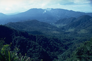 Poás volcano is visible in this view from the NW with small gas plumes rising from the Botos cone in the center of the complex; the peak to its left is von Frantzius cone. The flank of Cerro Congo is across a saddle from von Frantzius on the far-left horizon. Two large calderas are at the summit, the youngest of which formed about 40,000 years ago.
 Poás volcano rises above coffee crops on the floor of the central valley of Costa Rica. Poás is the westernmost of three major volcanoes of the Cordillera Central that are easily visible from the capital city of San José and its outskirts. Ash deposits from their eruptions have contributed to fertile agricultural soils in the Central Valley. Poás National Park was established in 1971 and is one of the country's premier natural attractions.
 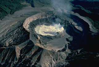 Steam pours from the surface of the hot, acid lake in the active vent of Poás volcano in this 1983 view from the south. The frequent eruptions from this lake in historical time make Poás one of Costa Rica's most active volcanoes and keep the flanks of the 1-km-wide, 275-m-deep crater vegetation free. Smaller eruptions produce geyser-like activity within the crater lake. Occasional larger eruptions completely eject the crater lake.
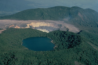 The summit of Poás volcano, seen here in 1983 from the south, contains a group of craters along a N-S line. The forested Botos cone (foreground) is filled with the waters of Laguna del Agua Fría (also known as Laguna del Poás). The unvegetated active summit crater appears at the center. A third crater cuts the south side of the forested von Frantzius cone in the background.
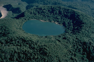 Densely forested Botos cone, the southernmost of the three volcanic cones forming the summit of Poás volcano, last erupted about 7500 years ago. Following this eruption activity shifted north to the presently active crater, whose unvegetated rim is seen at the upper left. The floor of the 1-km-wide Botos maar is now covered by the waters of Laguna del Agua Fria ("Cold Water Lake").
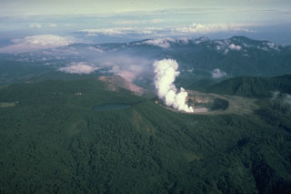 Poás is a broad volcano with a summit area containing three craters and is one of the most active volcanoes of Costa Rica. This photo from the east shows a plume rising from the active summit crater, which has been the site of frequent phreatic and phreatomagmatic eruptions since 1828, and the lake filled Botos crater to the left.
 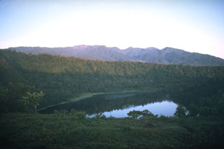 The Platanar volcanic complex on the horizon is the NW-most volcano in the Cordillera Central of Costa Rica. The complex consists of Platanar and Porvenir, which formed within the Chocosuela caldera. This view is from the east with the Hule maar, located about 11 km north of the Poás summit, in the foreground.
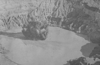 An ash plume rises above the crater lake of Poás volcano in 1915. Intermittent eruptions producing ashfall during 8 October 1914 to 15 May 1915. The 10 April eruption was seen from San José, and the last of a series of eruptions during 15-19 April that produced ashfall across great distances.
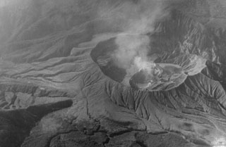 This June 1956 shows gas emissions from a new circular sub-crater formed in the summit crater of Poás volcano during an eruption from 1952-57. Phreatic explosions increased in intensity from 1952 to early 1953. Ash emission began in May 1953 and the crater lake was gone by 22 May. The first juvenile material was observed in mid-July, and Strombolian activity continued until 1955, after which geyser-like activity resumed. Lava appeared in the crater in 1957, and a phreatic explosion ejected ash on 25 December 1957.
 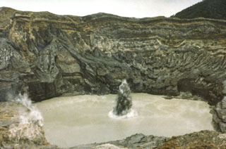 A plume containing ash and mud erupts through the Poás crater lake in July 1977 when phreatic explosions were produced at 25-minute intervals. This activity had begun in May 1977.
 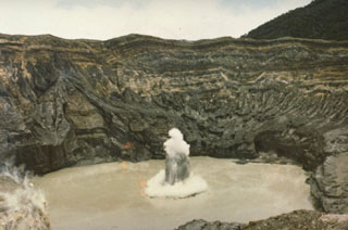 An ejection of steam and ash rises above the surface of the crater lake of Poás volcano in July 1977. The white ring at the base of the eruption plume is a steam cloud that is traveling along the surface of the lake. Mild phreatic explosions such as this one were typical of the eruption that began in May 1977 and lasted at least until July. The crater walls rise about 250 m above the lake.
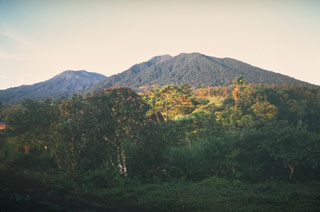 The broad Poás volcanic complex is seen here from the NE and shows and the northern flank of Cerro Congo in the center, with the von Frantzius cone to the left. An eruption of Cerro Congo around 5,140 years ago emplaced a pyroclastic flow deposit.
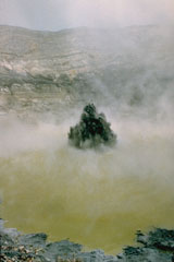 Phreatic eruptions resumed from Poás in June 1987, ejecting lake water and sediments to a maximum reported height of 75 m. This 23 January 1988 photo shows the typical ejection of plumes of gas, ash, and mud above the crater lake. The crater lake disappeared by 19 April 1989 then ash emission began. Phreatic activity began again after rainwater formed a new lake. During May 1989 ash plumes reached heights of 1.5-2 km above the crater.
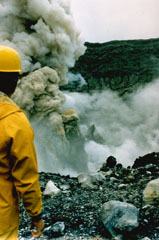 A geologist observes an ash plume rising 400 m above the summit crater of Poás on 25 April 1989. By 19 April, four days before this explosion, the crater lake had disappeared. In May 1989 ash plumes reached 1.5-2 km above the crater.
 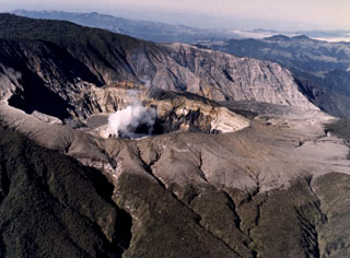 The degassing Poás crater, seen here in an aerial view from the NE, lies within the smaller of two nested calderas at the summit. This inner caldera is 4 km in diameter. A tourist overlook along the ESE crater rim near the upper left provides a view into the crater.
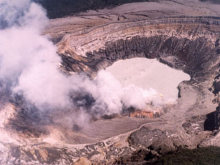 This February 1982 photo of the Poás active crater shows a gas plume rising from fumaroles on the southern crater rim. The northern crater wall in the background exposes pyroclastic deposits from phreatomagmatic and phreatic eruptions.
 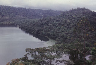 The Hule maar complex formed about 11 km N of the Poás summit. The 2-km-wide complex contains Laguna Hule on the W side, the small Laguna Bosque Alegre on the N, and Laguna Congo to the NW. The cone to the right rises about 130 m above the roughly 20-m-deep lake.
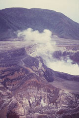 Von Frantzius cone rises beyond the degassing active crater of Poás. This cone was constructed near the northern margin of the inner caldera.
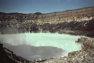 The degassing crater lake at the summit of Poás volcano is seen here in 1982. The 800-m-wide crater lies near the center of the smaller of two calderas at the summit. One of the world’s most acidic natural lakes, the diameter and depth varies with seasonal rainfall and eruptive activity; on occasion the lake has disappeared.
  Radial drainages draped with lush vegetation descend the flanks of Poás volcano. These waterfalls on the Río La Paz lie on the eastern flank of Poás along the road between the central valley and the Atlantic coastal plain. NE-flank drainages empty into the Río Sarapiquí and then the Río San Juan en route to the Carribean Sea. Poás is the centerpiece of a national park that preserves highland forests and abundant wildlife.
 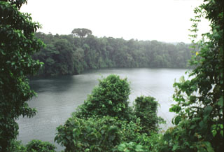 The Laguna Río Cuarto maar is at the northern end of a chain of vents extending to about 18 km from Poás volcano. The 600 x 750 m wide maar has a maximum depth of 66 m and the crater walls rise 4-20 m above the lake surface. The maar erupted through lahar and alluvial deposits on the coastal plain at an elevation of about 400 m above sea level.
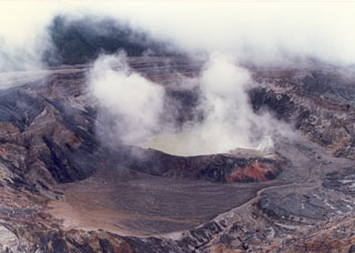 The Poás crater lake is seen here on 4 October 1987 during an intermittent eruption lasting from June 1987 to June 1990. Sporadic small phreatic explosions had started in June 1987 and continued until at least October 1988. The crater lake disappeared by April 1989, and in the following month ash plumes reached heights of 1.5-2 km above the crater.
 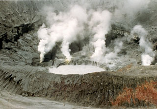 Minor phreatic eruptions ejecting material to heights of several meters were reported in March 1994. Two more phreatic eruptions were reported at the end of April, by which time the crater lake was nearly gone. Intense gas emission in the ensuing months caused health problems and severe economic losses in agricultural areas. Eruptions producing ash plumes that took place on 3 June and 9 July-5 August formed a small new crater. The crater lake (seen here 2 September 1994) returned, and minor phreatic eruptions occurred in October.
 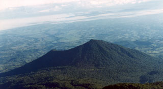 Cerro Congo is about 6 km N of Poás volcano and was is part of a N-S-trending chain of vents that extends into the Caribbean coastal plain in the background. The summit crater, located at the northern end of Poás National Park, opens towards the NW.
 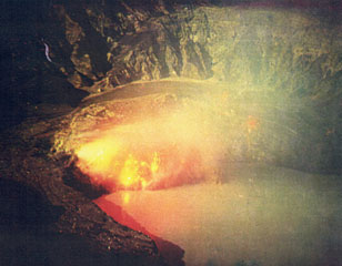 Moderate eruptions with strong gas and ash emission took place from the Poás main crater during March to May 1981. This 19 March time-exposure photograph from the northern crater rim shows an incandescent lava dome.
  The broad massif of Poás volcano rises about 35 km to the NW above the outskirts of the city of San José. The summit of the volcano is a national park and is easily accessible by road from the capital city. The massive 2708-m-high volcano covers an area of about 300 km2 and rises about 1400 m above the central valley. Two large calderas cut its summit, and an acidic crater lake partially fills the active crater.
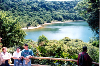 Botos is the southernmost of the three cones forming the summit of Poás volcano. Following cessation of eruptions at Botos, activity shifted NW to the now-active summit crater. The floor of the 1-km-wide crater is now covered by Laguna del Agua Fría.
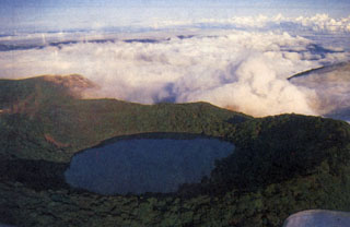 Botos cone forms the high point of the Poás volcanic massif. It was the eruptive focus prior to about 7,500 years ago, when activity shifted NW to the crater hidden beneath the clouds. The 1-km-wide crater contains a 400-m-wide lake.
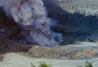 Poás erupted intermittently from June 1987 to June 1990, producing ash plumes such as this one seen on 6 March 1989. Phreatic explosions had resumed from June 1987 until at least October 1988, punctuated by large explosions on 9 April 1988. The crater lake completely disappeared by April 1989, and during May ash plumes reached heights of 1.5-2 km above the crater.
  This view from the north looks across vents extending north from Poás. In the foreground is the Hule maar complex, with Laguna Bosque Alegre to the left and Laguna Congo at bottom right; the forested peak in the middle distance is Cerro Congo. Poás volcano is about 12 km to the south and forms the horizon here.
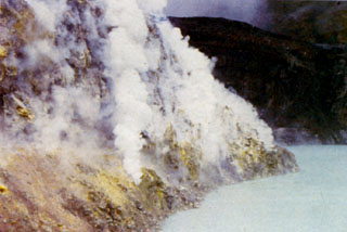 Gases emanate from fumaroles within the sulfur-lined wall of a lava dome at the bottom of the Poás active crater. The turquoise-colored crater lake is among the most acidic natural waters on Earth. The hot lake has been the source of frequent phreatic eruptions that produce plumes of steam, ash, and mud.
 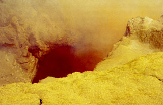 Yellow sulfur and other minerals precipitate around high-temperature fumaroles in the Poás summit crater. Fumarole temperatures approaching 600°C were recorded in 1988, several times higher than the melting point of sulfur. The ejection of sulfur clasts as well as small sulfur flows have been documented during several eruptions at Poás.
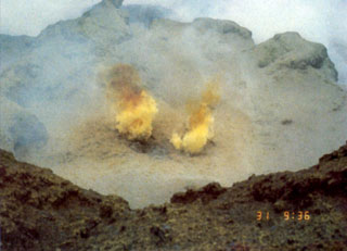 Fumarole gases at Poás are sometimes tinted yellow by the sulfur content. Sulfur clasts have been ejected during some explosive eruptions. Acidic gas plumes have damaged vegetation in the national park and surrounding areas, causing widespread devastation to coffee and other crops. An explosion on 9 April 1988 dropped acidic sulfur-rich mud on visitors, cars, and plants near the tourist overlook.
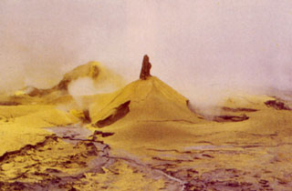 Small cones of mud and sulfur up to 3 m high formed on the active crater floor during 1989. Eruptive activity from June 1987 to June 1990 included phreatic explosions within the crater lake ejecting mud and sulfur, the formation of temporary small pools of sulfur-rich water, and the emission of sulfur flows up to 30 m long. Acidic gas plumes caused extensive damage to vegetation on the flanks.
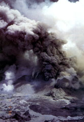 Ash plumes rise above vents in the Poás summit crater on 4 May 1990, near the end of an eruptive period that began in June 1987. At the time of this photo the crater lake had shrunk substantially to only several centimeters deep that fluctuated slightly with changes in rainfall recharge. Lake temperatures were over 72°C (measured by infrared thermometer), and small hot springs around the lake had temperatures of 85°C. Minor explosive eruptions continued into the following month.
 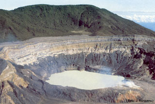 The acidic crater lake at the summit of Poás is seen here from the overlook on the southern crater rim. The von Frantzius cone in the background formed along the northern rim of the innermost of two large nested calderas at the summit. The crater lake has been the source of frequent phreatic eruptions.
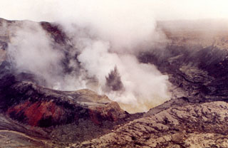 Ash and mud from a small phreatic explosion rise above the degassing Poás crater lake on 28 August 1988. Phreatic explosions had been occurring since June of the previous year and lasted for a few more months beyond August 1988. Activity was nearly continuous during the second half of August and the first week of September, with plumes containing mud rising 5-10 m. During the rest of the month plumes rose as much as 25 m. Small explosions continued, and by April 1989 the crater lake disappeared.
 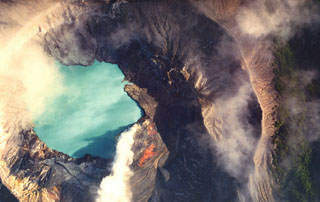 A vertical view into the crater lake of Poás volcano in December 1999 shows a gas plume (bottom center) originating from a vent in the south side of the lake. December plume heights ranged between 0.7 and 1 km. The 800-m-wide crater contains an acidic lake.
 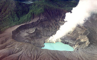 A gas plume rises from the lava dome on the south side of the Poás summit crater lake in this February 2000 view from the NW. Degassing produced plumes up to about 700 m high in May and bubbling within the crater lake had been reported since late March. Temperatures of around 40°C were measured on the NE shore of the lake at various points in May. The 400-m-wide Laguna del Fría is visible at the upper left within the Botos crater.
The maps shown below have been scanned from the GVP map archives and include the volcano on this page. Clicking on the small images will load the full 300 dpi map. Very small-scale maps (such as world maps) are not included. The maps database originated over 30 years ago, but was only recently updated and connected to our main database. We welcome users to tell us if they see incorrect information or other problems with the maps; please use the Contact GVP link at the bottom of the page to send us email.
The following 71 samples associated with this volcano can be found in the Smithsonian's NMNH Department of Mineral Sciences collections, and may be availble for research (contact the Rock and Ore Collections Manager). Catalog number links will open a window with more information.
| Catalog Number | Sample Description | Lava Source | Collection Date |
|---|---|---|---|
| NMNH 113102-16 | Volcanic Ash | -- | -- |
| NMNH 116066-444 | Tephra | -- | -- |
| NMNH 116066-445 | Lapilli | -- | -- |
| NMNH 116066-447 | Tephra | -- | -- |
| NMNH 116066-448 | Tephra | -- | -- |
| NMNH 116066-449 | Lapilli | -- | -- |
| NMNH 116066-451 | Tephra | -- | -- |
| NMNH 116066-452 | Tephra | -- | -- |
| NMNH 116066-453 | Tephra | -- | -- |
| NMNH 116066-454 | Tephra | -- | -- |
| NMNH 116066-455 | Tephra | -- | -- |
| NMNH 116066-456 | Lapilli | -- | -- |
| NMNH 116066-457 | Tephra | -- | -- |
| NMNH 116066-459 | Tephra | -- | -- |
| NMNH 116066-460 | Tephra | -- | -- |
| NMNH 116066-461 | Tephra | -- | -- |
| NMNH 116066-462 | Tephra | -- | -- |
| NMNH 116066-484 | Tephra | -- | 2 May 1985 |
| NMNH 116066-485 | Tephra | -- | 2 May 1985 |
| NMNH 116066-486 | Tephra | -- | 2 May 1985 |
| NMNH 116066-487 | Tephra | -- | 23 May 1985 |
| NMNH 116066-488 | Tephra | -- | 23 May 1985 |
| NMNH 116066-489 | Tephra | -- | 23 May 1985 |
| NMNH 116066-490 | Tephra | -- | 23 May 1985 |
| NMNH 116066-491 | Tephra | -- | 23 May 1985 |
| NMNH 116066-492 | Tephra | -- | 23 May 1985 |
| NMNH 116066-493 | Tephra | -- | 23 May 1985 |
| NMNH 116066-571 | Tephra | -- | -- |
| NMNH 116066-572 | Tephra | -- | -- |
| NMNH 116066-573 | Tephra | -- | -- |
| NMNH 116066-574 | Tephra | -- | -- |
| NMNH 116066-575 | Tephra | -- | -- |
| NMNH 116066-576 | Tephra | -- | -- |
| NMNH 116066-577 | Tephra | -- | -- |
| NMNH 116066-578 | Tephra | -- | -- |
| NMNH 116066-579 | Tephra | -- | -- |
| NMNH 116066-580 | Tephra | -- | -- |
| NMNH 116066-581 | Tephra | -- | -- |
| NMNH 116066-582 | Tephra | -- | -- |
| NMNH 116066-583 | Tephra | -- | -- |
| NMNH 116066-584 | Tephra | -- | -- |
| NMNH 116066-585 | Tephra | -- | -- |
| NMNH 116066-586 | Tephra | -- | -- |
| NMNH 116066-587 | Tephra | -- | -- |
| NMNH 116066-588 | Tephra | -- | -- |
| NMNH 116066-589 | Tephra | -- | -- |
| NMNH 116066-590 | Tephra | -- | -- |
| NMNH 116066-591 | Tephra | -- | -- |
| NMNH 116066-592 | Tephra | -- | -- |
| NMNH 116066-593 | Tephra | -- | -- |
| NMNH 116066-594 | Tephra | -- | -- |
| NMNH 116066-723 | Tephra | -- | -- |
| NMNH 116066-850 | Tephra | -- | -- |
| NMNH 116066-851 | Tephra | -- | -- |
| NMNH 116066-852 | Tephra | -- | -- |
| NMNH 116066-853 | Tephra | -- | -- |
| NMNH 116066-854 | Tephra | -- | -- |
| NMNH 116066-855 | Tephra | -- | -- |
| NMNH 116066-856 | Tephra | -- | -- |
| NMNH 116066-857 | Tephra | -- | -- |
| NMNH 116066-858 | Tephra | -- | -- |
| NMNH 116066-859 | Tephra | -- | -- |
| NMNH 116066-860 | Tephra | -- | -- |
| NMNH 116066-861 | Tephra | -- | -- |
| NMNH 116066-862 | Tephra | -- | -- |
| NMNH 116066-863 | Tephra | -- | -- |
| NMNH 116066-864 | Tephra | -- | -- |
| NMNH 116221 | Sulfur | -- | 23 Jul 1994 |
| NMNH 116620-1 | Tephra | -- | 23 Jul 1994 |
| NMNH 116620-2 | Tephra | -- | 23 Jul 1994 |
| NMNH 116621 | Sulfur | -- | -- |
| Copernicus Browser | The Copernicus Browser replaced the Sentinel Hub Playground browser in 2023, to provide access to Earth observation archives from the Copernicus Data Space Ecosystem, the main distribution platform for data from the EU Copernicus missions. |
| MIROVA | Middle InfraRed Observation of Volcanic Activity (MIROVA) is a near real time volcanic hot-spot detection system based on the analysis of MODIS (Moderate Resolution Imaging Spectroradiometer) data. In particular, MIROVA uses the Middle InfraRed Radiation (MIR), measured over target volcanoes, in order to detect, locate and measure the heat radiation sourced from volcanic activity. |
| MODVOLC Thermal Alerts | Using infrared satellite Moderate Resolution Imaging Spectroradiometer (MODIS) data, scientists at the Hawai'i Institute of Geophysics and Planetology, University of Hawai'i, developed an automated system called MODVOLC to map thermal hot-spots in near real time. For each MODIS image, the algorithm automatically scans each 1 km pixel within it to check for high-temperature hot-spots. When one is found the date, time, location, and intensity are recorded. MODIS looks at every square km of the Earth every 48 hours, once during the day and once during the night, and the presence of two MODIS sensors in space allows at least four hot-spot observations every two days. Each day updated global maps are compiled to display the locations of all hot spots detected in the previous 24 hours. There is a drop-down list with volcano names which allow users to 'zoom-in' and examine the distribution of hot-spots at a variety of spatial scales. |
|
WOVOdat
Single Volcano View Temporal Evolution of Unrest Side by Side Volcanoes |
WOVOdat is a database of volcanic unrest; instrumentally and visually recorded changes in seismicity, ground deformation, gas emission, and other parameters from their normal baselines. It is sponsored by the World Organization of Volcano Observatories (WOVO) and presently hosted at the Earth Observatory of Singapore.
GVMID Data on Volcano Monitoring Infrastructure The Global Volcano Monitoring Infrastructure Database GVMID, is aimed at documenting and improving capabilities of volcano monitoring from the ground and space. GVMID should provide a snapshot and baseline view of the techniques and instrumentation that are in place at various volcanoes, which can be use by volcano observatories as reference to setup new monitoring system or improving networks at a specific volcano. These data will allow identification of what monitoring gaps exist, which can be then targeted by remote sensing infrastructure and future instrument deployments. |
| Volcanic Hazard Maps | The IAVCEI Commission on Volcanic Hazards and Risk has a Volcanic Hazard Maps database designed to serve as a resource for hazard mappers (or other interested parties) to explore how common issues in hazard map development have been addressed at different volcanoes, in different countries, for different hazards, and for different intended audiences. In addition to the comprehensive, searchable Volcanic Hazard Maps Database, this website contains information about diversity of volcanic hazard maps, illustrated using examples from the database. This site is for educational purposes related to volcanic hazard maps. Hazard maps found on this website should not be used for emergency purposes. For the most recent, official hazard map for a particular volcano, please seek out the proper institutional authorities on the matter. |
| IRIS seismic stations/networks | Incorporated Research Institutions for Seismology (IRIS) Data Services map showing the location of seismic stations from all available networks (permanent or temporary) within a radius of 0.18° (about 20 km at mid-latitudes) from the given location of Poás. Users can customize a variety of filters and options in the left panel. Note that if there are no stations are known the map will default to show the entire world with a "No data matched request" error notice. |
| UNAVCO GPS/GNSS stations | Geodetic Data Services map from UNAVCO showing the location of GPS/GNSS stations from all available networks (permanent or temporary) within a radius of 20 km from the given location of Poás. Users can customize the data search based on station or network names, location, and time window. Requires Adobe Flash Player. |
| DECADE Data | The DECADE portal, still in the developmental stage, serves as an example of the proposed interoperability between The Smithsonian Institution's Global Volcanism Program, the Mapping Gas Emissions (MaGa) Database, and the EarthChem Geochemical Portal. The Deep Earth Carbon Degassing (DECADE) initiative seeks to use new and established technologies to determine accurate global fluxes of volcanic CO2 to the atmosphere, but installing CO2 monitoring networks on 20 of the world's 150 most actively degassing volcanoes. The group uses related laboratory-based studies (direct gas sampling and analysis, melt inclusions) to provide new data for direct degassing of deep earth carbon to the atmosphere. |
| Large Eruptions of Poás | Information about large Quaternary eruptions (VEI >= 4) is cataloged in the Large Magnitude Explosive Volcanic Eruptions (LaMEVE) database of the Volcano Global Risk Identification and Analysis Project (VOGRIPA). |
| EarthChem | EarthChem develops and maintains databases, software, and services that support the preservation, discovery, access and analysis of geochemical data, and facilitate their integration with the broad array of other available earth science parameters. EarthChem is operated by a joint team of disciplinary scientists, data scientists, data managers and information technology developers who are part of the NSF-funded data facility Integrated Earth Data Applications (IEDA). IEDA is a collaborative effort of EarthChem and the Marine Geoscience Data System (MGDS). |

