Keyword Collections | Keyword "pyroclastic surge"
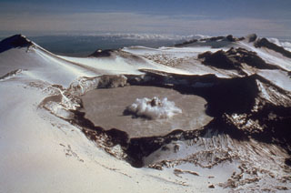 A small phreatic eruption on 29 February 1980, produces a column of ash and steam above Ruapehu's Crater Lake. A darker center plume is surrounded by a white ring produced by pyroclastic surges traveling across the lake surface. This view is from the NW, with Mitre Peak at the upper left. A series of small phreatic explosions had begun on 5 December 1979 and lasted until 15 April the following year.
Photo by Peter Otway, 1980 (New Zealand Geological Survey).
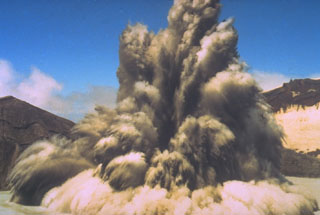 The interaction of magma and water can produce strong phreatic (steam-driven) explosions, such as in this 1980 photo of New Zealand's Ruapehu volcano. Ash and steam trail from large ejected blocks in the eruption column. Pyroclastic surge can be seen traveling radially along the surface of a crater lake. Phreatic or phreatomagmatic explosions are common at submarine volcanoes, crater lakes, and other places where hot magma (or associated gases) encounters surface water or groundwater.
Photo by Hollick, 1980, courtesy of Bruce Houghton (Wairakei Research Center).
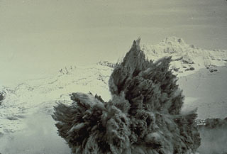 A Surtseyan eruption on 8 May 1971 at Crater Lake at the summit of Ruapehu volcano in New Zealand ejects a dark cock’s tail jet of volcanic ash, mud, and steam. Individual ejected blocks can be seen at the margins of the plume. This type of eruption column is typical of explosions that involve water-magma interactions.
Photo by Peter Otway, 1971 (New Zealand Geological Survey).
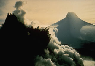 A dark cock's-tail plume is ejected from Crater Lake during the 8 May 1971 eruption of Ruapehu. This view from the NW shows Mitre Peak in the background at the onset of the eruption, which ejected material to 1.5 km above the crater. It was the largest of a series of phreatic and phreatomagmatic eruptions from 3 April to November.
Photo by Peter Otway, 1971 (New Zealand Geological Survey).
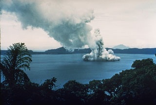 Phreatic explosions from Motmot Island in Lake Wisdom, on Long Island, during a 1953-54 eruption. The Surtseyan explosion produced a jet of steam and ash seen rising above the lake, and a base surge traveling radially away from the vent across the surface. The western wall of the 10 x 12.5 km Long Island caldera is 200-300 m high in the distance. Twentieth century eruptions at Long Island have originated from vents at or near Motmot Island.
Photo by John Best (courtesy of Wally Johnson, Australia Bureau of Mineral Resources).
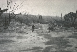 The vehicle to the right was suspended 3 m above the ground between the tops of two broken trees by the devastating pyroclastic surges of the 21 January 1951 eruption of Mount Lamington. The vehicle was located in the village of Higaturu, 10 km N of the volcano. Velocities of the pyroclastic surges were estimated to be in excess of 120 km per hour. The high-temperature surges destroyed the village, removing houses from their foundations and demolishing a steel-framed hospital building.
Photo by Tony Taylor, 1951 (Australia Bureau of Mineral Resources).
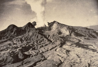 The first historical eruption of Lamington was in 1951, prior to which it was not known to be a volcano by those living on its flanks. Following continuous light ash emission beginning on 17 January the paroxysmal eruption on 21 January produced pyroclastic flows and surges that swept all sides of the volcano to a maximum distance of 12 km to the north, killing nearly 3,000 people. This 5 February photo shows the devastated northern flanks and a plume rising from a growing lava dome in the new crater. Slow dome growth ended in 1956.
Photo by Tony Taylor, 1951 (Australia Bureau of Mineral Resources).
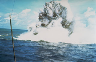 A shallow phreatomagmatic, or Surtseyan eruption from Kavachi volcano on 17 or 18 July 1977. Jets of dark ash can be seen emerging from white steam plumes. Numerous individual blocks ejected at high velocity are trailed by steam. Similar activity was observed from boats and airplanes for a period of less than one week.
Photo by W.G. Muller, 1977 (Barrier Reef Cruises, Queensland, Australia; courtesy of R.W. Johnson).
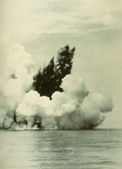 A dark cock’s tail jet is ejected from a submarine vent at Anak Krakatau (Child of Krakatau) on 12 June 1930. A white steam plume rises above a pyroclastic surge that travels along the sea surface in a radial direction from the vent. Base surges such as these are common at submarine eruptions. The first eruptions of Anak Krakatau to breach the surface were seen in December 1927.
Photo by C.E. Stehn, 1930 (courtesy Volcanological Survey of Indonesia).
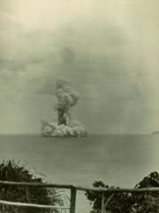 A submarine eruption from Anak Krakatau on 13 June 1930, produces both a vertical eruption plume and a base surge extending radially from the vent along the surface of the sea. Submarine eruptions were first observed in December 1927, forming several ephemeral islands. By 12 August 1930 Anak Krakatau had become a permanent island.
Photo by W. Petroschevsky, 1930 (courtesy Volcanological Survey of Indonesia).
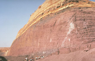 Geologists examine a quarry in a post-caldera cone of the Vulsini volcanic complex. The base of the quarry exposes thick, red-colored scoria deposits produced by Strombolian eruptions that built a scoria cone. These are overlain by bedded, yellowish pyroclastic surge deposits.
Photo by Richard Waitt, 1985 (U.S. Geological Survey).
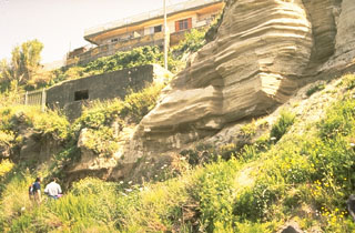 The bedded layers at the right, near the town of Torre de Greco on the S flank of Vesuvius, are pyroclastic surge deposits from the Plinian Avellino eruption that occurred about 3,700 years ago. This eruption, one of eight major explosive eruptions since formation of the Monte Somma caldera, produced 2.9 km3 of tephra. Pyroclastic surges (1 km3) traveled down all sides of the volcano and as far as 22 km NW, covering an area now overlain by much of the city of Naples.
Photo by Roberto Scandone (University of Rome).
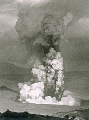 An ash plume rises above a vent on the SW side of Volcano Island at Taal on 30 September 1965, during a two-day eruption that began on the 28th. The white plume at the bottom is a horizontally moving base surge. The devastating pyroclastic surges caused 150 fatalities.
Photo by L.E. Andrews, 1965 (courtesy of Jim Moore, U.S. Geological Survey).
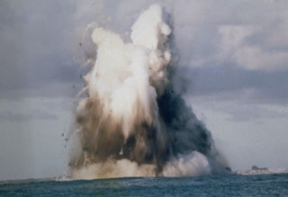 A submarine explosion from Nishinoshima breaches the surface on 9 October 1973. Steam trails behind ejected hot blocks at the margin of the plume. Submarine eruptions began on 12 April 1973 and the new island was first observed on 11 September. Lava flows began in September and three new islands were formed, which joined together during October-November 1973.
Photo courtesy of Japan Meteorological Agency, 1973.
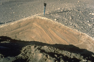 Pyroclastic surges are dilute pyroclastic flows with a high proportion of gas. They originated from secondary phreatic explosions at Mount St. Helens in 1980 and produced these cross-bedded layers. They were deposited from successive, rapidly moving horizontal clouds of gas, ash, and rock fragments that resulted from the interaction of hot pyroclastic flow deposits from the May 18 eruption with melt water produced by glacial ice carried down by the collapse of the summit.
Photo by Norm Banks, 1980 (U.S. Geological Survey).
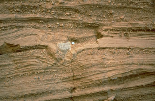 Pyroclastic surge deposits surround the Cerro Colorado maar of the Pinacate volcanic field in NW México. These thin beds (note the coin for scale) were formed by successive explosions that produced pyroclastic surges. The light-colored rock in the center of the photo is a ballistic block that impacted the surface of earlier surge deposits, compressing them and forming a small pit called a bomb sag.
Photo by Richard Waitt, 1988 (U.S. Geological Survey).
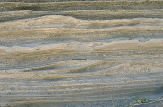 Pyroclastic surge deposits from La Breña maar in México's Durango volcanic field show both laminar and dune bedding. The thin beds (pen in the center for scale) were created by successive explosive eruptions that produced high-velocity pyroclastic surges that swept radially away from the volcano. The direction of movement of the surge clouds was from right to left, as seen from the truncated dune beds on the near-vent side.
Photo by Jim Luhr, 1988 (Smithsonian Institution).
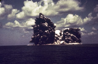 An explosion from the Beyonesu Rocks at the Myjinsho submarine caldera in Japan's central Izu Islands breaches the sea surface on 23 September 1952. These cock’s tail jets of blocks and ash are characteristic of shallow submarine explosions. This photo was taken 5 seconds after the explosion breached the sea surface; five minutes later the eruption was over and the sea was again calm. The suddenness of these powerful explosions proved to be fatal to 31 people on a research vessel that sailed over the vent the following day.
Photo courtesy of Ryohei Morimoto (University of Tokyo), 1952.
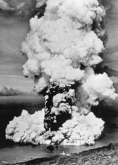 A column of ash and steam rises above a new submarine vent off the western coast of Fayal Island in early October 1957. Horizontally traveling base surges form a ring at the base of the eruption column. Explosive eruptions began on September 27 and formed a small island that eventually was joined to the main island, partially burying the Capelinhos lighthouse, which is visible on the center shoreline (bottom). Lava effusion was continuous for the last five months of the 13-month eruption.
Photo by U.S. Air Force, 1957 (published in Green and Short, 1971).
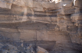 Pyroclastic surge deposits exposed in gullies on the flanks of Cráter Elegante in the Pinacate volcanic field of NW México. This photo shows cross bedding produced by particles transported by saltation or dilute suspension in a high-velocity pyroclastic surge. The direction of movement of the surge cloud, seen by the truncation of dune beds on the near-vent side, was from right to left. This type of bedding is common in areas near the rim of the maar.
Photo by Bill Rose, 1997 (Michigan Technological University).
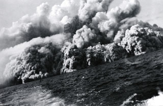 Pyroclastic surges at about 0805 on 1 August 1952 travel across the sea at the western coast of the island, 20 minutes after the start of the eruption. Several inches of ash and lapilli up to 12 mm in diameter fell on the deck of the fishing boat from which this photo was taken as it sailed away from the volcano at full speed.
Photo by Robert Petrie, 1952 (U.S. Navy; courtesy of Sherman Neuschel, U.S. Geological Survey).
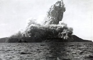 A new cone, Volcán Bárcena, was rapidly constructed during an eruption that began on 1 August 1952 at the southern end of Isla San Benedicto. This photo, taken from off the west coast of the island only four minutes after the start of the eruption, also shows the onset of pyroclastic surges. Lava extrusion occurred in September, November, and December. On 8 December activity shifted to a vent on the SE flank, producing a lava delta that extended about 700 m to sea. Activity ended in late February 1953.
Photo by Robert Petrie, 1952 (U.S. Navy; courtesy of Sherman Neuschel, U.S. Geological Survey).
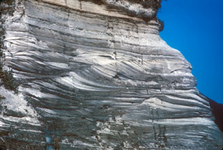 A sequence of pyroclastic surge deposits exposed in a sea cliff on Niijima, in the northern part of the Izu Islands of Japan. These cross-bedded layers were produced during repeated erosion and deposition by multiple pyroclastic surge events. The eruptions accompanied the formation of a lava dome at Mukaijima on the southern part of the island. The flat airfall deposits cap the exposure.
Photo by R.V. Fisher, 1979 (University of California Santa Barbara).
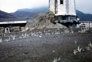 Pyroclastic surge, or base surge deposits from the 1957 phreatomagmatic Capelinhos eruption lap up against a lighthouse near the western coast of Fayal Island in the Azores. Pyroclastic surges produced by magma-water interaction during the Surtseyan eruption nearly buried the lower floor of the lighthouse building. The initially submarine eruption began off the western tip of Fayal, forming a small island that was eventually joined to the main island.
Photo by R.V. Fisher, 1979 (University of California Santa Barbara).


