Recently Published Bulletin Reports
Erebus (Antarctica) Lava lake remains active; most thermal alerts recorded since 2019
Rincon de la Vieja (Costa Rica) Frequent phreatic explosions during July-December 2023
Bezymianny (Russia) Explosion on 18 October 2023 sends ash plume 8 km high; lava flows and incandescent avalanches
Kilauea (United States) Low-level lava effusions in the lava lake at Halema’uma’u during July-December 2022
Nyamulagira (DR Congo) Lava flows and thermal activity during May-October 2023
Bagana (Papua New Guinea) Explosions, ash plumes, ashfall, and lava flows during April-September 2023
Mayon (Philippines) Lava flows, pyroclastic flows, ash emissions, and seismicity during April-September 2023
Nishinoshima (Japan) Eruption plumes and gas-and-steam plumes during May-August 2023
Krakatau (Indonesia) White gas-and-steam plumes and occasional ash plumes during May-August 2023
Villarrica (Chile) Strombolian activity, gas-and-ash emissions, and crater incandescence during April-September 2023
Merapi (Indonesia) Frequent incandescent avalanches during April-September 2023
Ebeko (Russia) Moderate explosive activity with ash plumes continued during June-November 2023
Erebus (Antarctica) — January 2024  Cite this Report
Erebus
Antarctica
77.53°S, 167.17°E; summit elev. 3794 m
All times are local (unless otherwise noted)
Lava lake remains active; most thermal alerts recorded since 2019
The lava lake in the summit crater of Erebus has been active since at least 1972. Located in Antarctica overlooking the McMurdo Station on Ross Island, it is the southernmost active volcano on the planet. Because of the remote location, activity is primarily monitored by satellites. This report covers activity during 2023.
The number of thermal alerts recorded by the Hawai'i Institute of Geophysics and Planetology’s MODVOLC Thermal Alerts System increased considerably in 2023 compared to the years 2020-2022 (table 9). In contrast to previous years, the MODIS instruments aboard the Aqua and Terra satellites captured data from Erebus every month during 2023. Consistent with previous years, the lowest number of anomalous pixels were recorded in January, November, and December.
Table 9. Number of monthly MODIS-MODVOLC thermal alert pixels recorded at Erebus during 2017-2023. See BGVN 42:06 for data from 2000 through 2016. The table was compiled using data provided by the HIGP – MODVOLC Thermal Alerts System.
| Year |
Jan |
Feb |
Mar |
Apr |
May |
Jun |
Jul |
Aug |
Sep |
Oct |
Nov |
Dec |
SUM |
| 2017 |
0 |
21 |
9 |
0 |
0 |
1 |
11 |
61 |
76 |
52 |
0 |
3 |
234 |
| 2018 |
0 |
21 |
58 |
182 |
55 |
17 |
137 |
172 |
103 |
29 |
0 |
0 |
774 |
| 2019 |
2 |
21 |
162 |
151 |
55 |
56 |
75 |
53 |
29 |
19 |
1 |
0 |
624 |
| 2020 |
0 |
2 |
16 |
18 |
4 |
4 |
1 |
3 |
18 |
3 |
1 |
6 |
76 |
| 2021 |
0 |
9 |
1 |
0 |
2 |
56 |
46 |
47 |
35 |
52 |
5 |
3 |
256 |
| 2022 |
1 |
13 |
55 |
22 |
15 |
32 |
39 |
19 |
31 |
11 |
0 |
0 |
238 |
| 2023 |
2 |
33 |
49 |
82 |
41 |
32 |
70 |
64 |
42 |
17 |
5 |
11 |
448 |
Sentinel-2 infrared images showed one or two prominent heat sources within the summit crater, accompanied by adjacent smaller sources, similar to recent years (see BGVN 46:01, 47:02, and 48:01). A unique image was obtained on 25 November 2023 by the OLI-2 (Operational Land Imager-2) on Landsat 9, showing the upper part of the volcano surrounded by clouds (figure 32).
Geologic Background. Mount Erebus, the world's southernmost historically active volcano, overlooks the McMurdo research station on Ross Island. It is the largest of three major volcanoes forming the crudely triangular Ross Island. The summit of the dominantly phonolitic volcano has been modified by one or two generations of caldera formation. A summit plateau at about 3,200 m elevation marks the rim of the youngest caldera, which formed during the late-Pleistocene and within which the modern cone was constructed. An elliptical 500 x 600 m wide, 110-m-deep crater truncates the summit and contains an active lava lake within a 250-m-wide, 100-m-deep inner crater; other lava lakes are sometimes present. The glacier-covered volcano was erupting when first sighted by Captain James Ross in 1841. Continuous lava-lake activity with minor explosions, punctuated by occasional larger Strombolian explosions that eject bombs onto the crater rim, has been documented since 1972, but has probably been occurring for much of the volcano's recent history.
Information Contacts: Hawai'i Institute of Geophysics and Planetology (HIGP) - MODVOLC Thermal Alerts System, School of Ocean and Earth Science and Technology (SOEST), Univ. of Hawai'i, 2525 Correa Road, Honolulu, HI 96822, USA (URL: http://modis.higp.hawaii.edu/); Copernicus Browser, Copernicus Data Space Ecosystem, European Space Agency (URL: https://dataspace.copernicus.eu/browser/); NASA Earth Observatory, EOS Project Science Office, NASA Goddard Space Flight Center, Goddard, Maryland, USA (URL: https://earthobservatory.nasa.gov/images/152134/erebus-breaks-through).
Rincon de la Vieja (Costa Rica) — January 2024 Cite this Report
Rincon de la Vieja
Costa Rica
10.83°N, 85.324°W; summit elev. 1916 m
All times are local (unless otherwise noted)
Frequent phreatic explosions during July-December 2023
Rincón de la Vieja is a volcanic complex in Costa Rica with a hot convecting acid lake that exhibits frequent weak phreatic explosions, gas-and-steam emissions, and occasional elevated sulfur dioxide levels (BGVN 45:10, 46:03, 46:11). The current eruption period began June 2021. This report covers activity during July-December 2023 and is based on weekly bulletins and occasional daily reports from the Observatorio Vulcanologico Sismologica de Costa Rica-Universidad Nacional (OVSICORI-UNA).
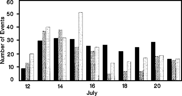
Numerous weak phreatic explosions continued during July-December 2023, along with gas-and-steam emissions and plumes that rose as high as 3 km above the crater rim. Many weekly OVSICORI-UNA bulletins included the previous week's number of explosions and emissions (table 9). For many explosions, the time of explosion was given (table 10). Frequent seismic activity (long-period earthquakes, volcano-tectonic earthquakes, and tremor) accompanied the phreatic activity.
Table 9. Number of reported weekly phreatic explosions and gas-and-steam emissions at Rincón de la Vieja, July-December 2023. Counts are reported for the week before the Weekly Bulletin date; not all reports included these data. Courtesy of OVSICORI-UNA.
| OVSICORI Weekly Bulletin |
Number of explosions |
Number of emissions |
| 28 Jul 2023 |
6 |
14 |
| 4 Aug 2023 |
10 |
12 |
| 1 Sep 2023 |
13 |
11 |
| 22 Sep 2023 |
12 |
13 |
| 29 Sep 2023 |
6 |
11 |
| 6 Oct 2023 |
12 |
5 |
| 13 Oct 2023 |
7 |
9 |
| 20 Oct 2023 |
1 |
15 |
| 27 Oct 2023 |
3 |
23 |
| 3 Nov 2023 |
3 |
10 |
| 17 Nov 2023 |
0 |
Some |
| 24 Nov 2023 |
0 |
14 |
| 8 Dec 2023 |
4 |
16 |
| 22 Dec 2023 |
8 |
18 |
Table 10. Summary of activity at Rincón de la Vieja during July-December 2023. Weak phreatic explosions and gas emissions are noted where the time of explosion was indicated in the weekly or daily bulletins. Height of plumes or emissions are distance above the crater rim. Courtesy of OVSICORI-UNA.
| Date |
Time |
Description of Activity |
| 1 Jul 2023 |
0156 |
Explosion. |
| 2 Jul 2023 |
0305 |
Explosion. |
| 4 Jul 2023 |
0229, 0635 |
Event at 0635 produced a gas-and-steam plume that rose 700 m and drifted W; seen by residents in Liberia (21 km SW). |
| 9 Jul 2023 |
1843 |
Explosion. |
| 21 Jul 2023 |
0705 |
Explosion. |
| 26 Jul 2023 |
1807 |
Explosion. |
| 28 Jul 2023 |
0802 |
Explosion generated a gas-and-steam plume that rose 500 m. |
| 30 Jul 2023 |
1250 |
Explosion. |
| 31 Jul 2023 |
2136 |
Explosion. |
| 11 Aug 2023 |
0828 |
Explosion. |
| 18 Aug 2023 |
1304 |
Explosion. |
| 21 Aug 2023 |
1224 |
Explosion generated gas-and-steam plumes rose 500-600 m. |
| 22 Aug 2023 |
0749 |
Explosion generated gas-and-steam plumes rose 500-600 m. |
| 24 Aug 2023 |
1900 |
Explosion. |
| 25 Aug 2023 |
0828 |
Event produced a steam-and-gas plume that rose 3 km and drifted NW. |
| 27-28 Aug 2023 |
0813 |
Four small events; the event at 0813 on 28 August lasted two minutes and generated a steam-and-gas plume that rose 2.5 km. |
| 1 Sep 2023 |
1526 |
Explosion generated plume that rose 2 km and ejected material onto the flanks. |
| 2-3 Sep 2023 |
- |
Small explosions detected in infrasound data. |
| 4 Sep 2023 |
1251 |
Gas-and-steam plume rose 1 km and drifted W. |
| 7 Nov 2023 |
1113 |
Explosion. |
| 8 Nov 2023 |
0722 |
Explosion. |
| 12 Nov 2023 |
0136 |
Small gas emissions. |
| 14 Nov 2023 |
0415 |
Small gas emissions. |
According to OVSICORI-UNA, during July-October the average weekly sulfur dioxide (SO2) flux ranged from 68 to 240 tonnes/day. However, in mid-November the flux increased to as high as 334 tonnes/day, the highest value measured in recent years. The high SO2 flux in mid-November was also detected by the TROPOMI instrument on the Sentinel-5P satellite (figure 43).
Geologic Background. Rincón de la Vieja, the largest volcano in NW Costa Rica, is a remote volcanic complex in the Guanacaste Range. The volcano consists of an elongated, arcuate NW-SE-trending ridge constructed within the 15-km-wide early Pleistocene Guachipelín caldera, whose rim is exposed on the south side. Sometimes known as the "Colossus of Guanacaste," it has an estimated volume of 130 km3 and contains at least nine major eruptive centers. Activity has migrated to the SE, where the youngest-looking craters are located. The twin cone of Santa María volcano, the highest peak of the complex, is located at the eastern end of a smaller, 5-km-wide caldera and has a 500-m-wide crater. A Plinian eruption producing the 0.25 km3 Río Blanca tephra about 3,500 years ago was the last major magmatic eruption. All subsequent eruptions, including numerous historical eruptions possibly dating back to the 16th century, have been from the prominent active crater containing a 500-m-wide acid lake located ENE of Von Seebach crater.
Information Contacts: Observatorio Vulcanológico Sismológica de Costa Rica-Universidad Nacional (OVSICORI-UNA), Apartado 86-3000, Heredia, Costa Rica (URL: http://www.ovsicori.una.ac.cr/); NASA Global Sulfur Dioxide Monitoring Page, Atmospheric Chemistry and Dynamics Laboratory, NASA Goddard Space Flight Center (NASA/GSFC), 8800 Greenbelt Road, Goddard MD 20771, USA (URL: https://so2.gsfc.nasa.gov/).
Bezymianny (Russia) — November 2023 Cite this Report
Bezymianny
Russia
55.972°N, 160.595°E; summit elev. 2882 m
All times are local (unless otherwise noted)
Explosion on 18 October 2023 sends ash plume 8 km high; lava flows and incandescent avalanches
Bezymianny, located on Russia’s Kamchatka Peninsula, has had eruptions since 1955 characterized by dome growth, explosions, pyroclastic flows, ash plumes, and ashfall. Activity during November 2022-April 2023 included gas-and-steam emissions, lava dome collapses generating avalanches, and persistent thermal activity. Similar eruptive activity continued from May through October 2023, described here based on information from weekly and daily reports of the Kamchatka Volcano Eruptions Response Team (KVERT), notices from Tokyo VAAC (Volcanic Ash Advisory Center), and from satellite data.
Overall activity decreased after the strong period of activity in late March through April 2023, which included ash explosions during 29 March and 7-8 April 2023 that sent plumes as high as 10-12 km altitude, along with dome growth and lava flows (BGVN 48:05). This reduced activity can be seen in the MIROVA thermal detection system graph (figure 56), which was consistent with data from the MODVOLC thermal detection system and with Sentinel-2 satellite images that showed persistent hotspots in the summit crater when conditions allowed observations. A renewed period of strong activity began in mid-October 2023.
Activity increased significantly on 17 October 2023 when large collapses began during 0700-0830 on the E flanks of the lava dome and continued to after 0930 the next day (figure 57). Ash plumes rose to an altitude of 4.5-5 km, extending 220 km NNE by 18 October. A large explosion at 1630 on 18 October produced an ash plume that rose to an altitude of 11 km (8 km above the summit) and drifted NNE and then NW, extending 900 km NW within two days at an altitude of 8 km. Minor ashfall was noted in Kozyrevsk (45 km WNW). At 0820 on 20 October an ash plume was identified in satellite images drifting 100 km ENE at altitudes of 4-4.5 km.
Lava flows and hot avalanches from the dome down the SE flank continued over the next few days, including 23 October when clear conditions allowed good observations (figures 58 and 59). A large thermal anomaly was observed over the volcano through 24 October, and in the summit crater on 30 October (figure 60). Strong fumarolic activity continued, with numerous avalanches and occasional incandescence. By the last week of October, volcanic activity had decreased to a level consistent with that earlier in the reporting period.
Aviation warnings were frequently updated during 17-20 October. KVERT issued a Volcano Observatory Notice for Aviation (VONA) on 17 October at 1419 and 1727 (0219 and 0527 UTC) raising the Aviation Color Code (ACC) from Yellow to Orange (second highest level). The next day, KVERT issued a VONA at 1705 (0505 UTC) raising the ACC to Red (highest level) but lowered it back to Orange at 2117 (0917 UTC). After another decrease to Yellow and back to Orange, the ACC was reduced to Yellow on 20 October at 1204 (0004 UTC). In addition, the Tokyo VAAC issued a series of Volcanic Ash Advisories beginning on 16 October and continuing through 30 October.
Geologic Background. The modern Bezymianny, much smaller than its massive neighbors Kamen and Kliuchevskoi on the Kamchatka Peninsula, was formed about 4,700 years ago over a late-Pleistocene lava-dome complex and an edifice built about 11,000-7,000 years ago. Three periods of intensified activity have occurred during the past 3,000 years. The latest period, which was preceded by a 1,000-year quiescence, began with the dramatic 1955-56 eruption. This eruption, similar to that of St. Helens in 1980, produced a large open crater that was formed by collapse of the summit and an associated lateral blast. Subsequent episodic but ongoing lava-dome growth, accompanied by intermittent explosive activity and pyroclastic flows, has largely filled the 1956 crater.
Information Contacts: Kamchatka Volcanic Eruptions Response Team (KVERT), Far Eastern Branch, Russian Academy of Sciences, 9 Piip Blvd., Petropavlovsk-Kamchatsky, 683006, Russia (URL: http://www.kscnet.ru/ivs/kvert/); Kamchatka Volcanological Station, Kamchatka Branch of Geophysical Survey, (KB GS RAS), Klyuchi, Kamchatka Krai, Russia (URL: http://volkstat.ru/); Tokyo Volcanic Ash Advisory Center (VAAC), 1-3-4 Otemachi, Chiyoda-ku, Tokyo 100-8122, Japan (URL: http://ds.data.jma.go.jp/svd/vaac/data/); Hawai'i Institute of Geophysics and Planetology (HIGP) - MODVOLC Thermal Alerts System, School of Ocean and Earth Science and Technology (SOEST), Univ. of Hawai'i, 2525 Correa Road, Honolulu, HI 96822, USA (URL: http://modis.higp.hawaii.edu/); MIROVA (Middle InfraRed Observation of Volcanic Activity), a collaborative project between the Universities of Turin and Florence (Italy) supported by the Centre for Volcanic Risk of the Italian Civil Protection Department (URL: http://www.mirovaweb.it/); Copernicus Browser, Copernicus Data Space Ecosystem, European Space Agency (URL: https://dataspace.copernicus.eu/browser/).chr
Kilauea (United States) — January 2023 Cite this Report
Kilauea
United States
19.421°N, 155.287°W; summit elev. 1222 m
All times are local (unless otherwise noted)
Low-level lava effusions in the lava lake at Halema’uma’u during July-December 2022
Kīlauea is the southeastern-most volcano in Hawaii and overlaps the E flank of the Mauna Loa volcano. Its East Rift Zone (ERZ) has been intermittently active for at least 2,000 years. An extended eruption period began in January 1983 and was characterized by open lava lakes and lava flows from the summit caldera and the East Rift Zone. During May 2018 magma migrated into the Lower East Rift Zone (LERZ) and opened 24 fissures along a 6-km-long NE-trending fracture zone that produced lava flows traveling in multiple directions. As lava emerged from the fissures, the lava lake at Halema'uma'u drained and explosions sent ash plumes to several kilometers altitude (BGVN 43:10).
The current eruption period started during September 2021 and has recently been characterized by lava effusions, spatter, and sulfur dioxide emissions in the active Halema’uma’u lava lake (BGVN 47:08). Lava effusions, some spatter, and sulfur dioxide emissions have continued during this reporting period of July through December 2022 using daily reports, volcanic activity notices, and abundant photo, map, and video data from the US Geological Survey's (USGS) Hawaiian Volcano Observatory (HVO).
Summary of activity during July-December 2022. Low-level effusions have continued at the western vent of the Halema’uma’u crater during July through early December 2022. Occasional weak ooze-outs (also called lava break outs) would occur along the margins of the crater floor. The overall level of the active lava lake throughout the reporting period gradually increased due to infilling, however it stagnated in mid-September (table 13). During September through November, activity began to decline, though lava effusions persisted at the western vent. By 9 December, the active part of the lava lake had completely crusted over, and incandescence was no longer visible.
Table 13. Summary of measurements taken during overflights at Kīlauea that show a gradual increase in the active lava lake level and the volume of lava effused since 29 September 2021. Lower activity was reported during September-October. Data collected during July-December 2022. Courtesy of HVO.
| Date: |
Level of the active lava lake (m): |
Cumulative volume of lava effused (million cubic meters): |
| 7 Jul 2022 |
130 |
95 |
| 19 Jul 2022 |
133 |
98 |
| 4 Aug 2022 |
136 |
102 |
| 16 Aug 2022 |
137 |
104 |
| 12 Sep 2022 |
143 |
111 |
| 5 Oct 2022 |
143 |
111 |
| 28 Oct 2022 |
143 |
111 |
Activity during July 2022. Lava effusions were reported from the western vent in the Halema’uma’u crater, along with occasional weak ooze-outs along the margins of the crater floor. The height of the lava lake was variable due to deflation-inflation tilt events; for example, the lake level dropped approximately 3-4 m during a summit deflation-inflation event reported on 1 July. Webcam images taken during the night of 6-12 July showed intermittent low-level spattering at the western vent that rose less than 10 m above the vent (figure 519). Measurements made during an overflight on 7 July indicated that the crater floor was infilled about 130 m and that 95 million cubic meters of lava had been effused since 29 September 2021. A single, relatively small lava ooze-out was active to the S of the lava lake. Around midnight on 8 July there were two brief periods of lava overflow onto the lake margins. On 9 July lava ooze-outs were reported near the SE and NE edges of the crater floor and during 10-11 July they occurred near the E, NE, and NW edges. On 16 July crater incandescence was reported, though the ooze-outs and spattering were not visible. On 18 July overnight webcam images showed incandescence in the western vent complex and two ooze-outs were reported around 0000 and 0200 on 19 July. By 0900 there were active ooze-outs along the SW edge of the crater floor. Measurements made from an overflight on 19 July indicated that the crater floor was infilled about 133 m and 98 million cubic meters of lava had erupted since 29 September 2021 (figure 520). On 20 July around 1600 active ooze-outs were visible along the N edge of the crater, which continued through the next day. Extensive ooze-outs occurred along the W margin during 24 July until 1900; on 26 July minor ooze-outs were noted along the N margin. Minor spattering was visible on 29 July along the E margin of the lake. The sulfur dioxide emission rates ranged 650-2,800 tons per day (t/d), the higher of which was measured on 8 July (figure 519).
Activity during August 2022. The eruption continued in the Halema’uma’u crater at the western vent. According to HVO the lava in the active lake remained at the level of the bounding levees. Occasional minor ooze-outs were observed along the margins of the crater floor. Strong nighttime crater incandescence was visible after midnight on 6 August over the western vent cone. During 6-7 August scattered small lava lobes were active along the crater floor and incandescence persisted above the western vent through 9 August. During 7-9 August HVO reported a single lava effusion source was active along the NW margin of the crater floor. Measurements from an overflight on 4 August indicated that the crater floor was infilled about 136 m total and that 102 million cubic meters of lava had been erupted since the start of the eruption. Lava breakouts were reported along the N, NE, E, S, and W margins of the crater during 10-16 August. Another overflight survey conducted on 16 August indicated that the crater floor infilled about 137 m and 104 million cubic meters of lava had been erupted since September 2021. Measured sulfur dioxide emissions rates ranged 1,150-2,450 t/d, the higher of which occurred on 8 August.
Activity during September 2022. During September, lava effusion continued from the western vent into the active lava lake and onto the crater floor. Intermittent minor ooze-outs were reported through the month. A small ooze-out was visible on the W crater floor margin at 0220 on 2 September, which showed decreasing surface activity throughout the day, but remained active through 3 September. On 3 September around 1900 a lava outbreak occurred along the NW margin of the crater floor but had stopped by the evening of 4 September. Field crews monitoring the summit lava lake on 9 September observed spattering on the NE margin of the lake that rose no higher than 10 m, before falling back onto the lava lake crust (figure 521). Overflight measurements on 12 September indicated that the crater floor was infilled a total of 143 m and 111 million cubic meters of lava had been erupted since September 2021. Extensive breakouts in the W and N part of the crater floor were reported at 1600 on 20 September and continued into 26 September. The active part of the lava lake dropped by 10 m while other parts of the crater floor dropped by several meters. Summit tiltmeters recorded a summit seismic swarm of more than 80 earthquakes during 1500-1800 on 21 September, which occurred about 1.5 km below Halema’uma’u; a majority of these were less than Mw 2. By 22 September the active part of the lava lake was infilled about 2 m. On 23 September the western vent areas exhibited several small spatter cones with incandescent openings, along with weak, sporadic spattering (figure 522). The sulfur dioxide emission rate ranged from 930 t/d to 2,000 t/d, the higher of which was measured on 6 September.
Activity during October 2022. Activity during October declined slightly compared to previous months, though lava effusions persisted from the western vent into the active lava lake and onto the crater floor during October (figure 523). Slight variations in the lava lake were noted throughout the month. HVO reported that around 0600 on 3 October the level of the lava lake has lowered slightly. Overflight measurements taken on 5 October indicated that the crater floor was infilled a total of about 143 m and that 111 million cubic meters of lava had been effused since September 2021. During 6-7 October the lake gradually rose 0.5 m. Sulfur dioxide measurements made on 22 October had an emission rate of 700 t/d. Another overflight taken on 28 October showed that there was little to no change in the elevation of the crater floor: the crater floor was infilled a total of 143 m and 111 million cubic meters of lava had erupted since the start of the eruption.
Activity during November 2022. Activity remained low during November, though HVO reported that lava from the western vent continued to effuse into the active lava lake and onto the crater floor throughout the month. The rate of sulfur dioxide emissions during November ranged from 300-600 t/d, the higher amount of which occurred on 9 November.
Activity during December 2022. Similar low activity was reported during December, with lava effusing from the western vent into the active lava lake and onto the crater floor. During 4-5 December the active part of the lava lake was slightly variable in elevation and fluctuated within 1 m. On 9 December HVO reported that lava was no longer erupting from the western vent in the Halema’uma’u crater and that sulfur dioxide emissions had returned to near pre-eruption background levels; during 10-11 December, the lava lake had completely crusted over, and no incandescence was visible (figure 524). Time lapse camera images covering the 4-10 December showed that the crater floor showed weak deflation and no inflation. Some passive events of crustal overturning were reported during 14-15 December, which brought fresh incandescent lava to the lake surface. The sulfur dioxide emission rate was approximately 200 t/d on 14 December. A smaller overturn event on 17 December and another that occurred around 0000 and into the morning of 20 December were also detected. A small seismic swarm was later detected on 30 December.
Geologic Background. Kilauea overlaps the E flank of the massive Mauna Loa shield volcano in the island of Hawaii. Eruptions are prominent in Polynesian legends; written documentation since 1820 records frequent summit and flank lava flow eruptions interspersed with periods of long-term lava lake activity at Halemaumau crater in the summit caldera until 1924. The 3 x 5 km caldera was formed in several stages about 1,500 years ago and during the 18th century; eruptions have also originated from the lengthy East and Southwest rift zones, which extend to the ocean in both directions. About 90% of the surface of the basaltic shield volcano is formed of lava flows less than about 1,100 years old; 70% of the surface is younger than 600 years. The long-term eruption from the East rift zone between 1983 and 2018 produced lava flows covering more than 100 km2, destroyed hundreds of houses, and added new coastline.
Information Contacts: Hawaiian Volcano Observatory (HVO), U.S. Geological Survey, PO Box 51, Hawai'i National Park, HI 96718, USA (URL: http://hvo.wr.usgs.gov/).
Nyamulagira (DR Congo) — November 2023 Cite this Report
Nyamulagira
DR Congo
1.408°S, 29.2°E; summit elev. 3058 m
All times are local (unless otherwise noted)
Lava flows and thermal activity during May-October 2023
Nyamulagira (also known as Nyamuragira) is a shield volcano in the Democratic Republic of Congo with the summit truncated by a small 2 x 2.3 km caldera with walls up to about 100 m high. Documented eruptions have occurred within the summit caldera, as well as from numerous flank fissures and cinder cones. The current eruption period began in April 2018 and has more recently been characterized by summit crater lava flows and thermal activity (BGVN 48:05). This report describes lava flows and variable thermal activity during May through October 2023, based on information from the Observatoire Volcanologique de Goma (OVG) and various satellite data.
Lava lake activity continued during May. The MIROVA (Middle InfraRed Observation of Volcanic Activity) system recorded moderate-to-strong thermal activity throughout the reporting period; activity was more intense during May and October and relatively weaker from June through September (figure 95). The MODVOLC thermal algorithm, detected a total of 209 thermal alerts. There were 143 hotspots detected during May, eight during June, nine during September, and 49 during October. This activity was also reflected in infrared satellite images, where a lava flow was visible in the NW part of the crater on 7 May and strong activity was seen in the center of the crater on 4 October (figure 96). Another infrared satellite image taken on 12 May showed still active lava flows along the NW margin of the crater. According to OVG lava effusions were active during 7-29 May and moved to the N and NW parts of the crater beginning on 9 May. Strong summit crater incandescence was visible from Goma (27 km S) during the nights of 17, 19, and 20 May (figure 97). On 17 May there was an increase in eruptive activity, which peaked at 0100 on 20 May. Notable sulfur dioxide plumes drifted NW and W during 19-20 May (figure 98). Drone footage acquired in partnership with the USGS (United States Geological Survey) on 20 May captured images of narrow lava flows that traveled about 100 m down the W flank (figure 99). Data from the Rumangabo seismic station indicated a decreasing trend in activity during 17-21 May. Although weather clouds prevented clear views of the summit, a strong thermal signature on the NW flank was visible in an infrared satellite image on 22 May, based on an infrared satellite image. On 28 May the lava flows on the upper W flank began to cool and solidify. By 29 May seismicity returned to levels similar to those recorded before the 17 May increase. Lava effusion continued but was confined to the summit crater; periodic crater incandescence was observed.
Low-level activity was noted during June through October. On 1 June OVG reported that seismicity remained at lower levels and that crater incandescence had been absent for three days, though infrared satellite imagery showed continued lava effusion in the summit crater. The lava flows on the flanks covered an estimated 0.6 km2. Satellite imagery continued to show thermal activity confined to the lava lake through October (figure 96), although no lava flows or significant sulfur dioxide emissions were reported.
Geologic Background. Africa's most active volcano, Nyamulagira (also known as Nyamuragira), is a massive high-potassium basaltic shield about 25 km N of Lake Kivu and 13 km NNW of the steep-sided Nyiragongo volcano. The summit is truncated by a small 2 x 2.3 km caldera that has walls up to about 100 m high. Documented eruptions have occurred within the summit caldera, as well as from the numerous flank fissures and cinder cones. A lava lake in the summit crater, active since at least 1921, drained in 1938, at the time of a major flank eruption. Recent lava flows extend down the flanks more than 30 km from the summit as far as Lake Kivu; extensive lava flows from this volcano have covered 1,500 km2 of the western branch of the East African Rift.
Information Contacts: Observatoire Volcanologique de Goma (OVG), Departement de Geophysique, Centre de Recherche en Sciences Naturelles, Lwiro, D.S. Bukavu, DR Congo; Hawai'i Institute of Geophysics and Planetology (HIGP) - MODVOLC Thermal Alerts System, School of Ocean and Earth Science and Technology (SOEST), Univ. of Hawai'i, 2525 Correa Road, Honolulu, HI 96822, USA (URL: http://modis.higp.hawaii.edu/); MIROVA (Middle InfraRed Observation of Volcanic Activity), a collaborative project between the Universities of Turin and Florence (Italy) supported by the Centre for Volcanic Risk of the Italian Civil Protection Department (URL: http://www.mirovaweb.it/); NASA Global Sulfur Dioxide Monitoring Page, Atmospheric Chemistry and Dynamics Laboratory, NASA Goddard Space Flight Center (NASA/GSFC), 8800 Greenbelt Road, Goddard, Maryland, USA (URL: https://so2.gsfc.nasa.gov/); Copernicus Browser, Copernicus Data Space Ecosystem, European Space Agency (URL: https://dataspace.copernicus.eu/browser/); Charles Balagizi, Goma Volcano Observatory, Departement de Geophysique, Centre de Recherche en Sciences Naturelles, Lwiro, D.S. Bukavu, DR Congo.
Bagana (Papua New Guinea) — October 2023 Cite this Report
Bagana
Papua New Guinea
6.137°S, 155.196°E; summit elev. 1855 m
All times are local (unless otherwise noted)
Explosions, ash plumes, ashfall, and lava flows during April-September 2023
The remote volcano of Bagana is located in central Bougainville Island, Papua New Guinea. Recorded eruptions date back to 1842 and activity has consisted of effusive activity that has built a small lava dome in the summit crater and occasional explosions that produced pyroclastic flows. The most recent eruption has been ongoing since February 2000 and has produced occasional explosions, ash plumes, and lava flows. More recently, activity has been characterized by ongoing effusive activity and ash emissions (BGVN 48:04). This report updates activity from April through September 2023 that has consisted of explosions, ash plumes, ashfall, and lava flows, using information from the Darwin Volcanic Ash Advisory Center (VAAC) and satellite data.
An explosive eruption was reported on 7 July that generated a large gas-and-ash plume to high altitudes and caused significant ashfall in local communities; the eruption plume had reached upper tropospheric (16-18 km altitude) altitudes by 2200, according to satellite images. Sulfur dioxide plumes were detected in satellite images on 8 July and indicated that the plume was likely a mixture of gas, ice, and ash. A report issued by the Autonomous Bougainville Government (ABG) (Torokina District, Education Section) on 10 July noted that significant ash began falling during 2000-2100 on 7 July and covered most areas in the Vuakovi, Gotana (9 km SW), Koromaketo, Laruma (25 km W) and Atsilima (27 km NW) villages. Pyroclastic flows also occurred, according to ground-based reports; small deposits confined to one drainage were inspected by RVO during an overflight on 17 July and were confirmed to be from the 7 July event. Ashfall continued until 10 July and covered vegetation, which destroyed bushes and gardens and contaminated rivers and streams.
RVO reported another eruption on 14 July. The Darwin VAAC stated that an explosive event started around 0830 on 15 July and produced an ash plume that rose to 16.5 km altitude by 1000 and drifted N, according to satellite images. The plume continued to drift N and remained visible through 1900, and by 2150 it had dissipated.
Ashfall likely from both the 7 and 15 July events impacted about 8,111 people in Torokina (20 km SW), including Tsito/Vuakovi, Gotana, Koromaketo, Kenaia, Longkogari, Kenbaki, Piva (13 km SW), and Atsinima, and in the Tsitovi district, according to ABG. Significant ashfall was also reported in Ruruvu (22 km N) in the Wakunai District of Central Bougainville, though the thickness of these deposits could not be confirmed. An evacuation was called for the villages in Wakunai, where heavy ashfall had contaminated water sources; the communities of Ruruvu, Togarau, Kakarapaia, Karauturi, Atao, and Kuritaturi were asked to evacuate to a disaster center at the Wakunai District Station, and communities in Torokina were asked to evacuate to the Piva District station. According to a news article, more than 7,000 people needed temporary accommodations, with about 1,000 people in evacuation shelters. Ashfall had deposited over a broad area, contaminating water supplies, affecting crops, and collapsing some roofs and houses in rural areas. Schools were temporarily shut down. Intermittent ash emissions continued through the end of July and drifted NNW, NW, and SW. Fine ashfall was reported on the coast of Torokina, and ash plumes also drifted toward Laruma and Atsilima.
A small explosive eruption occurred at 2130 on 28 July that ejected material from the crater vents, according to reports from Torokina, in addition to a lava flow that contained two lobes. A second explosion was detected at 2157. Incandescence from the lava flow was visible from Piva as it descended the W flank around 2000 on 29 July (figure 47). The Darwin VAAC reported that a strong thermal anomaly was visible in satellite images during 30-31 July and that ash emissions rose to 2.4 km altitude and drifted WSW on 30 July. A ground report from RVO described localized emissions at 0900 on 31 July.
The Darwin VAAC reported that ash plumes were identified in satellite imagery at 0800 and 1220 on 12 August and rose to 2.1 km and 3 km altitude and drifted NW and W, respectively. A news report stated that aid was sent to more than 6,300 people that were adversely affected by the eruption. Photos taken during 17-19 August showed ash emissions rising no higher than 1 km above the summit and drifting SE. A small explosion generated an ash plume during the morning of 19 August. Deposits from small pyroclastic flows were also captured in the photos. Satellite images captured lava flows and pyroclastic flow deposits. Two temporary seismic stations were installed near Bagana on 17 August at distances of 7 km WSW (Vakovi station) and 11 km SW (Kepox station). The Kepox station immediately started to record continuous, low-frequency background seismicity.
Satellite data. Little to no thermal activity was detected during April through mid-July 2023; only one anomaly was recorded during early April and one during early June, according to MIROVA (Middle InfraRed Observation of Volcanic Activity) data (figure 48). Thermal activity increased in both power and frequency during mid-July through September, although there were still some short gaps in detected activity. MODVOLC also detected increased thermal activity during August; thermal hotspots were detected a total of five times on 19, 20, and 27 August. Weak thermal anomalies were also captured in infrared satellite images on clear weather days throughout the reporting period on 7, 12, and 17 April, 27 May, 1, 6, 16, and 31 July, and 19 September (figure 48); a strong thermal anomaly was visible on 31 July. Distinct sulfur dioxide plumes that drifted generally NW were intermittently captured by the TROPOMI instrument on the Sentinel-5P satellite and sometimes exceeded two Dobson Units (DUs) (figure 49).
Geologic Background. Bagana volcano, in a remote portion of central Bougainville Island, is frequently active. This massive symmetrical cone was largely constructed by an accumulation of viscous andesitic lava flows. The entire edifice could have been constructed in about 300 years at its present rate of lava production. Eruptive activity is characterized by non-explosive effusion of viscous lava that maintains a small lava dome in the summit crater, although occasional explosive activity produces pyroclastic flows. Lava flows with tongue-shaped lobes up to 50 m thick and prominent levees descend the flanks on all sides.
Information Contacts: Rabaul Volcano Observatory (RVO), Geohazards Management Division, Department of Mineral Policy and Geohazards Management (DMPGM), PO Box 3386, Kokopo, East New Britain Province, Papua New Guinea; Darwin Volcanic Ash Advisory Centre (VAAC), Bureau of Meteorology, Northern Territory Regional Office, PO Box 40050, Casuarina, NT 0811, Australia (URL: http://www.bom.gov.au/info/vaac/); MIROVA (Middle InfraRed Observation of Volcanic Activity), a collaborative project between the Universities of Turin and Florence (Italy) supported by the Centre for Volcanic Risk of the Italian Civil Protection Department (URL: http://www.mirovaweb.it/); Hawai'i Institute of Geophysics and Planetology (HIGP) - MODVOLC Thermal Alerts System, School of Ocean and Earth Science and Technology (SOEST), Univ. of Hawai'i, 2525 Correa Road, Honolulu, HI 96822, USA (URL: http://modis.higp.hawaii.edu/); NASA Global Sulfur Dioxide Monitoring Page, Atmospheric Chemistry and Dynamics Laboratory, NASA Goddard Space Flight Center (NASA/GSFC), 8800 Greenbelt Road, Goddard, Maryland, USA (URL: https://so2.gsfc.nasa.gov/); Copernicus Browser, Copernicus Data Space Ecosystem, European Space Agency (URL: https://dataspace.copernicus.eu/browser/); Autonomous Bougainville Government, P.O Box 322, Buka, AROB, PNG (URL: https://abg.gov.pg/); Andrew Tupper (Twitter: @andrewcraigtupp); Simon Carn, Geological and Mining Engineering and Sciences, Michigan Technological University, 1400 Townsend Drive, Houghton, MI 49931, USA (URL: http://www.volcarno.com/, Twitter: @simoncarn); Radio NZ (URL: https://www.rnz.co.nz/news/pacific/494464/more-than-7-000-people-in-bougainville-need-temporary-accommodation-after-eruption); USAID, 1300 Pennsylvania Ave, NW, Washington DC 20004, USA (URL: https://www.usaid.gov/pacific-islands/press-releases/aug-08-2023-united-states-provides-immediate-emergency-assistance-support-communities-affected-mount-bagana-volcanic-eruptions).
Mayon (Philippines) — October 2023 Cite this Report
Mayon
Philippines
13.257°N, 123.685°E; summit elev. 2462 m
All times are local (unless otherwise noted)
Lava flows, pyroclastic flows, ash emissions, and seismicity during April-September 2023
Mayon is located in the Philippines and has steep upper slopes capped by a small summit crater. Historical eruptions date back to 1616 CE that have been characterized by Strombolian eruptions, lava flows, pyroclastic flows, and mudflows. Eruptions mostly originated from a central conduit. Pyroclastic flows and mudflows have commonly descended many of the approximately 40 drainages that surround the volcano. The most recent eruption occurred during June through October 2022 and consisted of lava dome growth and gas-and-steam emissions (BGVN 47:12). A new eruption was reported during late April 2023 and has included lava flows, pyroclastic density currents, ash emissions, and seismicity. This report covers activity during April through September 2023 based on daily bulletins from the Philippine Institute of Volcanology and Seismology (PHIVOLCS).
During April through September 2023, PHIVOLCS reported near-daily rockfall events, frequent volcanic earthquakes, and sulfur dioxide measurements. Gas-and-steam emissions rose 100-900 m above the crater and drifted in different directions. Nighttime crater incandescence was often visible during clear weather and was accompanied by incandescent avalanches of material. Activity notably increased during June when lava flows were reported on the S, SE, and E flanks (figure 52). The MIROVA graph (Middle InfraRed Observation of Volcanic Activity) showed strong thermal activity coincident with these lava flows, which remained active through September (figure 53). According to the MODVOLC thermal algorithm, a total of 110 thermal alerts were detected during the reporting period: 17 during June, 40 during July, 27 during August, and 26 during September. During early June, pyroclastic density currents (PDCs) started to occur more frequently.
Low activity was reported during much of April and May; gas-and-steam emissions rose 100-900 m above the crater and generally drifted in different directions. A total of 52 rockfall events and 18 volcanic earthquakes were detected during April and 147 rockfall events and 13 volcanic events during May. Sulfur dioxide flux measurements ranged between 400-576 tons per day (t/d) during April, the latter of which was measured on 29 April and between 162-343 t/d during May, the latter of which was measured on 13 May.
Activity during June increased, characterized by lava flows, pyroclastic density currents (PDCs), crater incandescence and incandescent rockfall events, gas-and-steam emissions, and continued seismicity. Weather clouds often prevented clear views of the summit, but during clear days, moderate gas-and-steam emissions rose 100-2,500 m above the crater and drifted in multiple directions. A total of 6,237 rockfall events and 288 volcanic earthquakes were detected. The rockfall events often deposited material on the S and SE flanks within 700-1,500 m of the summit crater and ash from the events drifted SW, S, SE, NE, and E. Sulfur dioxide emissions ranged between 149-1,205 t/d, the latter of which was measured on 10 June. Short-term observations from EDM and electronic tiltmeter monitoring indicated that the upper slopes were inflating since February 2023. Longer-term ground deformation parameters based on EDM, precise leveling, continuous GPS, and electronic tilt monitoring indicated that the volcano remained inflated, especially on the NW and SE flanks. At 1000 on 5 June the Volcano Alert Level (VAL) was raised to 2 (on a 0-5 scale). PHIVOLCS noted that although low-level volcanic earthquakes, ground deformation, and volcanic gas emissions indicated unrest, the steep increase in rockfall frequency may indicate increased dome activity.
A total of 151 dome-collapse PDCs occurred during 8-9 and 11-30 June, traveled 500-2,000 m, and deposited material on the S flank within 2 km of the summit crater. During 8-9 June the VAL was raised to 3. At approximately 1947 on 11 June lava flow activity was reported; two lobes traveled within 500 m from the crater and deposited material on the S (Mi-isi), SE (Bonga), and E (Basud) flanks. Weak seismicity accompanied the lava flow and slight inflation on the upper flanks. This lava flow remained active through 30 June, moving down the S and SE flank as far as 2.5 km and 1.8 km, respectively and depositing material up to 3.3 km from the crater. During 15-16 June traces of ashfall from the PDCs were reported in Sitio Buga, Nabonton, City of Ligao and Purok, and San Francisco, Municipality of Guinobatan. During 28-29 June there were two PDCs generated by the collapse of the lava flow front, which generated a light-brown ash plume 1 km high. Satellite monitors detected significant concentrations of sulfur dioxide beginning on 29 June. On 30 June PDCs primarily affected the Basud Gully on the E flank, the largest of which occurred at 1301 and lasted eight minutes, based on the seismic record. Four PDCs generated between 1800 and 2000 that lasted approximately four minutes each traveled 3-4 km on the E flank and generated an ash plume that rose 1 km above the crater and drifted N and NW. Ashfall was recorded in Tabaco City.
Similar strong activity continued during July; slow lava effusion remained active on the S and SE flanks and traveled as far as 2.8 km and 2.8 km, respectively and material was deposited as far as 4 km from the crater. There was a total of 6,983 rockfall events and 189 PDCs that affected the S, SE, and E flanks. The volcano network detected a total of 2,124 volcanic earthquakes. Continuous gas-and-steam emissions rose 200-2,000 m above the crater and drifted in multiple directions. Sulfur dioxide emissions averaged 792-4,113 t/d, the latter of which was measured on 28 July. During 2-4 July three PDCs were generated from the collapse of the lava flow and resulting light brown plumes rose 200-300 m above the crater. Continuous tremor pulses were reported beginning at 1547 on 3 July through 7 July at 1200, at 2300 on 8 July and going through 0300 on 10 July, and at 2300 on 16 July, as recorded by the seismic network. During 6-9 July there were 10 lava flow-collapse-related PDCs that generated light brown plumes 300-500 m above the crater. During 10-11 July light ashfall was reported in some areas of Mabinit, Legazpi City, Budiao and Salvacion, Daraga, and Camalig, Albay. By 18 July the lava flow advanced 600 m on the E flank as well.
During 1733 on 18 July and 0434 on 19 July PHIVOLCS reported 30 “ashing” events, which are degassing events accompanied by audible thunder-like sounds and entrained ash at the crater, which produced short, dark plumes that drifted SW. These events each lasted 20-40 seconds, and plume heights ranged from 150-300 m above the crater, as recorded by seismic, infrasound, visual, and thermal monitors. Three more ashing events occurred during 19-20 July. Short-term observations from electronic tilt and GPS monitoring indicate deflation on the E lower flanks in early July and inflation on the NW middle flanks during the third week of July. Longer-term ground deformation parameters from EDM, precise leveling, continuous GPS, and electronic tilt monitoring indicated that the volcano was still generally inflated relative to baseline levels. A short-lived lava pulse lasted 28 seconds at 1956 on 21 July, which was accompanied by seismic and infrasound signals. By 22 July, the only lava flow that remained active was on the SE flank, and continued to extend 3.4 km, while those on the S and E flanks weakened markedly. One ashing event was detected during 30-31 July, whereas there were 57 detected during 31 July-1 August; according to PHIVOLCS beginning at approximately 1800 on 31 July eruptive activity was dominated by phases of intermittent ashing, as well as increased in the apparent rates of lava effusion from the summit crater. The ashing phases consisted of discrete events recorded as low-frequency volcanic earthquakes (LFVQ) typically 30 seconds in duration, based on seismic and infrasound signals. Gray ash plume rose 100 m above the crater and generally drifted NE. Shortly after these ashing events began, new lava began to effuse rapidly from the crater, feeding the established flowed on the SE, E, and E flanks and generating frequent rockfall events.
Intensified unrest persisted during August. There was a total of 4,141 rockfall events, 2,881 volcanic earthquakes, which included volcanic tremor events, 32 ashing events, and 101 PDCs detected throughout the month. On clear weather days, gas-and-steam emissions rose 300-1,500 m above the crater and drifted in different directions (figure 54). Sulfur dioxide emissions averaged 735-4,756 t/d, the higher value of which was measured on 16 August. During 1-2 August the rate of lava effusion decreased, but continued to feed the flows on the SE, S, and E flanks, maintaining their advances to 3.4 km, 2.8 km, and 1.1 km from the crater, respectively (figure 55). Rockfall and PDCs generated by collapses at the lava flow margins and from the summit dome deposited material within 4 km of the crater. During 3-4 August there were 10 tremor events detected that lasted 1-4 minutes. Short-lived lava pulse lasted 35 seconds and was accompanied by seismic and infrasound signals at 0442 on 6 August. Seven collapses were recorded at the front of the lava flow during 12-14 August.
During September, similar activity of slow lava effusion, PDCs, gas-and-steam emissions, and seismicity continued. There was a total of 4,452 rockfall events, 329 volcanic earthquakes, which included volcanic tremor events, two ashing events, and 85 PDCs recorded throughout the month. On clear weather days, gas-and-steam emissions rose 100-1,500 m above the crater and drifted in multiple directions. Sulfur dioxide emissions averaged 609-2,252 t/d, the higher average of which was measured on 6 September. Slow lava effusion continued advancing on the SE, S, and E flanks, maintaining lengths of 3.4 km, 2.8 km, and 1.1 km, respectively. Rockfall and PDC events generated by collapses along the lava flow margins and at the summit dome deposited material within 4 km of the crater.
Geologic Background. Symmetrical Mayon, which rises above the Albay Gulf NW of Legazpi City, is the most active volcano of the Philippines. The steep upper slopes are capped by a small summit crater. Recorded eruptions since 1616 CE range from Strombolian to basaltic Plinian, with cyclical activity beginning with basaltic eruptions, followed by longer periods of andesitic lava flows. Eruptions occur predominately from the central conduit and have also produced lava flows that travel far down the flanks. Pyroclastic density currents and mudflows have commonly swept down many of the approximately 40 ravines that radiate from the summit and have often damaged populated lowland areas. A violent eruption in 1814 killed more than 1,200 people and devastated several towns.
Information Contacts: Philippine Institute of Volcanology and Seismology (PHIVOLCS), Department of Science and Technology, University of the Philippines Campus, Diliman, Quezon City, Philippines (URL: http://www.phivolcs.dost.gov.ph/); MIROVA (Middle InfraRed Observation of Volcanic Activity), a collaborative project between the Universities of Turin and Florence (Italy) supported by the Centre for Volcanic Risk of the Italian Civil Protection Department (URL: http://www.mirovaweb.it/); Hawai'i Institute of Geophysics and Planetology (HIGP) - MODVOLC Thermal Alerts System, School of Ocean and Earth Science and Technology (SOEST), Univ. of Hawai'i, 2525 Correa Road, Honolulu, HI 96822, USA (URL: http://modis.higp.hawaii.edu/); Copernicus Browser, Copernicus Data Space Ecosystem, European Space Agency (URL: https://dataspace.copernicus.eu/browser/); William Rogers, Legazpi City, Albay Province, Philippines.
Nishinoshima (Japan) — October 2023 Cite this Report
Nishinoshima
Japan
27.247°N, 140.874°E; summit elev. 100 m
All times are local (unless otherwise noted)
Eruption plumes and gas-and-steam plumes during May-August 2023
Nishinoshima, located about 1,000 km S of Tokyo, is a small island in the Ogasawara Arc in Japan. The island is the summit of a massive submarine volcano that has prominent submarine peaks to the S, W, and NE. Eruptions date back to 1973 and the current eruption period began in October 2022. Recent activity has consisted of small ash plumes and fumarolic activity (BGVN 48:07). This report covers activity during May through August 2023, using information from monthly reports of the Japan Meteorological Agency (JMA) monthly reports and satellite data.
Activity during May through June was relatively low. The Japan Coast Guard (JCG) did overflights on 14 and 22 June and reported white gas-and-steam emissions rising 600 m and 1,200 m from the central crater of the pyroclastic cone, respectively (figure 125). In addition, multiple white gas-and-steam emissions rose from the inner rim of the W side of the crater and from the SE flank of the pyroclastic cone. Discolored brown-to-green water was observed around almost the entire perimeter of the island; on 22 June light green discolored water was observed off the S coast of the island.
Observations from the Himawari meteorological satellite confirmed an eruption on 9 and 10 July. An eruption plume rose 1.6 km above the crater and drifted N around 1300 on 9 July. Satellite images acquired at 1420 and 2020 on 9 July and at 0220 on 10 July showed continuing emissions that rose 1.3-1.6 km above the crater and drifted NE and N. The Tokyo VAAC reported that an ash plume seen by a pilot and identified in a satellite image at 0630 on 21 July rose to 3 km altitude and drifted S.
Aerial observations conducted by JCG on 8 August showed a white-and-gray plume rising from the central crater of the pyroclastic cone, and multiple white gas-and-steam emissions were rising from the inner edge of the western crater and along the NW-SE flanks of the island (figure 126). Brown-to-green discolored water was also noted around the perimeter of the island.
Intermittent low-to-moderate power thermal anomalies were recorded in the MIROVA graph (Middle InfraRed Observation of Volcanic Activity), showing an increase in both frequency and power beginning in July (figure 127). This increase in activity coincides with eruptive activity on 9 and 10 July, characterized by eruption plumes. According to the MODVOLC thermal alert algorithm, one thermal hotspot was recorded on 20 July. Weak thermal anomalies were also detected in infrared satellite imagery, accompanied by strong gas-and-steam plumes (figure 128).
Geologic Background. The small island of Nishinoshima was enlarged when several new islands coalesced during an eruption in 1973-74. Multiple eruptions that began in 2013 completely covered the previous exposed surface and continued to enlarge the island. The island is the summit of a massive submarine volcano that has prominent peaks to the S, W, and NE. The summit of the southern cone rises to within 214 m of the ocean surface 9 km SSE.
Information Contacts: Japan Meteorological Agency (JMA), 1-3-4 Otemachi, Chiyoda-ku, Tokyo 100-8122, Japan (URL: http://www.jma.go.jp/jma/indexe.html); Tokyo Volcanic Ash Advisory Center (VAAC), 1-3-4 Otemachi, Chiyoda-ku, Tokyo 100-8122, Japan (URL: http://ds.data.jma.go.jp/svd/vaac/data/); MIROVA (Middle InfraRed Observation of Volcanic Activity), a collaborative project between the Universities of Turin and Florence (Italy) supported by the Centre for Volcanic Risk of the Italian Civil Protection Department (URL: http://www.mirovaweb.it/); Copernicus Browser, Copernicus Data Space Ecosystem, European Space Agency (URL: https://dataspace.copernicus.eu/browser/).
Krakatau (Indonesia) — October 2023 Cite this Report
Krakatau
Indonesia
6.1009°S, 105.4233°E; summit elev. 285 m
All times are local (unless otherwise noted)
White gas-and-steam plumes and occasional ash plumes during May-August 2023
Krakatau is located in the Sunda Strait between Java and Sumatra, Indonesia. Caldera collapse during the catastrophic 1883 eruption destroyed Danan and Perbuwatan cones and left only a remnant of Rakata. The post-collapse cone of Anak Krakatau (Child of Krakatau) was constructed within the 1883 caldera at a point between the former Danan and Perbuwatan cones; it has been the site of frequent eruptions since 1927. The current eruption period began in May 2021 and has recently consisted of Strombolian eruptions and ash plumes (BGVN 48:07). This report describes lower levels of activity consisting of ash and white gas-and-steam plumes during May through August 2023, based on information provided by the Indonesian Center for Volcanology and Geological Hazard Mitigation, referred to as Pusat Vulkanologi dan Mitigasi Bencana Geologi (PVMBG), MAGMA Indonesia, and satellite data.
Activity was relatively low during May and June. Daily white gas-and-steam emissions rose 25-200 m above the crater and drifted in different directions. Five ash plumes were detected at 0519 on 10 May, 1241 on 11 May, 0920 on 12 May, 2320 on 12 May, and at 0710 on 13 May, and rose 1-2.5 km above the crater and drifted SW. A webcam image taken on 12 May showed ejection of incandescent material above the vent. A total of nine ash plumes were detected during 6-11 June: at 1434 and 00220 on 6 and 7 June the ash plumes rose 500 m above the crater and drifted NW, at 1537 on 8 June the ash plume rose 1 km above the crater and drifted SW, at 0746 and at 0846 on 9 June the ash plumes rose 800 m and 3 km above the crater and drifted SW, respectively, at 0423, 1431, and 1750 on 10 June the ash plumes rose 2 km, 1.5 km, and 3.5 km above the crater and drifted NW, respectively, and at 0030 on 11 June an ash plume rose 2 km above the crater and drifted NW. Webcam images taken on 10 and 11 June at 0455 and 0102, respectively, showed incandescent material ejected above the vent. On 19 June an ash plume at 0822 rose 1.5 km above the crater and drifted SE.
Similar low activity of white gas-and-steam emissions and few ash plumes were reported during July and August. Daily white gas-and-steam emissions rose 25-300 m above the crater and drifted in multiple directions. Three ash plumes were reported at 0843, 0851, and 0852 on 20 July that rose 500-2,000 m above the crater and drifted NW.
The MIROVA (Middle InfraRed Observation of Volcanic Activity) graph of MODIS thermal anomaly data showed intermittent low-to-moderate power thermal anomalies during May through August 2023 (figure 140). Although activity was often obscured by weather clouds, a thermal anomaly was visible in an infrared satellite image of the crater on 12 May, accompanied by an eruption plume that drifted SW (figure 141).
Geologic Background. The renowned Krakatau (frequently mis-named as Krakatoa) volcano lies in the Sunda Strait between Java and Sumatra. Collapse of an older edifice, perhaps in 416 or 535 CE, formed a 7-km-wide caldera. Remnants of that volcano are preserved in Verlaten and Lang Islands; subsequently the Rakata, Danan, and Perbuwatan cones were formed, coalescing to create the pre-1883 Krakatau Island. Caldera collapse during the catastrophic 1883 eruption destroyed Danan and Perbuwatan, and left only a remnant of Rakata. This eruption caused more than 36,000 fatalities, most as a result of tsunamis that swept the adjacent coastlines of Sumatra and Java. Pyroclastic surges traveled 40 km across the Sunda Strait and reached the Sumatra coast. After a quiescence of less than a half century, the post-collapse cone of Anak Krakatau (Child of Krakatau) was constructed within the 1883 caldera at a point between the former Danan and Perbuwatan cones. Anak Krakatau has been the site of frequent eruptions since 1927.
Information Contacts: Pusat Vulkanologi dan Mitigasi Bencana Geologi (PVMBG, also known as Indonesian Center for Volcanology and Geological Hazard Mitigation, CVGHM), Jalan Diponegoro 57, Bandung 40122, Indonesia (URL: http://www.vsi.esdm.go.id/); MAGMA Indonesia, Kementerian Energi dan Sumber Daya Mineral (URL: https://magma.esdm.go.id/v1); MIROVA (Middle InfraRed Observation of Volcanic Activity), a collaborative project between the Universities of Turin and Florence (Italy) supported by the Centre for Volcanic Risk of the Italian Civil Protection Department (URL: http://www.mirovaweb.it/); Copernicus Browser, Copernicus Data Space Ecosystem, European Space Agency (URL: https://dataspace.copernicus.eu/browser/).
Villarrica (Chile) — October 2023 Cite this Report
Villarrica
Chile
39.42°S, 71.93°W; summit elev. 2847 m
All times are local (unless otherwise noted)
Strombolian activity, gas-and-ash emissions, and crater incandescence during April-September 2023
Villarrica, in central Chile, consists of a 2-km-wide caldera that formed about 3,500 years ago and is located at the base of the presently active cone at the NW margin of a 6-km-wide caldera. Historical eruptions eruptions date back to 1558 and have been characterized by mild-to-moderate explosive activity with occasional lava effusions. The current eruption period began in December 2014 and has recently consisted of nighttime crater incandescence, ash emissions, and seismicity (BGVN 48:04). This report covers activity during April through September 2023 and describes occasional Strombolian activity, gas-and-ash emissions, and nighttime crater incandescence. Information for this report primarily comes from the Southern Andes Volcano Observatory (Observatorio Volcanológico de Los Andes del Sur, OVDAS), part of Chile's National Service of Geology and Mining (Servicio Nacional de Geología y Minería, SERNAGEOMIN) and satellite data.
Seismicity during April consisted of long period (LP) events and tremor (TRE); a total of 9,413 LP-type events and 759 TR-type events were detected throughout the month. Nighttime crater incandescence persisted and was visible in the degassing column. Sulfur dioxide data was obtained using Differential Absorption Optical Spectroscopy Equipment (DOAS) that showed an average value of 1,450 ± 198 tons per day (t/d) during 1-15 April and 1,129 ± 201 t/d during 16-30 April, with a maximum daily value of 2,784 t/d on 9 April. Gas-and-steam emissions of variable intensities rose above the active crater as high as 1.3 km above the crater on 13 April. Strombolian explosions were not observed and there was a slight decrease in the lava lake level.
There were 14,123 LP-type events and 727 TR-type events detected during May. According to sulfur dioxide measurements taken with DOAS equipment, the active crater emitted an average value of 1,826 ± 482 t/d during 1-15 May and 912 ± 41 t/d during 16-30 May, with a daily maximum value of 5,155 t/d on 13 May. Surveillance cameras showed continuous white gas-and-steam emissions that rose as high as 430 m above the crater on 27 May. Nighttime incandescence illuminated the gas column less than 300 m above the crater rim was and no pyroclastic emissions were reported. A landslide was identified on 13 May on the E flank of the volcano 50 m from the crater rim and extending 300 m away; SERNAGEOMIN noted that this event may have occurred on 12 May. During the morning of 27 and 28 May minor Strombolian explosions characterized by incandescent ejecta were recorded at the crater rim; the last reported Strombolian explosions had occurred at the end of March.
Seismic activity during June consisted of five volcano-tectonic (VT)-type events, 21,606 LP-type events, and 2,085 TR-type events. The average value of sulfur dioxide flux obtained by DOAS equipment was 1,420 ± 217 t/d during 1-15 June and 2,562 ± 804 t/d, with a maximum daily value of 4,810 t/d on 17 June. White gas-and-steam emissions rose less than 480 m above the crater; frequent nighttime crater incandescence was reflected in the degassing plume. On 12 June an emission rose 100 m above the crater and drifted NNW. On 15 June one or several emissions resulted in ashfall to the NE as far as 5.5 km from the crater, based on a Skysat satellite image. Several Strombolian explosions occurred within the crater; activity on 15 June was higher energy and ejected blocks 200-300 m on the NE slope. Surveillance cameras showed white gas-and-steam emissions rising 480 m above the crater on 16 June. On 19 and 24 June low-intensity Strombolian activity was observed, ejecting material as far as 200 m from the center of the crater to the E.
During July, seismicity included 29,319 LP-type events, 3,736 TR-type events, and two VT-type events. DOAS equipment recorded two days of sulfur dioxide emissions of 4,220 t/d and 1,009 t/d on 1 and 13 July, respectively. Constant nighttime incandescence was also recorded and was particularly noticeable when accompanied by eruptive columns on 12 and 16 July. Minor explosive events were detected in the crater. According to Skysat satellite images taken on 12, 13, and 16 July, ashfall deposits were identified 155 m S of the crater. According to POVI, incandescence was visible from two vents on the crater floor around 0336 on 12 July. Gas-and-ash emissions rose as high as 1.2 km above the crater on 13 July and drifted E and NW. A series of gas-and-steam pulses containing some ash deposited material on the upper E flank around 1551 on 13 July. During 16-31 July, average sulfur dioxide emissions of 1,679 ± 406 t/d were recorded, with a maximum daily value of 2,343 t/d on 28 July. Fine ash emissions were also reported on 16, 17, and 23 July.
Seismicity persisted during August, characterized by 27,011 LP-type events, 3,323 TR-type events, and three VT-type events. The average value of sulfur dioxide measurements taken during 1-15 August was 1,642 ± 270 t/d and 2,207 ± 4,549 t/d during 16-31 August, with a maximum daily value of 3,294 t/d on 27 August. Nighttime crater incandescence remained visible in degassing columns. White gas-and-steam emissions rose 480 m above the crater on 6 August. According to a Skysat satellite image from 6 August, ash accumulation was observed proximal to the crater and was mainly distributed toward the E slope. White gas-and-steam emissions rose 320 m above the crater on 26 August. Nighttime incandescence and Strombolian activity that generated ash emissions were reported on 27 August.
Seismicity during September was characterized by five VT-type events, 12,057 LP-type events, and 2,058 TR-type events. Nighttime incandescence persisted. On 2 September an ash emission rose 180 m above the crater and drifted SE at 1643 (figure 125) and a white gas-and-steam plume rose 320 m above the crater. According to the Buenos Aires VAAC, periods of continuous gas-and-ash emissions were visible in webcam images from 1830 on 2 September to 0110 on 3 September. Strombolian activity was observed on 2 September and during the early morning of 3 September, the latter event of which generated an ash emission that rose 60 m above the crater and drifted 100 m from the center of the crater to the NE and SW. Ashfall was reported to the SE and S as far as 750 m from the crater. The lava lake was active during 3-4 September and lava fountaining was visible for the first time since 26 March 2023, according to POVI. Fountains captured in webcam images at 2133 on 3 September and at 0054 on 4 September rose as high as 60 m above the crater rim and ejected material onto the upper W flank. Sulfur dioxide flux of 1,730 t/d and 1,281 t/d was measured on 3 and 4 September, respectively, according to data obtained by DOAS equipment.
Strong Strombolian activity and larger gas-and-ash plumes were reported during 18-20 September. On 18 September activity was also associated with energetic LP-type events and notable sulfur dioxide fluxes (as high as 4,277 t/d). On 19 September Strombolian activity and incandescence were observed. On 20 September at 0914 ash emissions rose 50 m above the crater and drifted SSE, accompanied by Strombolian activity that ejected material less than 100 m SSE, causing fall deposits on that respective flank. SERNAGEOMIN reported that a Planet Scope satellite image taken on 20 September showed the lava lake in the crater, measuring 32 m x 35 m and an area of 0.001 km2. Several ash emissions were recorded at 0841, 0910, 1251, 1306, 1312, 1315, and 1324 on 23 September and rose less than 150 m above the crater. The sulfur dioxide flux value was 698 t/d on 23 September and 1,097 t/d on 24 September. On 24 September the Volcanic Alert Level (VAL) was raised to Orange (the third level on a four-color scale). SENAPRED maintained the Alert Level at Yellow (the middle level on a three-color scale) for the communities of Villarrica, Pucón (16 km N), Curarrehue, and Panguipulli.
During 24-25 September there was an increase in seismic energy (observed at TR-events) and acoustic signals, characterized by 1 VT-type event, 213 LP-type events, and 124 TR-type events. Mainly white gas-and-steam emissions, in addition to occasional fine ash emissions were recorded. During the early morning of 25 September Strombolian explosions were reported and ejected material 250 m in all directions, though dominantly toward the NW. On 25 September the average value of sulfur dioxide flux was 760 t/d. Seismicity during 25-30 September consisted of five VT-type events, 1,937 LP-type events, and 456 TR-type events.
During 25-29 September moderate Strombolian activity was observed and ejected material as far as the crater rim. In addition, ash pulses lasting roughly 50 minutes were observed around 0700 and dispersed ENE. During 26-27 September a TR episode lasted 6.5 hours and was accompanied by discrete acoustic signals. Satellite images from 26 September showed a spatter cone on the crater floor with one vent that measured 10 x 14 m and a smaller vent about 35 m NE of the cone. SERNAGEOMIN reported an abundant number of bomb-sized blocks up to 150 m from the crater, as well as impact marks on the snow, which indicated explosive activity. A low-altitude ash emission was observed drifting NW around 1140 on 28 September, based on webcam images. Between 0620 and 0850 on 29 September an ash emission rose 60 m above the crater and drifted NW. During an overflight taken around 1000 on 29 September scientists observed molten material in the vent, a large accumulation of pyroclasts inside the crater, and energetic degassing, some of which contained a small amount of ash. Block-sized pyroclasts were deposited on the internal walls and near the crater, and a distal ash deposit was also visible. The average sulfur dioxide flux measured on 28 September was 344 t/d. Satellite images taken on 29 September ashfall was deposited roughly 3 km WNW from the crater and nighttime crater incandescence remained visible. The average sulfur dioxide flux value from 29 September was 199 t/d. On 30 September at 0740 a pulsating ash emission rose 1.1 km above the crater and drifted NNW (figure 126). Deposits on the S flank extended as far as 4.5 km from the crater rim, based on satellite images from 30 September.
Infrared MODIS satellite data processed by MIROVA (Middle InfraRed Observation of Volcanic Activity) showed intermittent thermal activity during April through September, with slightly stronger activity detected during late September (figure 127). Small clusters of thermal activity were detected during mid-June, early July, early August, and late September. According to the MODVOLC thermal alert system, a total of four thermal hotspots were detected on 7 July and 3 and 23 September. This activity was also intermittently captured in infrared satellite imagery on clear weather days (figure 128).
Geologic Background. The glacier-covered Villarrica stratovolcano, in the northern Lakes District of central Chile, is ~15 km south of the city of Pucon. A 2-km-wide caldera that formed about 3,500 years ago is located at the base of the presently active, dominantly basaltic to basaltic andesite cone at the NW margin of a 6-km-wide Pleistocene caldera. More than 30 scoria cones and fissure vents are present on the flanks. Plinian eruptions and pyroclastic flows that have extended up to 20 km from the volcano were produced during the Holocene. Lava flows up to 18 km long have issued from summit and flank vents. Eruptions documented since 1558 CE have consisted largely of mild-to-moderate explosive activity with occasional lava effusion. Glaciers cover 40 km2 of the volcano, and lahars have damaged towns on its flanks.
Information Contacts: Servicio Nacional de Geología y Minería (SERNAGEOMIN), Observatorio Volcanológico de Los Andes del Sur (OVDAS), Avda Sta María No. 0104, Santiago, Chile (URL: http://www.sernageomin.cl/); Proyecto Observación Villarrica Internet (POVI) (URL: http://www.povi.cl/); Sistema y Servicio Nacional de Prevención y Repuesta Ante Desastres (SENAPRED), Av. Beauchef 1671, Santiago, Chile (URL: https://web.senapred.cl/); Buenos Aires Volcanic Ash Advisory Center (VAAC), Servicio Meteorológico Nacional-Fuerza Aérea Argentina, 25 de mayo 658, Buenos Aires, Argentina (URL: http://www.smn.gov.ar/vaac/buenosaires/inicio.php); MIROVA (Middle InfraRed Observation of Volcanic Activity), a collaborative project between the Universities of Turin and Florence (Italy) supported by the Centre for Volcanic Risk of the Italian Civil Protection Department (URL: http://www.mirovaweb.it/); Hawai'i Institute of Geophysics and Planetology (HIGP) - MODVOLC Thermal Alerts System, School of Ocean and Earth Science and Technology (SOEST), Univ. of Hawai'i, 2525 Correa Road, Honolulu, HI 96822, USA (URL: http://modis.higp.hawaii.edu/); Copernicus Browser, Copernicus Data Space Ecosystem, European Space Agency (URL: https://dataspace.copernicus.eu/browser/).
Merapi (Indonesia) — October 2023 Cite this Report
Merapi
Indonesia
7.54°S, 110.446°E; summit elev. 2910 m
All times are local (unless otherwise noted)
Frequent incandescent avalanches during April-September 2023
Merapi, located just north of the major city of Yogyakarta in central Java, Indonesia, has had activity within the last 20 years characterized by pyroclastic flows and lahars accompanying growth and collapse of the steep-sided active summit lava dome. The current eruption period began in late December 2020 and has more recently consisted of ash plumes, intermittent incandescent avalanches of material, and pyroclastic flows (BGVN 48:04). This report covers activity during April through September 2023, based on information from Balai Penyelidikan dan Pengembangan Teknologi Kebencanaan Geologi (BPPTKG), the Center for Research and Development of Geological Disaster Technology, a branch of PVMBG which specifically monitors Merapi. Additional information comes from the Pusat Vulkanologi dan Mitigasi Bencana Geologi (PVMBG, also known as Indonesian Center for Volcanology and Geological Hazard Mitigation, CVGHM), MAGMA Indonesia, the Darwin Volcanic Ash Advisory Centre (VAAC), and various satellite data.
Activity during April through September 2023 primarily consisted of incandescent avalanches of material that mainly affected the SW and W flanks and traveled as far as 2.3 km from the summit (table 25) and white gas-and-steam emissions that rose 10-1,000 m above the crater.
Table 25. Monthly summary of avalanches and avalanche distances recorded at Merapi during April through September 2023. The number of reported avalanches does not include instances where possible avalanches were heard but could not be visually confirmed as a result of inclement weather. Data courtesy of BPPTKG (April-September 2023 daily reports).
| Month |
Average number of avalanches per day |
Distance avalanches traveled (m) |
| Apr 2023 |
19 |
1,200-2,000 |
| May 2023 |
22 |
500-2,000 |
| Jun 2023 |
18 |
1,200-2,000 |
| Jul 2023 |
30 |
300-2,000 |
| Aug 2023 |
25 |
400-2,300 |
| Sep 2023 |
23 |
600-2,000 |
BPPTKG reported that during April and May white gas-and-steam emissions rose 10-750 m above the crater, incandescent avalanches descended 500-2,000 m on the SW and W flanks (figure 135). Cloudy weather often prevented clear views of the summit, and sometimes avalanches could not be confirmed. According to a webcam image, a pyroclastic flow was visible on 17 April at 0531. During the week of 28 April and 4 May a pyroclastic flow was reported on the SW flank, traveling up to 2.5 km. According to a drone overflight taken on 17 May the SW lava dome volume was an estimated 2,372,800 cubic meters and the dome in the main crater was an estimated 2,337,300 cubic meters.
During June and July similar activity persisted with white gas-and-steam emissions rising 10-350 m above the crater and frequent incandescent avalanches that traveled 300-2,000 m down the SW, W, and S flanks (figure 136). Based on an analysis of aerial photos taken on 24 June the volume of the SW lava dome was approximately 2.5 million cubic meters. A pyroclastic flow was observed on 5 July that traveled 2.7 km on the SW flank. According to the Darwin VAAC multiple minor ash plumes were identified in satellite images on 19 July that rose to 3.7 km altitude and drifted S and SW. During 22, 25, and 26 July a total of 17 avalanches descended as far as 1.8 km on the S flank.
Frequent white gas-and-steam emissions continued during August and September, rising 10-450 m above the crater. Incandescent avalanches mainly affected the SW and W flanks and traveled 400-2,300 m from the vent (figure 137). An aerial survey conducted on 10 August was analyzed and reported that estimates of the SW dome volume was 2,764,300 cubic meters and the dome in the main crater was 2,369,800 cubic meters.
Frequent and moderate-power thermal activity continued throughout the reporting period, according to a MIROVA (Middle InfraRed Observation of Volcanic Activity) analysis of MODIS satellite data (figure 138). There was an increase in the number of detected anomalies during mid-May. The MODVOLC thermal algorithm recorded a total of 47 thermal hotspots: six during April, nine during May, eight during June, 15 during July, four during August, and five during September. Some of this activity was captured in infrared satellite imagery on clear weather days, sometimes accompanied by incandescent material on the SW flank (figure 139).
Geologic Background. Merapi, one of Indonesia's most active volcanoes, lies in one of the world's most densely populated areas and dominates the landscape immediately north of the major city of Yogyakarta. It is the youngest and southernmost of a volcanic chain extending NNW to Ungaran volcano. Growth of Old Merapi during the Pleistocene ended with major edifice collapse perhaps about 2,000 years ago, leaving a large arcuate scarp cutting the eroded older Batulawang volcano. Subsequent growth of the steep-sided Young Merapi edifice, its upper part unvegetated due to frequent activity, began SW of the earlier collapse scarp. Pyroclastic flows and lahars accompanying growth and collapse of the steep-sided active summit lava dome have devastated cultivated lands on the western-to-southern flanks and caused many fatalities.
Information Contacts: Balai Penyelidikan dan Pengembangan Teknologi Kebencanaan Geologi (BPPTKG), Center for Research and Development of Geological Disaster Technology (URL: http://merapi.bgl.esdm.go.id/, Twitter: @BPPTKG); MAGMA Indonesia, Kementerian Energi dan Sumber Daya Mineral (URL: https://magma.esdm.go.id/v1); Pusat Vulkanologi dan Mitigasi Bencana Geologi (PVMBG, also known as Indonesian Center for Volcanology and Geological Hazard Mitigation, CVGHM), Jalan Diponegoro 57, Bandung 40122, Indonesia (URL: http://www.vsi.esdm.go.id/); Darwin Volcanic Ash Advisory Centre (VAAC), Bureau of Meteorology, Northern Territory Regional Office, PO Box 40050, Casuarina, NT 0811, Australia (URL: http://www.bom.gov.au/info/vaac/); MIROVA (Middle InfraRed Observation of Volcanic Activity), a collaborative project between the Universities of Turin and Florence (Italy) supported by the Centre for Volcanic Risk of the Italian Civil Protection Department (URL: http://www.mirovaweb.it/); Hawai'i Institute of Geophysics and Planetology (HIGP) - MODVOLC Thermal Alerts System, School of Ocean and Earth Science and Technology (SOEST), Univ. of Hawai'i, 2525 Correa Road, Honolulu, HI 96822, USA (URL: http://modis.higp.hawaii.edu/); Copernicus Browser, Copernicus Data Space Ecosystem, European Space Agency (URL: https://dataspace.copernicus.eu/browser/); Øystein Lund Andersen (URL: https://www.oysteinlundandersen.com/, https://twitter.com/oysteinvolcano).
Ebeko
Russia
50.686°N, 156.014°E; summit elev. 1103 m
All times are local (unless otherwise noted)
Moderate explosive activity with ash plumes continued during June-November 2023
Ebeko, located on the N end of Paramushir Island in Russia’s Kuril Islands just S of the Kamchatka Peninsula, consists of three summit craters along a SSW-NNE line at the northern end of a complex of five volcanic cones. Observed eruptions date back to the late 18th century and have been characterized as small-to-moderate explosions from the summit crater, accompanied by intense fumarolic activity. The current eruptive period began in June 2022, consisting of frequent explosions, ash plumes, and thermal activity (BGVN 47:10, 48:06). This report covers similar activity during June-November 2023, based on information from the Kamchatka Volcanic Eruptions Response Team (KVERT) and satellite data.
Moderate explosive activity continued during June-November 2023 (figures 50 and 51). According to visual data from Severo-Kurilsk, explosions sent ash 2-3.5 km above the summit (3-4.5 km altitude) during most days during June through mid-September. Activity after mid-September was slightly weaker, with ash usually reaching less than 2 km above the summit. According to KVERT the volcano in October and November was, with a few exceptions, either quiet or obscured by clouds that prevented satellite observations. KVERT issued Volcano Observatory Notices for Aviation (VONA) on 8 and 12 June, 13 and 22 July, 3 and 21 August, and 31 October warning of potential aviation hazards from ash plumes drifting 3-15 km from the volcano. Based on satellite data, KVERT reported a persistent thermal anomaly whenever weather clouds permitted viewing.
Geologic Background. The flat-topped summit of the central cone of Ebeko volcano, one of the most active in the Kuril Islands, occupies the northern end of Paramushir Island. Three summit craters located along a SSW-NNE line form Ebeko volcano proper, at the northern end of a complex of five volcanic cones. Blocky lava flows extend west from Ebeko and SE from the neighboring Nezametnyi cone. The eastern part of the southern crater contains strong solfataras and a large boiling spring. The central crater is filled by a lake about 20 m deep whose shores are lined with steaming solfataras; the northern crater lies across a narrow, low barrier from the central crater and contains a small, cold crescentic lake. Historical activity, recorded since the late-18th century, has been restricted to small-to-moderate explosive eruptions from the summit craters. Intense fumarolic activity occurs in the summit craters, on the outer flanks of the cone, and in lateral explosion craters.
Information Contacts: Kamchatka Volcanic Eruptions Response Team (KVERT), Far Eastern Branch, Russian Academy of Sciences, 9 Piip Blvd., Petropavlovsk-Kamchatsky, 683006, Russia (URL: http://www.kscnet.ru/ivs/kvert/).
Search Bulletin Archive by Publication Date
Select a month and year from the drop-downs and click "Show Issue" to have that issue displayed in this tab.
The default month and year is the latest issue available.
Bulletin of the Global Volcanism Network - Volume 17, Number 07 (July 1992)
Managing Editor: Lindsay McClelland
Aira (Japan)
Occasional seismically recorded explosions and frequent quiet ash emissions
Arenal (Costa Rica)
Lava extrusion; Strombolian activity; pyroclastic flows
Asosan (Japan)
Phreatic activity and seismicity decline after block ejection
Bogoslof (United States)
New lava dome enlarges island
Copahue (Chile-Argentina)
Small explosions and mudflows; strong sulfur odors
Etna (Italy)
Continued lava production from SE-flank fissure; lava diversion summarized
Galeras (Colombia)
More details of 16 July explosion; previous activity summarized
Irazu (Costa Rica)
Continued thermal activity and seismicity; crater lake rises
Kilauea (United States)
Lava flows south from East-rift vents
Langila (Papua New Guinea)
Explosive activity and small lava flow
Lengai, Ol Doinyo (Tanzania)
Fluid lava from summit-crater vents; gas and temperature data
Manam (Papua New Guinea)
Weak ash emission and glow
Merapi (Indonesia)
Growing lava dome spawns avalanches; summit gas data
Nyamulagira (DR Congo)
NE-flank fissures continue to produce lava
Pinatubo (Philippines)
Continued dome growth; officials warn of possible explosive eruption
Poas (Costa Rica)
Fumarolic activity; frequent seismicity; crater lake fills
Rabaul (Papua New Guinea)
Increased seismicity; largest monthly total since August 1988
Spurr (United States)
Brief but vigorous explosive activity; large cloud causes widespread light ashfall
Turrialba (Costa Rica)
Fewer seismic events
Unzendake (Japan)
Dome growth slows, but rockfalls and heavy rain trigger destructive pyroclastic and debris flows
Aira
Japan
31.5772°N, 130.6589°E; summit elev. 1117 m
All times are local (unless otherwise noted)
Occasional seismically recorded explosions and frequent quiet ash emissions
Six explosions . . . occurred in July, but caused no damage. Although explosions detected by seismic instruments, sounds, and air shocks have been infrequent since May, 31 quiet ash emissions were seen in May, 14 in June, and 19 in July, comparable to previous months. Ground observers reported that July's highest ash cloud rose 3.5 km (to ~4.5 km altitude) on the 29th. Captain Greg Wolfsheimer (Northwest Airlines) reported that a moderately dense, light-gray cloud was rising to more than 5 km altitude when his aircraft passed Sakura-jima at 1735 that day. No volcanic earthquake swarms were recorded in July.
Geologic Background. The Aira caldera in the northern half of Kagoshima Bay contains the post-caldera Sakurajima volcano, one of Japan's most active. Eruption of the voluminous Ito pyroclastic flow accompanied formation of the 17 x 23 km caldera about 22,000 years ago. The smaller Wakamiko caldera was formed during the early Holocene in the NE corner of the caldera, along with several post-caldera cones. The construction of Sakurajima began about 13,000 years ago on the southern rim and built an island that was joined to the Osumi Peninsula during the major explosive and effusive eruption of 1914. Activity at the Kitadake summit cone ended about 4,850 years ago, after which eruptions took place at Minamidake. Frequent eruptions since the 8th century have deposited ash on the city of Kagoshima, located across Kagoshima Bay only 8 km from the summit. The largest recorded eruption took place during 1471-76.
Information Contacts: JMA; G. Wolfsheimer, Gig Harbor, WA.
Arenal
Costa Rica
10.463°N, 84.703°W; summit elev. 1670 m
All times are local (unless otherwise noted)
Lava extrusion; Strombolian activity; pyroclastic flows
Extrusion of block lava, sporadic Strombolian activity, and gas emission were continuing in early August. Small pyroclastic flows were occasionally generated, as on 4 August at 1543 when one moved W and another S, and the ash column rose more than 1 km above the active summit crater (C). Another pyroclastic flow traveled S at 1604, reaching 1,050 m elevation. Lava continued to flow SW into the forest, advancing 150 m over a 15-day period ending in early August to reach 640 m elevation. Fumarolic activity occurred from the old summit crater (D).
On 12-22 July, personnel from OVSICORI, W. Melson, and a group of SI volunteers carried out 24-hour monitoring of the volcano. They sonically recorded 679 eruption events of three types (figure 49). Some were detected seismically 30 km away (at OVSICORI station JTS). Harmonic and monochromatic tremor were recorded for several-minute periods.
Vegetation on the NE, E, and SE flanks continued to be affected by acid rain and tephra fall. Small cold avalanches occurred in the Calle de Arena and Guillermina quebradas, and the Río Agua Caliente.
Geologic Background. Conical Volcán Arenal is the youngest stratovolcano in Costa Rica and one of its most active. The 1670-m-high andesitic volcano towers above the eastern shores of Lake Arenal, which has been enlarged by a hydroelectric project. Arenal lies along a volcanic chain that has migrated to the NW from the late-Pleistocene Los Perdidos lava domes through the Pleistocene-to-Holocene Chato volcano, which contains a 500-m-wide, lake-filled summit crater. The earliest known eruptions of Arenal took place about 7000 years ago, and it was active concurrently with Cerro Chato until the activity of Chato ended about 3500 years ago. Growth of Arenal has been characterized by periodic major explosive eruptions at several-hundred-year intervals and periods of lava effusion that armor the cone. An eruptive period that began with a major explosive eruption in 1968 ended in December 2010; continuous explosive activity accompanied by slow lava effusion and the occasional emission of pyroclastic flows characterized the eruption from vents at the summit and on the upper western flank.
Information Contacts: E. Fernández, J. Barquero, and V. Barboza, OVSICORI.
Asosan
Japan
32.8849°N, 131.085°E; summit elev. 1592 m
All times are local (unless otherwise noted)
Phreatic activity and seismicity decline after block ejection
Blocks were ejected during the night of 30 June-1 July from Crater 1 for the first time since... December 1990. Vigorous steam emission followed for about 10 days, fed a plume to a maximum of 2 km height on 6 and 8 July, then gradually declined toward the end of the month (figure 20). Ejections of water, mud, and blocks that rose ~50 m above the surface of the crater lake were observed almost every day during July. The lake shrank rapidly in early July until it occupied only about 1/3 of the crater floor. The temperature of the lake surface (measured by infrared thermometer) reached 95°C on 4 July (figure 19), the highest since March 1991, but declined to around 60° by the end of the month. Isolated tremor episodes, which had peaked at ~2,000/day at the end of June, declined rapidly after the block ejection to 0-6/day (figure 20). The amplitude of post-eruption continuous tremor also declined (figure 21).
Similar activity continued through mid-August, with weak mud ejections from the lake, steady steam emissions to 1,000 m height, and low-level seismicity. The lake expanded again to cover all of the crater floor by 5 August because of inflow of groundwater, precipitation, and weaker ejection activity.
The area within 1 km of the crater . . . was reopened on 10 August.
Geologic Background. The 24-km-wide Asosan caldera was formed during four major explosive eruptions from 300,000 to 90,000 years ago. These produced voluminous pyroclastic flows that covered much of Kyushu. The last of these, the Aso-4 eruption, produced more than 600 km3 of airfall tephra and pyroclastic-flow deposits. A group of 17 central cones was constructed in the middle of the caldera, one of which, Nakadake, is one of Japan's most active volcanoes. It was the location of Japan's first documented historical eruption in 553 CE. The Nakadake complex has remained active throughout the Holocene. Several other cones have been active during the Holocene, including the Kometsuka scoria cone as recently as about 210 CE. Historical eruptions have largely consisted of basaltic to basaltic andesite ash emission with periodic strombolian and phreatomagmatic activity. The summit crater of Nakadake is accessible by toll road and cable car, and is one of Kyushu's most popular tourist destinations.
Information Contacts: JMA.
Bogoslof (United States) — July 1992 Cite this Report
Bogoslof
United States
53.93°N, 168.03°W; summit elev. 150 m
All times are local (unless otherwise noted)
New lava dome enlarges island
A large new lava dome grew on the N side of Bogoslof Island (figure 1) during the steam-and-ash eruption reported in 17:6. The eruption apparently began about 6 July, and the last reports of activity were received on 24 July.
A plume was first visible on satellite imagery at about 1500 on 6 July, rising to an estimated 3 km altitude. Previous small plumes, if any, would have been obscured by clouds at about 6 km altitude that had remained over the area for the previous few days. Just after 1700 on 6 July, Thomas Madsen (Aleutian Air) saw a continuously rising steam column that disappeared into low clouds at 350 m altitude. From his vantage point 30 km SSE, the column appeared to be emerging from the sea just beyond the island. No eruptive activity had been evident during his previous flight two days earlier. At about 1800, Joe May and David Alborn (MarkAir) saw a white plume reaching at least 1.8 km altitude. During the late afternoon of 7 July, a commercial fisherman saw a rocky new island, with steam and some ash emerging from its summit, between Bogoslof Island and Fire Island (the 1883 dome). A fracture extended from the new island's summit to the sea, from where steam was also rising. No eruptive activity had been evident when the fisherman passed Bogoslof early 6 July.
Only intermittent small plumes appeared on satellite imagery through 13 July. However, plumes were continuous for the next two days, reaching a maximum altitude, on 14 July, of 5.5 km. The largest plume, at 1140 on 15 July, extended ~100 km ESE over neighboring Unalaska Island at 3-3.5 km altitude. At 1755 that day, May and Alborn saw a fairly dark, continuous, steam-and-ash plume that reached about 3.5 km elevation. Satellite images again showed only intermittent plumes 16-17 July, and none since then. Additional pilot observations included a rapidly rising mushroom-shaped cloud with a black stem, reaching at least 4.5 km above sea level on 17 July at 1623 (Wyman Owens, Peninsula Airways). On 20 July at 1830 Joseph Maricelli (Northwest Airlines) saw a gray plume rising from Bogoslof, with a very pale top that may have reached 8 km altitude. A gray cloud was still rising to 4.5 km when Randy Lovett and Tom Peebles (MarkAir) passed at 2056.
Photographs taken from a boat by Larry Shaishnikoff on 21 July, and video footage from a U.S. Coast Guard C-130 aircraft on 24 July, show a profusely steaming new lava dome at the N tip of the main island. Steam with some ash was emerging from most of the dome's surface during Shaishnikoff's visit. Incandescent lava could be seen within large crags over most of the dome, but was brightest on the upper NW and SE flanks. Estimates of its size from the video footage (AVO) and photographs (John Reeder) were similar, at ~80-90 m high and roughly 300-400 m across. It has a steep-sided central spire surrounded by a blocky, more gently sloping debris apron, and is adjacent to the remnant of the 1927 dome. Rock color and surface texture looked very similar to those of the 1927 dome in the Shaishnikoff photos. Approximately horizontal new land ("rocks" on figure 1) extended slightly above sea level just NNE of the dome. No steaming was occurring from these rocks, which may have been uplifted sea floor. Dall porpoises, numerous birds, and some Steller sea lions near Fire Island, several hundred meters from the new dome, did not appear to have been affected by the activity.
Pilot reports of steaming and possible ash emission continued through 24 July, after which occasional pilot observations indicated no further significant activity.
No ashfall has been reported at the two nearest towns, Dutch Harbor/Unalaska (100 km E of Bogoslof) and Nikolski (Umnak I., 120 km SW). The principal hazards from Bogoslof's eruptions are to aircraft in the Aleutian Islands and on Trans-Pacific international routes across the Bering Sea. No aircraft incidents have been reported. A SIGMET issued 20 July was cancelled the next day. No seismometers are maintained near the island.
The volcano's subaerial portion consists of fragmental deposits, agglomerate, lava spires, dome remnants, and beach sediments, all of historical age (Byers, 1959). All sampled rocks are high-potassium andesites and basalts (Arculus et al., 1977). The island is remote and uninhabited, but houses a large sea-lion rookery. The island's low elevation and frequent explosive activity since the first historical eruption in 1796 have resulted in rapid, well-documented morphologic changes over the past 200 years. Particularly vigorous eruptions occurred in 1883, 1907 (both of which deposited small amounts of ash on Dutch Harbor), and 1926-27. These eruptions were characterized by sporadic, violent explosions, with lava flows and dome-building continuing for several months (Jaggar, 1930). Three kilometers of muddy water encountered by a ship near the island in September 1951 may have been from a submarine eruption.
References. Arculus, R., Delong, S., Kay, R.W., Brooks, C., and Sun, S., 1977, The Alkalic Rock Suite of Bogoslof Island, Eastern Aleutian Arc, Alaska: Journal of Geology, v. 85, p. 177-186.
Byers, F.M., 1959, Geology of Umnak and Bogoslof Islands, Alaska: USGS Bulletin 1028-L.
Jaggar, T., 1930, Recent Activity of Bogoslof Volcano: The Volcano Letter, no. 275, p. 1-3.
Geologic Background. Bogoslof is the emergent summit of a submarine volcano that lies 40 km N of the main Aleutian arc. It rises 1,500 m above the Bering Sea floor. Repeated construction and destruction of lava domes at different locations during historical time has greatly modified the appearance of this "Jack-in-the-Box" volcano and has introduced a confusing nomenclature applied during frequent visits by exploring expeditions. The present triangular-shaped, 0.75 x 2 km island consists of remnants of lava domes emplaced from 1796 to 1992. Castle Rock (Old Bogoslof) is a steep-sided pinnacle that is a remnant of a spine from the 1796 eruption. The small Fire Island (New Bogoslof), about 600 m NW of Bogoslof Island, is a remnant of a lava dome formed in 1883.
Information Contacts: AVO; J. Reeder, ADGGS.
Copahue (Chile-Argentina) — July 1992 Cite this Report
Copahue
Chile-Argentina
37.856°S, 71.183°W; summit elev. 2953 m
All times are local (unless otherwise noted)
Small explosions and mudflows; strong sulfur odors
A series of explosions started [at Copahue (figure 1)] on 31 July at about 0900 and continued until 1133 [all times are Chile local time]. Photographs taken 10 km NE of the volcano (at Los Copahues thermal springs, Argentina) show small, cauliflower-shaped columns emerging from the E (Del Agrio) crater. Ash clouds were rapidly dispersed by SW winds, and a strong sulfur smell was noted in the area. Renewed explosions began at around 1800 and continued until about 0300 the next morning, also producing ash columns and a sulfur smell. Earthquakes had begun to be felt in the area on 30 July.
Hugo Moreno overflew the summit on 1 August at 1700. Solfataric activity was intense in the E crater, and snow had melted on the inner crater walls and rim. Pyroclastic-fall deposits covered ~ 1.5 km2 of the upper NE flank, and light ashfall extended 4-5 km NE. The bottom of the active crater had previously been filled by a green, highly sulfuric, acid lake (pH about 1.5), which appeared to be covered by a grayish, cracked ash blanket. Small debris-flow deposits could be seen for 3-4 km along Del Agrio stream, which drains the crater lake through a small notch in the E rim.
An explosion occurred on 2 August at 0330, and fine lapilli-fall (2-16 mm diameter) was reported 30 minutes later at Caviahue village, 15 km SE of the volcano, where hotels were filled with tourists. Small phreatic explosions occurred at 15-minute intervals during the morning. Field observations by Daniel Delpino revealed that lapilli-sized pumice to 7 mm in diameter had fallen on the volcano's snow-covered flanks. About 90% of the ejecta were accessory fragments, including rounded sulfur-rich vesicular particles. Only ~ 10% were believed to be juvenile. Four small debris flows were identified, one toward the E (Del Agrio stream), the other three toward the S (into Chile). These coalesced into one flow that turned SW along the Lomín river, which flows into one of Chile's major rivers, the Bíobío. The debris-flow deposits were a mixture of snow, ice, and pyroclastic material up to 1 m deep. Earthquakes were felt for the first time at Caviahue on 2 August between 2230 and 2245, when three had intensities of about MM II-III. An intense sulfur smell was noted throughout the area within the Del Agrio caldera that contains Caviahue and several lakes.
Some of the 300 tourists at a hotel in Caviahue suffered from headaches, and they were advised to leave the area. A 20-km restricted zone around the volcano was recommended by Hugo Moreno. Additional visitors were prevented from entering the Caviahue area. There are few towns near the volcano in Chile. Guallalí is 20 km SW and Trapatrapa is 17 km NW, but many houses and small settlements are distributed along the Lomín/Bíobío and Queco rivers. The Chilean electricity enterprise (ENDESA) was warned of potential hazards because the Pangue and Ralco hydroelectric projects have camps along the Bíobío river, 45 and 35 km from the volcano, respectively.
Univ de la Frontera seismologists installed two MEQ-800 seismic stations at the E foot of the volcano on 5 August, one 9 km from the active crater (near Caviahue), the other 18 km away (in Cajón Chico). During the first 8 hours, 150 harmonic tremor events were recorded (figure 2), with frequencies of 0.9-1.3 Hz. The next day, 815 events were recorded, including a 2.5-minute long-period earthquake at 1858 associated with a phreatomagmatic explosion that generated a mushroom-shaped column 700 m high. Strong winds rapidly carried the column NE, leaving a dark-gray deposit on the recent NE-flank snowfall. No eruptive activity had been reported since the 2 August explosion, but bad weather had obscured the volcano until 30 minutes before the 6 August ash ejection.
Daniel Delpino, Luís Mas, and Hugo Moreno overflew the volcano by helicopter during the late morning of 7 August. An elliptical airfall deposit 11 km long and 2 km wide covered the NE flank. Several secondary, gravitationally generated, flows had occurred on steep unstable talus slopes near the crater. Ballistic blocks had produced numerous impact craters to ~ 1 m in diameter in this area. Moderate fumarolic activity was occurring in the crater. S of the v-shaped notch in the crater rim, very narrow red-brownish mudflows, probably overflows of muddy crater-lake water, extended no more than 150 m. The geologists landed ~ 2.5 km NE of the crater near the tephra-dispersion axis. The dominant airfall material was accretionary lapilli 0.3-1 cm in diameter, composed of very fine sulfur-rich dust spherulites. Most of the remainder of the deposit was also accessory material, including angular volcanic lithic fragments up to 3 cm across. Small globular to ribbon-shaped vesicular glassy fragments were also found, and were interpreted as juvenile hydroclastites. A new, less-voluminous debris-flow deposit had been emplaced along the Del Agrio stream, on top of the earlier deposit. Pale-brown muddy material extended about 200 m beyond the previous flow front, ~ 4.2 km from the crater. Another overflight late on 8 August showed small fumaroles in Del Agrio crater, but no other visible activity within the 2-km-long, ENE-WSW row of summit craters, or elsewhere outside of the Termas de Copahue area.
Seismicity declined after the 6 August explosion, remaining at low levels until tremor began to increase on 9 August at 0230. Between 0330 and 1230, 176 episodes of harmonic tremor were recorded, and 5 high-frequency events were detected during the same period. A 2.9-minute long-period earthquake occurred at 1057, probably marking a phreatic or phreatomagmatic explosion. However, the volcano was obscured by weather clouds, and the explosion could not be confirmed.
O. González-Ferrán visited the volcano on 12-13 August, with the support of the Chilean Air Force. The source of the explosions was a new vent, 100 m in diameter at the rim and 30 m across at the base, on the outer SW flank of the active crater (figure 3). Ash deposits evident during his fieldwork extended ENE and SE, to maximum distances of 4 and 6 km, respectively. Partial melting of the glacier, 5-40 m thick, that covers the older inactive summit craters and the SSW flank, had generated at least three jökulhlaups and a small lahar that extended ~ 6 km down the S flank toward the Lomín/Bíobío river system. An ~ 60-m-long fracture (f on figure 3) below the outflow of the crater lake was the source of another small mudflow that descended the Del Agrio river toward Del Agrio lake. The crater lake, ~ 300 m in diameter with 5-6 x 10⁵ m3 of acid water, continues to drain to the E at 2,716 m altitude. Lake level had dropped 8-10 m since the previous visit by González-Ferrán in 1990. Solfataras were active on the crater's S interior wall, and fresh landslides were visible on the SE interior wall. The glacier's headwall, 30-50 m high, is 80 m above the lake, and is the lake's main source of water.
Small earthquakes at 3.7 and 6.3 km depth were recorded at 0222 and 0226 on 14 August. A light-gray gas cloud extending 10 km SE from Del Agrio crater was seen at 0700. Daniel Delpino, Alberto Andolino, and Mario Deza reported strong effervescence and waves on the crater lake, which also showed strong fumarolic activity, at 1500. An explosion signal lasting 10 seconds was recorded at 1731. Four minutes later, a dense, light-gray gas cloud with dimensions of about 2 x 0.6 x 0.5 km descended ~ 4 km ESE, remaining there until about 0615 the next morning. A series of explosions and a strong increase in tremor, to 30-40 episodes/hour, began at 2100 on 14 August. During the night, the entire volcano was covered by a gaseous fog. Tremor activity was lower on 15 August, with about 20-25 episodes per hour between 0700 and 1700. Earthquakes were recorded at Caviahue at 0538, 0558, and 0645.
Geologic Background. Volcán Copahue is an elongated composite cone constructed along the Chile-Argentina border within the 6.5 x 8.5 km wide Trapa-Trapa caldera that formed between 0.6 and 0.4 million years ago near the NW margin of the 20 x 15 km Pliocene Caviahue (Del Agrio) caldera. The eastern summit crater, part of a 2-km-long, ENE-WSW line of nine craters, contains a briny, acidic 300-m-wide crater lake (also referred to as El Agrio or Del Agrio) and displays intense fumarolic activity. Acidic hot springs occur below the eastern outlet of the crater lake, contributing to the acidity of the Río Agrio, and another geothermal zone is located within Caviahue caldera about 7 km NE of the summit. Infrequent mild-to-moderate explosive eruptions have been recorded since the 18th century. Twentieth-century eruptions from the crater lake have ejected pyroclastic rocks and chilled liquid sulfur fragments.
Information Contacts: D. Delpino, A. Bermudez, and M. Pérez, Dirección Provincial de Minería, Zapala, Argentina; H. Moreno, SERNAGEOMIN-SAVO, Temuco, Chile; G. Fuentealba and J. Cayupi, SAVO-Univ de la Frontera, Temuco, Chile; Oscar González-Ferrán, Univ de Chile.
Etna
Italy
37.748°N, 14.999°E; summit elev. 3357 m
All times are local (unless otherwise noted)
Continued lava production from SE-flank fissure; lava diversion summarized
The following, from R. Romano, describes activity from early July through early August.
Early July-early August activity. The eruption ... was continuing after ~ 8 months. Gas emission from the upper part of the fissure has greatly diminished lately, although abundant white vapor was often observed, probably because of weather conditions. Fieldwork on 5 August revealed no notable changes in effusive activity from previous months. The lava flow was visible through a skylight at the beginning of the main lava channel (at 2,205 m asl) and through two smaller skylights at 2,100 m altitude. From there to ~ 1,800 m, lava flowed through a complex system of tubes, resurfacing from numerous ephemeral vents that varied in number (generally about 10) and location (mainly in the center of the lava field). From these ephemeral vents (all between 1,800 and 1,700 m elevation) very modest lava flows emerged. These advanced a few hundred meters at most, never moved past 1,600 m altitude, and remained within the pre-existing lava field. The total volume of lava produced by 234 days of activity was estimated at 170 x 106 m3.
No significant changes were observed at the central craters, where gas emission continued. The more active vent in early August was at the W crater (Bocca Nuova). Northeast Crater has remained obstructed for a few months, with only weak fumarolic activity on the inner walls. Internal collapses continued to occur. Gas emission from Southeast Crater was unchanged.
Seismic activity was low, with only 22 recorded events from early July through early August. The majority of the seismicity was characterized by swarm sequences in the summit area. The most significant, on 11 August, consisted of four shocks with a maximum magnitude of 2.5. Harmonic tremor was of very low energy and showed no variation over time.
The following is from a report by L. Villari.
Civil Protection problems and lava diversion. An earthen barrier was erected at the E end of Val Calanna by the beginning of January 1992, to prevent or delay the advance of lava into a narrow valley leading directly to the nearby (~ 2 km downslope) village of Zafferana Etnea (17:02). Lava expanded into the large Val Calanna basin in February and March, and began to accumulate against the inner wall of the barrier on 14 March. By the end of the month, lava almost completely filled the Val Calanna basin and rose slowly up the barrier's inner wall. Several lobes successively reached the barrier, and the lava field progressively grew and thickened, reaching the barrier rim by 7 April. Lava first overflowed the barrier, along its N sector, during the evening of 8 April, quickly followed by other lobes along the S and central part of the barrier's rim. Lava covered ~ 1 km during the first few hours, merging downslope into a single stream that advanced quickly toward the village. The flow's confinement in a narrow valley favored more rapid progress downslope. Three minor earthen barriers were rapidly constructed along the valley (10-11 April, 830 m asl, 110 m long, 12 m high; 11-12 April, 810 m asl, 90 m long, 6 m high; 13-14 April, 770 m asl, 160 m long, 12 m high) to slow the advancing flow. The barriers were built, like the major one at the E end of Val Calanna, by digging the valley bottom in front of the advancing flow and accumulating the loose material on a small natural scarp. Because the valley is narrow, the confined basins were only able to contain small volumes of lava, and the flow's advance was only briefly delayed (for hours to a day). The front reached <1 km from Zafferana (at Piano dell'Acqua) on 16 April, ~1.5 km from the major barrier and 8 km from the eruptive fissure (figure 53).
At that time, morphologic conditions prevented any other local intervention to slow the lava advance. The creation of any possible artificial obstacle to the advancing front would divert the flow toward inhabited areas not necessarily threatened by the natural flow path. Diversion efforts were therefore concentrated far upslope, near the eruptive vent.
Attention was primarily on a skylight in the main lava tube at ~ 2,000 m altitude on the W wall of the Valle del Bove, a few hundred meters from the active vent. The diversion's early focus was blockage of the main tube carrying lava to the active front, by sliding solid rocks and concrete blocks into the flowing lava. Access problems required transport of solid materials to the site by helicopter, to be directly unloaded into the lava stream, or accumulated around the skylight's rim for later use. Lava tube blockage was also assisted by blasting large volumes of solid lava and welded scoriae forming the flow levees. This was partially successful and contributed to slowing the advance of the active front by several days.
Despite these efforts, on 5 May, a major new flow emerged from Val Calanna atop the 10 April flow, reaching Piano dell'Acqua on 11 May, 120 m beyond the 16 April flow and ~ 500 m from the outskirts of Zafferana. On 22 May, a further attempt to divert lava from the main natural tube to an artificially excavated channel high in the Valle del Bove produced a vigorous lobe that traveled 1 km in a few hours. Only 1/3 of the lava was spilled into the artificial channel, and the new flow roofed over within two days, with a significant loss of supply from the main natural flow.
A four-phase intervention plan was then defined (figure 54): a) digging an artificial channel to drain the main natural tube; b) cutting the lateral tube wall to a minimum thickness (2-3 m) that could be blasted through with a single charge; c) blasting the lateral wall; d) blocking the natural tube to divert all of the lava into the artificial channel.
Phases a and b were accomplished in about a week. A 7-ton charge, set off in a single explosion on 27 May at 1636, opened a large breach in the natural tube and caused spillage of ~ 80% of the flowing lava. The natural tube was progressively blocked by sliding solid materials into it during the next two days, and the flow was totally diverted into the artificial channel by 29 May. The artificially channeled flow went down the W slope of the Valle del Bove and remained confined inside the valley. The diversion effort stopped the most advanced front that had been moving toward Zafferana, by removing its source of supply.
The artificially channeled lava flow had extended to 1,550 m asl in the S part of the Valle del Bove (at Piano del Trifoglietto) by 30 May. Lava output from the ephemeral vents in Val Calanna quickly decreased, and molten lava was not evident within a few days.
The effusion rate from the eruptive fissure decreased sharply 31 May-1 June, causing the active flow front to be confined within the Valle del Bove, as activity resumed in the central craters. Several hours of continuous ash emission occurred from the W crater (Bocca Nuova) on 31 May, and an incandescent blowhole formed in the E crater (La Voragine) following gas blasts on 1 June. Noisy gas emission continued from La Voragine in succeeding days.
During June, lava flowing in the artificial channel expanded within the Valle del Bove to ~ 1,650 m elevation, overlapping the lava field that had formed since January. The effusion rate was reduced ~ 50% by the end of June, and the upper part of the artificial channel became a tube. The longest flow did not extend more than 1.5 km from the diversion point at 2,000 m altitude. At the end of June, the newly generated lava field, overlapping the old one, covered ~ 0.8 km2.
Northeast Crater. Repeated inner-wall collapses have been observed in Northeast Crater since February. They became quasi-continuous from 26 February through mid-March, associated with explosive activity that ejected blocks and caused a little fine reddish ashfall. From the end of March until 23 May, the collapses were limited to episodes lasting only several hours each, associated with only minor fine ashfall. The crater bottom dropped ~70 m, leaving a pit ~100 m across in place of the previous funnel-shaped depression.
Lava flow measurements. Lava-channel dimensions, flow velocity, and related rheological parameters were observed at a skylight along the lava tube at 2,000 m altitude, and at ephemeral vents in the Val Calanna area, 7 km downstream at 1,000 m elevation. Flow velocities at the exit of the lava tube (~ 4-5 m wide and 5 m deep) in May and the beginning of June were 0.5-1 m/s; flow rates and viscosities were 15-25 m3/s and 100-300 Pas. At the ephemeral vents and the single-channeled flows (1-4 m wide and 1-2.5 m deep), March-May flow velocities were 0.1-0.3 m/s. The calculated flow rate ranged from 0.1 to 4 m3/s, with a corresponding viscosity of 150-1,300 Pas. (See the report by Murray, below, for velocities and flow rates from late June through mid-July).
Direct measurements in June along the main channel (10-40 cm below the lava surface) at 2,000 m altitude, using an immersion thermocouple (Pt-PtRh) yielded temperatures of 1,053-1,068°C. Values were similar (1,030-1,068°C) at several ephemeral vents (10-60 cm inside the lava flow) in the Val Calanna area from March until the end of May.
Petrography and chemistry. Analysis of lava sampled near the vent and at the flow fronts showed no significant variations in chemical or petrologic composition (17:02). All are porphyritic hawaiites (Mg## 52-54), with phenocrysts of plagioclase (15-25 volume %), clinopyroxene (7-10%), olivine (2-3%) and minor (~ 1%) Ti-magnetite.
Seismicity. Low-level seismic activity characterized February-June, despite the continuing eruption. The daily rate was quite low, with only 24 fault-derived earthquakes of M >1 recorded during the period, a rather low value for Etna. No variations were evident in the daily rate or the cumulative strain release (figure 55). Most of the recorded shocks were centered on the SE flank. Maximum local magnitude was 2.8. There were no significant changes in the pattern of volcanic tremor amplitude. Two short episodes of increasing amplitude, on 31 May and 1 June, had maximum overall amplitudes slightly lower than during the December 1991 eruptive phase.
From 26 February until May, seismic stations on the upper flanks recorded many shocks characterized by an emergent onset and low frequency content. At least three waveform types were recognized. All of the shocks were located near the summit craters at <1 km depth. At the same time, morphologic changes were noted within Northeast Crater, associated with the emission of non-juvenile tephra. Most of these shocks were believed to be linked to rockfalls within Northeast Crater. Some explosion shocks were recorded during the same period. These phenomena were most common in February and March, then gradually decreased, disappearing entirely by 23 May.
Ground deformation. Continuous monitoring of ground tilt in a shallow borehole network showed only minor variations since the eruption began in December 1991. No sign of the expected deflation of the volcano was noted, despite the large volume of magma that has been erupted.
EDM networks on the S, SW, and NE flanks, previously surveyed in 1991, several months before the eruption began, were re-measured in late spring and early summer. Contraction was observed, mostly on the SW and NE flanks, while the S flank did not show any appreciable change in line length. The overall deformation pattern of the volcano appears consistent with shallow magma injection into the eruptive fissure, trending roughly NNW-SSE (figure 56). GPS surveys in April-May 1992 detected significant contraction of lines, mostly on the W flank, compared to previous surveys in June-July 1991 (figure 57).
The following, from J.B. Murray, describes eruptive activity and the results of deformation studies, 9 June-14 July.
Lava flows. The rate of lava production from the vent in the W wall of the Valle del Bove was much lower than in April. Active flows were visited on 28 June, and 7, 10, 12, and 13 July. Central flow speeds of 2-10 m/minute (depending on slope), widths of 1.5-6 m, and a rate estimated at around 0.3-0.4 m3/s were noted at a single flow on 28 June. A flow about twice as big was seen to the E, suggesting a total discharge of the order of 1 m3/s. Flow fronts were only advancing to ~ 1.2 km from the vent on 28 June, but discharge seemed slightly increased during July visits to the fronts, which were about 2.2 km from the vent on 7 July, and 2.6 km by 13 July.
Summit activity. Continued collapse was occurring around the edge of Northeast Crater, with rockfalls every few minutes or so. Particularly big collapses were seen on 8 July between 1556 and 1610. Southeast Crater had strong high-temperature fumaroles, but no Strombolian activity.
The floors of the two central craters both had single vents that continuously discharged hot gas without any explosions. The vent in La Voragine was ~3 x 10 m, glowed bright red in daylight, and beginning 10 June emitted gas in voluminous puffs from which radiant heat could be felt. There were no signs of fresh bombs or scoriae around the vent. The depth of Bocca Nuova was estimated at ~160 ± 20 m.
Vertical movement. A 25-km levelling traverse, and heights derived from trigonometric levelling during trilateration, yielded details of vertical displacement of 241 stations across the summit and upper flanks since September 1991. Subsidence occurred along a narrow strip extending SSE from the summit, with maximum movements reaching just over 1 m (at two stations between Cisternazza and Belvedere). This central strip is flanked by a swelling to the W of 3-7 cm, and a much larger swelling to the E that reaches 37 cm (at Serra Giannicola Piccola). Southeast Crater has dropped 87 cm and Northeast Crater 48 cm, and the NE rift has risen another 3.4 cm (near Monte Pizzillo). These movements are similar to displacements seen over eruptive dikes in 1989, 1986, 1985, and 1983, but the swelling to the E is higher and broader than any previously recorded.
Horizontal movement. The summit trilateration network shows E-W extensions of 1-1.5 m since September 1991 across the graben and fissures leading S to the eruption site. It is clear that the main feeder dike passes between the Torre del Filosofo and Belvedere, and probably crosses into the Valle del Bove just E of Cisternazza (figure 53). Movements of this magnitude are not unusual during Etna's flank eruptions, and are similar to those recorded during the four eruptions mentioned above.
After network adjustment, some individual station vectors showed unexpected movements. Many of the stations E of the summit also show large eastward displacements, with two (near the Serra Giannicola Piccola) showing 1.3 m of eastward movement, and much of the Valle del Leone having moved 0.5 m ENE. The region at the top of the valley's E wall is cut by new N-S fissures, and SE of Southeast Crater is a region of complex fissuring N of a new cinder cone.
Dry-tilt data. Results from the 30 dry-tilt stations confirm that this eruption is a major one among recent eruptions. In addition to the expected large tilts near the eruptive fissures (192 µrad near Cisternazza), unusually large post-September 1991 tilts of 115 and 92 µrad occurred ~ 4 and 5 km SW of the summit (at Monte Palestra and Monte Vituddi). Unexpectedly large tilts were also recorded ~ 7 km NW and 4.5 km WNW of the summit (at Monte Maletto and Monte Nunziata), and both the Punta Lucia and Pizzi Deneri stations have abruptly increased their tilt to the E, as after the 1981 eruption.
The observed dry tilts are exceptional and suggest that something fairly fundamental has occurred. Only the 1981 eruption had tilts of this size at distant stations. That eruption marked a major turning point in Etna's deformation. After 1981, five stations that had previously been stable, even during flank eruptions, tilted during the next few years by amounts that eventually totalled as much as 1,000 µrad.
Geologic Background. Mount Etna, towering above Catania on the island of Sicily, has one of the world's longest documented records of volcanism, dating back to 1500 BCE. Historical lava flows of basaltic composition cover much of the surface of this massive volcano, whose edifice is the highest and most voluminous in Italy. The Mongibello stratovolcano, truncated by several small calderas, was constructed during the late Pleistocene and Holocene over an older shield volcano. The most prominent morphological feature of Etna is the Valle del Bove, a 5 x 10 km caldera open to the east. Two styles of eruptive activity typically occur, sometimes simultaneously. Persistent explosive eruptions, sometimes with minor lava emissions, take place from one or more summit craters. Flank vents, typically with higher effusion rates, are less frequently active and originate from fissures that open progressively downward from near the summit (usually accompanied by Strombolian eruptions at the upper end). Cinder cones are commonly constructed over the vents of lower-flank lava flows. Lava flows extend to the foot of the volcano on all sides and have reached the sea over a broad area on the SE flank.
Information Contacts: L. Villari, R. Romano, and T. Caltabiano, IIV; P. Carveni, M. Grasso, and C. Monaco, Univ di Catania; G. Luongo, OV; J. Murray, Open Univ.
Galeras
Colombia
1.22°N, 77.37°W; summit elev. 4276 m
All times are local (unless otherwise noted)
More details of 16 July explosion; previous activity summarized
Most of the 1991 summit lava dome was ejected by an explosion on 16 July. The following summarizes activity since 1989 and provides additional detail about the July explosion.
Previous activity, 1989 to mid-1992. Increased fumarolic activity accompanied by minor ash emission and seismicity began in February 1989. Emission of ash that consisted of lithic fragments and some crystals occurred in early May. The ash was dispersed toward the SW, N, and E (onto Pasto. . .). The minimum volume of the ashfall was estimated at 4 x 10⁵ m3. Fumarolic activity continued for the rest of 1989. In 1990, small to moderate ash emissions were associated with long-period earthquakes and tremor pulses. Blocks to 15 cm in diameter were deposited around the crater by a small explosion on 2 August 1990. Another explosion on 25 November produced small quantities of juvenile glass. The finest ash was deposited on Pasto, producing a thin, discontinuous cover <1 mm thick. Ash emissions were frequent during the next 12 months, associated with long-period signals and tremor episodes that increased in number and size through November 1991 (figures 56 and 57).
Fumarole temperatures reached 738°C in September 1990 and January 1991. Incandescence at vents was associated with an increase in gas emission and magmatic intrusion in June 1991. Long-period seismicity and tremor increased in July, coinciding with a strong increase in deformation rates measured by electronic tiltmeters near the crater (figure 58). Magma rose toward the surface, emerging as a dome in the bottom of the crater in October and November.
Seismicity was generally declining at the beginning of December 1991 with the exception of minor high-frequency activity. Electronic tiltmeters were stable, and gas emissions became less frequent with less ash content. Some tremor signals with durations of 18-33 minutes and dominant periods of 1 and 0.2 seconds were recorded in April and May 1992. These signals were analogous to those in the second half of 1991, associated with dome formation.
Seismicity and deformation, early July 1992. Long-period seismicity decreased gradually as the number of tremor pulses increased during the first 15 days of July. A moderate number of high-energy tremor pulses occurred 11-12 July. Six monochromatic long-period (1.54 Hz) events lasting about 80 seconds were recorded 14-16 July. On 15 July, a small swarm of ~18 high-frequency earthquakes had magnitudes of up to 0.5. Deformation rates were low (~1 µrad/day) compared to those of October and December 1991. Cumulative deformation was ~5 µrad, occurring as successive waves at the tiltmeter (Crater) 0.9 km E of the crater.
16 July explosion. The explosion at 1640 on 16 July destroyed >90% of the dome at the bottom of the crater. Fragments of various sizes were ejected ballistically. Blocks 30-40 cm in diameter fell as much as 2.3 km away; some to 1 m in diameter reached 1.3 km distance, falling on a road where they made impact craters 3 m across and 1 m deep; fragments 3.5 m across were found 400 m from the crater rim; and on the E edge of the caldera, 169 projectiles were counted in an area ~10 m wide and 1,000 m long. Incandescent blocks started forest fires on the NE flank, 2.3 km from the crater.
The dark-gray eruption column with turbulent, cauliflower-like edges rose ~4 km. Ash was dispersed mainly to the W and had a calculated minimum volume of 5.7 x 10⁴ m3. Blocks, with a minimum volume of 2.2 x 10⁴ m3, were concentrated toward the E and NE. The temperatures of block surfaces were ~290°C, and of the pyroclastic deposits around the crater, ~230°C.
Seismographs registered a 6-minute signal that began at 1640:32, saturating instruments for the initial 37 seconds. Two distinct elements were noted. The first had a frequency of 0.5 Hz and a duration magnitude of 3, and the second was a 1.3 Hz tremor event that lasted 4 minutes.
A strong accompanying explosive sound was heard at 5.5 km distance (in Genoy), and in parts of Pasto 9 km away. A relatively weak expansion wave broke some glass 9 km away, in the corregimiento (magistracy) of Nariño.
Geologic Background. Galeras, a stratovolcano with a large breached caldera located immediately west of the city of Pasto, is one of Colombia's most frequently active volcanoes. The dominantly andesitic complex has been active for more than 1 million years, and two major caldera collapse eruptions took place during the late Pleistocene. Long-term extensive hydrothermal alteration has contributed to large-scale edifice collapse on at least three occasions, producing debris avalanches that swept to the west and left a large open caldera inside which the modern cone has been constructed. Major explosive eruptions since the mid-Holocene have produced widespread tephra deposits and pyroclastic flows that swept all but the southern flanks. A central cone slightly lower than the caldera rim has been the site of numerous small-to-moderate eruptions since the time of the Spanish conquistadors.
Information Contacts: J. Romero, INGEOMINAS-Observatorio Vulcanológico del Sur.
Irazu
Costa Rica
9.979°N, 83.852°W; summit elev. 3436 m
All times are local (unless otherwise noted)
Continued thermal activity and seismicity; crater lake rises
The level of the turquoise-green crater lake continued to rise. The subaqueous fumaroles on the lake's N and SE sides remained active, but fumarolic activity on the N and NW sides of the crater has diminished considerably. The seismic station (IRZ2) 5 km WSW of the main crater registered 33 low-frequency events in July, about the same number as in June. On 9 July at 0627, a M 2.5 earthquake occurred 6.6 km SE of the main crater at 5 km depth.
Geologic Background. The massive Irazú volcano in Costa Rica, immediately E of the capital city of San José, covers an area of 500 km2 and is vegetated to within a few hundred meters of its broad summit crater complex. At least 10 satellitic cones are located on its S flank. No lava effusion is known since the eruption of the Cervantes lava flows from S-flank vents about 14,000 years ago, and all known Holocene eruptions have been explosive. The focus of eruptions at the summit crater complex has migrated to the W towards the main crater, which contains a small lake. The first well-documented eruption occurred in 1723, and frequent explosive eruptions have occurred since. Ashfall from the last major eruption during 1963-65 caused significant disruption to San José and surrounding areas. Phreatic activity reported in 1994 may have been a landslide event from the fumarolic area on the NW summit (Fallas et al., 2018).
Information Contacts: E. Fernández, J. Barquero, and V. Barboza, OVSICORI.
Kilauea (United States) — July 1992 Cite this Report
Kilauea
United States
19.421°N, 155.287°W; summit elev. 1222 m
All times are local (unless otherwise noted)
Lava flows south from East-rift vents
Lava production . . . was continuous for most of July, pausing for a few days on the 22nd. The lava pond perched next to the E-51 spatter cones drained in early July, and a thick crust formed on its surface. The pond remained inactive for the rest of the month, as lava from the E-51 vent bypassed it through a lava tube to the S. Lava flows emerged from a tube at the base of the E-51 shield, building a sizeable secondary shield there. Flows moving SE entered the forest on 9 July just E of the 1986 flow, advanced along a front 500 m wide (figure 85), and reached the steepest portion of the S-facing fault scarp (pali) on 20 July.
The number of microearthquakes beneath the summit and East rift generally remained low, but 275 shallow, long-period (B-type, 1-3 Hz) events were recorded on 22 July. That day, observers reported a decline in activity at the vent, and the tube system slowly drained. By 23 July, the terminus of the new flow was stagnant.
A gradual increase in tremor amplitude to about twice background level began early on 27 July. Lava returned to the tube system during the day, breaking out at the base of the E-51 shield, where flows ponded before spreading in all directions. On 30 July, more flows emerged from the tube system S of the ponded area and advanced S, reaching the forest in the national park on 3 August.
The lava lake in Pu`u `O`o crater was active throughout July. Its surface fluctuated between 45 and 70 m below the crater rim. Upwelling was constant in the uprift portion of the lava lake, while degassing and spattering was most vigorous on the lake's downrift edge.
Geologic Background. Kilauea overlaps the E flank of the massive Mauna Loa shield volcano in the island of Hawaii. Eruptions are prominent in Polynesian legends; written documentation since 1820 records frequent summit and flank lava flow eruptions interspersed with periods of long-term lava lake activity at Halemaumau crater in the summit caldera until 1924. The 3 x 5 km caldera was formed in several stages about 1,500 years ago and during the 18th century; eruptions have also originated from the lengthy East and Southwest rift zones, which extend to the ocean in both directions. About 90% of the surface of the basaltic shield volcano is formed of lava flows less than about 1,100 years old; 70% of the surface is younger than 600 years. The long-term eruption from the East rift zone between 1983 and 2018 produced lava flows covering more than 100 km2, destroyed hundreds of houses, and added new coastline.
Information Contacts: T. Mattox and P. Okubo, HVO.
Langila (Papua New Guinea) — July 1992 Cite this Report
Langila
Papua New Guinea
5.525°S, 148.42°E; summit elev. 1330 m
All times are local (unless otherwise noted)
Explosive activity and small lava flow
"Weak-to-moderate eruptive activity continued in July. Lava effusion at Crater 3 from 25 to 27 July or longer was associated with increased explosive activity late in the month.
"Activity at Crater 2 was at a low level 1-19 July with emissions of weak white vapour, occasionally blue or containing ash. A weak explosion probably associated with Crater 2 was heard on 1 July. There was no night glow during this period. Crater 2 was more active from 20 July until the end of the month. Loud-to-low rumbling noises and explosions were heard, accompanied by emissions of weak-to-moderate, occasionally thick, grey ash clouds. Weak night glow was observed from 20 July onward.
"Activity at Crater 3 was also low for most of the month, punctuated by occasional forceful emissions of grey-to-brown ash clouds, sometimes reaching more than 1 km above the summit. Activity increased to a moderate level from 25 July with audible explosive activity, night glow from the summit crater, and emission of a lava flow on the cone's N slope. The summit was obscured by clouds from 25 July and it was not clear whether the flow was still active. The explosion noises that started on 25 July continued until the end of the month. Light ashfalls ~10 km downwind from the volcano were noted on 5 and 22 July. Seismic activity was at a low level throughout the month despite the increase in visual activity."
Geologic Background. Langila, one of the most active volcanoes of New Britain, consists of a group of four small overlapping composite basaltic-andesitic cones on the lower E flank of the extinct Talawe volcano in the Cape Gloucester area of NW New Britain. A rectangular, 2.5-km-long crater is breached widely to the SE; Langila was constructed NE of the breached crater of Talawe. An extensive lava field reaches the coast on the N and NE sides of Langila. Frequent mild-to-moderate explosive eruptions, sometimes accompanied by lava flows, have been recorded since the 19th century from three active craters at the summit. The youngest and smallest crater (no. 3 crater) was formed in 1960 and has a diameter of 150 m.
Information Contacts: B. Talai and C. McKee, RVO.
Ol Doinyo Lengai (Tanzania) — July 1992 Cite this Report
Ol Doinyo Lengai
Tanzania
2.764°S, 35.914°E; summit elev. 2962 m
All times are local (unless otherwise noted)
Fluid lava from summit-crater vents; gas and temperature data
During a 24-hour visit to the crater on 16-17 July by members of Geo-découverte and SVG, no lava emission was observed. However, the brownish color of some small lava flows from hornito T20 (figure 25) suggested that they were very recent. Magma was seen bubbling and splashing from small conduits in the bottom of T20, 3 m below the rim. During the night, a faint dull-red glow from the lava was visible. The level of the activity was irregular; sometimes the inner bottom of T20 was partially covered by lava, while at other times splashing noises could be heard but no lava was visible. Continuous vapor emission occurred only from the biggest (T5/T9) of the six hornitos on the crater floor.
Geologists sampled thermal features in the crater and conducted three overflights during the following week. Temperatures of 70-170°C were recorded in the hornitos on the crater floor, and reached 70-90°C under the solid crust of sulfur sublimates on the N rim. The 170°C maximum temperature was measured at hornito T15, where an iron tube was inserted. Gas was collected, at a temperature of 145°C inside the tube. A caustic soda bottle was used to sample H2O, CO2, total sulfur, chlorine, fluorine, and non-condensable gases. Samples were also taken containing AgNO3 and NH3 for sulfur species determination, and others for analyses of dry gases, inert gases, and isotopes. Impregnated and carbon-coated filters were used for collection within the plume and of sublimates on the ground. Fresh and older lava from the active hornito were collected. Pictures and 16-mm movies were taken during the overflights (on 18, 21, and 24 July). A lava flow was observed extending N from the central active hornito on 24 July.
Geologic Background. The symmetrical Ol Doinyo Lengai is the only volcano known to have erupted carbonatite tephras and lavas in historical time. The prominent stratovolcano, known to the Maasai as "The Mountain of God," rises abruptly above the broad plain south of Lake Natron in the Gregory Rift Valley. The cone-building stage ended about 15,000 years ago and was followed by periodic ejection of natrocarbonatitic and nephelinite tephra during the Holocene. Historical eruptions have consisted of smaller tephra ejections and emission of numerous natrocarbonatitic lava flows on the floor of the summit crater and occasionally down the upper flanks. The depth and morphology of the northern crater have changed dramatically during the course of historical eruptions, ranging from steep crater walls about 200 m deep in the mid-20th century to shallow platforms mostly filling the crater. Long-term lava effusion in the summit crater beginning in 1983 had by the turn of the century mostly filled the northern crater; by late 1998 lava had begun overflowing the crater rim.
Information Contacts: F. LeGuern, CNRS, France; M. Pennini, Istituto de Geocronologia, Italy; F. Emmi and L. Mansfeld, Etna Trekking, Italy; I. Munro, Executive Wilderness Prog, Nairobi; L. Cantamessa, Geo-découverte, Switzerland; F. Cruchon, S. Haefeli, W. Tribolet, and P. Vetsch, SVG, Switzerland.
Manam (Papua New Guinea) — July 1992 Cite this Report
Manam
Papua New Guinea
4.08°S, 145.037°E; summit elev. 1807 m
All times are local (unless otherwise noted)
Weak ash emission and glow
"Activity during July remained at the low levels reported for the second half of June. There was weak fumarolic activity through most of July, with white and blue vapours emitted from Southern Crater and mostly white vapours from Main Crater. Weak grey ash from Southern Crater was observed on 22 July.
Weak fluctuating night glow from Southern Crater was seen 20-29 July, due to deep-seated explosive activity. There was no night glow from Main Crater during the month and no audible sounds from either crater. Seismic activity was at a low level throughout July. A slight increase was noted later in the month, probably related to the incandescence and explosive activity. No significant change has been recorded from the water-tube tiltmeter at the Observatory since the beginning of May."
Geologic Background. The 10-km-wide island of Manam, lying 13 km off the northern coast of mainland Papua New Guinea, is one of the country's most active volcanoes. Four large radial valleys extend from the unvegetated summit of the conical basaltic-andesitic stratovolcano to its lower flanks. These valleys channel lava flows and pyroclastic avalanches that have sometimes reached the coast. Five small satellitic centers are located near the island's shoreline on the northern, southern, and western sides. Two summit craters are present; both are active, although most observed eruptions have originated from the southern crater, concentrating eruptive products during much of the past century into the SE valley. Frequent eruptions, typically of mild-to-moderate scale, have been recorded since 1616. Occasional larger eruptions have produced pyroclastic flows and lava flows that reached flat-lying coastal areas and entered the sea, sometimes impacting populated areas.
Information Contacts: B. Talai and C. McKee, RVO.
Merapi
Indonesia
7.54°S, 110.446°E; summit elev. 2910 m
All times are local (unless otherwise noted)
Growing lava dome spawns avalanches; summit gas data
The volume of the lava dome at the end of July was calculated at ~10.5 x 10⁶ m3, of which 2.8 x 10⁶ m3 were pyroclastic-flow and avalanche deposits. Glow from rockfalls tended to become less bright in late July, but the distance traveled by avalanches remained relatively constant, at up to 1,500 m (to the WNW). Gases at the Gendol solfatara field, in the S part of the summit crater, were sampled for analysis (table 6).
Table 6.Gas concentrations (in volume %) and temperatures (in °C) measured at Merapi's Gendol solfatara field, May-December 1992. Courtesy of S. Bronto.
| Gas |
06 May |
27 Jun |
09 Jul |
23 Jul |
08 Sep |
22 Oct |
03 Dec |
| H2 |
0.63 |
1.19 |
1.33 |
1.72 |
1.03 |
1.09 |
0.91 |
| O2+Ar |
0.015 |
0.05 |
0.09 |
3.05 |
0.04 |
0.02 |
0.005 |
| N2 |
0.11 |
0.27 |
0.77 |
28.23 |
0.27 |
0.15 |
0.23 |
| CO |
0.03 |
0.04 |
0.06 |
0.09 |
0.05 |
0.05 |
0.06 |
| CO2 |
4.57 |
8.48 |
11.17 |
29.09 |
4.46 |
3.21 |
4.48 |
| SO2 |
0.79 |
1.57 |
1.77 |
10.86 |
0.71 |
2.20 |
0.95 |
| H2S |
0.44 |
1.35 |
1.10 |
1.66 |
0.32 |
0.40 |
1.08 |
| HCl |
0.11 |
0.29 |
0.42 |
6.37 |
0.17 |
0.40 |
0.51 |
| H2O |
93.31 |
86.76 |
83.29 |
18.95 |
92.96 |
92.18 |
91.76 |
| Temp |
802 |
818 |
820 |
813 |
816 |
807 |
824 |
Geologic Background. Merapi, one of Indonesia's most active volcanoes, lies in one of the world's most densely populated areas and dominates the landscape immediately north of the major city of Yogyakarta. It is the youngest and southernmost of a volcanic chain extending NNW to Ungaran volcano. Growth of Old Merapi during the Pleistocene ended with major edifice collapse perhaps about 2,000 years ago, leaving a large arcuate scarp cutting the eroded older Batulawang volcano. Subsequent growth of the steep-sided Young Merapi edifice, its upper part unvegetated due to frequent activity, began SW of the earlier collapse scarp. Pyroclastic flows and lahars accompanying growth and collapse of the steep-sided active summit lava dome have devastated cultivated lands on the western-to-southern flanks and caused many fatalities.
Information Contacts: S. Bronto, MVO.
Nyamulagira (DR Congo) — July 1992 Cite this Report
Nyamulagira
DR Congo
1.408°S, 29.2°E; summit elev. 3058 m
All times are local (unless otherwise noted)
NE-flank fissures continue to produce lava
The eruption . . . was continuing at the end of July 1992. A new vent (no. 19) opened during the night of 4-5 July (figure 12). For several days, the new vent ejected mainly ash and bombs without a significant lava flow, then was the source of intermittent fountaining until 15 July. Several hundred meters E of cone 19, another vent (no. 20) became active on 14 July, producing a voluminous lava flow for the first two days, and high lava fountains that rose 50 m on 21 July. Another new vent (no. 21) developed SE of cone 19 on 19 July, feeding a lava fountain that was visible 5 km away. The amplitude of microtremors remained high through July, suggesting to geologists that ascent of magma from a deep reservoir continued at a significant rate.
Geologic Background. Africa's most active volcano, Nyamulagira (also known as Nyamuragira), is a massive high-potassium basaltic shield about 25 km N of Lake Kivu and 13 km NNW of the steep-sided Nyiragongo volcano. The summit is truncated by a small 2 x 2.3 km caldera that has walls up to about 100 m high. Documented eruptions have occurred within the summit caldera, as well as from the numerous flank fissures and cinder cones. A lava lake in the summit crater, active since at least 1921, drained in 1938, at the time of a major flank eruption. Recent lava flows extend down the flanks more than 30 km from the summit as far as Lake Kivu; extensive lava flows from this volcano have covered 1,500 km2 of the western branch of the East African Rift.
Information Contacts: N. Zana, CRSN, Bukavu.
Pinatubo (Philippines) — July 1992 Cite this Report
Pinatubo
Philippines
15.13°N, 120.35°E; summit elev. 1486 m
All times are local (unless otherwise noted)
Continued dome growth; officials warn of possible explosive eruption
The lava dome in the center of the caldera lake was continuing to grow as of mid-August. Periods of increased seismicity and decreased gas emission prompted an official warning of possible renewed explosive activity, but none had occurred at press time. Rain-induced lahars and secondary explosions from the pyroclastic-flow deposits continued with the ongoing rainy season.
By late July, the lava dome was 250 m across and 75 m high in the center of the 600 x 800 m crater lake. Lake depth was estimated at < 5 m. COSPEC measurements on 21 July indicated an SO2 emission rate of 900 ± 200 metric tons/day (t/d). Secondary explosions from the 1991 pyroclastic-flow deposits occurred daily, producing columns that sometimes reached 7.5 km altitude. Secondary pyroclastic flows were triggered in the Pasig-Potrero and Marella drainages. Daily lahars were filling channels below 100 m elevation. Seismicity was dominated by high-frequency events, but long-period events and tremor occurred roughly once a day in episodes that lasted up to an hour. Maximum tremor amplitude was 4-5 mm peak-to-peak.
A systematic increase in low-frequency seismicity started at the beginning of August. Earthquake counts reached 125 low-frequency and 41 high-frequency events during the 24 hours ending at 0600 on 10 August. A newly installed seismic station near the N rim of the caldera detected numerous signals reminiscent of those recorded at a similar site 3-4 days before the onset of the 1991 explosive eruption. SO2 emission dropped from 830 t/d on 3 August to 250 t/d on 6 August, and remained at relatively low levels. A similar decrease had occurred several days before the 1991 explosions. Because of these changes, PHIVOLCS warned of the threat of another explosive eruption within a week or less, but noted that explosions comparable to those of 15 June 1991 were not anticipated. People were strongly urged to avoid the official danger zone that extends in a 10-km radius from the crater. No population centers are within the danger zone, but about 2,000 people living nearby sought refuge in government evacuation centers.
An aerial survey on 10 August revealed additional growth of the dome, to about 300 m in diameter and 100 m high. Uplift of some 2 m had produced a beach about 30 m wide against the dome's N flank. By the next day the beach front was 50 m from the edge of the dome, and it had advanced an additional 5 m outward by 12 August. Gas rose to several hundred meters above the crater rim. The rate of SO2 emission had declined to about 200 t/d by 7 August and was about the same on 11 August.
Geologic Background. Prior to 1991 Pinatubo volcano was a relatively unknown, heavily forested lava dome complex located 100 km NW of Manila with no records of historical eruptions. The 1991 eruption, one of the world's largest of the 20th century, ejected massive amounts of tephra and produced voluminous pyroclastic flows, forming a small, 2.5-km-wide summit caldera whose floor is now covered by a lake. Caldera formation lowered the height of the summit by more than 300 m. Although the eruption caused hundreds of fatalities and major damage with severe social and economic impact, successful monitoring efforts greatly reduced the number of fatalities. Widespread lahars that redistributed products of the 1991 eruption have continued to cause severe disruption. Previous major eruptive periods, interrupted by lengthy quiescent periods, have produced pyroclastic flows and lahars that were even more extensive than in 1991.
Information Contacts: PHIVOLCS; Reuters.
Poas
Costa Rica
10.2°N, 84.233°W; summit elev. 2697 m
All times are local (unless otherwise noted)
Fumarolic activity; frequent seismicity; crater lake fills
The crater lake continued to grow in July, covering some terraces on its SE side. Water temperature was 70°C and pH was 1.5. Fumarolic activity continued in the central and N parts of the crater. Sporadic bubbling occurred from some points in the SE and near the center of the crater. The seismic station (POA2) 2.7 km SW of the main crater registered an average of 170 low-frequency events per day in July, and a total of 18 medium- to high-frequency events classified as A-B because they had characteristics of both types. June values were slightly higher.
Geologic Background. The broad vegetated edifice of Poás, one of the most active volcanoes of Costa Rica, contains three craters along a N-S line. The frequently visited multi-hued summit crater lakes of the basaltic-to-dacitic volcano are easily accessible by vehicle from the nearby capital city of San José. A N-S-trending fissure cutting the complex stratovolcano extends to the lower N flank, where it has produced the Congo stratovolcano and several lake-filled maars. The southernmost of the two summit crater lakes, Botos, last erupted about 7,500 years ago. The more prominent geothermally heated northern lake, Laguna Caliente, is one of the world's most acidic natural lakes, with a pH of near zero. It has been the site of frequent phreatic and phreatomagmatic eruptions since an eruption was reported in 1828. Eruptions often include geyser-like ejections of crater-lake water.
Information Contacts: E. Fernández, J. Barquero, and V. Barboza, OVSCIORI.
Rabaul (Papua New Guinea) — July 1992 Cite this Report
Rabaul
Papua New Guinea
4.2459°S, 152.1937°E; summit elev. 688 m
All times are local (unless otherwise noted)
Increased seismicity; largest monthly total since August 1988
"There was a marked increase in seismic activity . . . in July; 1,089 caldera earthquakes were recorded . . .. This is the highest monthly total since August 1988. Thirty of these earthquakes have been located, mainly in three distinct areas: the NE, NW, and S parts of the caldera seismic zone."
Geologic Background. The low-lying Rabaul caldera on the tip of the Gazelle Peninsula at the NE end of New Britain forms a broad sheltered harbor utilized by what was the island's largest city prior to a major eruption in 1994. The outer flanks of the asymmetrical shield volcano are formed by thick pyroclastic-flow deposits. The 8 x 14 km caldera is widely breached on the east, where its floor is flooded by Blanche Bay and was formed about 1,400 years ago. An earlier caldera-forming eruption about 7,100 years ago is thought to have originated from Tavui caldera, offshore to the north. Three small stratovolcanoes lie outside the N and NE caldera rims. Post-caldera eruptions built basaltic-to-dacitic pyroclastic cones on the caldera floor near the NE and W caldera walls. Several of these, including Vulcan cone, which was formed during a large eruption in 1878, have produced major explosive activity during historical time. A powerful explosive eruption in 1994 occurred simultaneously from Vulcan and Tavurvur volcanoes and forced the temporary abandonment of Rabaul city.
Information Contacts: B. Talai and C. McKee, RVO.
Spurr (United States) — July 1992 Cite this Report
Spurr
United States
61.299°N, 152.251°W; summit elev. 3374 m
All times are local (unless otherwise noted)
Brief but vigorous explosive activity; large cloud causes widespread light ashfall
A brief explosive eruption of Spurr occurred on 18 August, with little or no apparent precursory seismicity. Preliminary data suggested that the 18 August activity was similar to somewhat stronger than the previous explosive episode, on 27 June. The 27 June ash had been carried N, away from nearby populated areas, but the 18 August ash fell on Anchorage, Alaska's largest city, 130 km E of Spurr, closing its international airport and forcing most of its residents indoors.
The eruption was first reported at 1548 by an airplane pilot who saw a dark cloud, probably an ash plume, breaking through weather clouds. About 8 minutes of seismicity at slightly above background preceded the pilot report. No lightning pulses, which often accompany ash eruptions, were detected, but there were additional pilot reports of ash during the next half-hour. Seismicity increased markedly at 1641, and by 1645, NOAA C-band radar had detected a plume to almost 11 km altitude. The National Weather Service released a SIGMET, warning pilots of the ash plume, at 1653.
AVO personnel overflew the volcano about an hour after strong activity began. Dark ash engulfed the entire S portion of the edifice, suggesting that the source of the tephra was in the general vicinity of Crater Peak, the S-flank vent at ~2,300 m elevation that was the source of the 27 June explosive episode. The summit area was clear, but AVO geologists filmed violently roiling, turbulent pulses of black ash ascending through the weather cloud deck at ~2,400 m altitude. Large ballistic fragments were being thrown to 300 m above the cloud deck, and white, lenticular shock-wave clouds ringed the vent area. S of Crater Peak, ash ascended from a light-colored pyroclastic avalanche that had descended to ~900 m elevation (above the Chakachatna river valley). No evidence of flooding was observed, but ash and weather clouds prevented low-altitude flights down the valley. Although lightning apparently was not triggered by the 27 June eruption, 171 lightning strikes were recorded by the AVO detection system in the 1-hour period beginning at 1841 on 18 August. Seismicity began to decline at about 2000, and seismic data suggested that the main phase of the eruption was over at 2020.
The axis of ashfall extended ESE (across Cook Inlet, along Turnagain Arm, and over Prince William Sound) (figure 6). Pilots reported ash to about 18 km altitude, but radar and satellite data suggested that it reached a maximum of about 13.5 km altitude. Ashfall began to diminish at the nearby Beluga Power Plant at 2100. About 0.15-0.3 cm of ash fell on Anchorage between 2000 and 2300; similar amounts were reported from Valdez (300 km E) and Cordova (350 km ESE), where ashfall started at about 0145 and was continuing 4 hours later. Anchorage International Airport was closed at about 2020 and remained closed for much of 19 August, as cleanup efforts were hampered by wind redistribution of the ash. Flights were also halted to and from Elmendorf Air Force Base and Merrill Field (both in the Anchorage area) and Kenai Municipal Airport. A Notice to Airmen announced temporary flight restrictions within 50 km of Spurr, and advised extreme caution downwind of the restricted area. No aircraft encounters with the ash cloud were reported. Health officials warned Anchorage residents, especially those with respiratory problems, to remain indoors during the ashfall.
Satellite images showed a large plume moving SE at roughly 70 km/hour after feeding from the volcano ended. By the early afternoon of 19 August, ash was observed at 9-10.5 km altitude from an aircraft near Juneau (about 1,000 km ESE of Spurr), and a diffuse ash layer was seen at 2-4.5 km. Very light ashfall was reported at Juneau. By 20 August, the plume had spread over Queen Charlotte Island and coastal British Columbia. Ash was seen at about 10 km altitude from an aircraft near the NW end of Vancouver Island, nearly 2000 km from Spurr. Early on 21 August, satellite imagery showed an arcuate NE-SW plume extending roughly 3500 km from about 55°N in central Saskatchewan across central Alberta, SW British Columbia, and into the Pacific Ocean, to about 38°N, 145°W, off the coast of N California.
Data from the Nimbus-7 satellite's Total Ozone Mapping Spectrometer showed a cloud about 2000 km long, covering an area of 370,000 km2 and containing about 240 kilotons of SO2, on 19 August at 0251 (figure 7). Maximum SO2 values from the 27 June eruption were 185 kilotons (BGVN 17:06).
A steam plume containing a little ash rose about 2.5 km above the Crater Peak vent during an AVO overflight at 1145 on 19 August, and similar activity was observed by pilots during the afternoon. A swarm of about 12 volcanic earthquakes occurred between 1400 and 1415, and may have been associated with increased steaming. Seismic activity generally decreased slowly, but remained slightly above background during the night. The next day, AVO personnel observed a small steam plume rising less than 500 m above the Crater Peak vent, and minor steaming from the surface of a hot avalanche that had descended the SE flank. Seismicity continued to decline.
Geologic Background. Mount Spurr is the closest volcano to Anchorage, Alaska (130 km W) and just NE of Chakachamna Lake. The summit is a large lava dome at the center of a roughly 5-km-wide amphitheater open to the south formed by a late-Pleistocene or early Holocene debris avalanche and associated pyroclastic flows that destroyed an older edifice. The debris avalanche traveled more than 25 km SE, and the resulting deposit contains blocks as large as 100 m in diameter. Several ice-carved post-collapse cones or lava domes are present. The youngest vent, Crater Peak, formed at the southern end of the amphitheater and has been the source of about 40 identified Holocene tephra layers. Eruptions from Crater Peak in 1953 and 1992 deposited ash in Anchorage.
Information Contacts: AVO; G. Bluth, NASA GSFC; SAB, NOAA/NESDIS; G. Stephens, NOAA/NESDIS; N. Krull, FAA.
Turrialba (Costa Rica) — July 1992 Cite this Report
Turrialba
Costa Rica
10.025°N, 83.767°W; summit elev. 3340 m
All times are local (unless otherwise noted)
Fewer seismic events
The seismic station (VTU) 0.5 km E of the main crater recorded six low-frequency events in July, compared to 17 in June.
Geologic Background. Turrialba, the easternmost of Costa Rica's Holocene volcanoes, is a large vegetated basaltic-to-dacitic stratovolcano located across a broad saddle NE of Irazú volcano overlooking the city of Cartago. The massive edifice covers an area of 500 km2. Three well-defined craters occur at the upper SW end of a broad 800 x 2200 m summit depression that is breached to the NE. Most activity originated from the summit vent complex, but two pyroclastic cones are located on the SW flank. Five major explosive eruptions have occurred during the past 3500 years. A series of explosive eruptions during the 19th century were sometimes accompanied by pyroclastic flows. Fumarolic activity continues at the central and SW summit craters.
Information Contacts: E. Fernández, J. Barquero, and V. Barboza, OVSICORI.
Unzendake
Japan
32.761°N, 130.299°E; summit elev. 1483 m
All times are local (unless otherwise noted)
Dome growth slows, but rockfalls and heavy rain trigger destructive pyroclastic and debris flows
The lava dome complex continued to grow through mid-August (table 9). Viscous lava did not continuously reach the surface, although magmatic intrusion caused some endogenous growth. Changes to the size of the dome complex were small, and the magma-supply rate has decreased to half of its peak of > 300,000 m3/day in late 1991-early 1992. A rough estimate of the late July-early August rate is 110,000-160,000 m3/day. Earthquakes had been frequent during periods of endogenous growth at the higher magma-supply rate, but recently there have been few seismic events in the absence of lava extrusion, implying that magma is no longer being continuously supplied to the dome complex.
Table 9. Chronology of eruptive events at Unzen, July 1990 to mid-August 1992. Courtesy of JMA.
| Date |
Volcanic Activity |
| Jul 1990 |
Earthquakes and tremor episodes began. |
| 17 Nov 1990 |
Phreatic ash eruption. |
| 12 Feb 1991 |
Phreatic ash eruption resumed at Byobu-iwa crater. |
| Apr 1991 |
Phreatic eruptions at Jigoku-ato crater. |
| 13 May 1991 |
Summit seismicity and deformation begin. |
| 20 May 1991 |
Lava dome 1 emerged in Jigoku-ato crater. |
| 24 May 1991 |
First pyroclastic flow observed. |
| 03 Jun 1991 |
Large pyroclastic flow killing 43 people and damaging 179 houses; growth of lava dome 2 began shortly thereafter. |
| 08 Jun 1991 |
Large pyroclastic flow, extending 5.5 km and damaging 207 houses. |
| 11 Jun 1991 |
Explosion, producing block fall in inhabited areas. |
| 30 Jun 1991 |
The largest debris flow, caused by heavy rainfall, damaging 202 houses. |
| 11 Aug 1991 |
Summit seismicity began to increase. |
| 12 Aug 1991 |
Ejection of incandescent blocks. Continuous ash emission. Sudden decrease in pyroclastic flows. |
| 13 Aug 1991 |
Dome 3 recognized, W of dome 2. |
| 25 Aug 1991 |
Beginning of pyroclastic flow activity into Oshiga valley. |
| 31 Aug 1991 |
Evacuation from Senbongi area, NE of the summit. |
| 06 Sep 1991 |
Summit seismicity began to increase. |
| 15 Sep 1991 |
The largest pyroclastic flow, extending 5.5 km, damaged 218 houses. |
| 16 Sep 1991 |
Peak of summit seismicity. |
| 17 Sep 1991 |
Summit seismicity declined. New dome 4 recognized from the air. |
| 24 Oct 1991 |
Summit seismicity began to increase. |
| 25 Oct 1991 |
Dome inflation recognized from the air. |
| Nov 1991 |
Inflation of dome 4. Increase in summit seismicity, and decrease in pyroclastic flow activity. |
| late Nov 1991 |
Cryptodome 5 formed. |
| 03 Dec 1991 |
Lava dome 6 began to emerge. |
| through Dec 1991 |
Continuous growth of dome 6. Pyroclastic flows to SE and ESE (Tansanui and Oshiga valleys). |
| late Dec 1991 |
Summit seismicity declined. |
| 27 Dec 1991 |
Shimabara Railway traffic resumed. |
| 29 Dec 1991 |
Summit seismicity resumed. |
| Jan 1992 |
High seismicity at summit. Pyroclastic flows to E and ESE. |
| 02 Feb 1992 |
Large pyroclastic flow, extending 3 km; no damage. |
| 12 Feb 1992 |
30-minute pyroclastic flow sequence triggered by partial collapse of dome 6. Many pyroclastic flows to the SE. |
| 22 Apr 1992 |
Many pyroclastic flows to the SE. |
| 08 Aug 1992 |
Many pyroclastic flows to the SE damage 17 houses; large debris flow damages 72 houses. |
| 12-13 Aug 1992 |
Large debris flows destroy 55 houses. |
| 15 Aug 1992 |
Debris flow destroys 40 houses. |
Dome 7 (figure 44), which began to emerge in late March, grew exogenously in late July, creating petal and peel structures on its surface. A few days after dome 7 stopped growing, the axis of the petal structures was buried by material that collapsed from the dome above it, and its surface became reddish, implying that magma supply had nearly ceased.
In early August, plug-like blocks of the cryptodome, a mass of brown lava surrounded by circular faults, were pushed horizontally eastward at an average rate of ~ 10 m/day. Geologists believe that the plug may represent a magma conduit inclining westward beneath Jigoku-ato crater that was the source of viscous lava when the magma-supply rate was high. A grayish fresh lava surface with step-growth wrinkles appeared along the circular fault.
Rockfalls from the plug and its periphery generated pyroclastic flows along the Mizunashi River (SE of the summit) and Akamatsu Valley (S and SE of the volcano), traveling ~ 3 km from the crater. When a part of the cryptodome collapsed, a reddish ash cloud rose from the rockfalls to ~1,000 m, the highest to 1,300 m on 5 July. Ash frequently fell on inhabited areas around the volcano (including Shimabara city and Fukae town, which extend to within 7 and 4 km of the dome, respectively, and the Unzen spa area).
Small earthquakes continued to occur within and beneath the dome complex, at rates recorded by JMA of 50-400/day in July and the first half of August. Rates in late July were the highest since March, and the July total of 5,614 was also the largest since March.
Seismometers began to record a burst of pyroclastic flows, the most vigorous since 22 April, on 8 August at 0823. Sixteen were recorded by 1030, including events with durations of 180 seconds at 0945, 130 seconds at 0953, and 170 seconds at 1000. Heavy rains and dense clouds from a typhoon, which passed near the volcano that morning, obscured the volcano and prevented determination of pyroclastic-flow lengths and directions. Pyroclastic flows traveling along the Akamatsu Valley ~ 3.5 km from the dome burned 17 houses in an area (Minami-Kamikoba, Fukae town) that had been evacuated since June 1991. An additional house burned on 9 August at about 1330, but the cause of the fire was not known. No houses had been burned by pyroclastic flows since the destruction of 218 on 15 September 1991.
Typhoon rains fell at rates to 60 mm/hour on 8 August, triggering debris flows that produced distinctive signatures on seismic records. Debris flows were frequent along the Mizunashi River on 8 August between 0730 and 0900. The largest extended 7 km E of the dome, burying highways and the Shimabara railway, and damaging 72 houses in Shimabara city and Fukae town. Rain that fell from about noon on 12 August until the next morning caused 2 more large debris flows, at about 1930 on the 12th and 0400 on the 13th. Peak precipitation rates were 30 mm/hour and 10 mm/hour at two nearby rain gauges. The flows again traveled along the Mizunashi river, burying highways and the railway, and destroying 55 houses along both sides of the river's lower reaches. Structural damage from the August debris flows was the first since 30 June 1991. Highways were reopened by the evening of 13 August, but railway traffic was still halted as of 16 August. Forty more houses were destroyed along the Mizunashi River by a rain-induced debris flow early on 15 August. Another typhoon . . . was expected to reach the Unzen area late on 18 August.
Weather prevented observations of changes in dome morphology, as the succession of large pyroclastic flows and debris flows occurred for about a week in mid-August. When geologists examined the debris flows, they were steaming vigorously, and contained hot fragments of lava blocks derived from the youngest pyroclastic flows. A few hours after a debris flow was deposited, surface and interior temperatures of one of its lava blocks were about 80°C and 300°C, respectively. Debris flows were generated in the middle sections of the Oshiga (NE flank) and Akamatsu valleys. The middle portion of the Mizunashi valley was always covered by a sequence of new pyroclastic-flow deposits when visited by geologists.
The evacuated areas . . . were unchanged as of mid-August, and 6,054 residents remained evacuated. None were reported injured by the activity.
Geologic Background. The massive Unzendake volcanic complex comprises much of the Shimabara Peninsula east of the city of Nagasaki. An E-W graben, 30-40 km long, extends across the peninsula. Three large stratovolcanoes with complex structures, Kinugasa on the north, Fugen-dake at the east-center, and Kusenbu on the south, form topographic highs on the broad peninsula. Fugendake and Mayuyama volcanoes in the east-central portion of the andesitic-to-dacitic volcanic complex have been active during the Holocene. The Mayuyama lava dome complex, located along the eastern coast west of Shimabara City, formed about 4000 years ago and was the source of a devastating 1792 CE debris avalanche and tsunami. Historical eruptive activity has been restricted to the summit and flanks of Fugendake. The latest activity during 1990-95 formed a lava dome at the summit, accompanied by pyroclastic flows that caused fatalities and damaged populated areas near Shimabara City.
Information Contacts: S. Nakada, Kyushu Univ; JMA.