Aira (Japan) | 10 May-16 May 2023 | Continuing Activity Cite this Report Cite this Report |
 Aira Aira
Ryukyu Volcanic Arc
|
JMA reported ongoing activity at both Minamidake Crater and Showa Crater (Aira Caldera’s Sakurajima volcano) during 8-15 May. Crater incandescence was observed nightly at Minamidake Crater. On 8 May sulfur dioxide emissions were extremely high at 3,900 tons per day. At 1315 on 9 May an explosion at Minamidake generated an ash plume that rose 1.2 km above the crater rim and drifted SW, and ejected blocks 1.1 km from the vent. Eruptive events at 1527, 1724, and 1817 on 11 May produced ash plumes that rose as high as 1.3 km and drifted NW and W. At Showa Crater eruptive events recorded at 1009, 1303, and 1401 on 8 May, at 0550, 0726, 2204, and 2321 on 11 May, at 1831 on 12 May, and at 0859 on 14 May produced ash plumes that rose as high as 1.7 km above the crater rim and drifted in multiple directions. Sulfur dioxide emissions were somewhat high on 12 May, averaging 1,800 tons per day. The Alert Level remained at 3 (on a 5-level scale), and residents were warned to stay 2 km away from both craters.
Source: Japan Meteorological Agency (JMA)
|
Bezymianny (Russia) | 10 May-16 May 2023 | Continuing ActivityCite this Report |
 Bezymianny Bezymianny
Eastern Kamchatka Volcanic Arc
|
KVERT reported that activity at Bezymianny was generally characterized by gas-and-steam emissions, incandescence at the lava dome, and hot avalanches from the lava dome during 4-11 May. A daily thermal anomaly was identified daily in satellite images. The Aviation Color Code remained at Yellow (the second lowest level on a four-color scale). Dates are based on UTC times; specific events are in local time where noted.
Source: Kamchatkan Volcanic Eruption Response Team (KVERT)
|
Cotopaxi (Ecuador) | 10 May-16 May 2023 | Continuing ActivityCite this Report |
 Cotopaxi Cotopaxi
Northern Andean Volcanic Arc
|
IG reported that moderate eruptive activity continued at Cotopaxi during 9-16 May. Daily seismic activity was characterized by long-period earthquakes and tremors indicating emissions; a few volcano-tectonic earthquakes were recorded during the week. Emissions of steam, gas, and variable amounts of ash were observed on most days. During 9-10 May plumes with moderate amounts of ash rose 2-3 km above the crater rim and drifted SW, N, and NE. Ashfall was reported in areas to the SW, including San Joaquín and San Agustín de Callo. On 11 May gas-and-steam plumes rose 700 m above the summit and drifted to the E and SE. Emissions with moderate ash content on 12 May rose 1-2 km above the crater rim and drifted to the SE; later that day ash plumes rose 700 m. On 13 May steam-and-gas emissions with low or no ash content rose 900 m above the summit and drifted S, and gas-and-ash plumes rose 800 m and drifted SE. On 15 May steam-and-ash plumes rose 400 m and drifted W and SW. Weather clouds often prevented views during 14-16 May. Servicio Nacional de Gestión de Riesgos y Emergencias (SNGRE) maintained the Alert Level at Yellow (the second lowest level on a four-color scale).
Sources: Instituto Geofísico-Escuela Politécnica Nacional (IG-EPN), Servicio Nacional de Gestión de Riesgos y Emergencias (SNGRE)
|
Dukono (Indonesia) | 10 May-16 May 2023 | Continuing ActivityCite this Report |
 Dukono Dukono
Halmahera Volcanic Arc
|
PVMBG reported that the eruption at Dukono was ongoing during 10-15 May. Daily dense white-and-gray ash plumes rose as high as 700 m above the summit and drifted E and N. The Alert Level remained at 2 (on a scale of 1-4), and the public was warned to remain outside of the 2-km exclusion zone.
Source: Pusat Vulkanologi dan Mitigasi Bencana Geologi (PVMBG, also known as CVGHM)
|
Ebeko (Russia) | 10 May-16 May 2023 | Continuing ActivityCite this Report |
 Ebeko Ebeko
Kuril Volcanic Arc
|
KVERT reported that moderate activity at Ebeko was ongoing during 4-11 May. According to volcanologists in Severo-Kurilsk (Paramushir Island, about 7 km E) explosions during 4, 6-7, and 9-10 May generated ash plumes that rose as high as 4 km (13,100 ft) a.s.l. and drifted E. A thermal anomaly was identified in satellite images on 9 May. The Aviation Color Code remained at Orange (the second highest level on a four-color scale). Dates are based on UTC times; specific events are in local time where noted.
Source: Kamchatkan Volcanic Eruption Response Team (KVERT)
|
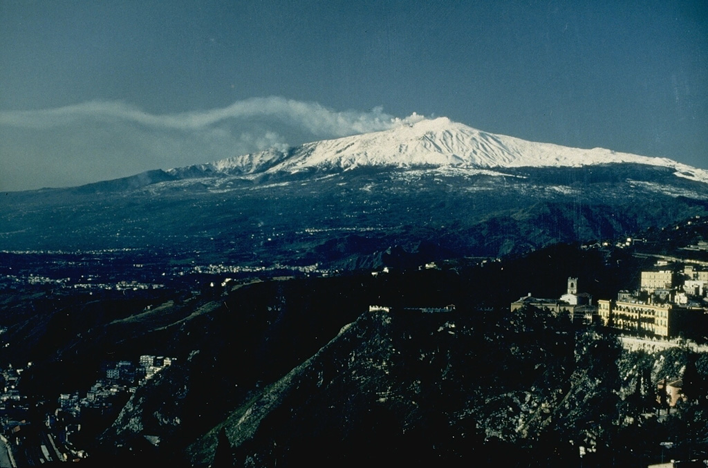
Etna (Italy) | 10 May-16 May 2023 | Continuing ActivityCite this Report |
 Etna Etna
Sicily Volcanic Province
|
INGV reported that an explosion at Etna’s SE Crater occurred at 0839 on 14 May and produced an ash emission that rapidly dispersed around the summit area. The Aviation Color Code was raised to Yellow at 0902 and then lowered back to Green at 1830 on 14 May. No significant variations in the seismic data were associated with the explosion.
Source: Sezione di Catania - Osservatorio Etneo (INGV)
|
Great Sitkin (United States) | 10 May-16 May 2023 | Continuing ActivityCite this Report |
 Great Sitkin Great Sitkin
Aleutian Ridge Volcanic Arc
|
AVO reported that lava likely continued to erupt at the summit of Great Sitkin during 9-16 May. Satellite data acquired on 11 May showed that the thick lava continued to expand towards the E but remained confined to the summit crater. Seismicity was low. Nothing significant was seen in satellite and webcam images during most of the week due to persistent weather clouds obscuring views. The Volcano Alert Level remained at Watch (the second highest level on a four-level scale) and the Aviation Color Code remained at Orange (the second highest level on a four-color scale).
Source: US Geological Survey Alaska Volcano Observatory (AVO)
|
Krakatau (Indonesia) | 10 May-16 May 2023 | Continuing ActivityCite this Report |
 Krakatau Krakatau
Sunda Volcanic Arc
|
During 10-13 May PVMBG reported that white-and-gray and white-and-brown ash plumes generally rose as high as 200 m above Anak Krakatau’s summit and drifted SW and NW, though a few Volcano Observatory Notices for Aviation (VONAs) described higher plumes. At 1241 on 11 May a gray ash plume rose 1 km above summit and drifted SW. At 0920 on 12 May a dense gray ash plume rose 2.5 km and drifted SW. At 2320 a dense gray ash plume rose 1.5 km and drifted SW. An accompanying webcam image showed incandescent material being ejected above the vent. At 0710 on 13 May a dense gray ash plume rose 2 km and drifted SW. The Alert Level remained at 3 (on a scale of 1-4), and the public was warned to stay at least 5 km away from the crater.
Source: Pusat Vulkanologi dan Mitigasi Bencana Geologi (PVMBG, also known as CVGHM)
|
Lewotolok (Indonesia) | 10 May-16 May 2023 | Continuing ActivityCite this Report |
 Lewotolok Lewotolok
Sunda Volcanic Arc
|
PVMBG reported that the eruption at Lewotolok was ongoing during 9-16 May. Almost daily white-and-gray ash plumes generally rose as high as 500 m above the summit and drifted in variable directions. At 0632 on 11 May a white-to-gray ash plume rose 500 m and drifted SW. At 0645 and 0957 on 11 May white-to-gray ash plumes rose 400-600 m and drifted E and SE, respectively. Nighttime webcam images of incandescent material being ejected above the summit were posted in daily reports during 10-13 May. The Alert Level remained at 2 (on a scale of 1-4) and the public was warned to stay 2 km away from the summit crater.
Source: Pusat Vulkanologi dan Mitigasi Bencana Geologi (PVMBG, also known as CVGHM)
|
Merapi (Indonesia) | 10 May-16 May 2023 | Continuing ActivityCite this Report |
 Merapi Merapi
Sunda Volcanic Arc
|
BPPTKG reported that the eruption at Merapi (on Java) continued during 5-11 May and seismicity remained at elevated levels. The SW lava dome produced 106 lava avalanches that traveled as far as 1.8 km down the SW flank (upstream in the Bebeng drainages). Morphological changes to the SW lava dome due to continuing collapses of material were evident in webcam images. The Alert Level remained at 3 (on a scale of 1-4), and the public was warned to stay 3-7 km away from the summit based on location.
Source: Balai Penyelidikan dan Pengembangan Teknologi Kebencanaan Geologi (BPPTKG)
|
Nyamulagira (DR Congo) | 10 May-16 May 2023 | Continuing ActivityCite this Report |
 Nyamulagira Nyamulagira
Albertine Rift Volcanic Province
|
The Observatoire Volcanologique de Goma (OVG) reported that the lava lake in Nyamulagira’s summit crater continued to be active during 30 April-6 May. A Sentinel satellite image from 7 May showed active lava flows traveling towards the NW part of the crater. Another image on 12 May showed active flows along the NE margin of the dark and cooler 7 May flows. Weather clouds and possible volcanic emissions obscured parts of the crater.
Sources: Observatoire Volcanologique de Goma (OVG), Sentinel Hub
|
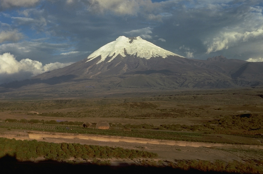
Popocatepetl (Mexico) | 10 May-16 May 2023 | Continuing ActivityCite this Report |
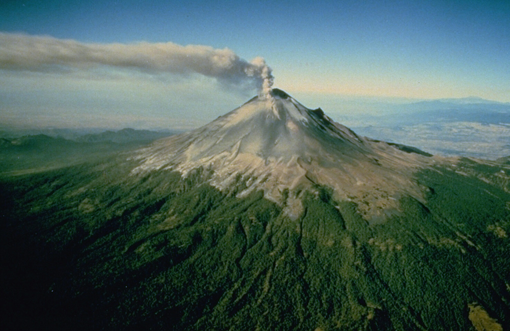 Popocatepetl Popocatepetl
Trans-Mexican Volcanic Arc
|
CENAPRED reported that there were 127-281 daily steam, gas, and ash emissions and minor-to-moderate explosions recorded at Popocatépetl during 9-16 May. Plumes mostly drifted SE, ESE, and ENE. On 9 May minor explosions were recorded at 1141, 2009, and 2310, and on 10 May moderate explosions were recorded at 0152 and 0316. Ashfall was reported in Tlalmanalco (30 km NW) and Tetela del Volcán (20 km SW) in Morelos during 9-10 May. On 11 May minor explosions were recorded at 0135, 0215, and 1621, while moderate explosions were recorded at 0526, 0811, 0838, 1601, and 1646. Minor explosions occurred at 1318 and 1452 on 12 May. On 13 May minor explosions occurred at 0012, 0805, and 2146, and a moderate explosion occurred at 1012. Ashfall was reported in the municipalities of Nealtican (20 km E), Huejotzingo (21 km E), and Domingo Arenas (20 km NE). On 14 May minor explosions were recorded at 0605, 0711, 0831, 1413, 1439, and 2312; moderate explosions were recorded at 1253, 1444, 1608, and 1941. On 15 May the network detected minor explosions at 0033 and 0051, and moderate explosions at 0352, 0512, 0617, 0852, 1051, 1232, and 1613. Minor amounts of ash fell in the municipalities of Puebla (43 km E) and Atlixco (24 km SE) and moderate amounts fell in municipalities near the volcano to the S. Weather clouds prevented views on 16 May. According to the Washington VAAC daily ash plumes were identified in satellite images rising 6.1-7.3 km (20,000-24,000 ft) a.s.l. (0.7-1.9 km above the crater rim) and drifting E and SE. The Alert Level remained at Yellow, Phase Two (the middle level on a three-color scale). CENAPRED urged people to respect the exclusion radius of 12 km and to not ascend the volcano.
Sources: Centro Nacional de Prevencion de Desastres (CENAPRED), Washington Volcanic Ash Advisory Center (VAAC)
|
Reventador (Ecuador) | 10 May-16 May 2023 | Continuing ActivityCite this Report |
 Reventador Reventador
Northern Andean Volcanic Arc
|
IG reported that the eruption at Reventador was ongoing during 10-16 May. Seismicity was characterized by explosions, long-period earthquakes, harmonic tremors, and emission-related tremors. Steam, gas, and ash plumes were observed in some webcam images, though weather conditions occasionally obscured views. Ash emissions on 12 May rose 500 m above the crater rim and drifted N. On 14 May a steam-and-ash plume rose 250 m and drifted NE. On 16 May an ash plume rose as high as 1 km above the crater and drifted W and SW. Incandescence at the crater was visible at night during 10-12 and 16 May, and incandescent blocks rolled 200-700 m down the flanks. Servicio Nacional de Gestión de Riesgos y Emergencias (SNGRE) maintained the Alert Level at Orange (the second highest level on a four-color scale).
Sources: Instituto Geofísico-Escuela Politécnica Nacional (IG-EPN), Servicio Nacional de Gestión de Riesgos y Emergencias (SNGRE)
|
Rincon de la Vieja (Costa Rica) | 10 May-16 May 2023 | Continuing ActivityCite this Report |
 Rincon de la Vieja Rincon de la Vieja
Central America Volcanic Arc
|
OVSICORI-UNA reported that periodic phreatic eruptions occurred at Rincón de la Vieja during 9-16 May. Phreatic events recorded at 1945 on 9 May, at 1419 on 10 May, and at 1100 on 11 May produced plumes that rose less than 1.5 km above the crater rim. Additional phreatic activity were recorded at 2232 on 11 May, and at both 2332 and 2338 on 12 May, though it was not known if emissions were generated. A short-lived explosive event at 0258 on 14 May ejected material onto the N flank and caused lahars to descend the Penjamo, Azul, and Azufrado rivers. Phreatic events at 1155 and 1748 that same day produced emissions that rose 500 m and 1.5 km above the crater rim, respectively. Gas emissions were occasionally visible during 15-16 May.
Source: Observatorio Vulcanologico y Sismologico de Costa Rica-Universidad Nacional (OVSICORI-UNA)
|
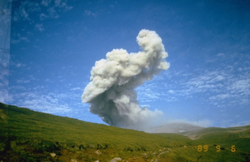
Sangay (Ecuador) | 10 May-16 May 2023 | Continuing ActivityCite this Report |
 Sangay Sangay
Northern Andean Volcanic Arc
|
IG reported a high level of activity at Sangay during 9-16 May, though weather clouds prevented visual observations during most of the week. Ash plumes rose 500 m and drifted SW on 9 May. A webcam image from 1833 on 14 May showed lava flowing 500 m down the SE flank. Servicio Nacional de Gestión de Riesgos y Emergencias (SNGRE) maintained the Alert Level at Yellow (the second lowest level on a four-color scale).
Sources: Instituto Geofísico-Escuela Politécnica Nacional (IG-EPN), Servicio Nacional de Gestión de Riesgos y Emergencias (SNGRE)
|
Santa Maria (Guatemala) | 10 May-16 May 2023 | Continuing ActivityCite this Report |
 Santa Maria Santa Maria
Central America Volcanic Arc
|
INSIVUMEH reported that the eruption at Santa María’s Santiaguito lava-dome complex continued during 10-16 May. Effusion from the Caliente dome complex fed lava flows that descended the San Isidro and Zanjón Seco drainages on the W and SW flanks; the main lava flow was 4.3 km long and remained active. Daily weak-to-moderate explosions generated gas, steam, and ash plumes that generally rose up to 800 m above the crater and drifted SE, S, SW, and W. Explosions were sometimes accompanied by block-and-ash flows that descended multiple flanks of the dome. Incandescence from the dome and lava flows was visible during the nights and early mornings. An average of 40 explosions per day were recorded during 9-10 and 13-14 May, generating ash plumes that rose up to 1 km above the dome and drifted S and SW. Ashfall was reported in Fincas El Patrocinio, El Faro (7 km S), Las Marías (10 km S), and others nearby on 10 May.
Source: Instituto Nacional de Sismologia, Vulcanologia, Meteorologia, e Hidrologia (INSIVUMEH)
|
Semeru (Indonesia) | 10 May-16 May 2023 | Continuing ActivityCite this Report |
 Semeru Semeru
Sunda Volcanic Arc
|
PVMBG reported that the eruption at Semeru continued during 10-16 May and a few Volcano Observatory Notices for Aviation (VONAs) describing ash emissions were issued during the week. White-to-gray ash plumes that were sometimes dense rose 500-700 m above the summit and drifted S, SW, W, and N at 1115 on 10 May, at 0725 and 0830 on 12 May, at 0858, 1010, and 1241 on 13 May, at 0523 and 1656 on 14 May, and at 0757 on 16 May. The Alert Level remained at 3 (third highest on a scale of 1-4). The public was warned to stay at least 5 km away from the summit in all directions, 13 km from the summit to the SE, 100 m from the banks of the Kobokan drainage as far as 17 km from the summit, and to avoid other drainages including the Bang, Kembar, and Sat, due to lahar, avalanche, and pyroclastic flow hazards.
Source: Pusat Vulkanologi dan Mitigasi Bencana Geologi (PVMBG, also known as CVGHM)
|
Semisopochnoi (United States) | 10 May-16 May 2023 | Continuing ActivityCite this Report |
 Semisopochnoi Semisopochnoi
Aleutian Ridge Volcanic Arc
|
AVO reported that low-level unrest continued at Semisopochnoi during 9-16 May. Weather clouds mostly obscured satellite and webcam views. Volcanic tremor was detected during 9-10 May; there was no evidence of explosive or earthquake activity in the geophysics data during the rest of the week. The Volcano Alert Level remained at Watch (the second highest level on a four-level scale) and the Aviation Color Code remained at Orange (the second highest level on a four-color scale).
Source: US Geological Survey Alaska Volcano Observatory (AVO)
|
Sheveluch (Russia) | 10 May-16 May 2023 | Continuing ActivityCite this Report |
 Sheveluch Sheveluch
Eastern Kamchatka Volcanic Arc
|
KVERT reported that the ongoing eruption at Sheveluch was generally characterized by occasional explosions, continuing lava-dome growth, incandescence, and strong fumarolic activity during 4-11 May. A thermal anomaly over the active crater and Karan lava dome area was identified in satellite images all week. Intense fumarolic activity was likely associated with dome growth. During 8-9 May ash from pyroclastic flow deposits on the SE flank were resuspended by winds and blown 60 km W based on satellite images. The Aviation Color Code remained at Orange (the second highest level on a four-color scale). Dates are based on UTC times; specific events are in local time where noted.
Source: Kamchatkan Volcanic Eruption Response Team (KVERT)
|
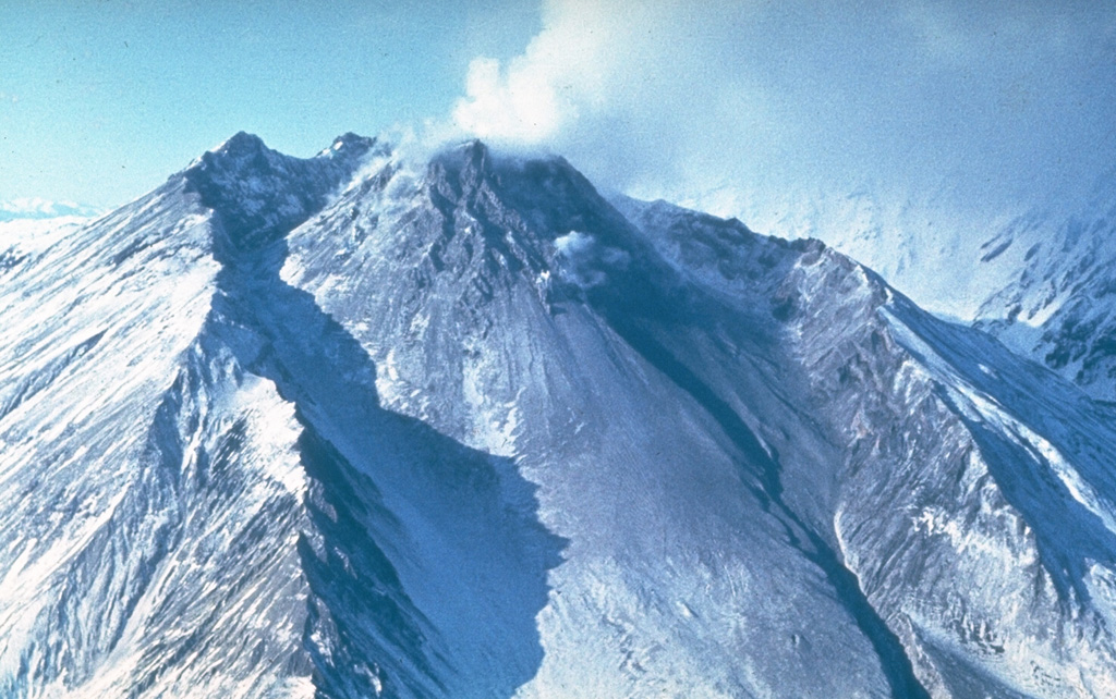
St. Helens (United States) | 10 May-16 May 2023 | Continuing ActivityCite this Report |
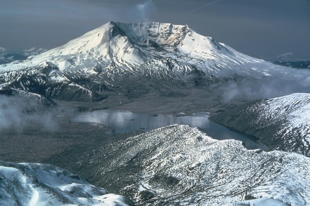 St. Helens St. Helens
High Cascades Volcanic Arc
|
USGS reported that at 2045 on 14 May a debris flow in Mount St. Helens' South Coldwater Creek destroyed a Highway SR 504 bridge, cutting off access and power to Johnston Ridge Observatory. While the loss of power interrupted a major telemetry hub, other stations remined operational and continued to provide data; the debris flow was recorded in seismic data from nearby stations. The source material in the flow originated from the climactic 1980 debris avalanche and eruption of Mount St. Helens. According to a news article at least 11 people had to spend the night at the Johnston Ridge Observatory and were airlifted out the next day. Officials noted that the highway will be closed for an indefinite amount of time.
Sources: US Geological Survey Cascades Volcano Observatory (CVO), KING-TV
|
Stromboli (Italy) | 10 May-16 May 2023 | Continuing ActivityCite this Report |
 Stromboli Stromboli
Aeolian Volcanic Arc
|
INGV reported ongoing Strombolian activity at Stromboli during 8-14 May. Activity was centered at two vents (one each at craters N1 and N2) in Area N, within the upper part of the Sciara del Fuoco, and from three vents in the Area C-S (South-Central Crater area) in the crater terrace area. Explosions at the N1 and N2 craters in Area N were low intensity and ejected coarse material (bombs and lapilli), sometimes mixed with ash at N1, as high as 80 m at a rate of 4-9 explosions per hour. Medium- to high-intensity explosions at the two vents in sector S2 (Area C-S) ejected ash sometimes mixed with coarse material at an average rate of 5-8 explosions per hour. Low-intensity gas explosions occurred at S1 in Area C-S. No significant activity was identified in Sector C in Area C-S.
Source: Sezione di Catania - Osservatorio Etneo (INGV)
|
Suwanosejima (Japan) | 10 May-16 May 2023 | Continuing ActivityCite this Report |
 Suwanosejima Suwanosejima
Ryukyu Volcanic Arc
|
JMA reported that the eruption at Suwanosejima's Ontake Crater continued during 8-15 May and crater incandescence was reported nightly. Explosions recorded at 0701, 1200, and 2330 on 8 May produced ash plumes that rose as high as 1 km above the crater rim and mainly drifted SE. Explosions were also recorded at 1358 and 1648, though characteristics of associated emissions were unknown. Eruptive events at 2001 on 8 May, 1753 on 9 May, 0405, 0647, and 1236 on 11 May, and 1919 on 13 May generated ash plumes that rose as high as 1.3 km and generally drifted S, SW, and N. The Alert Level remained at 3 (on a 5-level scale) and residents were warned to stay 2 km away from the crater.
Source: Japan Meteorological Agency (JMA)
|

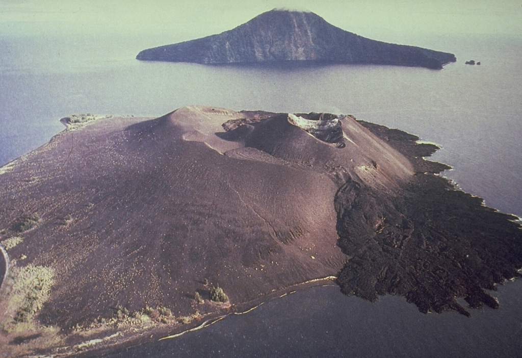
 Fuego
Fuego Kita-Ioto