PVMBG reported increased activity at Tengger Caldera’s Bromo cone in a 13 December press release. Emissions that day were white, gray, and brown, had variable densities, and rose as high as 900 m above the summit. The plumes drifted in multiple directions. The report noted that tremor was continuous and accompanied in December by three volcanic earthquakes. Deformation data indicated inflation in December. Daily white emissions that rose as high as 700 m above the summit and drifted in multiple directions were visible through 18 December. The Alert Level remained at 2 (on a scale of 1-4), and visitors were warned to stay outside of a 1-km radius of the crater.
Source: Pusat Vulkanologi dan Mitigasi Bencana Geologi (PVMBG, also known as CVGHM)
Minor ash emission in December 2023; persistent weak thermal anomaly in the Bromo crater
Tengger Caldera, located at the N end of a volcanic massif in Indonesia’s East Java, consists of five overlapping stratovolcanoes. The youngest and only active cone in the 16-km-wide caldera is Bromo, which typically produces gas-and-steam plumes, occasional ash plumes and explosions, and weak thermal signals (BGVN 44:05, 47:01). This report covers activity during January 2022-December 2023, consisting of mostly white gas-and-steam emissions and persistent weak thermal anomalies. Information was provided by the Pusat Vulkanologi dan Mitigasi Bencana Geologi (PVMBG, also known as Indonesian Center for Volcanology and Geological Hazard Mitigation, CVGHM) and satellite imagery. The Alert Level remained at 2 (on a scale of 1-4), and visitors were warned to stay at least 1 km from the crater.
Activity was generally low during the reporting period, similar to that in 2021. According to almost daily images from MAGMA Indonesia (a platform developed by PVMBG), white emissions and plumes rose from 50 to 900 m above the main crater during this period (figure 24). During several days in March and June 2022, white plumes reached heights of 1-1.2 km above the crater.
 |
Figure 24. Webcam image showing a gas-and-steam plume from the Bromo cone in the Tengger Caldera on 2 April 2023. Courtesy of MAGMA Indonesia. |
After an increase in activity at 2114 on 3 February 2023, a PVMBG team that was sent to observe white emissions rising as high as 300 m during 9-12 February and heard rumbling noises. A sulfur dioxide odor was also strong near the crater and measurements indicated that levels were above the healthy (non-hazardous) threshold of 5 parts per million; differential optical absorption spectroscopy (DOAS) measurements indicated an average flux of 190 metric tons per day on 11 February. Incandescence originating from a large fumarole in the NNW part of the crater was visible at night. The team observed that vegetation on the E caldera wall was yellow and withered. The seismic network recorded continuous tremor and deep and shallow volcanic earthquakes.
According to a PVMBG press release, activity increased on 13 December 2023 with white, gray, and brown emissions rising as high as 900 m above Bromo’s crater rim and drifting in multiple directions (figure 25). The report noted that tremor was continuous and was accompanied in December by three volcanic earthquakes. Deformation data indicated inflation in December. There was no observable difference in the persistent thermal anomaly in the crater between 11 and 16 December 2023.
 |
Figure 25. Webcam image showing a dark plume that rose 900 m above the summit of the Bromo cone in the Tengger Caldera on 13 December 2023. Courtesy of MAGMA Indonesia. |
All clear views of the Bromo crater throughout this time, using Sentinel-2 infrared satellite images, showed a weak persistent thermal anomaly; none of the anomalies were strong enough to cause MODVOLC Thermal Alerts. A fire in the SE part of the caldera in early September 2023 resulted in a brief period of strong thermal anomalies.
Information Contacts: Pusat Vulkanologi dan Mitigasi Bencana Geologi (PVMBG, also known as Indonesian Center for Volcanology and Geological Hazard Mitigation, CVGHM), Jalan Diponegoro 57, Bandung 40122, Indonesia (URL: http://www.vsi.esdm.go.id/); MAGMA Indonesia, Kementerian Energi dan Sumber Daya Mineral (URL: https://magma.esdm.go.id/v1); Copernicus Browser, Copernicus Data Space Ecosystem, European Space Agency (URL: https://dataspace.copernicus.eu/browser/); Hawai'i Institute of Geophysics and Planetology (HIGP) - MODVOLC Thermal Alerts System, School of Ocean and Earth Science and Technology (SOEST), Univ. of Hawai'i, 2525 Correa Road, Honolulu, HI 96822, USA (URL: http://modis.higp.hawaii.edu/).
2023: February
| December
2021: March
| May
| August
| September
2020: December
2019: February
| March
| April
| July
2016: January
| February
| March
| April
| May
| June
| July
| August
| September
| October
| November
2015: April
| May
| July
| November
| December
2014: May
2012: March
| October
2011: January
| February
| March
| April
| May
| June
2010: November
| December
2007: June
2006: July
| August
| September
2004: June
| August
2001: January
2000: November
| December
PVMBG reported increased activity at Tengger Caldera’s Bromo cone in a 13 December press release. Emissions that day were white, gray, and brown, had variable densities, and rose as high as 900 m above the summit. The plumes drifted in multiple directions. The report noted that tremor was continuous and accompanied in December by three volcanic earthquakes. Deformation data indicated inflation in December. Daily white emissions that rose as high as 700 m above the summit and drifted in multiple directions were visible through 18 December. The Alert Level remained at 2 (on a scale of 1-4), and visitors were warned to stay outside of a 1-km radius of the crater.
Source: Pusat Vulkanologi dan Mitigasi Bencana Geologi (PVMBG, also known as CVGHM)
PVMBG sent a team of scientists to investigate Tengger Caldera’s Bromo cone after an increase in activity was detected on 3 February, characterized by crater incandescence, rumbling sounds, and a strong sulfur dioxide odor. They observed somewhat dense white emissions rising as high as 300 m during 9-12 February and heard moderate-to-strong rumbling noises. A sulfur dioxide odor was strong near the crater and measurements indicated that levels were above the healthy (non-hazardous) threshold of 5 parts per million; differential optical absorption spectroscopy (DOAS) measurements indicated an average flux of 190 tons per day on 11 February. During clear periods the largest solfatara on the NNW part of the crater floor was visible and ranged in temperature from 46 to 66 degrees Celsius based on handheld instruments. Crater incandescence, originating from the solfatara, was visible at night. The Alert Level remained at 2 (on a scale of 1-4), and visitors were warned to stay outside of a 1-km radius of the crater.
Source: Pusat Vulkanologi dan Mitigasi Bencana Geologi (PVMBG, also known as CVGHM)
PVMBG reported that activity at Tengger Caldera’s Bromo cone increased at 2114 on 3 February and was characterized by crater incandescence, rumbling sounds, and a strong sulfur dioxide odor. The report noted that sometimes-dense white plumes rose as high as 900 m above the summit during the previous week and through 7 February, and that vegetation on the E caldera wall was yellow and withered. The seismic network recorded continuous tremor and deep and shallow volcanic earthquakes. The Alert Level remained at 2 (on a scale of 1-4), and visitors were warned to stay outside of a 1-km radius of the crater.
Source: Pusat Vulkanologi dan Mitigasi Bencana Geologi (PVMBG, also known as CVGHM)
PVMBG reported that during 21-27 September white gas-and-steam plumes rose as high as 400 m above the rim of Tengger Caldera’s Bromo cone and drifted SW, W, and NW. White-and-gray plumes rose as high as 500 m during 22-23 September. A weak thermal anomaly was visible in Sentinel-2 infrared satellite images on 22 and 27 September. The Alert Level remained at 2 (on a scale of 1-4), and visitors were warned to stay outside of a 1-km radius of the crater.
Sources: Pusat Vulkanologi dan Mitigasi Bencana Geologi (PVMBG, also known as CVGHM); Sentinel Hub
PVMBG reported that during 18-24 August white gas-and-steam plumes rose 50-400 m above Tengger Caldera’s Bromo cone and drifted SW, W, and NW. A weak thermal anomaly was visible in Sentinel-2 infrared satellite images on 23 August. The Alert Level remained at 2 (on a scale of 1-4), and visitors were warned to stay outside of a 1-km radius of the crater.
Sources: Pusat Vulkanologi dan Mitigasi Bencana Geologi (PVMBG, also known as CVGHM); Sentinel Hub
PVMBG reported that during 3-9 August white steam-and-gas plumes rose as high as 400 m above Tengger Caldera’s Bromo cone and drifted NW, W, and SW. Thermal anomalies were visible in satellite images on 3 and 8 August; a weaker anomaly was also visible on 29 July. The Alert Level remained at 2 (on a scale of 1-4), and visitors were warned to stay outside of a 1-km radius of the crater.
Sources: Pusat Vulkanologi dan Mitigasi Bencana Geologi (PVMBG, also known as CVGHM); Sentinel Hub
PVMBG reported that during 14-17 May white-and-gray plumes rose as high as 500 m above the summit of Tengger Caldera’s Bromo cone and drifted in multiple directions. A sulfur odor was noted at the observation post. The Alert Level remained at 2 (on a scale of 1-4), and visitors were warned to stay outside of a 1-km radius of the crater.
Source: Pusat Vulkanologi dan Mitigasi Bencana Geologi (PVMBG, also known as CVGHM)
PVMBG reported that during 30 March-5 April white steam-and-gas plumes rose 50-700 m above the summit of Tengger Caldera’s Bromo cone. The plumes were white to gray during 1-2 April. The Alert Level remained at 2 (on a scale of 1-4), and visitors were warned to stay outside of a 1-km radius of the crater.
Source: Pusat Vulkanologi dan Mitigasi Bencana Geologi (PVMBG, also known as CVGHM)
PVMBG reported that during 26-27 December white-and-gray plumes rose 50-700 m above the summit of Tengger Caldera’s Bromo cone. At 0550 on 28 December a gas-and-ash emission rose at least 500 m above the summit according to an observer. Ashfall was reported in the Ngadirejo area, about 5 km NE. The Alert Level remained at 2 (on a scale of 1-4), and visitors were warned to stay outside of a 1-km radius of the crater.
Source: Pusat Vulkanologi dan Mitigasi Bencana Geologi (PVMBG, also known as CVGHM)
The Darwin VAAC reported that on 28 July ash plumes from Tengger Caldera’s Bromo cone rose to an altitude of 2.4 km (8,000 ft) a.s.l. and drifted NW based on webcam images, satellite data, and weather models. The Alert Level remained at 2 (on a scale of 1-4), and visitors were warned to stay outside of a 1-km radius of the crater.
Sources: Darwin Volcanic Ash Advisory Centre (VAAC); Pusat Vulkanologi dan Mitigasi Bencana Geologi (PVMBG, also known as CVGHM)
PVMBG reported that rain triggered a lahar at 1700 on 19 July that originated on the SW flank of Tengger Caldera’s Bromo cone. The Alert Level remained at 2 (on a scale of 1-4), and visitors were warned to stay outside of a 1-km radius of the crater.
Sources: Pusat Vulkanologi dan Mitigasi Bencana Geologi (PVMBG, also known as CVGHM); Darwin Volcanic Ash Advisory Centre (VAAC)
The Darwin VAAC reported that during 24-26 April white plumes of variable density rose 300-500 m above Tengger Caldera’s Bromo cone. White-to-black emissions rose 500 m above the cone on 27 April, and white-to-gray emissions rose 600 m above the cone on 29 April. The Alert Level remained at 2 (on a scale of 1-4), and visitors were warned to stay outside of a 1-km radius of the crater.
Sources: Darwin Volcanic Ash Advisory Centre (VAAC); Pusat Vulkanologi dan Mitigasi Bencana Geologi (PVMBG, also known as CVGHM)
The Darwin VAAC reported that on 17 April ash plumes from Tengger Caldera’s Bromo cone rose to an altitude of 3 km (10,000 ft) a.s.l. and drifted W, based on webcam images and satellite data. On 21 April BNPB stated that ash emissions had been observed almost daily, and that tremor was recorded continuously. The Alert Level remained at 2 (on a scale of 1-4), and visitors were warned to stay outside of a 1-km radius of the crater.
Sources: Pusat Vulkanologi dan Mitigasi Bencana Geologi (PVMBG, also known as CVGHM); Darwin Volcanic Ash Advisory Centre (VAAC); Badan Nacional Penanggulangan Bencana (BNPB)
The Darwin VAAC reported that during 10-11 and 15-16 April ash plumes from Tengger Caldera’s Bromo cone rose to an altitude of 3 km (10,000 ft) a.s.l. and drifted in multiple directions, based on webcam images and satellite data. The Alert Level remained at 2 (on a scale of 1-4), and visitors were warned to stay outside of a 1-km radius of the crater.
Source: Pusat Vulkanologi dan Mitigasi Bencana Geologi (PVMBG, also known as CVGHM)
PVMBG reported that at 0718 on 6 April ash plumes from Tengger Caldera’s Bromo cone rose 900 m above the crater rim and drifted SE. The Darwin VAAC reported that during 7-8 April ash plumes rose to an altitude of 3 km (10,000 ft) a.s.l. and drifted N and E, based on webcam images, satellite data, and ground-based observations. The Alert Level remained at 2 (on a scale of 1-4), and visitors were warned to stay outside of a 1-km radius of the crater.
Sources: Pusat Vulkanologi dan Mitigasi Bencana Geologi (PVMBG, also known as CVGHM); Darwin Volcanic Ash Advisory Centre (VAAC)
The Darwin VAAC reported that during 27-28 March ash plumes from Tengger Caldera’s Bromo cone rose to altitudes of 3.4-4 km (11,000-13,000 ft) a.s.l. and drifted W, NW, N, and NE, based on webcam images, satellite data, and notices from PVMBG. The Alert Level remained at 2 (on a scale of 1-4), and visitors were warned to stay outside of a 1-km radius of the crater.
Source: Pusat Vulkanologi dan Mitigasi Bencana Geologi (PVMBG, also known as CVGHM)
PVMBG reported that during 19-26 March ash plumes of variable densities and colors ranging from white to black rose as high as 1.2 km above the crater rim of Tengger Caldera’s Bromo cone. The ash plumes drifted in multiple directions. The Alert Level remained at 2 (on a scale of 1-4), and visitors were warned to stay outside of a 1-km radius of the crater.
Source: Pusat Vulkanologi dan Mitigasi Bencana Geologi (PVMBG, also known as CVGHM)
PVMBG reported that during 1 January-17 March plumes rising from Tengger Caldera’s Bromo cone were generally white to gray in color, had variable densities, and rose no higher than 700 m above the crater rim. Tremor signals increased on 10 March and were accompanied by changes in the color and height of the emissions. On 16 March a dense gray ash plume rose 1.5 km and drifted E, causing ashfall in areas both inside and outside the caldera. Two seismic signals indicating explosions were recorded around 1547 on 17 March. Periods of continuous ash emissions were observed during 17-18 March, with ash plumes rising as high as 1.2 km above the crater rim and drifting NE, N, NW, and W. At 1020 on 19 March a black ash plume rose 1.5 km and drifted E and NE. The Alert Level remained at 2 (on a scale of 1-4).
Source: Pusat Vulkanologi dan Mitigasi Bencana Geologi (PVMBG, also known as CVGHM)
PVMBG reported that on 10 March an eruption at Tengger Caldera’s Bromo cone generated a white, brown, and gray ash plume that, according to a ground observer, rose 600 m and drifted SW. An event at 0600 on 11 March produced a dense gray-to-brown ash plume that rose 600 m and drifted S, SW, and W. The Alert Level remained at 2 (on a scale of 1-4).
Source: Pusat Vulkanologi dan Mitigasi Bencana Geologi (PVMBG, also known as CVGHM)
PVMBG reported that at 0600 on 18 February an eruption at Tengger Caldera’s Bromo cone generated a dense white-and-brown ash plume that rose 600 m and drifted WSW. The Alert Level remained at 2 (on a scale of 1-4).
Source: Pusat Vulkanologi dan Mitigasi Bencana Geologi (PVMBG, also known as CVGHM)
Based on analyses of satellite and webcam images and information from PVMBG, the Darwin VAAC reported that during 10-12 November ash plumes from Tengger Caldera’s Bromo cone rose to an altitude of 3 km (10,000 ft) a.s.l. and drifted NW, E, and SE.
Source: Darwin Volcanic Ash Advisory Centre (VAAC)
PVMBG reported that during 1-20 October brownish, reddish, and grayish gray plumes from Tengger Caldera's Bromo cone rose as high as 900 m above the crater and drifted E, NW, W, and SW. Seismic activity was dominated by constant tremor although the amplitude decreased. On 20 October the Alert Level was lowered to 2 (on a scale of 1-4); residents and visitors were reminded not to approach the crater within a radius of 1 km.
Source: Pusat Vulkanologi dan Mitigasi Bencana Geologi (PVMBG, also known as CVGHM)
Based on analyses of satellite images, the Darwin VAAC reported that during 5-6 October ash plumes from Tengger Caldera’s Bromo cone rose to an altitude of 2.7 km (9,000 ft) a.s.l. and drifted almost 40 km SW and W. On 7 October PVMBG reported that activity at Bromo cone remained high. Grayish-white and blackish-brown plumes rose 100-300 m above the crater rim and drifted NW.
Source: Darwin Volcanic Ash Advisory Centre (VAAC)
Based on analyses of satellite images and information from PVMBG, the Darwin VAAC reported that on 29 September and 1 October ash plumes from Tengger Caldera’s Bromo cone rose to an altitude of 2.7 km (9,000 ft) a.s.l. and drifted E and SE.
Source: Darwin Volcanic Ash Advisory Centre (VAAC)
PVMBG reported that during 1 June-25 September brownish gray plumes from Tengger Caldera's Bromo cone rose as high as 1.2 km above the crater. A sulfur odor was noted at the Bromo observation post, thunderous noises sometimes vibrated the post doors, and occasionally crater incandescence was observed. Seismic activity was dominated by shallow volcanic earthquakes and tremor. The deformation network measured inflation. Based on analyses of satellite images and information from PVMBG, the Darwin VAAC reported that during 22-23 September ash plumes rose to an altitude of 3 km (10,000 ft) a.s.l. (720 m above the crater) and drifted almost 40 km SW. On 26 September the Alert Level was raised to 3 (on a scale of 1-4); residents and visitors were reminded not to approach the crater within a radius of 2.5 km.
Sources: Pusat Vulkanologi dan Mitigasi Bencana Geologi (PVMBG, also known as CVGHM); Darwin Volcanic Ash Advisory Centre (VAAC)
Based on analyses of satellite images, the Darwin VAAC reported that on 10 August minor gas-and-steam emissions from Tengger Caldera’s Bromo cone remained localized within the caldera.
Source: Darwin Volcanic Ash Advisory Centre (VAAC)
Based on analyses of satellite images and information from PVMBG, the Darwin VAAC reported that during 27-31 July and 1 August ash plumes from Tengger Caldera’s Bromo cone rose to an altitude of 3 km (10,000 ft) a.s.l. and drifted as far as 55 km NW, W, and SW.
Source: Darwin Volcanic Ash Advisory Centre (VAAC)
Based on analyses of satellite images, the Darwin VAAC reported that during 23-24 July ash plumes from Tengger Caldera's Bromo cone rose to an altitude of 3 km (10,000 ft) a.s.l. and drifted over 45 km NW and W.
Source: Darwin Volcanic Ash Advisory Centre (VAAC)
Based on satellite images, wind data, and information from PVMBG, the Darwin VAAC reported that during 13-16 and 19 July ash plumes from Tengger Caldera's Bromo cone rose to altitudes of 2.1-3.3 km (7,000-11,000 ft) a.s.l. and drifted over 45 km NW, SW, and SE. BNPB reported that the Abdul Rachman Saleh Airport in Malang (26 km W) closed again due to ash, from 2307 on 15 July to 0900 on 16 July; six flights were diverted and two were cancelled. Minor amounts of ash fell in the communities of Probolinggo (35 km NE) and Lumajang (36 km SW). The Alert Level remained at 2 (on a scale of 1-4); residents and visitors were reminded not to approach the crater within a radius of 1 km.
Sources: Darwin Volcanic Ash Advisory Centre (VAAC); Badan Nacional Penanggulangan Bencana (BNPB)
Based on satellite images, wind data, and information from PVMBG, the Darwin VAAC reported that during 6-12 July ash plumes from Tengger Caldera's Bromo cone rose to altitudes of 2.7-3 km (9,000-10,000 ft) a.s.l. and drifted as far as 120 km S, SSW, SW, and W. BNPB reported that the Abdul Rachman Saleh Airport in Malang (26 km W) closed from 2300 on 11 July to 0900 on 12 July due to thin ash deposits around the airport. The Alert Level remained at 2 (on a scale of 1-4); residents and visitors were reminded not to approach the crater within a radius of 1 km.
Sources: Darwin Volcanic Ash Advisory Centre (VAAC); Badan Nacional Penanggulangan Bencana (BNPB)
Based on satellite images and model data, the Darwin VAAC reported that during 24-28 June ash plumes from Tengger Caldera's Bromo cone rose to an altitude of 3 km (10,000 ft) a.s.l. and drifted 55 km SW and W.
Source: Darwin Volcanic Ash Advisory Centre (VAAC)
Based on satellite images, wind data, and information from PVMBG, the Darwin VAAC reported that on 21 June ash plumes from Tengger Caldera's Bromo cone rose to an altitude of 3 km (10,000 ft) a.s.l. and drifted almost 20 km S and SE.
Source: Darwin Volcanic Ash Advisory Centre (VAAC)
Based on satellite images, wind data, and information from PVMBG, the Darwin VAAC reported that during 1-3 June ash plumes from Tengger Caldera's Bromo cone rose to an altitude of 3 km (10,000 ft) a.s.l. and drifted as far as 65 km N and NW.
Source: Darwin Volcanic Ash Advisory Centre (VAAC)
Based on satellite images, wind data, and information from PVMBG, the Darwin VAAC reported that during 28-31 May ash plumes from Tengger Caldera's Bromo cone rose to an altitude of 2.4 km (8,000 ft) a.s.l. and drifted as far as 55 km NW, SW, S, and NNE.
Source: Darwin Volcanic Ash Advisory Centre (VAAC)
Based on satellite images and wind data, the Darwin VAAC reported that during 23-24 May ash plumes from Tengger Caldera's Bromo cone rose to an altitude of 3 km (10,000 ft) a.s.l. and drifted as far as 75 km NE
Source: Darwin Volcanic Ash Advisory Centre (VAAC)
Based on satellite images and wind data, the Darwin VAAC reported that during 27-28 April ash plumes from Tengger Caldera's Bromo cone rose to altitudes of 3-3.6 km (10,000-12,000 ft) a.s.l. and drifted NW, W, SW, and SE.
Source: Darwin Volcanic Ash Advisory Centre (VAAC)
Based on satellite images and wind data, the Darwin VAAC reported that on 20 April ash plumes from Tengger Caldera's Bromo cone rose to an altitude of 3 km (10,000 ft) a.s.l. and drifted S and almost 20 km NW. On 26 April another ash plume rose to the same altitude and drifted W.
Source: Darwin Volcanic Ash Advisory Centre (VAAC)
Based on satellite images, wind data, and ground reports from PVMBG, the Darwin VAAC reported that during 13 and 17-18 April ash plumes from Tengger Caldera's Bromo cone rose to altitudes of 3-3.3 km (10,000-11,000 ft) a.s.l. and drifted W, NE, and E.
Source: Darwin Volcanic Ash Advisory Centre (VAAC)
Based on satellite images, wind data, and ground reports from PVMBG, the Darwin VAAC reported that during 6-8 and 10-12 April ash plumes from Tengger Caldera's Bromo cone rose to an altitude of 3 km (10,000 ft) a.s.l. and drifted SW, WSW, and W.
Source: Darwin Volcanic Ash Advisory Centre (VAAC)
Based on satellite images, wind data, and ground reports from PVMBG, the Darwin VAAC reported that during 2-5 April ash plumes from Tengger Caldera's Bromo cone rose to altitudes of 2.1-3.6 km (7,000-12,000 ft) a.s.l. and drifted 25-45 km SW and W.
Source: Darwin Volcanic Ash Advisory Centre (VAAC)
Based on satellite images, wind data, ground reports, and information from PVMBG, the Darwin VAAC reported that during 17-23 February ash plumes from Tengger Caldera's Bromo cone rose to an altitude of 3 km (10,000 ft) a.s.l. and drifted at most 55 km NW, ESE, and SE.
Source: Darwin Volcanic Ash Advisory Centre (VAAC)
Based on satellite images and wind data, the Darwin VAAC reported that during 10-16 February ash plumes from Tengger Caldera's Bromo cone rose to an altitude of 3 km (10,000 ft) a.s.l. and drifted in multiple directions.
Source: Darwin Volcanic Ash Advisory Centre (VAAC)
Based on satellite images and wind data, the Darwin VAAC reported that on 6 and 9 February ash plumes rose to an altitude of 3 km (10,000 ft) a.s.l. and drifted 35-45 km NE and W.
Source: Darwin Volcanic Ash Advisory Centre (VAAC)
Based on information from PVMBG, satellite images, and wind data, the Darwin VAAC reported that during 27-30 January ash plumes rose to an altitude of 3.9 km (13,000 ft) a.s.l. and drifted 25-65 NE, ENE, and E.
Source: Pusat Vulkanologi dan Mitigasi Bencana Geologi (PVMBG, also known as CVGHM)
PVMBG reported that during 14-22 January brownish gray plumes from Tengger Caldera's Bromo cone rose as high as 1.8 km above the crater. Seismicity fluctuated; the number of explosion signals increased and some shallow and deep volcanic earthquakes were recorded. The Alert Level remained at 3 (on a scale of 1-4); residents and visitors were reminded not to approach the crater within a radius of 2.5 km.
Based on information from PVMBG and satellite images, the Darwin VAAC reported that during 23 and 25-26 January ash plumes rose to altitudes of 3.6-3.9 km (12,000-13,000 ft) a.s.l. and drifted ENE, E, and SE.
Source: Pusat Vulkanologi dan Mitigasi Bencana Geologi (PVMBG, also known as CVGHM)
Based on satellite and webcam images, the Darwin VAAC reported that during 13-19 January ash plumes from Tengger Caldera's Bromo cone rose to an altitude of 3.6-4.2 km (12,000-14,000 ft) a.s.l. and drifted 15-160 km NW, W, SW, and S.
Source: Darwin Volcanic Ash Advisory Centre (VAAC)
Based on satellite and webcam images, the Darwin VAAC reported that during 6-12 January ash plumes from Tengger Caldera's Bromo cone rose to an altitude of 3.6 km (12,000 ft) a.s.l. and drifted 30-165 km in multiple directions.
Source: Darwin Volcanic Ash Advisory Centre (VAAC)
Based on satellite and webcam images, the Darwin VAAC reported that during 30 December-5 January ash plumes from Tengger Caldera's Bromo cone rose to altitudes of 3.6-4.2 km (12,000-14,000 ft) a.s.l. and drifted 15-110 km in multiple directions.
Source: Darwin Volcanic Ash Advisory Centre (VAAC)
Based on satellite and webcam images, the Darwin VAAC reported that during 23-29 December ash plumes from Tengger Caldera's Bromo cone rose to altitudes of 3.6-4.2 km (12,000-14,000 ft) a.s.l. and drifted 45-205 km N, NNE, NE, E, and SE.
Source: Darwin Volcanic Ash Advisory Centre (VAAC)
According to a news article, ash from Tengger Caldera's Bromo cone emitted on 15 December caused the Abdul Rachman Saleh Airport in Malang to close. On 16 December BNPB reported that ash plumes continued to rise from the cone. Based on satellite and webcam images, the Darwin VAAC reported that during 15, 17-19, and 21-22 December ash plumes rose to altitudes of 3-3.6 km (10,000-12,000 ft) a.s.l. and drifted 25-95 km W, NW, N, E, and SE.
Sources: Badan Nacional Penanggulangan Bencana (BNPB); Darwin Volcanic Ash Advisory Centre (VAAC); Bernama
Based on satellite and webcam images, the Darwin VAAC reported that during 9-15 December ash plumes from Tengger Caldera's Bromo cone rose to an altitude of 3 km (10,000 ft) a.s.l. and drifted 45-65 km NE, NW, W, and SW. On 15 December BNPB reported that activity at the volcano remained high; gray-brown ash plumes rose 1.5 km above the crater and drifted W and NW. Weak rumbling was noted.
Source: Darwin Volcanic Ash Advisory Centre (VAAC)
PVMBG reported that during 15 November-4 December white plumes from Tengger Caldera's Bromo cone rose as high as 150 m above the crater, and an intense sulfur dioxide odor was noted at the Bromo observation post. On 15, 23, and 27 November dense ash plumes rose 150 m above the crater rim. RSAM values increased at the beginning of November, and then sharply increased in the beginning of December. Based on seismic analysis, visual observations, and hazard potential, the Alert Level was raised to 3 (on a scale of 1-4) on 4 December. Residents and visitors were warned not to approach the crater within a radius of 2.5 km.
Based on information from PVMBG and satellite images, the Darwin VAAC reported that during 5 and 7-8 December ash plumes rose to an altitude of 3 km (10,000 ft) a.s.l. and drifted 55-185 km W, SW, S, and SE.
Sources: Pusat Vulkanologi dan Mitigasi Bencana Geologi (PVMBG, also known as CVGHM); Darwin Volcanic Ash Advisory Centre (VAAC)
PVMBG reported that during 1 August-16 November white plumes from Tengger Caldera's Bromo cone rose as high as 150 m above the crater, and an intense sulfur dioxide odor was noted at the Bromo observation post. On 5, 8, and 12 November booming was reported and emissions rose 1.2 km above the crater; diffuse amounts of ash were present in the emissions on 12 November. Seismicity was dominated by tremor, but also included deep and shallow volcanic earthquakes. The Alert Level remained at 2 (on a scale of 1-4). Residents and visitors were warned not to approach the crater within a radius of 1 km.
Source: Pusat Vulkanologi dan Mitigasi Bencana Geologi (PVMBG, also known as CVGHM)
PVMBG reported that during 1 March-13 July white plumes from Tengger Caldera's Bromo cone rose as high as 100 m above the crater, and a sulfur dioxide odor was periodically noted at the Bromo observation post. Seismicity was dominated by tremor, but also included volcanic earthquakes. The Alert Level remained at 2 (on a scale of 1-4). Residents and visitors were warned not to approach the crater within a radius of 1 km.
Source: Pusat Vulkanologi dan Mitigasi Bencana Geologi (PVMBG, also known as CVGHM)
PVMBG reported that during 1 April-25 May white plumes from Tengger Caldera's Bromo cone rose 50 m above the crater. A sulfur dioxide odor was noted at the Bromo observation post. Seismicity was dominated by tremor, but also included volcanic earthquakes. The Alert Level remained at 2 (on a scale of 1-4). Residents and visitors were warned not to approach the crater within a radius of 1 km.
Source: Pusat Vulkanologi dan Mitigasi Bencana Geologi (PVMBG, also known as CVGHM)
PVMBG reported that during January-10 April white plumes from Tengger Caldera's Bromo cone rose 50-100 m above the crater. A sulfur dioxide odor was noted at the Bromo observation post. Seismicity was dominated by tremor, but also included volcanic earthquakes. The Alert Level remained at 2 (on a scale of 1-4). Residents and visitors were warned not to approach the crater within a radius of 1 km.
Source: Pusat Vulkanologi dan Mitigasi Bencana Geologi (PVMBG, also known as CVGHM)
PVMBG reported that during January-10 April white plumes from Tengger Caldera's Bromo cone rose 50-100 m above the crater. A sulfur dioxide odor was noted at the Bromo observation post. Seismicity was dominated by tremor, but also consisted of volcanic earthquakes, shallow volcanic earthquakes, and distant tectonic earthquakes. The Alert Level remained at 2 (on a scale of 1-4). Residents and visitors were warned not to approach the crater within a radius of 1 km.
Source: Pusat Vulkanologi dan Mitigasi Bencana Geologi (PVMBG, also known as CVGHM)
PVMBG reported that during 1-30 April diffuse white plumes from Tengger Caldera's Bromo cone rose 50 m above the crater. Seismicity increased during 15-30 April. From 1 to 4 May seismicity again increased and denser white plumes rose as high as 250 m. On 4 May the Alert Level was raised to 2 (on a scale of 1-4). Residents and visitors were warned not to approach the crater within a radius of 1 km.
Source: Pusat Vulkanologi dan Mitigasi Bencana Geologi (PVMBG, also known as CVGHM)
CVGHM reported that during 1 September-3 October diffuse white plumes from Tengger Caldera's Bromo cone rose 50 m above the crater. Seismicity increased on 1 October, and during 1-3 October a sulfur odor was occasionally noted at the Bromo Observation Post. On 3 October the Alert Level was raised to 2 (on a scale of 1-4).
Source: Pusat Vulkanologi dan Mitigasi Bencana Geologi (PVMBG, also known as CVGHM)
CVGHM reported that during 1 January-29 March white plumes from Tengger Caldera's Bromo cone rose 50 m above the crater and seismicity declined. On 30 March the Alert Level was lowered to 1 (on a scale of 1-4).
Source: Pusat Vulkanologi dan Mitigasi Bencana Geologi (PVMBG, also known as CVGHM)
CVGHM reported that during 1-10 May white-to-gray ash plumes from Tengger Caldera's Bromo cone rose 400-600 m above the crater and drifted ENE, and incandescence emanated from the crater. During 11-20 May white-to-gray ash plumes rose 200-400 m above the crater and drifted E. Ash plumes continued to rise from the crater during 1-13 June to heights of 100-200 m above the crater and drifted E. Ash continued to fall in areas within 2 km E and NE during May and June. On 13 June the Alert Level was lowered to 2 (on a scale of 1-4).
Source: Pusat Vulkanologi dan Mitigasi Bencana Geologi (PVMBG, also known as CVGHM)
Based on analyses of satellite imagery, the Darwin VAAC reported that during 9-10 May ash plumes from Tengger Caldera's Bromo cone rose to an altitude of 2.7 km (9,000 ft) a.s.l. and drifted 45-75 km NE and E.
Source: Darwin Volcanic Ash Advisory Centre (VAAC)
Based on analyses of satellite imagery, the Darwin VAAC reported that on 27 April an ash plume from Tengger Caldera's Bromo cone rose to an altitude of 4.3 km (14,000 ft) a.s.l. and drifted about 75 km WSW. On 2 May an ash plume rose to an altitude of 3 km (10,000 ft) a.s.l. and drifted about 75 km N.
Source: Darwin Volcanic Ash Advisory Centre (VAAC)
CVGHM reported that during 29 March-4 April brownish-gray ash plumes from Tengger Caldera's Bromo cone rose 400-800 m above the crater and drifted N, E, and NE. Ash fell at the Bromo observation post. Incandescence emanated from the crater and incandescent material was periodically ejected above the crater. Roaring of varying intensity was heard. The Alert Level remained at 3 (on a scale of 1-4). Residents and tourists were not permitted within a 2-km radius of the active crater.
Source: Pusat Vulkanologi dan Mitigasi Bencana Geologi (PVMBG, also known as CVGHM)
CVGHM reported that during 22-25 March brownish-gray ash plumes from Tengger Caldera's Bromo cone rose 400-800 m above the crater and drifted SW, NE, and E. Incandescent material was ejected 300 m above the crater, and landed as far as 500 m away during 22-23 March, 300 m away on 24 March, and 250 m away on 25 March. Roaring and booming was also noted. The Alert Level remained at 3 (on a scale of 1-4). Residents and tourists were not permitted within a 2-km-radius of the active crater.
Based on analyses of satellite imagery, the Darwin VAAC reported that during 27-28 March ash plumes rose to an altitude of 4.3 km (14,000 ft) a.s.l. and drifted 55 km NE.
Sources: Pusat Vulkanologi dan Mitigasi Bencana Geologi (PVMBG, also known as CVGHM); Darwin Volcanic Ash Advisory Centre (VAAC)
CVGHM reported that on 10 March ash from Tengger Caldera's Bromo cone fell in areas to the E and NE, including in the Probolinggo district (35 km NE). During 18-20 March gray-to-brown ash plumes rose 400-800 m above the crater and drifted SE. Incandescent material was ejected 300 m above the crater and landed up to 500 m away. Roaring and booming noises were also noted. The Alert Level remained at 3 (on a scale of 1-4). Residents and tourists were not permitted within a 2-km radius of the active crater.
Based on analyses of satellite imagery and information from CVGHM, the Darwin VAAC reported that during 18-20 March ash plumes rose to an altitude of 3 km (10,000 ft) a.s.l. and drifted 27-150 km NW, SW, and S.
Sources: Pusat Vulkanologi dan Mitigasi Bencana Geologi (PVMBG, also known as CVGHM); Darwin Volcanic Ash Advisory Centre (VAAC)
CVGHM reported that during 17-18 February brownish gray ash plumes from Tengger Caldera's Bromo cone rose 400-800 m above the crater and drifted ENE. Incandescent material was ejected 300 m above the crater and landed as far as 500 m away, and roaring and booming was heard. The Alert Level remained at 3 (on a scale of 1-4). Residents and tourists were not permitted within a 2-km-radius of the active crater.
Source: Pusat Vulkanologi dan Mitigasi Bencana Geologi (PVMBG, also known as CVGHM)
CVGHM reported that during 8-9 February gray-to-brown ash plumes from Tengger Caldera's Bromo cone rose 400-800 m above the crater and drifted E. Incandescent material was ejected 300 m above the crater and landed as far as 500 m away, and roaring and booming was heard. Ash fell at the Bromo observation post on 8 February. The Alert Level remained at 3 (on a scale of 1-4). Residents and tourists were not permitted within a 2-km-radius of the active crater.
Based on a pilot observation, the Darwin VAAC reported that on 9 February an eruption produced a plume that rose to an altitude of 7 km (23,000 ft) a.s.l. and drifted W. On 11 February satellite imagery showed an ash plume drifting 37 km SE at an altitude of 3 km (10,000 ft) a.s.l. Ash plumes on 12 February rose to altitudes of 3-7.9 km (10,000-26,000 ft) a.s.l. and drifted 37-167 km NW and SE.
Sources: Pusat Vulkanologi dan Mitigasi Bencana Geologi (PVMBG, also known as CVGHM); Darwin Volcanic Ash Advisory Centre (VAAC)
CVGHM reported that on 5 February volcanic bombs ejected from Tengger Caldera's Bromo cone were found 1.2-1.4 km from the crater rim. During 5-8 February gray-to-brown ash plumes rose 400-800 m above the crater and drifted ENE. Incandescent material was ejected 200-300 m above the crater and landed as far as 500 m away. Roaring and booming noises were noted. Ash fell at the Bromo observation post, and in nearby villages including Ngadirejo (10 km WNW), Sukapura (14 km NE), and Sumber (18 km E). High-amplitude seismicity and volcanic tremor were detected. Deformation measurements had remained stable since 31 December 2010. The Alert Level remained at 3 (on a scale of 1-4). Residents and tourists were not permitted within a 2-km-radius of the active crater.
Source: Pusat Vulkanologi dan Mitigasi Bencana Geologi (PVMBG, also known as CVGHM)
According to news articles, ash plumes from Tengger Caldera's Bromo cone caused flights between Perth and Bali to be disrupted during 27-28 January. Based on analysis of satellite imagery, the Darwin VAAC reported that on 28 January an ash plume rose to an altitude of 5.5 km (18,000 ft) a.s.l. and drifted 370 km E and SE. On 29 January an ash plume rose to an altitude of 3.7 km (12,000 ft) a.s.l. and drifted 93 km E. The ash cloud from the previous day was again detected and slowly drifted N. Based on analysis of imagery from multiple satellites and information from CVGHM, the VAAC reported that during 29-31 January ash plumes rose to an altitude of 3.7 km (12,000 ft) a.s.l. and drifted 55 km NW.
Sources: Darwin Volcanic Ash Advisory Centre (VAAC); The Sydney Morning Herald; The West Australian
CVGHM reported that during 22-23 January gray-to-brown plumes from Tengger Caldera's Bromo cone rose 400-800 m above the crater and drifted E. Incandescent material was ejected 200 m above the crater and landed as far as 500 m away on 22 January. The Alert Level remained at 3 (on a scale of 1-4). Residents and tourists were not permitted within a 2-km-radius of the active crater. Based on analysis of satellite imagery and information from CVGHM, the Darwin VAAC reported that on 24 January an ash plume rose to an altitude of 3.7 km (12,000 ft) a.s.l. and drifted more than 220 km E. A high concentration of sulfur dioxide in the area was also detected.
Sources: Pusat Vulkanologi dan Mitigasi Bencana Geologi (PVMBG, also known as CVGHM); Darwin Volcanic Ash Advisory Centre (VAAC)
Based on analyses of satellite imagery, the Darwin VAAC reported that on 30 December an ash plume from Tengger Caldera's Bromo cone rose to an altitude of 4.3 km (14,000 ft) a.s.l. and drifted about 95 km E.
Source: Darwin Volcanic Ash Advisory Centre (VAAC)
CVGHM reported that during 8-19 December gray-to-brown plumes from Tengger Caldera's Bromo cone rose 400-800 m above the crater and drifted E, NE, and N. On 19 December explosions produced an ash plume that rose 2 km above the crater rim. Ashfall was heavy around the crater and was reported in areas as far away as the Juanda Airport (70 km NNW) in Surabaya. The ash damaged agricultural land, impacted trees and river valleys, and disrupted transportation infrastructure. The Alert Level remained at 3 (on a scale of 1-4). Residents and tourists were not permitted within a 2-km-radius of the active crater.
During 20-25 December gray-to-brown plumes rose 800-1,200 m above the crater and drifted N and NE. Ejected material fell back around the crater. On 25 December, ash and occasionally lapilli fell at the Bromo observation post, about 2 km away. The ashfall was about 20 cm thick.
Based on analysis of satellite imagery and information from CVGHM, the Darwin VAAC reported that during 26-27 December an ash plume rose to an altitude of 5.5 km (18,000 ft) a.s.l. and drifted 150 km NE.
Sources: Pusat Vulkanologi dan Mitigasi Bencana Geologi (PVMBG, also known as CVGHM); Darwin Volcanic Ash Advisory Centre (VAAC)
Based on analyses of satellite imagery, the Darwin VAAC reported that on 20 December a possible ash plume from Tengger Caldera's Bromo cone rose to an altitude of 6.1 km (20,000 ft) a.s.l. and drifted about 95 km S. The area was partially obscured by meteorological cloud cover.
Source: Darwin Volcanic Ash Advisory Centre (VAAC)
On 6 December, CVGHM reported that seismicity from Tengger Caldera's Bromo cone had declined since 30 November, and deformation measurements showed deflation. White-to-gray plumes rose 200-300 m above the crater rim and drifted N. The Alert Level was lowered to 3 (on a scale of 1-4). Residents and tourists were not permitted within a 2-km-radius of the active crater.
Source: Pusat Vulkanologi dan Mitigasi Bencana Geologi (PVMBG, also known as CVGHM)
According to the Darwin VAAC, CVGHM stated that an eruption from Tengger Caldera's Bromo cone had occurred on 26 November. An ash plume detected in satellite imagery rose to an altitude of 13.7 km (45,000 ft) a.s.l. and dissipated. During 27-29 November satellite imagery showed ash plumes drifting 55-165 km at an altitude of 4.3 km (14,000 ft) a.s.l. According to news articles, Malang city's domestic airport, 25 km W, closed on 29 November. Meteorological clouds prevented observations during 29-30 November. The Alert Level remained at 4, the highest level, on a scale of 1-4.
Sources: Darwin Volcanic Ash Advisory Centre (VAAC); Agence France-Presse (AFP)
CVGHM reported that during November seismicity from Tengger Caldera increased, and volcanic tremor was first detected on 8 November. The heights of gas-and-steam plumes increased during the month, going from 75 m above the crater during 1-7 November to100-250 m above the crater during 8-23 November. The Alert Level was raised to 3 (on a scale of 1-4) on 23 November. Residents and tourists were not permitted within a 3-km-radius of the active crater. Later that night, seismic activity increased and a white-to-gray plume rose 200-300 m above the crater. The Alert Level was raised to 4. The tourist areas surrounding Tengger Caldera was closed.
Source: Pusat Vulkanologi dan Mitigasi Bencana Geologi (PVMBG, also known as CVGHM)
CVGHM reported that during 18-25 June diffuse ash plumes from Tengger Caldera rose to an altitude of 2.4 km (7,900 ft) a.s.l. The Alert Level remained at 2 (on a scale of 1-4). [Correction: CVGHM later confirmed that the plumes did not contain ash.]
Source: Pusat Vulkanologi dan Mitigasi Bencana Geologi (PVMBG, also known as CVGHM)
CVGHM reported that the Alert Level for Tengger Caldera was lowered one level to 2 (on a scale of 1-4) on 18 September due to decreased activity.
Source: Pusat Vulkanologi dan Mitigasi Bencana Geologi (PVMBG, also known as CVGHM)
CVGHM reported that the Alert Level for Tengger Caldera was raised one level to 3 (on a scale of 1-4) on 9 September due to an increase in tremor.
Source: Pusat Vulkanologi dan Mitigasi Bencana Geologi (PVMBG, also known as CVGHM)
CVGHM reported that the Alert Level for Tengger Caldera was raised one level to 2 (on a scale of 1-4) on 1 September due to heightened activity and a strong smell of sulfur.
Sources: Pusat Vulkanologi dan Mitigasi Bencana Geologi (PVMBG, also known as CVGHM); The Star
A small plume from Tengger Caldera was visible on a satellite image on 14 July. No ash was detected.
Source: Darwin Volcanic Ash Advisory Centre (VAAC)
Due to a decrease in seismic and volcanic activity at Tengger Caldera, DVGHM decreased the Alert Level from 2 to 1 on 16 August. They warned that gas emissions could still be dangerous to visitors and recommended that people do not enter a 1 km radius zone around the volcano.
Source: Pusat Vulkanologi dan Mitigasi Bencana Geologi (PVMBG, also known as CVGHM)
During 15-17 June, low-level activity continued at the Bromo cone of Tengger caldera, with "thin smoke" emissions rising 25-150 m above the summit. Seismicity was dominated by emission earthquakes. EDM (electric distance meter) and GPS (global positioning system) techniques were used to measure deformation; 1-5 and 0.2-6.2 mm of deflation were recorded, respectively. The Alert Level at Tengger caldera remained at 2 (on a scale of 1-4).
Source: Pusat Vulkanologi dan Mitigasi Bencana Geologi (PVMBG, also known as CVGHM)
According to DVGHM, a phreatic eruption at the Bromo cone of Tengger caldera on 8 June at 1526 produced an ash cloud that rose 3 km above the volcano. The eruption lasted ~20 minutes. Ash drifted WNW and rocks and ash were deposited in a ~300 m radius around the volcano's crater. Two tourists were killed and five people were injured. At this time the volcano was at Alert Level 3. After the explosion, only steam and gas were emitted until an explosion on 14 June at 0819 sent ash ~100 m above the volcano. Around 15 June activity generally decreased and the Alert Level was reduced to 2. The public was prohibited from entering within a 1-km-radius around the crater.
Sources: Agence France-Presse (AFP); Pusat Vulkanologi dan Mitigasi Bencana Geologi (PVMBG, also known as CVGHM); Darwin Volcanic Ash Advisory Centre (VAAC)
On 8 June, the Bromo vent of Tengger Caldera erupted, producing a gas-and-ash plume that rose ~3 km above the summit and caused light tephra-fall in the surrounding area. Two people were killed and at least seven injured by ballistics during the eruption. No evacuations have been ordered.
Sources: BBC News; The Jakarta Post; Darwin Volcanic Ash Advisory Centre (VAAC); Agence France-Presse (AFP)
Ground-based observers reported to the Darwin VAAC that on 15 January an ash plume rose to ~3 km and irregular eruptions sent ash to ~2.7 km. Extensive cloudiness prohibited the detection of ash on satellite imagery.
Source: Darwin Volcanic Ash Advisory Centre (VAAC)
Explosions and seismic activity during 2-8 January decreased in comparison to the previous week. Minor explosions from Bromo sent ash to ~200 m above the crater rim, with an average of 28 events per day. The volcano remained at Alert Level 2 (on a scale of 1-4).
Source: Pusat Vulkanologi dan Mitigasi Bencana Geologi (PVMBG, also known as CVGHM)
The VSI reported that during 12-18 December explosion and tremor activity at the volcano increased in comparison to the previous week. Minor explosions sent ash to 500-600 m above the crater rim. In addition, continuous tremor and a large number of explosion earthquakes (2,375) were recorded. The volcano remained at Alert Level 2 (ranging from 1 to 4). Tengger caldera has been active for approximately one month; therefore any further Tengger activity will be reported in the "Continuous Activity" section.
Source: Pusat Vulkanologi dan Mitigasi Bencana Geologi (PVMBG, also known as CVGHM)
The VSI reported that during 5-11 December volcanic activity at Bromo cone in the Tengger caldera was marked by ongoing explosions and continuous tremor. Ash clouds produced from the explosions reached 150-900 m above the crater rim. The volcano remained at Alert Level 2 (ranging from 1 to 4).
Source: Pusat Vulkanologi dan Mitigasi Bencana Geologi (PVMBG, also known as CVGHM)
According to reports from the VSI and aviation sources, a minor explosion took place on 8 December that sent ash to ~3 km a.s.l.
Source: Darwin Volcanic Ash Advisory Centre (VAAC)
The VSI reported that several small explosions occurred at Bromo cone in the Tengger caldera. The explosions started on 29 November, increasing in intensity until 3 December. During this period ash was ejected up to 100-150 m above the crater rim. At 2130 on 4 December small-scale explosions began, sending ash up to 900 m above the crater rim to the NNE and depositing 1- to 3-cm-thick layers of ash up to 40 km from the volcano. As of 0600 on 5 November only small ash explosions were reported. There was no noted precursory activity; prior to 29 November daily activity at the volcano consisted of small ash plumes that rose up to 50 m above the crater. Seismic data were not available. On 29 November the local government recommended that no one climb the volcano. The Alert Level is at 2 (ranging from 1 to 4).
Sources: Pusat Vulkanologi dan Mitigasi Bencana Geologi (PVMBG, also known as CVGHM); Darwin Volcanic Ash Advisory Centre (VAAC)
Reports are organized chronologically and indexed below by Month/Year (Publication Volume:Number), and include a one-line summary. Click on the index link or scroll down to read the reports.
Large incandescent tephra to 1.5 km away
Vapor emission from Bromo cone . . . began 2 June. Several days later, Bromo started to eject incandescent tephra. Glowing bombs 1 m in diameter fell as much as 400 m from the crater rim, while ash-laden vapor rose 600-800 m, accompanied by rumbling. Crowds of tourists approached to within 500 m of the vent during the first two weeks of the eruption.Activity intensified during the 3rd week, with explosions every few seconds to two minutes. By 21 June, some cauliflower-shaped ash clouds rose 900 m. VSI moved tourists away from the immediate vicinity of the eruption to the caldera rim, where a resort hotel is located ~4 km from Bromo.
By 24 June, explosive episodes, accompanied by loud detonations, had become more vigorous but less frequent, occurring at 4-5 minute intervals. Although about half of the ejecta fell back into the crater, 1-m-diameter bombs set bushes afire at the foot of Batok cone, 1.5 km away.
Information Contacts: A. Sudradjat, L. Pardyanto, and Suparban, VSI.
Explosions resume, then end
Activity at Bromo cone peaked on 20-21 June when 480 explosions were recorded during a 24-hour period. Ash-laden steam columns rose 1.2 km and bombs fell 1.5 km away, setting vegetation afire. Activity declined in late June and remained weak until mid-July. Frequent explosions resumed 15 July, when about 1,000 were recorded in 24 hours. Explosions remained frequent for more than a week, then declined steadily after 24 July to about one every 48 hours in August. Kompas newspaper reported a minor eruption on 9 September at 0825 and added that tourists were not being allowed to descend to the crater. However, by the end of September, activity had weakened sufficiently to allow tourists into the crater area.
Further Reference. Siswoyo, S., 1978, Report on seismic activity at Bromo and Lamongan (1977-78): Geological Survey of Indonesia, Bandung.
Information Contacts: A. Sudradjat and L. Pardyanto, VSI; M. Krafft, Cernay; Kompas, Bandung.
Weak white gas emission
Normal activity continued . . . in July, with weak white fumes rising 30-60 m above the summit. A total of 449 gas emission earthquakes were recorded.
Information Contacts: VSI.
Eruption at Bromo causes ashfall 20 km away; gas emissions
An ash eruption from the active vent on the N side of Bromo crater at 0600 on 3 March produced a dark gray plume that rose 100-200 m above the crater rim. The plume extended >20 km S and SE, causing ashfall (0.5-2 mm thick) that covered ~10 km2 of cultivated land in and around the area of Sukapura (~20 km away). No injuries were reported as a result of this activity. Continuous weak-to-moderate gas emissions lasted through the end of March. COSPEC measurements showed that the SO2 flux was 6 t/d on 8 March. SO2 emission gradually increased to a peak of 22.8 t/d on the 18th before dropping again on 19-20 March (figure 1). Measurements during 27-31 March were again higher, 15-21 t/d.
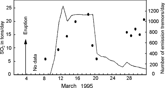 |
Figure 1. SO2 values measured by COSPEC (dots) and daily number of gas-emission tremor events (solid line) at Bromo (Tengger Caldera), March 1995. Courtesy of VSI. |
Volcanic tremor events associated with the gas emissions (maximum amplitude 2-7 mm) were recorded continuously beginning on 9 March using PS-2 and Teledyne seismographs installed between 500 and 1,000 m from the active crater. The number of distinct earthquakes (maximum amplitude1,100 to ~400, and gradually decreased through the end of the month (figure 1). Three tectonic earthquakes were detected on 23 February, and one each on 24 and 28 February, and 28 March.
Information Contacts: W. Tjetjep, VSI.
Eruption from Bromo sends dark ash plume 700 m above the rim
On 9 September, dark gray emissions were observed reaching a height of 70 m above the rim of Bromo Crater. Volcanic tremor associated with the emission events (maximum amplitude of 1-3 mm) was recorded continuously beginning on 8 September, using a PS-2 seismograph installed 750 m from the active crater. After 10 September the plume was denser than during the March-May 1995 activity (20:03). An international Notice to Airmen (NOTAM) on the morning of 22 September reported an ash cloud with a top at ~3 km altitude and a SW drift. The height of the ash column gradually increased, peaking at 700 m (~3 km altitude) on 25 September (figure 2); during the emission, maximum tremor amplitude was 49 mm. A thick dark gray ash cloud caused ashfall in nearby villages, reported as far away as ~20 km E (around the area of Sukapura). The eruption vent, with a diameter of ~25 m, was located on the N part of the crater floor, similar to the last eruption. Ash eruptions were continuing at the end of October, but the activity was gradually decreasing. In October the maximum plume height was 200-450 m above the crater rim; the maximum tremor amplitude was 8-40 mm.
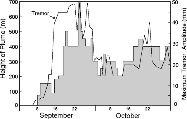 |
Figure 2. Height of ash plume and maximum tremor amplitude at Bromo, Tengger Caldera, September-October 1995. Courtesy of VSI. |
Information Contacts: W. Tjetjep, VSI; BOM Darwin, Australia.
Sudden explosion 29 November; eruption continues as of 18 December
A minor explosion issued from Bromo, the youngest cone of the Tengger volcanic complex (figure 3), without warning on 29 November 2000. Activity leading up to the explosion was low, characterized by a white plume that rose ~50 m on a daily basis (figure 4). The seismograph for the area was in disrepair since 18 October, so no seismic data were available. The explosion initiated with dark ash rising 100-150 m. Ash ejection persisted, reached 600-700 m in height above the crater rim, and the plume drifted up to 40 km from Bromo, where ash was deposited in layers 1-3 cm thick. A volcanic ash advisory was issued to aviators due to a plume ~1.2 km above the summit. Pilots were encouraged to navigate around the plume in order to avoid a potentially dangerous encounter. Following the explosion, the Volcanological Survey of Indonesia (VSI) repaired and upgraded the seismograph on the volcano.
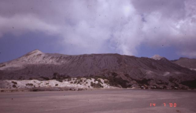 |
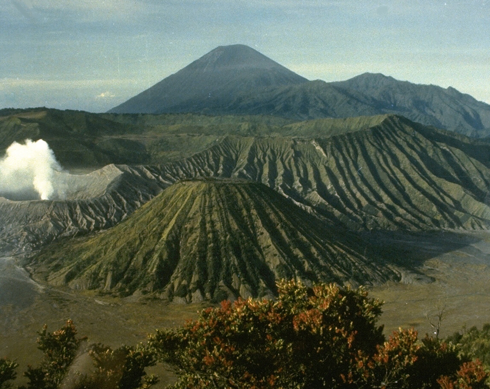
Figure 3. Photograph of the active Bromo cone in the Tengger volcanic complex on 14 July 2000, prior to the recent eruption, from the floor of the Sand Sea Caldera. Typical steam emissions can be seen rising from the crater, which is approximately 700 m in diameter at the rim. Courtesy of Ed Venzke, SI. |
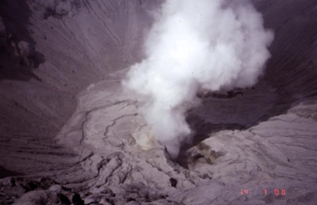 |
Figure 4. Photograph looking into the steaming Bromo crater of the Tengger volcanic complex on 14 July 2000. The field of view in this photo, taken from the crater rim, is on the order of 150 m. Courtesy of Ed Venzke, SI. |
Ongoing explosions and continuous tremor accompanied the volcanic activity during 5-11 December. Explosion earthquakes had amplitudes of 4-30 mm, while tremor had amplitudes of 2-6 mm. As of 5 December, the ash ejection was dark gray-brown in color, and smelled strongly of sulfur. Ash plumes rose 150-900 m over the following week, and by 8 December, satellite imagery showed convective clouds in the vicinity, and volcanic ash advisories indicated that the ash cloud had drifted to ~6.8 km above and E of the summit. The hazard status for Bromo cone placed at 2 (on a 1-4 scale). Explosions and tremor activity were ongoing and increased during the week of 12-18 December. Small explosions sent gray-brown to dark gray ash 500-600 m above the crater rim. A sulfur odor continued to be smelled at the observatory on the caldera rim (figure 5). Amplitudes for explosion earthquakes and tremor earthquakes were 5-34 mm and 1-5 mm, respectively. The seismograph recorded an unprecedented 2,375 explosion earthquakes in addition to continuous tremor.
 |
Figure 5. Photograph of the Bromo-Tengger Volcano Observatory maintained by VSI. The observatory is located on the oustide of the caldera wall, with a small building for visual observations on the rim (to the right in this view). Courtesy of Ed Venzke, SI. |
Information Contacts: Dali Ahmad, Volcanological Survey of Indonesia (VSI), Jalan Diponegoro No. 57, Bandung 40122, Indonesia (URL: http://www.vsi.esdm.go.id/); Darwin Volcanic Ash Advisory Centre (VAAC), Bureau of Meteorology, Northern Territory Regional Office, PO Box 40050, Casuarina, NT 0811, Australia (URL: http://www.bom.gov.au/info/vaac/).
Minor explosions, ash emissions, and tremor through 8 January 2001
Explosions from Bromo cone and unbroken tremor continued at Tengger Caldera since the previous report (BGVN 25:11). An average of 99 minor explosions daily during 19-25 December 2000 produced gray-brown ash that rose ~300-450 m above the cone's rim. The volcano's seismograph recorded 678 explosion earthquakes and tremor with amplitudes that ranged from 2 to 12 mm.
VSI reports resumed during 2-8 January 2001 when activity was purportedly lower. Small explosions sent gray-brown to dark ash 200 m above the crater, and about 29 events occurred per day. The seismograph registered 191 explosion earthquakes and continuous tremor with amplitudes of 2-10 mm. Tengger's hazard status remained at 2 (on a scale of 1-4), and no further VSI reports were issued. The Darwin Volcanic Ash Advisory Centre, however, issued an advisory to aviators on 15 January to warn them of an ash cloud up to an altitude of 3 km drifting toward the NE. The advisory also stated that ground-based observations indicated that irregular eruptions sent ash up to altitudes of 2,750 m, over 400 m above the Bromo cone. When the report was issued, ash was expected to spread E-NE at ~30 km/hour; heavy cloud-cover prevented the acquisition of satellite information concerning the eruption. No further ash advisories were released after 15 January.
Information Contacts: Dali Ahmad, Volcanological Survey of Indonesia (VSI), Jalan Diponegoro No. 57, Bandung 40122, Indonesia (URL: http://www.vsi.esdm.go.id/); Darwin Volcanic Ash Advisory Centre (VAAC), Bureau of Meteorology, Northern Territory Regional Office, PO Box 40050, Casuarina, NT 0811, Australia (URL: http://www.bom.gov.au/info/vaac/).
Mount Bromo's 8 June eruption killed two and ejected a 3-km-high ash plume
Reports of the Volcanological Survey of Indonesia (VSI) stated that Mount Bromo produced a phreatic eruption at 1526 on 8 June 2004. The eruption killed two people and injured several others. The Bromo cone is the youngest and most active volcano within the larger Tengger caldera complex. Bromo also resides within an inner caldera (Sandsea caldera).
The eruption, which vented at the crater, had a duration of ~20 minutes. Ash rose up to 3 km above the crater rim (figure 6) and was blown to the WNW and detected at the Mount (Gunung) Kelud observatory (~ 75 km away). Lapilli and ash spread out over a radius of ~ 300 m from the crater's center.
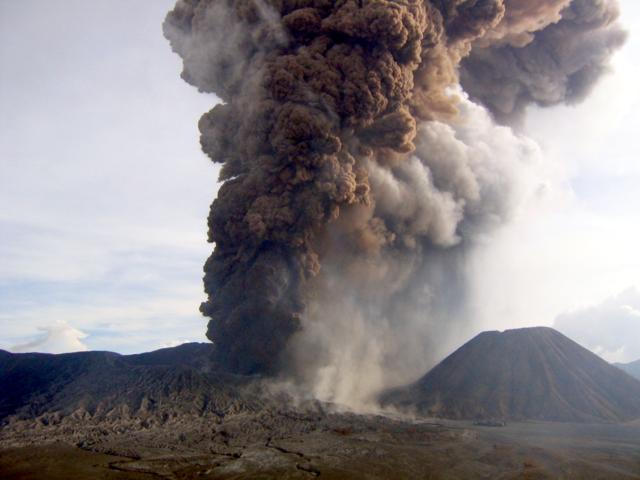 |
Figure 6. Bromo's 8 June 2004 eruption as seen 2.2 km away, looking from the N. The photographer, K. Nishi, was in the seismic station and saw evidence of the eruption on the seismic system. He ran to the adjacent crater rim and took a series of shots. This one was taken 9 minutes after the eruption began. The prominent cone on the right is Batok. Courtesy of K. Nishi. |
Bromo was closed to the public until further notice. Its hazard status was set to the elevated state of 'Alert Level III' (on a scale with a maximum of IV). Search and rescue teams were advised to stay away from the volcano until declaration of safe approach.
John Seach reported that many buildings in the nearby towns of Malang and Probolinggo were covered by a light coating of ash 2 hours after the eruption. The neighboring towns of Lumajang and Pasuruan were also affected by the eruption.
From 0600 on 9 June to 0600 on 10 June, visual observations disclosed a thin white and slightly red cloud about 25-50 m above the crater, moving W. Seismic records were dominated by tremor with peak-to-peak amplitudes ranging from ~ 1-4 mm. Seismometers also registered 123 emission earthquakes and 15 type-A volcanic earthquakes.
During 1800 on 10 June through 0600 on 11 June, the activity of Bromo was dominated by 'smoke emissions' of low-to-medium intensity reaching heights of ~ 25-100 m. Shallow volcanic earthquakes increased, and continuous tremor occurred with a peak-to-peak amplitude of 6.0 mm. Four volcanic earthquakes were detected within about 8-15 minutes, followed by tremor for 18 minutes, after which came 8 volcanic earthquakes. Despite all of the tremor and earthquakes, however, no explosion followed. When the weather was clear, VSI scientists could see white, thick 'smoke' emissions and smelled sulfur.
At 0819 on 14 June 2004, there was an ash explosion, accompanied by a plume that rose to 100 m. Pre-explosion spectrometer measurements suggested SO2 fluxes of 200 tons/day. During 13-14 June the seismic record contained emission and tectonic earthquakes, as well as a half hour of continuous tremor with a peak-to-peak amplitude of 6.0 mm. Deformation measurement using electronic distance meters (EDM) and global positioning systems (GPS) implied deflations of about 2-6 mm and 2-15 mm, respectively.
By 0630 on 15 June 2004, activity at Bromo had generally decreased, and the Alert Level was reduced to Level II. During that day emissions of white thin smoke rose ~ 25-150 m above the summit and the seismograph recorded 24 emission earthquakes and 1 tectonic earthquake. Deformation measured by EDM and GPS implied respective deflations of 1.0-5.0 mm and 0.2-6.2 mm.
Information Contacts: Dali Ahmad, Volcanological Survey of Indonesia (VSI), Directorate of Volcanology and Geological Hazard Mitigation, Jalan Diponegoro No. 57, Bandung 40122, Indonesia (URL: http://www.vsi.esdm.go.id/); Heri Retnowate, Reuters; Derwin Pereira, The Straits Times; John Seach, P.O. Box 842, Southport BC 4215, Queensland, Australia (URL: http://www.volcanolive.com); Darwin Volcanic Ash Advisory Centre (VAAC), Bureau of Meteorology, Northern Territory Regional Office, PO Box 40050, Casuarina, NT 0811, Australia (URL: http://www.bom.gov.au/info/vaac/).
Video of the 8 June eruption; minor ash plumes through 18 July
Mount Bromo's 8 June 2004 eruption killed two visitors and injured five more (BGVN 29:05). This report mainly adds a few details for the events of 8 June and a video of the eruption plume. It also summarizes reports through 18 July, an interval characterized by mild ash-bearing eruptions (to 100 m high) without a repeat of the robust eruption seen on 8 June.
A 3-minute-long video clip of the eruption was shot by Kiyoshi Nishi, a volcano seismologist attached to the Indonesian Directorate of Volcanology and Geological Hazard Mitigation (DVGHM). (DVGHM was reorganized from the former Volcanological Survey of Indonesia). Nishi works for the Japan International Cooperation Agency, a Japanese government organization offering technical and grant assistance.
The video begins after a substantial plume had already developed. The plume continued to rise, and the main body of it appeared to ascend with only minor effects of wind, rising in a roughly vertical direction. Identifiable zones of distinct coloration appeared within the plume, in shades of brown, reddish-brown, gray, and white. The white-gray zone, which clearly erupted earlier, moved away from the viewer. Most of the footage shows the brown and red parts of the plume evolving. Subsidiary clouds several times began bulging out of the main plume's margins. The image is valuable because of the need to accurately assess ash plume heights and behavior such as the rise time of the plume top, colored zones, and subsidiary clouds, and the absolute plume heights with respect to time.
 |
Movie 1. Video showing the Bromo eruption of 8 June 2004, taken looking from the NE, at a spot in the vicinity of the seismic station and ~ 2.2 km away from the eruptive vent on Bromo. The video (34.7 MB, 3.0-minute long AVI) began at 15 hours, 25 minutes, and 45 seconds; it was shot with a Canon IXY Digital 30 camera in movie mode at 15 frames/second. The same video was also featured on the VSI website. The video begins in 'landscape' format and later shifts to 'portrait' format. Courtesy of Kyoshi Nishi, JICA Silver Expert. |
Seismicity during 9-14 June was marked by long periods of continuous tremor (maximum peak-to-peak amplitude 6.0 mm), shallow type-A and type-B volcanic earthquakes, intermittent tectonic earthquakes, and a high number of emission earthquakes (see table 1 and BGVN 29:05 for details). Reports around this time noted that distance meters (EDM) and global positioning system (GPS) receivers on Bromo recorded deformation that suggested deflation of the edifice. On 14 June, Bromo ejected another ash plume that rose 100 m above the summit.
Table 1. Weekly seismicity at Bromo as measured by the Volcanological Survey of Indonesia (VSI) seismograph. Courtesy of VSI.
| Date | Volcanic Type A | Volcanic Type B | Tremor | Local Tectonic | Emission |
| 07 Jun-13 Jun 2004 | 26 | 15 | continuous | 0 | 387 |
| 14 Jun-20 Jun 2004 | 0 | 0 | 0 | 0 | 376 |
| 21 Jun-27 Jun 2004 | 15 | 0 | 3 | 3 | 163 |
| 28 Jun-04 Jul 2004 | 1 | 0 | 2 | 0 | 104 |
| 05 Jul-11 Jul 2004 | 2 | 0 | 2 | 3 | 116 |
| 12 Jul-18 Jul 2004 | 2 | 0 | 3 | 0 | 79 |
Nearly two weeks after the 8 June eruption, no similarly substantial event had occurred. On 15 June, DVGHM decreased the Alert Level to II, or 'eruption imminent.' Reports covering 14 June-18 July noted a decrease in seismically detected volcanic emissions (table 2). The number of emission earthquakes decreased by ~ 50% after 20 June and dropped again the week of 12-18 July. Bromo's emissions continued to bear ash, and during 14-27 June a thick ash plume rose 25-100 m above the crater rim. In accord with the decline in seismically detected emissions, observers noted smaller (25-50 m high), thinner plumes during 28 June-18 July.
Other seismicity also decreased (table 2). Seismometers recorded 15 type-A earthquakes during 21-27 June, but this was a peak in the trend for 14 June-18 July, which was generally 1-2 per week. Seismometers recorded no type-B earthquakes at Bromo since the week of its phreatic eruption. Tremor, continuous during 7-13 June, dropped to 2-3 events/week. Local tectonic earthquakes were intermittent.
Information Contacts: Directorate of Volcanology and Geological Hazard Mitigation (DVGHM), Jalan Diponegoro No. 57, Bandung 40122, Indonesia (URL: http://www.vsi.esdm.go.id/); Darwin Volcanic Ash Advisory Centre (VAAC), Bureau of Meteorology, Northern Territory Regional Office, PO Box 40050, Casuarina, NT 0811, Australia (URL: http://www.bom.gov.au/info/vaac/); Kiyoshi Nishi, Japan International Cooperation Agency (JICA) (URL: https://www.jica.go.jp/).
Ongoing emissions, 2004-2011
Tengger Caldera contains the frequently erupting Bromo cone, which has repeatedly erupted since about the year 1590. Under normal conditions, Bromo emits a white, sparse-to- dense vapor reaching heights of 75-150 m above the rim, with an acrid smell of sulphur. Our last report noted the eruption on 8 June 2004 (BGVN 29:07); small plumes and seismic signals suggestive of emissions continued through the previous reporting interval, which ended 18 July 2004. According to a December 2010 report from the Center of Volcanology and Geological Hazard Mitigation (CVGHM), during 1994, 1996, 2000, and 2004, Bromo's eruptions ejected glowing lava that fell in the vicinity of the crater. The countryside around Bromo is not densely populated, since it lies within the Bromo-Tengger-Semeru National Park, but the volcano is a popular tourist destination.
On 16 August 2004, due to a decrease in seismic and volcanic activity at Tengger, the Center of Volcanology and Geological Hazard Mitigation (CVGHM) decreased the Alert Level from 2 to 1 (on a scale of 1-4).
The next report we received on Tengger was from the Darwin Volcanic Ash Advisory Center (VAAC), which noted that a small plume was visible on a satellite image on 14 July 2006. No ash was detected.
On 1 September 2006, CVGHM raised the Alert Level for Tengger to 2 due to heightened activity and a strong smell of sulfur. On 9 September, the Alert Level was raised to 3 due to an increase in tremor, but lowered to 2 on 18 September due to decreased activity.
According to CVGHM, during 18-25 June 2007, diffuse but ash-free plumes rose to an altitude of 2.4 km. Nineteen tectonic earthquakes, one local-tectonic earthquake, and continuous tremor with a maximum amplitude of 0.5-1 mm was noted between 11 June-1 July 2007.
No further reports were received until November 2010, when seismicity increased. Volcanic tremor was first detected on 8 November. According to volcanologist and photographer Richard Roscoe (Photovolcanica), tremor became almost continuous by 22 November along with degassing. CVGHM noted that the heights of gas-and-steam plumes increased during the month, from 75 m above the crater during 1-7 November to 100-250 m above the crater during 8-23 November. The Alert Level was raised to 3 on 23 November. Residents and tourists were not permitted within a 3-km-radius of the active crater. Later that night, seismic activity increased, and a white-to-gray plume rose 200-300 m above the crater. The Alert Level was raised to 4. The tourist areas surrounding the volcano was closed.
Bromo erupted on 26 November 2010, triggering the first significant ash emission, according to Richard Roscoe. He noted that the output of ash was high at several stages during the eruption, which led to significant damage to vegetation in downwind areas. According to the Darwin VAAC, on that day the cloud tops reached 13.7 km and volcanic ash was thought to be "entrained into deep convective clouds."
During 27-29 November satellite imagery showed ash plumes drifting 55-165 km at an altitude of 4.3 km. According to a news article (Agence France-Presse), Malang city's domestic airport, 25 km W, closed on 29 November due to ash. Cloud cover prevented observations during 29-30 November.
On 6 December, CVGHM reported that seismicity at Bromo had declined since 30 November, and deformation measurements showed deflation. White-to-gray plumes rose 200-300 m above the crater rim and drifted N. The Alert Level was lowered to 3. Residents and tourists were not permitted within a 2-km-radius of the active crater.
CVGHM reported that during 8-19 December gray-to-brown plumes from Bromo rose 400-800 m above the crater and drifted E, NE, and N. Tremors continued with a maximum amplitude of 17-32 mm. On 19 December, explosions produced an ash plume that rose 2 km above the crater rim. Ashfall was heavy around the crater and was reported in areas as far away as the Juanda Airport (70 km NNW) in Surabaya. The ash damaged agricultural land, affected trees and river valleys, and disrupted the transportation infrastructure. According to the Darwin VAAC, a possible ash plume from Bromo cone rose to an altitude of 6.1 km on 20 December and drifted about 95 km S.
CVGHM noted that between 19-23 December, tremor continued with a maximum amplitude of 5-30 mm, and 17 eruptive earthquakes occurred with a maximum amplitude of 40 mm and a duration of about 17 to167 seconds each. Tiltmeter deformation measurements showed slight inflation (5 microradians) from 25 November to 14 December; from 15 December through at least February 2011, both its radial and tangential components remained relatively stable. Similarly, measurements of deformation using EDM from 25 November to 20 December 2010 showed relative stability.
According to CVGHM, during 20-25 December, gray-to-brown plumes rose 800-1,200 m above the crater and drifted N and NE. Ejected material fell back around the crater. On 25 December, ash and occasional lapilli fell at the Bromo observation post, about 2 km away. The ashfall was about 20 cm thick. A news report (Reuters) indicated that some flights were cancelled on 20 December between Australia and Bali due to ash, but the emitting volcano was not identified. CVGHM noted that the ash had damaged agricultural land and trees on the slopes and in river valleys, and had paralyzed transportation in the Cemoro Lawang area. Heavy rain during this time raised concern for potential lahars and landslides.
During 24-25 December, tremor continued with a maximum amplitude of 15-40 mm. Two eruptive earthquakes were noted, with a maximum amplitude of 40 mm and a duration of 25 seconds.
The Darwin VAAC reported that during 26-27 December an ash plume rose to an altitude of 5.5 km and drifted 150 km NE. Another ash plume rose to an altitude of 4.3 km on 30 December and drifted about 95 km to the E.
CVGHM reported that during 22-23 January 2011, continuous tremor occurred (maximum amplitude 15-38 mm) and gray-to-brown plumes from Bromo rose 400-800 m above the crater and drifted E. Incandescent material was ejected 200 m above the crater and landed as far as 500 m away. The Darwin VAAC reported that on 24 January an ash plume rose to an altitude of 3.7 km and drifted more than 220 km E. The VAAC report noted that CVGHM had confirmed the eruption and observers had sensed elevated sulfur-dioxide gas in the area.
According to news reports (The West Australian, Sydney Morning Herald), ash plumes from Bromo disrupted flights between Australia (Perth, Sydney, Darwin) and Bali during 27-28 January. An ash plume on 28 January rose to an altitude of 5.5 km and drifted 370 km E and SE. Another ash plume on 29 January rose to an altitude of 3.7 km and drifted 93 km E. During 29-31 January, ash plumes rose to an altitude of 3.7 km and drifted 55 km NW.
CVGHM reported that on 5 February volcanic bombs ejected from Bromo were found 1.2-1.4 km from the crater rim. During 5-9 February and 17-18 February, gray-to-brown ash plumes rose 400-800 m above the crater and drifted E and ENE, causing ashfall in nearby villages. Incandescent material was ejected 200-300 m above the crater and landed as far as 500 m away. Roaring and booming noises were noted. Ash fell at the Bromo observation post, and in nearby villages, including Ngadirejo (10 km WNW), Sukapura (14 km NE), and Sumber (18 km E). High-amplitude seismicity and volcanic tremor were detected. During 5-9 February, the maximum amplitude of the tremor was 17-40 mm.
Based on pilot observation, the Darwin VAAC reported that on 9 February an eruption produced a plume that rose to an altitude of 7 km and drifted W. On 11 February satellite imagery showed an ash plume drifting 37 km SE at an altitude of 3 km. Additional ash plumes on 12 February rose to altitudes of 3-7.9 km and drifted 37-167 km NW and SE.
On 10 March 2011, according to CVGHM, ash fell in areas to the E and NE, including in the Probolinggo district (35 km NE). During 18-20 March, 22-25 March, and 29 March-4 April 2011, gray-to-brown ash plumes rose 400-800 m above the crater and drifted in multiple directions. Incandescent material was ejected 300 m above the crater and landed up to 500 m away. Roaring and booming noises were also noted. According to the Darwin VAAC, during 18-20 March, ash plumes rose to an altitude of 3 km and drifted 27-150 km NW, SW, and S. Ash plumes on 27-28 March rose to an altitude of 4.3 km and drifted 55 km NE.
According to Richard Roscoe, activity in mid-March 2011 could be distinguished into largely Strombolian phases accompanied by little ash and variable levels of degassing, and phases during which significant amounts of ash were released. (Roscoe, 2011). Strombolian phases were sometimes accompanied by powerful shockwaves, often after short periods (10-30 seconds) of complete calm, presumably signifying blockage of the vent causing pressure buildup. (Roscoe, 2011).
Photo gallery. Several sets of photos from mid-March 2011 documented substantial ash plumes and multiple incandescent bombs escaping Bromo's crater, in many cases Strombolian eruptions with bombs falling on the upper flanks. Some of the 30-second night exposures had streaks documenting more than 10 bombs.
Richard Roscoe presented an album that also contained considerable text, including references (Roscoe, 2011).
A second set of photos was taken in March 2011 by Indonesian travel consultant Aris Yanto (Yanto, 2011). It shows the eruption in a wide variety of conditions from locations near and at distance from the vent (showing many plumes in profile).
References. Roscoe, R, 2011, Bromo Volcano (Tengger Caldera), Photovolcanoica, 86 photographs (URL: http://www.photovolcanica.com/VolcanoInfo/Bromo/Bromo.html).
Yanto, A, 2011, Mt. Bromo on 17-20 [March], 2011; Aris Yanto's gallery, Picasa Web Albums, 40 photos, 640 x 361 pixels (URL: https://picasaweb.google.com/ndesoadventure/MTBromoOn17202011).
Information Contacts: Center of Volcanology and Geological Hazard Mitigation (CVGHM), Jalan Diponegoro 57, Bandung 40122, Indonesia (URL: http://vsi.esdm.go.id/); Darwin Volcanic Ash Advisory Centre (VAAC), Bureau of Meteorology, Northern Territory Regional Office, PO Box 40050, Casuarina, NT 0811, Australia (URL: http://www.bom.gov.au/info/vaac/); Agence France-Presse (URL: http://www.afp.com/afpcom/en/); The Sydney Morning Herald (URL: http://www.smh.com.au/); The West Australian (URL: http://au.news.yahoo.com/thewest/); Reuters (URL: http://www.reuters.com/); Richard Roscoe, Photovolcanica (URL: http://www.photovolcanica.com/).
Modest April 2011 eruption at Bromo followed by increasing tremor
This report discusses Bromo's behavior during April 2011 to early October 2012, an interval of ongoing seismicity. The Bromo cone, located within the Tengger caldera, has erupted repeatedly since about the year 1590. Under normal conditions in recent decades, Bromo emits a white, sulfurous, diffuse-to-dense vapor plume reaching heights of about 75-150 m above the rim. Observations of Bromo are carried out both visually and with instruments. Visual observation is aided by a closed circuit TV (CCTV) camera. A seismic station incorporates both analog and digital recordings. Observations of deformation are carried out with one tiltmeter station.
Our last report on Bromo (BGVN 36:03) presented activity through March 2011, which could be differentiated into largely Strombolian phases accompanied by little ash and variable levels of degassing, and phases during which significant amounts of ash were released (Roscoe, 2011). Strombolian phases were sometimes accompanied by powerful shockwaves, often after short periods (10-30 seconds) of complete calm (Roscoe, 2011).
During most of April 2011, the Bromo cone was relatively quiet until 27 April when the Darwin Volcanic Ash Advisory Centre (VAAC) reported an ash plume rising to an altitude of ~4.3 km and drifting ~75 km WSW. From 1-10 May the Center of Volcanology and Geological Hazard Mitigation (CVGHM) reported white-to-gray ash plumes rising ~400-600 m above the crater and drifting ENE, and incandescence emanating from the crater. On 2 May the Darwin VAAC reported that a significant ash plume rose to an altitude of ~3 km and drifted ~75 km N. Based on analyses of satellite imagery, the Darwin VAAC again reported that during 9-10 May ash plumes from Bromo rose to an altitude of ~2.7 km and drifted 45-75 km NE and E. During 11-20 May white-to-gray ash plumes rose ~200-400 m above the crater and drifted E.
Ash plumes continued to rise from the crater during 1-13 June, reaching heights of ~100-200 m above the crater and drifting E. Ash fell in areas within 2 km to the E and NE during May and June. On 13 June the Alert Level was lowered to 2 (on a scale of 1-4). During the rest of 2011 Bromo was quiet.
From 1 January-29 March 2012 CVGHM reported that white plumes from the Bromo cone rose ~50 m above the crater; background seismicity declined. On 30 March the Alert Level was lowered to 1. This modest activity continued until 1 September when diffuse white plumes from the Bromo cone rose 50 m above the crater. During 1-28 September 2012, the following seismic events were recorded: 6 deep volcanic, 1 shallow volcanic, and 57 long-distance tectonic earthquakes. Tremor continued with a maximum amplitude of 0.5 mm. From 29 September to 1 October 2012 continuous tremor was recorded, reaching a maximum amplitude of 11 mm. The dominant reading was 0.5 mm.
Seismicity increased on 1 October, and during 1-3 October a sulfur odor was occasionally noted at the Bromo Observation Post. On 2 October 2012, continuous tremor reached a maximum amplitude of 11 mm with a dominant reading of 7 mm. On 3 October the tremor rose continuously, reaching 22 mm. Accordingly, on 3 October the Alert Level was raised to 2.
Reference. Roscoe, R., 2011, Bromo Volcano (Tengger Caldera), Photovolcanica, 86 photographs, Updated 21 August 2011, Accessed 21 November 2012 (URL: http://www.photovolcanica.com/VolcanoInfo/Bromo/Bromo.html).
Information Contacts: Center of Volcanology and Geological Hazard Mitigation (CVGHM), Jalan Diponegoro 57, Bandung 40122, Indonesia (URL: http://vsi.esdm.go.id/); Darwin Volcanic Ash Advisory Centre (VAAC), Bureau of Meteorology, Northern Territory Regional Office, PO Box 40050, Casuarina, NT 0811, Australia (URL: http://www.bom.gov.au/info/vaac/).
New eruption begins 12 November 2015; ash plumes cause airport closure in December 2015 and July 2016
Activity at the Bromo cone of Tengger Caldera during April 2011 to early October 2012 was characterized by ongoing seismicity and an eruption during April-June 2011 (BGVN 37:10). No activity was reported in late 2012 or throughout 2013 by the observatory, Pusat Vulkanologi dan Mitigasi Bencana Geologi (PVMBG, also known as CVGHM). White emissions were noted by PVMBG during a short period in 2014, and one day of thermal alerts were identified by MODVOLC and MIROVA, using MODIS satellite data. White emissions were also observed during most of 2015. An eruption began in November 2015 and continued for about a year; the last report of ash came from the Darwin Volcanic Ash Advisory Centre (VAAC) on 12 November 2016.
Information in this report comes from Darwin VAAC satellite observations (plume identification, altitude, and drift direction); infrared MODIS satellite data (processed by MODVOLC and MIROVA); and PVMBG and/or Badan Nacional Penanggulangan Bencana (BNPB) (geophysical measurements, field observations, Alert Levels).
Tengger caldera is a 16-km-wide feature found at N end of volcanic massif extending from the active Semeru volcano. A sketch map of the caldera from 1844 is essentially identical to the current morphology of the cones (figure 7).
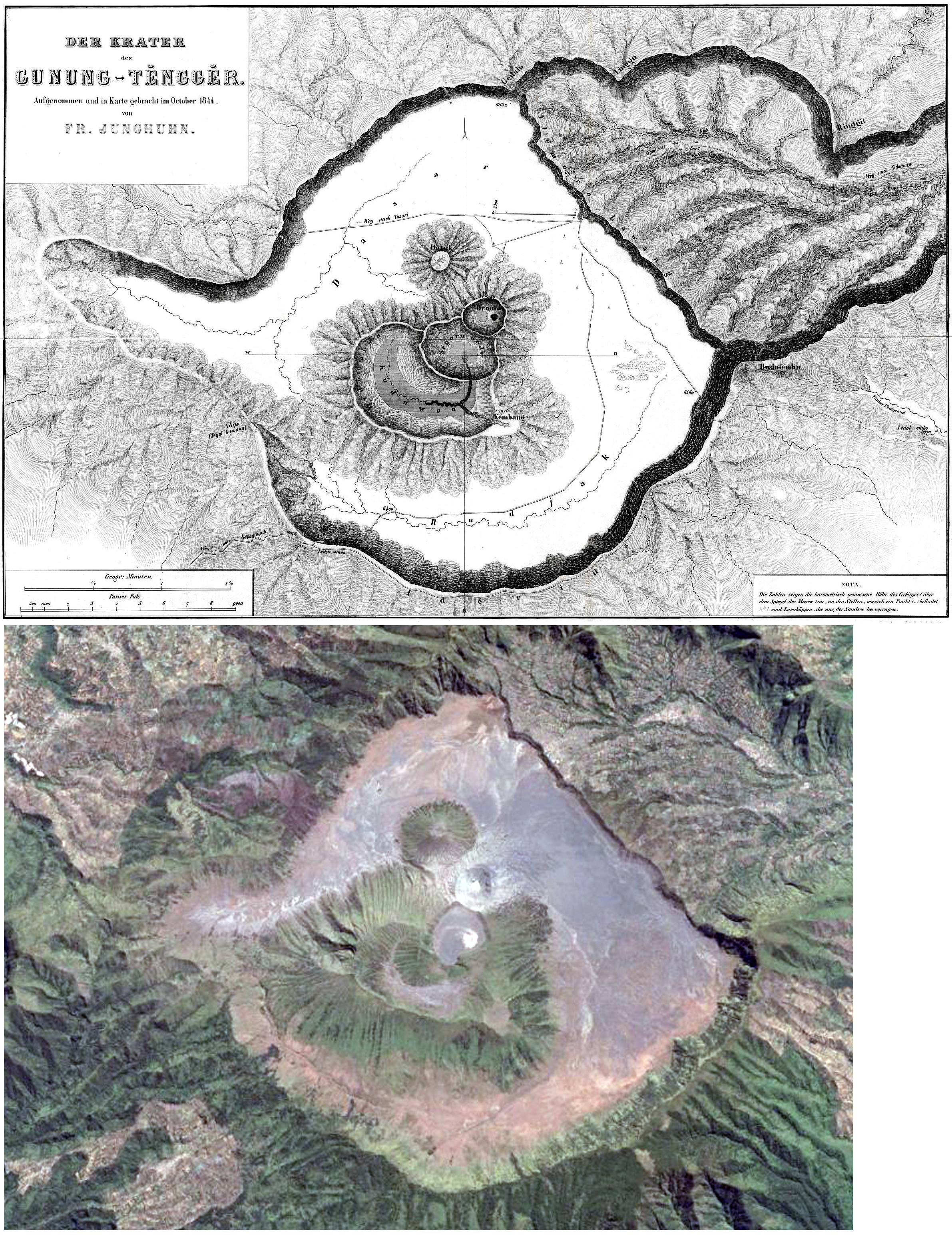 |
Figure 7. The sketch (top) is a 19th century map of Tengger Caldera showing several volcanoes within the caldera (Junghuhn, 1844). The satellite image (bottom) acquired in September 2013 (Google Earth) shows that the morphology of the caldera is largely unchanged. |
Activity slightly increased for a short period in 2014. PVMBG reported that during 1-30 April diffuse white plumes rose 50 m above the crater rim. Seismicity increased during 15-30 April. From 1 to 4 May seismicity again increased and denser white plumes rose as high as 250 m. On 4 May the Alert Level was raised to 2 (the second highest level on a scale of 1-4). Residents and visitors were warned not to approach the crater within a radius of 1 km. Later that year, on 22 October, an alert characterized by a three-pixel thermal anomaly was issued by MODVOLC.
Non-eruptive activity during 2014-2015. PVMBG reported that during mid-April through mid-July 2015 white plumes continued to rise at most 100 m above the crater rim. A sulfur dioxide odor was noted at the Bromo observation post. Seismicity was dominated by tremor, but also included volcanic earthquakes. Two thermally elevated pixels triggered a MODVOLC alert during 17-18 September and a five-pixel alert was issued for 25 October.
During 1 August-4 December 2015 white plumes rose as high as 150 m above the crater rim, and an intense sulfur dioxide odor was noted at the Bromo observation post. Seismicity was dominated by tremor, but also included deep and shallow volcanic earthquakes; RSAM values increased at the beginning of November, and then sharply increased in the beginning of December. Based on seismic analysis, visual observations, and hazard potential, the Alert Level was raised to 3 (on a scale of 1-4) on 4 December. Residents and visitors were warned not to approach the crater within a radius of 2.5 km.
Eruptive activity during 2015-2016. On 5, 8, and 12 November 2015 booming noises were reported and emissions rose 1.2 km above the crater; small amounts of ash were present in the emissions on 12 November. On 15, 23, and 27 November dense ash plumes rose 150 m above the crater rim.
Based on information from PVMBG and satellite images, the Darwin VAAC reported that during 5 and 7-15 December ash plumes rose to an altitude of 3 km and drifted 55-185 km in almost all directions. On 15 December BNPB reported that activity remained high; gray-brown ash plumes rose 1.5 km above the crater and drifted W and NW. Weak rumbling was noted. According to a news article, ash emitted on that same day caused the Abdul Rachman Saleh Airport (26 km W) in Malang to close. BNPB reported ash plumes rising from the cone on 16 December 2015. The Darwin VAAC reported that during 17-19, and 21-31 December ash plumes rose to altitudes of 3-4.2 km and drifted as far as 95 km W, NW, N, E, and SE.
Ash emissions were regularly observed during 1 January-12 November 2016 by both the Darwin VAAC and PVMBG observers. Ash-plume altitudes fluctuated between 2.7 and 4.2 km, or 0.4-1.9 km above the crater rim; plumes drifted in multiple directions as far as 205 km (figure 8). PVMBG reported that during 14-22 January brownish gray plumes rose as high as 1.8 km above the crater. Two low-power thermal anomalies were reported by MIROVA, one in mid-January and one later in the month. On 26 February the Alert Level was lowered to 2. On 18 April one low-power thermal anomaly was identified.
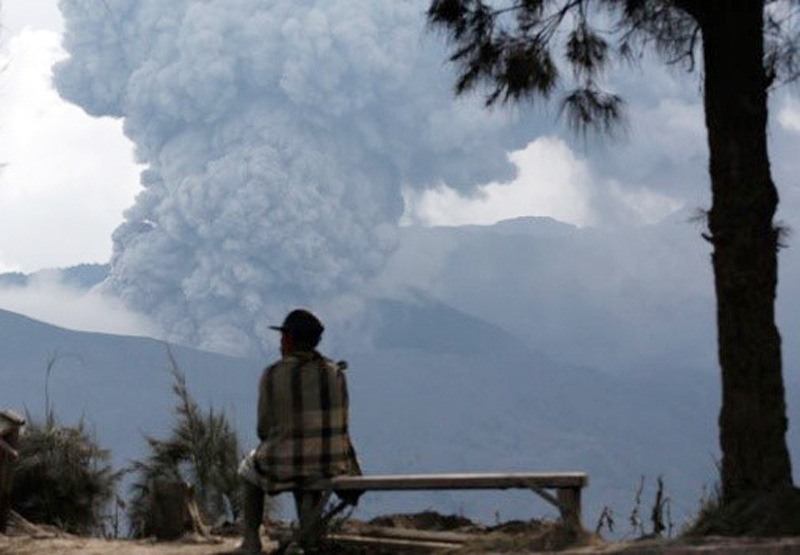 |
Figure 8. Photo of a man watching an ash plume rising from the Bromo cone in Tengger Caldera on 5 January 2016. Courtesy of Reuters/Darren Whiteside. |
Ash plumes occasionally affected surrounding populated areas. BNPB reported that the Abdul Rachman Saleh Airport in Malang (26 km W) closed from 2300 on 11 July 2016 to 0900 on 12 July due to thin ash deposits around the airport. BNPB reported that the same airport closed again due to ash from 2307 on 15 July to 0900 on 16 July; six flights were diverted and two were cancelled. Minor amounts of ash fell in the communities of Probolinggo (35 km NE) and Lumajang (36 km SW).
PVMBG reported that during 1 June-25 September 2016 brownish gray plumes rose as high as 1.2 km above the crater. A sulfur odor was noted at the Bromo observation post, thunderous noises sometimes vibrated the post doors, and occasionally crater incandescence was observed. The deformation network measured inflation. On 26 September the Alert Level was raised to 3 (on a scale of 1-4); residents and visitors were reminded not to approach the crater within a radius of 2.5 km. PVMBG reported that during 1-20 October brownish, reddish, and grayish gray plumes rose as high as 900 m above the crater and drifted E, NW, W, and SW. Seismic activity was dominated by constant tremor although the amplitude decreased. On 20 October the Alert Level was lowered to 2 (on a scale of 1-4).
Seismic data for 1 January-20 October 2016 (figure 9) included RSAM values for seismically detected eruptions (Letusan), emissions (Hembusan), shallow volcanic signals (VB), deep volcanic signals (VA), and local (TL) and distant (TJ) tectonic earthquakes. Sulfur dioxide emissions fluctuated between about 100 and 450 tonnes/day (t/d) during 17 July-5 October 2016 (figure 10). Measurements were often hampered by fog. For comparison, previous measurements of sulfur dioxide emissions occurred in October 2005, March 2007, December 2008, and December 2009.
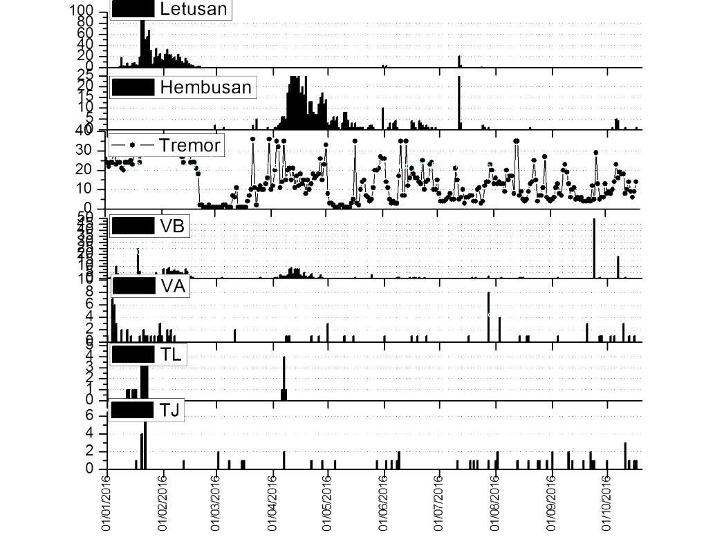 |
Figure 9. RSAM values for seismically detected eruptions (Letusan), emissions (Hembusan), shallow volcanic signals (VB), deep volcanic signals (VA), and local (TL) and far (TJ) tectonic earthquakes cover the period during 1 January-20 October 2016. |
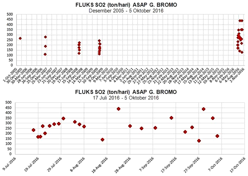 |
Figure 10. Sulfur dioxide emissions in tons/day from 1 October 2005 to 2 November 2016 (top) and an expanded view from 17 July to 24 September 2016 (bottom). Courtesy of PVMBG. |
References: Junghuhn, Franz Wilhelm, 1844, Java, seine Gestalt, Pflanzendecke und innere Bauart, 2. Band (Java , its shape , plant cover and interior design , 2. Band, Tengger Mountains), recorded by Franz Wilhelm Junghuhn. From Wikipedia (URL: https://nl.wikipedia.org/wiki/Franz_Junghuhn).
Information Contacts: Pusat Vulkanologi dan Mitigasi Bencana Geologi (PVMBG, also known as Indonesian Center for Volcanology and Geological Hazard Mitigation, CVGHM), Jalan Diponegoro 57, Bandung 40122, Indonesia (URL: http://www.vsi.esdm.go.id/); Darwin Volcanic Ash Advisory Centre (VAAC), Bureau of Meteorology, Northern Territory Regional Office, PO Box 40050, Casuarina, NT 0811, Australia (URL: http://www.bom.gov.au/info/vaac/); Badan Nasional Penanggulangan Bencana (BNPB), National Disaster Management Agency, Graha BNPB - Jl. Scout Kav.38, East Jakarta 13120, Indonesia (URL: http://www.bnpb.go.id/); MIROVA (Middle InfraRed Observation of Volcanic Activity), a collaborative project between the Universities of Turin and Florence (Italy) supported by the Centre for Volcanic Risk of the Italian Civil Protection Department (URL: http://www.mirovaweb.it/); Hawai'i Institute of Geophysics and Planetology (HIGP), MODVOLC Thermal Alerts System, School of Ocean and Earth Science and Technology (SOEST), Univ. of Hawai'i, 2525 Correa Road, Honolulu, HI 96822, USA (URL: http://modis.higp.hawaii.edu/, http://modis.higp.hawaii.edu/); Reuters (URL: https://en.tempo.co/read/news/2016/01/26/055739393/Mount-Bromo-Erupting-Lava).
New explosions with ash plumes from Bromo Cone mid-February-April 2019
The 16-km-wide Tengger Caldera in East Java, Indonesia is a massive volcanic complex with numerous overlapping stratovolcanos (figure 11). Mount Bromo is a pyroclastic cone that lies within the large Sandsea Caldera at the northern end of the complex (figure 12) and has erupted more than 20 times during each of the last two centuries. It is part of the Bromo Tengger Semeru National Park (also a UNESCO Biosphere Reserve) and is frequently visited by tourists. The last eruption from November 2015 to November 2016 produced hundreds of ash plumes that rose as high as 4 km altitude; some of them drifted for hundreds of kilometers before dissipating and briefly disrupted air traffic. Only steam and gas plumes were observed at Mount Bromo from December 2016 to February 2018 when a new series of explosions with ash plumes began; they are covered in this report with information provided by the Pusat Vulkanologi dan Mitigasi Bencana Geologi (PVMBG, also known as CVGHM) and the Darwin Volcanic Ash Advisory Centre (VAAC). Copyrighted ground and drone-based images from Øystein Lund Andersen have been used with permission of the photographer.
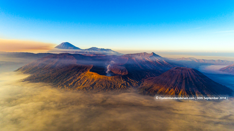 |
Figure 11. The Tengger Caldera viewed from the north Mount Bromo issuing steam in the foreground and Semeru volcano in the background on 30 September 2018. Courtesy of Øystein Lund Andersen, used with permission. |
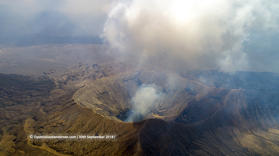 |
Figure 12. Aerial view of the Bromo Cone in Tengger Caldera seen from the west on 30 September 2018. Courtesy of Øystein Lund Andersen, used with permission. |
PVMBG lowered the Alert Level at Bromo on 21 October 2016 from III to II near the end of an eruptive episode lasting nearly a year. The last VAAC report was issued on 12 November 2016 (BGVN 41:12) noting that the last ash emission had been observed the previous day drifting NW at 3 km altitude. Throughout 2017 and 2018 Bromo remained at Alert Level II, with no unusual activity described by PVMBG. During 1-2 September 2018, a wildfire in the Bromo Tengger Semeru National Park burned 65 hectares of savannah (figure 13); the fire produced 12 MODVOLC thermal alerts around the Tengger Caldera rim. No reports of increased volcanic activity were issued by PVMBG during the period.
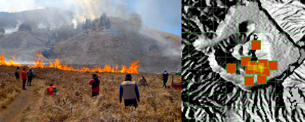 |
Figure 13. A wall of fire in the Bromo Tengger Semeru National Park savanna during 1-2 September 2018 produced thermal alerts that were not related to volcanic activity at the Bromo Cone in Tengger Caldera. Image courtesy of the park authority, reported by Mongabay. MODVOLC thermal alerts courtesy of Hawai'i Institute of Geophysics and Planetology (HIGP). |
After slightly more than two years of little activity other than gas and steam plumes, ash emissions resumed from the Bromo Cone on 18 February 2019. After a brief pause, a new explosion on 10 March marked the beginning of a series of near-daily ash emissions that lasted for the rest of March, producing ash plumes that rose to altitudes ranging from 3.0 to 5.2 km and drifted in many different directions. A new series of ash emissions began on 6 April, rising to 3 km and also drifting in multiple directions. Ash emission density decreased during the month; plumes were only rising a few hundred meters above the summit by the end of April and consisted of mostly steam and moderate amounts of ash.
Activity during February-April 2019. PVMBG reported that at 0600 on 18 February 2019 an eruption at Tengger Caldera's Bromo Cone generated a dense white-and-brown ash plume that rose 600 m and drifted WSW. The plume was not visible in satellite imagery, according to the Darwin VAAC. The Alert Level remained at 2 (on a scale of 1-4). After a few weeks of quiet a new explosion on 10 March (local time) produced a white, brown, and gray ash plume that rose 600 m above the summit; the plume was visible in satellite imagery extending SW. Increased tremor amplitude was also reported on 10 March. A new emission the next morning produced similar ash plumes that drifted S, SW, and W at 3 km altitude. On the morning of 12 March (local time) a continuous ash plume was observed in satellite imagery at 3.4 km altitude drifting SW. The plume drifted counterclockwise towards the S, E, and NE throughout the day and continued to drift NE and SE on 13 March. The altitude of the plume was reported at 4.3 km later that day based on a pilot report.
Continuous brown, gray, and black ash emissions were reported by PVMBG during 14-19 March at altitudes ranging from 3 to 3.9 km; they drifted generally NE to NW. Ashfall was noted around the crater and downwind a short distance. The Darwin VAAC reported continuous ash emissions to 5.2 km altitude drifting SE on 20 March. It was initially reported by a pilot and partially discernable in satellite imagery before dissipating. Ongoing ash emissions of variable densities and colors ranging from white to black were intermittently visible in satellite imagery and confirmed in webcam and ground reports at around 3.0 km altitude during 21-25 March (figures 14-17). Ashfall impacted the closest villages to Bromo, including Cemara Lawang (30 km NW), which was covered by a thin layer of ash. A few trees in the area were toppled over by the weight of the ash. The plume altitude increased slightly on 26 March to 3.7-3.9 km, drifting N and NE. The higher altitude plume dissipated early on 28 March, but ash emissions continued at 3.0 km for the rest of the day.
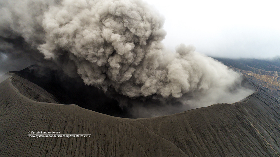 |
Figure 14. Ash drifted NNE from the Bromo Cone in Tengger Caldera on 23 March 2019. Courtesy of Øystein Lund Andersen (drone image), used with permission. |
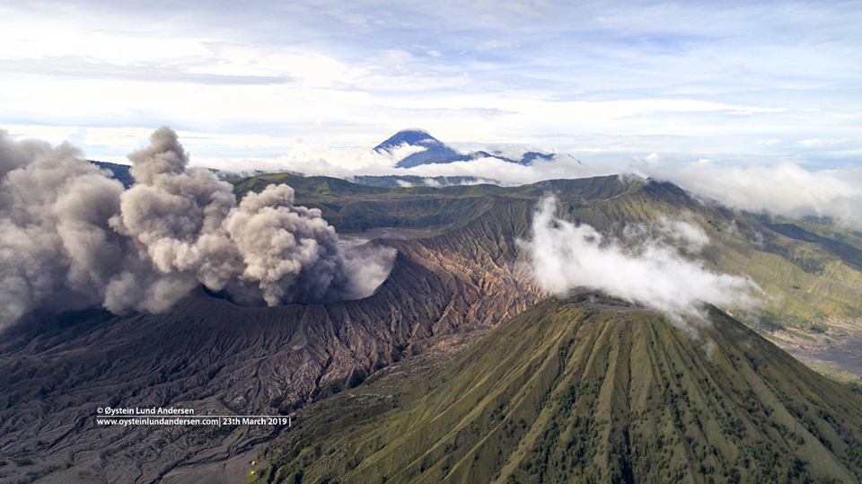 |
Figure 15. Ash drifted N from the Bromo Cone in Tengger Caldera on 23 March 2019. The Batok Cone is on the right, Segera Wedi is behind Bromo, and Semeru is in the far background. Courtesy of Øystein Lund Andersen, used with permission. |
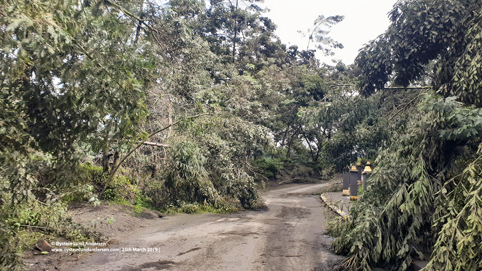 |
Figure 16. A few trees toppled from ashfall in the vicinity of the Bromo Cone in Tengger Caldera on 24 March 2019. Courtesy of Øystein Lund Andersen, used with permission. |
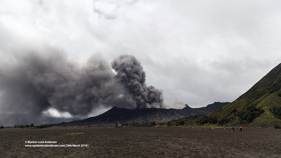 |
Figure 17. Ash plumes from the Bromo Cone in Tengger Caldera on 24 March 2019 caused ashfall in communities as far as 30 km away. View is from the floor of the Sandsea Caldera. Courtesy of Øystein Lund Andersen, used with permission. |
After just a few days of quiet, new ash emissions rising to 3.0 km altitude and drifting SE were reported by both PVMBG (from the webcam) and the Darwin VAAC on 6 April 2019. By the next day the continuous ash emissions were drifting N, then E during 8-10 April, and S during 11 and 12 April. A new emission seen in the webcam was reported by the Darwin VAAC on 15 April (UTC) that rose to 3.0 km and drifted W. Ash plumes were intermittently visible in either webcam or satellite imagery until 17 April rising 500-1,000 m above the crater; from 19-25 April only steam plumes were reported rising 300-500 m above the summit. A minor ash emission was reported from the webcam on 26 April that rose to 3.0 km altitude and drifted NE for a few hours before dissipating. PVMBG reported medium density white to gray ash plumes that rose 400-600 m above the crater for the remainder of the month.
Information Contacts: Pusat Vulkanologi dan Mitigasi Bencana Geologi (PVMBG, also known as Indonesian Center for Volcanology and Geological Hazard Mitigation, CVGHM), Jalan Diponegoro 57, Bandung 40122, Indonesia (URL: http://www.vsi.esdm.go.id/); Darwin Volcanic Ash Advisory Centre (VAAC), Bureau of Meteorology, Northern Territory Regional Office, PO Box 40050, Casuarina, NT 0811, Australia (URL: http://www.bom.gov.au/info/vaac/); Hawai'i Institute of Geophysics and Planetology (HIGP) - MODVOLC Thermal Alerts System, School of Ocean and Earth Science and Technology (SOEST), Univ. of Hawai'i, 2525 Correa Road, Honolulu, HI 96822, USA (URL: http://modis.higp.hawaii.edu/); Øystein Lund Andersen (Twitter: @OysteinLAnderse, https://twitter.com/OysteinLAnderse, URL: http://www.oysteinlundandersen.com); Mongabay, URL: https://news.mongabay.com/2018/09/fires-tear-through-east-java-park-threatening-leopard-habitat/.
Ash emissions on 19 and 28 July 2019; lahar on the SW flank of Bromo
The Mount Bromo pyroclastic cone within the Tengger Caldera erupts frequently, typically producing gas-and-steam plumes, ash plumes, and explosions (BGVN 44:05). Information compiled for the reporting period of May-July 2019 is from the Pusat Vulkanologi dan Mitigasi Bencana Geologi (PVMBG, also known as CVGHM) and the Darwin Volcanic Ash Advisory Centre (VAAC).
The eruptive activity at Tengger Caldera that began in mid-February continued through late July 2019, including white-and-brown ash plumes, ash emissions, and tremors. During the months of May through June 2019, white plumes rose between 50 to 600 m above the summit. Satellite imagery captured a small gas-and-steam plume from Bromo on 5 June (figure 18). Low-frequency tremors were recorded by a seismograph from May through July 2019.
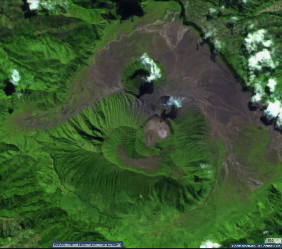 |
Figure 18. Sentinel-2 satellite image showing a small gas-and-steam plume rising from the Bromo cone (center) in the Tengger Caldera on 5 June 2019. Thermal (urban) satellite image (bands 12, 11, 4) courtesy of Sentinel Hub Playground. |
According to PVMBG and a Volcano Observatory Notice for Aviation (VONA), an ash eruption occurred on 19 July 2019; however, no ash column was observed due to weather conditions. A seismograph recorded five earthquakes and three shallow volcanic tremors the same day. In addition, rainfall triggered a lahar on the SW flank of Bromo.
On 28 July the Darwin VAAC reported that ash plumes originating from Bromo rose to a maximum altitude of about 3.9 km and drifted NW from the summit, based on webcam images and pilot reports. PVMBG reported that lower altitude ash plumes (2.4 km) on the same day were also recorded by webcam images, satellite imagery (Himawari-8), and weather models.
Information Contacts: Pusat Vulkanologi dan Mitigasi Bencana Geologi (PVMBG, also known as Indonesian Center for Volcanology and Geological Hazard Mitigation, CVGHM), Jalan Diponegoro 57, Bandung 40122, Indonesia (URL: http://www.vsi.esdm.go.id/); Darwin Volcanic Ash Advisory Centre (VAAC), Bureau of Meteorology, Northern Territory Regional Office, PO Box 40050, Casuarina, NT 0811, Australia (URL: http://www.bom.gov.au/info/vaac/).
Ash plumes during 26-28 December 2020 with ashfall to the NE
Activity at Bromo, the youngest and only active cone within the 16-km-wide Tengger caldera in East Java, is characterized by occasional explosions with ash plumes followed by periods of relative quiet with only gas-and-steam emissions (BGVN 44:05). There have been more than 30 eruptive periods since 1900. During the first seven months of 2019, ash explosions occurred on 18 February 2019 and became especially numerous in March and April, with more explosive activity in July 2019 (BGVN 44:05, 44:08). The volcano is monitored by the Pusat Vulkanologi dan Mitigasi Bencana Geologi (PVMBG, also known as Indonesian Center for Volcanology and Geological Hazard Mitigation, CVGHM) and by the Darwin Volcanic Ash Advisory Centre (VAAC).
Following the ash explosion on 28 July 2019, satellite observations frequently showed a white gas-and-steam plume in the Bromo crater (figure 19). No additional eruptive activity was reported until 26-27 December 2020 when PVMBG reported white-and-gray plumes rose 50-700 m above the summit of Bromo’s cone. The next day, at 0550 on 28 December, an observer spotted a gas-and-ash emission rising at least 500 m above the summit. The Darwin VAAC was unable to confirm if there was ash in the plume based on satellite data, but ashfall was reported in the Ngadirejo area, about 5 km NE. The Alert Level remained at 2 (on a scale of 1-4), and visitors were warned to stay outside a 1-km radius of the crater.
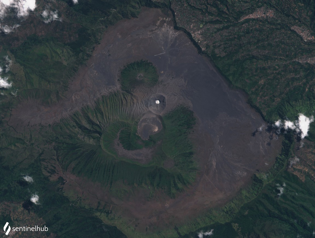 |
Figure 19. Satellite image of the Tengger Caldera on 12 September 2020, with a typical white plume visible in the Bromo crater. Sentinel-2 image with natural color rendering (bands 4, 3, 2). Courtesy of Sentinel Hub Playground. |
Information Contacts: Pusat Vulkanologi dan Mitigasi Bencana Geologi (PVMBG, also known as Indonesian Center for Volcanology and Geological Hazard Mitigation, CVGHM), Jalan Diponegoro 57, Bandung 40122, Indonesia (URL: http://www.vsi.esdm.go.id/); Darwin Volcanic Ash Advisory Centre (VAAC), Bureau of Meteorology, Northern Territory Regional Office, PO Box 40050, Casuarina, NT 0811, Australia (URL: http://www.bom.gov.au/info/vaac/); Sentinel Hub Playground (URL: https://www.sentinel-hub.com/explore/sentinel-playground).
Weak thermal anomaly in the summit crater during April-June 2021
Tengger Caldera, located at the N end of a volcanic massif in East Java, consists of five overlapping stratovolcanoes that are truncated by a caldera. An overlapping cluster of post-caldera cones was constructed on the floor of the Sandsea caldera within the last several thousand years, the youngest of which is Bromo, the only currently active cone in the 16-km-wide caldera. Its most recent eruption period occurred during late December 2020 and was characterized by ash plumes and ashfall (BGVN 46:02). This report covers low-level activity consisting of thermal anomalies in the Bromo crater during April through June 2021, with information provided by the Pusat Vulkanologi dan Mitigasi Bencana Geologi (PVMBG, also known as Indonesian Center for Volcanology and Geological Hazard Mitigation, CVGHM) and satellite imagery.
Activity was relatively low during January through June 2021 and was dominantly white-to-gray gas-and-steam emissions that rose 50-700 m above the summit along with rare volcanic earthquakes. Weather conditions often obscured views of the volcano. A slight sulfur smell was occasionally reported in the Bromo area. Starting on 15 April a persistent weak thermal anomaly was identified in the Bromo crater, continuing through 9 June, based on Sentinel-2 infrared satellite imagery (figure 20).
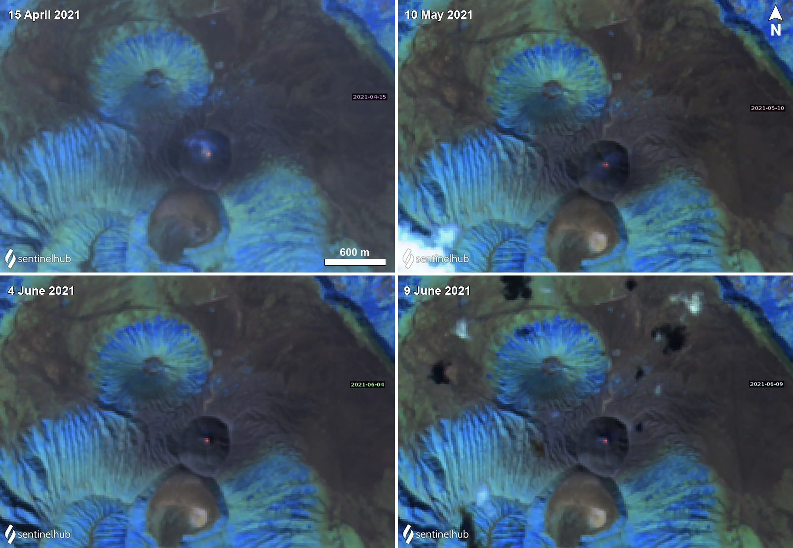 |
Figure 20. Sentinel-2 infrared satellite images showing a weak thermal anomaly in the summit crater of Bromo in the Tengger Caldera on 15 April (top left), 10 May (top right), 4 June (bottom left) and 9 June (bottom right) 2021. Images using “Atmospheric penetration” rendering (bands 12, 11, 8a). Courtesy of Sentinel Hub Playground. |
Information Contacts: Pusat Vulkanologi dan Mitigasi Bencana Geologi (PVMBG, also known as Indonesian Center for Volcanology and Geological Hazard Mitigation, CVGHM), Jalan Diponegoro 57, Bandung 40122, Indonesia (URL: http://www.vsi.esdm.go.id/); Sentinel Hub Playground (URL: https://www.sentinel-hub.com/explore/sentinel-playground).
Gas-and-steam emissions and a weak thermal anomaly at Bromo during July-December 2021
Tengger Caldera, located at the N end of a volcanic massif in East Java, consists of five overlapping stratovolcanoes that are truncated by a caldera. An overlapping cluster of post-caldera cones was constructed on the floor of the Sandsea caldera within the last several thousand years, the youngest of which is Bromo, the only currently active cone in the 16-km-wide caldera. Its most recent eruption period occurred during April 2021 and mostly consisted of white-to-gray gas-and-steam emissions and a weak thermal anomaly in the Bromo crater (BGVN 46:07). This report covers continued low-level activity consisting of white-to-gray gas-and-steam emissions, with information provided by the Pusat Vulkanologi dan Mitigasi Bencana Geologi (PVMBG, also known as Indonesian Center for Volcanology and Geological Hazard Mitigation, CVGHM) and satellite imagery.
Activity was relatively low during July through December 2021 and was primarily characterized by white-and-gray gas-and-steam emissions that rose 50-600 m above the summit (figure 21). Weather conditions often obscured views of the volcano. Intermittent deep volcanic earthquakes were also reported. A persistent weak thermal anomaly was identified in the Bromo crater, on clear weather days in Sentinel-2 infrared satellite imagery (figure 22). According to MIROVA (Middle InfraRed Observation of Volcanic Activity) data, a gradual increase in the number and frequency of thermal pixels was detected from April through October (figure 23). On 3 and 5 October and 4, 25, and 31 December a light sulfur smell was reported by the Bromo Observation Post (2.5 km from the volcano).
 |
Figure 21. Webcam image of Tengger Caldera’s Bromo cone emitting a white gas-and-steam plume on 7 November 2021. The cone to the right is Batok. Courtesy of MAGMA Indonesia. |
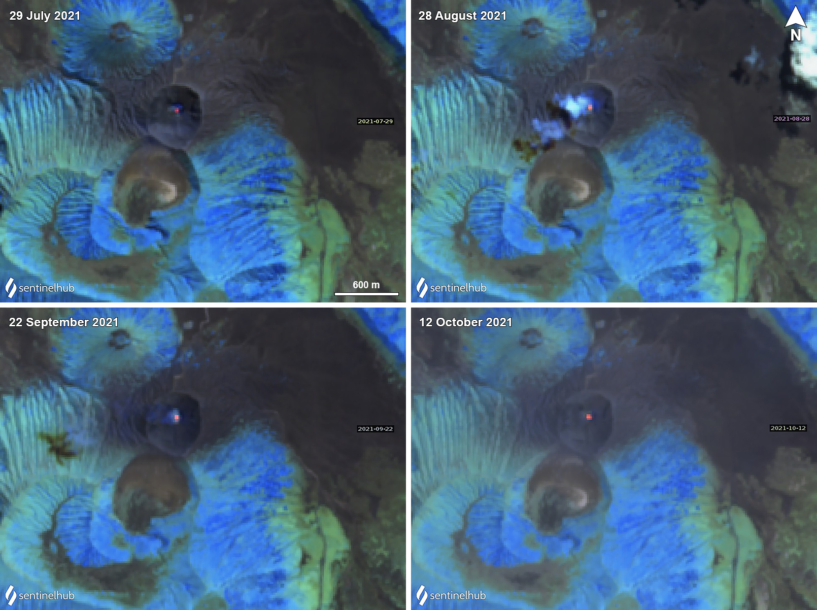 |
Figure 22. Sentinel-2 infrared satellite images showing a weak but persistent thermal anomaly in the Bromo crater at Tengger Caldera on 29 July (top left), 28 August (top right), 22 September (bottom left), and 12 October (bottom right) 2021. Some weak gas-and-steam emissions also accompanied the thermal activity, as shown on 28 August and 22 September. Images using “Atmospheric penetration” rendering (bands 12, 11, 8a). Courtesy of Sentinel Hub Playground. |
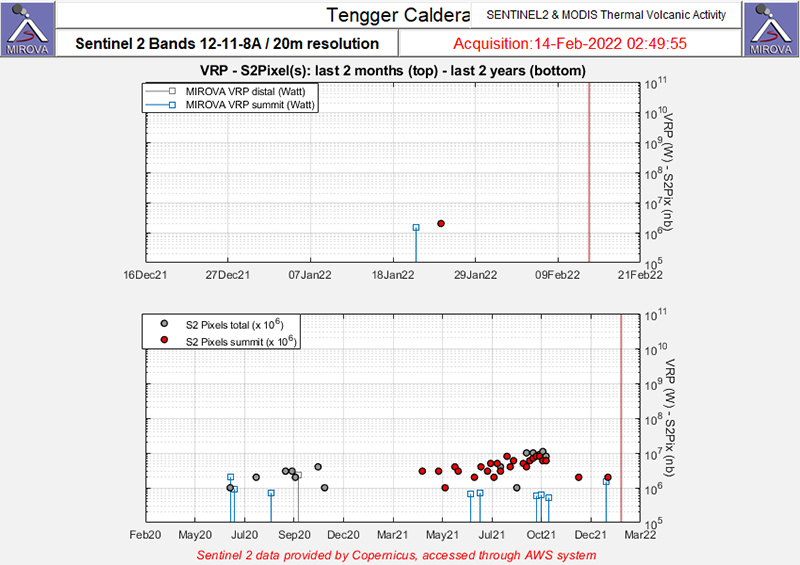 |
Figure 23. A gradual increase in the number and frequency of thermal anomalies (red dots) at Tengger Caldera was detected during April through October 2021 as recorded by the Sentinel-2 MODIS Thermal Volcanic Activity data (bands 12, 11, 8A). Courtesy of MIROVA. |
Information Contacts: Pusat Vulkanologi dan Mitigasi Bencana Geologi (PVMBG, also known as Indonesian Center for Volcanology and Geological Hazard Mitigation, CVGHM), Jalan Diponegoro 57, Bandung 40122, Indonesia (URL: http://www.vsi.esdm.go.id/); MAGMA Indonesia, Kementerian Energi dan Sumber Daya Mineral (URL: https://magma.esdm.go.id/v1); MIROVA (Middle InfraRed Observation of Volcanic Activity), a collaborative project between the Universities of Turin and Florence (Italy) supported by the Centre for Volcanic Risk of the Italian Civil Protection Department (URL: http://www.mirovaweb.it/); Sentinel Hub Playground (URL: https://www.sentinel-hub.com/explore/sentinel-playground).
Minor ash emission in December 2023; persistent weak thermal anomaly in the Bromo crater
Tengger Caldera, located at the N end of a volcanic massif in Indonesia’s East Java, consists of five overlapping stratovolcanoes. The youngest and only active cone in the 16-km-wide caldera is Bromo, which typically produces gas-and-steam plumes, occasional ash plumes and explosions, and weak thermal signals (BGVN 44:05, 47:01). This report covers activity during January 2022-December 2023, consisting of mostly white gas-and-steam emissions and persistent weak thermal anomalies. Information was provided by the Pusat Vulkanologi dan Mitigasi Bencana Geologi (PVMBG, also known as Indonesian Center for Volcanology and Geological Hazard Mitigation, CVGHM) and satellite imagery. The Alert Level remained at 2 (on a scale of 1-4), and visitors were warned to stay at least 1 km from the crater.
Activity was generally low during the reporting period, similar to that in 2021. According to almost daily images from MAGMA Indonesia (a platform developed by PVMBG), white emissions and plumes rose from 50 to 900 m above the main crater during this period (figure 24). During several days in March and June 2022, white plumes reached heights of 1-1.2 km above the crater.
|
Figure 24. Webcam image showing a gas-and-steam plume from the Bromo cone in the Tengger Caldera on 2 April 2023. Courtesy of MAGMA Indonesia. |
After an increase in activity at 2114 on 3 February 2023, a PVMBG team that was sent to observe white emissions rising as high as 300 m during 9-12 February and heard rumbling noises. A sulfur dioxide odor was also strong near the crater and measurements indicated that levels were above the healthy (non-hazardous) threshold of 5 parts per million; differential optical absorption spectroscopy (DOAS) measurements indicated an average flux of 190 metric tons per day on 11 February. Incandescence originating from a large fumarole in the NNW part of the crater was visible at night. The team observed that vegetation on the E caldera wall was yellow and withered. The seismic network recorded continuous tremor and deep and shallow volcanic earthquakes.
According to a PVMBG press release, activity increased on 13 December 2023 with white, gray, and brown emissions rising as high as 900 m above Bromo’s crater rim and drifting in multiple directions (figure 25). The report noted that tremor was continuous and was accompanied in December by three volcanic earthquakes. Deformation data indicated inflation in December. There was no observable difference in the persistent thermal anomaly in the crater between 11 and 16 December 2023.
|
Figure 25. Webcam image showing a dark plume that rose 900 m above the summit of the Bromo cone in the Tengger Caldera on 13 December 2023. Courtesy of MAGMA Indonesia. |
All clear views of the Bromo crater throughout this time, using Sentinel-2 infrared satellite images, showed a weak persistent thermal anomaly; none of the anomalies were strong enough to cause MODVOLC Thermal Alerts. A fire in the SE part of the caldera in early September 2023 resulted in a brief period of strong thermal anomalies.
Information Contacts: Pusat Vulkanologi dan Mitigasi Bencana Geologi (PVMBG, also known as Indonesian Center for Volcanology and Geological Hazard Mitigation, CVGHM), Jalan Diponegoro 57, Bandung 40122, Indonesia (URL: http://www.vsi.esdm.go.id/); MAGMA Indonesia, Kementerian Energi dan Sumber Daya Mineral (URL: https://magma.esdm.go.id/v1); Copernicus Browser, Copernicus Data Space Ecosystem, European Space Agency (URL: https://dataspace.copernicus.eu/browser/); Hawai'i Institute of Geophysics and Planetology (HIGP) - MODVOLC Thermal Alerts System, School of Ocean and Earth Science and Technology (SOEST), Univ. of Hawai'i, 2525 Correa Road, Honolulu, HI 96822, USA (URL: http://modis.higp.hawaii.edu/).
|
|
||||||||||||||||||||||||||
There is data available for 67 confirmed eruptive periods.
2023 Dec 13 - 2023 Dec 13 Confirmed Eruption (Explosive / Effusive) VEI: 1
| Episode 1 | Eruption (Explosive / Effusive) | |||||||||||||||||||||||||||||
|---|---|---|---|---|---|---|---|---|---|---|---|---|---|---|---|---|---|---|---|---|---|---|---|---|---|---|---|---|---|
| 2023 Dec 13 - 2023 Dec 13 | Evidence from Observations: Reported | ||||||||||||||||||||||||||||
|
List of 4 Events for Episode 1
|
|||||||||||||||||||||||||||||
[ 2021 Apr 15 - 2021 Oct 22 ] Uncertain Eruption
| Episode 1 | Eruption (Explosive / Effusive) | Bromo | ||||||||||||||||||
|---|---|---|---|---|---|---|---|---|---|---|---|---|---|---|---|---|---|---|---|
| 2021 Apr 15 - 2021 Oct 22 | Evidence from Observations: Satellite (infrared) | ||||||||||||||||||
|
List of 2 Events for Episode 1 at Bromo
|
|||||||||||||||||||
2020 Dec 26 - 2020 Dec 28 Confirmed Eruption (Explosive / Effusive) VEI: 1
| Episode 1 | Eruption (Explosive / Effusive) | ||||||||||||||
|---|---|---|---|---|---|---|---|---|---|---|---|---|---|---|
| 2020 Dec 26 - 2020 Dec 28 | Evidence from Observations: Reported | |||||||||||||
|
List of 1 Events for Episode 1
|
||||||||||||||
2019 Feb 18 - 2019 Jul 28 Confirmed Eruption (Explosive / Effusive) VEI: 2
| Episode 1 | Eruption (Explosive / Effusive) | Bromo | |||||||||||||||||||||||
|---|---|---|---|---|---|---|---|---|---|---|---|---|---|---|---|---|---|---|---|---|---|---|---|---|
| 2019 Feb 18 - 2019 Jul 28 | Evidence from Observations: Reported | |||||||||||||||||||||||
|
List of 3 Events for Episode 1 at Bromo
|
||||||||||||||||||||||||
2015 Nov 12 - 2016 Nov 12 Confirmed Eruption (Explosive / Effusive) VEI: 2
| Episode 1 | Eruption (Explosive / Effusive) | Bromo cone | |||||||||||||||||||||||||||||||||||||||||||||||||||||||||||||||||||||||||||||||||||||||||||||||||||||||||||||||||||||||||||||||||||||||||||||||||||||||||||||||||||||||||||||||||||||||||||||||||||||||||||||||||||||
|---|---|---|---|---|---|---|---|---|---|---|---|---|---|---|---|---|---|---|---|---|---|---|---|---|---|---|---|---|---|---|---|---|---|---|---|---|---|---|---|---|---|---|---|---|---|---|---|---|---|---|---|---|---|---|---|---|---|---|---|---|---|---|---|---|---|---|---|---|---|---|---|---|---|---|---|---|---|---|---|---|---|---|---|---|---|---|---|---|---|---|---|---|---|---|---|---|---|---|---|---|---|---|---|---|---|---|---|---|---|---|---|---|---|---|---|---|---|---|---|---|---|---|---|---|---|---|---|---|---|---|---|---|---|---|---|---|---|---|---|---|---|---|---|---|---|---|---|---|---|---|---|---|---|---|---|---|---|---|---|---|---|---|---|---|---|---|---|---|---|---|---|---|---|---|---|---|---|---|---|---|---|---|---|---|---|---|---|---|---|---|---|---|---|---|---|---|---|---|---|---|---|---|---|---|---|---|---|---|---|---|---|---|---|---|
| 2015 Nov 12 - 2016 Nov 12 | Evidence from Observations: Reported | |||||||||||||||||||||||||||||||||||||||||||||||||||||||||||||||||||||||||||||||||||||||||||||||||||||||||||||||||||||||||||||||||||||||||||||||||||||||||||||||||||||||||||||||||||||||||||||||||||||||||||||||||||||
|
List of 41 Events for Episode 1 at Bromo cone
|
||||||||||||||||||||||||||||||||||||||||||||||||||||||||||||||||||||||||||||||||||||||||||||||||||||||||||||||||||||||||||||||||||||||||||||||||||||||||||||||||||||||||||||||||||||||||||||||||||||||||||||||||||||||
2010 Nov 26 - 2011 Jun 13 Confirmed Eruption (Explosive / Effusive) VEI: 3 (?)
| Episode 1 | Non-eruptive (Precursory) | ||||||||||||||||||||||||
|---|---|---|---|---|---|---|---|---|---|---|---|---|---|---|---|---|---|---|---|---|---|---|---|---|
| 2010 Nov 8 - 2010 Nov 26 | Evidence from Observations: Seismicity | |||||||||||||||||||||||
|
List of 3 Events for Episode 1
|
||||||||||||||||||||||||
| Episode 2 | Eruption (Explosive / Effusive) | Bromo | ||||||||||||||||||||||||||||||||||||||||||||||||||||||||||||||||||||||||||||||||||||||||||||||||||||||||||||||||||||||||||||||||||||||||||||||||||||||||||||||||||||||||||||||||||||||||||||||||||||||||||||||||||||||||||||||||||||||||||||||||||||||||||||||||||||||||||||||||||||||||||||||||||||||||||||||||||||||||||||||||||||||||
|---|---|---|---|---|---|---|---|---|---|---|---|---|---|---|---|---|---|---|---|---|---|---|---|---|---|---|---|---|---|---|---|---|---|---|---|---|---|---|---|---|---|---|---|---|---|---|---|---|---|---|---|---|---|---|---|---|---|---|---|---|---|---|---|---|---|---|---|---|---|---|---|---|---|---|---|---|---|---|---|---|---|---|---|---|---|---|---|---|---|---|---|---|---|---|---|---|---|---|---|---|---|---|---|---|---|---|---|---|---|---|---|---|---|---|---|---|---|---|---|---|---|---|---|---|---|---|---|---|---|---|---|---|---|---|---|---|---|---|---|---|---|---|---|---|---|---|---|---|---|---|---|---|---|---|---|---|---|---|---|---|---|---|---|---|---|---|---|---|---|---|---|---|---|---|---|---|---|---|---|---|---|---|---|---|---|---|---|---|---|---|---|---|---|---|---|---|---|---|---|---|---|---|---|---|---|---|---|---|---|---|---|---|---|---|---|---|---|---|---|---|---|---|---|---|---|---|---|---|---|---|---|---|---|---|---|---|---|---|---|---|---|---|---|---|---|---|---|---|---|---|---|---|---|---|---|---|---|---|---|---|---|---|---|---|---|---|---|---|---|---|---|---|---|---|---|---|---|---|---|---|---|---|---|---|---|---|---|---|---|---|---|---|---|---|---|---|---|---|---|---|---|---|---|---|---|---|---|---|---|---|---|---|---|---|---|---|---|---|---|---|---|---|---|---|---|---|---|---|---|
| 2010 Nov 26 - 2011 Jun 13 | Evidence from Observations: Reported | ||||||||||||||||||||||||||||||||||||||||||||||||||||||||||||||||||||||||||||||||||||||||||||||||||||||||||||||||||||||||||||||||||||||||||||||||||||||||||||||||||||||||||||||||||||||||||||||||||||||||||||||||||||||||||||||||||||||||||||||||||||||||||||||||||||||||||||||||||||||||||||||||||||||||||||||||||||||||||||||||||||||||
|
List of 64 Events for Episode 2 at Bromo
|
|||||||||||||||||||||||||||||||||||||||||||||||||||||||||||||||||||||||||||||||||||||||||||||||||||||||||||||||||||||||||||||||||||||||||||||||||||||||||||||||||||||||||||||||||||||||||||||||||||||||||||||||||||||||||||||||||||||||||||||||||||||||||||||||||||||||||||||||||||||||||||||||||||||||||||||||||||||||||||||||||||||||||
2004 Jun 8 - 2004 Jun 24 ± 3 days Confirmed Eruption (Explosive / Effusive) VEI: 2
| Episode 1 | Eruption (Explosive / Effusive) | Bromo | ||||||||||||||||||||||||||||||||||||||||||||||||||||||||||||||||||||
|---|---|---|---|---|---|---|---|---|---|---|---|---|---|---|---|---|---|---|---|---|---|---|---|---|---|---|---|---|---|---|---|---|---|---|---|---|---|---|---|---|---|---|---|---|---|---|---|---|---|---|---|---|---|---|---|---|---|---|---|---|---|---|---|---|---|---|---|---|---|
| 2004 Jun 8 - 2004 Jun 24 ± 3 days | Evidence from Observations: Reported | ||||||||||||||||||||||||||||||||||||||||||||||||||||||||||||||||||||
|
List of 12 Events for Episode 1 at Bromo
|
|||||||||||||||||||||||||||||||||||||||||||||||||||||||||||||||||||||
2000 Nov 29 - 2001 Jan 15 (on or after) Confirmed Eruption (Explosive / Effusive) VEI: 2
| Episode 1 | Eruption (Explosive / Effusive) | Bromo | |||||||||||||||||||||||||||||||||
|---|---|---|---|---|---|---|---|---|---|---|---|---|---|---|---|---|---|---|---|---|---|---|---|---|---|---|---|---|---|---|---|---|---|---|
| 2000 Nov 29 - 2001 Jan 15 (on or after) | Evidence from Observations: Reported | |||||||||||||||||||||||||||||||||
|
List of 5 Events for Episode 1 at Bromo
|
||||||||||||||||||||||||||||||||||
1995 Sep 9 - 1995 Dec 16 ± 15 days Confirmed Eruption (Explosive / Effusive) VEI: 1
| Episode 1 | Eruption (Explosive / Effusive) | Bromo | ||||||||||||||||||||||||||||
|---|---|---|---|---|---|---|---|---|---|---|---|---|---|---|---|---|---|---|---|---|---|---|---|---|---|---|---|---|---|
| 1995 Sep 9 - 1995 Dec 16 ± 15 days | Evidence from Observations: Reported | ||||||||||||||||||||||||||||
|
List of 4 Events for Episode 1 at Bromo
|
|||||||||||||||||||||||||||||
1995 Mar 3 - 1995 May 26 ± 5 days Confirmed Eruption (Explosive / Effusive) VEI: 1
| Episode 1 | Eruption (Explosive / Effusive) | Bromo | |||||||||||||||||||||||||||||||||
|---|---|---|---|---|---|---|---|---|---|---|---|---|---|---|---|---|---|---|---|---|---|---|---|---|---|---|---|---|---|---|---|---|---|---|
| 1995 Mar 3 - 1995 May 26 ± 5 days | Evidence from Observations: Reported | |||||||||||||||||||||||||||||||||
|
List of 5 Events for Episode 1 at Bromo
|
||||||||||||||||||||||||||||||||||
1984 May 12 - 1984 May 31 Confirmed Eruption (Explosive / Effusive) VEI: 1
| Episode 1 | Eruption (Explosive / Effusive) | Bromo | |||||||||||||||||||||||
|---|---|---|---|---|---|---|---|---|---|---|---|---|---|---|---|---|---|---|---|---|---|---|---|---|
| 1984 May 12 - 1984 May 31 | Evidence from Observations: Reported | |||||||||||||||||||||||
|
List of 3 Events for Episode 1 at Bromo
|
||||||||||||||||||||||||
1983 Dec 21 - 1983 Dec 21 Confirmed Eruption (Explosive / Effusive) VEI: 1
| Episode 1 | Eruption (Explosive / Effusive) | Bromo | ||||||||||||||||||
|---|---|---|---|---|---|---|---|---|---|---|---|---|---|---|---|---|---|---|---|
| 1983 Dec 21 - 1983 Dec 21 | Evidence from Observations: Reported | ||||||||||||||||||
|
List of 2 Events for Episode 1 at Bromo
|
|||||||||||||||||||
[ 1983 Apr 15 ± 5 days - 1983 Jun 28 ± 1 days ] Uncertain Eruption
| Episode 1 | Eruption (Explosive / Effusive) | Bromo | |||||||||||||||||||||||
|---|---|---|---|---|---|---|---|---|---|---|---|---|---|---|---|---|---|---|---|---|---|---|---|---|
| 1983 Apr 15 ± 5 days - 1983 Jun 28 ± 1 days | Evidence from Unknown | |||||||||||||||||||||||
|
List of 3 Events for Episode 1 at Bromo
|
||||||||||||||||||||||||
1980 Jun 5 ± 1 days - 1980 Sep 20 Confirmed Eruption (Explosive / Effusive) VEI: 2
| Episode 1 | Eruption (Explosive / Effusive) | Bromo | |||||||||||||||||||||||||||||||||
|---|---|---|---|---|---|---|---|---|---|---|---|---|---|---|---|---|---|---|---|---|---|---|---|---|---|---|---|---|---|---|---|---|---|---|
| 1980 Jun 5 ± 1 days - 1980 Sep 20 | Evidence from Observations: Reported | |||||||||||||||||||||||||||||||||
|
List of 5 Events for Episode 1 at Bromo
|
||||||||||||||||||||||||||||||||||
1972 Jan 26 - 1972 Mar 16 ± 15 days Confirmed Eruption (Explosive / Effusive) VEI: 2
| Episode 1 | Eruption (Explosive / Effusive) | Bromo | ||||||||||||||||||||||||||||
|---|---|---|---|---|---|---|---|---|---|---|---|---|---|---|---|---|---|---|---|---|---|---|---|---|---|---|---|---|---|
| 1972 Jan 26 - 1972 Mar 16 ± 15 days | Evidence from Observations: Reported | ||||||||||||||||||||||||||||
|
List of 4 Events for Episode 1 at Bromo
|
|||||||||||||||||||||||||||||
1956 Jun 16 ± 15 days - 1956 Jul 16 (?) ± 15 days Confirmed Eruption (Explosive / Effusive) VEI: 2
| Episode 1 | Eruption (Explosive / Effusive) | Bromo | |||||||||||||||||||||||||||||||||
|---|---|---|---|---|---|---|---|---|---|---|---|---|---|---|---|---|---|---|---|---|---|---|---|---|---|---|---|---|---|---|---|---|---|---|
| 1956 Jun 16 ± 15 days - 1956 Jul 16 (?) ± 15 days | Evidence from Observations: Reported | |||||||||||||||||||||||||||||||||
|
List of 5 Events for Episode 1 at Bromo
|
||||||||||||||||||||||||||||||||||
1955 Dec 29 - 1955 Dec 30 Confirmed Eruption (Explosive / Effusive) VEI: 2
| Episode 1 | Eruption (Explosive / Effusive) | Bromo | ||||||||||||||||||
|---|---|---|---|---|---|---|---|---|---|---|---|---|---|---|---|---|---|---|---|
| 1955 Dec 29 - 1955 Dec 30 | Evidence from Observations: Reported | ||||||||||||||||||
|
List of 2 Events for Episode 1 at Bromo
|
|||||||||||||||||||
1950 May 27 - 1950 Aug 16 ± 15 days Confirmed Eruption (Explosive / Effusive) VEI: 2
| Episode 1 | Eruption (Explosive / Effusive) | Bromo | |||||||||||||||||||||||
|---|---|---|---|---|---|---|---|---|---|---|---|---|---|---|---|---|---|---|---|---|---|---|---|---|
| 1950 May 27 - 1950 Aug 16 ± 15 days | Evidence from Observations: Reported | |||||||||||||||||||||||
|
List of 3 Events for Episode 1 at Bromo
|
||||||||||||||||||||||||
1948 Feb 15 - 1948 Apr 25 Confirmed Eruption (Explosive / Effusive) VEI: 3
| Episode 1 | Eruption (Explosive / Effusive) | Bromo | |||||||||||||||||||||||||||||||||
|---|---|---|---|---|---|---|---|---|---|---|---|---|---|---|---|---|---|---|---|---|---|---|---|---|---|---|---|---|---|---|---|---|---|---|
| 1948 Feb 15 - 1948 Apr 25 | Evidence from Observations: Reported | |||||||||||||||||||||||||||||||||
|
List of 5 Events for Episode 1 at Bromo
|
||||||||||||||||||||||||||||||||||
1940 Apr 25 - 1940 Jul 3 (on or after) Confirmed Eruption (Explosive / Effusive) VEI: 2
| Episode 1 | Eruption (Explosive / Effusive) | Bromo | ||||||||||||||||||
|---|---|---|---|---|---|---|---|---|---|---|---|---|---|---|---|---|---|---|---|
| 1940 Apr 25 - 1940 Jul 3 (on or after) | Evidence from Observations: Reported | ||||||||||||||||||
|
List of 2 Events for Episode 1 at Bromo
|
|||||||||||||||||||
1939 Jun 24 - 1939 Jul Confirmed Eruption (Explosive / Effusive) VEI: 2
| Episode 1 | Eruption (Explosive / Effusive) | Bromo | ||||||||||||||||||
|---|---|---|---|---|---|---|---|---|---|---|---|---|---|---|---|---|---|---|---|
| 1939 Jun 24 - 1939 Jul | Evidence from Observations: Reported | ||||||||||||||||||
|
List of 2 Events for Episode 1 at Bromo
|
|||||||||||||||||||
1935 Jul Confirmed Eruption (Explosive / Effusive) VEI: 2
| Episode 1 | Eruption (Explosive / Effusive) | Bromo | ||||||||||||||||||
|---|---|---|---|---|---|---|---|---|---|---|---|---|---|---|---|---|---|---|---|
| 1935 Jul - Unknown | Evidence from Observations: Reported | ||||||||||||||||||
|
List of 2 Events for Episode 1 at Bromo
|
|||||||||||||||||||
1930 May 30 - 1930 Jul Confirmed Eruption (Explosive / Effusive) VEI: 2
| Episode 1 | Eruption (Explosive / Effusive) | Bromo | ||||||||||||||||||
|---|---|---|---|---|---|---|---|---|---|---|---|---|---|---|---|---|---|---|---|
| 1930 May 30 - 1930 Jul | Evidence from Observations: Reported | ||||||||||||||||||
|
List of 2 Events for Episode 1 at Bromo
|
|||||||||||||||||||
1929 Aug 7 - 1929 Sep 8 Confirmed Eruption (Explosive / Effusive) VEI: 2
| Episode 1 | Eruption (Explosive / Effusive) | Bromo | ||||||||||||||||||
|---|---|---|---|---|---|---|---|---|---|---|---|---|---|---|---|---|---|---|---|
| 1929 Aug 7 - 1929 Sep 8 | Evidence from Observations: Reported | ||||||||||||||||||
|
List of 2 Events for Episode 1 at Bromo
|
|||||||||||||||||||
1928 Dec 16 Confirmed Eruption (Explosive / Effusive) VEI: 2
| Episode 1 | Eruption (Explosive / Effusive) | Bromo | ||||||||||||||||||
|---|---|---|---|---|---|---|---|---|---|---|---|---|---|---|---|---|---|---|---|
| 1928 Dec 16 - Unknown | Evidence from Observations: Reported | ||||||||||||||||||
|
List of 2 Events for Episode 1 at Bromo
|
|||||||||||||||||||
1928 Mar 15 ± 5 days - 1928 Jul Confirmed Eruption (Explosive / Effusive) VEI: 2
| Episode 1 | Eruption (Explosive / Effusive) | Bromo | ||||||||||||||||||||||||||||
|---|---|---|---|---|---|---|---|---|---|---|---|---|---|---|---|---|---|---|---|---|---|---|---|---|---|---|---|---|---|
| 1928 Mar 15 ± 5 days - 1928 Jul | Evidence from Observations: Reported | ||||||||||||||||||||||||||||
|
List of 4 Events for Episode 1 at Bromo
|
|||||||||||||||||||||||||||||
1922 Feb 5 - 1922 Jun 20 Confirmed Eruption (Explosive / Effusive) VEI: 2
| Episode 1 | Eruption (Explosive / Effusive) | Bromo | ||||||||||||||||||
|---|---|---|---|---|---|---|---|---|---|---|---|---|---|---|---|---|---|---|---|
| 1922 Feb 5 - 1922 Jun 20 | Evidence from Observations: Reported | ||||||||||||||||||
|
List of 2 Events for Episode 1 at Bromo
|
|||||||||||||||||||
1921 Jun - 1921 Oct 17 Confirmed Eruption (Explosive / Effusive) VEI: 2
| Episode 1 | Eruption (Explosive / Effusive) | Bromo | |||||||||||||||||||||||
|---|---|---|---|---|---|---|---|---|---|---|---|---|---|---|---|---|---|---|---|---|---|---|---|---|
| 1921 Jun - 1921 Oct 17 | Evidence from Observations: Reported | |||||||||||||||||||||||
|
List of 3 Events for Episode 1 at Bromo
|
||||||||||||||||||||||||
1915 Nov - 1916 Jun Confirmed Eruption (Explosive / Effusive) VEI: 3
| Episode 1 | Eruption (Explosive / Effusive) | Bromo | ||||||||||||||||||||||||||||
|---|---|---|---|---|---|---|---|---|---|---|---|---|---|---|---|---|---|---|---|---|---|---|---|---|---|---|---|---|---|
| 1915 Nov - 1916 Jun | Evidence from Observations: Reported | ||||||||||||||||||||||||||||
|
List of 4 Events for Episode 1 at Bromo
|
|||||||||||||||||||||||||||||
1910 Jan 18 - 1910 Jan 21 Confirmed Eruption (Explosive / Effusive) VEI: 2
| Episode 1 | Eruption (Explosive / Effusive) | Bromo | |||||||||||||||||||||||
|---|---|---|---|---|---|---|---|---|---|---|---|---|---|---|---|---|---|---|---|---|---|---|---|---|
| 1910 Jan 18 - 1910 Jan 21 | Evidence from Observations: Reported | |||||||||||||||||||||||
|
List of 3 Events for Episode 1 at Bromo
|
||||||||||||||||||||||||
1909 Jan 12 - 1909 Jan 14 Confirmed Eruption (Explosive / Effusive) VEI: 2
| Episode 1 | Eruption (Explosive / Effusive) | Bromo | |||||||||||||||||||||||
|---|---|---|---|---|---|---|---|---|---|---|---|---|---|---|---|---|---|---|---|---|---|---|---|---|
| 1909 Jan 12 - 1909 Jan 14 | Evidence from Observations: Reported | |||||||||||||||||||||||
|
List of 3 Events for Episode 1 at Bromo
|
||||||||||||||||||||||||
1907 Dec 14 - 1908 Feb 13 Confirmed Eruption (Explosive / Effusive) VEI: 2
| Episode 1 | Eruption (Explosive / Effusive) | Bromo | |||||||||||||||||||||||
|---|---|---|---|---|---|---|---|---|---|---|---|---|---|---|---|---|---|---|---|---|---|---|---|---|
| 1907 Dec 14 - 1908 Feb 13 | Evidence from Observations: Reported | |||||||||||||||||||||||
|
List of 3 Events for Episode 1 at Bromo
|
||||||||||||||||||||||||
1907 Aug 28 Confirmed Eruption (Explosive / Effusive) VEI: 2
| Episode 1 | Eruption (Explosive / Effusive) | Bromo | ||||||||||||||||||
|---|---|---|---|---|---|---|---|---|---|---|---|---|---|---|---|---|---|---|---|
| 1907 Aug 28 - Unknown | Evidence from Observations: Reported | ||||||||||||||||||
|
List of 2 Events for Episode 1 at Bromo
|
|||||||||||||||||||
1906 Sep 25 - 1907 May 18 Confirmed Eruption (Explosive / Effusive) VEI: 2
| Episode 1 | Eruption (Explosive / Effusive) | Bromo | ||||||||||||||||||
|---|---|---|---|---|---|---|---|---|---|---|---|---|---|---|---|---|---|---|---|
| 1906 Sep 25 - 1907 May 18 | Evidence from Observations: Reported | ||||||||||||||||||
|
List of 2 Events for Episode 1 at Bromo
|
|||||||||||||||||||
1896 Confirmed Eruption (Explosive / Effusive) VEI: 2
| Episode 1 | Eruption (Explosive / Effusive) | Bromo | ||||||||||||||||||
|---|---|---|---|---|---|---|---|---|---|---|---|---|---|---|---|---|---|---|---|
| 1896 - Unknown | Evidence from Observations: Reported | ||||||||||||||||||
|
List of 2 Events for Episode 1 at Bromo
|
|||||||||||||||||||
1893 Jan 13 - 1893 Mar 27 Confirmed Eruption (Explosive / Effusive) VEI: 2
| Episode 1 | Eruption (Explosive / Effusive) | Bromo | |||||||||||||||||||||||
|---|---|---|---|---|---|---|---|---|---|---|---|---|---|---|---|---|---|---|---|---|---|---|---|---|
| 1893 Jan 13 - 1893 Mar 27 | Evidence from Observations: Reported | |||||||||||||||||||||||
|
List of 3 Events for Episode 1 at Bromo
|
||||||||||||||||||||||||
1890 May - 1890 Sep Confirmed Eruption (Explosive / Effusive) VEI: 2
| Episode 1 | Eruption (Explosive / Effusive) | Bromo | ||||||||||||||||||
|---|---|---|---|---|---|---|---|---|---|---|---|---|---|---|---|---|---|---|---|
| 1890 May - 1890 Sep | Evidence from Observations: Reported | ||||||||||||||||||
|
List of 2 Events for Episode 1 at Bromo
|
|||||||||||||||||||
[ 1888 Feb 27 ] Uncertain Eruption
| Episode 1 | Eruption (Explosive / Effusive) | Bromo | ||||||||||||||||||
|---|---|---|---|---|---|---|---|---|---|---|---|---|---|---|---|---|---|---|---|
| 1888 Feb 27 - Unknown | Evidence from Unknown | ||||||||||||||||||
|
List of 2 Events for Episode 1 at Bromo
|
|||||||||||||||||||
1886 Nov 11 - 1887 Jan 25 Confirmed Eruption (Explosive / Effusive) VEI: 2
| Episode 1 | Eruption (Explosive / Effusive) | Bromo | ||||||||||||||||||
|---|---|---|---|---|---|---|---|---|---|---|---|---|---|---|---|---|---|---|---|
| 1886 Nov 11 - 1887 Jan 25 | Evidence from Observations: Reported | ||||||||||||||||||
|
List of 2 Events for Episode 1 at Bromo
|
|||||||||||||||||||
1886 Apr 15 - 1886 Apr 26 Confirmed Eruption (Explosive / Effusive) VEI: 2
| Episode 1 | Eruption (Explosive / Effusive) | Bromo | ||||||||||||||||||
|---|---|---|---|---|---|---|---|---|---|---|---|---|---|---|---|---|---|---|---|
| 1886 Apr 15 - 1886 Apr 26 | Evidence from Observations: Reported | ||||||||||||||||||
|
List of 2 Events for Episode 1 at Bromo
|
|||||||||||||||||||
1885 Oct 31 - 1886 Jan 10 Confirmed Eruption (Explosive / Effusive) VEI: 2
| Episode 1 | Eruption (Explosive / Effusive) | Bromo | ||||||||||||||||||||||||||||
|---|---|---|---|---|---|---|---|---|---|---|---|---|---|---|---|---|---|---|---|---|---|---|---|---|---|---|---|---|---|
| 1885 Oct 31 - 1886 Jan 10 | Evidence from Observations: Reported | ||||||||||||||||||||||||||||
|
List of 4 Events for Episode 1 at Bromo
|
|||||||||||||||||||||||||||||
1885 Jun (?) Confirmed Eruption (Explosive / Effusive) VEI: 2
| Episode 1 | Eruption (Explosive / Effusive) | Bromo | ||||||||||||||||||
|---|---|---|---|---|---|---|---|---|---|---|---|---|---|---|---|---|---|---|---|
| 1885 Jun (?) - Unknown | Evidence from Observations: Reported | ||||||||||||||||||
|
List of 2 Events for Episode 1 at Bromo
|
|||||||||||||||||||
1877 Apr 24 (?) Confirmed Eruption (Explosive / Effusive) VEI: 2
| Episode 1 | Eruption (Explosive / Effusive) | Bromo | ||||||||||||||||||
|---|---|---|---|---|---|---|---|---|---|---|---|---|---|---|---|---|---|---|---|
| 1877 Apr 24 (?) - Unknown | Evidence from Observations: Reported | ||||||||||||||||||
|
List of 2 Events for Episode 1 at Bromo
|
|||||||||||||||||||
1867 Dec 13 - 1868 Jan 12 Confirmed Eruption (Explosive / Effusive) VEI: 2
| Episode 1 | Eruption (Explosive / Effusive) | Bromo | |||||||||||||||||||||||
|---|---|---|---|---|---|---|---|---|---|---|---|---|---|---|---|---|---|---|---|---|---|---|---|---|
| 1867 Dec 13 - 1868 Jan 12 | Evidence from Observations: Reported | |||||||||||||||||||||||
|
List of 3 Events for Episode 1 at Bromo
|
||||||||||||||||||||||||
1866 Jul Confirmed Eruption (Explosive / Effusive) VEI: 2
| Episode 1 | Eruption (Explosive / Effusive) | Bromo | ||||||||||||||||||
|---|---|---|---|---|---|---|---|---|---|---|---|---|---|---|---|---|---|---|---|
| 1866 Jul - Unknown | Evidence from Observations: Reported | ||||||||||||||||||
|
List of 2 Events for Episode 1 at Bromo
|
|||||||||||||||||||
1865 Dec 1 - 1865 Dec 18 Confirmed Eruption (Explosive / Effusive) VEI: 2
| Episode 1 | Eruption (Explosive / Effusive) | Bromo | ||||||||||||||||||
|---|---|---|---|---|---|---|---|---|---|---|---|---|---|---|---|---|---|---|---|
| 1865 Dec 1 - 1865 Dec 18 | Evidence from Observations: Reported | ||||||||||||||||||
|
List of 2 Events for Episode 1 at Bromo
|
|||||||||||||||||||
1865 Apr - 1865 May Confirmed Eruption (Explosive / Effusive) VEI: 2
| Episode 1 | Eruption (Explosive / Effusive) | Bromo | ||||||||||||||||||
|---|---|---|---|---|---|---|---|---|---|---|---|---|---|---|---|---|---|---|---|
| 1865 Apr - 1865 May | Evidence from Observations: Reported | ||||||||||||||||||
|
List of 2 Events for Episode 1 at Bromo
|
|||||||||||||||||||
1860 Jun 12 - 1860 Jun 14 Confirmed Eruption (Explosive / Effusive) VEI: 2
| Episode 1 | Eruption (Explosive / Effusive) | Bromo | ||||||||||||||||||
|---|---|---|---|---|---|---|---|---|---|---|---|---|---|---|---|---|---|---|---|
| 1860 Jun 12 - 1860 Jun 14 | Evidence from Observations: Reported | ||||||||||||||||||
|
List of 2 Events for Episode 1 at Bromo
|
|||||||||||||||||||
1859 Jan 30 - 1859 Mar 4 ± 4 days Confirmed Eruption (Explosive / Effusive) VEI: 2
| Episode 1 | Eruption (Explosive / Effusive) | Bromo | ||||||||||||||||||||||||||||
|---|---|---|---|---|---|---|---|---|---|---|---|---|---|---|---|---|---|---|---|---|---|---|---|---|---|---|---|---|---|
| 1859 Jan 30 - 1859 Mar 4 ± 4 days | Evidence from Observations: Reported | ||||||||||||||||||||||||||||
|
List of 4 Events for Episode 1 at Bromo
|
|||||||||||||||||||||||||||||
1858 Oct 18 Confirmed Eruption (Explosive / Effusive) VEI: 2
| Episode 1 | Eruption (Explosive / Effusive) | Bromo | |||||||||||||||||||||||
|---|---|---|---|---|---|---|---|---|---|---|---|---|---|---|---|---|---|---|---|---|---|---|---|---|
| 1858 Oct 18 - Unknown | Evidence from Observations: Reported | |||||||||||||||||||||||
|
List of 3 Events for Episode 1 at Bromo
|
||||||||||||||||||||||||
1858 Mar 4 Confirmed Eruption (Explosive / Effusive) VEI: 2
| Episode 1 | Eruption (Explosive / Effusive) | Bromo | ||||||||||||||||||
|---|---|---|---|---|---|---|---|---|---|---|---|---|---|---|---|---|---|---|---|
| 1858 Mar 4 - Unknown | Evidence from Observations: Reported | ||||||||||||||||||
|
List of 2 Events for Episode 1 at Bromo
|
|||||||||||||||||||
1857 Confirmed Eruption (Explosive / Effusive) VEI: 2
| Episode 1 | Eruption (Explosive / Effusive) | Bromo | ||||||||||||||||||
|---|---|---|---|---|---|---|---|---|---|---|---|---|---|---|---|---|---|---|---|
| 1857 - Unknown | Evidence from Observations: Reported | ||||||||||||||||||
|
List of 2 Events for Episode 1 at Bromo
|
|||||||||||||||||||
1856 Sep 10 Confirmed Eruption (Explosive / Effusive) VEI: 2
| Episode 1 | Eruption (Explosive / Effusive) | Volcano Uncertain | |||||||||||||||||||||||
|---|---|---|---|---|---|---|---|---|---|---|---|---|---|---|---|---|---|---|---|---|---|---|---|---|
| 1856 Sep 10 - Unknown | Evidence from Unknown | |||||||||||||||||||||||
|
List of 3 Events for Episode 1 at Volcano Uncertain
|
||||||||||||||||||||||||
1844 Nov 9 Confirmed Eruption (Explosive / Effusive) VEI: 2
| Episode 1 | Eruption (Explosive / Effusive) | Bromo | ||||||||||||||||||
|---|---|---|---|---|---|---|---|---|---|---|---|---|---|---|---|---|---|---|---|
| 1844 Nov 9 - Unknown | Evidence from Observations: Reported | ||||||||||||||||||
|
List of 2 Events for Episode 1 at Bromo
|
|||||||||||||||||||
1843 Jan Confirmed Eruption (Explosive / Effusive) VEI: 2
| Episode 1 | Eruption (Explosive / Effusive) | Bromo | ||||||||||||||||||
|---|---|---|---|---|---|---|---|---|---|---|---|---|---|---|---|---|---|---|---|
| 1843 Jan - Unknown | Evidence from Observations: Reported | ||||||||||||||||||
|
List of 2 Events for Episode 1 at Bromo
|
|||||||||||||||||||
1842 Jan 24 - 1842 Jun Confirmed Eruption (Explosive / Effusive) VEI: 2
| Episode 1 | Eruption (Explosive / Effusive) | Bromo | ||||||||||||||||||||||||||||
|---|---|---|---|---|---|---|---|---|---|---|---|---|---|---|---|---|---|---|---|---|---|---|---|---|---|---|---|---|---|
| 1842 Jan 24 - 1842 Jun | Evidence from Observations: Reported | ||||||||||||||||||||||||||||
|
List of 4 Events for Episode 1 at Bromo
|
|||||||||||||||||||||||||||||
1835 Confirmed Eruption (Explosive / Effusive) VEI: 2
| Episode 1 | Eruption (Explosive / Effusive) | Bromo | ||||||||||||||||||
|---|---|---|---|---|---|---|---|---|---|---|---|---|---|---|---|---|---|---|---|
| 1835 - Unknown | Evidence from Observations: Reported | ||||||||||||||||||
|
List of 2 Events for Episode 1 at Bromo
|
|||||||||||||||||||
1830 Dec 15 - 1830 Dec 16 Confirmed Eruption (Explosive / Effusive) VEI: 2
| Episode 1 | Eruption (Explosive / Effusive) | Bromo | ||||||||||||||||||
|---|---|---|---|---|---|---|---|---|---|---|---|---|---|---|---|---|---|---|---|
| 1830 Dec 15 - 1830 Dec 16 | Evidence from Observations: Reported | ||||||||||||||||||
|
List of 2 Events for Episode 1 at Bromo
|
|||||||||||||||||||
1830 Mar 3 Confirmed Eruption (Explosive / Effusive) VEI: 2
| Episode 1 | Eruption (Explosive / Effusive) | Bromo | ||||||||||||||||||
|---|---|---|---|---|---|---|---|---|---|---|---|---|---|---|---|---|---|---|---|
| 1830 Mar 3 - Unknown | Evidence from Observations: Reported | ||||||||||||||||||
|
List of 2 Events for Episode 1 at Bromo
|
|||||||||||||||||||
1829 Nov 5 - 1829 Nov 11 Confirmed Eruption (Explosive / Effusive) VEI: 2
| Episode 1 | Eruption (Explosive / Effusive) | Bromo | |||||||||||||||||||||||||||||||||
|---|---|---|---|---|---|---|---|---|---|---|---|---|---|---|---|---|---|---|---|---|---|---|---|---|---|---|---|---|---|---|---|---|---|---|
| 1829 Nov 5 - 1829 Nov 11 | Evidence from Observations: Reported | |||||||||||||||||||||||||||||||||
|
List of 5 Events for Episode 1 at Bromo
|
||||||||||||||||||||||||||||||||||
1825 Nov 5 - 1825 Nov 8 Confirmed Eruption (Explosive / Effusive) VEI: 2
| Episode 1 | Eruption (Explosive / Effusive) | Bromo | ||||||||||||||||||
|---|---|---|---|---|---|---|---|---|---|---|---|---|---|---|---|---|---|---|---|
| 1825 Nov 5 - 1825 Nov 8 | Evidence from Observations: Reported | ||||||||||||||||||
|
List of 2 Events for Episode 1 at Bromo
|
|||||||||||||||||||
1822 Dec 28 - 1823 Jan 5 ± 4 days Confirmed Eruption (Explosive / Effusive) VEI: 2
| Episode 1 | Eruption (Explosive / Effusive) | Bromo | |||||||||||||||||||||||
|---|---|---|---|---|---|---|---|---|---|---|---|---|---|---|---|---|---|---|---|---|---|---|---|---|
| 1822 Dec 28 - 1823 Jan 5 ± 4 days | Evidence from Observations: Reported | |||||||||||||||||||||||
|
List of 3 Events for Episode 1 at Bromo
|
||||||||||||||||||||||||
1820 Confirmed Eruption (Explosive / Effusive) VEI: 2
| Episode 1 | Eruption (Explosive / Effusive) | Bromo | |||||||||||||||||||||||
|---|---|---|---|---|---|---|---|---|---|---|---|---|---|---|---|---|---|---|---|---|---|---|---|---|
| 1820 - Unknown | Evidence from Observations: Reported | |||||||||||||||||||||||
|
List of 3 Events for Episode 1 at Bromo
|
||||||||||||||||||||||||
1815 Apr 5 - 1815 Apr 17 (on or after) Confirmed Eruption (Explosive / Effusive) VEI: 2
| Episode 1 | Eruption (Explosive / Effusive) | Bromo | |||||||||||||||||||||||
|---|---|---|---|---|---|---|---|---|---|---|---|---|---|---|---|---|---|---|---|---|---|---|---|---|
| 1815 Apr 5 - 1815 Apr 17 (on or after) | Evidence from Observations: Reported | |||||||||||||||||||||||
|
List of 3 Events for Episode 1 at Bromo
|
||||||||||||||||||||||||
1804 Sep Confirmed Eruption (Explosive / Effusive) VEI: 2
| Episode 1 | Eruption (Explosive / Effusive) | Bromo | ||||||||||||||||||
|---|---|---|---|---|---|---|---|---|---|---|---|---|---|---|---|---|---|---|---|
| 1804 Sep - Unknown | Evidence from Observations: Reported | ||||||||||||||||||
|
List of 2 Events for Episode 1 at Bromo
|
|||||||||||||||||||
[ 1775 ] Uncertain Eruption
| Episode 1 | Eruption (Explosive / Effusive) | Bromo | |||
|---|---|---|---|---|
| 1775 - Unknown | Evidence from Unknown | |||
[ 1767 ] Uncertain Eruption
| Episode 1 | Eruption (Explosive / Effusive) | Bromo | |||
|---|---|---|---|---|
| 1767 - Unknown | Evidence from Unknown | |||
1590 ± 50 years Confirmed Eruption (Explosive / Effusive) VEI: 2
| Episode 1 | Eruption (Explosive / Effusive) | Bromo | ||||||||||||||||||||||||||||
|---|---|---|---|---|---|---|---|---|---|---|---|---|---|---|---|---|---|---|---|---|---|---|---|---|---|---|---|---|---|
| 1590 ± 50 years - Unknown | Evidence from Isotopic: 14C (uncalibrated) | ||||||||||||||||||||||||||||
|
List of 4 Events for Episode 1 at Bromo
|
|||||||||||||||||||||||||||||
0330 ± 50 years Confirmed Eruption (Explosive / Effusive) VEI: 3 (?)
| Episode 1 | Eruption (Explosive / Effusive) | Segorowedi | |||||||||||||||||||||||||||||||||||||||||||
|---|---|---|---|---|---|---|---|---|---|---|---|---|---|---|---|---|---|---|---|---|---|---|---|---|---|---|---|---|---|---|---|---|---|---|---|---|---|---|---|---|---|---|---|---|
| 0330 ± 50 years - Unknown | Evidence from Isotopic: 14C (uncalibrated) | |||||||||||||||||||||||||||||||||||||||||||
|
List of 7 Events for Episode 1 at Segorowedi
|
||||||||||||||||||||||||||||||||||||||||||||
0190 ± 50 years Confirmed Eruption (Explosive / Effusive) VEI: 2
| Episode 1 | Eruption (Explosive / Effusive) | Widodaren | ||||||||||||||||||||||||||||||||||||||||||||||||
|---|---|---|---|---|---|---|---|---|---|---|---|---|---|---|---|---|---|---|---|---|---|---|---|---|---|---|---|---|---|---|---|---|---|---|---|---|---|---|---|---|---|---|---|---|---|---|---|---|---|
| 0190 ± 50 years - Unknown | Evidence from Isotopic: 14C (uncalibrated) | ||||||||||||||||||||||||||||||||||||||||||||||||
|
List of 8 Events for Episode 1 at Widodaren
|
|||||||||||||||||||||||||||||||||||||||||||||||||
0830 BCE ± 50 years Confirmed Eruption (Explosive / Effusive) VEI: 4
| Episode 1 | Eruption (Explosive / Effusive) | Sandsea caldera | |||||||||||||||||||||||
|---|---|---|---|---|---|---|---|---|---|---|---|---|---|---|---|---|---|---|---|---|---|---|---|---|
| 0830 BCE ± 50 years - Unknown | Evidence from Isotopic: 14C (uncalibrated) | |||||||||||||||||||||||
|
List of 3 Events for Episode 1 at Sandsea caldera
|
||||||||||||||||||||||||
5260 BCE ± 780 years Confirmed Eruption (Explosive / Effusive)
| Episode 1 | Eruption (Explosive / Effusive) | Sandsea caldera | ||||||||||||||||||||||||||||
|---|---|---|---|---|---|---|---|---|---|---|---|---|---|---|---|---|---|---|---|---|---|---|---|---|---|---|---|---|---|
| 5260 BCE ± 780 years - Unknown | Evidence from Isotopic: 14C (uncalibrated) | ||||||||||||||||||||||||||||
|
List of 4 Events for Episode 1 at Sandsea caldera
|
|||||||||||||||||||||||||||||
This compilation of synonyms and subsidiary features may not be comprehensive. Features are organized into four major categories: Cones, Craters, Domes, and Thermal Features. Synonyms of features appear indented below the primary name. In some cases additional feature type, elevation, or location details are provided.
Synonyms |
||||
| Bromo-Tengger Caldera | ||||
Cones |
||||
| Feature Name | Feature Type | Elevation | Latitude | Longitude |
| Batok | Pyroclastic cone | |||
| Bromo
Brama |
Pyroclastic cone | 2329 m | ||
| Cemara Lawang
Cemorolawang |
Stratovolcano | |||
| Kursi, Gunung
Koersi, Gunung |
Pyroclastic cone | |||
| Pananjakan
Panandjakan |
Cone | 2770 m | ||
| Semongkrong, Gunung | Cone | |||
| Watangan, Gunung | Cone | |||
| Widodaren, Gunung | Pyroclastic cone | |||
Craters |
||||
| Feature Name | Feature Type | Elevation | Latitude | Longitude |
| Grati | Maar | |||
| Keciri, Gunung | Pleistocene caldera | |||
| Kundi-Baruklingting-Sapikerep | Pleistocene caldera | |||
| Ngadisari | Pleistocene caldera | |||
| Nongkojajar | Pleistocene caldera | |||
| Sandsea | Caldera | |||
| Segarawedi Kedul
Segarawedi Kidul |
Crater | |||
| Segarawedi Lor | Crater | |||
Domes |
||||
| Feature Name | Feature Type | Elevation | Latitude | Longitude |
| Gondang | Dome | |||
| Gunturan | Dome | |||
| Penunggul | Dome | |||
| Prongoll | Dome | |||
| Ringgit | Dome | |||
| Sambinongko | Dome | |||
| Sedaeng | Dome | |||
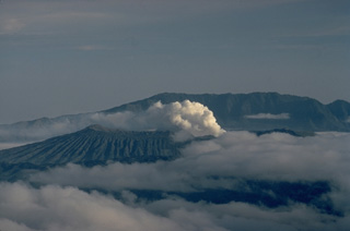 Steam rises from Bromo, a post-caldera cone of the Tengger caldera, seen here from Semeru volcano to the south. The ridge in the background is the outer wall of the 16-km-wide Ngadisari caldera. Bromo, the source of all historical eruptions at Tengger caldera, is one of several post-collapse cones constructed within the younger Tengger (Sandsea) caldera.
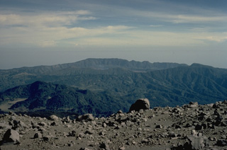 The Tengger caldera complex forms the large depression in the background of this view from Semeru volcano to its south. The compound caldera consists of the 16-km-wide Ngadisari caldera and the younger Sandsea caldera. A faint steam plume lingers at the center of the photo above Bromo, the source of all historical eruptions at Tengger caldera. Gunung Bromo is part of a complex of pyroclastic cones constructed within the Sandsea caldera.
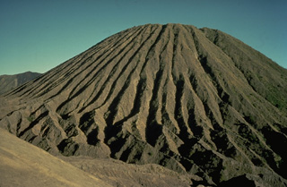 Erosion of friable tephra deposits forming the Batok pyroclastic cone on the floor of Tengger caldera has created dramatic erosional furrows that reach from the summit to the base of the cone. Batok is one of the youngest of the post-caldera cones; charcoal from a scoria layer on the eastern flank of Batok was radiocarbon dated at about 360 years ago. Only the historically active cone of Bromo, from where this photo was taken, is younger.
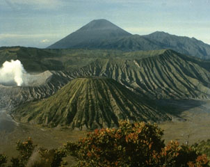 Bromo volcano produces a gas-and-steam plume at the left in this view from the rim of Ngadisari caldera, the older of two Tengger calderas. Bromo and Batok in the lower center are two of several post-caldera cones within the caldera. The towering peak of Semeru appears in the background at the end of a N-S trending volcanic massif.
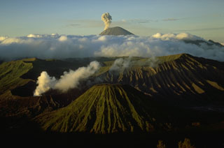 Semeru, Java's highest volcano, is seen in eruption on the skyline at the southern end of a volcanic chain extending from Tengger caldera on the north. The eroded post-caldera cone of Batok is the center foreground and Bromo in the left foreground producing a white plume.
 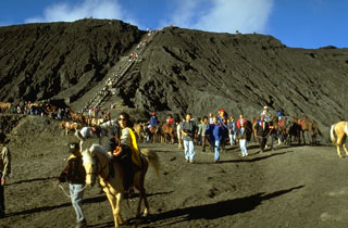 Bromo, a historically active cone within the Tengger caldera, is one of Indonesia's most visited volcanoes. Legends portray the formation of Bromo, whose name means "fire." Visitors climb a broad stairway to the crater rim after reaching the foot of the cone from the rim of Tengger caldera by foot or horseback across the flat-bottomed Sandsea caldera.
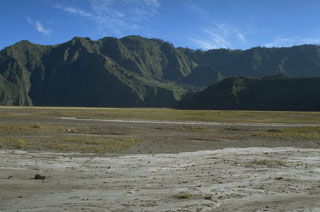 Two caldera walls can be seen in this view across the flat Sandsea caldera floor. The low ridge in the shadow in the foreground is the northern wall of the younger Tengger (Sandsea) caldera, which merges at the upper left with the background ridge, the northern wall of the 16-km-wide Ngadisari caldera.
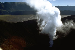 A gas-and-steam plume rises from Bromo crater, one of several post-caldera cones constructed within the Tengger caldera. The low rim of the younger Tengger (Sandsea) caldera rises immediately above the flat caldera floor and the background ridge forms the northern wall of the 16-km-wide Ngadisari caldera. Minor explosive eruptions are common at Bromo, one of Java's most active volcanoes.
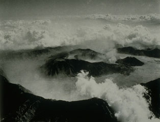 Tengger caldera is about 16 km wide and 500 m deep. Seven eruptive centers are on the floor of the flat-bottomed Sandsea caldera, the youngest at the compound Tengger caldera. The cluster of post-caldera cones was constructed along E-W and NNE-SSW fracture zones. Bromo is the active cone in this view from the south. Bromo crater is around 600 x 700 m and contains a terrace indicating the migration of its eruptive center to the north.
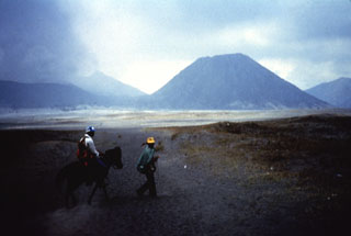 Batok (right), a prominent cone on the floor of Tengger caldera, is one of the youngest of the post-caldera cones. Charcoal from a scoria layer on the eastern flank of Batok was radiocarbon dated at about 360 years old. The only younger cone of Tengger caldera is the historically active Bromo, which is producing a cone to the left.
The following 2 samples associated with this volcano can be found in the Smithsonian's NMNH Department of Mineral Sciences collections, and may be availble for research (contact the Rock and Ore Collections Manager). Catalog number links will open a window with more information.
| Catalog Number | Sample Description | Lava Source | Collection Date |
|---|---|---|---|
| NMNH 116701-4 | Andesite Pumice | -- | -- |
| NMNH 116701-5 | Andesite | -- | -- |
| Copernicus Browser | The Copernicus Browser replaced the Sentinel Hub Playground browser in 2023, to provide access to Earth observation archives from the Copernicus Data Space Ecosystem, the main distribution platform for data from the EU Copernicus missions. |
| MIROVA | Middle InfraRed Observation of Volcanic Activity (MIROVA) is a near real time volcanic hot-spot detection system based on the analysis of MODIS (Moderate Resolution Imaging Spectroradiometer) data. In particular, MIROVA uses the Middle InfraRed Radiation (MIR), measured over target volcanoes, in order to detect, locate and measure the heat radiation sourced from volcanic activity. |
| MODVOLC Thermal Alerts | Using infrared satellite Moderate Resolution Imaging Spectroradiometer (MODIS) data, scientists at the Hawai'i Institute of Geophysics and Planetology, University of Hawai'i, developed an automated system called MODVOLC to map thermal hot-spots in near real time. For each MODIS image, the algorithm automatically scans each 1 km pixel within it to check for high-temperature hot-spots. When one is found the date, time, location, and intensity are recorded. MODIS looks at every square km of the Earth every 48 hours, once during the day and once during the night, and the presence of two MODIS sensors in space allows at least four hot-spot observations every two days. Each day updated global maps are compiled to display the locations of all hot spots detected in the previous 24 hours. There is a drop-down list with volcano names which allow users to 'zoom-in' and examine the distribution of hot-spots at a variety of spatial scales. |
|
WOVOdat
Single Volcano View Temporal Evolution of Unrest Side by Side Volcanoes |
WOVOdat is a database of volcanic unrest; instrumentally and visually recorded changes in seismicity, ground deformation, gas emission, and other parameters from their normal baselines. It is sponsored by the World Organization of Volcano Observatories (WOVO) and presently hosted at the Earth Observatory of Singapore.
GVMID Data on Volcano Monitoring Infrastructure The Global Volcano Monitoring Infrastructure Database GVMID, is aimed at documenting and improving capabilities of volcano monitoring from the ground and space. GVMID should provide a snapshot and baseline view of the techniques and instrumentation that are in place at various volcanoes, which can be use by volcano observatories as reference to setup new monitoring system or improving networks at a specific volcano. These data will allow identification of what monitoring gaps exist, which can be then targeted by remote sensing infrastructure and future instrument deployments. |
| Volcanic Hazard Maps | The IAVCEI Commission on Volcanic Hazards and Risk has a Volcanic Hazard Maps database designed to serve as a resource for hazard mappers (or other interested parties) to explore how common issues in hazard map development have been addressed at different volcanoes, in different countries, for different hazards, and for different intended audiences. In addition to the comprehensive, searchable Volcanic Hazard Maps Database, this website contains information about diversity of volcanic hazard maps, illustrated using examples from the database. This site is for educational purposes related to volcanic hazard maps. Hazard maps found on this website should not be used for emergency purposes. For the most recent, official hazard map for a particular volcano, please seek out the proper institutional authorities on the matter. |
| IRIS seismic stations/networks | Incorporated Research Institutions for Seismology (IRIS) Data Services map showing the location of seismic stations from all available networks (permanent or temporary) within a radius of 0.18° (about 20 km at mid-latitudes) from the given location of Tengger Caldera. Users can customize a variety of filters and options in the left panel. Note that if there are no stations are known the map will default to show the entire world with a "No data matched request" error notice. |
| UNAVCO GPS/GNSS stations | Geodetic Data Services map from UNAVCO showing the location of GPS/GNSS stations from all available networks (permanent or temporary) within a radius of 20 km from the given location of Tengger Caldera. Users can customize the data search based on station or network names, location, and time window. Requires Adobe Flash Player. |
| DECADE Data | The DECADE portal, still in the developmental stage, serves as an example of the proposed interoperability between The Smithsonian Institution's Global Volcanism Program, the Mapping Gas Emissions (MaGa) Database, and the EarthChem Geochemical Portal. The Deep Earth Carbon Degassing (DECADE) initiative seeks to use new and established technologies to determine accurate global fluxes of volcanic CO2 to the atmosphere, but installing CO2 monitoring networks on 20 of the world's 150 most actively degassing volcanoes. The group uses related laboratory-based studies (direct gas sampling and analysis, melt inclusions) to provide new data for direct degassing of deep earth carbon to the atmosphere. |
| Large Eruptions of Tengger Caldera | Information about large Quaternary eruptions (VEI >= 4) is cataloged in the Large Magnitude Explosive Volcanic Eruptions (LaMEVE) database of the Volcano Global Risk Identification and Analysis Project (VOGRIPA). |
| EarthChem | EarthChem develops and maintains databases, software, and services that support the preservation, discovery, access and analysis of geochemical data, and facilitate their integration with the broad array of other available earth science parameters. EarthChem is operated by a joint team of disciplinary scientists, data scientists, data managers and information technology developers who are part of the NSF-funded data facility Integrated Earth Data Applications (IEDA). IEDA is a collaborative effort of EarthChem and the Marine Geoscience Data System (MGDS). |

