A submarine eruption at Iliwerung was observed during 28-29 November, prompting PVMBG to raise the Alert Level to 2 (on a scale of 0-4). Residents reported seeing the sea surface, 30 m from the shore to the S, bubbling up to heights of less than 1 m beginning at 2152 on 28 November; the activity lasted about an hour. Eruptive activity at the sea surface was again observed at 0517 on 29 November. An observer described bubbling water and a plume rising about 100 m a few hours later, at 0829, though they noted that the activity was about 1 km S of the Hobal submarine vent (about 3 km E of the summit), the site of multiple eruptions since 1973. PVMBG warned residents to stay away from the coastline and the water nearest to the activity.
Source: Pusat Vulkanologi dan Mitigasi Bencana Geologi (PVMBG, also known as CVGHM)
Submarine eruption during 28-29 November 2021
Iliwerung is constructed on the southern rim of the Lerek caldera on the south-facing peninsula on Lembata Island. The summit lava dome was formed during an eruption in 1870. Beginning in 1973-1974, submarine eruptions began from the lower ESE flank Hobal vent, located 2 km from the summit crater. Since then, activity originated from this vent during eruptions in 1983, 1993, 1999, and 2013. The eruption in August 2013 that consisted of diffuse fumarolic emissions, incandescence at sea level, discolored water, and shallow volcanic earthquakes (BGVN 40:05). This report updates activity through December 2021 and describes a submarine eruption during 28-29 November 2021. Information primarily comes from Pusat Vulkanologi dan Mitigasi Bencana Geologi (PVMBG, also known as CVGHM, or the Center of Volcanology and Geological Hazard Mitigation).
A submarine eruption was observed during 28-29 November 2021, which prompted PVMBG to raise the Volcano Alert Level (VAL) to 2 (on a scale of 0-4). Residents reported that the ocean surface was bubbling up to heights of less than 1 m at 2152 on 28 November from a spot 30 m from the shore. This activity lasted about an hour and originated about 1 km SW of the Hobal submarine vent. Bubbling up was also observed at 0517 the next day on 29 November. Additional bubbling water and a plume was noted at 0829 that rose 100 m. Intermittent tremors were also detected, beginning on 29 November and continuing through the end of December.
Information Contacts: Pusat Vulkanologi dan Mitigasi Bencana Geologi (PVMBG, also known as Indonesian Center for Volcanology and Geological Hazard Mitigation, CVGHM), Jalan Diponegoro 57, Bandung 40122, Indonesia (URL: http://www.vsi.esdm.go.id/).
2021: November
2013: August
2001: October
A submarine eruption at Iliwerung was observed during 28-29 November, prompting PVMBG to raise the Alert Level to 2 (on a scale of 0-4). Residents reported seeing the sea surface, 30 m from the shore to the S, bubbling up to heights of less than 1 m beginning at 2152 on 28 November; the activity lasted about an hour. Eruptive activity at the sea surface was again observed at 0517 on 29 November. An observer described bubbling water and a plume rising about 100 m a few hours later, at 0829, though they noted that the activity was about 1 km S of the Hobal submarine vent (about 3 km E of the summit), the site of multiple eruptions since 1973. PVMBG warned residents to stay away from the coastline and the water nearest to the activity.
Source: Pusat Vulkanologi dan Mitigasi Bencana Geologi (PVMBG, also known as CVGHM)
CVGHM reported that observers at a post 6 km away from Iliwerung reported that diffuse fumarolic emissions from the crater were visible during the mornings from 19 August to 1 September. Seismicity decreased on 19 August and remained at normal levels. On 2 September the Alert Level was lowered to 1 (on a scale of 0-4).
Source: Pusat Vulkanologi dan Mitigasi Bencana Geologi (PVMBG, also known as CVGHM)
CVGHM reported that observers at a post 590 m a.s.l. and 6 km away from Iliwerung reported that diffuse fumarolic emissions from the crater were visible during the mornings from 1 to 19 August. Seismicity fluctuated during the month, but 81 shallow volcanic earthquakes were detected between 1606 and 1741 on 19 August, compared to a total of 30 the previous 18 days. The Alert Level was raised to 2 (on a scale of 0-4).
At 0714 on 20 August an eruption from the submarine SE flank vent, Hobal, ejected dense white plumes 2 km a.s.l. that drifted S. Incandescence at sea level was observed at 0746, and the water around the eruption site turned yellow. Fishermen and tourists were not permitted within a 2-km-radius of Hobal.
Source: Pusat Vulkanologi dan Mitigasi Bencana Geologi (PVMBG, also known as CVGHM)
An increase in tectonic earthquakes around Iliwerung during 17-26 October led VSI to raise the Alert Level from 1 to 2 (on a scale of 1-4). From 2 to 11 earthquakes were felt per day with Modified Mercalli intensities of I-II. Visual and instrumental monitoring did not show a significant change in volcanic activity.
Source: Pusat Vulkanologi dan Mitigasi Bencana Geologi (PVMBG, also known as CVGHM)
Reports are organized chronologically and indexed below by Month/Year (Publication Volume:Number), and include a one-line summary. Click on the index link or scroll down to read the reports.
Submarine explosions
Explosions occurred 17 and 18 August from a submarine vent (Hobal) S of Iliwerung. No casualties were reported.
Its previous eruption began with submarine activity in December 1973; by July 1974, there were two small islands at the eruption site and a third emerged in August. All have subsequently been eroded away. In July 1979, about 50 x 106 m3 of Iliwerung were removed by a landslide. About 1/3 of this material entered the sea, and (probably aided by additional submarine slumping) generated tsunami that killed hundreds of people.
Information Contacts: L. Pardyanto, VSI; AFP.
Submarine eruption produces 100-m-high water columns
A submarine eruption in the Alor Strait was reported on 16 September by a Japanese cargo ship. Crew members felt three shocks at around 0630, and observed a rising steam cloud or plume soon after. Explosions occurred at 0656 and 0855. Each explosion produced a water column ~100 m high, followed by a cone of upwelling water; no other unusual phenomena were observed after the explosions. From ~6.5 km away, the ship located the explosion site at about 8.538°S, 123.592°E, [2 km ESE of the Iliwerung summit]. The VSI confirmed that an eruption had occurred from the submarine Hobal vent at Iliwerung....
Information Contacts: JMA; M.A. Purvawinata, VSI.
Follow-up on Hobal vent eruption and 1979 tsunami
In September, Hobal vent on the [ESE] submarine flanks of Iliwerung volcano (figure 1) produced an eruption that broke the ocean surface (18:08).... During the eruption pyroclastic material sank within ~200 m of the point where it penetrated the ocean surface, consequently no samples were obtained. This suggests that the erupted material lacked sufficient closed vesicles to allow it to float.
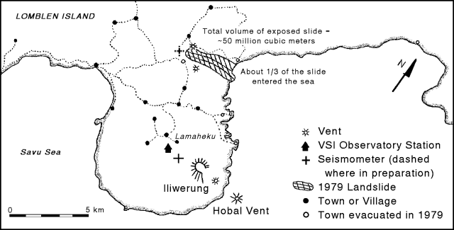 |
Figure 1. Map showing Iliwerung volcano, Hobal vent, and the known extent of the 1979 landslide that triggered a tsunami. Note that N is to the upper right. Courtesy of VSI. |
Depth to the Hobal vent has never been measured, though in 1979 the VSI estimated it at 50 m. The bathymetry of this region is also significant because of its relevance to tsunamis. A 1979 landslide NW of Iliwerung reached the sea (figure 1), and probably aided by additional submarine slumping, triggered a tsunami that killed hundreds of people. Several areas evacuated prior to the 1979 landslide and tsunami still remain evacuated. Relevant aspects of the tectonic setting, and the effects of a 1992 earthquake-triggered tsunami on the N side of Flores Island are discussed by Yeh and others (1993).
Seismic data were acquired by VSI prior to the September Hobal eruption. The data were received at Lamaheku seismic station, at ~75-m elevation on the W flank of Iliwerung, 4.5 km from the Hobal vent. The seismic record is incomplete, but for July to September 1992, the number of volcanic B-type earthquakes averaged more than 70/month, reaching ~96 in September 1992. A gap in the record occurred in early 1993, but later in the year B-type earthquakes progressively increased from ~30 in May to 60 in September. Thus, the B-type events increased prior to the September eruption, but at least one interval with more B-type events passed without reports of concurrent eruptions.
VSI has informed local governments about the hazards of future eruptions, and has established a volcanic danger area that includes at least four communities on Iliwerung. Local VSI staff continue to monitor the region, and as of 1 November, were in the process of installing a new seismic station.
Reference. Yeh, H., Imamura, F., Synolakis, C., Yoshinobu T., Liu, P., and Shi, S., 1993, The Flores Island tsunamis: Eos, Transactions of the American Geophysical Union, v. 74, no. 33.
Information Contacts: W. Tjetjep, VSI.
Increase in felt earthquakes during October 2001
During 17-26 October 2001 the Volcanological Survey of Indonesia reported an increase in felt earthquakes. A total of 2-11 events occurred per day, with Mercalli magnitudes of I-II. The earthquakes S and P wave arrival times differed by between 1 and 35 seconds. Visual and instrumental monitoring revealed a lack of significant changes. The Alert Level was increased from 1 to 2 (on a scale of 1-4). No further reports were issued through at least May 2003.
Information Contacts: Dali Ahmad, Volcanological Survey of Indonesia (VSI), Jalan Diponegoro No. 57, Bandung 40122, Indonesia (URL: http://www.vsi.esdm.go.id/).
Submarine flank eruption during August 2013 accompanied by crater fumarolic emissions
A submarine vent [~2 km ESE] of Iliwerung, named Hobal, erupted in December 1973-August 1974, August 1983 (SEAN 08:08), September 1993 (BGVN 28:06), and May-September 1999. No further activity was reported from this volcano until August 2013 when Hobal had another short eruption on the 20th.
The Center of Volcanology and Geological Hazard Mitigation (CVGHM) reported that observers at the observation post 6 km from Iliwerung saw diffuse fumarolic emissions from the crater during the mornings from 1 to 19 August 2013. The various seismic signals fluctuated during the month, but 81 shallow volcanic earthquakes were detected between 1606 and 1741 on 19 August. The Alert Level was raised to 2 (on a scale of 0-4).
At 0714 on 20 August 2013 an eruption from the submarine Hobal vent ejected dense white plumes to 2 km altitude that drifted S. Incandescence at sea level was observed at 0746, and the water around the eruption site turned yellow. Fishermen and tourists were not permitted within a 2 km radius of the activity.
Although seismicity had decreased on 19 August, the observers reported that the diffuse morning fumarolic crater emissions had continued through 1 September. On 2 September the Alert Level was lowered to 1 (on a scale of 0-4).
Information Contacts: Indonesian Center of Volcanology and Geological Hazard Mitigation, Pusat Vulkanologi dan Mitigasi Bencana Geologi (PVMBG, also known as CVGHM), Jalan Diponegoro 57, Bandung 40122, Indonesia (URL: http://www.vsi.esdm.go.id/).
Submarine eruption during 28-29 November 2021
Iliwerung is constructed on the southern rim of the Lerek caldera on the south-facing peninsula on Lembata Island. The summit lava dome was formed during an eruption in 1870. Beginning in 1973-1974, submarine eruptions began from the lower ESE flank Hobal vent, located 2 km from the summit crater. Since then, activity originated from this vent during eruptions in 1983, 1993, 1999, and 2013. The eruption in August 2013 that consisted of diffuse fumarolic emissions, incandescence at sea level, discolored water, and shallow volcanic earthquakes (BGVN 40:05). This report updates activity through December 2021 and describes a submarine eruption during 28-29 November 2021. Information primarily comes from Pusat Vulkanologi dan Mitigasi Bencana Geologi (PVMBG, also known as CVGHM, or the Center of Volcanology and Geological Hazard Mitigation).
A submarine eruption was observed during 28-29 November 2021, which prompted PVMBG to raise the Volcano Alert Level (VAL) to 2 (on a scale of 0-4). Residents reported that the ocean surface was bubbling up to heights of less than 1 m at 2152 on 28 November from a spot 30 m from the shore. This activity lasted about an hour and originated about 1 km SW of the Hobal submarine vent. Bubbling up was also observed at 0517 the next day on 29 November. Additional bubbling water and a plume was noted at 0829 that rose 100 m. Intermittent tremors were also detected, beginning on 29 November and continuing through the end of December.
Information Contacts: Pusat Vulkanologi dan Mitigasi Bencana Geologi (PVMBG, also known as Indonesian Center for Volcanology and Geological Hazard Mitigation, CVGHM), Jalan Diponegoro 57, Bandung 40122, Indonesia (URL: http://www.vsi.esdm.go.id/).
|
|
||||||||||||||||||||||||||
There is data available for 14 confirmed Holocene eruptive periods.
2021 Nov 28 - 2021 Nov 29 Confirmed Eruption (Explosive / Effusive) VEI: 0
| Episode 1 | Eruption (Explosive / Effusive) | ||||||||||||||||||||
|---|---|---|---|---|---|---|---|---|---|---|---|---|---|---|---|---|---|---|---|---|
| 2021 Nov 28 - 2021 Nov 29 | Evidence from Observations: Reported | |||||||||||||||||||
| A submarine eruption was observed during 28-29 November. Residents reported seeing the sea surface, 30 m from the shore to the S, bubbling up to heights of less than 1 m. The activity was about 1 km S of the Hobal submarine vent (about 3 km E of the summit). | ||||||||||||||||||||
|
List of 2 Events for Episode 1
|
||||||||||||||||||||
2013 Aug 20 - 2013 Aug 20 Confirmed Eruption (Explosive / Effusive) VEI: 0
| Episode 1 | Eruption (Explosive / Effusive) | Hobal (submarine vent on SE flank) | |||||||||||||||||||||||||||||||||||||||
|---|---|---|---|---|---|---|---|---|---|---|---|---|---|---|---|---|---|---|---|---|---|---|---|---|---|---|---|---|---|---|---|---|---|---|---|---|---|---|---|---|
| 2013 Aug 20 - 2013 Aug 20 | Evidence from Observations: Reported | |||||||||||||||||||||||||||||||||||||||
|
List of 6 Events for Episode 1 at Hobal (submarine vent on SE flank)
|
||||||||||||||||||||||||||||||||||||||||
1999 May 22 - 1999 Sep 16 (on or after) ± 15 days Confirmed Eruption (Explosive / Effusive) VEI: 0
| Episode 1 | Eruption (Explosive / Effusive) | Hobal (submarine vent on SE flank) | |||||||||||||||||||||||||||||||||||||||
|---|---|---|---|---|---|---|---|---|---|---|---|---|---|---|---|---|---|---|---|---|---|---|---|---|---|---|---|---|---|---|---|---|---|---|---|---|---|---|---|---|
| 1999 May 22 - 1999 Sep 16 (on or after) ± 15 days | Evidence from Observations: Reported | |||||||||||||||||||||||||||||||||||||||
|
List of 6 Events for Episode 1 at Hobal (submarine vent on SE flank)
|
||||||||||||||||||||||||||||||||||||||||
1993 Sep 15 - 1993 Sep 19 Confirmed Eruption (Explosive / Effusive) VEI: 2
| Episode 1 | Eruption (Explosive / Effusive) | Hobal (submarine vent on SE flank) | |||||||||||||||||||||||||||||||||||||||
|---|---|---|---|---|---|---|---|---|---|---|---|---|---|---|---|---|---|---|---|---|---|---|---|---|---|---|---|---|---|---|---|---|---|---|---|---|---|---|---|---|
| 1993 Sep 15 - 1993 Sep 19 | Evidence from Observations: Reported | |||||||||||||||||||||||||||||||||||||||
|
List of 6 Events for Episode 1 at Hobal (submarine vent on SE flank)
|
||||||||||||||||||||||||||||||||||||||||
1983 Aug 17 - 1983 Aug 18 Confirmed Eruption (Explosive / Effusive) VEI: 1
| Episode 1 | Eruption (Explosive / Effusive) | Hobal (submarine vent on SE flank) | |||||||||||||||||||||||||||||
|---|---|---|---|---|---|---|---|---|---|---|---|---|---|---|---|---|---|---|---|---|---|---|---|---|---|---|---|---|---|---|
| 1983 Aug 17 - 1983 Aug 18 | Evidence from Observations: Reported | |||||||||||||||||||||||||||||
|
List of 4 Events for Episode 1 at Hobal (submarine vent on SE flank)
|
||||||||||||||||||||||||||||||
[ 1976 Mar 8 ] Uncertain Eruption
| Episode 1 | Eruption (Explosive / Effusive) | Hobal (submarine vent on SE flank) | ||||||||||||||||||||||||
|---|---|---|---|---|---|---|---|---|---|---|---|---|---|---|---|---|---|---|---|---|---|---|---|---|---|
| 1976 Mar 8 - Unknown | Evidence from Unknown | ||||||||||||||||||||||||
|
List of 3 Events for Episode 1 at Hobal (submarine vent on SE flank)
|
|||||||||||||||||||||||||
1973 Dec 5 - 1974 Aug 22 Confirmed Eruption (Explosive / Effusive) VEI: 2
| Episode 1 | Eruption (Explosive / Effusive) | Hobal (submarine vent on SE flank) | ||||||||||||||||||||||||||||||||||||||||||||
|---|---|---|---|---|---|---|---|---|---|---|---|---|---|---|---|---|---|---|---|---|---|---|---|---|---|---|---|---|---|---|---|---|---|---|---|---|---|---|---|---|---|---|---|---|---|
| 1973 Dec 5 - 1974 Aug 22 | Evidence from Observations: Reported | ||||||||||||||||||||||||||||||||||||||||||||
|
List of 7 Events for Episode 1 at Hobal (submarine vent on SE flank)
|
|||||||||||||||||||||||||||||||||||||||||||||
1952 Mar 24 Confirmed Eruption (Explosive / Effusive) VEI: 1
| Episode 1 | Eruption (Explosive / Effusive) | ||||||||||||||||||||||||||||||
|---|---|---|---|---|---|---|---|---|---|---|---|---|---|---|---|---|---|---|---|---|---|---|---|---|---|---|---|---|---|---|
| 1952 Mar 24 - Unknown | Evidence from Observations: Reported | |||||||||||||||||||||||||||||
|
List of 4 Events for Episode 1
|
||||||||||||||||||||||||||||||
1951 Nov 12 - 1951 Nov 16 Confirmed Eruption (Explosive / Effusive) VEI: 2
| Episode 1 | Eruption (Explosive / Effusive) | ||||||||||||||||||||||||||||||||||||||||||||||||||
|---|---|---|---|---|---|---|---|---|---|---|---|---|---|---|---|---|---|---|---|---|---|---|---|---|---|---|---|---|---|---|---|---|---|---|---|---|---|---|---|---|---|---|---|---|---|---|---|---|---|---|
| 1951 Nov 12 - 1951 Nov 16 | Evidence from Observations: Reported | |||||||||||||||||||||||||||||||||||||||||||||||||
|
List of 8 Events for Episode 1
|
||||||||||||||||||||||||||||||||||||||||||||||||||
1950 Sep 10 - 1950 Oct 2 Confirmed Eruption (Explosive / Effusive) VEI: 2
| Episode 1 | Eruption (Explosive / Effusive) | ||||||||||||||||||||||||||||||||||||||||||||||||||||||||||||||||||||||
|---|---|---|---|---|---|---|---|---|---|---|---|---|---|---|---|---|---|---|---|---|---|---|---|---|---|---|---|---|---|---|---|---|---|---|---|---|---|---|---|---|---|---|---|---|---|---|---|---|---|---|---|---|---|---|---|---|---|---|---|---|---|---|---|---|---|---|---|---|---|---|
| 1950 Sep 10 - 1950 Oct 2 | Evidence from Observations: Reported | |||||||||||||||||||||||||||||||||||||||||||||||||||||||||||||||||||||
|
List of 12 Events for Episode 1
|
||||||||||||||||||||||||||||||||||||||||||||||||||||||||||||||||||||||
1949 Apr 9 - 1949 Apr 29 Confirmed Eruption (Explosive / Effusive) VEI: 2
| Episode 1 | Eruption (Explosive / Effusive) | |||||||||||||||||||||||||||||||||||||||||||||
|---|---|---|---|---|---|---|---|---|---|---|---|---|---|---|---|---|---|---|---|---|---|---|---|---|---|---|---|---|---|---|---|---|---|---|---|---|---|---|---|---|---|---|---|---|---|
| 1949 Apr 9 - 1949 Apr 29 | Evidence from Observations: Reported | ||||||||||||||||||||||||||||||||||||||||||||
|
List of 7 Events for Episode 1
|
|||||||||||||||||||||||||||||||||||||||||||||
1948 Apr 7 - 1948 Nov 26 Confirmed Eruption (Explosive / Effusive) VEI: 2
| Episode 1 | Eruption (Explosive / Effusive) | East flank (Iligripe) | |||||||||||||||||||||||||||||||||||||||||||||||||||||||||||
|---|---|---|---|---|---|---|---|---|---|---|---|---|---|---|---|---|---|---|---|---|---|---|---|---|---|---|---|---|---|---|---|---|---|---|---|---|---|---|---|---|---|---|---|---|---|---|---|---|---|---|---|---|---|---|---|---|---|---|---|---|
| 1948 Apr 7 - 1948 Nov 26 | Evidence from Observations: Reported | |||||||||||||||||||||||||||||||||||||||||||||||||||||||||||
|
List of 10 Events for Episode 1 at East flank (Iligripe)
|
||||||||||||||||||||||||||||||||||||||||||||||||||||||||||||
[ 1941 Jun 5 ] Uncertain Eruption
| Episode 1 | Eruption (Explosive / Effusive) | |||||||||||||||
|---|---|---|---|---|---|---|---|---|---|---|---|---|---|---|---|
| 1941 Jun 5 - Unknown | Evidence from Unknown | ||||||||||||||
|
List of 1 Events for Episode 1
|
|||||||||||||||
1928 Confirmed Eruption (Explosive / Effusive) VEI: 2
| Episode 1 | Eruption (Explosive / Effusive) | Iliwerung | ||||||||||||||||||||||||
|---|---|---|---|---|---|---|---|---|---|---|---|---|---|---|---|---|---|---|---|---|---|---|---|---|---|
| 1928 - Unknown | Evidence from Observations: Reported | ||||||||||||||||||||||||
|
List of 3 Events for Episode 1 at Iliwerung
|
|||||||||||||||||||||||||
1910 Confirmed Eruption (Explosive / Effusive) VEI: 2
| Episode 1 | Eruption (Explosive / Effusive) | Iliwerung | |||||||||||||||||||
|---|---|---|---|---|---|---|---|---|---|---|---|---|---|---|---|---|---|---|---|---|
| 1910 - Unknown | Evidence from Observations: Reported | |||||||||||||||||||
|
List of 2 Events for Episode 1 at Iliwerung
|
||||||||||||||||||||
1870 Confirmed Eruption (Explosive / Effusive) VEI: 3
| Episode 1 | Eruption (Explosive / Effusive) | Iliwerung (Iliadowajo) | |||||||||||||||||||||||||||||
|---|---|---|---|---|---|---|---|---|---|---|---|---|---|---|---|---|---|---|---|---|---|---|---|---|---|---|---|---|---|---|
| 1870 - Unknown | Evidence from Observations: Reported | |||||||||||||||||||||||||||||
|
List of 4 Events for Episode 1 at Iliwerung (Iliadowajo)
|
||||||||||||||||||||||||||||||
This compilation of synonyms and subsidiary features may not be comprehensive. Features are organized into four major categories: Cones, Craters, Domes, and Thermal Features. Synonyms of features appear indented below the primary name. In some cases additional feature type, elevation, or location details are provided.
Synonyms |
||||
| Iliweroeng | Hiro | Lama Heru | Ilipoegora | Penoetoen | ||||
Cones |
||||
| Feature Name | Feature Type | Elevation | Latitude | Longitude |
| Hobal | Submarine cone | 8° 32' 17.00" S | 123° 35' 31.00" E | |
Craters |
||||
| Feature Name | Feature Type | Elevation | Latitude | Longitude |
| Ado Wajung
Ado Wadjung |
Crater | 1018 m | ||
| Lerek | Caldera | |||
| Lusitobe North | Crater | 300 m | ||
| Lusitobe South | Crater | 247 m | ||
Domes |
||||
| Feature Name | Feature Type | Elevation | Latitude | Longitude |
| Iligripe
Ilipetrus |
Dome - Crater | 190 m | ||
| Ilimonjet | Dome | 592 m | ||
| Ilipenutun | Dome | 172 m | ||
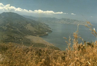 A landslide in 1979, not associated with an eruption, originated from the northern end of the Iliwerung volcanic massif. The resulting debris avalanche swept into the Indian Ocean at a high velocity and produced a tsunami that scoured the shoreline of Lembata (Lomblen) Island, killing more than 500 people. The extent of the runup of the tsunami can be seen forming the flat barren area in the center of the photo, which was taken from the SW on 27 July 1979, shortly after the tsunami.
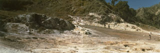 The Watuwawer fumarole field at Iliwerung volcano provides a permanent heat source for cooking utilized by people living on the flanks of the volcano.
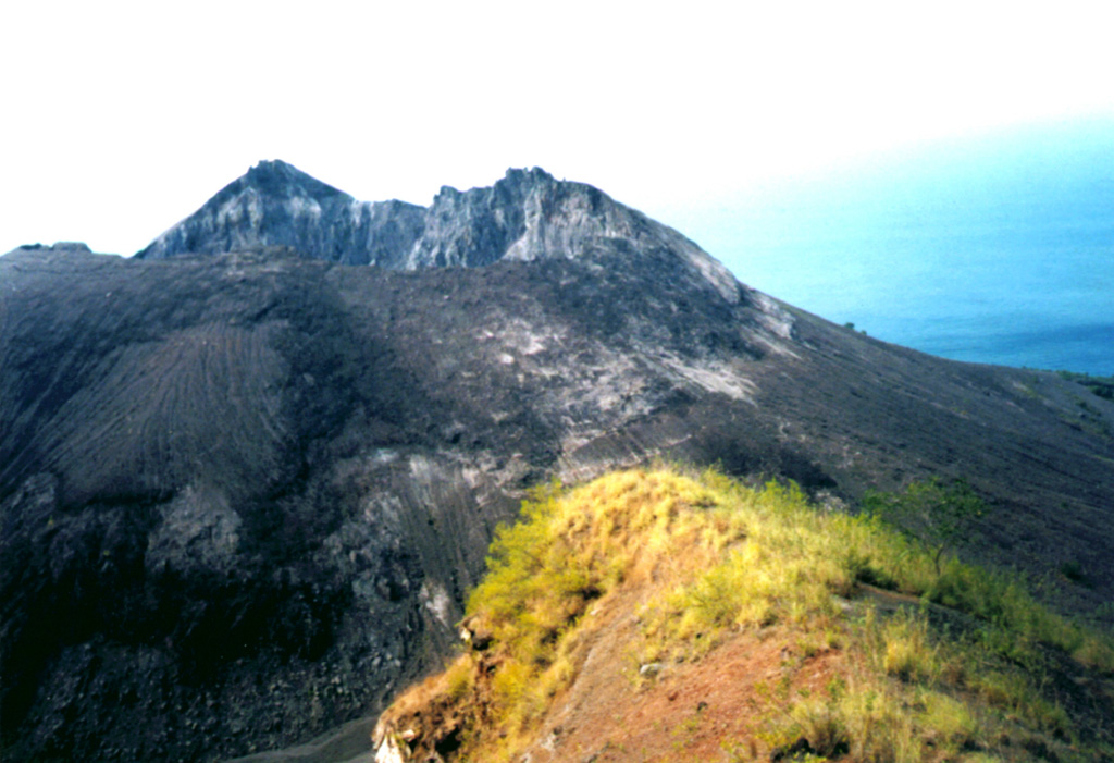
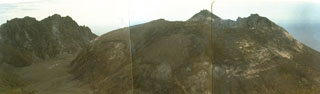 A lava dome, formed during the first historical eruption of Iliwerung volcano in 1870, occupies the summit crater of the volcano, seen here in 1979 from the western rim of Ado Wajung crater. Iliwerung forms one of the south-facing peninsulas on Lembata (Lomblen) Island, and has a series of lava domes and craters along N-S and NW-SE lines. Many of these vents, including submarine vents offshore, have erupted in historical time.
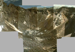 A composite photo taken in 1979 shows the crater at summit of Iliwerung lava dome. The summit lava dome was formed during an eruption in 1870, the first historical eruption of Iliwerung volcano.
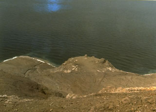 Iligripe lava dome on the SE flank of Iliwerung volcano on Lembata (formerly Lomblen) Island formed during an eruption from April 7 to November 26, 1948. Growth of the 190-m-high lava dome, seen here at the center of this 1979 photo, was accompanied by explosive eruptions and pyroclastic flows.
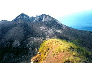 A lava dome, formed during the first historical eruption of Iliwerung volcano in 1870, occupies the summit crater of the volcano, seen here in 1979 from the rim of Ado Wajung crater. Iliwerung forms one of the south-facing peninsulas on Lembata (formerly Lomblen) Island, and has a series of lava domes and craters along N-S and NW-SE lines. Many of these vents, including submarine vents offshore, have erupted in historical time.
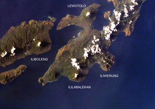 Four volcanoes are seen in this NASA International Space Station image (with north to the upper left) of Solor (lower left), Adonara (upper left), and Lembata (right) Islands. Ililabalekan volcano on SW Lembata (formerly Lomblen) Island is the only one of these without historical eruptions, although fumaroles are found near its summit. A satellitic cone was constructed on the SE flank of the steep-sided volcano, and four craters, one of which contains a lava dome and two small explosion pits, occur at the summit of Mount Labalekan.
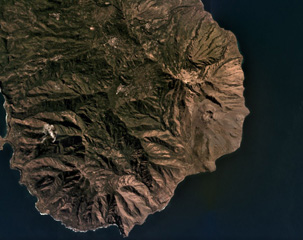 Iliwerung forms a peninsula in southern Lembata island, seen here in this July 2019 Planet Labs satellite image monthly mosaic (N is at the top; this image is approximately 11 km across). The 330 x 400 m recent crater is near the eastern coastline in this view and submarine eruptions have produced ephemeral islands off the SE flank.
There are no samples for Iliwerung in the Smithsonian's NMNH Department of Mineral Sciences Rock and Ore collection.
| Copernicus Browser | The Copernicus Browser replaced the Sentinel Hub Playground browser in 2023, to provide access to Earth observation archives from the Copernicus Data Space Ecosystem, the main distribution platform for data from the EU Copernicus missions. |
| MIROVA | Middle InfraRed Observation of Volcanic Activity (MIROVA) is a near real time volcanic hot-spot detection system based on the analysis of MODIS (Moderate Resolution Imaging Spectroradiometer) data. In particular, MIROVA uses the Middle InfraRed Radiation (MIR), measured over target volcanoes, in order to detect, locate and measure the heat radiation sourced from volcanic activity. |
| MODVOLC Thermal Alerts | Using infrared satellite Moderate Resolution Imaging Spectroradiometer (MODIS) data, scientists at the Hawai'i Institute of Geophysics and Planetology, University of Hawai'i, developed an automated system called MODVOLC to map thermal hot-spots in near real time. For each MODIS image, the algorithm automatically scans each 1 km pixel within it to check for high-temperature hot-spots. When one is found the date, time, location, and intensity are recorded. MODIS looks at every square km of the Earth every 48 hours, once during the day and once during the night, and the presence of two MODIS sensors in space allows at least four hot-spot observations every two days. Each day updated global maps are compiled to display the locations of all hot spots detected in the previous 24 hours. There is a drop-down list with volcano names which allow users to 'zoom-in' and examine the distribution of hot-spots at a variety of spatial scales. |
|
WOVOdat
Single Volcano View Temporal Evolution of Unrest Side by Side Volcanoes |
WOVOdat is a database of volcanic unrest; instrumentally and visually recorded changes in seismicity, ground deformation, gas emission, and other parameters from their normal baselines. It is sponsored by the World Organization of Volcano Observatories (WOVO) and presently hosted at the Earth Observatory of Singapore.
GVMID Data on Volcano Monitoring Infrastructure The Global Volcano Monitoring Infrastructure Database GVMID, is aimed at documenting and improving capabilities of volcano monitoring from the ground and space. GVMID should provide a snapshot and baseline view of the techniques and instrumentation that are in place at various volcanoes, which can be use by volcano observatories as reference to setup new monitoring system or improving networks at a specific volcano. These data will allow identification of what monitoring gaps exist, which can be then targeted by remote sensing infrastructure and future instrument deployments. |
| Volcanic Hazard Maps | The IAVCEI Commission on Volcanic Hazards and Risk has a Volcanic Hazard Maps database designed to serve as a resource for hazard mappers (or other interested parties) to explore how common issues in hazard map development have been addressed at different volcanoes, in different countries, for different hazards, and for different intended audiences. In addition to the comprehensive, searchable Volcanic Hazard Maps Database, this website contains information about diversity of volcanic hazard maps, illustrated using examples from the database. This site is for educational purposes related to volcanic hazard maps. Hazard maps found on this website should not be used for emergency purposes. For the most recent, official hazard map for a particular volcano, please seek out the proper institutional authorities on the matter. |
| IRIS seismic stations/networks | Incorporated Research Institutions for Seismology (IRIS) Data Services map showing the location of seismic stations from all available networks (permanent or temporary) within a radius of 0.18° (about 20 km at mid-latitudes) from the given location of Iliwerung. Users can customize a variety of filters and options in the left panel. Note that if there are no stations are known the map will default to show the entire world with a "No data matched request" error notice. |
| UNAVCO GPS/GNSS stations | Geodetic Data Services map from UNAVCO showing the location of GPS/GNSS stations from all available networks (permanent or temporary) within a radius of 20 km from the given location of Iliwerung. Users can customize the data search based on station or network names, location, and time window. Requires Adobe Flash Player. |
| DECADE Data | The DECADE portal, still in the developmental stage, serves as an example of the proposed interoperability between The Smithsonian Institution's Global Volcanism Program, the Mapping Gas Emissions (MaGa) Database, and the EarthChem Geochemical Portal. The Deep Earth Carbon Degassing (DECADE) initiative seeks to use new and established technologies to determine accurate global fluxes of volcanic CO2 to the atmosphere, but installing CO2 monitoring networks on 20 of the world's 150 most actively degassing volcanoes. The group uses related laboratory-based studies (direct gas sampling and analysis, melt inclusions) to provide new data for direct degassing of deep earth carbon to the atmosphere. |
| Large Eruptions of Iliwerung | Information about large Quaternary eruptions (VEI >= 4) is cataloged in the Large Magnitude Explosive Volcanic Eruptions (LaMEVE) database of the Volcano Global Risk Identification and Analysis Project (VOGRIPA). |
| EarthChem | EarthChem develops and maintains databases, software, and services that support the preservation, discovery, access and analysis of geochemical data, and facilitate their integration with the broad array of other available earth science parameters. EarthChem is operated by a joint team of disciplinary scientists, data scientists, data managers and information technology developers who are part of the NSF-funded data facility Integrated Earth Data Applications (IEDA). IEDA is a collaborative effort of EarthChem and the Marine Geoscience Data System (MGDS). |

