Based on information from KEMSD, the Tokyo VAAC reported that an eruption plume from Avachinsky rose to an altitude of 4.3 km (14,000 ft) a.s.l. and drifted S and E on 10 May. [Note: KVERT did not detect ash on satellite imagery nor by direct observation.]
Source: Tokyo Volcanic Ash Advisory Center (VAAC)
Shallow earthquakes in 2005; plume in 2008
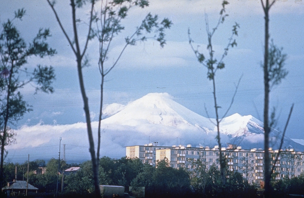
This report discusses Avachinsky in 2001-2010. Following lava flows emitted in 1991 (BGVN 16:12), Avachinsky generated near-daily fumarolic plumes and generally low (background) seismicity (figure 3). The escaping gases contained sufficient sulfur to construct an area of sulfurous deposits at a prominent NW-trending crack on the SW rim of the summit crater. In 2001 a series of minor earthquakes were sometimes accompanied by gas-and-steam plumes (some with ash) (BGVN 26:11). Weak fumarolic activity and small mudflows also were observed.
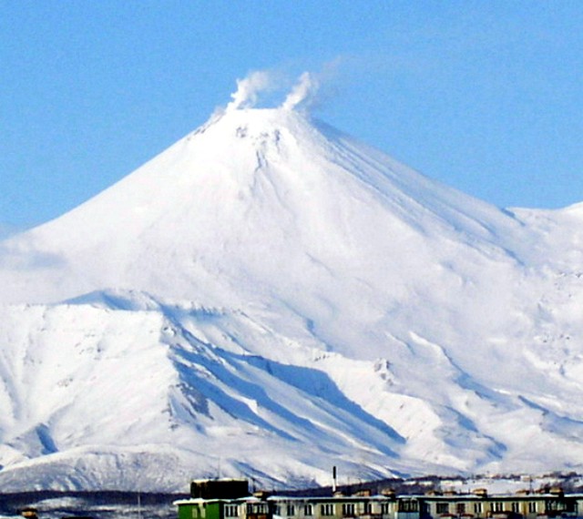 |
Figure 3. View of Avachinsky volcano from the W on 24 March 2004. From Droznin and others (2004?). |
By November 2001, seismic activity had declined to background levels where it apparently remained until 2005. On 8 November 2005, the Kamchatkan Volcanic Eruption Response Team (KVERT) reported that the number and energy of shallow earthquakes below Avachinsky had increased during the previous month. A weak thermal anomaly near the volcano's summit was visible on satellite imagery on 7 November. Seismicity increased significantly on 21 November, with very shallow earthquakes and several hybrid earthquakes. A weak thermal anomaly near the summit was visible on satellite imagery during 20-21 November.
During 2006 moderate fumarolic activity occurred, producing a steam plume about 700 m above crater. Seismicity was at background levels, with occasional weak seismic events at 500 m depth.
On 10 May 2008, a plume from Avachinsky rose to an altitude of 4.3 km and drifted S and E. KVERT did not detect ash by direct observation or on satellite imagery.
Cross-sectional view. A topographical profile of the volcano (figure 4) shows the inferred geothermal reservoir. The possible drill hole (dark line) and plant are only in proposal stages.
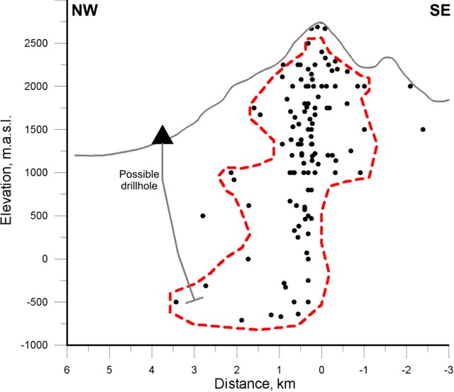 |
Figure 4. Inferred boundaries of geothermal reservoirs (dashed line) in vertical cross-sections of the Avachinsky volcano. Circles depict earthquake hypocenters associated with a steam eruption in 2001 (data from four stations, Kamchatka EMSD GS RAS). From Droznin and others (2004?). |
Droznin and others (2004?) note that "The heat discharge of the fumaroles may be estimated based on the geometrical characteristics of their clouds, taking into account local meteorological conditions.... The Avachinsky volcano fumaroles have been monitored since 2003 for the purpose of using the size of the fumaroles clouds to estimate the corresponding heat discharge. Its worth noting, that the real size of the thermo-clouds may be estimated only when there is 100% air saturation.
"The October 2001 eruption revealed an active steam-dominated reservoir below the lava plug of 1991. The swarm of the earthquakes hypocenters synchronized with the eruption 2001, showing the true geometrical size of the steam-dominated reservoir [figure 4]. This 1-km radius reservoir extends from the elevation of the lava plug at 2,750 m a.s.l. to -1,000 m a.s.l., where some north east trend shifting of the reservoir occurs. Similar earthquake distributions were detected in 2004."
Reference. Droznin, V.A., Dubrovskaya, I.K., Kiryukhin, A.V., Chernykh, E.V., Senyukov, S.L., and Ivanysko G.O., 2004(?), Avachinsky volcano geothermal reservoir based on fumaroles activity and seismological network data; (undated) Report of the Institute of Volcanology FEB RAS, Piip-9, Petropavlovsk-Kamchatsky, Russia, 683006.
Information Contacts: Kamchatka Volcanic Eruptions Response Team (KVERT), Far East Division, Russian Academy of Sciences, 9 Piip Blvd., Petropavlovsk-Kamchatsky, 683006, Russia (URL: http://www.kscnet.ru/ivs/); Tokyo Volcanic Ash Advisory Centre, Tokyo, Japan (URL: http://ds.data.jma.go.jp/svd/vaac/data/); Kamchatkan Experimental and Methodical Seismological Department (KEMSD), Geophysical service, Russian Academy of Science (URL: http://www.emsd.iks.ru/index-e.php).
2008: May
2005: November
2001: October
Based on information from KEMSD, the Tokyo VAAC reported that an eruption plume from Avachinsky rose to an altitude of 4.3 km (14,000 ft) a.s.l. and drifted S and E on 10 May. [Note: KVERT did not detect ash on satellite imagery nor by direct observation.]
Source: Tokyo Volcanic Ash Advisory Center (VAAC)
Seismic activity at Avachinsky began to increase significantly on 21 November, with very shallow earthquakes and several hybrid earthquakes recorded at the volcano during 0800-2400. A weak thermal anomaly near the volcano's summit was visible on satellite imagery during 20-21 November. KVERT reported that based on these changes, the possibility of sudden ash explosions had increased. The Concern Color Code remained at Yellow as it has since 8 November.
Source: Kamchatkan Volcanic Eruption Response Team (KVERT)
KVERT reported on 8 November that the number and energy of shallow earthquakes below Avachinsky increased during the previous month. A weak thermal anomaly near the volcano's summit was visible on satellite imagery on 7 November. KVERT reported that based on these changes the possibility of sudden ash explosions at Avachinsky had increased, so the Concern Color Code was raised from Green to Yellow on 8 November.
Source: Kamchatkan Volcanic Eruption Response Team (KVERT)
During 26 October to 2 November seismicity was at background levels, with only weak earthquakes detected (magnitudes less than or equal to 1.2). During 29 October to 1 November, when the volcano was visible, weak-to-powerful gas-and-steam emissions were observed extending to the SE and E. The Concern Color Code was reduced from Yellow to Green.
Source: Kamchatkan Volcanic Eruption Response Team (KVERT)
During 19-26 October several gas-and-steam plumes rose above Avachinsky's crater, with the highest plume reaching 1 km and extending 20 km to the SE on 20 October. Seismic activity continued above background levels; ten earthquakes occurred with magnitudes of 1.3-2.1. The volcano remained at Concern Color Code Yellow.
Source: Kamchatkan Volcanic Eruption Response Team (KVERT)
During 12-19 October gas-and-steam plumes rose above Avachinsky's crater and until 18 October seismicity was at background levels or was not registered. During 18 and 19 October a series of weak local earthquakes were detected ~700 m beneath the summit. On 17 October a fracture was observed in the lava dome that extended E-SE and W-NW, joining the hottest parts of the edifice. The fracture extended 100-150 m down the flanks of the cone.The volcano remained at Concern Color Code Yellow.
Source: Kamchatkan Volcanic Eruption Response Team (KVERT)
Intense gas-and-steam plumes rose above the volcano several times during 6-11 October, with the highest plume climbing 500 m. During the report period, weak fumarolic activity occurred and seismicity was at background levels. Satellite imagery on 2 October showed a broad band of warm ground that appeared to follow the rim of the crater, with a small area of warm ground in the center of the crater. The volcano remained at Concern Color Code Yellow.
Source: Kamchatkan Volcanic Eruption Response Team (KVERT)
During 25 August until at least 5 October several earthquakes, with magnitudes between 1.2 and 2.5, were detected near Avachinsky. On 5 October at 0759 an earthquake inside the volcano's edifice was accompanied by a small gas-and-steam explosion with small amounts of ash that rose less than 1 km above the crater. A thin layer of ash covered the SE sector of the volcano's edifice. The same day at 1000 larger gas-and-steam plumes were observed rising above the volcano. Mudflows traveled 50-100 m down Avachinsky's SE slope. KVERT personnel believe the mudflows were caused by intensive activity at a single fumarole on the SE side of the summit. On 5 October the Concern Color Code at Avachinsky was raised from Green to Yellow.
Source: Kamchatkan Volcanic Eruption Response Team (KVERT)
Reports are organized chronologically and indexed below by Month/Year (Publication Volume:Number), and include a one-line summary. Click on the index link or scroll down to read the reports.
Explosions feed 4-5-km tephra clouds; lava in crater; flank mudflows
An eruption began on 13 January with explosions at 1158 and 1203 that ejected ash clouds to 4-5 km above the crater. Ash fell on Petropavlovsk, roughly 30 km SSW. Lava was observed in the crater and small mudflows moved down the flanks. No pre-eruption seismicity was recorded, but seismic activity associated with the eruption was increasing as of 17 January.
Information Contacts: B. Ivanov, IV.
Lava dome filled crater during January 1991 eruption
The following supplements the preliminary report in 15:12. The eruption lasted until 30 January 1991, filling the summit crater (400-500 m in diameter) with ~21 x 106 metric tons of lava (figure 1). Circumferential and radial fissures 6 m deep covered the surface of the lava dome. Lava overflowed the S rim, feeding a flow that advanced 1.5 km down the SSE flank and short flows on the SW flank. Numerous fumaroles developed around the dome's margins.
 |
Figure 1. View looking NW at the summit of Avachinsky, 11 October 1991. The summit crater (400-500 m in diameter) is filled with lava from the January 1991 eruption. Small lava flows at right extend down the SW flank. Photo taken by A. Ovsyannikov. |
Information Contacts: IVGG.
Fumarolic activity around 1991 dome
Fumarolic activity was occurring from numerous points around the margins of the January 1991 lava dome during a 13 May overflight. Numerous circumferential and radial fissures, previously observed in October 1991, covered the dome's surface, but the small lava flows that extended down the SSE and SW flanks were no longer visible.
Information Contacts: H. Gaudru, SVE, Switzerland; G. de St. Cyr, T. de St. Cyr, and I. de St. Cyr, Lyon, France; T. Vaudelin, Genève, Switzerland.
Fumarolic activity
Fumarolic activity observed in late April from the crater area resulted from normal condensation of steam and was not caused by eruptive activity.
Information Contacts: V. Kirianov, IVGG.
Intense fumarolic activity
Summit crater observations were made by SVE team members during an overflight on 24 August. Fumarolic activity was very intense on and around the crater, and a very active fumarole field, with many yellow sulfur deposits, occupied a large area just below the rim on the SW slope. No fresh lava was visible on the surface of the lava plug that filled the summit crater . . . during the January 1991 eruption.
Information Contacts: H. Gaudru, SVE, Switzerland.
Usual fumarolic activity; seismicity low
Helicopter observations on 12-13 September revealed only the usual fumarolic activity, which was continuing through 6 November. Seismicity also remained at background levels of ~2-3 earthquakes/day through 28 October, except for an increase to ~8-10 earthquakes/day at depths of 1-2 km during the week of 14-21 October.
Information Contacts: V. Kirianov, IVGG.
Fumarolic activity from central crater
Seismicity was at background levels from mid-December into early January. During 4-6 January, a slight increase in seismic activity (16 events) was recorded at the volcano, but seismicity had returned to background levels (2-3 events/day) by mid-month. Seismicity was again above background in late January through mid-February. Strong fumarolic activity continued from the summit lava flow in the central crater. Similar activity was noted in May 1992, and in April, August, September, and October 1993.
Information Contacts: V. Kirianov, IVGG.
Increased seismicity and a higher steam plume
On 7 March the Institute of Volcanic Geology and Geochemistry (IVGG) reported a noteworthy increase in seismicity beneath Avachinsky and an increase in the height of the steam plume to ~100 m above the volcano. The steam plume suggested a possible increase in heat flux. The IVGG reported that the possibility of an eruption within the next few weeks to months has increased significantly. Elevated seismicity was previously reported in late 1993 and early 1994 (BGVN 19:01).
Information Contacts: Tom Miller, Alaska Volcano Observatory (URL: https://www.avo.alaska.edu/); Vladimir Kirianov, Institute of Volcanic Geology and Geochemistry, Piip Ave. 9, Petropavlovsk-Kamchatsky, 683006, Russia.
Normal seismic activity and degassing
Seismicity remained slightly above or at normal levels in June and the first half of July. Normal fumarolic activity was seen above the crater. Regular reports from KVERT (via AVO) resumed in June after funding problems in Russia halted communications in December 1994 (BGVN 19:11).
Information Contacts: Tom Miller, Alaska Volcano Observatory (AVO); Vladimir Kirianov, Kamchatka Volcanic Eruptions Response Team (KVERT), Institute of Volcanic Geology and Geochemistry, Russia.
Normal seismic and fumarolic activity
Seismicity was about at background level during September, October, and November. Normal fumarolic emissions were observed above the crater.
Information Contacts: Tom Miller, Alaska Volcano Observatory (AVO); Vladimir Kirianov, Kamchatka Volcanic Eruptions Response Team (KVERT), Institute of Volcanic Geology and Geochemistry, Russia.
Fumarolic plume on 22 December
Seismicity continued at normal background levels during November 1996-December 1997. On 22 December, a fumarolic plume rose ~200 m above the crater.
Information Contacts: Vladimir Kirianov, Kamchatka Volcanic Eruptions Response Team (KVERT), Institute of Volcanic Geology and Geochemistry, Russia; Tom Miller, Alaska Volcano Observatory (AVO).
Distinct change in seismic activity
A distinct change in seismic activity began on 3 December. About 120 shallow events of very low magnitude were recorded during 3-6 December. The only days during the episode when observation was not obscured by cloud were 1 and 3-6 December, but no plumes were seen those days.
Information Contacts: Olga Chubarova, Kamchatka Volcanic Eruptions Response Team (KVERT), Institute of Volcanic Geology and Geochemistry, Piip Ave. 9, Petropavlovsk-Kamchatsky, 683006, Russia; Tom Miller, Alaska Volcano Observatory (AVO), a cooperative program of a) U.S. Geological Survey, 4200 University Drive, Anchorage, AK 99508-4667, USA (URL: http://www.avo.alaska.edu/), b) Geophysical Institute, University of Alaska, PO Box 757320, Fairbanks, AK 99775-7320, USA, and c) Alaska Division of Geological & Geophysical Surveys, 794 University Ave., Suite 200, Fairbanks, AK 99709, USA.
Modest October steam plumes reach 10 km long; minor ash eruption 5 October
Seismic activity increased at Avachinsky during early December 1998 (BGVN 23:11). After that, seismicity stayed mostly at background levels until 25 August 2001, when it increased slightly, and was variable through at least October.
On 31 August, three earthquakes were registered, M 1.7, 2.2, and 2.6. On 20 September an M 1.7 earthquake occurred. On 21 September from 1705 until 1721, a series of earthquakes within the volcano's edifice was recorded, including an M 2.5 event at a depth of ~4 km. On 22 September at 0500 UTC, a 3-pixel thermal anomaly was clearly seen in an AVHRR image of Avachinsky.
At 0750 on 5 October, with an accompanying M 1.5 earthquake, a small explosion lofted ash to less than 1 km above the crater with minor ash falling on the SE flank. Around 19 October a series of weak local earthquakes (~ 50 events of M 0.5-1.5) was registered within 24 hours in the edifice at a depth of ~700 m beneath the summit.
Weak fumarolic activity was observed during 20, 23, 26, and 28 September, and 2-4, 10, 11, 16, and 17 October. In contrast, on 6 October fumarolic activity was observed over the entire crater. Small mudflows down the SE flank were visible in late September after every snowfall, presumably due to strong thermal activity of a fumarole on the SE crater rim. Gas-and-steam plumes were observed several times during September and October 2001 (figure 2 and table 1) when clouds did not obscure the volcano.
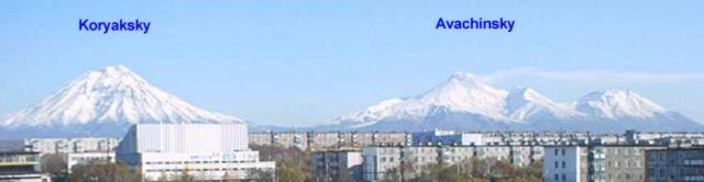 |
Figure 2. Avachinsky (summit elevation, 2,741 m) and Koryaksky (3,456 m) stratovolcanoes as seen from the city of Petropavlovsk on 13 October 2001. They reside 35-40 km NE of the city and their summits are separated by 12 km. A white plume is extending E from Avachinsky. Courtesy of KVERT. |
Table 1. Gas-and-steam plumes reported at Avachinsky during September and October 2001. Courtesy KVERT.
| Date | Time | Plume height / location |
| 19 Sep 2001 | -- | 30 m above crater. |
| 06 Oct 2001 | 1250 | Low over crater, extending 10 km SE. |
| 07 Oct 2001 | 0850 | Rising 50 m over the crater and extending SSE. |
| 07 Oct 2001 | 1700 | Rising 200 m above crater. |
| 09 Oct 2001 | -- | Rising low above crater, extending 5 km E. |
| 11 Oct 2001 | 0940 | Rising 200 m and extending 5 km E. |
| 12 Oct 2001 | 2000 | Rising over the crater and extending 1 km E. |
| 13 Oct 2001 | 1130 | Extending 10 km E. |
| 13 Oct 2001 | 2000 | Extending 10 km E. |
| 20 Oct 2001 | 1430-1930 | Rising ~1 km above the crater; extending 20 km SE. |
| 21-22 Oct 2001 | -- | Rising 50-200 m above the crater and extending SE, E, and NE. |
A band-6 satellite image on 2 October showed a broad area of warm ground that appeared to follow the rim of the crater, with a small area in the center of the crater. Band-7 data on 2 October showed hotter areas in the SE and SW parts of the crater, and possibly on the N side. On 5 October, the Concern Color Code was increased from Green (volcano is dormant; normal seismicity and fumarolic activity) to Yellow (volcano is restless; eruption may occur). A large, elongate cloud was recorded extending to the SE from the volcano at 1830 on 8 October.
The last explosive eruption at Avachinsky occurred in 1991 and lasted 6 days. The eruption began with two ash explosions directed SW toward Petropavlovsk, and covered the town with an ash layer a few millimeters thick. Effusion of lava began 28 hours later. Further explosive activity occurred simultaneously with the lava emission. As a result of the eruption, a lava plug filled the entire crater.
The Kamchatka Volcanic Eruptions Response Team (KVERT) speculated that the recent activity at Avachinsky could indicate the occurrence of a scenario similar to the eruptions in the years 1737 and 1827. Present activity could lead to a large eruption accompanied by directed blasts with voluminous tephra, debris avalanches, and mudflows. Or, gradual damage of the plug might occur by various means, including earthquakes, small explosive discharges, mudflows, etc. Both scenarios could pose a potential hazard to nearby farm cottages (dachas), the Radyugina settlement, and Petropavlovsk-Kamchatsky city.
Information Contacts: Olga Girina and Lilia Bazanov, Kamchatka Volcanic Eruptions Response Team (KVERT), Institute of Volcanic Geology and Geochemistry, Piip Ave. 9, Petropavlovsk-Kamchatsky, 683006, Russia; John C. Eichelberger and Tom Murray, Alaska Volcano Observatory (AVO), a cooperative program of a) U.S. Geological Survey, 4200 University Drive, Anchorage, AK 99508-4667, USA (URL: http://www.avo.alaska. edu/), b) Geophysical Institute, University of Alaska, PO Box 757320, Fairbanks, AK 99775-7320, USA, and c) Alaska Division of Geological & Geophysical Surveys, 794 University Ave., Suite 200, Fairbanks, AK 99709, USA.
Shallow earthquakes in 2005; plume in 2008
This report discusses Avachinsky in 2001-2010. Following lava flows emitted in 1991 (BGVN 16:12), Avachinsky generated near-daily fumarolic plumes and generally low (background) seismicity (figure 3). The escaping gases contained sufficient sulfur to construct an area of sulfurous deposits at a prominent NW-trending crack on the SW rim of the summit crater. In 2001 a series of minor earthquakes were sometimes accompanied by gas-and-steam plumes (some with ash) (BGVN 26:11). Weak fumarolic activity and small mudflows also were observed.
|
Figure 3. View of Avachinsky volcano from the W on 24 March 2004. From Droznin and others (2004?). |
By November 2001, seismic activity had declined to background levels where it apparently remained until 2005. On 8 November 2005, the Kamchatkan Volcanic Eruption Response Team (KVERT) reported that the number and energy of shallow earthquakes below Avachinsky had increased during the previous month. A weak thermal anomaly near the volcano's summit was visible on satellite imagery on 7 November. Seismicity increased significantly on 21 November, with very shallow earthquakes and several hybrid earthquakes. A weak thermal anomaly near the summit was visible on satellite imagery during 20-21 November.
During 2006 moderate fumarolic activity occurred, producing a steam plume about 700 m above crater. Seismicity was at background levels, with occasional weak seismic events at 500 m depth.
On 10 May 2008, a plume from Avachinsky rose to an altitude of 4.3 km and drifted S and E. KVERT did not detect ash by direct observation or on satellite imagery.
Cross-sectional view. A topographical profile of the volcano (figure 4) shows the inferred geothermal reservoir. The possible drill hole (dark line) and plant are only in proposal stages.
|
Figure 4. Inferred boundaries of geothermal reservoirs (dashed line) in vertical cross-sections of the Avachinsky volcano. Circles depict earthquake hypocenters associated with a steam eruption in 2001 (data from four stations, Kamchatka EMSD GS RAS). From Droznin and others (2004?). |
Droznin and others (2004?) note that "The heat discharge of the fumaroles may be estimated based on the geometrical characteristics of their clouds, taking into account local meteorological conditions.... The Avachinsky volcano fumaroles have been monitored since 2003 for the purpose of using the size of the fumaroles clouds to estimate the corresponding heat discharge. Its worth noting, that the real size of the thermo-clouds may be estimated only when there is 100% air saturation.
"The October 2001 eruption revealed an active steam-dominated reservoir below the lava plug of 1991. The swarm of the earthquakes hypocenters synchronized with the eruption 2001, showing the true geometrical size of the steam-dominated reservoir [figure 4]. This 1-km radius reservoir extends from the elevation of the lava plug at 2,750 m a.s.l. to -1,000 m a.s.l., where some north east trend shifting of the reservoir occurs. Similar earthquake distributions were detected in 2004."
Reference. Droznin, V.A., Dubrovskaya, I.K., Kiryukhin, A.V., Chernykh, E.V., Senyukov, S.L., and Ivanysko G.O., 2004(?), Avachinsky volcano geothermal reservoir based on fumaroles activity and seismological network data; (undated) Report of the Institute of Volcanology FEB RAS, Piip-9, Petropavlovsk-Kamchatsky, Russia, 683006.
Information Contacts: Kamchatka Volcanic Eruptions Response Team (KVERT), Far East Division, Russian Academy of Sciences, 9 Piip Blvd., Petropavlovsk-Kamchatsky, 683006, Russia (URL: http://www.kscnet.ru/ivs/); Tokyo Volcanic Ash Advisory Centre, Tokyo, Japan (URL: http://ds.data.jma.go.jp/svd/vaac/data/); Kamchatkan Experimental and Methodical Seismological Department (KEMSD), Geophysical service, Russian Academy of Science (URL: http://www.emsd.iks.ru/index-e.php).
|
|
||||||||||||||||||||||||||||
There is data available for 55 confirmed eruptive periods.
2001 Oct 5 - 2001 Oct 5 Confirmed Eruption (Explosive / Effusive) VEI: 1
| Episode 1 | Eruption (Explosive / Effusive) | |||||||||||||||||||||||||||||||||||||||
|---|---|---|---|---|---|---|---|---|---|---|---|---|---|---|---|---|---|---|---|---|---|---|---|---|---|---|---|---|---|---|---|---|---|---|---|---|---|---|---|
| 2001 Oct 5 - 2001 Oct 5 | Evidence from Observations: Reported | ||||||||||||||||||||||||||||||||||||||
|
List of 6 Events for Episode 1
|
|||||||||||||||||||||||||||||||||||||||
1991 Jan 13 - 1991 Jan 30 Confirmed Eruption (Explosive / Effusive) VEI: 2
| Episode 1 | Eruption (Explosive / Effusive) | |||||||||||||||||||||||||||||||||||||||||||||||||
|---|---|---|---|---|---|---|---|---|---|---|---|---|---|---|---|---|---|---|---|---|---|---|---|---|---|---|---|---|---|---|---|---|---|---|---|---|---|---|---|---|---|---|---|---|---|---|---|---|---|
| 1991 Jan 13 - 1991 Jan 30 | Evidence from Observations: Reported | ||||||||||||||||||||||||||||||||||||||||||||||||
|
List of 8 Events for Episode 1
|
|||||||||||||||||||||||||||||||||||||||||||||||||
1945 Feb 25 - 1945 Feb 25 Confirmed Eruption (Explosive / Effusive) VEI: 4
| Episode 1 | Eruption (Explosive / Effusive) | |||||||||||||||||||||||||||||||||||||||||||||||||||||||||||
|---|---|---|---|---|---|---|---|---|---|---|---|---|---|---|---|---|---|---|---|---|---|---|---|---|---|---|---|---|---|---|---|---|---|---|---|---|---|---|---|---|---|---|---|---|---|---|---|---|---|---|---|---|---|---|---|---|---|---|---|
| 1945 Feb 25 - 1945 Feb 25 | Evidence from Observations: Reported | ||||||||||||||||||||||||||||||||||||||||||||||||||||||||||
|
List of 10 Events for Episode 1
|
|||||||||||||||||||||||||||||||||||||||||||||||||||||||||||
1938 Mar 6 - 1938 Dec 1 (on or after) Confirmed Eruption (Explosive / Effusive) VEI: 3
| Episode 1 | Eruption (Explosive / Effusive) | ||||||||||||||||||||||||||||||||||
|---|---|---|---|---|---|---|---|---|---|---|---|---|---|---|---|---|---|---|---|---|---|---|---|---|---|---|---|---|---|---|---|---|---|---|
| 1938 Mar 6 - 1938 Dec 1 (on or after) | Evidence from Observations: Reported | |||||||||||||||||||||||||||||||||
|
List of 5 Events for Episode 1
|
||||||||||||||||||||||||||||||||||
1926 Mar 27 - 1927 Mar 14 (?) Confirmed Eruption (Explosive / Effusive) VEI: 4
| Episode 1 | Eruption (Explosive / Effusive) | ||||||||||||||||||||||||||||||||||||||||||||||||||||||||||||||||
|---|---|---|---|---|---|---|---|---|---|---|---|---|---|---|---|---|---|---|---|---|---|---|---|---|---|---|---|---|---|---|---|---|---|---|---|---|---|---|---|---|---|---|---|---|---|---|---|---|---|---|---|---|---|---|---|---|---|---|---|---|---|---|---|---|
| 1926 Mar 27 - 1927 Mar 14 (?) | Evidence from Observations: Reported | |||||||||||||||||||||||||||||||||||||||||||||||||||||||||||||||
|
List of 11 Events for Episode 1
|
||||||||||||||||||||||||||||||||||||||||||||||||||||||||||||||||
[ 1910 ] Uncertain Eruption
| Episode 1 | Eruption (Explosive / Effusive) | ||||
|---|---|---|---|---|
| 1910 - Unknown | Evidence from Unknown | |||
1909 Aug Confirmed Eruption (Explosive / Effusive) VEI: 2
| Episode 1 | Eruption (Explosive / Effusive) | |||||||||||||||||||||||||||||||||||||||
|---|---|---|---|---|---|---|---|---|---|---|---|---|---|---|---|---|---|---|---|---|---|---|---|---|---|---|---|---|---|---|---|---|---|---|---|---|---|---|---|
| 1909 Aug - Unknown | Evidence from Observations: Reported | ||||||||||||||||||||||||||||||||||||||
|
List of 6 Events for Episode 1
|
|||||||||||||||||||||||||||||||||||||||
1901 Jul 7 - 1901 Jul 13 Confirmed Eruption (Explosive / Effusive) VEI: 2
| Episode 1 | Eruption (Explosive / Effusive) | |||||||||||||||||||||||||||||
|---|---|---|---|---|---|---|---|---|---|---|---|---|---|---|---|---|---|---|---|---|---|---|---|---|---|---|---|---|---|
| 1901 Jul 7 - 1901 Jul 13 | Evidence from Observations: Reported | ||||||||||||||||||||||||||||
|
List of 4 Events for Episode 1
|
|||||||||||||||||||||||||||||
1894 Oct - 1895 Feb Confirmed Eruption (Explosive / Effusive) VEI: 2
| Episode 1 | Eruption (Explosive / Effusive) | |||||||||||||||||||||||||||||
|---|---|---|---|---|---|---|---|---|---|---|---|---|---|---|---|---|---|---|---|---|---|---|---|---|---|---|---|---|---|
| 1894 Oct - 1895 Feb | Evidence from Observations: Reported | ||||||||||||||||||||||||||||
|
List of 4 Events for Episode 1
|
|||||||||||||||||||||||||||||
1881 Confirmed Eruption (Explosive / Effusive) VEI: 2
| Episode 1 | Eruption (Explosive / Effusive) | |||||||||||||||||||
|---|---|---|---|---|---|---|---|---|---|---|---|---|---|---|---|---|---|---|---|
| 1881 - Unknown | Evidence from Observations: Reported | ||||||||||||||||||
|
List of 2 Events for Episode 1
|
|||||||||||||||||||
1878 Confirmed Eruption (Explosive / Effusive) VEI: 2
| Episode 1 | Eruption (Explosive / Effusive) | |||||||||||||||||||
|---|---|---|---|---|---|---|---|---|---|---|---|---|---|---|---|---|---|---|---|
| 1878 - Unknown | Evidence from Observations: Reported | ||||||||||||||||||
|
List of 2 Events for Episode 1
|
|||||||||||||||||||
1855 May 28 - 1855 Sep 4 ± 4 days Confirmed Eruption (Explosive / Effusive) VEI: 2
| Episode 1 | Eruption (Explosive / Effusive) | |||||||||||||||||||||||||||||
|---|---|---|---|---|---|---|---|---|---|---|---|---|---|---|---|---|---|---|---|---|---|---|---|---|---|---|---|---|---|
| 1855 May 28 - 1855 Sep 4 ± 4 days | Evidence from Observations: Reported | ||||||||||||||||||||||||||||
|
List of 4 Events for Episode 1
|
|||||||||||||||||||||||||||||
1854 Aug 13 Confirmed Eruption (Explosive / Effusive) VEI: 2
| Episode 1 | Eruption (Explosive / Effusive) | |||||||||||||||||||||||||||||
|---|---|---|---|---|---|---|---|---|---|---|---|---|---|---|---|---|---|---|---|---|---|---|---|---|---|---|---|---|---|
| 1854 Aug 13 - Unknown | Evidence from Observations: Reported | ||||||||||||||||||||||||||||
|
List of 4 Events for Episode 1
|
|||||||||||||||||||||||||||||
1853 Dec 21 - 1854 Mar 14 Confirmed Eruption (Explosive / Effusive) VEI: 2
| Episode 1 | Eruption (Explosive / Effusive) | ||||||||||||||||||||||||
|---|---|---|---|---|---|---|---|---|---|---|---|---|---|---|---|---|---|---|---|---|---|---|---|---|
| 1853 Dec 21 - 1854 Mar 14 | Evidence from Observations: Reported | |||||||||||||||||||||||
|
List of 3 Events for Episode 1
|
||||||||||||||||||||||||
1851 Nov 26 - 1852 Feb 14 ± 4 days Confirmed Eruption (Explosive / Effusive) VEI: 2
| Episode 1 | Eruption (Explosive / Effusive) | |||||||||||||||||||||||||||||
|---|---|---|---|---|---|---|---|---|---|---|---|---|---|---|---|---|---|---|---|---|---|---|---|---|---|---|---|---|---|
| 1851 Nov 26 - 1852 Feb 14 ± 4 days | Evidence from Observations: Reported | ||||||||||||||||||||||||||||
|
List of 4 Events for Episode 1
|
|||||||||||||||||||||||||||||
[ 1837 ] Uncertain Eruption
| Episode 1 | Eruption (Explosive / Effusive) | ||||
|---|---|---|---|---|
| 1837 - Unknown | Evidence from Unknown | |||
1828 Apr 17 Confirmed Eruption (Explosive / Effusive) VEI: 2
| Episode 1 | Eruption (Explosive / Effusive) | ||||||||||||||||||||||||
|---|---|---|---|---|---|---|---|---|---|---|---|---|---|---|---|---|---|---|---|---|---|---|---|---|
| 1828 Apr 17 - Unknown | Evidence from Observations: Reported | |||||||||||||||||||||||
|
List of 3 Events for Episode 1
|
||||||||||||||||||||||||
1827 Jun 27 - 1827 Jun 29 Confirmed Eruption (Explosive / Effusive) VEI: 4
| Episode 1 | Eruption (Explosive / Effusive) | ||||||||||||||||||||||||||||||||||||||||||||
|---|---|---|---|---|---|---|---|---|---|---|---|---|---|---|---|---|---|---|---|---|---|---|---|---|---|---|---|---|---|---|---|---|---|---|---|---|---|---|---|---|---|---|---|---|
| 1827 Jun 27 - 1827 Jun 29 | Evidence from Observations: Reported | |||||||||||||||||||||||||||||||||||||||||||
|
List of 7 Events for Episode 1
|
||||||||||||||||||||||||||||||||||||||||||||
[ 1789 ] Uncertain Eruption
| Episode 1 | Eruption (Explosive / Effusive) | ||||
|---|---|---|---|---|
| 1789 - Unknown | Evidence from Unknown | |||
1779 Jun 15 - 1779 Jun 16 Confirmed Eruption (Explosive / Effusive) VEI: 3
| Episode 1 | Eruption (Explosive / Effusive) | ||||||||||||||||||||||||||||||||||
|---|---|---|---|---|---|---|---|---|---|---|---|---|---|---|---|---|---|---|---|---|---|---|---|---|---|---|---|---|---|---|---|---|---|---|
| 1779 Jun 15 - 1779 Jun 16 | Evidence from Observations: Reported | |||||||||||||||||||||||||||||||||
|
List of 5 Events for Episode 1
|
||||||||||||||||||||||||||||||||||
1772 Confirmed Eruption (Explosive / Effusive) VEI: 2
| Episode 1 | Eruption (Explosive / Effusive) | |||||||||||||||||||
|---|---|---|---|---|---|---|---|---|---|---|---|---|---|---|---|---|---|---|---|
| 1772 - Unknown | Evidence from Observations: Reported | ||||||||||||||||||
|
List of 2 Events for Episode 1
|
|||||||||||||||||||
1737 Aug - 1737 Aug Confirmed Eruption (Explosive / Effusive) VEI: 3
| Episode 1 | Eruption (Explosive / Effusive) | |||||||||||||||||||||||||||||||||||||||||||||||||
|---|---|---|---|---|---|---|---|---|---|---|---|---|---|---|---|---|---|---|---|---|---|---|---|---|---|---|---|---|---|---|---|---|---|---|---|---|---|---|---|---|---|---|---|---|---|---|---|---|---|
| 1737 Aug - 1737 Aug | Evidence from Observations: Reported | ||||||||||||||||||||||||||||||||||||||||||||||||
|
List of 8 Events for Episode 1
|
|||||||||||||||||||||||||||||||||||||||||||||||||
1550 (?) Confirmed Eruption (Explosive / Effusive)
| Episode 1 | Eruption (Explosive / Effusive) | ||||||||||||||
|---|---|---|---|---|---|---|---|---|---|---|---|---|---|---|
| 1550 (?) - Unknown | Evidence from Isotopic: 14C (uncalibrated) | |||||||||||||
|
List of 1 Events for Episode 1
|
||||||||||||||
1400 (?) Confirmed Eruption (Explosive / Effusive)
| Episode 1 | Eruption (Explosive / Effusive) | ||||||||||||||
|---|---|---|---|---|---|---|---|---|---|---|---|---|---|---|
| 1400 (?) - Unknown | Evidence from Isotopic: 14C (uncalibrated) | |||||||||||||
|
List of 1 Events for Episode 1
|
||||||||||||||
1200 (?) Confirmed Eruption (Explosive / Effusive)
| Episode 1 | Eruption (Explosive / Effusive) | |||||||||||||||||||
|---|---|---|---|---|---|---|---|---|---|---|---|---|---|---|---|---|---|---|---|
| 1200 (?) - Unknown | Evidence from Correlation: Tephrochronology | ||||||||||||||||||
|
List of 2 Events for Episode 1
|
|||||||||||||||||||
1100 (?) Confirmed Eruption (Explosive / Effusive)
| Episode 1 | Eruption (Explosive / Effusive) | |||||||||||||||||||
|---|---|---|---|---|---|---|---|---|---|---|---|---|---|---|---|---|---|---|---|
| 1100 (?) - Unknown | Evidence from Correlation: Tephrochronology | ||||||||||||||||||
|
List of 2 Events for Episode 1
|
|||||||||||||||||||
0900 (?) Confirmed Eruption (Explosive / Effusive)
| Episode 1 | Eruption (Explosive / Effusive) | |||||||||||||||||||
|---|---|---|---|---|---|---|---|---|---|---|---|---|---|---|---|---|---|---|---|
| 0900 (?) - Unknown | Evidence from Correlation: Tephrochronology | ||||||||||||||||||
|
List of 2 Events for Episode 1
|
|||||||||||||||||||
0700 (?) Confirmed Eruption (Explosive / Effusive)
| Episode 1 | Eruption (Explosive / Effusive) | |||||||||||||||||||
|---|---|---|---|---|---|---|---|---|---|---|---|---|---|---|---|---|---|---|---|
| 0700 (?) - Unknown | Evidence from Correlation: Tephrochronology | ||||||||||||||||||
|
List of 2 Events for Episode 1
|
|||||||||||||||||||
0400 (?) Confirmed Eruption (Explosive / Effusive)
| Episode 1 | Eruption (Explosive / Effusive) | |||||||||||||||||||
|---|---|---|---|---|---|---|---|---|---|---|---|---|---|---|---|---|---|---|---|
| 0400 (?) - Unknown | Evidence from Correlation: Tephrochronology | ||||||||||||||||||
|
List of 2 Events for Episode 1
|
|||||||||||||||||||
0100 (?) Confirmed Eruption (Explosive / Effusive)
| Episode 1 | Eruption (Explosive / Effusive) | |||||||||||||||||||
|---|---|---|---|---|---|---|---|---|---|---|---|---|---|---|---|---|---|---|---|
| 0100 (?) - Unknown | Evidence from Correlation: Tephrochronology | ||||||||||||||||||
|
List of 2 Events for Episode 1
|
|||||||||||||||||||
1350 BCE (?) Confirmed Eruption (Explosive / Effusive) VEI: 5
| Episode 1 | Eruption (Explosive / Effusive) | Tephra layer IIAV3 | |||||||||||||||||||||||
|---|---|---|---|---|---|---|---|---|---|---|---|---|---|---|---|---|---|---|---|---|---|---|---|---|
| 1350 BCE (?) - Unknown | Evidence from Isotopic: 14C (uncalibrated) | |||||||||||||||||||||||
|
List of 3 Events for Episode 1 at Tephra layer IIAV3
|
||||||||||||||||||||||||
1500 BCE (?) Confirmed Eruption (Explosive / Effusive) VEI: 5
| Episode 1 | Eruption (Explosive / Effusive) | Tephra layer AV1 | ||||||||||||||||||||||||||||
|---|---|---|---|---|---|---|---|---|---|---|---|---|---|---|---|---|---|---|---|---|---|---|---|---|---|---|---|---|---|
| 1500 BCE (?) - Unknown | Evidence from Isotopic: 14C (calibrated) | ||||||||||||||||||||||||||||
|
List of 4 Events for Episode 1 at Tephra layer AV1
|
|||||||||||||||||||||||||||||
1700 BCE (?) Confirmed Eruption (Explosive / Effusive)
| Episode 1 | Eruption (Explosive / Effusive) | |||||||||||||||||||
|---|---|---|---|---|---|---|---|---|---|---|---|---|---|---|---|---|---|---|---|
| 1700 BCE (?) - Unknown | Evidence from Correlation: Tephrochronology | ||||||||||||||||||
|
List of 2 Events for Episode 1
|
|||||||||||||||||||
2100 BCE (?) Confirmed Eruption (Explosive / Effusive)
| Episode 1 | Eruption (Explosive / Effusive) | Tephra layer IAv27 | ||||||||||||||||||
|---|---|---|---|---|---|---|---|---|---|---|---|---|---|---|---|---|---|---|---|
| 2100 BCE (?) - Unknown | Evidence from Correlation: Tephrochronology | ||||||||||||||||||
|
List of 2 Events for Episode 1 at Tephra layer IAv27
|
|||||||||||||||||||
2300 BCE (?) Confirmed Eruption (Explosive / Effusive)
| Episode 1 | Eruption (Explosive / Effusive) | Tephra layer IAv26 | ||||||||||||||||||
|---|---|---|---|---|---|---|---|---|---|---|---|---|---|---|---|---|---|---|---|
| 2300 BCE (?) - Unknown | Evidence from Correlation: Tephrochronology | ||||||||||||||||||
|
List of 2 Events for Episode 1 at Tephra layer IAv26
|
|||||||||||||||||||
2500 BCE (?) Confirmed Eruption (Explosive / Effusive)
| Episode 1 | Eruption (Explosive / Effusive) | Tephra layer IAv25 | ||||||||||||||||||
|---|---|---|---|---|---|---|---|---|---|---|---|---|---|---|---|---|---|---|---|
| 2500 BCE (?) - Unknown | Evidence from Correlation: Tephrochronology | ||||||||||||||||||
|
List of 2 Events for Episode 1 at Tephra layer IAv25
|
|||||||||||||||||||
2530 BCE ± 300 years Confirmed Eruption (Explosive / Effusive) VEI: 4
| Episode 1 | Eruption (Explosive / Effusive) | Tephra layer IAv24; AV2 | |||||||||||||||||||||||||||||||||||||||||||||||||||||
|---|---|---|---|---|---|---|---|---|---|---|---|---|---|---|---|---|---|---|---|---|---|---|---|---|---|---|---|---|---|---|---|---|---|---|---|---|---|---|---|---|---|---|---|---|---|---|---|---|---|---|---|---|---|---|
| 2530 BCE ± 300 years - Unknown | Evidence from Isotopic: 14C (calibrated) | |||||||||||||||||||||||||||||||||||||||||||||||||||||
|
List of 9 Events for Episode 1 at Tephra layer IAv24; AV2
|
||||||||||||||||||||||||||||||||||||||||||||||||||||||
2650 BCE (?) Confirmed Eruption (Explosive / Effusive)
| Episode 1 | Eruption (Explosive / Effusive) | Tephra layer IAv23 | ||||||||||||||||||
|---|---|---|---|---|---|---|---|---|---|---|---|---|---|---|---|---|---|---|---|
| 2650 BCE (?) - Unknown | Evidence from Correlation: Tephrochronology | ||||||||||||||||||
|
List of 2 Events for Episode 1 at Tephra layer IAv23
|
|||||||||||||||||||
2900 BCE (?) Confirmed Eruption (Explosive / Effusive)
| Episode 1 | Eruption (Explosive / Effusive) | Tephra layer IAv22 | ||||||||||||||||||
|---|---|---|---|---|---|---|---|---|---|---|---|---|---|---|---|---|---|---|---|
| 2900 BCE (?) - Unknown | Evidence from Correlation: Tephrochronology | ||||||||||||||||||
|
List of 2 Events for Episode 1 at Tephra layer IAv22
|
|||||||||||||||||||
2950 BCE (?) Confirmed Eruption (Explosive / Effusive)
| Episode 1 | Eruption (Explosive / Effusive) | Tephra layer IAv21 | ||||||||||||||||||
|---|---|---|---|---|---|---|---|---|---|---|---|---|---|---|---|---|---|---|---|
| 2950 BCE (?) - Unknown | Evidence from Correlation: Tephrochronology | ||||||||||||||||||
|
List of 2 Events for Episode 1 at Tephra layer IAv21
|
|||||||||||||||||||
3200 BCE ± 150 years Confirmed Eruption (Explosive / Effusive) VEI: 5
| Episode 1 | Eruption (Explosive / Effusive) | Tephra layer IAv20; AV3 | ||||||||||||||||||||||||||||||||||||||||||||||||
|---|---|---|---|---|---|---|---|---|---|---|---|---|---|---|---|---|---|---|---|---|---|---|---|---|---|---|---|---|---|---|---|---|---|---|---|---|---|---|---|---|---|---|---|---|---|---|---|---|---|
| 3200 BCE ± 150 years - Unknown | Evidence from Isotopic: 14C (calibrated) | ||||||||||||||||||||||||||||||||||||||||||||||||
|
List of 8 Events for Episode 1 at Tephra layer IAv20; AV3
|
|||||||||||||||||||||||||||||||||||||||||||||||||
3400 BCE (?) Confirmed Eruption (Explosive / Effusive)
| Episode 1 | Eruption (Explosive / Effusive) | Tephra layer IAv19 | |||||||||||||
|---|---|---|---|---|---|---|---|---|---|---|---|---|---|---|
| 3400 BCE (?) - Unknown | Evidence from Correlation: Tephrochronology | |||||||||||||
|
List of 1 Events for Episode 1 at Tephra layer IAv19
|
||||||||||||||
3500 BCE (?) Confirmed Eruption (Explosive / Effusive)
| Episode 1 | Eruption (Explosive / Effusive) | Tephra layer IAv18 | ||||||||||||||||||
|---|---|---|---|---|---|---|---|---|---|---|---|---|---|---|---|---|---|---|---|
| 3500 BCE (?) - Unknown | Evidence from Correlation: Tephrochronology | ||||||||||||||||||
|
List of 2 Events for Episode 1 at Tephra layer IAv18
|
|||||||||||||||||||
3700 BCE (?) Confirmed Eruption (Explosive / Effusive)
| Episode 1 | Eruption (Explosive / Effusive) | Tephra layer IAv17 | ||||||||||||||||||
|---|---|---|---|---|---|---|---|---|---|---|---|---|---|---|---|---|---|---|---|
| 3700 BCE (?) - Unknown | Evidence from Correlation: Tephrochronology | ||||||||||||||||||
|
List of 2 Events for Episode 1 at Tephra layer IAv17
|
|||||||||||||||||||
3790 BCE ± 100 years Confirmed Eruption (Explosive / Effusive) VEI: 4
| Episode 1 | Eruption (Explosive / Effusive) | Tephra layer IAv16 | ||||||||||||||||||||||||||||||||||||||||||||||||
|---|---|---|---|---|---|---|---|---|---|---|---|---|---|---|---|---|---|---|---|---|---|---|---|---|---|---|---|---|---|---|---|---|---|---|---|---|---|---|---|---|---|---|---|---|---|---|---|---|---|
| 3790 BCE ± 100 years - Unknown | Evidence from Isotopic: 14C (calibrated) | ||||||||||||||||||||||||||||||||||||||||||||||||
|
List of 8 Events for Episode 1 at Tephra layer IAv16
|
|||||||||||||||||||||||||||||||||||||||||||||||||
4050 BCE (?) Confirmed Eruption (Explosive / Effusive)
| Episode 1 | Eruption (Explosive / Effusive) | Tephra layer IAv15 | ||||||||||||||||||
|---|---|---|---|---|---|---|---|---|---|---|---|---|---|---|---|---|---|---|---|
| 4050 BCE (?) - Unknown | Evidence from Correlation: Tephrochronology | ||||||||||||||||||
|
List of 2 Events for Episode 1 at Tephra layer IAv15
|
|||||||||||||||||||
4200 BCE (?) Confirmed Eruption (Explosive / Effusive)
| Episode 1 | Eruption (Explosive / Effusive) | Tephra layer IAv14 | ||||||||||||||||||
|---|---|---|---|---|---|---|---|---|---|---|---|---|---|---|---|---|---|---|---|
| 4200 BCE (?) - Unknown | Evidence from Correlation: Tephrochronology | ||||||||||||||||||
|
List of 2 Events for Episode 1 at Tephra layer IAv14
|
|||||||||||||||||||
4250 BCE (?) Confirmed Eruption (Explosive / Effusive)
| Episode 1 | Eruption (Explosive / Effusive) | Tephra layer IAv13 | ||||||||||||||||||
|---|---|---|---|---|---|---|---|---|---|---|---|---|---|---|---|---|---|---|---|
| 4250 BCE (?) - Unknown | Evidence from Correlation: Tephrochronology | ||||||||||||||||||
|
List of 2 Events for Episode 1 at Tephra layer IAv13
|
|||||||||||||||||||
4340 BCE ± 75 years Confirmed Eruption (Explosive / Effusive) VEI: 5
| Episode 1 | Eruption (Explosive / Effusive) | Tephra layer IAv12; AV4 | |||||||||||||||||||||||||||||||||||||||||||||||||||||
|---|---|---|---|---|---|---|---|---|---|---|---|---|---|---|---|---|---|---|---|---|---|---|---|---|---|---|---|---|---|---|---|---|---|---|---|---|---|---|---|---|---|---|---|---|---|---|---|---|---|---|---|---|---|---|
| 4340 BCE ± 75 years - Unknown | Evidence from Isotopic: 14C (calibrated) | |||||||||||||||||||||||||||||||||||||||||||||||||||||
|
List of 9 Events for Episode 1 at Tephra layer IAv12; AV4
|
||||||||||||||||||||||||||||||||||||||||||||||||||||||
4400 BCE (?) Confirmed Eruption (Explosive / Effusive)
| Episode 1 | Eruption (Explosive / Effusive) | Tephra layer IAv11 | ||||||||||||||||||
|---|---|---|---|---|---|---|---|---|---|---|---|---|---|---|---|---|---|---|---|
| 4400 BCE (?) - Unknown | Evidence from Correlation: Tephrochronology | ||||||||||||||||||
|
List of 2 Events for Episode 1 at Tephra layer IAv11
|
|||||||||||||||||||
4460 BCE ± 100 years Confirmed Eruption (Explosive / Effusive) VEI: 4
| Episode 1 | Eruption (Explosive / Effusive) | Tephra layer IAv10; AV5 | |||||||||||||||||||||||||||||||||||||||||||
|---|---|---|---|---|---|---|---|---|---|---|---|---|---|---|---|---|---|---|---|---|---|---|---|---|---|---|---|---|---|---|---|---|---|---|---|---|---|---|---|---|---|---|---|---|
| 4460 BCE ± 100 years - Unknown | Evidence from Isotopic: 14C (calibrated) | |||||||||||||||||||||||||||||||||||||||||||
|
List of 7 Events for Episode 1 at Tephra layer IAv10; AV5
|
||||||||||||||||||||||||||||||||||||||||||||
4550 BCE ± 200 years Confirmed Eruption (Explosive / Effusive) VEI: 4
| Episode 1 | Eruption (Explosive / Effusive) | Tephra layer IAv7 | ||||||||||||||||||||||||||||||||||||||||||||||||
|---|---|---|---|---|---|---|---|---|---|---|---|---|---|---|---|---|---|---|---|---|---|---|---|---|---|---|---|---|---|---|---|---|---|---|---|---|---|---|---|---|---|---|---|---|---|---|---|---|---|
| 4550 BCE ± 200 years - Unknown | Evidence from Isotopic: 14C (calibrated) | ||||||||||||||||||||||||||||||||||||||||||||||||
|
List of 8 Events for Episode 1 at Tephra layer IAv7
|
|||||||||||||||||||||||||||||||||||||||||||||||||
5450 BCE (?) Confirmed Eruption (Explosive / Effusive)
| Episode 1 | Eruption (Explosive / Effusive) | Tephra layer IAv6 | ||||||||||||||||||
|---|---|---|---|---|---|---|---|---|---|---|---|---|---|---|---|---|---|---|---|
| 5450 BCE (?) - Unknown | Evidence from Correlation: Tephrochronology | ||||||||||||||||||
|
List of 2 Events for Episode 1 at Tephra layer IAv6
|
|||||||||||||||||||
5500 BCE (?) Confirmed Eruption (Explosive / Effusive)
| Episode 1 | Eruption (Explosive / Effusive) | Tephra layer IAv5 | ||||||||||||||||||
|---|---|---|---|---|---|---|---|---|---|---|---|---|---|---|---|---|---|---|---|
| 5500 BCE (?) - Unknown | Evidence from Correlation: Tephrochronology | ||||||||||||||||||
|
List of 2 Events for Episode 1 at Tephra layer IAv5
|
|||||||||||||||||||
5600 BCE (?) Confirmed Eruption (Explosive / Effusive)
| Episode 1 | Eruption (Explosive / Effusive) | Tephra layer IAv4 | ||||||||||||||||||
|---|---|---|---|---|---|---|---|---|---|---|---|---|---|---|---|---|---|---|---|
| 5600 BCE (?) - Unknown | Evidence from Correlation: Tephrochronology | ||||||||||||||||||
|
List of 2 Events for Episode 1 at Tephra layer IAv4
|
|||||||||||||||||||
5700 BCE (?) Confirmed Eruption (Explosive / Effusive)
| Episode 1 | Eruption (Explosive / Effusive) | Tephra layer IAv3 | ||||||||||||||||||
|---|---|---|---|---|---|---|---|---|---|---|---|---|---|---|---|---|---|---|---|
| 5700 BCE (?) - Unknown | Evidence from Correlation: Tephrochronology | ||||||||||||||||||
|
List of 2 Events for Episode 1 at Tephra layer IAv3
|
|||||||||||||||||||
5980 BCE ± 100 years Confirmed Eruption (Explosive / Effusive) VEI: 5
| Episode 1 | Eruption (Explosive / Effusive) | Tephra layer IAv2 | ||||||||||||||||||||||||||||||||||||||
|---|---|---|---|---|---|---|---|---|---|---|---|---|---|---|---|---|---|---|---|---|---|---|---|---|---|---|---|---|---|---|---|---|---|---|---|---|---|---|---|
| 5980 BCE ± 100 years - Unknown | Evidence from Isotopic: 14C (calibrated) | ||||||||||||||||||||||||||||||||||||||
|
List of 6 Events for Episode 1 at Tephra layer IAv2
|
|||||||||||||||||||||||||||||||||||||||
6100 BCE (?) Confirmed Eruption (Explosive / Effusive)
| Episode 1 | Eruption (Explosive / Effusive) | Tephra layer IAv1 | |||||||||||||||||||||||
|---|---|---|---|---|---|---|---|---|---|---|---|---|---|---|---|---|---|---|---|---|---|---|---|---|
| 6100 BCE (?) - Unknown | Evidence from Correlation: Tephrochronology | |||||||||||||||||||||||
|
List of 3 Events for Episode 1 at Tephra layer IAv1
|
||||||||||||||||||||||||
This compilation of synonyms and subsidiary features may not be comprehensive. Features are organized into four major categories: Cones, Craters, Domes, and Thermal Features. Synonyms of features appear indented below the primary name. In some cases additional feature type, elevation, or location details are provided.
Synonyms |
||||
| Avachinskaia, Sopka | Avacha | Gorelaia Sopka | Suachu | Monastyr | Saria | Awatscha | Awatschinskij | ||||
Cones |
||||
| Feature Name | Feature Type | Elevation | Latitude | Longitude |
| Avachi | Cone | |||
| Kozelskiy
Kozel |
Stratovolcano | 2189 m | 53° 14' 0.00" N | 158° 54' 0.00" E |
| Monastyr | Cone | 1600 m | ||
Domes |
||||
| Feature Name | Feature Type | Elevation | Latitude | Longitude |
| Bulka | Dome | |||
| Odinokaia | Dome | |||
 The two historically active volcanoes Koryaksky (left) and Avachinsky (right) volcanoes at dusk beyond the city of Petropavlovsk and Avachinsky bay.
 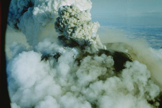 An ash plume rises from the summit crater of Avachinsky on 16 January 1991. An explosive eruption began on 13 January 1991 and produced ash plumes 4-5 km above the crater, resulting in ashfall on Petropavlovsk. During the eruption, lava filled the 260-m-wide summit crater. Small lava flows spilled over the crater rim and advanced 1.5 km down the SSE flank and a short distance down the SW flank. The lava flows melted snow to form small lahars down the S flank.
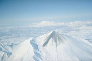 During an eruption in January 1991, lava filled the summit crater of Avachinsky and produced these dark lava flows that overtopped the S rim and traveled 1.5 km down the SSE flank. The modern cone of Avachinsky was constructed within a large horseshoe-shaped crater, with the rim visible to the right and to the left of the cone in this view. The crater formed during flank collapse during the Pleistocene. Zhupanovsky is visible to the NE.
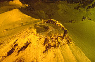 Lava from a 13-30 January 1991 eruption fills the summit crater of Avachinsky in this spring 1991 aerial photo from the south. Prior to the eruption the 400-500 m wide crater was about 250 m deep.
 Steaming lava flows descended the SSE and SW flanks of Avachinsky in January 1991 and melted snow to form the dark lahars that traveled down the flank. The 1991 eruption began with explosive eruptions on 13 January and ended on the 30th.
 The Avachinsky cone was constructed during the late Pleistocene and Holocene within a horseshoe-shaped crater formed by late-Pleistocene flank collapse. The 250-m-deep summit crater seen in this view was completely filled with a lava during an eruption in 1991.
 This is a view of the pre-1991 eruption crater at the summit of Avachinsky. During the 1991 eruption lava filled the crater and overtopped the rim to form lava flows on the SSE and SW flanks.
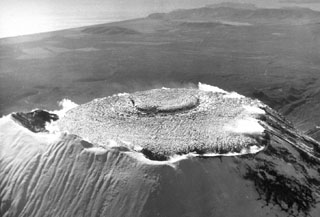 This October 1991 photo looks NW across the lava that filled the summit crater of Avachinsky during an eruption in January 1991. The eruption began on 13 January and produced ash plumes to 4-5 km above the crater. By the time the eruption ended on 30 January, the crater was 400-500 m wide, 250 m deep, and filled with lava to its rim. Lava spilled over the southern rim of the crater, producing lava flows that traveled 1.5 km down the SSE flank and short distances down the SW flank.
 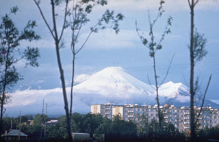 Avachinsky rises above Petropavlovsk, Kamchatka's largest city. The peak to the right is the rim of a large horseshoe-shaped crater that formed during flank collapse about 30,000-40,000 years ago and produced a major debris avalanche buried an area of about 500 km2 to the south, underlying the city of Petropavlovsk. The modern cone was constructed inside this crater. Frequent historical eruptions have been recorded since 1737.
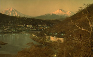
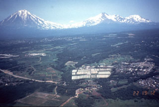 The Avachinskaya volcano group consists of a NW-SE-trending group of cones N of Petropavlovsk. Seen here from the western outskirts of the city with Koryaksky on the left, Avachinsky to the right-center, and Kozelskiy cone to the far right.
  A white plume is visible blowing E from the summit Avachinsky on 7 October 2001. View is from the SW with the city of Elizovo in the foreground.
The following 14 samples associated with this volcano can be found in the Smithsonian's NMNH Department of Mineral Sciences collections, and may be availble for research (contact the Rock and Ore Collections Manager). Catalog number links will open a window with more information.
| Catalog Number | Sample Description | Lava Source | Collection Date |
|---|---|---|---|
| NMNH 116556-1 | Olivine Rock | -- | -- |
| NMNH 116556-2 | Pumice | -- | -- |
| NMNH 116556-3 | Basalt | -- | -- |
| NMNH 116556-4 | Andesitic Basalt | -- | -- |
| NMNH 116556-5 | Andesitic Basalt | -- | -- |
| NMNH 116556-62 | Volcanic Ash | -- | -- |
| NMNH 116556-71 | Pumice | -- | -- |
| NMNH 116556-72 | Andesite | -- | -- |
| NMNH 116556-73 | Andesite | -- | -- |
| NMNH 116556-74 | Basaltic Andesite | -- | -- |
| NMNH 116556-75 | Andesite | -- | -- |
| NMNH 116556-76 | Andesite | -- | -- |
| NMNH 116556-77 | Andesite | -- | -- |
| NMNH 116556-78 | Andesite | -- | -- |
| Copernicus Browser | The Copernicus Browser replaced the Sentinel Hub Playground browser in 2023, to provide access to Earth observation archives from the Copernicus Data Space Ecosystem, the main distribution platform for data from the EU Copernicus missions. |
| MIROVA | Middle InfraRed Observation of Volcanic Activity (MIROVA) is a near real time volcanic hot-spot detection system based on the analysis of MODIS (Moderate Resolution Imaging Spectroradiometer) data. In particular, MIROVA uses the Middle InfraRed Radiation (MIR), measured over target volcanoes, in order to detect, locate and measure the heat radiation sourced from volcanic activity. |
| MODVOLC Thermal Alerts | Using infrared satellite Moderate Resolution Imaging Spectroradiometer (MODIS) data, scientists at the Hawai'i Institute of Geophysics and Planetology, University of Hawai'i, developed an automated system called MODVOLC to map thermal hot-spots in near real time. For each MODIS image, the algorithm automatically scans each 1 km pixel within it to check for high-temperature hot-spots. When one is found the date, time, location, and intensity are recorded. MODIS looks at every square km of the Earth every 48 hours, once during the day and once during the night, and the presence of two MODIS sensors in space allows at least four hot-spot observations every two days. Each day updated global maps are compiled to display the locations of all hot spots detected in the previous 24 hours. There is a drop-down list with volcano names which allow users to 'zoom-in' and examine the distribution of hot-spots at a variety of spatial scales. |
|
WOVOdat
Single Volcano View Temporal Evolution of Unrest Side by Side Volcanoes |
WOVOdat is a database of volcanic unrest; instrumentally and visually recorded changes in seismicity, ground deformation, gas emission, and other parameters from their normal baselines. It is sponsored by the World Organization of Volcano Observatories (WOVO) and presently hosted at the Earth Observatory of Singapore.
GVMID Data on Volcano Monitoring Infrastructure The Global Volcano Monitoring Infrastructure Database GVMID, is aimed at documenting and improving capabilities of volcano monitoring from the ground and space. GVMID should provide a snapshot and baseline view of the techniques and instrumentation that are in place at various volcanoes, which can be use by volcano observatories as reference to setup new monitoring system or improving networks at a specific volcano. These data will allow identification of what monitoring gaps exist, which can be then targeted by remote sensing infrastructure and future instrument deployments. |
| Volcanic Hazard Maps | The IAVCEI Commission on Volcanic Hazards and Risk has a Volcanic Hazard Maps database designed to serve as a resource for hazard mappers (or other interested parties) to explore how common issues in hazard map development have been addressed at different volcanoes, in different countries, for different hazards, and for different intended audiences. In addition to the comprehensive, searchable Volcanic Hazard Maps Database, this website contains information about diversity of volcanic hazard maps, illustrated using examples from the database. This site is for educational purposes related to volcanic hazard maps. Hazard maps found on this website should not be used for emergency purposes. For the most recent, official hazard map for a particular volcano, please seek out the proper institutional authorities on the matter. |
| IRIS seismic stations/networks | Incorporated Research Institutions for Seismology (IRIS) Data Services map showing the location of seismic stations from all available networks (permanent or temporary) within a radius of 0.18° (about 20 km at mid-latitudes) from the given location of Avachinsky. Users can customize a variety of filters and options in the left panel. Note that if there are no stations are known the map will default to show the entire world with a "No data matched request" error notice. |
| UNAVCO GPS/GNSS stations | Geodetic Data Services map from UNAVCO showing the location of GPS/GNSS stations from all available networks (permanent or temporary) within a radius of 20 km from the given location of Avachinsky. Users can customize the data search based on station or network names, location, and time window. Requires Adobe Flash Player. |
| DECADE Data | The DECADE portal, still in the developmental stage, serves as an example of the proposed interoperability between The Smithsonian Institution's Global Volcanism Program, the Mapping Gas Emissions (MaGa) Database, and the EarthChem Geochemical Portal. The Deep Earth Carbon Degassing (DECADE) initiative seeks to use new and established technologies to determine accurate global fluxes of volcanic CO2 to the atmosphere, but installing CO2 monitoring networks on 20 of the world's 150 most actively degassing volcanoes. The group uses related laboratory-based studies (direct gas sampling and analysis, melt inclusions) to provide new data for direct degassing of deep earth carbon to the atmosphere. |
| Large Eruptions of Avachinsky | Information about large Quaternary eruptions (VEI >= 4) is cataloged in the Large Magnitude Explosive Volcanic Eruptions (LaMEVE) database of the Volcano Global Risk Identification and Analysis Project (VOGRIPA). |
| EarthChem | EarthChem develops and maintains databases, software, and services that support the preservation, discovery, access and analysis of geochemical data, and facilitate their integration with the broad array of other available earth science parameters. EarthChem is operated by a joint team of disciplinary scientists, data scientists, data managers and information technology developers who are part of the NSF-funded data facility Integrated Earth Data Applications (IEDA). IEDA is a collaborative effort of EarthChem and the Marine Geoscience Data System (MGDS). |

