A special statement was issued by USGS on 31 January noting an increased rate of uplift at Three Sisters during the previous few years. An area 20 km in diameter, centered 5 km W of South Sister, inflated up to 2.2 cm between June 2020 and August 2021, based on analysis of satellite data. GPS data indicated that the uplift had continued to the present. Additionally, bursts of small earthquakes were recorded in October 2021, December 2021, and January 2022, all located within the area of deformation.
Uplift in that area was first detected in the mid-1990s; the rate was highest during 1999-2000 at 5 cm per year, but then slowed until 2020. A total of 30 cm of uplift was recorded from 1995 to 2020. The cause of the deformation was uncertain, though it was likely occurring due to small accumulations of magma at about 7 km depth based on conclusions from a 1990 study. The Volcano Alert Level remained at Normal and the Aviation Color Code remained at Green as there was no evidence of an imminent eruption.
Source: US Geological Survey
Uplift continues during 2005, but at perhaps half the previous rate
According to the U.S. Geological Survey, field surveys indicated that the uplift of the broad area in the Three Sisters region of central Oregon, gradually swelling since late 1997 (BGVN 26:05), continued as of 14 December 2005. However, the swelling may have slowed somewhat during the past year.
The area of uplift is 20 km in diameter and is centered 5 km W of South Sister volcano. The middle of the uplift rose at an average rate of 2.5 cm per year as a result of intrusion of a modest volume of magma 7 km below the ground surface. Seismic activity related to the uplift has been scant, except for a swarm of more than 300 small earthquakes in late March 2004 (BGVN 29:06). Volcanic gases released from the intruding magma dissolve in ground water so water in local springs and streams is slightly enriched in chemical components derived from volcanic gases. Scientists believe that periods of intrusion similar to the present one have occurred in the area before. The duration and outcome of the current episode are considered to be impossible to forecast, and only continued monitoring will show whether or not this episode of intrusion is slowly ending.
Investigations during 2005 showed the following. (1) Earthquakes continued at a low rate?only five were located in the uplift area in 2005; these were small, up to M1.5. (2) The chemical composition of local spring and stream water remained unchanged from that of the past 5 years. (3) Uplift of the ground surface continued, but seems to have slowed from the rate observed in past years. The three techniques used to measure ground deformation, all having a degree of uncertainty, together suggest that the rate decreased in 2004-2005, perhaps by as much as one half. If so, the rate of intrusion of magma has declined as well.
Information Contacts: Cascades Volcano Observatory (CVO), U.S. Geological Survey, 1300 SE Cardinal Court, Building 10, Suite 100, Vancouver, WA 98683-9589, USA (URL: https://volcanoes.usgs.gov/observatories/cvo/).
2022: January
2004: March
2001: May
A special statement was issued by USGS on 31 January noting an increased rate of uplift at Three Sisters during the previous few years. An area 20 km in diameter, centered 5 km W of South Sister, inflated up to 2.2 cm between June 2020 and August 2021, based on analysis of satellite data. GPS data indicated that the uplift had continued to the present. Additionally, bursts of small earthquakes were recorded in October 2021, December 2021, and January 2022, all located within the area of deformation.
Uplift in that area was first detected in the mid-1990s; the rate was highest during 1999-2000 at 5 cm per year, but then slowed until 2020. A total of 30 cm of uplift was recorded from 1995 to 2020. The cause of the deformation was uncertain, though it was likely occurring due to small accumulations of magma at about 7 km depth based on conclusions from a 1990 study. The Volcano Alert Level remained at Normal and the Aviation Color Code remained at Green as there was no evidence of an imminent eruption.
Source: US Geological Survey
On 23 March at around 1000 a seismic swarm began at South Sister that lasted ~48 hours. Over 300 volcano-tectonic earthquakes up to M 1.9 were recorded. The earthquakes were located in the NE quadrant of the area of on-going uplift.
Sources: US Geological Survey Cascades Volcano Observatory (CVO); Pacific Northwest Seismic Network
The USGS Cascades Volcano Observatory reported on 8 May that between 1996 and 2000 they detected slight uplift of the ground surface over a broad area 5 km W of South Sister volcano. The uplift occurred over an area ~15-20 km in diameter and the maximum amount of uplift at its center is ~10 cm. CVO personnel believe the uplift may reflect intrusion of a small volume of magma at ~7 km depth beneath the ground surface. They stated that if the intrusion of magma continues it could eventually lead to a volcanic eruption, but precursory activity would most likely occur beforehand. There is no precursory activity that suggests an eruption is imminent; seismic activity at the volcano is near or below background levels, gas emissions are low, and no unusual surface changes have been observed.
Sources: US Geological Survey Cascades Volcano Observatory (CVO); Associated Press
Reports are organized chronologically and indexed below by Month/Year (Publication Volume:Number), and include a one-line summary. Click on the index link or scroll down to read the reports.
Radar interferometry suggests uplift during 1996-2000
United States Geological Survey (USGS) scientists detected a slight uplift of the ground surface over a broad region centered 5 km W of South Sister volcano in the Three Sisters region (figure 1). The area is located within the central Oregon Cascade range, 35 km W of Bend, and 100 km E of Eugene, Oregon. The measured uplift, which occurred during 1996-2000, covered an area ~15-20 km in diameter; the maximum amount of uplift at the region's center was ~10 cm. Several close aerial inspections of the area revealed no unusual surface features.
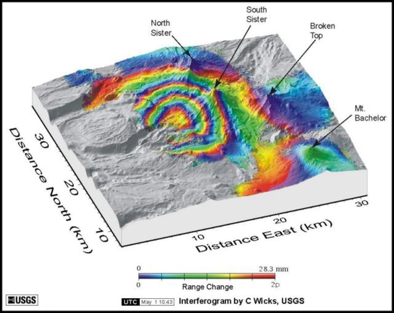 |
Figure 1. Radar interferogram showing ground uplift pattern centered ~ 5 km W of South Sister. Each shaded region represents ~ 2.8 cm of ground movement in the direction of the satellite. In this case, four concentric shaded bands show that the surface moved toward the satellite (close to vertical) by as much as 10 cm between August 1996 and October 2000. Data gaps occur where forest vegetation or other factors hinder the acquisition of useful radar data. A numerical model places the source of the uplift ~ 7 km beneath the ground surface. After a color version by Wicks and others (2001), which uses radar images from the European Space Agency's ERS satellites. |
The uplift was detected by using satellite radar interferometry (InSAR), which uses satellite data to make radar images of the ground surface (figure 1). InSAR can detect even minor (down to a few centimeters) changes in ground elevation over time. Images from 1996 and 2000 were compared and revealed the rise in ground level. The exact timing of uplift between the two dates, or whether it will continue, is unknown, but is being studied further.
The specific cause of the uplift was also uncertain. Uplift in the Three Sisters region may reflect intrusion of a relatively small volume of magma at a possible depth of 7 km. If this is the result of intrusion, it indicates that the region remains active, but does not suggest eruptive activity without additional precursors. In the Three Sisters area, earthquake activity appeared to be at or near background levels and gas emissions were low as of May 2001. The USGS plans to enhance the existing monitoring network in the region to more accurately detect possible precursors and to better understand the uplift phenomenon. Installation of one or more additional seismometers, a global positioning system (GPS) receiver, a resurvey of existing benchmarks and installation of new ones, and periodic airborne and ground-based sampling of gases are all being considered.
References. Wicks, C., Jr., Dzurisin, D., Ingebritsen, S.E., Thatcher, W., and Lu, Z., 2001, Ground uplift near the Three Sisters volcanic center, central Oregon Cascade Range, detected by satellite radar interferometry: in prep.
Information Contacts: Cascades Volcano Observatory (CVO), U.S. Geological Survey (USGS), 5400 MacArthur Blvd., Vancouver, WA 98661 USA (URL: https://volcanoes.usgs.gov/observatories/cvo/); Volcano Hazards Team, USGS, 345 Middlefield Road, Menlo Park, CA 94025-3591 USA (URL: http://volcanoes.usgs.gov/); Pacific Northwest Seismograph Network, University of Washington Geophysics Program, Box 351650, Seattle, WA 98195-1650 USA (URL: http://www.geophys.washington.edu/SEIS/PNSN/); Oregon Department of Geology and Mineral Industries, 800 NE Oregon St., Suite 965, Portland, OR 97232 USA (URL: http://www.oregongeology.org/sub/default.htm).
Studies suggest magma slowly accumulating at depth
Uplift (up to ~10 cm) occurred during 1996-2000 over a broad region centered 5 km W of South Sister in the Three Sisters region (BGVN 26:05). At the time scientists did not know exactly when the uplift had occurred, whether it would continue, or its specific cause. Although most of these questions remain, some new data are available.
On 18 March 2002 scientists from the USGS Cascades Volcano Observatory and Central Washington University reported that they, in cooperation with staff from the U.S. Forest Service's (USFS) Willamette and Deschutes National Forests, confirmed that slow uplift of the area was continuing at approximately the same rate as previously reported (i.e., a maximum rate of ~2.5 cm/year).
About a month later NASA's Jet Propulsion Laboratory (JPL) released a simulated natural-color image from the Aster high-resolution imaging instrument on the satellite Terra. Aster uses 14 spectral bands, at wavelengths from visible to thermal-infrared, and it has a spatial resolution of 15-90 m. By draping the Aster data over digital topography from the U.S. Geological Survey's National Elevation Dataset, they created a new perspective view of the Three Sisters and adjacent Cascade volcanoes (figure 2). The image was timely because of concerns about continued uplift in the area. BGVN 26:05 included a radar interferogram showing ground uplift pattern during 1996-2000, movement centered ~ 5 km W of South Sister.
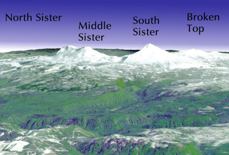 |
Figure 2. The Three Sisters volcanic area appears in this perspective view from the SW quadrant. The view uses a simulated natural-color image from the satellite-borne Aster imaging system, which has been draped over digital topography taken from the U.S. Geological Survey's National Elevation Dataset. N lies to the upper-right; the distance between the summits of North Sister and South Sister is ~ 7 km. The image was released on 12 April 2002. Courtesy NASA's Jet Propulsion Laboratory. |
Analyses of spring water samples collected during late summer 2001 were similar to those from earlier surveys but isotopic studies of carbon and helium in the most recent samples, which were not done previously, suggested a magmatic source. Taken together, the ground deformation, seismic, spring water chemistry, and gas emission results suggest that uplift was caused by slow accumulation of magma at a depth of 6-7 km beneath the surface. If magma intrusion were to continue, it could eventually lead to a volcanic eruption; however, an eruption is unlikely without months to years of precursory activity. In addition to continued or accelerating uplift, precursors to an eruption would include earthquakes, typically swarms of small events generated by fracturing of rock as magma moves upward, and large emissions of volcanic gases, such as carbon dioxide, which is released from the magma.
The Pacific Northwest Seismograph Network (PNSN) has reported three earthquakes in the Three Sisters region since January 2001. On 21 August 2001 a M 1.9 earthquake occurred at a depth of 4.9 km; on 5 November 2001 a M 1 earthquake occurred at a depth of 1 km; and on 18 January 2002 an M 2.4 earthquake occurred at a depth of 3.0 km. The recent earthquakes are consistent with background seismicity at Three Sisters. As of mid-July 2002, the number of earthquakes and gas emissions remained at low-t-obackground levels while steady uplift continued.
General Reference. Scott, W.E., 1987, Holocene rhyodacite eruptions on the flanks of South Sister volcano, Oregon: Geol Soc Amer Spec Pap, v. 212, p. 35-53.
Information Contacts: Cascades Volcano Observatory (CVO), U.S. Geological Survey (USGS), Building 10, Suite 100, 1300 SE Cardinal Court, Vancouver, WA 98683 (URL: https://volcanoes.usgs.gov/observatories/cvo/); Volcano Hazards Team, USGS, 345 Middlefield Road, Menlo Park, CA 94025-3591 USA (URL: http://volcanoes.usgs.gov/); Pacific Northwest Seismograph Network (PNSN), University of Washington Geophysics Program, Box 351650, Seattle, WA 98195-1650 USA (URL: http://www.geophys.washington.edu/SEIS/PNSN/); Jet Propulsion Laboratory, California Institute of Technology, National Aeronautics and Space Administration, Pasadena, CA 91109 (URL: http://www.jpl.nasa.gov/).
March 2004 seismic swarm and continued magmatic uplift
At approximately 1000 on 23 March 2004, a swarm of small earthquakes began at the Three Sisters volcanic center in the central Oregon Cascade Range. As of the morning of 24 March, the regional seismic network had detected ~ 100 earthquakes, with M ~ 1.5; by the end of the swarm, over 300 volcano-tectonic earthquakes with M ~ 1.9 were recorded (figure 3), with the rate of earthquakes peaking late on 23 March. The earthquakes occurred in the NE part of an area centered 5 km W of South Sister volcano, a zone in which the ground had been uplifted by as much as 25 cm since late 1997.
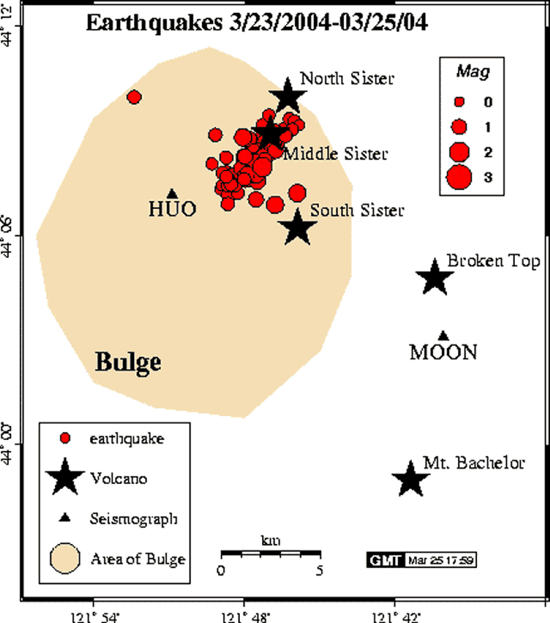 |
Figure 3. Map of the 23-25 March 2004 seismic swarm at Three Sisters volcanoes. Courtesy of Pacific Northwest Seismograph Network (PNSN) website. |
Scientists inferred that the cause of the uplift was continuing magmatic intrusion ~ 7 km below the surface. The intrusion volume was estimated at ~ 40 million cubic meters. Until 23 March, only a few earthquakes had accompanied this process, but scientists predicted that swarms of small earthquakes would eventually accompany the uplift, and they suggested that the most likely cause of the earthquakes was small amounts of slippage on faults as the crust adjusted to the slow ground deformation that had been occurring since 1997. Heat and gases related to the magmatic intrusion also likely caused increases in fluid pressure deep underground, helping trigger minor faulting events.
Scientists deployed another seismometer in order to locate earthquakes more precisely. They also planned additional fieldwork with the assistance of the Willamette and Deschutes National Forests, aiming to fix problems with some field instruments that resulted from a heavy winter snow-pack, and to assess sites for new instruments.
Information Contacts: Cascades Volcano Observatory (CVO), U.S. Geological Survey (USGS), Building 10, Suite 100, 1300 SE Cardinal Court, Vancouver, WA 98683 (URL: https://volcanoes.usgs.gov/observatories/cvo/); Volcano Hazards Team, USGS, 345 Middlefield Road, Menlo Park, CA 94025-3591 USA (URL: http://volcanoes.usgs.gov/); Pacific Northwest Seismograph Network (PNSN), University of Washington Geophysics Program, Box 351650, Seattle, WA 98195-1650, USA (URL: http://www.geophys.washington.edu/SEIS/PNSN/).
Uplift continues during 2005, but at perhaps half the previous rate
According to the U.S. Geological Survey, field surveys indicated that the uplift of the broad area in the Three Sisters region of central Oregon, gradually swelling since late 1997 (BGVN 26:05), continued as of 14 December 2005. However, the swelling may have slowed somewhat during the past year.
The area of uplift is 20 km in diameter and is centered 5 km W of South Sister volcano. The middle of the uplift rose at an average rate of 2.5 cm per year as a result of intrusion of a modest volume of magma 7 km below the ground surface. Seismic activity related to the uplift has been scant, except for a swarm of more than 300 small earthquakes in late March 2004 (BGVN 29:06). Volcanic gases released from the intruding magma dissolve in ground water so water in local springs and streams is slightly enriched in chemical components derived from volcanic gases. Scientists believe that periods of intrusion similar to the present one have occurred in the area before. The duration and outcome of the current episode are considered to be impossible to forecast, and only continued monitoring will show whether or not this episode of intrusion is slowly ending.
Investigations during 2005 showed the following. (1) Earthquakes continued at a low rate?only five were located in the uplift area in 2005; these were small, up to M1.5. (2) The chemical composition of local spring and stream water remained unchanged from that of the past 5 years. (3) Uplift of the ground surface continued, but seems to have slowed from the rate observed in past years. The three techniques used to measure ground deformation, all having a degree of uncertainty, together suggest that the rate decreased in 2004-2005, perhaps by as much as one half. If so, the rate of intrusion of magma has declined as well.
Information Contacts: Cascades Volcano Observatory (CVO), U.S. Geological Survey, 1300 SE Cardinal Court, Building 10, Suite 100, Vancouver, WA 98683-9589, USA (URL: https://volcanoes.usgs.gov/observatories/cvo/).
|
|
||||||||||||||||||||||||||||
There is data available for 6 confirmed eruptive periods.
[ 1853 Jul ] Discredited Eruption
A Willamette Valley missionary reported puffs of dense smoke rising from the summit of one of the Three Sisters in July 1853 (Harris, 1988). However, detailed mapping (Hildreth et al., 2012) indicated that none of the main Three Sisters stratovolcanoes were active during the Holocene and no flank vents were active after about 1,600 years ago.
0439 ± 108 years Confirmed Eruption (Explosive / Effusive) VEI: 2 (?)
| Episode 1 | Eruption (Explosive / Effusive) | NW of North Sister (Collier Cone) | ||||||||||||||||||||||||||||||||||||||
|---|---|---|---|---|---|---|---|---|---|---|---|---|---|---|---|---|---|---|---|---|---|---|---|---|---|---|---|---|---|---|---|---|---|---|---|---|---|---|---|
| 0439 ± 108 years - Unknown | Evidence from Isotopic: 14C (calibrated) | ||||||||||||||||||||||||||||||||||||||
| The Collier Cone tephra and lava flow is 14C dated about 1,600 ± 100 years BP (Scott et al., 1989). This has a corrected age intercept of 1,511 BP (range 1,354-1,569 BP; Sherrod et al., 2004), or 439 CE. Lava flows traveled 5 km NW and 13.5 km W down White Branch Creek. | |||||||||||||||||||||||||||||||||||||||
|
List of 6 Events for Episode 1 at NW of North Sister (Collier Cone)
|
|||||||||||||||||||||||||||||||||||||||
0040 ± 202 years Confirmed Eruption (Explosive / Effusive) VEI: 2 (?)
| Episode 1 | Eruption (Explosive / Effusive) | NW of North Sister (Four-in-One Cone) | ||||||||||||||||||||||||||||||||||||||
|---|---|---|---|---|---|---|---|---|---|---|---|---|---|---|---|---|---|---|---|---|---|---|---|---|---|---|---|---|---|---|---|---|---|---|---|---|---|---|---|
| 0040 ± 202 years - Unknown | Evidence from Isotopic: 14C (calibrated) | ||||||||||||||||||||||||||||||||||||||
| The Four-in-One Cone tephra and lava flows are 14C dated about 1,980 ± 160 years BP (Scott et al., 1989). Taylor (1968) listed an age of about 2,600 BP, but this is considered too old. The 1,980 BP date has a corrected age intercept of 1,910 BP (range 1720-2123 BP; Sherrod et al., 2004), or 40 CE. The four aligned cinder cones were each breached by lava flows that traveled a maximum of about 4 km NW. | |||||||||||||||||||||||||||||||||||||||
|
List of 6 Events for Episode 1 at NW of North Sister (Four-in-One Cone)
|
|||||||||||||||||||||||||||||||||||||||
0050 BCE (?) Confirmed Eruption (Explosive / Effusive) VEI: 3
| Episode 1 | Eruption (Explosive / Effusive) | N & S flanks of South Sister (Devils Hill) | |||||||||||||||||||||||||||||||||||||||||||||||||||||
|---|---|---|---|---|---|---|---|---|---|---|---|---|---|---|---|---|---|---|---|---|---|---|---|---|---|---|---|---|---|---|---|---|---|---|---|---|---|---|---|---|---|---|---|---|---|---|---|---|---|---|---|---|---|---|
| 0050 BCE (?) - Unknown | Evidence from Isotopic: 14C (uncalibrated) | |||||||||||||||||||||||||||||||||||||||||||||||||||||
| The Devils Hill eruption occurred at the end of a roughly 2,300-2,000 BP eruptive period (350 to 50 BCE). Most activity occurred on the S flank, where the Newberry and other lava flows and domes were emplaced along a N-S fissure, although minor tephra was erupted from the Carver Lake vents on the N flank (Scott, 1987). | ||||||||||||||||||||||||||||||||||||||||||||||||||||||
|
List of 9 Events for Episode 1 at N & S flanks of South Sister (Devils Hill)
|
||||||||||||||||||||||||||||||||||||||||||||||||||||||
0350 BCE (?) Confirmed Eruption (Explosive / Effusive) VEI: 4
| Episode 1 | Eruption (Explosive / Effusive) | SW flank of South Sister (Rock Mesa) | ||||||||||||||||||||||||||||||||||||||||||||||||
|---|---|---|---|---|---|---|---|---|---|---|---|---|---|---|---|---|---|---|---|---|---|---|---|---|---|---|---|---|---|---|---|---|---|---|---|---|---|---|---|---|---|---|---|---|---|---|---|---|---|
| 0350 BCE (?) - Unknown | Evidence from Isotopic: 14C (uncalibrated) | ||||||||||||||||||||||||||||||||||||||||||||||||
| The Rock Mesa and Devils Hill eruptions have 14C dates that vary widely from nearly 2,800 to just under 2,000 2,800 BP, but are thought from 14C, paleomagnetic, and other evidence to have occurred between 2,300 and 2,000 BP (350 to 50 BCE), with an apparent dormant interval of from 100 to a few hundred years (Scott, 1987). Both episodes began with Plinian explosions that produced tephra, small pyroclastic flows and surges, and culminated with the emplacement of rhyodacite domes and lava flows (Scott, 1987). | |||||||||||||||||||||||||||||||||||||||||||||||||
|
List of 8 Events for Episode 1 at SW flank of South Sister (Rock Mesa)
|
|||||||||||||||||||||||||||||||||||||||||||||||||
0800 BCE (?) Confirmed Eruption (Explosive / Effusive) VEI: 2 (?)
| Episode 1 | Eruption (Explosive / Effusive) | North of North Sister (Yapoah Cone) | |||||||||||||||||||||||||||||||||
|---|---|---|---|---|---|---|---|---|---|---|---|---|---|---|---|---|---|---|---|---|---|---|---|---|---|---|---|---|---|---|---|---|---|---|
| 0800 BCE (?) - Unknown | Evidence from Correlation: Tephrochronology | |||||||||||||||||||||||||||||||||
| The symmetrical Yapoah Cone formed between about 2,900 and 2,600 years BP (Taylor, 1968). A line of spatter cones about 1 km to the north may also have been active at this time (Taylor, 1965). Lava flows erupted from vents at the N and NW sides of Yapoah traveled 5 km N to McKenzie Pass before being deflected by Little Belknap shield volcano and traveling an additional 8 km NW. | ||||||||||||||||||||||||||||||||||
|
List of 5 Events for Episode 1 at North of North Sister (Yapoah Cone)
|
||||||||||||||||||||||||||||||||||
7350 BCE ± 2700 years Confirmed Eruption (Explosive / Effusive) VEI: 2 (?)
| Episode 1 | Eruption (Explosive / Effusive) | WNW of North Sister (Sims Butte) | ||||||||||||||||||||||||||||||||||||||
|---|---|---|---|---|---|---|---|---|---|---|---|---|---|---|---|---|---|---|---|---|---|---|---|---|---|---|---|---|---|---|---|---|---|---|---|---|---|---|---|
| 7350 BCE ± 2700 years - Unknown | Evidence from Correlation: Tephrochronology | ||||||||||||||||||||||||||||||||||||||
| Sims Butte was active between the 12,000 BP latest Pleistocene glacial drift and the 6,600 BP Mazama ash (Taylor, 1979; Taylor, 1981). Lava flows traveled 15 km W down White Branch Creek almost to the McKenzie River. | |||||||||||||||||||||||||||||||||||||||
|
List of 6 Events for Episode 1 at WNW of North Sister (Sims Butte)
|
|||||||||||||||||||||||||||||||||||||||
This compilation of synonyms and subsidiary features may not be comprehensive. Features are organized into four major categories: Cones, Craters, Domes, and Thermal Features. Synonyms of features appear indented below the primary name. In some cases additional feature type, elevation, or location details are provided.
Cones |
||||
| Feature Name | Feature Type | Elevation | Latitude | Longitude |
| Ahalapan Cinder Field | Pyroclastic cone | |||
| Collier Cone | Pyroclastic cone | 2296 m | 44° 11' 0.00" N | 121° 47' 0.00" W |
| Condon Butte | Pyroclastic cone | 1799 m | 44° 13' 0.00" N | 121° 51' 0.00" W |
| Conte, Le | Pyroclastic cone | 2000 m | 44° 3' 0.00" N | 121° 48' 0.00" W |
| Four-in-One Cone | Pyroclastic cone | 1907 m | 44° 12' 0.00" N | 121° 49' 0.00" W |
| Little Brother | Shield volcano | 2380 m | 44° 11' 0.00" N | 121° 48' 0.00" W |
| Middle Sister | Stratovolcano | 3064 m | 44° 89' 54.00" N | 121° 47' 3.00" W |
| North Sister | Stratovolcano | 3073 m | 44° 9' 57.00" N | 121° 46' 22.00" W |
| Sims Butte | Pyroclastic cone | 1722 m | 44° 11' 0.00" N | 121° 52' 0.00" W |
| South Sister | Stratovolcano | 3159 m | 44° 6' 13.00" N | 121° 46' 10.00" W |
| Yapoah Crater | Pyroclastic cone | 2053 m | 44° 13' 0.00" N | 121° 47' 0.00" W |
Craters |
||||
| Feature Name | Feature Type | Elevation | Latitude | Longitude |
| Island Fissure | Fissure vent | |||
| Matthieu Lakes Fissure | Fissure vent | |||
Domes |
||||
| Feature Name | Feature Type | Elevation | Latitude | Longitude |
| Black Hump
Prouty Hill Step Sister |
Dome | 2838 m | ||
| Devils Hill | Dome | 2000 m | 44° 3' 0.00" N | 121° 45' 0.00" W |
| Kaleetan Butte | Dome | |||
| Newberry | Dome | 2390 m | 44° 5' 0.00" N | 121° 45' 0.00" W |
| Rock Mesa | Dome | 2088 m | 44° 4' 0.00" N | 121° 48' 0.00" W |
 An aerial view from the NW shows North Sister (center) and Middle Sister (right) with young lava flows from N-flank scoria cones. The latest dated lava flow originated about 1,600 years ago from Collier Cone, near the center of the photo below the left flank of North Sister. One lava flow lobe traveled to the NW and levees on the western lobe are visible in the right foreground. They western lobe traveled 13.5 km down the White Branch Creek valley.
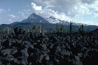 The McKenzie Pass area contains one of the largest concentrations of recent volcanism in the continental United States. Fresh lava flows in the foreground from the Belknap shield volcano merge with unvegetated lava flows from scoria cones on the north flank of North Sister in the background, with Middle Sister to its right.
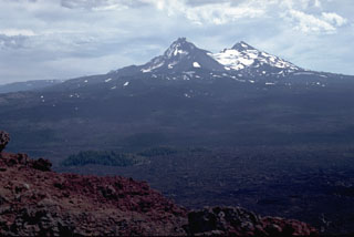 The Belknap Crater scoria cone provides a panorama of recent volcanism in the McKenzie Pass area. Younger lava flows from scoria cones on the north flanks of North and Middle Sister volcanoes in the background merge with flows from the Belknap shield volcano. Most of these flows were erupted in the past few thousand years. In the left foreground, lava flows from Belknap diverge around kipukas, islands of older rocks.
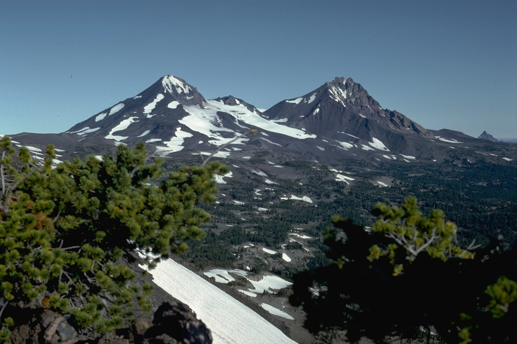
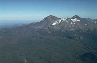
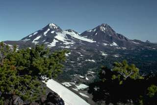 North Sister volcano to the right and Middle Sister to the left, seen from Broken Top volcano to the south, are the two northernmost volcanoes in the Three Sisters volcano group in the central Oregon Cascades. Glaciers have deeply eroded the Pleistocene North Sister volcano, but young Holocene lava flows from scoria cones on the north flank have erupted in the past few thousand years.
 North Sister volcano on the right and Middle Sister to its left rise above ranch lands of eastern Oregon. These large volcanoes have not been active since the Pleistocene, but scoria cones on the north flank of North Sister have produced some of the youngest lava flows in the Cascade Range.
 The Three Sisters volcanoes form the most prominent landmarks of the central Oregon Cascades. All three volcanoes ceased erupting during the Pleistocene, but flank vents of South Sister to the left and North Sister to the right have erupted in the past few thousand years.
 The north flank of North Sister contains young scoria cones that have produced lava flows during the past few thousand years, seen here covered with light snow. Yapoah cone, the symmetrical snow-covered cone in the center of the photo, produced a lava flow about 2,600-2,900 years ago that traveled beyond the margin of the photo for 13 km to the NE.
 Middle Sister, seen here from the NE near the saddle between North Sister and Middle Sister, is younger than North Sister. The steep cliffs forming the eastern flank are due to glacial erosion that exposed part of its dacite plug.
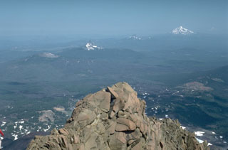 The summit of North Sister provides a panorama of Cascade volcanism that includes, from left to right, lava flows of the McKenzie Pass area in the foreground, the low Belknap shield volcano, the eroded summit pinnacles of Mount Washington and Three Fingered Jack volcanoes, and snow-capped Mount Jefferson to the upper right.
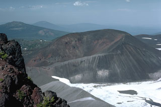 The horseshoe-shaped Collier Cone on the NNW flank of North Sister, partially covered by the Collier Glacier in this 1984 photo, was the source about 1,600 years ago of the youngest dated eruption in the North Sister volcanic field. Lava flows traveled 5 km NW and 13.5 km W down the White Branch Creek. The foreground portion of the cone in this view looking NE has been partially eroded by Collier Glacier when it was at the level of the gray glacial moraine in the foreground on the left margin of the glacier.
 The lava flow across the upper part of the photo, seen here from Black Crater, originated from Yapoah cone on the north flank of North Sister about 2,600-2,900 years ago. The flow traveled 5 km N before being diverted by lavas from Little Belknap shield volcano and flowing an additional 8 km NE.
 This blocky lava flow in the McKenzie Pass area of the central Oregon Cascades originated from Yapoah scoria cone on the north flank of North Sister about 2,600-2,900 years ago. The flow traveled 5 km to the north before being deflected by lava flows from the Belknap and Little Belknap shield volcanoes and then flowed an additional 8 km to the NE.
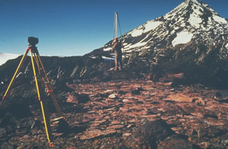 U.S. Geological Survey scientists monitor deformation on the Three Sisters volcanoes in the central Oregon Cascades, with Middle Sister volcano in the background. Precise leveling that permits detection of minor uplift is one of several monitoring techniques used to forecast eruptions.
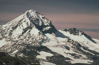 Middle Sister volcano, viewed from the west flank of Broken Top to the SE, has a smoother profile than North Sister volcano to the right but also shows evidence of glacial erosion on its eastern flank, exposing part of the dacitic lava dome that formed its central plug.
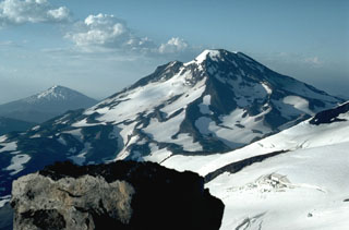 The close proximity of the Three Sisters volcanoes, in contrast to the other large Cascade volcanoes that are typically 60-100 km apart, can be seen in this view of South Sister volcano from the summit of North Sister with the glacier-covered slopes of Middle Sister to the lower right. Mount Bachelor is in the distance to the left.
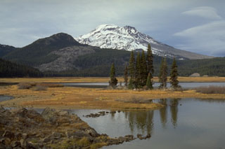 The southernmost of a series of obsidian lava domes and flows erupted about 2,000 years ago along a 5-km-long N-S fissure on the SE flank of South Sister, with the end of the flow visible to the left near Sparks Lake. The barren lower right skyline of South Sister is the Newberry lava flow, the largest and northernmost of the lava flows erupted along the 5-km-long chain named after Devils Hill, the forested peak to the left.
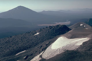 The Newberry lava flow in the foreground is the northernmost and largest of a series of 15 lava domes and flows erupted from a N-S fissure on the SE flank of South Sister volcano. It was preceded by an explosive eruption that produced pyroclastic flows. Another Holocene volcano, Mount Bachelor, is the peak to the left.
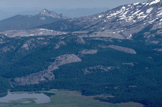 The Devils Hill chain of lava domes and flows erupted along a 5-km-long fissure on the SE flank of South Sister about 2,000 years ago, and can be seen diagonally across the center of this view to the NW. A similar, but more localized eruption produced the Rock Mesa lava flow, the light-colored area to the upper left. The eroded peak of The Husband volcano is in the distance.
 The center of the Devils Hill chain on the SE flank of South Sister contains several small lava domes and flows that are more widely spaced than those at the northern and southern ends. The flows are named for Devils Hill, the partially forested peak to the right.
 An aerial view of the summit of South Sister from the south, seen here in 1981, shows a snow-filled summit crater that seasonally contains a small melt-water lake. Fissure eruptions occurred during the Holocene from flank vents including some near Carver Lakes on the NE flank, seen here to the upper right.
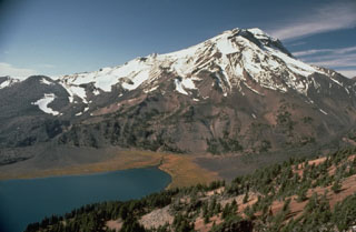 South Sister is the highest of the Three Sisters volcanoes and is seen here above Green Lake from the west flank of Broken Top volcano. The bare slope to the far-left is the Newberry lava flow, the northernmost of a series of SE-flank obsidian domes and flows.
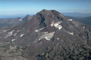 South Sister, seen here from the south, still contains a preserved summit crater although glaciers have eroded the flanks. Holocene eruptions have occurred from flank vents.
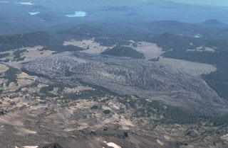 The Rock Mesa obsidian lava flow is seen here in an aerial view from the north above South Sister volcano. It is the largest of a series of lava flows which erupted about 2,300 to 2,000 years ago from vents on the SW and SE flanks.
 The Rock Mesa lava flow in the foreground erupted from a vent on the SW flank of South Sister volcano about 2,300 years ago. Emplacement of the lava flow was the final stage of an eruption that began with strong explosions accompanied by pyroclastic flows and surges.
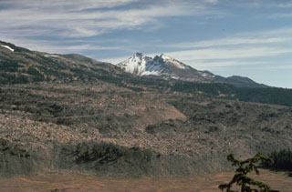 Broken Top volcano provides a backdrop to the margin of the 0.5 km3 Rock Mesa lava flow, which erupted from a vent on the SW flank of South Sister volcano about 2,300 years ago. Emplacement of the lava flow was the final stage of an eruption that began with strong explosions accompanied by pyroclastic flows and surges.
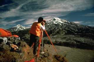 Electronic Distance Measurements (EDM) by the U.S. Geological Survey at South Sister volcano, with Middle Sister to the left, are conducted routinely to monitor these Cascades volcanoes for potential eruptive activity. By measuring the distance between two fixed points, these instruments can detect minor changes in the surface of the volcanic edifice that can occur prior to eruptions.
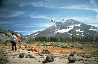 A helicopter delivers supplies to a U.S. Geological Survey field crew conducting Electronic Distance Measurement surveys on the flank of South Sister volcano in the central Cascades of Oregon.
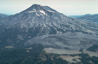 The large lava flow to the lower right is the Rock Mesa lava flow on the SW flank of South Sister. The rhyodacite flow erupted about 2,300 years ago from a vent now filled by a small lava dome. Lava extrusion was preceded by explosive eruptions that produced airfall tephra and pyroclastic flows.
 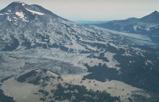 An aerial view from the SW with Le Conte crater in the left foreground shows lava flows from two major Holocene flank eruptions of South Sister volcano. The Rock Mesa flow, immediately behind Le Conte crater and the Newberry lava flow on the South Sister lower SE flank, were erupted between about 2,300 and 2,000 years ago. They were also accompanied by explosive eruptions.
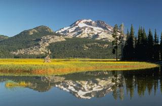 South Sister, reflected in the waters of Sparks Lake, is the highest and youngest of the Three Sisters volcanoes in the central Oregon Cascades. The summit cone of South Sister has not erupted since the late Pleistocene, but the light-colored rocks above the meadow at the left are part of a group of lava flows on the flank that were extruded about 2,000 years ago.
The following 3 samples associated with this volcano can be found in the Smithsonian's NMNH Department of Mineral Sciences collections, and may be availble for research (contact the Rock and Ore Collections Manager). Catalog number links will open a window with more information.
| Catalog Number | Sample Description | Lava Source | Collection Date |
|---|---|---|---|
| NMNH 117465-105 | Obsidian | Obsidian Cliffs; Middle Sister | -- |
| NMNH 117465-106 | Obsidian | Obsidian Cliffs; Middle Sister | -- |
| NMNH 117465-107 | Obsidian | Obsidian Cliffs; Middle Sister | -- |
| Copernicus Browser | The Copernicus Browser replaced the Sentinel Hub Playground browser in 2023, to provide access to Earth observation archives from the Copernicus Data Space Ecosystem, the main distribution platform for data from the EU Copernicus missions. |
| MIROVA | Middle InfraRed Observation of Volcanic Activity (MIROVA) is a near real time volcanic hot-spot detection system based on the analysis of MODIS (Moderate Resolution Imaging Spectroradiometer) data. In particular, MIROVA uses the Middle InfraRed Radiation (MIR), measured over target volcanoes, in order to detect, locate and measure the heat radiation sourced from volcanic activity. |
| MODVOLC Thermal Alerts | Using infrared satellite Moderate Resolution Imaging Spectroradiometer (MODIS) data, scientists at the Hawai'i Institute of Geophysics and Planetology, University of Hawai'i, developed an automated system called MODVOLC to map thermal hot-spots in near real time. For each MODIS image, the algorithm automatically scans each 1 km pixel within it to check for high-temperature hot-spots. When one is found the date, time, location, and intensity are recorded. MODIS looks at every square km of the Earth every 48 hours, once during the day and once during the night, and the presence of two MODIS sensors in space allows at least four hot-spot observations every two days. Each day updated global maps are compiled to display the locations of all hot spots detected in the previous 24 hours. There is a drop-down list with volcano names which allow users to 'zoom-in' and examine the distribution of hot-spots at a variety of spatial scales. |
|
WOVOdat
Single Volcano View Temporal Evolution of Unrest Side by Side Volcanoes |
WOVOdat is a database of volcanic unrest; instrumentally and visually recorded changes in seismicity, ground deformation, gas emission, and other parameters from their normal baselines. It is sponsored by the World Organization of Volcano Observatories (WOVO) and presently hosted at the Earth Observatory of Singapore.
GVMID Data on Volcano Monitoring Infrastructure The Global Volcano Monitoring Infrastructure Database GVMID, is aimed at documenting and improving capabilities of volcano monitoring from the ground and space. GVMID should provide a snapshot and baseline view of the techniques and instrumentation that are in place at various volcanoes, which can be use by volcano observatories as reference to setup new monitoring system or improving networks at a specific volcano. These data will allow identification of what monitoring gaps exist, which can be then targeted by remote sensing infrastructure and future instrument deployments. |
| Volcanic Hazard Maps | The IAVCEI Commission on Volcanic Hazards and Risk has a Volcanic Hazard Maps database designed to serve as a resource for hazard mappers (or other interested parties) to explore how common issues in hazard map development have been addressed at different volcanoes, in different countries, for different hazards, and for different intended audiences. In addition to the comprehensive, searchable Volcanic Hazard Maps Database, this website contains information about diversity of volcanic hazard maps, illustrated using examples from the database. This site is for educational purposes related to volcanic hazard maps. Hazard maps found on this website should not be used for emergency purposes. For the most recent, official hazard map for a particular volcano, please seek out the proper institutional authorities on the matter. |
| IRIS seismic stations/networks | Incorporated Research Institutions for Seismology (IRIS) Data Services map showing the location of seismic stations from all available networks (permanent or temporary) within a radius of 0.18° (about 20 km at mid-latitudes) from the given location of Three Sisters. Users can customize a variety of filters and options in the left panel. Note that if there are no stations are known the map will default to show the entire world with a "No data matched request" error notice. |
| UNAVCO GPS/GNSS stations | Geodetic Data Services map from UNAVCO showing the location of GPS/GNSS stations from all available networks (permanent or temporary) within a radius of 20 km from the given location of Three Sisters. Users can customize the data search based on station or network names, location, and time window. Requires Adobe Flash Player. |
| DECADE Data | The DECADE portal, still in the developmental stage, serves as an example of the proposed interoperability between The Smithsonian Institution's Global Volcanism Program, the Mapping Gas Emissions (MaGa) Database, and the EarthChem Geochemical Portal. The Deep Earth Carbon Degassing (DECADE) initiative seeks to use new and established technologies to determine accurate global fluxes of volcanic CO2 to the atmosphere, but installing CO2 monitoring networks on 20 of the world's 150 most actively degassing volcanoes. The group uses related laboratory-based studies (direct gas sampling and analysis, melt inclusions) to provide new data for direct degassing of deep earth carbon to the atmosphere. |
| Large Eruptions of Three Sisters | Information about large Quaternary eruptions (VEI >= 4) is cataloged in the Large Magnitude Explosive Volcanic Eruptions (LaMEVE) database of the Volcano Global Risk Identification and Analysis Project (VOGRIPA). |
| EarthChem | EarthChem develops and maintains databases, software, and services that support the preservation, discovery, access and analysis of geochemical data, and facilitate their integration with the broad array of other available earth science parameters. EarthChem is operated by a joint team of disciplinary scientists, data scientists, data managers and information technology developers who are part of the NSF-funded data facility Integrated Earth Data Applications (IEDA). IEDA is a collaborative effort of EarthChem and the Marine Geoscience Data System (MGDS). |

