On 17 May, OVDAS-SERNAGEOMIN reported that seven hybrid earthquakes were detected beneath Chaitén at a depth of 1 km; the highest local magnitude recorded was 3.6. A second report on 19 May noted that seismicity had slightly increased during the previous few months, characterized by an increase in magnitude and occurrence of long-period events, volcano-tectonic events, and hybrid events. Thermal anomalies from the lava dome complex had also been detected although the report did not state when. The Alert Level was raised to Yellow, on a three-color scale.
Source: Servicio Nacional de Geología y Minería (SERNAGEOMIN)
Declining seismicity, thermal emissions, and plumes during 2013
In this report, we cover declining activity observed at Chaitén during 2012-2013. The Servicio Nacional de Geología y Minería (SERNAGEOMIN) had reduced the Alert Level to Green on 2 May 2011 (BGVN 36:11) and continued to monitor activity and release online bulletins. These activity bulletins were available during February 2012-October 2013. We also note the thermal alerts from MODVOLC during January 2010-April 2013.
The recent rhyolitic eruption of Chaitén began in May 2008 (BGVN 33:04) and, according to Pallister and others (2013), comprised five major phases: (1) an explosive sequence (1-11 May 2008), (2) a transitional time that included ash plumes and lava extrusion (11-31 May 2008), (3) lava flows and dome growth (June-September 2008), (4) spine extrusion and dome growth (October 2008-February 2009), and (5) endogenous lava dome growth (February 2009-early 2010). Following those phases of activity, ash plumes and thermal emissions declined during 2010-2011 (figure 31); intermittent thermal anomalies and vapor emissions dominated activity during 2011-April 2013. Since April 2013, thermal alerts were no longer reported by the MODVOLC system.
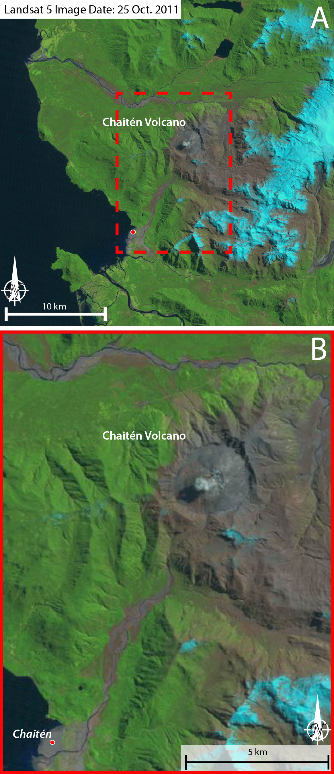 |
Figure 31. On 25 October 2011, this Landsat 5 image captured a small plume rising from Chaitén's active lava dome. A) This wideview includes the caldera and surrounding region of Chaitén. Meandering river systems link the volcanic highlands with the Pacific coast. A) and B) The town of Chaitén is located at the red circle, on the delta formed by runoff from the highlands that include Chaitén ~11 km NE. Note that the scale bars are approximate. Courtesy of USGS/NASA. |
SERNAGEOMIN reported decreasing seismicity during 2012-2013 (table 3). Volcano-tectonic (VT) events dominated these datasets while hybrid events were very rare. Local magnitudes (ML) and magnitudes calculated from signal duration (MD) were reported as well as the reduced displacement (calculated for long-period earthquakes).
Table 3. Seismicity during February 2012-September 2013 is reported for total earthquake counts (EQ), volcano-tectonic earthquakes (VT), long-period earthquakes (LP), and hybrid (HYB). Note that "**" indicates reporting of ML values where MD values were not reported. Reduced displacement (RD) is reported for LP events. Courtesy of SERNAGEOMIN.
| Date | EQ | VT | Max ML | LP | MD | RD cm2 | HYB | MD |
| Feb 2012 | 226 | 170 | 1.9 | 54 | 1.8 | 4.0 | 2 | 1.3 |
| Mar 2012 | 303 | 216 | 3.0 | 86 | 0.6 | 9.3 | 0 | 0 |
| Apr 2012 | 179 | 106 | 1.8 | 73 | 2 | 2.3 | 0 | 0 |
| May 2012 | 109 | 47 | 2.3 | 62 | 1.6 | 58.2 | 0 | 0 |
| Jun 2012 | 47 | 22 | 1.6 | 25 | 1 | 5.4 | 0 | 0 |
| Jul 2012 | 93 | 63 | 2.8 | 30 | 1.7 | 0.5 | 0 | 0 |
| Aug 2012 | 96 | 72 | 2.5 | 23 | 2.3 | 9.6 | 0 | 0 |
| Sep 2012 | 56 | 41 | 2.5 | 15 | 0.5 | 0.1 | 0 | 0 |
| Oct 2012 | 49 | 39 | 1.9 | 10 | 2.3 | 3 | 0 | 0 |
| Nov 2012 | 61 | 49 | 1.9 | 12 | 1.9 | 7.4 | 0 | 0 |
| Dec 2012 | 45 | 42 | 2.7 | 3 | 1.7 | 1.1 | 0 | 0 |
| Jan 2013 | 76 | 55 | 2.9 | 16 | 2.3 | 11.4 | 5 | -- |
| Feb 2013 | 43 | 28 | 1.7 | 15 | -- | 0.8 | 0 | 0 |
| Mar 2013 | 5 | 4 | 1.0 | 1 | -- | 1.7 | 0 | 0 |
| Apr 2013 | -- | -- | -- | -- | -- | -- | -- | -- |
| May 2013 | 53 | 44 | 1.9 | 11 | 1.6** | 3.8 | -- | -- |
| Jun 2013 | -- | -- | -- | -- | -- | -- | -- | -- |
| Jul 2013 | 67 | 50 | 0.8 | 17 | 1.3** | 5.6 | -- | -- |
| Aug 2013 | 38 | 29 | 1.4 | 8 | 1.3** | 6.4 | 1 | 2.0** |
| Sep 2013 | 5 | 5 | 1.3 | -- | -- | -- | -- | -- |
| Oct 2013 | 30 | 21 | 2.4 | 9 | 1.7** | -- | -- | -- |
When clear viewing conditions permitted, nighttime incandescence and vapor plumes were captured by the SERNAGEOMIN webcamera during February 2012-September 2013. Observations included plume heights ranging 300-600 m above the crater.
Thermal alerts. Elevated temperatures were detected from Chaitén during much of the eruption that began in May 2008. Thermal anomalies were detected by MODIS sensors on the Terra and Aqua satellites every month until September 2010 (table 4). As the eruption waned, elevated temperatures were observed less often and were absent during the months of July 2011, May 2012, August-October 2012, December 2012, March 2013, and after 2 April 2013. The MODVOLC alerts chiefly occurred in the immediate area of the crater (figure 32).
Table 4. The MODVOLC system generated alerts during January 2010-April 2013. The number of thermal alerts detected per year decreased from 2010 through early 2013. Courtesy of HIGP.
| Date | Days/Month | Pixels/Month |
| Jan 2010 | 5 | 5 |
| Feb 2010 | 7 | 9 |
| Mar 2010 | 7 | 9 |
| Apr 2010 | 6 | 6 |
| May 2010 | 4 | 4 |
| Jun 2010 | 1 | 1 |
| Jul 2010 | 2 | 2 |
| Aug 2010 | 3 | 3 |
| Sep 2010 | 0 | 0 |
| Oct 2010 | 3 | 3 |
| Nov 2010 | 1 | 1 |
| Dec 2010 | 4 | 4 |
| Jan 2011 | 6 | 6 |
| Feb 2011 | 7 | 7 |
| Mar 2011 | 1 | 1 |
| Apr 2011 | 4 | 4 |
| May 2011 | 3 | 3 |
| Jun 2011 | 3 | 3 |
| Jul 2011 | 1 | 1 |
| Aug 2011 | 1 | 1 |
| Sep 2011 | 2 | 2 |
| Oct 2011 | 4 | 4 |
| Nov 2011 | 1 | 1 |
| Dec 2011 | 9 | 9 |
| Jan 2012 | 7 | 7 |
| Feb 2012 | 2 | 2 |
| Mar 2012 | 3 | 4 |
| Apr 2012 | 2 | 2 |
| May 2012 | 0 | 0 |
| Jun 2012 | 3 | 3 |
| Jul 2012 | 2 | 3 |
| Aug 2012 | 0 | 0 |
| Sep 2012 | 0 | 0 |
| Oct 2012 | 0 | 0 |
| Nov 2012 | 2 | 2 |
| Dec 2012 | 0 | 0 |
| Jan 2013 | 3 | 3 |
| Feb 2013 | 2 | 2 |
| Mar 2013 | 0 | 0 |
| Apr 2013 | 1 | 1 |
| May 2013 | 0 | 0 |
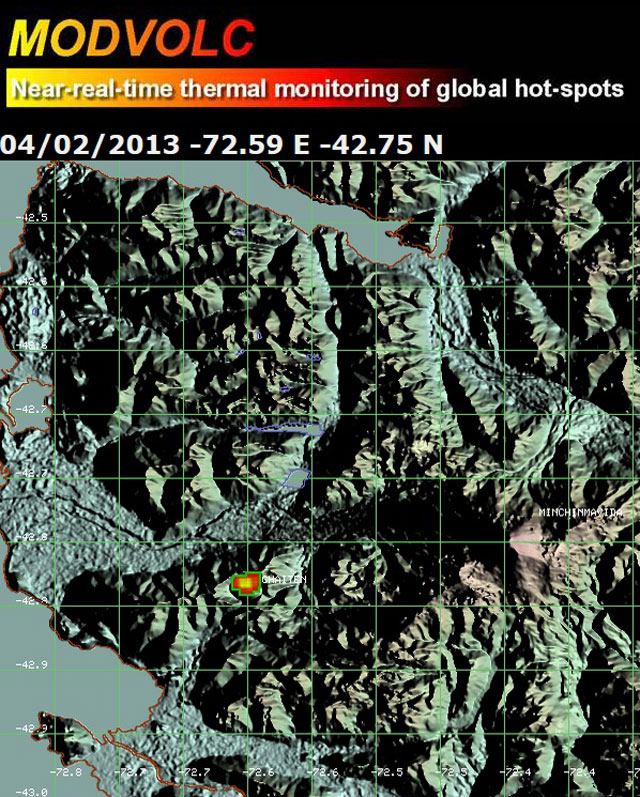 |
Figure 32. As seen here, from April 2012 to April 2013, MODVOLC generated alerts (red and orange point) on 15 days for Chaitén. Those alerts indicated elevated temperatures within 2 km of the summit area. Courtesy of HIGP. |
References. NASA Landsat Program, 2011, Landsat ETM scene LT52320902011298COA00, SLC-Off, USGS, Sioux Falls, October 25, 2011.
Pallister, J.S., Diefenbach, A.K., Burton, W.C., Muñoz, J., Griswold, J.P., Lara, L.E., Lowenstern, J.B., and Valenzuela, C., 2013, The Chaitén rhyolite lava dome: Eruption sequence, lava dome volumes, rapid effusion rates and source of the rhyolite magma, Andean Geology, 40, (2): 277-294.
Information Contacts: Observatorio Volcanológico de los Andes del Sur-Servicio Nacional de Geologia y Mineria (OVDAS-SERNAGEOMIN), Avda Sta María No. 0104, Santiago, Chile (URL: http://www.sernageomin.cl/); and Hawai'i Institute of Geophysics and Planetology (HIGP) MODVOLC Thermal Alerts System, School of Ocean and Earth Science and Technology (SOEST), Univ. of Hawai'i, 2525 Correa Road, Honolulu, HI 96822, USA (URL: http://modis.higp.hawaii.edu/).
2015: May
2011: January
| May
2010: January
| February
| March
| May
| July
| October
| November
2009: January
| February
| March
| April
| May
| June
| July
| August
| September
| October
| November
| December
2008: April
| May
| June
| July
| August
| September
| October
| November
| December
On 17 May, OVDAS-SERNAGEOMIN reported that seven hybrid earthquakes were detected beneath Chaitén at a depth of 1 km; the highest local magnitude recorded was 3.6. A second report on 19 May noted that seismicity had slightly increased during the previous few months, characterized by an increase in magnitude and occurrence of long-period events, volcano-tectonic events, and hybrid events. Thermal anomalies from the lava dome complex had also been detected although the report did not state when. The Alert Level was raised to Yellow, on a three-color scale.
Source: Servicio Nacional de Geología y Minería (SERNAGEOMIN)
SERNAGEOMIN reported that during 2011 seismic activity from Chaitén remained low and that no growth of the lava-dome complex was detected. Visual observations indicated low emissions. The Alert Level was lowered to Green, Level 2, on a three-color scale.
Source: Servicio Nacional de Geología y Minería (SERNAGEOMIN)
SERNAGEOMIN reported that during 1-14 January cameras installed around Chaitén's caldera rim, as well as cameras in Pumalin Park and Chaitén town, showed degassing from the lava-dome complex. Gas plumes composed primarily of water vapor rose at most 800 m above the complex. Incandescence on the surface of the dome was observed at night. The Alert Level remained at Yellow Level 3, on a three-color scale.
Source: Servicio Nacional de Geología y Minería (SERNAGEOMIN)
On 11 November, SERNAGEOMIN reported that, although seismic events at Chaitén's lava-dome complex continued to increase in the previous weeks, the magnitudes of the earthquakes remained relatively low. Gas-and-steam plumes rose 300-400 m above the caldera rim. Based on analyses of satellite imagery and web camera footage, the Buenos Aires VAAC reported that on 13 November a gas-and-ash plume rose to an altitude of 1.5 km (5,000 ft) a.s.l. and drifted 40 km SE. On 15 November ash plumes observed through the web camera rose to altitudes of 1.8-2.1 km (6,000-7,000 ft) a.s.l. and drifted E. The Alert Level remained Yellow Level 3 on a three-color scale.
Sources: Servicio Nacional de Geología y Minería (SERNAGEOMIN); Buenos Aires Volcanic Ash Advisory Center (VAAC)
Based on analyses of satellite imagery and web camera footage, the Buenos Aires VAAC reported that an ash plume from Chaitén's lava-dome complex rose to an altitude of 1.8 km (6,000 ft) a.s.l. on 4 November and drifted 25 km NE. Cloud cover prevented clear satellite views of the volcano in subsequent images.
Source: Buenos Aires Volcanic Ash Advisory Center (VAAC)
Based on analyses of web camera footage, the Buenos Aires VAAC reported that an ash plume from Chaitén's lava-dome complex rose to an altitude of 2.1 km (7,000 ft) a.s.l. on 21 October. The report also noted a plume drifting ENE.
Source: Buenos Aires Volcanic Ash Advisory Center (VAAC)
Based on analyses of satellite imagery and web camera footage, the Buenos Aires VAAC reported that a plume from Chaitén's lava-dome complex drifted 20 km ENE on 30 July. An 18-km-wide ash plume also drifted 45 km ESE.
Source: Buenos Aires Volcanic Ash Advisory Center (VAAC)
Based on analyses of satellite imagery, the Buenos Aires VAAC reported that an ash plume from Chaitén's lava-dome complex drifted 70 km SSE on 24 July. Meteorological cloud cover in subsequent images prevented further detection of the plume.
Source: Buenos Aires Volcanic Ash Advisory Center (VAAC)
Based on web camera views, the Buenos Aires VAAC reported that an ash plume from Chaitén's lava-dome complex drifted NE at an altitude of 1.8 km (6,000 ft) a.s.l. on 14 May.
Source: Buenos Aires Volcanic Ash Advisory Center (VAAC)
Based on analyses of satellite imagery, the Buenos Aires VAAC reported that a plume from Chaitén's lava-dome complex drifted 20 km SW on 29 March.
Source: Buenos Aires Volcanic Ash Advisory Center (VAAC)
On 17 March SERNAGEOMIN reported that, during the previous few weeks, growth of Chaitén's lava-dome complex was concentrated in the W part. Gas-and-ash plumes, seen through the video camera located on the rim of the caldera, rose at most 1 km from the central area of the domes. Seismic activity persisted at a low level. The Alert Level remained at Red.
Source: Servicio Nacional de Geología y Minería (SERNAGEOMIN)
Based on web camera views and analyses of satellite imagery, the Buenos Aires VAAC reported that a diffuse ash plume from Chaitén's lava-dome complex, likely mixed with steam and gas, drifted NE on 15 March.
Source: Buenos Aires Volcanic Ash Advisory Center (VAAC)
On 11 February, ODVAS-SERNAGEOMIN reported that a camera, installed 800 m from the center of Chaitén's lava-dome complex in late January, showed incandescence and gas emissions on 28 January. Seismicity had also increased during 21 January-3 February. The Alert Level remained at Red. Based on web camera views and analyses of satellite imagery, the Buenos Aires VAAC reported that a steam-and-gas plume drifted 25 km NW on 11 February at an altitude of 2.4 km (8,000 ft) a.s.l.
Sources: Servicio Nacional de Geología y Minería (SERNAGEOMIN); Buenos Aires Volcanic Ash Advisory Center (VAAC)
SERNAGEOMIN reported that during 5-19 January Chaitén's lava-dome complex continued to grow, although possibly at rates lower than during previous weeks. The magnitude and number of hybrid earthquakes decreased. The Alert Level remained at Red.
Source: Servicio Nacional de Geología y Minería (SERNAGEOMIN)
Based on web camera views and analyses of satellite imagery, the Buenos Aires VAAC reported that an ash plume from Chaitén's lava-dome complex drifted NNE on 14 January at an altitude of 1.8 km (6,000 ft) a.s.l. A steam-and-gas plume drifted NE at the same altitude the next day.
Source: Buenos Aires Volcanic Ash Advisory Center (VAAC)
SERNAGEOMIN reported that during 16 December 2009-4 January 2010 steam-and-gas plumes from Chaitén's lava-dome complex seen on the web camera during periods of clear weather rose 1.5 km above the lava domes. Seismicity, along with occasional block-and-ash flows, indicated that the lava domes continued to grow. Based on web camera views and analyses of satellite imagery, the Buenos Aires VAAC reported that on 6 January a plume drifted 50 km ENE at an altitude of 2.1 km (7,000 ft) a.s.l. The next day an ash plume drifted SE and E at the same altitude.
Sources: Servicio Nacional de Geología y Minería (SERNAGEOMIN); Buenos Aires Volcanic Ash Advisory Center (VAAC)
Based on web camera views, the Buenos Aires VAAC reported that a plume from Chaitén's lava-dome complex drifted SE on 30 December at an altitude of 2.1 km (7,000 ft) a.s.l.
Source: Buenos Aires Volcanic Ash Advisory Center (VAAC)
SERNAGEOMIN reported that during 1-15 December Chaitén's lava-dome complex produced steam, gas, and ash plumes that rose 2 km above the lava domes. On 7 December emissions originated from the N and S areas of the complex. Block-and-ash flows were noted the next day. The Alert Level remained at Red. Based on web camera views and SIGMET notices, the Buenos Aires VAAC reported that on 18 December an ash plume drifted SSE at altitudes of 1.8-2.4 km (6,000-8,000 ft) a.s.l.
Sources: Servicio Nacional de Geología y Minería (SERNAGEOMIN); Buenos Aires Volcanic Ash Advisory Center (VAAC)
Based on web camera views, the Buenos Aires VAAC reported that a steam-and-gas plume from Chaitén's lava-dome complex drifted SE on 12 December at altitudes of 1.5-2.1 km (5,000-7,000 ft) a.s.l.
Source: Buenos Aires Volcanic Ash Advisory Center (VAAC)
Based on analyses of satellite imagery, the Buenos Aires VAAC reported that emissions from Chaitén's lava-dome complex drifted 15 km SE on 8 December.
Source: Buenos Aires Volcanic Ash Advisory Center (VAAC)
Based on analyses of satellite imagery, the Buenos Aires VAAC reported that on 26 November a diffuse plume from Chaitén's lava-dome complex drifted ENE.
Source: Buenos Aires Volcanic Ash Advisory Center (VAAC)
Based on web camera views, the Buenos Aires VAAC reported that on 23 November a gas plume from Chaitén's lava-dome complex rose to an altitude of 2.4 km (8,000 ft) a.s.l. and drifted SSE.
Source: Buenos Aires Volcanic Ash Advisory Center (VAAC)
SERNAGEOMIN reported that during 31 October-1 November Chaitén's lava-dome complex produced steam plumes that sometimes contained gas and ash. The plumes were visible on the web camera and rose at most 1 km above the lava domes. The Alert Level remained at Red.
Source: Servicio Nacional de Geología y Minería (SERNAGEOMIN)
SERNAGEOMIN reported that Chaitén's lava-dome complex continued to grow during 16-30 October. The Alert Level remained at Red.
Source: Servicio Nacional de Geología y Minería (SERNAGEOMIN)
Based on analyses of satellite imagery, the Buenos Aires VAAC reported that on 30 October a diffuse ash plume from Chaitén's lava-dome complex rose possibly mixed with steam and gas drifted SSE. On 1 November, a plume drifted 20 km W.
Source: Buenos Aires Volcanic Ash Advisory Center (VAAC)
SERNAGEOMIN reported that Chaitén's lava-dome complex continued to grow during 1-15 October. Steam from the E part of the complex and ash-and-steam plumes from the center were seen on clear days using the web camera, S of the volcano. Small emissions originated from numerous areas. An explosion on 14 October produced a dense ash cloud that drifted W. The Alert Level remained at Red. Based on web camera views, the Buenos Aires VAAC reported continuous emissions on 21 October. Plumes rose to altitudes of 1.8-2.4 km (6,000-8,000 ft) a.s.l. and drifted SSE.
Sources: Servicio Nacional de Geología y Minería (SERNAGEOMIN); Buenos Aires Volcanic Ash Advisory Center (VAAC)
Based on web camera views and analyses of satellite imagery, the Buenos Aires VAAC reported that on 14 October an ash plume from Chaitén's lava-dome complex rose to an altitude of 2.1 km (7,000 ft) a.s.l. and drifted 150 km NNE. A diffuse plume was seen the next day drifting 15 km SW at the same altitude as the previous day. During 15-16 October, a thermal anomaly was seen. On 18 October, a possible plume drifted 50 km SE at an altitude of 2.1 km (7,000 ft) a.s.l. Diffuse ash plumes possibly mixed with steam and gas rose to an altitude of 1.8 km (6,000 ft) a.s.l. on 20 October and drifted NE and SE.
Source: Buenos Aires Volcanic Ash Advisory Center (VAAC)
During 16-30 September, SERNAGEOMIN reported that Chaitén's Domo Nuevo 1 (Phase I) and Domo Nuevo 2 (Phase II) lava-dome complex continued to grow, generating block-and-ash flows from the collapse of unstable slopes. Gas plumes continued to rise from the complex and were visible using the web camera, S of the volcano.
On 29 September, people living in Chaitén town, 10 km SW, noticed that the eruption column was larger. A dark area in the plume seen on the web camera was interpreted to possibly be from collapse of part of the lava dome to the SW. Scientists conducted an overflight and saw a third lava dome (Phase III) in the SW area of the complex, which had filled up a depression left by a collapse on 19 February. They also noted a NNW-trending depression along the center of the lava domes with spines at the N end, and that the central spine complex had disappeared. Ash-and-gas plumes that occasionally rose 2 km above the lava domes had two sources: one from the new dome and one from the central depression. Several parts of the depressions circling the lava domes had been filled in by collapsed material, and the depositional area near the mouth of the Blanco River had also grown.
Based on web camera views, SIGMET notices, and analyses of satellite imagery, the Buenos Aires VAAC reported that on 30 September and 3 October diffuse ash plumes, possibly mixed with steam and gas, rose to an altitude of 2.4 km (8,000 ft) a.s.l. and drifted as far away as 55 km SE.
Sources: Servicio Nacional de Geología y Minería (SERNAGEOMIN); Buenos Aires Volcanic Ash Advisory Center (VAAC)
Based on web camera views and analyses of satellite imagery, the Buenos Aires VAAC reported that on 28 September a diffuse ash plume from Chaitén's Domo Nuevo 1 and Domo Nuevo 2 lava-dome complex, possibly mixed with steam and gas, rose to an altitude of 2.4 km (8,000 ft) a.s.l. The plume drifted less than 40 km W and SW.
Source: Buenos Aires Volcanic Ash Advisory Center (VAAC)
During 1-16 September, SERNAGEOMIN reported that Chaitén's Domo Nuevo 1 and Domo Nuevo 2 lava-dome complex continued to grow. The Alert Level remained at Red. Based on web camera views, SIGMET notices, and analyses of satellite imagery, the Buenos Aires VAAC reported that during 16 and 20-22 September ash plumes rose to altitudes of 1.8-2.4 km (6,000-8,000 ft) a.s.l. and drifted NE, E, and SE.
Sources: Servicio Nacional de Geología y Minería (SERNAGEOMIN); Buenos Aires Volcanic Ash Advisory Center (VAAC)
Based on web camera views and analyses of satellite imagery, the Buenos Aires VAAC reported that on 15 September a diffuse ash plume from Chaitén's Domo Nuevo 1 and Domo Nuevo 2 lava-dome complex, possibly mixed with steam and gas, rose to an altitude of 2.1 km (7,000 ft) a.s.l. The plume drifted NE and SE.
Source: Buenos Aires Volcanic Ash Advisory Center (VAAC)
SERNAGEOMIN reported that during 20-31 August Chaitén's Domo Nuevo 1 and Domo Nuevo 2 lava-dome complex continued to grow, particularly in the W area of the complex. Collapses originating from unstable slopes generated block-and-ash flows, and gas-and-ash plumes occasionally rose 1.5 km above the lava domes. The Alert Level remained at Red. Based on web camera views and analyses of satellite imagery, the Buenos Aires VAAC reported that on 6 September an ash plume rose to an altitude of 2.4 km (8,000 ft) a.s.l. and drifted E. The next day, a plume rose to an altitude of 2.1 km (7,000 ft) a.s.l. and drifted NE.
Sources: Servicio Nacional de Geología y Minería (SERNAGEOMIN); Buenos Aires Volcanic Ash Advisory Center (VAAC)
SERNAGEOMIN reported that during 4-20 August Chaitén's Domo Nuevo 1 and Domo Nuevo 2 lava-dome complex continued to grow, particularly in the W area of the complex. Gas-and-ash plumes occasionally rose 1.5 km above the lava domes. Based on web camera views and analyses of satellite imagery, the Buenos Aires VAAC reported that on 31 August a 4-km-wide ash plume drifted 20 km NE at an altitude of 2.1 km (7,000 ft) a.s.l.
Sources: Servicio Nacional de Geología y Minería (SERNAGEOMIN); Buenos Aires Volcanic Ash Advisory Center (VAAC)
Based on web camera views and analyses of satellite imagery, the Buenos Aires VAAC reported that on 19 and 23 August steam-and-ash plumes from Chaitén's Domo Nuevo 1 and Domo Nuevo 2 lava-dome complex were detected. On 19 August, the plume drifted SW.
Source: Buenos Aires Volcanic Ash Advisory Center (VAAC)
Based on web camera views and analyses of satellite imagery, the Buenos Aires VAAC reported that on 13 and 18 August ash plumes from Chaitén's Domo Nuevo 1 and Domo Nuevo 2 lava-dome complex rose to altitudes of 1.8-2.1 km (6,000-7,000 ft) a.s.l. and drifted SE.
Source: Buenos Aires Volcanic Ash Advisory Center (VAAC)
Based on web camera views and analyses of satellite imagery, the Buenos Aires VAAC reported that during 29 July-1 August, and on 4 August, ash plumes from Chaitén's Domo Nuevo 1 and Domo Nuevo 2 lava-dome complex rose to altitudes of 1.8-2.4 km (6,000-8,000 ft) a.s.l. and drifted N, S, and SE.
Source: Buenos Aires Volcanic Ash Advisory Center (VAAC)
Based on web camera views from the S, SERNAGEOMIN reported that during 16-22 July gas-and-ash plumes rose 1.5 km from Chaitén's growing Domo Nuevo 1 and Domo Nuevo 2 lava-dome complex. Collapses originating from unstable slopes generated block-and-ash flows, particularly in the W area of the complex. The Alert Level remained at Red. Based on web camera views and analyses of satellite imagery, the Buenos Aires VAAC reported that on 28 July an ash plume rose to an altitude of 1.8 km (6,000 ft) a.s.l. and drifted NE.
Sources: Servicio Nacional de Geología y Minería (SERNAGEOMIN); Buenos Aires Volcanic Ash Advisory Center (VAAC)
Based on web camera views from the S, SERNAGEOMIN reported that during 8-15 July gas-and-ash plumes rose 1.2 km from Chaitén's growing Domo Nuevo 1 and Domo Nuevo 2 lava-dome complex. Collapses originating from unstable slopes generated block-and-ash flows, particularly in the W area of the complex. The Alert Level remained at Red. Based on web camera views, analyses of satellite imagery, and a SIGMET notice, the Buenos Aires VAAC reported that during 16, 19, and 21 July ash plumes rose to altitudes of 1.8-2.4 km (6,000-8,000 ft) a.s.l. and drifted NNE, SE, and SSW. Thermal anomalies were detected in satellite imagery on 16 and 19 July.
Sources: Servicio Nacional de Geología y Minería (SERNAGEOMIN); Buenos Aires Volcanic Ash Advisory Center (VAAC)
Based on web camera views from the S, SERNAGEOMIN reported that during 3-8 July gas-and-ash plumes rose 1.5 km from Chaitén's growing Domo Nuevo 1 and Domo Nuevo 2 lava-dome complex. Collapses originating from unstable slopes generated block-and-ash flows, particularly in the W area of the complex. The Alert Level remained at Red. Based on web camera views and a SIGMET notice, the Buenos Aires VAAC reported that on 10 July ash plumes rose to altitudes of 1.8-2.4 km (6,000-8,000 ft) a.s.l. and drifted NE. A thermal anomaly was also seen in satellite imagery on 11 June.
Sources: Servicio Nacional de Geología y Minería (SERNAGEOMIN); Buenos Aires Volcanic Ash Advisory Center (VAAC)
SERNAGEOMIN reported that during 24 June-2 July unspecified activity from Chaitén's growing Domo Nuevo 1 and Domo Nuevo 2 lava-dome complex was occasionally observed, and seismicity had decreased. The Alert Level remained at Red. Based on analysis of satellite imagery and web camera views, the Buenos Aires VAAC reported that on 4 July an ash plume rose to an altitude of 2.1 km (7,000 ft) a.s.l. and drifted SE.
Sources: Servicio Nacional de Geología y Minería (SERNAGEOMIN); Buenos Aires Volcanic Ash Advisory Center (VAAC)
Based on web camera views from the S, SERNAGEOMIN reported that during 16-23 June gas-and-ash plumes rose 1.5 km from Chaitén's growing Domo Nuevo 1 and Domo Nuevo 2 lava-dome complex. Collapses originating from unstable slopes generated block-and-ash flows. The Alert Level remained at Red. Based on SIGMET notices and web camera views, the Buenos Aires VAAC reported that during 24-25 and 27-28 June ash plumes rose to altitudes of 1.8-2.4 km (6,000-8,000 ft) a.s.l. and drifted W, S, E, and NE.
Sources: Servicio Nacional de Geología y Minería (SERNAGEOMIN); Buenos Aires Volcanic Ash Advisory Center (VAAC)
As noted in an OVDAS-SERNAGEOMIN report, eruptive activity continued during 8-16 June with sustained growth of the lava dome complex, from which block-and-ash flows were generated. Steam-and-ash plumes generally rose 1.5 km above the dome. Seismicity remained at typical levels. The Alert Level remained at Red.
Source: Servicio Nacional de Geología y Minería (SERNAGEOMIN)
Based on web camera views, analysis of satellite imagery, and a SIGMET notice, the Buenos Aires VAAC reported that on 11 and 14 June ash plumes from Chaitén's Domo Nuevo 1 and Domo Nuevo 2 lava-dome complex rose to altitudes of 1.8-2.4 km (6,000-8,000 ft) a.s.l. and drifted NE and SE. A thermal anomaly was also seen in satellite imagery on 11 June.
Source: Buenos Aires Volcanic Ash Advisory Center (VAAC)
Based on web camera views, SERNAGEOMIN reported that during 27 May-8 June gas-and-ash plumes rose 1.5 km from Chaitén's growing Domo Nuevo 1 and Domo Nuevo 2 lava-dome complex. Collapses originating from unstable slopes generated block-and-ash flows that were sometimes seen from Chaitén town, 10 km SW. Ashfall was occasionally reported in Chaitén town and nearby areas. The Alert Level remained at Red. Based on analysis of satellite imagery, a SIGMET notice, and web camera views, the Buenos Aires VAAC reported that during 5-9 June ash plumes rose to altitudes of 1.5-3.7 km (5,000-12,000 ft) a.s.l. and drifted WSW, SE, ENE, and NE. A thermal anomaly was also seen in satellite imagery on 7 June.
Sources: Servicio Nacional de Geología y Minería (SERNAGEOMIN); Buenos Aires Volcanic Ash Advisory Center (VAAC)
Based on web camera views, SERNAGEOMIN reported that during 20-27 May gas-and-ash plumes rose 1.5 km from Chaitén's growing Domo Nuevo 1 and Domo Nuevo 2 lava-dome complex. Collapses originating from unstable slopes generated block-and-ash flows that were sometimes seen from Chaitén town, 10 km SW. Seismicity remained elevated; the hypocenters of the large hybrid earthquakes were located under the W part of the complex at depths of 5-9 km. The Alert Level remained at Red. Based on web camera views, the Buenos Aires VAAC reported that during 28-29 May and 1-2 June ash plumes rose to altitudes of 1.8-2.4 km (6,000-8,000 ft) a.s.l. Thermal anomalies were also seen in satellite imagery on all three days.
Sources: Servicio Nacional de Geología y Minería (SERNAGEOMIN); Buenos Aires Volcanic Ash Advisory Center (VAAC)
SERNAGEOMIN reported that time-lapse photographs of Chaitén taken during 12-19 May showed the continued eruption of the Domo Nuevo 1 and Domo Nuevo 2 lava-dome complex. Gas-and-ash plumes that varied in color from white to gray rose 1.5 km above the complex. Collapses originating from unstable slopes of the lava domes generated block-and-ash flows. Growth was concentrated in the SW area of the lava-dome complex. The Alert Level remained at Red. Based on web camera views, analysis of satellite imagery, and a SIGMET notice, the Buenos Aires VAAC reported that on 21 and 26 May ash plumes rose to altitudes of 2.4-3.7 km (8,000-12,000 ft) a.s.l. Plumes drifted SSE on 21 May and 45-50 km NE on 26 May.
Sources: Servicio Nacional de Geología y Minería (SERNAGEOMIN); Buenos Aires Volcanic Ash Advisory Center (VAAC)
SERNAGEOMIN reported that during 5-12 May gas-and-ash plumes rose up to 1.5 km from Chaitén's growing Domo Nuevo 1 and Domo Nuevo 2 lava-dome complex. Collapses originating from unstable slopes generated block-and-ash flows. Seismicity remained elevated. The Alert Level remained at Red. Based on web camera views, the Buenos Aires VAAC reported that on 13 May, a diffuse ash plume rose to an altitude of 2 km (6,500 ft) a.s.l. and drifted NE.
Sources: Servicio Nacional de Geología y Minería (SERNAGEOMIN); Buenos Aires Volcanic Ash Advisory Center (VAAC)
SERNAGEOMIN reported that during 29 April-4 May gas-and-ash plumes rose up to 2 km from Chaitén's growing Domo Nuevo 1 and Domo Nuevo 2 lava-dome complex. Collapses originating from unstable slopes generated block-and-ash flows. An overflight on 1 May revealed a large central spine fractured into three main blocks. The surface of the lava dome complex was very irregular and several spines had grown 100 m above the dome surface. Seismicity remained high. The Alert Level remained at Red. Based on analysis of satellite imagery, SIGMET notices, web camera views, and information from the Puerto Montt Flight Information Region (FIR), the Buenos Aires VAAC reported that during 5 and 10-12 May, ash plumes rose to altitudes of 2.1-4.6 km (7,000-15,000 ft) a.s.l. and drifted N, NE, and ENE.
Sources: Servicio Nacional de Geología y Minería (SERNAGEOMIN); Buenos Aires Volcanic Ash Advisory Center (VAAC)
Based on web camera views and analysis of satellite imagery, the Buenos Aires VAAC reported that on 29 April an ash plume from Chaitén's Domo Nuevo 1 and Domo Nuevo 2 lava-dome complex rose to an altitude of 2.1 km (7,000 ft) a.s.l. and drifted NW.
Source: Buenos Aires Volcanic Ash Advisory Center (VAAC)
SERNAGEOMIN reported that gas-and-ash plumes rose 1.5 km from Chaitén's Domo Nuevo 1 and Domo Nuevo 2 lava-dome complex during 15-21 April. Seismicity remained elevated; the largest earthquakes recorded were M 4.5. The Alert Level remained at Red. Based on web camera views, analysis of satellite imagery, and pilot observations, the Buenos Aires VAAC reported that on 25 and 28 April, ash plumes rose to altitudes of 2.1-3 km (7,000-10,000 ft) a.s.l. and drifted NE and N. According to a news article, one of about 70 people who had refused to evacuate Chaitén town (and stayed without basic services) died from hypothermia.
Sources: Herald Tribune; Servicio Nacional de Geología y Minería (SERNAGEOMIN); Buenos Aires Volcanic Ash Advisory Center (VAAC)
SERNAGEOMIN reported that during 12-16 April, seismicity from Chaitén's Domo Nuevo 1 and Domo Nuevo 2 lava-dome complex continued to increase. M 4-4.5 hybrid earthquakes occurred every 2-3 hours. Web camera views showed increased incandescence from the lava domes and gas-and-ash plumes that were wider at their base than previously seen. The plumes rose 1.5 km (4,900 ft) above the domes. The Alert Level remained at Red. Based on web camera views, analysis of satellite imagery, and a SIGMET notice, the Buenos Aires VAAC reported that during 16 and 18-19 April, ash plumes rose to altitudes of 1.8-2.4 km (6,000-8,000 ft) a.s.l. and drifted SE and N.
Sources: Servicio Nacional de Geología y Minería (SERNAGEOMIN); Buenos Aires Volcanic Ash Advisory Center (VAAC)
SERNAGEOMIN reported that cloudy weather often prevented observations of Chaitén's Domo Nuevo 1 and Domo Nuevo 2 lava-dome complex during 30 March-6 April. Occasional clear views revealed that collapses from the central spine continued, and a new smaller spine grew on the southern area of Domo Nuevo 1. On 8 April, seismic activity gradually increased. During 11-12 April, the numbers and magnitudes of earthquakes were the highest; magnitudes reached M 4.5. The Alert Level remained at Red. Based on analysis of satellite imagery and web camera views, the Buenos Aires VAAC reported that during 9-11 and 14 April, ash plumes rose to altitudes of 1.5-2.4 km (5,000-8,000 ft) a.s.l. and drifted NE, ENE, and ESE.
Sources: Servicio Nacional de Geología y Minería (SERNAGEOMIN); Buenos Aires Volcanic Ash Advisory Center (VAAC)
SERNAGEOMIN reported that during 17-23 March Chaitén's lava-dome complex continued to grow from an area that includes the central spines and part of Domo Nuevo 1. This was also the main area where collapses from unstable slopes caused block-and-ash flows. Continuously emitted steam plumes with varying amounts of tephra and gas-and-ash plumes generated by block-and-ash flows drifted N and ESE. The block-and-ash flow volume was smaller compared to the previous week. The Alert Level remained at Red.
Source: Servicio Nacional de Geología y Minería (SERNAGEOMIN)
SERNAGEOMIN reported that during 10-16 March Chaitén's Domo Nuevo 1 and Domo Nuevo 2 lava-dome complex continued to grow. Collapses, originating from unstable slopes of the SE part of Domo Nuevo 1 and from a central spine complex, generated block-and-ash flows. Material from the collapses was channeled towards the Chaitén (Blanco) River valley. Ash-and-gas plumes drifted mainly SE. Based on web camera views and SIGMET notices, the Buenos Aires VAAC reported that during 20-21 and 23 March ash plumes rose to altitudes of 2.1-2.4 km (7,000-8,000 ft) a.s.l. and drifted E and NE.
Sources: Servicio Nacional de Geología y Minería (SERNAGEOMIN); Buenos Aires Volcanic Ash Advisory Center (VAAC)
Based on web camera views, analysis of satellite imagery, and SIGMET notices, the Buenos Aires VAAC reported that during 11-15 March ash plumes from Chaitén rose to altitudes of 2.1-3.7 km (7,000-12,000 ft) a.s.l. and drifted NNE, NE, E, and SE. A thermal anomaly was detected in satellite imagery on 15 March.
Source: Buenos Aires Volcanic Ash Advisory Center (VAAC)
SERNAGEOMIN reported that during 28 February-3 March Chaitén's Domo Nuevo 1 and Domo Nuevo 2 lava-dome complex continued to grow. Collapses, originating from unstable slopes of the SE part of Domo Nuevo 1 and from a central spine complex, generated block-and-ash flows. Material from the collapses accumulated in the basal ring depression surrounding the dome complex and throughout the Chaitén (Blanco) River valley. Ash-and-gas plumes drifted mainly SE. Data collected during an overflight on 3 March revealed that temperatures of deposited material in the Chaitén River valley remained elevated. A steam-and-ash plume rose 1 km above the domes and drifted S.
Based on web camera views and analysis of satellite imagery, the Buenos Aires VAAC reported that during 3 and 5-9 March ash plumes rose to altitudes of 2.1-2.4 km (7,000-8,000 ft) a.s.l. and drifted SE, E, and NE.
Sources: Servicio Nacional de Geología y Minería (SERNAGEOMIN); Buenos Aires Volcanic Ash Advisory Center (VAAC)
On 24 February, SERNAGEOMIN reported that an overflight of Chaitén's Domo Nuevo 1 and Domo Nuevo 2 lava-dome complex revealed that a large amount of material from the 19 February partial dome collapse had accumulated in the basal ring depression surrounding the dome complex and throughout the Chaitén (Blanco) River valley. Most of the collapsed material originated from Domo Nuevo 1. Steam plumes with little ash content rose from the N part of Domo Nuevo 2 and steam and brown ash plumes were emitted from a central spine complex. Steam plumes and sporadic explosions were noted from the S part of Domo Nuevo 1; producing four plumes that mixed and rose 1.5 km above the complex. Small collapses, originating from unstable slopes of the SE part of Domo Nuevo 1, generated block-and-ash flows.
On 26 February, observers in Chaitén town (10 km SW) reported that plumes rose 2 km above the complex. During 26-27 February, small collapses caused the plume to occasionally enlarge and turn brown. On 27 February, an overflight revealed that the S part of Domo Nuevo 1 continued to grow. Numerous fan-shaped deposits from collapses were seen on the S slope. Based on web camera views, the Buenos Aires VAAC reported that during 27 February, and 2-3 March plumes rose to altitudes of 2.1-2.4 km (7,000-8,000 ft) a.s.l. Plumes drifted E on 27 February and SE on 3 March.
Sources: Servicio Nacional de Geología y Minería (SERNAGEOMIN); Buenos Aires Volcanic Ash Advisory Center (VAAC)
SERNAGEOMIN reported that on 19 February a partial lava-dome collapse of the S flank of Chaitén's Domo Nuevo 1 and Domo Nuevo 2 lava-dome complex generated lateral explosions, block-and-ash flows, and pyroclastic flows. A pyroclastic flow traveled S down the Chaitén (Blanco) River valley, stopping within about 5 km of Chaitén town (10 km SW). Ash plumes rose to an altitude of 9.1 km (30,000 ft) a.s.l. and drifted W and SE. Ash fell in Futaleufú (about 65 km ESE), and, according to ONEMI, accumulated to thicknesses of 3-5 mm. Overflights revealed that the tree leaves in a forest near the S flank were burned and steam rose from new deposits in the Chaitén River valley. Ash-and-steam plumes rose to altitudes of 7.1-9.1 km (23,300-30,000 ft) a.s.l. A 500 x 500 m scar from the partial dome collapse was seen on the S flank. Seismicity decreased to pre-collapse levels by the afternoon. The steaming from pyroclastic flow deposits was again seen in the channel and on the shores of the Chaitén River valley during an overflight the next day, but had greatly decreased by 21 February. Using photos taken during 19 and 20 February overflights, scientists estimated that 10 million cubic meters of material was removed from the S flank of the dome complex. According to a news article, about 200 people were living in Chaitén town on 19 February. ONEMI reported that many of those people self-evacuated, but about 46 people remained in the town, refusing to leave. On 23 February, lahars traveled down river valleys and an off-white plume was seen on the web camera rising about 1 km above the lava domes.
Based on SIGMET notices, analysis of satellite imagery, and web camera views, the Buenos Aires VAAC reported that during 23-24 February ash plumes rose to altitudes 2.1-3 km (7,000-10,000 ft) a.s.l. and drifted NE and E.
Sources: Buenos Aires Volcanic Ash Advisory Center (VAAC); Servicio Nacional de Geología y Minería (SERNAGEOMIN); Oficina Nacional de Emergencia-Ministerio del Interior (ONEMI); Patagonia Times
Based on SIGMET notices, analysis of satellite imagery, reports from the Puerto Montt Flight Information Region (FIR), and web camera views, the Buenos Aires VAAC reported that on 4, 6, and 7 February ash plumes from Chaitén rose to altitudes 2-3 km (6,500-10,000 ft) a.s.l. and drifted N, NE, and SE.
Source: Buenos Aires Volcanic Ash Advisory Center (VAAC)
Based on web camera views, SERNAGEOMIN reported that during 28 January-2 February Chaitén's Domo Nuevo 2 continued to grow and produce block-and-ash flows. On 28 January, a dense ash plume that rose 500 m above the lava dome was immediately followed by a block-and-ash flow that traveled W. The Alert Level remained Red.
Based on SIGMET notices and web camera views, the Buenos Aires VAAC reported that during 28 and 30-31 January, and 1 February ash plumes from Chaitén rose to altitudes 1.8-2.4 km (6,000-8,000 ft) a.s.l. and drifted E and NE.
Sources: Servicio Nacional de Geología y Minería (SERNAGEOMIN); Buenos Aires Volcanic Ash Advisory Center (VAAC)
SERNAGEOMIN reported that on 19 January spine collapses from Chaitén's Domo Nuevo 2 produced block-and-ash flows that traveled down the SE and E flanks. An overflight on 21 January revealed landslide scars on the E flank of Domo Nuevo 2. Reddish-brown ash plumes rose from the active dome. A thermal camera showed that the greater temperature anomalies originated from the top of Domo Nuevo 2; anomalies were also present on Domo Nuevo 1 and on many block-and-ash flow deposits. The Alert Level remained Red.
Based on analysis of satellite imagery and web camera views, the Buenos Aires VAAC reported that during 21-22 and 25-27 January ash plumes rose to altitudes 1.8-2.4 km (6,000-8,000 ft) a.s.l. and drifted E and NE.
Sources: Servicio Nacional de Geología y Minería (SERNAGEOMIN); Buenos Aires Volcanic Ash Advisory Center (VAAC)
SERNAGEOMIN reported that seismicity from Chaitén increased during 9-12 January. The unstable slopes of Domo Nuevo 2 and spine collapses continued to produce block-and-ash flows. Based on SIGMET notices, analysis of satellite imagery, and web camera views, the Buenos Aires VAAC reported that on 15, 17, 19, and 20 January ash plumes rose to altitudes 1.5-2.1 km (5,000-7,000 ft) a.s.l. and drifted NE, E, and SE. A small thermal anomaly was detected in satellite imagery on 19 January.
Sources: Servicio Nacional de Geología y Minería (SERNAGEOMIN); Buenos Aires Volcanic Ash Advisory Center (VAAC)
SERNAGEOMIN reported that during 29 December-9 January Chaitén's Domo Nuevo 2 continued to grow and generate a gas-and-ash plume. The plume rose to altitudes of 2.6-3.1 km (8,500-10,200 ft) a.s.l.; block-and-ash flows from frequent spine collapses tinged the plume reddish brown. On 2 January, observers in Chaitén town reported that a block-and-ash flow traveled E and produced a second plume. An overflight on 9 January revealed that Domo Nuevo 1 and Domo Nuevo 2 filled up the 3-km-wide inner caldera. Activity was concentrated on the S part of Domo Nuevo 2. The Alert Level remained Red. According to a news article, Argentine Airlines resumed flights into Esquel airport (about 120 km E) on 12 January, after suspending operations due to ash during the previous eight months.
Based on SIGMET notices and web camera views, the Buenos Aires VAAC reported that on 10 and 12 January ash plumes continuously rose to altitudes 1.8-2.7 km (6,000-9,000 ft) a.s.l. and drifted NNE and E.
Sources: Servicio Nacional de Geología y Minería (SERNAGEOMIN); Infobae; Buenos Aires Volcanic Ash Advisory Center (VAAC)
Based on analysis of satellite imagery, pilot observations, and web camera views, the Buenos Aires VAAC reported that during 31 December-2 January and 4-5 January ash plumes from Chaitén continuously rose to altitudes 1.8-2.4 km (6,000-8,000 ft) a.s.l. and drifted NW, N, NNE, and SE. Ash plumes were visible through the web camera on 3 January.
Source: Buenos Aires Volcanic Ash Advisory Center (VAAC)
SERNAGEOMIN reported that, although inclement weather mostly prevented observations of Chaitén during 24-29 December, a gas-and-steam plume was seen on a web camera rising above Domo Nuevo 2 on 25 and 28 December. The plume was brown mainly at the base and rose to an altitude of about 3.1 km (10,200 ft) a.s.l. The Alert Level remained Red.
Based on analysis of satellite imagery and web camera views, the Buenos Aires VAAC reported that during 25-26 and 29 December ash plumes continuously rose to altitudes 2-2.1 km (6,500-7,000 ft) a.s.l. and drifted NNE.
Sources: Servicio Nacional de Geología y Minería (SERNAGEOMIN); Buenos Aires Volcanic Ash Advisory Center (VAAC)
Based on analysis of satellite imagery, web camera views, and pilot observations, the Buenos Aires VAAC reported that during 18-19 and 23 December ash plumes from Chaitén continuously rose to altitudes 1.4-2.1 km (4,500-7,000 ft) a.s.l. and drifted ESE and SE.
Source: Buenos Aires Volcanic Ash Advisory Center (VAAC)
SERNAGEOMIN reported that during 25 November-15 December gas-and-steam plumes with variable amounts of ash rose from Chaitén to altitudes of 2.6-3.1 km (8,500-10,200 ft) a.s.l. and drifted E. Intense gas emissions came from the S flank of the first new lava dome (Dome 1), and from the NE part of the second new dome (Dome 2). On 4 December ash ejections originated from the WNW area of the dome complex. Ash plumes rose from Dome 2 to an altitude of 3.6 km (11,800 ft) a.s.l. and drifted W.
An overflight on 6 December revealed that the old lava dome was almost completely covered by Dome 1 (reddish to brown in color). Most of the eruptive activity was concentrated at the site of Dome 2, NE of Dome 1. Dome 2 was grayish in color and exhibited pinnacles and a very uneven top. Constant rockfalls originated from the slopes. Gravitational collapses of the spines produced block-and-ash flows that traveled N, NW, and S, and towards the contact area of the two domes. Domes 1 and 2 both exceeded the height of the caldera rim; Dome 1 was about 250 m above the N rim of the caldera, and Dome 2 was about 350 m above the rim. During 9-15 December, Dome 2 continued to grow rapidly and generate block-and-ash flows. The Alert Level remained at Red.
Based on observations of satellite imagery and web camera views, the Buenos Aires VAAC reported that during 10-11 and 13-14 December ash and steam plumes continuously rose to altitudes 1.8-2.4 km (6,000-8,000 ft) a.s.l. and drifted E, NE, N, and NW. Thermal anomalies were detected on satellite imagery on 10 and 14 December.
Sources: Servicio Nacional de Geología y Minería (SERNAGEOMIN); Buenos Aires Volcanic Ash Advisory Center (VAAC)
Based on observations of satellite imagery, pilot reports, SIGMET notices, and web camera views, the Buenos Aires VAAC reported that during 3-8 December, ash plumes from Chaitén rose to altitudes 1.8-4.6 km (6,000-15,000 ft) a.s.l. and drifted NE, NW, and SW. A thermal anomaly was detected on satellite imagery during 4 and 6-8 December.
Source: Buenos Aires Volcanic Ash Advisory Center (VAAC)
Based on observations of satellite imagery, pilot reports, SIGMET notices, and web camera views, the Buenos Aires VAAC reported that on 23, 25, 27, and 29 November, and 2 December, ash plumes from Chaitén rose to altitudes 1.8-3 km (6,000-10,000 ft) a.s.l. and drifted SE and NNW. A thermal anomaly was detected on satellite imagery on 25 and 29 November.
Source: Buenos Aires Volcanic Ash Advisory Center (VAAC)
On 25 November SERNAGEOMIN reported that continuous emissions of gas and ash from Chaitén produced plumes that rose to altitudes of 2.6-3.1 km (8,500-10,200 ft) a.s.l. A lateral explosion was observed on the web camera on 17 November. Based on observations of satellite imagery, SIGMET notices, and web camera views, the Buenos Aires VAAC reported that during 19-21, 23, and 25 November ash plumes continuously rose to altitudes 1.8-2.4 km (6,000-8,000 ft) a.s.l. and drifted ESE, SE, and S.
Sources: Servicio Nacional de Geología y Minería (SERNAGEOMIN); Buenos Aires Volcanic Ash Advisory Center (VAAC)
Based on observations of satellite imagery, SIGMET notices, and web camera views, the Buenos Aires VAAC reported that during 12-17 November ash plumes from Chaitén continuously rose to altitudes 1.4-3.7 km (4,500-12,000 ft) a.s.l. and drifted NW, NNE, ENE, and E. A thermal anomaly was detected on satellite imagery on 12 November.
Source: Buenos Aires Volcanic Ash Advisory Center (VAAC)
SERNAGEOMIN reported that on 5 November the S bank of the Chaitén River (locally known as the Blanco) had overflowed and flooded local houses due to intense rains a few days before.
Based on observations of satellite imagery and web camera views, the Buenos Aires VAAC reported that during 9-11 November ash plumes from Chaitén rose to altitudes 2.1-2.4 km (7,000-8,000 ft) a.s.l. and drifted ESE, E, and NE. A thermal anomaly was present on 10 November.
Sources: Servicio Nacional de Geología y Minería (SERNAGEOMIN); Buenos Aires Volcanic Ash Advisory Center (VAAC)
On 29 October, SERNAGEOMIN received reports of an increase in activity at Chaitén characterized by several explosions that darkened the plume and caused it to rise from about 1.6 km (5,200 ft) a.s.l to about 3.1 km (10,200 ft) a.s.l. SERNAGEOMIN reported that variations in seismicity remained similar to patterns detected during the pervious weeks. A gas plume was continually emitted to an altitude of 3.1 km (10,200 ft) a.s.l. during the previous week. ONEMI reported that during an overflight on 30 October, scientists observed a landslide that had originated from the active lava dome. The next day observers described a plume emitted from multiple areas that rose to an altitude of 2.1 km (6,900 ft) a.s.l. The white component of the plume (steam and gas) emitted mainly from the center and S parts of the lava dome. Vents on the N and NE area produced a gray plume. The Alert Level remained Red.
Based on observations of satellite imagery, Puerto Montt Flight Information Region (FIR) notices, web camera views, SIGMET notices, and pilot reports, the Buenos Aires VAAC reported that during 29-30 October and 1-3 November ash plumes from Chaitén rose to altitudes 2.4-3.7 km (8,000-12,000 ft) a.s.l. and drifted N, NE, and E. Thermal anomalies were present on 30 October and 2 November.
On 4 November, SERNAGEOMIN reported that a recent overflight confirmed the presence of a second new lava dome. The new dome grew in the NE part of the first dome that started to form in May 2008, and had a diameter of about 300 m and a height of about 150 m. Spines protruded from the top. Seismicity was concentrated underneath that area.
Sources: Buenos Aires Volcanic Ash Advisory Center (VAAC); Servicio Nacional de Geología y Minería (SERNAGEOMIN); Oficina Nacional de Emergencia-Ministerio del Interior (ONEMI)
Based on web camera views and analysis of satellite imagery, the Buenos Aires VAAC reported that during 24 and 26-28 October, continuous ash plumes from Chaitén rose to altitudes of 2.1-7.3 km (7,000-24,000 ft) a.s.l. and drifted NE and E. A thermal anomaly was detected on 27 October.
Source: Buenos Aires Volcanic Ash Advisory Center (VAAC)
SERNAGEOMIN reported that during 14-20 October a gas-and-ash plume from Chaitén rose to an altitude of 3.1 km (10,200 ft) a.s.l. The lava dome continued to grow, especially the E side. The Volcanic Alert level remained at Red. Based on web camera views, information from the Puerto Montt Flight Information Region (FIR), analysis of satellite imagery, and SIGMET reports, the Buenos Aires VAAC reported that during 14-18 and 21 October continuous ash plumes from Chaitén rose to altitudes of 2.1-4 km (7,000-13,000 ft) a.s.l. and drifted N, NE, and ESE.
Sources: Servicio Nacional de Geología y Minería (SERNAGEOMIN); Buenos Aires Volcanic Ash Advisory Center (VAAC)
SERNAGEOMIN reported that during 7-13 October a gas-and-ash plume from Chaitén rose to an altitude of 3.1 km (10,200 ft) a.s.l. The Volcanic Alert level remained at Red. Based on web camera views, Puerto Montt Flight Information Region (FIR) notices, analysis of satellite imagery, and SIGMET reports, the Buenos Aires VAAC reported that during 12-14 October, continuous ash plumes from Chaitén rose to altitudes of 2.4-4 km (8,000-13,000 ft) a.s.l. and drifted N and E.
Sources: Servicio Nacional de Geología y Minería (SERNAGEOMIN); Buenos Aires Volcanic Ash Advisory Center (VAAC)
SERNAGEOMIN reported that during 23-25 September, Chaitén continued to produce two vigorous gas-and-ash plumes from separate locations on the lava dome that rose to an altitude of 2.6 km (8,500 ft) a.s.l. During 27-28 September, activity increased and the two plumes rose to an altitude of 5.1 km (16,700 ft) a.s.l. Later in the day on 28 September, the plumes rose to an altitude of 4.1 km (13,500 ft) a.s.l. During an overflight on 30 September, scientists observed the small lagoon that remained in a depression in the N area of the basal "ring" that lies between the new lava dome and the caldera rim. The base of the S flank of the old lava dome was still evident; fumaroles were noted along the contact of the old and new domes. The new lava dome had grown higher and laterally from the NE flank until it touched the caldera rim. The Alert level remained Red.
Based on pilot observations, analysis of satellite imagery, and SIGMET reports, the Buenos Aires VAAC reported that during 3 and 5-8 October continuous ash plumes rose to altitudes of 2.4-3.5 km (8,000-11,500 ft) a.s.l. and drifted NE, ENE, and E.
Sources: Servicio Nacional de Geología y Minería (SERNAGEOMIN); Buenos Aires Volcanic Ash Advisory Center (VAAC)
Based on web camera views and analysis of satellite imagery, the Buenos Aires VAAC reported that during 25-30 September continuous ash plumes rose to altitudes of 2.1-2.7 km (7,000-9,000 ft) a.s.l. and drifted E, ESE, and SE. A thermal anomaly over the lava dome was detected by satellite imagery during 25-27 September. On 26 September, SERNAGEOMIN reported that Chaitén continued to produce two gas-and-ash plumes that rose to altitudes of 2.6-3.1 km (8,500-10,200 ft) a.s.l. and drifted NE.
Sources: Servicio Nacional de Geología y Minería (SERNAGEOMIN); Buenos Aires Volcanic Ash Advisory Center (VAAC)
SERNAGEOMIN reported that during 8-22 September two eruption columns from Chaitén rose to altitudes of 2.1-3.1 km (6,900-10,200 ft) a.s.l. and drifted N and NE. The plume emitted from an area to the S contained more ash than the predominantly steam plume emitted from an area to the N. The Volcanic Alert level remained at Red.
Based on web camera views, pilot observations, analysis of satellite imagery, and SIGMET reports, the Buenos Aires VAAC reported that during 17-22 September continuous ash plumes rose to altitudes of 1.8-3.7 km (6,000-12,000 ft) a.s.l. and drifted WNW, N, ENE, E, and ESE. A thermal anomaly over the lava dome was detected by satellite imagery during 20-22 September.
Sources: Servicio Nacional de Geología y Minería (SERNAGEOMIN); Buenos Aires Volcanic Ash Advisory Center (VAAC)
Based on web camera views, pilot observations, analysis of satellite imagery, and SIGMET reports, the Buenos Aires VAAC reported that during 10 and 12-15 September, continuous ash plumes from Chaitén rose to altitudes of 2.1-3 km (7,000-10,000 ft) a.s.l. and drifted N, NW, SW, S, and SE.
Source: Buenos Aires Volcanic Ash Advisory Center (VAAC)
SERNAGEOMIN reported that during 3-5 September two moderately vigorous plumes from Chaitén were visible on the web camera and rose to altitudes of 2.1-3.1 km (6,900-10,200 ft) a.s.l. The plumes drifted NW, N, SE, and S. The plume emitted from the S sector was wider and contained more ash than the plume emitted from the N sector. Clouds prevented observations during 7-8 September.
Based on web camera views, analysis of satellite imagery, and information from the Puerto Montt Flight Information Region (FIR), the Buenos Aires VAAC reported that during 3-6 and 8 September, ash plumes rose continuously to altitudes of 1.5-3 km (5,000-10,000 ft) a.s.l. and drifted NW, ESE, and SE.
Sources: Servicio Nacional de Geología y Minería (SERNAGEOMIN); Buenos Aires Volcanic Ash Advisory Center (VAAC)
SERNAGEOMIN reported that clouds obscured camera views of Chaitén's eruption plume during most of 26-29 August. Glimpses utilizing the web camera revealed that continuous ash plumes rose to an altitude of 1.5 km (4,900 ft) a.s.l. and drifted SW. They also reported that seismicity had increased slightly during the previous few days.
Based on web camera views and analysis of satellite imagery, the Buenos Aires VAAC reported that during 27-29 August ash plumes rose to altitudes of 1.8-3 km (6,000-10,000 ft) a.s.l. and drifted SE.
Sources: Servicio Nacional de Geología y Minería (SERNAGEOMIN); Buenos Aires Volcanic Ash Advisory Center (VAAC)
Based on web camera views, pilot observations, and analysis of satellite imagery, the Buenos Aires VAAC reported that during 20-23 and 26 August ash plumes from Chaitén rose to altitudes of 2.1-3 km (7,000-10,000 ft) a.s.l. and drifted SE, E, and NE. A thermal anomaly over the lava dome was detected on satellite imagery during 22-23 August.
Source: Buenos Aires Volcanic Ash Advisory Center (VAAC)
SERNAGEOMIN reported that continuous emissions of gas-and-ash plumes from Chaitén were observed on 13 August, after three days of bad weather prevented visual observations. Plumes rose to an altitude of 2 km (6,600 ft) a.s.l., but later that day rose to greater altitudes of 6-7 km (19,700-23,000 ft) a.s.l. The increased activity did not correspond to any significant variation in seismicity. Plumes were emitted from two areas on the E and S flanks and were different colors; the area on the E flank produced steam plumes with minor ash content and the area on the S flank emitted darker ash plumes. The plumes drifted SW and caused ashfall in Chaitén town for several hours. The ash accumulation was 1.5 cm thick.
Based on web camera views, SIGMET reports, analysis of satellite imagery, and information from the Puerto Montt Flight Information Region (FIR), the Buenos Aires VAAC reported that during 16 and 18-19 August ash plumes rose to altitudes of 1.4-2.4 km (4,500-8,000 ft) a.s.l. and drifted NE, E, and SE.
Sources: Servicio Nacional de Geología y Minería (SERNAGEOMIN); Buenos Aires Volcanic Ash Advisory Center (VAAC)
Based on web camera views, SIGMET reports, observations of satellite imagery, and information from the Puerto Montt Flight Information Region (FIR), the Buenos Aires VAAC reported that during 7-8 August ash plumes from Chaitén rose to an altitude of 2.4 km (8,000 ft) a.s.l. and drifted E and NE.
Source: Buenos Aires Volcanic Ash Advisory Center (VAAC)
SERNAGEOMIN reported that clouds obscured camera views of Chaitén's eruption plume during most of 30-31July. A glimpse on 31 July revealed that a steam-and-ash plume rose to an altitude of 1.5 km (4,900 ft) a.s.l. Explosions were heard. A steam-and-ash plume was seen at an altitude of about 3.1 km during an overflight on 31 July and drifted NE. The plume was emitted from a fracture caused by a vertical collapse of the S flank of the lava dome. A horseshoe-shaped scar on the E side of the dome, about 500 m wide and 200 m high, formed on an unknown date within the previous several days. The scar was inferred to have formed by a lateral explosion rather than collapse because hummocky morphology typical of landslide deposits was not found below the scar. Material from the explosion was transported by rivers that eventually flowed N into the Rayas River, and also fell in small lagoons at the S base of the dome. On 4 August a small steam plume possibly containing some ash was seen through another quick break in the clouds and drifted E.
Source: Servicio Nacional de Geología y Minería (SERNAGEOMIN)
SERNAGEOMIN reported that clouds obscured camera views of Chaitén's eruption plume on 21 and 22 July. The E-drifting eruption plume was weaker when observed on 23 July and only rose to an altitude of less than 2 km (6,600 ft) a.s.l. In contrast, during 21-23 July earthquakes greater than M 2.6 increased in number and magnitude. The Alert Level was raised to Volcanic Alert Red Level 6.
An overflight on 24 July revealed a plume that rose to an altitude of 2 km (6,600 ft) a.s.l. It vented from an area S of a previous emission point, on the S flank of the new lava dome. The plume intermingled with other plumes generated by explosions. A gas-and-steam plume was emitted from a depression, also on the S flank, that was possibly formed by an explosion or partial collapse the previous day or two. Gas-and-steam plumes were emitted from the base of the E flank. On 24 July, ashfall near the city of Chaitén was about 3 cm thick. During 24-29 July, clouds generally prevented visual observations; occasionally the plume was visible and rose to an altitude of 2 km (6,600 ft) a.s.l. On 27 July, ashfall was again reported in the city of Chaitén.
Source: Servicio Nacional de Geología y Minería (SERNAGEOMIN)
SERNAGEOMIN reported that after two weeks of inclement weather around Chaitén, clouds cleared on 18 July and ash plumes were observed. During 18-21 July mushroom-shaped ash plumes emitted from the S sector of the new lava dome rose to an altitude of 2.5 km (8,200 ft) a.s.l. Occasionally, explosions would push the plumes to altitudes of 3 km (10,000 ft) a.s.l. The plumes drifted N and NW, affecting several areas on the coast. The Alert Level remained at Red.
Source: Servicio Nacional de Geología y Minería (SERNAGEOMIN)
SERNAGEOMIN reports through 12 July 2008 indicated that the eruption at Chaitén was continuing, although poor weather conditions made visual observations difficult. However, explosion plumes were seen on some occasions. Volcano-tectonic (VT) earthquakes continued, concentrated on the E and SE crater rim. Seismicity doubled during 10-12 July, and some VT events were greater than M 2.2.
Ash advisories issued by the Buenos Aires VAAC noted continuous emissions based on webcam observations during 9-11 July, but plumes could not be seen in satellite imagery.
Sources: Servicio Nacional de Geología y Minería (SERNAGEOMIN); Buenos Aires Volcanic Ash Advisory Center (VAAC)
SERNAGEOMIN reported that during 27 June-4 July, visual observations of Chaitén were inhibited due to inclement weather. During 27-28 June, lahars descended multiple drainages and were especially notable in the Chaitén and Amarrillo rivers. On 30 June, an ash plume that rose to an altitude of 2.1 km (6,900 ft) a.s.l. was observed by means of a video camera in the city of Chaitén. A photograph of the new lava dome revealed that it completely covered the S side of the old lava dome. Lahar deposits were seen in the W part of the caldera and a drainage in the S caldera was blocked by rockfalls, causing small ponds to form. On 2 July, ash plumes that rose to altitudes of 4.1 km (13,500 ft) a.s.l. originated from a previously active area on the S flank and from a new area farther W. The plumes drifted N and NE.
Based on web camera views, SIGMET reports, observations of satellite imagery, pilot reports, and information from the Puerto Montt Flight Information Region (FIR), the Buenos Aires VAAC reported that during 2-3, 5, and 8 July ash plumes rose to altitudes of 2.1-4 km (7,000-13,000 ft) a.s.l. and drifted ENE, E, and SE.
Sources: Servicio Nacional de Geología y Minería (SERNAGEOMIN); Buenos Aires Volcanic Ash Advisory Center (VAAC)
SERNAGEOMIN reported that during 23-26 June visual observations of Chaitén were inhibited due to inclement weather. Based on web camera views, SIGMET reports, observations of satellite imagery, pilot reports, and information from the Puerto Montt Flight Information Region (FIR), the Buenos Aires VAAC reported continuous ash emissions on 25 June. They further reported ash plumes at altitudes of 0.6-4.6 km (2,000-15,000 ft) a.s.l. during 30 June-1 July. Ash plumes drifted NE and NNW on 30 June, and NNE on 1 July.
Sources: Servicio Nacional de Geología y Minería (SERNAGEOMIN); Buenos Aires Volcanic Ash Advisory Center (VAAC)
Based on observations during an overflight on 17 June, SERNAGEOMIN reported that ash plumes emitted from the S contact between Chaitén's old and new lava domes rose to an altitude of 2 km (6,600 ft) a.s.l. and drifted N and NW. An explosion temporarily propelled the ash plume to an altitude of 3 km (10,000 ft) a.s.l. and steam plumes rose from several other contact points along the S edge of the lava dome. Rockfalls from the active dome continued to descend the S flank of the old dome to the caldera floor. During 18-21 June, visual observations were inhibited due to inclement weather. During 18-20 June, possible ashfall was reported in Queilén (about 70 km W) and Quellón (about 80 km WSW). Ashfall was reported in Chaitén town (10 km SW) and other areas SE, W, and E. The Alert Level remained at Red.
Based on observations of satellite imagery, SIGMET reports, and pilot observations, the Buenos Aires VAAC reported that during 18-24 June ash plumes rose to altitudes of 2.4-4.6 km (8,000-15,000 ft) a.s.l. and drifted approximately NE, E, SE, SW, and W. Thermal anomalies were identified on satellite imagery on 19 and 22 June.
Sources: Servicio Nacional de Geología y Minería (SERNAGEOMIN); Buenos Aires Volcanic Ash Advisory Center (VAAC)
SERNAGEOMIN reported that visual observations of Chaitén were inhibited due to inclement weather during 10-12 June. Customs officers in the town of Chaitén reported noises on 11 June. They also reported the presence of two new craters to the S that emitted ash-and-gas plumes on 12 June. The plumes drifted S. Later that day in Chaitén town, an abrupt swelling of the river Chaitén was observed. Seismic events increased in number and intensity.
An overflight on 14 June revealed spines rising above the top of the new lava dome, which had grown in height to exceed the old dome. Gas, ash, and steam plumes were primarily emitted from a vent, about 100 m in diameter, at the SE contact between the old and the new lava dome. Previously, emissions came from the NW contact between the old and new domes. Continuous explosions produced ash plumes that rose to an altitude of 3 km (10,000 ft) a.s.l. and drifted E. Several other points of gas-and-steam emissions were seen along the contact. Small block-and-ash flows from the new dome had descended the S flank of the old dome and occasionally reached the caldera floor. The Alert Level remained at Red.
Based on observations of satellite imagery, SIGMET reports, and pilot observations, the Buenos Aires VAAC reported that during 11-16 June ash plumes rose to altitudes of 2.1-3.7 km (7,000-12,000 ft) a.s.l. and drifted N, NE, and E.
Sources: Servicio Nacional de Geología y Minería (SERNAGEOMIN); Buenos Aires Volcanic Ash Advisory Center (VAAC)
SERNAGEOMIN reported that during an overflight of Chaitén on 3 June, the lava dome appeared more extensive and voluminous as compared to previous observations. About 2500 hectares (6,200 acres) of forest on the N and NE flanks of the volcano were burned by pyroclastic flows or lateral explosions. During 3-10 June ash-and-steam plumes rose to a maximum altitude of 3 km (10,000 ft) a.s.l. and drifted SE. Abundant steam plumes were noted. The Alert Level remained at Red.
Based on observations of satellite imagery, SIGMET reports, and pilot observations, the Buenos Aires VAAC reported that during 4-9 June continuous ash plumes rose to altitudes of 1.8-7.3 km (6,000-24,000 ft) a.s.l. and drifted NNE, NE, E, and ESE. According to a news article, commercial flights continued to be disrupted in multiple areas.
Sources: Diario El Chubut; Servicio Nacional de Geología y Minería (SERNAGEOMIN); Buenos Aires Volcanic Ash Advisory Center (VAAC)
Based on observations of satellite imagery, SIGMET reports, and pilot observations, the Buenos Aires VAAC reported that during 28 May-3 June continuous ash plumes from Chaitén rose to altitudes of 3-6.4 km (10,000-21,000 ft) a.s.l. and drifted N, NE, E, and SE. Cloudy conditions occasionally inhibited observations.
SERNAGEOMIN reported ash plumes that rose to altitudes of 3.5-4 km (11,200-13,100 ft) a.s.l. and drifted N, NNE, and W during 28 May-2 June. Beaches to the W and N (about 12 km away) continued to accumulate pumice up to 40 cm in diameter carried to the ocean by the Yelcho, Negro, and Chaitén rivers. On 28 May, the ash affected towns and caused airport closings hundreds of kilometers N. A dense layer of mist with suspended ash, about 1.5 km thick and continuous around the volcano on 31 May, resulted in poor visibility. An ash plume at an altitude of 4 km (13,100 ft) a.s.l. was observed above the layer on 30 May. The Alert level remained at Red.
Sources: Servicio Nacional de Geología y Minería (SERNAGEOMIN); Buenos Aires Volcanic Ash Advisory Center (VAAC)
Based on observations of satellite imagery and pilot reports, the Buenos Aires VAAC reported that during 21 and 23-27 May ash plumes from Chaitén rose to altitudes of 3-6.4 km (10,000-21,000 ft) a.s.l. and drifted N, NE, E, and SE. Cloudy conditions occasionally inhibited observations. A thermal anomaly was present on 26 May.
During aerial observations on 21 May, SERNAGEOMIN scientists observed a new lava dome that formed in the interior of an active crater on the N flank of the older lava dome. Explosions from the new lava dome generated reddish plumes and small pyroclastic flows that descended the N flank. Steam plumes were emitted from the western part of the dome. Eruption plumes generated from an area in the S part of the active crater drifted SE. The Alert level remained at Red. An overflight conducted on 24 May revealed that the lava dome had grown slightly and was just above the top of the old dome. A crater about 200 m in diameter S of the new dome emitted ash and gas. Block-and-ash flows traveled mostly N. Many of the areas rivers were gray with ash and pumice. Lahars along the Chaitén river continued to affect Chaitén town. During 24-25 May, ash plumes rose to an approximate altitude of 4.6 km (15,100 ft) a.s.l.; explosions occasionally propelled the gas-and-ash column to an altitude of 6.1 km (20,000 ft) a.s.l.
SERNAGEOMIN reported that during 23-26 May, the number and intensity of seismic events decreased, and explosions were less powerful and produced smaller volumes of material. On 25 May, ONEMI reported that the 50-km high-risk zone was reduced to 24 km due to the decrease in activity. Residents were permitted to retrieve property and animals from within the high-risk zone.
Sources: Buenos Aires Volcanic Ash Advisory Center (VAAC); Servicio Nacional de Geología y Minería (SERNAGEOMIN); Oficina Nacional de Emergencia-Ministerio del Interior (ONEMI)
Based on observations of satellite imagery and SIGMET reports, the Buenos Aires VAAC reported that during 14-19 May ash plumes from Chaitén rose to altitudes of 5.5-9.1 km (18,000-30,000 ft) a.s.l. and drifted N, NE, and E. Cloudy conditions often inhibited observations. A thermal anomaly was present in the crater on 19 May.
Based on estimates made during an overflight of the area, ONEMI reported on 14 May that about 90 percent of the town of Chaitén was flooded. SERNAGEOMIN reported that on 15 May ashfall accumulated up to 1 mm thick on a ship and an island to the W, and several areas inland were white due to ash cover. Lahars continued to cause the Chaitén and Blanco-Rayas rivers to overflow, affecting new areas in Chaitén town. The Alert Level remained at Red.
According to news articles, the military evacuated small groups of mostly journalists and troops remaining in areas near Chaitén on 19 May. A court ordered police to use force if necessary to move the few remaining people that refused to evacuate to areas outside of the 50 km high-risk zone.
Sources: Buenos Aires Volcanic Ash Advisory Center (VAAC); Servicio Nacional de Geología y Minería (SERNAGEOMIN); Oficina Nacional de Emergencia-Ministerio del Interior (ONEMI); Reuters
Based on observations of satellite imagery, SIGMET reports, and pilot reports, the Buenos Aires VAAC reported that during 7-13 May ash plumes from Chaitén were continuously present and during 7-9 May rose to altitudes of 6.1-10.1 km (20,000-33,000 ft) a.s.l. The plumes drifted E and NE.
SERNAGEOMIN reported that on 7 May, seismicity from Chaitén increased and a large explosion was registered. On 8 May small pyroclastic flows traveled E and contacted the Rayas River, possibly causing steam plumes. During a break in the cloud cover, the ash-and-gas plume, present since 2 May, was seen rising to an altitude of 15.1 km (50,000 ft) a.s.l. and drifting NE. The W side of the plume was darker and denser. ONEMI (Oficina Nacional de Emergencia - Ministerio del Interior) reported ashfall in multiple areas on 7, 8, and 10 May.
On 12 May, the plume rose to an altitude of 8 km (26,200 ft) a.s.l. During an overflight conducted by SERNAGEOMIN, four more plumes of a similar altitude were generated by explosions and drifted NE. Several hectares of burned vegetation, likely from pyroclastic flows or lateral explosions, were noted on the N flank of the dome. Small pyroclastic flows may also have been responsible for completely burned forest to areas in the NE, and on the W and NW dome flanks. A lahar caused the banks of the Chaitén River to overflow about 200 m on each side, damaging about 40 houses and numerous cars that were partially or fully submerged. During an overflight on 13 May, evidence of pyroclastic flows on the N flank was observed. An ash-and-gas plume emitted from the lava dome drifted NE. The Alert Level remained at Red.
Sources: Buenos Aires Volcanic Ash Advisory Center (VAAC); Servicio Nacional de Geología y Minería (SERNAGEOMIN); Oficina Nacional de Emergencia-Ministerio del Interior (ONEMI)
SERNAGEOMIN reported that Chaitén erupted on 2 May, following increased seismicity in the region the day before. A pulsating white to gray ash plume rose to an estimated altitude greater than 21 km (68,900 ft) a.s.l. and drifted SSE. The Alert Level was raised to Red. Based on observations of satellite imagery and pilot reports, the Buenos Aires VAAC reported an ash plume at altitudes of 13.7-16.8 km (45,000-55,000 ft) a.s.l. drifted NE. According to news articles, Chile's government declared a state of emergency on 2 May and several hundred people were evacuated from the town of Chaitén (10 km SE). The eruption was initially thought to have been from Minchinmávida, about 17 km ENE, which last erupted in 1835.
According to news sources, ashfall was reported during 2-6 May both locally and up to hundreds of kilometers away, affecting water supplies and roads. Based on observations of satellite imagery and pilot reports, the Buenos Aires VAAC reported that during 3-6 May ash plume rose to altitudes of 7-10.7 km (23,000-35,000 ft) a.s.l. and drifted SE, E, W, and NE. News sources indicated that about 4,000-5,000 people were evacuated from the town of Chaitén and surrounding areas as the eruption continued. On 5 May, ONEMI (Oficina Nacional de Emergencia - Ministerio del Interior) reported that evacuations took place in Futaleufú, about 65 km ESE, where about 30 cm of ash accumulated. One elderly person died during the evacuation efforts. On 6 May, ONEMI and SERNAGEOMIN reported that the eruption became more forceful and generated a wider and darker gray ash plume to an estimated altitude of 30 km (98,400 ft) a.s.l. All remaining people in Chaitén were ordered to evacuate, as well as anyone within 50 km of the volcano.
Sources: Buenos Aires Volcanic Ash Advisory Center (VAAC); Associated Press; Servicio Nacional de Geología y Minería (SERNAGEOMIN); Oficina Nacional de Emergencia-Ministerio del Interior (ONEMI); Agence France-Presse (AFP)
Reports are organized chronologically and indexed below by Month/Year (Publication Volume:Number), and include a one-line summary. Click on the index link or scroll down to read the reports.
First recorded eruption generates large ash plume; thousands evacuated
The first historical eruption at Chaitén began on the morning of 2 May 2008, following increased seismicity in the region the day before. Chaitén, located W of the larger Minchinmávida (or Michinmahuida) stratovolcano, is a small 3-km-diameter post-glacial caldera or explosion crater (figure 1) which probably was formed ~ 9.4 ka BP, based on dating of scoria-rich surge deposits (Naranjo and Stern, 2004). Within the explosion crater lies an obsidian lava dome of rhyolite composition.
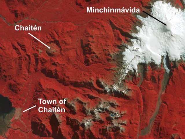 |
Figure 1. Orthorectified 15-m ASTER infrared (VNIR) satellite image from 1 April 2006 showing Chaitén volcano (upper left), ice-covered Minchinmávida volcano (right), and the town of Chaitén (lower left). Courtesy of Rick Wessels, Alaska Volcano Observatory. |
Servicio Nacional de Geología y Minería (SERNAGEOMIN) reported that a pulsating white-to-gray ash plume on 2 May rose to an estimated altitude greater than 21 km and drifted SSE. Based on observations of satellite imagery and pilot reports, the Buenos Aires VAAC reported an ash plume at altitudes of 13.7-16.8 km that drifted NE. According to news articles, Chile's government declared a state of emergency on 2 May and several hundred people were evacuated from the coastal town of Chaitén (10 km SE).
According to news sources, ashfall was reported during 2-6 May both locally and up to hundreds of kilometers away, affecting water supplies and roads. Based on observations of satellite imagery and pilot reports, the Buenos Aires VAAC reported that during 3-6 May ash plumes rose as high as 10.7 km altitude and drifted variably to the SE (figure 2), E, W, and NE. News sources indicated that about 4,000-5,000 people were evacuated from the town of Chaitén and surrounding areas as the eruption continued. On 5 May, ONEMI (Oficina Nacional de Emergencia - Ministerio del Interior) reported that evacuations also took place in Futaleufú, about 65 km ESE of Chaitén, where ~ 30 cm of ash accumulated. One elderly person died during the evacuation efforts. On 6 May, ONEMI and SERNAGEOMIN reported that the eruption became more forceful and generated a wider and darker gray ash plume rising to an estimated altitude of 30 km. All remaining people in Chaitén were ordered to evacuate, as well as anyone within 50 km of the volcano.
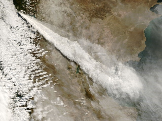 |
Figure 2. The Moderate Resolution Imaging Spectroradiometer (MODIS) on NASA's Terra satellite captured this image of a long, cloud-like plume extending about 700 km SE from Chaitén on 3 May at 1035 local time. The plume rises high over the Andes mountains, drifts across Argentina, and thins over the Atlantic Ocean. Courtesy of NASA Earth Observatory and the MODIS Rapid Response System. |
Activity continued, and a lava dome began growing from a vent on the upper flank of the old dome. Lahars and floods also inundated the town of Chaitén, causing widespread destruction. Additional details will be provided in future reports.
References. Naranjo, J.A., and Stern, C.R., 2004, Holocene tephrochronology of the southernmost part (42°30'-45°S) of the Andean Southern Volcanic Zone: Revista Geológica de Chile, v. 31, no. 2, p. 225-240.
Information Contacts: Servicio Nacional de Geología y Minería (SERNAGEOMIN), Avda Sta María No 0104, Santiago, Chile (URL: http://www.sernageomin.cl/); Oficina Nacional de Emergencia - Ministerio del Interior (ONEMI), Beaucheff 1637 / 1671, Santiago, Chile (URL: http://www.onemi.cl/); José Antonio Naranjo, Departamento de Geología Aplicada, SERNAGEOMIN; Buenos Aires Volcanic Ash Advisory Center (VAAC), Buenos Aires, Argentina (URL: http://www.smn.gov.ar/vaac/buenosaires/productos.php); Rick Wessels, Alaska Volcano Observatory, U.S. Geological Survey, Anchorage, AK, USA (URL: http://www.avo.alaska.edu/); NASA Earth Observatory (URL: http://earthobservatory.nasa.gov/); Associated Press (URL: http://www.ap.org/); Agence France-Presse (URL: http://www.afp.com/).
Widespread rhyolitic ash; a dome then a tephra cone; destructive lahars
[Chaitén began erupting] on the morning of 2 May 2008 (BGVN 33:04). This report discusses events through 30 May, in particular, summarizing reports ("Noticias") issued by Servicio Nacional de Geología y Minería (SERNAGEOMIN). News and other reports have variously stated 8,000-12,000 people evacuated.
Impacts of ashfall in Argentina also spurred a local government report (Anonymous, 2008) noting that the Argentine Atomic Energy Commission analyzed tephra (pumice and ash) from ashfalls in Argentina. Results established the tephra as a low-silica rhyolite (table 1).
Table 1. Major element analyses (ranges for four samples) from Chaitén's ash. The samples were all from Argentina, at or near the settlements of Corovado (120 km SE of the volcano), Trevelin and Esquel (~100 km E), and Epuyén (~120 km NE). The values presented are weight percent (with total Fe shown as Fe2O3). In general, low silica rhyolites are typically about 69-74% SiO2; high-silica rhyolites, about 75-84%SiO2. Values here were measured by Laboratorio de Geoquímica de la Comisión Nacional de Energía Atómica, Regional Cuyo (Anonymous, 2008).
| Oxide | Range (wt. %) |
| SiO2 | 71.80-73.30 |
| Al2O3 | 13.50-14.35 |
| Total Fe as Fe2O3 | 1.43- 1.85 |
| CaO | 1.00- 2.50 |
| MgO | 0.30- 0.60 |
| Na2O | 4.40- 4.60 |
| K2O | 3.15- 3.30 |
| MnO | 0.04 |
| Total | 99.33-99.92 |
News reports during May (and later) stated that ash in and over Argentina closed airports. Many flights were also cancelled.
Chaitén volcano is in southern Chile, at the S end of Patagonia's Lakes district (figure 3). The evacuated town of Chaitén (figure 4) served as the provincial capital of Palena. The town was home to about 4,000 people, but lahars have buried at least portions of it. That town was also the main jumping-off point for Pumalin Park, a new nature sanctuary funded by philanthropist Douglas Tompkins.
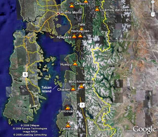 |
Figure 3. Map showing Chaitén volcano and other Southern Volcanic Zone volcanoes in Chile. The large island to the west is Chiloé Island. The passage at the N end of Chiloé island is called the Chacao strait; and the body of water it leads to is the Ancud gulf; farther S it becomes the Corcovado gulf. The city of Puerto Montt and major roads emphasize that the town of Chaitén lacks road access to the N. The town has an airport, but most residents evacuated by boat. Courtesy of Google Earth. |
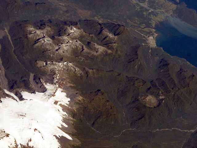 |
Figure 4. A pre-eruption photograph taken in 2003 looking downward and approximately SW from the International Space Station. Chaitén volcano sits in the lower right, with the larger snow-covered Minchinmavida at lower left. The Blanco river leads from the 3-km-diameter caldera towards the sea and passes through the town of Chaitén (top right), 10 km from the volcano. Photo ISS006E42130; courtesy of NASA. |
To the W of Chaitén town lies both the large (190 km long) Chiloé island and the much smaller Talcán island. Talcán island sits ~ 30 km from the town of Chaitén; it served as a staging area for monitoring efforts. Many of the larger rivers along the coast in the region reach the sea at fjords, and Chaitén town sits at the head of a fjord of the same name.
Synopsis of key events. Events during May included the month-long persistence of ash plumes; impressive electrical discharges coincident with some ash plumes; an ash blanket spanning cross-continent; some variable (and difficult to forecast) plume-dispersal patterns; small pyroclastic flows on multiple days; and lahars that progressively engulfed the town of Chaitén.
Some other highlights include the following. By 6 May, two explosion craters on the dome's N flank had united to form one large crater. By 21 May, aerial viewers saw a new dome had extruded in the N-central sector of the older rhyolite dome (figure 5). That new dome continued to grow through May, sprouting on the older dome, and later in the month, forming a large tephra cone. On 24 May, observers saw a vigorous eruption venting from an explosion crater on the old dome. They also noted that the new dome had grown taller than the old one. On 26 May, reports declared that the eruption had entered a less energetic phase (subplinean) with ash plumes rising 3-5 km in altitude.
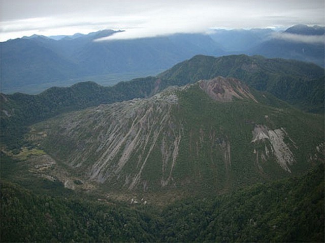 |
Figure 5. The dome-filled caldera of Chaitén volcano is seen in an aerial view from the S taken prior to the 2008 eruption. The elliptical 2.5 x 4 km wide summit caldera was formed during an eruption about 9,400 years ago. A rhyolitic, 962-m-high obsidian lava dome occupies much of the caldera floor. Photo by Eric Manríquez T. (Instituto Geográfico Militar). |
SERNAGEOMIN began to author reports on Chaitén starting the day the eruption began (2 May 2008, BGVN 32:04). Ten reports discussed May events. In addition, although little discussed in this report, the advent of digital and internet technology enabled eruption observers to share unprecedented numbers of photographs and videos. Satellite data on the eruption was also impressive (eg., NASA's Earth Observatory website featured 14 reports on Chaitén's May impacts).
Activity during 4-31 May. Amid reports of tall plumes on 3-6 May (BGVN 33:04), Andes del Sur (OVDAS) of SERNAGEOMIN installed three non-telemetered seismic stations around the volcano. These stations were later moved to more accessible places to enable more frequent data inspection. Improved seismic stations were installed later in the month (see below).
The 5 May eruptive vigor is partly revealed by an astronaut photo (NASA-ISS, 2008). Taken from a height of 344 km, it showed a plume punching through weather clouds and manifesting powerful vertical transport. It also highlights how weather clouds then would have thwarted ground observers from seeing, and thus assessing, the height of the plume top in those conditions.
Satellite imagery acquired on 5 May and discussed by NASA's Earth Observatory website that day revealed the Chaitén plume and a fresh blanket of ash. The ash blanket stretched from the high Andes to the Atlantic coast, and the ash plume continued E beyond it. Areas of the land surface along the Andes and to the Pacific were obscured by weather clouds.
The 6 May report noted that the eruption intensified at 0820 that day, leading to vigorous explosions of rhythmic character and high sustained energy. An ash column rose to ~ 30 km altitude. At this point in time, the column was taller and wider than those seen in the earlier, initial eruptive phase.
A helicopter flight at 1000 on the 6th indicated that two explosion craters on the dome's N flank had united to form one crater ~ 800 m in diameter. The column height had decreased. Consistent with mobile ash on the ground, the amount of ash in rivers in the region had increased.
After large explosions on 6 and 7 May, earthquakes occurred that were thought to denote moving fluid associated with a magma chamber beneath the volcano. Hypocenter calculations suggested the magma chamber was at less than 5 km depth. The ambient seismicity near the volcano around that time was ~ 35 volcano-tectonic earthquakes per day.
During 8 May, despite frequent low-hanging clouds, viewers glimpsed areas E of Chaitén. Along a N-trending valley there, thin gray spirals of cloud descended into the Rayas river, and ultimately the Rayas itself also began to emit clouds. SERNAGEOMIN's 9 May report explained these phenomena as the result of small pyroclastic flows inferred to have heated the river waters, thus yielding vapor that subsequently condensed to form the spirals of cloud.
The atmosphere, which on 8 May was cloudy during the hours 0715 to 1515, cleared somewhat during 1500-1630. At 1600 viewers saw both the volcano and a NE-blowing mushroom-shaped cloud that reached 14 km altitude. Photographic evidence (not included) showed that to the W side of the column there appeared a smaller cloud that looked denser and medium to dark gray. That smaller cloud was thought to have been associated with a new vent located at the foot of the dome's W side.
At 1300 on 12 May observers on Talcán island saw the upper portion of an ash column, which rose to 8.0 km altitude. Helicopter flights found strong SW winds aloft, blowing 80-100 km/hour to the NE. Despite the wind, during the flight about four explosions rose to similar (8 km) altitudes, thus sustaining the plume.
Aerial inspection of the caldera and dome at 1430 on 12 May revealed that small pyroclastic flows had burned multiple hectares of native forest in the headwaters of the Rayas river on the caldera's N flank and as far as the Austral highway. Similar processes had also devastated vegetation both everywhere within the caldera and on parts of the outer NE flanks. A wide, vertically oriented ash column originated from a vent extending from a crater on the older dome's N flank to its summit.
A photo of the caldera provided in the 13 May report showed a powerful billowing eruption. Incandescent areas spread along the dome's upper SE side, and a blanket of fresh fragmental deposits covered much of the upper dome.
On 12 May a helicopter crew found Chaitén town flooded by lahars traveling down the Blanco river. Based on the two photos in the report, the lahars at that point had covered roughly the lower half of single-story structures closest to the river and as far back as perhaps 3-5 buildings from those closest to the river's former margin. Some buildings closest the river were dislodged, a few had only their uppermost walls and roofs exposed. Significant portions of the town farther from the river still stood above the level of inundation.
Subsequent to 12 May, the river rose yet farther, and lahars took out a bridge. The lahars stretched ~ 200 m farther into the town reaching ~ 40 homes and numerous vehicles. Scenes of the town of Chaitén became the subject of many news reports and some videos posted on the web.
NASA's Earth Observatory posted an image acquired on 12 May (figure 6). Ash was again visible across the entire continent, spreading in a band trending ENE of the volcano. The ash is more visible in this image as the plume is blowing well S of the ash blanket.
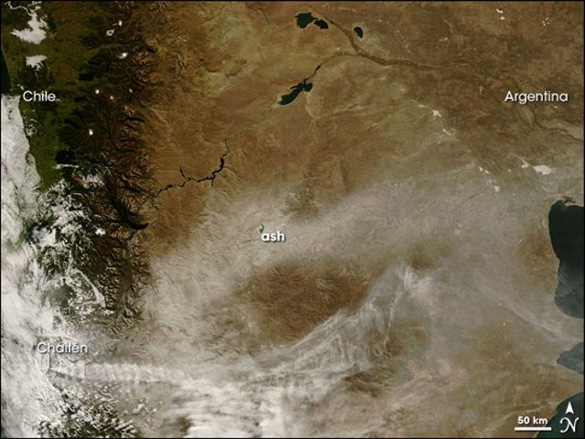 |
Figure 6. Chaitén's plume crosses the bottom of this Terra satellite image from 12 May 2008, becoming more diffuse before reaching the Atlantic coast. The ashfall blanket in an E-W cross-continent band. Courtesy of NASA Earth Observatory by Jeff Schmaltz and Michon Scott (their 12 May report). |
The 16 May report noted that the eruption was clearly plinean in nature and the source of continuous plumes. But, in the past two days, the plumes had not risen above 5 km altitude. Seismicity during 14-16 May included swarms of hybrid earthquakes.
At 0730 on 15 May observers saw the upper part of an ash plume reach 4 km altitude. The plume was swept NE in 140 km/hr winds. That day, a helicopter took observers over the town of Chaitén and the Amarillo and Michinmahuida rivers. Wide areas of the region were covered by white tephra. Lahars continued, apparent both to Chaitén's S and along the Blanco river to the coast. Lahars covered the Chaitén airfield and invaded the dock areas, as well as its main plaza, swamping government buildings. The lahars continued rising as the river bed and flood plains filled with sediments. Discolored water was seen widely (including N of Chaitén town in Pumalín bay,). Some elongate pumice rafts were floating in the Corcovado gulf.
In response to the crisis at Chaitén, during mid-May, the United States gave Chile several radio-telemetered seismic stations. Three members of the US Geological Survey (USGS) also joined SERNAGEOMIN and other agencies in Chile to install two stations. The visiting team, there during mid-May to early June, also discussed instrument operations, maintenance, and data interpretation.
The diagram in figure 7 indicates the key components of the portable seismic station initially used (without telemetry) and the new seismic stations installed (with digital instrumentation, telemetry, and linkage to the Internet). Both of the new seismic stations were installed on the mainland, broadcasting to a site on Chiloé island. Photographs of the area were taken during fieldwork (figures 8-10).
 |
Figure 7. Diagrams comparing seismic stations and related components. At Chaitén, the portable stations were replaced by telemetered seismic stations during mid-May 2008. The A/D converter changes continuouos (Analog) signals to a stream of discrete (Digital) numbers. A "wideband" (broadband) seismic sensor can detect ground motions over wide frequency ranges compared to the narrower ranges typical of older instruments. These instruments also have a more uniform response across these varied frequencies, easing data interpretation. Courtesy of SERNAGEOMIN (from their 20 May report). |
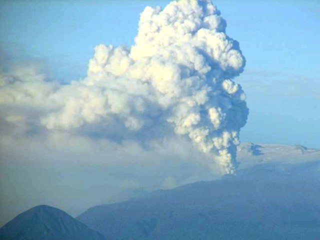 |
Figure 8. Chaitén eruption plume seen looking E across the gulf on 19 May 2008. The snow-covered flanks of Michimahuida volcano appear in the background. Courtesy of J.N. Marso (USGS). |
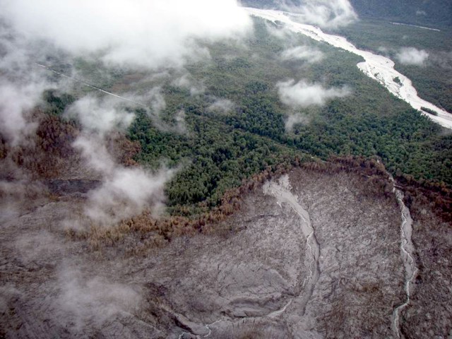 |
Figure 9. Native forest destroyed by pyroclastic surges on the flanks of Chaitén during mid-May to early June 2008. Note the singed band located between the zone of total destruction (bottom) and unaffected forest (top). A road is visible across much of the photo. Photo by A.B. Lockhart, USGS. |
 |
Figure 10. (top) Town of Chaitén overrun by lahars during mid-May to early June 2008. Lahars had began to accumulate as a delta at the river mouth. Owing to sedimentation, the river (seen in background) had changed course and was then flowing through the town. The airport is on photo's right side between the town and the steep hill in background. (bottom) This closer view illustrates variable amounts of lahar damage affecting Chaitén town. This town was completely evacuated within several days of the eruption's onset. Photos by A.B. Lockhart, USGS. |
At midday on 15 May, the authors described a cold wind that carried fine ash W. Ash fell on the ship Aquiles and on Talcán island, reaching 0.5-1.0 mm thick. In the same time frame, ash fell at the Blanco and Rayas rivers at least as far W as the Chaitén fjord's mouth.
Favorable weather, including strong wind, enabled scientists to assess the caldera on 21 May (figure 11). They found a new dome had emerged, already of significant size. It extruded from an area in the old dome. The eruption at the time was vigorous, though marked by sporadic explosions.
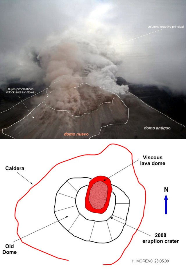 |
Figure 11. (top) An annotated photo from a helicopter on 21 May 2008 looking S into the erupting Chaitén caldera documenting the emergence of a new dome on the N side of the old one. The old dome (dark color, lower right) emitted a white plume; the new one (pale rose in colored versions of this photo, center) emitted a pale rose plume. Small block-and-ash flows descended the new dome's N side. The dark material in the background is the far (S) caldera wall. The venting ash column delivered considerable ashfall downwind. (bottom) A schematic (plan view) of the caldera seen that day (composed 23 May 2008 by H. Moreno). Both courtesy of SERNAGEOMIN. |
An overflight on 24 May revealed the new dome had slightly higher elevation than the old dome. Airborne observers saw the cone's 200-m-diameter crater vigorously expelling gas and ash. This vent was on the higher parts of the old dome in an area just to the S of the active dome.
The eruption, although unceasing, was described in the 26 May report as having decreased to subplinean. It remained in this lower energy state through at least month's end. On 25 May, ash columns reached ~ 3.5 km in altitude, with occasional explosions prompting plumes up to 5 km. Plumes often blew NE.
The 22 May report mentioned a swarm of hybrid earthquakes, in this case with considerable 3 Hz content. Volcano-tectonic earthquakes diminished progressively during 22-26 May, both in number and magnitude. These accompanied a reduction in volcanism.
A substantial tephra cone had developed on top of the new and old domes by 26 May (figure 12). The new dome, pink in color, was still present but lay directly behind the collar of tephra composing the new tephra cone. A summit crater vented plumes of different color. Although a dome had emerged, vigorous ash plume emission continued.
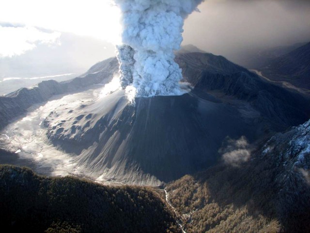 |
Figure 12. Chaitén seen from a helicopter on 26 May with the camera aimed NE. A tephra cone stood atop the new and old dome complex. The cone's steep upper walls discharged a broad plume from an unusually ample summit crater. The plume was two-toned, with distinctively shaded material on its left and right sides. Lumpy areas on the middle to lower cone correspond to the obsidian on the now buried older dome. Some burned vegetation exists in the bottom center of the photo along the outflowing Blanco river. Photo by J.N. Marso (USGS). |
A 26 May Terra image showed some areas of ashfall, but also several unusual features attributed to the eruption. These were described in the 26 May Earth Observatory report. First, rivers and lakes around the volcano were a distinct blue-green color, and this discoloration persisted into the Corcovado gulf, presumably from the waters' high suspended loads.
Second, although views of ridges (topographic highs) were clear and unobstructed in the image, a dendritic pattern of clouds, fog or mist hugged the valleys (topographic lows) for at least 200-300 km N and NE of the volcano. These white, opaque clouds originated from Chaitén.
On 28 May the ash column rose to 3.5-4 km altitude, blowing N to NW. It affected localities hundreds of kilometers away. Chilean airports closed in Puerto Montt, Osorno, Valdivia, and as far as 300 km N in Temuco. Lower altitude winds blew ash farther W, affecting coastal areas between the town of Chaitén and Chumildén, including Talcán island. In these areas, suspended ash appeared as a dense mist, grounding aircraft, including those used for vol;cano inspections.
During the last few days May, the number and magnitude of volcano-tectonic earthquakes diminished, and both low-frequency and hybrid earthquakes were absent. These changes coincided with a drop in the altitudes of eruption columns over the course of about a week.
Reference. Anonymous, 2008, Análisis químicos realizados en la contingencia del Volcán Chaitén: Municpalidad de Lago Puelo, 4 p. Accessed July 2008 (URL: http://www.lagopuelo.gov.ar/extras/riesgos/Analisis_quimicos_realizados_contingencia_Volcan_Chaiten[1].pdf).
Naranjo, J.A., and Stern, C.R., 2004, Holocene tephrochronology of the southernmost part (42°30'-45°S) of the Andean Southern Volcanic Zone: Revista Geológica de Chile, v. 31, no. 2, p. 225-240.
NASA-ISS, 2008, Astronaut photo from the International Space Station taken at 2027 on 5 May 2008 UTC. (Frame 6214, Mission ISS 017; file name, ISS017-E-6214.JPG). Image Science and Analysis Laboratory, NASA-Johnson Space Center (URL: http://eol.jsc.nasa.gov/scripts/sseop/photo.pl?mission=ISS017&roll=E&frame=6214>
Information Contacts: Servicio Nacional de Geología y Minería (SERNAGEOMIN), Avenida Santa María 0104, Santiago, Chile (URL: http://www.sernageomin.cl/); Oficina Nacional de Emergencia - Ministerio del Interior (ONEMI), Beaucheff 1637 / 1671, Santiago, Chile (URL: http://www.onemi.cl/); José Antonio Naranjo, Departamento de Geología Aplicada, SERNAGEOMIN, Avenida Santa María 0104, Santiago, Chile; NASA Earth Observatory (URL: http://earthobservatory.nasa.gov/); John Pallaster, Andy B. Lockhart, Jeff N. Marso, and John Ewert, US Geological Survey (USGS), Volcano Disaster Assistance Program (VDAP), 1300 SE Cardinal Court, Bldg. 10, Suite 100, Vancouver, WA 98683, USA; Image Science and Analysis Laboratory, NASA-Johnson Space Center, The Gateway to Astronaut Photography of Earth (URL: http://eol.jsc.nasa.gov/).
Events of June-July include diminished plumes, substantial seismicity, and lateral blast
Follow previous reports of May 2008 activity (BGVN 33:04, 33:05), this report summarizes Chaitén's behavior from 31 May through 25 July 2008. The bulk of this report came from SERNAGEOMIN (Servicio Nacional de Geología y Minería) and to some extent ONEMI (Oficina Nacional de Emergencia - Ministerio del Interior). A web camera located on a tower in Chaitén town and aimed upstream along the Blanco (Chaitén) river has helped authorities assess both the state of the volcano's plumes and the river (see URL in Information Contacts). In a later section are included some descriptions and photos by Richard Roscoe taken on 9 July.
On 3 June it was reported that lateral blasts or surges (or related processes) had devastated ~ 25 km2 of native forest. Other behavior during this interval included consistent ash plumes, which were generally present when the volcano was visible, and continued growth of the intracrater dome and tephra cone. Vent areas and the dome and tephra cone's morphology changed as the dome grew more elongate.
The late May to early June behavior included a short-term seismic decrease, and a weakened eruptive column. During the reporting interval, the column was often noticeably weaker than in early May, but the seismicity was still relatively high. The two main seismic instruments monitoring the volcano (figure 13) registered numerous sustained events through late July, which began to cluster NNE of Chaitén. Some of the earthquakes were up to M 2.6.
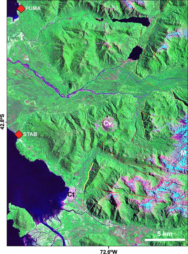 |
Figure 13. Monitoring instrumentation includes two telemetered seismic stations, PUMA (short for Pumalín) and STAB (short for Santa Barbara), which sit adjacent the coast and monitor Chaitén volcano (Cv). On 12 July the stations detected two earthquakes centered NE of the volcano along a major fault trace there (the Liquiñe-Ofqui fault system). The colored versions of the map distinguish second-order faults, which mostly have left-lateral kinematics (red lines), and eroded scarps (yellow lines). Snow-covered Michinmahuida stratovolcano is also a prominent feature (M, along the E margin of map), as is the town of Chaitén (Ct). Courtesy of Luis E. Lara. |
SERNAGEOMIN repeatedly interpreted the earthquakes to signify magma ascending from depth. If this magma reached the surface, they noted, vigorous eruptions might return. The high-viscosity of rhyolitic magmas seen here increases potential explosivity. This rhyolitic eruption at Chaitén is the first historically at a monitored volcano. The last significant rhyolitic eruption was at Novarupta volcano in Alaska in 1912.
Chaitén town has largely survived the lahars thus far. A deeper concern is that the growing dome and tephra cone sent bouncing rocks and smaller debris into the caldera's moat. In an early July SERNAGEOMIN report, the authors noted that the caldera's breach, located on the S, appeared blocked by recently eroded products. Small lakes were also then seen on the crater floor. Since the moat area drains to the S through this breach and feeds into the Blanco river, temporary dams in the moat area might seal the caldera's outflow, only to suddenly fail and release large volumes of debris towards the town. Despite this concern, as of 25 July such an event had been absent; however, on 12 July a sudden flood struck Chaitén town (see below).
Activity during June 2008. On 1 June, Chaitén's plume blew W, affecting Chiloé island (including the towns of Queilen, Lebjn, Chonchi, Dalcahue, and Castro, the island's capital). These conditions thwarted work on the seismic network. On 2 June dense fog affected the Gulf of Corcovado, especially adjacent Chiloé island, an atmosphere attributed to remobilization of air-fall ash by wind. That day, a helicopter managed to take off and the view enabled scientists to see an eruptive column to no higher than 3.0 km altitude dispersing SSE.
Seismicity on 2 July was higher than the previous days. Abundant were VT earthquakes, followed by long- period (LP) earthquakes. Between 1 and 2 July, seismic stations registered an average of 5 VT earthquakes per hour (below M 2). At some stations, some of the LP signals were sporadic, lasting less than a minute.
A 5 June SERNAGEOMIN report noted that explosions diminished gradually. Although ash was present, vapor dominated the emissions. A 3 June aerial inspection revealed that the dome's volume and footprint had increased, although it still had not reached the caldera's N wall.
The effects of N and NE flank blasts (or surges, pyroclastic flows, or related processes) were noted during aerial observations from the 3 June flight. The surges had scorched and burned an area of native forest. On this day observers computed an estimate of the damaged area, ~ 2,500 hectares (~ 25 km2). An undated photo looking down on part of the destruction appeared in BGVN 33:05 and more photos appear below. Several SERNAGEOMIN reports mentioned small pyroclastic flows during early and mid-May (12 May in particular, BGVN 33:05). Bulletin editors take the 3 June estimate as reflecting the sum of all devastation to that point in time.
On 3 and 4 June the plume's top stood below 3 km altitude. A 10 June SERNAGEOMIN report noted the continued lowered eruptive and seismic intensity through that time. Plumes continued to remain under 3 km altitude and they still affected air travel.
On 12 June observers at Chaitén town noticed tephra-bearing emissions. Noises had emanated from the volcano that day and the previous one. The SERNAGEOMIN report associated these emissions with two new vents seen on the S flank of the old dome, where craters had developed. Vapor-rich plumes had emerged from these areas and the observers inferred that the vents were possibly due to magma-water interactions. In addition, sudden floods swept into Chaitén town in the afternoon on 12 June, despite a lack of evidence for greater rains across the region. They were inferred as related to the emissions the same day.
Seismicity beneath the volcano on 12 June increased in the morning both in terms of the number of earthquakes and their magnitudes. Most of these events were less than M 2. Two prominent earthquakes struck ~ 5 km farther NE of the volcano, along the Liquiñe-Ofqui fault zone.
The 22 June report noted that observers looking at the contact between the old and new domes had seen two craters there that emitted ash plumes. The observers also noted near-source falls of both blocks and ash.
The same report said that a 17 June aerial inspection documented an ash plume to over 2 km over the volcano's summit that blew N and NW. Roars and associated noise from the eruption included the sound of an explosion at 1430 on 17 June. The resulting column rose to a height above the summit of over 3 km but later dropped to 2 km. Emissions continued from a crater S of the contact between the old and new domes. Immediately to the W of this crater, a new and growing crater issued increasingly large emissions of ash and gas. Numerous smaller vents were also apparent, chiefly emitting steam. Loose material covered parts of the old dome, forming a ring-shaped structure (a tephra cone). That structure's steep sides and inner and outer walls occasionally underwent mass wasting. Poor weather during 19-25 June halted aerial inspections then, but ash fell in Chaitén town and to the W and SE, as well as Queilen and other portions of E Chiloé island.
Following 20 June, seismicity remained stable with ~ 40-45 earthquakes per day. Sporadic numbers of VT earthquakes took place; there was no change in the number of LP earthquakes. Investigators inferred a lack of pressure increase in the volcanic system. During bad weather on 23-25 June some earthquakes again occurred on the Liquiñe-Ofqui fault zone, with epicenters in an area 2-3 km E of the volcano. A power outage struck midday on 25 June. A back-up power supply (UPS) worked for a while, but ultimately the outage caused several hours of lost seismic data at the Queilen processing center. Available data suggested a small increase in both the number and amplitudes of earthquakes during 24-25 June. During 0000-1200 on 25 June, instruments recorded 35 VT earthquakes, and four of those were M 2.2; LP earthquakes were absent.
Seismicity during the days leading up the SERNAGEOMIN report issued on 27 June reflected VT earthquakes generally below M 2, reaching 50 per day. An exception was on the 25th when four earthquakes exceeded M 2.0.
July 2008. On 1 July an ash column rose ~ 3 km above the top of the new dome. It blew N and NE. An aerial observation at close hand discerned two roughly vertical, sub-parallel eruption plumes issuing from vents in the crater. One plume, most active in recent weeks, came from a sector S of the new dome. The second plume came from a sector more to the W of the new dome. A photo of the scene in the 3 July SERNAGEOMIN report also depicted the area of eruption largely engulfed in white clouds from numerous fumaroles on the dome. On 3 July SERNAGEOMIN began a series of reports on unrest at Llaima stratovolcano (which went to Red alert on 10 July). Around 16 July a weather front also moved in across the Chiloé island region. Consecutive SERNAGEOMIN reports discussing Chaitén were only issued on 3 and 21 July, with a lack of much discussion on that volcano for the interval 3-15 July.
During 15-20 July seismicity stood relatively high, with an average of 350-400 VT earthquakes per day. On 20 July more than 20 earthquakes surpassed M 2.6. The next reports noted that on 21 and 22 July VT earthquakes occurred 330 times per day; 60 of those were near M 2.6, and that the number of earthquakes decreased on 24 July. Still, some of the minor earthquakes reached M 2.6 and were detected up to 300 km away. Seismic data around this time were interpreted to reflect magma at depth moving towards the surface, possibly implying a reactivation of the system, although the earthquake's depth was poorly constrained.
Chaitén's plume blew E at ~ 2 km altitude above the summit and appeared weaker than usual when seen as the weather cleared after 1500 on 23 July. During 22-24 July, earthquakes had increased both in number and magnitude, with the largest M ~ 2.6.
A new area of epicenters appeared during 22 and 23 July at a location 6 km ENE of the volcano. Seismic stations located 176 and 296 km from Chaitén, respectively monitoring the volcanoes Calbuco and Puyehue-Cordón Caulle, recorded these events, the first such occurrence since the eruption began. Previously, conspicuous epicenters had mainly occurred to the S and SE. Preliminary hypocenter calculations suggested the larger earthquakes in this NNE area were deeper, at 10-15 km depth.
Arrival times of S- and P-waves at stations Pumalín and Santa Bárbara indicated that the smaller magnitude earthquakes still occurred S and SE of Chaitén, whereas the larger magnitude earthquakes struck in the area 6 km ENE. An inspection flight carried viewers to the N and NE of the volcano on 24 July where they saw that the single active central vent sat to the S of the new dome. The emissions then were intermittent, white, and ash poor. When strongest, a thin plume rose to under 2 km altitude, with strong winds causing dispersion to the S and SE. When viewed on 24 July, the new dome also contained a significant depression in the S sector, at a point immediately N of the main active vent mentioned above. This depression emitted steam and gases. The new dome seemed to have decreased its growth rate, at least in the N sector. Strong steaming emerged from base of the dome's E sector. The observers looked around the new dome on the NW, N and NE sides, and they saw neither ponded areas nor lakes. During 24-27 July, the ash column rose to 2.5 km and occasionally 3.0 km altitude. The most active vent was the previously mentioned one located S of the new dome. The plume blew N and NW where it affected various localities along the coast.
Floating pumice. By early June, the white pumice from the eruption accumulated at river mouths to the volcano's W. Some fragments of pumice were as large as 40 cm in diameter. In addition to the Blanco river, those carrying the pumice included the Yelcho and Negro (respectively entering the sea 2 km and 5 km S of Chaitén town). Pumice rafts in the Gulf were seen in May (BGVN 33:05). During June and at least early July, along beaches of Chiloé (and particularly at Lelbjn, 12 km N of Queilen, a town almost directly W of Chaitén town) floating pumice continued to arrive. This area lies 60-100 km across Corcorvado gulf from the mouth of the Blanco river at Chaitén town. The pumice deposits, which included tree trunks and other debris, covered a thin zone along the shoreline stretching ~ 20 m from the sea's edge when photographed the afternoon of 1 July.
Roscoe's July 2008 photos. One of the subjects Roscoe presented on his PhotoVolcanica website was Chaitén's N devastated area, and some of those photos appear here (figures 14 and 15). The captions were brief and omitted the direction the camera was aimed. He visited the devastated area on 9 July 2008.
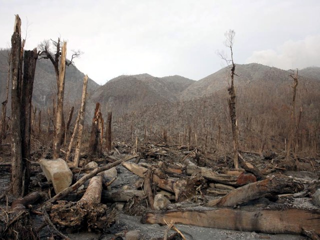 |
Figure 14. One of the parts of the devastation zone containing large lithic blocks (~ 1 m across), the most conspicuous being the one at left, which may have been perched above fallen timber. Trees here fell away from the viewer. Courtesy of Richard Roscoe, PhotoVolcanica.com. |
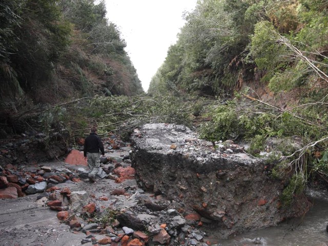 |
Figure 15. Drainages redirected by Chaitén's eruption caused erosion of this road to the volcano's N. Courtesy of Richard Roscoe, PhotoVolcanica.com. |
Roscoe noted that in the area he photographed, "Most trees were snapped off a couple of meters above the ground. The [pyroclastic] flow does not appear to have been hot enough to burn the leaves off the trees at the point we visited at the base of the volcano. Many branches with brown leaves were lying around. Very little pumice was found in the area although much of it may have been swept away during subsequent heavy rainfall."
In Chaitén town, Roscoe documented damage-mitigation and salvaging efforts (figure 16). Two of Roscoe's photos showed heavy equipment (a large backhoe and a bulldozer) reshaping the lahar deposits in an attempt to control encroaching lahars. Other scenes included people retrieving belongings, excavating lahar deposits covering the floor and lower shelves of a grocery store, and improving drainage from and access to their homes.
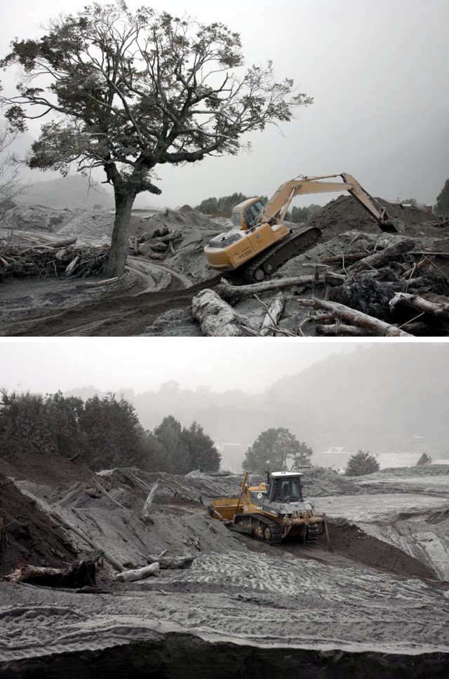 |
Figure 16. Work in Chaitén town to strengthen river banks to protect town from lahars. Although laden with tree trunks, the lahars appear quite uniform in color and character, devoid of coarse lithics or large rafted pumices. Courtesy of Richard Roscoe, PhotoVolcanica.com. |
Information Contacts: Servicio Nacional de Geología y Minería(SERNAGEOMIN), Avda Sta María No 0104, Santiago, Chile (URL: http://www.sernageomin.cl/); Oficina Nacional de Emergencia - Ministerio del Interior (ONEMI), Beaucheff 1637 / 1671, Santiago, Chile (URL: http://www.onemi.cl/); Luis E. Lara, Departamento de Geología Aplicada, SERNAGEOMIN; Richard Roscoe, Photovolcanica.com (URL: http://www.photovolcanica.com/).
During June-November2008 dome continues to enlarge despite a lateral blast
What follows summarizes official agency reporting on Chaitén's behavior from 26 July 2008 through early November 2008. Noteworthy events included a large scar that developed on the E dome area by 31 July 2008 from an inferred lateral blast, observance of a new lava dome (or dome lobe), ongoing seismicity, the emergence of the new dome as the highest point in the complex, dome growth to a point where the dome crossed the moat to impinge on the caldera wall, ongoing destruction to the town of Chaitén (10 km SW) by debris-laden floodwaters, and changes in the river system due to lahars. The hazard status remained at Volcanic Alert Red, Level 6—the highest level—throughout the reporting period.
The bulk of this report came from those issued by the Servicio Nacional de Geología y Minería (SERNAGEOMIN) with collaboration from the Oficina Nacional de Emergencia—Ministerio del Interior (ONEMI). Collectively, they and partner organizations listed below under Information Contacts issued over 20 reports we used in discussions here. Below, we reference the four reports from which we extracted figures (ONEMI-SERNAGEOMIN, 2008a, b, c, and d). Respectively, these four reports covered these respective date ranges in 2008: (a, no. 45) 31 July-1 August; (b, no. 55) 23-30 September; (c, no. 58) 14-20 September; and (d, no. 60) 31 October-7 November.
As previously reported, activity at Chaitén during June-July 2008 included diminished plumes compared with earlier activity, substantial seismicity, and lateral blasts that devastated ~25 km2 of native forest (BGVN 33:06).
Seismicity, dominated by volcano-tectonic earthquakes, increased in July 2008, with some higher-magnitude earthquakes felt by the residents of the town of Chaitén. According to Carn and others (2009), "During July [2008], ash and steam emissions subsided while lava extrusion continued, accompanied daily by up to 300 hybrid earthquakes, which have characteristics transitional between low- and high-frequency events. Earthquake magnitudes increased from less than 2.5 to 4 by the end of July, raising concerns about renewed explosive eruptions, but seismicity declined in August. By late September 2008, the new lava dome volume was about half a cubic kilometer."
Clouds often obscured the view of Chaitén during 23 July-25 November. However, when visible, gas-and-ash plumes generally rose to an altitude of 1.4-4 km. In one of many examples, a modest (2 km high) plume dropped minor ash on 15 October, leaving plant leaves with a thin sprinkling of ash. Plumes reached over 4 km altitude on 13 August (up to 6-7 km), 27-28 September (5 km), and 26-28 October (7 km). Ash fell in the town of Chaitén at times. Noteworthy cases of ash accumulation including those on 24 July (3 cm thick); 27 July (thickness unstated); and 13 August (1.5 cm thick).
An overflight on 24 July revealed a 2-km-altitude plume that escaped from an area S of a previous vent, a zone on the S flank of the new lava dome. That plume contained emissions from various areas on the dome and included ash-bearing plumes generated by explosions. A gas-and-steam plume was emitted from a depression, also on the S flank, that was possibly formed by an explosion or partial collapse the previous day or two.
The Buenos Aires Volcanic Ash Advisory Center saw thermal anomalies over the lava dome in satellite imagery. Detections occurred during 22-23 August, 20-22 and 25-27 September, 27 and 30 October, and 2, 10, and 12 November 2008.
Scar in the dome. A Twin Otter aircraft flew past the volcano on 31 July 2008, and observers first saw a large scar on the E side of the dome. At some point in the flight they also saw a 2-km-altitude, languid, light-colored plume, which contained a small proportion of ash and blew NE. The plume vented most strongly from the growing dome's upper area. The scar was horseshoe-shaped, ~500 m wide, and ~200 m high, and had formed on an unknown date near the end of July 2008 (figure 17). The scar was inferred to have formed by a lateral explosion rather than collapse, because hummocky morphology typical of landslide deposits was absent on the caldera's floor (the moat) below the scar (OVDAS-SERNAGEOMIN, 2008a). Recent pyroclastic flow deposits associated with the scar also were not conspicuous. The location of the scar on the E dome was judged fortunate; if the same volume of material had blasted from the S dome, it would have traveled into the Chaitén (Blanco) River, and accordingly, to the town of Chaitén. Material from the explosion was transported into drainages that eventually flowed N into the Rayas River, and also entered small lakes at the S base of the dome (figure 18). However a significant volume of the material broken loose from the dome by the directed blast was visible in and adjacent to the SE moat. In the E moat, there were both a lake and a steep erosional scarp (figure 18). Thus, after the blast, the valley's SE drainage became obstructed, whereas the SW drainage remained open. Debris-charged water was visible in many parts of the moat.
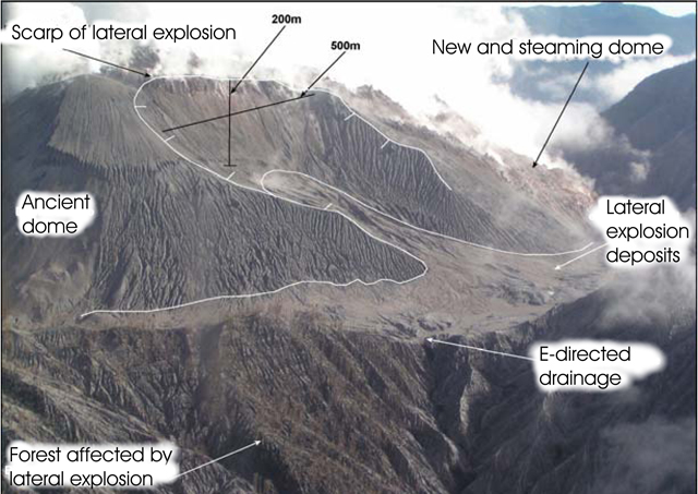 |
Figure 17. Scar of the lateral explosion taken at Chaitén on 31 July 2008 looking at the dome's E side. This view also contains multiple labels detailing the scene. Taken from SERNAGEOMIN (2008a). |
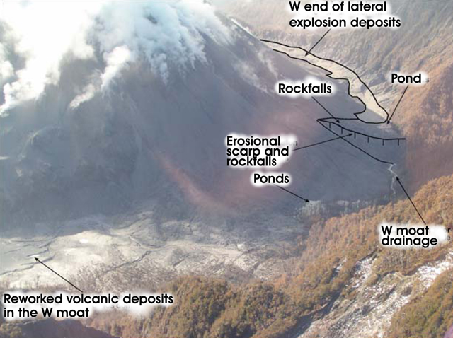 |
Figure 18. Vista of Chaitén's S moat as seen 31 July 2008 from the NE. Taken from OVDASSERNAGEOMIN (2008a). |
Observations during August-November 2008. On 1 August, a N-facing camera situated ~1 km SE of town at the Chaitén airfield showed an active eruption plume in the morning, but weather obstructed the plume in the afternoon. This is one of two such web cameras at that airfield in a national system supported by the Chilean civil aviation agency DGAC. The other web camera shows the town of Chaitén (for more information see IFIS, 2011, in References below).
Seismicity decreased beginning in August and remained relatively low and variable through mid-September 2008. Hybrid earthquakes dominated, and, after 20 September, they increased in number and magnitude. SERNAGEOMIN interpreted seismicity during this time within the system as associated with movements of magmatic fluids and rock rupture. In late September, a seismic station was reinstalled in the volcano's N sector (previously sited at Auchemó, on an island 8 km SSW of the town of Chaitén). The new location was chosen in hopes that it would enable seismologists to better assess the volcano's seismic signals.
Although visual observations revealed comparative quiet during 23-25 September with weak plumes of mainly steam to 1.5-km altitude, the intensity of activity rose on the 27 and 28 September, when a series of columns emitted in separate puffs reached to 3- and sometimes 4-km altitude. The plumes were conspicuous from the settlements of Chaitén and Queilen and contained steam and fine ash.
On 30 September, the new dome had grown, but it lacked both any new scars (like the one seen on 31 July) and signs of further collapse at the 31 July scar. Small lakes remained on the N moat (arrow at left, figure 19). Portions of the older dome were still exposed (arrow at right, figure 19).
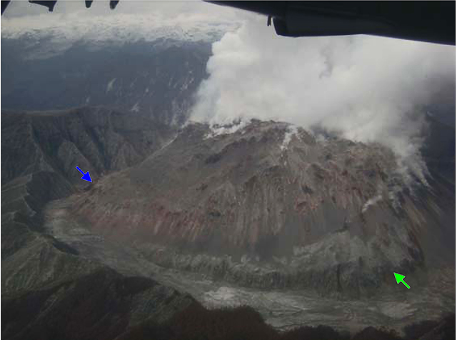 |
Figure 19. Aerial photo of the W portion of Chaitén's dome taken 30 September 2008 (from the E; arrows discussed in text). The upper dome gave off steam over a wide area. Taken from OVDAS-SERNAGEOMIN (2008b). |
An overflight occurred on 30 September, thanks to a Presidential Delegation, during which the emissions remained similar to those previously described. Observers found it hard to define a single vent area for the emissions, although it appeared that abundant vapor escaped in the N dome area (figure 19).
Observers also commented that the scar on the E dome had changed morphology due to erosion. A photo documented that, by 30 September, new dome growth was sufficient in the NE sector to have reached the NE wall. By this time, the report authors noted, the growing dome's height had exceeded that of the caldera's topographic margin (the summit, 1,112 m elevation, a point on the S rim).
The number of hybrid earthquakes increased beginning on 20 September through early October. Beginning on 4 October, the number of earthquakes over M 3.0 decreased, a decline interpreted as related to slowed dome growth. Seismicity continued to decrease through mid-October, and was concentrated mainly in the volcano's S sector. Volcano-tectonic earthquakes did not exceed 3 per day, with magnitudes less than 1.5. Epicenters plotted on a map for 14-16 November scattered along a broad ~3-km-long line trending tangent to the ESE rim of the caldera, with several on the SE dome. Their focal depths were 0.5-3 km.
A miniDoas (a portable spectrometer based largely on differential optical absorption, Nadeau and Williams-Jones, 2008) was used for ground-based transects of the plume on 15 October 2008 to assess SO2 fluxes. After several transects along a N65°W path and wind estimates of 5 m/s (from the Chilean Meteorological Directorate), the resulting flux estimate was 190 metric tons per day.
On 29 October, activity at Chaitén increased, characterized by several explosions that darkened the plume and caused it to rise from ~1.6 km to ~3.1 km. SERNAGEOMIN reported that variations in seismicity remained similar to patterns detected during the previous weeks.
On a 30 October flight, scientists observed a landslide that had originated from the active lava dome. The next day, observers described a plume emitted from multiple areas that rose to an altitude of 2.1 km. The white component of the plume (steam and gas) emitted mainly from the center and S portions of the dome. Vents on the dome's N and NE areas produced a gray plume.
An ONEMI-SERNAGEOMIN report (2008d) covered the date range 31 October-7 November 2008. Owing to bad weather, only on 2 November did observers or cameras in the town of Chatén manage to obtain a reasonable view of the volcano (figure 20). That day, they also saw an appreciable white column that appeared to be predominantly steam, similar to many of the plumes of recent months. The plume blew E, and its top reached ~2 km above the dome.
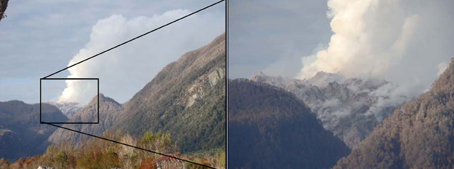 |
Figure 20. Chaitén as seen on 2 November 2008 from the town of the same name (~10 km SW). The photo on the right zooms in on dome in the framed area. Authors described the dome as "constantly growing." Taken from ONEMI-SERNAGEOMIN (2008d). |
On 4 November, ONEMI-SERNAGEOMIN reported that a recent overflight confirmed the presence of a second new lava dome. The new dome grew in the NE part of the first dome that started to form in May 2008 and had a diameter of ~300 m and a height of ~150 m. Spines protruded from the top. Seismicity was concentrated underneath the dome.
Seismicity during 31 October-7 November 2008. Elevated seismicity prevailed during the first week of November. Hybrid earthquakes dominated, averaging 2-5 events per hour. Those over M 3 occurred 1-2 times per hour. They typically had long, low-frequency (1 Hz) codas and focal depths of 0.5-2 km at points below and alongside the caldera.
Volcano-tectonic earthquakes were predominantly of low magnitude (under M 1). A larger event, M 2.2, occurred on 5 November; this was the first event of this type and magnitude in over a month. It was located 2 km W of the caldera margin at 7 km below the surface. The focus was close to, and possibly related to, a major structural lineament that trends NE across the Chaitén substructure at depths below 5 km.
Regarding the town of Chaitén. Heavy rains struck the region on 3 November, and, by 5 November, flooding had inundated parts of the town on the S banks of the Chaitén (Blanco) River (figure 21). One of the drainages with headwaters in the caldera feed into this river, and the moving water carried great quantities of volcanic material downstream. Lahars followed the river, leaving abundant sediments along their path, and they reached the sea at the river's mouth.
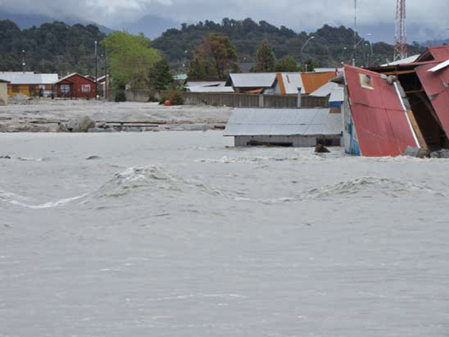 |
Figure 21. The sediment-charged Chaitén river seen in flood on 5 November 2008 looking towards the S side of the town of Chaitén. At distance appear intact portions of the town on higher ground. The river passes E and S of the town and then enters the sea at Chaitén bay on the Corcorvado gulf (see figure 13 in BGVN 33:06 and maps in various issues). Extensive tidal areas lie SE of the town. Taken from ONEMISERNAGEOMIN (2008d). |
According to ONEMI-SERNAGEOMIN, during dry conditions, both wind and vehicular traffic in Chaitén kicked up fine ash, which remained suspended in the atmosphere. This ash had obliged the town's few remaining inhabitants to don dust masks. The requisite masks needed to filter out material down to 5 microns in diameter.
References. IFIS (Internet Flight Information Service), 2011, Location map showing camera at Chaitén airfield (URL: http://www.aipchile.cl/aerodromo/ubicacion/designador/SCTN; Images of the volcano, http://www.aipchile.cl/camara/show/id/14); Images of the river and town, http://www.aipchile.cl/camara/show/id/15).
Carn, S. A., Pallister, J. S., Lara, L., Ewert, J. W., Watt, S., Prata, A. J., Thomas, R. J., and Villarosa, G., 2009, The Unexpected Awakening of Chaitén Volcano, Chile, Eos, Transactions, American Geophysical Union, Vol. 90, No. 24, 16 JUNE 2009, pp. 205-206.
Nadeau, P. A. and Williams-Jones, G., 2008, Beyond COSPECRecent advances in SO2 monitoring technology. In: Williams-Jones, G., Stix, J. & Hickson, C. (eds.) The COSPEC Cookbook: Making SO2 Measurements at Active Volcanoes. IAVCEI, Methods in Volcanology, 1, 219-233.
OVDAS-SERNAGEOMIN, 2008a, Erupción del volcán Chaitén, Cuadragésimo Quinto Informe Técnico, 31 de julio al 01 de agosto de 2008, 4 pp., Issued 1 August 2008 (in Spanish) [file name: Informe_45_Chaitén_al_01.08.08[1].pdf].
OVDAS-SERNAGEOMIN, 2008b, Erupción del volcán Chaitén, Informe Técnico No. 55, 23-30 de septiembre de 2008, 4 pp., (Issued 30 September 2008 (in Spanish) [file name: Informe_55_Chaitén_al_30.09.08[1].pdf].
OVDAS-SERNAGEOMIN, 2008c, Erupción del volcán Chaitén, Informe Técnico No. 58, 14-20 de Septiembre de 2008, 3 pp. Issued 20 October 2008 (in Spanish), [file name: Informe_58_Chaitén_al_20.10.08.pdf].
OVDAS-SERNAGEOMIN, 2008d, Erupción del volcán Chaitén, Informe Técnico No. 60, 31 de octubre-07 de noviembre de 2008; 3 pp., Issued 8 November 2008 (in Spanish), [file name: Informe_60_Chaitén_al_07.11.08.pdf].
Information Contacts: Oficina Nacional de Emergencia - Ministerio del Interior (ONEMI), Beaucheff 1637 / 1671, Santiago, Chile (URL: http://www.onemi.cl/); Observatorio Volcanológico de los Andes del Sur-Servico Nacional de Geologia y Mineria (OVDAS-SERNAGEOMIN), Avda Sta María No. 0104, Santiago, Chile (URL: http://www.sernageomin.cl/); Buenos Aires Volcanic Ash Advisory Center (VAAC), Servicio Meteorológico Nacional-Fuerza Aérea Argentina, 25 de mayo 658, Buenos Aires, Argentina (URL: http://www.smn.gov.ar/vaac/buenosaires/productos.php).
Declining vigor; magma ascent rate; disaster recovery in the town of Chaitén
The previous report on Chaitén volcano, Chile (BGVN 35:12) noted that a second new lava dome was reported on 4 November 2008. The Alert Level remained at Red (the highest of the alert level system) from the onset of the eruption on 2 May 2008 through April 2010. This report will chronologically summarize the growth of the new lava domes and major eruptive events. In general, a gradual decline in activity occurred during November 2008-September 2011. The Alert Level stood at Yellow during May 2010-May 2011, and was then lowered to Green, where it remained through the end of 2011. Most of the information in this report comes from weekly to monthly reports from the Observatorio Volcanológico de los Andes del Sur-Servicio Nacional de Geología y Minería (OVDAS-SERNAGEOMIN) with collaboration from the Oficina Nacional de Emergencia - Ministerio del Interior (ONEMI). Finally, the current status of the town of Chaitén (which was abandoned by all but a handful of residents who continued to live there without electricity or running water) will be discussed. The potential hazards from dome-collapse-generated block-and-ash flows and lahars from remobilized volcanic deposits were persistent throughout the reporting period.
Portions of this report were initially synthesized and edited by Nick Legg (covering November 2008-March 2009) and Eduardo Guerrero (covering April 2009-July 2009), as part of a graduate student writing assignment in a volcanology class at Oregon State University under the guidance of professor Shan de Silva.
New lava domes observed. Initially occupying the caldera of Chaitén was the lava dome ('old dome') that existed prior to the 2 May 2008 eruption (and for the ~ 9,400 years since the previous eruption). A lava dome ('Dome 1') first observed on 21 May 2008 and a new lava dome ('Dome 2') confirmed on 4 November 2008 during an overflight (BGVN 35:12) were extruded on top of the old dome (figures 22 and 23). A third phase of dome extrusion ('Dome 3') was observed on 29 September 2009.
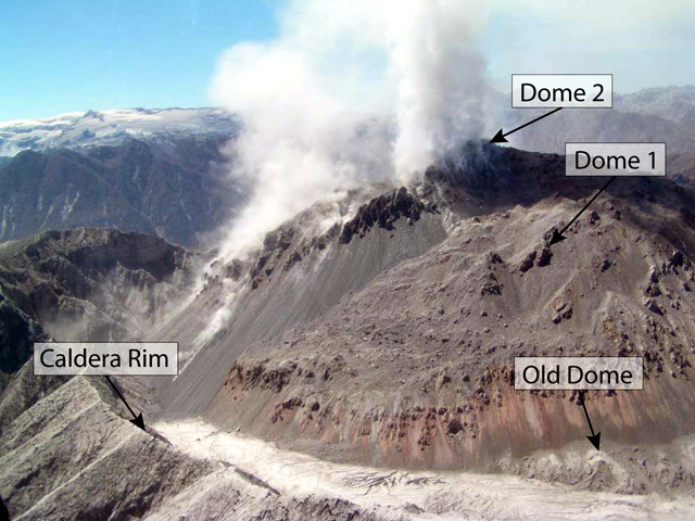 |
Figure 22. December 2008 aerial photograph of the Chaitén dome complex taken looking approximately SE into the caldera. The domes were emplaced on top of the old dome, emplaced ~9,400 years ago. Courtesy of OVDAS-SERNAGEOMIN. |
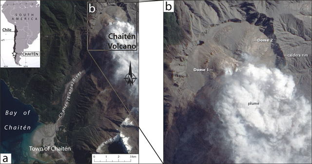 |
Figure 23. Satellite photograph of Chaitén and surroundings, acquired on 30 September 2009. (a) Chaitén volcano (top right corner), Chaitén (Blanco) River, and their proximity to the town of Chaitén (bottom left). Note the significant lahar deposits at the mouth of the Chaitén river and cutting through the town of Chaitén. Inset index map shows Chaitén's location in Southern Chile. (b) Enlarged, annotated view of Chaitén volcano. Dome 1 is in the W side of the caldera and Dome 2 is in the NNE part. Dome 3 is not visible in this photograph. Satellite photograph courtesy of NASA Earth Observatory; index map modified from MapsOf.net. |
November 2008-April 2010 (Red Alert). Following the confirmation of the existence of Dome 2 on 4 November 2008, a lateral explosion occurred on 17 November, directed WSW. The explosion was not constrained to either Dome 1 or 2 alone, but was associated with a collapse resulting from continued dome extrusion. By 6 December 2008, both active domes had exceed the height of the caldera rim (Dome 1 by ~ 250 m and Dome 2 by ~ 350 m). SERNAGEOMIN reported an increase in the growth of Dome 2, corresponding to a temporally slight increase in both hybrid (HB) and volcano-tectonic (VT) earthquakes.
Plumes continued to vary in color, indicating varying contributions of steam and ash from both new domes. By 9 January 2009, an observational overflight revealed that the inner caldera had been filled by Domes 1 and 2, and growth of sharp spines or pinnacles was reported.
On 19 January, a major collapse of the Dome 2 summit spines occurred, producing block-and-ash flows that traveled down the SE and E flanks of Chaitén. After the collapse, observers noted a decrease in seismicity and slowed dome extrusion.
During a flyby facilitated by ONEMI and the Chilean Air Force on 21 January 2009, researchers from the University at Buffalo-State University of New York (UB-SUNY) and the University of Chile acquired thermal images of the dome complex (figure 24). The thermal images indicated that, while Dome 1 still had areas of elevated temperature, the highest temperatures (greater than 150°C) corresponded to the pinnacles at the summit of Dome 2 (figure 24a). Images of pyroclastic flow and rockfall deposits resting within the E part of the caldera disclosed elevated temperatures there as well (higher than 80°C in places, figure 24b). Their research on thermal imaging of Chaitén will be showcased in an upcoming publication.
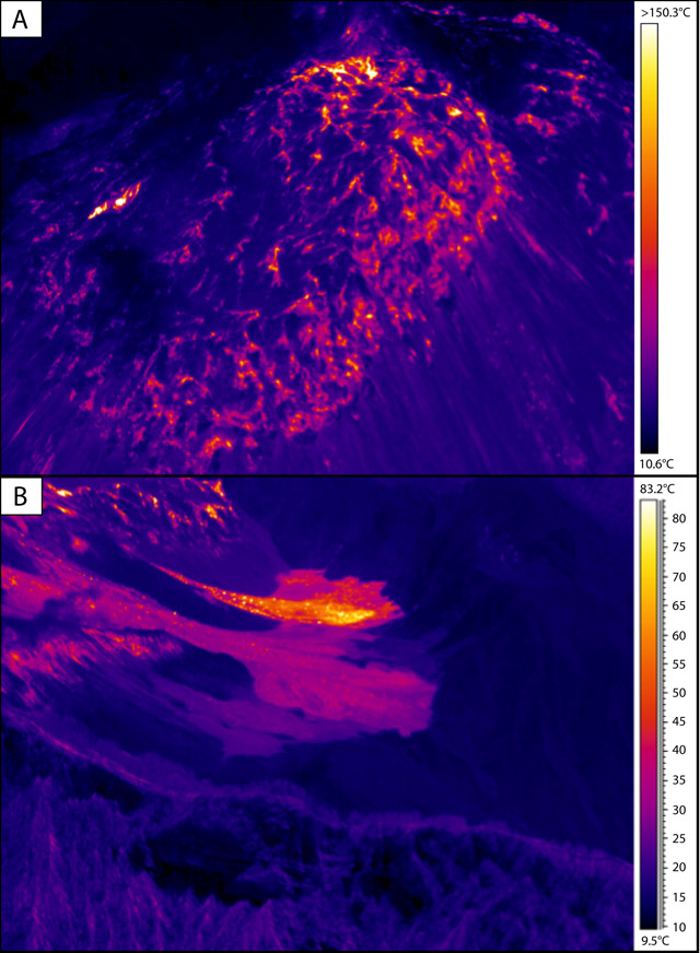 |
Figure 24. Thermal images of the dome complex of Chaitén acquired on 21 January 2009. (a) The summit of Dome 2, where the highest temperatures were recorded; the same area corresponded to the pinnacles and the area of the most rapid growth of Dome 2. (b) Pyroclastic flow and rockfall deposits within the E part of the caldera, emplaced just prior to 21 January, that were still elevated in temperature. The colors are scaled uniquely for both images with the temperature scales shown at right. The flyby was facilitated by ONEMI and the Chilean Air Force, the images were acquired by Patrick Whelley (UB) and Andrés Paves (University of Chile), and processing was performed by Marc Bernstein (UB); use of the thermal camera was courtesy of Eliza Calder under the UB-SUNY Research Foundation. |
By 9 February 2009, a new high-standing pinnacle atop Dome 2 indicated the return of rapid dome growth. This did not coincide with significant increases in seismicity.
On 19 February, a large partial collapse generated pyroclastic flows that traveled down the Chaitén River towards the town of Chaitén (see annotated photo below). This event produced a plume reaching 9.1 km altitude according to the Buenos Aires Volcanic Ash Advisory Center (VAAC). The plume was white (indicating high water vapor content) at the top, and contained abundant ash at the base. The collapse created a scarp measuring approximately 500 m by 500 m. Increased seismicity occurred on the same day; background volcanic tremor occurred from 1028 until 1346, and swarms of earthquakes ranging from M 3.6-4.2 originated at depths of 3-5 km. Due to the amount of material deposited from the collapse (~10 x 106 m3), SERNAGEOMIN reported a significantly higher than normal danger of lahars.
On 25 February 2009, dome growth focused on Dome 1, although seismicity had gradually decreased in frequency (excluding the outstanding events of mid-February discussed above) compared to November-December 2008 values. Despite the decrease, on the afternoon of 3 March, dome collapses occurred every ~ 40 minutes. Within the next few days, SERNAGEOMIN reported that "VT's almost disappeared." A gradual decrease in seismicity continued until 24 March, when the frequency of HB earthquakes increased briefly, but they decreased again by early April.
On 6 April, a prominent spine of lava was observed on the S part of Dome 1 (figure 25). It indicated that dome growth was still concentrated in the W part of the caldera (Dome 1). The next week, the same spine was reported to have a wider base, and the crater reportedly glowed at night. In early May, an aerial photograph captured a close view of a very fractured central lava spine of the dome complex (figure 26).
 |
Figure 25. Images taken by Dirección General de Aeronáutica Civil (DGAC) and a Channel 13 cameraman on 6 April 2009 showing a prominent spine of lava that had grown in the S area of Dome 1. Courtesy of OVDAS-SERNAGEOMIN. |
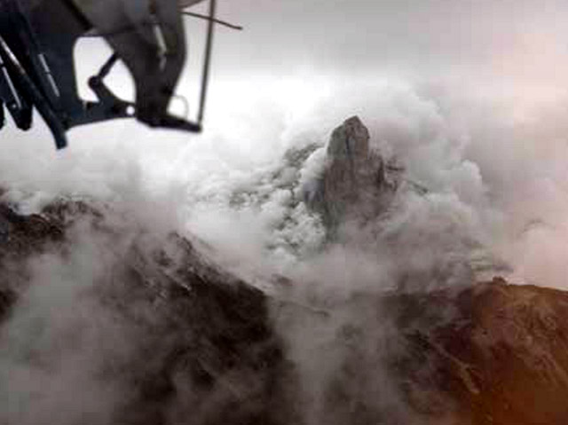 |
Figure 26. Aerial view of the dome complex in early May 2009 showing a very fractured central pinnacle. Courtesy of Javier Romero. |
In the later parts of May 2009, dome growth and seismicity continued to be focused on the W part of the caldera, associated with Dome 1. Although there was no significant increase in seismicity until a slight increase in June, witnesses in the town of Chaitén reporting feeling tremors in May. Otherwise, activity through August consisted of continuous ash-and-steam emissions, small collapses of unstable portions of the domes, and resulting block-and-ash flows. Seasonal precipitation remobilized previously erupted material and lahars reached the town in July.
Seismicity remained slightly elevated (relative to April and May) through September. On 14 September, a surveillance camera captured a plume as wide as the caldera reaching ~ 1.5 km high. This plume was significantly wider than plumes in the previous months. On 29 September, witness reports prompted SERNAGEOMIN to fly past the caldera, and obervers saw evidence of a significant recent collapse.
SERNAGEOMIN's 29 September observation flight provided stunning views of the dome complex leading to the detection of a new dome, Dome 3, that had filled the 19 February 2009 collapse scar (figures 27 and 28). Dome 3 had a depression in its N sector and small central pinnacles (figure 28). The central pinnacle of the whole complex had disappeared, and a large active depression, elongated to the NNW, had formed E of Dome 3. This depression reportedly resulted from either a lateral explosion or a relatively slow and structurally controlled internal collapse.
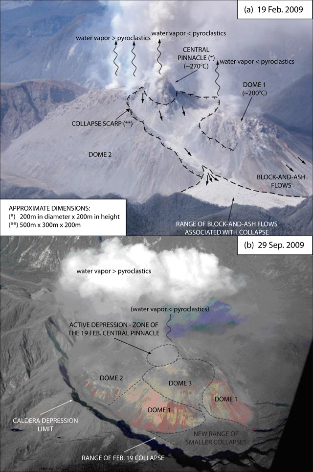 |
Figure 27. Aerial views of Chaitén’s dome complex taken following the partial collapses of (a) 19 February and (b) 29 September 2009. (a) The dome complex following the 19 February partial collapse. Dimensions of the central pinnacle (*) and the collapse scarp (**) are given at the lower left. (b) The dome complex following the 29 September partial collapse, showing the first observation of Dome 3. Labels in all capital letters indicate structures or deposits, and labels in all lowercase indicate relative amounts of water vapor and ash in emitted plumes. Courtesy of OVDAS-SERNAGEOMIN; (a) photo by Paul Duhart, (b) photo and interpretation by Jorge Muñoz. |
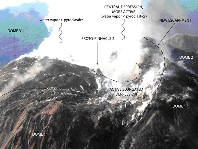 |
Figure 28. Aerial view of the center of Chaitén's dome complex on 29 September 2009. The then-newly ob served central depression is the most active area in the photograph, and a small new pinnacle, Proto-pinnacle 2, is seen near this area. Labels in all capital letters indicate structures or de pos its, and labels in all low er case indicate relative amounts of water vapor and ash in emitted plumes. Courtesy of OVDAS-SERNAGEOMIN; photo and interpretation by Jorge Muñoz. |
Following the events of September, no major outstanding activity was reported through the rest of 2009. In late January 2010, two new telemetered seismic stations were added to the monitoring network, increasing the number of seismic stations around Chaitén to ten. A new observation camera was also installed ~ 800 m from the dome complex.
During the end of 2009 and January 2010, the growth rate of the dome complex slowed, and seismicity declined significantly, with larger earthquakes (stronger than M 3.5) being absent through at least March (figure 29). Following a few months of relatively calmer activity at Chaitén, and after at least a month without emissions of ash, the Alert Level was lowered to Yellow on 1 May 2010.
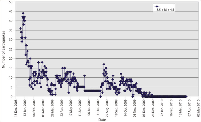 |
Figure 29. Daily earthquakes between M 3.5 and M 4.5 at Chaitén, from the onset of the eruption on 2 May 2008 to 1 April 2010 (a month prior to the lowering of the Alert Level to Yellow). Courtesy of OVDAS-SERNAGEOMIN. |
1 May 2010-2 May 2011 (Yellow Alert). During the period of Yellow Alert, reported plume heights remained below 2.1 km altitude (Buenos Aires VAAC); compared to the prior, more active period when plumes regularly reached 3-4 km in height, this was a significant decline. Over this period, the Buenos Aires VAAC reported occasional emissions that included ash (table 2). OVDAS-SERNAGEOMIN began recording mainly VT events (interpreted as relating to rock fracturing) and long period (LP) events (interpreted as related to fluid dynamics in and beneath the volcanic edifice). Both types of seismicity remained low throughout the remainder of 2010 and into 2011. However, incandescence of the lava dome surface was observed at night in late January 2011.
Table 2. Emissions from Chaitén's lava dome complex during the period of Yellow Alert (1 May 2010-2 May 2011); '--' indicates information that was not reported. Courtesy of the Buenos Aires VAAC.
| Date | Altitude | Drift distance | Drift direction |
| 14 May 2010 | 1.8 km | -- | NE |
| 24 Jul 2010 | -- | 70 km | SSE |
| 30 Jul 2010 | -- | 20 km | NNE |
| 30 Jul 2010 | -- | 45 km | ESE |
| 21 Oct 2010 | 2.1 km | -- | ENE |
| 04 Nov 2010 | 1.8 km | 25 km | NE |
| 13 Nov 2010 | 1.5 km | 40 km | SE |
| 15 Nov 2010 | 1.8-2.1 km | -- | E |
3 May 2011-September 2011 (Green Alert). On 2 May 2011, the Alert Level was lowered to Green due to lower levels of activity since January 2011, including (1) seismicity remaining at low levels of occurrence and magnitude; (2) no significant emissions of ash; (3) a lack of dome growth and associated partial collapses; and (4) a lack of visual observations suggesting restlessness.
Since 3 May 2011, ash-free plumes rose no higher than 0.5 km; the exception was one plume in late May or early June. Seismicity remained low, with daily counts averaging fewer than 2 for LP events, less than 10 for VT events, and less than 1 for HB events.
Magma ascent prior to 2 May 2008 eruption. Wicks and others (2011) stated that "Because of the historically rare and explosive nature of rhyolite eruptions and because of the surprisingly short warning before the eruption of the Chaitén volcano, any information about the workings of the magmatic system at Chaitén, and rhyolitic systems in general, is important from both the scientific and hazard perspectives." There were only about 24 hours between the first felt seismicity in the town of Chaitén and the onset of the eruption. Such a short precursory period has been recorded for basaltic eruptions (e.g. Hekla volcano, Iceland; Soosalu and Einarsson, 2002), but not for silicic eruptions such as Chaitén (Castro and Dingwell, 2009).
Castro and Dingwell (2009) used petrological experiments to constrain the temperatures and decompression rates of the magma erupted explosively at Chaitén on 2 May 2008. Their results suggested that the magma rose from depths of at least 5 km in about four hours, shorter than the roughly 1-day period of seismicity that was felt in the town of Chaitén.
Wicks and others (2011) interpreted radar interferometry observations to indicate that the rapid ascent (as reported by Castro and Dingwell, 2009) of the Chaitén magma was controlled by pre-existing faults in the crust beneath Chile (figure 30). Specifically, they modeled a large, dipping, sill-like body (their "reservoir") residing under Minchinmávida volcano (~ 20 km E of Chaitén, "M" on figure 30) and rising towards the surface to the W of Chaitén (Morro Vilcún, "MV" on figure 30). The magma followed a path that intersected an inferred vertical conduit feeding Chaitén. They interpreted the rhyolitic reservoir as originating from either 1) a combination of tectonic stresses and magmatic overpressure draining rhyolitic magma from a mafic reservoir beneath Minchinmávida, or 2) an event similar to the M 9.5, 1960 Chilean earthquake creating permeability and a pressure gradient, allowing the overpressured magma to migrate to beneath Chaitén.
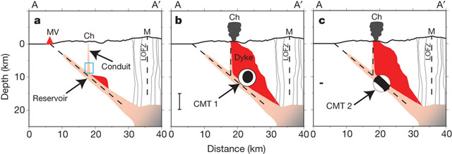 |
Figure 30. Cross-sectional model of the magmatic system that ultimately erupted at Chaitén (Wicks and others, 2011). The profile A-A' is approximately W-E; Morro Vilcún (MV), Chaitén (Ch), and Minchinmávida (M) are plotted at their relative positions on the surface. Stages a, b, and c are illustrated by a series of model cartoons. (a) The sill-like body (Reservoir) extends to the W, towards the surface, from the magma chamber beneath Minchinmávida; the dike (red body) begins propagation upwards, but at this stage has not intersected Chaitén's conduit. (b) Diking leads to an injection-caused earthquake (inflational, shown by the moment tensor solution "beachball diagram" where black indicates compression and white indicates tension) which occurred 2 hours before the 2 May 2008 eruption began. (c) As the eruption progressed and drained the shallow storage beneath Chaitén, the sill-like reservoir collapsed (shown by the moment tensor solution diagram). In all frames, the Liquiñe-Ofqui Fault Zone (LOFZ) is indicated beneath Minchinmávida volcano. CMT 1 refers to the centroid mean solution (CMT) of a moment magnitude 5.2 earthquake that occurred 2 hours prior to the main eruption on 2 May 2008. CMT 2 refers to an earthquake of magnitude 5.0 that occurred 19 hours after the onset of eruption. From Wicks and others (2011). |
Restoring the town and damaged infrastructure. On 9 April 2011, the Chilean government reported that President Sebastián Piñera had announced the "North Chaitén Solution" plan. After restoring basic services (e.g. electricity) to the town of Chaitén in the first months of 2011, President Piñera stated that "everything will be definitively restored, electricity and light has already returned and ... all of the electricity poles are new." He also announced plans to dredge the harbor a second time (necessary due to the amount of remobilized volcanic material deposited in the bay) to allow boats to dock, a plan to install a floating dock, ongoing surveying for new paved roads to other surrounding cities, and plans for the town's school and aerodome.
References. Castro, J.M., and Dingwell, D.B., 2009, Rapid ascent of rhyolitic magma at Chaitén volcano, Chile: Nature, v. 461, p. 780-784 (DOI:10.1038/nature08458).
Soosalu, H., and Einarsson, P., 2002, Earthquake activity related to the 1991 eruption of the Hekla volcano, Iceland: Bulletin of Volcanology, v. 63, p. 536-544.
Wicks, C., de la Llera, J.C., Lara., L.E., and Lowenstern, J., 2011, The role of dyking and fault control in the rapid onset of eruption at Chaitén volcano, Chile, Nature, v. 478, pp. 374-377 (DOI:10.1038/nature10541).
Information Contacts: Observatorio Volcanológico de los Andes del Sur-Servico Nacional de Geologia y Mineria (OVDAS-SERNAGEOMIN), Avda Sta María No. 0104, Santiago, Chile (URL: http://www.sernageomin.cl/); Oficina Nacional de Emergencia - Ministerio del Interior (ONEMI), Beaucheff 1637 / 1671, Santiago, Chile (URL: http://www.onemi.cl/); NASA Earth Observatory (URL: http://earthobservatory.nasa.gov/); MapsOf.net (URL: http://mapsof.net/); Marc Bernstien, Eliza Calder, and Patrick Whelley, University at Buffalo, State University of New York, 411 Cooke Hall, Buffalo, NY 14260; Andrés Paves, University of Chile, 2002 Blanco Encalada, Santiago, Chile; Buenos Aires Volcanic Ash Advisory Center (VAAC), Servicio Meteorológico Nacional-Fuerza Aérea Argentina, 25 de mayo 658, Buenos Aires, Argentina (URL: http://www.smn.gov.ar/vaac/buenosaires/productos.php); Javier Romero, Dirección de Vialidad - Ministerio de Obras Públicas, Puerto Montt; Gobierno de Chile, Santiago, Chile (URL: http://www.gob.cl/ or http://www.gob.cl/english/).
Declining seismicity, thermal emissions, and plumes during 2013
In this report, we cover declining activity observed at Chaitén during 2012-2013. The Servicio Nacional de Geología y Minería (SERNAGEOMIN) had reduced the Alert Level to Green on 2 May 2011 (BGVN 36:11) and continued to monitor activity and release online bulletins. These activity bulletins were available during February 2012-October 2013. We also note the thermal alerts from MODVOLC during January 2010-April 2013.
The recent rhyolitic eruption of Chaitén began in May 2008 (BGVN 33:04) and, according to Pallister and others (2013), comprised five major phases: (1) an explosive sequence (1-11 May 2008), (2) a transitional time that included ash plumes and lava extrusion (11-31 May 2008), (3) lava flows and dome growth (June-September 2008), (4) spine extrusion and dome growth (October 2008-February 2009), and (5) endogenous lava dome growth (February 2009-early 2010). Following those phases of activity, ash plumes and thermal emissions declined during 2010-2011 (figure 31); intermittent thermal anomalies and vapor emissions dominated activity during 2011-April 2013. Since April 2013, thermal alerts were no longer reported by the MODVOLC system.
|
Figure 31. On 25 October 2011, this Landsat 5 image captured a small plume rising from Chaitén's active lava dome. A) This wideview includes the caldera and surrounding region of Chaitén. Meandering river systems link the volcanic highlands with the Pacific coast. A) and B) The town of Chaitén is located at the red circle, on the delta formed by runoff from the highlands that include Chaitén ~11 km NE. Note that the scale bars are approximate. Courtesy of USGS/NASA. |
SERNAGEOMIN reported decreasing seismicity during 2012-2013 (table 3). Volcano-tectonic (VT) events dominated these datasets while hybrid events were very rare. Local magnitudes (ML) and magnitudes calculated from signal duration (MD) were reported as well as the reduced displacement (calculated for long-period earthquakes).
Table 3. Seismicity during February 2012-September 2013 is reported for total earthquake counts (EQ), volcano-tectonic earthquakes (VT), long-period earthquakes (LP), and hybrid (HYB). Note that "**" indicates reporting of ML values where MD values were not reported. Reduced displacement (RD) is reported for LP events. Courtesy of SERNAGEOMIN.
| Date | EQ | VT | Max ML | LP | MD | RD cm2 | HYB | MD |
| Feb 2012 | 226 | 170 | 1.9 | 54 | 1.8 | 4.0 | 2 | 1.3 |
| Mar 2012 | 303 | 216 | 3.0 | 86 | 0.6 | 9.3 | 0 | 0 |
| Apr 2012 | 179 | 106 | 1.8 | 73 | 2 | 2.3 | 0 | 0 |
| May 2012 | 109 | 47 | 2.3 | 62 | 1.6 | 58.2 | 0 | 0 |
| Jun 2012 | 47 | 22 | 1.6 | 25 | 1 | 5.4 | 0 | 0 |
| Jul 2012 | 93 | 63 | 2.8 | 30 | 1.7 | 0.5 | 0 | 0 |
| Aug 2012 | 96 | 72 | 2.5 | 23 | 2.3 | 9.6 | 0 | 0 |
| Sep 2012 | 56 | 41 | 2.5 | 15 | 0.5 | 0.1 | 0 | 0 |
| Oct 2012 | 49 | 39 | 1.9 | 10 | 2.3 | 3 | 0 | 0 |
| Nov 2012 | 61 | 49 | 1.9 | 12 | 1.9 | 7.4 | 0 | 0 |
| Dec 2012 | 45 | 42 | 2.7 | 3 | 1.7 | 1.1 | 0 | 0 |
| Jan 2013 | 76 | 55 | 2.9 | 16 | 2.3 | 11.4 | 5 | -- |
| Feb 2013 | 43 | 28 | 1.7 | 15 | -- | 0.8 | 0 | 0 |
| Mar 2013 | 5 | 4 | 1.0 | 1 | -- | 1.7 | 0 | 0 |
| Apr 2013 | -- | -- | -- | -- | -- | -- | -- | -- |
| May 2013 | 53 | 44 | 1.9 | 11 | 1.6** | 3.8 | -- | -- |
| Jun 2013 | -- | -- | -- | -- | -- | -- | -- | -- |
| Jul 2013 | 67 | 50 | 0.8 | 17 | 1.3** | 5.6 | -- | -- |
| Aug 2013 | 38 | 29 | 1.4 | 8 | 1.3** | 6.4 | 1 | 2.0** |
| Sep 2013 | 5 | 5 | 1.3 | -- | -- | -- | -- | -- |
| Oct 2013 | 30 | 21 | 2.4 | 9 | 1.7** | -- | -- | -- |
When clear viewing conditions permitted, nighttime incandescence and vapor plumes were captured by the SERNAGEOMIN webcamera during February 2012-September 2013. Observations included plume heights ranging 300-600 m above the crater.
Thermal alerts. Elevated temperatures were detected from Chaitén during much of the eruption that began in May 2008. Thermal anomalies were detected by MODIS sensors on the Terra and Aqua satellites every month until September 2010 (table 4). As the eruption waned, elevated temperatures were observed less often and were absent during the months of July 2011, May 2012, August-October 2012, December 2012, March 2013, and after 2 April 2013. The MODVOLC alerts chiefly occurred in the immediate area of the crater (figure 32).
Table 4. The MODVOLC system generated alerts during January 2010-April 2013. The number of thermal alerts detected per year decreased from 2010 through early 2013. Courtesy of HIGP.
| Date | Days/Month | Pixels/Month |
| Jan 2010 | 5 | 5 |
| Feb 2010 | 7 | 9 |
| Mar 2010 | 7 | 9 |
| Apr 2010 | 6 | 6 |
| May 2010 | 4 | 4 |
| Jun 2010 | 1 | 1 |
| Jul 2010 | 2 | 2 |
| Aug 2010 | 3 | 3 |
| Sep 2010 | 0 | 0 |
| Oct 2010 | 3 | 3 |
| Nov 2010 | 1 | 1 |
| Dec 2010 | 4 | 4 |
| Jan 2011 | 6 | 6 |
| Feb 2011 | 7 | 7 |
| Mar 2011 | 1 | 1 |
| Apr 2011 | 4 | 4 |
| May 2011 | 3 | 3 |
| Jun 2011 | 3 | 3 |
| Jul 2011 | 1 | 1 |
| Aug 2011 | 1 | 1 |
| Sep 2011 | 2 | 2 |
| Oct 2011 | 4 | 4 |
| Nov 2011 | 1 | 1 |
| Dec 2011 | 9 | 9 |
| Jan 2012 | 7 | 7 |
| Feb 2012 | 2 | 2 |
| Mar 2012 | 3 | 4 |
| Apr 2012 | 2 | 2 |
| May 2012 | 0 | 0 |
| Jun 2012 | 3 | 3 |
| Jul 2012 | 2 | 3 |
| Aug 2012 | 0 | 0 |
| Sep 2012 | 0 | 0 |
| Oct 2012 | 0 | 0 |
| Nov 2012 | 2 | 2 |
| Dec 2012 | 0 | 0 |
| Jan 2013 | 3 | 3 |
| Feb 2013 | 2 | 2 |
| Mar 2013 | 0 | 0 |
| Apr 2013 | 1 | 1 |
| May 2013 | 0 | 0 |
|
Figure 32. As seen here, from April 2012 to April 2013, MODVOLC generated alerts (red and orange point) on 15 days for Chaitén. Those alerts indicated elevated temperatures within 2 km of the summit area. Courtesy of HIGP. |
References. NASA Landsat Program, 2011, Landsat ETM scene LT52320902011298COA00, SLC-Off, USGS, Sioux Falls, October 25, 2011.
Pallister, J.S., Diefenbach, A.K., Burton, W.C., Muñoz, J., Griswold, J.P., Lara, L.E., Lowenstern, J.B., and Valenzuela, C., 2013, The Chaitén rhyolite lava dome: Eruption sequence, lava dome volumes, rapid effusion rates and source of the rhyolite magma, Andean Geology, 40, (2): 277-294.
Information Contacts: Observatorio Volcanológico de los Andes del Sur-Servicio Nacional de Geologia y Mineria (OVDAS-SERNAGEOMIN), Avda Sta María No. 0104, Santiago, Chile (URL: http://www.sernageomin.cl/); and Hawai'i Institute of Geophysics and Planetology (HIGP) MODVOLC Thermal Alerts System, School of Ocean and Earth Science and Technology (SOEST), Univ. of Hawai'i, 2525 Correa Road, Honolulu, HI 96822, USA (URL: http://modis.higp.hawaii.edu/).
|
|
||||||||||||||||||||||||||
There is data available for 5 confirmed eruptive periods.
2008 May 2 - 2011 May 31 ± 3 days Confirmed Eruption (Explosive / Effusive) VEI: 4
| Episode 1 | Eruption (Explosive / Effusive) | ||||||||||||||||||||||||||||||||||||||||||||||||||||||||||||||||||||||||||
|---|---|---|---|---|---|---|---|---|---|---|---|---|---|---|---|---|---|---|---|---|---|---|---|---|---|---|---|---|---|---|---|---|---|---|---|---|---|---|---|---|---|---|---|---|---|---|---|---|---|---|---|---|---|---|---|---|---|---|---|---|---|---|---|---|---|---|---|---|---|---|---|---|---|---|
| 2008 May 2 - 2011 May 31 ± 3 days | Evidence from Observations: Reported | |||||||||||||||||||||||||||||||||||||||||||||||||||||||||||||||||||||||||
|
List of 13 Events for Episode 1
|
||||||||||||||||||||||||||||||||||||||||||||||||||||||||||||||||||||||||||
1640 ± 18 years Confirmed Eruption (Explosive / Effusive) VEI: 4 (?)
| Episode 1 | Eruption (Explosive / Effusive) | |||||||||||||||||||||||||||||||||||||||
|---|---|---|---|---|---|---|---|---|---|---|---|---|---|---|---|---|---|---|---|---|---|---|---|---|---|---|---|---|---|---|---|---|---|---|---|---|---|---|---|
| 1640 ± 18 years - Unknown | Evidence from Isotopic: 14C (calibrated) | ||||||||||||||||||||||||||||||||||||||
|
List of 6 Events for Episode 1
|
|||||||||||||||||||||||||||||||||||||||
3100 BCE ± 220 years Confirmed Eruption (Explosive / Effusive) VEI: 5
| Episode 1 | Eruption (Explosive / Effusive) | Cha2/Mic2 tephra | ||||||||||||||||||||||||||||||||||||||
|---|---|---|---|---|---|---|---|---|---|---|---|---|---|---|---|---|---|---|---|---|---|---|---|---|---|---|---|---|---|---|---|---|---|---|---|---|---|---|---|
| 3100 BCE ± 220 years - Unknown | Evidence from Isotopic: 14C (calibrated) | ||||||||||||||||||||||||||||||||||||||
|
List of 6 Events for Episode 1 at Cha2/Mic2 tephra
|
|||||||||||||||||||||||||||||||||||||||
6650 BCE ± 1300 years Confirmed Eruption (Explosive / Effusive)
| Episode 1 | Eruption (Explosive / Effusive) | ||||||||||||||||||||||||
|---|---|---|---|---|---|---|---|---|---|---|---|---|---|---|---|---|---|---|---|---|---|---|---|---|
| 6650 BCE ± 1300 years - Unknown | Evidence from Correlation: Tephrochronology | |||||||||||||||||||||||
|
List of 3 Events for Episode 1
|
||||||||||||||||||||||||
7750 BCE ± 200 years Confirmed Eruption (Explosive / Effusive) VEI: 5
| Episode 1 | Eruption (Explosive / Effusive) | Cha1 tephra | |||||||||||||||||||||||||||||||||||||||||||
|---|---|---|---|---|---|---|---|---|---|---|---|---|---|---|---|---|---|---|---|---|---|---|---|---|---|---|---|---|---|---|---|---|---|---|---|---|---|---|---|---|---|---|---|---|
| 7750 BCE ± 200 years - Unknown | Evidence from Isotopic: 14C (calibrated) | |||||||||||||||||||||||||||||||||||||||||||
|
List of 7 Events for Episode 1 at Cha1 tephra
|
||||||||||||||||||||||||||||||||||||||||||||
The Global Volcanism Program has no synonyms or subfeatures listed for Chaitén.
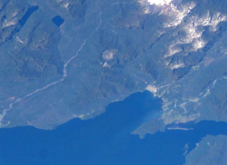 The small circular feature just above the center of this NASA International Space Station image (with north to the upper left) is Chaitén caldera. It is located 10 km NE of the town of Chaitén, the light-colored area along on the Gulf of Corcovado below and to the right of the caldera. This small, glacier-free, 3.5-km-wide caldera is of Pleistocene age, but has a rhyolitic Holocene lava dome.
  The dome-filled caldera of Chaitén volcano is seen in an aerial view from the south taken prior to an eruption in 2008. The volcano is located 10 km NE of the town of Chaitén on the Gulf of Corcovado. The elliptical 2.5 x 4 km wide summit caldera was formed during an eruption dated at about 9400 years ago. A rhyolitic, 962-m-high obsidian lava dome occupies much of the caldera floor.
 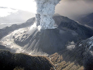 An eruption plume rises from a broad crater in a tephra cone atop the new and old dome complex in this May 26, 2008 helicopter view of Chaitén from the SW. Lumpy areas on the middle to lower cone mark obsidian outcrops on the now buried older dome. Burned vegetation is visible at the bottom center along the Blanco River. A major explosive eruption at Chaitén volcano began on May 2, marking the first historical eruption of the volcano. Mudflows destroyed much of the town of Chaitén.
 There are no samples for Chaitén in the Smithsonian's NMNH Department of Mineral Sciences Rock and Ore collection.
| Copernicus Browser | The Copernicus Browser replaced the Sentinel Hub Playground browser in 2023, to provide access to Earth observation archives from the Copernicus Data Space Ecosystem, the main distribution platform for data from the EU Copernicus missions. |
| MIROVA | Middle InfraRed Observation of Volcanic Activity (MIROVA) is a near real time volcanic hot-spot detection system based on the analysis of MODIS (Moderate Resolution Imaging Spectroradiometer) data. In particular, MIROVA uses the Middle InfraRed Radiation (MIR), measured over target volcanoes, in order to detect, locate and measure the heat radiation sourced from volcanic activity. |
| MODVOLC Thermal Alerts | Using infrared satellite Moderate Resolution Imaging Spectroradiometer (MODIS) data, scientists at the Hawai'i Institute of Geophysics and Planetology, University of Hawai'i, developed an automated system called MODVOLC to map thermal hot-spots in near real time. For each MODIS image, the algorithm automatically scans each 1 km pixel within it to check for high-temperature hot-spots. When one is found the date, time, location, and intensity are recorded. MODIS looks at every square km of the Earth every 48 hours, once during the day and once during the night, and the presence of two MODIS sensors in space allows at least four hot-spot observations every two days. Each day updated global maps are compiled to display the locations of all hot spots detected in the previous 24 hours. There is a drop-down list with volcano names which allow users to 'zoom-in' and examine the distribution of hot-spots at a variety of spatial scales. |
|
WOVOdat
Single Volcano View Temporal Evolution of Unrest Side by Side Volcanoes |
WOVOdat is a database of volcanic unrest; instrumentally and visually recorded changes in seismicity, ground deformation, gas emission, and other parameters from their normal baselines. It is sponsored by the World Organization of Volcano Observatories (WOVO) and presently hosted at the Earth Observatory of Singapore.
GVMID Data on Volcano Monitoring Infrastructure The Global Volcano Monitoring Infrastructure Database GVMID, is aimed at documenting and improving capabilities of volcano monitoring from the ground and space. GVMID should provide a snapshot and baseline view of the techniques and instrumentation that are in place at various volcanoes, which can be use by volcano observatories as reference to setup new monitoring system or improving networks at a specific volcano. These data will allow identification of what monitoring gaps exist, which can be then targeted by remote sensing infrastructure and future instrument deployments. |
| Volcanic Hazard Maps | The IAVCEI Commission on Volcanic Hazards and Risk has a Volcanic Hazard Maps database designed to serve as a resource for hazard mappers (or other interested parties) to explore how common issues in hazard map development have been addressed at different volcanoes, in different countries, for different hazards, and for different intended audiences. In addition to the comprehensive, searchable Volcanic Hazard Maps Database, this website contains information about diversity of volcanic hazard maps, illustrated using examples from the database. This site is for educational purposes related to volcanic hazard maps. Hazard maps found on this website should not be used for emergency purposes. For the most recent, official hazard map for a particular volcano, please seek out the proper institutional authorities on the matter. |
| IRIS seismic stations/networks | Incorporated Research Institutions for Seismology (IRIS) Data Services map showing the location of seismic stations from all available networks (permanent or temporary) within a radius of 0.18° (about 20 km at mid-latitudes) from the given location of Chaitén. Users can customize a variety of filters and options in the left panel. Note that if there are no stations are known the map will default to show the entire world with a "No data matched request" error notice. |
| UNAVCO GPS/GNSS stations | Geodetic Data Services map from UNAVCO showing the location of GPS/GNSS stations from all available networks (permanent or temporary) within a radius of 20 km from the given location of Chaitén. Users can customize the data search based on station or network names, location, and time window. Requires Adobe Flash Player. |
| DECADE Data | The DECADE portal, still in the developmental stage, serves as an example of the proposed interoperability between The Smithsonian Institution's Global Volcanism Program, the Mapping Gas Emissions (MaGa) Database, and the EarthChem Geochemical Portal. The Deep Earth Carbon Degassing (DECADE) initiative seeks to use new and established technologies to determine accurate global fluxes of volcanic CO2 to the atmosphere, but installing CO2 monitoring networks on 20 of the world's 150 most actively degassing volcanoes. The group uses related laboratory-based studies (direct gas sampling and analysis, melt inclusions) to provide new data for direct degassing of deep earth carbon to the atmosphere. |
| Large Eruptions of Chaitén | Information about large Quaternary eruptions (VEI >= 4) is cataloged in the Large Magnitude Explosive Volcanic Eruptions (LaMEVE) database of the Volcano Global Risk Identification and Analysis Project (VOGRIPA). |
| EarthChem | EarthChem develops and maintains databases, software, and services that support the preservation, discovery, access and analysis of geochemical data, and facilitate their integration with the broad array of other available earth science parameters. EarthChem is operated by a joint team of disciplinary scientists, data scientists, data managers and information technology developers who are part of the NSF-funded data facility Integrated Earth Data Applications (IEDA). IEDA is a collaborative effort of EarthChem and the Marine Geoscience Data System (MGDS). |

