The Darwin VAAC reported that at 1040 on 28 May an ash plume from Kerinci was identified in a satellite image drifting SW at 5.8 km (19,000 ft) a.s.l., or 2 km above the summit. PVMBG noted that white steam-and-gas plumes rose 200 m above the summit that same day. The Alert Level remained at 2 (on a scale of 1-4) and the public was reminded to stay 3 km away from the crater.
Sources: Darwin Volcanic Ash Advisory Centre (VAAC), Pusat Vulkanologi dan Mitigasi Bencana Geologi (PVMBG, also known as CVGHM)
Eruption during October 2022-February 2023 with minor ash plumes
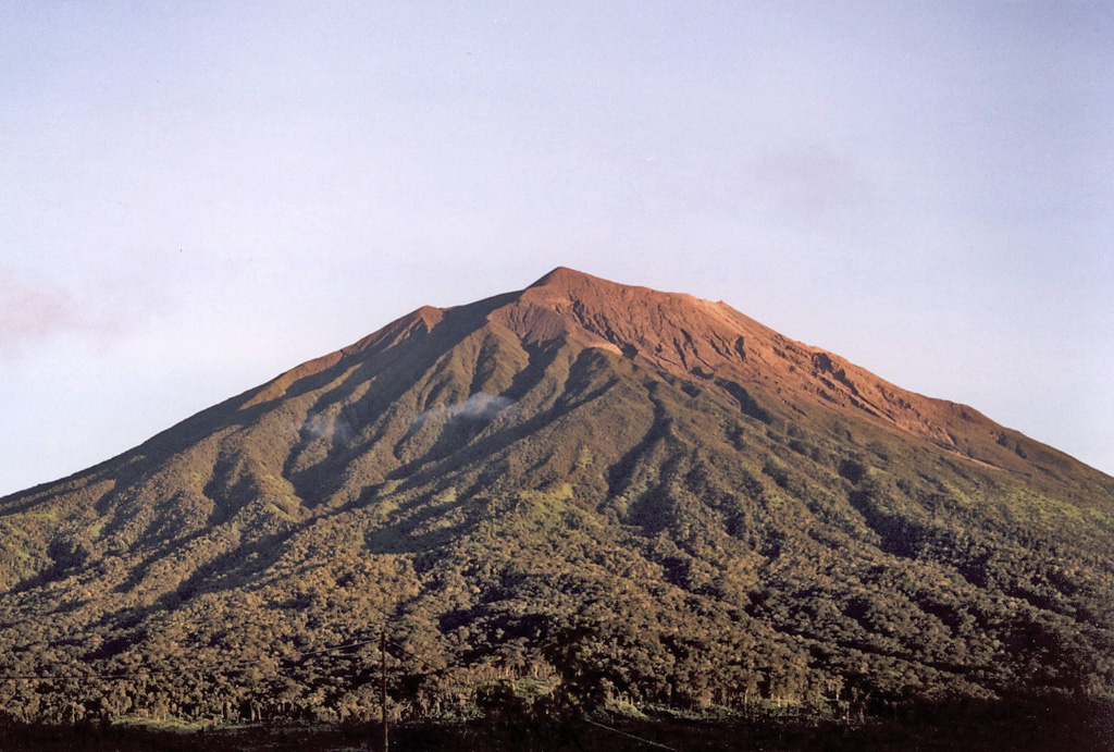
Kerinci, a stratovolcano in central Sumatra, Indonesia, has had numerous moderate explosive eruptions since 1838. The previous eruption lasted from April 2018 until June 2021 and included intermittent gas-and-steam and ash plumes (BGVN 43:07, 46:07). This report covers activity during July 2021-February 2023, and is based on data from the Pusat Vulkanologi dan Mitigasi Bencana Geologi (PVMBG), also known as the Center for Volcanology and Geological Hazard Mitigation (CVGHM), the Darwin Volcanic Ash Advisory Centre (VAAC), and satellites.
A new eruption began on 15 October 2022, when observers reported plumes with brown, gray, or black ash that drifted downwind a short distance above the crater, with the highest rising 1.2 km on 12 January 2023; the last reported ash plume was on 27 February 2023. Weather clouds obscured the volcano on most days, allowing only infrequent good webcam photos or satellite images. Although ash plumes were often seen, white steam-and-gas plumes were also visible on many days. There were no thermal anomalies detected over the course of this activity in Sentinel-2 or MODIS data. Though infrequently observed by the TROPOMI instrument aboard the Sentinel-5P satellite, the sulfur dioxide plumes that were detected were localized above the volcano.
According to PVMBG’s MAGMA-Indonesia daily reports from July 2021 through early October 2022, no explosions or ash emissions were observed; white emissions were observed most days when weather permitted. The Darwin VAAC issued an advisory for a plume on 14 October 2021 that reached as high as 750 m, but no ash was identified in satellite data and PVMBG only observed a white steam-and-gas plume. During 15-16 October a new eruption began with a steam-and-ash plumes that rose about 50-350 m above the summit (figure 25) and drifted NE. According to PVMBG and the Darwin VAAC, on 19 October, at 0620 and 0815, ash plumes rose 500-700 m above the summit. On most subsequent days in October ash emissions were visible rising 300-750 m above the summit and drifting primarily NE and NW.
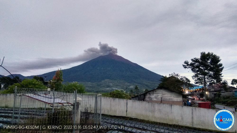 |
Figure 25. Webcam photo of Kerinci on 16 October 2022 showing a gray ash plume rising from the summit crater. Courtesy of MAGMA Indonesia. |
In November, ash plumes rose 150-400 m and drifted in various directions. At 0830 on 27 November an ash plume rose 400 m and drifted E. During 29-30 November, white steam-and-gas plumes rose 300 m. During December, frequent ash plumes and white steam-and-gas plumes rose 100-300 m almost daily, except for an ash plume at 0822 on 6 December which rose 700 m and drifted SW. According to PVMBG, the amplitude of continuous tremor increased during 28-29 December.
The eruption was ongoing during 4-8 January with brown, brown-to-gray, or white-and-brown ash plumes rising as high as 200 m above the crater rim and drifting NE and E. During 10-14 January daily ash plumes that were brown or gray rose generally 400-900 m above the summit and drifted N, NE, and W. At 1810 on 12 January a dense gray ash plume rose 1.2 km above the summit and drifted NW.
An eruptive event was recorded at 0230 on 3 February but not visually confirmed; white-and-gray ash plumes were visible later that day rising 100 m above the summit and drifting NE and E. Plumes with brown or gray ash were visible when conditions were clear, typically in the early morning hours, during 4-10 and 14 February, with small plumes only reaching 150-200 m above the summit and drifting in easterly directions. At 1207 on 15 February a dense brown ash plume rose 200 m and drifted E (figure 26). Dense brown ash plumes rose 150-250 m and drifted E and SE at 0908 and 1937 on 16 February. Plumes with gray or brown ash rose 50-150 m above the crater rim on 26 and 27 February.
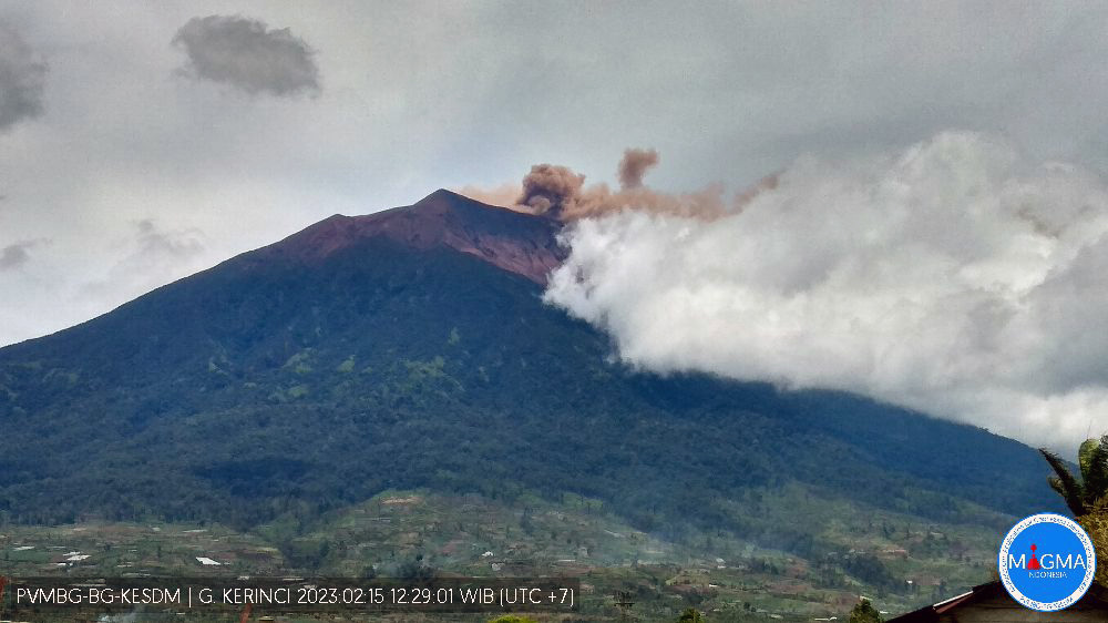 |
Figure 26. Webcam photo of Kerinci showing a brown ash plume rising from the summit crater on 15 February 2023. Courtesy of MAGMA Indonesia. |
Information Contacts: Pusat Vulkanologi dan Mitigasi Bencana Geologi (PVMBG, also known as Indonesian Center for Volcanology and Geological Hazard Mitigation, CVGHM), Jalan Diponegoro 57, Bandung 40122, Indonesia (URL: http://www.vsi.esdm.go.id/); MAGMA Indonesia, Kementerian Energi dan Sumber Daya Mineral (URL: https://magma.esdm.go.id/v1); Darwin Volcanic Ash Advisory Centre (VAAC), Bureau of Meteorology, Northern Territory Regional Office, PO Box 40050, Casuarina, NT 0811, Australia (URL: http://www.bom.gov.au/info/vaac/); Global Sulfur Dioxide Monitoring Page, Atmospheric Chemistry and Dynamics Laboratory, NASA Goddard Space Flight Center (NASA/GSFC), 8800 Greenbelt Road, Goddard, Maryland, USA (URL: https://so2.gsfc.nasa.gov/); Sentinel Hub Playground (URL: https://www.sentinel-hub.com/explore/sentinel-playground); MIROVA (Middle InfraRed Observation of Volcanic Activity), a collaborative project between the Universities of Turin and Florence (Italy) supported by the Centre for Volcanic Risk of the Italian Civil Protection Department (URL: http://www.mirovaweb.it/).
2024: May
2023: January
| February
2022: October
| November
| December
2021: May
| June
2020: January
| February
| March
| April
| August
| October
2019: February
| March
| April
| May
| June
| July
| August
| October
2018: May
| June
| July
| September
| October
2017: August
2016: March
| April
| May
| June
| November
2015: April
| May
| June
| July
2009: April
2008: February
| March
| May
2007: September
2004: June
| July
| August
| September
2002: January
| August
2001: August
| September
| November
| December
The Darwin VAAC reported that at 1040 on 28 May an ash plume from Kerinci was identified in a satellite image drifting SW at 5.8 km (19,000 ft) a.s.l., or 2 km above the summit. PVMBG noted that white steam-and-gas plumes rose 200 m above the summit that same day. The Alert Level remained at 2 (on a scale of 1-4) and the public was reminded to stay 3 km away from the crater.
Sources: Darwin Volcanic Ash Advisory Centre (VAAC); Pusat Vulkanologi dan Mitigasi Bencana Geologi (PVMBG, also known as CVGHM)
PVMBG reported that the eruption at Kerinci was ongoing during 22-28 February. Weather clouds often prevented visual observations of the volcano. White-and-gray ash plumes rose 50-150 m above the crater rim and drifted W and E on 26 February. The next day white-and-brown ash plumes rose as high as 150 m and drifted W. The Alert Level remained at 2 (on a scale of 1-4) and the public was reminded to stay 3 km away from the crater.
Source: Pusat Vulkanologi dan Mitigasi Bencana Geologi (PVMBG, also known as CVGHM)
PVMBG reported that the eruption at Kerinci was ongoing during 15-20 February. Ash plumes of variable densities were visible during 15-16 and 18 February rising as high as 250 m above the summit and drifting mainly NE, E, and W. White steam-and-gas plumes were visible on the other days. At 1207 on 15 February a dense brown ash plume rose 200 m and drifted E. At 0908 on 16 February a dense brown ash plume rose 250 m and drifted E, and at 1937 a gray-to-brown ash plume rose 150 m that drifted E and SE. The Alert Level remained at 2 (on a scale of 1-4) and the public was reminded to stay 3 km away from the crater.
Source: Pusat Vulkanologi dan Mitigasi Bencana Geologi (PVMBG, also known as CVGHM)
PVMBG reported that the eruption at Kerinci was ongoing during 8-14 February. Ash plumes were visible on most days, though weather conditions prevented views towards the end of the week. At 0724 on 8 February a gray ash plum rose 150 m above the summit and drifted E. Gray-to-brown ash plumes rose 150 m and drifted NE that same day. White-and-gray ash plumes rose 150 m and drifted NE during 9-10 February. At 1740 on 10 February a dense gray ash plume rose around 100 m and drifted E, and on 14 February white-and-brown ash plumes rose 200 m and drifted NE. The Alert Level remained at 2 (on a scale of 1-4) and the public was reminded to stay 3 km away from the crater.
Source: Pusat Vulkanologi dan Mitigasi Bencana Geologi (PVMBG, also known as CVGHM)
PVMBG reported that the eruption at Kerinci was ongoing during 1-7 February. An eruptive event was recorded at 0230 on 3 February but was not visually confirmed. White-and-gray ash plumes were visible later that day rising 100 m above the summit and drifting NE and E. At 0646 on 4 February a gray-to-brown ash plume rose 200 m and drifted E and SE. At 0722 on 5 February a dense brown ash plume rose 200 m and drifted NE and E. White-and-brown emissions rose as high as 150 m on 7 February. The Alert Level remained at 2 (on a scale of 1-4) and the public was reminded to stay 3 km away from the crater.
Source: Pusat Vulkanologi dan Mitigasi Bencana Geologi (PVMBG, also known as CVGHM)
The eruption at Kerinci was ongoing during 10-17 January. Daily ash plumes that were brown or gray and mostly dense rose generally 400-900 m above the summit and drifted N, NE, and W during 10-14 January. At 1810 on 12 January a dense gray ash plume rose 1.2 km above the summit and drifted NW. Only white plumes were occasionally visible rising from the summit during 15-17 January. The Alert Level remained at 2 (on a scale of 1-4) and the public was reminded to stay 3 km away from the crater.
Source: Pusat Vulkanologi dan Mitigasi Bencana Geologi (PVMBG, also known as CVGHM)
The eruption at Kerinci was ongoing during 4-8 January with brown, brown-to-gray, or white-and-brown ash plumes rising as high as 200 m above the crater rim and drifting NE and E. The Alert Level remained at 2 (on a scale of 1-4).
Source: Pusat Vulkanologi dan Mitigasi Bencana Geologi (PVMBG, also known as CVGHM)
The eruption at Kerinci was ongoing with brown or white-and-brown ash plumes rising as high as 200 m above the crater rim on most days during 20 December 2022-3 January 2023. The amplitude of continuous tremor increased during 28-29 December, suggesting increased fluid flow or rising magma. The Alert Level remained at 2 (on a scale of 1-4).
Source: Pusat Vulkanologi dan Mitigasi Bencana Geologi (PVMBG, also known as CVGHM)
PVMBG reported that daily white steam-and-gas plumes rose as high as 150 m above Kerinci’s summit and drifted NE and NW during 14-17 December. Brown plumes rose 100 m above the summit and drifted NW and E during 17-19 December. The Aviation Color Code remained at Orange (the second highest level on a four-color scale). The Alert Level remained at 2 (on a scale of 1-4), and the public was warned to remain outside of the 3-km exclusion zone.
Source: Pusat Vulkanologi dan Mitigasi Bencana Geologi (PVMBG, also known as CVGHM)
PVMBG reported that white steam-and-gas plumes rose as high as 300 m above Kerinci’s summit and drifted E almost daily during 29 November-5 December. Gray and white-to-brown plumes rose 100-300 m above the summit during 1-3 December. At 0822 on 6 December a gray-to-black ash plume rose about 700 m above the summit and drifted SW. The Aviation Color Code remained at Orange (the second highest level on a four-color scale). The Alert Level remained at 2 (on a scale of 1-4), and the public was warned to remain outside of the 3-km exclusion zone.
Source: Pusat Vulkanologi dan Mitigasi Bencana Geologi (PVMBG, also known as CVGHM)
PVMBG reported that white steam-and-gas plumes rose as high as 150 m above Kerinci’s summit and drifted NE during 25-26 November. Gray plumes of variable densities rose 100-500 m above the summit and drifted NE, E, and NW. At 0830 on 27 November a gray ash plume rose about 400 m above the summit and drifted E. The Aviation Color Code remained at Orange (the second highest level on a four-color scale). The Alert Level remained at 2 (on a scale of 1-4), and the public was warned to remain outside of the 3-km exclusion zone.
Source: Pusat Vulkanologi dan Mitigasi Bencana Geologi (PVMBG, also known as CVGHM)
PVMBG reported that brown ash plumes from Kerinci, often dense, rose as high as 150 m above the summit and drifted NE, E, and SE during 16-18 and 20-21 November. Weather clouds prevented visual observations during 18-20 November. The Aviation Color Code remained at Orange (the second highest level on a four-color scale). The Alert Level remained at 2 (on a scale of 1-4), and the public was warned to remain outside of the 3-km exclusion zone.
Source: Pusat Vulkanologi dan Mitigasi Bencana Geologi (PVMBG, also known as CVGHM)
PVMBG reported that diffuse white-and-brown plumes from Kerinci rose as high as 150 m above the summit and drifted W during 9-15 November. The Aviation Color Code remained at Orange (the second highest level on a four-color scale). The Alert Level remained at 2 (on a scale of 1-4), and the public was warned to remain outside of the 3-km exclusion zone.
Source: Pusat Vulkanologi dan Mitigasi Bencana Geologi (PVMBG, also known as CVGHM)
PVMBG reported that diffuse white-and-brown plumes from Kerinci rose as high as 400 m above the summit and drifted NE and NW on most days during 2-7 November. The Aviation Color Code was raised to Orange (the second highest level on a four-color scale). The Alert Level remained at 2 (on a scale of 1-4), and the public was warned to remain outside of the 3-km exclusion zone.
Source: Pusat Vulkanologi dan Mitigasi Bencana Geologi (PVMBG, also known as CVGHM)
PVMBG reported that on 27 October a somewhat dense, gray-and-black plume rose around 300 m above Kerinci’s summit and drifted E. The Aviation Color Code was raised to Orange (the second highest level on a four-color scale). The Alert Level remained at 2 (on a scale of 1-4), and the public was warned to remain outside of the 3-km exclusion zone.
Source: Pusat Vulkanologi dan Mitigasi Bencana Geologi (PVMBG, also known as CVGHM)
PVMBG reported that white-and-brown or gray plumes from Kerinci rose as high as 750 m above the summit and drifted NE and NW during 18-24 October. The Aviation Color Code was raised to Orange (the second highest level on a four-color scale). The Alert Level remained at 2 (on a scale of 1-4), and the public was warned to remain outside of the 3-km exclusion zone.
Source: Pusat Vulkanologi dan Mitigasi Bencana Geologi (PVMBG, also known as CVGHM)
PVMBG reported that white-and-black plumes from Kerinci rose as high as 350 m above the summit and drifted NE during 15-16 October. Two VONAs were posted on 19 October; at 0620 on 19 October an ash plume rose 500 m above the summit and drifted NW, and at 0815 an ash plume rose 700 m and drifted NW. The Aviation Color Code was raised to Orange (the second highest level on a four-color scale). The Alert Level remained at 2 (on a scale of 1-4), and the public was warned to remain outside of the 3-km exclusion zone.
Source: Pusat Vulkanologi dan Mitigasi Bencana Geologi (PVMBG, also known as CVGHM)
PVMBG reported that at 1730 on 13 June an ash plume from Kerinci rose 700 m above the summit and drifted W. The Alert Level remained at 2 (on a scale of 1-4), and the public was warned to remain outside of the 3-km exclusion zone.
Source: Pusat Vulkanologi dan Mitigasi Bencana Geologi (PVMBG, also known as CVGHM)
The Darwin VAAC reported that on 6 June an ash plume from Kerinci rose to 4 km (13,000 ft) a.s.l. and drifted WNW. The Alert Level remained at 2 (on a scale of 1-4), and the public was warned to remain outside of the 3-km exclusion zone.
Sources: Darwin Volcanic Ash Advisory Centre (VAAC); Pusat Vulkanologi dan Mitigasi Bencana Geologi (PVMBG, also known as CVGHM)
PVMBG reported that at 0614 on 31 May an ash plume from Kerinci rose 700 m above the summit and drifted NW, based on information from a ground observer. The Alert Level remained at 2 (on a scale of 1-4), and the public was warned to remain outside of the 3-km exclusion zone.
Sources: Pusat Vulkanologi dan Mitigasi Bencana Geologi (PVMBG, also known as CVGHM); Darwin Volcanic Ash Advisory Centre (VAAC)
PVMBG reported that on 17 October dense white, brown, and black ash plumes rose 100-800 m above Kerinci’s summit and drifted NE. White-and-brown plumes rose as high as 400 m and drifted NE and E during 18-19 October. The Alert Level remained at 2 (on a scale of 1-4), and the public was reminded to stay outside of the general 1-km radius from the summit and 4 km on the SSE flank.
Source: Pusat Vulkanologi dan Mitigasi Bencana Geologi (PVMBG, also known as CVGHM)
PVMBG reported that during 19-22 August brown emissions from Kerinci rose as high as 600 m above the summit and drifted W. Pilots reported that during 20-21 August ash plumes rose to 4-4.6 km (13,000-15,000 ft) a.s.l., or 150-770 m above the summit, and drifted NE and SW. The Alert Level remained at 2 (on a scale of 1-4), and the public was warned to remain outside of the 3-km exclusion zone.
Sources: Pusat Vulkanologi dan Mitigasi Bencana Geologi (PVMBG, also known as CVGHM); Darwin Volcanic Ash Advisory Centre (VAAC)
PVMBG reported that at 1602 on 12 August a brown ash emission from Kerinci rose 1 km above the summit and drifted NE, E, and SE. At 1225 on 13 August and 0731 on 15 August brown ash emissions rose 600-800 m and drifted ENE and NW, respectively. On 16 August brown emissions rose 300-500 m and drifted W. The Alert Level remained at 2 (on a scale of 1-4), and the public was warned to remain outside of the 3-km exclusion zone.
Sources: Pusat Vulkanologi dan Mitigasi Bencana Geologi (PVMBG, also known as CVGHM); Darwin Volcanic Ash Advisory Centre (VAAC)
PVMBG reported that at 1024 on 7 August a brown ash emission from Kerinci rose 600 m above the summit and drifted NE, E, and SE. At 1140 on 9 August a brown ash plume rose 600 m above the summit and drifted ENE. The Alert Level remained at 2 (on a scale of 1-4), and the public was warned to remain outside of the 3-km exclusion zone.
Sources: Pusat Vulkanologi dan Mitigasi Bencana Geologi (PVMBG, also known as CVGHM); Darwin Volcanic Ash Advisory Centre (VAAC)
According to the Darwin VAAC, PVMBG reported that on 10 April an ash plume from Kerinci rose 600 m above the summit and drifted NW. On 13 April an observer noted that an ash plume rose to 900 m above the summit; the emission was not visible in satellite data. An ash plume rose 400 m above the summit on 14 April; meteorological clouds obscured views. The Alert Level remained at 2 (on a scale of 1-4), and the public was warned to remain outside of the 3-km exclusion zone.
Sources: Darwin Volcanic Ash Advisory Centre (VAAC); Pusat Vulkanologi dan Mitigasi Bencana Geologi (PVMBG, also known as CVGHM)
PVMBG reported that at 0854 on 6 April a brown ash emission rose 500 m above Kerinci’s summit and drifted NNW. Another brown emission was visible the next day at 0717, rising at least 400 m and drifting ENE. The Alert Level remained at 2 (on a scale of 1-4), and the public was warned to remain outside of the 3-km exclusion zone.
Source: Pusat Vulkanologi dan Mitigasi Bencana Geologi (PVMBG, also known as CVGHM)
The Darwin VAAC reported that on 25 March an ash plume from Kerinci rose to 4.3 km (14,000 ft) a.s.l. and drifted WSW based on information from PVMBG. The Alert Level remained at 2 (on a scale of 1-4), and the public was warned to remain outside of the 3-km exclusion zone.
Sources: Darwin Volcanic Ash Advisory Centre (VAAC); Pusat Vulkanologi dan Mitigasi Bencana Geologi (PVMBG, also known as CVGHM)
PVMBG reported that at 1633 on 14 March a brown ash emission rose 500 m above Kerinci’s summit and drifted WNW. The Alert Level remained at 2 (on a scale of 1-4), and the public was warned to remain outside of the 3-km exclusion zone.
Source: Pusat Vulkanologi dan Mitigasi Bencana Geologi (PVMBG, also known as CVGHM)
PVMBG reported that at 0710 on 4 March, 1625 on 5 March, and 0655 on 6 March brown ash emissions rose 200-500 m above Kerinci’s summit and drifted NW and NE. The Alert Level remained at 2 (on a scale of 1-4), and the public was warned to remain outside of the 3-km exclusion zone.
Source: Pusat Vulkanologi dan Mitigasi Bencana Geologi (PVMBG, also known as CVGHM)
PVMBG reported that at 0600 on 1 March and 0742 on 2 March brown ash emissions rose 400-500 m above Kerinci’s summit and drifted SSW and NE, respectively. The Alert Level remained at 2 (on a scale of 1-4), and the public was warned to remain outside of the 3-km exclusion zone.
Source: Pusat Vulkanologi dan Mitigasi Bencana Geologi (PVMBG, also known as CVGHM)
PVMBG reported that at 0600 on 16 February and at 0048 on 17 February brown ash emissions rose 400 m above Kerinci’s summit and drifted SW. The Alert Level remained at 2 (on a scale of 1-4), and the public was warned to remain outside of the 3-km exclusion zone.
Source: Pusat Vulkanologi dan Mitigasi Bencana Geologi (PVMBG, also known as CVGHM)
PVMBG reported that during 1-3 February brown ash plumes rose 150-300 m above Kerinci’s summit; ash plumes drifted NE on 1 February. The Alert Level remained at 2 (on a scale of 1-4), and the public was warned to remain outside of the 3-km exclusion zone.
Source: Pusat Vulkanologi dan Mitigasi Bencana Geologi (PVMBG, also known as CVGHM)
PVMBG reported that on 24 January a brown ash plume rose 500 m above Kerinci’s summit and drifted NW. The Alert Level remained at 2 (on a scale of 1-4), and the public was warned to remain outside of the 3-km exclusion zone.
Source: Pusat Vulkanologi dan Mitigasi Bencana Geologi (PVMBG, also known as CVGHM)
The Darwin VAAC and PVMBG reported that during 3-6 January brown ash plumes rose 200-600 m above Kerinci’s summit and drifted S and ESE. The Alert Level remained at 2 (on a scale of 1-4), and the public was warned to remain outside of the 3-km exclusion zone.
Sources: Pusat Vulkanologi dan Mitigasi Bencana Geologi (PVMBG, also known as CVGHM); Darwin Volcanic Ash Advisory Centre (VAAC)
PVMBG reported that at 0614 on 30 October a brownish-white ash emission from Kerinci rose around 800 m above the summit and drifted NE, E, and SE. Brownish ash emissions rose 800 m and drifted WSW at 1721 on 30 October and to 500 m and drifted ESE at 0543 on 1 November. An eruptive event at 0553 on 2 November generated a brown ash emission that rose 500 m and drifted ESE. During 3-5 November brown ash plumes rose 100-500 m. The Alert Level remained at 2 (on a scale of 1-4), and the public was warned to remain outside of the 3-km exclusion zone.
Source: Pusat Vulkanologi dan Mitigasi Bencana Geologi (PVMBG, also known as CVGHM)
PVMBG reported that at 1253 on 6 October a brown ash emission from Kerinci rose around 600 m above the summit and drifted WSW according to a ground observer. The Alert Level remained at 2 (on a scale of 1-4), and the public was warned to remain outside of the 3-km exclusion zone.
Source: Pusat Vulkanologi dan Mitigasi Bencana Geologi (PVMBG, also known as CVGHM)
The Darwin VAAC reported that on 2 September a possible minor ash plume from Kerinci rose to an altitude of 4.9 km (16,000 ft) a.s.l. and drifted WSW, based on satellite images and weather models.
Source: Darwin Volcanic Ash Advisory Centre (VAAC)
PVMBG reported that at 1248 on 31 July a gray ash emission from Kerinci rose around 800 m above the summit and drifted E and NE according to a ground observer. The Alert Level remained at 2 (on a scale of 1-4), and the public was warned to remain outside of the 3-km exclusion zone.
Source: Pusat Vulkanologi dan Mitigasi Bencana Geologi (PVMBG, also known as CVGHM)
The Darwin VAAC reported that on 12 July an ash plume from Kerinci rose to an altitude of 4 km (13,000 ft) a.s.l. and drifted SW, based on satellite images and weather models.
Source: Darwin Volcanic Ash Advisory Centre (VAAC)
PVMBG reported that at 0604 on 7 June a grayish ash emission from Kerinci rose 800 m above the summit and drifted E according to a ground observer. The Alert Level remained at 2 (on a scale of 1-4), and tourists were warned to remain outside of the 3-km exclusion zone.
Source: Pusat Vulkanologi dan Mitigasi Bencana Geologi (PVMBG, also known as CVGHM)
PVMBG reported that at 1804 on 10 May a brown ash emission from Kerinci rose 700 m and drifted ESE. Seismic activity was characterized by continuous volcanic tremor and gas emissions. The Alert Level remained at 2 (on a scale of 1-4) with a 3-km exclusion zone.
Source: Pusat Vulkanologi dan Mitigasi Bencana Geologi (PVMBG, also known as CVGHM)
In a Volcano Observatory Notice for Aviation (VONA) PVMBG noted that local residents reported ashfall from Kerinci in areas 7 km S and NE. According to a news article at least five villages were affected late on 2 May, including Tanjung Bungo, Sangir, Sangir Tengah, Sungai Rumpun, and Bendung Air. A brown ash emission was observed at 1836 on 3 May rising 800 m above the crater rim and drifting ESE. Seismicity was dominated by continuous volcanic tremor and signals indicating gas emissions. The next day at 1708 a brown ash emission rose 300 m and drifted SE. According to the Darwin VAAC an ash emission was observed by a pilot at 0610 on 5 May drifting NE at an altitude of 6.7 km (22,000 ft) a.s.l. The Alert Level remained at 2 (on a scale of 1-4), and tourists were warned to remain outside of the 3-km exclusion zone.
Sources: Pusat Vulkanologi dan Mitigasi Bencana Geologi (PVMBG, also known as CVGHM); UZone
PVMBG reported that at 1559 on 13 April and 0629 on 14 April brownish ash plumes rose 400 m above Kerinci’s crater rim and drifted E and NE, respectively, as noted by a ground-based observer. The Alert Level remained at 2 (on a scale of 1-4), and tourists were warned to remain outside of the 3-km exclusion zone.
Source: Pusat Vulkanologi dan Mitigasi Bencana Geologi (PVMBG, also known as CVGHM)
PVMBG reported that at 1637 on 3 April a brownish ash plume rose 4.3 km above Kerinci’s crater rim and drifted NE, as noted by a ground-based observer. The Alert Level remained at 2 (on a scale of 1-4), and tourists were warned to remain outside of the 3-km exclusion zone.
Source: Pusat Vulkanologi dan Mitigasi Bencana Geologi (PVMBG, also known as CVGHM)
PVMBG reported that at 1051, 1456, and 1511 on 30 March brownish or grayish ash plumes from Kerinci rose 500-600 m above the crater rim and drifted NE. The Alert Level remained at 2 (on a scale of 1-4), and tourists were warned to remain outside of the 3-km exclusion zone.
Source: Pusat Vulkanologi dan Mitigasi Bencana Geologi (PVMBG, also known as CVGHM)
The Darwin VAAC reported that on 13 March an ash plume from Kerinci rose to an altitude of 4 km (13,000 ft) a.s.l. and drifted S based on information from PVMBG. On 15 March an ash plume identified in satellite images rose to an altitude of 4.3 (14,000 ft) a.s.l. and drifted W. The Alert Level remained at 2 (on a scale of 1-4), and tourists were warned to remain outside of the 3-km exclusion zone.
Source: Darwin Volcanic Ash Advisory Centre (VAAC)
PVMBG reported that at 1850 on 7 March a brown ash emission rose 150 m above the rim of Kerinci summit vent and drifted NE. Ash also drifted down the SE and E flanks. Another brown ash emission was observed at 1209 on 8 March rising 700 m and drifting W. Brown ash emissions at 1607 on 10 March and 0919 on 11 March rose 300 m and 500 m, respectively, and drifted NE. Seismicity was dominated by volcanic tremor during 7-11 March.
Source: Pusat Vulkanologi dan Mitigasi Bencana Geologi (PVMBG, also known as CVGHM)
PVMBG reported that at 1309 on 13 February an observer noted a brownish-white ash plume rising 400 m above Kerinci’s crater rim and drifting NE. The Alert Level remained at 2 (on a scale of 1-4).
Source: Pusat Vulkanologi dan Mitigasi Bencana Geologi (PVMBG, also known as CVGHM)
Based on satellite images, ground observers, and wind model data, the Darwin VAAC reported that during 18-22 October ash plumes from Kerinci rose to an altitude of 4.3 km (14,000 ft) a.s.l. and drifted N, W, WSW, and SW.
Source: Darwin Volcanic Ash Advisory Centre (VAAC)
Based on satellite and wind model data, the Darwin VAAC reported that during 28-30 September and 2 October ash plumes from Kerinci rose to an altitude of 4.3 km (14,000 ft) a.s.l. and drifted SW and W.
Source: Darwin Volcanic Ash Advisory Centre (VAAC)
Based on satellite data, the Darwin VAAC reported that on 22 July an ash plume from Kerinci rose to an altitude of 4.3 km (14,000 ft) a.s.l. and drifted SW.
Source: Darwin Volcanic Ash Advisory Centre (VAAC)
Based on satellite data, the Darwin VAAC reported that on 10 June an ash plume from Kerinci rose to an altitude of 4 km (13,000 ft) a.s.l. and drifted W.
Source: Darwin Volcanic Ash Advisory Centre (VAAC)
Based on satellite data, the Darwin VAAC reported that on 5 June a minor ash emission from Kerinci rose to an altitude of 4.3 km (14,000 ft) a.s.l. and drifted W.
Source: Darwin Volcanic Ash Advisory Centre (VAAC)
Based on satellite data, the Darwin VAAC reported that on 13 August an ash plume from Kerinci rose to an altitude of 4.3 km (14,000 ft) a.s.l. and drifted WSW.
Source: Darwin Volcanic Ash Advisory Centre (VAAC)
Based on satellite data, the Darwin VAAC reported that during 16-19 and 21 November ash plumes from Kerinci rose to altitudes of 4.3-4.6 km (14,000-15,000 ft) a.s.l. and drifted NE, ENE, SE, and S. Plumes drifted almost 30 km on 17 November.
Source: Darwin Volcanic Ash Advisory Centre (VAAC)
Based on satellite data, the Darwin VAAC reported that on 15 November an ash plume from Kerinci rose to an altitude of 4.3 km (14,000 ft) a.s.l. and drifted 30 km NE.
Source: Darwin Volcanic Ash Advisory Centre (VAAC)
Based on satellite data and information from PVMBG, the Darwin VAAC reported that during 8-9 June ash plumes from Kerinci rose to an altitude of 4.3 km (14,000 ft) a.s.l. and drifted NW and N.
Source: Darwin Volcanic Ash Advisory Centre (VAAC)
Based on satellite data and information from PVMBG, the Darwin VAAC reported that during 4-6 June ash plumes from Kerinci rose to altitudes of 4.3-4.6 km (14,000-15,000 ft) a.s.l. and drifted NW and N.
Source: Darwin Volcanic Ash Advisory Centre (VAAC)
Based on reports from PVMBG and satellite data, the Darwin VAAC reported that on 4 May an ash plume from Kerinci rose to an altitude of 4.3 km (14,000 ft) a.s.l. and drifted WSW
Source: Darwin Volcanic Ash Advisory Centre (VAAC)
Based on a pilot observation, the Darwin VAAC reported that on 29 April an ash plume from Kerinci rose to an altitude of 6.1 km (20,000 ft) a.s.l.
Source: Darwin Volcanic Ash Advisory Centre (VAAC)
Based on reports from PVMBG, the Darwin VAAC reported that on 21 April an ash plume from Kerinci rose to an altitude of 4.3 km (14,000 ft) a.s.l., and drifted NE and E.
Source: Darwin Volcanic Ash Advisory Centre (VAAC)
Based on reports from PVMBG, the Darwin VAAC stated that on 16 April ash plumes from Kerinci rose to an altitude of 4.6 km (15,000 ft) a.s.l. and drifted E.
Source: Darwin Volcanic Ash Advisory Centre (VAAC)
Based on a pilot observation and reports from PVMBG, the Darwin VAAC reported that on 10 April ash plumes from Kerinci rose to altitudes of 4-4.3 km (13,000-14,000 ft) a.s.l. and drifted NE and E.
Source: Darwin Volcanic Ash Advisory Centre (VAAC)
Based on satellite images and ground reports from PVMBG, the Darwin VAAC reported that during 31 March-2 April and 4-5 April ash plumes from Kerinci rose to altitudes of 4.3-4.9 km (14,000-16,000 ft) a.s.l., and drifted NW, N, and E.
Source: Darwin Volcanic Ash Advisory Centre (VAAC)
PVMBG reported that during 1 April-12 July white plumes from Kerinci rose 50-300 m and drifted E and W. Seismicity was dominated by signals indicating emissions (270 events per day on average) as well as shallow volcanic earthquakes (4 per day on average). The Alert Level remained at 2 (on a scale of 1-4). Residents and visitors were advised not to enter an area within 3 km of the summit.
Source: Pusat Vulkanologi dan Mitigasi Bencana Geologi (PVMBG, also known as CVGHM)
PVMBG reported that during May-8 June 2015 white plumes from Kerinci rose 50-100 m and drifted E. Seismicity was dominated by signals indicating emissions (100-110 per day on average) as well as volcanic earthquakes (1 per day on average). The Alert Level remained at 2 (on a scale of 1-4). Residents and visitors were advised not to enter an area within 3 km of the summit.
Source: Pusat Vulkanologi dan Mitigasi Bencana Geologi (PVMBG, also known as CVGHM)
PVMBG reported that during 1 February-21 May 2015 white plumes from Kerinci rose 50-150 m and drifted E and W. Seismicity during 1-21 May was dominated by signals indicating emissions (100-110 per day on average) as well as volcanic earthquakes (1 per day on average). The Alert Level remained at 2 (on a scale of 1-4). Residents and visitors were advised not to enter an area within 3 km of the summit.
Source: Pusat Vulkanologi dan Mitigasi Bencana Geologi (PVMBG, also known as CVGHM)
PVMBG reported that on 2 June 2013 an eruption at Kerinci from 0843 to 0848 generated an ash plume that rose 1 km above the crater. Ashfall as thick as 5 mm was reported in areas E, including Tangkil. During 1 February-13 April 2015 white plumes rose 50-150 m and drifted E and W. The Alert Level remained at 2 (on a scale of 1-4). Residents and visitors were advised not to enter an area within 3 km of the summit.
Source: Pusat Vulkanologi dan Mitigasi Bencana Geologi (PVMBG, also known as CVGHM)
CVGHM reported that diffuse white plumes from Kerinci typically rise about 300 m above the crater. On 9 September 2007 the Alert Level was raised to 2 (on a scale of 1-4) because "black smoke" plumes rose 800 m above the crater. The height of the plumes (described as "smoke") declined, but remained variable, so the Alert Level continued at 2. On 24 March 2008, ash-and-gas plumes rose to 4.3 km (14,100 ft) a.s.l. In early April 2009, increased seismicity was accompanied by ash plumes that rose as high as 600 m above the crater. During 1-20 April, light and dark plumes rose to a maximum of 500 m above the crater. On 19 April, ashfall was reported at a nearby observation post. During 19-20 April, noises indicative of an eruption were heard at the observation post. The Alert Status remained at 2 (on a scale of 1-4). Residents and visitors were advised not to enter an area within 1 km of the summit.
Source: Pusat Vulkanologi dan Mitigasi Bencana Geologi (PVMBG, also known as CVGHM)
CVGHM reported that seismic and surface activity from Kerinci increased during 10-11 May. White plumes rose to altitudes of 4.3-4.5 km (14,100-14,800 ft) a.s.l. and drifted E. On 11 May, a gray plume was possibly spotted. The Alert Status remained at 2 (on a scale of 1-4). Residents and visitors were advised not to enter an area within 1 km of the summit.
Source: Pusat Vulkanologi dan Mitigasi Bencana Geologi (PVMBG, also known as CVGHM)
CVGHM reported that seismicity from Kerinci increased during 17-24 March. On 24 March, an ash-and-gas plume rose to an altitude of 4.3 (14,100 ft) a.s.l. The Alert Status remained at 2 (on a scale of 1-4). Residents and visitors were advised not to enter an area within 1 km of the summit.
Source: Pusat Vulkanologi dan Mitigasi Bencana Geologi (PVMBG, also known as CVGHM)
CVGHM reported that white plumes from Kerinci rose to altitudes of 4.1-4.3 km (13,500-14,100 ft) a.s.l. during 14-18 February. The Alert Status remained at 2 (on a scale of 1-4). Residents and visitors were advised not to enter an area within 1 km of the summit.
Source: Pusat Vulkanologi dan Mitigasi Bencana Geologi (PVMBG, also known as CVGHM)
CVGHM reported that the Alert Status of Kerinci was raised on 9 September from 1 to 2 (on a scale of 1-4).
Source: Pusat Vulkanologi dan Mitigasi Bencana Geologi (PVMBG, also known as CVGHM)
A pilot reported to the Darwin VAAC that an ash cloud emitted from Kerinci was visible on 27 September at 0813 drifting W at a height of ~6 km a.s.l. Ash was not visible on satellite imagery.
Source: Darwin Volcanic Ash Advisory Centre (VAAC)
Increased volcanic activity at Kerinci during late July led DVGHM to raise the Alert Level to 2 from 1 (on a scale of 1-4) on 6 August.
Sources: ABC News - Australian Broadcasting Corporation; Pusat Vulkanologi dan Mitigasi Bencana Geologi (PVMBG, also known as CVGHM)
During 24-31 July, volcanic and seismic activity increased at Kerinci. An ash plume rose 100-600 m above the crater rim and drifted W. Ash was deposited up to 1 cm thick and as far away as 3 km from the crater. There was an increase in volcanic earthquakes during the report week in comparison to the previous week. Visitors were advised not to climb to the volcano's peak until activity decreased.
Source: Pusat Vulkanologi dan Mitigasi Bencana Geologi (PVMBG, also known as CVGHM)
According to the Darwin VAAC, on 22 June an ash plume from Kerinci was observed drifting W at a height of ~3.8 km a.s.l. No ash was visible on satellite imagery.
Source: Darwin Volcanic Ash Advisory Centre (VAAC)
During 5-18 August, seismicity at Kerinci was dominated by small explosion earthquakes. According to the Darwin VAAC, on 27 August at 1000 an ash plume was observed at a height of ~3.5 km a.s.l. drifting to the NW. The cloud was not visible on satellite imagery.
Sources: Darwin Volcanic Ash Advisory Centre (VAAC); Pusat Vulkanologi dan Mitigasi Bencana Geologi (PVMBG, also known as CVGHM)
The Darwin VAAC reported that on 13 August around 0925 an ash plume from Kerinci rose to ~7.3 km a.s.l. Ash was not visible on satellite imagery.
Source: Pusat Vulkanologi dan Mitigasi Bencana Geologi (PVMBG, also known as CVGHM)
During 21-27 January, seismicity at Kerinci seemed to decrease in comparison to the previous week. Seismicity was dominated by 391 small explosions. Minor explosions on 26 January produced plumes 100-600 m above the summit. The volcano remained at Alert Level 2.
Source: Pusat Vulkanologi dan Mitigasi Bencana Geologi (PVMBG, also known as CVGHM)
Seismicity decreased during 30 December-6 January at Kerinci, with 341 small explosions occurring. In addition, plumes only reached 50-100 m above the summit in comparison to 100-800 m the previous week. The volcano remained at Alert Level 2 (on a scale of 1-4).
Source: Pusat Vulkanologi dan Mitigasi Bencana Geologi (PVMBG, also known as CVGHM)
Three explosions occurred at Kerinci during 19 and 25 December that produced predominately E-drifting plumes 100-800 m above the volcano. The volcano remained at Alert Level 2 (on a scale of 1-4).
Source: Pusat Vulkanologi dan Mitigasi Bencana Geologi (PVMBG, also known as CVGHM)
During 26 November- 2 December seismicity was dominated by 664 small explosion earthquakes. White, thick plumes rose 50-300 m above the volcano, which remained at Alert Level 2 (on a scale of 1-4).
Source: Pusat Vulkanologi dan Mitigasi Bencana Geologi (PVMBG, also known as CVGHM)
The number of small explosion earthquakes at Kerinci increased to 2,281 during 10-16 September from 1,128 the previous week. Steam plumes rose to 600 m above the volcano, which remained at Alert Level 2 (on a scale of 1-4)
Source: Pusat Vulkanologi dan Mitigasi Bencana Geologi (PVMBG, also known as CVGHM)
During 3-9 September activity at Kerinci was dominated by 1,128 small explosion earthquakes. On 9 September during 0800-1200 small explosions produced ash plumes that rose to 0.5 km above the volcano. Kerinci remained at Alert Level 2 (on a scale of 1-4).
Source: Pusat Vulkanologi dan Mitigasi Bencana Geologi (PVMBG, also known as CVGHM)
During 13-26 August eruptive activity ceased and seismic activity was dominated by small explosion earthquakes (2,252). The volcano remained at Alert Level 2 (on a scale of 1-4).
Source: Pusat Vulkanologi dan Mitigasi Bencana Geologi (PVMBG, also known as CVGHM)
On 9 August a small explosion at Kerinci produced an ash cloud that rose 700 m above the summit. Workers in rice fields around the volcano heard a booming sound and VSI personnel saw the dark brown ash cloud drift to the NNE. During 30 July-12 August seismographs recorded 990 small explosion events. The volcano was at Alert Level 2.
Source: Pusat Vulkanologi dan Mitigasi Bencana Geologi (PVMBG, also known as CVGHM)
Reports are organized chronologically and indexed below by Month/Year (Publication Volume:Number), and include a one-line summary. Click on the index link or scroll down to read the reports.
Fumarolic emissions containing SO2 from crater floor
Kerinci . . . was visited by a team of climbers 28-29 March. A white plume containing SO2 was continuously emitted from numerous fumaroles on the crater floor, 400 m below the summit.
Information Contacts: T. Casadevall and A. Wight, USGS Bandung.
Seismic signals and some ash-bearing plumes
Seismic signals during August through 20 September (1- 10 mm amplitude) arrived at ~5-minute intervals. This behavior preceded ash-bearing emissions up to 800 m above the summit, ~4x higher than those normally seen. By the end of September, both the seismic signals and emissions dropped, the latter reaching ~600 m high.
Activity continued to decrease during October. White vapor was released from the crater and rose 800 m with occasional small explosions. During October seismic signals had a maximum amplitude of 7 mm.
Information Contacts: Wimpy S. Tjetjep, Volcanological Survey of Indonesia, Jalan Diponegoro No. 57, Bandung 40122, Indonesia.
Plume rises to 2 km on 4 July
Activity increased beginning on 4 July. A gray-to-black plume escaped the summit crater under high pressure around noon. Local residents heard a noise similar to cannon-fire. The cloud rose 800-2,000 m above the summit. The eruption ended about 1700. On 5 July the volcano had resumed its normal level of activity; the plume reached heights of 100-400 m above the summit.
Information Contacts: R. Sukhyar, Director, Volcanological Survey of Indonesia (VSI), Bandung, Indonesia (URL: http://www.vsi.esdm.go.id/).
Rumbling, ash, and sulfur smell on 3 November
Increasing activity culminated in an eruption on 3 November. In the early afternoon the volcano rumbled three times and ash covered the nearby village of Palempok. Residents also noticed a strong sulfur smell. Rumbling was heard twice on 6 November by residents of Tangkil and Palempok. Unfortunately, the seismograph used to monitor the volcano had been inoperative since 3 November.
Information Contacts: R. Sukhyar, Volcanological Survey of Indonesia (VSI), Bandung, Indonesia (URL: http://www.vsi.esdm.go.id/).
Continuous tremor in June, black ash eruptions in July
The intensity of eruption at Kerinci varied during April and May. White or gray ash plumes rose up to 700 m above the summit on many days during these months. Periodic increases and decreases in both volcanic and tectonic earthquakes were recorded.
In June the number of daily volcanic earthquakes increased and the ash erupted from the summit became darker in color. During the week of 22-28 June, volcanologists noticed that the ash column rose 600 m above the summit under strong gas pressure and that the summit topography changed. On 28 June tremor became continuous and at 0630 on 29 June an ash column rose 1,000 m above the summit under strong gas pressure. Increased ash emissions and nearly continuous tremor continued for several weeks.
Two eruptions of dark brown and black ash rose 800 m above the summit on 21 July. Black ash was vigorously ejected on 23 July. The ash from this eruption drifted eastward in a billowing cloud. Ash erupted on 28 July fell on nearby villages and farms. During August activity slowly decreased in intensity: tremor resumed normal levels and periods of duration, and emissions were a more normal dense white color. Eruption plumes rose to heights of 100-500 m. This calmer activity persisted through September.
Information Contacts: Volcanological Survey of Indonesia (VSI), Jalan Diponegoro No. 57, Bandung 40122, Indonesia (URL: http://www.vsi.esdm.go.id/).
Gas-and-steam plumes and explosion earthquakes, February to mid-October 2000
Persistent fumarolic activity occurred at Kerinci during February to mid-October 2000. During the report period Kerinci mainly produced light-colored, variably dense gas-and-steam plumes that rose 50-600 m. Plumes were occasionally reported to darken and become dense between 29 February and 20 March, possibly indicating ash emission, although no ashfall was reported. Small explosion earthquakes, usually related to gas discharge, dominated seismicity throughout the interval with an average of ~240 events recorded per week. These earthquakes were continuous during late April to mid-May. Consistent numbers of deep volcanic (A-type), shallow volcanic (B-type), and tectonic earthquakes occurred throughout the period. During the report interval no major eruptions were observed, and Kerinci's hazard status did not exceed 2 (on a scale of 1-4).
Information Contacts: Dali Ahmad, Volcanological Survey of Indonesia (VSI), Jalan Diponegoro No. 57, Bandung 40122, Indonesia (URL: http://www.vsi.esdm.go.id/).
Minor explosions, ash plumes, and seismicity from May 2001 through early 2002
During May 2001 through at least early January 2002, seismic activity at Kerinci was dominated by small explosion earthquakes. Plumes were visible above the summit and generally drifted E throughout most of the report period (table 1). Minor explosions occurred and on 9 August an explosion was accompanied by a booming sound heard by people working in rice fields around the volcano. At 0925 the same day a brown, high-pressure plume was observed reaching 700 m above the summit. The plume was visible drifting NNE for ~5 minutes.
Table 1. Seismicity at Kerinci during 7 May 2001 through 6 January 2002. The left-hand column shows time intervals; the adjacent four columns indicate the number of earthquakes or maximum tremor amplitudes seen during the time intervals; the right-hand column adds comments about plume heights. Courtesy VSI.
| Date | Deep volcanic | Shallow volcanic | Small explosion | Tectonic | Plume color and height |
| 07 May-13 May 2001 | 1 | 1 | 436 | 4 | White-thick; 800 m |
| 14 May-20 May 2001 | 2 | 3 | 973 | 6 | -- |
| 28 May-03 Jun 2001 | -- | 7 | 47 | 12 | Gray; 100-800 m |
| 04 Jun-10 Jun 2001 | 4 | -- | 24 | 7 | Gray; 100-300 m |
| 11 Jun-17 Jun 2001 | -- | 4 | continuous | 6 | Gray; 100-500 m |
| 18 Jun-24 Jun 2001 | 2 | 1 | continuous | 9 | Gray; 100-1000 m |
| 25 Jun-01 Jul 2001 | 1 | 3 | continuous | 10 | White; 500 m |
| 02 Jul-08 Jul 2001 | -- | -- | 360 | 10 | -- |
| 30 Jul-12 Aug 2001 | 6 | 6 | 990 | 16 | Brown; 700 m |
| 13 Aug-26 Aug 2001 | 1 | 6 | 2252 | 10 | White-brown; 500 m |
| 27 Aug-02 Sep 2001 | 1 | 2 | 971 | 9 | Gray; 400 m |
| 03 Sep-09 Sep 2001 | 1 | 1 | 1128 | 9 | Gray; 500 m |
| 10 Sep-16 Sep 2001 | 5 | 6 | 2281 | 5 | Gray; 600 m |
| 17 Sep-23 Sep 2001 | 3 | 4 | 920 | 6 | Gray; 300 m |
| 24 Sep-30 Sep 2001 | 2 | 6 | 1162 | 6 | White-thick; 500 m |
| 01 Oct-07 Oct 2001 | 2 | 1 | 1187 | 3 | White-thick; 400 m |
| 08 Oct-14 Oct 2001 | -- | 6 | 219 | 7 | White-thick; 700 m |
| 15 Oct-21 Oct 2001 | 1 | 1 | continuous | 7 | White-thick; 700 m |
| 22 Oct-28 Oct 2001 | 1 | 11 | continuous | 4 | White-thick; 300 m |
| 29 Oct-04 Nov 2001 | 4 | 6 | continuous | 3 | White-thick; 400 m |
| 05 Nov-11 Nov 2001 | 1 | 2 | 310 | 3 | White-thick; 50-300 m |
| 12 Nov-18 Nov 2001 | 1 | 3 | 329 | 9 | White-thick; 50-300 m |
| 19 Nov-25 Nov 2001 | 3 | 1 | continuous | 4 | White-thick; 50-500 m |
| 26 Nov-02 Dec 2001 | 1 | -- | 664 | 3 | White-thick; 50-300 m |
| 03 Dec-09 Dec 2001 | -- | -- | 736 | 10 | 50-400 m |
| 17 Dec-30 Dec 2001 | 6 | 4 | continuous | 9 | Gray; 100-800 m |
| 30 Dec-06 Jan 2002 | 1 | -- | 341 | 13 | White; 50-100 m |
Eruptive activity stopped briefly during mid-August. During 0800-1200 on 9 September, explosive activity produced a brown ash plume that rose 500 m above the summit. Gas pressure was low in early November and seismic activity decreased slightly. The volcano remained at Alert Level 2 (on a scale of 1-4) throughout the report period.
Information Contacts: Dali Ahmad, Volcanological Survey of Indonesia (VSI), Jalan Diponegoro No. 57, Bandung 40122, Indonesia (URL: http://www.vsi.esdm.go.id/).
Small explosion earthquakes dominate, plumes 600 m above summit
During January-May 2002, seismic activity at Kerinci was dominated by small explosion earthquakes. Plumes reached up to 600 m above the summit (table 2). An explosion during 0950-1030 on 4 May produced ash that rose 400 m above the summit. The Alert Level remained at 2 throughout the report period.
Table 2. Seismicity and plume observations at Kerinci during 7 January through 19 May 2002. Courtesy VSI.
| Date | Deep volcanic | Shallow volcanic | Small explosion | Tectonic | Plume observations |
| 07 Jan-13 Jan 2002 | 4 | 3 | 263 | 3 | White thin-thick medium-pressure plume rose 50-100 m and drifted E. |
| 14 Jan-20 Jan 2002 | -- | -- | 409 | 7 | -- |
| 21 Jan-27 Jan 2002 | 4 | -- | 391 | 13 | A minor explosion on 26 January produced a dark gray plume that rose ~100-600 m above the summit. |
| 28 Jan-03 Feb 2002 | 1 | -- | 630 | 9 | Gray plume reached 500 m above the summit. |
| 04 Feb-10 Feb 2002 | -- | 4 | 461 | 10 | A minor explosion on 8 February produced a thick gray ash plume that rose 500 m above the summit. |
| 11 Feb-17 Feb 2002 | 1 | -- | 172 | 2 | White thick plume rose 50-300 m. |
| 18 Feb-24 Feb 2002 | 1 | -- | 133 | 6 | White thick plume 50-300 m above the summit. |
| 25 Feb-03 Mar 2002 | -- | 1 | 628 | 4 | White thick plume 50-300 m above the summit. |
| 03 Mar-10 Mar 2002 | -- | -- | 673 | -- | White thick medium-pressure plume 50-400 m above the summit. |
| 11 Mar-17 Mar 2002 | -- | -- | continuous | 6 | White thick medium-pressure plume 50-500 m above the summit. |
| 18 Mar-24 Mar 2002 | 1 | 3 | continuous | 5 | White brown thick plume ~100-500 m above the summit; drifted E. |
| 25 Mar-31 Mar 2002 | -- | 1 | continuous | 8 | White brown thick medium-high pressure plume 100-500 m above the summit; drifted E. |
| 01 Apr-07 Apr 2002 | 4 | 2 | 294 | 6 | White-brownish medium-high pressure plume 100-500 m above the summit; drifted E. |
| 08 Apr-14 Apr 2002 | 1 | 1 | 262 | 4 | White thick darkish medium-high pressure plume 50-300 m above the summit; drifted E. |
| 15 Apr-21 Apr 2002 | 1 | -- | 272 | 7 | White thick medium-high pressure plume rose 50-500 m above the summit; drifted E. |
| 22 Apr-28 Apr 2002 | 1 | 0 | 352 | 8 | White thin-thick medium-high pressure plume rose 50-400 m above the summit. |
| 29 Apr-05 May 2002 | 3 | 0 | continuous | 6 | White-brownish ash plume rose 400 m above the summit. |
| 06 May-12 May 2002 | 3 | 2 | continuous | 1 | -- |
| 13 May-19 May 2002 | 1 | 2 | 285 | 8 | -- |
Information Contacts: Dali Ahmad, Volcanological Survey of Indonesia (VSI), Jalan Diponegoro No. 57, Bandung 40122, Indonesia (URL: http://www.vsi.esdm.go.id/).
Continuous small explosions during May through early September 2002
During 27 May-8 September 2002, seismicity at Kerinci was dominated by continuous small explosion earthquakes. Plumes reached up to 800 m above the summit (table 3). The Alert Level remained at 2 throughout the report period.
Table 3. Earthquakes reported at Kerinci during 27 May-8 September 2002. Continuous small explosions were reported throughout the report period. Courtesy VSI.
| Date | Deep volcanic (A-type) | Shallow volcanic (B-type) | Tectonic | Plume observations |
| 27 May-02 Jun 2002 | -- | -- | -- | Low-pressure plume reached 600 m and drifted W. |
| 03 Jun-09 Jun 2002 | 1 | 2 | 2 | Whitish-gray, thick, low-pressure plume reached 700 m and drifted W. |
| 10 Jun-16 Jun 2002 | 3 | 1 | 10 | Whitish-gray, thick, medium-pressure plume rose 700-800 m. |
| 17 Jun-23 Jun 2002 | 1 | 8 | 16 | Whitish-gray, thick, medium-pressure plume rose 100-500 m and drifted W. |
| 24 Jun-30 Jun 2002 | 7 | 1 | 7 | Whitish-gray, thick, medium-pressure plume rose 100-500 m and drifted W. |
| 01 Jul-07 Jul 2002 | 3 | 1 | 3 | White ash plume rose 50-500 m and drifted W. |
| 08 Jul-14 Jul 2002 | 1 | 2 | 3 | Whitish-gray ash plume rose 100-500 m and drifted E. |
| 15 Jul-21 Jul 2002 | 2 | 2 | 0 | Whitish-gray ash plume rose 100-400 m and drifted E. |
| 22 Jul-28 Jul 2002 | 3 | 1 | 3 | Whitish-gray ash plume rose 100-400 m and drifted E. |
| 29 Jul-04 Aug 2002 | 0 | 0 | 4 | White thin-thick ash plume rose 100-300 m and drifted W. |
| 05 Aug-11 Aug 2002 | 8 | 0 | 5 | White thin-thick ash plume rose 100-300 m and drifted W. |
| 12 Aug-18 Aug 2002 | 2 | 3 | 5 | White thin-thick ash plume rose 100-300 m and drifted E. |
| 19 Aug-25 Aug 2002 | 2 | 1 | 5 | White, thin, medium-pressure ash plume rose 100-400 m and drifted E. |
| 26 Aug-01 Sep 2002 | 3 | 0 | 2 | Whitish-gray, thin, medium-pressure ash plume rose 100-500 m and drifted S. |
| 02 Sep-08 Sep 2002 | 0 | 3 | 7 | White, thin-medium, medium-pressure ash plume rose 100-300 m and drifted S. |
Information Contacts: Volcanological Survey of Indonesia (VSI), Jalan Diponegoro No. 57, Bandung 40122, Indonesia (URL: http://www.vsi.esdm.go.id/).
Continuous emissions through December 2002
Emissions were continuous through at least late October 2002 (table 4). During most of the period 9 September-27 October a "white-thin ash plume" rose 50-400 m and drifted toward the W or SW. No ashfall was reported. Kerinci remained at Alert Level 2 (on a scale of 1-4). No further reports were issued during 2002.
Table 4. Earthquakes registered at Kerinci during 9 September-27 October 2002. Courtesy VSI.
| Date | B-type volcanic | Emission | Tectonic |
| 09 Sep-15 Sep 2002 | 3 | Continuous | 7 |
| 16 Sep-22 Sep 2002 | 4 | Continuous | 8 |
| 23 Sep-29 Sep 2002 | 1 | Continuous | 5 |
| 30 Sep-06 Oct 2002 | 1 | Continuous | 4 |
| 07 Oct-13 Oct 2002 | 2 | Continuous | 16 |
| 14 Oct-20 Oct 2002 | -- | Continuous | 2 |
| 21 Oct-27 Oct 2002 | -- | Continuous | -- |
Information Contacts: Volcanological Survey of Indonesia (VSI), Jalan Diponegoro No. 57, Bandung 40122, Indonesia (URL: http://www.vsi.esdm.go.id/).
Dark ash plumes in late July-early August 2004
Although frequently active, the most recent eruptive period at Kerinci had ended by late 2002 (BGVN 27:08 and 27:12). A new eruptive episode was reported by the Directorate of Volcanology and Geological Hazard Mitigation (DVGHM) starting in late July. However, the Darwin Volcanic Ash Advisory Centre (VAAC) issued an advisory on 22 June after receiving a report of ash from Kerinci at ~ 3.8 km altitude (summit level) drifting W; no ash was visible on satellite imagery.
During 24-31 July 2004 observers reported seeing a "white, thick blackish" plume rising 100-600 m above the crater rim and drifting WSW. Ashfall deposits as thick as 1 cm were identified at distances of 3 km from the summit. The number of volcanic earthquakes recorded rose during this week and remained high through the week ending on 8 August (table 5). Another eruption on the morning of 6 August sent a gray ash plume 600 m above the summit. Based on the increased activity, DVGHM raised the hazard status to Alert Level II (yellow).
Table 5. Seismicity at Kerinci, 12 July-29 August 2004. Courtesy of DVGHM.
| Date | Volcanic A | Volcanic B | Local Tectonic | Emission |
| 12 Jul-18 Jul 2004 | 2 | 1 | -- | continuous |
| 19 Jul-25 Jul 2004 | 5 | 3 | 2 | continuous |
| 26 Jul-01 Aug 2004 | 6 | 3 | 1 | continuous |
| 02 Aug-08 Aug 2004 | 5 | 2 | 2 | continuous |
| 09 Aug-15 Aug 2004 | 1 | 1 | -- | continuous |
| 16 Aug-22 Aug 2004 | 2 | 2 | -- | continuous |
| 23 Aug-29 Aug 2004 | -- | 1 | -- | continuous |
Volcanic earthquakes decreased during 9-15 August, although continuous emission signals were still being recorded and thin white plumes were seen rising 50-300 m above the summit. Similar activity continued the following week. A thick gray plume rising 50 m was reported the week of 23-29 August, but there was no change in seismicity.
Information Contacts: Dali Ahmad, Hetty Triastuty, Nia Haerani, and Sri Kisyati, Directorate of Volcanology and Geological Hazard Mitigation, Jalan Diponegoro No. 57, Bandung 40122, Indonesia, URL: http://www.vsi.esdm.go.id/); Darwin Volcanic Ash Advisory Centre (VAAC), Bureau of Meteorology, Northern Territory Regional Office, PO Box 40050, Casuarina, NT 0811, Australia (URL: http://www.bom.gov.au/info/vaac/).
27 September 2004 ash plumes to 6 km altitude; thick gray plumes during October 2004
Events at Kerinci were previously discussed through 29 August 2004 (BGVN 29:08). The following report overlaps slightly, covering 17 July through 24 October 2004. As already reported, on 24 July 2004 a thick plume rose to 100-600 m above the crater rim, ash fell ~ 3 km from the crater forming deposits as thick as 1 cm. Seismicity is summarized in table 6.
Table 6. Volcanic seismicity registered at Kerinci during 17 July to 24 October 2004. Courtesy of DVGHM.
| Date | Volcanic A | Volcanic B | Emission |
| 17 Jul-24 Jul 2004 | 2 | 1 | 0.5-3 |
| 24 Jul-31 Jul 2004 | 5-6 | 3 | 0.5-5 |
| 02 Aug-08 Aug 2004 | 5 | 2 | continuous |
| 09 Aug-15 Aug 2004 | 1 | 1 | continuous |
| 16 Aug-22 Aug 2004 | 2 | 2 | continuous |
| 23 Aug-29 Aug 2004 | -- | 1 | continuous |
| 27 Sep-03 Oct 2004 | 5 | 1 | continuous |
| 04 Oct-10 Oct 2004 | -- | 1 | continuous |
| 11 Oct-17 Oct 2004 | -- | 2 | continuous |
| 18 Oct-24 Oct 2004 | 3 | 2 | continuous |
There were six Darwin VAAC reports on Kerinci in 2004, two on 21 June and four on 27 September. (Prior to that the VAAC reports were clustered in mid- to late-August 2002.) The 21 June cases discussed a continuous emission with ash to ~ 4 km drifting W. The 27 September cases began with and then repeated an aviator's statement (an AIREP at 0136 UTC 27 September), noting that ash was observed to ~ 6 km, drifting W. For all six cases (June and September), the VAAC staff noted that due to cloud cover, ash was not visible in satellite data.
Kerinci erupted on 6 August 2004 at 0835 hours. Gray ash rose to 50-600 m above the summit. The hazard status was raised to Alert Level II (yellow) at 1030, where it stayed for the remainder of this report period.
During 9-15 August 2004 the number of earthquakes decreased. A white thin plume again rose to 50-300 m above the summit. Volcanic activity remained relatively stable from 15 August through 24 October 2004, with thick gray plumes rising 50-300 m above the summit.
Information Contacts: Directorate of Volcanology and Geological Hazard Mitigation (DVGHM), Jalan Diponegoro 57, Bandung 40122, Indonesia (URL: http://www.vsi.esdm.go.id/).
Occasional steam plumes in 2007-2008; ash emission on 9 September 2007
Kerinci last erupted on 6 August 2004. Following that, the volcano was relatively quiet through January 2005 (BGVN 30:01). This report discusses events through 11 May 2008. Satellite thermal imaging has not shown any "hot-spots" for the past several years, but the behavior there has been characterized by emissions of billows of thin white smoke that rose to ~ 200 m above the crater.
On 8 September 2007, a number of minor seismic events occurred. On 9 September, vapor emissions increased, pulsing at ~ 5-minute intervals, and accompanied by inky black ash. The plume rose ~ 700-800 m above the crater rim and ash fell within ~ 8 km of the vent.
The Center of Volcanology and Geological Hazard Mitigation (CVGHM) reported that the Alert Status was raised to 2 (on a scale of 1-4). Visitors and tourists were not permitted to approach the crater closer than 1 km.
Activity in the following months did not show any significantly abnormal behavior until 14-18 February 2008, when more voluminous thick white plumes rose ~ 500 m above the crater rim.
According to CVGHM, the seismicity increased during 17-24 March 2008. On 24 March, an ash-and-gas plume rose to an altitude of 4.3 km. Another increase in seismicity occurred during 10-11 May, when thick white plumes rose to altitudes of 4.3-4.5 km and drifted E. The Alert Status remained at 2.
Information Contacts: Center of Volcanology and Geological Hazard Mitigation (CVGHM), Jalan Diponegoro 57, Bandung 40122, Indonesia (URL: http://www.vsi.esdm.go.id/); Hawai'i Institute of Geophysics and Planetology (HIGP) Thermal Alerts System, School of Ocean and Earth Science and Technology (SOEST), Univ. of Hawai'i, 2525 Correa Road, Honolulu, HI 96822, USA (URL: http://modis.higp.hawaii.edu/).
Eruptions, ash plumes, and seismicity during 1-21 April 2009
Since a 2004 eruption, Kerinci had been relatively quiet except for ash plumes in September 2007 and ash and steam plumes in February, March, and May 2008 (BGVN 33:05). Eruptions sent ash plumes hundreds of meters above the crater during the first three weeks of April 2009, causing ashfall 8 km away. A report on this period by the Center of Volcanology and Geological Hazard Mitigation (CVGHM) noted that the active crater normally emits whitish plumes ~300 m above the peak. During September 2007 through at least 21 April 2009 the Alert Level remained at 2 (on a scale of 1-4). Residents and visitors have been advised to remain at least 1 km from the summit and to don masks in cases of heavy ashfall.
According to CVGHM, seismicity also increased at Kerinci during the first three weeks of April 2009. The signals were generally dominated by those from eruptions and their associated seismically detected signals traveling through air (as opposed to rock), 'air blasts.' The daily average of air blasts was 38, with the daily maximum reaching 54. The amplitudes of eruptive earthquake signals were 5-49 mm; the amplitudes of the air blasts were 0.5-9 mm. In addition, earthquakes during this 3-week period also included those of deep volcanic origin on 9 and 10 April (1 per day).
The increased seismicity was accompanied by steam-, ash-, or cinder-bearing plumes, sometimes dense, that rose as high as 500-600 m above the crater. On 3 April an eruption reached ~500 m above the crater; variable plumes continued through 12 April. A nearby observation post reported the rumbling of eruptions and ashfall during 19-20 April that extended as much as 8 km from the crater.
The eruptions deposited loose material (ash, cinders, lapilli, volcanic bombs, etc.) along the volcano's slope that leads to a nearby river. CVGHM was concerned that a heavy rain in the vicinity of the volcano could pick up this loose material and cause a lahar along the river channel.
Satellite thermal monitoring using MODVOLC during 2009 recorded over 25 alerts at Kerinci between 29 April and 19 June 2009.
Information Contacts: Center of Volcanology and Geological Hazard Mitigation (CVGHM), Jalan Diponegoro 57, Bandung 40122, Indonesia (URL: http://www.vsi.esdm.go.id/); MODVOLC, Hawai'i Institute of Geophysics and Planetology (HIGP) Thermal Alerts System, School of Ocean and Earth Science and Technology (SOEST), Univ. of Hawai'i, 2525 Correa Road, Honolulu, HI 96822, USA (URL: http://modis.higp.hawaii.edu/).
Brief ash eruptions in December 2011, June 2013, March-June 2016, and November 2016
After an eruption in April 2009 (BGVN 34:12), Kerinci was quiet until it erupted again in December 2011. The Indonesian agency responsible for volcano monitoring is the Pusat Vulkanologi dan Mitigasi Bencana Geologi (PVMBG), also known as the Center for Volcanology and Geological Hazard Mitigation (CVGHM). Since mid-December 2011 there have been four instances where there was an emission of ash, qualifying the event as an eruption. These took place in December 2011, June 2013, and twice in 2016. The eruptions in 2016 were separated by five months, so are treated as distinct eruptions.
PVMBG mentioned in its 2015 reports on Kerinci that an eruption on 15 December 2011 generated an ash plume that rose about 600 m above the summit (summit elevation is 3.8 km). No other details were given.
A brief eruption was reported by PVMBG on 2 June 2013, from 0843 to 0848, that generated an ash plume 1 km above the crater. Ashfall as thick as 5 mm was reported in areas to the E, including Tangkil (7.5 km SE). In a Jakarta Post story, a resident of Sungai Rumpun village (about 10 km SE) reported hearing a loud bang and black plumes with a sulfur odor. The article noted that several villages in Gunung Tujuh district (an area that includes the SE flank of the volcano) received heavy ashfall, but it was washed off the crops by rain.
Although PVMBG reported white plumes during 1 February-12 July 2015 that rose 50-300 m and drifted E and W, no clear eruptive activity was noted. Seismicity during this period was dominated by signals indicating emissions and shallow volcanic earthquakes. Climbers who reached the summit around this time (exact dates not reported, images uploaded 17 January 2016) photographed steam plumes (figure 1) and solid lava flows (figure 2) in the crater.
 |
Figure 1. Photo of a steam plume rising from the Kerinci summit crater. Date not reported; uploaded 17 January 2016. Courtesy of Bernhard Huber. |
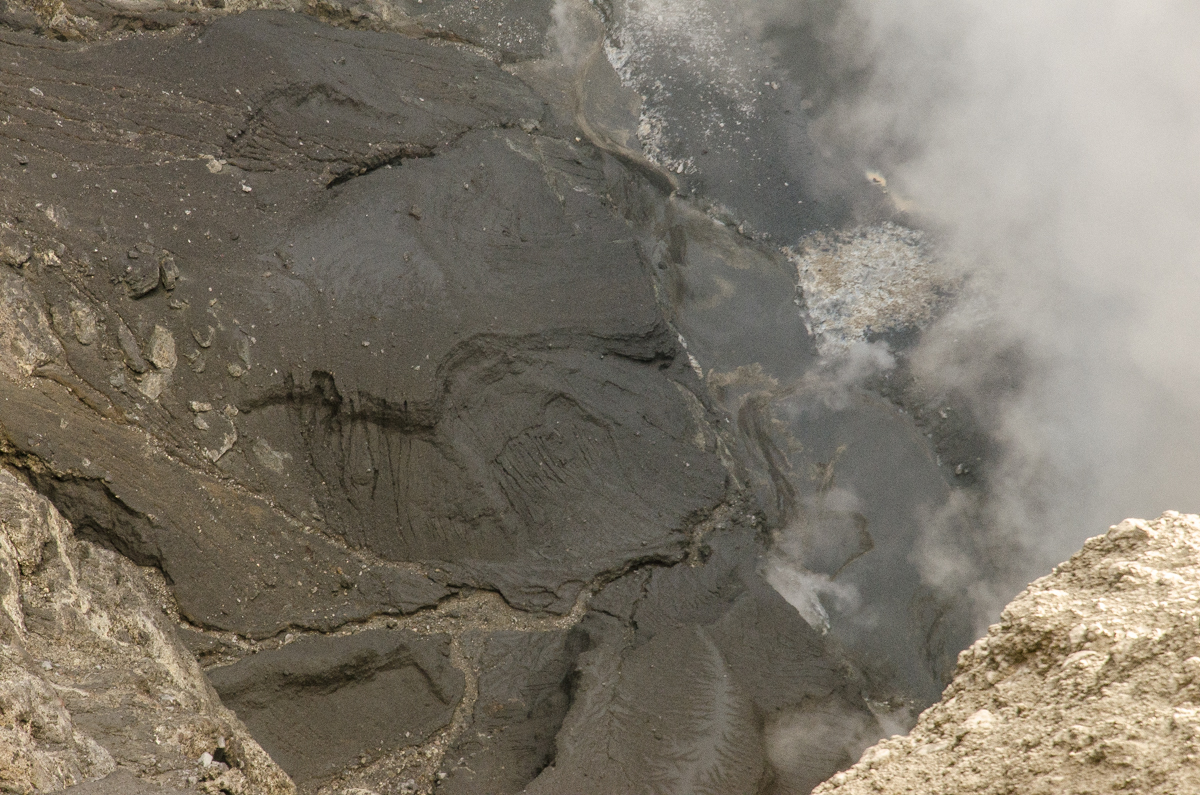 |
Figure 2. Photo of the crater floor at Kerinci showing solidified lava flows and steam. Date not reported; uploaded 17 January 2016. Courtesy of Bernhard Huber. |
Based on satellite images and ground reports from PVMBG, the Darwin Volcanic Ash Advisory Centre (VAAC) reported that during 15 days between 31 March and 9 June 2016 ash plumes rose to altitudes of 4.0-4.9 km and drifted N, NW, NE, E, and WSW. On 29 April an ash plume rose to an altitude of 6.1 km.
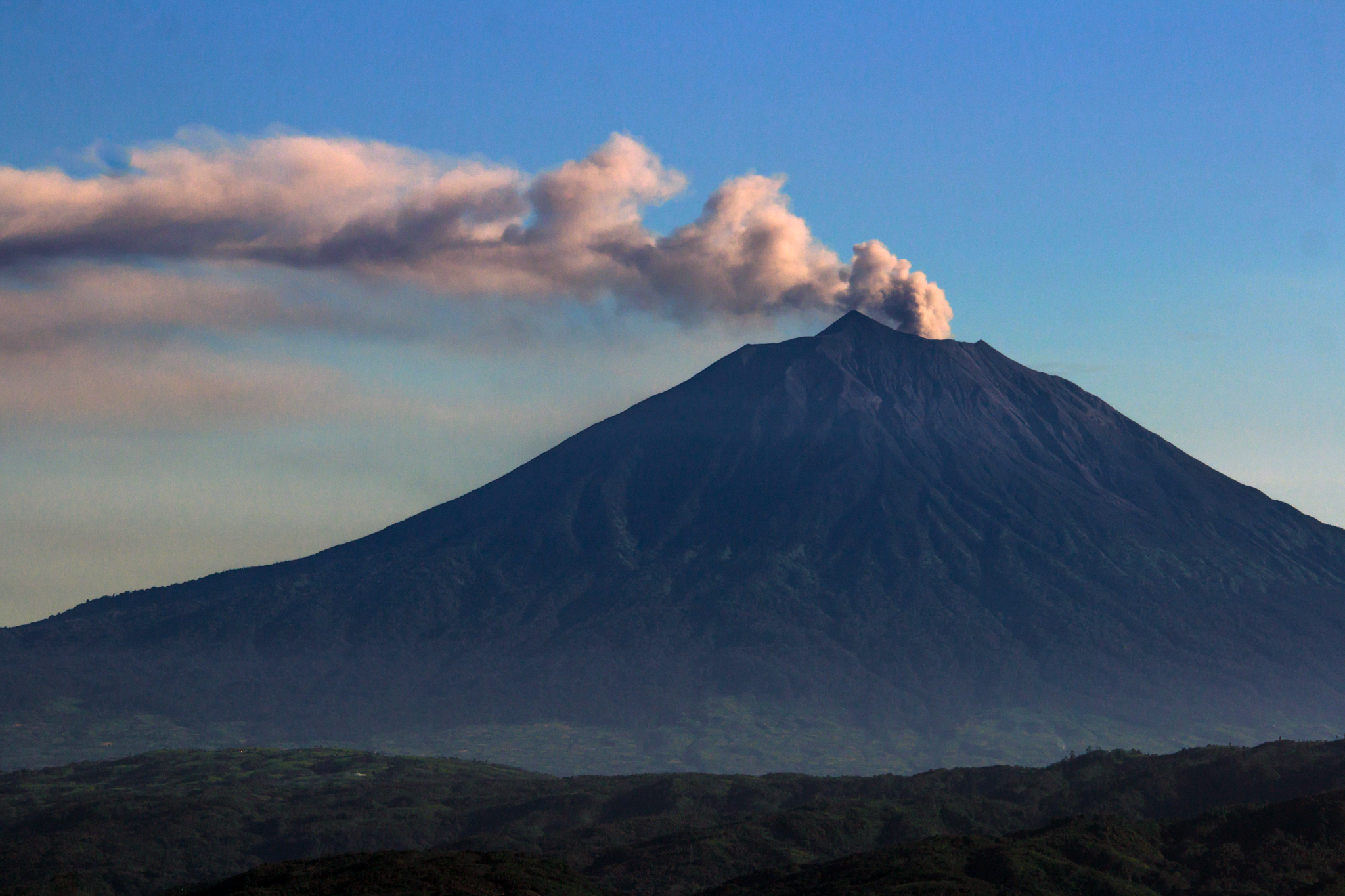 |
Figure 3. Photo of Kerinci showing a plume rising from the summit crater on 9 June 2016. Courtesy of Luke Mackin. |
Ash plumes were again reported on 15-19, and 21 November 2016 based on observations of satellite data by the Darwin VAAC. The plumes rose to altitudes of 4.3-4.6 km and drifted NE, ENE, SE, and S. On 15 and 17 November they drifted almost 30 km downwind. The Alert Level remained at 2 (on a scale of 1-4), where it has been since September 2007, and PVMBG advised residents and visitors not to enter an area within 3 km of the summit.
Information Contacts: Pusat Vulkanologi dan Mitigasi Bencana Geologi (PVMBG, also known as Indonesian Center for Volcanology and Geological Hazard Mitigation, CVGHM), Jalan Diponegoro 57, Bandung 40122, Indonesia (URL: http://www.vsi.esdm.go.id/); Darwin Volcanic Ash Advisory Centre (VAAC), Bureau of Meteorology, Northern Territory Regional Office, PO Box 40050, Casuarina, NT 0811, Australia (URL: http://www.bom.gov.au/info/vaac/); Bernhard Huber (URL: https://www.flickr.com/photos/97278656@N08/, https://creativecommons.org/licenses/by-nc-nd/2.0/); Luke Mackin (URL: https://www.flickr.com/photos/wildsumatra/, https://creativecommons.org/licenses/by-nc-sa/2.0/); Jakarta Post (URL: http://www.thejakartapost.com/news/2013/06/02/mt-kerinci-erupts.html).
Small ash plumes observed in August 2017, April 2018, and June 2018
Kerinci has produced intermittent ash explosions in recent years, including December 2011, June 2013, March-June 2016, and November 2016 (BGVN 42:04). The Darwin Volcanic Ash Advisory Centre (VAAC) has issued the only reports on activity between December 2016 and July 2018, and these have been based on satellite data. The Indonesia volcano monitoring agency, Pusat Vulkanologi dan Mitigasi Bencana Geologi (PVMBG, also known as Indonesian Center for Volcanology and Geological Hazard Mitigation, CVGHM), has kept the Alert Level at 2 (on a scale of 1-4) since 9 September 2007.
According to the Darwin VAAC, on 13 August 2017, an ash plume rose to an altitude of 4.3 km and drifted WSW.
Sentinel-2 satellite imagery showed what appeared to be a small ash plume rising from the crater on 21 April 2018 (figure 4). The Darwin VAAC also reported that on 5 June 2018 a minor ash emission rose to an altitude of 4.3 km and drifted W (figure 5). On 10 June an ash plume rose to an altitude of 4 km and drifted W.
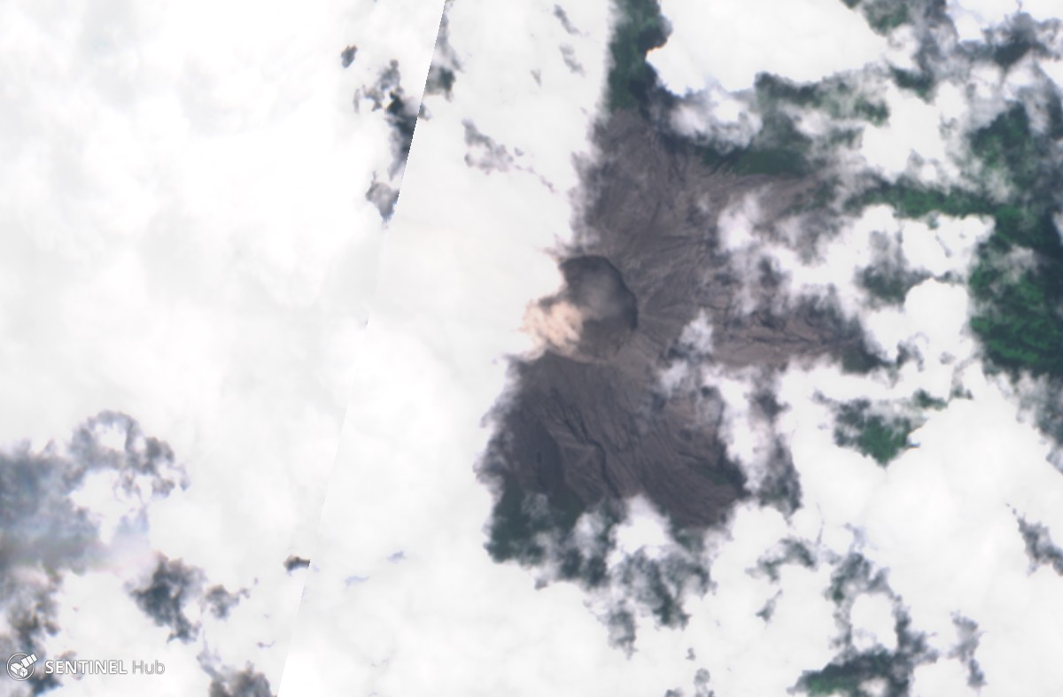 |
Figure 4. Natural color satellite image from Sentinel-2 on 21 April 2018 showing a small light-brown ash plume rising from the Kerinci summit crater. Courtesy of Sentinel Hub. |
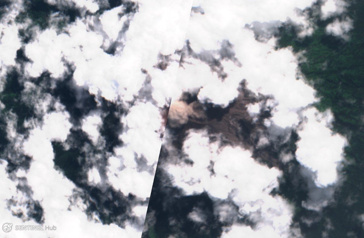 |
Figure 5. A brown ash plume is visible in this natural color Sentinel-2 satellite image of the Kerinci crater on 5 June 2018. Courtesy of Sentinel Hub. |
During the reporting period, no significant sulfur dioxide levels near the volcano were recorded by NASA's satellite-borne ozone instruments, and no thermal anomalies were detected.
Information Contacts: Darwin Volcanic Ash Advisory Centre (VAAC), Bureau of Meteorology, Northern Territory Regional Office, PO Box 40050, Casuarina, NT 0811, Australia (URL: http://www.bom.gov.au/info/vaac/); Pusat Vulkanologi dan Mitigasi Bencana Geologi (PVMBG, also known as Indonesian Center for Volcanology and Geological Hazard Mitigation, CVGHM), Jalan Diponegoro 57, Bandung 40122, Indonesia (URL: http://www.vsi.esdm.go.id/); Sentinel Hub Playground (URL: https://www.sentinel-hub.com/explore/sentinel-playground); Hawai'i Institute of Geophysics and Planetology (HIGP) - MODVOLC Thermal Alerts System, School of Ocean and Earth Science and Technology (SOEST), Univ. of Hawai'i, 2525 Correa Road, Honolulu, HI 96822, USA (URL: http://modis.higp.hawaii.edu/); NASA Goddard Space Flight Center (NASA/GSFC), Global Sulfur Dioxide Monitoring Page, Atmospheric Chemistry and Dynamics Laboratory, 8800 Greenbelt Road, Goddard, Maryland, USA (URL: https://so2.gsfc.nasa.gov/).
A persistent gas-and-steam plume and intermittent ash plumes occurred from July 2018 through January 2019
Kerinci is a frequently active volcano in Sumatra, Indonesia. Recent activity has consisted of intermittent explosions, ash, and gas-and-steam plumes. The volcano alert has been at Level II since 9 September 2007. This report summarizes activity during July 2018-January 2019 based on reports by The Indonesia volcano monitoring agency, Pusat Vulkanologi dan Mitigasi Bencana Geologi (PVMBG, also known as Indonesian Center for Volcanology and Geological Hazard Mitigation, CVGHM), MAGMA Indonesia, notices from the Darwin Volcano Ash Advisory Center (Darwin VAAC), and satellite data.
Throughout this period dilute gas-and-steam plumes rising about 300 m above the summit were frequently observed and seismicity continued (figure 6). During July through January ash plumes were observed by the Darwin VAAC up to 4.3 km altitude and dispersed in multiple directions (table 7 and figure 7).
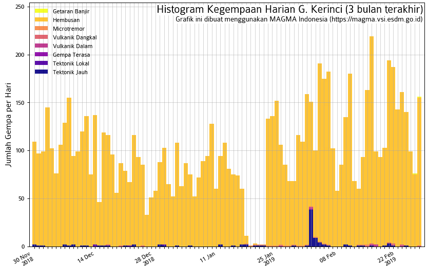 |
Figure 6. Graph showing seismic activity at Kerinci from November 2018 through February 2019. Courtesy of MAGMA Indonesia. |
Table 7. Summary of ash plumes (altitude and drift direction) for Kerinci during July 2018 through January 2019. The summit is at 3.5 km altitude. Data courtesy of the Darwin Volcanic Ash Advisory Center (VAAC) and MAGMA Indonesia.
| Date | Ash plume altitude (km) | Ash plume drift direction |
| 22 Jul 2018 | 4.3 | SW |
| 28-30 Sep 2018 | 4.3 | SW, W |
| 02 Oct 2018 | 4.3 | SW, W |
| 18-22 Oct 2018 | 4.3 | N, W, WSW, SW |
| 19 Jan 2019 | 4 | E to SE |
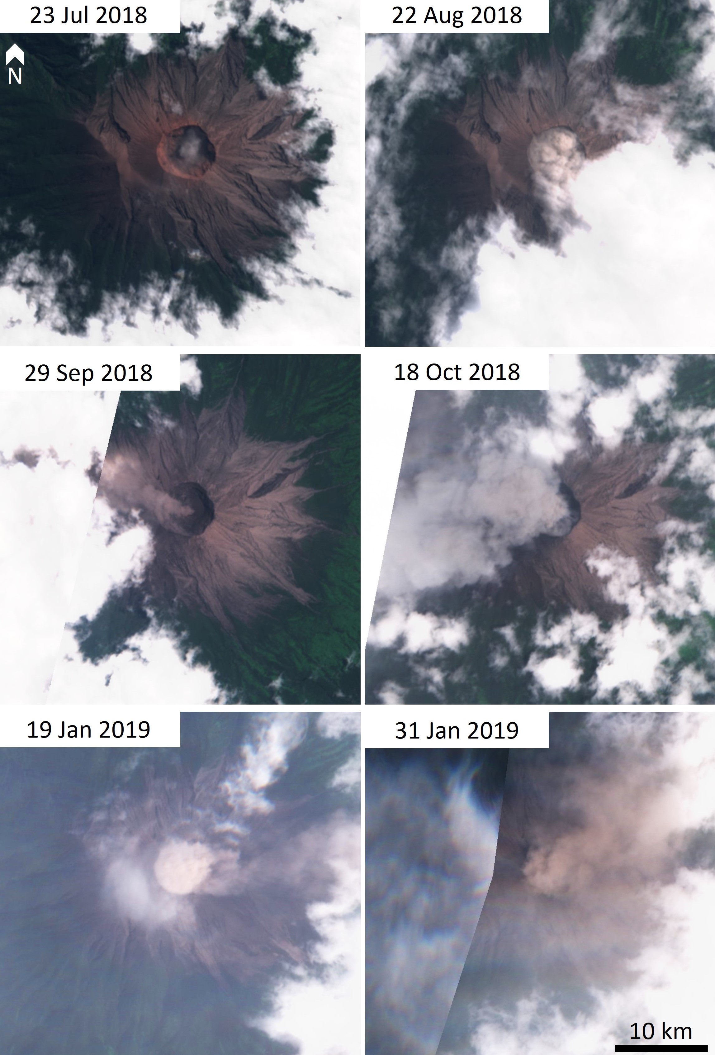 |
Figure 7. Dilute ash plumes at Kerinci during July 2018-January 2019. Sentinel-2 natural color (bands 4, 3, 2) satellite images courtesy of Sentinel Hub Playground. |
Based on satellite data, a Darwin VAAC advisory reported an ash plume to 4.3 km altitude on 22 July that drifted to the SW and S. Only one day with elevated thermal emission was noted in Sentinel-2 satellite data for the entire reporting period, on 13 September 2018 (figure 8). No thermal signatures were detected by MODVOLC. On 28-29 September there was an ash plume observed to 500-600 m above the peak that dispersed to the W. Several VAAC reports on 2 and 18-22 October detected ash plumes that rose to 4.3 km altitude and drifted in different directions. On 19 January from 0734 to 1000 an ash plume rose to 200 m above the crater and dispersed to the E and SE (figure 9).
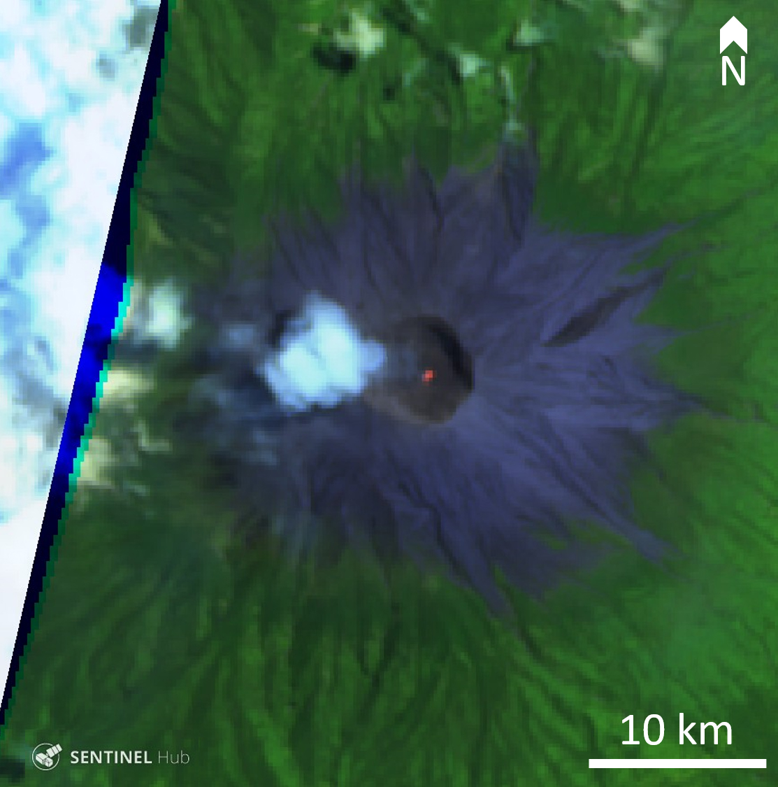 |
Figure 8. Small thermal anomaly at Kerinci volcano on 13 September 2018. False color (urban) image (band 12, 11, 4) courtesy of Sentinel Hub Playground. |
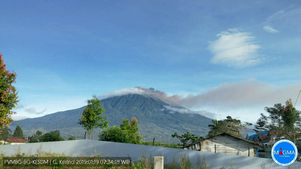 |
Figure 9. Small ash plume at Kerinci on 19 January 2019 that reached 200 m above the crater and traveled west. Courtesy of MAGMA Indonesia. |
Information Contacts: Pusat Vulkanologi dan Mitigasi Bencana Geologi (PVMBG, also known as Indonesian Center for Volcanology and Geological Hazard Mitigation, CVGHM), Jalan Diponegoro 57, Bandung 40122, Indonesia (URL: http://www.vsi.esdm.go.id/); MAGMA Indonesia, Kementerian Energi dan Sumber Daya Mineral (URL: https://magma.vsi.esdm.go.id/); Darwin Volcanic Ash Advisory Centre (VAAC), Bureau of Meteorology, Northern Territory Regional Office, PO Box 40050, Casuarina, NT 0811, Australia (URL: http://www.bom.gov.au/info/vaac/); Sentinel Hub Playground (URL: https://www.sentinel-hub.com/explore/sentinel-playground).
Intermittent explosions with ash plumes, February-May 2019
Frequently active, Indonesia's Mount Kerinci on Sumatra has been the source of numerous moderate explosive eruptions since its first recorded eruption in 1838. Intermittent explosions with ash plumes, usually multiple times per month, have characterized activity since April 2018. Similar activity continued during February-May 2019, the period covered in this report with information provided primarily by the Indonesian volcano monitoring agency, Pusat Vulkanologi dan Mitigasi Bencana Geologi (PVMBG, also known as Indonesian Center for Volcanology and Geological Hazard Mitigation, CVGHM), MAGMA Indonesia, notices from the Darwin Volcano Ash Advisory Center (Darwin VAAC), and satellite data. PVMBG has maintained an Alert Level II (of 4) at Kerinci for several years.
On 13 February 2019 the Kerinci Volcano Observatory (KVO), part of PVMBG, noted a brownish-white ash emission that was drifting NE about 400 m above the summit. The seismicity during the event was dominated by continuous volcanic tremor. A brown ash emission was reported on 7 March 2019 that rose to 3.9 km altitude and drifted NE. Ash also drifted 1,300 m down the SE flank. Another ash plume the next morning drifted W at 4.5 km altitude, according to KVO. On 10, 11, and 13 March KVO reported brown ash plumes drifting NE from the summit at about 4.0-4.3 km altitude. The Darwin VAAC observed continuous ash emissions in satellite imagery on 15 March drifting W at 4.3 m altitude that dissipated after about 3 hours (figure 10). A gray ash emission was reported on 19 March about 600 m above the summit drifting NE; local news media noted that residents of Kayo Aro reported emissions on both 18 and 19 March (figure 11). An ash emission appeared in satellite imagery on 25 March (figure 10). On 30 March the observatory reported two ash plumes; a brown emission at 0351 UTC and a gray emission at 0746 UTC that both drifted NE at about 4.4 km altitude and dissipated within a few hours. PVMBG reported another gray ash plume the following day at a similar altitude.
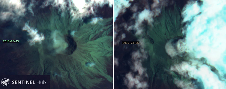 |
Figure 10. Sentinel-2 satellite imagery of Kerinci from 15 (left) and 25 (right) March 2019 showed evidence of ash plumes rising from the summit. Kerinci's summit crater is about 500 m wide. "Geology" rendering (bands 12, 4, 2), courtesy of Sentinel Hub Playground. |
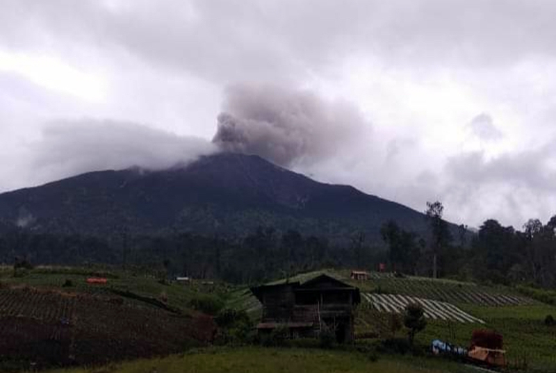 |
Figure 11. Dense ash plumes from Kerinci were reported by local news media on 18 and 19 March 2019. Courtesy of Nusana Jambi. |
Activity continued during April with a brown ash emission reported on 3 April by several different agencies; the Darwin VAAC and PVMBG daily reports noted that the plume was about 500 m above the summit (4.3 km altitude) drifting NE. KVO observed two brown ash emissions on 13 April (UTC) that rose to 4.2 km altitude and drifted NE. Satellite imagery showed minor ash emissions from the summit on 14 April; steam plumes 100-500 m above the summit characterized activity for the remainder of April (figure 12).
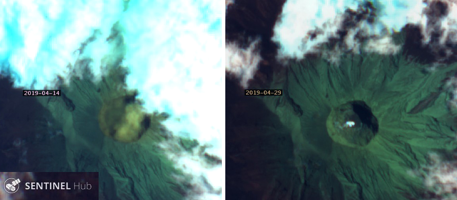 |
Figure 12. A dilute ash emission rose from the summit of Kerinci on 14 April 2019 (left); only steam emissions were present on a clear 29 April in Sentinel-2 imagery (right). "Geology" rendering (bands 12, 4, 2), courtesy of Sentinel Hub Playground. |
Ashfall on the NE and S flanks within 7 km of the volcano was reported on 2 May 2019. According to a news article, at least five villages were affected late on 2 May, including Tanjung Bungo, Sangir, Sangir Tengah, Sungai Rumpun, and Bendung Air (figures 13 and 14). The smell of sulfur was apparent in the villages. Brown ash emissions were observed on 3 and 4 May that rose to 4.6 and 4.1 km altitude and drifted SE. The Darwin VAAC reported an emission on 5 May, based on a pilot report, that rose to 6.7 km altitude and drifted NE for about an hour before dissipating. A brown ash emission on 10 May rose 700 m above the summit and drifted SE. Satellite imagery captured ash emissions from the summit on 14 and 24 May (figure 15). For the remainder of the month, 300-700-m-high dense steam plumes were noted daily until PVMBG reported white and brown plumes on 26 and 27 May rising 500-1,000 m above the summit. Although thermal anomalies were not reported during the period, persistent weak SO2 emissions were identified in TROPOMI instrument satellite data multiple times per month (figure 16).
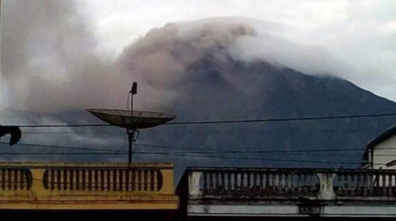 |
Figure 13. Ashfall was reported from five villages on the flanks of Kerinci on 2 May 2019. Courtesy of Uzone. |
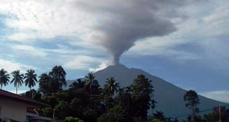 |
Figure 14. An ash plume at Kerinci rose hundreds of meters on 2 May 2019; ashfall was reported in several nearby villages. Courtesy of Kerinci Time. |
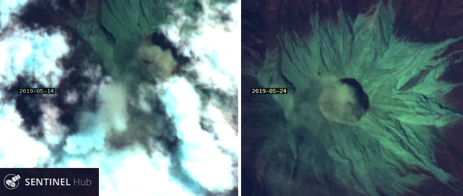 |
Figure 15. Ash emissions from Kerinci were captured in Sentinel-2 satellite imagery on 14 (left) and 24 (right) May 2019. The summit crater is about 500 m wide. "Geology" rendering (bands 12, 4, 2), courtesy of Sentinel Hub Playground. |
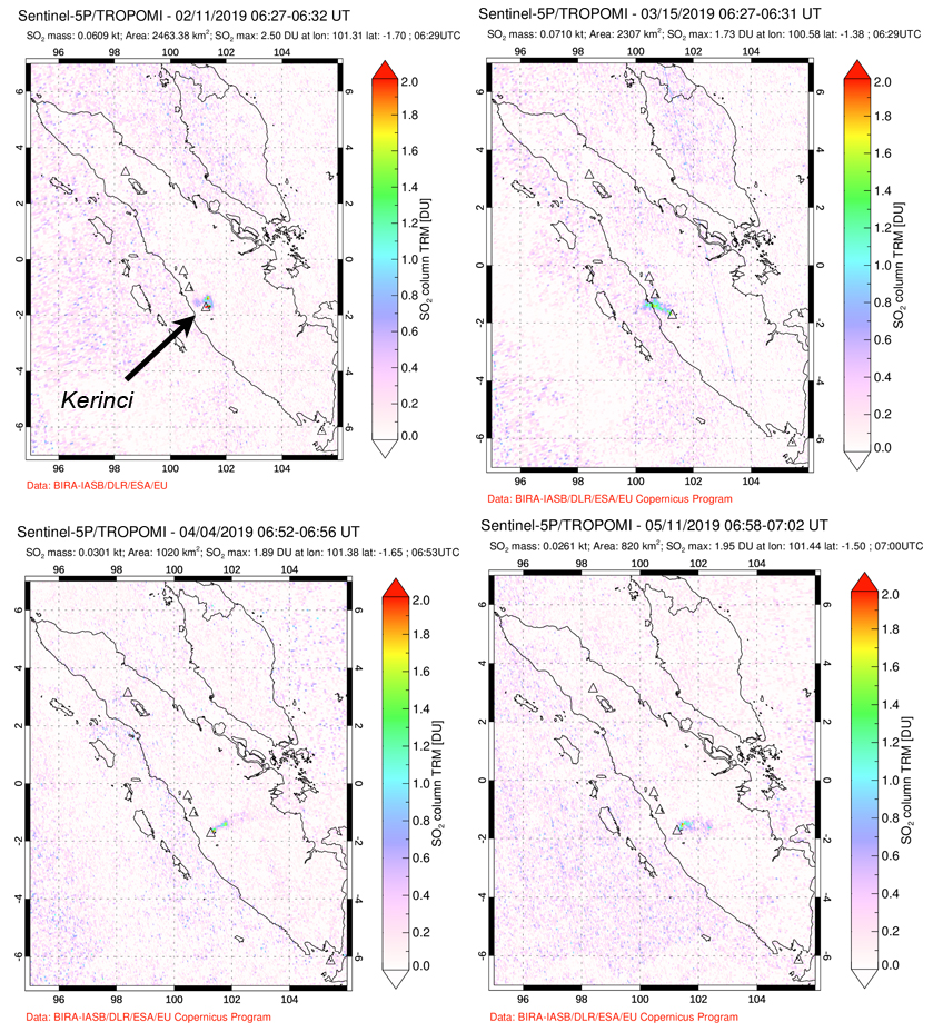 |
Figure 16. Weak SO2 anomalies from Kerinci emissions were captured by the TROPOMI instrument on the Sentinel-5P satellite multiple times each month from February to May 2019. Courtesy of NASA Goddard Space Flight Center. |
Information Contacts: Pusat Vulkanologi dan Mitigasi Bencana Geologi (PVMBG, also known as Indonesian Center for Volcanology and Geological Hazard Mitigation, CVGHM), Jalan Diponegoro 57, Bandung 40122, Indonesia (URL: http://www.vsi.esdm.go.id/); MAGMA Indonesia, Kementerian Energi dan Sumber Daya Mineral (URL: https://magma.vsi.esdm.go.id/); Sentinel Hub Playground (URL: https://www.sentinel-hub.com/explore/sentinel-playground); Global Sulfur Dioxide Monitoring Page, Atmospheric Chemistry and Dynamics Laboratory, NASA Goddard Space Flight Center (NASA/GSFC), 8800 Greenbelt Road, Goddard, Maryland, USA (URL: https://so2.gsfc.nasa.gov/); Nuansa Jambi, Informasi Utama Jambi: (URL: https://nuansajambi.com/2019/03/20/gunung-kerinci-semburkan-asap-tebal/); Kerinci Time (URL: https://kerincitime.co.id/gunung-kerinci-semburkan-abu-vulkanik.html); Uzone.id (URL: https://news.uzone.id/gunung-kerinci-erupsi-5-desa-tertutup-abu-tebal).
Intermittent gas-and-steam and ash plumes during June-early November 2019
Kerinci, located in Sumatra, Indonesia, is a highly active volcano characterized by explosive eruptions with ash plumes and gas-and-steam emissions. The most recent eruptive episode began in April 2018 and included intermittent explosions with ash plumes. Volcanism continued from June-November 2019 with ongoing intermittent gas-and-steam and ash plumes. The primary source of information for this report comes from Pusat Vulkanologi dan Mitigasi Bencana Geologi (PVMBG, also known as Indonesian Center for Volcanology and Geological Hazard Mitigation, CVGHM), the Darwin Volcanic Ash Advisory Centre (VAAC), and MAGMA Indonesia.
Brown- to gray-colored ash clouds drifting in different directions were reported by PVMBG, the Darwin VAAC, and MAGMA Indonesia between June and early November 2019. Ground observations, satellite imagery, and weather models were used to monitor the plume, which ranged from 4.3 to 4.9 km altitude, or about 500-1,100 m above the summit. On 7 June 2019 at 0604 a gray ash emission rose 800 m above the summit, drifting E, according to a ground observer. An ash plume on 12 July rose to 4 km altitude and drifted SW, as determined by satellite imagery and weather models. An eruption produced a gray ash cloud on 31 July that rose to 4.6 km altitude and drifted NE and E, according to PVMBG and the Darwin VAAC (figure 17). Another ash cloud rose up to 4.3 km altitude on 3 August. On 2 September a possible ash plume rose to a maximum altitude of 4.9 km and drifted WSW, according to the Darwin VAAC advisory.
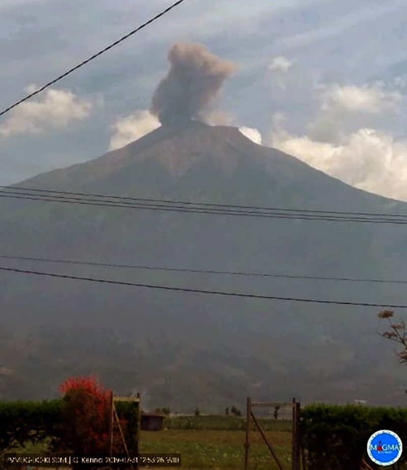 |
Figure 17. A gray ash plume at Kerinci rose roughly 800 m above the summit on 31 July 2019 and drifted NE and E. Courtesy of MAGMA Indonesia. |
Brown ash emissions rose to 4.4 km altitude at 1253 on 6 October, drifting WSW. Similar plumes reached 4.6 km altitude twice on 30 October and moved NE, SE, and E at 0614 and WSW at 1721, based on ground observations. On 1-2 November, ground observers saw brown ash emissions rising up to 4.3 km drifting ESE. Between 3 and 5 November the brown ash plumes rose 100-500 m above the summit, according to PVMBG.
Gas emissions continued to be observed through November, as reported by PVMBG and identified in satellite imagery (figure 18). Seismicity that included volcanic earthquakes also continued between June and early November, when the frequency decreased.
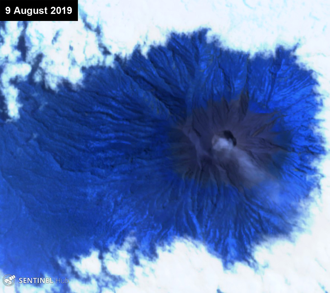 |
Figure 18. Sentinel-2 thermal satellite imagery showing a typical white gas-and-steam plume at Kerinci on 9 August 2019. Sentinel-2 satellite image with "Atmospheric penetration" (bands 12, 11, 8A) rendering; courtesy of Sentinel Hub Playground. |
Information Contacts: Pusat Vulkanologi dan Mitigasi Bencana Geologi (PVMBG, also known as Indonesian Center for Volcanology and Geological Hazard Mitigation, CVGHM), Jalan Diponegoro 57, Bandung 40122, Indonesia (URL: http://www.vsi.esdm.go.id/); Darwin Volcanic Ash Advisory Centre (VAAC), Bureau of Meteorology, Northern Territory Regional Office, PO Box 40050, Casuarina, NT 0811, Australia (URL: http://www.bom.gov.au/info/vaac/); MAGMA Indonesia, Kementerian Energi dan Sumber Daya Mineral (URL: https://magma.vsi.esdm.go.id/); Sentinel Hub Playground (URL: https://www.sentinel-hub.com/explore/sentinel-playground).
Intermittent ash emissions during January-early May 2020
Kerinci is a stratovolcano located in Sumatra, Indonesia that has been characterized by explosive eruptions with ash plumes and gas-and-steam emissions. The most recent eruptive episode began in April 2018 which has included intermittent explosions and ash plumes. The previous report (BGVN 44:12) described more recent activity consisting of intermittent gas-and-steam and ash plumes which occurred during June through early November 2019. This volcanism continued through May 2020, though little to no activity was reported during December 2019. The primary source of information for this report comes from Pusat Vulkanologi dan Mitigasi Bencana Geologi (PVMBG, also known as Indonesian Center for Volcanology and Geological Hazard Mitigation, CVGHM) and the Darwin Volcanic Ash Advisory Centre (VAAC).
Activity during December 2019 consisted of white gas-and-steam emissions rising 100-500 m above the summit. White and brown emissions continued intermittently through May 2020, rising to a maximum altitude of 1 km above the summit on 14 April. During 3-6 and 8-9 January 2020, the Darwin VAAC and PVMBG issued notices reporting brown volcanic ash rising 150-600 m above the summit drifting S and ESE (figure 19). PVMBG published a VONA notice on 24 January at 0828 reporting ash rising 400 m above the summit. Brown emissions continued intermittently throughout the reporting period. On 1 February, volcanic ash was observed rising 300-960 m above the summit and drifting NE; PVMBG reported continuing brown emissions during 1-3 February. During 16-17 February, two VONA notices reported that brown ash plumes rose 150-400 m above the summit and drifted SW accompanied by consistent white gas-and-steam emissions (figure 20).
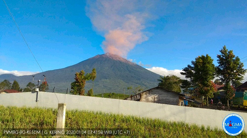 |
Figure 19. Brown ash plume rose 500-600 m above Kerinci on 4 January 2020. Courtesy of MAGMA Indonesia via Øystein Lund Andersen. |
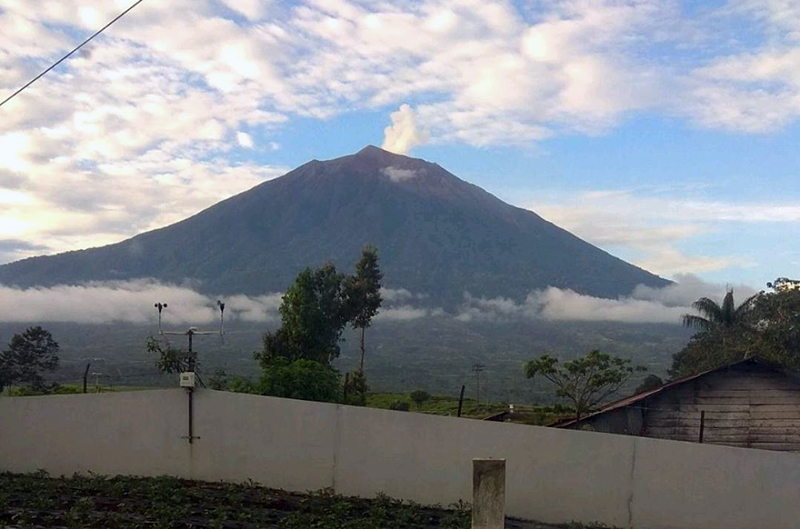 |
Figure 20. White gas-and-steam emissions rose 400 m above Kerinci on 19 February 2020. Courtesy of MAGMA Indonesia via Øystein Lund Andersen. |
During 1-16 and 25-26 March 2020 brown ash emissions were frequently observed rising 100-500 m above the summit drifting in multiple directions. During 6-8 and 10-15, April brown ash emissions were reported 50-1,000 m above the summit. The most recent Darwin VAAC and VONA notices were published on 14 April, reporting volcanic ash rising 400 and 600 m above the summit, respectively; however, PVMBG reported brown emissions rising up to 1,000 m. By 25-27 April brown ash emissions rose 50-300 m above the summit. Intermittent white gas-and-steam emissions continued through May. The last brown emissions seen in May were reported on the 7th rising 50-100 m above the summit.
Information Contacts: Pusat Vulkanologi dan Mitigasi Bencana Geologi (PVMBG, also known as Indonesian Center for Volcanology and Geological Hazard Mitigation, CVGHM), Jalan Diponegoro 57, Bandung 40122, Indonesia (URL: http://www.vsi.esdm.go.id/); Darwin Volcanic Ash Advisory Centre (VAAC), Bureau of Meteorology, Northern Territory Regional Office, PO Box 40050, Casuarina, NT 0811, Australia (URL: http://www.bom.gov.au/info/vaac/); MAGMA Indonesia, Kementerian Energi dan Sumber Daya Mineral (URL: https://magma.vsi.esdm.go.id/); Sentinel Hub Playground (URL: https://www.sentinel-hub.com/explore/sentinel-playground); Øystein Lund Andersen (Twitter: @OysteinLAnderse, https://twitter.com/OysteinLAnderse, URL: http://www.oysteinlundandersen.com, images at https://twitter.com/OysteinLAnderse/status/1213658331564269569/photo/1 and https://twitter.com/OysteinLAnderse/status/1230419965209018369/photo/1).
Intermittent ash plumes and gas-and-steam emissions during June-November 2020
Kerinci, located in Sumatra, Indonesia, has had numerous explosive eruptions since 1838, with more recent activity characterized by gas-and-steam and ash plumes. The current eruptive episode began in April 2018 and has recently consisted of intermittent brown ash emissions and white gas-and-steam emissions (BGVN 45:07); similar activity continued from June through November 2020. Information primarily comes from the Pusat Vulkanologi dan Mitigasi Bencana Geologi (PVMBG, also known as CVGHM, or the Center of Volcanology and Geological Hazard Mitigation), MAGMA Indonesia, the Darwin Volcanic Ash Advisory Centre (VAAC), and satellite data.
Activity has been characterized by dominantly white and brown gas-and-steam emissions and occasional ash plumes, according to PVMBG. Near daily gas-and-steam emissions were observed rising 50-6,400 m above the crater throughout the reporting period: beginning in late July and continuing intermittently though November. [Sentinel-2 satellite imagery showed frequent brown emissions rising above the summit crater at varying intensities and drifting in different directions from 27 July 2020 to 4 November, though the intensity gradually declined over time (figure 21).]
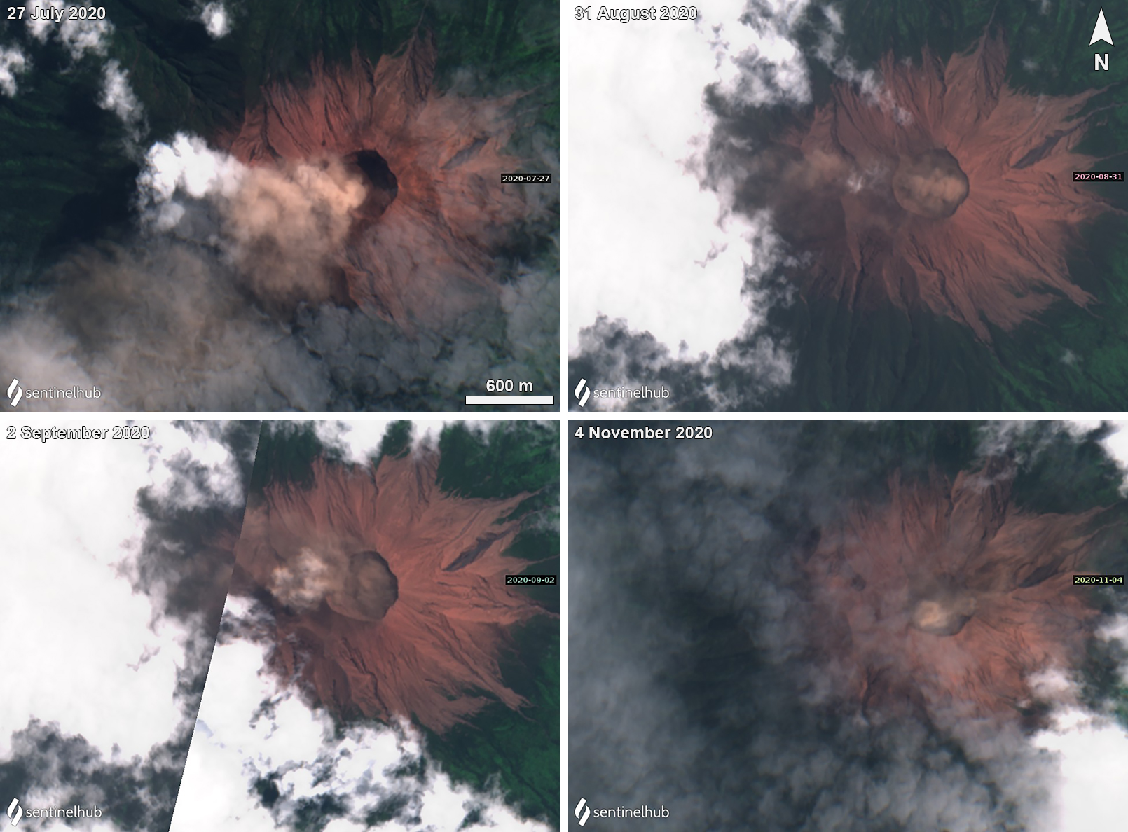 |
Figure 21. Sentinel-2 satellite imagery of brown emissions at Kerinci from July through November 2020 drifting in multiple directions. On 27 July (top left) the brown emissions drifted SW. On 31 August (top right) the brown emissions drifted W. On 2 September (bottom left) slightly weaker brown emissions drifting W. On 4 November (bottom right) weak brown emissions mostly remained within the crater, some of which drifted E. Images using “Natural Color” rendering (bands 4, 3, 2), courtesy of Sentinel Hub Playground. |
During June through July the only activity reported by PVMBG consisted of white gas-and-steam emissions and brown emissions. On 4 June white gas-and-steam emissions rose to a maximum height of 6.4 km above the crater. White-and-brown emissions rose to a maximum height of 700 m above the crater on 2 June and 28 July.
Continuous white-and-brown gas-and-steam emissions were reported in August that rose 50-1,000 m above the crater. The number of ash plumes reported during this month increased compared to the previous months. In a Volcano Observatory Notice for Aviation (VONA) issued on 7 August at 1024, PVMBG reported an ash plume that rose 600 m above the crater and drifted E, SE, and NE. In addition, the Darwin VAAC released two notices that described continuous minor ash emissions rising to 4.3 km altitude and drifting E and NE. On 9 August an ash plume rose 600 m above the crater and drifted ENE at 1140. An ash plume was observed rising to a maximum of 1 km above the crater, drifting E, SE, and NE on 12 August at 1602, according to a PVMBG VONA and Darwin VAAC advisory. The following day, brown emissions rose to a maximum of 1 km above the crater and were accompanied by a 600-m-high ash plume that drifted ENE at 1225. Ground observers on 15 August reported an eruption column that rose to 4.6 km altitude; PVMBG described brown ash emissions up to 800 m above the crater drifting NW at 0731 (figure 22). During 20-21 August pilots reported an ash plume rising 150-770 m above the crater drifting NE and SW, respectively.
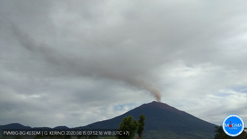 |
Figure 22. Webcam image of an ash plume rising above Kerinci on 15 August 2020. Courtesy of MAGMA Indonesia. |
Activity in September had decreased slightly compared to the previous month, characterized by only white-and-brown gas-and-steam emissions that rose 50-300 m above the crater; solely brown emissions were observed on 30 September and rose 50-100 m above the crater. This low level of activity persisted into October, with white gas-and-steam emissions to 50-200 m above the crater and brown emissions rising 50-300 m above the crater. On 16 October PVMBG released a VONA at 0340 that reported an ash plume rising 687 m above the crater and drifting NE. On 17 October white, brown, and black ash plumes that rose 100-800 m above the crater drifted NE according to both PVMBG and a Darwin VAAC advisory (figure 23). During 18-19 October white, brown, and black ash emissions rose up to 400 m above the crater and drifted NE and E.
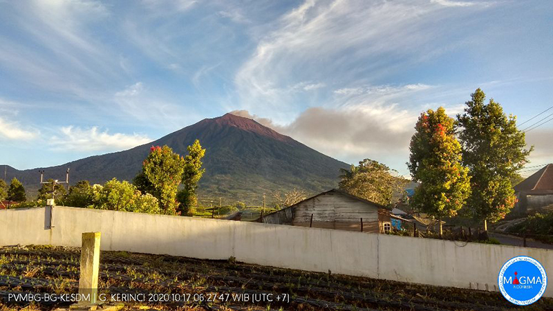 |
Figure 23. Webcam image of a brown ash emission from Kerinci on 17 October 2020. Courtesy of MAGMA Indonesia. |
Information Contacts: Pusat Vulkanologi dan Mitigasi Bencana Geologi (PVMBG, also known as Indonesian Center for Volcanology and Geological Hazard Mitigation, CVGHM), Jalan Diponegoro 57, Bandung 40122, Indonesia (URL: http://www.vsi.esdm.go.id/); MAGMA Indonesia, Kementerian Energi dan Sumber Daya Mineral (URL: https://magma.vsi.esdm.go.id/); Darwin Volcanic Ash Advisory Centre (VAAC), Bureau of Meteorology, Northern Territory Regional Office, PO Box 40050, Casuarina, NT 0811, Australia (URL: http://www.bom.gov.au/info/vaac/); Sentinel Hub Playground (URL: https://www.sentinel-hub.com/explore/sentinel-playground).
Gas-and-steam and occasional ash plumes during December 2020-June 2021
Kerinci is located in Sumatra, Indonesia, and has had numerous moderate explosive eruptions since 1838. Its most recent eruption began in April 2018 and has been characterized by intermittent gas-and-steam and ash plumes through November 2020 (BGVN 45:12). This report covers and similar, but relatively low activity during December 2020 through June 2021 based on information from the Pusat Vulkanologi dan Mitigasi Bencana Geologi (PVMBG, also known as CVGHM, or the Center of Volcanology and Geological Hazard Mitigation), the Darwin Volcanic Ash Advisory Centre (VAAC), and satellite imagery.
Volcanic earthquakes and intermittent white-to-brown gas-and-steam plumes rose 50-800 m above the summit during December 2020 through June 2021 (figure 24); the volcano was often obscured by clouds. Brown ash plumes filling much of the crater could be observed in satellite imagery on 21 and 26 December 2020 and 5 and 8 January 2021. During 21-22 March, PVMBG and the Darwin VAAC reported an ash plume that rose 600 m above the summit and drifted SW. Small plumes of steam and possibly ash were present in a clear satellite view of the crater on 8 April. On 31 May at 0614 an ash plume rose 700 m above the summit and drifted NW, based on ground reports. An ash plume on 6 June rose to 4 km altitude and extended WNW according to HIMAWARI-8 satellite imagery. Another ash plume was reported at 1730 on 13 June that rose 700 m above the summit and drifted W.
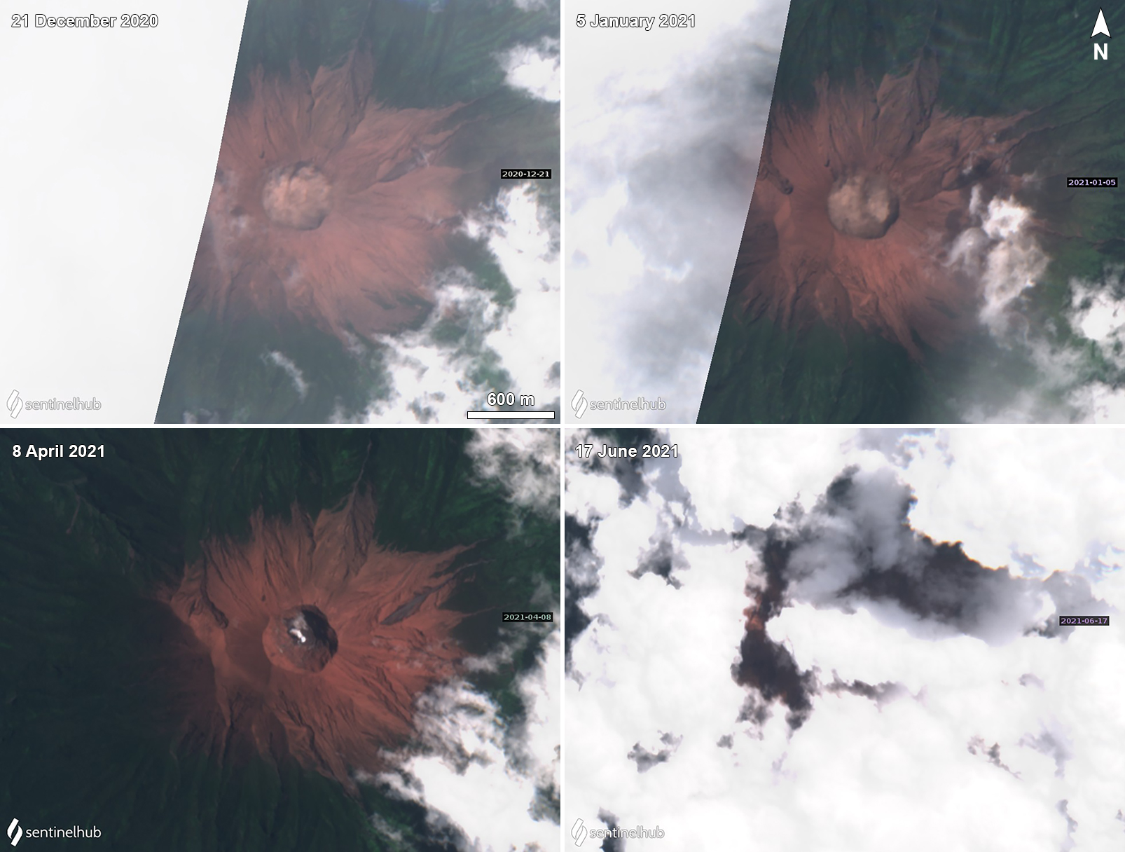 |
Figure 24. Sentinel-2 satellite imagery of brown, white, and gray emissions at Kerinci during 21 December (top left) 2020, 5 January (top right), 8 April (bottom left), and 17 June (bottom right) 2021. The brown emissions mostly remained within the crater area. The gray emissions drifted NE. Images using “Natural Color” rendering (bands 4, 3, 2). Courtesy of Sentinel Hub Playground. |
Information Contacts: Pusat Vulkanologi dan Mitigasi Bencana Geologi (PVMBG, also known as Indonesian Center for Volcanology and Geological Hazard Mitigation, CVGHM), Jalan Diponegoro 57, Bandung 40122, Indonesia (URL: http://www.vsi.esdm.go.id/); Darwin Volcanic Ash Advisory Centre (VAAC), Bureau of Meteorology, Northern Territory Regional Office, PO Box 40050, Casuarina, NT 0811, Australia (URL: http://www.bom.gov.au/info/vaac/); Sentinel Hub Playground (URL: https://www.sentinel-hub.com/explore/sentinel-playground).
Eruption during October 2022-February 2023 with minor ash plumes
Kerinci, a stratovolcano in central Sumatra, Indonesia, has had numerous moderate explosive eruptions since 1838. The previous eruption lasted from April 2018 until June 2021 and included intermittent gas-and-steam and ash plumes (BGVN 43:07, 46:07). This report covers activity during July 2021-February 2023, and is based on data from the Pusat Vulkanologi dan Mitigasi Bencana Geologi (PVMBG), also known as the Center for Volcanology and Geological Hazard Mitigation (CVGHM), the Darwin Volcanic Ash Advisory Centre (VAAC), and satellites.
A new eruption began on 15 October 2022, when observers reported plumes with brown, gray, or black ash that drifted downwind a short distance above the crater, with the highest rising 1.2 km on 12 January 2023; the last reported ash plume was on 27 February 2023. Weather clouds obscured the volcano on most days, allowing only infrequent good webcam photos or satellite images. Although ash plumes were often seen, white steam-and-gas plumes were also visible on many days. There were no thermal anomalies detected over the course of this activity in Sentinel-2 or MODIS data. Though infrequently observed by the TROPOMI instrument aboard the Sentinel-5P satellite, the sulfur dioxide plumes that were detected were localized above the volcano.
According to PVMBG’s MAGMA-Indonesia daily reports from July 2021 through early October 2022, no explosions or ash emissions were observed; white emissions were observed most days when weather permitted. The Darwin VAAC issued an advisory for a plume on 14 October 2021 that reached as high as 750 m, but no ash was identified in satellite data and PVMBG only observed a white steam-and-gas plume. During 15-16 October a new eruption began with a steam-and-ash plumes that rose about 50-350 m above the summit (figure 25) and drifted NE. According to PVMBG and the Darwin VAAC, on 19 October, at 0620 and 0815, ash plumes rose 500-700 m above the summit. On most subsequent days in October ash emissions were visible rising 300-750 m above the summit and drifting primarily NE and NW.
|
Figure 25. Webcam photo of Kerinci on 16 October 2022 showing a gray ash plume rising from the summit crater. Courtesy of MAGMA Indonesia. |
In November, ash plumes rose 150-400 m and drifted in various directions. At 0830 on 27 November an ash plume rose 400 m and drifted E. During 29-30 November, white steam-and-gas plumes rose 300 m. During December, frequent ash plumes and white steam-and-gas plumes rose 100-300 m almost daily, except for an ash plume at 0822 on 6 December which rose 700 m and drifted SW. According to PVMBG, the amplitude of continuous tremor increased during 28-29 December.
The eruption was ongoing during 4-8 January with brown, brown-to-gray, or white-and-brown ash plumes rising as high as 200 m above the crater rim and drifting NE and E. During 10-14 January daily ash plumes that were brown or gray rose generally 400-900 m above the summit and drifted N, NE, and W. At 1810 on 12 January a dense gray ash plume rose 1.2 km above the summit and drifted NW.
An eruptive event was recorded at 0230 on 3 February but not visually confirmed; white-and-gray ash plumes were visible later that day rising 100 m above the summit and drifting NE and E. Plumes with brown or gray ash were visible when conditions were clear, typically in the early morning hours, during 4-10 and 14 February, with small plumes only reaching 150-200 m above the summit and drifting in easterly directions. At 1207 on 15 February a dense brown ash plume rose 200 m and drifted E (figure 26). Dense brown ash plumes rose 150-250 m and drifted E and SE at 0908 and 1937 on 16 February. Plumes with gray or brown ash rose 50-150 m above the crater rim on 26 and 27 February.
|
Figure 26. Webcam photo of Kerinci showing a brown ash plume rising from the summit crater on 15 February 2023. Courtesy of MAGMA Indonesia. |
Information Contacts: Pusat Vulkanologi dan Mitigasi Bencana Geologi (PVMBG, also known as Indonesian Center for Volcanology and Geological Hazard Mitigation, CVGHM), Jalan Diponegoro 57, Bandung 40122, Indonesia (URL: http://www.vsi.esdm.go.id/); MAGMA Indonesia, Kementerian Energi dan Sumber Daya Mineral (URL: https://magma.esdm.go.id/v1); Darwin Volcanic Ash Advisory Centre (VAAC), Bureau of Meteorology, Northern Territory Regional Office, PO Box 40050, Casuarina, NT 0811, Australia (URL: http://www.bom.gov.au/info/vaac/); Global Sulfur Dioxide Monitoring Page, Atmospheric Chemistry and Dynamics Laboratory, NASA Goddard Space Flight Center (NASA/GSFC), 8800 Greenbelt Road, Goddard, Maryland, USA (URL: https://so2.gsfc.nasa.gov/); Sentinel Hub Playground (URL: https://www.sentinel-hub.com/explore/sentinel-playground); MIROVA (Middle InfraRed Observation of Volcanic Activity), a collaborative project between the Universities of Turin and Florence (Italy) supported by the Centre for Volcanic Risk of the Italian Civil Protection Department (URL: http://www.mirovaweb.it/).
|
|
||||||||||||||||||||||||||
There is data available for 38 confirmed Holocene eruptive periods.
2024 May 28 - 2024 May 28 Confirmed Eruption (Explosive / Effusive) VEI: 2
| Episode 1 | Eruption (Explosive / Effusive) | ||||||||||||||||||||
|---|---|---|---|---|---|---|---|---|---|---|---|---|---|---|---|---|---|---|---|---|
| 2024 May 28 - 2024 May 28 | Evidence from Observations: Satellite (visual) | |||||||||||||||||||
|
List of 2 Events for Episode 1
|
||||||||||||||||||||
2022 Oct 15 - 2023 Feb 27 Confirmed Eruption (Explosive / Effusive) VEI: 2
| Episode 1 | Eruption (Explosive / Effusive) | ||||||||||||||||||||
|---|---|---|---|---|---|---|---|---|---|---|---|---|---|---|---|---|---|---|---|---|
| 2022 Oct 15 - 2023 Feb 27 | Evidence from Observations: Reported | |||||||||||||||||||
|
List of 2 Events for Episode 1
|
||||||||||||||||||||
2018 Apr 21 - 2021 Jun 13 Confirmed Eruption (Explosive / Effusive) VEI: 1
| Episode 1 | Eruption (Explosive / Effusive) | Summit crater | ||||||||||||||||||||||||||||||||||||||||||||||||||||||||||||||||
|---|---|---|---|---|---|---|---|---|---|---|---|---|---|---|---|---|---|---|---|---|---|---|---|---|---|---|---|---|---|---|---|---|---|---|---|---|---|---|---|---|---|---|---|---|---|---|---|---|---|---|---|---|---|---|---|---|---|---|---|---|---|---|---|---|---|
| 2018 Apr 21 - 2021 Jun 13 | Evidence from Observations: Reported | ||||||||||||||||||||||||||||||||||||||||||||||||||||||||||||||||
|
List of 11 Events for Episode 1 at Summit crater
|
|||||||||||||||||||||||||||||||||||||||||||||||||||||||||||||||||
2017 Aug 13 - 2017 Aug 13 Confirmed Eruption (Explosive / Effusive) VEI: 1
| Episode 1 | Eruption (Explosive / Effusive) | Summit crater | |||||||||||||||||||
|---|---|---|---|---|---|---|---|---|---|---|---|---|---|---|---|---|---|---|---|---|
| 2017 Aug 13 - 2017 Aug 13 | Evidence from Observations: Reported | |||||||||||||||||||
|
List of 2 Events for Episode 1 at Summit crater
|
||||||||||||||||||||
2016 Nov 15 - 2016 Nov 21 Confirmed Eruption (Explosive / Effusive) VEI: 1
| Episode 1 | Eruption (Explosive / Effusive) | Summit crater | ||||||||||||||||||||||||
|---|---|---|---|---|---|---|---|---|---|---|---|---|---|---|---|---|---|---|---|---|---|---|---|---|---|
| 2016 Nov 15 - 2016 Nov 21 | Evidence from Observations: Reported | ||||||||||||||||||||||||
|
List of 3 Events for Episode 1 at Summit crater
|
|||||||||||||||||||||||||
2016 Mar 31 - 2016 Jun 9 Confirmed Eruption (Explosive / Effusive) VEI: 2
| Episode 1 | Eruption (Explosive / Effusive) | Summit crater | ||||||||||||||||||||||||||||||||||||||||||||||||||||||
|---|---|---|---|---|---|---|---|---|---|---|---|---|---|---|---|---|---|---|---|---|---|---|---|---|---|---|---|---|---|---|---|---|---|---|---|---|---|---|---|---|---|---|---|---|---|---|---|---|---|---|---|---|---|---|---|
| 2016 Mar 31 - 2016 Jun 9 | Evidence from Observations: Reported | ||||||||||||||||||||||||||||||||||||||||||||||||||||||
|
List of 9 Events for Episode 1 at Summit crater
|
|||||||||||||||||||||||||||||||||||||||||||||||||||||||
2013 Jun 2 - 2013 Jun 2 Confirmed Eruption (Explosive / Effusive) VEI: 2
| Episode 1 | Eruption (Explosive / Effusive) | Summit crater | |||||||||||||||||||||||||||||
|---|---|---|---|---|---|---|---|---|---|---|---|---|---|---|---|---|---|---|---|---|---|---|---|---|---|---|---|---|---|---|
| 2013 Jun 2 - 2013 Jun 2 | Evidence from Observations: Reported | |||||||||||||||||||||||||||||
| A brief eruption on 2 June 2013, from 0843 to 0848, generated an ash plume 1 km above the crater. Ashfall as thick as 5 mm was reported in areas to the E. | ||||||||||||||||||||||||||||||
|
List of 4 Events for Episode 1 at Summit crater
|
||||||||||||||||||||||||||||||
2011 Dec 15 - 2011 Dec 15 Confirmed Eruption (Explosive / Effusive) VEI: 1
| Episode 1 | Eruption (Explosive / Effusive) | Summit crater | |||||||||||||||||||
|---|---|---|---|---|---|---|---|---|---|---|---|---|---|---|---|---|---|---|---|---|
| 2011 Dec 15 - 2011 Dec 15 | Evidence from Observations: Reported | |||||||||||||||||||
|
List of 2 Events for Episode 1 at Summit crater
|
||||||||||||||||||||
2009 Apr 1 (?) - 2009 Jun 19 (?) Confirmed Eruption (Explosive / Effusive) VEI: 1
| Episode 1 | Eruption (Explosive / Effusive) | ||||||||||||||||||||||||||||||
|---|---|---|---|---|---|---|---|---|---|---|---|---|---|---|---|---|---|---|---|---|---|---|---|---|---|---|---|---|---|---|
| 2009 Apr 1 (?) - 2009 Jun 19 (?) | Evidence from Observations: Reported | |||||||||||||||||||||||||||||
|
List of 4 Events for Episode 1
|
||||||||||||||||||||||||||||||
2008 Mar 24 Confirmed Eruption (Explosive / Effusive) VEI: 1
| Episode 1 | Eruption (Explosive / Effusive) | |||||||||||||||||||||||||||||||||||
|---|---|---|---|---|---|---|---|---|---|---|---|---|---|---|---|---|---|---|---|---|---|---|---|---|---|---|---|---|---|---|---|---|---|---|---|
| 2008 Mar 24 - Unknown | Evidence from Observations: Reported | ||||||||||||||||||||||||||||||||||
|
List of 5 Events for Episode 1
|
|||||||||||||||||||||||||||||||||||
2007 Sep 9 - 2007 Sep 9 Confirmed Eruption (Explosive / Effusive) VEI: 1
| Episode 1 | Eruption (Explosive / Effusive) | ||||||||||||||||||||||||||||||
|---|---|---|---|---|---|---|---|---|---|---|---|---|---|---|---|---|---|---|---|---|---|---|---|---|---|---|---|---|---|---|
| 2007 Sep 9 - 2007 Sep 9 | Evidence from Observations: Reported | |||||||||||||||||||||||||||||
|
List of 4 Events for Episode 1
|
||||||||||||||||||||||||||||||
2004 Jun 22 (?) - 2004 Oct 24 (?) Confirmed Eruption (Explosive / Effusive) VEI: 2
| Episode 1 | Eruption (Explosive / Effusive) | ||||||||||||||||||||||||||||||||||||||||
|---|---|---|---|---|---|---|---|---|---|---|---|---|---|---|---|---|---|---|---|---|---|---|---|---|---|---|---|---|---|---|---|---|---|---|---|---|---|---|---|---|
| 2004 Jun 22 (?) - 2004 Oct 24 (?) | Evidence from Observations: Reported | |||||||||||||||||||||||||||||||||||||||
|
List of 6 Events for Episode 1
|
||||||||||||||||||||||||||||||||||||||||
2001 May 12 - 2002 Aug 27 (?) Confirmed Eruption (Explosive / Effusive) VEI: 2
| Episode 1 | Eruption (Explosive / Effusive) | |||||||||||||||||||||||||||||||||||
|---|---|---|---|---|---|---|---|---|---|---|---|---|---|---|---|---|---|---|---|---|---|---|---|---|---|---|---|---|---|---|---|---|---|---|---|
| 2001 May 12 - 2002 Aug 27 (?) | Evidence from Observations: Reported | ||||||||||||||||||||||||||||||||||
|
List of 5 Events for Episode 1
|
|||||||||||||||||||||||||||||||||||
1999 Mar 16 (on or before) ± 15 days - 1999 Sep 16 (on or after) ± 15 days Confirmed Eruption (Explosive / Effusive) VEI: 2
| Episode 1 | Eruption (Explosive / Effusive) | |||||||||||||||||||||||||||||||||||
|---|---|---|---|---|---|---|---|---|---|---|---|---|---|---|---|---|---|---|---|---|---|---|---|---|---|---|---|---|---|---|---|---|---|---|---|
| 1999 Mar 16 (on or before) ± 15 days - 1999 Sep 16 (on or after) ± 15 days | Evidence from Observations: Reported | ||||||||||||||||||||||||||||||||||
|
List of 5 Events for Episode 1
|
|||||||||||||||||||||||||||||||||||
1998 Nov 3 Confirmed Eruption (Explosive / Effusive) VEI: 2 (?)
| Episode 1 | Eruption (Explosive / Effusive) | |||||||||||||||||||||||||
|---|---|---|---|---|---|---|---|---|---|---|---|---|---|---|---|---|---|---|---|---|---|---|---|---|---|
| 1998 Nov 3 - Unknown | Evidence from Observations: Reported | ||||||||||||||||||||||||
|
List of 3 Events for Episode 1
|
|||||||||||||||||||||||||
1998 Jul 4 - 1998 Jul 4 Confirmed Eruption (Explosive / Effusive) VEI: 2
| Episode 1 | Eruption (Explosive / Effusive) | |||||||||||||||||||||||||
|---|---|---|---|---|---|---|---|---|---|---|---|---|---|---|---|---|---|---|---|---|---|---|---|---|---|
| 1998 Jul 4 - 1998 Jul 4 | Evidence from Observations: Reported | ||||||||||||||||||||||||
|
List of 3 Events for Episode 1
|
|||||||||||||||||||||||||
1996 Aug 16 ± 15 days - 1996 Oct 16 (?) ± 15 days Confirmed Eruption (Explosive / Effusive) VEI: 1
| Episode 1 | Eruption (Explosive / Effusive) | ||||||||||||||||||||||||||||||
|---|---|---|---|---|---|---|---|---|---|---|---|---|---|---|---|---|---|---|---|---|---|---|---|---|---|---|---|---|---|---|
| 1996 Aug 16 ± 15 days - 1996 Oct 16 (?) ± 15 days | Evidence from Observations: Reported | |||||||||||||||||||||||||||||
|
List of 4 Events for Episode 1
|
||||||||||||||||||||||||||||||
1990 Dec 31 ± 365 days Confirmed Eruption (Explosive / Effusive) VEI: 2
| Episode 1 | Eruption (Explosive / Effusive) | |||||||||||||||||||||||||
|---|---|---|---|---|---|---|---|---|---|---|---|---|---|---|---|---|---|---|---|---|---|---|---|---|---|
| 1990 Dec 31 ± 365 days - Unknown | Evidence from Observations: Reported | ||||||||||||||||||||||||
|
List of 3 Events for Episode 1
|
|||||||||||||||||||||||||
[ 1971 Jun 16 ± 15 days - 1971 Jun 16 ± 15 days ] Uncertain Eruption
| Episode 1 | Eruption (Explosive / Effusive) | |||||||||||||||||||||||||
|---|---|---|---|---|---|---|---|---|---|---|---|---|---|---|---|---|---|---|---|---|---|---|---|---|---|
| 1971 Jun 16 ± 15 days - 1971 Jun 16 ± 15 days | Evidence from Unknown | ||||||||||||||||||||||||
|
List of 3 Events for Episode 1
|
|||||||||||||||||||||||||
1969 Jul 2 ± 182 days - 1970 Jul 2 ± 182 days Confirmed Eruption (Explosive / Effusive) VEI: 2
| Episode 1 | Eruption (Explosive / Effusive) | ||||||||||||||||||||||||||||||
|---|---|---|---|---|---|---|---|---|---|---|---|---|---|---|---|---|---|---|---|---|---|---|---|---|---|---|---|---|---|---|
| 1969 Jul 2 ± 182 days - 1970 Jul 2 ± 182 days | Evidence from Observations: Reported | |||||||||||||||||||||||||||||
|
List of 4 Events for Episode 1
|
||||||||||||||||||||||||||||||
1968 Feb 3 - 1968 Mar 18 Confirmed Eruption (Explosive / Effusive) VEI: 2
| Episode 1 | Eruption (Explosive / Effusive) | ||||||||||||||||||||||||||||||
|---|---|---|---|---|---|---|---|---|---|---|---|---|---|---|---|---|---|---|---|---|---|---|---|---|---|---|---|---|---|---|
| 1968 Feb 3 - 1968 Mar 18 | Evidence from Observations: Reported | |||||||||||||||||||||||||||||
|
List of 4 Events for Episode 1
|
||||||||||||||||||||||||||||||
1967 Nov 2 Confirmed Eruption (Explosive / Effusive) VEI: 2
| Episode 1 | Eruption (Explosive / Effusive) | ||||||||||||||||||||
|---|---|---|---|---|---|---|---|---|---|---|---|---|---|---|---|---|---|---|---|---|
| 1967 Nov 2 - Unknown | Evidence from Observations: Reported | |||||||||||||||||||
|
List of 2 Events for Episode 1
|
||||||||||||||||||||
1966 Jun 9 - 1966 Jun 30 (on or after) Confirmed Eruption (Explosive / Effusive) VEI: 2
| Episode 1 | Eruption (Explosive / Effusive) | ||||||||||||||||||||||||||||||
|---|---|---|---|---|---|---|---|---|---|---|---|---|---|---|---|---|---|---|---|---|---|---|---|---|---|---|---|---|---|---|
| 1966 Jun 9 - 1966 Jun 30 (on or after) | Evidence from Observations: Reported | |||||||||||||||||||||||||||||
|
List of 4 Events for Episode 1
|
||||||||||||||||||||||||||||||
1964 Jul 8 - 1964 Jul 8 (?) Confirmed Eruption (Explosive / Effusive) VEI: 2
| Episode 1 | Eruption (Explosive / Effusive) | |||||||||||||||||||||||||
|---|---|---|---|---|---|---|---|---|---|---|---|---|---|---|---|---|---|---|---|---|---|---|---|---|---|
| 1964 Jul 8 - 1964 Jul 8 (?) | Evidence from Observations: Reported | ||||||||||||||||||||||||
|
List of 3 Events for Episode 1
|
|||||||||||||||||||||||||
1963 Jul 16 ± 15 days Confirmed Eruption (Explosive / Effusive) VEI: 2
| Episode 1 | Eruption (Explosive / Effusive) | ||||||||||||||||||||
|---|---|---|---|---|---|---|---|---|---|---|---|---|---|---|---|---|---|---|---|---|
| 1963 Jul 16 ± 15 days - Unknown | Evidence from Observations: Reported | |||||||||||||||||||
|
List of 2 Events for Episode 1
|
||||||||||||||||||||
1960 Jul 16 ± 15 days Confirmed Eruption (Explosive / Effusive) VEI: 2
| Episode 1 | Eruption (Explosive / Effusive) | ||||||||||||||||||||
|---|---|---|---|---|---|---|---|---|---|---|---|---|---|---|---|---|---|---|---|---|
| 1960 Jul 16 ± 15 days - Unknown | Evidence from Observations: Reported | |||||||||||||||||||
|
List of 2 Events for Episode 1
|
||||||||||||||||||||
1952 Jan 16 ± 15 days - 1952 Jun 16 ± 15 days Confirmed Eruption (Explosive / Effusive) VEI: 2
| Episode 1 | Eruption (Explosive / Effusive) | ||||||||||||||||||||
|---|---|---|---|---|---|---|---|---|---|---|---|---|---|---|---|---|---|---|---|---|
| 1952 Jan 16 ± 15 days - 1952 Jun 16 ± 15 days | Evidence from Observations: Reported | |||||||||||||||||||
|
List of 2 Events for Episode 1
|
||||||||||||||||||||
1938 Jan 19 - 1938 Mar 18 Confirmed Eruption (Explosive / Effusive) VEI: 2
| Episode 1 | Eruption (Explosive / Effusive) | ||||||||||||||||||||
|---|---|---|---|---|---|---|---|---|---|---|---|---|---|---|---|---|---|---|---|---|
| 1938 Jan 19 - 1938 Mar 18 | Evidence from Observations: Reported | |||||||||||||||||||
|
List of 2 Events for Episode 1
|
||||||||||||||||||||
1937 Sep 8 Confirmed Eruption (Explosive / Effusive) VEI: 2
| Episode 1 | Eruption (Explosive / Effusive) | ||||||||||||||||||||
|---|---|---|---|---|---|---|---|---|---|---|---|---|---|---|---|---|---|---|---|---|
| 1937 Sep 8 - Unknown | Evidence from Observations: Reported | |||||||||||||||||||
|
List of 2 Events for Episode 1
|
||||||||||||||||||||
1936 Aug 30 - 1936 Aug 30 Confirmed Eruption (Explosive / Effusive) VEI: 2
| Episode 1 | Eruption (Explosive / Effusive) | |||||||||||||||||||||||||
|---|---|---|---|---|---|---|---|---|---|---|---|---|---|---|---|---|---|---|---|---|---|---|---|---|---|
| 1936 Aug 30 - 1936 Aug 30 | Evidence from Observations: Reported | ||||||||||||||||||||||||
|
List of 3 Events for Episode 1
|
|||||||||||||||||||||||||
1936 Apr 29 - 1936 Apr 29 Confirmed Eruption (Explosive / Effusive) VEI: 2
| Episode 1 | Eruption (Explosive / Effusive) | |||||||||||||||||||||||||
|---|---|---|---|---|---|---|---|---|---|---|---|---|---|---|---|---|---|---|---|---|---|---|---|---|---|
| 1936 Apr 29 - 1936 Apr 29 | Evidence from Observations: Reported | ||||||||||||||||||||||||
|
List of 3 Events for Episode 1
|
|||||||||||||||||||||||||
1923 Sep - 1923 Sep Confirmed Eruption (Explosive / Effusive) VEI: 1
| Episode 1 | Eruption (Explosive / Effusive) | ||||||||||||||||||||
|---|---|---|---|---|---|---|---|---|---|---|---|---|---|---|---|---|---|---|---|---|
| 1923 Sep - 1923 Sep | Evidence from Observations: Reported | |||||||||||||||||||
|
List of 2 Events for Episode 1
|
||||||||||||||||||||
1921 May - 1921 Jun Confirmed Eruption (Explosive / Effusive) VEI: 2
| Episode 1 | Eruption (Explosive / Effusive) | ||||||||||||||||||||
|---|---|---|---|---|---|---|---|---|---|---|---|---|---|---|---|---|---|---|---|---|
| 1921 May - 1921 Jun | Evidence from Observations: Reported | |||||||||||||||||||
|
List of 2 Events for Episode 1
|
||||||||||||||||||||
1908 Oct - 1909 Confirmed Eruption (Explosive / Effusive) VEI: 2
| Episode 1 | Eruption (Explosive / Effusive) | ||||||||||||||||||||||||||||||
|---|---|---|---|---|---|---|---|---|---|---|---|---|---|---|---|---|---|---|---|---|---|---|---|---|---|---|---|---|---|---|
| 1908 Oct - 1909 | Evidence from Observations: Reported | |||||||||||||||||||||||||||||
|
List of 4 Events for Episode 1
|
||||||||||||||||||||||||||||||
1887 Mar 23 - 1887 Mar 30 Confirmed Eruption (Explosive / Effusive) VEI: 2 (?)
| Episode 1 | Eruption (Explosive / Effusive) | ||||||||||||||||||||
|---|---|---|---|---|---|---|---|---|---|---|---|---|---|---|---|---|---|---|---|---|
| 1887 Mar 23 - 1887 Mar 30 | Evidence from Observations: Reported | |||||||||||||||||||
|
List of 2 Events for Episode 1
|
||||||||||||||||||||
1878 Dec 11 Confirmed Eruption (Explosive / Effusive) VEI: 2
| Episode 1 | Eruption (Explosive / Effusive) | ||||||||||||||||||||
|---|---|---|---|---|---|---|---|---|---|---|---|---|---|---|---|---|---|---|---|---|
| 1878 Dec 11 - Unknown | Evidence from Observations: Reported | |||||||||||||||||||
|
List of 2 Events for Episode 1
|
||||||||||||||||||||
1874 (?) Confirmed Eruption (Explosive / Effusive) VEI: 2 (?)
| Episode 1 | Eruption (Explosive / Effusive) | ||||||||||||||||||||
|---|---|---|---|---|---|---|---|---|---|---|---|---|---|---|---|---|---|---|---|---|
| 1874 (?) - Unknown | Evidence from Observations: Reported | |||||||||||||||||||
|
List of 2 Events for Episode 1
|
||||||||||||||||||||
1842 Confirmed Eruption (Explosive / Effusive) VEI: 2
| Episode 1 | Eruption (Explosive / Effusive) | ||||||||||||||||||||
|---|---|---|---|---|---|---|---|---|---|---|---|---|---|---|---|---|---|---|---|---|
| 1842 - Unknown | Evidence from Observations: Reported | |||||||||||||||||||
|
List of 2 Events for Episode 1
|
||||||||||||||||||||
1838 Confirmed Eruption (Explosive / Effusive) VEI: 2
| Episode 1 | Eruption (Explosive / Effusive) | ||||||||||||||||||||
|---|---|---|---|---|---|---|---|---|---|---|---|---|---|---|---|---|---|---|---|---|
| 1838 - Unknown | Evidence from Observations: Reported | |||||||||||||||||||
|
List of 2 Events for Episode 1
|
||||||||||||||||||||
This compilation of synonyms and subsidiary features may not be comprehensive. Features are organized into four major categories: Cones, Craters, Domes, and Thermal Features. Synonyms of features appear indented below the primary name. In some cases additional feature type, elevation, or location details are provided.
Synonyms |
||||
| Korinci | Indrapura, Peak of | Gadang, Gunung | Berapi | Kerintji | Koerinci | Koerintji | Korintji | ||||
Cones |
||||
| Feature Name | Feature Type | Elevation | Latitude | Longitude |
| Buntak, Bukit | Cone | 1250 m | 1° 37' 0.00" S | 101° 15' 0.00" E |
Craters |
||||
| Feature Name | Feature Type | Elevation | Latitude | Longitude |
| Berapi-Elok | Crater | 3655 m | ||
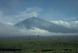 Kerinci is Indonesia's highest volcano, and one of its most active, and is seen here above tea plantations to the south. A small plume rises from the unvegetated summit that has a cone containing a 600-m-wide summit crater over 400 m deep with a crater lake at the bottom. Frequent small-to-moderate explosive eruptions have occurred in historical time.
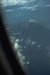 A commercial flight above the Padang Highlands of central Sumatra provides a view of a plume rising from the summit crater of Kerinci, Indonesia's highest volcano.
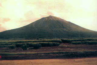 Kerinci volcano towers above tea plantations near its southern flank. The volcano is the most prominent feature of the massive Kerinci Seblat National Park, which stretches along a 345-km-long section of Sumatra. A plume is often seen at the summit of Kerinci, which is one of the most active volcanoes in Sumatra.
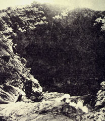 The steep-walled, 600-m-wide summit crater of Kerinci volcano seen from the southern rim. The crater, which is located at the summit of Indonesia's highest volcano, is 450 m deep and is often contains a small lake.
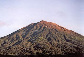 The unvegetated summit of Gunung Kerinci in central Sumatra is seen here from Pengamatan on its southern flank. Kerinci is one of the most active volcanoes in Sumatra and has been the source of numerous moderate explosive eruptions since its first recorded eruption in 1838. The 13 x 25 km wide volcano rises above the surrounding plains.
There are no samples for Kerinci in the Smithsonian's NMNH Department of Mineral Sciences Rock and Ore collection.
| Copernicus Browser | The Copernicus Browser replaced the Sentinel Hub Playground browser in 2023, to provide access to Earth observation archives from the Copernicus Data Space Ecosystem, the main distribution platform for data from the EU Copernicus missions. |
| MIROVA | Middle InfraRed Observation of Volcanic Activity (MIROVA) is a near real time volcanic hot-spot detection system based on the analysis of MODIS (Moderate Resolution Imaging Spectroradiometer) data. In particular, MIROVA uses the Middle InfraRed Radiation (MIR), measured over target volcanoes, in order to detect, locate and measure the heat radiation sourced from volcanic activity. |
| MODVOLC Thermal Alerts | Using infrared satellite Moderate Resolution Imaging Spectroradiometer (MODIS) data, scientists at the Hawai'i Institute of Geophysics and Planetology, University of Hawai'i, developed an automated system called MODVOLC to map thermal hot-spots in near real time. For each MODIS image, the algorithm automatically scans each 1 km pixel within it to check for high-temperature hot-spots. When one is found the date, time, location, and intensity are recorded. MODIS looks at every square km of the Earth every 48 hours, once during the day and once during the night, and the presence of two MODIS sensors in space allows at least four hot-spot observations every two days. Each day updated global maps are compiled to display the locations of all hot spots detected in the previous 24 hours. There is a drop-down list with volcano names which allow users to 'zoom-in' and examine the distribution of hot-spots at a variety of spatial scales. |
|
WOVOdat
Single Volcano View Temporal Evolution of Unrest Side by Side Volcanoes |
WOVOdat is a database of volcanic unrest; instrumentally and visually recorded changes in seismicity, ground deformation, gas emission, and other parameters from their normal baselines. It is sponsored by the World Organization of Volcano Observatories (WOVO) and presently hosted at the Earth Observatory of Singapore.
GVMID Data on Volcano Monitoring Infrastructure The Global Volcano Monitoring Infrastructure Database GVMID, is aimed at documenting and improving capabilities of volcano monitoring from the ground and space. GVMID should provide a snapshot and baseline view of the techniques and instrumentation that are in place at various volcanoes, which can be use by volcano observatories as reference to setup new monitoring system or improving networks at a specific volcano. These data will allow identification of what monitoring gaps exist, which can be then targeted by remote sensing infrastructure and future instrument deployments. |
| Volcanic Hazard Maps | The IAVCEI Commission on Volcanic Hazards and Risk has a Volcanic Hazard Maps database designed to serve as a resource for hazard mappers (or other interested parties) to explore how common issues in hazard map development have been addressed at different volcanoes, in different countries, for different hazards, and for different intended audiences. In addition to the comprehensive, searchable Volcanic Hazard Maps Database, this website contains information about diversity of volcanic hazard maps, illustrated using examples from the database. This site is for educational purposes related to volcanic hazard maps. Hazard maps found on this website should not be used for emergency purposes. For the most recent, official hazard map for a particular volcano, please seek out the proper institutional authorities on the matter. |
| IRIS seismic stations/networks | Incorporated Research Institutions for Seismology (IRIS) Data Services map showing the location of seismic stations from all available networks (permanent or temporary) within a radius of 0.18° (about 20 km at mid-latitudes) from the given location of Kerinci. Users can customize a variety of filters and options in the left panel. Note that if there are no stations are known the map will default to show the entire world with a "No data matched request" error notice. |
| UNAVCO GPS/GNSS stations | Geodetic Data Services map from UNAVCO showing the location of GPS/GNSS stations from all available networks (permanent or temporary) within a radius of 20 km from the given location of Kerinci. Users can customize the data search based on station or network names, location, and time window. Requires Adobe Flash Player. |
| DECADE Data | The DECADE portal, still in the developmental stage, serves as an example of the proposed interoperability between The Smithsonian Institution's Global Volcanism Program, the Mapping Gas Emissions (MaGa) Database, and the EarthChem Geochemical Portal. The Deep Earth Carbon Degassing (DECADE) initiative seeks to use new and established technologies to determine accurate global fluxes of volcanic CO2 to the atmosphere, but installing CO2 monitoring networks on 20 of the world's 150 most actively degassing volcanoes. The group uses related laboratory-based studies (direct gas sampling and analysis, melt inclusions) to provide new data for direct degassing of deep earth carbon to the atmosphere. |
| Large Eruptions of Kerinci | Information about large Quaternary eruptions (VEI >= 4) is cataloged in the Large Magnitude Explosive Volcanic Eruptions (LaMEVE) database of the Volcano Global Risk Identification and Analysis Project (VOGRIPA). |
| EarthChem | EarthChem develops and maintains databases, software, and services that support the preservation, discovery, access and analysis of geochemical data, and facilitate their integration with the broad array of other available earth science parameters. EarthChem is operated by a joint team of disciplinary scientists, data scientists, data managers and information technology developers who are part of the NSF-funded data facility Integrated Earth Data Applications (IEDA). IEDA is a collaborative effort of EarthChem and the Marine Geoscience Data System (MGDS). |

