The Global Volcanism Program has no activity reports available for Jefferson.
The Global Volcanism Program has no Weekly Reports available for Jefferson.
The Global Volcanism Program has no Bulletin Reports available for Jefferson.
|
|
||||||||||||||||||||||||||||
There is data available for 2 confirmed eruptive periods.
0950 (?) Confirmed Eruption (Explosive / Effusive)
| Episode 1 | Eruption (Explosive / Effusive) | S of Jefferson (South Cinder Peak) | ||||||||||||||||||||||||||||
|---|---|---|---|---|---|---|---|---|---|---|---|---|---|---|---|---|---|---|---|---|---|---|---|---|---|---|---|---|---|
| 0950 (?) - Unknown | Evidence from Sidereal: Varve Count | ||||||||||||||||||||||||||||
|
List of 4 Events for Episode 1 at S of Jefferson (South Cinder Peak)
|
|||||||||||||||||||||||||||||
4500 BCE ± 50 years Confirmed Eruption (Explosive / Effusive)
| Episode 1 | Eruption (Explosive / Effusive) | SSE of Jefferson (Forked Butte) | ||||||||||||||||||||||||||||
|---|---|---|---|---|---|---|---|---|---|---|---|---|---|---|---|---|---|---|---|---|---|---|---|---|---|---|---|---|---|
| 4500 BCE ± 50 years - Unknown | Evidence from Sidereal: Varve Count | ||||||||||||||||||||||||||||
|
List of 4 Events for Episode 1 at SSE of Jefferson (Forked Butte)
|
|||||||||||||||||||||||||||||
This compilation of synonyms and subsidiary features may not be comprehensive. Features are organized into four major categories: Cones, Craters, Domes, and Thermal Features. Synonyms of features appear indented below the primary name. In some cases additional feature type, elevation, or location details are provided.
Cones |
||||
| Feature Name | Feature Type | Elevation | Latitude | Longitude |
| Forked Butte | Pyroclastic cone | 1976 m | 44° 36' 0.00" N | 121° 47' 0.00" W |
| Horseshoe Cone | Pyroclastic cone | 44° 38' 0.00" N | 121° 45' 0.00" W | |
| South Cinder Peak | Pyroclastic cone | 2971 m | 44° 34' 0.00" N | 121° 49' 0.00" W |
Domes |
||||
| Feature Name | Feature Type | Elevation | Latitude | Longitude |
| Goat's Peak | Dome | 2182 m | 44° 39' 0.00" N | 121° 48' 0.00" W |
 The western slopes of Mount Jefferson rise above forested hills composed of older Pleistocene volcanic rocks. Scoria cones younger than the eroded main edifice, which ceased activity during the late Pleistocene, are located to the south.
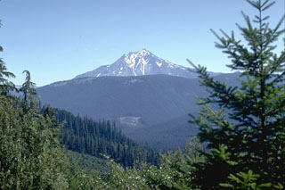
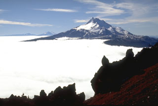 Mount Jefferson is seen to the south from Olallie Butte. The Three Sisters and Broken Top volcanoes are on the horizon to the left. Within 15 km from the main edifice domes and lava flows have erupted from at least 35 vents.
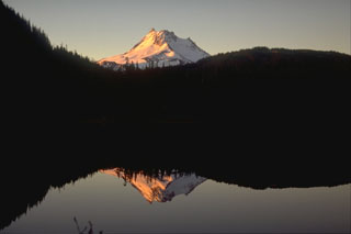 Mount Jefferson rises above Breitenbush Lake to the north. The glacially eroded volcano has not erupted since the late Pleistocene, although flank vents to the south that are not associated with the main edifice have been active since 7,700 years ago.
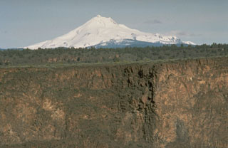 Mount Jefferson of the central Oregon Cascades rises above deep canyons eroded into thick lava flows of the Columbia River Basalt formation that covers a large area to the NE.
  Volcanic activity at glacially eroded Mount Jefferson, Oregon's second highest peak, ended during the Pleistocene. However, scoria cones south of the volcano have been active as recently as about 1,000 years ago. The extensive Whitewater Glacier in the foreground has eroded deeply into the volcano across the E flank.
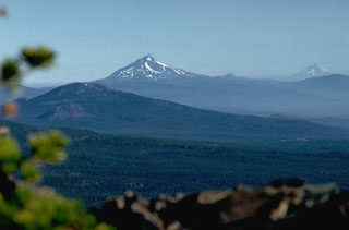 Mount Jefferson in the center and Mount Hood to the right, seen from Broken Top volcano to the south, are the two highest peaks in Oregon, towering above lower volcanic peaks of the High Cascades, such as Black Butte in the foreground. Mount Hood has been active in historical time and Mount Jefferson has Holocene scoria cones to its south, although previous eruptions of the main edifice occurred during the late Pleistocene.
 The unnamed scoria cone to the lower right, viewed from Bear Butte to the NW, was the source of a 13-km-long lava flow that traveled to the west down Jefferson Creek in the center of the photo. The lava flow overlies the northern lobe of a 6,500-year-old flow from Forked Butte, another Holocene scoria cone south of Mount Jefferson. The Forked Butte lava flow divided into lobes that traveled on either side of Sugar Pine Ridge in the background.
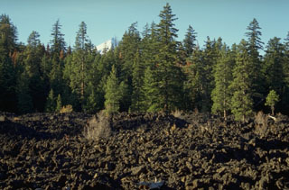 The Jefferson Creek lava flow traveled 13 km down Jefferson and Candle Creeks from an unnamed cinder cone NE of Forked Butte and is younger than the nearby 6,500-year-old Forked Butte lava flow. The two flows traveled down different drainages and joined near this point. The snow-covered summit of Mount Jefferson is visible above the trees.
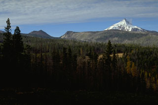 Forked Butte, the scoria cone on the left skyline south of snow-capped Mount Jefferson, formed about 6,500 years ago. It produced lava that flowed from the notch to the right of Forked Butte down valleys on both sides of Sugar Pine Ridge that forms the right skyline. The southern lobe traveled 8 km to the west down Cabot Creek below Sugar Pine Ridge.
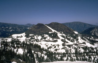 Forked Butte, viewed here from the SW, is a Holocene scoria cone south of Mount Jefferson that produced an 8-km-long lava flow down Cabot Creek about 6,500 years ago. Forked Butte is one of three cones south of Jefferson that have produced Holocene lava flows.
 Forked Butte scoria cone in the foreground formed about 6,500 years ago south of Mount Jefferson, whose flank appears to the right. A lava flow from the southern base of Forked Butte traveled 8 km to the west down Cabot Creek.
 Snow-covered Forked Butte scoria cone in the center of the photo rises above the valley floor across from Bear Butte on the NE. A lava flow that was emplaced about 6,500 years ago can be seen down the left flank of the cone, one of two lobes that split around either side of Sugar Pine Ridge to the far left.
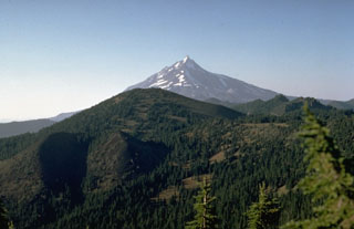 The latest eruption in the Mount Jefferson area occurred from the scoria cone at the lower left on the flank of South Cinder Peak in the center of the photo. The eruption, dated to about 1,000 years ago, formed the cone and produced a lava flow that split into two lobes. One traveled to the NW, and the other flowed 3.5 km W into Marion Lake.
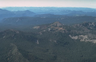 South Cinder Peak, the unvegetated scoria cone near the center of the photo, is the youngest volcanic feature in the Mount Jefferson area. A smaller cinder cone seen at the left on its south flank in this view from the SE, formed about 1,000 years ago and produced a lava flow that traveled to the west.
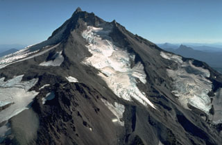 Mount Jefferson has been inactive since the late Pleistocene and shows the effect of extensive erosion by glaciers. The Jefferson Park Glacier on the N flank in the foreground and the Whitewater Glacier on the E flank are the two largest on Jefferson.
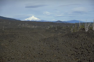 The lava flow in the foreground, with snow-capped Mount Jefferson in the background, was emplaced about 2,600-2,900 years ago from Yapoah scoria cone on the north flank of North Sister. Lava flows in the middle of the photo originated from the Little Belknap shield volcano, part of one of the largest concentrations of recent volcanism in the continental United States: the McKenzie Pass area of the central Oregon Cascade Range.
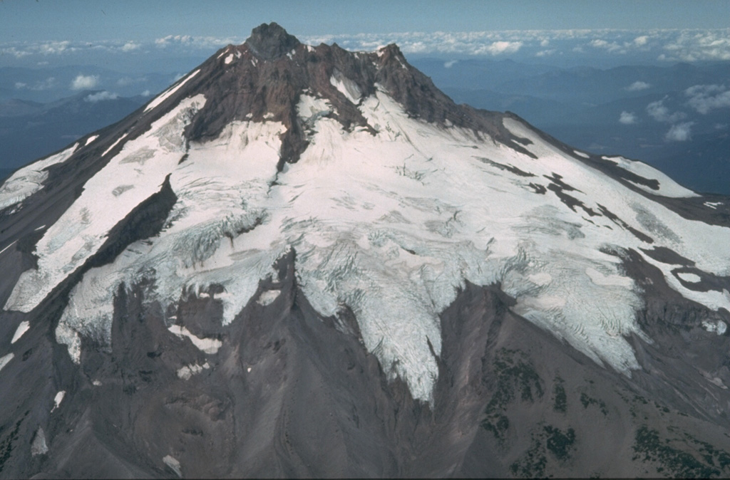
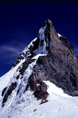 The steep summit pinnacle of Mount Jefferson, seen here from the south, is one of the most dramatic summits of a Cascade Range volcano. Jefferson has been inactive since the late Pleistocene, allowing glacial erosion to remove much of the original summit and exposing the more erosion-resistant rocks that cooled slowly in the central conduit.
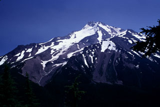 Deep glacial valleys cut the western flanks of Mount Jefferson. The original edifice was extensively eroded by glaciers prior to formation of a younger dacite cone on top of the older edifice. Lava dome growth was associated with the younger volcano and were accompanied by major ash-producing eruptions and pyroclastic flows, before activity ceased activity during the late Pleistocene.
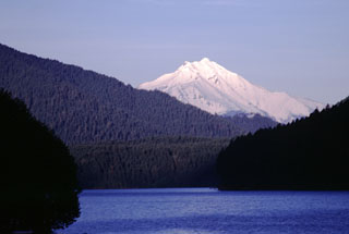 Snow-capped Mount Jefferson rises above Detroit Lake, a hydroelectric reservoir NW of the volcano. The Mount Jefferson region is a popular recreational area in the central Cascades and is in the Mount Jefferson Wilderness Area.
 There are no samples for Jefferson in the Smithsonian's NMNH Department of Mineral Sciences Rock and Ore collection.
| Copernicus Browser | The Copernicus Browser replaced the Sentinel Hub Playground browser in 2023, to provide access to Earth observation archives from the Copernicus Data Space Ecosystem, the main distribution platform for data from the EU Copernicus missions. |
| MIROVA | Middle InfraRed Observation of Volcanic Activity (MIROVA) is a near real time volcanic hot-spot detection system based on the analysis of MODIS (Moderate Resolution Imaging Spectroradiometer) data. In particular, MIROVA uses the Middle InfraRed Radiation (MIR), measured over target volcanoes, in order to detect, locate and measure the heat radiation sourced from volcanic activity. |
| MODVOLC Thermal Alerts | Using infrared satellite Moderate Resolution Imaging Spectroradiometer (MODIS) data, scientists at the Hawai'i Institute of Geophysics and Planetology, University of Hawai'i, developed an automated system called MODVOLC to map thermal hot-spots in near real time. For each MODIS image, the algorithm automatically scans each 1 km pixel within it to check for high-temperature hot-spots. When one is found the date, time, location, and intensity are recorded. MODIS looks at every square km of the Earth every 48 hours, once during the day and once during the night, and the presence of two MODIS sensors in space allows at least four hot-spot observations every two days. Each day updated global maps are compiled to display the locations of all hot spots detected in the previous 24 hours. There is a drop-down list with volcano names which allow users to 'zoom-in' and examine the distribution of hot-spots at a variety of spatial scales. |
|
WOVOdat
Single Volcano View Temporal Evolution of Unrest Side by Side Volcanoes |
WOVOdat is a database of volcanic unrest; instrumentally and visually recorded changes in seismicity, ground deformation, gas emission, and other parameters from their normal baselines. It is sponsored by the World Organization of Volcano Observatories (WOVO) and presently hosted at the Earth Observatory of Singapore.
GVMID Data on Volcano Monitoring Infrastructure The Global Volcano Monitoring Infrastructure Database GVMID, is aimed at documenting and improving capabilities of volcano monitoring from the ground and space. GVMID should provide a snapshot and baseline view of the techniques and instrumentation that are in place at various volcanoes, which can be use by volcano observatories as reference to setup new monitoring system or improving networks at a specific volcano. These data will allow identification of what monitoring gaps exist, which can be then targeted by remote sensing infrastructure and future instrument deployments. |
| Volcanic Hazard Maps | The IAVCEI Commission on Volcanic Hazards and Risk has a Volcanic Hazard Maps database designed to serve as a resource for hazard mappers (or other interested parties) to explore how common issues in hazard map development have been addressed at different volcanoes, in different countries, for different hazards, and for different intended audiences. In addition to the comprehensive, searchable Volcanic Hazard Maps Database, this website contains information about diversity of volcanic hazard maps, illustrated using examples from the database. This site is for educational purposes related to volcanic hazard maps. Hazard maps found on this website should not be used for emergency purposes. For the most recent, official hazard map for a particular volcano, please seek out the proper institutional authorities on the matter. |
| IRIS seismic stations/networks | Incorporated Research Institutions for Seismology (IRIS) Data Services map showing the location of seismic stations from all available networks (permanent or temporary) within a radius of 0.18° (about 20 km at mid-latitudes) from the given location of Jefferson. Users can customize a variety of filters and options in the left panel. Note that if there are no stations are known the map will default to show the entire world with a "No data matched request" error notice. |
| UNAVCO GPS/GNSS stations | Geodetic Data Services map from UNAVCO showing the location of GPS/GNSS stations from all available networks (permanent or temporary) within a radius of 20 km from the given location of Jefferson. Users can customize the data search based on station or network names, location, and time window. Requires Adobe Flash Player. |
| DECADE Data | The DECADE portal, still in the developmental stage, serves as an example of the proposed interoperability between The Smithsonian Institution's Global Volcanism Program, the Mapping Gas Emissions (MaGa) Database, and the EarthChem Geochemical Portal. The Deep Earth Carbon Degassing (DECADE) initiative seeks to use new and established technologies to determine accurate global fluxes of volcanic CO2 to the atmosphere, but installing CO2 monitoring networks on 20 of the world's 150 most actively degassing volcanoes. The group uses related laboratory-based studies (direct gas sampling and analysis, melt inclusions) to provide new data for direct degassing of deep earth carbon to the atmosphere. |
| Large Eruptions of Jefferson | Information about large Quaternary eruptions (VEI >= 4) is cataloged in the Large Magnitude Explosive Volcanic Eruptions (LaMEVE) database of the Volcano Global Risk Identification and Analysis Project (VOGRIPA). |
| EarthChem | EarthChem develops and maintains databases, software, and services that support the preservation, discovery, access and analysis of geochemical data, and facilitate their integration with the broad array of other available earth science parameters. EarthChem is operated by a joint team of disciplinary scientists, data scientists, data managers and information technology developers who are part of the NSF-funded data facility Integrated Earth Data Applications (IEDA). IEDA is a collaborative effort of EarthChem and the Marine Geoscience Data System (MGDS). |

