The Global Volcanism Program has no activity reports available for Crater Lake.
The Global Volcanism Program has no Weekly Reports available for Crater Lake.
The Global Volcanism Program has no Bulletin Reports available for Crater Lake.
|
|
||||||||||||||||||||||||||||
There is data available for 5 confirmed eruptive periods.
2850 BCE (?) Confirmed Eruption (Explosive / Effusive)
| Episode 1 | Eruption (Explosive / Effusive) | Lava dome ENE of Wizard Island | |||||||||||||||||||||||
|---|---|---|---|---|---|---|---|---|---|---|---|---|---|---|---|---|---|---|---|---|---|---|---|---|
| 2850 BCE (?) - Unknown | Evidence from Isotopic: 14C (calibrated) | |||||||||||||||||||||||
|
List of 3 Events for Episode 1 at Lava dome ENE of Wizard Island
|
||||||||||||||||||||||||
5250 BCE (?) Confirmed Eruption (Explosive / Effusive)
| Episode 1 | Eruption (Explosive / Effusive) | Wizard Island and Merriam Cone | |||||||||||||||||||||||
|---|---|---|---|---|---|---|---|---|---|---|---|---|---|---|---|---|---|---|---|---|---|---|---|---|
| 5250 BCE (?) - Unknown | Evidence from Correlation: Tephrochronology | |||||||||||||||||||||||
|
List of 3 Events for Episode 1 at Wizard Island and Merriam Cone
|
||||||||||||||||||||||||
5550 BCE (?) Confirmed Eruption (Explosive / Effusive) VEI: 0
| Episode 1 | Eruption (Explosive / Effusive) | Central Platform | |||||||||||||||||||||||
|---|---|---|---|---|---|---|---|---|---|---|---|---|---|---|---|---|---|---|---|---|---|---|---|---|
| 5550 BCE (?) - Unknown | Evidence from Correlation: Tephrochronology | |||||||||||||||||||||||
|
List of 3 Events for Episode 1 at Central Platform
|
||||||||||||||||||||||||
5680 BCE ± 150 years Confirmed Eruption (Explosive / Effusive) VEI: 7
| Episode 1 | Eruption (Explosive / Effusive) | Mt. Mazama summit and flank vents | ||||||||||||||||||||||||||||||||||||||||||||||||
|---|---|---|---|---|---|---|---|---|---|---|---|---|---|---|---|---|---|---|---|---|---|---|---|---|---|---|---|---|---|---|---|---|---|---|---|---|---|---|---|---|---|---|---|---|---|---|---|---|---|
| 5680 BCE ± 150 years - Unknown | Evidence from Sidereal: Ice Core | ||||||||||||||||||||||||||||||||||||||||||||||||
|
List of 8 Events for Episode 1 at Mt. Mazama summit and flank vents
|
|||||||||||||||||||||||||||||||||||||||||||||||||
5900 BCE ± 50 years Confirmed Eruption (Explosive / Effusive) VEI: 6
| Episode 1 | Eruption (Explosive / Effusive) | North flank (Llao Rock) | |||||||||||||||||||||||||||||||||
|---|---|---|---|---|---|---|---|---|---|---|---|---|---|---|---|---|---|---|---|---|---|---|---|---|---|---|---|---|---|---|---|---|---|---|
| 5900 BCE ± 50 years - Unknown | Evidence from Isotopic: 14C (calibrated) | |||||||||||||||||||||||||||||||||
|
List of 5 Events for Episode 1 at North flank (Llao Rock)
|
||||||||||||||||||||||||||||||||||
This compilation of synonyms and subsidiary features may not be comprehensive. Features are organized into four major categories: Cones, Craters, Domes, and Thermal Features. Synonyms of features appear indented below the primary name. In some cases additional feature type, elevation, or location details are provided.
Synonyms |
||||
| Mazama, Mount | ||||
Cones |
||||
| Feature Name | Feature Type | Elevation | Latitude | Longitude |
| Bald Crater | Pyroclastic cone | 1974 m | 43° 3' 0.00" N | 122° 13' 0.00" W |
| Bear Butte | Cone | 1932 m | 42° 59' 0.00" N | 122° 0' 0.00" W |
| Cleetwood | Vent | 2135 m | 42° 58' 59.00" N | 122° 4' 0.00" W |
| Crater Peak | Cone | 2214 m | 42° 51' 0.00" N | 122° 5' 49.00" W |
| Danger Bay | Stratovolcano | 2050 m | 42° 55' 0.00" N | 122° 4' 0.00" W |
| Desert Cone | Cone | 2027 m | 43° 2' 7.00" N | 122° 9' 29.00" W |
| Dutton Cliff | Stratovolcano | 2484 m | 42° 54' 0.00" N | 122° 5' 0.00" W |
| Forgotten Cone | Pyroclastic cone | 2330 m | 42° 57' 0.00" N | 122° 10' 0.00" W |
| Hillman Peak | Stratovolcano | 2486 m | 42° 57' 11.00" N | 122° 10' 1.00" W |
| Llao Bay | Shield volcano | 2100 m | 42° 58' 0.00" N | 122° 8' 0.00" W |
| Llao Rock | Vent | 2452 m | 42° 58' 23.00" N | 122° 7' 59.00" W |
| Lookout Butte | Cone | 1865 m | 42° 59' 0.00" N | 121° 56' 0.00" W |
| Maklaks Crater
Diller Cone |
Pyroclastic cone | 1945 m | 42° 49' 59.00" N | 122° 1' 1.00" W |
| Merriam Cone | Pyroclastic cone | 1734 m | 42° 57' 43.00" N | 122° 5' 42.00" W |
| Phantom Cone | Stratovolcano | 2300 m | 42° 54' 0.00" N | 122° 5' 0.00" W |
| Pothole Butte | Cone | 1877 m | 42° 57' 0.00" N | 121° 56' 0.00" W |
| Red Cone | Cone | 2247 m | 43° 0' 0.00" N | 122° 10' 1.00" W |
| Redcloud | Vent | 2423 m | 42° 56' 0.00" N | 122° 3' 0.00" W |
| Scott, Mount | Stratovolcano | 2721 m | 42° 55' 30.00" N | 122° 1' 1.00" W |
| Scout Hill | Cone | 1948 m | 42° 58' 0.00" N | 121° 58' 0.00" W |
| Sentinel Rock | Stratovolcano | 2141 m | 42° 55' 0.00" N | 122° 4' 0.00" W |
| Timber Crater | Shield volcano | 2256 m | 43° 3' 0.00" N | 122° 4' 0.00" W |
| Union Peak | Cone | 2346 m | 42° 49' 59.00" N | 122° 13' 30.00" W |
| Wizard Island | Pyroclastic cone | 2115 m | 42° 56' 31.00" N | 122° 8' 42.00" W |
Craters |
||||
| Feature Name | Feature Type | Elevation | Latitude | Longitude |
| Williams Crater
Forgotten Crater |
Crater - Cone | 2330 m | 42° 57' 18.00" N | 122° 10' 37.00" W |
Domes |
||||
| Feature Name | Feature Type | Elevation | Latitude | Longitude |
| Grouse Hill | Dome | 2256 m | 42° 59' 35.00" N | 122° 7' 19.00" W |
| Merriam Point | Dome | 2200 m | 42° 58' 0.00" N | 122° 8' 0.00" W |
| Sharp Peak | Dome | 1818 m | 43° 0' 0.00" N | 122° 0' 29.00" W |
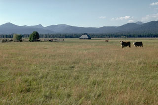 This ridge rising above pastures of the Klamath River valley is the rim of Crater Lake caldera in the Cascade Range. Formation of the caldera about 7,700 years ago removed the top of what was then Mount Mazama. The southern caldera rim is located at the point above the two larger trees at the left side of the photo. Mount Scott, an older volcano located east of the caldera rim, forms the small distant peak to the far right.
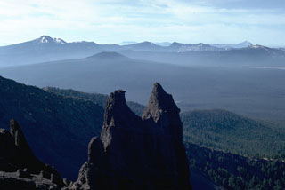 The rim of the Crater Lake caldera is seen in the distance from the summit of Mt. Thielsen to the north. The caldera formed about 7,700 years ago during a large explosive eruption that resulted in the collapse of ancestral Mount Mazama. Mount Scott forms the high point on the left skyline, and Timber Crater is the smaller cone below and left of the north caldera rim.
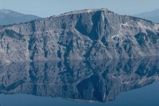 The massive Llao Rock lava flow, exposed in the NW wall of Crater Lake caldera, was emplaced at the end of a major eruption about 200 years prior to the formation of the caldera. The thin, light-colored unit at the base of the lava flow, seen prominently on the right, is a Plinian pumice deposit from that major explosive eruption. The lava flow is more than 350 m thick and is overlain by tephra from the caldera-forming eruption of Crater Lake.
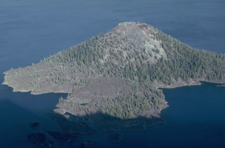 The Wizard Island scoria cone has a symmetrical 90-m-wide crater at its summit, formed above the west floor of Oregon's Crater Lake caldera within a few hundred years of caldera formation. A lava flow created the peninsula in the foreground on the NW side of the cone, which forms a small island on the west side of Crater Lake.
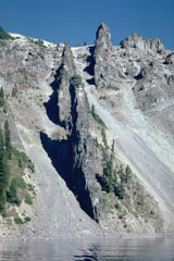 Devil's Backbone is a segmented dike that rises nearly 400 m from the shore of Crater Lake in the western rim of the caldera. The andesite dike was a feeder for a vent that was near Mount Hillman but has since been removed by glacial erosion.
 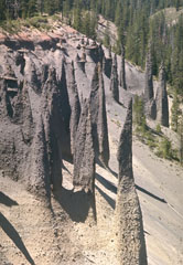 Erosion of the large pyroclastic flow deposit emplaced during the caldera-forming eruption of Crater Lake has exposed these pinnacles. The more resistant spires formed when the deposit was releasing hot gases after emplacement, forming fumarole pathways that cemented the grains together. The change in color of the deposit marks a change in the chemistry of the erupted rocks. The lighter-colored basal rhyodacite is overlain by gray (iron-and magnesium-rich) andesite.
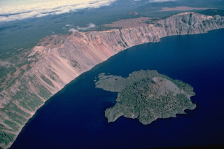 Wizard Island formed within a few hundred years of formation of Crater Lake caldera from a vent near the west caldera rim. This aerial view from the south shows the island, with a symmetrical cinder cone at its right side and lava flows forming small peninsulas on its flanks. Hillman Peak, in the center on the caldera rim, is the youngest of the pre-collapse Mount Mazama stratovolcanoes.
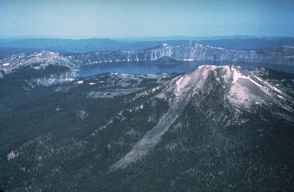
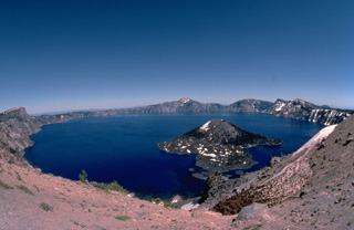 The spectacular 8 x 10 km wide Crater Lake caldera was formed about 6850 years ago when Mount Mazama, a complex of overlapping shield volcanoes and stratovolcanoes, collapsed following a major explosive eruption. The eruption blanketed a huge area with ash falls and produced pyroclastic flows that swept all sides of the volcano. This wide-angle view is from the west caldera rim with the post-caldera cone of Wizard Island in the foreground.
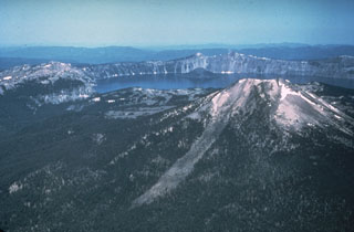 The 8 x 10 km wide Crater Lake caldera formed about 7,700 years ago during one of the world's largest Holocene eruptions. This eruption resulted in the collapse of ancestral Mount Mazama. This view from the east shows Mount Scott in the right foreground, one of the pre-caldera volcanoes. A post-caldera cone, Wizard Island, rises above the far lake surface.
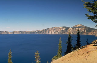 The 8 x 10 km wide Crater Lake caldera was formed about 7,700 years ago when Mount Mazama, a complex of overlapping stratovolcanoes, collapsed following a major explosive eruption. The eruption produced widespread ashfall and pyroclastic flows that traveled as far as 70 km. The caldera, seen here from the S rim, is 1,200 m deep and filled to half its depth by Crater Lake.
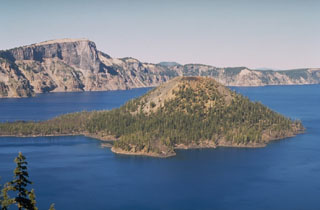 Wizard Island is a scoria cone in Crater Lake caldera, which formed about 7,700 years ago. A lava flow from a vent on its NW flank forms the peninsula to the left. Llao Rock, a massive lava flow that forms the peak on the caldera rim, was erupted about 100-200 years prior to formation of Crater Lake caldera.
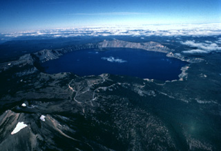 The dramatic 8 x 10 km wide Crater Lake caldera is seen here in an aerial view from the east. The caldera was formed about 6850 years ago during a major eruption that caused the collapse of ancestral Mount Mazama, a complex of overlapping stratovolcanoes and shield volcanoes. Mount Scott, a pre-collapse stratovolcano, is the peak with small snowfields at the lower left. Wizard Island, a post-caldera cinder cone, can be seen near the far side of Crater Lake.
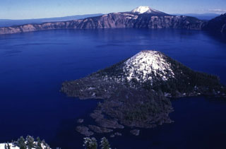 The lake within Crater Lake is the deepest in the USA at nearly 600 m, within the caldera that formed during a major eruption of its predecessor Mount Mazama around 7,700 years ago. Snow mantles the summit of the Wizard Island cone in the foreground.
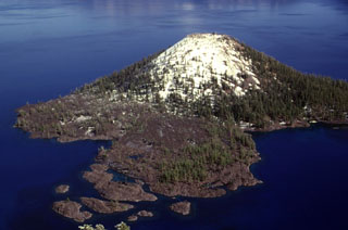 The Wizard Island cone formed while the lake was still filling the Crater Lake caldera. The cone grew near the western structural margin of the caldera on top of a broader central platform of lava flows, and the visible portion represents about 2% of post-caldera eruptive products, the rest of which are below the lake surface.
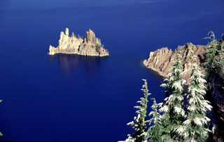 Phantom Ship is the eroded remnants of resistant dikes that now rise above the waters of Crater Lake. These dikes were feeders for lavas of Phantom Cone, the oldest of the known pre-collapse edifices forming Mount Mazama. Phantom Cone lavas have been dated to about 400,000 years before present and are exposed in the SE wall of the Crater Lake caldera.
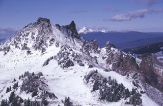 Hillman Peak, the westernmost andesitic stratovolcano of Mount Mazama, is partially dissected by Crater Lake caldera. The base of the cone consists of thin andesite lava flows; these are overlain by bedded fall deposits. The upper part of the cone, seen here, consists of andesitic lava flows erupted about 67,000 years ago. The snow-capped peak on the far horizon to the north is Mount Thielsen, a Pleistocene volcano.
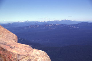 The snow-mantled peaks on the northern horizon are the remnants of Mount Mazama, seen here from the summit of Mt. McLoughlin. Mount Mazama was a complex of overlapping edifices that was once one of Oregon's largest volcanoes, until it collapsed about 7,700 years ago and formed the 8 x 10 km Crater Lake caldera. The highest peak to the right is Mount Scott, part of a pre-caldera edifice east of the caldera rim.
 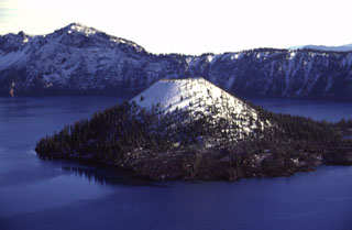 Wizard Island is the only one of three post-caldera cones within the Crater Lake caldera. The symmetrical scoria cone has a 90-m-wide summit crater. It formed several hundred years after the collapse of Mount Mazama about 7,700 years ago along the western structural margin of the caldera. Much of the cone lies beneath the nearly-600-m-deep waters of Crater Lake. A small dome is located on a central platform below the water and east of Wizard Island.
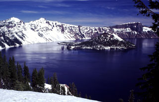 Volcanoes form some of Earth's most spectacular scenery and have been designated as national parks in many countries. The natural landscapes in these parks are a source of visual inspiration and varied recreational opportunities, and can also provide economic benefit to surrounding communities. Crater Lake National Park in the Oregon Cascade Range was established in 1902. This image looks across to Wizard Island and the western caldera rim from near the park visitor center and the Crater Lake Lodge.
The following 195 samples associated with this volcano can be found in the Smithsonian's NMNH Department of Mineral Sciences collections, and may be availble for research (contact the Rock and Ore Collections Manager). Catalog number links will open a window with more information.
| Catalog Number | Sample Description | Lava Source | Collection Date |
|---|---|---|---|
| NMNH 111123-1309 | Hypersthene Andesite | -- | -- |
| NMNH 111123-1310 | Hypersthene Andesite | -- | -- |
| NMNH 111123-1311 | Hypersthene Andesite | -- | -- |
| NMNH 111123-1312 | Hypersthene Andesite | -- | -- |
| NMNH 111123-1313 | Hypersthene Andesite | -- | -- |
| NMNH 111123-1314 | Dacite | -- | -- |
| NMNH 111123-1315 | Hypersthene Dacite | -- | -- |
| NMNH 111123-1316 | Hypersthene Dacite | -- | -- |
| NMNH 111123-1317 | Hypersthene Dacite | -- | -- |
| NMNH 111123-1318 | Hypersthene Dacite | -- | -- |
| NMNH 111123-1319 | Hypersthene Dacite | -- | -- |
| NMNH 111123-1320 | Basalt | -- | -- |
| NMNH 111123-1321 | Basalt | -- | -- |
| NMNH 112584-25 | Andesite | -- | -- |
| NMNH 112584-26 | Pumiceous Tuff | -- | -- |
| NMNH 112584-27 | Pumice | -- | -- |
| NMNH 112586-1 | Welded Tuff | -- | -- |
| NMNH 116387-70 | Hornblendic Pumice | -- | -- |
| NMNH 116387-70A | Hornblendic Pumice | -- | -- |
| NMNH 116387-70B | Hornblendic Pumice | -- | -- |
| NMNH 116387-71A | Volcanic Sublimate | -- | -- |
| NMNH 116387-71B | Volcanic Sublimate | -- | -- |
| NMNH 116387-71C | Volcanic Sublimate | -- | -- |
| NMNH 116387-72A | Vaporphase Scoria | -- | -- |
| NMNH 116387-72B | Vaporphase Scoria | -- | -- |
| NMNH 116387-72C | Vaporphase Scoria | -- | -- |
| NMNH 116387-72D | Vaporphase Scoria | -- | -- |
| NMNH 116387-72E | Vaporphase Scoria | -- | -- |
| NMNH 116387-72F | Vaporphase Scoria | -- | -- |
| NMNH 116387-72G | Vaporphase Scoria | -- | -- |
| NMNH 116387-73 | Vaporphase Scoria | -- | -- |
| NMNH 116387-74 | Vaporphase Scoria | -- | -- |
| NMNH 116387-75 | Vaporphase Scoria | -- | -- |
| NMNH 116387-76 | Dacite Pumice | -- | -- |
| NMNH 116387-77 | Dacite Pumice | -- | -- |
| NMNH 116387-78 | Dacite Pumice | -- | -- |
| NMNH 116387-79 | Dacite Pumice | -- | -- |
| NMNH 116387-80 | Hornblendic Pumice | -- | -- |
| NMNH 116387-81 | Basaltic Scoria | -- | -- |
| NMNH 116387-82 | Basaltic Scoria | -- | -- |
| NMNH 116387-83 | Basaltic Scoria | -- | -- |
| NMNH 116387-84 | Scoria | -- | -- |
| NMNH 116387-85 | Dacitic Pumice | -- | -- |
| NMNH 116387-86 | Scoria | -- | -- |
| NMNH 116387-89 | Pumice | -- | -- |
| NMNH 116387-90 | Pumice | -- | -- |
| NMNH 117465-100 | Obsidian | Cleetwood Flow | -- |
| NMNH 117465-101 | Obsidian | Cloudclap Flow | -- |
| NMNH 117465-102 | Obsidian | Llao Rock Flow | -- |
| NMNH 117465-103 | Obsidian | Llao Rock Flow | -- |
| NMNH 117465-104 | Obsidian | Grouse Hill | -- |
| NMNH 117551-129 | Obsidian | -- | -- |
| NMNH 75434 | Unidentified | -- | -- |
| NMNH 75434-1 | Andesite | -- | -- |
| NMNH 75434-100 | Andesite | -- | -- |
| NMNH 75434-101 | Dacite | -- | -- |
| NMNH 75434-103 | Dacite | -- | -- |
| NMNH 75434-104 | Dacite | -- | -- |
| NMNH 75434-105 | Dacite | -- | -- |
| NMNH 75434-106 | Dacite | -- | -- |
| NMNH 75434-107 | Dacite | -- | -- |
| NMNH 75434-108 | Dacite | -- | -- |
| NMNH 75434-109 | Dacite | -- | -- |
| NMNH 75434-110 | Dacite | -- | -- |
| NMNH 75434-111 | Dacite | -- | -- |
| NMNH 75434-112 | Dacite | -- | -- |
| NMNH 75434-115 | Dacite | -- | -- |
| NMNH 75434-116 | Dacite | -- | -- |
| NMNH 75434-117 | Dacite | -- | -- |
| NMNH 75434-118 | Dacite | -- | -- |
| NMNH 75434-119 | Dacite | -- | -- |
| NMNH 75434-120 | Dacite | -- | -- |
| NMNH 75434-121 | Dacite | -- | -- |
| NMNH 75434-122 | Dacite | -- | -- |
| NMNH 75434-123 | Dacite | -- | -- |
| NMNH 75434-124 | Dacite | -- | -- |
| NMNH 75434-125 | Dacite | -- | -- |
| NMNH 75434-126 | Dacite | -- | -- |
| NMNH 75434-127 | Dacite | -- | -- |
| NMNH 75434-128 | Dacite | -- | -- |
| NMNH 75434-129 | Rhyolitic Tuff | -- | -- |
| NMNH 75434-13 | Andesite | -- | -- |
| NMNH 75434-131 | Dacite | -- | -- |
| NMNH 75434-132 | Dacite | -- | -- |
| NMNH 75434-133 | Basalt | -- | -- |
| NMNH 75434-135 | Sedimentary Rock | -- | -- |
| NMNH 75434-136 | Dacite | -- | -- |
| NMNH 75434-137 | Dacite | -- | -- |
| NMNH 75434-138 | Dacite | -- | -- |
| NMNH 75434-139 | Dacite | -- | -- |
| NMNH 75434-140 | Dacite | -- | -- |
| NMNH 75434-141 | Dacite | -- | -- |
| NMNH 75434-142 | Dacite | -- | -- |
| NMNH 75434-144 | Dacite | -- | -- |
| NMNH 75434-145 | Dacite | -- | -- |
| NMNH 75434-147 | Dacite | -- | -- |
| NMNH 75434-148 | Dacite | -- | -- |
| NMNH 75434-149 | Dacite | -- | -- |
| NMNH 75434-150 | Dacite | -- | -- |
| NMNH 75434-152 | Basalt | -- | -- |
| NMNH 75434-153 | Basalt | -- | -- |
| NMNH 75434-154 | Basalt | -- | -- |
| NMNH 75434-155 | Basalt | -- | -- |
| NMNH 75434-156 | Basalt | -- | -- |
| NMNH 75434-157 | Basalt | -- | -- |
| NMNH 75434-159 | Basalt | -- | -- |
| NMNH 75434-160 | Basalt | -- | -- |
| NMNH 75434-161 | Basalt | -- | -- |
| NMNH 75434-162 | Basalt | -- | -- |
| NMNH 75434-163 | Basalt | -- | -- |
| NMNH 75434-164 | Basalt | -- | -- |
| NMNH 75434-165 | Basalt | -- | -- |
| NMNH 75434-166 | Basalt | -- | -- |
| NMNH 75434-167 | Basalt | -- | -- |
| NMNH 75434-168 | Basalt | -- | -- |
| NMNH 75434-169 | Basalt | -- | -- |
| NMNH 75434-17 | Andesite | -- | -- |
| NMNH 75434-170 | Basalt | -- | -- |
| NMNH 75434-171 | Basalt | -- | -- |
| NMNH 75434-172 | Basalt | -- | -- |
| NMNH 75434-174 | Basalt | -- | -- |
| NMNH 75434-175 | Basalt | -- | -- |
| NMNH 75434-177 | Basalt | -- | -- |
| NMNH 75434-178 | Basalt | -- | -- |
| NMNH 75434-179 | Basalt | -- | -- |
| NMNH 75434-180 | Basalt | -- | -- |
| NMNH 75434-181 | Basalt | -- | -- |
| NMNH 75434-182 | Basalt | -- | -- |
| NMNH 75434-183 | Basalt | -- | -- |
| NMNH 75434-184 | Basalt | -- | -- |
| NMNH 75434-185 | Basalt | -- | -- |
| NMNH 75434-186 | Basalt | -- | -- |
| NMNH 75434-187 | Basalt | -- | -- |
| NMNH 75434-188 | Basalt | -- | -- |
| NMNH 75434-19 | Andesite | -- | -- |
| NMNH 75434-190 | Basalt | -- | -- |
| NMNH 75434-191 | Basalt | -- | -- |
| NMNH 75434-192 | Basalt | -- | -- |
| NMNH 75434-193 | Basalt | -- | -- |
| NMNH 75434-194 | Basalt | -- | -- |
| NMNH 75434-195 | Basalt | -- | -- |
| NMNH 75434-196 | Basalt | -- | -- |
| NMNH 75434-197 | Dacite | -- | -- |
| NMNH 75434-198 | Andesite | -- | -- |
| NMNH 75434-199 | Dacite | -- | -- |
| NMNH 75434-2 | Andesite | -- | -- |
| NMNH 75434-200 | Andesite | -- | -- |
| NMNH 75434-201 | Andesite | -- | -- |
| NMNH 75434-202 | Andesite | -- | -- |
| NMNH 75434-203 | Andesite | -- | -- |
| NMNH 75434-204 | Dacite | -- | -- |
| NMNH 75434-205 | Dacite | -- | -- |
| NMNH 75434-206 | Dacite | -- | -- |
| NMNH 75434-207 | Basalt | -- | -- |
| NMNH 75434-209 | Basalt | -- | -- |
| NMNH 75434-210 | Andesite | -- | -- |
| NMNH 75434-211 | Andesite | -- | -- |
| NMNH 75434-22 | Andesite | -- | -- |
| NMNH 75434-23 | Andesite | -- | -- |
| NMNH 75434-3 | Andesite | -- | -- |
| NMNH 75434-34 | Andesite | -- | -- |
| NMNH 75434-35 | Andesite | -- | -- |
| NMNH 75434-36 | Andesite | -- | -- |
| NMNH 75434-37 | Andesite | -- | -- |
| NMNH 75434-4 | Andesite | -- | -- |
| NMNH 75434-45 | Andesite | -- | -- |
| NMNH 75434-47 | Andesite | -- | -- |
| NMNH 75434-48 | Andesite | -- | -- |
| NMNH 75434-5 | Andesite | -- | -- |
| NMNH 75434-52 | Andesite | -- | -- |
| NMNH 75434-53 | Andesite | -- | -- |
| NMNH 75434-54 | Andesite | -- | -- |
| NMNH 75434-56 | Andesite | -- | -- |
| NMNH 75434-57 | Andesite | -- | -- |
| NMNH 75434-64 | Andesite | -- | -- |
| NMNH 75434-69 | Andesite | -- | -- |
| NMNH 75434-71 | Andesite | -- | -- |
| NMNH 75434-81 | Andesite | -- | -- |
| NMNH 75434-82 | Andesite | -- | -- |
| NMNH 75434-83 | Andesite | -- | -- |
| NMNH 75434-84 | Andesite | -- | -- |
| NMNH 75434-85 | Andesite | -- | -- |
| NMNH 75434-86 | Andesite | -- | -- |
| NMNH 75434-87 | Andesite | -- | -- |
| NMNH 75434-88 | Andesite | -- | -- |
| NMNH 75434-89 | Andesite | -- | -- |
| NMNH 75434-90 | Andesite | -- | -- |
| NMNH 75434-91 | Andesite | -- | -- |
| NMNH 75434-92 | Andesite | -- | -- |
| NMNH 75434-93 | Andesite | -- | -- |
| NMNH 75434-95 | Andesite | -- | -- |
| NMNH 75434-96 | Andesite | -- | -- |
| NMNH 75434-97 | Andesite | -- | -- |
| NMNH 75434-98 | Basalt | -- | -- |
| NMNH 75434-99 | Andesite | -- | -- |
| Copernicus Browser | The Copernicus Browser replaced the Sentinel Hub Playground browser in 2023, to provide access to Earth observation archives from the Copernicus Data Space Ecosystem, the main distribution platform for data from the EU Copernicus missions. |
| MIROVA | Middle InfraRed Observation of Volcanic Activity (MIROVA) is a near real time volcanic hot-spot detection system based on the analysis of MODIS (Moderate Resolution Imaging Spectroradiometer) data. In particular, MIROVA uses the Middle InfraRed Radiation (MIR), measured over target volcanoes, in order to detect, locate and measure the heat radiation sourced from volcanic activity. |
| MODVOLC Thermal Alerts | Using infrared satellite Moderate Resolution Imaging Spectroradiometer (MODIS) data, scientists at the Hawai'i Institute of Geophysics and Planetology, University of Hawai'i, developed an automated system called MODVOLC to map thermal hot-spots in near real time. For each MODIS image, the algorithm automatically scans each 1 km pixel within it to check for high-temperature hot-spots. When one is found the date, time, location, and intensity are recorded. MODIS looks at every square km of the Earth every 48 hours, once during the day and once during the night, and the presence of two MODIS sensors in space allows at least four hot-spot observations every two days. Each day updated global maps are compiled to display the locations of all hot spots detected in the previous 24 hours. There is a drop-down list with volcano names which allow users to 'zoom-in' and examine the distribution of hot-spots at a variety of spatial scales. |
|
WOVOdat
Single Volcano View Temporal Evolution of Unrest Side by Side Volcanoes |
WOVOdat is a database of volcanic unrest; instrumentally and visually recorded changes in seismicity, ground deformation, gas emission, and other parameters from their normal baselines. It is sponsored by the World Organization of Volcano Observatories (WOVO) and presently hosted at the Earth Observatory of Singapore.
GVMID Data on Volcano Monitoring Infrastructure The Global Volcano Monitoring Infrastructure Database GVMID, is aimed at documenting and improving capabilities of volcano monitoring from the ground and space. GVMID should provide a snapshot and baseline view of the techniques and instrumentation that are in place at various volcanoes, which can be use by volcano observatories as reference to setup new monitoring system or improving networks at a specific volcano. These data will allow identification of what monitoring gaps exist, which can be then targeted by remote sensing infrastructure and future instrument deployments. |
| Volcanic Hazard Maps | The IAVCEI Commission on Volcanic Hazards and Risk has a Volcanic Hazard Maps database designed to serve as a resource for hazard mappers (or other interested parties) to explore how common issues in hazard map development have been addressed at different volcanoes, in different countries, for different hazards, and for different intended audiences. In addition to the comprehensive, searchable Volcanic Hazard Maps Database, this website contains information about diversity of volcanic hazard maps, illustrated using examples from the database. This site is for educational purposes related to volcanic hazard maps. Hazard maps found on this website should not be used for emergency purposes. For the most recent, official hazard map for a particular volcano, please seek out the proper institutional authorities on the matter. |
| IRIS seismic stations/networks | Incorporated Research Institutions for Seismology (IRIS) Data Services map showing the location of seismic stations from all available networks (permanent or temporary) within a radius of 0.18° (about 20 km at mid-latitudes) from the given location of Crater Lake. Users can customize a variety of filters and options in the left panel. Note that if there are no stations are known the map will default to show the entire world with a "No data matched request" error notice. |
| UNAVCO GPS/GNSS stations | Geodetic Data Services map from UNAVCO showing the location of GPS/GNSS stations from all available networks (permanent or temporary) within a radius of 20 km from the given location of Crater Lake. Users can customize the data search based on station or network names, location, and time window. Requires Adobe Flash Player. |
| DECADE Data | The DECADE portal, still in the developmental stage, serves as an example of the proposed interoperability between The Smithsonian Institution's Global Volcanism Program, the Mapping Gas Emissions (MaGa) Database, and the EarthChem Geochemical Portal. The Deep Earth Carbon Degassing (DECADE) initiative seeks to use new and established technologies to determine accurate global fluxes of volcanic CO2 to the atmosphere, but installing CO2 monitoring networks on 20 of the world's 150 most actively degassing volcanoes. The group uses related laboratory-based studies (direct gas sampling and analysis, melt inclusions) to provide new data for direct degassing of deep earth carbon to the atmosphere. |
| Large Eruptions of Crater Lake | Information about large Quaternary eruptions (VEI >= 4) is cataloged in the Large Magnitude Explosive Volcanic Eruptions (LaMEVE) database of the Volcano Global Risk Identification and Analysis Project (VOGRIPA). |
| EarthChem | EarthChem develops and maintains databases, software, and services that support the preservation, discovery, access and analysis of geochemical data, and facilitate their integration with the broad array of other available earth science parameters. EarthChem is operated by a joint team of disciplinary scientists, data scientists, data managers and information technology developers who are part of the NSF-funded data facility Integrated Earth Data Applications (IEDA). IEDA is a collaborative effort of EarthChem and the Marine Geoscience Data System (MGDS). |

