
The Global Volcanism Program has no activity reports available for Chichinautzin.
The Global Volcanism Program has no Weekly Reports available for Chichinautzin.
The Global Volcanism Program has no Bulletin Reports available for Chichinautzin.
|
|
||||||||||||||||||||||||||||
There is data available for 8 confirmed eruptive periods.
0399 ± 149 years Confirmed Eruption (Explosive / Effusive) VEI: 3 (?)
| Episode 1 | Eruption (Explosive / Effusive) | Xitle | |||||||||||||||||||||||||||||||||||||||||||
|---|---|---|---|---|---|---|---|---|---|---|---|---|---|---|---|---|---|---|---|---|---|---|---|---|---|---|---|---|---|---|---|---|---|---|---|---|---|---|---|---|---|---|---|---|
| 0399 ± 149 years - Unknown | Evidence from Isotopic: 14C (calibrated) | |||||||||||||||||||||||||||||||||||||||||||
| A wide variety of radiocarbon dates have been obtained for the Xitle eruption, most of which were not well constrained stratigraphically. Siebe (2000) obtained two 14C dates averaging 1,670 ± 35 years BP on charcoal created by scoria-fall from the eruption (2-sigma calibrated ages of 250-548 CE). Yarza de la Torre (1971) mentioned an Aztec tradition of an eruption, probably in 76 CE. The eruption began with ash emission and later was dominated by lava effusion, which covered the prehistoric Cuicuilco urban centers and nearby agricultural lands (Martin del Pozzo, 1993). | ||||||||||||||||||||||||||||||||||||||||||||
|
List of 7 Events for Episode 1 at Xitle
|
||||||||||||||||||||||||||||||||||||||||||||
0203 ± 131 years Confirmed Eruption (Explosive / Effusive) VEI: 3
| Episode 1 | Eruption (Explosive / Effusive) | Chichinautzin | ||||||||||||||||||||||||||||
|---|---|---|---|---|---|---|---|---|---|---|---|---|---|---|---|---|---|---|---|---|---|---|---|---|---|---|---|---|---|
| 0203 ± 131 years - Unknown | Evidence from Isotopic: 14C (calibrated) | ||||||||||||||||||||||||||||
| Radiocarbon dates were obtained for an eruption at 1,835 ± 55 years BP, which has a 2-sigma calibrated age of 72-334 CE (Siebe et al., 2004). A small shield volcano capped by a cinder cone was constructed. Lava flows advanced a maximum of 14.5 km N and 9 km S. | |||||||||||||||||||||||||||||
|
List of 4 Events for Episode 1 at Chichinautzin
|
|||||||||||||||||||||||||||||
2238 BCE ± 1413 years Confirmed Eruption (Explosive / Effusive) VEI: 3
| Episode 1 | Eruption (Explosive / Effusive) | Guespalapa | |||||||||||||||||||||||||||||||||
|---|---|---|---|---|---|---|---|---|---|---|---|---|---|---|---|---|---|---|---|---|---|---|---|---|---|---|---|---|---|---|---|---|---|---|
| 2238 BCE ± 1413 years - Unknown | Evidence from Isotopic: 14C (calibrated) | |||||||||||||||||||||||||||||||||
|
List of 5 Events for Episode 1 at Guespalapa
|
||||||||||||||||||||||||||||||||||
4250 BCE ± 75 years Confirmed Eruption (Explosive / Effusive) VEI: 3 (?)
| Episode 1 | Eruption (Explosive / Effusive) | Tláloc | ||||||||||||||||||||||||||||||||||||||
|---|---|---|---|---|---|---|---|---|---|---|---|---|---|---|---|---|---|---|---|---|---|---|---|---|---|---|---|---|---|---|---|---|---|---|---|---|---|---|---|
| 4250 BCE ± 75 years - Unknown | Evidence from Isotopic: 14C (uncalibrated) | ||||||||||||||||||||||||||||||||||||||
|
List of 6 Events for Episode 1 at Tláloc
|
|||||||||||||||||||||||||||||||||||||||
5840 BCE ± 500 years Confirmed Eruption (Explosive / Effusive)
| Episode 1 | Eruption (Explosive / Effusive) | Cuauhtzin | ||||||||||||||||||||||||||||||||||||||||||||||||||||||||||
|---|---|---|---|---|---|---|---|---|---|---|---|---|---|---|---|---|---|---|---|---|---|---|---|---|---|---|---|---|---|---|---|---|---|---|---|---|---|---|---|---|---|---|---|---|---|---|---|---|---|---|---|---|---|---|---|---|---|---|---|
| 5840 BCE ± 500 years - Unknown | Evidence from Isotopic: 14C (uncalibrated) | ||||||||||||||||||||||||||||||||||||||||||||||||||||||||||
|
List of 10 Events for Episode 1 at Cuauhtzin
|
|||||||||||||||||||||||||||||||||||||||||||||||||||||||||||
7340 BCE ± 1050 years Confirmed Eruption (Explosive / Effusive) VEI: 0
| Episode 1 | Eruption (Explosive / Effusive) | Cerro Tetepetl, Tenango lava flow | ||||||||||||||||||
|---|---|---|---|---|---|---|---|---|---|---|---|---|---|---|---|---|---|---|---|
| 7340 BCE ± 1050 years - Unknown | Evidence from Isotopic: 14C (calibrated) | ||||||||||||||||||
|
List of 2 Events for Episode 1 at Cerro Tetepetl, Tenango lava flow
|
|||||||||||||||||||
7370 BCE ± 300 years Confirmed Eruption (Explosive / Effusive) VEI: 4
| Episode 1 | Eruption (Explosive / Effusive) | Tres Cruces | ||||||||||||||||||||||||||||
|---|---|---|---|---|---|---|---|---|---|---|---|---|---|---|---|---|---|---|---|---|---|---|---|---|---|---|---|---|---|
| 7370 BCE ± 300 years - Unknown | Evidence from Isotopic: 14C (calibrated) | ||||||||||||||||||||||||||||
|
List of 4 Events for Episode 1 at Tres Cruces
|
|||||||||||||||||||||||||||||
7930 BCE ± 500 years Confirmed Eruption (Explosive / Effusive) VEI: 3
| Episode 1 | Eruption (Explosive / Effusive) | Volcán Pelado | |||||||||||||||||||||||||||||||||
|---|---|---|---|---|---|---|---|---|---|---|---|---|---|---|---|---|---|---|---|---|---|---|---|---|---|---|---|---|---|---|---|---|---|---|
| 7930 BCE ± 500 years - Unknown | Evidence from Isotopic: 14C (uncalibrated) | |||||||||||||||||||||||||||||||||
|
List of 5 Events for Episode 1 at Volcán Pelado
|
||||||||||||||||||||||||||||||||||
This compilation of synonyms and subsidiary features may not be comprehensive. Features are organized into four major categories: Cones, Craters, Domes, and Thermal Features. Synonyms of features appear indented below the primary name. In some cases additional feature type, elevation, or location details are provided.
Synonyms |
||||
| Topilejo-Xicomulco Volcanic Field | Sierra Chichinautzin Volcanic Field | ||||
Cones |
||||
| Feature Name | Feature Type | Elevation | Latitude | Longitude |
| Agua, Cerro del | Pyroclastic cone | 19° 5' 49.00" N | 99° 0' 10.00" W | |
| Aholo, Volcan | Cone | 2712 m | 19° 5' 32.00" N | 98° 51' 16.00" W |
| Ahuazatépetl, Volcán | Pyroclastic cone | 2950 m | ||
| Amoloc, Volcán | Pyroclastic cone | 2664 m | 19° 6' 32.00" N | 98° 52' 32.00" W |
| Atlalcorra, Volcán | Pyroclastic cone | 2705 m | 19° 6' 36.00" N | 98° 53' 39.00" W |
| Ayaqueme, Cerro | Cone | 2940 m | 19° 10' 1.00" N | 98° 57' 15.00" W |
| Boludo | Pyroclastic cone | 3120 m | 19° 5' 0.00" N | 99° 23' 0.00" W |
| Caballito | Pyroclastic cone | |||
| Cadenita | Pyroclastic cone | |||
| Caldera, Cerro de la | Cone | 2484 m | ||
| Calvario, El | Cone | 2550 m | 19° 17' 0.00" N | 99° 30' 30.00" W |
| Capulín | Pyroclastic cone | |||
| Cardos, Los | Pyroclastic cone | 19° 5' 35.00" N | 99° 16' 0.00" W | |
| Chalchihuites | Pyroclastic cone | 19° 6' 0.00" N | 99° 18' 0.00" W | |
| Chapultepec | Lava cone | 2672 m | 19° 12' 19.00" N | 99° 33' 24.00" W |
| Chichinautzin, Cerro | Shield volcano | 3470 m | 19° 5' 25.00" N | 99° 8' 10.00" W |
| Chinconquiat, Cerro | Pyroclastic cone | 2920 m | 19° 10' 7.00" N | 98° 49' 5.00" W |
| Coaxusco | Pyroclastic cone | |||
| Cohuazalo, Volcán | Cone | 2810 m | ||
| Coyoltepec | Pyroclastic cone | |||
| Cuatepetl, Volcan | Pyroclastic cone | 2766 m | 19° 5' 34.00" N | 98° 51' 35.00" W |
| Cuauatl | Pyroclastic cone | 3002 m | 19° 9' 54.00" N | 99° 25' 15.00" W |
| Cuautzin | Shield volcano | 3510 m | 19° 9' 20.00" N | 99° 6' 27.00" W |
| Delaire, Volcán | Cone | 2440 m | ||
| Dos Cerros | Shield volcano | 19° 9' 10.00" N | 98° 56' 25.00" W | |
| Escobeta, Cerro | Cone | 2760 m | ||
| Guarda, Cerro el | Cone | 2960 m | ||
| Herradura | Cone | |||
| Hijo del Cuauhtzin | Pyroclastic cone | |||
| Huehuel, Volcán | Cone | 3110 m | ||
| Huehuelcón, Volcán | Cone | 2970 m | ||
| Huihuilanco, Lomas | Cone | 2870 m | ||
| Huilote | Pyroclastic cone | |||
| Huilotito | Pyroclastic cone | |||
| Huipilo, Volcán | Cone | 2807 m | 19° 3' 2.00" N | 98° 53' 2.00" W |
| Huiztomayo, Cerro | Cone | 2580 m | ||
| Joya, Cerro la | Pyroclastic cone | 2686 m | 19° 10' 37.00" N | 98° 47' 39.00" W |
| Jumento | Pyroclastic cone | 19° 12' 29.00" N | 99° 18' 46.00" W | |
| Loreto, Cerro | Cone | 2680 m | ||
| Manteca | Pyroclastic cone | |||
| Marqués, Cerro el | Cone | |||
| Mazatepec | Cone | |||
| Mesa, La | Cone | 2540 m | ||
| Metepec | Cone | |||
| Molcajete, El | Cone | 3040 m | 19° 18' 0.00" N | 99° 25' 30.00" W |
| Negro, Volcan | Pyroclastic cone | 3214 m | 19° 10' 0.00" N | 99° 22' 48.00" W |
| Oclayuca | Pyroclastic cone | 19° 2' 28.00" N | 99° 3' 30.00" W | |
| Ocoxusco, Volcán | Pyroclastic cone | 2830 m | 19° 4' 0.00" N | 98° 54' 30.00" W |
| Ocusacayo | Shield volcano | 19° 8' 28.00" N | 99° 4' 5.00" W | |
| Ololica | Pyroclastic cone | |||
| Palamito | Pyroclastic cone | |||
| Pehualtepec | Pyroclastic cone | 2940 m | 19° 13' 0.00" N | 99° 24' 0.00" W |
| Pelado, Volcán | Shield volcano | 3620 m | 19° 9' 0.00" N | 99° 13' 1.00" W |
| Pelagatos, Cerro | Cone | 3020 m | ||
| Ratas, Las | Pyroclastic cone | 3230 m | 19° 12' 0.00" N | 99° 2' 30.00" W |
| San Nicolás | Cone | |||
| Santiago, Cerro el | Cone | |||
| Silva, La | Pyroclastic cone | 3048 m | 19° 10' 11.00" N | 99° 23' 15.00" W |
| Sochól, Cerro | Cone | 3010 m | 19° 7' 23.00" N | 98° 57' 10.00" W |
| Suchioc Chico | Pyroclastic cone | |||
| Suchioc Grande | Pyroclastic cone | |||
| Tabaquillo | Lava cone | 19° 7' 5.00" N | 99° 17' 22.00" W | |
| Tapeixte, Cerro | Pyroclastic cone | 2760 m | 19° 10' 24.00" N | 98° 48' 0.00" W |
| Tecolotepec
Holotepec |
Pyroclastic cone | 3035 m | 19° 5' 11.00" N | 99° 28' 55.00" W |
| Teconto | Pyroclastic cone | |||
| Tenayo, Cerro | Pyroclastic cone | 2760 m | 19° 11' 9.00" N | 98° 48' 54.00" W |
| Tepecingo | Cone | |||
| Tepetl | Pyroclastic cone | |||
| Tepetlapan | Pyroclastic cone | |||
| Tepezingo | Pyroclastic cone | 2918 m | 19° 3' 33.00" N | 99° 26' 33.00" W |
| Tetepetl, Cerro
Tenango |
Lava cone | 2923 m | 19° 6' 10.00" N | 99° 37' 16.00" W |
| Tetequillo | Lava cone | |||
| Teuhtli, Volcán
Teutli, Volcán |
Shield volcano | 2712 m | 19° 13' 23.00" N | 99° 1' 46.00" W |
| Texontepec | Lava cone | 2980 m | 19° 14' 30.00" N | 99° 24' 50.00" W |
| Teziolo, Cerro el | Cone | 2660 m | ||
| Tezontle | Pyroclastic cone | 2938 m | 19° 2' 10.00" N | 99° 27' 46.00" W |
| Tezoyo, Cerro el | Cone | 2600 m | ||
| Tilapa | Cone | 2880 m | 19° 11' 30.00" N | 99° 25' 0.00" W |
| Tioca | Pyroclastic cone | 19° 12' 0.00" N | 99° 6' 0.00" W | |
| Tioquitas | Pyroclastic cone | |||
| Tlacotepec | Lava cone | |||
| Tlacuallcli | Pyroclastic cone | |||
| Tlacuayol, Cerro | Cone | 2700 m | ||
| Tlaloc, Volcán | Shield volcano | 3690 m | 19° 6' 33.00" N | 99° 2' 0.00" W |
| Tlamacasco | Lava cone | |||
| Tlapexcua, Volcán | Cone | 2810 m | ||
| Tomasquillo | Cone | |||
| Tres Cruces | Pyroclastic cone | 2948 m | 19° 5' 44.00" N | 99° 29' 0.00" W |
| Tres Cruces, Cerro | Pyroclastic cone | 3288 m | 19° 4' 4.00" N | 99° 12' 53.00" W |
| Tres Cumbres, Cerro | Cone | 2440 m | ||
| Tuxtepec | Pyroclastic cone | 2810 m | 19° 5' 56.00" N | 99° 27' 28.00" W |
| Tzempoli | Pyroclastic cone | |||
| Xicomulco | Lava cone | 19° 12' 20.00" N | 99° 3' 55.00" W | |
| Xicontle | Pyroclastic cone | 2981 m | 19° 14' 25.00" N | 99° 12' 45.00" W |
| Xitle
Xitli |
Pyroclastic cone | 3100 m | 19° 14' 48.00" N | 99° 13' 19.00" W |
| Xiuhtepetl, Volcan | Cone | 3323 m | 19° 4' 0.00" N | 99° 34' 14.00" W |
| Xoxocol | Pyroclastic cone | |||
| Xoyacán, Cerro | Cone | 2730 m | ||
| Yoyolica, Volcán | Pyroclastic cone | 3080 m | 19° 13' 0.00" N | 99° 11' 0.00" W |
| Zempoala | Stratovolcano | 19° 3' 0.00" N | 99° 20' 0.00" W | |
| Zoceyuca, Cerro | Pyroclastic cone | 2800 m | 19° 8' 10.00" N | 98° 53' 58.00" W |
| Zoyazál, Volcán | Cone | 2688 m | 19° 3' 32.00" N | 98° 53' 24.00" W |
Craters |
||||
| Feature Name | Feature Type | Elevation | Latitude | Longitude |
| Tlacotenco | Fissure vent | |||
Domes |
||||
| Feature Name | Feature Type | Elevation | Latitude | Longitude |
| Ajusco, Volcán | Dome | 3938 m | 19° 12' 27.00" N | 99° 15' 29.00" W |
| Quepil, Cerro | Dome | 3540 m | 19° 10' 0.00" N | 99° 17' 0.00" W |
| Santiago, El Cerro de | Dome | |||
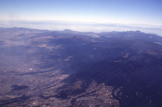 Mexico City encroaches onto the Chichinautzin volcanic field, which covers a broad 1,000 km2 area immediately south of the city. Many of the more than 150 small cones in the volcanic field are of Holocene age. Among the larger features of the field seen in this aerial view from the NW are Volcán Ajusco (the brown-colored peak in the center below the skyline) along with Cerro Pelado, Cerro Chichinautzin, and Cerro Tláloc to the left. In addition to the Xitle eruption less than 2,000 years ago, an eruption of Cerro Chichinautzin was witnessed by local inhabitants.
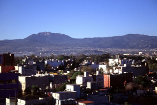 Ajusco volcano rises above Mexico City to the south. The Chichinautzin volcanic field covers a broad, 1,000 km2 area with more than 150 small cones of mostly Holocene age. One of the youngest eruptions occurred from the Xitle cone about 1,670 years ago, producing a massive 3.2 km3 lava flow that covered prehistorical urban centers and agricultural land. It is now overlain by the southern part of Mexico City.
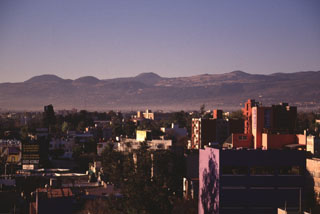 Young scoria cones of the Chichinautzin volcanic field appear on the skyline above Mexico City. Many of the more than 150 small cones within the volcanic field are of Holocene age. At least two of the cones erupted less than 2,000 years ago, producing lava flows that impacted inhabited areas.
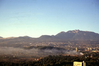 The Xitle scoria cone, the large flat-topped cone on the center horizon, is one of the youngest features of the Chichinautzin volcanic field. Xitle erupted about 1,670 years ago. Initial ash emission was followed by extrusion of a lava flow that traveled 13 km N and covered the prehistoric Cuicuilco urban centers and nearby agricultural lands. Portions of Mexico City, including the National University (UNAM), were built on this lava flow. The Ajusco lava-dome complex appears to the upper right.
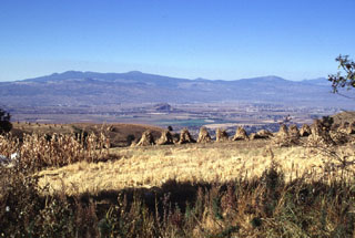 The SE part of the Chichinautzin volcanic field, seen here from the east on the flanks of the Sierra Nevada, forms a major topographic barrier at the southern end of the Valley of Mexico. Several small shield volcanoes, including Volcán Tláloc, appear on the horizon. The shield volcanoes have smaller cones on their flanks, some of which were also constructed on the floor of the Valley of Mexico.
 The irregular reddish area in the center of this false-color LANDSAT image is the Tenango lava flow. It was erupted about 8500 years ago from an E-W-trending fracture that also passes through Nevado de Toluca volcano, whose flanks appear at the left. The basaltic andesite Tenango flow forms a prominent isolated mesa on which the fortified city of Teotenango with its many pyramids and courts was built by the Matlatzinca people about 1000 BCE. The Tenango flow lies at the far western end of the Chichinautzin volcanic field of central México.
 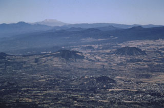 Cones of the Chichinautzin volcanic field in the foreground and middle distance are seen here looking to the west from Popocatépetl volcano. The large flat-topped volcano on the far horizon is Nevado de Toluca. The broad Chichinautzin volcanic field covers a 90-km-wide area south of the Valley of Mexico between the base of the Sierra Nevada (containing Popocatépetl and Iztaccíhuatl) and the eastern flank of Nevado de Toluca.
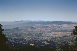 A wide-angle view of the Chichinautzin volcanic field from the flanks of Popocatépetl shows some of the abundant pyroclastic cones and low shield volcanoes that form the mostly monogenetic field. The massive Chichinautzin volcanic field covers more than 1,000 km2 and stretches 90 km in an E-W direction from the eastern base of Nevado de Toluca volcano (the light-colored peak on the far horizon) to the western flanks of Popocatépetl and Iztaccíhuatl.
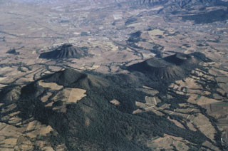 Five small scoria cones are aligned NE-SW near the town of Amecameca at the far eastern end of the Chichinautzin volcanic field. The large cone to the lower left is Cerro Chinconquiat, the larger of the two cones at the mid-right is Cerro Tapeixte, and the smaller one at the far right is Cerro la Joya. The cone with radian erosion gullies to the left immediately above Cerro Chinconquiat is Cerro Tenayo.
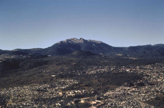 The small Xitle scoria cone in the center of the photo is directly below Volcán Ajusco, the large lava-dome complex on the horizon, and was the source of a voluminous lava flow about 1,670 years ago. The 3.2 km3 flow traveled 13 km north and underlies much of the forested area in the middle of the photo as well as the southern part of Mexico City in the foreground. The flow covered the Preclassic city of Cuicuilco, one of the oldest archaeological sites in central México, and underlies the campus of the National University of México (UNAM).
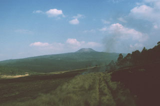 A symmetrical cone is located on Volcán Pelado, a small shield volcano about 10 km south of Xitle volcano. Pyroclastic flows accompanied the formation of the cone. Pelado and the Xitle cone, which erupted about 1,670 years ago, are among the many Holocene vents of the Chichinautzin volcanic field. Both eruptions affected nearby settlements.
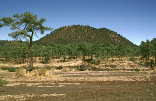 The vegetated lava flows in the middle of the photo traveled short distances to the south from Xitle flank vents, the scoria cone in the background. Most lava flows followed the topographic gradient to the north. Scoria-fall deposits from the 150-m-high pyroclastic cone mantle the foreground and overlie parts of the lava flows.
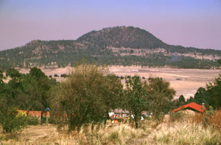 Xitle scoria cone, seen here from the SE, is one of the youngest features of the Chichinautzin volcanic field. The west-flank Xicontle cone, with a 150-m-wide crater, forms the flat ridge to the left. The eruption began about 1,600 years ago producing ashfall that underlies early lava flows. Five flank vents, at Xicontle and on other sides of the Xitle cone, produced voluminous lava flows that surrounded the scoria cone and traveled up to 13 km N, covering 80 km2.
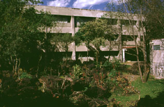 The campus of the Universidad Nacional Autónoma de México (UNAM), the National University of México, overlies a 1,600-year-old lava flow from the Xitle scoria cone in the Chichinautzin volcanic field. Basaltic lava from Xitle is exposed in the foreground between buildings of the departments of geology and geophysics. Volcanologists and seismologists from the university conduct research on Mexican volcanoes and are involved in monitoring of ongoing activity.
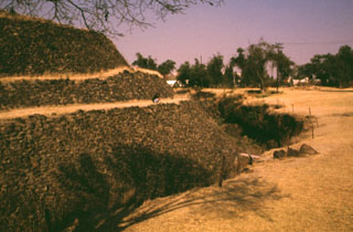 The Cuicuilco pyramid in the southern part of Mexico City was surrounded by lava flows from Xitle volcano about 1,600 years ago. The basaltic flows underlie the area to the right and are exposed in the trench walls around the pyramid. The Preclassic Cuicuilco site is one of the oldest archaeological areas in central México. The earliest occupations date back to 2,100-1,800 BCE, and the pyramid was constructed about 80-600 BCE, when Cuicuilco had become an important Pre-Hispanic city.
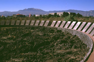 Vegetation has been cleared from the surface of a massive lava flow from Xitle volcano to form a park on the campus of the National University of México (UNAM). Pahoehoe textures of the roughly 1,600-year-old basaltic lava flow are exposed in the park. The tube-fed flow traveled 13 km from Xitle, a small scoria cone whose summit forms the flat area on the horizon to the left of Volcán Ajusco, the large lava dome complex on the horizon.
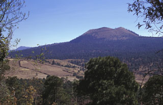 Volcán Pelado is a small shield volcano in the eastern part of the Chichinautzin field with a cone at the summit. Formation of the volcano, between about 10,500 and 9,260 years ago, was accompanied by pyroclastic flows that entrained pottery fragments from nearby settlements. Volcán Pelado lies 10 km south of Xitle, another scoria cone of the Chichinautzin volcanic field that erupted less than 2,000 years ago.
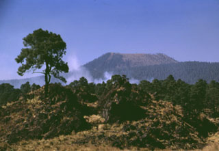 The cone of Volcán Pelado is located SE of Ajusco volcano. The eruption of the cone, seen here from the SE, produced pyroclastic flows that traveled to the north, east, and south. Lava flows that erupted from E-W-trending fissures cover an area of about 63 km2. Pottery shards have been found within the deposits, indicating that the eruption affected neighboring settlements.
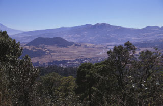 The Chichinautzin volcanic field covers an area of more than 1,000 km2 in a 90-km-wide, E-W-trending area south of the Valley of Mexico. This view looks SE from the 1,600-year-old Xitle scoria cone to Volcán Yololica (the forested scoria cone to left of the center), with Volcán Cuauhtzin on the horizon (right-center) and Volcán Tlaloc to its left. The name Chichinautzin means Burning Lord in the Nahuatl language, and several eruptions have impacted Pre-Hispanic cultures in the Valley of Mexico.
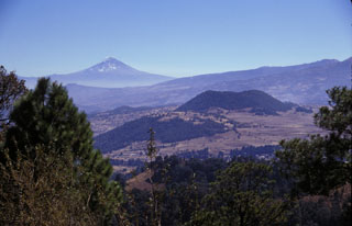 Volcán Popocatépetl rises to the SE beyond the Sierra Chichinautzin, as seen from the summit of Xitle volcano, one of the youngest cones of the Chichinautzin volcanic field. The scoria cone near the center is Volcán Yololica. More than 150 small cones formed across the Chichinautzin range; many of these are of Holocene age.
 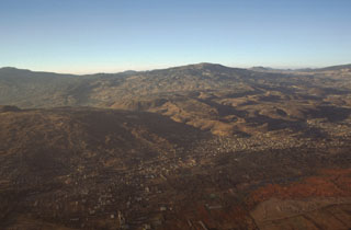 Several volcanoes of the Chichinautzin volcanic field can be seen in this aerial photo from the NE. To the lower left is Volcán Teuhtli with a small cone on its summit to the far left. The lava flow with steep flow boundaries in the center of the photo descending diagonally to the right is the massive Xicomulco lava flow. Volcán Cuauhtzin, in the background to the right, emplaced widespread lava flows.
 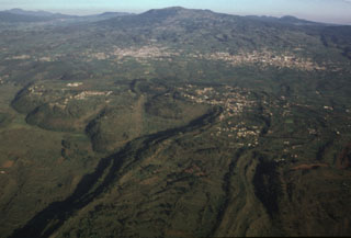 The large, steep-sided Xicomulco lava flow descends from the flanks of the Sierra Chichinautzin into the Valley of Mexico. The viscous lava flow averages 75 m in thickness, displays prominent flow levees, and traveled 4.5 km north. The flow was extruded with very little explosive activity and the vent was subsequently filled in and is now overlain by the town of San Bartolo Xicomulco (right-center). In the background is the town of San Pablo Oztotepec. Volcán Tlaloc is the broad volcano in the center of the horizon.
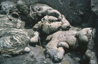 Pillow lavas from Xitle are exposed near the Cuicuilco Ceremonial Center, Mexico City. It is thought that the basaltic lava flows entered into a pond, causing the formation of pillow structures. The possibility that these flow textures indirectly represent "man-made" pillows (entering an artificial pond) has been considered.
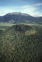 Xitle scoria cone, seen here in an aerial view from the NE with Ajusco volcano in the background, is one of the youngest cones of the Chichinautzin volcanic field. It is about 100 m high, with a crater that is 350 m wide and 115 m deep, and it formed around 2,000 years ago. Xitle (also known as Xicti) means “belly button” in the Nahuatl language, a reference to the shape of the cone and its crater. Volcán Ajusco is a Pliocene-Pleistocene lava dome complex surrounded by block-and-ash flow deposits.
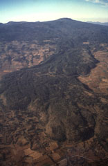 Volcán Tláloc, the broad volcano on the horizon, is one of the larger volcanic centers of the eastern part of the Chichinautzin volcanic field. It erupted about 6,200 years ago and is seen here from the east with a large lava flow in the foreground.
 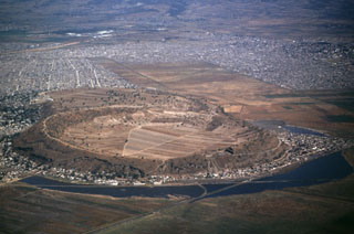 Xico is a low circular tuff ring within Mexico City that is part of the Chichinautzin volcanic field, seen here from the S. This volcano was formed by phreatomagmatic eruptions through the middle of Lake Chalco, the remains of which can be seen surrounding the tuff ring. Chalco and Lakes Texcoco and Xochimilco were formed when lava flows blocked river drainages to the S.
 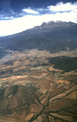 Monogenetic cones of the Chichinautzin volcanic field are seen here below the western flanks of Iztaccíhuatl. These cones, including Cerro Tenayo to the lower left, lie at the easternmost extension of the 90-km-wide Chichinautzin volcanic field, south of the Valley of Mexico. The compound Iztaccíhuatl volcano is mostly Pleistocene in age.
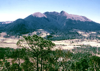 Volcán Ajusco, the highest peak of the Chichinautzin volcanic field, is seen here from the summit of the Xitle scoria cone to the NE. The Pliocene-Pleistocene Ajusco consists of lava domes surrounded by block-and-ash flows. During the Pleistocene the NE flank collapsed, producing a debris avalanche that traveled 16 km. Late-stage eruptions produced more mafic lava flows from flank vents, marking a transition to the monogenetic volcanism of the Chichinautzin volcanic field.
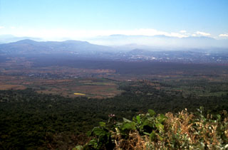 The darker forested area in the center of this photo, extending from the middle right almost across the broad valley floor, is the Texcal lava flow. This lava flow traveled 24 km S onto the Cuernavaca plain after being erupted about 4,200 years ago from the Guespalapa scoria cone. Unlike the Pelado or Chichinautzin eruptions, the Guespalapa eruption did not produce a small shield, but rather one of the longest lava flows of the Sierra Chichinautzin.
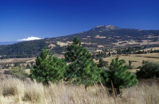 The Cuautzin lava dome (right horizon) north of the crest of the Sierra Chichinautzin, with cnow-capped Iztaccihuatl volcano on the left horizon. It formed between about 7,360 and 8,225 radiocarbon years ago, producing lava flows and block-and-ash flow deposits around the dome. Cuautzin means "Seat of the Eagle" in the Nahuatl language.
 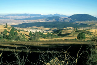 The broad forested ridge in the center of this photo is the Tenango lava flow, which was erupted about 8,500 radiocarbon years ago from an E-W-trending fissure at the western margin of the Chichinautzin volcanic field. It forms a prominent isolated mesa on which the fortified city of Teotenango with its many pyramids and courts was built by the Matlatzinca people about 1000 BCE.
The following 3 samples associated with this volcano can be found in the Smithsonian's NMNH Department of Mineral Sciences collections, and may be availble for research (contact the Rock and Ore Collections Manager). Catalog number links will open a window with more information.
| Catalog Number | Sample Description | Lava Source | Collection Date |
|---|---|---|---|
| NMNH 117276-5 | Lava | Pelado, Cerro | -- |
| NMNH 117276-7 | Lava | Xitle | -- |
| NMNH 117276-8 | Ignimbrite | Amealco Caldera | -- |
| Copernicus Browser | The Copernicus Browser replaced the Sentinel Hub Playground browser in 2023, to provide access to Earth observation archives from the Copernicus Data Space Ecosystem, the main distribution platform for data from the EU Copernicus missions. |
| MIROVA | Middle InfraRed Observation of Volcanic Activity (MIROVA) is a near real time volcanic hot-spot detection system based on the analysis of MODIS (Moderate Resolution Imaging Spectroradiometer) data. In particular, MIROVA uses the Middle InfraRed Radiation (MIR), measured over target volcanoes, in order to detect, locate and measure the heat radiation sourced from volcanic activity. |
| MODVOLC Thermal Alerts | Using infrared satellite Moderate Resolution Imaging Spectroradiometer (MODIS) data, scientists at the Hawai'i Institute of Geophysics and Planetology, University of Hawai'i, developed an automated system called MODVOLC to map thermal hot-spots in near real time. For each MODIS image, the algorithm automatically scans each 1 km pixel within it to check for high-temperature hot-spots. When one is found the date, time, location, and intensity are recorded. MODIS looks at every square km of the Earth every 48 hours, once during the day and once during the night, and the presence of two MODIS sensors in space allows at least four hot-spot observations every two days. Each day updated global maps are compiled to display the locations of all hot spots detected in the previous 24 hours. There is a drop-down list with volcano names which allow users to 'zoom-in' and examine the distribution of hot-spots at a variety of spatial scales. |
|
WOVOdat
Single Volcano View Temporal Evolution of Unrest Side by Side Volcanoes |
WOVOdat is a database of volcanic unrest; instrumentally and visually recorded changes in seismicity, ground deformation, gas emission, and other parameters from their normal baselines. It is sponsored by the World Organization of Volcano Observatories (WOVO) and presently hosted at the Earth Observatory of Singapore.
GVMID Data on Volcano Monitoring Infrastructure The Global Volcano Monitoring Infrastructure Database GVMID, is aimed at documenting and improving capabilities of volcano monitoring from the ground and space. GVMID should provide a snapshot and baseline view of the techniques and instrumentation that are in place at various volcanoes, which can be use by volcano observatories as reference to setup new monitoring system or improving networks at a specific volcano. These data will allow identification of what monitoring gaps exist, which can be then targeted by remote sensing infrastructure and future instrument deployments. |
| Volcanic Hazard Maps | The IAVCEI Commission on Volcanic Hazards and Risk has a Volcanic Hazard Maps database designed to serve as a resource for hazard mappers (or other interested parties) to explore how common issues in hazard map development have been addressed at different volcanoes, in different countries, for different hazards, and for different intended audiences. In addition to the comprehensive, searchable Volcanic Hazard Maps Database, this website contains information about diversity of volcanic hazard maps, illustrated using examples from the database. This site is for educational purposes related to volcanic hazard maps. Hazard maps found on this website should not be used for emergency purposes. For the most recent, official hazard map for a particular volcano, please seek out the proper institutional authorities on the matter. |
| IRIS seismic stations/networks | Incorporated Research Institutions for Seismology (IRIS) Data Services map showing the location of seismic stations from all available networks (permanent or temporary) within a radius of 0.18° (about 20 km at mid-latitudes) from the given location of Chichinautzin. Users can customize a variety of filters and options in the left panel. Note that if there are no stations are known the map will default to show the entire world with a "No data matched request" error notice. |
| UNAVCO GPS/GNSS stations | Geodetic Data Services map from UNAVCO showing the location of GPS/GNSS stations from all available networks (permanent or temporary) within a radius of 20 km from the given location of Chichinautzin. Users can customize the data search based on station or network names, location, and time window. Requires Adobe Flash Player. |
| DECADE Data | The DECADE portal, still in the developmental stage, serves as an example of the proposed interoperability between The Smithsonian Institution's Global Volcanism Program, the Mapping Gas Emissions (MaGa) Database, and the EarthChem Geochemical Portal. The Deep Earth Carbon Degassing (DECADE) initiative seeks to use new and established technologies to determine accurate global fluxes of volcanic CO2 to the atmosphere, but installing CO2 monitoring networks on 20 of the world's 150 most actively degassing volcanoes. The group uses related laboratory-based studies (direct gas sampling and analysis, melt inclusions) to provide new data for direct degassing of deep earth carbon to the atmosphere. |
| Large Eruptions of Chichinautzin | Information about large Quaternary eruptions (VEI >= 4) is cataloged in the Large Magnitude Explosive Volcanic Eruptions (LaMEVE) database of the Volcano Global Risk Identification and Analysis Project (VOGRIPA). |
| EarthChem | EarthChem develops and maintains databases, software, and services that support the preservation, discovery, access and analysis of geochemical data, and facilitate their integration with the broad array of other available earth science parameters. EarthChem is operated by a joint team of disciplinary scientists, data scientists, data managers and information technology developers who are part of the NSF-funded data facility Integrated Earth Data Applications (IEDA). IEDA is a collaborative effort of EarthChem and the Marine Geoscience Data System (MGDS). |

