Landslide in geothermal field; 23 people reported dead
International press reports stated that a well blowout in the Zunil geothermal field triggered a landslide that killed [23] people. Later investigation determined that the landslide [was more likely caused by failure of the steep slopes above the well than by a "blowout"]. The following report is intended to clarify events and document the deposits.
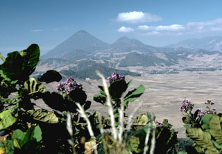
A landslide occurred at approximately 2230 on 5 January at Zunil geothermal field (figure 19) (2.5 km WSW of Zunil, on the E flank of Santa María volcano; Santiaguito is on the SW flank of Santa María), damaging either the wellhead or the surface casing (or both) of well ZCQ-4. The landslide scarp was above the well pad, and it was unclear if the damaged geothermal well played a role in causing the landslide. The landslide lobes flowed ESE about 1 km from above the well site, destroying . . . 6-8 houses on the level terrace area below, and blocking the road between Quetzaltenango and Retalhuleu. Seventeen bodies had been recovered by 10 January, but other reports indicated that 33 people had been killed. Rescue workers continued to search for buried survivors on 7 January. The site of a proposed 15-megawatt geothermal power plant and an older well (ZCQ-1) were covered with slide debris. Well ZCQ-4 was blowing uncontrolled, and the Instituto Nacional de Electrificación (INDE) was [exploring ways to shut-in the well, which was buried by slide debris]. Another well, ZD-1, was being drilled when the landslide occurred, and the crew was evacuated safely.
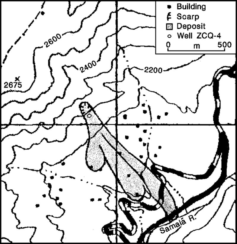 |
Figure 1. Sketch map showing well ZCQ-4 in the Zunil geothermal field and deposits of the 5 January landslide. Contour interval, 100 m. From the Colomba and Santa Catarina Ixtahuacán quadrangles (nos. 1860 II and 1960 III). |
The landslide was composed of four overlapping lobes, the lowest of which was mostly kaolinite and fine-grained altered volcanic materials; a large area of intensely argillically altered rocks had existed above the wellsite before geothermal development began in the 1970's. The three subsequent landslide lobes were smaller, and appeared to be wetter but less highly fluidized than the first. The first deposit was sufficiently fluidized that people sank to 10 cm depth when walking across its surface. While the long axes of the largest boulders transported by the landslide were 2-4.5 m, boulders had average diameters of 0.4 m in the first flow, and 0.58 m in the second flow. The first flow had a less-prominent levee (about 1 m high) than the second (2-3 m high). In many places, deposit surfaces and the ground nearby were partially covered by fine material that appeared to have been laterally "sprayed" over the surfaces, apparently by the landslide itself.
The landslide covered an area [>800 m long and 200-300 m wide, with a combined thickness of 3-10 m]. [Calculations by Flynn and others (1991) indicated a slide volume of about 800,000 m3.] The vertical distance between the top of the scarp, 80 m high and 60 m wide, and the distal toe of the landslide was about 250 m. [Topographic releif in the vicinity of the slide is extreme; measured slope angles range from 30 to 50°.] On 7 January, an additional landslide was caused by the collapse of a 50-m-tall andesitic lava column that detached from the landslide scarp.
A cone of loose material that surrounds the well appeared to have been constructed when landslide debris around the well was thrown out by escaping steam. The cone was about 15 m across, and 10 m high, with steam emerging through a 5-m-diameter crater at the top, carrying particulate matter to 10-20 m height on 7 January. An earlier such cone collapsed, forming one of the upper 3 landslide lobes. Andrés Caicedo reported that the steam discharge was considerably less than when the well was previously flow-tested, possibly suggesting that the wellhead was damaged but intact.
Reports vary on the presence of precursor activity. [There was no record of rain before or during the slide.] Luis Mérida reported that new ground cracks appeared near ZCQ-4 about 1 week prior to the landslide and Mérida recommended evacuating the area. However, no earthquakes were reported.
ZCQ-4 was drilled in 1981 to 1,026 m total depth. . . . The maximum measured reservoir temperature was [260°C].
Further Reference. Adams, M.C., Mink, L., Moore, J., White, L., and Caicedo Anchissi, A., 1990, Geochemistry and hydrology of the Zunil Geothermal System, Guatemala: Geothermal Resources Council Transactions, v. 14, Part II, p. 837-844.
Flynn, T., Goff, F., and others, 1991, [title unknown]: Geothermal Resources Council Transactions, v. 15, p. 425-433.
Schaefer, S., and Williams, S., 1991, [title unknown]: Geotimes, May 1991, p. 20-22.
Information Contacts: S. Williams, M. Calvache, S. Schaefer, T. Ross, and other field trip participants, Louisiana State Univ, USA; Andrés Caicedo, INDE, Guatemala City, Guatemala; Luis Mérida, Cordon y Mérida, Guatemala City, Guatemala; David Sussman, UNOCAL Geothermal Division, P.O. Box 6854, Santa Rosa, CA 95406 USA; Marshall Reed, U.S. Dept of Energy, USA; Otoniel Matías, INSIVUMEH. [Corrections and additions by David Sussman.]
The Global Volcanism Program has no Weekly Reports available for Almolonga.
Reports are organized chronologically and indexed below by Month/Year (Publication Volume:Number), and include a one-line summary. Click on the index link or scroll down to read the reports.
Landslide in geothermal field; 23 people reported dead
International press reports stated that a well blowout in the Zunil geothermal field triggered a landslide that killed [23] people. Later investigation determined that the landslide [was more likely caused by failure of the steep slopes above the well than by a "blowout"]. The following report is intended to clarify events and document the deposits.
A landslide occurred at approximately 2230 on 5 January at Zunil geothermal field (figure 19) (2.5 km WSW of Zunil, on the E flank of Santa María volcano; Santiaguito is on the SW flank of Santa María), damaging either the wellhead or the surface casing (or both) of well ZCQ-4. The landslide scarp was above the well pad, and it was unclear if the damaged geothermal well played a role in causing the landslide. The landslide lobes flowed ESE about 1 km from above the well site, destroying . . . 6-8 houses on the level terrace area below, and blocking the road between Quetzaltenango and Retalhuleu. Seventeen bodies had been recovered by 10 January, but other reports indicated that 33 people had been killed. Rescue workers continued to search for buried survivors on 7 January. The site of a proposed 15-megawatt geothermal power plant and an older well (ZCQ-1) were covered with slide debris. Well ZCQ-4 was blowing uncontrolled, and the Instituto Nacional de Electrificación (INDE) was [exploring ways to shut-in the well, which was buried by slide debris]. Another well, ZD-1, was being drilled when the landslide occurred, and the crew was evacuated safely.
|
Figure 1. Sketch map showing well ZCQ-4 in the Zunil geothermal field and deposits of the 5 January landslide. Contour interval, 100 m. From the Colomba and Santa Catarina Ixtahuacán quadrangles (nos. 1860 II and 1960 III). |
The landslide was composed of four overlapping lobes, the lowest of which was mostly kaolinite and fine-grained altered volcanic materials; a large area of intensely argillically altered rocks had existed above the wellsite before geothermal development began in the 1970's. The three subsequent landslide lobes were smaller, and appeared to be wetter but less highly fluidized than the first. The first deposit was sufficiently fluidized that people sank to 10 cm depth when walking across its surface. While the long axes of the largest boulders transported by the landslide were 2-4.5 m, boulders had average diameters of 0.4 m in the first flow, and 0.58 m in the second flow. The first flow had a less-prominent levee (about 1 m high) than the second (2-3 m high). In many places, deposit surfaces and the ground nearby were partially covered by fine material that appeared to have been laterally "sprayed" over the surfaces, apparently by the landslide itself.
The landslide covered an area [>800 m long and 200-300 m wide, with a combined thickness of 3-10 m]. [Calculations by Flynn and others (1991) indicated a slide volume of about 800,000 m3.] The vertical distance between the top of the scarp, 80 m high and 60 m wide, and the distal toe of the landslide was about 250 m. [Topographic releif in the vicinity of the slide is extreme; measured slope angles range from 30 to 50°.] On 7 January, an additional landslide was caused by the collapse of a 50-m-tall andesitic lava column that detached from the landslide scarp.
A cone of loose material that surrounds the well appeared to have been constructed when landslide debris around the well was thrown out by escaping steam. The cone was about 15 m across, and 10 m high, with steam emerging through a 5-m-diameter crater at the top, carrying particulate matter to 10-20 m height on 7 January. An earlier such cone collapsed, forming one of the upper 3 landslide lobes. Andrés Caicedo reported that the steam discharge was considerably less than when the well was previously flow-tested, possibly suggesting that the wellhead was damaged but intact.
Reports vary on the presence of precursor activity. [There was no record of rain before or during the slide.] Luis Mérida reported that new ground cracks appeared near ZCQ-4 about 1 week prior to the landslide and Mérida recommended evacuating the area. However, no earthquakes were reported.
ZCQ-4 was drilled in 1981 to 1,026 m total depth. . . . The maximum measured reservoir temperature was [260°C].
Further Reference. Adams, M.C., Mink, L., Moore, J., White, L., and Caicedo Anchissi, A., 1990, Geochemistry and hydrology of the Zunil Geothermal System, Guatemala: Geothermal Resources Council Transactions, v. 14, Part II, p. 837-844.
Flynn, T., Goff, F., and others, 1991, [title unknown]: Geothermal Resources Council Transactions, v. 15, p. 425-433.
Schaefer, S., and Williams, S., 1991, [title unknown]: Geotimes, May 1991, p. 20-22.
Information Contacts: S. Williams, M. Calvache, S. Schaefer, T. Ross, and other field trip participants, Louisiana State Univ, USA; Andrés Caicedo, INDE, Guatemala City, Guatemala; Luis Mérida, Cordon y Mérida, Guatemala City, Guatemala; David Sussman, UNOCAL Geothermal Division, P.O. Box 6854, Santa Rosa, CA 95406 USA; Marshall Reed, U.S. Dept of Energy, USA; Otoniel Matías, INSIVUMEH. [Corrections and additions by David Sussman.]
|
|
||||||||||||||||||||||||||||
There is data available for 3 confirmed eruptive periods.
[ 1891 ] Discredited Eruption
[ 1823 ] Discredited Eruption
1818 Jan 16 - 1818 Jun 19 (on or after) Confirmed Eruption (Explosive / Effusive) VEI: 2
| Episode 1 | Eruption (Explosive / Effusive) | East flank of Cerro Quemado | ||||||||||||||||||||||||||||||||||||||
|---|---|---|---|---|---|---|---|---|---|---|---|---|---|---|---|---|---|---|---|---|---|---|---|---|---|---|---|---|---|---|---|---|---|---|---|---|---|---|---|
| 1818 Jan 16 - 1818 Jun 19 (on or after) | Evidence from Observations: Reported | ||||||||||||||||||||||||||||||||||||||
|
List of 6 Events for Episode 1 at East flank of Cerro Quemado
|
|||||||||||||||||||||||||||||||||||||||
[ 1785 ] Discredited Eruption
1765 Oct 24 - 1765 Oct 25 Confirmed Eruption (Explosive / Effusive) VEI: 2
| Episode 1 | Eruption (Explosive / Effusive) | Cerro Quemado | |||||||||||||||||||||||||||||||||||||||||||
|---|---|---|---|---|---|---|---|---|---|---|---|---|---|---|---|---|---|---|---|---|---|---|---|---|---|---|---|---|---|---|---|---|---|---|---|---|---|---|---|---|---|---|---|---|
| 1765 Oct 24 - 1765 Oct 25 | Evidence from Observations: Reported | |||||||||||||||||||||||||||||||||||||||||||
|
List of 7 Events for Episode 1 at Cerro Quemado
|
||||||||||||||||||||||||||||||||||||||||||||
0800 ± 50 years Confirmed Eruption (Explosive / Effusive) VEI: 3
| Episode 1 | Eruption (Explosive / Effusive) | Cerro Quemado | |||||||||||||||||||||||||||||||||||||||||||
|---|---|---|---|---|---|---|---|---|---|---|---|---|---|---|---|---|---|---|---|---|---|---|---|---|---|---|---|---|---|---|---|---|---|---|---|---|---|---|---|---|---|---|---|---|
| 0800 ± 50 years - Unknown | Evidence from Isotopic: 14C (calibrated) | |||||||||||||||||||||||||||||||||||||||||||
|
List of 7 Events for Episode 1 at Cerro Quemado
|
||||||||||||||||||||||||||||||||||||||||||||
This compilation of synonyms and subsidiary features may not be comprehensive. Features are organized into four major categories: Cones, Craters, Domes, and Thermal Features. Synonyms of features appear indented below the primary name. In some cases additional feature type, elevation, or location details are provided.
Domes |
||||
| Feature Name | Feature Type | Elevation | Latitude | Longitude |
| Huitán, Cerro | Dome | 2690 m | 14° 49' 30.00" N | 91° 28' 0.00" W |
| Pedrera, Cerro la | Dome | 2560 m | 14° 49' 16.00" N | 91° 30' 43.00" W |
| Quemado, Cerro
Crespo, Cerro Catinocjuyup Quetzaltenango, Volcán de |
Dome | 3197 m | 14° 47' 46.00" N | 91° 31' 8.00" W |
| Tecún Umán, Cerro
Baúl, El |
Dome | 2665 m | 14° 49' 26.00" N | 91° 29' 42.00" W |
Thermal |
||||
| Feature Name | Feature Type | Elevation | Latitude | Longitude |
| Almolonga, Baños | Thermal | 2200 m | 14° 48' 0.00" N | 91° 29' 0.00" W |
| Azufrados, Baños | Thermal | |||
| Cura, Baños del | Thermal | |||
| Rosario, Baños del | Thermal | |||
| Zunil Geothermal Field | Thermal | |||
 The rounded hills in the middle of the photo are part of a chain of lava domes of the Almolonga volcanic field. Partial flank collapse of an edifice sometime prior to 84,000 years ago formed a 3.3-km-wide collapse scarp that is surrounded by a ring-dike configuration of dacite and rhyolite lava domes, seen here from the east. Cerro Quemado is a young dome near the center of the horizon, right of the larger Santa María, that produced a 2.5-km-long lava flow on its eastern flank in 1818.
 Cerro Quemado is the youngest lava dome complex of Volcán de Almolonga and is seen here across the Llano del Pinal plain. Collapse of the NE flank about 1,150 years ago produced a debris avalanche deposit that forms the undulating topography in the foreground. An associated lateral blast also occurred across the Llano del Pinal. The eruption concluded with the emplacement of a small lava dome inside the avalanche scarp.
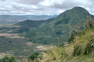 Cerro Quemado, seen here from the SW, is the youngest lava dome complex of Volcán de Almolonga. It is located immediately south of Guatemala's second largest city, Quezaltenango, the outskirts of which are visible to the upper left. The dome complex consists of a series of domes and flows.
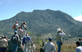 A group of volcanologists are standing on the surface of a debris avalanche deposit produced by collapse of the Cerro Quemado NE flank about 1,150 years ago, with the avalanche scarp in the background to the SW. The scarp, which fills all but the far right-hand slope of this view, is 1 x 1.5 km wide. An associated lateral blast also swept across a 40 km2 area to the NE. The eruption concluded with the emplacement of a small lava dome near the headwall of the scarp.
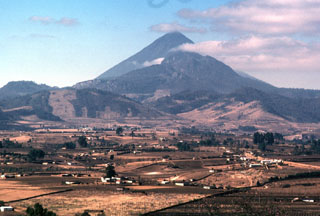 Cerro Quemado is seen here with Santa María towering directly behind it. An eruption of Cerro Quemado, part of the Almolonga lava dome complex, took place in 1818. The lava flow that forms the left-hand ridge of Cerro Quemado in this view from the NE was extruded from the east-central flank and traveled 2.5 km towards the towns of Zunil and Almolonga. Minor explosive eruptions accompanied the extrusion and produced ashfall on nearby hills.
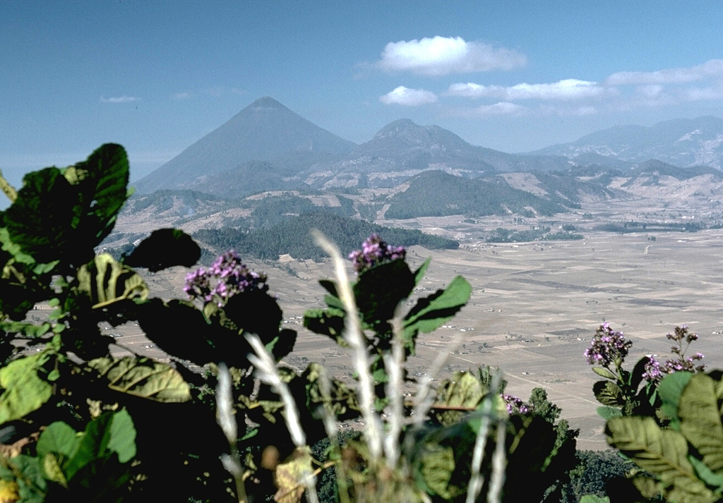
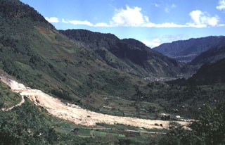 The light-colored area in the foreground is a landslide from the Almolonga volcano Zunil geothermal field that occurred on 5 January 1991. The landslide traveled 800 m from its source along the Zunil fault zone toward the Río Samalá and killed 23 people living on the valley floor and cut off the highway between Quetzaltenango and the Pacific coast. Some of the survivors of the slide were treated for burns from the hot flow. This view looks along the Río Samalá valley to the NE with the flanks of Cerro Quemado in the background to the left.
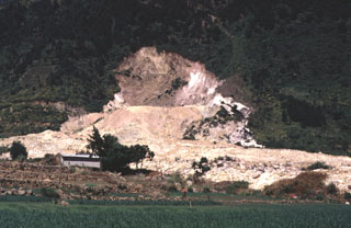 This photograph shows the source area of the 5 January 1991 Almolonga volcano Zunil geothermal field landslide. The slide damaged and buried the geothermal well ZCQ-4 within the Zunil 1 geothermal project. A small crater formed when debris that buried the well was ejected by hot water and steam that escaped from the damaged well.
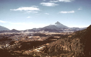 The line of low-elevation forested lava domes in the center of the photo are a chain of domes erupted along the rim of a Pleistocene caldera of the Almolonga complex. The highest dome, Cerro Quemado, is the peak seen here from the north below and to the left of Santa María, the highest peak in this photo. A 3.3-km-wide caldera formed within the field sometime prior to 85,000 years ago. Post-caldera eruptions produced eight lava domes.
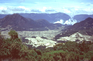 The Cerro Quemado lava dome (left), seen here from Siete Orejas volcano, is one of a series of lava domes along the margin of the Almolonga caldera. The Cerro Quemado dome complex formed during the Holocene from eruptions along at least eight vents. One of these domes forms the low rounded feature below the center horizon. Santa María lies just out of view to the right, and the western side of the Santo Tomás volcanic complex forms the horizon.
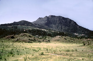 Collapse of the NE flank of the Almolonga Cerro Quemado lava dome about 1,150 years ago produced a debris avalanche deposit with the hummocky terrain in the foreground. An associated lateral blast also swept across the Llano del Pinal, the plain in the foreground. The eruption concluded with the emplacement of a small lava dome inside the avalanche scarp.
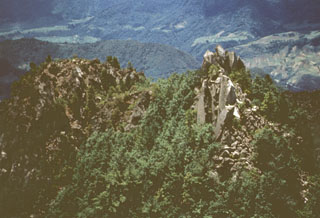 Lava spines are seen here along the summit ridge of Cerro Quemado, the youngest of a series of lava domes erupted along the margins of Almolonga volcano. The early stages of the Cerro Quemado complex eruptions produced a sequence of lava flows and domes erupted from at least eight vents. During the later stages about 1,150 years ago the summit dome of Cerro Quemado was emplaced following failure of the summit area. An eruption took place from an E-flank vent in 1818.
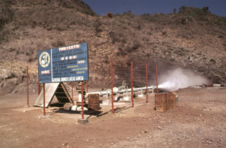 The Almolonga volcano Zunil geothermal project is seen here in 1981, a decade prior to a landslide that buried the well site. Well ZCQ-4 was drilled in 1981 to a depth of about 1.3 km and cemented to a depth of 400 m. In October 1989 the recorded bottom hole temperature was 260°C. The upper part of the geothermal system contains acid-sulfate hot springs. Associated mud pools and fumaroles occur at high points on both sides of the Río Samalá, and bicarbonate-rich hot springs discharge into the river's canyon.
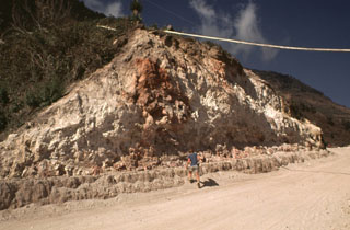 The rock around the Almolonga volcano Zunil geothermal field on the SE flank of Cerro Quemado volcano is extensively hydrothermally altered. The geothermal area is located along the Zunil fault zone, which juxtaposes brownish-red weathered to lightly altered andesite to dacite lava flows with white-to-pink heavily altered and brecciated volcanic rock. Hydrothermal alteration minerals include kaolinite, pyrite, gypsum, and alunite. The NE-SW-trending left-lateral fault zone runs parallel to the valley of the Río Samalá.
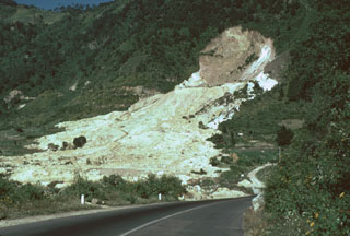 The 80-m-high headwall scarp of the 5 January 1991 landslide at the Almolonga volcano Zunil geothermal field exposes the regional Zunil fault zone. The avalanche deposit extends about 800 m from the source and damaged the highway between Quetzaltenango and the town of Retalhuleu on the Pacific coastal plain. The avalanche destroyed a church and more than a half-dozen houses, killing 23 people. The elevation difference from the head of the scarp to the distal end of the deposit was 250 m.
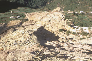 This view looks down the path of the 5 January 1991 landslide at the Almolonga volcano Zunil geothermal site. The avalanche of extensively hydrothermally altered material along the Zunil fault zone traveled 800 m from its source. The slide nearly reached the Río Samala and can be seen at the top of the photo cutting the highway between Quetzaltenango and Retalhuleu. The deposit has four overlapping lobes with a combined thickness of 2-3 m.
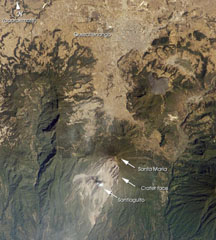 Santa María, located south of the city Quetzaltenango, is one of the country's most active volcanoes. The Santiaguito lava dome complex was constructed within a large crater formed during the 1902 eruption. The unvegetated lava flow above and to the right of Santa María was erupted from Cerro Quemado, part of the Almolonga volcanic complex, which also includes the series of lava domes to the north of Cerro Quemado. The large forested valley to the left is part of Siete Orejas volcano.
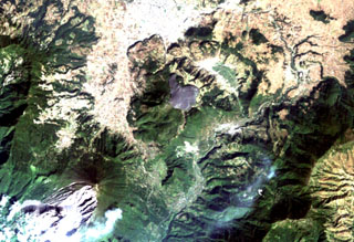 The arcuate area at the top center below the light-colored city of Quetzaltenango is the Almolonga volcanic complex. An arcuate series of lava domes outlines the northern part of the complex, while the unvegetated area to the south is the 1818 lava flow from Cerro Quemado volcano, the youngest of the Almolonga complex. Almolonga is located along the Zunil fault zone, which extends diagonally SW along the Río Samalá (bottom-center). The furrowed 1902 crater of Santa María volcano lies at the lower left.
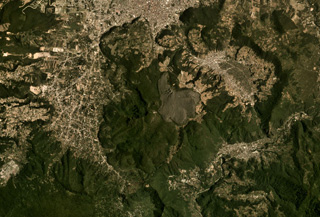 Cerro Quemado is a complex of lava domes and flows, including the unvegetated 1818 deposit in the center of this August 2019 Planet Labs satellite image monthly mosaic (N is at the top; this image is approximately 12 km across). It is part of the Almolonga volcanic group that includes the caldera of Volcán de Almolonga to the E and a series of domes to the N. The city of Quetzaltenango is visible to the N.
There are no samples for Almolonga in the Smithsonian's NMNH Department of Mineral Sciences Rock and Ore collection.
| Copernicus Browser | The Copernicus Browser replaced the Sentinel Hub Playground browser in 2023, to provide access to Earth observation archives from the Copernicus Data Space Ecosystem, the main distribution platform for data from the EU Copernicus missions. |
| MIROVA | Middle InfraRed Observation of Volcanic Activity (MIROVA) is a near real time volcanic hot-spot detection system based on the analysis of MODIS (Moderate Resolution Imaging Spectroradiometer) data. In particular, MIROVA uses the Middle InfraRed Radiation (MIR), measured over target volcanoes, in order to detect, locate and measure the heat radiation sourced from volcanic activity. |
| MODVOLC Thermal Alerts | Using infrared satellite Moderate Resolution Imaging Spectroradiometer (MODIS) data, scientists at the Hawai'i Institute of Geophysics and Planetology, University of Hawai'i, developed an automated system called MODVOLC to map thermal hot-spots in near real time. For each MODIS image, the algorithm automatically scans each 1 km pixel within it to check for high-temperature hot-spots. When one is found the date, time, location, and intensity are recorded. MODIS looks at every square km of the Earth every 48 hours, once during the day and once during the night, and the presence of two MODIS sensors in space allows at least four hot-spot observations every two days. Each day updated global maps are compiled to display the locations of all hot spots detected in the previous 24 hours. There is a drop-down list with volcano names which allow users to 'zoom-in' and examine the distribution of hot-spots at a variety of spatial scales. |
|
WOVOdat
Single Volcano View Temporal Evolution of Unrest Side by Side Volcanoes |
WOVOdat is a database of volcanic unrest; instrumentally and visually recorded changes in seismicity, ground deformation, gas emission, and other parameters from their normal baselines. It is sponsored by the World Organization of Volcano Observatories (WOVO) and presently hosted at the Earth Observatory of Singapore.
GVMID Data on Volcano Monitoring Infrastructure The Global Volcano Monitoring Infrastructure Database GVMID, is aimed at documenting and improving capabilities of volcano monitoring from the ground and space. GVMID should provide a snapshot and baseline view of the techniques and instrumentation that are in place at various volcanoes, which can be use by volcano observatories as reference to setup new monitoring system or improving networks at a specific volcano. These data will allow identification of what monitoring gaps exist, which can be then targeted by remote sensing infrastructure and future instrument deployments. |
| Volcanic Hazard Maps | The IAVCEI Commission on Volcanic Hazards and Risk has a Volcanic Hazard Maps database designed to serve as a resource for hazard mappers (or other interested parties) to explore how common issues in hazard map development have been addressed at different volcanoes, in different countries, for different hazards, and for different intended audiences. In addition to the comprehensive, searchable Volcanic Hazard Maps Database, this website contains information about diversity of volcanic hazard maps, illustrated using examples from the database. This site is for educational purposes related to volcanic hazard maps. Hazard maps found on this website should not be used for emergency purposes. For the most recent, official hazard map for a particular volcano, please seek out the proper institutional authorities on the matter. |
| IRIS seismic stations/networks | Incorporated Research Institutions for Seismology (IRIS) Data Services map showing the location of seismic stations from all available networks (permanent or temporary) within a radius of 0.18° (about 20 km at mid-latitudes) from the given location of Almolonga. Users can customize a variety of filters and options in the left panel. Note that if there are no stations are known the map will default to show the entire world with a "No data matched request" error notice. |
| UNAVCO GPS/GNSS stations | Geodetic Data Services map from UNAVCO showing the location of GPS/GNSS stations from all available networks (permanent or temporary) within a radius of 20 km from the given location of Almolonga. Users can customize the data search based on station or network names, location, and time window. Requires Adobe Flash Player. |
| DECADE Data | The DECADE portal, still in the developmental stage, serves as an example of the proposed interoperability between The Smithsonian Institution's Global Volcanism Program, the Mapping Gas Emissions (MaGa) Database, and the EarthChem Geochemical Portal. The Deep Earth Carbon Degassing (DECADE) initiative seeks to use new and established technologies to determine accurate global fluxes of volcanic CO2 to the atmosphere, but installing CO2 monitoring networks on 20 of the world's 150 most actively degassing volcanoes. The group uses related laboratory-based studies (direct gas sampling and analysis, melt inclusions) to provide new data for direct degassing of deep earth carbon to the atmosphere. |
| Large Eruptions of Almolonga | Information about large Quaternary eruptions (VEI >= 4) is cataloged in the Large Magnitude Explosive Volcanic Eruptions (LaMEVE) database of the Volcano Global Risk Identification and Analysis Project (VOGRIPA). |
| EarthChem | EarthChem develops and maintains databases, software, and services that support the preservation, discovery, access and analysis of geochemical data, and facilitate their integration with the broad array of other available earth science parameters. EarthChem is operated by a joint team of disciplinary scientists, data scientists, data managers and information technology developers who are part of the NSF-funded data facility Integrated Earth Data Applications (IEDA). IEDA is a collaborative effort of EarthChem and the Marine Geoscience Data System (MGDS). |

