India Volcanoes
India has 2 Holocene volcanoes. Note that as a scientific organization we provide these listings for informational purposes only, with no international legal or policy implications. Volcanoes will be included on this list if they are within the boundaries of a country, on a shared boundary or area, in a remote territory, or within a maritime Exclusive Economic Zone. Bolded volcanoes have erupted within the past 20 years. Suggestions and data updates are always welcome ().
| Volcano Name | Last Eruption | Volcanic Region | Primary Landform |
|---|---|---|---|
| Barren Island | 2025 CE | Andaman Volcanic Province | Composite |
| Narcondum | Unknown - Evidence Credible | Andaman Volcanic Province | Composite |
Chronological listing of known Holocene eruptions (confirmed or uncertain) from volcanoes in India. Bolded eruptions indicate continuing activity.
| Volcano Name | Start Date | Stop Date | Certainty | VEI | Evidence |
|---|---|---|---|---|---|
| Barren Island | 2025 Jul 30 | 2025 Dec 30 (continuing) | Confirmed | Observations: Reported | |
| Barren Island | 2024 Mar 15 | 2024 May 29 | Confirmed | 2 | Observations: Satellite (infrared) |
| Barren Island | 2022 Dec 30 | 2023 Aug 18 | Confirmed | 2 | Observations: Reported |
| Barren Island | [2022 May 15] | [2022 May 15] | Uncertain | ||
| Barren Island | 2019 Oct 23 | 2022 Jan 30 | Confirmed | Observations: Satellite (visual) | |
| Barren Island | 2018 Sep 25 | 2019 Apr 30 | Confirmed | 1 | Observations: Reported |
| Barren Island | 2017 Jan 15 | 2017 Mar 24 | Confirmed | 1 | Observations: Reported |
| Barren Island | 2015 Mar 17 | 2016 May 17 ± 1 days | Confirmed | 2 | Observations: Satellite (infrared) |
| Barren Island | 2013 Oct 12 | 2014 Jun 1 ± 15 days | Confirmed | 2 | Observations: Reported |
| Barren Island | 2013 Feb 16 | 2013 Feb 16 | Confirmed | 2 | Observations: Reported |
| Barren Island | 2010 Sep 17 | 2011 Jun 22 | Confirmed | 1 | Observations: Reported |
| Barren Island | 2008 May 13 | 2010 Apr 19 (?) | Confirmed | 2 | Observations: Reported |
| Barren Island | 2005 May 26 | 2007 Dec 23 (?) | Confirmed | 2 | Observations: Reported |
| Barren Island | [2000 Jan 16 ± 15 days] | [Unknown] | Uncertain | ||
| Barren Island | 1994 Dec 20 (on or before) | 1995 Jun 5 ± 8 days | Confirmed | 2 | Observations: Reported |
| Barren Island | 1991 Apr 1 | 1991 Oct 31 ± 7 days | Confirmed | 2 | Observations: Reported |
| Barren Island | [1852] | [Unknown] | Uncertain | ||
| Barren Island | 1832 Mar | Unknown | Confirmed | 2 | Observations: Reported |
| Barren Island | 1803 Nov | 1804 Jan 31 (on or after) | Confirmed | 2 | Observations: Reported |
| Barren Island | 1795 Dec 20 | 1795 Dec 21 (on or after) | Confirmed | 2 | Observations: Reported |
| Barren Island | 1789 Mar 24 | Unknown | Confirmed | 2 | Observations: Reported |
| Barren Island | 1787 May 12 | Unknown | Confirmed | 2 | Observations: Reported |
| Barren Island | 8060 BCE ± 100 years | Unknown | Confirmed | Correlation: Tephrochronology |
India has 0 Pleistocene volcanoes. Note that as a scientific organization we provide these listings for informational purposes only, with no international legal or policy implications. Volcanoes will be included on this list if they are within the boundaries of a country, on a shared boundary or area, in a remote territory, or within a maritime Exclusive Economic Zone. Suggestions and data updates are always welcome ().
There are 12 photos available for volcanoes in India.
 An ash plume in 1991 rises above Barren Island along the volcanic arc connecting north of Sumatra. The 3-km-wide island contains a 1.6-km-wide crater that is partially filled by a scoria cone that has been the source of eruptions since the first was recorded in 1787. Lava flows reached the coast during several recent eruptions.
Photo courtesy of D. Haldar, 1991 (Geological Survey of India).
 The lava delta extending across the photo formed during the 1994-1995 eruption of Barren Island. The eruption was first noticed by the Indian Navy on 20 December 1994. Explosive activity was observed from satellite images and during visits from January to March and May 1995. Four vents were active from the summit to the S flank of the cone along a N-S south line. A new vent was observed on 11 May on the W flank of the cone that produced a lava flow.
Photo courtesy of D. Chandrasekharam and others, 2003 (Indian Institute of Technology).
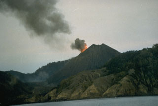
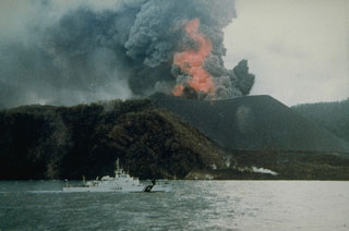 Barren Island erupted for the first time in the 20th century in April 1991. Strombolian eruptions from the central cone produced ash plumes and incandescent ejecta, and a lava flow that is visible in the foreground and reached the W coast of the island. By the time of this 25 September photograph, all subsidiary vents had merged to form an enlarged summit crater.
Photo courtesy of D. Haldar, 1991 (Geological Survey of India)
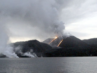
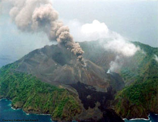 Barren Island is shown erupting on 28 May 2005 from the WNW. The black lava flow in the foreground is from the 1994-95 eruption. A lava flow is being extruded from a flank vent below the white plume. Eruptions that began on 26 May occurred from the summit of the scoria cone as well as flank vents. Lava flows later reached the W coast along the same path as flows from the 1991 and 1994-95 eruptions.
Photo courtesy of Indian Coast Guard, 2005.
 A view from off the west coast of Barren Island on 26 August 2005 shows a Strombolian eruption from the central scoria cone. The main crater was active and both explosive and effusive activity had shifted to the N. Two incandescent lava flows are visible along the slopes of the scoria cone, and steam-and-gas plumes mark the entry point of the lava flows into the sea.
Photo by A. Kar, 2005 (Central Ground Water Board).
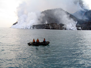 A lava flow enters the sea along the W coast of Barren Island on 21 July 2005. The flow entered the sea at two points following the routes of the previous 1991 and 1994-95 lava flows. A plume from the summit crater of the central scoria cone is visible to the upper right, along with an active lava channel descending the flanks.
Photo courtesy of Indian Coast Guard, 2005.
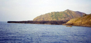
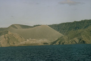
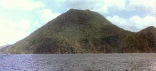 Narcondum is located about 140 km NNE of Barren Island. Both volcanoes are part of the Andaman and Nicobar Islands of India in the Andaman Sea, and are part of a volcanic arc extending from Sumatra. The small 3 x 4 km wide island, located about 130 km E of North Andaman Island, is densely vegetated and has three peaks. No evidence of historical volcanism is present.
Photo published in Shanker et al., 2001 (courtesy of D. Haldar, Geological Survey of India).
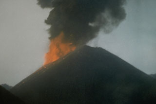 Incandescent ejecta and an ash plume from Strombolian eruptions that began in April 1991 are seen in this 16 May 1991 view of the scoria cone in the center of Barren Island. The 1991 eruption was the first from Barren Island in the 20th century.
Photo courtesy V.K. Raina, 1991 (Geological Survey of India)
 An eruption in 1991 dramatically modified the morphology of the central scoria cone on the small Barren Island, one of the Andaman Islands, north of Sumatra. During the eruption the height of the cinder cone was reduced from 305 to 225 m, and the diameter of its crater increased from 60 to about 200 m. Two small scoria cones also formed in the lava field west of the main cone.
Photo courtesy of D. Haldar, 1992 (Geological Survey of India).
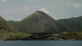 Prior to the 1991 eruption, the central scoria cone in the crater of Barren Island was 305 m high with a 60-m-wide crater at its summit. The black lava flow in the foreground erupted during 1803-1804 and extends from the base of the cone to the west coast. This lava flow was the first known in historical time from Barren Island.
Photo courtesy of D. Haldar, 1990 (Geological Survey of India).
 The central scoria cone of Barren Island is seen here from the SW erupting in May 1991. The 1991 eruption, the first of the 20th century from Barren Island, included explosive activity from a vent on the upper NE flank and lava flows that reached the west coast of the island.
 Photo courtesy of V.K. Raina, 1991 (Geological Survey of India).
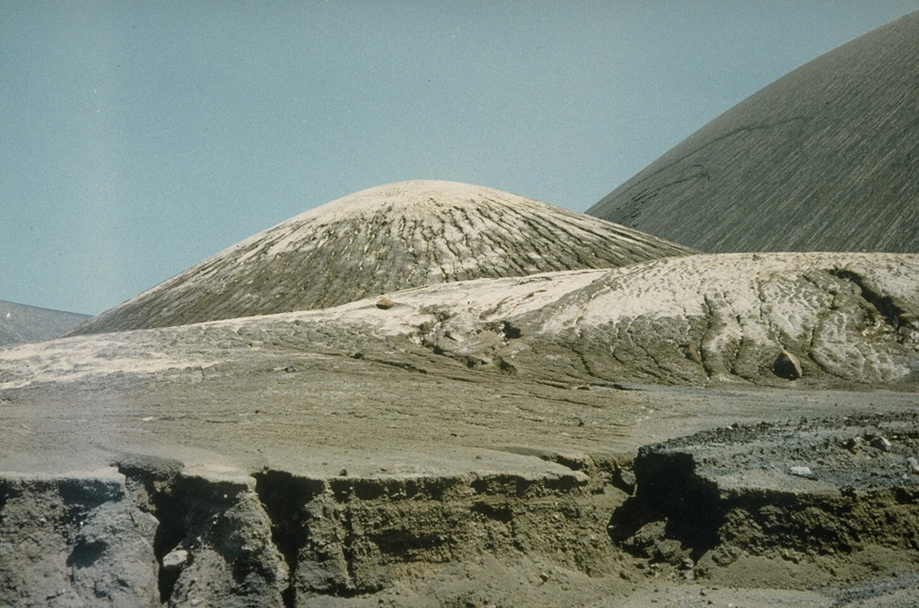
 Light-colored volcanic ash from the 1991 eruption mantles the surface of a lava flow from the same eruption, and the scoria cone in the center of the photo. The slopes of the central cone, the source of the ashfall, is the larger feature to the right.
Photo courtesy of D. Haldar, 1991 (Geological Survey of India).
This is a compilation of India volcano information sources, such as official monitoring or other government agencies.
| Volcano Observatories |
|---|
| Geological Survey of India |
| Volcanic Ash Advisory Center |
|---|
| Darwin Volcanic Ash Advisory Centre (VAAC) |
| - Darwin VAAC Archive |