Satellite data showed an area of yellow-green discolored water that was about 4.2 km in diameter in the vicinity of the submarine Kavachi volcano on 19 April. A more diffuse plume of discolored water extended another ~11 km NE before dissipating.
Source: Copernicus
Discolored water plumes observed intermittently during August 2022-January 2023
Kavachi is an active submarine volcano in the SW Pacific, located in the Solomon Islands south of Gatokae and Vangunu islands. Its first recorded eruption occurred in 1939, and since then it has produced many ephemeral islands up to 1 km long where occasionally lava flows were observed. Volcanism has been characterized by phreatomagmatic explosions that ejected steam, ash, and incandescent bombs. The previous report described intermittent discolored water plumes based on Sentinel-2 natural color satellite imagery (BGVN 47:08). This report covers similar activity of discolored water during August 2022 through January 2023 using satellite imagery.
Observations using Sentinel-2 natural color satellite imagery showed occasional discolored (light yellow-green) submarine plumes that generally originated from a single point during each month of the reporting period (figure 28). The discolored water drifted or extended in various directions, usually different with every observation. Four discolored plumes were visible on 3, 8, 13, and 23 August; a translucent, milky brown color surrounded the origin point on 8 August, and as the plume extended S the color was lighter yellow-green. Four discolored plumes were visible on 2, 7, 12, and 22 September; the plume on 7 September extended for several kilometers to the SE and the area around the origin point was a translucent milky brown color (figure 28). The color of the plumes on 12 and 22 September appeared less intense compared to the previous plumes during the month.
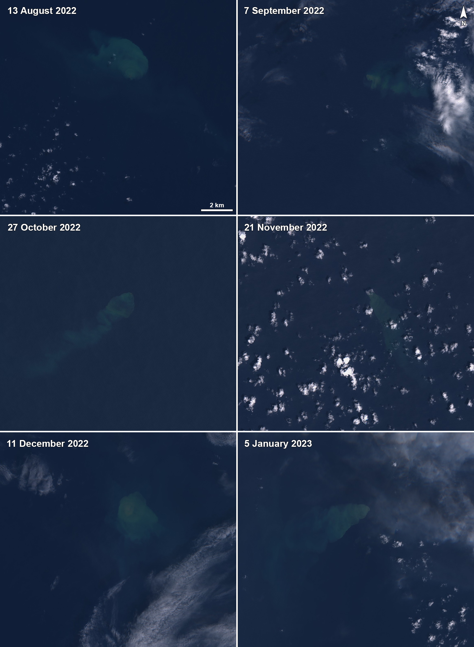 |
Figure 28. Sentinel-2 satellite images showing light yellow-green discolored plumes of water above Kavachi on 13 August 2022 (top left), 7 September 2022 (top right), 27 October 2022 (middle left), 21 November 2022 (middle right), 11 December 2022 (bottom left), and 5 January 2023 (bottom right). The plumes varied in intensity, length, and direction, though they all originated from a single point. Images with “Natural color” rendering (bands 4, 3, 2). Courtesy of Sentinel Hub Playground. |
Plumes were detected in satellite imagery drifting various directions on 2, 7, 12, 17, and 27 October, with additional sightings on 1, 6, and 21 November. A weather cloud covered most of the view of the discolored plume on 6 December, though on 11 December the affected area seemed relatively stationary above the origin point (figure 28). There was a small translucent circle of milky brown discolored water in the center, surrounded by lighter yellow-green discolored water. On 16 December a faint discolored plume extended NE. A strong discolored plume was visible on 5 January 2023 that extended W; the water around the origin point was a translucent, milky brown color that lightened to yellow-green as it extended farther away (figure 28). On 15, 20, and 30 January the plumes extended W, W, and NE; the plumes on 15 and 30 January were relatively narrow and were several kilometers long.
Information Contacts: Sentinel Hub Playground (URL: https://www.sentinel-hub.com/explore/sentinel-playground).
2024: February
| March
| April
2022: February
| March
| May
| November
2021: February
| October
2020: April
| September
2014: January
2004: March
2003: November
2002: January
| December
2001: September
| November
Satellite data showed an area of yellow-green discolored water that was about 4.2 km in diameter in the vicinity of the submarine Kavachi volcano on 19 April. A more diffuse plume of discolored water extended another ~11 km NE before dissipating.
Source: Copernicus
Satellite data showed a roughly circular area of yellow-green discolored water that was about 2.9 km in diameter in the vicinity of the submarine Kavachi volcano on 9 April. A more diffuse plume expanded another ~5 km E. Weather clouds obscured views on 14 April.
Source: Copernicus
Satellite data showed a circular area of yellow-green discolored water that was about 3.3 km in diameter in the vicinity of the submarine Kavachi volcano on 20 March. Weather clouds obscured satellite views on 25 and 30 March.
Source: Copernicus
On 8 March satellite data showed a plume of discolored water from the submarine Kavachi volcano extending N and curving E about 25 km before dissipating.
Source: NASA Earth Observatory
Satellite data showed distinct yellow-green discolored water in the vicinity of the submarine Kavachi volcano on 14 and 19 February. The discolored water extended 15-20 km SE and E.
Source: Copernicus
Satellite data showed distinct yellow-green discolored water in the vicinity of the submarine Kavachi volcano on 2, 7, 12, and 22 September, 2, 7, 12, 17, and 27 October, and 1, 6, and 11 November.
Source: Sentinel Hub
Satellite data showed discolored water around Kavachi on 10, 20, 25, and 30 April as well as on 5 May.
Sources: Sentinel Hub; Culture Volcan
Satellite data showed discolored water around Kavachi on 31 March. The discolored water fanned out to the S over a short distance, though it was not clearly observed due to cloudy weather.
Sources: Sentinel Hub; Culture Volcan
Satellite data showed discolored water around Kavachi in the month of February, on three of four image acquisition dates. Discolored water fanned out short distances (around 3 km) mainly to the E on 4 February and to the WSW on 14 February. Cloudy weather prevented views of the vent area on 9 February. On 19 February a relatively narrow plume of discolored water drifted E and then dispersed about 6 km away.
Sources: Sentinel Hub; Culture Volcan
Satellite data showed discolored water around and to the SW of Kavachi on 12 October. Discolored water was not obviously visible in images from 2, 7, and 17 October.
Source: Sentinel Hub
Satellite data showed discolored water around and to the SW of Kavachi on 25 January. Discolored water was not obviously visible in 20 January images; weather clouds prevented views of the area in images through 14 February.
Sources: Sentinel Hub; Culture Volcan
Satellite data showed discolored water around Kavachi possibly beginning in early September; by 7 September discolored plumes in the water were visible E of the submarine cone.
Source: Copernicus
Satellite data showed discolored water around Kavachi beginning on 16 March 2020 extending SE of Kavachi; distinct discolored plumes were also observed on 25 and 30 April 2020. On 25 April a satellite image showed a plume in the water that spread over an approximate area of 30 square kilometers. The image acquired on 30 April showed a thin ribbon of discolored water extending W of Kavachi.
Sources: Sentinel Hub; Culture Volcan
According to NASA's Earth Observatory, a satellite image acquired on 29 January showed a plume of discolored water E of Kavachi, likely from lava fragments and dissolved gases. A bright area above the submerged peak suggested churning water. There was no sign that the volcano had breached the sea surface.
Source: NASA Earth Observatory
Based on a report by an observer from The Wilderness Lodge, a news article indicated that Kavachi recently began to erupt after a long quiet period.
Source: People First Network
An observer from The Wilderness Lodge reported that a 15-m-high island formed at Kavachi during an eruptive cycle 3 months prior to a visit on 16 November. By 16 November the summit had reduced to ~32 m below sea level. No evidence of volcanic activity was observed during the 3 previous months, which is the first time this has occurred in 4 years of observation.
Source: The Wilderness Lodge
According to an observer at the Kavachi Wilderness Lodge, during October to November the top of Kavachi rose above sea surface, ultimately reaching 10 m a.s.l. The island that was produced was subsequently eroded by late-season southeasterly winds and swells.
Source: The Wilderness Lodge
During visits to Kavachi in January, occasional explosive eruptions were seen that produced columns of steam, ash, rock, and water up to 1 km a.s.l. Sulfur slicks, small fragments of volcanic rock, and bubbles from the release of gas were visible at the sea surface. In addition, loud sounds were heard approximately every 2-15 minutes. The volcano's summit was estimated to be 60 m below sea level.
Source: The Wilderness Lodge
During 27 November-13 December explosive eruptions occurred daily at Kavachi. During the next observation period (on 13 January), volcanic debris and gas bubbles were seen upwelling from the submarine volcano. The latter activity was more vigorous than similar activity seen in December 2001, and it was accompanied by frequent loud noises.
Source: The Wilderness Lodge
A visit to Kavachi on 25 November revealed sulfur, mud, and tiny pieces of volcanic rock upwelling from the submarine volcano. The pieces of volcanic rock covered the sea surface over an area more than 100 m across. No explosive eruptions were seen during a 6 hour observation period.
Source: The Wilderness Lodge
As of 1 November no eruptive activity had been observed at Kavachi for about 5 weeks. Kavachi was watched from the coast of Gatokae Island, at a post about 26 km from the volcano. Low-level activity may well have occurred that was not visible from this observation post.
Source: The Wilderness Lodge
Kavachi erupted daily during August through mid-September. During August ash and volcanic projectiles were observed rising 400 m above sea level and the glow from the volcano was visible from the coast of Gatokae Island, 32 km away.
Source: The Wilderness Lodge
Reports are organized chronologically and indexed below by Month/Year (Publication Volume:Number), and include a one-line summary. Click on the index link or scroll down to read the reports.
Pilot observes eruption; floating pumice for 70 miles
Card 0811 (30 October 1969) Pilot observes eruption; floating pumice for 70 miles
"Captain John Seaton of Solomon Islands Airways reported that submarine volcano Kavachi . . . was sighted erupting pm 28 October. Brown pumice spread on sea for 70 miles; 0.5-second eruption cycle. No lava build-up above sea level."
Information Contacts: R.B.M. Thompson, Geological Survey, Honiara, Solomon Islands.
Water ejections continue through mid-November; floating pumice
Card 0813 (03 November 1969) Water eruptions seen on 28 October reduced to boiling action by the 31st
The following is from Solomon Islands Airways. Kavachi activity first observed 28 October [at] 0400 GMT from distance with water eruptions only being observed. Able to observe more closely [on the] 29th when shock waves followed by water eruption were observed at roughly 30-second intervals. Further observations [on the] 31st showed activity continuing, but by 0100 GMT explosions and massive bubbles had ceased but boiling action of sea water still very persistent. Surface of sea for radius of 70 nautical miles streaked with red/brown matter which could be pumice. Other dye-type discoloration evident in patches up to 20 miles radius.
The following is from the Geophysical Observatory in Port Moresby. From Stade Captain Fiji Airways flight on arrival Port Moresby [3 November at 0045 GMT]: "[2 November at 2101 GMT] Kavachi erupting grey mud from under sea to maximum height of 20 feet at 2-minute intervals. Sea light-green for a radius of 200 yards."
Card 0821 (12 November 1969) Variable activity reported through 10 November
The following cable from R. Thompson was received on 6 November. "Kavachi activity declining. Water eruptions (are) irregular, 30-minute intervals. Water shoot contains fragments black lava lifted from floor. Quiescent phase gentle upwelling 20 feet circumference. White subterranean flash observed before all upwellings. No steam except after water eruption. No pumice; yellow scum."
The following cable from Captain Ivanoff was received on 10 November. "Submarine volcano Kavachi observed [on] 4 November by Captain Betts as follows: Core of activity 50 yards across active every four minutes discharging water ten feet rock and gas and a little mud. One geyser 200 feet sighted during total 30-minute observation. Area approximately three miles diameter colored light brown. Observation by Captain Ivanoff flight 7 November: Similar to previous sighting but eruption every 4.5-5 minutes every third eruption up to 50 feet water discoloration five miles diameter. Eight photos taken in 24-minute observation."
Card 0828 (20 November 1969) Activity has decreased since 11 November
The following was received from Solomon Islands Airways. The average size of eruptions (mainly water and steam) is not more than one hundred feet, but on one occasion, 3 November, I was able to observe what I considered a massive eruption of water and steam which extended vertically for well over 200 feet and possibly as high as 500 feet. The base of the column of water would have been at least 500 feet in diameter. The water in this area has always been discolored from time to time as slight activity continued, but on this occasion, i.e. over the last two weeks, the strength of the discoloration has increased greatly and can be seen clearly from 25 miles distance at 2,000 feet [altitude].
At the beginning of observations there was a high content of muddy-looking rubbish emerging from the center of the turbulent area but as the days went by this tended to clear itself and more steam began to replace it. Similarly, the amount of red water observed on the surface as far away as the Russell Islands had tended to dissipate with only faint streaks being observed over the last few days. Generally the activity is much cleaner-looking than it was two weeks ago, although I would suspect that the total activity has not waned very much. The eruption cycle on 7 November was about every minute on the average.
An interesting point is the shock wave effect seen in the water just prior to an eruption - a circular shock similar to that from a naval depth charge can be seen quite clearly and some few seconds later the column or irregular mass of water would appear, linger, and then slowly subside into the sea.
The following cable was received on 20 November from R. Thompson. "Kavachi submarine volcano activity (has) waned to minor sea upwelling with discoloration. No water fountains observed since 11 November."
Table 1. Summary of Kavachi activity observations, 28 October-10 November 1969. The ocean water color was "lime green" on all days after 28 October.
| Date | GMT | Magnitude | Height (feet) | Cycle | Observations |
| 28 Oct 1969 | 0310 | Moderate | ~100 | -- | None |
| 29 Oct 1969 | 0010 | Moderate | Up to 50 | 0.5 min | Extensive floating red/brown lava |
| 31 Oct 1969 | 2205 | Moderate | Up to 50 | 0.5 min | Extensive floating red/brown lava |
| 03 Nov 1969 | 0357 | Mod/Severe | 500 | 0.5 min | Extensive floating red/brown lava |
| 04 Nov 1969 | 0305 | Slight | 20-50 | 1 min | Small streaks |
| 07 Nov 1969 | 0050 | Moderate | 20-200 | 1 min | Height is with steam cloud |
| 10 Nov 1969 | 0300 | Moderate | 300 | -- | One eruption seen; height is with steam cloud |
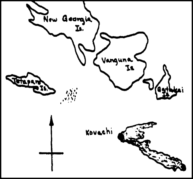 |
Figure 1. Sketch map showing location of Kavachi and zone of water discoloration, October-November 1969. |
Information Contacts:
Card 0813 (03 November 1969) Captain John Seaton, Solomon Islands Airways, Honiara; D. Denham, Geophysical Observatory, Port Moresby, Papua New Guinea.
Card 0821 (12 November 1969) R.B.M Thompson, Geological Survey of the Solomon Islands, Honiara; Captain Ivanoff, Ansett Airlines, LAE, New Guinea.
Card 0828 (20 November 1969) Captain John Seaton, Solomon Islands Airways, Honiara; R.B.M Thompson, Geological Survey of the Solomon Islands, Honiara.
Renewed water spouts in late December 1969
Card 0846 (12 January 1970) Renewed water spouts in late December 1969
"The volcano was observed to be welling up very gently on 5 December and from then until the week before Christmas it was generally quiet. On the 22nd to the 24th of December the activity had renewed and water spouts were rising to 100 feet every five to ten minutes. It appears that this type of activity can be expected for some time."
Information Contacts: R.B.M Thompson, Geological Survey of the Solomon Islands, Honiara.
Cone observed 50 feet above the surface; glowing ash cloud
Card 0858 (02 February 1970) Cone observed 50 feet above the surface; glowing ash cloud
The following was received via cable on 31 Janaury. "Kavachi activity renewed. Cone 50 feet above sea with incandescent crest ash cloud glowing base 1,000 feet with rocks flying to 100 feet steam generated around base eruption minute intervals. First report watch (on ship) Fortune Glory 0800 GMT [30 January] confirmed aerially by TAA plane 2200 GMT [30 January]."
Information Contacts: R.B.M Thompson, Geological Survey of the Solomon Islands, Honiara.
Eruption ends; island disappears by mid-February
Card 0901 (01 April 1970) Eruption ends by 7 February; island erodes below ocean surface
Kavachi eruptions ceased between 0400 GMT on 6 February and 2200 GMT on 7 February.
R. Thompson visited the island on 6 February at which time he observed a semi-circular island with a peak 30-35 feet above the surface and a rust-colored volcanic pipe six feet in diameter visible to the NW end of the island. The solid lava material was very rough with uneven blocks of lava that had flat sides.
At 0300 GMT on 14 February [R. Citron] overflew Kavachi Island NE to the SW at an altitude of 150-200 feet. Observed a rock island protruding about 20-25 feet above the surface with breakers crashing on the island from the SW. The rocks were black in color. There was a brown and green discoloration on the water's surface that traveled in a direction SW from the island. The island had a surface area of approximately 500 square feet and appeared to be breaking down from severe wave action. Three cyclones were near the area and the sea was extremely rough. The diameter of the discolored area around the island was estimated at 200 feet traveling several thousand feet downstream toward the SW. Visited Kavachi volcano between 2200 and 2300 hours GMT on 16 February. Island was submarine with large breakers breaking on its submerged southwest flank. Brown discoloration over vent. Green yellowish discoloration trailing 1,000-1,500 feet toward SW. Attempt to obtain lava samples negative due to dangerously rough seas.
William Proctor managed to obtain lava samples from Kavachi on 3 March (reported by R. Thompson). He estimated the depth of the summit at nine feet and its position at 157°59'E, 09°00'S, which is not quite the position marked on the marine chart.
Card 0921 (28 April 1970) Summary of events from 28 October 1969 through 3 March 1970
Summary of events at Kavachi from 28 October through 3 March 1970. All times are UTC.
0400 on 28 October 1969: Water eruptions were observed from a distance of about 15 miles from a Solomon Islands Airways plane.
2200 on 28 October 1969: The sea was discolored a yellowish green and reddish brown material observed to be floating on it. This material extended almost as far as the Russell Islands. Water eruptions occurred about every 30 seconds and rose to heights of up to 100 feet. The water in the eruptions was saturated with black rocks, pebbles, sand and mud. After the eruptions the mud fraction discolored the sea; a circular green muddy sea centered around the vent about 200-300 yards in diameter.
2200 on 29 October 1969: Similar activity no close observation.
0130 on 30 October 1969: Similar activity water eruptions probably 20-50 feet.
0130 on 31 October 1969: Activity waned to boiling action.
2700 on 2 November 1969: Two minute eruption cycle, eruption to 20 feet.
0130 on 3 November 1969: Massive water eruption up to 200 feet: possibly 500 feet approaching the vent from three miles away.
0300-0330 on 4 November 1969: Two small water fount eruptions up to 25 feet high observed from five mile to eight miles away which occurred with a two minute interval. Water fountain eruption at 0330 rose to about 60 feet. Flashes of light seen but these were not followed by eruptions.
0120 on 7 November 1969: 30-50 feet water fountains frequency 3 minutes.
0125 on 11 November 1969: No eruptions observed over 10 minutes from five miles.
0125 on 17 November 1969 through 19 November 1969: No eruptions observed on these days but a close look revealed discoloration of water and minor boiling type upwelling.
5 December 1969: Gentle upwelling.
14-20 December: A close look suggested all activity had ceased.
22 December 1969: Renewed steam and water eruptions up to 100 feet every five to ten minutes.
0130 on 16 January 1970: One steam eruption up to 100 feet.
0700 on 30 January 1970: Cargo vessel "Fortune Glory" reported a full volcanic eruption. Black smoke with glowing rocks coming out of vent at the top. The nearest observation was made from about five miles.
2300 on 30 January 1970: Plane circled the erupting vent and confirmed the first report.
2300 on 1 February 1970: Eruption observed.
0130 on 2 February 1970: Eruption observed.
0130 on 6 February 1970: Eruption observed to be continuing.
2200 on 7 February 1970: Close examination made. Eruption had ceased leaving a pyramid of black rock about 20 feet high. The heat of the rock shown by the spray breaking over the rock being converted to steam. The surviving rock above sea level appeared to be fairly massive but the southern flank had a coppled appearance. On the northeastern side of the cone these appeared to be remnants of a vent about five feet in diameter. The inner walls of the vent were coated with ochre, yellow and brown material.
0300 on 14 February 1970: Remnant cone observed about twenty feet above surface.
2200 on 16 February 1970: All rock above sea level gone but rock was observed about three meters below sea level.
3 March 1970: Small fragments of rock obtained by dredging. No loose rock found and rocks obtained were broken off from head of sunken cone by a heavy dredge. Depth of rock about three meters.
Information Contacts:
Card 0901 (01 April 1970) R.B.M Thompson, Geological Survey of the Solomon Islands, Honiara; Robert A. Citron, Smithsonian Institution.
Card 0921 (28 April 1970) R.B. Thompson, Geological Survey of the Solomon Islands, Honiara.
Pilot observes eruption of water and tephra above the surface on 23 August
A new eruption of Kavachi volcano was sighted on 24 August at 0800 by Solair pilot Bruce Kirkwood. A fountain of water and volcanic ejecta reached 30 m height. The eruption was continuing as of 2 September. Seismicity was being monitored by Deni Tuni at Vakambo, 45 km north of the volcano. The last eruption of Kavachi ended in February 1970.
Information Contacts: R. Thompson, Geological Survey, Honiara.
Island formation on 7 September; lava and block eruptions
Much of the following information was received by R.B.M. Thompson from Solair pilots Bruce Kirkwood, Robert Snape, and Eric Cooper. Fountains of water and rock continued at least through 4 September, reaching about 60 m height. No information is available for 5 September.
6 September. A resident of Gatukai Island (NE of Kavachi) noted a change of the eruption column from white steam and spray to "smoke" during the afternoon (figure 2).
 |
Figure 2. Airphoto of Kavachi, taken 6 September 1976 (airplane wing at left of photo). Courtesy of R.B.M. Thompson. |
7 September. A morning overflight revealed that a rubble pile had reached the surface. Heavy swells were breaking over the rubble, which continuously emitted steam and "smoke", accompanied by bursts of rocks. The maximum height reached by the ejecta was about 90 m. By 1600, a cone, extruding lava, extended 1.5-3 m above the surface.
8 September. At 1300 the cone was about 9 m above sea level and 40 m across (at sea level). A red glow from the cone's central vent was clearly visible in bright sunlight. Lava was pouring over the NW rim, which was about 3 m lower than the rest of the cone. Eruptions of blocks, reaching more than 150 m height, occurred at approximately 1-minute intervals. Some of the blocks were fairly large and some were glowing. Brown and white "smoke" was emitted continuously.
9 September. At 1030 the volcano was less active than the day before. Lava surged up and down, overspilling the NW rim into the sea on the larger upsurges. Eruptions of blocks, ash, and vapor, occurring every 1-2 minutes, were less intense than on the 8th. The island appeared to be breaking up, most rapidly on the NW, the prevailing wave direction. The maximum height of the cone above sea level was about 6 m. The surrounding water was discolored by a brownish scum. Photographs were taken by seismological observer Deni Tuni (figure 3).
 |
Figure 3. Airphoto of Kavachi, taken 9 September 1976 by Deni Tuni. View is from the E. Note the bombs being emitted from the vent. Courtesy of R.B.M. Thompson. |
Information Contacts: R. Thompson, Geological Survey, Honiara.
Pyroclastic eruptions continue through September
The lava flow, which began on 7 September when the cone first built itself above sea level, ceased between 9 and 11 September. Pyroclastic eruptions continued, with small bursts every 30 seconds and larger ones every 2 minutes. "Smoke" emission was continuous. Tephra deposition had filled the breach in the SE wall of the crater by 15 September. Photographs taken on that date show an elongate island (NW-SE) about 100 m in length. Pyroclastic activity lasted until at least 1 October, maintaining its 30-second and 2-minute periodicity. No pumice was reported. Cone height stabilized at 15-20 m, with accretion of tephra compensating for erosion by the sea. An observer 24 km away noted no activity on 6 October. A survey to determine the size and position of the new cone was planned for 12 October.
A temporary seismological station installed on Vakambo Island (8.37°S, 157.85°E, near New Georgia Island 73 km from Kavachi) began recording on 24 September. Twenty earthquakes were recorded 24 September-5 October, all with S-P separations corresponding to Kavachi epicenters, but they cannot be conclusively associated with the eruption since they were not recorded by another station. The station was operated by Deni Tuni.
Information Contacts: R. Thompson, Geological Survey, Honiara.
Eruptive activity observed in October 1976 and February 1977
Captain Stewart Evans approached Kavachi at 1500 on 13 October observing subsurface activity, but no island. He reports: "There was a definite eruption cycle during the first 2 hours of observation. Eruptions were fairly regular at approximately 15-minute intervals, and every 4th or 5th eruption was of noticeably greater magnitude. The cycle broke down about 1730. Frequent tremors were then heard and felt from the government survey vessel Wakio, stationed about 1 km from the vent. The tremors were felt at 5-10 minute intervals, but eruptions became less frequent and less violent. No eruptions were sighted for a 40-minute period while steaming away from the area at about 1800.
"The crest of the volcano was estimated to be less than 15 m below the surface and the sea was stained brown over an area approximately l00 m in diameter. The average height attained by ejecta (water and volcanic debris) was 10-15 m above the sea surface. The maximum height attained following the highest ejection was estimated at 30 m. Small waves were generated by each eruption. The average wave was 1 m high and radiated to about 500 m from the volcano. No bottom was found in a 365-m range on the echo sounder around a 1-km perimeter of the volcano."
"On 23 October, I observed a circular area of shallow (yellow-blue) sea surrounding a deep (dark blue) area, from an airplane above Kavachi. A yellow-blue area looking like a reef extended to the SE."
A study of 8 mm movies taken 9, 14, and 30 September, 1976 shows that red-hot blocks reached a maximum dimension of more than 1 m.
No other activity was reported until 0945 on 22 February, 1977 when Solair Chief Pilot Bruce Kirkwood reported plumes of spray and rock debris thrown upwards to about 60 m at intervals of 10 minutes.
Information Contacts: R. Thompson, Geological Survey, Honiara.
Renewed activity
Renewed activity was first observed on 19 July at 1000 by Solair Pilot Bruce Kirkwood, 3 days after the previous overflight. Eruptions were seen on 20 July, and at about 30-second intervals on 22 July. Ash was ejected by the vent, which remained below the ocean surface.
Information Contacts: R. Thompson, Geological Survey, Honiara.
New island formed
On 21 June, Bruce Kirkwood observed an eruption at Kavachi. Geologists from the Solomon Islands Ministry of Natural Resources flew over the site the next day and observed a circular island 30-50 m in diameter and 1-2 m in height (figure 4). Occasional weak explosions ejected ash and scoria, and the perimeter of the island was steaming.
 |
Figure 4. Airphoto taken 22 June 1978 showing the island formed by Kavachi's eruption. Courtesy of Frank Coulson. |
Kirkwood flew over the volcano again on 14 July and reported a N-S elongate island with a central cone estimated to be 30 m high. Bombs and blocks were thrown from the central vent to as much as 400 m altitude, and lava poured down the S flank. A small subsidiary vent appeared to be forming near sea level on the E coast.
By 16 July (Kirkwood's next overflight) the S half of the island, including the central vent, had dropped along an E-W fault with a scarp that formed the new S edge of the island. The subsided area appeared to be just below sea level and eruptive activity there continued. During the 10-minute overflight, 1 explosion was observed.
Information Contacts: F. Coulson, Ministry of Natural Resources, Honiara.
Eruption ends
When observed on 28 July, the eruption had ended. A small rocky island, about 15 m long, 5 m wide and no more than 3 m high remained at the eruption site. The island was expected to be destroyed by wave action within a few days to a few weeks.
Information Contacts: F. Coulson and D. Tuni, Ministry of Natural Resources, Honiara.
Small submarine eruption
Bruce Kirkwood observed a small submarine eruption on 7 October. A mixture of water, steam, and blocks rose intermittently to more than 100 m above the ocean surface. Sea water surrounding the eruption site was slightly discolored.
Information Contacts: D. Tuni, Ministry of Natural Resources, Honiara; B. Kirkwood, Solair.
Submarine activity diminishes
Solair pilots flying over Kavachi on 14 October observed a submarine eruption similar to that reported by Kirkwood on 7 October, although there appeared to be more mud in the surrounding seas. By 23 October, activity had decreased to occasional bursts of hot water at the surface.
Information Contacts: D. Tuni, Ministry of Natural Resources, Honiara.
More submarine activity
On 11 November at 1215 a Solair flight diverged from its normal route to observe the volcano. Drs. Hughes and Dunkley of the Geological Division, Ministry of Natural Resources, reported that a dense, nearly vertical steam jet was billowing to approximately 300 m, but dissipated as the plane approached. The eruption site was marked by white water, and a stream of muddy, turbid, pale brown water extending several km NE from the volcano. On 3 December Dunkley observed an area of discolored water several hundred meters wide extending NW (down current) about 4 km. No eruption was in progress.
Information Contacts: D. Tuni, Ministry of Natural Resources, Honiara.
Submarine activity continues
Solair Captain Peter Cox overflew Kavachi on 9 January at 1540. At 30- to 60- minute intervals steam fountains rose to a height he estimated at 150 m. The sea was stained light brown for as much as 15-20 km from the volcano, but Cox saw no floating pumice.
Ministry of Natural Resources geologist A. Smith observed minor eruptive activity on 25 February. Submarine explosions apparently originating at 5-10 m depth transmitted shock waves to the surface. Some gas bubbles could be seen but no ejecta were evident. The prevailing wind drove seas to the NE, carrying an expanding plume of yellow-brown to yellow-green water visible on the surface for at least 2 km from the volcano.
Information Contacts: D. Tuni, Ministry of Natural Resources, Honiara.
Bubbling and discolored water
Solair pilots who overflew Kavachi in mid-September reported gas bubbling and discolored sea water. No eruption columns were observed.
Further Reference. Johnson, R.W., and Tuni, D., 1986?, Kavachi, an active forearc volcano in the western Solomon Islands: reported eruptions between 1950 and 1982, in Taylor, B., and Exon N.F., (eds.), Seafloor spreading ridge, subduction, volcanism, and sedimentation offshore.
Information Contacts: F. Coulson, Ministry of Natural Resources, Honiara.
Submarine explosions
On the morning of 30 December, Solair Captain Brian Smith observed dirty water over Kavachi while flying from Honiara to Munda. When he returned to Honiara that afternoon, Kavachi was ejecting rock debris, mud, steam, and water to a height of 30 m. The eruption was observed by the captain and crew of the MV Iu Mi Nao the same afternoon. On 31 December, the eruption was intensifying, with one explosion per minute ejecting material to 200-300 m height. By 1 January, both eruptive intensity and height of the ejecta column had decreased. On 7 January, Deni Tuni observed explosions while en route to Honiara on the MR Compass Rose II. Two explosions ejected black plumes that probably contained ash to about 20 m height. A third explosion, which appeared to consist mainly of steam and perhaps other gases, spread along the horizon, forming a pyramid-shaped cloud before disappearing. As of mid-January, no island had formed.
Information Contacts: D. Tuni, Ministry of Natural Resources, Honiara.
Continuing submarine activity
The submarine eruption . . . described in 10:12 had been observed by residents of a nearby island in early December and was continuing in late February, but had ended by 3 March.
From Saira village, roughly 25 km from Kavachi on Vangunu Island, Oliver Jino reported that the eruption sequence began on 9 December. After the previously reported observations from aircraft and ships 30 December-7 January, the next sighting was on 20 January, when Dr. G. Baines noted three ejections of water and steam, 1.5-2 minutes apart, from a Solair plane flying >45 km from the volcano. An area that looked like a coral reef but was probably volcanic debris extended downcurrent from the vent. On 24 January, Mr. B. Papukera, another Solair passenger, observed a single similar ejection. No activity was evident from a Solair plane on 5 February. On 25 February, Solair Captain Don Lemon observed renewed activity ejecting water and steam to 100 m or more asl. Two days later, Lemon again flew near the volcano, observing gas bubbles over the vent and muddy-looking water drifting away from it, but no explosions. On 3 March, personnel in a powered dinghy from the RV Thomas Washington searched the area but found no sign of activity.
Information Contacts: D. Tuni, Ministry of Natural Resources, Honiara.
Submarine activity
Eruptive activity . . . was reported on 5, 16, and 21 July. On 5 July at 1000, Solair Captain Brian Smith observed jets of water and volcanic debris being ejected to 60-90 m, forming a cone. In the center of the cone, incandescent magma could be seen. Two days later, Pilot Bill Watts reported discolored water and bubbles, but no explosions. On 8 July Pilot Tas Laurie observed steam and discolored water.
A week later, on 21 July, ejection of water and steam to 60-90 m was again reported, lasting 2-3 minutes at a time, but not forming a cone. Activity continued for ~2 days, then subsided.
Information Contacts: P. Dereni, Ministry of Natural Resources, Honiara.
Submarine eruption builds new island
A newly emergent volcanic island near previously active Kavachi was observed ejecting lava and ash during a helicopter overflight on 4 May. John Starcy (Australian High Commissioner, Honiara, Solomon Islands) reported that "the volcanic action had already formed a thick rim of black material above sea level, inside which a large body of molten lava was churning and spewing out rocks." At the time, the island was estimated to be ~300x150 m in diameter and ~30 m high, with a lava pond ~50 m in diameter. Red Marsden (a Rabaul-based pilot) flew over the volcano on 12 May. The island had a regular conical shape that he estimated was ~15-20 m high. The volcano continued to eject incandescent lava fragments and some dark material to ~50 m height. White vapor emission occurred between ejections, and considerable steam rose from along the water line. Activity continued as of 13 May and the size of the cone continued to increase.
The location of the new island remains uncertain (figure 5) [but more precise navigation linked it to Kavachi; see 16:7]. It was reported at 8.88°S, 157.88°E, 20 km NW of Kavachi, by Starcy, and ~38 km SW of Kavachi (at 9.23°S, 157.70°E; within the Woodlark Basin) by Ted Tame (Rabaul representative of the Papua New Guinea National Disaster and Emergency Services). A submarine volcano was shown on Admiralty Chart 3995 at ~25 km W of Kavachi (at 9.0°S, 157.8°E), between the two reported positions, but the Machias 1981 bathymetry survey failed to find this feature (Exon and Johnson, 1986). Instead, the survey located a bathymetric high 10 km to the WNW that is probably a southward-trending ridge originating on Tetepare Island.
 |
Figure 5. Map of the western Solomon Islands. Crosses represent reported new island locations, triangles mark the New Georgia Group volcanoes (Pliocene to Recent), and the filled circle represents the unnamed submarine volcano on Admiralty Chart 3995. Modified from Exon and Johnson (1986). |
Reference. Exon, N.E., and Johnson, R.W., 1986, The elusive Cook volcano and other submarine forearc volcanoes in the Solomon Islands: BMR Journal of Australian Geology & Geophysics, v. 10, p. 77-83.
Information Contacts: G. Wheller, CSIRO, Australia; C. McKee, RVO.
Continued explosions from new island
Pilots from Solomon Islands Airways reported that "the volcano is still active and increasing in size, though slowly" as of 14 June. Photographs taken on 12 May (by Rod Marsland, a Rabaul-based pilot) show the island to have been ~110 m in diameter, with a 15-m-diameter crater (assuming a height of 25 m based on an average of several visual estimates). Lava was being ejected to 30 m height in the photos. The new island's exact location remains uncertain.
Information Contacts: P. de Saint-Ours, RVO.
May-June submarine eruption ends; temporary island eroded away
An eruption built a small temporary island . . . first observed on 4 May, but its location was initially uncertain. However, more precise navigational data from the chief pilot of Western Pacific Air Services placed the activity at 9.00°S, 157.97°E, roughly 3 km NE of Kavachi's summit.
Activity apparently had not changed when, during an overflight on 5 June, [John] Monroe observed a vigorously active lava fountain roughly 25 m high and a plume that rose >2,500 m. The island's dimensions were estimated at 150-200 m long and ~50 m high. Carl Rossiter reported that divers ~45 km NE of Kavachi (at Kicha Island) felt powerful explosions while underwater on 7-8 and 12-13 June. Individual explosions occurred a few seconds apart in groups of 12-20. Explosion groups generally lasted a total of 1-2 minutes, were typically preceded and followed by rumbling, and were separated by roughly 30 minutes of quiet. No explosions were felt at other dive sites, where islands were between the observers and Kavachi.
The eruption weakened in mid-June, and the island disappeared beneath the ocean surface later in the month. No additional activity has been reported.
Information Contacts: R. Addison and A. Papabatu, Ministry of Natural Resources, Honiara; J. Monroe, San Jose, USA; C. Rossiter, See and Sea Travel Service, San Francisco, USA.
Bathymetric survey reveals gas emission
A bathymetric survey in the vicinity of Kavachi volcano was carried out on 11 August by the HMNZS Tui. The ship made three parallel transits, ~1,200 m apart, over the summit of the unnamed seamount ~7 km NW of Kavachi. The summit is mostly flat, with a depth of at least 130 m found on each pass. The transit farthest NE showed a shallow and a deep crater on the tracing of the 12 kHz echo sounder. The 44-kHz echo sounder showed two small plumes rising to mid-water depth on either side of the smaller crater.
Near Kavachi itself, inflatable boats with hand-held echo sounders and portable GPS receivers were used to determine spot water-depths. A sulfur smell and a patch of milk-colored water 20 m in diameter were reported by boat crews near the shallowest (20 m) depth location (8.994°S, 157.973°E). Several other similar patches were observed within 150 m of this point, in water 20-30 m deep.
Information Contacts: L. Hall, Defence Scientific Establishment, and Lt. Cdr. G. Craig, HMNZSTui, Auckland Naval Base, New Zealand.
Submarine ejection of mud and hot ash; plumes rise to 2.1 km
On 16 January a Solair pilot reported continuous ejection of mud and hot ash up to 2,100 m altitude. When the pilot returned on 17 January, the eruption was continuing with intermittent plumes reaching similar heights. On 29 January the sea water near the volcano was discolored and dirty, however, there were no reports of eruptive activity.
Kavachi is a basaltic to andesitic shallow submarine volcano. It has produced ephemeral islands at least nine times since its first recorded eruption in 1939. The last record of eruptive activity was in May 1991 (see BGVN 16:07).
Information Contacts: Alison K. Papabatu, Ministry of Energy, Water and Mineral Resources, Solomon Islands.
Scientists aboard a research vessel observe a new submarine eruption
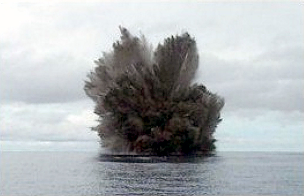
On 14 May 2000 Australian research vessel Franklin visited Kavachi seamount to discover that... a new eruption was underway (figure 6). The vessel was supporting an Australian Commonwealth Scientific and Industrial Research Organization (CSIRO) research cruise (FR04/00) entitled Project SHAARC (Submarine Hydrothermally Active Arc Volcanoes). Upon arrival at 0600 hours observers saw waves breaking on the peak of the volcano. Every 5-7 minutes the scientists on the CSIRO vessel witnessed violent eruptions that lasted 2-3 minutes each, prevailing for the approximately 20 hours that they observed the volcano. The position of the eruption column was fixed specifically at 8.99°S, 157.97°E, and the volcano's peak was estimated at 2-5 m below the water surface. The eruptions ejected ash and incandescent blocks of lava up to 70 m above the sea surface and sulfurous steam plumes rose to heights of 500 m.
 |
Figure 6. Photograph showing an eruption at Kavachi Seamount, 14 May 2000. Courtesy of CSIRO. |
The science team aboard Franklin documented the apparent new phase of island-building eruptive activity. A bathymetric map was produced that differed significantly from the previous map of the volcano made in 1984. Hydrocast/CTD (conductivity-temperature-depth) surveys were undertaken; these detected numerous chemical and particle plumes in the water column; the plumes extended at least 5 km from the eruptive center. Systematic sampling of rocks and ash from the flanks of the volcano returned glassy, vesicular basalts and hydrothermally altered sulfide-rich volcanic breccias. In addition, approximately 500 photographs and 2 hours of digital video captured ~20 eruptions during daylight.
The scientific participants on the CSIRO-led cruise were: Brent McInnes, CSIRO Exploration & Mining Chief Scientist; Richard Arculus, Principal Investigator, and Cromwell Qopoto, Australian National University (ANU); Gary Massoth, Principal Investigator, and Cornel DeRonde, New Zealand Institute of Geological and Nuclear Sciences Ltd (IGNS); Ed Baker, National Oceanic and Atmospheric Administration (NOAA); Pamela Brodie, Dan Conwell, Tim MacConachy, and Ron Plaschke, CSIRO; John Chadwick, University of Florida; and Philip Pousai, University of Papua New Guinea.
Information Contacts: Brent McInnes, Chieft Scientist (FRO4/00), Division of Exploration & Mining, Australian Commonwealth Scientific and Industrial Organization (CSIRO), PO Box 136, North Ryde, NSW 1670, Australia (URL: http://www.csiro.au/).
Daily eruptions August to mid-September 2001; eruption 27 November
The last report (BGVN 25:04) described the submarine eruption that occurred in May 2000. During August through mid-September 2001, Corey Howell of the Wilderness Lodge (adjacent Peava village, Gatokae Island; 8° 47'S, 158° 14'E) reported that Kavachi erupted daily. During August ash and volcanic projectiles were observed rising ~400 m above sea level and the glow from the volcano was visible from the coast of Gatokae Island 32 km away. [According to Howell, the current phase of eruptive activity has been in progress since at least November 1999, with eruptions ranging from a minimum of once a week to eruptions from 5-15 minutes sustained over several days.]
Howell reported that activity waned in late September. As of 1 November no eruptive activity had been observed at Kavachi for about five weeks, but the observation post sat at the coast of Gatokae (also written Nggatokae) Island ~26 km NE of the volcano (see regional maps, CSLP Card 8028; BGVN 16:04). Low-level activity may have occurred that was not visible from the observation post.
A visit on 25 November revealed upwelling sulfur, mud, and tiny pieces of volcanic rock. The pieces of rock covered the sea surface over an area ~200 m across. A brownish green stain clouded the seawater. No explosive eruptions were seen during 6 hours of observation. Howell further noted that on 27 November Kavachi resumed explosive activity with columns reaching ~2 km high.
Reference. Johnson, W., and Tuni, D., Kavachi, 1987, An active forearc volcano in the western Solomon Islands: reported eruptions between 1950 and 1982, in Taylor, B., and Exon, N.F. (eds.), Marine geology, geophysics, and geochemistry of the Woodlark Basin, Solomon Islands: Circum-Pacific Council Energy Min Resour Earth Sci Ser, v. 7, p. 89-112.
Information Contacts: Corey Howell, The Wilderness Lodge, PO Box 206, Honiara, Solomon Islands (URL: http://www.thewildernesslodge.org).
Ongoing submarine eruptions; shifting summit elevations; bathymetry
This report covers activity at Kavachi submarine volcano since the eruptions in August to mid-September 2001 and on 27 November 2001 (BGVN 26:11). It includes information from Corey Howell of The Wilderness Lodge on the island of Gatokae (Nggatokae), ~ 35 km NE of Kavachi, and a research cruise of the Commonwealth Scientific and Industrial Research Organization (CSIRO) (McConachy and others, 2002).
On his visit to the site of the volcano on 25 November 2001, Howell described a colored stain in the seawater. His photo of the setting portrays a calm sea surface without visible agitation and very little froth floating on the surface; the stain rose from depth. Elsewhere on his website he commented about trolling and catching fish within upwelled material on this date: "Trolling around the vent at Kavachi delivered the goods once again with 23 large rainbow runner, two Spaniards, [bara]cuda, and bigeye trevally-112 kilos [kg] of fish, which fed the entire village. We dropped two very large Spaniards, both taking the lure right in the middle of the vent upwelling, and saw countless sharks, runner, trevally, and yellowfin."
Howell noted that explosive eruptions occurred daily during 27 November-13 December 2001. Strong monsoon winds prevented visits then. In discussing regional weather patterns he noted that the prevailing monsoon westerly winds common at Kavachi from December to March reach 15-18 knots, increasing to 25-30 knots during torrential rain squalls. Conditions become choppy with seas 1-2 m with an underlying 2-3 m SW groundswell. Seas such as these could influence erosion at Kavachi.
Howell visited Kavachi again on 14 and 28 January 2002, and he passed some 15 km from Kavachi on 17 January 2002. In his summary of those observations and visits, written on 30 January 2002, Howell noted that he had measured the summit's current depth at 60 m. He saw a continuous stream of sulfur, small fragments of volcanic rock, and gases escape, resulting in a vigorous dirty-yellow to light-brown upwelling at the surface. Columns of bubbles rose to the surface and slicks of sulfur prevailed down-current, forming an extensive plume of discolored water several kilometers in length. Occasional explosive eruptions produced columns composed of and occasionally ash, rock, and water, rising to a height of ~ 1 km and visible for at least 40 km.
He went on to say that the vent had emitted a range of loud sonic cracks and booms at intervals of 2-15 minutes. These sounds were loud and clear to witnesses standing in the boat but were heard best in the water, leading to "a sensation that can only be described as being shot point-blank with a high-powered rifle sans pain." Below 10 m water depth divers heard a continual barrage of different sounds coming from the vent. Several powerful earthquakes were felt on nearby Gatokae Island during this observation period (November 2001-January 2002); however, the large regional earthquake that struck Port Vila, Vanuatu, was not felt on the island. When Howell visited Kavachi on 14 January he noted a slick of unidentified materials coming from the vent column. On 28 January he saw extensive trails of yellow sulfur extending down current.
CSIRO conducted two echo-sounding bathymetric surveys of Kavachi a bit over 22 months apart, enabling morphologic comparisons. The earlier survey took place on 14 May 2000 (research cruise FR04/00, Project SHAARC; McInnes and others, 2000) (see BGVN 25:04). The later survey occurred on 28 March 2002 (research cruise FR03/2002, Project SOLAVENTS 2002; McConachy and others, 2002).
Comparing the 2000 to the 2002 bathymetry (figure 7, top and bottom) showed that Kavachi had changed, in places significantly. In 2002 the summit had dropped to clearly well below sea level, compared with 3 m below in 2000. Some lower parts of the volcano appeared to be at lesser depths, perhaps due to mass wasting carrying material downslope and depositing it there. The CSIRO 2002 cruise kept some distance from the summit area, and the shallowest point surveyed was just E of the summit at 85 m depth. Neither of the cruises crossed over the apex of the Kavachi summit.
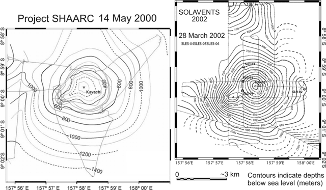 |
Figure 7. Bathymetric maps of Kavachi made by the CSIRO Project SHAARC cruise on 14 May 2000 (left) and the CSIRO Project SOLAVENTS cruise on 28 March 2002 (right). For both maps the fine lines represent ship's tracks during echo soundings. Contour intervals on the SHAARC map are 100 m, for the SOLAVENTS map, 50 m. The SOLAVENTS map shows locations of hydrocast samples (SLH) and bottom grab samples (SLG). Courtesy of Tim McConachy, CSIRO. |
During the CSIRO 2002 cruise an unusual rise in the surface seawater temperature was recorded NW of the summit area and scum resembling oil slicks was noted on the surface in places. Methane analyses of water collected through hydrocasts (a technique where sample bottles are lowered by a cable) suggest hydrothermal sources on the flanks of Kavachi. A bottom grab sample taken at 95 m depth just E of the summit gave off a pungent hydrogen sulfide odor; the black volcanic sand recovered contained small specks (up to pea size) of yellow sulfur and traces of pyrite. A second grab sample, collected NW of the summit, contained gravel-size pieces of more altered, gray to cream colored rock as well as black volcanic sand and gravel. A third grab sample SW of the summit contained black volcanic sand and gravel, but no evidence of native sulfur or sulfide.
About a fortnight after their 28 March 2002 visit, the crew received an email from Howell (dated 18 April 2002), in which he noted that observers on the weather coast of Gatokae (the island's SW side, which faces toward Kavachi) reported eruptions each day that week except Monday. The eruptions usually occurred only once or twice in a 24-hour period.
Howell visited Kavachi again on 16 March 2002, finding the summit then at a depth of 34 m. He determined the summit's coordinates using a Garmin GPS (global positioning system) with a nominal accuracy of ~ 9 m. When this position was plotted on the map generated by the CSIRO 2002 cruise and contoured, Kavachi appeared quite conical in shape with a prominent SW ridge defined by the 350 m contour. Howell's work placed the new summit ~ 315 m E of its previous location (fixing it at 8°59.64'S, 157°58.409'E; whereas the 2000 SHAARC research cruise fixed it at 8°59.65'S, 157°58.23'E).
According to Howell, during October to November 2002 Kavachi ultimately rose to form an island 10-15 m above sea level. In accord with this emergence from the sea, Wright and others (in press) noted four alerts in the MODIS-MODVOLC satellite thermal detection system during November 2002. Howell stated that subsequently the island eroded in late-season SE seas and swells. When visited on 16 November 2003, Howell found the summit at ~ 32 m below sea level, a significant change from the island seen three months earlier.
In summary, table 2 shows discontinuous observations of elevation/depth of the summit of Kavachi over a period of about 3.5 years (2000-2003).
Table 2. A compilation listing the stated elevations (+) and depths (-) of Kavachi's summit over a 3.5-year period. Courtesy of Tim McConachy (CSIRO) and Corey Howell (The Wilderness Lodge).
| Date | Summit depth / elevation | Source |
| 14 May 2000 | -2 to -5 m | CSIRO |
| 28 Jan 2002 | -60 m | Howell |
| 16 Mar 2002 | -34 m | Howell |
| 28 Mar 2002 | Well below sea level | CSIRO |
| Oct/Nov 2002 | +10 m | Howell |
| ~Aug 2003 | +15 m | Howell |
| 16 Nov 2003 | -32 m | Howell |
References. McConachy, T.F., Yeats, C.J., Arculus, R.J., Beattie, R., Belford, S., Holden, J., Kim, J., MacDonald, L., Schardt, C., Sestak, S., Stevens, B., and Tolia, D. (edited by C.J. Yeats), 2002, SOLAVENTS-2002, Solomons Australia Vents Expedition aboard the RV Franklin, 26 March-21 April 2002: CSIRO Exploration and Mining Report 1026F, Final Cruise Report FR03-2002, 456 p.
Peterson, M.G., Wallace, S., and Tolia, D., 1999, Records of explosive Surseyan eruptions from Kavachi, Solomon Islands, in 1961, 1970, 1976, 1978, 1991, 1998, and 1999, Keith, A.W.C., and Rodda, P., eds.: Abstracts of Papers Presented at the STAR (Science, Technology and Resources) Network, SOPAC Miscellaneous Report 355, p. 53.
McInnes, B.I.A., Arculus, R., Massoth, G., Baker, E., Chadwick, J., DeRonde, C., McConachy, T., Posai, P., and Qopoto, C., 2000, Project SHAARC, Investigation of submarine, hydrothermally active arc volcanoes in the Tabar-Lihir-Tanga-Feni Island and Solomon Island chains: CSIRO Exploration and Mining Open File Report 762F, 20 p.
Wright, R., Flynn, L.P., Garbeil, H., Harris, A.J.L., and Pilger, E., (in press), MODVOLC: near-real-time thermal monitoring of global volcanism, Journal of Volcanology and Geothermal Research, Elsevier (2004)
Information Contacts: Timothy F. McConachy, CSIRO Division of Exploration and Mining, P.O. Box 136, North Ryde, NSW 1670, Australia; Corey Howell, The Wilderness Lodge, P.O. Box 206, Honiara, Solomon Islands (URL: http://www.thewildernesslodge.org/).
Eruption on 15 March 2004 breaks the water surface
The Solomon Islands' goverment-supported web service, the People First Network (PFnet) reported in March 2004 that Corey Howell of The Wilderness Lodge, Gatokae Island, observed Kavachi erupting (figure 8). Kavachi is among the world's few regularly erupting submarine volcanoes that sends material above the ocean surface in witnessed (and reported) eruptions.
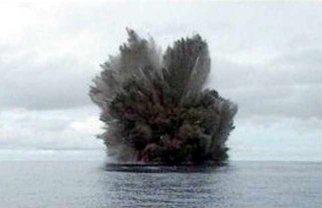 |
Figure 8. A photo of Kavachi erupting as seen on 15 March 2004. The original caption on PFnet was "Kavachi awoke on Monday in spectacular fashion after an eight-month slumber...." Courtesy of Corey Howell. |
The figure caption on PFnet notes an 8-month period of Kavachi inactivity, which was also confirmed in brief correspondence with Howell. A report that summarized the interval between the summer of 2001 and the end of 2003 (BGVN 29:01) lacked any mention of an eruption during mid-August 2003, eight months before the recent eruption.
Information Contacts: Corey Howell, The Wilderness Lodge, P.O. Box 206, Homiara, Solomon Islands (URL: http://www.thewildernesslodge.org/); People First Network (PFnet), Rural Development Volunteers Association, Ministry of Provincial Government and Rural Development, PO Box 919, Honiara, Solomon Islands.
Vigorous upwelling, discolored water, and minor explosions in April 2007
A large earthquake (M 8.1) occurred in the Solomon Islands on 2 April 2007, centered about 126 km NW of Kavachi. Following the earthquake, Corey Howell of The Wilderness Lodge on Gatokae Island received several reports from residents on Gatokae and Vangunu Islands describing noises attributed to Kavachi (~ 35 km WSW of Gatokae). A confirmed report from Marila Timi of Biche Village (on the S coast of Gatokae) stated that around the time of the 2 April earthquake, Kavachi emitted an eruption column visible from her garden above the village.
On 6 April Howell traveled to Kavachi to observe the volcano. Howell spent 2.5 hours on location within 200 m of the active vent, and dove down to within tens of meters of the vent. The volcano exhibited its usual vigorous upwelling, producing a plume of discolored mud- and sulfur-laden water several hundred meters wide and at least 3 km in length downcurrent (figure 9). He measured a temperature of 40°C in the subsurface plume, which appeared normal as compared with his previous 30 visits to Kavachi since 1999. The only explosive activity observed or felt was occasional thudding detonations and sea-surface percussions, with shockwaves producing spray and billows of ash-laden water (figures 10 and 11). Kavachi lacked a significant explosive eruption column or signs of ejected pyroclastic materials, behavior witnessed on many previous visits. On this visit, Howell found nothing out of the ordinary following the 2 April earthquake.
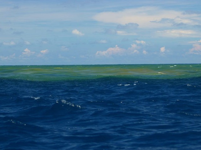 |
Figure 9. Photograph showing a mud-and sulfur-laden plume downcurrent of Kavachi's upwelling vent on 6 April 2007, forming a discolored area several hundred meters wide and several kilometers long. Howell noted that such plumes are frequently seen at Kavachi. Courtesy of Roy Hall (posted on The Wilderness Lodge website). |
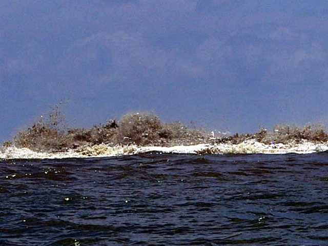 |
Figure 10. Some of the stronger activity observed at Kavachi on 6 April 2007 included very turbulent ash-laden water above the vent, explosive and percussive noises, and discolored water downcurrent of the vent. Courtesy of Roy Hall (posted on The Wilderness Lodge website). |
 |
Figure 11. Some of the stronger activity observed above the vent at Kavachi on 6 April 2007 consisted of shockwaves producing dancing spray, accompanied by staccato bursts of sound. These noises also reverberated through the bottom of the boat. Courtesy of Roy Hall (posted on The Wilderness Lodge website). |
Information Contacts: Corey Howell, The Wilderness Lodge, Peava Village, Gatokae Island, Western Province, Solomon Islands (URL: http://thewildernesslodge.org/).
Plume of discolored water seen in January 2014 satellite imagery indicates probable eruption
The most recent previously observed eruption of Kavachi occurred during 2-6 April 2007 and consisted of vigorous upwelling, discolored water, and minor explosions (BGVN 32:02). On 29 January 2014, the NASA Advanced Land Imager (ALI) on the Earth Observing-1 (EO-1) satellite imaged a plume of discolored water at least 5 km long streaming ESE from the submarine volcano (figure 12). The water plume, likely discolored due to dissolved volcanic gases and suspended tephra in the water, originated at the location of the volcano. Directly above the source of the discolored water, a bright patch suggests vigorously churning water, but there was no sign that an eruption had broken the ocean surface.
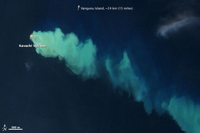 |
Figure 12. Satellite image of discolored water flowing ESE from a possible eruption of Kavachi on 29 January 2014. Note the 500 m scale bar at lower left. Courtesy of NASA Earth Observatory; image by Jesse Allen and Robert Simmon, using EO-1 ALI data from the NASA EO-1 team. Caption by Robert Simmon. |
Information Contacts: NASA Earth Observatory (URL: http://earthobservatory.nasa.gov/NaturalHazards/view.php?id=83025); NASA EO-1 team (URL: http://eo1.gsfc.nasa.gov/).
Evidence of regular explosive activity during 2006-2016 from satellite and direct observations
The submarine Kavachi volcano in the Solomon Islands south of Gatokae and Vangunu islands is frequently active but rarely observed. Consistent activity was reported for more than 4 years between November 1999 and August 2003. An 8-month period of quiet was broken with another explosive eruption above the ocean surface on 15 March 2004 (BGVN 30:03). No observations of ongoing activity are known over the next two years, though eruptions may have continued. Satellite imagery using the Advanced Spaceborne Thermal Emission and Reflection Radiometer (ASTER) during 2006-2016 frequently revealed evidence of activity, on at least 35 days, using the Visible Near Infrared (VNIR) bands. Very little ASTER imagery is available for Kavachi during 2001-2005.
ASTER images on 27 February and 24 March 2006 (figure 13) show renewed activity. Vigorous upwelling along with turbulent ash-laden water and a sulfur odor was witnessed on 6 April 2007 (BGVN 32:07). An ASTER image on 15 June 2007 (figure 14) showed pulses of discolored water originating from the vent, confirming ongoing activity. A small area of discolored water was next seen in satellite imagery on 12 December 2007. A small plume of discolored water appeared in ASTER imagery again on 26 February 2008. On 20 March 2008 the Landsat 7 Enhanced Thematic Mapper captured an image of an ash-and-steam eruption plume extending about 25 km NNE towards Gatokae (figure 15). The next satellite evidence of discolored water plumes were on 7 October 2008.
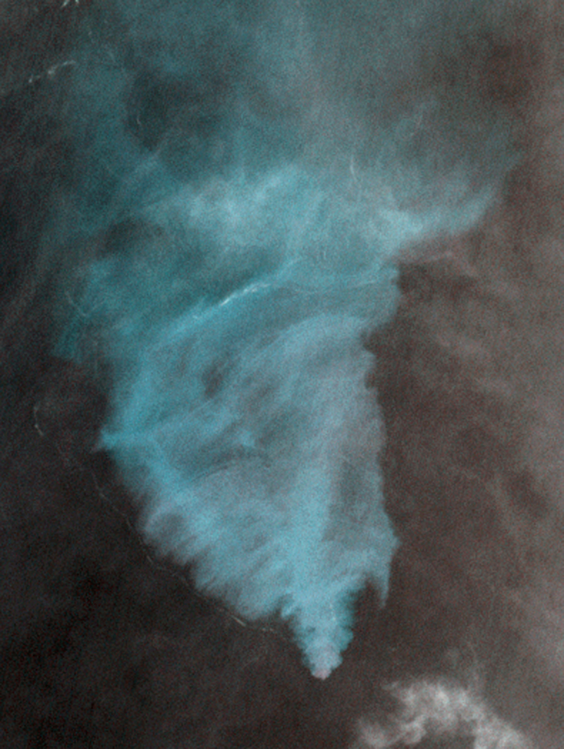 |
Figure 13. ASTER VNIR satellite image showing a submarine plume of discolored water originating above the summit of Kavachi, 24 March 2006. There appears to be turbulence at the ocean surface and a possible line of pumice along the lower left edge of the discolored area. Courtesy NASA/METI/AIST/Japan Spacesystems, and U.S./Japan ASTER Science Team, ASTER via the Image Database for Volcanoes. |
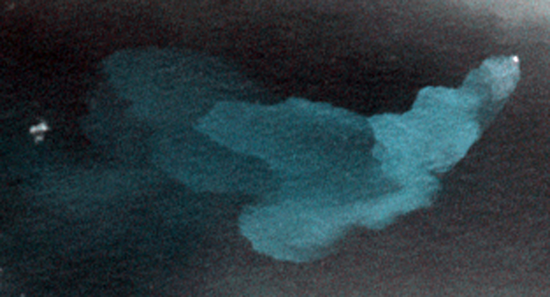 |
Figure 14. ASTER VNIR satellite image showing a submarine plume of discolored water originating above the summit of Kavachi, 15 June 2007. Distinct pulses of activity, possibly individual explosions at the bright surface origin spot, can be identified based on the increasing diffusion of suspended particulates with distance from the source. Courtesy NASA/METI/AIST/Japan Spacesystems, and U.S./Japan ASTER Science Team, ASTER via the Image Database for Volcanoes. |
 |
Figure 15. Satellite image showing an eruption plume from Kavachi on 20 March 2008 taken using the Enhanced Thematic Mapper on Landsat 7. Image modified using the "Percent Clip" option. Courtesy of USGS LandsatLook Viewer. |
An image on 11 November 2009 showed a larger very bright spot above the summit, possibly indicating turbulent activity at the ocean surface. Evidence of activity became more frequent in 2010, with imagery showing plumes on 15 February, 19 March, 23 June, 11 September, and 30 November. Submarine plumes continued to be visible often in ASTER images the following year, on 1 January, 13 March, 9 May, and 16 October 2011. The next available satellite image with a discolored submarine plume from Kavachi was on 9 April 2012. Additional plumes were seen on 16 April, 3 June (figure 16), 31 August, and 26 November 2012.
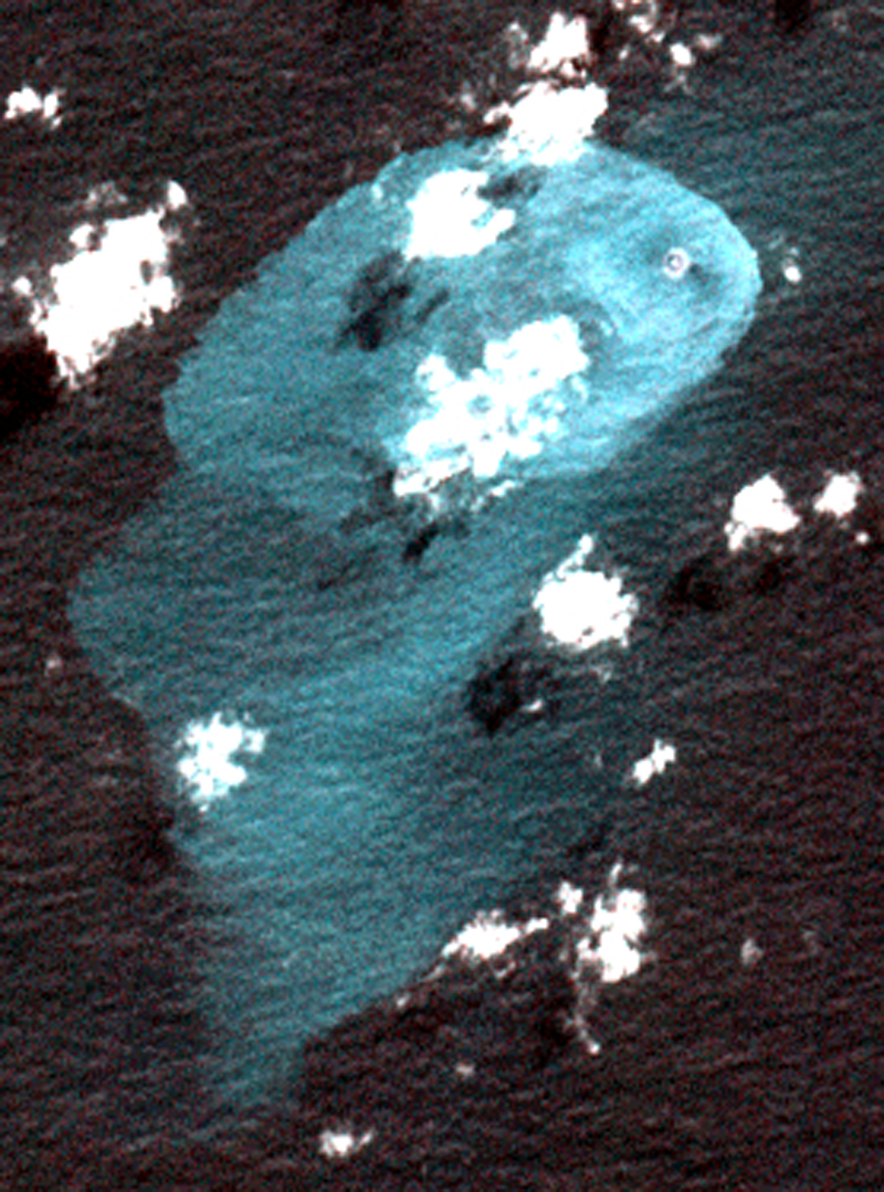 |
Figure 16. ASTER VNIR satellite image showing a submarine plume of discolored water originating above the summit of Kavachi, 3 June 2012. There appears to be a small island or area of persistent ash-laden surface turbulence at the source of the plume. Courtesy NASA/METI/AIST/Japan Spacesystems, and U.S./Japan ASTER Science Team, ASTER via the Image Database for Volcanoes. |
Intermittent satellite evidence of ongoing activity continued in 2013 with a discolored water plumes on 28 April, 15 June, 8 July, 25 August, 10 September, and 8 December. On 24 September 2013, Brennan Phillips of the University of Rhode Island passed within 2 km of the main peak onboard the M/Y Alucia but "did not see any visual eruptive activity on the surface."
Although the imagery is not conclusive, many of the ASTER images after 3 June 2012 appeared to show a small island. On 9 January 2014 the ASTER imagery was much clearer, providing greater visual evidence that eruptive activity had built a small island from which discolored water plumes were emanating (figure 17). A few weeks later, on 29 January, the Earth Observing 1 (EO1) Advanced Land Imager (ALI) obtained an image of a submarine plume (BGVN 39:07) and turbulent source area similar to those seen in ASTER imagery. Additional activity was in evidence on 21 March and 8 May.
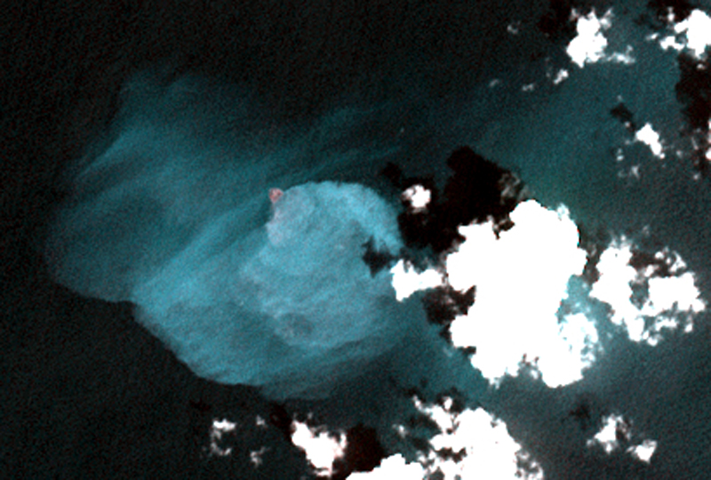 |
Figure 17. ASTER VNIR satellite image showing a submarine plume of discolored water originating above the summit of Kavachi, 9 January 2014. A distinct small island or area of persistent ash-laden surface turbulence can be readily identified at the source of the plume. Courtesy NASA/METI/AIST/Japan Spacesystems, and U.S./Japan ASTER Science Team, ASTER via the Image Database for Volcanoes. |
A cruise ship operated by EYOS Expeditions reported an eruption "at least four times" on 10 June 2014 (figure 18). The Expeditions' website noted that a staff member "spotted on the horizon discolored water and disturbances on the surface. As the vessel approached closer a few large plumes of water broke the surface about once every 10 minutes. Just before the ship left, however, [the] sea seemed to erupt and a massive plume of water and ash shot high into the air…." The island, or possibly an eruption exhibiting turbulence with abundant ash at the surface, appeared again on a 9 November 2014 image, and submarine plumes were evident in an 11 December 2014 image.
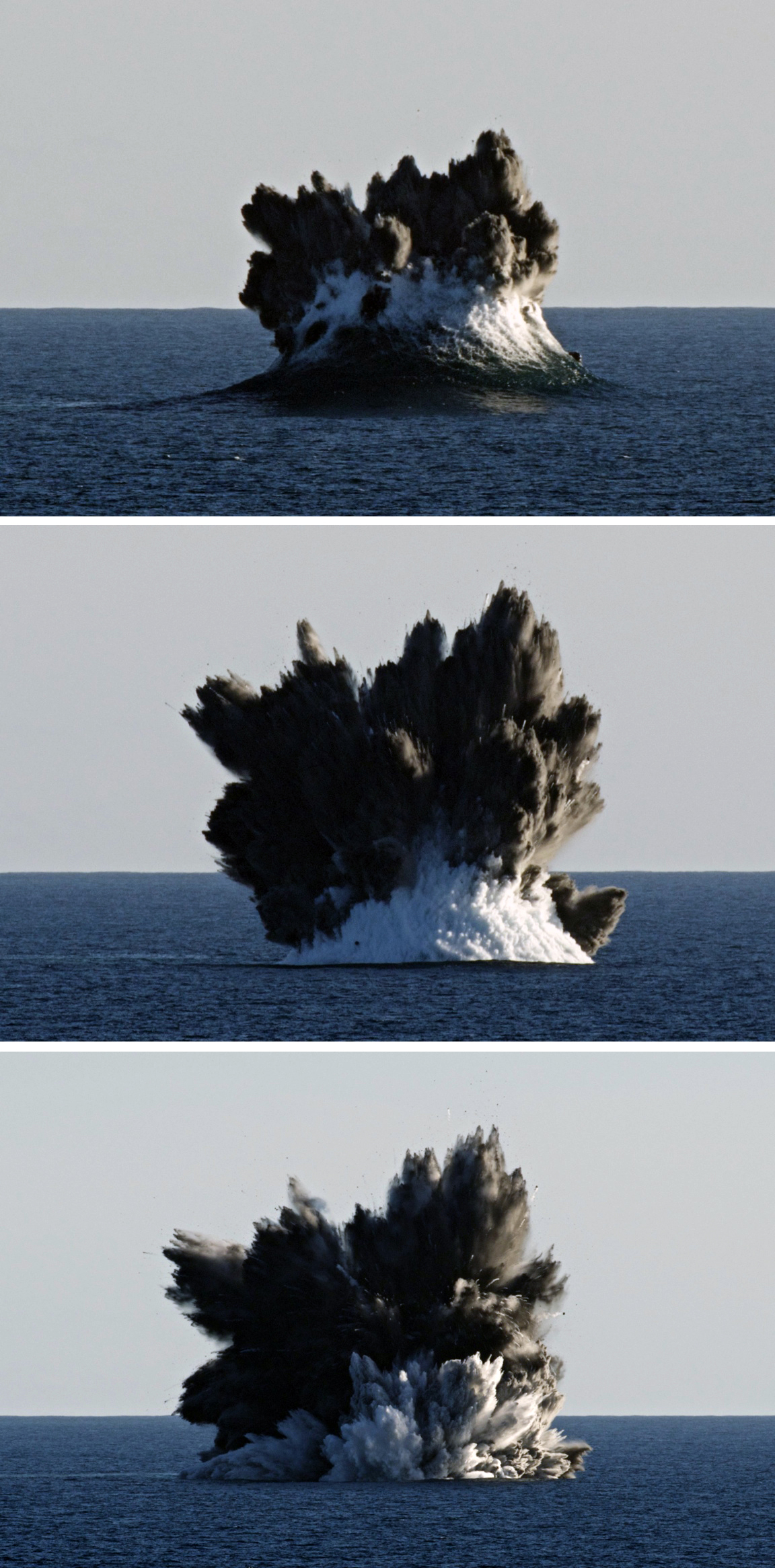 |
Figure 18. Photo of an eruption sequence from Kavachi on 10 June 2014 taken from a cruise ship. Courtesy of EYOS Expeditions. |
An expedition for National Geographic in January 2015 took place during a rare lull in volcanic activity that enabled access to the volcano for mapping and sampling. B. Phillips reported that no eruptive activity was seen while at the summit location on 12-14 and 18 January 2015, but there was a large surface plume and lots of off-gassing from the crater rim; ASTER imagery confirmed a plume of discolored water on 12 January. Autonomous cameras deployed directly into the crater observed sharks, reef fish, and what appear to larvaceans (National Geographic, 2015).
Satellite imagery showed discolored submarine plumes on 18 October 2015, but then not again until 26 August 2016. Eruptions were witnessed on a second visit by B. Phillips for National Geographic during 31 October-1 November 2016 (see National Geographic, 2017). Activity consisted of phreato-magmatic explosions approximately every 7 minutes that sent steam, ash, and incandescent tephra up to 50 m above the ocean surface. There was an occasional larger eruption roughly every hour. A remotely operated surface "drone" with a GoPro camera was right at the edge of the explosion but remained functional. Small lava particles stuck to the PVC hull of the vehicle itself were recovered and given to the Marine Geological Samples Laboratory (MGSL) of the Graduate School of Oceanography (GSO), University of Rhode Island."
Bathymetric survey. A paper by Phillips and others (2016) following the January 2015 visit included medium-resolution bathymetry of the main peak (figure 19), along with benthic imagery, biological observations, petrological and geochemical analysis of samples from the crater rim, measurement of water temperature and gas flux over the summit, and descriptions of the hydrothermal plume structure. Based on the bathymetry, the summit was described by Phillips and others (2016) as being oblong with a pockmarked crater measuring approximately 75 x 120 m, and a rim rising to an average of 24 m depth. The deepest soundings on the peak were about 70 m and indicated asymmetrical terrain surrounded by almost uniform flanks with 18° slopes that descend to depths greater than 1,000 m. They confirmed the existence of a "southwest extension," or secondary summit rising to 260 m depth 1.3 km SW of the main summit.
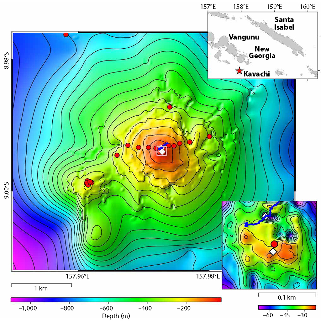 |
Figure 19. Bathymetry of Kavachi submarine volcano and the summit crater (inset, lower right). Red circles indicate locations of water column profiles and benthic imagery. White diamonds locate baited drop cameras deployments. The blue line delineates the path of a surface drifter that measured temperature and atmospheric CO2, The contour map and the inset at lower right were created from approximately 85,000 depth soundings visualized and edited as a three-dimensional point-cloud using IVS Fledermaus. The location map (upper right) was created with Generic Mapping Tools (v 4.5) using data available from Marine Geoscience Data System's Global Multi-Resolution Topography Data Synthesis (v 3.1). From Philips and others (2016). |
References: National Geographic, 2015, Sharks discovered inside underwater volcano (exclusive video) (URL: http://video.nationalgeographic.com/video/expedition-raw/150708-sciex-exraw-sharks-underwater-volcano; https://www.youtube.com/watch?v=0e3t18rrjOA).
National Geographic, 2017, Robot vs. Volcano: "Sometimes It's Just Fun to Blow Stuff Up" (exclusive) (URL: http://video.nationalgeographic.com/video/expedition-raw/170419-sciex-exraw-robot-vs-volcano-sometimes-just-fun-to-blow-stuff-up; https://www.youtube.com/watch?v=Ca0zAAIVK3E).
Phillips, B.T., Dunbabin, M., Henning, B., Howell, C., DeCiccio, A., Flinders, A., Kelley, K.A., Scott, J.J., Albert, S., Carey, S., Tsadok, R., and Grinham, A., 2016. Exploring the "Sharkcano": Biogeochemical observations of the Kavachi submarine volcano (Solomon Islands), Oceanography v. 29(4), p. 160-169 (https://doi.org/10.5670/oceanog.2016.85).
Information Contacts: EYOS Expeditions, Knox House, 16-18 Finch Rd, Douglas, Isle of Man, IM1 2PT (URL: http://www.eyos-expeditions.com/2014/07/kavachi-volcano/, https://my.yb.tl/eyosexpeditions/1604/); Brennan Phillips, Harvard University, Wyss Institute for Biologically Inspired Engineering, Wood Lab, 60 Oxford St., Cambridge, MA 02138 USA; Image Database for Volcanoes, Geological Survey of Japan, National Institute of Advanced Industrial Science and Technology (AIST) (URL: https://gbank.gsj.jp/vsidb/image/index-E.html, https://gbank.gsj.jp/vsidb/image/Kavachi/aster_p1.html); USGS LandsatLook Viewer (URL: https://landsatlook.usgs.gov/).
Discolored water plumes seen using satellite imagery in 2018 and 2020
Kavachi is a submarine volcano located in the Solomon Islands south of Gatokae and Vangunu islands. Volcanism is frequently active, but rarely observed. The most recent eruptions took place during 2014, which consisted of an ash eruption, and during 2016, which included phreatomagmatic explosions (BGVN 42:03). This reporting period covers December 2016-April 2020 primarily using satellite data.
Activity at Kavachi is often only observed through satellite images, and frequently consists of discolored submarine plumes for which the cause is uncertain. On 1 January 2018 a slight yellow discoloration in the water is seen extending to the E from a specific point (figure 20). Similar faint plumes were observed on 16 January, 25 February, 2 March, 26 April, 6 May, and 25 June 2018. No similar water discoloration was noted during 2019, though clouds may have obscured views.
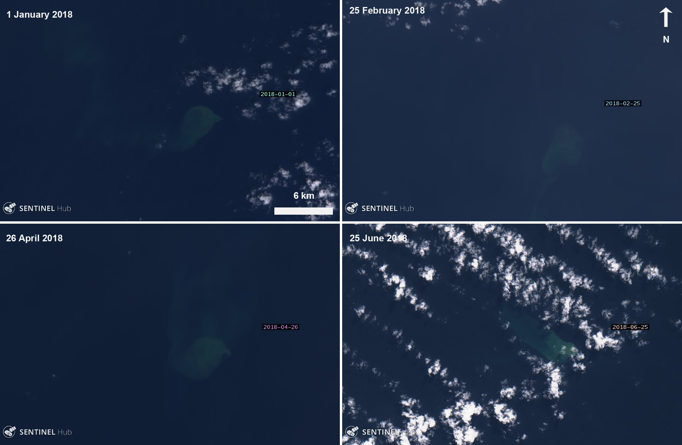 |
Figure 20. Satellite images from Sentinel-2 revealed intermittent faint water discoloration (yellow) at Kavachi during the first half of 2018, as seen here on 1 January (top left), 25 February (top right), 26 April (bottom left), and 25 June (bottom right). Images with “Natural color” rendering (bands 4, 3, 2); courtesy of Sentinel Hub Playground. |
Activity resumed in 2020, showing more discolored water in satellite imagery. The first instance occurred on 16 March, where a distinct plume extended from a specific point to the SE. On 25 April a satellite image showed a larger discolored plume in the water that spread over about 30 km2, encompassing the area around Kavachi (figure 21). Another image on 30 April showed a thin ribbon of discolored water extending about 50 km W of the vent.
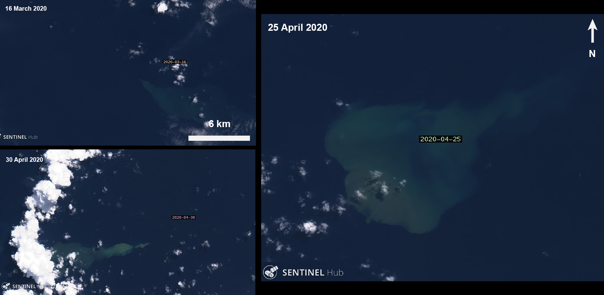 |
Figure 21. Sentinel-2 satellite images of a discolored plume (yellow) at Kavachi beginning on 16 March (top left) with a significant large plume on 25 April (right), which remained until 30 April (bottom left). Images with “Natural color” rendering (bands 4, 3, 2); courtesy of Sentinel Hub Playground. |
Information Contacts: Sentinel Hub Playground (URL: https://www.sentinel-hub.com/explore/sentinel-playground).
Discolored water plumes observed in satellite imagery during early September 2020
Kavachi is an active submarine volcano in the SW Pacific, located in the Solomon Islands south of Gatokae and Vangunu islands. Volcanism has been characterized by phreatomagmatic explosions that ejected steam, ash, and incandescent bombs. The previous report described discolored water plumes extending from a single point during early 2018 and April 2020 (BGVN 45:05); similar activity was recorded for this current reporting period covering May through September 2020 and primarily using satellite data.
Activity at Kavachi is most frequently observed through satellite images and typically consists of discolored submarine plumes. On 2 September 2020 a slight yellow discoloration in the water was observed extending E from a specific point (figure 22). Similar faint plumes continued to be recorded on 5, 7, 12, and 17 September, each of which seemed to be drifting generally E from a point source above the summit where previous activity has occurred. On 7 September the discolored plume was accompanied by white degassing and possibly agitated water on the surface at the origin point (figure 22).
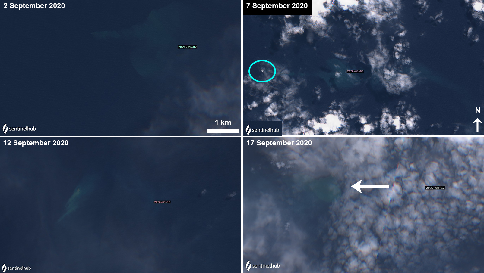 |
Figure 22. Sentinel-2 satellite images of a discolored plume (light yellow) at Kavachi beginning on 2 September (top left) and continuing through 17 September 2020 (bottom right). The light blue circle on the 7 September image highlights the surface degassing and source of the discolored water plume. The white arrow on the bottom right image is pointing to the faint discolored plume. Images with “Natural color” rendering (bands 4, 3, 2); courtesy of Sentinel Hub Playground. |
Information Contacts: Sentinel Hub Playground (URL: https://www.sentinel-hub.com/explore/sentinel-playground).
Discolored water plumes observed in satellite imagery during October 2020-April 2021
Kavachi is an active submarine volcano in the SW Pacific, located in the Solomon Islands south of Gatokae and Vangunu islands. Volcanism has been characterized by phreatomagmatic explosions that ejected steam, ash, and incandescent bombs. The previous report described discolored plumes extending from a single point during early September 2020 (BGVN 45:10); similar activity was recorded for this reporting period covering October 2020 through April 2021 using satellite data.
Activity at Kavachi is most frequently observed through Sentinel-2 satellite imagery and has recently been characterized by discolored submarine plumes. On 2 October 2020 a slight yellow-green discoloration in the water was observed extending NE from a specific point (figure 23). Similar faint discolored plumes were intermittently recorded on 27 October, 1 November 2020, and 25 January 2021, which each extended NE, SW, and SW, respectively, from a point source above the summit where previous activity has occurred. Intermittent discolored plumes were also visible during March 2021 (figure 24). The plume discoloration on 1 March extended S from the origin point. On 11 March, the discoloration remained near the origin point. A narrow plume extended several kilometers W on 26 March, followed by a short plume seen towards the NW on 31 March. The only plume seen in April was a broad diffuse area of discoloration extending S on the 10th (figure 24). No discoloration near the volcano was observed in May.
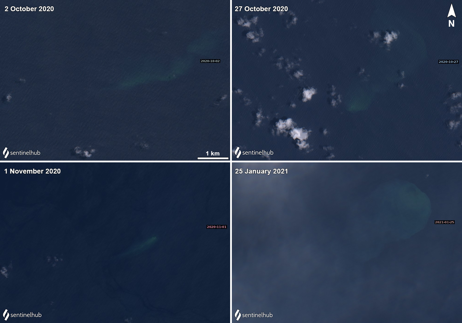 |
Figure 23. Sentinel-2 satellite images of a discolored plume (light yellow-green) at Kavachi beginning on 2 October 2020 (top left) that extended NE. Additional plumes were visible during clear weather on 27 October (top right) that extended NE, on 1 November (bottom left) 2020 that extended SW, and strongly on 25 January 2021 (bottom right) that extended SW. Images with “Natural color” rendering (bands 4, 3, 2). Courtesy of Sentinel Hub Playground. |
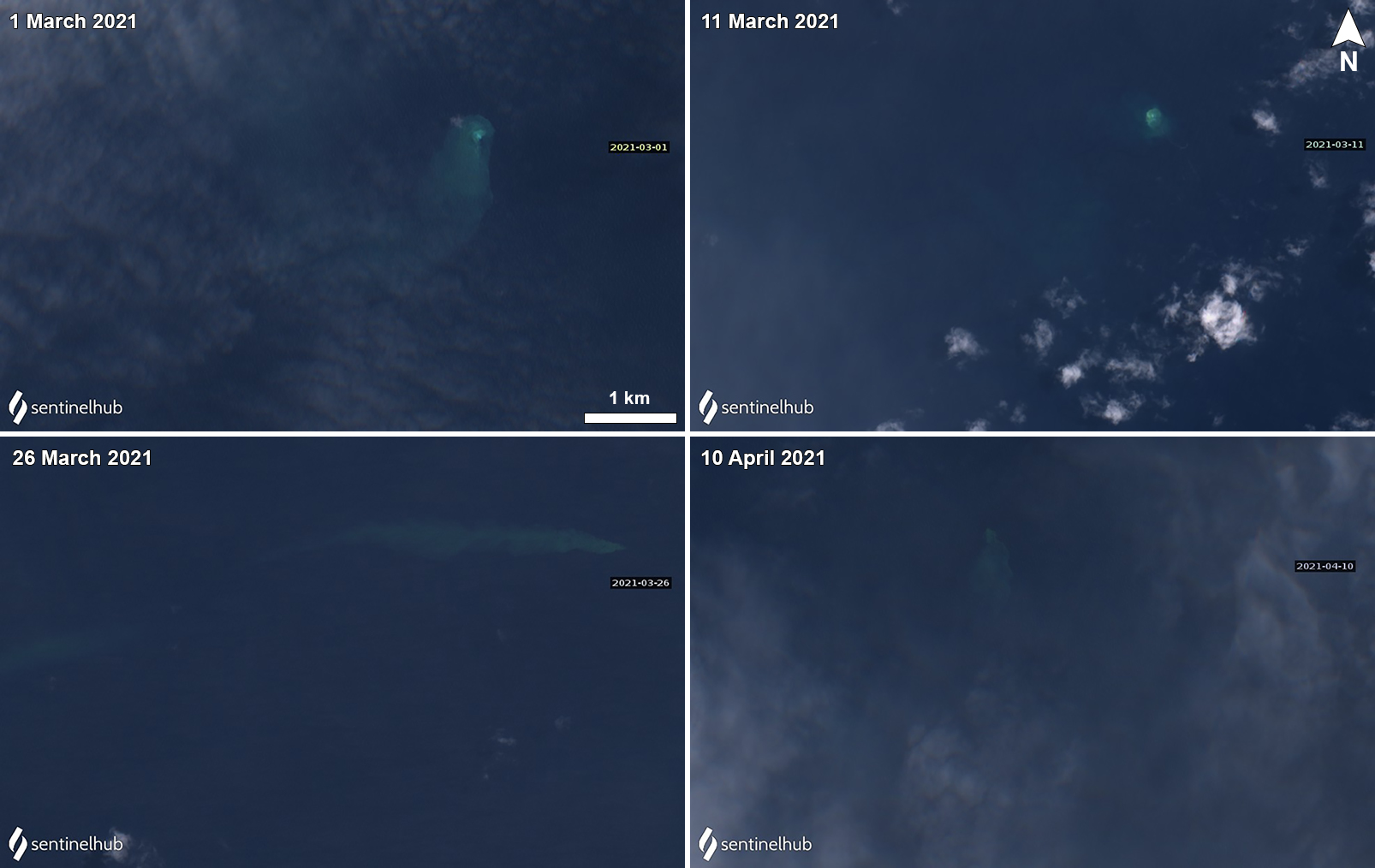 |
Figure 24. Sentinel-2 satellite imagery of discolored plumes (light yellow-green) at Kavachi during March-April 2021. On 1 March (top left) the plume was observed extending S with a strongly discolored origin point. On 11 March (top right) the plume remained close to the origin point and did not seem to extend outward. On 26 March (bottom left) the plume was narrow and strongly extended W for several kilometers. On 10 April (bottom right) the plume extended S. Images with “Natural color” rendering (bands 4, 3, 2). Courtesy of Sentinel Hub Playground. |
Information Contacts: Sentinel Hub Playground (URL: https://www.sentinel-hub.com/explore/sentinel-playground).
Discolored water plumes observed in satellite imagery during October 2021
Kavachi is an active submarine volcano in the SW Pacific, located in the Solomon Islands south of Gatokae and Vangunu islands. Volcanism has been characterized by phreatomagmatic explosions that ejected steam, ash, and incandescent bombs. The previous report described intermittent discolored plumes extending from a single point during October 2020 through 10 April 2021 (BGVN 46:06); similar activity was recorded for this reporting period covering May through October 2021 using satellite data.
Activity at Kavachi is primarily observed through Sentinel-2 natural color satellite imagery and has shown occasional discolored (light yellow-green) submarine plumes during late 2020 and into early 2021. After a period of no visible discolored water, the first observation of faint discoloration occurred on 7 October that originated from a specific point and extended generally E (figure 25). Another narrow plume was visible on 12 October that was more defined and stronger in color, extending initially SE and then turning E for several kilometers. Two other plumes that seemed to originate from the same location as the previous 7 and 12 October plumes were faintly visible on 17 and 27 October that extended E and SE, respectively for several kilometers. The one on the 27th extended over a broader area to the SE.
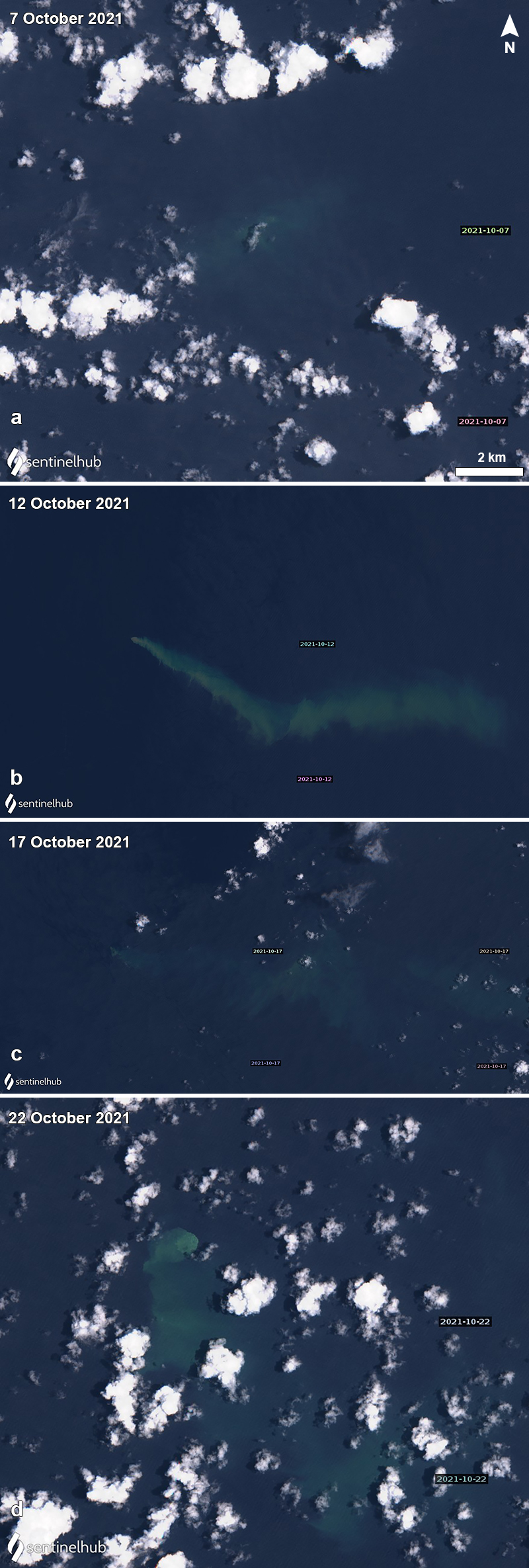 |
Figure 25. Sentinel-2 satellite imagery of discolored plumes (light yellow-green) at Kavachi during October 2021. On 7 October (a) the plume was a faint yellow-green and drifted from a single origin point. On 12 October (b) the plume was stronger and extended SE and then E. The plume continued to drift E on 17 October (c), though it was weaker compared to the previous capture. Then, on 27 October (d) a strong yellow-green plume was visible drifting S from its point of origin for several kilometers. Images with “Natural color” rendering (bands 4, 3, 2). Courtesy of Sentinel Hub Playground. |
Information Contacts: Sentinel Hub Playground (URL: https://www.sentinel-hub.com/explore/sentinel-playground).
Discolored water plumes intermittently observed in satellite imagery during November 2021-July 2022
Kavachi is an active submarine volcano in the SW Pacific, located in the Solomon Islands south of Gatokae and Vangunu islands. Its first recorded eruption occurred during 1939, and since then it has produced many ephemeral islands up to 1 km long where occasionally lava flows were observed. Volcanism has been characterized by phreatomagmatic explosions that ejected steam, ash, and incandescent bombs. The previous report described intermittent discolored plumes extending from a single point during October 2021 (BGVN 46:11). This report covers similar activity of discolored water during November 2021 through July 2022 based on satellite images.
Observations using Sentinel-2 natural color satellite imagery have shown occasional discolored (light yellow-green) submarine plumes originating from a single point during each month of the reporting period. On 1 November 2021 a light yellow-green plume was partially visible beneath cloud cover, which seemed to disperse to the W (figure 26). Plumes were visible in satellite images during 4, 14, and 19 (figure 27) February, which dispersed to the E, S, and E, respectively. On 1 March a strongly colored plume appeared brown above the source vent and extended NW (figure 27). Another one on 6 March extended SW and was lighter in color. Slightly discolored plumes were visible on 11, 16, and 21 March. A large plume visible on 20 April drifted slightly to the SW, though it remained relatively close to its point of origin. Another plume on 25 April extended from its point of origin toward the NW (figure 27). The head of the blue was brownish in color. Small to moderate discolored plumes were detected on 5, 15 (figure 27), 20, and 30 May. On 9 June a narrow plume and extended to the NE (figure 27), followed by weaker plumes on 19 and 29 June. On 4 July the plume was fan shaped, dispersing to the SE and E on 9 July. Other discolored plumes were visible on 14, 19, 24, and 29 July; on 24 July the plume was relatively strong, extended S, and was brown above the source vent (figure 27).
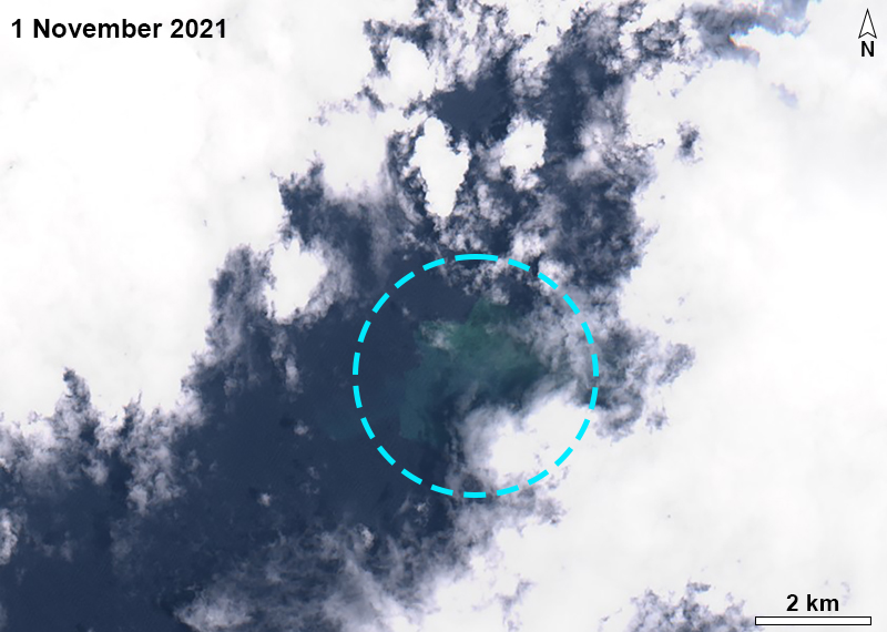 |
Figure 26. Sentinel-2 satellite image showing a light yellow-green discolored plume (blue circle) beneath cloud cover at Kavachi on 1 November 2021. Image with “Natural color” rendering (bands 4, 3, 2). Courtesy of Sentinel Hub Playground. |
 |
Figure 27. Sentinel-2 satellite images showing light yellow-green discolored plumes on 19 February 2022 (top left), 1 March 2022 (top right), 25 April 2022 (middle left), 15 May 2022 (middle right), 9 June 2022 (bottom left), and 24 July 2022 (bottom right). The plumes varied in strength and length, and drifted in different directions, often from a single point of origin. Images with “Natural color” rendering (bands 4, 3, 2). Courtesy of Sentinel Hub Playground. |
Information Contacts: Sentinel Hub Playground (URL: https://www.sentinel-hub.com/explore/sentinel-playground).
Discolored water plumes observed intermittently during August 2022-January 2023
Kavachi is an active submarine volcano in the SW Pacific, located in the Solomon Islands south of Gatokae and Vangunu islands. Its first recorded eruption occurred in 1939, and since then it has produced many ephemeral islands up to 1 km long where occasionally lava flows were observed. Volcanism has been characterized by phreatomagmatic explosions that ejected steam, ash, and incandescent bombs. The previous report described intermittent discolored water plumes based on Sentinel-2 natural color satellite imagery (BGVN 47:08). This report covers similar activity of discolored water during August 2022 through January 2023 using satellite imagery.
Observations using Sentinel-2 natural color satellite imagery showed occasional discolored (light yellow-green) submarine plumes that generally originated from a single point during each month of the reporting period (figure 28). The discolored water drifted or extended in various directions, usually different with every observation. Four discolored plumes were visible on 3, 8, 13, and 23 August; a translucent, milky brown color surrounded the origin point on 8 August, and as the plume extended S the color was lighter yellow-green. Four discolored plumes were visible on 2, 7, 12, and 22 September; the plume on 7 September extended for several kilometers to the SE and the area around the origin point was a translucent milky brown color (figure 28). The color of the plumes on 12 and 22 September appeared less intense compared to the previous plumes during the month.
|
Figure 28. Sentinel-2 satellite images showing light yellow-green discolored plumes of water above Kavachi on 13 August 2022 (top left), 7 September 2022 (top right), 27 October 2022 (middle left), 21 November 2022 (middle right), 11 December 2022 (bottom left), and 5 January 2023 (bottom right). The plumes varied in intensity, length, and direction, though they all originated from a single point. Images with “Natural color” rendering (bands 4, 3, 2). Courtesy of Sentinel Hub Playground. |
Plumes were detected in satellite imagery drifting various directions on 2, 7, 12, 17, and 27 October, with additional sightings on 1, 6, and 21 November. A weather cloud covered most of the view of the discolored plume on 6 December, though on 11 December the affected area seemed relatively stationary above the origin point (figure 28). There was a small translucent circle of milky brown discolored water in the center, surrounded by lighter yellow-green discolored water. On 16 December a faint discolored plume extended NE. A strong discolored plume was visible on 5 January 2023 that extended W; the water around the origin point was a translucent, milky brown color that lightened to yellow-green as it extended farther away (figure 28). On 15, 20, and 30 January the plumes extended W, W, and NE; the plumes on 15 and 30 January were relatively narrow and were several kilometers long.
Information Contacts: Sentinel Hub Playground (URL: https://www.sentinel-hub.com/explore/sentinel-playground).
This compilation of synonyms and subsidiary features may not be comprehensive. Features are organized into four major categories: Cones, Craters, Domes, and Thermal Features. Synonyms of features appear indented below the primary name. In some cases additional feature type, elevation, or location details are provided.
Synonyms |
| Kovachi | Rejo te Kavachi |
|
|
||||||||||||||||||||||||
There is data available for 34 confirmed Holocene eruptive periods.
2021 Oct 2 - 2024 Mar 1 (continuing) Confirmed Eruption Max VEI: 0
| Episode 1 | Submarine Episode | |||||||||||||||
|---|---|---|---|---|---|---|---|---|---|---|---|---|---|---|---|
| 2021 Oct 2 - 2024 Mar 1 (continuing) | Evidence from Observations: Satellite (visual) | ||||||||||||||
|
List of 1 Events for Episode 1
| |||||||||||||||
2020 Sep 2 - 2021 Apr 10 Confirmed Eruption Max VEI: 0
| Episode 1 | Eruption Episode | |||||||||||||||
|---|---|---|---|---|---|---|---|---|---|---|---|---|---|---|---|
| 2020 Sep 2 - 2021 Apr 10 | Evidence from Observations: Reported | ||||||||||||||
|
List of 1 Events for Episode 1
| |||||||||||||||
2020 Mar 16 - 2020 Apr 30 Confirmed Eruption Max VEI: 0
| Episode 1 | Eruption Episode | |||||||||||||||
|---|---|---|---|---|---|---|---|---|---|---|---|---|---|---|---|
| 2020 Mar 16 - 2020 Apr 30 | Evidence from Observations: Reported | ||||||||||||||
|
List of 1 Events for Episode 1
| |||||||||||||||
2014 Jan 29 - 2014 Jan 29 (?) Confirmed Eruption Max VEI: 1
| Episode 1 | Eruption Episode | Submarine | |||||||||||||||||||
|---|---|---|---|---|---|---|---|---|---|---|---|---|---|---|---|---|---|---|---|---|
| 2014 Jan 29 - 2014 Jan 29 (?) | Evidence from Observations: Satellite (visual) | |||||||||||||||||||
|
List of 2 Events for Episode 1 at Submarine
| ||||||||||||||||||||
2007 Apr 2 (?) - 2007 Apr 6 (in or after) Confirmed Eruption Max VEI: 1
| Episode 1 | Eruption Episode | |||||||||||||||||||||||||
|---|---|---|---|---|---|---|---|---|---|---|---|---|---|---|---|---|---|---|---|---|---|---|---|---|---|
| 2007 Apr 2 (?) - 2007 Apr 6 (in or after) | Evidence from Observations: Reported | ||||||||||||||||||||||||
|
List of 3 Events for Episode 1
| |||||||||||||||||||||||||
2004 Mar 15 Confirmed Eruption Max VEI: 1
| Episode 1 | Eruption Episode | ||||||||||||||||||||
|---|---|---|---|---|---|---|---|---|---|---|---|---|---|---|---|---|---|---|---|---|
| 2004 Mar 15 - Unknown | Evidence from Observations: Reported | |||||||||||||||||||
|
List of 2 Events for Episode 1
| ||||||||||||||||||||
1999 Nov 16 (?) ± 15 days - 2003 Aug 16 ± 15 days Confirmed Eruption Max VEI: 1
| Episode 1 | Eruption Episode | |||||||||||||||||||||||||||||||||||
|---|---|---|---|---|---|---|---|---|---|---|---|---|---|---|---|---|---|---|---|---|---|---|---|---|---|---|---|---|---|---|---|---|---|---|---|
| 1999 Nov 16 (?) ± 15 days - 2003 Aug 16 ± 15 days | Evidence from Observations: Reported | ||||||||||||||||||||||||||||||||||
|
List of 5 Events for Episode 1
| |||||||||||||||||||||||||||||||||||
1999 Feb 16 ± 15 days - 1999 May 16 ± 15 days Confirmed Eruption Max VEI: 1
| Episode 1 | Eruption Episode | ||||||||||||||||||||
|---|---|---|---|---|---|---|---|---|---|---|---|---|---|---|---|---|---|---|---|---|
| 1999 Feb 16 ± 15 days - 1999 May 16 ± 15 days | Evidence from Observations: Reported | |||||||||||||||||||
|
List of 2 Events for Episode 1
| ||||||||||||||||||||
[ 1998 Jul 2 ± 182 days ] Uncertain Eruption
| Episode 1 | Eruption Episode | |||||||||||||||
|---|---|---|---|---|---|---|---|---|---|---|---|---|---|---|---|
| 1998 Jul 2 ± 182 days - Unknown | Evidence from Unknown | ||||||||||||||
|
List of 1 Events for Episode 1
| |||||||||||||||
1997 Jan 16 - 1997 Jan 17 (in or after) Confirmed Eruption Max VEI: 1
| Episode 1 | Eruption Episode | |||||||||||||||||||||||||
|---|---|---|---|---|---|---|---|---|---|---|---|---|---|---|---|---|---|---|---|---|---|---|---|---|---|
| 1997 Jan 16 - 1997 Jan 17 (in or after) | Evidence from Observations: Reported | ||||||||||||||||||||||||
|
List of 3 Events for Episode 1
| |||||||||||||||||||||||||
1991 May 4 (in or before) - 1991 Sep 16 ± 15 days Confirmed Eruption Max VEI: 2
| Episode 1 | Eruption Episode | ||||||||||||||||||||||||||||||||||||||||
|---|---|---|---|---|---|---|---|---|---|---|---|---|---|---|---|---|---|---|---|---|---|---|---|---|---|---|---|---|---|---|---|---|---|---|---|---|---|---|---|---|
| 1991 May 4 (in or before) - 1991 Sep 16 ± 15 days | Evidence from Observations: Reported | |||||||||||||||||||||||||||||||||||||||
|
List of 6 Events for Episode 1
| ||||||||||||||||||||||||||||||||||||||||
1986 Jul 5 - 1986 Jul 23 Confirmed Eruption Max VEI: 1
| Episode 1 | Eruption Episode | ||||||||||||||||||||||||||||||
|---|---|---|---|---|---|---|---|---|---|---|---|---|---|---|---|---|---|---|---|---|---|---|---|---|---|---|---|---|---|---|
| 1986 Jul 5 - 1986 Jul 23 | Evidence from Observations: Reported | |||||||||||||||||||||||||||||
|
List of 4 Events for Episode 1
| ||||||||||||||||||||||||||||||
1985 Dec 9 - 1986 Feb 28 ± 3 days Confirmed Eruption Max VEI: 1
| Episode 1 | Eruption Episode | |||||||||||||||||||||||||
|---|---|---|---|---|---|---|---|---|---|---|---|---|---|---|---|---|---|---|---|---|---|---|---|---|---|
| 1985 Dec 9 - 1986 Feb 28 ± 3 days | Evidence from Observations: Reported | ||||||||||||||||||||||||
|
List of 3 Events for Episode 1
| |||||||||||||||||||||||||
1982 Apr 7 - 1982 Jun 2 ± 1 days Confirmed Eruption Max VEI: 2
| Episode 1 | Eruption Episode | ||||||||||||||||||||
|---|---|---|---|---|---|---|---|---|---|---|---|---|---|---|---|---|---|---|---|---|
| 1982 Apr 7 - 1982 Jun 2 ± 1 days | Evidence from Observations: Reported | |||||||||||||||||||
|
List of 2 Events for Episode 1
| ||||||||||||||||||||
[ 1981 Sep 15 ± 5 days ] Uncertain Eruption
| Episode 1 | Eruption Episode | |||||||||||||||
|---|---|---|---|---|---|---|---|---|---|---|---|---|---|---|---|
| 1981 Sep 15 ± 5 days - Unknown | Evidence from Unknown | ||||||||||||||
|
List of 1 Events for Episode 1
| |||||||||||||||
1980 Oct 7 - 1981 Feb 25 Confirmed Eruption Max VEI: 1
| Episode 1 | Eruption Episode | |||||||||||||||||||||||||
|---|---|---|---|---|---|---|---|---|---|---|---|---|---|---|---|---|---|---|---|---|---|---|---|---|---|
| 1980 Oct 7 - 1981 Feb 25 | Evidence from Observations: Reported | ||||||||||||||||||||||||
|
List of 3 Events for Episode 1
| |||||||||||||||||||||||||
1978 Jun 21 - 1978 Jul 22 ± 6 days Confirmed Eruption Max VEI: 2
| Episode 1 | Eruption Episode | |||||||||||||||||||||||||||||||||||||||||||||
|---|---|---|---|---|---|---|---|---|---|---|---|---|---|---|---|---|---|---|---|---|---|---|---|---|---|---|---|---|---|---|---|---|---|---|---|---|---|---|---|---|---|---|---|---|---|
| 1978 Jun 21 - 1978 Jul 22 ± 6 days | Evidence from Observations: Reported | ||||||||||||||||||||||||||||||||||||||||||||
|
List of 7 Events for Episode 1
| |||||||||||||||||||||||||||||||||||||||||||||
1977 Jul 17 (?) - 1977 Jul 22 Confirmed Eruption Max VEI: 1
| Episode 1 | Eruption Episode | ||||||||||||||||||||||||||||||
|---|---|---|---|---|---|---|---|---|---|---|---|---|---|---|---|---|---|---|---|---|---|---|---|---|---|---|---|---|---|---|
| 1977 Jul 17 (?) - 1977 Jul 22 | Evidence from Observations: Reported | |||||||||||||||||||||||||||||
|
List of 4 Events for Episode 1
| ||||||||||||||||||||||||||||||
1977 Feb 22 Confirmed Eruption Max VEI: 1
| Episode 1 | Eruption Episode | |||||||||||||||||||||||||
|---|---|---|---|---|---|---|---|---|---|---|---|---|---|---|---|---|---|---|---|---|---|---|---|---|---|
| 1977 Feb 22 - Unknown | Evidence from Observations: Reported | ||||||||||||||||||||||||
|
List of 3 Events for Episode 1
| |||||||||||||||||||||||||
1976 Aug 24 - 1976 Oct 13 Confirmed Eruption Max VEI: 1
| Episode 1 | Eruption Episode | |||||||||||||||||||||||||||||||||||
|---|---|---|---|---|---|---|---|---|---|---|---|---|---|---|---|---|---|---|---|---|---|---|---|---|---|---|---|---|---|---|---|---|---|---|---|
| 1976 Aug 24 - 1976 Oct 13 | Evidence from Observations: Reported | ||||||||||||||||||||||||||||||||||
|
List of 5 Events for Episode 1
| |||||||||||||||||||||||||||||||||||
1975 Aug 16 ± 15 days Confirmed Eruption Max VEI: 1
| Episode 1 | Eruption Episode | |||||||||||||||||||||||||||||||||||
|---|---|---|---|---|---|---|---|---|---|---|---|---|---|---|---|---|---|---|---|---|---|---|---|---|---|---|---|---|---|---|---|---|---|---|---|
| 1975 Aug 16 ± 15 days - Unknown | Evidence from Observations: Reported | ||||||||||||||||||||||||||||||||||
|
List of 5 Events for Episode 1
| |||||||||||||||||||||||||||||||||||
1974 Nov 12 - 1974 Dec 12 (?) Confirmed Eruption Max VEI: 1
| Episode 1 | Eruption Episode | |||||||||||||||||||||||||
|---|---|---|---|---|---|---|---|---|---|---|---|---|---|---|---|---|---|---|---|---|---|---|---|---|---|
| 1974 Nov 12 - 1974 Dec 12 (?) | Evidence from Observations: Reported | ||||||||||||||||||||||||
|
List of 3 Events for Episode 1
| |||||||||||||||||||||||||
1972 Oct 24 Confirmed Eruption Max VEI: 0
| Episode 1 | Eruption Episode | ||||||||||||||||||||
|---|---|---|---|---|---|---|---|---|---|---|---|---|---|---|---|---|---|---|---|---|
| 1972 Oct 24 - Unknown | Evidence from Observations: Reported | |||||||||||||||||||
|
List of 2 Events for Episode 1
| ||||||||||||||||||||
1969 Oct 28 - 1970 Feb 6 Confirmed Eruption Max VEI: 2
| Episode 1 | Eruption Episode | |||||||||||||||||||||||||||||||||||||||||||||
|---|---|---|---|---|---|---|---|---|---|---|---|---|---|---|---|---|---|---|---|---|---|---|---|---|---|---|---|---|---|---|---|---|---|---|---|---|---|---|---|---|---|---|---|---|---|
| 1969 Oct 28 - 1970 Feb 6 | Evidence from Observations: Reported | ||||||||||||||||||||||||||||||||||||||||||||
|
List of 7 Events for Episode 1
| |||||||||||||||||||||||||||||||||||||||||||||
1966 Mar 19 - 1966 Mar 22 (in or after) Confirmed Eruption Max VEI: 2
| Episode 1 | Eruption Episode | ||||||||||||||||||||||||||||||
|---|---|---|---|---|---|---|---|---|---|---|---|---|---|---|---|---|---|---|---|---|---|---|---|---|---|---|---|---|---|---|
| 1966 Mar 19 - 1966 Mar 22 (in or after) | Evidence from Observations: Reported | |||||||||||||||||||||||||||||
|
List of 4 Events for Episode 1
| ||||||||||||||||||||||||||||||
1965 Dec 11 - 1965 Dec 13 Confirmed Eruption Max VEI: 2
| Episode 1 | Eruption Episode | ||||||||||||||||||||||||||||||
|---|---|---|---|---|---|---|---|---|---|---|---|---|---|---|---|---|---|---|---|---|---|---|---|---|---|---|---|---|---|---|
| 1965 Dec 11 - 1965 Dec 13 | Evidence from Observations: Reported | |||||||||||||||||||||||||||||
|
List of 4 Events for Episode 1
| ||||||||||||||||||||||||||||||
1963 Dec 14 - 1964 Jan 31 (?) Confirmed Eruption Max VEI: 2
| Episode 1 | Eruption Episode | ||||||||||||||||||||||||||||||||||||||||
|---|---|---|---|---|---|---|---|---|---|---|---|---|---|---|---|---|---|---|---|---|---|---|---|---|---|---|---|---|---|---|---|---|---|---|---|---|---|---|---|---|
| 1963 Dec 14 - 1964 Jan 31 (?) | Evidence from Observations: Reported | |||||||||||||||||||||||||||||||||||||||
|
List of 6 Events for Episode 1
| ||||||||||||||||||||||||||||||||||||||||
1962 Jan 16 ± 15 days - 1962 Feb 16 ± 15 days Confirmed Eruption Max VEI: 2
| Episode 1 | Eruption Episode | ||||||||||||||||||||
|---|---|---|---|---|---|---|---|---|---|---|---|---|---|---|---|---|---|---|---|---|
| 1962 Jan 16 ± 15 days - 1962 Feb 16 ± 15 days | Evidence from Observations: Reported | |||||||||||||||||||
|
List of 2 Events for Episode 1
| ||||||||||||||||||||
1961 Mar 28 (in or before) Confirmed Eruption Max VEI: 2
| Episode 1 | Eruption Episode | |||||||||||||||||||||||||||||||||||
|---|---|---|---|---|---|---|---|---|---|---|---|---|---|---|---|---|---|---|---|---|---|---|---|---|---|---|---|---|---|---|---|---|---|---|---|
| 1961 Mar 28 (in or before) - Unknown | Evidence from Observations: Reported | ||||||||||||||||||||||||||||||||||
|
List of 5 Events for Episode 1
| |||||||||||||||||||||||||||||||||||
1958 Nov 21 - 1958 Dec 2 (?) Confirmed Eruption Max VEI: 0
| Episode 1 | Eruption Episode | ||||||||||||||||||||||||||||||
|---|---|---|---|---|---|---|---|---|---|---|---|---|---|---|---|---|---|---|---|---|---|---|---|---|---|---|---|---|---|---|
| 1958 Nov 21 - 1958 Dec 2 (?) | Evidence from Observations: Reported | |||||||||||||||||||||||||||||
|
List of 4 Events for Episode 1
| ||||||||||||||||||||||||||||||
1957 Feb 8 Confirmed Eruption Max VEI: 0
| Episode 1 | Eruption Episode | ||||||||||||||||||||
|---|---|---|---|---|---|---|---|---|---|---|---|---|---|---|---|---|---|---|---|---|
| 1957 Feb 8 - Unknown | Evidence from Observations: Reported | |||||||||||||||||||
|
List of 2 Events for Episode 1
| ||||||||||||||||||||
1952 Apr 16 - 1953 Jan 31 (?) Confirmed Eruption Max VEI: 2
| Episode 1 | Eruption Episode | |||||||||||||||||||||||||||||||||||
|---|---|---|---|---|---|---|---|---|---|---|---|---|---|---|---|---|---|---|---|---|---|---|---|---|---|---|---|---|---|---|---|---|---|---|---|
| 1952 Apr 16 - 1953 Jan 31 (?) | Evidence from Observations: Reported | ||||||||||||||||||||||||||||||||||
|
List of 5 Events for Episode 1
| |||||||||||||||||||||||||||||||||||
1951 Dec 1 ± 30 days Confirmed Eruption Max VEI: 2
| Episode 1 | Eruption Episode | |||||||||||||||||||||||||||||||||||
|---|---|---|---|---|---|---|---|---|---|---|---|---|---|---|---|---|---|---|---|---|---|---|---|---|---|---|---|---|---|---|---|---|---|---|---|
| 1951 Dec 1 ± 30 days - Unknown | Evidence from Observations: Reported | ||||||||||||||||||||||||||||||||||
|
List of 5 Events for Episode 1
| |||||||||||||||||||||||||||||||||||
1950 Dec 1 ± 30 days Confirmed Eruption Max VEI: 2
| Episode 1 | Eruption Episode | ||||||||||||||||||||||||||||||
|---|---|---|---|---|---|---|---|---|---|---|---|---|---|---|---|---|---|---|---|---|---|---|---|---|---|---|---|---|---|---|
| 1950 Dec 1 ± 30 days - Unknown | Evidence from Observations: Reported | |||||||||||||||||||||||||||||
|
List of 4 Events for Episode 1
| ||||||||||||||||||||||||||||||
1942 (?) Confirmed Eruption Max VEI: 1
| Episode 1 | Eruption Episode | ||||||||||||||||||||
|---|---|---|---|---|---|---|---|---|---|---|---|---|---|---|---|---|---|---|---|---|
| 1942 (?) - Unknown | Evidence from Observations: Reported | |||||||||||||||||||
|
List of 2 Events for Episode 1
| ||||||||||||||||||||
1939 Apr 30 (?) Confirmed Eruption Max VEI: 2
| Episode 1 | Eruption Episode | |||||||||||||||||||||||||
|---|---|---|---|---|---|---|---|---|---|---|---|---|---|---|---|---|---|---|---|---|---|---|---|---|---|
| 1939 Apr 30 (?) - Unknown | Evidence from Observations: Reported | ||||||||||||||||||||||||
|
List of 3 Events for Episode 1
| |||||||||||||||||||||||||
There is no Deformation History data available for Kavachi.
There is no Emissions History data available for Kavachi.
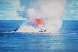 Incandescent rock and steam rise above the sea at Kavachi volcano in the Solomon Islands. By the time of this 30 June 1978 photo the vent of the submarine volcano had reached the sea surface. Dark extruded lava can be seen through the steam, with the plume rising a few thousand meters into the air. There was no sign of the submarine volcano on 20 June but the following day an eruption was observed. By the 22nd there was a 30-50 m wide island erupting incandescent lava.
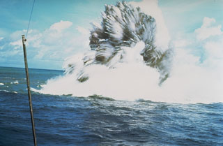 A shallow phreatomagmatic, or Surtseyan eruption from Kavachi volcano on 17 or 18 July 1977. Jets of dark ash can be seen emerging from white steam plumes. Numerous individual blocks ejected at high velocity are trailed by steam. Similar activity was observed from boats and airplanes for a period of less than one week.
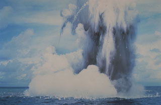 Submarine explosions from Kavachi volcano eject a cock’s-tail plume of water, steam, and ash above the sea surface in July 1977. Large ejected blocks are visible falling from the plume and impacting the sea surface. Similar activity was observed over a period of less than a week.
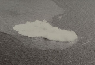 Submarine explosions took place at Kavachi from 28 October to 7 November 1969. This photo on the first day of the eruption shows steam rising above an area of water discoloration. Renewed explosions began on 22 December and a new island was first seen on 30 January. The last eruptions were observed on 6 February and the new island was eroded to below sea level by wave action between 7-17 February.
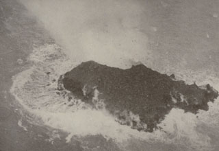 A newly-formed island at Kavachi on 9 September 1976. Submarine explosions ejected fountains of water and rock about 60 m high on 24 August. Similar activity was observed 4-6 September. By the 7th, lava effusion was observed. Lava flows ceased between 9-11 September, but explosions continued, and by the 15th the island was 100 m long. By 6 October the island was eroded. Explosive eruptions were last observed on 13 October from a vent estimated to be less than 15 m below sea level.
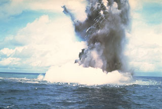 A Surtseyan cock’s-tail plume rises above the sea surface at Kavachi volcano on 17 or 18 July 1977. Additional explosions were seen 19-22 July, with vapor and ash clouds reaching several hundred feet above the sea surface. This activity is typical of submarine eruptions from Kavachi, one of the most active volcanoes of the Solomon Islands. At least eight new ephemeral islands have been formed since an eruption in 1939.
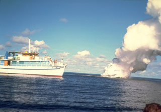 A submarine eruption from Kavachi volcano in July 1977. It is one of the most active submarine volcanoes in the SW Pacific, but is located far from major aircraft and shipping lanes. Sometimes referred to as Rejo te Kvachi ("Kavachi's Oven"), it has produced ephemeral islands up to 150 m long at least eight times since 1939.
 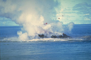 Clots of incandescent magma rise above Kavachi on 30 June 1978 after the vent of the submarine volcano had reached the sea surface. No eruptive activity was observed on 20 June, but there was an eruption the following day. On 22 June a 30-50 m island was observed erupting incandescent lava and gas and ash that rose a few thousand meters into the air. The eruption ended sometime between 16-28 July when observers on an overflight noted that the island was about 15 m wide and 3 m high.
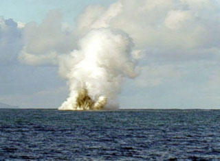 An explosive eruption from Kavachi volcano was seen from the Australian CSIRO research vessel Franklin on 14 May 2000. During their 20 hours of observations explosions were witnessed every 5-7 minutes, lasting 2-3 minutes each. The crater was estimated at 2-5 m below the water surface. The eruptions ejected ash and incandescent lava up to 70 m above the sea surface, and plumes rose to heights of 500 m. Kavachi had been erupting intermittently since November 1999.
 A cock’s-tail plume rises above Kavachi volcano during a Surtseyan eruption on 15 March 2004. Projections of individual blocks and ash can be seen at the margins of the plume. The frequently-erupting submarine volcano had been inactive since August 2003.
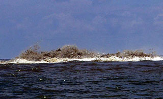 Some of the stronger activity observed at Kavachi on 6 April 2007 included turbulent ash-laden water above the vent, audible explosions, and discolored water down-current of the vent. Following 2 April 2007 Kavachi emitted an ash plume visible from Biche village (on the S coast of Nggatokae Island).
The maps shown below have been scanned from the GVP map archives and include the volcano on this page. Clicking on the small images will load the full 300 dpi map. Very small-scale maps (such as world maps) are not included. The maps database originated over 30 years ago, but was only recently updated and connected to our main database. We welcome users to tell us if they see incorrect information or other problems with the maps; please use the Contact GVP link at the bottom of the page to send us email.
The following 2 samples associated with this volcano can be found in the Smithsonian's NMNH Department of Mineral Sciences collections, and may be availble for research (contact the Rock and Ore Collections Manager). Catalog number links will open a window with more information.
| Catalog Number | Sample Description | Lava Source | Collection Date |
|---|---|---|---|
| NMNH 112235 | Basaltic Andesite | -- | -- |
| NMNH 112236 | Basaltic Andesite | -- | -- |
| Copernicus Browser | The Copernicus Browser replaced the Sentinel Hub Playground browser in 2023, to provide access to Earth observation archives from the Copernicus Data Space Ecosystem, the main distribution platform for data from the EU Copernicus missions. |
| MIROVA | Middle InfraRed Observation of Volcanic Activity (MIROVA) is a near real time volcanic hot-spot detection system based on the analysis of MODIS (Moderate Resolution Imaging Spectroradiometer) data. In particular, MIROVA uses the Middle InfraRed Radiation (MIR), measured over target volcanoes, in order to detect, locate and measure the heat radiation sourced from volcanic activity. |
| MODVOLC Thermal Alerts | Using infrared satellite Moderate Resolution Imaging Spectroradiometer (MODIS) data, scientists at the Hawai'i Institute of Geophysics and Planetology, University of Hawai'i, developed an automated system called MODVOLC to map thermal hot-spots in near real time. For each MODIS image, the algorithm automatically scans each 1 km pixel within it to check for high-temperature hot-spots. When one is found the date, time, location, and intensity are recorded. MODIS looks at every square km of the Earth every 48 hours, once during the day and once during the night, and the presence of two MODIS sensors in space allows at least four hot-spot observations every two days. Each day updated global maps are compiled to display the locations of all hot spots detected in the previous 24 hours. There is a drop-down list with volcano names which allow users to 'zoom-in' and examine the distribution of hot-spots at a variety of spatial scales. |
|
WOVOdat
Single Volcano View Temporal Evolution of Unrest Side by Side Volcanoes |
WOVOdat is a database of volcanic unrest; instrumentally and visually recorded changes in seismicity, ground deformation, gas emission, and other parameters from their normal baselines. It is sponsored by the World Organization of Volcano Observatories (WOVO) and presently hosted at the Earth Observatory of Singapore.
GVMID Data on Volcano Monitoring Infrastructure The Global Volcano Monitoring Infrastructure Database GVMID, is aimed at documenting and improving capabilities of volcano monitoring from the ground and space. GVMID should provide a snapshot and baseline view of the techniques and instrumentation that are in place at various volcanoes, which can be use by volcano observatories as reference to setup new monitoring system or improving networks at a specific volcano. These data will allow identification of what monitoring gaps exist, which can be then targeted by remote sensing infrastructure and future instrument deployments. |
| Volcanic Hazard Maps | The IAVCEI Commission on Volcanic Hazards and Risk has a Volcanic Hazard Maps database designed to serve as a resource for hazard mappers (or other interested parties) to explore how common issues in hazard map development have been addressed at different volcanoes, in different countries, for different hazards, and for different intended audiences. In addition to the comprehensive, searchable Volcanic Hazard Maps Database, this website contains information about diversity of volcanic hazard maps, illustrated using examples from the database. This site is for educational purposes related to volcanic hazard maps. Hazard maps found on this website should not be used for emergency purposes. For the most recent, official hazard map for a particular volcano, please seek out the proper institutional authorities on the matter. |
| IRIS seismic stations/networks | Incorporated Research Institutions for Seismology (IRIS) Data Services map showing the location of seismic stations from all available networks (permanent or temporary) within a radius of 0.18° (about 20 km at mid-latitudes) from the given location of Kavachi. Users can customize a variety of filters and options in the left panel. Note that if there are no stations are known the map will default to show the entire world with a "No data matched request" error notice. |
| UNAVCO GPS/GNSS stations | Geodetic Data Services map from UNAVCO showing the location of GPS/GNSS stations from all available networks (permanent or temporary) within a radius of 20 km from the given location of Kavachi. Users can customize the data search based on station or network names, location, and time window. Requires Adobe Flash Player. |
| DECADE Data | The DECADE portal, still in the developmental stage, serves as an example of the proposed interoperability between The Smithsonian Institution's Global Volcanism Program, the Mapping Gas Emissions (MaGa) Database, and the EarthChem Geochemical Portal. The Deep Earth Carbon Degassing (DECADE) initiative seeks to use new and established technologies to determine accurate global fluxes of volcanic CO2 to the atmosphere, but installing CO2 monitoring networks on 20 of the world's 150 most actively degassing volcanoes. The group uses related laboratory-based studies (direct gas sampling and analysis, melt inclusions) to provide new data for direct degassing of deep earth carbon to the atmosphere. |
| Large Eruptions of Kavachi | Information about large Quaternary eruptions (VEI >= 4) is cataloged in the Large Magnitude Explosive Volcanic Eruptions (LaMEVE) database of the Volcano Global Risk Identification and Analysis Project (VOGRIPA). |
| EarthChem | EarthChem develops and maintains databases, software, and services that support the preservation, discovery, access and analysis of geochemical data, and facilitate their integration with the broad array of other available earth science parameters. EarthChem is operated by a joint team of disciplinary scientists, data scientists, data managers and information technology developers who are part of the NSF-funded data facility Integrated Earth Data Applications (IEDA). IEDA is a collaborative effort of EarthChem and the Marine Geoscience Data System (MGDS). |

