Keyword Collections | Keyword "block-and-ash flow"
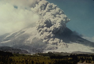 A pyroclastic flow descends the SW flank of Merapi volcano on 14 June 1984. A long period of lava dome growth began on 2 October 1972, and continued intermittently until 1990, occasionally punctuated by partial dome collapse that formed pyroclastic flows (block-and-ash flows) that travel down the flanks.
Photo by Ministry of Public Works, 1984 (courtesy of Volcanological Survey of Indonesia).
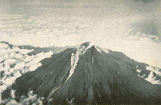 A small pyroclastic flow is shown traveling down the western flank from the breached crater of Merapi volcano in December 1930. A much larger pyroclastic flow that month traveled 12 km from the volcano, totally or partially destroying 42 villages and killing 1,369 people in one of Merapi's deadliest eruptions. Explosions had begun on 22 November 1930, accompanied by growth of a new lava dome and extrusion of a lava flow. Dome growth and associated pyroclastic flows (block-and-ash flows) continued until October 1931.
Photo published in Neumann van Padang, 1933 (courtesy of Volcanological Survey of Indonesia).
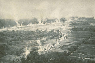 Steam rises from still-hot pyroclastic flow deposits in the Kali Blongkeng valley, 12 km from the summit of Merapi, in December 1930. Thirteen villages were totally destroyed and 29 more partially destroyed by these pyroclastic flows, which killed 1,369 people on 18 December.
Photo published in Neumann van Padang, 1933 (courtesy of Volcanological Survey of Indonesia).
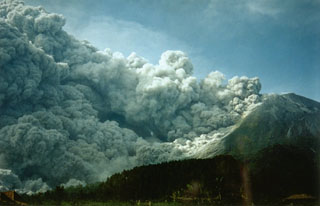 Collapse of the growing lava dome on 22 November 1994, produced a pyroclastic flow (block-and-ash flow) that swept 7.5 km down the south flank, overrunning several villages and killing 64 people. Six thousand people were evacuated as a result of this eruption.
Photo by Panut, 1994 (Volcanological Survey of Indonesia).
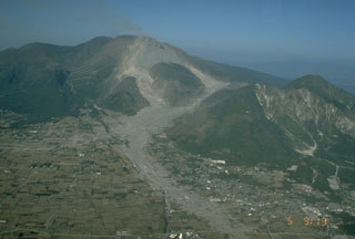 Shichimenzan and Mayuyama are two lava domes that form the forested peaks in this 5 November 1991 view from the SW. Mayuyama, the closest dome, has an E-facing scarp resulting from a major debris avalanche in 1792 that swept into the Ariake Sea. The avalanche produced a catastrophic tsunami that swept the coast of Shimabara Peninsula and traveled across the bay, causing nearly 15,000 fatalities. The light-colored areas in the foreground are 1991 block-and-ash flow deposits.
Photo by T. Kobayashi, 1991 (Kagoshima University).
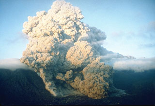 A pyroclastic flow on 23 June 1993 at Unzen volcano in southern Japan travels down the flanks of the volcano into the Senbongi residential district of Shimabara city. Pyroclastic flows had been occurring at Unzen since May 1991 as a result of partial collapse of the lava dome growing at the summit of Fugendake. This pyroclastic flow traveled 1 km through inhabited areas that had been evacuated since August 1991. One resident who had returned to watch his house burn was killed by a second pyroclastic flow.
Photo by Setsuya Nakada, 1993 (Kyushu University).
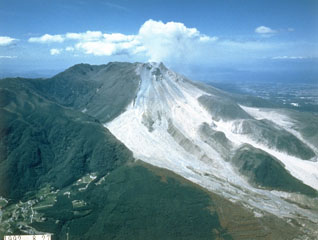 The light-colored area is composed of block-and-ash flow deposits produced by multiple collapse events of the growing lava dome at Unzen. By the time of this 28 August 1992 photo, taken from the SE, pyroclastic flows were traveling down both the Mizunashi valley (center) and the Oshigatani valley (right). Dome growth began in 1991 and continued into 1995.
Photo courtesy Takashi Yamada, 1992 (Public Works Research Institute, Ministry of Construction).
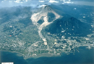 Light-colored block-and-ash flow deposits below the growing Fugendake lava dome are shown in this 11 September 1992 view from the E. Explosive activity began in November 1990 and preceded lava dome growth that began in May 1991. This was accompanied by pyroclastic flows that continued until February 1995 and caused disruption for villages and towns on the outskirts of Shimabara City in the foreground. The two lava domes of Shichmenzan and Mayuyama form the vegetated peaks to the right.
Photo courtesy Takashi Yamada, 1992 (Public Works Research Institute, Ministry of Construction).
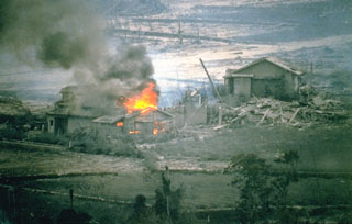 A house that was ignited by a hot block-and-ash flow burns in the Nakao River valley in June 1993. This marked the first destruction of property in drainages NE of Unzen. Pyroclastic flows on 23 June traveled 4 km down the NE flank and resulted in devastation across 1 km of a residential district on the outskirts of Shimabara City. The area had been evacuated since August 1991. One person who had entered the evacuated area to watch their house burn was killed by a second pyroclastic flow.
Photo courtesy Takashi Yamada, 1993 (Public Works Research Institute, Ministry of Construction).
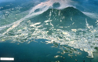 The forested islands in Shimabara harbor in the foreground were created by a massive debris avalanche in 1792 from Mayuyama, the left-most of the two forested lava domes behind the city. The high-velocity avalanche traveled 6.5 km from Mayuama and swept several kilometers out to sea. Impact of the debris into the ocean produced a devastating tsunami that swept 77 km of the shore of Shimabara Peninsula and caused nearly 15,000 fatalities. The light-colored area behind Mayuyama are block-and-ash flow deposits from the 1990-95 eruption.
Photo courtesy Takashi Yamada, 1994 (Public Works Research Institute, Ministry of Construction).
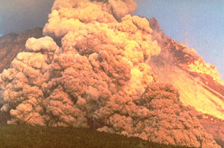 A block-and-ash flow travels down the flank of Fugendake in 1991. These were created by collapse of a lava dome that began on 24 May. The size of the flows gradually increased and on 3 June the largest flow of the eruption to that point swept 3 km down the Mizunashi River valley into Kita-Kamikoba village, killing 43 people and destroying many houses. On 8 June block-and-ash flows traveled 5.5 km to within 50 m of a major highway and destroyed an additional 73 houses.
Photo courtesy Willie Scott, 1991 (U.S. Geological Survey).
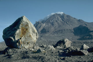 A volcanologist next to a 6-m-high block that was carried about 4 km down the north flank of Augustine volcano in Alaska during the 1976 eruption. Blocks of this size and larger are fragments of the summit lava dome that were carried within block-and-ash flows produced by periodic collapse of the growing dome. This photo was taken during a quiet phase of the 1986 eruption and shows the steaming summit lava dome.
Photo by Harry Glicken, 1986 (U.S. Geological Survey).
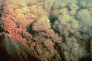 A convecting ash column rises above a small pyroclastic flow on the SW flank of Colima volcano in México on 16 April 1991. The pyroclastic flow, colored by the late-afternoon sun, was produced by the collapse of portions of the summit lava dome.
Photo by Alfredo Ramirez (pilot Ernesto Gómez Hofman), 1991 (courtesy Melchor Urzua, Protección Civil de Colima).
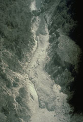 This 24 April 1991 aerial photo shows deposits from the 1991 eruption of Colima in the lower part of the Barranca El Cordobán on the south flank. The deposits at the bottom of the photo with rounded flow fronts and well-defined levees originated from block-and-ash flows. The darker, more recent deposits near the top of the photo contain a higher amount of juvenile (fresh magmatic) material.
Photo by Jean-Christophe Komorowski, 1991(Arizona State University).
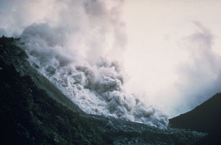 A pyroclastic flow produced by collapse of a growing lava dome descends the northern flank of the Santiaguito lava dome in November 1967. Periodic larger collapses of Santiaguito have sent pyroclastic flows down the populated southern flanks. The most catastrophic of these traveled 10 km in 1929, when hundreds to thousands of people were killed.
Photo by Dick Stoiber, 1967 (Dartmouth College).
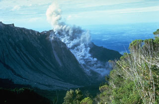 A small block-and-ash flow produced by a small collapse of the growing lava dome descends about 750 m down the north flank of El Brujo dome on 7 July 1967. The Pacific coastal plain is visible in the distance. El Brujo was the westernmost dome of the compound Santiaguito lava dome, which extends about 3 km in a roughly E-W direction.
Photo by Dick Stoiber, 1967 (Dartmouth College).
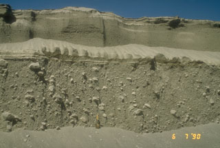 Pyroclastic flow deposits from the 15 April (lower 2/3 of section) and 21 April (upper 1/3 of section), 1990 eruptions of Redoubt in Alaska are exposed in a gully. The shovel at the base of the section provides scale. The larger 15 April pyroclastic flow carried large blocky fragments of a lava dome that had been growing in the summit crater.
Photo by Christina Neal, 1990 (Alaska Volcano Observatory, U.S. Geological Survey).
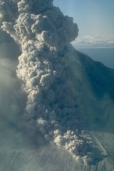 A pyroclastic flow travels down the north flank of Augustine volcano in Alaska on 30 March 1986, three days after the start of a five-month long eruption. An ash plume rises above the pyroclastic flow. As with many Augustine eruptions, early pyroclastic flows were pumice rich; later in the eruption block-and-ash flows were produced by collapse of a growing lava dome.
Photo by Betsy Yount, 1986 (Alaska Volcano Observatory, U.S. Geological Survey).
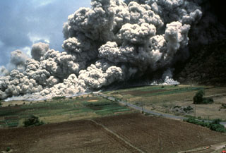 A devastating pyroclastic flow on 25 June 1997 sweeps across the lower NE flank of Soufrière Hills volcano on Montserrat. More than two dozen people within the officially evacuated zone were killed. This eruption sent an ash plume to ~10 km altitude and produced pyroclastic flows and surges that overran both vacated and partly inhabited NE-flank settlements, destroying 100-150 houses in eight villages within the restricted zone. The pyroclastic flow traveled 4.5 km and almost reached the sea.
Photo by Paul Cole, 1997 (Montserrat Volcano Observatory).
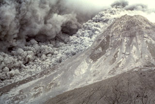 An ash plume expands above a pyroclastic flow sweeping down the E flank of the Soufrière Hills summit lava dome on 16 January 1997. The pyroclastic flow descended the Tar River valley to the sea, covering the new delta with new material that included blocks up to 5 m in diameter.
Photo by Richard Herd, 1997 (Montserrat Volcano Observatory).
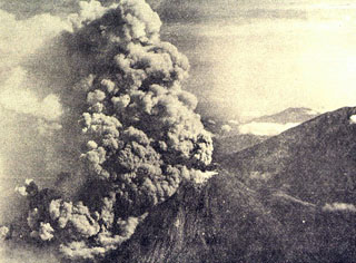 An ash plume rises above the summit and pyroclastic flows (block-and-ash flows) descend the western flank of Merapi in 1961. During 1961, eruptions took place on 13 April, 7-8 May, and 27-28 November. Pyroclastic flows during the 8 May eruption destroyed 10 villages and killed 6 people.
Photo by I. Suryo, 1961 (published in Kusumadinata 1979, Data Dasar Gunungapi Indonesia).
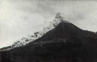 A pyroclastic flow traveling down the SW flank of Merapi volcano is seen from the Plawangan Observatory on 12 April 1967. Explosive eruptions, pyroclastic flows, and lava dome growth took place during 1967-70. Eruptive activity began on 12 January 1967. Paroxysmal phases took place on 7-9 October 1967 and 8 October 1968, during which partial collapse of the lava dome produced frequent pyroclastic flows (block-and-ash flows). The velocity of the pyroclastic flow seen in this photo was estimated by the Volcanological Survey of Indonesia to be 60 km/hour.
Photo by I. Suryo, 1967 (Volcanological Survey of Indonesia).
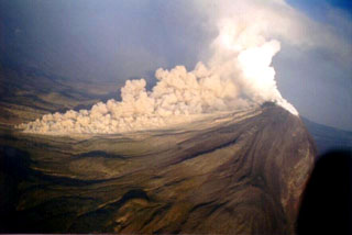 A pyroclastic flow descends the western flank of Colima at 0830 on 22 November 1998. The new growing lava dome had almost entirely filled the 1994 crater by the morning of the previous day, after which lava started flowing out of the summit crater area and producing block-and-ash flows at 3-5-minute intervals that mostly traveled south within the eastern branch of Barranca El Cordobán to distances of more than 4 km.
Photo courtesy of Abel Cortés, 1998 (Colima Volcano Observatory, Universidad de Colima).
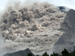 A pyroclastic flow travels down the SE flank of Merapi on 7 June 2006. Renewed lava dome growth had begun at Merapi in April 2006. Ashfall was reported 5 km from the summit on 27 April. Beginning in May, pyroclastic flows descended the flanks of the volcano, sometimes reaching populated areas.
Photo courtesy of The Research and Technology Development Agency for Volcanology, Yogyakarta (BPPTK), 2006.


