L'Observatoire Volcanologique et Sismologique de Martinique (OVSM) reported that seismicity at Pelée increased during 19-26 March. The seismic network recorded at least 55 high-frequency volcano-tectonic earthquakes with magnitudes less than or equal to 1, located at depths between 1.7 km below sea level and 1 km above sea level. The Alert Level remained at Yellow (the second lowest level on a four-color scale).
Source: L'Observatoire Volcanologique et Sismologique de Martinique (OVSM)
Elevated seismicity since December 2020; vegetation damaged by carbon dioxide degassing
Mount Pelée is a stratovolcano that forms the north end of the French island of Martinique, along the Lesser Antilles subduction zone. There have been at least four eruptions over the past 250 years: phreatic eruptions in 1792 and 1851, and more recently, magmatic eruptions that built lava domes during 1902-1905 and 1929-1932. Fumaroles at the summit in the area of those lava domes were active until 1970, but not since then. There are thermal springs on the upper and lower flanks of the volcano, most notably at the Rivière Chaude, Rivière Claire, Rivière Picodo and Rivière Mitan, as well as a few hydrothermal submarine springs on the Caribbean Sea coast to the southwest (figure 1). Information for this report was provided by the Volcanological and Seismological Observatory of Martinique (OVSM), Institut de Physique du Globe de Paris (IPGP), with contributions from F.R. Fontaine (IPGP, OVSM), J-C. Komorowski (IPGP), J. Corbeau (IPGP, OVSM), A. Burtin (IPGP), F. Jadelus (IPGP, OVSM), D. Melezan (IPGP, OVSM), C. Vidal (IPGP, OVSM), B. Zimmermann (IPGP, OVSM), J.M. Lavenaire (IPGP, OVSM), J.-G. Gabriel (IPGP, OVSM), J.-M. Saurel (IPGP), A. Lemarchand (IPGP), R. Grandin (IPGP), J.-B. de Chabalier (IPGP), F. Beauducel (IPGP), S. Moune (IPGP, OVSG), E. Chilun-Eusebe (IPGP, OVSG), V. Robert, R. Moretti (IPGP, OVSG), G. Boudon (IPGP), G. Carazzo (IPGP), A. Michaud-Dubuy (IPGP), and S. Tait (OMP).
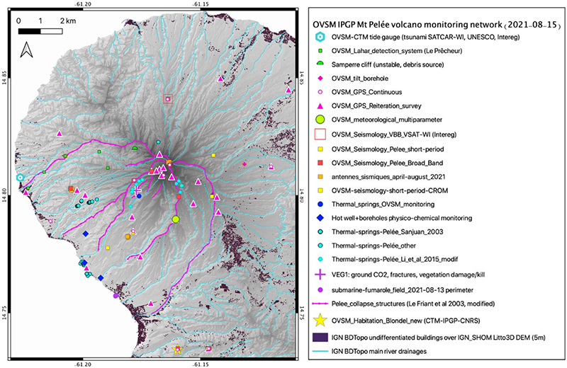 |
Figure 1. Map of Mount Pelée showing the monitoring networks in Martinique. Courtesy of OVSM – IPGP. |
Seismicity since 1980 and the installation of monitoring networks (figures 1 and 2) has typically been low. A few volcano-tectonic (VT) earthquakes were observed between 1 January 2015 and 1 April 2019, with a mean of two and a standard deviation of six earthquakes per month. Increased volcanic seismicity was recorded starting in April 2019 located 4-5 km below the summit (figure 3). A stronger increase was recorded between 2-15 December 2020 with 316 VT earthquakes during this period.
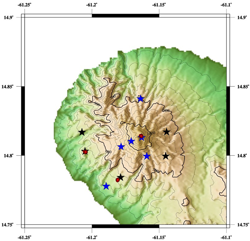 |
Figure 2. The seismic network of the OVSM - IPGP used for monitoring Mount Pelée. Broad-band three component seismic stations are in blue, short-period one component seismometers are in black, and temporary seismic nodes are in red. Courtesy of IPGP. |
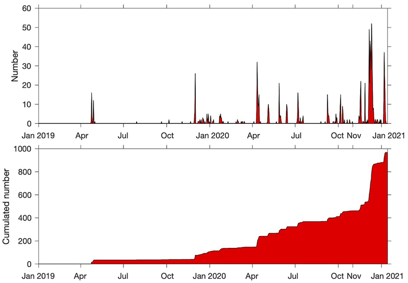 |
Figure 3. Graphs showing the daily number of volcano-tectonic (VT) earthquakes (top) recorded and the cumulated number of VT earthquakes (bottom) from 1 January 2019 to 14 January 2021 at Mount Pelée. The VT earthquakes were derived from the manual catalog of OVSM – IPGP. Courtesy of IPGP. |
In addition to the shallow VT events, a few deep VT earthquakes (~15 km below sea level) were recorded below the volcano in April-May 2019 (5) and November 2019 (1); this type of seismicity was not observed between January 2014 and March 2019. New tremor-type signals were recorded on 8 and 9 November 2020 (figure 4). Eight long-period (LP) earthquakes were detected in December 2020 during the stronger increase in volcanic seismic activity. Seismic activity typically occurred in swarms lasting up to a few days and has fluctuated since 4 December 2020, but remained significantly higher than base level (table 1 and figure 5). Despite the ongoing unrest, the seismic energy released has remained low and no volcanic earthquakes have been felt.
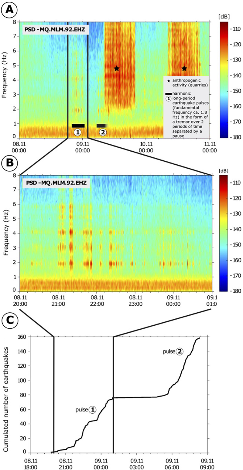 |
Figure 4. Spectrograms (a and b) of volcanic tremor at Mount Pelée recorded by a seismic station (MLM) of the OVSM - IPGP from 8-9 November 2020. (c) Cumulated number of long-period events detected within the volcanic tremor signal. Courtesy of IPGP. |
Table 1. Monthly numbers of volcanic earthquakes recorded at Mount Pelée by the OVSM – IPGP during December 2020-June 2021. Courtesy of IPGP.
| Month | Volcano-tectonic | Long-period | Hybrid | Tremor |
| Dec 2020 | 342 | 8 | 3 | 3 |
| Jan 2021 | 162 | 5 | 2 | 3 |
| Feb 2021 | 109 | 1 | 1 | 2 |
| Mar 2021 | 120 | 0 | 0 | 1 |
| Apr 2021 | 533 | 0 | 13 | 0 |
| May 2021 | 199 | 0 | 0 | 0 |
| Jun 2021 | 97 | 0 | 1 | 0 |
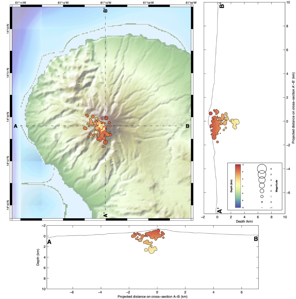 |
Figure 5. Map of Mount Pelée with N-S (right) and E-W (bottom) cross-sections showing the position and depth of hypocenters of the seismic events in April 2021. Only earthquakes that could be located are shown. Courtesy of IPGP. |
Due to the increased seismicity, OVSM - IPGP raised the Volcanic Alert Level (VAL) to Yellow (the second level on a four-color scale) on 4 December 2020. A zone of damaged, browned, and dead vegetation was observed at the end of December 2020 on the southwest flank between the upper Rivière Claire and the Rivière Chaude, above their confluence. A field expedition on 8 February 2021 by OVSM - IPGP investigators, with the support of the Emergency and Fire Department (STIS) and the civil protection helicopter, confirmed that the vegetation damage was associated with elevated levels of diffuse passive soil degassing of carbon dioxide from the ground. There were no visible fumaroles. This area is less than 200 m from the Rivière Claire where the presence of hydrogen sulfide has been reported in scientific literature for several years, in the vicinity of thermal springs.
Ground fractures in the center of the most deteriorated vegetation zone were 20-60 cm wide, 2-3 m deep, and several tens of meters long. Although some fractures had formed in the past, the clearest ones linked to the damaged vegetation may have formed recently. No fumarolic, water vapor, or gas emissions were visible and there was no thermal anomaly associated with these fractures. There was no evidence of significant fluid movements at depth recorded by the deformation network, or any changes in temperature or pH of the water at the regularly monitored sites. These observations are interpreted as reflecting increased activity of the hydrothermal system.
Information Contacts: Université de Paris, Institut de Physique du Globe de Paris (IPGP), CNRS, F-75005 Paris, France (URL: http://www.ipgp.fr/); Observatoire Volcanologique et Sismologique de la Martinique (OVSM), Institut de Physique du Globe de Paris, 97250, Fonds Saint Denis, France (URL: http://www.ipgp.fr/fr/ovsm/actualites-communiques-publics-de-lovsm, https://doi.org/10.18715/MARTINIQUE.OVSM, real-time location of seismic events are available at ws.ipgp.fr/fdsnws/event/1/ and https://renass.unistra.fr/fr/zones/les-antilles/); Observatoire Volcanologique et Sismologique de la Guadeloupe (OVSG), Institut de Physique du Globe de Paris, 97113, Gourbeyre, France (URL: https://www.ipgp.fr/fr/ovsg/observatoire-volcanologique-sismologique-de-guadeloupe); Observatoire Midi-Pyrénées (OMP), 31400 Toulouse, France (URL: https://www.omp.eu/).
L'Observatoire Volcanologique et Sismologique de Martinique (OVSM) reported that seismicity at Pelée increased during 19-26 March. The seismic network recorded at least 55 high-frequency volcano-tectonic earthquakes with magnitudes less than or equal to 1, located at depths between 1.7 km below sea level and 1 km above sea level. The Alert Level remained at Yellow (the second lowest level on a four-color scale).
Source: L'Observatoire Volcanologique et Sismologique de Martinique (OVSM)
L'Observatoire Volcanologique et Sismologique de Martinique (OVSM) reported that seismicity at Pelée remained at significant levels during 8-15 January, though had slightly decreased compared to the previous week. The seismic network recorded at least 22 high-frequency, volcano-tectonic earthquakes with magnitudes less than 1, located at shallow depths between 600 and 1,000 m above sea level. Two low-frequency, long-period earthquakes were also noted. The Alert Level remained at Yellow (the second lowest level on a four-color scale).
Source: L'Observatoire Volcanologique et Sismologique de Martinique (OVSM)
L'Observatoire Volcanologique et Sismologique de Martinique (OVSM) reported that seismicity related to volcanism has typically remained low at Pelée since 1980, when monitoring instrumentation was first installed, with a few dozen earthquakes recorded per year. Swarms were recorded in 1980, 1985-1986, 2007, and 2014, though the latter two swarms were associated with tectonic events. Volcanic seismicity appeared in April 2019 centered 4-5 km below the summit and deeper (more than 10 km below sea level). In addition, tremor-type signals were recorded during 8-9 November 2020, possibly signifying a reactivation of the hydrothermal system. The seismic data recorded since April 2019 represented an increase above baseline levels recorded during 1 January 2015 to April 2019. As a result of this activity OVSM raised the Alert Level to Yellow (the second lowest level on a four-color scale) on 4 December 2020.
Seismicity remained above background levels during 18 December 2020-1 January 2021, with at least 14 volcano-tectonic earthquakes detected with magnitudes less than or equal to 1. Scientists did not observe fumarolic activity during an overflight on 29 December 2020. The number of high-frequency, volcano-tectonic earthquakes (M 1 or less) totaled 65 during 1-8 January. A significant number (249) of long-period earthquakes in a volcanic tremor-type signal were distributed over two periods, 0000-0200 on 3 January and between 2100 on 3 January and 0200 on 4 January. Two isolated, low-frequency, long-period signals were also recorded. The data suggested ongoing perturbation of the hydrothermal system.
Source: L'Observatoire Volcanologique et Sismologique de Martinique (OVSM)
Reports are organized chronologically and indexed below by Month/Year (Publication Volume:Number), and include a one-line summary. Click on the index link or scroll down to read the reports.
Seismicity in 1929 crater
Seismicity began on 11 December 1985, the first recorded since a well-implemented volcano monitoring network was installed in 1978. A constant low level of seismicity has been observed since December, totaling 30 events as of 4 June. Two 3-component stations were established for a month, helping to locate the shocks, at a constant depth of 1-1.5 km below the 1929 crater. Magnitudes were weak, all less than 2, and only a few were recorded at the Morne des Cadets observatory, 9 km SW of the epicentral area.
The seismic network is composed of five seismometers within 5 km of the summit. Seismic signals noted before the recent activity were attributed to surface phenomena such as rockfalls or local landslides.
Information Contacts: N. Girardin and A. Hirn, IPGP, France; G. Boudon and J.P. Viode, Observatoire Volcanologique de la Montagne Pelée, Martinique.
Elevated seismicity since December 2020; vegetation damaged by carbon dioxide degassing
Mount Pelée is a stratovolcano that forms the north end of the French island of Martinique, along the Lesser Antilles subduction zone. There have been at least four eruptions over the past 250 years: phreatic eruptions in 1792 and 1851, and more recently, magmatic eruptions that built lava domes during 1902-1905 and 1929-1932. Fumaroles at the summit in the area of those lava domes were active until 1970, but not since then. There are thermal springs on the upper and lower flanks of the volcano, most notably at the Rivière Chaude, Rivière Claire, Rivière Picodo and Rivière Mitan, as well as a few hydrothermal submarine springs on the Caribbean Sea coast to the southwest (figure 1). Information for this report was provided by the Volcanological and Seismological Observatory of Martinique (OVSM), Institut de Physique du Globe de Paris (IPGP), with contributions from F.R. Fontaine (IPGP, OVSM), J-C. Komorowski (IPGP), J. Corbeau (IPGP, OVSM), A. Burtin (IPGP), F. Jadelus (IPGP, OVSM), D. Melezan (IPGP, OVSM), C. Vidal (IPGP, OVSM), B. Zimmermann (IPGP, OVSM), J.M. Lavenaire (IPGP, OVSM), J.-G. Gabriel (IPGP, OVSM), J.-M. Saurel (IPGP), A. Lemarchand (IPGP), R. Grandin (IPGP), J.-B. de Chabalier (IPGP), F. Beauducel (IPGP), S. Moune (IPGP, OVSG), E. Chilun-Eusebe (IPGP, OVSG), V. Robert, R. Moretti (IPGP, OVSG), G. Boudon (IPGP), G. Carazzo (IPGP), A. Michaud-Dubuy (IPGP), and S. Tait (OMP).
|
Figure 1. Map of Mount Pelée showing the monitoring networks in Martinique. Courtesy of OVSM – IPGP. |
Seismicity since 1980 and the installation of monitoring networks (figures 1 and 2) has typically been low. A few volcano-tectonic (VT) earthquakes were observed between 1 January 2015 and 1 April 2019, with a mean of two and a standard deviation of six earthquakes per month. Increased volcanic seismicity was recorded starting in April 2019 located 4-5 km below the summit (figure 3). A stronger increase was recorded between 2-15 December 2020 with 316 VT earthquakes during this period.
|
Figure 2. The seismic network of the OVSM - IPGP used for monitoring Mount Pelée. Broad-band three component seismic stations are in blue, short-period one component seismometers are in black, and temporary seismic nodes are in red. Courtesy of IPGP. |
|
Figure 3. Graphs showing the daily number of volcano-tectonic (VT) earthquakes (top) recorded and the cumulated number of VT earthquakes (bottom) from 1 January 2019 to 14 January 2021 at Mount Pelée. The VT earthquakes were derived from the manual catalog of OVSM – IPGP. Courtesy of IPGP. |
In addition to the shallow VT events, a few deep VT earthquakes (~15 km below sea level) were recorded below the volcano in April-May 2019 (5) and November 2019 (1); this type of seismicity was not observed between January 2014 and March 2019. New tremor-type signals were recorded on 8 and 9 November 2020 (figure 4). Eight long-period (LP) earthquakes were detected in December 2020 during the stronger increase in volcanic seismic activity. Seismic activity typically occurred in swarms lasting up to a few days and has fluctuated since 4 December 2020, but remained significantly higher than base level (table 1 and figure 5). Despite the ongoing unrest, the seismic energy released has remained low and no volcanic earthquakes have been felt.
|
Figure 4. Spectrograms (a and b) of volcanic tremor at Mount Pelée recorded by a seismic station (MLM) of the OVSM - IPGP from 8-9 November 2020. (c) Cumulated number of long-period events detected within the volcanic tremor signal. Courtesy of IPGP. |
Table 1. Monthly numbers of volcanic earthquakes recorded at Mount Pelée by the OVSM – IPGP during December 2020-June 2021. Courtesy of IPGP.
| Month | Volcano-tectonic | Long-period | Hybrid | Tremor |
| Dec 2020 | 342 | 8 | 3 | 3 |
| Jan 2021 | 162 | 5 | 2 | 3 |
| Feb 2021 | 109 | 1 | 1 | 2 |
| Mar 2021 | 120 | 0 | 0 | 1 |
| Apr 2021 | 533 | 0 | 13 | 0 |
| May 2021 | 199 | 0 | 0 | 0 |
| Jun 2021 | 97 | 0 | 1 | 0 |
|
Figure 5. Map of Mount Pelée with N-S (right) and E-W (bottom) cross-sections showing the position and depth of hypocenters of the seismic events in April 2021. Only earthquakes that could be located are shown. Courtesy of IPGP. |
Due to the increased seismicity, OVSM - IPGP raised the Volcanic Alert Level (VAL) to Yellow (the second level on a four-color scale) on 4 December 2020. A zone of damaged, browned, and dead vegetation was observed at the end of December 2020 on the southwest flank between the upper Rivière Claire and the Rivière Chaude, above their confluence. A field expedition on 8 February 2021 by OVSM - IPGP investigators, with the support of the Emergency and Fire Department (STIS) and the civil protection helicopter, confirmed that the vegetation damage was associated with elevated levels of diffuse passive soil degassing of carbon dioxide from the ground. There were no visible fumaroles. This area is less than 200 m from the Rivière Claire where the presence of hydrogen sulfide has been reported in scientific literature for several years, in the vicinity of thermal springs.
Ground fractures in the center of the most deteriorated vegetation zone were 20-60 cm wide, 2-3 m deep, and several tens of meters long. Although some fractures had formed in the past, the clearest ones linked to the damaged vegetation may have formed recently. No fumarolic, water vapor, or gas emissions were visible and there was no thermal anomaly associated with these fractures. There was no evidence of significant fluid movements at depth recorded by the deformation network, or any changes in temperature or pH of the water at the regularly monitored sites. These observations are interpreted as reflecting increased activity of the hydrothermal system.
Information Contacts: Université de Paris, Institut de Physique du Globe de Paris (IPGP), CNRS, F-75005 Paris, France (URL: http://www.ipgp.fr/); Observatoire Volcanologique et Sismologique de la Martinique (OVSM), Institut de Physique du Globe de Paris, 97250, Fonds Saint Denis, France (URL: http://www.ipgp.fr/fr/ovsm/actualites-communiques-publics-de-lovsm, https://doi.org/10.18715/MARTINIQUE.OVSM, real-time location of seismic events are available at ws.ipgp.fr/fdsnws/event/1/ and https://renass.unistra.fr/fr/zones/les-antilles/); Observatoire Volcanologique et Sismologique de la Guadeloupe (OVSG), Institut de Physique du Globe de Paris, 97113, Gourbeyre, France (URL: https://www.ipgp.fr/fr/ovsg/observatoire-volcanologique-sismologique-de-guadeloupe); Observatoire Midi-Pyrénées (OMP), 31400 Toulouse, France (URL: https://www.omp.eu/).
This compilation of synonyms and subsidiary features may not be comprehensive. Features are organized into four major categories: Cones, Craters, Domes, and Thermal Features. Synonyms of features appear indented below the primary name. In some cases additional feature type, elevation, or location details are provided.
Synonyms |
||||
| Pele, Montagne | ||||
Cones |
||||
| Feature Name | Feature Type | Elevation | Latitude | Longitude |
| Conil, Mont | Stratovolcano | 864 m | 14° 50' 21" N | 61° 11' 28" W |
Craters |
||||
| Feature Name | Feature Type | Elevation | Latitude | Longitude |
| L'etang Sec, Caldeira de | Crater | 1260 m | 14° 49' 1" N | 61° 9' 57" W |
| Macouba, Morne | Crater | 1224 m | 14° 49' 2" N | 61° 10' 11" W |
Domes |
||||
| Feature Name | Feature Type | Elevation | Latitude | Longitude |
| Aileron | Dome | 1082 m | 14° 48' 27" N | 61° 9' 27" W |
| Marcel, Piton | Dome | 1024 m | 14° 49' 24" N | 61° 10' 41" W |
|
|
||||||||||||||||||||||||||||
There is data available for 54 confirmed Holocene eruptive periods.
1929 Sep 16 - 1932 Dec 1 ± 30 days Confirmed Eruption VEI: 3
| Episode 1 | Eruption | ||||||||||||||||||||||||||||||||||||||||||||||||||||||||||||||||||||||||||||||||||||||||||||||||||||
|---|---|---|---|---|---|---|---|---|---|---|---|---|---|---|---|---|---|---|---|---|---|---|---|---|---|---|---|---|---|---|---|---|---|---|---|---|---|---|---|---|---|---|---|---|---|---|---|---|---|---|---|---|---|---|---|---|---|---|---|---|---|---|---|---|---|---|---|---|---|---|---|---|---|---|---|---|---|---|---|---|---|---|---|---|---|---|---|---|---|---|---|---|---|---|---|---|---|---|---|---|
| 1929 Sep 16 - 1932 Dec 1 ± 30 days | Evidence from Observations: Reported | |||||||||||||||||||||||||||||||||||||||||||||||||||||||||||||||||||||||||||||||||||||||||||||||||||
|
List of 18 Events for Episode 1
| ||||||||||||||||||||||||||||||||||||||||||||||||||||||||||||||||||||||||||||||||||||||||||||||||||||
1902 Apr 23 - 1905 Oct 5 Confirmed Eruption VEI: 4
| Episode 1 | Eruption | Rivière Blanche and summit crater | |||||||||||||||||||||||||||||||||||||||||||||||||||||||||||||||||||||||||||||||||||||||||||||||||||||||||||||
|---|---|---|---|---|---|---|---|---|---|---|---|---|---|---|---|---|---|---|---|---|---|---|---|---|---|---|---|---|---|---|---|---|---|---|---|---|---|---|---|---|---|---|---|---|---|---|---|---|---|---|---|---|---|---|---|---|---|---|---|---|---|---|---|---|---|---|---|---|---|---|---|---|---|---|---|---|---|---|---|---|---|---|---|---|---|---|---|---|---|---|---|---|---|---|---|---|---|---|---|---|---|---|---|---|---|---|---|---|---|---|
| 1902 Apr 23 - 1905 Oct 5 | Evidence from Observations: Reported | |||||||||||||||||||||||||||||||||||||||||||||||||||||||||||||||||||||||||||||||||||||||||||||||||||||||||||||
|
List of 20 Events for Episode 1 at Rivière Blanche and summit crater
| ||||||||||||||||||||||||||||||||||||||||||||||||||||||||||||||||||||||||||||||||||||||||||||||||||||||||||||||
1851 Aug 5 - 1852 Feb 1 ± 30 days Confirmed Eruption VEI: 2
| Episode 1 | Eruption | Upper Rivière Claire valley (900 m elevation) | ||||||||||||||||||||||||||||||||||
|---|---|---|---|---|---|---|---|---|---|---|---|---|---|---|---|---|---|---|---|---|---|---|---|---|---|---|---|---|---|---|---|---|---|---|---|
| 1851 Aug 5 - 1852 Feb 1 ± 30 days | Evidence from Observations: Reported | ||||||||||||||||||||||||||||||||||
|
List of 5 Events for Episode 1 at Upper Rivière Claire valley (900 m elevation)
| |||||||||||||||||||||||||||||||||||
1792 Jan 22 - 1792 Apr (?) Confirmed Eruption VEI: 1
| Episode 1 | Eruption | Upper Rivière Claire valley | |||||||||||||||||||||||||||||
|---|---|---|---|---|---|---|---|---|---|---|---|---|---|---|---|---|---|---|---|---|---|---|---|---|---|---|---|---|---|---|
| 1792 Jan 22 - 1792 Apr (?) | Evidence from Observations: Reported | |||||||||||||||||||||||||||||
|
List of 4 Events for Episode 1 at Upper Rivière Claire valley
| ||||||||||||||||||||||||||||||
1635 (in or before) Confirmed Eruption
| Episode 1 | Eruption | Tephra layer NRP3 | ||||||||||||||||||||||||
|---|---|---|---|---|---|---|---|---|---|---|---|---|---|---|---|---|---|---|---|---|---|---|---|---|---|
| 1635 (in or before) - Unknown | Evidence from Observations: Reported | ||||||||||||||||||||||||
|
List of 3 Events for Episode 1 at Tephra layer NRP3
| |||||||||||||||||||||||||
1460 ± 20 years Confirmed Eruption
| Episode 1 | Eruption | Tephra layer NRP2 | |||||||||||||||||||
|---|---|---|---|---|---|---|---|---|---|---|---|---|---|---|---|---|---|---|---|---|
| 1460 ± 20 years - Unknown | Evidence from Isotopic: 14C (uncalibrated) | |||||||||||||||||||
|
List of 2 Events for Episode 1 at Tephra layer NRP2
| ||||||||||||||||||||
1370 (?) Confirmed Eruption
| Episode 1 | Eruption | Tephra layer NRP1 | |||||||||||||||||||||||||||||
|---|---|---|---|---|---|---|---|---|---|---|---|---|---|---|---|---|---|---|---|---|---|---|---|---|---|---|---|---|---|---|
| 1370 (?) - Unknown | Evidence from Isotopic: 14C (uncalibrated) | |||||||||||||||||||||||||||||
|
List of 4 Events for Episode 1 at Tephra layer NRP1
| ||||||||||||||||||||||||||||||
1340 ± 50 years Confirmed Eruption VEI: 4
| Episode 1 | Eruption | Tephra layer P1 | ||||||||||||||||||||||||||||||||||
|---|---|---|---|---|---|---|---|---|---|---|---|---|---|---|---|---|---|---|---|---|---|---|---|---|---|---|---|---|---|---|---|---|---|---|---|
| 1340 ± 50 years - Unknown | Evidence from Isotopic: 14C (calibrated) | ||||||||||||||||||||||||||||||||||
|
List of 5 Events for Episode 1 at Tephra layer P1
| |||||||||||||||||||||||||||||||||||
1260 ± 20 years Confirmed Eruption
| Episode 1 | Eruption | NRC2 tephra | ||||||||||||||||||||||||||||||||||
|---|---|---|---|---|---|---|---|---|---|---|---|---|---|---|---|---|---|---|---|---|---|---|---|---|---|---|---|---|---|---|---|---|---|---|---|
| 1260 ± 20 years - Unknown | Evidence from Isotopic: 14C (uncalibrated) | ||||||||||||||||||||||||||||||||||
|
List of 5 Events for Episode 1 at NRC2 tephra
| |||||||||||||||||||||||||||||||||||
1190 (?) Confirmed Eruption
| Episode 1 | Eruption | ||||||||||||||||||||||||||||||
|---|---|---|---|---|---|---|---|---|---|---|---|---|---|---|---|---|---|---|---|---|---|---|---|---|---|---|---|---|---|---|
| 1190 (?) - Unknown | Evidence from Isotopic: 14C (uncalibrated) | |||||||||||||||||||||||||||||
|
List of 4 Events for Episode 1
| ||||||||||||||||||||||||||||||
0910 (?) Confirmed Eruption
| Episode 1 | Eruption | ||||||||||||||||||||||||||||||
|---|---|---|---|---|---|---|---|---|---|---|---|---|---|---|---|---|---|---|---|---|---|---|---|---|---|---|---|---|---|---|
| 0910 (?) - Unknown | Evidence from Isotopic: 14C (uncalibrated) | |||||||||||||||||||||||||||||
|
List of 4 Events for Episode 1
| ||||||||||||||||||||||||||||||
0890 ± 100 years Confirmed Eruption VEI: 4
| Episode 1 | Eruption | NRC1 tephra | |||||||||||||||||||||||||||||||||||||||
|---|---|---|---|---|---|---|---|---|---|---|---|---|---|---|---|---|---|---|---|---|---|---|---|---|---|---|---|---|---|---|---|---|---|---|---|---|---|---|---|---|
| 0890 ± 100 years - Unknown | Evidence from Isotopic: 14C (calibrated) | |||||||||||||||||||||||||||||||||||||||
|
List of 6 Events for Episode 1 at NRC1 tephra
| ||||||||||||||||||||||||||||||||||||||||
0720 (?) Confirmed Eruption
| Episode 1 | Eruption | ||||||||||||||||||||||||||||||
|---|---|---|---|---|---|---|---|---|---|---|---|---|---|---|---|---|---|---|---|---|---|---|---|---|---|---|---|---|---|---|
| 0720 (?) - Unknown | Evidence from Isotopic: 14C (uncalibrated) | |||||||||||||||||||||||||||||
|
List of 4 Events for Episode 1
| ||||||||||||||||||||||||||||||
0650 (?) Confirmed Eruption
| Episode 1 | Eruption | ||||||||||||||||||||||||||||||
|---|---|---|---|---|---|---|---|---|---|---|---|---|---|---|---|---|---|---|---|---|---|---|---|---|---|---|---|---|---|---|
| 0650 (?) - Unknown | Evidence from Isotopic: 14C (uncalibrated) | |||||||||||||||||||||||||||||
|
List of 4 Events for Episode 1
| ||||||||||||||||||||||||||||||
0450 (?) Confirmed Eruption VEI: 4
| Episode 1 | Eruption | ||||||||||||||||||||||||||||||
|---|---|---|---|---|---|---|---|---|---|---|---|---|---|---|---|---|---|---|---|---|---|---|---|---|---|---|---|---|---|---|
| 0450 (?) - Unknown | Evidence from Isotopic: 14C (uncalibrated) | |||||||||||||||||||||||||||||
|
List of 4 Events for Episode 1
| ||||||||||||||||||||||||||||||
0350 ± 75 years Confirmed Eruption VEI: 4
| Episode 1 | Eruption | Tephra layer P2 | ||||||||||||||||||||||||||||||||||
|---|---|---|---|---|---|---|---|---|---|---|---|---|---|---|---|---|---|---|---|---|---|---|---|---|---|---|---|---|---|---|---|---|---|---|---|
| 0350 ± 75 years - Unknown | Evidence from Isotopic: 14C (calibrated) | ||||||||||||||||||||||||||||||||||
|
List of 5 Events for Episode 1 at Tephra layer P2
| |||||||||||||||||||||||||||||||||||
0300 (?) Confirmed Eruption VEI: 4
| Episode 1 | Eruption | ||||||||||||||||||||||||||||||
|---|---|---|---|---|---|---|---|---|---|---|---|---|---|---|---|---|---|---|---|---|---|---|---|---|---|---|---|---|---|---|
| 0300 (?) - Unknown | Evidence from Isotopic: 14C (uncalibrated) | |||||||||||||||||||||||||||||
|
List of 4 Events for Episode 1
| ||||||||||||||||||||||||||||||
0220 ± 75 years Confirmed Eruption
| Episode 1 | Eruption | NMP tephra | |||||||||||||||||||||||||||||||||||||||
|---|---|---|---|---|---|---|---|---|---|---|---|---|---|---|---|---|---|---|---|---|---|---|---|---|---|---|---|---|---|---|---|---|---|---|---|---|---|---|---|---|
| 0220 ± 75 years - Unknown | Evidence from Isotopic: 14C (uncalibrated) | |||||||||||||||||||||||||||||||||||||||
|
List of 6 Events for Episode 1 at NMP tephra
| ||||||||||||||||||||||||||||||||||||||||
0130 (?) Confirmed Eruption VEI: 4
| Episode 1 | Eruption | ||||||||||||||||||||||||||||||
|---|---|---|---|---|---|---|---|---|---|---|---|---|---|---|---|---|---|---|---|---|---|---|---|---|---|---|---|---|---|---|
| 0130 (?) - Unknown | Evidence from Isotopic: 14C (uncalibrated) | |||||||||||||||||||||||||||||
|
List of 4 Events for Episode 1
| ||||||||||||||||||||||||||||||
0050 (?) Confirmed Eruption VEI: 4
| Episode 1 | Eruption | ||||||||||||||||||||||||||||||
|---|---|---|---|---|---|---|---|---|---|---|---|---|---|---|---|---|---|---|---|---|---|---|---|---|---|---|---|---|---|---|
| 0050 (?) - Unknown | Evidence from Isotopic: 14C (uncalibrated) | |||||||||||||||||||||||||||||
|
List of 4 Events for Episode 1
| ||||||||||||||||||||||||||||||
0010 ± 50 years Confirmed Eruption VEI: 4
| Episode 1 | Eruption | Tephra layer P3 | ||||||||||||||||||||||||||||||||||
|---|---|---|---|---|---|---|---|---|---|---|---|---|---|---|---|---|---|---|---|---|---|---|---|---|---|---|---|---|---|---|---|---|---|---|---|
| 0010 ± 50 years - Unknown | Evidence from Isotopic: 14C (calibrated) | ||||||||||||||||||||||||||||||||||
|
List of 5 Events for Episode 1 at Tephra layer P3
| |||||||||||||||||||||||||||||||||||
0200 BCE (?) Confirmed Eruption VEI: 4
| Episode 1 | Eruption | ||||||||||||||||||||||||||||||
|---|---|---|---|---|---|---|---|---|---|---|---|---|---|---|---|---|---|---|---|---|---|---|---|---|---|---|---|---|---|---|
| 0200 BCE (?) - Unknown | Evidence from Isotopic: 14C (uncalibrated) | |||||||||||||||||||||||||||||
|
List of 4 Events for Episode 1
| ||||||||||||||||||||||||||||||
0300 BCE ± 100 years Confirmed Eruption
| Episode 1 | Eruption | |||||||||||||||||||||||||||||||||||
|---|---|---|---|---|---|---|---|---|---|---|---|---|---|---|---|---|---|---|---|---|---|---|---|---|---|---|---|---|---|---|---|---|---|---|---|
| 0300 BCE ± 100 years - Unknown | Evidence from Isotopic: 14C (calibrated) | ||||||||||||||||||||||||||||||||||
|
List of 5 Events for Episode 1
| |||||||||||||||||||||||||||||||||||
0440 BCE (?) Confirmed Eruption VEI: 4
| Episode 1 | Eruption | ||||||||||||||||||||||||||||||
|---|---|---|---|---|---|---|---|---|---|---|---|---|---|---|---|---|---|---|---|---|---|---|---|---|---|---|---|---|---|---|
| 0440 BCE (?) - Unknown | Evidence from Isotopic: 14C (uncalibrated) | |||||||||||||||||||||||||||||
|
List of 4 Events for Episode 1
| ||||||||||||||||||||||||||||||
0590 BCE ± 200 years Confirmed Eruption VEI: 4 (?)
| Episode 1 | Eruption | Tephra layers NAB2 and P4 | |||||||||||||||||||||||||||||||||||||||
|---|---|---|---|---|---|---|---|---|---|---|---|---|---|---|---|---|---|---|---|---|---|---|---|---|---|---|---|---|---|---|---|---|---|---|---|---|---|---|---|---|
| 0590 BCE ± 200 years - Unknown | Evidence from Isotopic: 14C (calibrated) | |||||||||||||||||||||||||||||||||||||||
|
List of 6 Events for Episode 1 at Tephra layers NAB2 and P4
| ||||||||||||||||||||||||||||||||||||||||
0600 BCE (?) Confirmed Eruption
| Episode 1 | Eruption | ||||||||||||||||||||||||||||||
|---|---|---|---|---|---|---|---|---|---|---|---|---|---|---|---|---|---|---|---|---|---|---|---|---|---|---|---|---|---|---|
| 0600 BCE (?) - Unknown | Evidence from Isotopic: 14C (uncalibrated) | |||||||||||||||||||||||||||||
|
List of 4 Events for Episode 1
| ||||||||||||||||||||||||||||||
0620 BCE (?) Confirmed Eruption
| Episode 1 | Eruption | |||||||||||||||||||||||||
|---|---|---|---|---|---|---|---|---|---|---|---|---|---|---|---|---|---|---|---|---|---|---|---|---|---|
| 0620 BCE (?) - Unknown | Evidence from Isotopic: 14C (uncalibrated) | ||||||||||||||||||||||||
|
List of 3 Events for Episode 1
| |||||||||||||||||||||||||
0730 BCE (?) Confirmed Eruption
| Episode 1 | Eruption | ||||||||||||||||||||||||||||||
|---|---|---|---|---|---|---|---|---|---|---|---|---|---|---|---|---|---|---|---|---|---|---|---|---|---|---|---|---|---|---|
| 0730 BCE (?) - Unknown | Evidence from Isotopic: 14C (uncalibrated) | |||||||||||||||||||||||||||||
|
List of 4 Events for Episode 1
| ||||||||||||||||||||||||||||||
0890 BCE ± 50 years Confirmed Eruption
| Episode 1 | Eruption | Tephra layer NAB1 | |||||||||||||||||||||||||||||||||||||||
|---|---|---|---|---|---|---|---|---|---|---|---|---|---|---|---|---|---|---|---|---|---|---|---|---|---|---|---|---|---|---|---|---|---|---|---|---|---|---|---|---|
| 0890 BCE ± 50 years - Unknown | Evidence from Isotopic: 14C (calibrated) | |||||||||||||||||||||||||||||||||||||||
|
List of 6 Events for Episode 1 at Tephra layer NAB1
| ||||||||||||||||||||||||||||||||||||||||
1390 BCE ± 150 years Confirmed Eruption
| Episode 1 | Eruption | Tephra layer NRS3 | ||||||||||||||||||||||||||||||||||
|---|---|---|---|---|---|---|---|---|---|---|---|---|---|---|---|---|---|---|---|---|---|---|---|---|---|---|---|---|---|---|---|---|---|---|---|
| 1390 BCE ± 150 years - Unknown | Evidence from Isotopic: 14C (calibrated) | ||||||||||||||||||||||||||||||||||
|
List of 5 Events for Episode 1 at Tephra layer NRS3
| |||||||||||||||||||||||||||||||||||
2100 BCE ± 200 years Confirmed Eruption
| Episode 1 | Eruption | Tephra layer NRS2 | |||||||||||||||||||||||||||||||||||||||
|---|---|---|---|---|---|---|---|---|---|---|---|---|---|---|---|---|---|---|---|---|---|---|---|---|---|---|---|---|---|---|---|---|---|---|---|---|---|---|---|---|
| 2100 BCE ± 200 years - Unknown | Evidence from Isotopic: 14C (calibrated) | |||||||||||||||||||||||||||||||||||||||
|
List of 6 Events for Episode 1 at Tephra layer NRS2
| ||||||||||||||||||||||||||||||||||||||||
2280 BCE (?) Confirmed Eruption
| Episode 1 | Eruption | ||||||||||||||||||||||||||||||
|---|---|---|---|---|---|---|---|---|---|---|---|---|---|---|---|---|---|---|---|---|---|---|---|---|---|---|---|---|---|---|
| 2280 BCE (?) - Unknown | Evidence from Isotopic: 14C (uncalibrated) | |||||||||||||||||||||||||||||
|
List of 4 Events for Episode 1
| ||||||||||||||||||||||||||||||
2360 BCE (?) Confirmed Eruption
| Episode 1 | Eruption | |||||||||||||||||||||||||||||||||||
|---|---|---|---|---|---|---|---|---|---|---|---|---|---|---|---|---|---|---|---|---|---|---|---|---|---|---|---|---|---|---|---|---|---|---|---|
| 2360 BCE (?) - Unknown | Evidence from Isotopic: 14C (uncalibrated) | ||||||||||||||||||||||||||||||||||
|
List of 5 Events for Episode 1
| |||||||||||||||||||||||||||||||||||
2430 BCE (?) Confirmed Eruption VEI: 4
| Episode 1 | Eruption | ||||||||||||||||||||||||||||||
|---|---|---|---|---|---|---|---|---|---|---|---|---|---|---|---|---|---|---|---|---|---|---|---|---|---|---|---|---|---|---|
| 2430 BCE (?) - Unknown | Evidence from Isotopic: 14C (uncalibrated) | |||||||||||||||||||||||||||||
|
List of 4 Events for Episode 1
| ||||||||||||||||||||||||||||||
2460 BCE ± 100 years Confirmed Eruption
| Episode 1 | Eruption | Tephra layer NRS1 | ||||||||||||||||||||||||||||||||||
|---|---|---|---|---|---|---|---|---|---|---|---|---|---|---|---|---|---|---|---|---|---|---|---|---|---|---|---|---|---|---|---|---|---|---|---|
| 2460 BCE ± 100 years - Unknown | Evidence from Isotopic: 14C (calibrated) | ||||||||||||||||||||||||||||||||||
|
List of 5 Events for Episode 1 at Tephra layer NRS1
| |||||||||||||||||||||||||||||||||||
2660 BCE ± 200 years Confirmed Eruption VEI: 4 (?)
| Episode 1 | Eruption | Tephra layer P5 | ||||||||||||||||||||||||||||||||||
|---|---|---|---|---|---|---|---|---|---|---|---|---|---|---|---|---|---|---|---|---|---|---|---|---|---|---|---|---|---|---|---|---|---|---|---|
| 2660 BCE ± 200 years - Unknown | Evidence from Isotopic: 14C (calibrated) | ||||||||||||||||||||||||||||||||||
|
List of 5 Events for Episode 1 at Tephra layer P5
| |||||||||||||||||||||||||||||||||||
3020 BCE (?) Confirmed Eruption
| Episode 1 | Eruption | |||||||||||||||||||||||||||||||||||
|---|---|---|---|---|---|---|---|---|---|---|---|---|---|---|---|---|---|---|---|---|---|---|---|---|---|---|---|---|---|---|---|---|---|---|---|
| 3020 BCE (?) - Unknown | Evidence from Isotopic: 14C (uncalibrated) | ||||||||||||||||||||||||||||||||||
|
List of 5 Events for Episode 1
| |||||||||||||||||||||||||||||||||||
3120 BCE ± 200 years Confirmed Eruption
| Episode 1 | Eruption | NPM tephra | ||||||||||||||||||||||||||||||||||
|---|---|---|---|---|---|---|---|---|---|---|---|---|---|---|---|---|---|---|---|---|---|---|---|---|---|---|---|---|---|---|---|---|---|---|---|
| 3120 BCE ± 200 years - Unknown | Evidence from Isotopic: 14C (calibrated) | ||||||||||||||||||||||||||||||||||
|
List of 5 Events for Episode 1 at NPM tephra
| |||||||||||||||||||||||||||||||||||
3250 BCE (?) Confirmed Eruption
| Episode 1 | Eruption | |||||||||||||||||||||||||||||||||||
|---|---|---|---|---|---|---|---|---|---|---|---|---|---|---|---|---|---|---|---|---|---|---|---|---|---|---|---|---|---|---|---|---|---|---|---|
| 3250 BCE (?) - Unknown | Evidence from Isotopic: 14C (uncalibrated) | ||||||||||||||||||||||||||||||||||
|
List of 5 Events for Episode 1
| |||||||||||||||||||||||||||||||||||
3290 BCE (?) Confirmed Eruption
| Episode 1 | Eruption | ||||||||||||||||||||||||||||||
|---|---|---|---|---|---|---|---|---|---|---|---|---|---|---|---|---|---|---|---|---|---|---|---|---|---|---|---|---|---|---|
| 3290 BCE (?) - Unknown | Evidence from Isotopic: 14C (uncalibrated) | |||||||||||||||||||||||||||||
|
List of 4 Events for Episode 1
| ||||||||||||||||||||||||||||||
3430 BCE ± 75 years Confirmed Eruption VEI: 4 (?)
| Episode 1 | Eruption | Tephra layer P6 | ||||||||||||||||||||||||||||||||||||||||||||
|---|---|---|---|---|---|---|---|---|---|---|---|---|---|---|---|---|---|---|---|---|---|---|---|---|---|---|---|---|---|---|---|---|---|---|---|---|---|---|---|---|---|---|---|---|---|
| 3430 BCE ± 75 years - Unknown | Evidence from Isotopic: 14C (calibrated) | ||||||||||||||||||||||||||||||||||||||||||||
|
List of 7 Events for Episode 1 at Tephra layer P6
| |||||||||||||||||||||||||||||||||||||||||||||
3500 BCE ± 200 years Confirmed Eruption VEI: 4
| Episode 1 | Eruption | ||||||||||||||||||||||||||||||
|---|---|---|---|---|---|---|---|---|---|---|---|---|---|---|---|---|---|---|---|---|---|---|---|---|---|---|---|---|---|---|
| 3500 BCE ± 200 years - Unknown | Evidence from Correlation: Tephrochronology | |||||||||||||||||||||||||||||
|
List of 4 Events for Episode 1
| ||||||||||||||||||||||||||||||
3820 BCE (?) Confirmed Eruption VEI: 4
| Episode 1 | Eruption | ||||||||||||||||||||||||||||||
|---|---|---|---|---|---|---|---|---|---|---|---|---|---|---|---|---|---|---|---|---|---|---|---|---|---|---|---|---|---|---|
| 3820 BCE (?) - Unknown | Evidence from Isotopic: 14C (uncalibrated) | |||||||||||||||||||||||||||||
|
List of 4 Events for Episode 1
| ||||||||||||||||||||||||||||||
3930 BCE ± 100 years Confirmed Eruption
| Episode 1 | Eruption | Tephra layer NMR | ||||||||||||||||||||||||||||||||||
|---|---|---|---|---|---|---|---|---|---|---|---|---|---|---|---|---|---|---|---|---|---|---|---|---|---|---|---|---|---|---|---|---|---|---|---|
| 3930 BCE ± 100 years - Unknown | Evidence from Isotopic: 14C (calibrated) | ||||||||||||||||||||||||||||||||||
|
List of 5 Events for Episode 1 at Tephra layer NMR
| |||||||||||||||||||||||||||||||||||
4510 BCE ± 500 years Confirmed Eruption
| Episode 1 | Eruption | |||||||||||||||||||||||||||||||||||
|---|---|---|---|---|---|---|---|---|---|---|---|---|---|---|---|---|---|---|---|---|---|---|---|---|---|---|---|---|---|---|---|---|---|---|---|
| 4510 BCE ± 500 years - Unknown | Evidence from Isotopic: 14C (calibrated) | ||||||||||||||||||||||||||||||||||
|
List of 5 Events for Episode 1
| |||||||||||||||||||||||||||||||||||
5500 BCE ± 200 years Confirmed Eruption VEI: 4
| Episode 1 | Eruption | |||||||||||||||||||||||||||||||||||
|---|---|---|---|---|---|---|---|---|---|---|---|---|---|---|---|---|---|---|---|---|---|---|---|---|---|---|---|---|---|---|---|---|---|---|---|
| 5500 BCE ± 200 years - Unknown | Evidence from Isotopic: 14C (calibrated) | ||||||||||||||||||||||||||||||||||
|
List of 5 Events for Episode 1
| |||||||||||||||||||||||||||||||||||
5800 BCE (?) Confirmed Eruption
| Episode 1 | Eruption | ||||||||||||||||||||
|---|---|---|---|---|---|---|---|---|---|---|---|---|---|---|---|---|---|---|---|---|
| 5800 BCE (?) - Unknown | Evidence from Isotopic: 14C (uncalibrated) | |||||||||||||||||||
|
List of 2 Events for Episode 1
| ||||||||||||||||||||
6220 BCE ± 200 years Confirmed Eruption VEI: 4
| Episode 1 | Eruption | Vent slightly south of present summit | |||||||||||||||||||||||||||||
|---|---|---|---|---|---|---|---|---|---|---|---|---|---|---|---|---|---|---|---|---|---|---|---|---|---|---|---|---|---|---|
| 6220 BCE ± 200 years - Unknown | Evidence from Isotopic: 14C (calibrated) | |||||||||||||||||||||||||||||
|
List of 4 Events for Episode 1 at Vent slightly south of present summit
| ||||||||||||||||||||||||||||||
6450 BCE (?) Confirmed Eruption
| Episode 1 | Eruption | Vent slightly south of present summit | |||||||||||||||||||||||||||||
|---|---|---|---|---|---|---|---|---|---|---|---|---|---|---|---|---|---|---|---|---|---|---|---|---|---|---|---|---|---|---|
| 6450 BCE (?) - Unknown | Evidence from Isotopic: 14C (uncalibrated) | |||||||||||||||||||||||||||||
|
List of 4 Events for Episode 1 at Vent slightly south of present summit
| ||||||||||||||||||||||||||||||
6610 BCE ± 150 years Confirmed Eruption VEI: 4 (?)
| Episode 1 | Eruption | Tephra layer P8 | ||||||||||||||||||||||||||||||||||
|---|---|---|---|---|---|---|---|---|---|---|---|---|---|---|---|---|---|---|---|---|---|---|---|---|---|---|---|---|---|---|---|---|---|---|---|
| 6610 BCE ± 150 years - Unknown | Evidence from Isotopic: 14C (calibrated) | ||||||||||||||||||||||||||||||||||
|
List of 5 Events for Episode 1 at Tephra layer P8
| |||||||||||||||||||||||||||||||||||
7050 BCE ± 1000 years Confirmed Eruption
| Episode 1 | Eruption | ESE flank (Sans Nom lava dome) | ||||||||||||||
|---|---|---|---|---|---|---|---|---|---|---|---|---|---|---|---|
| 7050 BCE ± 1000 years - Unknown | Evidence from Isotopic: Uranium-series | ||||||||||||||
|
List of 1 Events for Episode 1 at ESE flank (Sans Nom lava dome)
| |||||||||||||||
7320 BCE ± 1730 years Confirmed Eruption
| Episode 1 | Eruption | |||||||||||||||||||||||||
|---|---|---|---|---|---|---|---|---|---|---|---|---|---|---|---|---|---|---|---|---|---|---|---|---|---|
| 7320 BCE ± 1730 years - Unknown | Evidence from Isotopic: 14C (calibrated) | ||||||||||||||||||||||||
|
List of 3 Events for Episode 1
| |||||||||||||||||||||||||
7750 BCE ± 500 years Confirmed Eruption
| Episode 1 | Eruption | ESE flank (Aileron lava dome) | ||||||||||||||
|---|---|---|---|---|---|---|---|---|---|---|---|---|---|---|---|
| 7750 BCE ± 500 years - Unknown | Evidence from Isotopic: Uranium-series | ||||||||||||||
|
List of 1 Events for Episode 1 at ESE flank (Aileron lava dome)
| |||||||||||||||
8210 BCE ± 200 years Confirmed Eruption VEI: 4 (?)
| Episode 1 | Eruption | Tephra layer P9 | ||||||||||||||||||||||||||||||||||
|---|---|---|---|---|---|---|---|---|---|---|---|---|---|---|---|---|---|---|---|---|---|---|---|---|---|---|---|---|---|---|---|---|---|---|---|
| 8210 BCE ± 200 years - Unknown | Evidence from Isotopic: 14C (calibrated) | ||||||||||||||||||||||||||||||||||
|
List of 5 Events for Episode 1 at Tephra layer P9
| |||||||||||||||||||||||||||||||||||
There is no Deformation History data available for Pelée.
There is no Emissions History data available for Pelée.
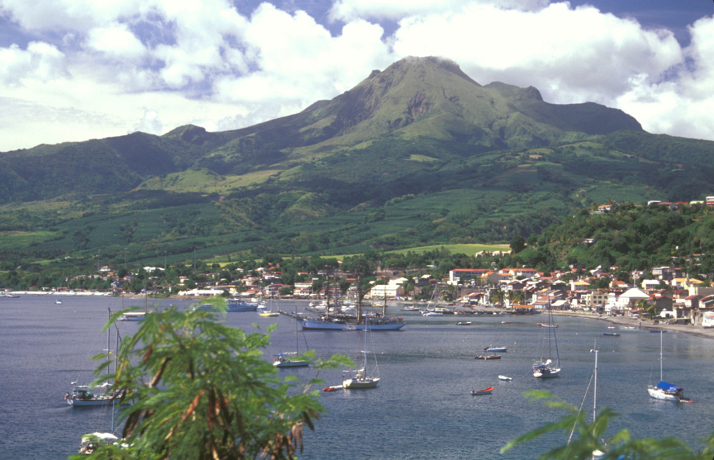
 Mont Pelee, seen here from the south, has a complex summit morphology. The eastern rim of the summit crater, the 1-km-wide Caldeira de l'Etang Sec, forms the notch just to the right of the summit. This crater cuts an edifice that was constructed within a larger horseshoe-shaped caldera, breached to the SW. It was formed during the Pleistocene as a result of a massive volcanic landslide. Two historical lava domes largely fill the Caldeira de l'Etang Sec. The 1929 lava dome forms the summit; the 1902 lava dome is out of sight behind it.
  Mount Pelee, the most renowned volcano of the West Indies, towers above the city of St. Pierre, which it destroyed during a major eruption in 1902. Pelee is the most active volcano of the Lesser Antilles, producing at least 20 major explosive eruptions during the past 5000 years. Extensive deposits of pyroclastic flows mantle the volcano. Its present summit consists of lava domes emplaced during eruptions in 1902 and 1929.
 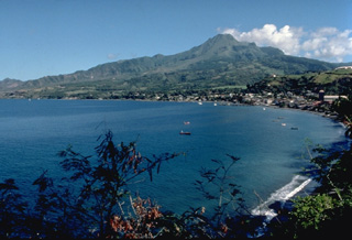 The deceptively serene-looking Pelee volcano towers above the Caribbean city of St. Pierre, located only 7.5 km to its south. Nearly 30,000 people of St. Pierre and surrounding towns were killed by pyroclastic flows and surges from Mount Pelee in 1902. The long ridge extending SW from Pelee is the northern wall of a large horseshoe-shaped caldera created by a massive volcanic landslide during the Pleistocene. The modern Pelee volcano, capped by lava domes from the 1902 and 1929 eruptions, was constructed within this scarp.
 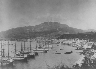 Ships line the harbor of St. Pierre before the catastrophic 1902 eruption. Prior to 1902, St. Pierre was one of the leading ports of the Carribean. At that time Mont Pelee was a forested volcano with a flat-topped summit. Residents and officials of St. Pierre, in the foreground 7.5 km south of the volcano, were not concerned that the volcano posed a threat to the city. Pelee had not erupted since 1851, and only minor phreatic eruptions had occurred then.
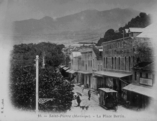 Prior to the 1902 eruption, St. Pierre was the largest and most beautiful city of the Lesser Antilles. The forested slopes of the seemingly benign Mount Pelee provided a scenic backdrop to the thriving commercial center on the NW coast of Martinique. The last eruption a half-century earlier had been a modest one, and even after the first explosions began on April 23, there was little concern. No volcanological studies had been made, and official statements of reassurance kept most residents in the city until the devastating eruption of May 8.
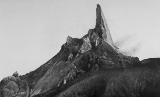 One of the most dramatic events following the devastating 1902 eruptions of Mount Pelee in Martinique was the growth of a towering spine on the summit lava dome. It began to rise above the dome on November 3, 1902. By May 31, 1903, the spine reached a height of 350 m above the dome, temporarily creating a 1617-m-high peak at the summit. It then slowly disintegrated and was gone by the end of the eruption. This March 11, 1903, photo shows the spine near its peak height, with a smoothly extruded eastern side.
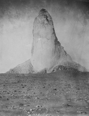 Slow, piston-like extrusion of a solidified portion of a lava dome sometimes produces vertical lava spines that rise above the surface of the dome. The world's largest known spine rose to a maximum height of 350 m, more than twice that of the Washington Monument, at Mount Pelee on Martinique in 1903. Growth of the spine began in November 1902 and reached its maximum on May 31, 1903. It slowly disintegrated and was gone by the end of the eruption two years later. This photo was taken on March 15, 1903.
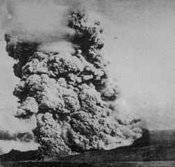 A pyroclastic flow, similiar to the one that destroyed the city of St. Pierre on Martinique on May 8, 1902, sweeps down the flanks of Mount Pelee volcano on December 16, 1902. A towering column of ash and steam rises above the advancing pyroclastic flow, which was formed by collapse of gas-rich rocks on a growing lava dome in the summit crater. The May 8 pyroclastic flow was substantially larger than this one, and would have covered an area wider than the entire shoreline of this photo.
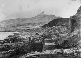 The devastated city of St. Pierre lies in ruins after a catastrophic eruption on 8 May 1902, in which pyroclastic flows and surges swept over the city, killing 28,000 people. The high-temperature pyroclastic surges devastated a 58 km2 area SW of the volcano and swept out to sea, capsizing all but two ships in the harbor. This March 1903 photo from the south shows Mount Pelee towering over the remnants of the city, capped by a dramatic lava spine that grew above the summit lava dome.
 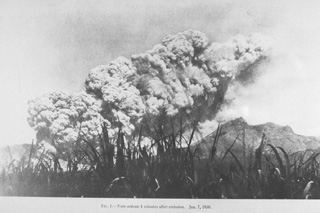 A pyroclastic flow produced by the collapse of a growing lava dome in the summit crater, sweeps down the SW flank of Mount Pelee on 1 January 1903. Small pyroclastic flows continued for 16 months following the catastrophic eruption of 8 May 1902, that destroyed St. Pierre. A second large pyroclastic flow, comparable in size to that of 8 May, devastated the SE flank on 30 August, killing an additional 1500 people. The frequency of pyroclastic flows diminished after September 1903, but they continued at longer intervals until October 1905.
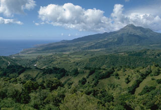 Mount Pelée towers above the city of St. Pierre (on the coast at the left), which the volcano destroyed during a catastrophic eruption in 1902. Pelée is the most active volcano of the Lesser Antilles arc, with more than 20 major eruptions during the past 5000 years. The modern volcano was constructed on the rim of a large SW-facing horseshoe-shaped caldera whose northern wall is the ridge in the shadow on the left horizon. This caldera formed as a result of slope failure of the paleo-Pelée volcano.
 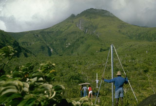 The summit of Pelée volcano rises immediately above scientists from the Mount Pelée volcano observatory and the Smithsonian Institution who are taking precision leveling measurements on the west flank. This procedure, sometimes referred to as "dry tilt," detects deformation of the volcano that often precedes an eruption by measuring the precise differences in elevation between two stadia rods placed on fixed points. This technique is part of monitoring efforts by the observatory to help detect future eruptions of this scenic, but deadly volcano.
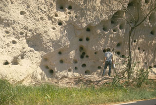 This photo portrays an unusual combination of geology and history. The light-colored deposits in this outcrop south of St. Pierre are pyroclastic-flow deposits similar to those of eruptions that destroyed the city in 1902. The abundant large holes in the outcrop are not a volcanological phenomenon, but were produced by cannon balls blasted into the unconsolidated deposit during British-French wars for control of the island of Martinique.
 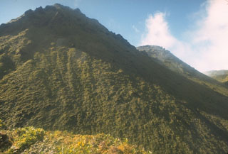 Two lava domes fill much of the Caldiera de l'Etang Sec crater at the summit of Mount Pelee. The lava dome at the left, seen from the east rim of the crater, was formed during an eruption that began in 1929. The vegetated knob halfway down the right skyline is a lava dome from the 1902 eruption. The 1929 eruption was similiar to that of 1902, but smaller in scale. After explosive removal of part of the 1902 dome, growth of a new dome began in January 1930. Pyroclastic flows accompanied dome growth until the end of 1932.
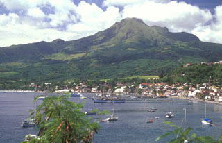 Mount Pelée towers above the city of St. Pierre in northern Martinique a century after the catastrophic eruption that destroyed the city in 1902. Pelée is the most active volcano of the Lesser Antilles arc, with more than 20 major eruptions during the past 5000 years. Lava domes formed during the 1902 eruption and one in 1929 form the present summit, which was constructed within a large scarp visible on the lower left horizon that formed when the volcano collapsed about 9000 years ago.
 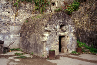 This prison cell in the city of St. Pierre housed one of the only two survivors of the 8 May 1902, eruption of Mount Pelée. Devastating pyroclastic flows and surges swept down the SW flank of the volcano early in the morning and destroyed the city, killing 28,000 people in the world's deadliest eruption of the 20th century.
 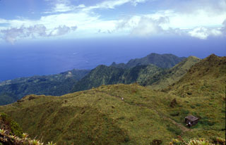 This view looks west from the 1902 lava dome within the summit crater of Mount Pelée. The area beyond the grassy knoll was part of the first portion of the ancestral volcano that underwent massive edifice collapse more than 100,000 years ago. This massive collapse produced a 25 cu km debris avalanche that swept into the Caribbean Sea up to 70 km from the coastline. Mount Pelée was subject to three major episodes of edifice collapse--the second took place about 25,000 years and the third about 9000 years ago.
 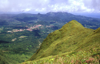 The steep-sided grassy knob in the right foreground is part of the Aileron lava dome, which formed during an eruption about 9700 years ago. This view looks to the SE towards the town of Morne Rouge (left-center), which was devastated by pyroclastic flows during the 1902 eruption. The Pleistocene Piton du Carbet volcano lies in the clouds on the right-center horizon.
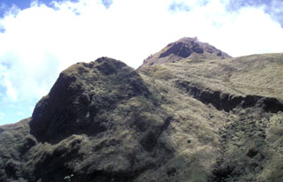 The steep-sided lava dome at the left is Aileron, which was formed about 9700 years ago. The back side of the dome was cut by the latest of three major edifice-collapse events at Mount Pelée. The eastern rim of l'Etang Sec, the current summit crater, cuts horizontally across the photo at the upper right in front of the 1929 dome on the right horizon.
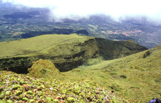 This view from the summit of Mount Pelée shows the eastern rim of l'Etang Sec, the current summit crater of Mount Pelée. The 1902 and 1920 lava domes fill much of this crater. The town with reddish roofs at the far right is Morne Rouge, affected by pyroclastic flows from the 1902 eruption.
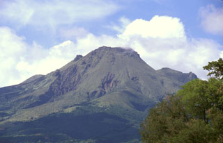 The 1929 lava dome forms the summit of Mount Pelée in this telephoto view from St. Pierre. The modern volcano was constructed within a scarp produced by collapse of the volcano about 9000 years ago. The irregularity on the right-hand flank is part of the eastern summit crater rim and the Aileron lava dome, which erupted about 9700 years ago.
 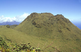 The 1902 lava dome fills much of the l'Etang Sec summit crater, as seen here from Morne Macouba, north of the summit. Following the catastrophic eruption on May 8, 1902, rapid growth of a summit lava dome began; it reached 350 m height by July 6. Intermittent explosive activity continued until October 31, 1903 and lava dome growth continued on a diminishing scale until October 5, 1905. The famous spine at one point rose to 1617 m, 220 m above the current summit (the 1929 lava dome), before it crumbled away.
Maps are not currently available due to technical issues.
The maps shown below have been scanned from the GVP map archives and include the volcano on this page. Clicking on the small images will load the full 300 dpi map. Very small-scale maps (such as world maps) are not included.
The following 34 samples associated with this volcano can be found in the Smithsonian's NMNH Department of Mineral Sciences collections, and may be availble for research (contact the Rock and Ore Collections Manager). Catalog number links will open a window with more information.
| Catalog Number | Sample Description | Lava Source | Collection Date |
|---|---|---|---|
| NMNH 102152 | Hypersthene Dacite | -- | -- |
| NMNH 102154 | Dacite | -- | -- |
| NMNH 111220 | Breadcrust Volcanic Bomb | -- | -- |
| NMNH 113056-1 | Beach Sand | -- | -- |
| NMNH 113056-10 | Tephra | -- | -- |
| NMNH 113056-11 | Tephra | -- | -- |
| NMNH 113056-12 | Tephra | -- | -- |
| NMNH 113056-13 | Tephra | -- | -- |
| NMNH 113056-14 | Tephra | -- | -- |
| NMNH 113056-15 | Tephra | -- | -- |
| NMNH 113056-16 | Tephra | -- | -- |
| NMNH 113056-17 | Tephra | -- | -- |
| NMNH 113056-18 | Tephra | -- | -- |
| NMNH 113056-2 | Tephra | -- | -- |
| NMNH 113056-3 | Tephra | -- | -- |
| NMNH 113056-4 | Tephra | -- | -- |
| NMNH 113056-5 | Tephra | -- | -- |
| NMNH 113056-6 | Tephra | -- | -- |
| NMNH 113056-7 | Tephra | -- | -- |
| NMNH 113056-8 | Tephra | -- | -- |
| NMNH 113056-9 | Tephra | -- | -- |
| NMNH 115748 | Hypersthene Andesite | -- | -- |
| NMNH 115749 | Hypersthene Andesite | -- | -- |
| NMNH 115750 | Hypersthene Andesite | -- | -- |
| NMNH 115751 | Pumice | -- | -- |
| NMNH 115752 | Pumice | -- | -- |
| NMNH 115753 | Pumice | -- | -- |
| NMNH 116782 | Breadcrust Volcanic Bomb | -- | -- |
| NMNH 74751 | Volcanic Dust | -- | -- |
| NMNH 74753 | Volcanic Dust | -- | -- |
| NMNH 74761 | Volcanic Dust | -- | -- |
| NMNH 76963 | Volcanic Dust | -- | -- |
| NMNH 88959 | Hypersthene Andesite | -- | -- |
| NMNH 88960 | Hypersthene Andesite | -- | -- |
| Copernicus Browser | The Copernicus Browser replaced the Sentinel Hub Playground browser in 2023, to provide access to Earth observation archives from the Copernicus Data Space Ecosystem, the main distribution platform for data from the EU Copernicus missions. |
| MIROVA | Middle InfraRed Observation of Volcanic Activity (MIROVA) is a near real time volcanic hot-spot detection system based on the analysis of MODIS (Moderate Resolution Imaging Spectroradiometer) data. In particular, MIROVA uses the Middle InfraRed Radiation (MIR), measured over target volcanoes, in order to detect, locate and measure the heat radiation sourced from volcanic activity. |
| MODVOLC Thermal Alerts | Using infrared satellite Moderate Resolution Imaging Spectroradiometer (MODIS) data, scientists at the Hawai'i Institute of Geophysics and Planetology, University of Hawai'i, developed an automated system called MODVOLC to map thermal hot-spots in near real time. For each MODIS image, the algorithm automatically scans each 1 km pixel within it to check for high-temperature hot-spots. When one is found the date, time, location, and intensity are recorded. MODIS looks at every square km of the Earth every 48 hours, once during the day and once during the night, and the presence of two MODIS sensors in space allows at least four hot-spot observations every two days. Each day updated global maps are compiled to display the locations of all hot spots detected in the previous 24 hours. There is a drop-down list with volcano names which allow users to 'zoom-in' and examine the distribution of hot-spots at a variety of spatial scales. |
|
WOVOdat
Single Volcano View Temporal Evolution of Unrest Side by Side Volcanoes |
WOVOdat is a database of volcanic unrest; instrumentally and visually recorded changes in seismicity, ground deformation, gas emission, and other parameters from their normal baselines. It is sponsored by the World Organization of Volcano Observatories (WOVO) and presently hosted at the Earth Observatory of Singapore.
GVMID Data on Volcano Monitoring Infrastructure The Global Volcano Monitoring Infrastructure Database GVMID, is aimed at documenting and improving capabilities of volcano monitoring from the ground and space. GVMID should provide a snapshot and baseline view of the techniques and instrumentation that are in place at various volcanoes, which can be use by volcano observatories as reference to setup new monitoring system or improving networks at a specific volcano. These data will allow identification of what monitoring gaps exist, which can be then targeted by remote sensing infrastructure and future instrument deployments. |
| Volcanic Hazard Maps | The IAVCEI Commission on Volcanic Hazards and Risk has a Volcanic Hazard Maps database designed to serve as a resource for hazard mappers (or other interested parties) to explore how common issues in hazard map development have been addressed at different volcanoes, in different countries, for different hazards, and for different intended audiences. In addition to the comprehensive, searchable Volcanic Hazard Maps Database, this website contains information about diversity of volcanic hazard maps, illustrated using examples from the database. This site is for educational purposes related to volcanic hazard maps. Hazard maps found on this website should not be used for emergency purposes. For the most recent, official hazard map for a particular volcano, please seek out the proper institutional authorities on the matter. |
| IRIS seismic stations/networks | Incorporated Research Institutions for Seismology (IRIS) Data Services map showing the location of seismic stations from all available networks (permanent or temporary) within a radius of 0.18° (about 20 km at mid-latitudes) from the given location of Pelée. Users can customize a variety of filters and options in the left panel. Note that if there are no stations are known the map will default to show the entire world with a "No data matched request" error notice. |
| UNAVCO GPS/GNSS stations | Geodetic Data Services map from UNAVCO showing the location of GPS/GNSS stations from all available networks (permanent or temporary) within a radius of 20 km from the given location of Pelée. Users can customize the data search based on station or network names, location, and time window. Requires Adobe Flash Player. |
| DECADE Data | The DECADE portal, still in the developmental stage, serves as an example of the proposed interoperability between The Smithsonian Institution's Global Volcanism Program, the Mapping Gas Emissions (MaGa) Database, and the EarthChem Geochemical Portal. The Deep Earth Carbon Degassing (DECADE) initiative seeks to use new and established technologies to determine accurate global fluxes of volcanic CO2 to the atmosphere, but installing CO2 monitoring networks on 20 of the world's 150 most actively degassing volcanoes. The group uses related laboratory-based studies (direct gas sampling and analysis, melt inclusions) to provide new data for direct degassing of deep earth carbon to the atmosphere. |
| Large Eruptions of Pelée | Information about large Quaternary eruptions (VEI >= 4) is cataloged in the Large Magnitude Explosive Volcanic Eruptions (LaMEVE) database of the Volcano Global Risk Identification and Analysis Project (VOGRIPA). |
| EarthChem | EarthChem develops and maintains databases, software, and services that support the preservation, discovery, access and analysis of geochemical data, and facilitate their integration with the broad array of other available earth science parameters. EarthChem is operated by a joint team of disciplinary scientists, data scientists, data managers and information technology developers who are part of the NSF-funded data facility Integrated Earth Data Applications (IEDA). IEDA is a collaborative effort of EarthChem and the Marine Geoscience Data System (MGDS). |

