Tanzania Volcanoes
A map display is currently under development.
Tanzania has 6 Holocene volcanoes. Note that as a scientific organization we provide these listings for informational purposes only, with no international legal or policy implications. Volcanoes will be included on this list if they are within the boundaries of a country, on a shared boundary or area, in a remote territory, or within a maritime Exclusive Economic Zone. Bolded volcanoes have erupted within the past 20 years. Suggestions and data updates are always welcome ().
| Volcano Name | Last Eruption | Volcanic Region | Primary Landform |
|---|---|---|---|
| Igwisi Hills | 10450 BCE | Albertine Rift Volcanic Province | Cluster |
| Kyejo | 1800 CE | Rukwa Rift Volcanic Province | Composite |
| Ol Doinyo Lengai | 2025 CE | Kenyan Rift Volcanic Province | Composite |
| Meru | 1910 CE | Kenyan Rift Volcanic Province | Composite |
| Ngozi | 1450 CE | Rukwa Rift Volcanic Province | Caldera |
| Rungwe | 1250 CE | Rukwa Rift Volcanic Province | Composite |
Chronological listing of known Holocene eruptions (confirmed or uncertain) from volcanoes in Tanzania. Bolded eruptions indicate continuing activity.
| Volcano Name | Start Date | Stop Date | Certainty | VEI | Evidence |
|---|---|---|---|---|---|
| Ol Doinyo Lengai | 2017 Apr 9 | 2025 Apr 29 (continuing) | Confirmed | 0 | Observations: Reported |
| Ol Doinyo Lengai | 2016 Sep 21 (on or before) | 2016 Oct 13 (on or after) | Confirmed | 0 | Observations: Reported |
| Ol Doinyo Lengai | 2015 Jun 20 (on or before) | 2015 Aug 24 (on or after) | Confirmed | 0 | Observations: Reported |
| Ol Doinyo Lengai | 2011 Jun 22 (in or before) | 2014 Jul 15 ± 10 days | Confirmed | 0 | Observations: Reported |
| Ol Doinyo Lengai | 2007 Jun 16 ± 15 days | 2010 Oct 9 (?) ± 1 days | Confirmed | 3 | Observations: Reported |
| Ol Doinyo Lengai | 1994 Sep 18 | 2006 Jul 16 (?) ± 15 days | Confirmed | 1 | Observations: Reported |
| Ol Doinyo Lengai | 1983 Jan 1 | 1993 Sep 24 | Confirmed | 2 | Observations: Reported |
| Ol Doinyo Lengai | [1969 Jul 16 (?) ± 15 days] | [Unknown] | Uncertain | ||
| Ol Doinyo Lengai | 1967 Jul 8 | 1967 Sep 4 | Confirmed | 3 | Observations: Reported |
| Ol Doinyo Lengai | 1960 Mar 16 (on or before) ± 15 days | 1966 Nov 28 ± 30 days | Confirmed | 3 | Observations: Reported |
| Ol Doinyo Lengai | 1958 Feb 6 (on or before) | Unknown | Confirmed | 1 | Observations: Reported |
| Ol Doinyo Lengai | 1955 Jan 19 | 1955 Jan 20 | Confirmed | 2 | Observations: Reported |
| Ol Doinyo Lengai | 1954 Jul 26 ± 5 days | 1954 Sep 16 ± 15 days | Confirmed | 2 | Observations: Reported |
| Ol Doinyo Lengai | 1940 Jul 24 | 1941 Feb | Confirmed | 3 | Observations: Reported |
| Ol Doinyo Lengai | 1926 | Unknown | Confirmed | 2 | Observations: Reported |
| Ol Doinyo Lengai | 1921 Feb | Unknown | Confirmed | 2 | Observations: Reported |
| Ol Doinyo Lengai | 1916 Dec 1 ± 30 days | 1917 Jun | Confirmed | 3 | Observations: Reported |
| Ol Doinyo Lengai | 1914 Aug 15 ± 270 days | 1915 | Confirmed | 0 | Observations: Reported |
| Ol Doinyo Lengai | 1913 | Unknown | Confirmed | 0 | Observations: Reported |
| Meru | 1910 Oct 26 | 1910 Dec 22 | Confirmed | 2 | Observations: Reported |
| Ol Doinyo Lengai | 1907 ± 3 years | 1910 Aug 4 (on or after) | Confirmed | 0 | Observations: Reported |
| Ol Doinyo Lengai | 1904 | Unknown | Confirmed | 0 | Observations: Reported |
| Meru | 1886 (?) | Unknown | Confirmed | 0 | Observations: Reported |
| Ol Doinyo Lengai | 1882 | 1883 | Confirmed | 2 | Observations: Reported |
| Ol Doinyo Lengai | 1880 Dec | Unknown | Confirmed | 2 | Observations: Reported |
| Meru | 1878 ± 1 years | Unknown | Confirmed | 2 | Observations: Reported |
| Kyejo | 1800 (?) | Unknown | Confirmed | 2 | Observations: Reported |
| Ngozi | 1450 ± 40 years | Unknown | Confirmed | Isotopic: 14C (calibrated) | |
| Ol Doinyo Lengai | 1350 (?) | Unknown | Confirmed | Correlation: Tephrochronology | |
| Rungwe | 1250 ± 40 years | Unknown | Confirmed | Isotopic: 14C (calibrated) | |
| Ol Doinyo Lengai | 0700 (?) | Unknown | Confirmed | Correlation: Tephrochronology | |
| Ol Doinyo Lengai | 0050 BCE (?) | Unknown | Confirmed | Correlation: Tephrochronology | |
| Rungwe | 0050 BCE ± 100 years | Unknown | Confirmed | 4 | Isotopic: 14C (calibrated) |
| Ol Doinyo Lengai | 1550 BCE ± 1500 years | Unknown | Confirmed | Correlation: Tephrochronology | |
| Rungwe | 2050 BCE (?) | Unknown | Confirmed | 5 | Correlation: Tephrochronology |
| Meru | 5850 BCE (?) | Unknown | Confirmed | 4 | Isotopic: 14C (uncalibrated) |
| Ngozi | 8250 BCE (?) | Unknown | Confirmed | 5 | Isotopic: 14C (calibrated) |
| Igwisi Hills | 10450 BCE ± 4800 years | Unknown | Confirmed | Isotopic: Cosmic Ray Exposure |
Tanzania has 17 Pleistocene volcanoes. Note that as a scientific organization we provide these listings for informational purposes only, with no international legal or policy implications. Volcanoes will be included on this list if they are within the boundaries of a country, on a shared boundary or area, in a remote territory, or within a maritime Exclusive Economic Zone. Suggestions and data updates are always welcome ().
| Volcano Name | Volcanic Region | Primary Landform |
|---|---|---|
| Burko | Kenyan Rift Volcanic Province | Composite |
| Embagai | Kenyan Rift Volcanic Province | Caldera |
| Gelai | Kenyan Rift Volcanic Province | Shield |
| Hanang | Kenyan Rift Volcanic Province | Composite |
| Izumbwe-Mpoli | Rukwa Rift Volcanic Province | Minor |
| Katete | Rukwa Rift Volcanic Province | Composite |
| Kerimasi | Kenyan Rift Volcanic Province | Composite |
| Ketumbeine | Kenyan Rift Volcanic Province | Shield |
| Kilimanjaro | Kenyan Rift Volcanic Province | Composite |
| Kwaraha | Kenyan Rift Volcanic Province | Composite |
| Loolmalasin | Kenyan Rift Volcanic Province | Composite |
| Ngorongoro | Kenyan Rift Volcanic Province | Caldera |
| Olmoti | Kenyan Rift Volcanic Province | Caldera |
| Sadiman | Kenyan Rift Volcanic Province | Composite |
| SW Usangu Basin | Rukwa Rift Volcanic Province | Cluster |
| Tukuyu | Rukwa Rift Volcanic Province | Shield |
| Usangu Scarp Basalt | Rukwa Rift Volcanic Province | Minor |
There are 28 photos available for volcanoes in Tanzania.
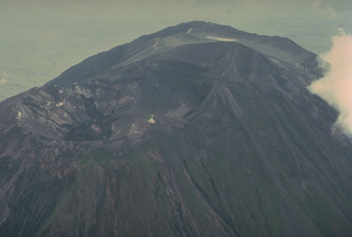
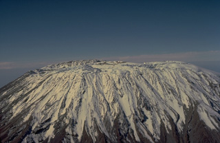 Massive Kilimanjaro, Africa's highest mountain, consists of three very large stratovolcanoes constructed along a NW-SE trend. Seen here from the SW, the ice-capped, 5895-m-high summit is cut by a 2.4 x 3.6 km caldera that gives the summit of the central stratovolcano (Kibo), an elongated broad profile. Most of Kilimanjaro was constructed during the Pleistocene, but a group of youthful-looking nested summit craters are of apparent Holocene age. Fumarolic activity continues at several locations on the summit plateau.
Copyrighted photo by Katia and Maurice Krafft, 1977.
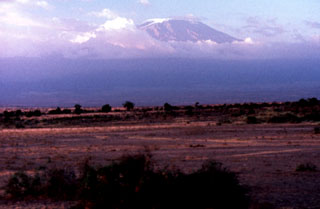 Massive Kilimanjaro, Africa's highest mountain, rises to the S above the Amboseli Game Preserve in Kenya. The 2.4 x 3.6 km caldera gives the ice-covered summit of Kibo an elongated, broad profile. Numerous smaller cones occupy a rift zone to the NW and SE of Kibo. Most of Kilimanjaro was constructed during the Pleistocene, but a group of nested summit craters are of apparent Holocene age.
Photo by Tom Jorstad, 1990 (Smithsonian Institution).
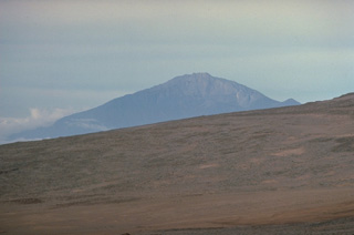
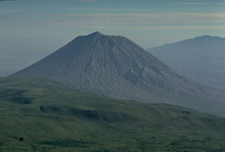 Symmetrical Ol Doinyo Lengai volcano is seen here from the slopes of Embagi volcano, to its SW. The summit peak separates two craters, the northernmost (left-hand) of which has been historically active. Ol Doinyo Lengai is renowned for its chemically distinctive products. It is the only volcano known to have erupted carbonatitic tephras and lavas during historical time. These sodium carbonate volcanic rocks are relatively poor in silica, the dominant chemical component of magmas erupted at nearly all of Earth's other volcanoes.
Copyrighted photo by Katia and Maurice Krafft, 1976.
 The north crater of Ol Doinyo Lengai, seen here from its NE rim in July 1988, has been the source of all historical eruptions from the volcano. The second crater is located on the other side of the summit peak. A decade-long eruption beginning in 1983 produced a series of lava flows on the floor of the crater. By December 1988 lava had overflowed into a shallow depression below and to the right of the summit.
Copyrighted photo by Katia and Maurice Krafft, 1988.
 Meru volcano, Africa's fourth highest mountain, rises to the west of its more prominent neighbor, Kilimanjaro. Seen here from the slopes of Kilimanjaro, 4565-m-high Meru is cut by a 5-km-wide breached caldera on the east side that formed about 7800 years ago when the summit of the volcano collapsed. The resulting massive debris avalanche and lahar traveled as far as the western flank of Kilimanjaro volcano. The historically active Ash Cone forms a prominent symmetrical cone inside the breached caldera.
 Copyrighted photo by Katia and Maurice Krafft, 1977.
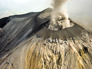 Ash eruption from Ol Doinyo Lengai seen on 12 March 2008 from the NNE. This image shows that the E, N, and W flanks of the cone had buried the original crater rim. Oversteepening of the cone flank in places resulted in small landslides which can be seen just below the cone as dark material covering the lighter areas of older weathered carbonatite. The peak beyond the ash plume is the summit.
Photo by Benoît Wilhelmi, 2008.
 A cluster of nested craters occupies the summit of Kilimanjaro volcano. This view looks ESE to Mawenzi, a dissected stratovolcano that is one of three forming the broad Kilimanjaro massif. The low ridge above the crater complex at the left is part of the steep-sided summit icecap. The coalescing volcanoes of Mawenzi, the central summit cone of Kibo, and Shira to the NW form the elongated Kilimanjaro massif, Africa's highest peak.
Copyrighted photo by Katia and Maurice Krafft, 1977.
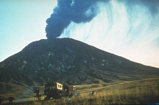 An ash plume rises above the summit of Ol Doinyo Lengai in 1966, near the end of an eruption that began in 1960. Quiet extrusion of carbonatite lava apparently took place from 1960 to 1966, although few direct observations were made. In early August 1966 activity changed to vigorous ash eruptions. A powerful explosive eruption was observed on 22 August. Explosive activity was also reported on 28 October and the volcano was reported to be quiescent in late December 1966.
Photo by Gordon Davies, 1966 (courtesy of Celia Nyamweru, Kenyatta University).
 This 1977 photo from the NW shows the summit crater of Ol Doinyo Lengai volcano prior to a decade-long eruption that began in 1983. The northern crater (left) has been active during historical time. An older southern crater is located behind the summit, which is the dark, rounded ridge below the upper right horizon. Prior to 1983 the northern crater was deep, with a steep-walled inner pit. Beginning in 1983, the slow effusion of lava flows on the crater floor began filling it.
Copyrighted photo by Katia and Maurice Krafft, 1977.
 A herd of wildebeest graze in the foreground during an explosive eruption from Tanzania's Ol Doinyo Lengai in 1966. Explosive activity began in August 1966, near the end of an eruption that began in 1960 and consisted of quiet emission of lava flows in the summit crater. Ash deposits from previous eruptions whiten the volcano's slopes. This is the only volcano known to have erupted carbonatite in historical time.
Photo by Gordon Davies, 1966 (courtesy of Celia Nyamweru, Kenyatta University).
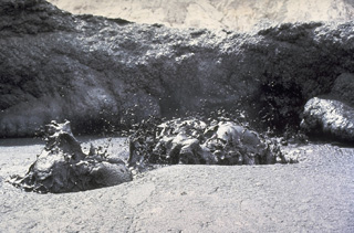
 Fresh black lava flows issue from a spatter cone on the crater floor at Ol Doinyo Lengai volcano in June 1960. Eruptive activity was first observed in March 1960. Quiet extrusion of carbonatite lava apparently took place from 1960 to 1966, although few direct observations were made. In early August 1966 activity changed to vigorous ash eruptions.
 Photo by Dick Moss, 1961 (courtesy of Celia Nyamweru, Kenyatta University).
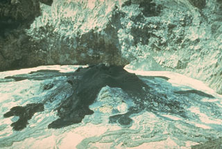
 Liquid black lava is ejected from a lava lake on the crater floor of Ol Doinyo Lengai volcano in Tanzania in June 1988. The relatively low-temperature carbonatitic lava (sodium carbonate) is black during daylight hours and is incandescent only at night. Temperatures of 495-544 degress Centigrade were measured during a June 1988 expedition. Slow extrusion of lava flows on the floor of the crater began in 1983.
Copyrighted photo by Katia and Maurice Krafft, 1988.
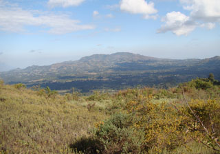
 Sarabwe and Fiteko cones, visible halfway up the flank of the Kyejo volcanic complex, erupted about 1800 CE, in the latest eruption in this region. The eruption from these cones formed the Sarabwe lava flow (not clear in this picture). The cones are seen from the village of Masebe, 5 km NW from the summit.
Photo by Karen Fontijn, 2008 (University of Ghent).
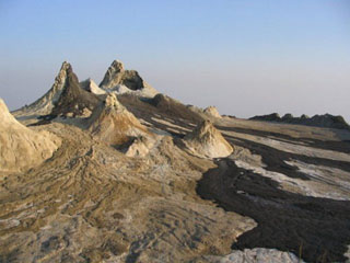
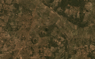 The Igwisi Hills volcanic complex contains the three kimberlite cones in the center of this November 2019 Planet Labs satellite image monthly mosaic (N is at the top; this image is approximately 3.5 km across). From the NE to SW, the three cones are NE Volcano, Central Volcano, and SW Volcano. Each cone produced viscous lavas that reached short distances from the vents.
Satellite image courtesy of Planet Labs Inc., 2020 (https://www.planet.com/).
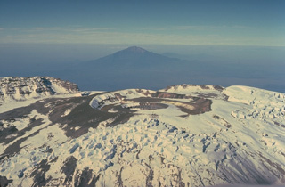 An aerial view across the summit plateau of Kilimanjaro looks west towards Meru stratovolcano in the distance. The nested craters in the center are the youngest features of the volcano. They cut a summit ash cone that has grown within a 2.4 x 3.6 caldera, whose rim is seen at the left.
Copyrighted photo by Katia and Maurice Krafft, 1977.
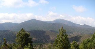 The summit of Rungwe is seen from WNW with the scarp resulting from edifice collapse in the background. At the left-center is a cone breached by a lava flow towards the S to SW (right). Rungwe volcano is the largest in the Karonga basin NW of Lake Malawi (Lake Nyasa) and is capped by a 4-km-wide caldera that is breached to the west. The caldera is largely filled by a series of youthful-looking uneroded and sparsely vegetated pumice cones, lava domes, and explosion craters.
Photo by Karen Fontijn, 2008 (University of Ghent).
 The chemically exotic lavas of Tanzania's Ol Doinyo Lengai volcano have unusually low temperatures and viscosities; it is the only volcano actively erupting carbonatitic (sodium carbonate) lava flows. Its lava flows are only incandescent during nighttime. The flows are usually only a few centimeters thick and travel only a few tens of meters from their source. This 1966 photo shows a small lava flow, only a meter wide, with miniature channels and levees (note the person at the top for scale).
Photo by Gordon Davies, 1966 (courtesy of Celia Nyamweru, Kenyatta University).
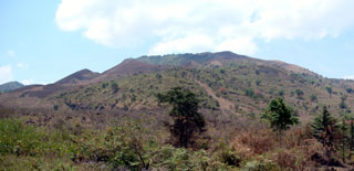
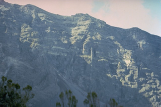
 The Kyejo volcanic complex (also spelled Kieyo) is seen from Katete, an eroded volcano located 10-15 km to the NNW. Late-stage activity consisted of the formation of numerous maars and cones. The latest eruption around 1800 CE took place from two cones that were constructed along a NW-trending fissure: Sarabwe and Fiteko. The eruption produced lava flows that overran several villages.
Photo by Karen Fontijn, 2008 (University of Ghent).
 The northern wall of the horseshoe-shaped caldera cutting the summit of Meru volcano rises vertically up to 900 m above the caldera floor. The 5-km-wide caldera is breached to the east and was formed as a result of a massive volcanic landslide about 7800 years ago.
Copyrighted photo by Katia and Maurice Krafft, 1977.
 Meru volcano (upper right), Africa's fourth highest mountain, is seen from the ice-covered summit plateau of neighboring Kilimanjaro volcano. The volcano is cut by a 5-km-wide breached caldera on the E side that formed about 7,800 years ago when the summit collapsed. A massive debris avalanche and lahar traveled to the east as far as the western flank of Kilimanjaro.
Photo by Tom Jorstad, 1991 (Smithsonian Institution).
 This June 1984 view looking southward across the north crater shows a fresh black lava flow and small spatter cones on the crater floor. This photo was taken early during the eruption episode that began in January 1983 and shows the considerable depth of the crater at the time. Continued emission of lava flows filled the crater to the level of the saddle at the top of the image by December 1988, at which time lava overflowed the rim into a shallow depression.
Photo by Fred Trott, 1984 (courtesy of Celia Nyamweru, Kenyatta University).
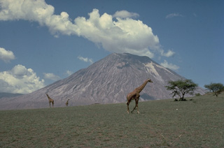 Giraffes graze on grasslands in front of the symmetrical Ol Doinyo Lengai stratovolcano. Known as "The Mountain of God," it rises abruptly above the broad plain south of Lake Natron. Ol Doinyo Lengai is the only volcano known to have erupted carbonatite tephra and lavas in historical time. Historical activity has included small tephra eruptions and emission of numerous natrocarbonititic lava flows on the floor of the summit crater.
 Copyrighted photo by Katia and Maurice Krafft, 1977.
 These fresh, dark-colored lava flows in the summit crater of Ol Doinyo Lengai volcano in Tanzania were erupted on 21 July 2004 from the spatter cone (about 12 m high) at the upper left, as well as other vents. The chemistry of these carbonatite lava flows causes rapid alteration of the flows, which can give them a light-colored surface within a few days of eruption. Frequent eruptions of small-volume lava flows in the summit crater began in 1983 and gradually filled the previously deep crater.
Photo by Frederick Belton, 2004 (Tennessee State University).
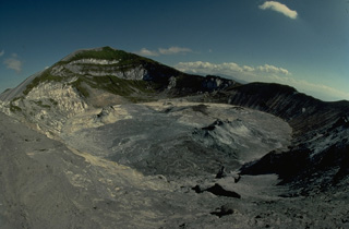
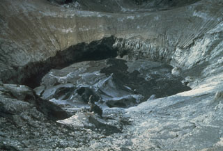
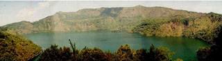 Lake-filled Ngozi caldera is seen here from its southern rim. The 1.5 x 2.5 km caldera lake is bounded by steep-walled cliffs 150-300 m high. The caldera is the most prominent volcanic feature of the Poroto Ridge, a transverse structure at the northern end of the Karonga basin in SW Tanzania. Numerous cones are situated along the ridge. The youngest activity along the ridge appears to have originated from Ngozi caldera and from pyroclastic cones to the N.
Photo by David Williamson, CNRS, France.
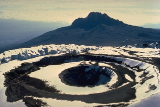
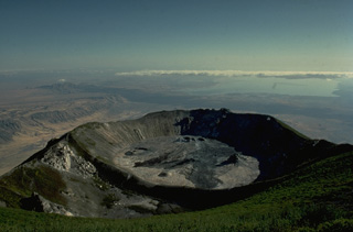
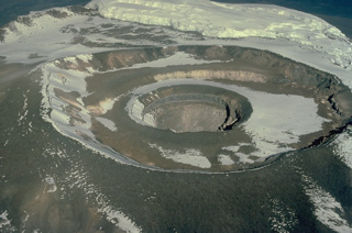 An aerial view from the SE overlooks three nested craters at the summit plateau of Tanzania's Kilimajaro volcano. The outer crater is 875 m wide and the inner pit is 340 m wide and 130 m deep. These craters, constructed within a 2.4 x 3.6 km summit caldera, are the youngest features of Kilimajaro volcano. Fumarolic activity occurs from several locations on the crater floor and on the wall of the inner crater.
 Copyrighted photo by Katia and Maurice Krafft, 1977.
 The northern crater of Ol Doinyo Lengai is seen here from the summit of the volcano in 1988 with Lake Natron in the distance. Ol Doinyo Lengai was built on the floor of the East African Rift, whose western wall forms the escarpment at the left. Newly erupted lava flows darken the floor of the crater in this photo taken during the course of a decade-long eruption that began in 1983.
Copyrighted photo by Katia and Maurice Krafft, 1988.
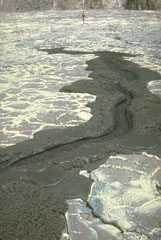
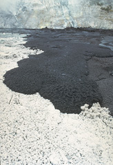 A black lava flow advances across the floor of Tanzania's Ol Doinyo Lengai volcano on June 27, 1988. The white-colored area in the foreground is not covered with snow, but is the surface of a recently cooled lava flow. The unusual carbonatitic (sodium carbonate) chemistry of flows from this volcano produces lava flows that are initially black, but have white edges within a few hours and alter to an entirely white surface within 48 hours.
Copyrighted photo by Katia and Maurice Krafft, 1988.
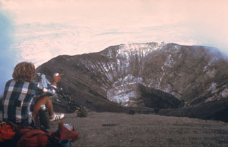 The northern crater of Ol Doinyo Lengai is seen here in February 1980 from the summit. The steep-walled inner crater formed during the explosive eruptions of 1966 and 1967. Another eruption began three years after this photo was taken. By December 1988 the crater filled with lava that had overflowed the near southern crater rim at the lower center of the photo.
Photo by Peterson, 1980 (courtesy of Celia Nyamweru, Kenyatta University).
This is a compilation of Tanzania volcano information sources, such as official monitoring or other government agencies.
| Volcanic Ash Advisory Center | |
|---|---|
| Toulouse Volcanic Ash Advisory Center (VAAC) Notices and Archive | |