Solomon Islands Volcanoes
A map display is currently under development.
Solomon Islands has 7 Holocene volcanoes. Note that as a scientific organization we provide these listings for informational purposes only, with no international legal or policy implications. Volcanoes will be included on this list if they are within the boundaries of a country, on a shared boundary or area, in a remote territory, or within a maritime Exclusive Economic Zone. Bolded volcanoes have erupted within the past 20 years. Suggestions and data updates are always welcome ().
| Volcano Name | Last Eruption | Volcanic Region | Primary Landform |
|---|---|---|---|
| Coleman Seamount | Unknown - Evidence Credible | Solomon Volcanic Province | Composite |
| Kana Keoki | Unknown - Evidence Credible | Solomon Volcanic Province | Composite |
| Kavachi | 2014 CE | Solomon Volcanic Province | Composite |
| New Georgia at 8.9°S | Unknown - Evidence Credible | Solomon Volcanic Province | Composite |
| Savo | 1847 CE | Solomon Volcanic Province | Composite |
| Simbo | 1910 CE | Solomon Volcanic Province | Composite |
| Tinakula | 2024 CE | Vanuatu Volcanic Arc | Composite |
Chronological listing of known Holocene eruptions (confirmed or uncertain) from volcanoes in Solomon Islands. Bolded eruptions indicate continuing activity.
| Volcano Name | Start Date | Stop Date | Certainty | VEI | Evidence |
|---|---|---|---|---|---|
| Kavachi | [2020 Mar 16] | [2024 Apr 24 (continuing)] | Uncertain | ||
| Tinakula | 2018 Dec 8 (on or before) | 2024 Dec 31 | Confirmed | 0 | Observations: Reported |
| Tinakula | 2017 Oct 21 | 2017 Oct 26 | Confirmed | 3 | Observations: Reported |
| Kavachi | 2014 Jan 29 | 2014 Jan 29 (?) | Confirmed | 1 | Observations: Satellite (visual) |
| Tinakula | 2008 Sep 19 (?) | 2008 Nov 29 (?) | Confirmed | 1 | Observations: Reported |
| Kavachi | 2007 Apr 2 (?) | 2007 Apr 6 (on or after) | Confirmed | 1 | Observations: Reported |
| Tinakula | 2006 Feb 11 | 2007 Nov 9 (?) | Confirmed | 2 | Observations: Reported |
| Kavachi | 2004 Mar 15 | Unknown | Confirmed | 1 | Observations: Reported |
| Tinakula | [2002 Nov 16 ± 15 days] | [Unknown] | Uncertain | ||
| Tinakula | [2002 Apr 16 ± 15 days] | [Unknown] | Uncertain | ||
| Tinakula | 2000 Feb 29 (?) | 2001 May 8 (?) | Confirmed | 1 | Observations: Reported |
| Kavachi | 1999 Nov 16 (?) ± 15 days | 2003 Aug 16 ± 15 days | Confirmed | 1 | Observations: Reported |
| Tinakula | 1999 May 16 ± 15 days | Unknown | Confirmed | 1 | Observations: Reported |
| Kavachi | 1999 Feb 16 ± 15 days | 1999 May 16 ± 15 days | Confirmed | 1 | Observations: Reported |
| Kavachi | [1998 Jul 2 ± 182 days] | [Unknown] | Uncertain | ||
| Kavachi | 1997 Jan 16 | 1997 Jan 17 (on or after) | Confirmed | 1 | Observations: Reported |
| Tinakula | 1995 Jul 2 ± 182 days | Unknown | Confirmed | 1 | Observations: Reported |
| Kavachi | 1991 May 4 (on or before) | 1991 Sep 16 ± 15 days | Confirmed | 2 | Observations: Reported |
| Tinakula | 1989 Aug 16 (on or before) ± 15 days | 1990 Feb 16 (on or after) ± 15 days | Confirmed | 1 | Observations: Reported |
| Kavachi | 1986 Jul 5 | 1986 Jul 23 | Confirmed | 1 | Observations: Reported |
| Kavachi | 1985 Dec 9 | 1986 Feb 28 ± 3 days | Confirmed | 1 | Observations: Reported |
| Tinakula | 1984 Jun 3 (on or before) | 1985 Jun 13 (on or after) | Confirmed | 2 | Observations: Reported |
| Kavachi | 1982 Apr 7 | 1982 Jun 2 ± 1 days | Confirmed | 2 | Observations: Reported |
| Kavachi | [1981 Sep 15 ± 5 days] | [Unknown] | Uncertain | ||
| Kavachi | 1980 Oct 7 | 1981 Feb 25 | Confirmed | 1 | Observations: Reported |
| Kavachi | 1978 Jun 21 | 1978 Jul 22 ± 6 days | Confirmed | 2 | Observations: Reported |
| Kavachi | 1977 Jul 17 (?) | 1977 Jul 22 | Confirmed | 1 | Observations: Reported |
| Kavachi | 1977 Feb 22 | Unknown | Confirmed | 1 | Observations: Reported |
| Kavachi | 1976 Aug 24 | 1976 Oct 13 | Confirmed | 1 | Observations: Reported |
| Kavachi | 1975 Aug 16 ± 15 days | Unknown | Confirmed | 1 | Observations: Reported |
| Kavachi | 1974 Nov 12 | 1974 Dec 12 (?) | Confirmed | 1 | Observations: Reported |
| Kavachi | 1972 Oct 24 | Unknown | Confirmed | 0 | Observations: Reported |
| Tinakula | 1971 Sep 6 | 1971 Dec 11 | Confirmed | 2 | Observations: Reported |
| Kavachi | 1969 Oct 28 | 1970 Feb 6 | Confirmed | 2 | Observations: Reported |
| Kavachi | 1966 Mar 19 | 1966 Mar 22 (on or after) | Confirmed | 2 | Observations: Reported |
| Kavachi | 1965 Dec 11 | 1965 Dec 13 | Confirmed | 2 | Observations: Reported |
| Tinakula | 1965 Nov 23 | 1966 Jun 11 | Confirmed | 3 | Observations: Reported |
| Kavachi | 1963 Dec 14 | 1964 Jan 31 (?) | Confirmed | 2 | Observations: Reported |
| Kavachi | 1962 Jan 16 ± 15 days | 1962 Feb 16 ± 15 days | Confirmed | 2 | Observations: Reported |
| Kavachi | 1961 Mar 28 (on or before) | Unknown | Confirmed | 2 | Observations: Reported |
| Kavachi | 1958 Nov 21 | 1958 Dec 2 (?) | Confirmed | 0 | Observations: Reported |
| Kavachi | 1957 Feb 8 | Unknown | Confirmed | 0 | Observations: Reported |
| Tinakula | [1955 Aug 16 ± 15 days] | [1955 Oct 15 ± 60 days] | Uncertain | ||
| Kavachi | 1952 Apr 16 | 1953 Jan 31 (?) | Confirmed | 2 | Observations: Reported |
| Kavachi | 1951 Dec 1 ± 30 days | Unknown | Confirmed | 2 | Observations: Reported |
| Tinakula | 1951 Oct 23 | 1951 Nov 27 ± 30 days | Confirmed | 3 | Observations: Reported |
| Kavachi | 1950 Dec 1 ± 30 days | Unknown | Confirmed | 2 | Observations: Reported |
| Kavachi | 1942 (?) | Unknown | Confirmed | 1 | Observations: Reported |
| Kavachi | 1939 Apr 30 (?) | Unknown | Confirmed | 2 | Observations: Reported |
| Simbo | 1910 ± 10 years | Unknown | Confirmed | Correlation: Anthropology | |
| Tinakula | 1909 Aug | Unknown | Confirmed | 2 | Observations: Reported |
| Tinakula | 1897 Mar 26 ± 5 days | Unknown | Confirmed | 2 | Observations: Reported |
| Tinakula | 1886 | Unknown | Confirmed | Observations: Reported | |
| Tinakula | 1871 | Unknown | Confirmed | 2 | Observations: Reported |
| Tinakula | 1869 Mar | Unknown | Confirmed | 2 | Observations: Reported |
| Savo | [1865 ± 20 years] | [Unknown] | Uncertain | ||
| Tinakula | 1857 Aug | Unknown | Confirmed | 2 | Observations: Reported |
| Tinakula | 1855 Aug | Unknown | Confirmed | 2 | Observations: Reported |
| Tinakula | 1840 (?) | Unknown | Confirmed | 3 | Observations: Reported |
| Savo | 1835 ± 5 years | 1847 (?) | Confirmed | 3 | Observations: Reported |
| Tinakula | 1797 | Unknown | Confirmed | 1 | Observations: Reported |
| Tinakula | 1767 Aug 17 | Unknown | Confirmed | 2 | Observations: Reported |
| Savo | 1650 ± 20 years | Unknown | Confirmed | Isotopic: 14C (calibrated) | |
| Tinakula | 1595 Sep 7 (in or before) | 1595 Sep 14 (?) | Confirmed | 3 | Observations: Reported |
| Savo | 1568 (in or before) | Unknown | Confirmed | 3 | Observations: Reported |
| Tinakula | 1050 BCE (?) | Unknown | Confirmed | Isotopic: 14C (uncalibrated) |
Solomon Islands has 7 Pleistocene volcanoes. Note that as a scientific organization we provide these listings for informational purposes only, with no international legal or policy implications. Volcanoes will be included on this list if they are within the boundaries of a country, on a shared boundary or area, in a remote territory, or within a maritime Exclusive Economic Zone. Suggestions and data updates are always welcome ().
| Volcano Name | Volcanic Region | Primary Landform |
|---|---|---|
| Gallego | Solomon Volcanic Province | Cluster |
| Kolombangara | Solomon Volcanic Province | Composite |
| Mbareke | Solomon Volcanic Province | Composite |
| Nggatokae | Solomon Volcanic Province | Composite |
| Nonda | Solomon Volcanic Province | Composite |
| Rendova | Solomon Volcanic Province | Composite |
| Vangunu | Solomon Volcanic Province | Composite |
There are 19 photos available for volcanoes in Solomon Islands.
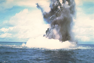 A Surtseyan cock’s-tail plume rises above the sea surface at Kavachi volcano on 17 or 18 July 1977. Additional explosions were seen 19-22 July, with vapor and ash clouds reaching several hundred feet above the sea surface. This activity is typical of submarine eruptions from Kavachi, one of the most active volcanoes of the Solomon Islands. At least eight new ephemeral islands have been formed since an eruption in 1939.
Photo by W.G. Muller, 1978 (Barrier Reef Cruises, Queensland, Australia; courtesy of D. Tuni).
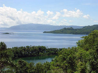 The saltwater Lake Ove in the foreground is seen from the rim of Ngusunu crater with the W coast of Simbo Island in the background. Simbo is a small island in the western Solomon Islands with three truncated andesitic volcanic centers. Indigenous people’s accounts told of the explosive enlargement of the Ngusunu explosion crater along the SW coast of the island one to two generations prior to 1955 and probably after 1882. Press reports mentioned an eruption at Simbo in the early 1900s.
Photo by Chris Lyne, 2005.
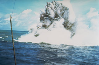 A shallow phreatomagmatic, or Surtseyan eruption from Kavachi volcano on 17 or 18 July 1977. Jets of dark ash can be seen emerging from white steam plumes. Numerous individual blocks ejected at high velocity are trailed by steam. Similar activity was observed from boats and airplanes for a period of less than one week.
Photo by W.G. Muller, 1977 (Barrier Reef Cruises, Queensland, Australia; courtesy of R.W. Johnson).
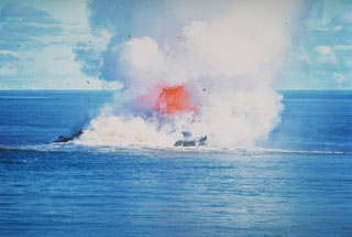 Incandescent rock and steam rise above the sea at Kavachi volcano in the Solomon Islands. By the time of this 30 June 1978 photo the vent of the submarine volcano had reached the sea surface. Dark extruded lava can be seen through the steam, with the plume rising a few thousand meters into the air. There was no sign of the submarine volcano on 20 June but the following day an eruption was observed. By the 22nd there was a 30-50 m wide island erupting incandescent lava.
Photo by W.G. Muller, 1978 (Barrier Reef Cruises, Queensland, Australia; courtesy of D. Tuni).
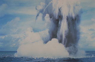 Submarine explosions from Kavachi volcano eject a cock’s-tail plume of water, steam, and ash above the sea surface in July 1977. Large ejected blocks are visible falling from the plume and impacting the sea surface. Similar activity was observed over a period of less than a week.
Photo by W.G. Muller, 1978 (Barrier Reef Cruises, Queensland, Australia; courtesy of D. Tuni).
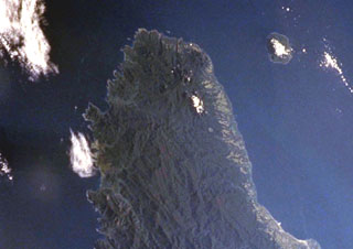 The Pliocene-to-Quaternary Gallego volcanics cover a large area of NW Guadalcanal Island along the top part of this NASA International Space Station image (N is to the upper right). Local traditions mention a historical eruption from Mount Roundhead, but this could refer to an eruption from Savo volcano, the island to the upper right. Mount Esperance volcano rises above Cape Esperance, across the channel from Savo Island. The city of Honiara lies along the northern coast of Guadalcanal Island at the lower right.
NASA International Space Station image ISS002-727A-10, 2001 (http://eol.jsc.nasa.gov/).
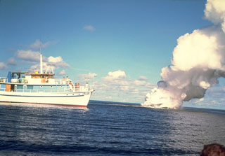 A submarine eruption from Kavachi volcano in July 1977. It is one of the most active submarine volcanoes in the SW Pacific, but is located far from major aircraft and shipping lanes. Sometimes referred to as Rejo te Kvachi ("Kavachi's Oven"), it has produced ephemeral islands up to 150 m long at least eight times since 1939.
 Photo by W.G. Muller, 1978 (Barrier Reef Cruises, Queensland, Australia; courtesy of D. Tuni).
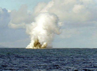 An explosive eruption from Kavachi volcano was seen from the Australian CSIRO research vessel Franklin on 14 May 2000. During their 20 hours of observations explosions were witnessed every 5-7 minutes, lasting 2-3 minutes each. The crater was estimated at 2-5 m below the water surface. The eruptions ejected ash and incandescent lava up to 70 m above the sea surface, and plumes rose to heights of 500 m. Kavachi had been erupting intermittently since November 1999.
Photo by Australian Commonwealth Scientific and Industrial Organization (CSIRO), 2000.
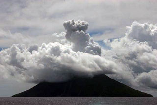 A plume rises above meteorological clouds over Tinakula volcano on 21 February 2006. Tinakula had resumed eruptive activity earlier that month.
Photo by Bill Yeaton, 2006.
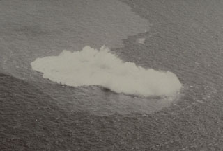 Submarine explosions took place at Kavachi from 28 October to 7 November 1969. This photo on the first day of the eruption shows steam rising above an area of water discoloration. Renewed explosions began on 22 December and a new island was first seen on 30 January. The last eruptions were observed on 6 February and the new island was eroded to below sea level by wave action between 7-17 February.
Photo by Chris Tabona, 1969.
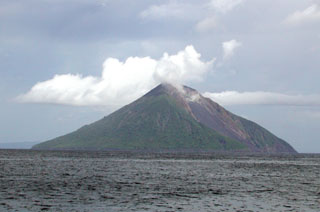 The northern side of the 3.5-km-wide Tinakula volcano at the NW end of the Santa Cruz Islands. The small island is the exposed portion of a stratovolcano that rises 3-4 km from the sea floor. A large breached crater extending from the summit to below the NW coast is visible to the right and has been the source of frequent eruptions dating back to at least 1595.
 Photo by Donn Tolia, 2002 (Geological Survey of the Solomon Islands, courtesy of CSIRO).
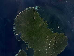 The Nonda volcanic center is on Vella Lavella Island in the Solomon Islands, near the center of this November 2019 satellite image monthly mosaic (N is at the top; this image is approximately 47 km across). It contains a lava dome and crater, and the nearby Paraso geothermal area remains active.
Satellite image courtesy of Planet Labs Inc., 2018 (https://www.planet.com/).
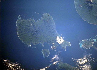 Vella Lavella Island (left center) lies in the New Georgia Islands in the Solomon Islands chain. North is to the upper left in this NASA International Space Station image. Nonda volcano, the youngest volcanic feature of Vella Lavella Island, is a lava dome located within a crater to the N. The Paraso thermal area is the (light-colored area at center) contains solfataras, hot springs, and boiling mud pots. Kolombangara Island is at the upper right.
NASA International Space Station image ISS002-727A-2, 2001 (http://eol.jsc.nasa.gov/).
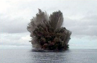 A cock’s-tail plume rises above Kavachi volcano during a Surtseyan eruption on 15 March 2004. Projections of individual blocks and ash can be seen at the margins of the plume. The frequently-erupting submarine volcano had been inactive since August 2003.
Photo by Corey Howell, 2004.
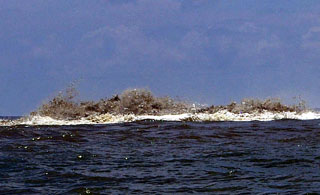 Some of the stronger activity observed at Kavachi on 6 April 2007 included turbulent ash-laden water above the vent, audible explosions, and discolored water down-current of the vent. Following 2 April 2007 Kavachi emitted an ash plume visible from Biche village (on the S coast of Nggatokae Island).
Photo by Roy Hall, 2007.
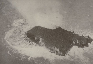 A newly-formed island at Kavachi on 9 September 1976. Submarine explosions ejected fountains of water and rock about 60 m high on 24 August. Similar activity was observed 4-6 September. By the 7th, lava effusion was observed. Lava flows ceased between 9-11 September, but explosions continued, and by the 15th the island was 100 m long. By 6 October the island was eroded. Explosive eruptions were last observed on 13 October from a vent estimated to be less than 15 m below sea level.
Photo by Deni Tuni, 1976 (Ministry of Lands, Energy and Mineral Resources, Solomon Islands).
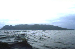 The 6 x 7 km island of Savo has been the source of major historical eruptions, which included pyroclastic flows that devastated much of the island. The summit contains a 1 x 1.5 km crater and lava domes are located on its floor, NE rim, and the outer flank of the volcano. Thermal areas located in the summit crater, along the flanks of the volcano, and offshore include fumaroles and small geysers.
Photo by Nick Varley (University of Colima).
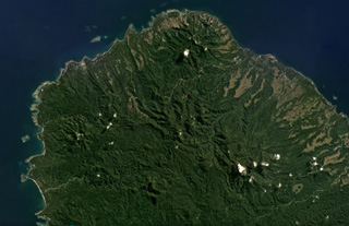 The Gallego Volcanic Field covers around 800 km2 on NW Guadalcanal Island, and 30 km2 on Savo to the N, with the former area shown in this June 2018 Planet Labs satellite image monthly mosaic (N is at the top; this image is approximately 27 km across). This image contains many eroded edifices, including Komambulu along the western shore (about halfway up the image). The Esperance volcanic center is at the northern end, and the Gallego volcanic ridge is to the SE.
Satellite image courtesy of Planet Labs Inc., 2018 (https://www.planet.com/).
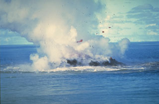 Clots of incandescent magma rise above Kavachi on 30 June 1978 after the vent of the submarine volcano had reached the sea surface. No eruptive activity was observed on 20 June, but there was an eruption the following day. On 22 June a 30-50 m island was observed erupting incandescent lava and gas and ash that rose a few thousand meters into the air. The eruption ended sometime between 16-28 July when observers on an overflight noted that the island was about 15 m wide and 3 m high.
Photo by W.G. Muller, 1978 (Barrier Reef Cruises, Queensland, Australia; courtesy of D. Tuni).
This is a compilation of Solomon Islands volcano information sources, such as official monitoring or other government agencies.
| Volcano Observatories | |
|---|---|
| Solomon Islands Seismology & Volcanology Network | |
| Volcanic Ash Advisory Center | |
|---|---|
| Wellington Volcanic Ash Advisory Center (VAAC) | |
| - Wellington VAAC Notices | |
