The Washington VAAC reported that at 0820 on 7 September a plume of resuspended ash at Tungurahua drifted W at an altitude of 4.9 km (16,000 ft) a.s.l., based on weather models and satellite images. The plume had dissipated by 1440.
Source: Washington Volcanic Ash Advisory Center (VAAC)
Ash emissions, explosions, and pyroclastic flows 26 February-16 March 2016; no further activity through 2017
Episodic eruptive activity at Ecuador's Tungurahua has persisted since November 2011. Periods of activity over several weeks that included ash plumes, Strombolian activity, pyroclastic flows, and lava flows were often followed by quiescence for a similar time span. This type of activity continued throughout 2015 (BGVN 42:08, 42:12); Strombolian activity, significant ash emissions, and SO2 plumes in mid-November 2015 marked the last significant activity for that year. The next episode began in late February 2016 and is discussed below with information provided by the Observatorio del Volcán Tungurahua (OVT) of the Instituto Geofísico (IG-EPN) of Ecuador, aviation alerts from the Washington Volcanic Ash Advisory Center (VAAC), and other sources of satellite data.
The latest eruptive episode at Tungurahua lasted from 26 February-16 March 2016. Multiple explosions with ash plumes that rose 3-8 km were frequent. Incandescent blocks were ejected up to 1,500 m down most flanks. Pyroclastic flows affected many of the ravines, although no communities reported damage. Significant SO2 emissions were recorded by satellite data between 27 February-8 March. An inflationary trend was recorded from early March through late September 2016, after which a period of deflation began. Tungurahua had occasional seismic swarms after the eruption, but no reported surface activity for the remainder of 2016 and 2017.
IG reported an ash emission on 5 January 2016 that rose 2 km above the crater and drifted NE, causing minor ashfall in the Pondoa and Bilbao sectors. Otherwise, no volcanic activity was reported until a new episode began on 26 February 2016 with a seismic swarm followed by a series of explosions and ash plumes that rose 3-8 km above the crater (figures 96 and 97). Incandescent blocks were ejected up to a kilometer down the NW, W, and SW flanks (figure 98). Pyroclastic flows were also generated that descended through the gorges of Juive, La Hacienda, Mandur and Cusúa, reaching distances of 500-1,500 m (figure 99).
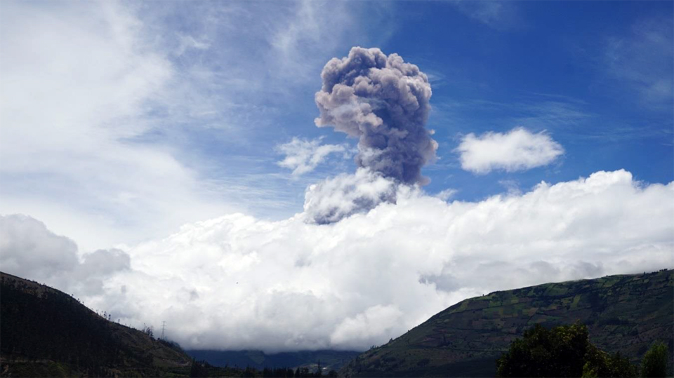 |
Figure 96. An ash emission at Tungurahua observed from OVT on 26 February 2016. Courtesy of IG-EPN, (Explosion en el Volcan Tunguraha, No. 20 [1], Informe especial Tungurahia No. 1). |
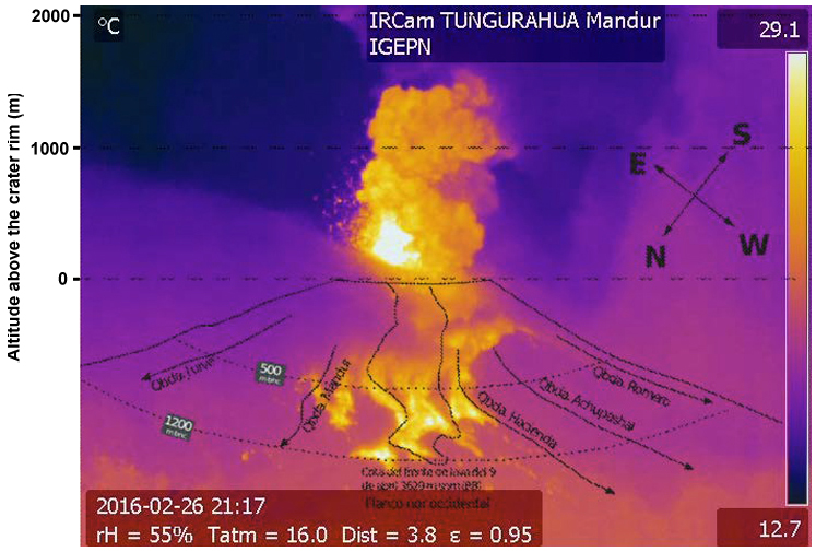 |
Figure 97. Ejecta traveled 1,000 m from the crater, an ash plume rose 2 km, and pyroclastic flows traveled down several drainages on the NW flank at Tungurahua on 26 February 2016 in this thermal image taken from the Mandur camera. Courtesy of OVT, IG-EPN (INFORME No. 836, SÍNTESIS SEMANAL DEL ESTADO DEL VOLCÁN TUNGURAHUA, Semana: Del 23 de febrero al 01 de marzo de 2016). |
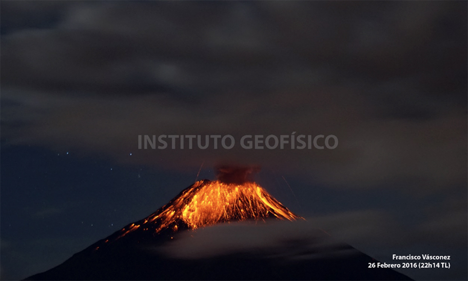 |
Figure 98. Incandescent blocks descended 1,000 m down the NW, W, and SW flanks of Tungurahua on 26 February 2016, and explosions were audible at OVT. Photo by F. Vásconez, courtesy of OVT, IG-EPN (INFORME No. 836, SÍNTESIS SEMANAL DEL ESTADO DEL VOLCÁN TUNGURAHUA, Semana: Del 23 de febrero al 01 de marzo de 2016). |
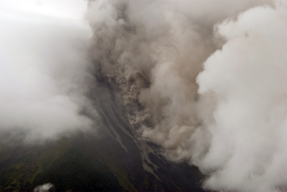 |
Figure 99. Pyroclastic flows descended the Mandur, La Hacienda and other ravines on the W flank of Tungurahua on 26 February 2016 as far as 1 km. Photo by F. Vásconez, courtesy of OVT, IG-EPN (INFORME No. 836, SÍNTESIS SEMANAL DEL ESTADO DEL VOLCÁN TUNGURAHUA, Semana: Del 23 de febrero al 01 de marzo de 2016). |
Continuous emissions with low to moderate ash content drifted W and SW on 27 February. The communities most affected by ashfall were Choglontus, Cotaló, El Manzano, Palitahua, Bilbao, Pillate, Juive, Ambato, Tisaleo, Riobamba, and Quero. The ash was mostly fine-grained, except in the area near Pillate and Choglontus, where the grain size reached up to 3 mm and consisted of reddish, black, gray, and beige fragments (figure 100). On the morning of 1 March 2015, several pyroclastic flows were observed descending through the Juive, Mandur, Achupashal, La Hacienda, and Romero ravines; they traveled 1.5-1.7 km (figure 101).
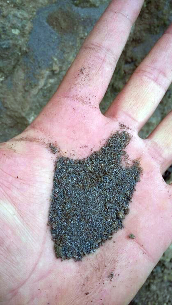 |
Figure 100. Coarse-grained ash fragments from Tungurahua collected in Ambato on 26 February 2016. Photo by Marco Montesdeoca (ECU911 Ambato), Courtesy of OVT, IG-EPN (Explosion en el Volcan Tunguraha, No. 2, Informe especial Tungurahia No. 2, 26 de febrero del 2016 (16h45)). |
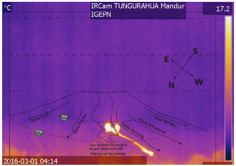 |
Figure 101. A pyroclastic flow descended 1.5 km down the Hacienda Ravine on 1 March 2016 at Tungurahua and was captured by the Mandur thermal camera. Courtesy of OVT, IG-EPN (INFORME No. 836, SÍNTESIS SEMANAL DEL ESTADO DEL VOLCÁN TUNGURAHUA, Semana: Del 23 de febrero al 01 de marzo de 2016). |
Ash emissions were constant throughout the first week in March (figures 102 and 103). During 1-5 March they drifted NW, SW and E, with ashfall reported in the towns of Pillate, Manzano, Choglontus, Palictahua and El Altar (figure 104). Incandescent blocks descended most of the flanks (figure 105). Beginning on 6 March, plumes drifted SW and S, with variable ash content. Pyroclastic flows along the W and NW flanks descended the Cusua, Juive, Mandur, Ashupashal, Romero, and Rhea drainages (figure 106), the farthest traveled went 2.2 km down the Ashupashal on 7 March. In addition to ash and other explosive debris, daily sulfur dioxide emissions were identified from 27 February-8 March 2016 by the OMI instrument on the Aura satellite (figure 107).
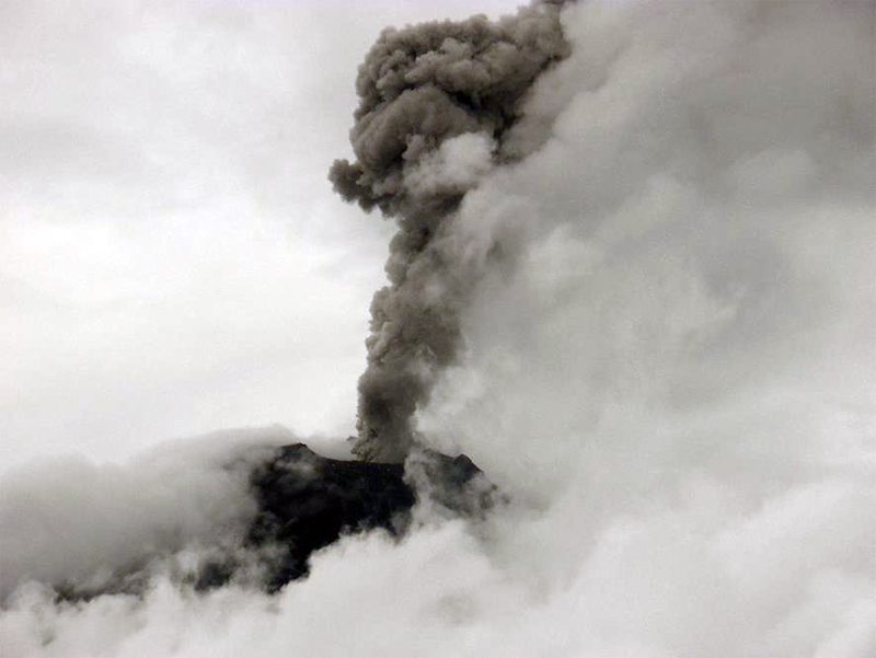 |
Figure 102. Constant ash emissions rose at least 1 km above the summit of Tungurahua during the first week of March 2016. Photo take on 3 March 2016 by P. Espin. Courtesy of OVT, IG-EPN (INFORME No. 837, SÍNTESIS SEMANAL DEL ESTADO DEL VOLCÁN TUNGURAHUA, Semana: Del 01 al 08 de marzo de 2016). |
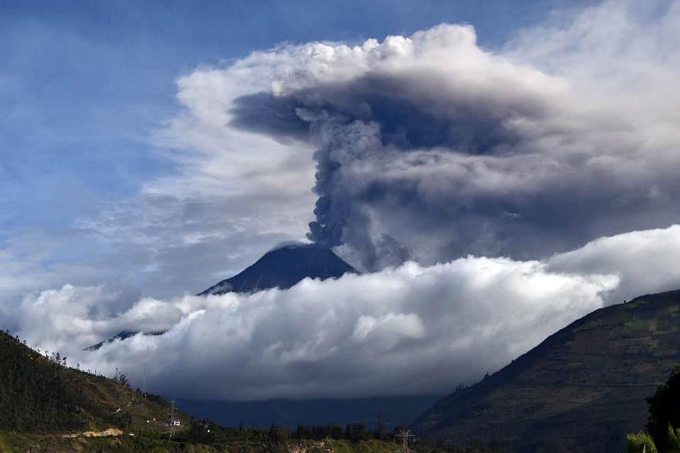 |
Figure 103. A dark ash plume formed a mushroom cloud over Tungurahua on 5 March 2016; it rose 2 km above the summit and drifted SW. Photo by E. Telenchana , courtesy of OVT, IG-EPN (INFORME No. 837, SÍNTESIS SEMANAL DEL ESTADO DEL VOLCÁN TUNGURAHUA, Semana: Del 01 al 08 de marzo de 2016). |
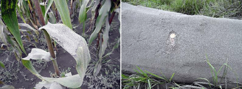 |
Figure 104. Ashfall in Choglontus on 6 March 2016 from Tungurahua. Photo by P. Espín, courtesy of OVT, IG-EPN (INFORME No. 837, SÍNTESIS SEMANAL DEL ESTADO DEL VOLCÁN TUNGURAHUA, Semana: Del 01 al 08 de marzo de 2016). |
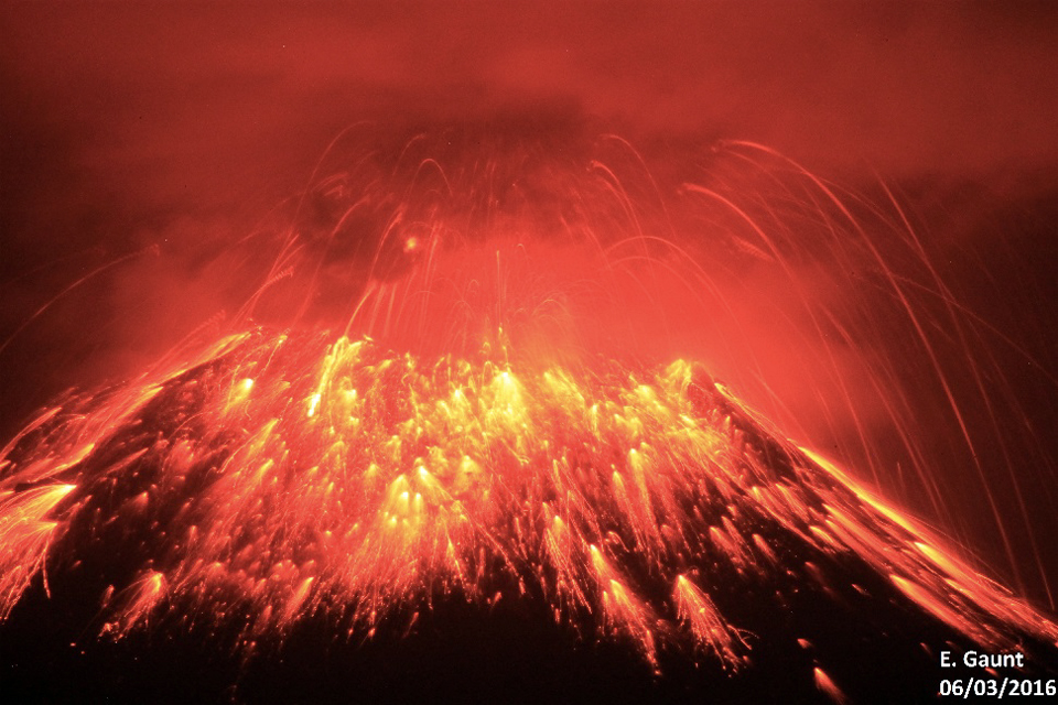 |
Figure 105. Strombolian explosions send incandescent blocks down the flanks of Tungurahua on 6 March 2016. Photo by E. Gaunt, courtesy of OVT, IG-EPN (INFORME No. 837, SÍNTESIS SEMANAL DEL ESTADO DEL VOLCÁN TUNGURAHUA, Semana: Del 01 al 08 de marzo de 2016). |
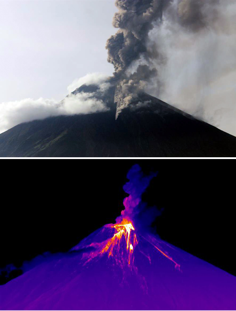 |
Figure 106. Visual (upper) and thermal (lower) images of Tungurahua taken from Cotalo showing a pyroclastic flow extending down the Achupashal drainage on 6 March 2016. Photo by E. Gaunt, thermal image by M. Almeida, courtesy of OVT, IG-EPN (INFORME No. 837, SÍNTESIS SEMANAL DEL ESTADO DEL VOLCÁN TUNGURAHUA, Semana: Del 01 al 08 de marzo de 2016). |
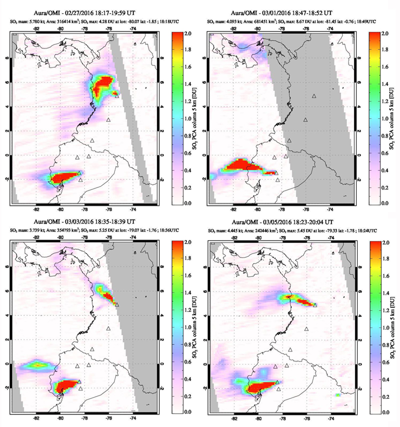 |
Figure 107. Substantial SO2 emissions from Tungurahua were measured daily during 27 February-8 March 2016 by the OMI instrument on the Aura satellite. The plumes drifted 300 km or more W on 27 February, 1, 3, and 5 March. Colombia's Nevado del Riuz (upper plume in images) also produced SO2 emissions during this same period. Courtesy of NASA Goddard Space Flight Center. |
Beginning on 28 February, a strong inflationary trend (almost 3 cm) was observed in the GPS data at the Mazón (SW flank) station. Three inclinometers on the NW flank also indicated inflation during 28 February-4 March.
Episodic explosions on 8 March 2016 produced plumes with high ash contents that rose 6 km. Small pyroclastic flows descended the NW flank in the Mandur, Rea, Achupashal, and La Hacienda ravines. Sporadic emissions continued for most of the second week of March, with varying ash contents, reaching between 1.5 and 4 km above the crater and drifting to the SSW. Reports of ashfall were received in the sectors of Choglontús, Manzano, Pillate, El Altar, and Palitahua, and minor ashfall in Juive and Cusúa. Several ash plumes (figure 108) and a small pyroclastic flow were observed on 13 March 2016. The Manzano lookout reported loud noises on 14 March, and ashfall in the afternoon, but weather obscured views of emissions. Rainy weather on 16 March also obscured views, but Manzano, Chacauco, Cusúa, and Juive lookouts reported ashfall and explosions. There were no further reports from the observatory of ash emissions, ashfall, or explosions; only minor steam plumes were observed on clear days after 16 March 2016.
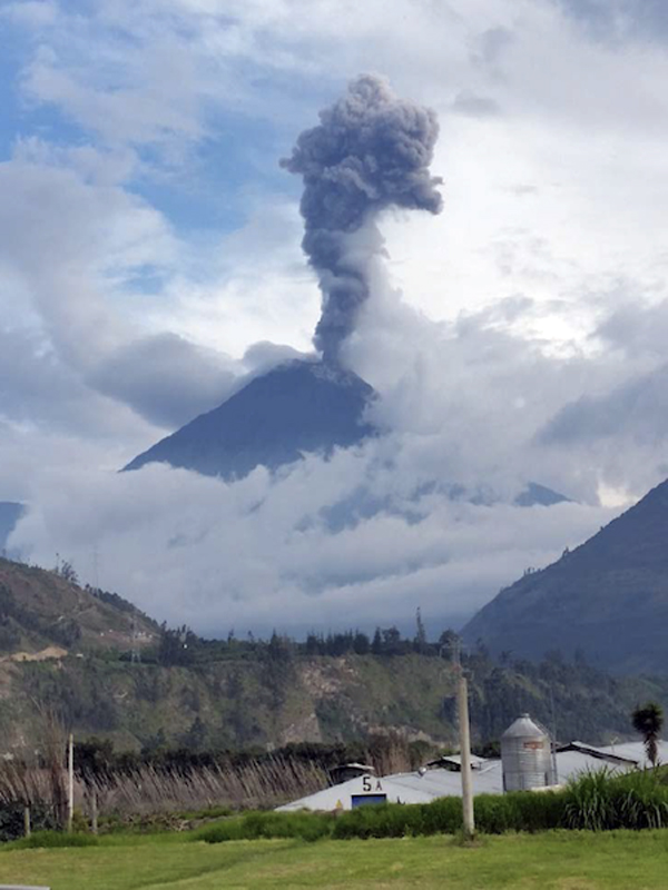 |
Figure 108. An ash emission at Tungurahua on 13 March 2016 was the last photographed for the eruption. Photo by M. Córdova from OVT, courtesy of IG-EPN (INFORME No. 838, SÍNTESIS SEMANAL DEL ESTADO DEL VOLCÁN TUNGURAHUA, Semana: Del 08 al 15 de marzo de 2016). |
The Washington VAAC reported possible ash emissions on 31 March 2016, but information from OVT indicated no surface activity. Intense rain on 28 March generated a small lahar that descended through the La Pampa ravine. Significant rainfall on 2 April caused lahars to affect Vazcun, Juive, Pondoa, Bilbao, Achupashal, Chontapamba and Malpayacu drainages. Seismicity continued to decrease throughout April 2016. A small swarm of Long Period seismic events (LP's) occurred between 1 and 20 May that were associated with fluid movements. The Washington VAAC reported ash emissions on 3, 8, and 13 May, but OVT reported no surface activity during the entire month (figure 109).
 |
Figure 109. Clear skies on 31 May 2016 at Tungurahua revealed a snow-covered summit with no evidence of emissions. Photo by M. Córdova, courtesy of OVT, IG-EPN (INFORME No. 849, SÍNTESIS SEMANAL DEL ESTADO DEL VOLCÁN TUNGURAHUA, Semana: Del 24 al 31 de mayo del 2016). |
In a Special Report released on 2 June 2016, IG-EPN noted a clear inflationary trend in data collected from two stations at Tungurahua since the end of the eruption in mid-March. The Retu inclinometer, located N of the crater, showed inflation on the radial axis of about 600 μrad (microradians), and about 200 μrad on the tangential axis. The same axis at the Mandur inclinometer (on the NW flank) had a smaller but distinct (~30 μrad) inflationary signal (figure 110).
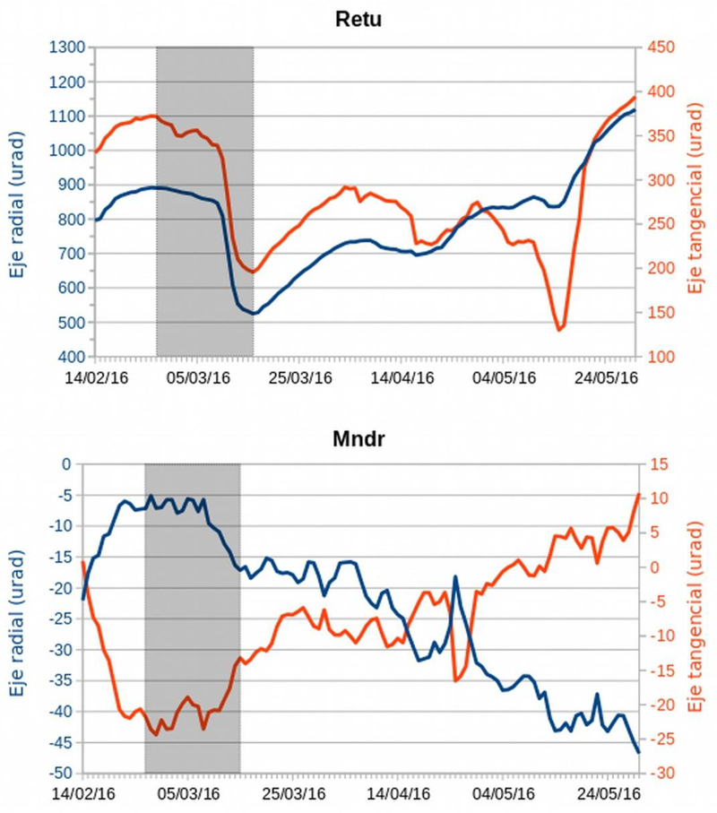 |
Figure 110. The pattern of deformation registered at the Retu (Refugio Tungurahua) and Mndr (Mandur) inclinometers from 14 February-30 May 2016 at Tungurahua. The gray area corresponds to the eruption of 26 February -16 March. An inflationary trend is apparent on both axes at the Retu instrument and on the tangential axis of the Mndr site. Courtesy of IG-EPN (Informe Especial Volcán Tungurahua - N°6, 2 de Junio de 2016). |
A Washington VAAC report on 1 June 2016 noted that the Guayaquil Meteorological Weather Office (MWO) reported an ash plume at Tungurahua, but OVT confirmed no surface activity. A very small lahar was recorded in the La Pampa ravine on 2 June. Although there were rains of varying intensity many days during June, they did not generate significant lahars, except one of medium size that occurred on 21 June in the Achupashal ravine. The Washington VAAC noted a report from the Guayaquil MWO of an ash emission on 5 July, but it was not detected in satellite imagery, and the OVT reported no surface activity. There was no surface activity reported by OVT from July to mid-September (figure 111), and internal seismicity remained very low. Occasional rainy periods generated muddy water in the ravines, but no significant lahars were reported.
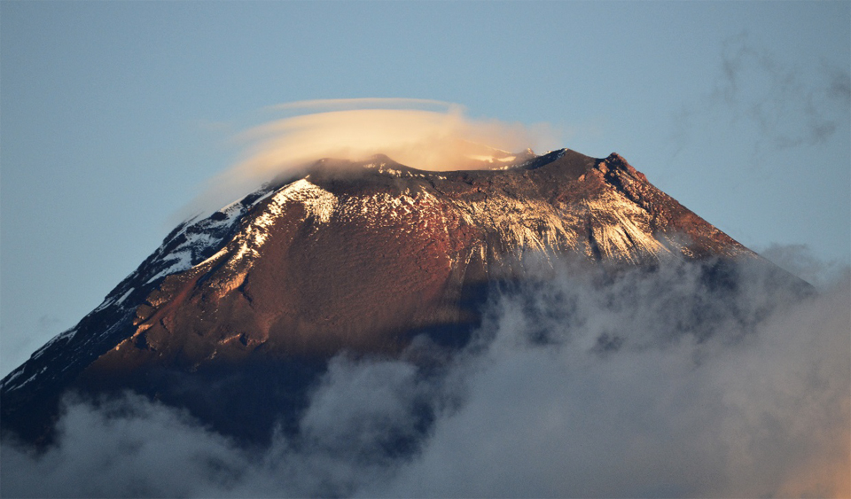 |
Figure 111. The summit of Tungurahua showed no sign of surface activity on 1 August 2016. Photo by Bernard J., courtesy of OVT, IG-EPN (INFORME No. 858, SÍNTESIS SEMANAL DEL ESTADO DEL VOLCÁN TUNGURAHUA, Semana: Del 26 de julio al 02 de agosto de 2016). |
A significant increase in the number of LP seismic events began on 12 September 2016, and a small seismic swarm was recorded on 18 September (figure 112). Small fumaroles were visible at the edges of the crater on 15 and 16 September (figure 113). At this same time, the inflationary trend that had been ongoing since the eruption earlier in the year switched to deflation as measured at the Retu inclinometer.
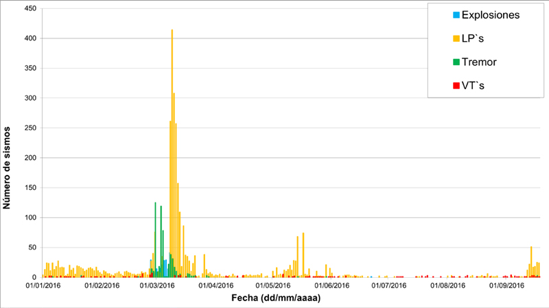 |
Figure 112. The number of different types of seismic events and explosions recorded at Tungurahua between 1 January and 18 September 2016. The largest spike between 26 February and 16 March corresponds to the eruption of that period. Other episodes of seismicity were recorded during May and mid-September, but did not result in ash emissions or explosions. Courtesy of IG-EPN (Informe Especial Volcán Tungurahua - N°7, 18 de Septiembre de 2016). |
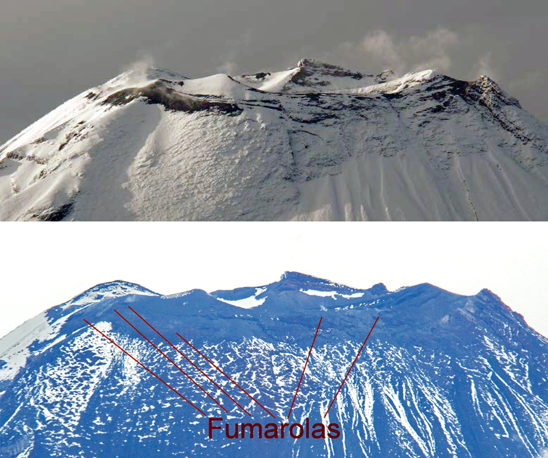 |
Figure 113. Closeup images of the summit of Tungurahua on 15 (top) and 16 (bottom) September 2016 reveal minor fumarolic activity. Top: Steam rises from two snow free areas on 15 September (INFORME No. 865, SÍNTESIS SEMANAL DEL ESTADO DEL VOLCÁN TUNGURAHUA, Semana: Del 13 al 20 de septiembre de 2016). Bottom: Fumarolic activity was also apparent in this telephoto image taken from OVT on 16 September. Photo by P. Ramón (Informe Especial Volcán Tungurahua - N°7, 18 de Septiembre de 2016). Courtesy of OVT, IG-EPN. |
Another increase in LP seismicity and tremors occurred on 24 September, but there were no reports of surface activity other than minor steam fumaroles. Seismicity remained elevated through early October; a one-hour tremor event was reported on 1 October. Seismicity decreased gradually over the following two weeks. Low-energy steam and gas emissions from fumaroles located on the S and SW flanks were observed during a flyover on 7 October 2016. This corresponded to the warmest areas revealed in the thermal image of the summit (figure 114). with a TMA (maximum apparent temperature) of 47.9°C and 36.5°C.
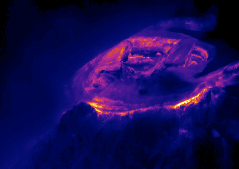 |
Figure 114. A thermal image of the summit of Tungurahua taken during a flyover on 7 October 2016 showed two areas on the crater rim with slightly elevated temperatures where fumarolic activity was occasionally observed. Image by P. Ramón, courtesy of OVT, IG-EPN (INFORME No. 868, SÍNTESIS SEMANAL DEL ESTADO DEL VOLCÁN TUNGURAHUA, Semana: Del 4 al 11 de octubre de 2016). |
Re-suspended ash from high winds in mid-November 2016 caused several VAAC notices to be issued, but no new emissions were reported by OVT through the end of 2016.
Tungurahua remained quiet throughout 2017. A 90-minute seismic swarm on 8 January 2017 and a minor increase in seismicity in the second half of March were the only seismic events above background levels. There were no emissions except for occasional minor fumarolic activity around the crater rim. Periods of heavy rainfall occasionally produced muddy water in the ravines; the only lahars were reported during 5-6 January, late April and 15 November.
Information Contacts: Instituto Geofísico (IG), Escuela Politécnica Nacional, Casilla 17-01-2759, Quito, Ecuador (URL: http://www.igepn.edu.ec ); NASA Goddard Space Flight Center (NASA/GSFC), Global Sulfur Dioxide Monitoring Page, Atmospheric Chemistry and Dynamics Laboratory, 8800 Greenbelt Road, Goddard, Maryland, USA (URL: https://so2.gsfc.nasa.gov/); Washington Volcanic Ash Advisory Center (VAAC), Satellite Analysis Branch (SAB), NOAA/NESDIS OSPO, NOAA Science Center Room 401, 5200 Auth Rd, Camp Springs, MD 20746, USA (URL: www.ospo.noaa.gov/Products/atmosphere/vaac, archive at: http://www.ssd.noaa.gov/VAAC/archive.html).
2023: September
2016: February
| March
| September
2015: April
| July
| August
| September
| October
| November
2014: January
| February
| March
| April
| June
| July
| August
| September
| October
2013: January
| February
| March
| April
| May
| July
| August
| October
| November
2012: January
| February
| March
| April
| May
| June
| July
| August
| December
2011: January
| April
| May
| October
| November
| December
2010: January
| February
| March
| May
| June
| July
| November
| December
2009: January
| February
| March
| April
| May
| June
| July
| August
| December
2008: January
| February
| March
| April
| May
| June
| July
| August
| September
| October
| November
| December
2007: January
| February
| March
| April
| May
| June
| July
| August
| September
| October
| November
| December
2006: January
| February
| March
| April
| May
| June
| July
| August
| September
| October
| November
| December
2005: January
| February
| March
| April
| May
| June
| July
| August
| September
| October
| November
| December
2004: January
| February
| March
| April
| May
| June
| July
| August
| September
| October
| November
| December
2003: January
| February
| March
| April
| May
| June
| July
| August
| September
| October
| November
| December
2002: January
| February
| March
| April
| May
| June
| July
| August
| September
| October
| November
| December
2001: January
| February
| March
| April
| May
| June
| July
| August
| September
| October
| November
| December
2000: November
| December
The Washington VAAC reported that at 0820 on 7 September a plume of resuspended ash at Tungurahua drifted W at an altitude of 4.9 km (16,000 ft) a.s.l., based on weather models and satellite images. The plume had dissipated by 1440.
Source: Washington Volcanic Ash Advisory Center (VAAC)
IG reported that during 27 September-4 October seismic activity at Tungurahua remained at moderate levels, characterized by 1-8 long-period earthquakes and up to three volcano-tectonic events per day. An hour-long period of tremor was recorded on 1 October. Minor fumarolic emissions rose above the crater rim.
Source: Instituto Geofísico-Escuela Politécnica Nacional (IG-EPN)
IG reported that Tungurahua's seismic network detected a significant increase in the number of long-period (LP) earthquakes on 12 September and small episodes of tremor beginning on 16 September. A swarm of 24 LP events were detected during 0408-0424 on 18 September. Starting at 1400 on 24 September the number of LP events again increased. Gas emissions were low, and together with the increased seismicity, possibly indicates a blocked conduit. IG noted that a possible large-scale eruption may happen within hours to days. In response, the Secretaría de Gestión de Riesgos (SGR) announced that the Alert Level was raised from Yellow to Orange (the second highest on a 4-color scale) on 26 September.
Sources: Instituto Geofísico-Escuela Politécnica Nacional (IG-EPN); Secretaría de Gestión de Riesgos (SGR)
IG reported that activity at Tungurahua was at moderate-to-high levels during 16-17 March, moderate levels during 18-21 March, and low levels on 22 March. Cloud cover prevented views of the volcano; the weather cleared for a brief period on 20 March and no activity was observed.
Source: Instituto Geofísico-Escuela Politécnica Nacional (IG-EPN)
IG reported that moderate-to-high levels of activity at Tungurahua continued during 9-15 March. Gas-and-ash plumes rose from the crater on most days, often to heights less than 2 km above the crater, and drifted NW, W, WSW, and SW; cloud cover sometimes obscured views of the volcano. Explosions were recorded daily, and crater incandescence was reported almost nightly. Ash fell on 9 March in Pillate (8 km W), El Manzano (8 km SW), Cotaló (8 km NW), and Macas. On 10 March a small pyroclastic flow traveled 1.5 km NW down the Achupashal drainage. On 15 March residents in the Runtún sector (NNE) heard an explosion and sounds resembling rolling rocks on the NE flank. Ash fell in Patate (NW) and Juive (7 km NNW).
Source: Instituto Geofísico-Escuela Politécnica Nacional (IG-EPN)
IG reported that moderate-to-high levels of Strombolian activity at Tungurahua continued during 2-8 March. Daily explosions were often accompanied by roaring and sounds resembling gunshots, and often caused local structures to vibrate. Steam-and-ash plumes rose from the crater daily often to heights less than 2.5 km above the crater and drifted NW, WNW, W, and SW; ash plumes rose 5 km on 4 March and to 6 km with a SE drift on 8 March. Ashfall was also reported daily in areas including Chontapamba (W), Pillate (8 km W), Bilbao (8 km W), Chacauco (NW), Juive (NW), Quero (20 km NW), Cusúa (NW), Choglontús (13 km WSW), Pelileo (8 km N), El Manzano (8 km SW), Vazcún (N), and Pondoa (N). Strombolian explosions observed nightly ejected incandescent blocks that rolled as far as 2 km down the flanks.
At 1020 on 4 March an explosion vibrated windows and generated an ash plume that rose 3 km above the crater. A pyroclastic flow traveled 1 km down the Romero drainage, and at 1152 another pyroclastic flow traveled 500 m down Achupashal (NW) drainage. On 6 March another explosion was followed by pyroclastic flows that traveled 1 km down the Achupashal, Rea, Pondoa (N), and Mandur (NW) drainages. Pyroclastic flows on 8 March traveled as far as 2.2 km down the Mandur, Romero, Bilbao, Juive, and Achupashal drainages.
On 5 March lahars descended the ravines of Achupashal, Juive, Pondoa, Mandur, Pingullo, Rea and Chontapamba; lahars in Pingullo and Cusúa led to the closure of the road.
Source: Instituto Geofísico-Escuela Politécnica Nacional (IG-EPN)
IG reported that a swarm of volcano-tectonic and long-period earthquakes began at Tungurahua at 1105 on 26 February. At 1211 an explosion produced a plume with high ash content that rose 5 km above the crater and drifted W. Ash fell in Juive (NW), Chico, Choglontús (13 km WSW), El Manzano (8 km SW), and Cahuají (8 km SW). Explosions at 1239, 1247, and 1252 generated ash plumes that rose 6-7 km above the crater. An explosion at 1333 generated a small pyroclastic flow that descended halfway down the W and NW flanks, and an ash plume that rose 8 km. At 1535 another pyroclastic flow, generated from material spilling over the WNW rim, also traveled halfway down the volcano in the Mandur (NW), Hacienda (NW), and Cusua (NW) drainages. Ashfall was noted in El Manzano, Choglontús, Pillate (8 km W), Juive, Ambato (31 km NW), and Quero (20 km NW); reddish, black, gray, and beige tephra up to 3 mm in diameter fell in Pillate and Choglontús. In the evening Strombolian activity ejected incandescent blocks which rolled 1.5 km down the flanks. For a short time around 2200 lava fountains rose 500 m.
Explosions and nighttime crater incandescence continued to be detected during 27 February-1 March, and explosions sometimes vibrated nearby structures. Ashfall was observed daily in areas including El Manzano, Palitahua (6 km SSW), Cotaló (8 km NW), Cahuají, Providencia, Puela (8 km SW), Chazo, Pillate, Choglontús, Mocha (25 km WNW), and areas of Quero. Ash plumes were observed rising 2-4 km above the crater on 27 February and 1 March. During 29 February-1 March pyroclastic flows descended the Juive, Mandur (NW), Achupashal (NW), and Romero drainages; the largest traveled 1.5 km down the Achupashal.
Source: Instituto Geofísico-Escuela Politécnica Nacional (IG-EPN)
IG reported high seismic activity at Tungurahua during 25 November-1 December, although the number of earthquakes decreased. During periods of clear weather on most days observers noted gas-and-steam plumes rising as high as 1.5 km and drifting mainly W.
Source: Instituto Geofísico-Escuela Politécnica Nacional (IG-EPN)
IG reported high seismic activity at Tungurahua during 17-24 November, characterized by long-period events, volcano-tectonic events, explosions, and signals indicating emissions; cloud cover sometimes prevented visual observations. Almost daily ash-and-gas emissions rose as high as 3 km above the crater and drifted SW, W, and NW. Ashfall was reported on most days, in areas including Choglontus (13 km WSW), Manzanó (8 km SW), Cotaló (8 km NW), Bilbao (8 km W), Chontapamba (W), Penipe (15 km SW), Cevallos (23 km NW), Mocha (25 km W), Chacauco (NW), Cusúa (8 km NW), and Píllate (8 km W). Incandescent blocks rolled 500 m down the flanks during 18-19 November.
Sources: Instituto Geofísico-Escuela Politécnica Nacional (IG-EPN); El Universo
IG reported high seismic activity at Tungurahua during 11-17 November, characterized by long-period events, volcano-tectonic events, explosions, and signals indicating emissions; cloud cover often prevented visual observations. Daily ash-and-gas emissions rose as high as 4 km above the crater and drifted W and NW. Ashfall was also reported daily, in areas including Choglontus (13 km WSW), Manzanó (8 km SW), Cotaló (8 km NW), Bilbao (8 km W), Chontapamba (W), Penipe (15 km SW), Cevallos (23 km NW), Mocha (25 km W), and Píllate (8 km W). Incandescent blocks rolled 500 m down the flanks during 12 and 14 November, and 1 km down the flanks on 15 November.
Source: Instituto Geofísico-Escuela Politécnica Nacional (IG-EPN)
IG reported high seismic activity at Tungurahua during 4-10 November, characterized by long-period events, volcano-tectonic events, an explosion, and signals indicating emissions; cloud cover often prevented visual observations. When occasionally visible, steam, gas, and ash plumes rose as high as 700 m, and drifted W, NE, and E. On 7 November a lahar in Chontapamba carried blocks 1 m in diameter and caused a road closure between Baños and Penipe. Nighttime crater incandescence was visible during 8-9 November, and ash fell in Choglontús, Manzano, and Palitahua on 9 November.
Source: Instituto Geofísico-Escuela Politécnica Nacional (IG-EPN)
IG reported high seismic activity at Tungurahua during 28 October-2 November, characterized by long-period events, volcano-tectonic events, and signals indicating emissions; cloud cover often prevented visual observations. Several minor ash emissions were visible on 29 October, and ashfall was reported in Choglontus (13 km WSW) and Manzanó (8 km SW). Steam, gas, and ash plumes rose as high as 1.5 km above the crater during 30 October-3 November and drifted E, NE, NW, and SW. Minor ashfall was reported in the Runtún sector (NNE) on 2 November.
Source: Instituto Geofísico-Escuela Politécnica Nacional (IG-EPN)
IG reported that seismicity decreased after a period of Strombolian activity at Tungurahua detected during 1900-2100 on 11 October; explosions were detected at 2015, 2110, and 2248. An explosion at 2318 on 13 October ejected blocks onto the W flank. Ashfall was reported in Choglontus (13 km WSW) the next morning. Cloud cover often prevented views of the summit area during 14-20 October. Ash fell in Cotaló (8 km NW), Bilbao (8 km W), and Choglontus on 19 October. Later that day a steam-and-ash emission rose 500 m above the crater and drifted W. Ashfall was reported in Manzanó (8 km SW) on 20 October.
Source: Instituto Geofísico-Escuela Politécnica Nacional (IG-EPN)
IG reported moderate-to-high seismic activity at Tungurahua during 7-13 October, characterized by long-period events, volcano-tectonic events, explosions, and signals indicating emissions. Cloud cover often prevented visual observations; steam-and-gas plumes were observed on a few days. Tremor began to be detected at 1340 on 11 October, and was accompanied by a gas-and-ash plume that rose 2 km above the crater. At 1906 incandescent blocks ejected from the crater rolled 500 m down the W flank. Later that night roaring, explosions, and falling blocks were heard, and structures in nearby towns vibrated. Ashfall was reported in Manzanó (8 km SW), Choglontus (13 km WSW), Pillate (8 km W), and Mocha (25 km W). Two small explosions took place on 12 October, ejecting blocks that rolled down the Cusúa (NW), Juive (NW), and Runtun drainages.
Source: Instituto Geofísico-Escuela Politécnica Nacional (IG-EPN)
IG reported moderate-to-high seismic activity at Tungurahua during 30 September-6 October, characterized by long-period events, volcano-tectonic events, and signals indicating emissions. Cloud cover often prevented visual observations; steam-and-vapor plumes were observed on a few days. On 4 October ashfall was reported in Manzanó (8 km SW). The next day residents in Manzanó heard an explosion; ashfall was reported there as well as in Cahuají (8 km SW).
Source: Instituto Geofísico-Escuela Politécnica Nacional (IG-EPN)
In a special report from 21 September, IG noted increased activity at Tungurahua during the previous two weeks, characterized by an increase in seismicity and the intensity of gas-and-ash emissions. An explosion on 19 September generated an ash plume that rose 2 km. Later that night weak glow from the crater was observed. Moderate levels of activity at Tungurahua were reported during 23-29 September; inclement weather often prevented visual observations. Seismicity significantly increased on 26 September, accompanied by emissions with high ash content that rose 500 m and ejected incandescent blocks that rolled 500 m down the NW flank. Ashfall was reported in Manzanó (8 km SW), Choglontus (13 km WSW), Caguají, and Palitahua (6 km SSW).
Source: Instituto Geofísico-Escuela Politécnica Nacional (IG-EPN)
IG reported that on 1 September a lahar descended Tungurahua's flank, closing part of the Penipe-Riobamba road. On 2 September ash plumes rose 3 km and drifted W. The next day ashfall was reported in Quero (20 km NW), Santuario, El Rosario, La Galera, Choglontus (13 km WSW), El Manzano (8 km SW), and Pillate (8 km W).
Source: Instituto Geofísico-Escuela Politécnica Nacional (IG-EPN)
IG reported moderate-to-high seismic activity at Tungurahua during 19-25 August, characterized by long-period events and volcano-tectonic events. Cloud cover often prevented visual observations. On 22 August water-vapor plumes with moderate amounts of ash drifted W. A small, reddish ash emission drifted W the next day. Five explosions on 25 August were felt by surrounding communities and generated ash plumes that rose 2 km. Ashfall was reported in Chontapamba (W), Bilbao (8 km W), Juive (7 km NNW), and Pillate (8 km W).
Source: Instituto Geofísico-Escuela Politécnica Nacional (IG-EPN)
IG reported moderate seismic activity at Tungurahua during 29 July-4 August, characterized by long-period events and tremor. Cloud cover often prevented visual observations. On 31 July a steam-and-ash plume drifted W, producing ashfall in Pillate (8 km W), Choglontus (13 km WSW), Bilbao (8 km W), and El Manzano (8 km SW), Mocha (25 km W), and Tisaleo (29 km NW). A steam-and-ash plume drifted W on 1 August.
Source: Instituto Geofísico-Escuela Politécnica Nacional (IG-EPN)
IG reported moderate seismic activity at Tungurahua during 14-21 July, characterized by long-period events, tremor, and a few explosions. Cloud cover often prevented visual observations. Explosions during 14-15 July generated ash plumes that rose 2 km above the crater and drifted W. Crater incandescence was visible at night. Ashfall overnight during 15-16 July was reported in Choglontus (13 km WSW), Bilbao, and El Manzano (8 km SW). On 17 July vapor-and-ash plumes were observed and ash fell in Choglontus. A lahar descended the Juive (NW) drainage on 18 July.
Source: Instituto Geofísico-Escuela Politécnica Nacional (IG-EPN)
IG reported moderate seismic activity at Tungurahua during 8-14 July, characterized by long-period events, minor instances of tremor, and a few explosions. Cloud cover often prevented visual observations. Steam-and-ash plumes during 9-10 July rose 500 m above the crater and drifted W; minor ashfall was reported in Choglontus (13 km WSW) and El Manzano (8 km SW). An explosion on 12 July produced an ash plume that rose 2 km and caused windows to vibrate in Juive (NW). An explosion on 13 July generated an ash plume that rose 1 km. The next day ashfall was reported in Palitahua (6 km SSW).
Source: Instituto Geofísico-Escuela Politécnica Nacional (IG-EPN)
IG reported moderate seismic activity at Tungurahua during 31 June-7 July, characterized by long-period events, minor instances of tremor, and one explosion. Cloud cover often prevented visual observations. On 31 June a vapor plume rose 500 m and drifted NW. Small amounts of ash fell in Choglontus (13 km WSW) and El Manzano (8 km SW), and roaring was reported. A steam emission rose 300 m on 3 July, and minor ashfall was again reported in Choglontus. An explosion produced a steam-and-ash plume that rose 1 km and drifted NW. A small pyroclastic flow occurred near the crater. Ashfall was reported in Choglontus. On 6 July minor ashfall was reported in El Manzano and a small explosion was recorded at 0554. A lahar descended the Achupashal drainage causing a road closure near Pájaros-Penipe.
Source: Instituto Geofísico-Escuela Politécnica Nacional (IG-EPN)
IG reported moderate activity at Tungurahua on 29 April, and low levels during 30 April-5 May. Minor steam plumes were visible most days even though inclement weather often obscured views of the crater area.
Source: Instituto Geofísico-Escuela Politécnica Nacional (IG-EPN)
IG reported moderate-to-high seismic activity at Tungurahua during 22-28 April, characterized by long-period events, tremor, and explosions. Cloud cover often prevented visual observations, and rainfall was recorded almost daily. During 22-23 April gray and red ash fell in Choglontus (13 km WSW), and a landslide in the area of Manto de la Novia was reported in the morning. During 23-24 April gray tephra fell in Bilbao (W), Chontapamba (W), Pillate (8 km W), Baños (8 km N), and Quero (20 km NW). Emissions with minor ash content were visible on 24 April; one emission rose 200 m and drifted NW. Ashfall on 25 April was reported in Chontapamba, Pillate, Romero, and Guambaló. During 25-26 April lahars descended the Quero, Bilbao, Chontapamba, Juive (NW), Mapayacu (SW), Pingullo (NW), Pondoa (N), Vazcún (N), Achupashal (NW), La Pirámide (NW), and Romero drainages. On 27 April ash fell in Pillate, and a vapor emission rose 2 km and drifted W. On 28 April an emission with a minor ash content rose 3 km and drifted W. Roaring was noted and lahars descended the La Pampa (NW) and Rea drainages.
Source: Instituto Geofísico-Escuela Politécnica Nacional (IG-EPN)
IG reported moderate-to-high activity at Tungurahua during 15-21 April; gas, water vapor, and/or ash plumes were noted daily, although cloud cover often prevented observations. Explosions on 15 April generated ash plumes that rose 3 km above the crater, followed by water vapor-and-ash emissions that rose 2 km and drifted WSW. On 17 April constant gas emissions with minor ash content rose 500-1,000 m and drifted W.
Source: Instituto Geofísico-Escuela Politécnica Nacional (IG-EPN)
IG reported that minor ash emissions from Tungurahua were seen almost daily during 8-14 April, although cloud cover often prevented visual observations. During 7-8 April ash emissions rose 500-800 m above the crater and drifted NW, W, and SW; ashfall was reported in Quero (20 km NW), Guanto, Guazmo, Mirador, Santuario, and in the sectors of El Manzano (8 km SW), Pillate (8 km W), and Choglontus (13 km WSW). Ashfall was reported in Chonglontus on 9 April. Later that day a plume with low ash content drifted W. During 9-10 April seismicity increased to a high level, and "drumbeat" events were detected there for the first time during 16 years of monitoring. Ashfall was reported in El Manzano and Chonglontus. On 11 April an emission with low ash content drifted W. On 13 April a steam-and-ash plume drifted W and SW, causing ashfall in El Manzano. On 14 April an emission with low ash content drifted W; ash fell in Mapayacu.
Source: Instituto Geofísico-Escuela Politécnica Nacional (IG-EPN)
IG reported that, although cloud cover often prevented visual observations of Tungurahua’s crater during 1-5 April, minor steam emissions were occasionally seen. On 6 April at 0356 tremor began to be detected and was associated with steam-and-ash emissions which rose 1 km above the crater. Noises were reported at 0730 and ashfall was reported in Cahuaji (8 km SW), Chacauco (NW), Manzano (8 km SW), and Punzupal Alto. Later that day an ash plume drifted W. Emissions in the early afternoon rose no higher than 1 km. On 7 April cloud cover prevented views of the crater most of the day; ashfall was reported in Palitahua (6 km SSW), and a water vapor-and-ash plume rose 1 km and drifted NW. Two explosions were detected by the seismic network.
Source: Instituto Geofísico-Escuela Politécnica Nacional (IG-EPN)
IG reported that during 1-7 October visual observations of Tungurahua were limited due to cloud cover. A small ash emission drifted W on 1 October and a plume with low ash content rose 1 km on 6 October. Ashfall was reported in El Manzano (8 km SW) and Choglontus (SW) on 1 October, in El Manzano, Chontillo, and Ambato (31 km N) on 3 October, and in Pillate (8 km W) on 6 October.
Source: Instituto Geofísico-Escuela Politécnica Nacional (IG-EPN)
IG reported that during 24-30 September visual observations of Tungurahua were sometimes limited due to cloud cover. On 24 September an ash plume rose 1.5 km and drifted NW. Ashfall was reported in Manzano (8 km SW), Choglontus (SW), and Quero (20 km NW). The next day ash plumes rose 500 m and drifted NW. On 27 September an ash plume rose 1 km and drifted SW. Nighttime incandescence from the crater was noted.
Source: Instituto Geofísico-Escuela Politécnica Nacional (IG-EPN)
IG reported that activity at Tungurahua remained at moderate-to-high levels during 17-22 September. On 18 September ash plumes rose 2 km and drifted mainly NW. Ashfall was reported in Cusúa (8 km NW), Mocha (25 km W), and Chacauco (NW), and windows vibrated at the Tungurahua Observatory (OVT) in Guadalupe (14 km N). An ash plume rose 2 km and drifted NW on 19 September. At night crater incandescence was noted and windows vibrated. A steam plume rose 2 km and drifted W and NW on 20 September, and ashfall was reported in Runtún (6 km NNE). On 21 September ash plumes rose 2.5 km and drifted NW; ashfall was reported in Manzano (8 km SW), Choglontus (13 km WSW), Bilbao (8 km W), Cusúa, Coltaló, and Motilones. Steam-and-ash plumes rose 2.5 km on 22 September and drifted W to NW. Ash fell in Cevallos, Quero, Mocha, and Tizaleo.
Source: Instituto Geofísico-Escuela Politécnica Nacional (IG-EPN)
IG reported moderate volcanic activity including explosions, long-period earthquakes, and tremor at Tungurahua during 10-16 September. On 10 September a minor ash plume was visible drifting SE from the summit. Ahfall was reported in the area of Quero (20 km NW) and Tisaleo (29 km NW) on 10 September. In the morning of 11 September, small explosions were reported that generated rockfalls on the flanks. Moderate rainfall on 12 and 15 September generated lahars within the NW drainages of Achupashal and La Pampa. Light ashfall was reported from Cusúa (~8 km NW of the summit) on 16 September and, during clear viewing conditions, snowfall was noted on Tungurahua’s upper flanks. Cloudy conditions frequently obscured views of the summit.
Source: Instituto Geofísico-Escuela Politécnica Nacional (IG-EPN)
During 3-9 September IG reported moderate-to-high activity from Tungurahua. Explosions were observed most days during clear conditions, but also heard during episodes of rumbling during 4-6 September.
On 3 September gray and black ashfall was reported in the areas of Manzano (8 km SW), Choglontus (13 km WSW), Tisaleo (29 km NW), Quero Alto (20 km NW), and Quinchicoto. In the afternoon a pyroclastic flow descended 500 m from the crater and explosions were detected during 1700-1900. Ashfall was also noted on 5 September in the towns of Manzano and Palitahua (6 km SSW). At 1210 an ash plume reached 1,500 m above the crater and drifted both W and E.
In the morning of 6 September an incandescent plume was observed rising from the summit. Ash drifted W and later SW, and 0.5 mm of black ash accumulated in the areas of Penipe (15 km SW), Puela (8 km SW), Pillate (8 km W), Galán (WNW), and to the S of Quero (20 km NW). The following day ashfall was reported in Palitagua (SW), Manzano, and Bilbao (8 km W).
The MODIS sensor onboard the Aqua satellite detected a thermal anomaly from the region of Tungurahua’s summit on 7 September.
On 8 September cloudy conditions persisted, but in the afternoon an ash plume was visible drifting NW; ashfall was reported from Cevallos (23 km NW), Quero, Mocha (25 km W), Pillate, and Tisaleo. Black ashfall was reported in the area of Pillate on the following day.
Sources: Instituto Geofísico-Escuela Politécnica Nacional (IG-EPN); Hawai'i Institute of Geophysics and Planetology (HIGP) Thermal Alerts Team
During 27 August-2 September IG reported that moderate to high eruptive activity continued at Tungurahua including volcanic tremor, explosions, and long-period earthquakes. On most days explosions described as roars and “gunfire” were heard that rattled structures at the observatory and around the volcano. On most days ash plumes rose 1.5-2.5 km (4,900-8,200 ft) a.s.l. above the crater rim and drifted N, W, and NW. On 27-28 August explosions expelled blocks on the W and NW flank that descended 800-1000 m below the crater rim. On 30 August pyroclastic flows decended 1500 m down the NW flank. IG reported nearly constant explosions and pyroclastic flows on 31 August that traversed down the ravines of La Hacienda, Achupashal, and Mandur.
On 1 September the explosions continued but were much smaller. Long-period earthquakes increased on 2 September, but explosions decreased with steam plumes containing little ash. On most days the Washington VAAC reported ongoing and continuous emissions, and ashfall was reported in several areas including Motilones, Chontapamba Pillate, Manzano, Chonglontus, Puela, Penipe, Quero, Cevallos Chontapamba, Bilbao, Cusúa, Pillate, La Calera, El Santuario, and El Rosario. . On 27 August the Washington VAAC reported that emissions rose to 6 km (22,000 ft) a.s.l. and on 30 August they rose to 6.7 km (20,000 ft) a.s.l.
Sources: Instituto Geofísico-Escuela Politécnica Nacional (IG-EPN); Washington Volcanic Ash Advisory Center (VAAC)
During 20-26 August IG reported that moderate to high eruptive activity continued at Tungurahua, including volcanic tremor, explosions, and long-period earthquakes. On most days explosions described as “canon like” blasts, roars, and “gunfire” were heard near the volcano and rattled windows in the town of Baños on 21 August. On most days ash plumes rose 1.5-5 km (4,900-16,400 ft) above the crater rim and drifted W and SW. On 22-23 August views through intermittent clouds showed blocks falling on the E flank of the volcano and on 24-25 August incandescent blocks fell 1-1.5 km below the crater rim. On 23-26 ashfall was reported in several areas, including Bilbao, Chacauco, Mocha, Choglontus, Tisaleo, and El Manzano. On 26 August muddy water was observed after rains in Mapayacu Gorge. On most days the Washington VAAC reported ongoing and continuous emissions. On 21 August the Washington VAAC reported emissions rose to 6 km (20,000 ft) a.s.l. and on 24 August emissions rose to 8.5 km (28,000 ft) a.s.l. On 26 August short duration explosions were reported.
Sources: Instituto Geofísico-Escuela Politécnica Nacional (IG-EPN); Washington Volcanic Ash Advisory Center (VAAC)
During 13-19 August IG reported that moderate to high eruptive activity continued at Tungurahua, including volcanic tremor, blasts, and long-period and volcano-tectonic earthquakes. On most days cloudy conditions allowed only intermittent views of the volcano. On 14 August a “canon blast” sound shook structures in the town of Baños, followed by an ash plume that rose 1.5 km (4,900 ft) a.s.l. and drifted SW. On 13 August a lahar was reported in the Chontapamba sector that moved blocks 50 cm in size. On 15 August during the early morning an explosion and rockfall was heard and a light ashfall was reported in Choglontus. On 17 August glow was observed in the crater. On 18-19 August a fine black ashfall was reported in the areas of Pillate, Chontapamba, Bilbao, Mocha, Motilones, Quero, and Tisaleo. On 19 August a plume rose 2-3 km (6,600-9,800 ft) a.s.l. and drifted W and NW. During 13-19 August the Washington VAAC reported ongoing emissions, including volcanic ash and steam-and-gas plumes. On 14 August a short duration explosion and volcanic ash was reported.
Sources: Instituto Geofísico-Escuela Politécnica Nacional (IG-EPN); Washington Volcanic Ash Advisory Center (VAAC)
During 6-12 August IG reported that moderate to high eruptive activity continued at Tungurahua. On 6, 8-9, and 11 August clouds obscured most views of the volcano, but frequent explosion sounds were heard that, on 9 August, shook structures in areas near and around the volcano. On 7 and 10 August Strombolian activity expelled incandescent blocks 500 m below the summit; on 7 August the blocks traveled primarily down the W flank. On 7-9 and 11 August ash and steam-and-ash plumes rose 1-1.5 km (3,300-4,900 ft) a.s.l. and drifted W and WNW. On 7 August ash was reported in the town of Quero and 8 August in El Manzano, Pillate, Cahuají and Tisaleo. On 8 August morning rains produced lahars that flowed down the ravines Achupashal, Pingullo and Chontapamba, that interrupted traffic on the Baños-Penipe road. On 9 August night rains caused lahars that flowed down streams Juive and La Pampa. Washington VAAC reported ongoing ash emissions on 6-12 August that, on 7 August, rose 6-6.4 km (20000-21000 ft) a.s.l.
Sources: Instituto Geofísico-Escuela Politécnica Nacional (IG-EPN); Washington Volcanic Ash Advisory Center (VAAC)
During 30 July-5 August IG reported that Tungurahua had moderate and increasing levels of seismicity. On 1-4 August ash plumes rose 1-4 km (3,300-13,100 ft) a.s.l. and drifted N, NW, W, SW, and E. Incandescent blocks ejected 700-1000m above the crater and traveled 500-700m down the flanks of Tungurahua from an explosion on 1 August, followed by 4 small to moderate explosions on 3 August and an explosion 4 August that rattled the observatory. IG reported incandescence within the crater on 2-4 August; observations were supplemented with a thermal camera when the summit was obscured by clouds. Washington VAAC reported ash emissions on 1-5 August that rose 6-8.5 km (20,000-28000 ft) a.s.l. Ashfall was reported in Choglontús, El Manzano, Motilones, Cusúa, Tisaleo, Mocha, Bilbao, Pillate, Chacauco, Pondoa, Sua, Cevallos, Motilones, Quero, Rumipamba, Yanayacu, Pinchicoto, and Tizaleo.
Sources: Instituto Geofísico-Escuela Politécnica Nacional (IG-EPN); Washington Volcanic Ash Advisory Center (VAAC)
During 23-27 July IG reported that Tungurahua had low levels of seismicity and cloudy conditions with small steam columns observed on 26 July. On 28 July the IG reported an increase in seismic activity and a small explosion with an ash plume that rose 1 km above the crater that moved NW. Ashfall was reported in the Chontapamba area. On 29 July seismicity was moderate and clouds obscured views of the volcano.
Source: Instituto Geofísico-Escuela Politécnica Nacional (IG-EPN)
During 16-21 July IG reported that Tungurahua had low levels of seismicity and cloudy conditions. On 22 July the IG reported clear weather and observed a steam column that rose tens of meters above the crater.
Source: Instituto Geofísico-Escuela Politécnica Nacional (IG-EPN)
IG reported that Tungurahua had low levels of seismicity and poor viewing conditions during 24-27 June and in July during 1-9 and 14. Heavy rain during the night of 24 June and morning of 25 June generated small lahars that caused damage to the Baños- Penipe highway. During the afternoon of 28 June clear viewing conditions allowed observations of a 100-m-high white plume rising from the summit crater. Otherwise, clear conditions revealed quiescence at the summit. Heavy rain during the night of 7 July and the following morning generated lahars in the drainages of Mandur to the NW: Pondoa, Cusúa, and Pingullo. A major road was destroyed in the area of Asupashal and the flow through Juive (NW) carried blocks up to 50 cm. A small lahar on 14 July was detected in the Juive drainage after heavy rainfall during the prior evening.
Source: Instituto Geofísico-Escuela Politécnica Nacional (IG-EPN)
IG reported poor viewing conditions during 18-23 June, and low levels of seismicity. Heavy rain during the night of 22 June generated small lahars within the Pingullo (NW), Romero Achupashal (NW), and Chontapamba (W) rivers. The lahars mobilized rocks up to 25 cm diameter.
Source: Instituto Geofísico-Escuela Politécnica Nacional (IG-EPN)
IG reported that activity at Tungurahua remained at moderate-to-high levels during 16-22 April. Although cloud cover sometimes prevented visual observations of the crater, ash plumes were observed on most days and drifted mostly WSW. Crater incandescence was often observed at night and roaring was reported from local areas. During 16-19 April ashfall was reported in Mocha (25 km WNW), Tizaleo (29 km NW), Bilbao (W), Cusúa (8 km NW), Choglontus (SW), El Manzano (8 km SW), and Palictahua. On 17 April ash plumes rose 3 km and drifted WSW. Incandescent blocks traveled 1 km down the W flank. On 18 April ash plumes rose 2 km and drifted WSW. At night Strombolian activity ejected incandescent blocks that again traveled 1 km down the W flank. Ash plumes rose 3-3.5 km during 19-20 April.
Source: Instituto Geofísico-Escuela Politécnica Nacional (IG-EPN)
IG reported that on 9 April incandescent blocks ejected by Strombolian activity at Tungurahua rolled down the flanks as far as 3 km. An ash plume rose 3 km above the crater and drifted SW, W and NW. Minor ashfall was reported in Cahuaji, Choglontus (SW), and El Manzano (8 km SW). On 10 April an emission observed during a break in cloud cover rose 500 m and drifted W. Ash fell in Quero (20 km NW), Santa Anita, Calera, and El Manzano. Later that day a lava flow on the upper W flank, in the Mandur drainage, was estimated to be 2 km long, 100 m wide, and 15 m thick. On 11 April ash plumes drifted NW, and ashfall was reported in Quero and Tisaleo. The next day ash plumes rose 3 km and drifted W. Ejected blocks from Strombolian activity traveled 1 km down the flanks. A special bulletin released by IG on 14 April reported several small to moderate explosions. A significant explosion at 0831 produced an infrasound signal that was 150 decibels 5.5 km away. Unconfirmed reports indicated that windows in Chacauco and Cusúa shattered. The shock wave was also detected in other locations including Ambato and Riobamba. An ash plume rose 5 km. On 15 April plumes with low ash content rose 3 km and drifted W. Ash fell in Runtún and Mocha. A lahar descended the Achupashal drainage, causing a temporary halt to traffic traveling on the Baños- Penipe highway.
Source: Instituto Geofísico-Escuela Politécnica Nacional (IG-EPN)
IG reported that seismicity at Tungurahua steadily increased from 2-4 April. On 2 April two small explosions, at 0757 and 2305, were accompanied by roaring and incandescent blocks rolling down the flanks. The second explosion ejected incandescent blocks and produced an ash plume that rose 600 m. Ashfall was reported in Cotaló (8 km NW) and Chacauco (NW). Although cloud cover often prevented visual observations, an ash plume generated by an explosion at 1455 on 4 April rose 2 km above the crater and drifted SW; ash fell in Choglontus (SW). On 4 April an explosion at 1810 lasted five minutes and generated pyroclastic flows that descended the NW and N flanks. An ash plume rose 10 km above the crater and drifted SW. Another explosion at 1816 lasted four minutes and possibly generated pyroclastic flows. Tephra up to 7 cm in diameter fell in Cusúa (8 km NW) and Píllaro. Constant tremor continued, interspersed with explosions. Strombolian activity was observed during the morning of 5 April. Steam-and-gas emissions with small amounts of ash rose less than 1 km and drifted W. At 1040 an ash plume rose 2 km. On 6 April ash plumes drifted W, and Strombolian activity ejected material that was deposited 1.5 km down the flanks. Ashfall was reported on 7 April in Bilbao (W) and Cevallos (23 km NW). On 8 April steam emissions with some ash rose 200 m and drifted SW. Minor ashfall was reported in Bilbao, El Manzano (8 km SW), Juive (7 km NNW), Mocha (25 km WNW), El Manzano. Large lahars descended the Achupashal (NW) and Confesionario drainages (WSW).
Source: Instituto Geofísico-Escuela Politécnica Nacional (IG-EPN)
IG reported that cloud cover occasionally prevented observations of Tungurahua during 26 March-1 April, although on clear days no surface activity was observed. Minor ashfall was reported in El Manzano (8 km SW) and Cahuaji on 26 March. Seismicity was at moderate levels and then declined during 28 March-1 April. Lahars on 31 March traveled down the Vascún (N) and Mapayacu (SW) drainages, carrying blocks up to 1 m in diameter in the latter drainage.
Source: Instituto Geofísico-Escuela Politécnica Nacional (IG-EPN)
IG reported that activity at Tungurahua was at moderate levels during 19-25 March; cloud cover often prevented observations. On 21 March an explosion was later followed by ashfall in Choglontus (SW). Heavy rains caused lahars in the Achupashal drainage (NW) which led to traffic disruption on the Baños- Penipe highway. Lahars also descended the Juive drainage (7 km NNW). On 25 March an ash plume rose 3 km and drifted N. Ashfall was reported in Quero (20 km NW) and Puñachiza.
Source: Instituto Geofísico-Escuela Politécnica Nacional (IG-EPN)
IG reported that activity at Tungurahua was at moderate levels during 11-16 March, but then declined during 17-18 March; cloud cover occasionally prevented observations. On 11 March rain caused major lahars in the Achupashal drainage which led to traffic disruption on the Baños- Penipe highway. Ash plumes on 12 March rose 1 km above the crater. On 14 March ash plumes rose 3 km and drifted W and SE. Sounds resembling blocks rolling down the flanks were reported by residents in Runtún (6 km NNE).
Source: Instituto Geofísico-Escuela Politécnica Nacional (IG-EPN)
IG reported that activity at Tungurahua was at moderate levels during 5-11 March; cloud cover occasionally prevented observations. Two explosions during 5-6 March were felt in local areas, and at the Tungurahua Observatory (OVT) in Guadalupe (14 km N). Ashfall was reported in El Manzano (8 km SW) and Palictahua. An explosion on 6 March generated an ash plume that rose 2 km and drifted NE. On 8 March ash plumes rose as high as 2 km and drifted W and NW. The next day an ash plume rose 1 km and drifted NE; ashfall was reported in Minsa.
Source: Instituto Geofísico-Escuela Politécnica Nacional (IG-EPN)
IG reported that activity at Tungurahua was at moderate levels during 26 February-4 March; cloud cover often prevented observations. On 26 February a small pyroclastic flow traveled 400 m down the N and NW flanks. Ashfall was reported in El Manzano (8 km SW) and Palictahua. The next day seismicity increased and inflation was detected at the summit area. Diffuse vapor plumes rose from the crater during 1-2 March.
Source: Instituto Geofísico-Escuela Politécnica Nacional (IG-EPN)
IG reported that activity at Tungurahua was at moderate-to-high levels during 19-25 February; cloud cover often prevented observations. On 20 February ash plumes rose 2-3.5 km above the crater and drifted SW. Ashfall was reported in Píllate (8 km W), Quero (20 km NW), and Tizaleo (29 km NW). The next day observers reported blocks rolling down the flanks. Ash fell in Píllate on 23 February.
Source: Instituto Geofísico-Escuela Politécnica Nacional (IG-EPN)
IG reported that on 11 February explosions from Tungurahua generated ash plumes that rose 3 km above the crater and drifted WNW. Roaring noises and sounds resembling blocks rolling down the flanks were noted. A small pyroclastic flow traveled down the flanks at 1720, and ashfall was reported in El Manzano (8 km SW). Incandescence on the N flank was observed at night during 12-13 February. Ash plumes again rose 3 km on 13 February causing ashfall in Choglontus (SW) and Capil. During 13-14 February Strombolian activity ejected blocks that rolled 500 m down the N flank. Ash plumes rose 3 km and drifted W, and minor amounts of ash fell in Tisaleo (29 km NW). Cloud cover prevented views on 15 February; ashfall was reported in Penipe (15 km SW). During periods of clear weather on 16 February observers noted that ash plumes rose 3 km. Ash fell in Runtún (6 km NNE), Penipe, and El Manzano. At night during 16-17 February incandescence from the crater was observed along with blocks that rolled 500 m down the flanks. Gas-and-ash plumes rose 5 km and drifted N, NW, W and SW, and ashfall was reported in Penipe, Chacauco (NW), and Pillate (8 km W). An ash plume rose 4 km on 18 February and drifted W. Minor amounts of ash fell in Choglontus.
Source: Instituto Geofísico-Escuela Politécnica Nacional (IG-EPN)
On 6 February, IG reported that since 3 February Tungurahua had produced almost constant emissions of gas, steam, and ash that rose 3-4 km above the crater and drifted N, causing ashfall in Ambato (31 km N), Patate (NW), Latacunga, and parts of Quito (130 km N). During 5-6 February ash plumes drifted E and SE and caused ashfall in Pondoa (8 km N), Vazcún (N), Runtún (6 km NNE), and San Antonio, and to a lesser extent in Rio Verde and Rio Negro. Strombolian activity was observed on 6 February.
Cloud cover often prevented visual observations during 7-11 February; explosions continued to be detected, roaring was periodically heard, and sounds resembling rolling blocks were occasionally reported. On 7 February ash fell in Palictahua. The next day a gas-and-ash plume rose 500 m and drifted W and SW. On 9 February an ash plume rose 4 km and drifted NW and NE. Strombolian activity ejected blocks 1 km away. During 10-11 February explosions vibrated structures, and ashfall was reported in Quero (20 km NW), Mocha (25 km WNW), El Manzano (8 km SW), and Choglontus (SW).
Source: Instituto Geofísico-Escuela Politécnica Nacional (IG-EPN)
IG reported that during the morning of 30 January the seismic network recorded an increase in the number of events at Tungurahua including some low-magnitude explosions, long-period events, and seismic tremor. Ashfall was reported in Pungal (40 km SSW), Penipe (15 km SW), and Palictahua in the district of Penipe. Cloud cover prevented ground observations, but IG noted that satellite images indicated the presence of ash plumes and thermal anomalies. The number and size of explosions increased at night during 30-31 January, and then a sharp decline in activity was noted on 31 January, characterized by very low seismicity. At 1701 an explosion generated an ash plume that rose 2 km and drifted SE and SW.
On 1 February, between 0800 and 1700, a swarm of volcano-tectonic earthquakes occurred in the upper conduit. Two moderately-sized explosions, at 1712 and 1732, generated ash plumes that rose 5 km, and pyroclastic flows that traveled 500 m down the NE and NW flanks. A larger explosion at 1739 produced an ash plume that rose 8 km and drifted SE and possibly SSE. Based on reports from IG, satellite images, pilot observations, web-camera images, and the Guayaquil MWO, the Washington VAAC reported that the ash plume rose to an estimated altitude of 13.7 km (45,000 ft) a.s.l., and drifted S at high altitudes and SW at lower altitudes. IG noted that pyroclastic flows traveled 7-8 km, reaching the base of the volcano and traveling over the Achupashal Baños- Penipe highway. Continuous ash-and-gas emissions followed; ash fell in multiple areas and total darkness was reported in Chacauco (NW). Explosions occurred every minute and vibrated structures in local towns. Pyroclastic flows descended the SW, W, NW, and NE flanks, and stopped short of towns and infrastructure. Ash emissions were sustained through the rest of the evening, and Strombolian explosions ejected incandescent blocks 800 m above the crater that fell and rolled 500 m down the flanks.
Activity gradually declined at 1900 until 2100 when explosions became more sporadic. On 2 February explosions at 0659, 0723, and 0801 were followed by ash emissions. During 2-3 February at least 10 explosions occurred and were heard in areas several kilometers away. On 3 February an ash plume rose 4 km and drifted N, reaching Quito as a mist of suspended very fine material that lingered most of the day.
Sources: Instituto Geofísico-Escuela Politécnica Nacional (IG-EPN); Washington Volcanic Ash Advisory Center (VAAC); Prensa Latina
IG reported that activity at Tungurahua remained at moderate levels during 6-12 November. Although cloud cover sometimes prevented visual observations of the crater, ash plumes were observed on most days. An ash plume rose 1 km and drifted W on 7 November. The next day ashfall was reported in Runtún (6 km NNE), Pondoa (8 km N), and Baños (8 km N). On 9 November an ash plume rose 3 km and drifted W, and blocks rolled down the flanks. Ash fell in Choglontus (SW), Bilbao (W), and Cusúa (8 km NW). On 10 and 12 November ash plumes rose 1 km and drifted SW, and 1.5 km and drifted W, respectively. Ashfall was reported in El Manzano (8 km SW) on 12 November.
Source: Instituto Geofísico-Escuela Politécnica Nacional (IG-EPN)
IG reported that, during the last week of October and the first days of November, moderate activity continued at Tungurahua; there were ~10 explosive emissions recorded. Plumes reached 800-2,000 m above the crater and drifted E and SE; ashfall was not reported from nearby communities. Seismicity included explosions, long-period earthquakes, volcano-tectonic earthquakes, and tremor (often associated with emissions). SO2 flux measured during this time period reached a maximum of 725 tons per day. Inflation and deflation trends continued to be detected by the tiltmeter network. Since August 2012 there have been six periods of general deflation each separated by 2-3 month intervals of relative stability.
Ongoing emissions were reported by the Washington VAAC on 30 October, primarily due to elevated seismicity. On 3 November, a pilot observed an ash plume at 8.5 km a.s.l. (28,000 ft); later in the day, ash was detected by the GOES-13 weather satellite as well as the local weather observatory and pilots. The ash plume reached 6.7 km a.s.l. (22,000 ft) and extended ~28 km SE.
During the evening of 4 November, IG observed an ash plume rising from the crater up to ~1 km a.s.l. and drifting SE. Cloudy conditions restricted observations on 5 November.
Sources: Instituto Geofísico-Escuela Politécnica Nacional (IG-EPN); Washington Volcanic Ash Advisory Center (VAAC)
IG reported that activity at Tungurahua remained high during 23-27 October. Although cloud cover sometimes prevented visual observations of the crater, ash plumes were observed almost daily. During 23-24 October continuous ash emissions produced plumes that rose 3-4 km above the crater and drifted NNE and SW. Ashfall was reported in Penipe (15 km SW), Palitahua (S), Riobamba (30 km S), Tisaleo (29 km NW), El Manzano (8 km SW), and Choglontus (SW). On 25 October blocks were observed rolling down the flanks, and ash fell in El Manzano and Choglontus. The next day continuous ash emissions rose 2 km and drifted SW. Ashfall was noted in Cevallos (23 km NW), Mocha (25 km WNW), Tisaleo, Penipe, El Manzano, and Cloglontus. Ash plumes rose 2 km and drifted W on 27 October. Low-energy gas-and-ash emissions drifted W and SW on 28 October. Ashfall was reported in Palitahua. On 29 October ash plumes rose 4 km and drifted E and NE. Ash fell in Penipe, Mocha, and El Manzano.
Source: Instituto Geofísico-Escuela Politécnica Nacional (IG-EPN)
IG reported that after a 3-month lull in activity at Tungurahua, a new eruption that began on 6 October was characterized by increased seismicity, Strombolian activity that ejected incandescent blocks, and ash plumes that produced ashfall in nearby areas. Seismicity peaked on 11 October and high-level ash plumes again produced ashfall in nearby towns. The number of explosions increased on 14 October and two small pyroclastic flows traveled a few hundred meters the next day.
Source: Instituto Geofísico-Escuela Politécnica Nacional (IG-EPN)
IG reported that seismic activity at Tungurahua was moderate to high during 7-13 August; the seismic network detected long-period earthquakes indicating fluid movement and some emissions. Although cloud cover mostly prevented visual observations of the crater, plumes were occasionally observed. On 8 August an ash plume rose 2 km and drifted W, and ash fell in Choglontus (SW). A small steam plume rose 100 m and drifted SW the next day. Minor vapor emissions were noted on 11 and 13 August.
Source: Instituto Geofísico-Escuela Politécnica Nacional (IG-EPN)
IG reported that activity at Tungurahua remained high during 31 July-5 August; the seismic network detected explosions, emissions, and long-period earthquakes indicating fluid movement. Although cloud cover mostly prevented visual observations of the crater, plumes were occasionally observed. Roaring was also heard. Steam plumes with low ash content were observed on 31 July, and on 1 August drifting W. Ashfall was reported in Mocha (25 km WNW) on 31 July and in El Manzano (8 km SW) on 1 August. On 2 August a low-energy steam-and-ash emission was noted. During 2-3 August ash fell in El Manzano and Choglontus (SW).
Source: Instituto Geofísico-Escuela Politécnica Nacional (IG-EPN)
IG reported that activity at Tungurahua remained high during 24-30 July. Although cloud cover often prevented visual observations of the crater, plumes were observed almost daily. Roaring was also regularly reported. On 24 July an ash plume rose 5 km above the crater and drifted WNW, causing black ashfall in El Manzano (8 km SW), Choglontus (SW), Puela (8 km SW), Cahuají (8 km SW), and minor ashfall in Cevallos (23 km NW), Quero (20 km NW), and Mocha (25 km WNW). On 25 July ashfall was reported in El Manzano, Choglontus, and Cahuají. An explosion at 1835 generated an ash plume that rose 2 km and drifted W. The next day windows vibrated at the Tungurahua Observatory (OVT) in Guadalupe (14 km N). Minor amounts of ash fell in El Manzano, Choglontus, Puela, Mocha, and in the sectors of Guaranda (65 km WSW), Salinas, and Guanujo (65 km WSW). Overnight during 26-27 July Strombolian activity ejected blocks that rolled 300 m down the flanks. At 1947 a strong explosion vibrated windows at OVT and in El Manzano and Pillate (8 km W). An ash plume rose 2 km and drifted WSW; minor ashfall was reported in Bilbao (W), Quero, and Mocha. Later that day ash emissions rose 500 m and drifted SW.
Activity increased on 28 July; at 0626 a higher number of long-period earthquakes were detected, explosions became more frequent and larger, blocks were ejected, and ash emission rose from the crater. An explosion at 0723 generated a small pyroclastic flow that descended the N flank. Ash fell in Choglontus, El Manzano, Mocha, and Tisaleo (29 km NW). Activity remained high the next day; ash plumes rose 2 km and drifted WNW. During 28-29 July and ashfall was reported in Mocha, Quero, Tisaleo, Cevallos, and Pillate.
Source: Instituto Geofísico-Escuela Politécnica Nacional (IG-EPN)
IG reported that at night during 16-17 July observers noted incandescent blocks falling onto Tungurahua's flanks. Cloud cover often prevented observations. An explosion was heard in Ambato (31 km N) on 16 July. Explosions were detected on 17 July, and white ashfall was reported in Choglontus (SW). Steam-and-ash plumes were observed rising 1.5 km and drifting W. During 18-19 July Strombolian activity ejected blocks that rolled 500 m down the flanks. Ash fell in Choglontus. Seismicity remained high during 17-19 July; 18-33 long-period earthquakes, 53-82 tremors indicting emissions, and 3-6 explosions were recorded per day.
On 19 July an ash plume rose 1 km and drifted SW. The geodetic monitoring system indicated an inflationary trend on the N flank and deflation SW of the volcano, indicating the presence of a magma body about 2 km below the crater. During 19-20 July ashfall was reported in Choglontus and El Manzano (8 km SW). On 20 July 127 long-period earthquakes, 71 tremors indicting emissions, and 43 explosions were detected.
Seismicity again increased on 21 July; 220 long-period earthquakes, three periods of tremor indicating emissions, and 15 explosions were detected. The three periods of tremor were characterized by two 1-hour-long sessions and a third period lasting at least eight hours. Explosions vibrated nearby structures, and ejected blocks onto the upper parts of the flanks. Gas-and-ash plumes rose as high as 5 km, and produced ashfall in Cevallos (23 km NW), Tisaleo (29 km NW), Mapayacu (SW), Choglontus, and El Manzano. Strombolian activity overnight during 21-22 July ejected blocks that rolled 500 m down the flanks. Strong explosions again vibrated structures, and ash emissions rose 1 km. Ashfall was noted in El Manzano, Pillate, Chacuaco and Cahuaji. On 23 July ash plumes rose 1.5 km and drifted WSW. Strombolian activity was observed overnight and roaring was heard. Ashfall was reported in Cahuají and Choglontus. Seimscity decreased but still remained high during 22-23 July; 22-40 long-period earthquakes, 7-12 tremors indicting emissions, and 4-9 explosions were detected per day.
Source: Instituto Geofísico-Escuela Politécnica Nacional (IG-EPN)
IG reported that seismic activity at Tungurahua was at low levels during 10-11 July, increased to moderate levels on 12 July, and increased again to moderate-to-high levels on 13 July; the number and type of events gradually and constantly increased. Cloud cover prevented visual observations of the crater. A total of 266 long-period events were recorded from 1500 on 13 July through the time of a large explosion at 0647 on 14 July, which was heard in areas as far as Guayaquil (about 180 km SW).
At 0651 an ash plume generated by the explosion rose 5.1 km above the crater and several significant pyroclastic flows descended the Achupashal ravine (NW). Continuous tremor was detected until 0840, and then seismicity dramatically decreased. At 0842 the plume rose to 8.3 km above the crater and drifted N, W, and S. At 0930 the plume drifted N and was observed drifting over the E parts of Quito (130 km N). Heavy amounts of ash and tephra fell in areas near the volcano including Bilbao (W, 4 cm diameter), Chacauco (NW, 5 cm diameter), Cotaló (8 km NW), Cahuají (8 km SW), Choglontus (SW), El Manzano (8 km SW), Puela (8 km SW), and Penipe (15 km SW); thinner deposits were reported in towns including Pelileo (8 km N), Ambato (31 km N), Cevallos (23 km NW), Colta (45 km SW), Guanujo (65 km WSW), and Guaranda (65 km WSW), and in the cantons of Guano (30 km SW), Valencia, Empalme, Buena Fé, and areas in the province of Manabi (180 km NW). According to news articles, over 200 people were evacuated from Cusua, Chacauco, and Juive.
On 15 July steam plumes were observed rising from the crater during times of better visibility. Long-period earthquakes and tremor were detected during 15-16 July. Ashfall was reported in El Manzano on 16 July; cloud cover continued to prevent observations of the crater.
Sources: Instituto Geofísico-Escuela Politécnica Nacional (IG-EPN); Associated Press
IG reported that during 15-20 May seismicity at Tungurahua remained at a moderate level and then decreased on 21 May. Visual observations were often limited due to cloud cover; steam plumes were observed rising from the crater on 17 and 19 May. A slight amount of ash fell in Choglontus (SW) on 15 May, and small lahars traveled down the Bilbao (W), Pingullo (NW), and La Pampa (S) on 20 May.
Source: Instituto Geofísico-Escuela Politécnica Nacional (IG-EPN)
IG reported that although cloud cover often prevented observations of Tungurahua during 8-14 May, ash plumes were observed almost daily. Seismicity remained at a moderate level. Explosions occasionally vibrated structures nearby and at the Tungurahua Observatory (OVT) in Guadalupe (14 km N). Strombolian activity was observed on most nights ejecting blocks sometimes 500 m above the crater; blocks that fell onto the flanks rolled as far as 1 km. During 9-10 May lava fountains rose 700 m above the crater. During 8-11 May ash plumes rose 1-2.5 km and drifted SW, W, and NW, producing ashfall in El Manzano (8 km SW), Choglontus (SW), Quero (20 km NW), Mocha (25 km WNW), Pillate (8 km W), Tisaleo (29 km NW), and Penipe on 8 and 10 May, and in Santa Fe de Galán, Mocha, Sabañag (15 km WNW), Tisaleo, and Quero (20 km NW) on 11 May. Ashfall was reported in Quero on 12 May. The next day explosions generated ash plumes that rose 2-3 km and drifted NW and W, producing ashfall in El Manzano. Roaring and sounds resembling rolling blocks were reported. On 14 May ash fell in Choglontus, El Manzano, and Mocha.
Source: Instituto Geofísico-Escuela Politécnica Nacional (IG-EPN)
IG reported that although cloud cover often prevented observations of Tungurahua during 1-7 May ash plumes were observed almost daily. Seismicity remained at a moderate level, although it increased on 4 May.
On 1 May an explosion and rolling blocks were heard, and ashfall was reported in El Manzano (8 km SW). The next day steam-and-ash plumes rose 1-1.5 km above the crater and drifted W. Ashfall was reported in Cevallos (23 km NW), Tisaleo (29 km NW), Quero (20 km NW), and Mocha (25 km WNW). During 2-4 May Strombolian activity was observed at night. On 3 May several explosions produced ash plumes that rose 2-3 km above the crater and drifted N and NW. Ash fell in Juive (7 km NNW), Runtún (6 km NNE), Pondoa 8 km N), Baños (8 km N), Patate (NW), Pelileo (8 km N), Ambato (31 km NW), Cevallos, and at the Tungurahua Observatory (OVT) in Guadalupe (14 km N). On 4 May explosions rattled windows in Baños, and ash plumes rose 1-1.5 km and drifted N and NW. Large lahars traveled down the La Pampa drainage on the S flank, while other lahars traveled down the Vazcún, Juive, and Mandur drainages on the N and NW flanks. Explosions on 5 May rattled windows in Ventanas, Pondoa, and Runtún. An ash plume rose 2 km and drifted W. Ashfall was again reported in Cevallos, Tisaleo, Quero, and Mocha. A pyroclastic flow descended the NW flank 2 km. On 6 May ash plumes drifted SW and ashfall was reported in Cevallos, Tisaleo, Quero, Mocha, Pillate (8 km W), Choglontus (SW), and El Manzano. The next day ash plumes rose 3 km and drifted SW. Ashfall was reported in Sabañag (15 km WNW), Chazo, Ilapo, and Riobamba (30 km S).
Source: Instituto Geofísico-Escuela Politécnica Nacional (IG-EPN)
IG reported that during 24-26 April activity at Tungurahua was low. On 27 April seismic activity increased; an ash plume rose 2 km above the crater and drifted NW, causing ashfall in Juive (7 km NNW). During the morning on 28 April steam-and-ash plumes rose 1-4 km and drifted at least 100 km SW and W. Later that day several explosions produced ash plumes that rose as high as 3.5 km and drifted W. Ashfall was reported in Baños (8 km N), Chacauco (NW), Bilbao (8 km W), Cusúa (8 km NW), Juive, Pondoa (8 km N), and Pillate (8 km W). At 1830 a steam-and-ash plume rose 5 km, and drifted SW and then W. Another explosion ejected incandescent blocks that fell on the flanks 400 m below the crater. During breaks in cloud cover on 29 April dark gray emissions were observed drifting ESE. Ashfall was reported in El Manzano (8 km SW), Cahuají (8 km SW), Puela (8 km SW), Penipe (15 km SW), and Riobamba (30 km S). An explosion caused structures to vibrate. On 30 April explosions produced ash plumes that rose 1.5-2 km and drifted WSW.
Source: Instituto Geofísico-Escuela Politécnica Nacional (IG-EPN)
IG reported that during 27 March-2 April seismicity at Tungurahua continued to trend downward, remaining at moderate levels. Cloud cover often prevented observations; a weak steam plume was observed rising from the crater on 27 March.
Source: Instituto Geofísico-Escuela Politécnica Nacional (IG-EPN)
IG reported that during 18-20 March seismicity at Tungurahua was high. Although cloud cover often prevented observations, steam-and-ash plumes were observed rising as high as 1 km above the crater. Slight ashfall was reported in Riobamba (30 km S) on 18 March. Seismicity declined on 21 March and continued to trend downward during 22-26 March. A small lahar descended the Chontapamba drainage (W) on 21 March. Steam plumes drifted W on 22 March, and were again observed during 25-26 March. A plume with low ash content rose 1 km above the crater on 24 March and drifted N. Slight roaring was reported from El Manzano (8 km SW).
Source: Instituto Geofísico-Escuela Politécnica Nacional (IG-EPN)
IG reported that during 13-17 March seismicity at Tungurahua was high. On 13 March ash plumes rose 1-3 km above the crater, and generated ashfall in Choglontús (SW) and Puela (8 km SW). The next day nearly continuous emissions of gas and ash rose 500 m. Explosions produced ash plumes that rose 3 km; ash fell between the Mapayacu (SW) and Rea drainages, and in Choglontús, Cahuají (8 km SW), and El Manzano (8 km SW). Blocks rolled 500 m down the flanks. On 15 March ash plumes drifted SE and W. An explosion generated an ash plume that rose 4 km and drifted E. A pyroclastic flow occurred near the crater. Explosions on 16 March generated ash plumes; ashfall was reported in Puela, Pillate (8 km W), and Ambato (31 km NW). On 17 March explosions again produced ash plumes that rose 4 km. Lava fountains rose 200-300 m above the crater and incandescent material fell on the flanks. A pyroclastic flow descended the upper parts of the Mandur (NW) drainage. Ashfall was reported in El Manzano, Palictagua and Choglontús.
Source: Instituto Geofísico-Escuela Politécnica Nacional (IG-EPN)
IG reported that during 2-12 March seismicity and sulfur dioxide emissions at Tungurahua were both moderate to high. Over 100 earthquakes were detected daily; 157 high-frequency tremors were recorded on 3 March and 233 long-period events were recorded on 6 March. Deformation measurements indicated that the rising magma body was small and concentrated beneath the NW flank.
Although cloud cover often prevented visual observations during 6-12 March, ash emissions were observed almost daily. On 6 March a steam plume with low ash content rose 1.5 km above the crater. Roaring was heard at night during 6-7 March, and ashfall was reported in Palitahua (S), El Manzano (8 km SW), Penipe (15 km SW), and Choglountus (SW). Ash plumes rose 1 km above the crater on 7 March and 2 km the next day, drifting W. During 8-12 March Strombolian activity ejected incandescent blocks that rolled at most 500 m down the flanks. Ash plumes drifted S, SW, and W. Ashfall during 10-11 March was reported in El Manzano and Choglountus. On 11 March ashfall was also reported in Pillate (8 km W).
Source: Instituto Geofísico-Escuela Politécnica Nacional (IG-EPN)
IG reported that seismicity at Tungurahua increased on 28 February. The next day an increase in the number of long-period earthquakes was accompanied by small explosions, roaring, and ash emissions. At around 1600 on 1 March a plume of water vapor and gas containing small amounts of ash rose a few hundred meters above the crater and drifted WNW. Ashfall was reported in areas on the SW flank including Choglontús (SW) and Manzano (8 km SW). On 2 March an explosion at 1106 produced noises from blocks rolling down the flanks. Instruments detected deformation on the NW flank. Cloud cover during 1-2 March inhibited visual observations.
At night during 2-3 March incandescent blocks were ejected from the crater and rolled 300 m down the flanks. Seismicity again increased on 3 March. Ash plumes rose from the crater and produced ashfall in Manzano and Penipe (15 km SW). Cloud cover prevented views on 4 March, however ashfall was reported in Manzano. On 5 March explosions produced an ash plume that rose 1-1.5 km above the crater and drifted W.
Source: Instituto Geofísico-Escuela Politécnica Nacional (IG-EPN)
On 3 January, IG reported that since 31 December seismicity at Tungurahua had decreased, and during 2-3 and 7-8 January there were no explosions, noises, or reported ashfall. One small explosion was detected on both 4 and 5 January. An explosion on 6 January was accompanied by roaring and sounds of rolling blocks. Minor ashfall was reported in Manzano (8 km SW). Cloud cover had often prevented visual observations during 31 December-8 January.
Source: Instituto Geofísico-Escuela Politécnica Nacional (IG-EPN)
IG reported that during 19-25 activity at Tungurahua remained high. On 19 December there were 60 explosions detected by the seismic network; explosions vibrated structures and were often heard by local residents. Ash plumes rose 2 km above the crater and drifted SW, causing ashfall in communities downwind including Choglontús (SW), Manzano (8 km SW), Palitahua (S), and Puela (8 km SW). The next day 78 explosions were detected, roaring was heard, and windows vibrated. Ash plumes rose 1 km and drifted W and SW. Ashfall was reported in Manzano, Palitahua, Choglontús. A pyroclastic flow, generated after an explosion, traveled 2 km down drainages on the NW flank.
During 21-25 December explosions ejected incandescent blocks that rolled as far as 1 km down the flanks. Gas-and-ash plumes rose less than 2 km above the crater and drifted W and NW. On 22 December ashfall was reported in Pillate and Manzano, and lava fountains 500 m high were observed at night. On 23 December explosions rattled windows. Strombolian explosions ejected incandescent blocks more than 500 m above the crater that rolled 1 km down the W and NW flanks. The next day seismicity decreased and minor ashfall Choglontús in was reported.
Source: Instituto Geofísico-Escuela Politécnica Nacional (IG-EPN)
IG reported that on 1 December there was 47 mm of rainfall on the upper E and NE flanks of Tungurahua, generating lahars that descended the Vazcún drainage on the N flank. Seismic stations began recording signals representing the lahars at 1556, and by 1605 contingency plans were activated to warn people downstream. People at the resort of El Salado had been evacuated by the time the lahars reached the area. The lahar was 6 m deep, carried blocks 1-3 m in diameter, and covered drinking water tanks in some areas.
Seismicity at Tungurahua reported by IG increased during 12-14 December. A large explosion at 1435 on 14 December produced a "cannon shot" sound and shook the ground. An ash-and-steam plume rose 6-7 km and drifted NW. Pyroclastic flows traveled down the SW flank. The Washington VAAC reported that an 11-km-wide detached ash plume was observed in satellite imagery drifting 17 km SE. On 15 December IG reported that an explosion was followed by an ash-and-gas plume that rose 2 km above the crater and drifted S and SE. Small amounts of ash fell in Runtún (6 km NNE).
On 16 December a large explosion generated ash plumes that rose to a maximum height of 7 km and contained lightning. Other explosions generated ash plumes that rose 2 km. Satellite imagery showed ash plumes drifting 140 km NW, and 110 km NE at an altitude of 7.9 km (26,000 ft) a.s.l. Tephra fell in Cotaló (8 km NW), Pondoa (8 km N), Runtún, and Pillate (8 km W), and coarse ash fell in Baños (8 km N), Vascún, and Ulba (NNE). Medium-to-fine-grained ash fell in Palitahua (S), Choglontús (SW), Manzano (8 km SW), Capil, Guadalupe Observatory (11 km N), Cevallos (23 km NW), Tisaleo (29 km NW), Ambato (31 km NW), Patate (NW), Píllaro, Pelileo (8 km N), Salcedo, and Pujilí Latacunga, Rio Verde, Agoyán, and Palora. The larger explosions during the morning produced "cannon shots" that broke a window in a local building, and were followed by pyroclastic flows that descended the SW and NW flanks. During 16-17 December incandescent blocks were ejected from the crater and rolled down the flanks.
On 17 December satellite images showed ash plumes drifting 50-130 km NE, and a dense ash plume drifting over 200 km NE at an altitude of 7 km (23,000 ft) a.s.l. A thermal anomaly was also detected. IG noted that explosions continued to generate ash plumes, but with progressively decreasing ash content. Ash plumes drifted NNE and NE, causing ashfall in communities downwind. According to a news article, some of these communities were evacuated.
The VAAC noted that a thermal anomaly was detected on 18 December. Ash plumes drifted 70 km W and 40 km SW. IG reported that seismicity remained elevated, and two pyroclastic flows traveled at most 3-4 km down the flanks and burned vegetation. Explosions rattled structures and ejected incandescent blocks. Ash plumes rose 2-3 km above the crater and drifted NW, W, and SW. Ash fell in multiple areas, and accumulated between 1 and 2 mm during 17-18 December in Juive (7 km NNW).
Sources: Washington Volcanic Ash Advisory Center (VAAC); ABC News - American Broadcasting Corporation; Instituto Geofísico-Escuela Politécnica Nacional (IG-EPN)
IG reported that during 29 August-4 September visual observations of Tungurahua were often limited due to cloud cover. Moderate seismicity was detected during 29-30 August and a few earthquakes were felt by residents. On 30 August steam plumes with low ash content rose 500 m above the crater and drifted W. Ashfall was reported in Manzano (8 km SW) and Choglontus. Incandescent blocks rolled 300 m down the flanks, roaring was heard, and structures in nearby areas vibrated. During 31 Auguts-1 September steam plumes rose 300-500 m and drifted W. Glow emanated from the crater and incandescent blocks rolled down the flanks, up to 500 m on 31 August. Ashfall was reported in Manzano. An explosion produced a plume that rose 300 m on 3 September, and a steam plume drifted W on 4 September.
Source: Instituto Geofísico-Escuela Politécnica Nacional (IG-EPN)
IG reported that at about noon on 21 August Tungurahua entered a second stage of activity since the onset of the eruption that began early in August. The second stage was characterized by low-to-moderate levels of activity; emissions decreased and intense seismic tremor declined to sporadic episodes lasting only a few minutes. During 22-28 August visual observations were often limited due to cloud cover. On 22 August steam-and-gas plumes rose from the crater, roaring was heard, and ashfall was reported in Choglontús (SW). Explosions at night ejected incandescent tephra that landed on the flanks 500 m below the crater. The next day gas-and-ash plumes rose 1.5-4 km above the crater and drifted W and NW. Ashfall was reported in Choglontús, Pillate (7 km W), and El Tablón. On 24 August gas-and-ash plumes rose 2 km and drifted W. During 24-25 August ash fell in Manzano (8 km SW), Choglontus, Chacauco (NW), Bilbao (8 km W), and Pillate. Explosions on 26 August generated ash-and-gas plumes that rose 2-3 km and drifted NW.
Source: Instituto Geofísico-Escuela Politécnica Nacional (IG-EPN)
IG reported that on 15 August three small explosions from Tungurahua were detected along with continuous tremor. An ash plume rose 1 km above the crater and drifted W, producing ashfall in El Manzano (8 km SW) and Pillate (7 km W). Activity increased the next day, characterized by increased tremor, roaring sounds, and instances of vibrating windows. An ash plume again rose 1 km, drifted W, and produced ashfall in El Manzano and Pillate. On 17 August two long periods of tremor associated with emissions were detected; 10 explosions were also recorded. Periodic clear views of the crater showed continuous steam-and-ash plumes rising 1.5-3 km above the crater and drifting WNW. Ash fell in Pillate and Bilbao (8 km W). Activity significantly increased at 2100, and strong explosions were detected. Cloud cover prevented visual observations.
In the morning of 18 August, satellite images showed a 50-km-long plume drifting NW. A pyroclastic flow deposit on the NW flank was observed with a thermal camera. Steam-and-ash plumes rose 1.5 km and drifted WNW; ashfall was reported in Choglontús (SW), Pillate, and San Juan de Pillate (9 km W). Strong glow from the crater was observed at night, along with incandescent blocks rolling down the top of the cone. A pyroclastic flow descended the NE flank, and a lava flow on the N flank traveled 500 m.
Activity remained elevated on 19 and 20 August; continuous tremor indicating emissions was detected, along with nine explosions on 19 August and five on 20 August. Steam-and-ash plumes rose 1.5-2 km and drifted W and SW. Ash fell in Pillate, Igualata (20 km W), El Santuario, Hualpamba, Cevallos (23 km NW), Quero (20 km NW), Mocha (25 km WNW), Santa Anita, and Tisaleo (29 km NW). Roaring sounds were heard and explosions vibrated windows. Strombolian activity ejected incandescent blocks that landed a few hundred meters away. An overflight on 20 August revealed an 80-m-wide inner crater that contained lava. Blocks had accumulated at the headwaters of streams on the SW, W, and NW flanks. According to a news article, 110 families were evacuated.
On 21 August 16 large explosions were detected and again caused windows to vibrate. Strong "cannon shots" were heard in areas as far as Ambato (40 km NW), Riobamba (30 km S), and Milagro, though roaring noises decreased in intensity and duration compared to the previous few days. Ash plumes rose 1.5-5 km and drifted W, and a pyroclastic flow traveled 2.5 km down the NW flank.
Sources: Associated Press; Instituto Geofísico-Escuela Politécnica Nacional (IG-EPN)
IG reported that during 8-13 August visual observations of Tungurahua were limited due to cloud cover. A vapor emission drifted W on 8 August. A small explosion on 10 August vibrated windows, and ash fell in Choglontús (SW). Three to four explosions on 11 and 12 August produced "gun shot" noises. At night incandescence from the crater was observed and sounds resembling blocks rolling down the flanks were reported. On 11 August an ash-and-steam plume rose from the crater, and the next day an ash plume rose 1 km and drifted W. During 12-13 August incandescent blocks were ejected 100 m above the crater and rolled 500 m down the flanks. Roaring was heard and ash fell in Cusúa (8 km NW) and Juive (7 km NNW). On 14 August seismicity increased and was accompanied by increased emissions. Ashfall was reported in Pillate (7 km W), Cusúa, and Choglontús.
Source: Instituto Geofísico-Escuela Politécnica Nacional (IG-EPN)
IG reported that during 1-5 August visual observations of Tungurahua were limited due to cloud cover. A small steam plume rose from the crater on 3 August and drifted W. Explosions on 5 August vibrated windows in nearby areas and produced sounds resembling gunshots. A plume rose 3 km above the crater and drifted W. Explosions during 5-6 August produced gas plumes with small amounts of ash that drifted WSW. Steam plumes rose 100 m above the crater the next day.
Source: Instituto Geofísico-Escuela Politécnica Nacional (IG-EPN)
IG reported that during 25-31 July visual observations of Tungurahua were limited due to cloud cover. On 25 July incandescence from the crater was observed at night, an explosion generated a "cannon shot" noise, and there were sounds resembling blocks rolling down the flanks. The next day a steam plume rose 200 m above the crater and drifted W. The Juive (NNW), La Pampa (S), and Mapayacu (SW) drainages contained muddy waters on 29 July; water on the Mapayacu drainage carried blocks that were 50 cm in diameter. An explosion on 30 July produced sounds resembling rolling blocks and caused vibrating windows in surrounding areas. One small explosion was detected on 31 July.
Source: Instituto Geofísico-Escuela Politécnica Nacional (IG-EPN)
IG reported that during 18-24 July visual observations of Tungurahua were limited due to cloud cover. On 20 July a steam plume drifted W, and on 21 July a steam plume rose 200 m above the crater and drifted the same direction. Many of the drainages contained muddy waters through the reporting period; a lahar descended the Mapayacu drainage (SW) on 23 July.
Source: Instituto Geofísico-Escuela Politécnica Nacional (IG-EPN)
IG reported that during 10-12 July explosions from Tungurahua were detected by the seismic network. On 11 July a gas-and-ash plume rose 1 km above the crater and drifted W. Residents reported "cannon shot" sounds, along with sounds resembling blocks rolling down the flanks. Slight ashfall was reported in Bilbao (8 km W). On 12 July gas-and-steam plumes rose 0.3-1 km high and an ash plume rose 1.5 km high. Cloud cover often prevented observations of the volcano during 13-16 July; clear views on the morning of 15 July showed no activity at the crater. A small explosion was detected on 14 July and an explosion on 17 July generated a steam plume with low ash content.
Source: Instituto Geofísico-Escuela Politécnica Nacional (IG-EPN)
IG reported that during 4-10 July visual observations of Tungurahua were limited due to cloud cover. An explosion on 5 July produced "cannon shot" sounds, along with sounds resembling blocks rolling down the flanks. Ashfall was reported in Manzano (8 km SW) and Chacuaco. On 6 July a satellite image showed a steam-and gas plume drifting W. On 7 and 9 July steam plumes rose 100 m above the crater.
Source: Instituto Geofísico-Escuela Politécnica Nacional (IG-EPN)
IG reported that during 27 June-2 July visual observations of Tungurahua were limited due to cloud cover. An explosion on 27 June produced "cannon shot" sounds, along with an ash plume that rose 3 km above the crater and drifted W. Ashfall was reported in Manzano (8 km SW).
Source: Instituto Geofísico-Escuela Politécnica Nacional (IG-EPN)
IG reported that during 20-26 June visual observations of Tungurahua were limited due to cloud cover. Incandescence from the crater was observed at night on 20 June. An explosion on 21 June produced an ash plume that rose less than 1 km above the crater and drifted W. Small lahars descended the Achupashal and La Pirámide drainages on the NW flank on 24 June.
Source: Instituto Geofísico-Escuela Politécnica Nacional (IG-EPN)
IG reported that during 13-19 June visual observations of Tungurahua were limited due to cloud cover. On 13 June ash plumes rose 2-2.5 km above the crater and drifted NE and N. Ashfall was reported in Cusúa (8 km NW) and Bilbao (8 km W). An explosion the next day caused windows to vibrate in areas 8 km SW and N. Steam plumes rose 0.5-2 km above the crater during 16-18 June. Windows in Manzano (8 km SW) vibrated during 18-19 June, and ashfall was reported in Palitagua, Runtún (6 km NNE), and Choglontús (SW).
Source: Instituto Geofísico-Escuela Politécnica Nacional (IG-EPN)
IG reported that during 6-12 June visual observations of Tungurahua were limited due to cloud cover. On 7 June lahars traveled SW down the Mapayacu drainage, carrying blocks 10-20 cm in diameter. Lahars also descended the Achupashal (NW) and El Confesionario (WSW) drainages, causing a temporary closure of the Baños-Penipe highway. On 10 June an explosion was detected by the seismic network; windows vibrated and ash fell in Manzano (8 km SW). An explosions was heard the next day, as well as sounds resembling rolling blocks. An ash plume rose 3 km above the crater and drifted W and E. Ashfall was reported in Manzano.
Source: Instituto Geofísico-Escuela Politécnica Nacional (IG-EPN)
IG reported that during 30 May-5 June visual observations of Tungurahua were sometimes limited due to cloud cover. On 30 May gas-and-ash plumes rose from the crater and ash fell on the upper flanks. The next day gas-and-ash plumes rose 200 m above the crater and drifted W. On 3 June gas-and-ash plumes rose 100 m above the crater and an ash plume drifted NW. Lahars descended multiple drainages on the W flank. On 5 June ashfall was reported in Pondoa (8 km N), Juive (7 km NNW), Runtún (6 km NNE), Chacauco (NW), and Chontapamba (W), and steam emissions rose 1 km above the crater and drifted E.
Source: Instituto Geofísico-Escuela Politécnica Nacional (IG-EPN)
IG reported that during 23-24 May gas-and-ash plumes from Tungurahua drifted SW, W, and NW. Ashfall was reported in Mapayacu (SW), Puela (8 km SW), Manzano (8 km SW), Cahuají (8 km SW), and Riobamba (30 km S). An explosion detected on 25 May was accompanied by roaring and sounds resembling rolling blocks. An ash plume rose 2.5 km above the crater and drifted NW. A steam-and-gas plume rose 200 m and drifted W. Cloud cover prevented observations during 26-29 May. Ashfall was reported in Manzano and Choglontus (SW) on 29 May.
Source: Instituto Geofísico-Escuela Politécnica Nacional (IG-EPN)
IG reported that during 16-22 May visual observations of Tungurahua were often limited due to cloud cover. On 16 May a steam-and-gas plume drifted W and lahars descended the W flank. On 18 May ashfall was reported in Manzano (8 km SW), Choglontus (SW), Chontapamba (W), Yuibug, Puela (8 km SW), and high in the Mapayacu drainage (SW). Roaring was heard on 22 May, and slight ashfall was reported in Manzano.
Source: Instituto Geofísico-Escuela Politécnica Nacional (IG-EPN)
IG reported that during 9-15 May visual observations of Tungurahua were often limited due to cloud cover. On 10 May a steam plume with low ash content rose 200 m above the crater and drifted W. Seismicity increased on 12 May. Explosions caused windows to vibrate in areas near the volcano. Sounds resembling blocks rolling down the flanks as well as roaring noises were reported. A plume with low ash content rose 2-3 km above the crater and drifted W and NW. The next day a plume rose 200 m above the crater and drifted W.
Source: Instituto Geofísico-Escuela Politécnica Nacional (IG-EPN)
IG reported that during 2-8 May visual observations of Tungurahua were often limited due to cloud cover. Explosions were heard in Baños on 2 May and ashfall was reported in Pillate (7 km W) the next day. On 4 May steam emissions rose from the crater and an ash plume drifted W. Ashfall was reported in Pillate and Choglontus (SW). On 6 May explosions were detected and roaring was heard. An ash plume rose 1.5 km above the crater and drifted WSW. Ashfall covered houses and pastures in Bilbao (8 km W) and Pillate. Ash also fell in Chacauco. An ash plume drifted W on 7 May; ashfall was reported in Bilbao, Pillate, Mapayacu (SW), Cevallos (23 km NW), Pillate (7 km W), and Chacauco.
Source: Instituto Geofísico-Escuela Politécnica Nacional (IG-EPN)
IG reported that during 25-30 April visual observations of Tungurahua were occasionally limited due to cloud cover. On 27 April a steam-and-ash plume rose 200 m above the crater and drifted WNW. On 30 April tremor was detected then followed by an ash plume that rose 4 km above the crater and drifted WNW. Ash fell in Manzano (8 km SW), Choglontus (SW), and Cahuají (8 km SW). At night observers in the SW noted incandescent blocks that that traveled 1.5 km down the flank. On 1 May steam-and-ash plumes drifted W producing ashfall in Bilbao (8 km W), Motilones (W), Cotaló (8 km NW), Pillate (7 km W), Chacuaco, Choglontus, Cahuají, and Manzano.
Source: Instituto Geofísico-Escuela Politécnica Nacional (IG-EPN)
IG reported that on 18 April a plume with low ash content rose 2 km above Tungurahua and drifted NW. Ashfall was reported in Juive (7 km NNW) and Cusúa (7 km NW). The next day, steam rose 1 km above the crater and drifted W, and lahars descended the W and SW flanks. On 20 April steam plumes rose 500-800 m and drifted W. A moderate-sized explosion on 22 April produced "cannon shots" and sounds resembling blocks rolling down the flanks. Rice-sized tephra fell in Pillate (7 km W). Lahars descended the Choglontus (SW), Confesionario (WSW), Romero Ingapirca, and Chontapamba (W) drainages, causing the Baños-Penipe road to close near Chontapamba. On 24 April a steam-and-ash plume rose 2 km above the crater.
Source: Instituto Geofísico-Escuela Politécnica Nacional (IG-EPN)
IG reported that during 11-15 April visual observations of Tungurahua were occasionally limited due to cloud cover. On 11 April an ash plume rose 5 km above the crater and drifted NE and SE. Ashfall was reported in areas 8 km SW. An explosion on 12 April was followed by ashfall in multiple areas including Ambato (31 km NW), Cusúa (8 km NW), and Bilbao (8 km W). A small ash plume drifted ESE on 13 April and steam plumes drifted SE during 13-14 April. Fumarolic activity in the crater was observed on 15 April.
Source: Instituto Geofísico-Escuela Politécnica Nacional (IG-EPN)
IG reported that during 4-8 April visual observations of Tungurahua were limited due to cloud cover. During 9-10 April ash-and-steam plumes rose 2-3 km above the crater and drifted from NE to SE. Explosions were heard in areas near the volcano. Ashfall was reported in Capil, Palictahua, and Los Toctes on 9 April. Lahars descended the W flank on 10 April and caused the road between Baños and Penipe to close.
Source: Instituto Geofísico-Escuela Politécnica Nacional (IG-EPN)
IG reported that during 28 March-3 April visual observations of Tungurahua were mostly limited due to cloud cover. A plume rose 800 m above the crater on 1 April and ashfall was reported in Pillate (7 km W), Choglontus (13 km WSW), and Motilones (W). Lahars descended the Pingullo and Achupashal (NW) drainages, carrying material 30 cm in diameter and causing a temporary road closure.
Source: Instituto Geofísico-Escuela Politécnica Nacional (IG-EPN)
IG reported that, although visual observations of Tungurahua during 21-25 March were occasionally limited due to cloud cover, steam plumes rose 0.5-4 km above the crater and drifted SW, W, NW, and NNE. On 21 March incandescence from the crater was observed and roaring noises were noted. The next day a steam-and-ash plume rose to a low height, and during 22-23 March ashfall was reported in Runtún (6 km NNE). Heavy rain during 24-25 March generated lahars in the Pampas area to the S and caused flooding in the sectors of Puela (8 km SW), Palitahua (S) and Ulba (NNE). Activity increased on 26 March. Roaring was heard in multiple areas. An ash plume rose 3 km above the crater and drifted NNE; ashfall was reported in Ventanas, Cusúa (8 km NW), Pondoa (about 8 km N), Baños (9 km N), San Francisco, and Río Verde.
Source: Instituto Geofísico-Escuela Politécnica Nacional (IG-EPN)
IG reported that, although visual observations of Tungurahua during 14-20 March were mostly limited due to cloud cover, steam plumes were noted on 18 March which drifted W. On 19 March explosions were detected by the seismic network. During brief periods where the crater was visible, observers noted incandescence emanating from the crater and a few blocks rolling 200 m down the flank. Slight ashfall was reported in Choglontus (8 km SW), Manzano (8 km SW), and Penipe (15 km SW) the next morning.
Source: Instituto Geofísico-Escuela Politécnica Nacional (IG-EPN)
IG reported that, although visual observations of Tungurahua during 6-11 March were sometimes limited due to cloud cover, steam plumes were noted on 6 and 8 March, and a gas-and-ash plume that rose 500 m above the crater was observed on 7 March. Slight ashfall was reported in Choglontus (13 km WSW) on 7 March. An ash plume rose 1 km above the crater on 11 March and drifted SE. Lahars descended the Chacauco (NW) and Mapayacu (SW) drainages. The next day seismicity increased and an ash plume rose 2-3 km above the crater that drifted W and SW. During 12-13 March ashfall was reported in Choglontus and Manzano (8 km SW).
Source: Instituto Geofísico-Escuela Politécnica Nacional (IG-EPN)
IG reported that during 29 February-2 March cloud cover prevented views of Tungurahua. On 3 March seismicity increased. Clouds mostly prevented observations; during breaks in the cloud cover ash plumes were observed rising 3 km above the crater and drifting S and SW. Explosions ejected blocks that rolled down the flanks. Two of the explosions generated sounds resembling cannon shots, and vibrated windows. Ashfall was reported in Choglontus (13 km WSW), Manzano (8 km SW), Cahuají (8 km SW), and Motilones (W). On 4 March ashfall was reported in Yuibug and observers noted hot deposits from a small pyroclastic flow that occurred high in the Achupashal drainage (NW). Ash plumes observed during breaks in the cloud cover on 5 March rose 1 km and drifted W. Ash again fell in Choglontus. Clouds prevented observations on 6 March.
Source: Instituto Geofísico-Escuela Politécnica Nacional (IG-EPN)
IG reported moderate activity at Tungurahua during 22-28 February. Steam plumes with some ash content rose to altitudes of 1-2 km (3,300-6,500 ft) a.s.l. and drifted W during 22-24 February. Ash fall was reported in Palitahua (6 km SSW), Choglontus (13 km WSW), and Manzano (8 km SW) on 23 February, and in the Mapayacu (SW) and Achupashal (NW) gorges on 24 February. Strombolian activity was observed on 24 February, and incandescence material that rose as high as 500 m above the crater fell on the W and NW flanks. Ashfall was reported to the SW in Manzano again on 25 February. A steam-and-ash plume rose as high as 800 m above the crater and drifted W on 26 February. Crater incandescence was observed on 23 and 27 February.
Source: Instituto Geofísico-Escuela Politécnica Nacional (IG-EPN)
IG reported continuing activity at Tungurahua during 15-21 February. Increased seismicity and constant harmonic tremor were detected on 16 February. Based on information from the Guayaquil MWO and IG, the Washington VAAC reported that during 17-18 February emissions rose to an altitude of 6 km (19, 500 ft) a.s.l. IG also noted that a steam plume with small amounts of ash drifted WSW on 19 February and W on 21 February.
Sources: Washington Volcanic Ash Advisory Center (VAAC); Instituto Geofísico-Escuela Politécnica Nacional (IG-EPN)
IG reported a new episode of activity from Tungurahua on 4 February with an explosion that produced roaring heard 14 km NW in Palitahua and Guadalupe. On 4 February an ash plume rose to altitudes of 7-8 km above the crater and drifted NE; lapilli fall was reported in Baños (9 km N), Pillate (7 km W), and Juive (7 km NNW). IG staff aboard a commercial flight on 4 February observed an ash plume that rose to an altitude of 1 km above the crater and drifted W. Ashfall and roaring noises were reported in Baños, Pillate, Juive, Pondoa (8 km N), Pelileo ( about 7 km NW), Guadalupe, Cevallos (23 km NW), and Patate (NW). A pyroclastic flow descended into the Achupashal drainage (NW). At night incandescent blocks ejected by an explosion traveled 1 km down the flanks. On 5 February clouds prevented views of the volcano, though loud "cannon shots" were heard in Baños and Juive, and ashfall was reported in Manzano (8 km SW). Clouds prevented views of the volcano during 6-7 February.
Source: Instituto Geofísico-Escuela Politécnica Nacional (IG-EPN)
IG reported that during 17-22 January low-level seismic activity was detected at Tungurahua and cloud cover mostly prevented observations. On 17 and 20 January steam plumes rose 500 m above the crater. Muddy water in the Achupashal and Pirámide drainages on the NW flanks was noted on 20 January, and a lahar traveled down the Pampas drainage on 21 January. Seismic activity slightly increased during 23-24 January.
Source: Instituto Geofísico-Escuela Politécnica Nacional (IG-EPN)
IG reported a new episode of activity and increased seismicity from Tungurahua during 11-17 January. On 12 January ashfall was reported in Manzano (8 km SW), Cahuají (8 km SW), and Choglontus (13 km WSW). A lahar descended the Achupashal drainage, carrying blocks up to 1 m in diameter, and caused the road to Baños (9 km N) to be closed. Cloud cover prevented observations of the crater. On 13 January ash-and-gas emissions were observed, and ash plumes rose as high as 7 km (23,000 ft) a.s.l. and drifted W. Ash-fall was reported in Palitahua (6 km SSW) and roaring noises were heard in Cusúa (8 km NW) and Manzano. On 14 January ash emissions rose 500 m above the crater and drifted WSW; ashfall was reported in Choglontus, Palitahua, and Manzano. Clouds obscured views on 15 January; however ashfall was reported in Palitahua and Manzano. Lahars descended drainages in Juive (NW) and Pondoa (N), carrying blocks 10-20 cm in diameter.
Source: Instituto Geofísico-Escuela Politécnica Nacional (IG-EPN)
IG reported a decrease in activity from Tungurahua during 4-10 January. On 4 January steam plumes rose as high as 500 m above the crater and drifted W. Additional steam plumes observed on 8 January also drifted W.
Source: Instituto Geofísico-Escuela Politécnica Nacional (IG-EPN)
IG reported moderate seismic activity at Tungurahua during 28 December-3 January. On 31 December small steam emissions were observed, and on 3 January a gas-and-steam plume rose 200 m above the crater. Ash-fall from last week's explosions accumulated to a depth of 2-4 mm in villages to the SW.
Source: Instituto Geofísico-Escuela Politécnica Nacional (IG-EPN)
IG reported that increased seismicity from Tungurahua was detected during 21-27 December. On 22 December ash plumes rose 500 m above the crater and drifted 2 km W. Ashfall was reported in Baños, Vazcún, and Manzano. One explosion at 0850 generated two small pyroclastic flows that descended the Achupashal and Hacienda drainages. Gas-and-ash plumes rose 4 km a.s.l. and drifted NE. On 23 December ash and gas emissions continued and at night Strombolian activity was observed with blocks rising 500 m above the crater. Ashfall was reported in Cahuají, Manzano, and Choglontus. On 24 December roaring noises were heard and ashfall in Cahuají, Manzano, and Choglontus was reported. An ash plume rose 500 m above the crater and drifted W and SW with ashfall reported in Manzano.
Source: Instituto Geofísico-Escuela Politécnica Nacional (IG-EPN)
IG reported a decrease in activity from Tungurahua during 14-20 December. On 15 December steam plumes rose as high as 300 m above the crater and drifted W. Additional steam plumes observed on 17 December also drifted W.
Source: Instituto Geofísico-Escuela Politécnica Nacional (IG-EPN)
IG reported that during 7-8 December activity continued at Tungurahua and roaring noises and sounds resembling "cannon shots" were heard. Ash plumes rose to altitudes of 1.5-4.0 km (4,920-16,400 ft) drifting W and NE on 7 December, and W and SW on 8 December. Ashfall was reported in communities to the W, NE, and SW. On 8 December ashfall was reported in Choglontús (SW), Chacauco, Manzano (8 km SW), Bilbao (8 km W), and Pillate (8 km W). Crater incandescence was observed on 10 December, but activity decreased during 10-11 December.
Based on pilot and satellite observations, the Washington VAAC reported that during 7-8 December ash plumes from Tungurahua rose to altitudes of 7.0-7.9 km (23,000 -26,000 ft) a.s.l. and drifted 18.5-24.0 km S and SW.
Sources: Washington Volcanic Ash Advisory Center (VAAC); Instituto Geofísico-Escuela Politécnica Nacional (IG-EPN)
IG reported that seismicity has remained the same from the previous week from Tungurahua, but the number of explosions has increased during 30 November-6 December. Incandescent blocks traveled 1 km down the flanks, and roaring noises and sounds resembling "cannon shots" were reported all week. Ashfall was reported from almost all populations near the volcano during the week. Ash plumes rose to altitudes of 1.5-5.0 km (4,920-16,400 ft) and drifted in multiple directions. On the night of 2 December lahars descended into the drainages and ejected incandescent blocks 500 m above the crater.
Seismicity increased on 3 December. During 3-5 December pyroclastic flows descended on the W flanks. Pyroclastic flows were also reported on the NW flank on 4 December, and large explosions occurred at 0130, 0600, and 1330. Significant ashfall was reported in San Juan, Manzano (8 km SW), and Bilbao (8 km W). On 5 December incandescent blocks were ejected 300 m above the crater and gray ash was deposited mainly to the E. On 6 December incandescence and Strombolian activity was observed.
Source: Instituto Geofísico-Escuela Politécnica Nacional (IG-EPN)
IG reported that increased seismicity from Tungurahua was detected at 1540 on 27 November, and at 1650 the seismic network recorded four volcano-tectonic earthquakes. Two small explosions at 1701 and 1705 were followed by a large explosion at 1718. Pyroclastic flows descended the Achupashal, Chotanpamba, and Mandur drainages on the NW and W flanks. Two more large explosions were detected at 1731 and 1735. Incandescent blocks traveled 1 km down the flanks, and roaring noises and sounds resembling "cannon shots" were reported. Ashfall was reported in Manzano (8 km SW), Bilbao (8 km W), and Pillate (8 km W), ash and tephra fell in Cotaló (8 km NW), and tephra fell in Cusúa (8 km NW). At 1905 a pyroclastic flow descended the S and SW flanks.
At 0200 on 28 November an explosion ejected incandescent material that fell on all flanks, and generated a pyroclastic flow that descended the Achupashal drainage. Starting before 0500 until 0900 an almost constant roar was heard and incandescent blocks traveled 1 km down the flanks, especially towards the W and NW. Three pyroclastic flows were noted on the S flank. Windows vibrated at the Tungurahua Observatory (OVT) in Guadalupe (14 km N). During the day, an ash plume rose 3 km above the crater and drifted in multiple directions. White ashfall was reported in Manzano, Choglontús (SW), Pondoa (8 km N), and Runtún (6 km NNE). In the evening incandescent blocks that were ejected 300 m above the crater rolled 400-500 m down the flanks. On 29 November an explosion detected at 0611 produced a small pyroclastic flow that traveled 500 m. Another pyroclastic flow at 0955 traveled 1 km W. Gas-and-ash plumes rose 4 km above the crater and drifted SE and W. According to a news article, people in high risk areas on the flanks, in communities such as Cusúa, Juive, Palictahua, and Manzano, evacuated voluntarily.
Sources: Agence France-Presse (AFP); Instituto Geofísico-Escuela Politécnica Nacional (IG-EPN)
The Washington VAAC reported that on 9 November an ash plume from Tungurahua was identified by a pilot. A later report stated that IG noted no ash emissions from Tungurahua since June, and that only gas-and-steam emissions had been observed that day.
Source: Washington Volcanic Ash Advisory Center (VAAC)
Based on a pilot observation, the Washington VAAC reported that on 24 October an ash plume from Tungurahua rose to an altitude of 7.3 km (24,000 ft) a.s.l. and drifted W. Ash was not observed in satellite imagery. [A 9 November VAAC report stated that IG noted no ash emissions from Tungurahua since June.]
Source: Washington Volcanic Ash Advisory Center (VAAC)
Based on information from IG, the Washington VAAC reported that on 7 October an ash plume from Tungurahua rose to an altitude of 6.1 km (20,000 ft) a.s.l. and drifted W. Ash was not observed in satellite imagery. [A 9 November VAAC report stated that IG noted no ash emissions from Tungurahua since June.]
Source: Washington Volcanic Ash Advisory Center (VAAC)
The IG reported that during 24-26 May explosions from Tungurahua were detected by the seismic network. On 24 May an ash plume rose to an altitude of 7 km (23,000 ft) a.s.l. Ashfall was reported in areas SW and W. The next day an ash plume drifted W. On 26 May ash plumes were not observed due to cloud cover but ashfall was reported to the SW; cloud cover prevented observations during 27-29 May. Muddy water was observed in multiple drainages during 26-30 May. Lahars on 27 May caused the highway to Baños to close. The highway remained closed during the next two days due to lahar risk.
Source: Instituto Geofísico-Escuela Politécnica Nacional (IG-EPN)
IG reported that on 17 May new fumaroles on Tungurahua's W flank, about 1 km below the crater, were observed from the Tungurahua Observatory (OVT) in Guadalupe (11 km N). Explosions during 17-23 May produced gas-and-steam plumes that rose to altitudes of 6-9 km (19,700-29,500 ft) a.s.l and mostly drifted SW, W, and NW. Ashfall was reported on most days in areas within 8 km SW, W, NW, N, and NNE, but reached as far as Guadalupe (11 km N), Ambato (31 km NW), and Penipe (15 km SW). On 17 May incandescence emanated from the crater. Blocks were also ejected from the crater, and rolled down the flanks, on 17, 19, and 21 May. Sounds resembling "cannon shots" were occasionally reported. Large windows vibrated on 21 May. Ash-and-gas plumes rose from the crater on 24 May and likely drifted W.
Source: Instituto Geofísico-Escuela Politécnica Nacional (IG-EPN)
IG reported that, although visual observations of Tungurahua during 11-15 May were often limited due to cloud cover, gas-and-steam plumes were noted during 12-14 May that rose 200-300 m above the crater and drifted E, SE, W, and NW. A small explosion on 15 May produced an ash plume that rose 500 m above the crater and drifted E. An ash plume the next day rose 200 m and drifted E. On 16 May an ash plume rose to an altitude of 8 km (26,200 ft) a.s.l. and drifted E, NE, and N. Incandescent blocks were ejected from the crater and rolled up to 500 m down the flanks. Ashfall was reported in the region of the Negro river.
Source: Instituto Geofísico-Escuela Politécnica Nacional (IG-EPN)
IG reported that, although visual observations of Tungurahua were occasionally limited due to cloud cover, ash plumes were noted during 4-6 May that rose to altitudes of 6-7 km (19,700-23,000 ft) a.s.l. and drifted W. Ashfall was reported in Alao, S of Riobamba (30 km S) on 4 May and in Manzano (8 km SW) on 5 and 7 May. Cloud cover prevented observations during 7-9 May. Roaring was also reported during 4-9 May. An explosion on 10 May produced an ash plume that rose to an altitude of 10 km (32,800 ft) a.s.l. and drifted W and NW. Slight ashfall was reported in areas as far as 23 km NW.
Source: Instituto Geofísico-Escuela Politécnica Nacional (IG-EPN)
IG reported that, although visual observations of Tungurahua were occasionally limited due to cloud cover during 26 April-3 May, ash plumes were noted daily and rose to altitudes of 7-12 km (23,000-39,400 ft) a.s.l. The plumes drifted in multiple directions. Ashfall was reported daily in areas within 8 km NNE, N, NW, W, and SW. On 27 and 29 April and during 1-3 May ashfall was reported in areas farther away including the Tungurahua Observatory (OVT) in Guadalupe (11 km N), Ambato (31 km NW), Mocha (25 km W), and 40 km WSW. Blocks ejected from the crater rolled down the flanks on most days and explosions periodically caused doors and windows to vibrate. On 29 April tremor intensified and Strombolian activity increased. According to news articles, an IG scientist noted that boulders the size of a truck were ejected from the crater, causing impact craters 10 m wide where they fell on the flanks. About 300 people evacuated.
Sources: Instituto Geofísico-Escuela Politécnica Nacional (IG-EPN); Batangas Today
On 22 April, IG reported that in recent months the seismic network at Tungurahua detected volcano-tectonic earthquakes, indicating increased pressure in the volcano. Deformation of the NW quadrant that began in early February was slow but continuous, and then accelerated during the previous nine days. On 21 April gas-and-ash plumes caused fine ashfall in Choglontús and Cahuají (8 km SW), Pillate (8 km W), Cotaló (8 km NW), Juive (7 km NNW), and Baños (8 km N). Strombolian activity was seen at night, producing small lava fountains and incandescent blocks that rolled 1 km down the flanks. Roaring was heard and a few explosions occurred during 21-22 April. IG recommended that residents do not go within 3 km of Tungurahua's crater. On 26 April six explosions were detected and constantly-generated ash plumes rose to an altitude of 12 km (39,400 ft) a.s.l. Plumes drifted W and NW, causing steady ashfall in areas downwind. Structures vibrated in surrounding areas, including in Baños.
Source: Instituto Geofísico-Escuela Politécnica Nacional (IG-EPN)
The IG reported that during 5-17 January activity at Tungurahua continued to decrease and ash was absent from plumes. At night during 11-12 January incandescence from the crater was observed. Although cloudy weather often prevented observations during 11-18 January, weak steam plumes were occasionally observed rising from the crater.
Source: Instituto Geofísico-Escuela Politécnica Nacional (IG-EPN)
On 5 January IG reported that, after moderately-sized explosions during 24-25 December, activity at Tungurahua had decreased. IG noted that during this time seismicity decreased and explosions had not occurred, deflation was detected, sulfur dioxide emissions gradually reduced, and decreases in the amount of ash present in plumes was noted. Although cloudy weather often prevented observations during 5-11 January, steam plumes were occasionally observed and rose above the crater to low heights.
Source: Instituto Geofísico-Escuela Politécnica Nacional (IG-EPN)
Although storm clouds occasionally prevented observations of the summit area, IG reported that steam plumes were observed almost daily during 29 December-4 January. Incandescence from the crater was occasionally observed at night. On 30 December a steam-and ash plume rose 500 m above the crater and drifted W. On 2 January a small explosion produced an ash plume that also rose 500 m above the crater and drifted W.
Source: Instituto Geofísico-Escuela Politécnica Nacional (IG-EPN)
The IG reported that during 21-23 December steam-and-ash plumes rose from Tungurahua and drifted NW, W, and SW. Ash fell in Bilbao, 8 km W, on 22 December. On 23 December explosions caused windows to vibrate in Cusúa (8 km NW), Pondoa (8 km N), and Baños (9 km N), producing sounds resembling "cannon shots." One of the explosions ejected incandescent material that rolled down to the lower flanks. Another produced a steam-and-ash plume that rose to an altitude of 11 km (36,100 ft) a.s.l. and drifted W and NW.
On 24 December steam-and-ash plumes rose 8 km (26,200 ft) a.s.l. and drifted NW and SW. Explosions caused windows to vibrate and sounds resembling "cannon shots" were noted. On 25 December incandescent material was ejected from the crater and rolled 2 km down the flanks. Steam-and-ash plumes rose from the crater during 25-27 December; ashfall was reported in Choglontús (SW) on the 25th. Ash plumes observed on 28 December drifted W. Incandescence from the crater was also noted.
Source: Instituto Geofísico-Escuela Politécnica Nacional (IG-EPN)
The IG reported that during 14-15 December gas-and-ash plumes from Tungurahua rose to an altitude of 8 km (26,200 ft) a.s.l. and drifted SW, NE, and E. Slight ashfall was reported in Puto, 50 km E. Explosions caused "cannot shot" noises, and blocks rolled down the flanks. Incandescence from the crater was observed at night. The next day steam-and-gas plumes, with occasional pulses of ash, rose to an altitude of 7 km (23,000 ft) a.s.l. and drifted E and W. Roaring was heard and ashfall was reported in Palictagua.
Although storm clouds occasionally prevented observations of the summit area, steam-and-gas plumes were seen during 17-18 and 21 December drifting S, SW, and W, and a plume was observed drifted S on 19 December. On 20 December ashfall was reported in areas to the N and NNW. Lahars descended the Mapayacu (SW) and Bramaderos drainages, carrying blocks up to 90 cm in diameter and depositing them in the Puela river to the S. Later that day, an explosion caused windows to vibrate in multiple areas. Incandescent blocks rolled 2 km down the flanks. A plume rose to an altitude of 7 km (23,000 ft) a.s.l. and drifted W.
Source: Instituto Geofísico-Escuela Politécnica Nacional (IG-EPN)
During 7-14 December, IG reported that ash-and-steam plumes from Tungurahua rose to altitudes of 6-9 km (19,700-30,000 ft) a.s.l. and drifted WNW, W, SSW, and SW. Ashfall was reported in areas as far as 8 km NW, 15 km W and SW, and 30 km S. Roars and sounds resembling "cannon shots" were noted almost daily. Explosions often caused windows and structures to vibrate. At night during 7-8 December Strombolian explosions ejected material 600 m above the crater. Blocks rolled 600-800 m down the flanks. On 9 December a pyroclastic flow traveled 3 km down the NW flank. During 9-10 and 12 December incandescent blocks rolled down the flanks. During 12-13 December incandescent blocks were ejected 500 m above the crater.
On 14 December, IG issued a special report stating that a lava flow with an estimated volume of hundreds of thousands of cubic meters traveled 1 km down the W flank on 4 December. The report noted that the flow was the second since the eruptions onset in 1999.
Source: Instituto Geofísico-Escuela Politécnica Nacional (IG-EPN)
During 2-3 December, IG reported that Strombolian activity from Tungurahua was seen at night. Ash plumes on 3 December rose to an altitude of 8 km (26,200 ft) a.s.l. and ashfall was reported in nearby areas. On 4 December, a sudden increase in tremor detected by the seismic network was followed by intense roaring noises, an increase in the number and intensity of explosions, and window and ground vibrations. Pyroclastic flows descended the N and W drainages at 0939 and continued to occur in those and additional drainages until 1522, including Cusúa, Mandur, and Juive (NW), as well as Rea, Choglontús, and Mapayacu (SW). Ashfall occurred in uninhabited regions to the S and SE. According to news articles, people within 8 km of the summit were evacuated.
On 5 December, satellite images showed ash plumes drifting SW. Ashfall was reported in areas within 8 km SW, W, NNW, and NW. Explosions caused windows to vibrate. During 5-6 December, blocks ejected from Strombolian activity rolled 1 km down the flanks. On 6 December, ash plumes rose to an altitude of 8 km (26,200 ft) a.s.l. and drifted NW, W and SW, causing ashfall downwind. Gas-and-ash plumes on 7 December rose to altitudes of 7-8 km (23,000-26,200 ft) a.s.l. and drifted SW and W. Ashfall resulted in deposits up to 1 mm thick in areas to the W. Ejected blocks rolled 1-2 km down the flanks and explosions vibrated windows.
Sources: Instituto Geofísico-Escuela Politécnica Nacional (IG-EPN); Reuters
The IG reported that on 22 November an explosion ejected incandescent blocks that fell onto the flanks 1.5 km below the crater rim, and produced an ash plume that rose to altitudes of 11-12 km (36,100-39,400 ft) a.s.l. Ashfall was reported in multiple areas to the W and SW. Smaller explosions produced ash plumes that rose to altitudes of 7-8 km (23,000-26,200 ft) a.s.l. and drifted NE and E. Lahars descended a SW drainage and temporarily dammed the Puela river. During 23-25 November, explosions produced ash plumes that rose less than 7 km (23,000 ft) a.s.l. Ashfall was reported in areas within 8 km N, NNE, W, and SW. Strombolian activity was seen at night.
During 25-26 and 29 November incandescent blocks were observed rolling down the flanks. During 26-30 November, steam-and-ash plumes rose to altitudes of 5.5-9 km (18,000-29,500 ft) a.s.l. and drifted SW and W. Plumes also drifted NW on 28 November. Ashfall was reported in areas within 8 km downwind, and roaring was occasionally reported. At night during 28-29 November Strombolian activity ejected blocks that rolled 400 m down the flanks. Satellite imagery on 29 November showed an increase in sulfur dioxide concentrations.
Source: Instituto Geofísico-Escuela Politécnica Nacional (IG-EPN)
Based on Air Force Weather Agency (AFWA) reports, pilot observations, and analyses of satellite imagery, the Washington VAAC reported that on 22 November an eruption from Tungurahua produced an ash plume that rose to an altitude of 7.6 km (25,000 ft) a.s.l. and drifted 37 km SW. Subsequent satellite images showed a detached ash cloud that became difficult to discern in images about 230 km SW of the volcano. Pilots reported additional ash emissions that rose to an altitude of 6.4 km (21,000 ft) a.s.l. On 23 November satellite images showed an ash plume drifting S. IG reported that an ash plume rose to an altitude of 7 km (23,000 ft) a.s.l.
Source: Washington Volcanic Ash Advisory Center (VAAC)
The IG reported that during 28 July-2 August steam emissions rose from Tungurahua's crater. On most days steam plumes with minor ash content rose 1-2 km above the crater and drifted NW or W. Minor ashfall was reported to the SW in the Choglontus area during 28-29 July.
Source: Instituto Geofísico-Escuela Politécnica Nacional (IG-EPN)
Observations of Tungurahua's summit area during 21-27 July were sometimes not possible due to inclement weather. Ash plumes seen during 21-23 July rose to altitudes of 6-9 km (19,700-29,500 ft) a.s.l. and drifted W and NW. Ashfall was reported in areas within 10 km NW, W, and SW during 22-24 July. Steam plumes were seen rising 200 m above the crater on 25 July and an explosion was heard on 26 July. On 27 July a series of explosions was detected by the seismic network. Roaring noises were followed by vibrating windows in areas to the N and NW. Slight ashfall was noted in areas to the SW and W, and as far as 23 km NW.
Source: Instituto Geofísico-Escuela Politécnica Nacional (IG-EPN)
Observations of Tungurahua's summit area during 13-20 July were sometimes not possible due to inclement weather. On 13 July incandescent blocks were seen rolling down the flanks at night and ashfall was reported in areas 8 km SW. Incandescence from the crater was seen the next night and ashfall was again reported in areas to the SW. During 15-18 July steam-and-ash plumes were observed and occasionally drifted SW. Ashfall was noted in areas within 8 km SW, W, and NW. Lahars descended drainages to the SW, NW, and N on 15 July. Rolling blocks on the flanks were seen after explosions on 18 July. During 19-20 July steam plumes drifted NW and W.
Source: Instituto Geofísico-Escuela Politécnica Nacional (IG-EPN)
Observations of Tungurahua's summit area during 7-13 July were often not possible due to inclement weather. On 7 July steam-and-ash plumes rose to an altitude of 6 km (19,700 ft) a.s.l. and drifted WSW. The next day explosions were accompanied by acoustic waves. A steam plume rose to an altitude of 8 km (26,200 ft) a.s.l. and drifted NW. Ashfall was reported in Cusúa about 8 km downwind. Incandescence from the crater was seen during both nights. Ash-and-steam plumes were seen on 9 July. Ashfall was reported in a few areas 8 km SW and W. On 10 and 12 July plumes with low ash content drifted W. Ashfall was reported 7-8 km to the W and NNW on 12 July. Incandescent blocks descended the flanks at night to 500 m below the crater on 9 and 12 July.
Source: Instituto Geofísico-Escuela Politécnica Nacional (IG-EPN)
Observations of Tungurahua's summit area during 30 June-6 July were mostly not possible due to inclement weather. On 2 July, gas plumes were seen drifting WSW during breaks in the cloud cover. Ashfall was reported in areas 8-9 km W and SW, and as far away as 40 km WSW in San Juan. Incandescence from the crater was seen at night and slight roaring was heard. Ashfall was again reported in areas 8-9 km W and SW during 3-4 July. Steam-and-ash plumes were seen on 5 July and rose to an altitude of 7 km (23,000 ft) a.s.l. Ash fell in areas 8 km to the SW. Steam-and-ash plumes were again seen on 6 July; ashfall was reported in areas 8 km W, NW, and N.
Source: Instituto Geofísico-Escuela Politécnica Nacional (IG-EPN)
Although storm clouds occasionally prevented observations of Tungurahua's summit area, steam-and-gas plumes were seen on 22 and 23 June and steam-and-ash plumes were seen during 24-28 June. The plumes rose as high as 1 km above the crater and drifted NW, W, and SW. During most days ash fell in areas within 8 km SW and occasionally in areas 8 km W and NW. Roaring noises were sometimes heard, and on 25 June were followed by vibrating windows 8 km W and SW. Lahars on 26 June traveled down drainages to the NW and W carrying blocks up to 2 m in diameter. On 27 June ashfall was reported from areas 23 km NW and 25 km W. During 27-28 June incandescence emanated from the crater at night.
Source: Instituto Geofísico-Escuela Politécnica Nacional (IG-EPN)
Although storm clouds occasionally prevented observations of Tungurahua's summit area during 16-18 June, steam-and-ash plumes were seen that rose to altitudes of 5.5-7 km (18,000-23,000 ft) a.s.l. Daily reports of ashfall came from multiple areas about 8 km W and SW, but ash was noted as far away as 15 km SW on 17 June. Ashfall in Cahuají (8 km SW) covered pastureland, preventing animals from grazing. Roaring noises were occasionally reported. During 17-18 June, incandescence from the crater was seen at night. An explosion was followed by roaring noises, sounds resembling blocks rolling down the flanks, and incandescence.
On 19 June steam-and-ash plumes rose 500 m above the crater and large windows vibrated after noises were heard. The next day snow covered parts of the E and S flanks. Steam-and-gas plumes rose 500 m and drifted SSW, E, and NW during 20-21 June. Lahars in drainages to the SW carried blocks up to 50 cm in diameter. On 21 June ashfall was reported in areas 8 km W.
Source: Instituto Geofísico-Escuela Politécnica Nacional (IG-EPN)
Although storm clouds occasionally prevented observations of Tungurahua's summit area during 9-12 June, steam-and-ash plumes were seen and rose to altitudes of 5.5-8 km (18,000-29,500 ft) a.s.l. Daily reports of ashfall came from multiple areas within about 8 km NW, W, and SW, but ash was noted as far away as 22 km NW and 25 km W on 9 June. Blocks, including some that were incandescent, occasionally ejected by explosions rolled at most 1 km down the flanks. Explosions caused noises resembling "cannon shots" and vibrating windows almost daily. During 13-14 June steam plumes from the crater and the NW flank rose 500-1,000 m above the crater and drifted W. An explosion on 15 June generated an ash plume that rose to an altitude of 7 km (23,000 ft) a.s.l. and drifted W.
Source: Instituto Geofísico-Escuela Politécnica Nacional (IG-EPN)
Although storm clouds often prevented observations of Tungurahua's summit area during 1-8 June, steam-and-ash plumes generated by explosions were sometimes seen and rose to altitudes of 6-8 km (19,700-26,200 ft) a.s.l. Larger explosions occasionally produced ash plumes that rose as high as an altitude of 9 km (29,500 ft) a.s.l. Daily reports of ashfall came from multiple areas within about 8 km NW, W, and SW. Explosions ejected blocks (that were occasionally incandescent) almost daily as high as 1 km above the crater rim. The blocks that fell outside of the crater descended the flanks a maximum distance of 2 km. Noises resembling "cannon shots" associated with explosions were often followed by vibrating windows and doors in local areas; on 6 June large windows vibrated at Tungurahua Observatory (OVT) in Guadalupe, 11 km N.
On 2 June a pyroclastic flow traveled 1.5 km down the NW flank. During 5-7 June ashfall was noted in areas farther away, including at OVT and Cevallos, 23 km NW. Explosions on 7 and 8 June generated ash plumes that rose to altitudes of 9-10 km (29,500-32,800 ft) a.s.l. and drifted W. On 7 June another small pyroclastic flow traveled 1.5 km down the NW flank.
Source: Instituto Geofísico-Escuela Politécnica Nacional (IG-EPN)
The IG reported that on 26 May a strong explosion from Tungurahua generated pyroclastic flows and an ash plume that rose to an altitude of 12 km (39,400 ft) a.s.l. and drifted W and SW. Ashfall was reported in areas to the S and SW, including Riobamba (30 km S). Noises resembling "cannon shots" associated with the explosion were heard as far away as Guadalupe, 11 km N. The pyroclastic flows were small and traveled 800-1,000 m down the N, NW, W, and SW flanks; they did not reach populated areas. Poor visibility mostly prevented observations of the crater the next day, but no activity was seen when the crater was visible. Slight ashfall was reported in Cahuají.
On 28 May another strong explosion produced an ash plume that rose to an altitude of 15 km (49,200 ft) a.s.l. and drifted WSW. Pumice blocks fell in local neighborhoods (likely 6-8 km away), and ash fell in several areas between Tungurahua and Guayaquil (about 180 km SW), and beyond. Pyroclastic flows traveled as far as 3 km down the NW, W, and SW flanks, but again did not reach populated areas. According to news articles, residents from two towns about 8 km NW were evacuated and the airport in Guayaquil was temporarily closed because the runways were covered in ash. Other flights passing through the area were rerouted.
During 28-29 May seismicity increased and 5-10 explosions were detected per hour. Explosions ejected incandescent blocks that fell 1-2 km below the summit. Ashfall was heavy in Runtún, 6 km NNE, at night on 28 May, and lighter in Juive and Puntzán, 7 km NW, the next morning. During 29-30 May explosions occurred at a rate of about 10 per hour. Several roaring noises were noted and "cannon shot" noises caused large windows nearby to vibrate. Incandescence around the crater was seen occasionally at night, during periods of clearer viewing. On 31 May and 1 June explosions generated audible "cannon shots" and ejected incandescent blocks as high as 1.5 km above the crater rim; several of the blocks rolled nearly 1 km down the flanks. Steam-and-ash plumes rose to altitudes of 7-9 km (23,000-29,500 ft) a.s.l. and drifted W, SW, N, and NE, causing ashfall in areas downwind.
Sources: Reuters; Instituto Geofísico-Escuela Politécnica Nacional (IG-EPN)
The IG reported that during 4-5 and 7-8 May lahars traveled down Tungurahua's N, W, and SW flanks. No activity from the crater was noted during 5-11 May, although meteorological cloud cover often prevented observations.
Source: Instituto Geofísico-Escuela Politécnica Nacional (IG-EPN)
The IG reported that although inclement weather often prevented observations of Tungurahua during 17-23 March, steam-and-gas plumes were occasionally seen. Explosions were detected by the seismic network and heard in nearby areas on 19 March; the largest explosion generated an ash plume that rose to an altitude of 9 km (29,500 ft) a.s.l. Ashfall was reported in Choglontús, to the SW. On 20 March small lahars affected the Baños-Penipe highway. On 22 March, ashfall was again reported in areas to the SW.
Source: Instituto Geofísico-Escuela Politécnica Nacional (IG-EPN)
The IG reported that rains during 9-11 March caused lahars to descend drainages on Tungurahua's NW, W, SW, and S flanks. Lahars caused the road to Baños to close on 10 March and carried blocks up to 50 cm in diameter on 11 March. Fumarolic activity in the crater was seen during 12-15 March when the weather was clearer.
Source: Instituto Geofísico-Escuela Politécnica Nacional (IG-EPN)
The IG reported that on 2 March an ash plume from Tungurahua rose to an altitude of 8.5 km (28,000 ft) a.s.l. and drifted NW. Although inclement weather often prevented observations of the volcano during 3-9 March, fumarolic activity in the crater was seen on 6 and 8 March. Ash fell in areas to the SW on 3 and 4 March.
Source: Instituto Geofísico-Escuela Politécnica Nacional (IG-EPN)
During 24-28 February, IG reported that as many as 11 explosions from Tungurahua were detected by the seismic network; explosions were not detected on 1 or 2 March. Although inclement weather occasionally prevented observations of the volcano, ash plumes were seen during 24 February-1 March rising to altitudes of 6.5-8 km (21,300-26,200 ft) a.s.l. and drifting SW and W. Ashfall was noted almost daily in areas downwind.
Source: Instituto Geofísico-Escuela Politécnica Nacional (IG-EPN)
The IG reported that explosions from Tungurahua were detected by the seismic network during 16-23 February. Although inclement weather often prevented observations of the volcano, ash plumes were seen rising to altitudes of 6-8 km (19,700-26,200 ft) a.s.l. and drifting S, SW, W, and ENE. Ashfall was noted almost daily, in areas to the SW and S. Blocks rolled down the flanks on 18 February. Lahars descended NW and W drainages on 20 February and a SW drainage on 22 February. On 21 February small block avalanches on the N flank generated pyroclastic flows.
Source: Instituto Geofísico-Escuela Politécnica Nacional (IG-EPN)
The IG reported that during 10-16 February explosions from Tungurahua were detected by the seismic network. The explosions often produced sounds resembling "cannon shots" and caused windows and structures to occasionally vibrate. Blocks ejected from the crater fell onto the flanks and rolled as far as 2 km from the crater. Ash plumes rose to altitudes of 5.5-9 km (18,000-29,500 ft) a.s.l. On 11 February, a small pyroclastic flow seen from Tungurahua Observatory (OVT) in Guadalupe, 11 km N, descended the N and NNW flanks. Ashfall was seen daily and impacted areas to the NW, W, SW, and S. Ashfall was 3 mm thick in Choglontus, Cahuají, and Pillate on 12 February, and 1 mm thick in Choglontus on 14 February.
Source: Instituto Geofísico-Escuela Politécnica Nacional (IG-EPN)
The IG reported that 14-51 explosions from Tungurahua were detected by the seismic network during 3-9 February. Inclement weather often prevented observations of the volcano; an ash plume was seen rising to an altitude of 7 km (23,000 ft) a.s.l. Ashfall was noted almost daily in areas to the SW, W, and NW, and was particularly heavy towards the end of the reporting period. Roaring noises and sounds resembling "cannon shots" were heard. Explosions sometimes caused windows and structures to vibrate, including large windows at the Tungurahua Observatory (OVT) in Guadalupe, 11 km N. Occasionally at night incandescence emanated from the crater and incandescent blocks rolled down the flanks as far as 1 km. On 3 February lahars descended drainages to the W and SW, carrying tree trunks and blocks up to 1 m in diameter, and causing the road from Riobamba to Baños to close. Strombolian activity from the crater was seen during 6-8 February.
Source: Instituto Geofísico-Escuela Politécnica Nacional (IG-EPN)
The IG reported that during 26 January-2 February explosions from Tungurahua were detected by the seismic network. Inclement weather occasionally prevented observations of the volcano; ash plumes were seen rising to altitudes no higher than 8 km (26,200 ft) a.s.l. Ashfall was noted almost daily in areas to the SW, W, and NW. Roaring noises and sounds resembling "cannon shots" were reported. During 26 and 28-30 January lava fountains were seen and sometimes ejected incandescent blocks that fell onto and rolled down the flanks. On 31 January, a lahar descended the Chontapamba drainage to the W.
Source: Instituto Geofísico-Escuela Politécnica Nacional (IG-EPN)
The IG reported that during 20-26 January explosions from Tungurahua were detected by the seismic network. Inclement weather often prevented observations of the volcano; occasionally ash plumes were seen rising to altitudes of 5.3-8 km (17,400-26,200 ft) a.s.l. Ashfall was noted almost daily in areas to the SW and sometimes to the W and NW. Roaring noises, sounds resembling "cannon shots," and vibrating windows were reported. During 20-23 January lava fountains and explosions ejected incandescent blocks that fell onto and rolled down the flanks. Blocks were also seen rolling down the flanks on 24 and 25 January. On 26 January, an explosion generated an ash plume that rose to an altitude of 9 km (30,000 ft) a.s.l. Ashfall was reported in areas to the NW, W, and WSW.
Source: Instituto Geofísico-Escuela Politécnica Nacional (IG-EPN)
The IG reported that during 13-14 January explosions from Tungurahua ejected incandescent material 1 km above and 1.5 km away from the crater, onto the flanks. Explosions produced noises resembling "cannon shots" and caused windows and structures to vibrate. Gas-and-ash plumes rose to altitudes of 7-8 km (23,000-26,000 ft) a.s.l. and drifted W and SW, causing ashfall. On 15 January, although meteorological clouds mostly prevented observations, an ash plume was seen rising to an altitude of 6 km (19,700 ft) a.s.l. Cloud cover prevented observations during the next two days. On 17 January, ashfall was reported in areas W and SW. Lahars descended drainages to the W and NW, causing the road to Baños to close. On 18 January, Strombolian activity ejected incandescent blocks and an ash plume rose to an altitude of 6 km (19,700 ft) a.s.l. Explosions caused windows and structures to vibrate. Ashfall was reported in areas W and SW on 18 and 19 January.
Source: Instituto Geofísico-Escuela Politécnica Nacional (IG-EPN)
The IG reported that during 5-6 January a gas-and-ash plume from Tungurahua rose to an altitude of 6.5 km (21,300 ft) a.s.l. and drifted NW. The sulfur dioxide emission rate was 3,200 tons per day, ten times the value measured during the previous months. On 7 January seismic tremor duration and amplitude increased, and signals indicative of explosions were detected. On 6 and 7 January, incandescent blocks were ejected and fell back into the crater. During 8-10 January, cloud cover often prevented observations; on 10 January a steam-and-ash plume rose to an altitude of 6.5 km (21,300 ft) a.s.l. and drifted W. Incandescence from the crater was sometimes seen at night. Ashfall up to 5 mm thick was reported in areas W and SW on 9 and 10 January. Roaring noises and vibrating glass were occasionally noted during the reporting period.
During 11-12 January, activity increased; ash plumes rose to higher altitudes and more explosions were detected. Incandescent blocks were ejected almost 1 km above the crater and 1.5 km away from the crater, onto the flanks. Gas-and-ash plumes rose to an altitude of 8 km (26,200 ft) a.s.l. and drifted in multiple directions. Ashfall was reported in areas to the NNW, W, SW, and S.
Source: Instituto Geofísico-Escuela Politécnica Nacional (IG-EPN)
The IG reported steam emissions from Tungurahua during 30 December-3 January. On 1 January, an ash plume rose to an altitude of 5.9 km (19,500 ft) a.s.l. and drifted NW. Slight ashfall was reported the next day in Manzano, 8 km SW. Roaring noises and incandescence from the crater were also reported. On 3 and 4 January, incandescent blocks were ejected from the crater. Based on information from the Guayaquil MWO and SIGMET notices, the Washington VAAC reported that ash plumes rose to altitudes of 6.7-9.1 km (22,000-30,000 ft) a.s.l. and drifted W. Thermal anomalies were detected in satellite imagery. On 4 January, ashfall was reported in areas to the W and SW.
Sources: Washington Volcanic Ash Advisory Center (VAAC); Instituto Geofísico-Escuela Politécnica Nacional (IG-EPN)
The IG reported that inclement weather often prevented observations of Tungurahua during 19-25 August, although steam-and-gas emissions were observed rising from the crater during 23-24 August. On 19 August, lahars that descended W drainages carried blocks up to 30 cm in diameter. Lahars also descended W and N drainages on 21 August.
Source: Instituto Geofísico-Escuela Politécnica Nacional (IG-EPN)
The IG reported that inclement weather often prevented observations of Tungurahua during 1-7 July; steam-and-ash plumes rose 1 km above the summit and drifted WSW on 1 July. Ashfall was reported in areas to the SW on 2 July. During 2 and 5-7 July, lahars that descended SW and W drainages carrying blocks up to 40 cm in diameter.
Source: Instituto Geofísico-Escuela Politécnica Nacional (IG-EPN)
The IG reported that tremor and explosions from Tungurahua were detected by the seismic network almost daily during 23-30 June. A plume with low ash content rose to an altitude of 7 km (23,000 ft) a.s.l. on 23 June and drifted W, and a small ash plume rose 200 m above the crater on 29 June. Cloud cover frequently prevented observations during the rest of the reporting period. Ashfall was occasionally reported in areas to the W and SW. Sounds resembling blocks rolling down the flanks and "cannon shot" noises were sometimes reported. On 23 June, lava fountains at the summit were observed and blocks ejected from the crater rolled as far as 1 km down the flanks. On 27 June, the seismic network possibly detected lahars in area drainages.
Source: Instituto Geofísico-Escuela Politécnica Nacional (IG-EPN)
Continued moderate seismic and eruptive activity was reported by the IG during 17-23 June. Explosions with resulting ashfall were reported on most days. Lava fountains were observed on the night of 21 June rising to a height of 500 m above the crater. Incandescent blocks seen over the next two days rolled as far as 2 km downslope.
Source: Instituto Geofísico-Escuela Politécnica Nacional (IG-EPN)
The IG reported that during 10-15 June tremor and explosions from Tungurahua were detected by the seismic network. Ash plumes rose to a maximum altitude of 7 km (23,000 ft) a.s.l. during 10-11 and 14 June; cloud cover frequently prevented observations during the reporting period. Ashfall was reported almost daily, mostly to the W. Some explosions were accompanied by "cannon shot" sounds or sounds resembling blocks rolling down the flanks. Windows occasionally vibrated.
Source: Instituto Geofísico-Escuela Politécnica Nacional (IG-EPN)
The IG reported that during 3-9 June tremor and explosions from Tungurahua were detected by the seismic network. On 3 June, lahars traveled down multiple drainages. A gas-and-ash plume rose 200 m and drifted SW; cloudy conditions prevented visual observations during the rest of the reporting period. Ashfall was detected in areas to the SW and W on 4 June. On 7 June, noises resembling blocks rolling down the flanks, "cannon shots," and roars were reported. The next day, "cannon shot" noises were followed by the vibration of windows in nearby areas.
Source: Instituto Geofísico-Escuela Politécnica Nacional (IG-EPN)
The IG reported that Strombolian activity was seen at night from Tungurahua during 26-28 May, followed by nighttime incandescence at the crater through 1 June. The Washington VAAC reported that during 27-29 and 31 May thermal anomalies were seen on satellite imagery. IG also stated that explosions, "cannon shots," and roaring noises were occasionally reported. On 28 May, steam-and-ash plumes rose to an altitude of 7 km (23,000 ft) a.s.l. and drifted W and SW. Blocks rolled 1 km down the flanks. Ashfall was reported downwind during 28-30 May.
Sources: Washington Volcanic Ash Advisory Center (VAAC); Instituto Geofísico-Escuela Politécnica Nacional (IG-EPN)
The IG reported that inclement weather often prevented observations of Tungurahua during 20-26 May; ash plumes rose 1-2 km above the summit and drifted W on 22, 24, 25, and 26 May. Occasionally roaring noises were reported and explosions caused structures to vibrate. During 20-23 and 25-26 May, ashfall was reported in areas to the W and SW. During 24-26 May, incandescence from the crater was seen and blocks rolled 100-500 m down the flanks.
Source: Instituto Geofísico-Escuela Politécnica Nacional (IG-EPN)
The IG reported that inclement weather sometimes prevented observations of Tungurahua during 13-19 May. Roaring noises were occasionally reported. On 13 and 18 May, a fine layer of ash fell in Manzano, 8 km SW. On 15 May, explosions and sounds resembling rolling blocks were noted. An explosion generated a steam-and-ash plume that rose to an altitude of 7 km (23,000 ft) a.s.l. and drifted ENE. During 16-18 May, steam and steam-and-ash plumes drifted NW, W, and E. During 17-18 May, blocks were heard or seen rolling down the flanks.
Source: Instituto Geofísico-Escuela Politécnica Nacional (IG-EPN)
The IG reported that inclement weather sometimes prevented observations of Tungurahua during 6-12 May. On 6 May, ashfall was reported in Baños, about 8 km N. Steam plumes rose to altitudes below 6.5 km (21,300 ft) a.s.l. during 6-8 May and drifted W. During 9-11 May, roaring noises, "cannon shots," and sounds resembling rolling blocks were reported. On 9 May, an ash plume rose to an altitude of 6 km (19,700 ft) a.s.l. The next day ash plumes rose to an altitude of 8 km (26,200 ft) a.s.l. while roaring noises were very strong.
Source: Instituto Geofísico-Escuela Politécnica Nacional (IG-EPN)
During 28 April-5 May, IG reported that, although inclement weather often prevented observations of Tungurahua, steam-and-gas plumes were seen almost daily. The plumes rose to altitudes below 6.8 km (22,300 ft) a.s.l. and drifted SW and W. Lahars descended the Achupashal drainage to the NW on 28 April and the Motilones drainage to the W on 1 May. Incandescence in the crater was seen at night on 30 April. During 29 April and 2-3 May, noises and explosions rattled structures and windows. On 3 May, ashfall was reported in areas to the SW, NW, and N.
Source: Instituto Geofísico-Escuela Politécnica Nacional (IG-EPN)
The IG reported that during 22-28 April steam-and-gas plumes occasionally containing ash rose from Tungurahua to an altitude of 6.5 km (21,300 ft) a.s.l. and drifted SW and W. Roaring noises were reported. Ashfall was noted in areas to the SW on 21 April. During 21-22 April, incandescence from the crater was seen; incandescent blocks ejected from the crater on 22 April rolled down the flanks. On 25 April, a lahar descended the Patacocha drainage.
Source: Instituto Geofísico-Escuela Politécnica Nacional (IG-EPN)
During 15-21 April, IG reported that clouds mostly prevented observations of Tungurahua; a steam-and-gas plume rose 100 m above the crater on 15 April and an ash plume rose 1 km above the crater and drifted NW on 18 April. Ashfall was reported in areas to the SW and N during 15-16 and 18-19 April. Roaring noises were occasionally heard.
Source: Instituto Geofísico-Escuela Politécnica Nacional (IG-EPN)
During 8-14 April, IG reported that clouds mostly prevented observations of Tungurahua; a steam plume seen on 9 April rose 300 m above the crater and drifted SW. On 10 April, slight ashfall was reported in areas to the SW. The next day, a lahar traveled SW down the Mapayacu drainage. On 14 April, a steam-and-gas plume containing some ash rose to an altitude of 7.5 km (24,600 ft) a.s.l. and drifted N.
Source: Instituto Geofísico-Escuela Politécnica Nacional (IG-EPN)
During 1-3 and 5 April, IG reported that steam or steam-and-ash plumes from Tungurahua rose a few meters to 1 km above the crater. Plumes drifted S, SW, and NNW. On 6 April, fumarolic plumes rose 500-600 m. Light ashfall was reported about 8 km SW in the town of Manzano.
Source: Instituto Geofísico-Escuela Politécnica Nacional (IG-EPN)
During 25-27 and 30-31 March, IG reported that steam-and-ash plumes from Tungurahua rose to altitudes of 5.5-7 km (18,000-23,000 ft) a.s.l. and drifted NW, NE, E, and SW. On 25 March, ashfall was reported in areas to the SW and lahars traveled down a drainage to the W. On 26 March, lahars traveled down multiple drainages to the W, SW, and S; a lahar in the Mapayacu drainage to the SW carried blocks up to 2 m in diameter. Inclement weather impaired visual observations during 28-29 March.
Source: Instituto Geofísico-Escuela Politécnica Nacional (IG-EPN)
The IG reported that during 17-18 and 22 March ash plumes from Tungurahua rose to altitudes of 5.5-7.5 km (18,000-24,600 ft) a.s.l. and drifted W, NW, and NNE. Ashfall was reported in areas downwind on 17 and 20 March. On 21 March, lahars carrying blocks up to 30 cm in diameter traveled down the Mapayacu drainage to the SW. Lahars were also seen in the Mandur drainage to the NW.
Source: Instituto Geofísico-Escuela Politécnica Nacional (IG-EPN)
On 11 March, IG reported that a steam-and-ash plume from Tungurahua rose 600 m above the summit and drifted E and NE. Fumaroles on the NE flank were active. On 12 and 16 March, plumes with low ash content rose to altitudes of 6-7 km (19,700-23,000 ft) a.s.l. and drifted NE. Steam plumes were occasionally seen during 13-14 and 17 March, and a plume rose 300-500 m above the summit and drifted E and W on 15 March.
Source: Instituto Geofísico-Escuela Politécnica Nacional (IG-EPN)
The IG reported that inclement weather frequently prevented visual observations of Tungurahua during 4-10 March. Slight ashfall was reported in areas to the NW on 4 March. On 6 March, steam-and-ash plumes rose 500 m above the crater. On 8 March, a steam plumes rose 100 m above the summit and fumaroles on the E flank were active.
Source: Instituto Geofísico-Escuela Politécnica Nacional (IG-EPN)
The IG reported that, although cloud cover occasionally prevented visual observation during 24 February-3 March, ash plumes from Tungurahua were seen and rose to altitudes of 5.5-10 km (18,000-32,800 ft) a.s.l. The plumes drifted in multiple directions. Ashfall was reported almost daily in areas to the SW, W, NW, N, and NE. Blocks were sometimes seen or heard rolling down the flanks, and roaring or explosion noises were noted. Strombolian activity at the summit was observed at night on 24 and 25 February. On 25 February, explosions caused the ground and large windows to vibrate. An explosion on 1 March was followed by an ash plume that rose to an altitude of 10 km (32,800 ft) a.s.l. and drifted NW. Incandescence at the crater was noted at night on 2 March.
According to a news article from 3 March, ash covered at least 250 hectares of cropland, and additional land for cattle grazing.
Sources: El Comercio; Instituto Geofísico-Escuela Politécnica Nacional (IG-EPN)
The IG reported that, although cloud cover occasionally prevented visual observation during 18-24 February, ash plumes from Tungurahua were seen and rose to altitudes of 6-8 km (19,700-26,200 ft) a.s.l. The plumes drifted mainly W and NW. Ashfall was reported almost daily and was noted in areas to the SW, W, and NW. Blocks were often seen or heard rolling down the flanks, and roaring or explosion noises were noted. On 18 February, incandescence in the crater was seen and a lahar traveled down a drainage to the W. Strombolian activity at the summit was observed during 19-20 and 22-23 February.
Source: Instituto Geofísico-Escuela Politécnica Nacional (IG-EPN)
The IG reported that although visual observations of Tungurahua were occasionally limited due to cloud cover; gas-and-ash plumes were seen and rose to altitudes of 5.5-7.5 km (18,000-24,600 ft) a.s.l. during 11-17 February. Plumes drifted W, NE, E, and SE. On 11 February, small lahars descended multiple gorges to the NW and S. Incandescence in the crater was seen at night on 11 and 12 February, and roaring was heard on 12 and 16 February. Ashfall was reported in areas to the SW on 12 February and to the N on 14 February. An explosion on 16 February that vibrated windows was followed by ash emissions that generated a plume to an altitude of 8 km (26,200 ft) a.s.l. The plume drifted W.
Source: Instituto Geofísico-Escuela Politécnica Nacional (IG-EPN)
The IG reported that during 4-8 February visual observations of Tungurahua were limited due to cloud cover; steam-and-ash plumes rose 0.5-1 km above the summit during 7 and 9-10 February. Plumes drifted W and NW. Cannon shots, roaring noises, and sounds resembling blocks rolling down the flanks were seldom reported. Based on pilot observations, the Washington VAAC reported that an ash plume rose to an altitude of 8.5 km (28,000 ft) a.s.l. and drifted SSE. On 4 and 8 February IG reported that ash fell in areas to the SW. Incandescence from the crater was seen at night on 6 February.
Sources: Washington Volcanic Ash Advisory Center (VAAC); Instituto Geofísico-Escuela Politécnica Nacional (IG-EPN)
The IG reported that although visual observations were limited due to cloud cover, ash-and-steam and ash plumes from Tungurahua drifted NE, W, and SW during 27 January-2 February. Incandescence in the crater was occasionally seen and roaring noises were noted. Ashfall was reported in areas on the SW flank during 30 January, and 1-2 February.
Source: Instituto Geofísico-Escuela Politécnica Nacional (IG-EPN)
The IG reported that during 20, 23, and 25-26 January steam-and-ash plumes from Tungurahua rose to altitudes of 6-7 km (19,700-23,000 ft) a.s.l. and drifted SW and W; cloud cover often prevented visual observations on the other days during 20-27 January. Roaring and explosions were occasionally heard. Incandescence in the crater was noted at night on 21 and 23 January. Ashfall was reported in areas to the SW on 23 January.
Source: Instituto Geofísico-Escuela Politécnica Nacional (IG-EPN)
The IG reported that during 13 and 15-16 January steam-and-ash plumes from Tungurahua rose to altitudes of 6-7 km (19,700-23,000 ft) a.s.l. and drifted W and NW; cloud cover often prevented visual observations on the other days during 14-20 January. Ashfall was reported, almost daily, in areas to the N, W, and SW. Roaring and explosions were occasionally reported. Incandescence in the crater was noted at night on 15, 18, and 19 January. On 16 January, a small lahar descended a drainage to the S. On 19 January, fumaroles in the crater were observed.
Source: Instituto Geofísico-Escuela Politécnica Nacional (IG-EPN)
The IG reported that during 7-10 and 12 January steam-and-ash plumes from Tungurahua rose to altitudes of 6-6.5 km (19,700-21,300 ft) a.s.l. and drifted NW, WNW, W, and E. On most days, ash fell within 8 km NW and SW, and roaring, explosions, and "cannon shot" noises were reported. On 7 and 10 January, incandescence blocks ejected from the crater rolled down the flanks.
Source: Instituto Geofísico-Escuela Politécnica Nacional (IG-EPN)
The IG reported that during 31 December-6 January ash plumes from Tungurahua rose to altitudes of 6-7 km (19,700-23,000 ft) a.s.l. and drifted SW, W, and NW. Ashfall was reported in areas downwind during 31 December-3 January; ashfall was heavy in Choglontus (W) on 2 January. Roaring, explosions, and "cannon shot" noises were reported almost daily, and large windows vibrated on 1, 3, and 4 January. During 2-4 January, incandescence at the summit was noted and blocks rolled up to 800 m down the flanks. Strombolian activity occurred at the summit on 4 January.
Source: Instituto Geofísico-Escuela Politécnica Nacional (IG-EPN)
The IG reported that during 23 and 25-29 December ash plumes from Tungurahua rose to altitudes of 6-9 km (19,700-29,500 ft) a.s.l. and drifted mostly S, SW, W, and NW. On 23 December incandescent material rolled down Tungurahua's flanks and a possible pyroclastic flow traveled 700 m down the NW flank. Ashfall was reported and explosions vibrated windows and the ground in areas to the SW. During 24-29 December roaring and "cannon shot" noises were reported almost daily; windows and the ground vibrated on 24, 28, and 30 December. A lahar traveled SW down the Mapayacu ravine on 27 December. Incandescence at the summit and ashfall in areas downwind were noted on 25, 26, 28, and 29 December. Explosions ejected blocks that rolled 500 m down the flanks on 25 December, 1500 m on 29 December, and 800 m on 30 December. On 30 December heavy black ash fell in areas to the SW.
Source: Instituto Geofísico-Escuela Politécnica Nacional (IG-EPN)
The IG reported that during 17-23 December steam-and-ash plumes from Tungurahua rose to altitudes of 6-11 km (19,700-36,100 ft) a.s.l. and drifted in multiple directions. Roaring noises were reported daily and ash fell in areas downwind (mostly to the SW) during 18-21 December. Nighttime incandescence was noted during 17 and 21-23 December. On 21 December, explosions vibrated the ground. The following day sounds resembling rolling blocks were reported, and incandescent blocks traveled 500 m down the flanks. On 23 December vibrations rattled windows in Guadalupe, about 11 km N.
Source: Instituto Geofísico-Escuela Politécnica Nacional (IG-EPN)
The IG reported that activity from Tungurahua on 15 December was characterized by increased seismicity, ash emissions, and the ejection of incandescent blocks. Ash plumes rose to an altitude of 6 km (19,700 ft) a.s.l. and drifted NE. Ashfall was reported 6 km NNE in Runtún. Observers at the Tungurahua Observatory (OVT) in Guadalupe, 11 km N, saw incandescent blocks ejected from the summit fall onto the W flank. Later that night, ash plumes rose to altitudes of 7 km (23,000 ft) a.s.l. and incandescence was seen at the summit. Emissions with variable ash content were seen on 16 December.
Source: Instituto Geofísico-Escuela Politécnica Nacional (IG-EPN)
The IG reported that on 4 December an ash plume from Tungurahua rose to an altitude of 7 km (23,000 ft) a.s.l. and drifted E. Light ashfall was reported in Runtún (6 km NNE) and Pondoa (about 8 km N). Cloud cover prevented visual observations during 5-9 December.
Source: Instituto Geofísico-Escuela Politécnica Nacional (IG-EPN)
The IG reported that multiple lahars descended the S, NW, N, and NNE flanks of Tungurahua on 25 November. A landslide into the Puela River (to the S) reduced the flow volume by narrowing the river's channel. Lahars in the Vazcún River (to the N) dragged blocks up to 3 m in diameter. During 28-29 November, fumarolic activity originated from the NE and NW areas of the crater.
Source: Instituto Geofísico-Escuela Politécnica Nacional (IG-EPN)
The IG reported that inclement weather mostly prevented observations of Tungurahua from 19-23 November; small fumarolic plumes were noted on 19 November. Roaring noises were reported on 20 November. On 22 November small lahars traveled down the Juive drainage (NNW flank), and on 25 November small lahars traveled down drainages on the W flank.
Source: Instituto Geofísico-Escuela Politécnica Nacional (IG-EPN)
The IG reported little observed activity from Tungurahua during 5-11 November. Light ashfall was reported in Pillate (8 km W) and part of Riobamba (about 30 km S) on 4 November. Fumarolic activity was weak on 7 November and present on the NW edge of the crater on 8 November.
Source: Instituto Geofísico-Escuela Politécnica Nacional (IG-EPN)
The IG reported that inclement weather mostly prevented observations of Tungurahua from 28 October to 4 November; steam plumes were noted on 2 November. On 28 October a lahar lasting about 30 minutes descended the Vascún River to the N. Lahars caused by rain descended multiple drainages on 1 November. Blocks about 50-70 cm in diameter were reported in Juive, (about 7 km NNW), La Pampas, (about 6 km S), and Bilbao (about 8 km N). Rolling blocks up to 1 m in diameter were reported in the SW. Residents bordering the Vascún River temporarily evacuated and then returned to their homes after the rain stopped.
Source: Instituto Geofísico-Escuela Politécnica Nacional (IG-EPN)
The IG reported that inclement weather mostly prevented observations of Tungurahua during 22-28 October; fumarolic activity was noted on 22 October. On 23 October muddy waters descended the Vascún River to the N, causing a landslide and a ruptured water pipe that serviced Baños.
Source: Instituto Geofísico-Escuela Politécnica Nacional (IG-EPN)
The IG reported that multiple lahars and mudflows descended drainages around Tungurahua on 14 October. A majority of the lahars traveled down drainages in the Pampas sector to the S, carrying blocks an average of 30-40 cm in diameter and up to 2 m in diameter. Other lahars and small mudflows descended drainages to the NW and W. On 19 October a small lahar descended the Bilbao drainage to the W.
Source: Instituto Geofísico-Escuela Politécnica Nacional (IG-EPN)
The IG reported that fumarolic activity from Tungurahua was observed during 19-20 September. During 21-22 September, small mudflows and sediment-laden waters descended drainages on the W and NW flanks. A lahar 50 cm thick was reported in the Pampas sector to the S.
Source: Instituto Geofísico-Escuela Politécnica Nacional (IG-EPN)
The IG reported that clouds mostly prevented visual observations of Tungurahua during 3-9 September. On 3 September, a small lahar carried blocks down river drainages to the NW. Steam plumes rose 200 m above the crater on 6 September. On 8 September, a lahar descended a drainage to the S and carried blocks up to 50 cm in diameter.
Source: Instituto Geofísico-Escuela Politécnica Nacional (IG-EPN)
The IG reported that on 19 August fumarolic plumes from Tungurahua rose 20 m above the NE crater and on 20 August, steam-and-ash plumes rose about 50 m above the crater. On 21 August, intense rains prompted the Tungurahua Observatory (OVT) to issue a warning of potential lahars in the Vascún river. A natural dam in the river was previously identified as potentially hazardous. On 23 August, a person in El Salado detected vibrations. The dam ruptured and material descended the Vascún river to the N at speeds of 10-15 m/s, destroying a house, damaging and demolishing bridges, and destroying multiple public swimming pools in the Baños area. Two people were injured and two people were missing.
Source: Instituto Geofísico-Escuela Politécnica Nacional (IG-EPN)
The IG reported that during 6-8 August, explosions from Tungurahua were detected by the seismic network. Although clouds mostly prevented visual observations, steam-and-ash plumes were observed; on 6 August, ash plumes rose to an altitude of 5.5 km (18,000 ft) a.s.l. and drifted W. Ashfall was reported in areas to the SW.
Source: Instituto Geofísico-Escuela Politécnica Nacional (IG-EPN)
The IG reported that during 30-31 July and 2-5 August, explosions from Tungurahua were detected by the seismic network. Although clouds occasionally prevented visual observations, ash plumes were observed that rose to altitudes of 6-9 km (19,700-29,500 ft) a.s.l. and drifted NW, W, and SW. On 30 July, explosions and noises resembling blocks rolling down the flanks were reported. Incandescence at the crater was noted on 31 July. On 31 July and 3 and 4 August blocks rolled up to 1 km down the flanks and ashfall was reported in areas to the SW and W. During 3-4 August, roaring noises were reported in multiple areas. On 4 August an explosion produced an ash plume that rose to an altitude of 13 km (42,700 ft) a.s.l. Intense ashfall was reported in areas W. The noise generated by the explosion was heard as far away as Ambato, 31 km NW.
Source: Instituto Geofísico-Escuela Politécnica Nacional (IG-EPN)
The IG reported that during 22-23 July, explosions from Tungurahua were detected by the seismic network. An ash plume rose to an altitude of 9 km (29,500 ft) a.s.l. On 25 July, lahars descended two drainages on the W flank. On 26 July, ash-and-steam plumes drifted NW and SW, and explosions and roaring noises were reported. Nighttime incandescence from the crater was noted. On 27 July, roaring noises accompanied ash plumes that rose to altitudes of 8-10 km (26,200-32,800 ft) a.s.l. Ashfall was reported in areas to the SW. During 27-29 July, incandescence was seen around the crater and blocks rolled 800 m down the flanks. Noises were reported and explosions caused windows to vibrate. Ashfall was reported in areas to the SW.
Source: Instituto Geofísico-Escuela Politécnica Nacional (IG-EPN)
The IG reported that during 15-22 July, explosions from Tungurahua were detected by the seismic network. Although clouds occasionally inhibited visual observations, steam and ash-and-steam plumes were spotted and rose to altitudes of 7-10 km (23,000-32,800 ft) a.s.l. and drifted W and SW. On 19 and 22 July, nighttime incandescence from the crater was observed. On 20 July, lahars descended NW and S drainages. Ashfall was reported in areas downwind during 19-22 July. On 21 and 22 July, explosions vibrated windows in areas NW.
Source: Instituto Geofísico-Escuela Politécnica Nacional (IG-EPN)
Ongoing ash emissions reported by the Washington VAAC during 9-15 July were based on pilot reports and continuing seismicity. Meteorological clouds prevented satellite observations of the plume near the volcano.
Sources: Instituto Geofísico-Escuela Politécnica Nacional (IG-EPN); Washington Volcanic Ash Advisory Center (VAAC)
IG reported that during 1-7 July, explosions from Tungurahua were detected by the seismic network. Cloud cover inhibited visual observations during most days. On 1 July, an ash plume rose to an altitude of 7 km (23,000 ft) a.s.l. and drifted W. During 4-6 July, explosions were heard. On 6 July, ashfall was reported in areas to the W and NW and incandescent blocks rolled 500 m down the flanks. On 7 July, explosions rattled windows in areas to the W, NW, and NE; ashfall was reported to the W.
Source: Instituto Geofísico-Escuela Politécnica Nacional (IG-EPN)
Although clouds occasionally inhibited visual observations, IG reported that during 25-27 June, steam and ash-and-steam plumes from Tungurahua rose to an altitude of 6 km (19,700 ft) a.s.l. and drifted W and N. Incandescence from inside the crater was observed at night. On 29 June, an explosion generated a "cannon shot" noise and roaring, and caused windows to vibrate in Cusúa, about 7 km NW. More explosions were felt later that day. On 30 June and 1 July, slight ashfall was reported in the town of Manzano, about 8 km SW.
Source: Instituto Geofísico-Escuela Politécnica Nacional (IG-EPN)
The IG reported that during 18-19 June, ash-and-steam plumes from Tungurahua rose to altitudes of 6-8 km (19,700-26,200 ft) a.s.l. and drifted W, NW, and N. On 18 June, a small explosion was detected by the seismic network, and sounds of blocks rolling down the flanks, roaring noises, and "cannon shots" were reported. On 19 June, ashfall was reported in areas NW and W; in Cotaló, about 8 km NW, ash deposits measured about 2 mm thick. Incandescent material and blocks were ejected 500 m above the summit. Blocks rolled about 1 km down the flanks and roaring noises were reported. On 20 June, clouds inhibited visual observations of the summit. Lahars descended NW, W, and S drainages. A mudflow that traveled SW towards the Puela river carried blocks up to 80 cm in diameter.
On 21 June, two periods of increased seismicity were accompanied by strong ash emissions. The resultant ash plumes rose to altitudes of 8-11 km (26,200-36,100 ft) a.s.l. and drifted W. Intense ashfall was reported in areas within 8 km W and SW of the crater. On 22 June, lahars descended several drainages on the W and S flanks. Steam plumes with small ash content rose to an altitude of 6 km (19,700 ft) a.s.l. and drifted W. Roaring noises vibrated windows in areas to the W. During 23-24 June, seismicity decreased and visual observations were inhibited by clouds.
Source: Instituto Geofísico-Escuela Politécnica Nacional (IG-EPN)
The IG reported that although visual observations were occasionally limited due to cloud cover during 12-15 June, ash-and-steam plumes from Tungurahua were spotted that rose to altitudes less than 6 km (19,700 ft) a.s.l. Ash plumes drifted W and NE and ashfall was reported during 13-15 June in areas within 8 km W and SW. On 15 June, lahars descended NW and S drainages and resulted in a road closure in the Pampas sector to the S. A small lahar descended the Palitahua drainage on 16 June.
Source: Instituto Geofísico-Escuela Politécnica Nacional (IG-EPN)
IG reported that on 2 June, two small explosions from Tungurahua were detected by the seismic network and ashfall was reported in areas on the SW flank. During 3-9 June, both activity at the summit and seismicity declined significantly. Ash-and-steam plumes rose to an altitude of 5.2 km (17,100 ft) a.s.l. during 4-5 June and drifted W and SW. A steam plume was visible on 8 June. Cloudy weather inhibited visual observations on other days during 3-10 June.
Source: Instituto Geofísico-Escuela Politécnica Nacional (IG-EPN)
On 29 May, IG reported that activity from Tungurahua had gradually increased during the previous few weeks. On 23 May, a marked increase in the number of explosions and the intensity and frequency of ash plumes and ashfall was noted. Although visual observations were mostly limited due to cloud cover during 28 May-2 June, steam and ash-and-steam plumes were spotted and rose to altitudes of 6-7 km (19,700-23,000 ft) a.s.l. Ashfall was reported in areas downwind. On 29 May, seismicity increased; several episodes of seismic tremor were detected. Two episodes were accompanied by roaring noises, ash emissions, and incandescent blocks that were ejected from the summit and rolled down the flanks. A thermal anomaly was detected in satellite imagery. Pyroclastic flows descended the N and NW flanks; deposits were observed the next day. On 30 May, emissions of plumes with low ash content were constant and roaring noises were reported. Slight roaring noises were reported on 1 and 3 June.
Source: Instituto Geofísico-Escuela Politécnica Nacional (IG-EPN)
The IG reported that although visual observations were occasionally limited due to cloud cover during 21-27 May, ash and ash-and-steam plumes, often generated by explosions from Tungurahua, were spotted and rose to altitudes of 5.8-9 km (19,000-29,500 ft) a.s.l. Ash plumes drifted SW, W, and NW and ashfall was reported daily in areas within 8 km downwind. Roaring noises, "cannon shot" noises, and sounds resembling blocks rolling down the flanks were reported. On 22, 25, 26, and 27 May, windows vibrated in nearby areas, including at the Tungurahua Observatory (OVT) in Guadalupe, 11 km N. On 23 May, incandescence at the summit was seen at night. On 27 May, lahars descended a drainage in the Pampas sector to the S.
Source: Instituto Geofísico-Escuela Politécnica Nacional (IG-EPN)
The IG reported that although visual observations were occasionally limited due to cloud cover during 14-20 May, ash and steam plumes from Tungurahua were spotted most days and rose to altitudes of 6-8 km (19,700-26,200 ft) a.s.l. Ashfall was reported in areas within 8 km to the SW and W during 14-15 and 17-18 May. On 15 May, Strombolian activity was observed and blocks rolled down the flanks. On 17 and 18 May, "cannon shots" and explosions vibrated large windows in areas to the SW and W. Roaring noises were occasionally heard. On 18 May, a lahar possibly descended a drainage to the W. On 19 May, numerous incandescent blocks rolled about 1.6 km down the flanks following a large explosion. Roaring and "cannon shot" noises were audible and windows vibrated in nearby areas after the large explosion and several others that followed throughout the night. Ashfall was reported in areas W and NW during 19-20 May.
Based on information from IG, the Washington VAAC reported that on 20 May an ash plume rose to an altitude of 7.9 km (26,000 ft) a.s.l. and drifted NW.
Sources: Instituto Geofísico-Escuela Politécnica Nacional (IG-EPN); Washington Volcanic Ash Advisory Center (VAAC)
The IG reported that although visual observations were occasionally limited due to cloud cover during 7-13 May, ash and steam plumes from Tungurahua were spotted most days and rose to altitudes of 5-8 km (16,400-26,200 ft) a.s.l. Ashfall was reported in areas within 8 km to the SW, W, N, and NW on 6, 10, and 11 May. On 8 May, muddy waters were reported in areas SW and S and roaring noises were audible. On 11 May, incandescence at the summit was reported along with roaring noises and blocks that rolled 1 km down the flanks. After an explosion on 12 May, windows vibrated, roaring noises were again reported, and rockfalls occurred in an area 8 km S.
Source: Instituto Geofísico-Escuela Politécnica Nacional (IG-EPN)
The IG reported that although visual observations were occasionally limited due to cloud cover during 29 April-6 May, ash-and-steam plumes from Tungurahua were spotted and generally rose to altitudes of 5.5-7 km (18,000-23,000 ft) a.s.l. Ashfall was reported in areas to the SW and W during 29 April-1 May and on 4 May. On 30 April, explosions produced steam-and-ash plumes to altitudes of 9-10 km (29,500-32,800 ft) a.s.l. Incandescence at the summit was visible and incandescent blocks rolled down the flanks. Roaring noises were audible. On 1 May, explosions were accompanied by "cannon shots" and intense incandescence at the summit. Windows vibrated in areas 6 km NE. Incandescent blocks rolled 1 km down the flanks. On 3 May, a small lahar descended the W flank.
Source: Instituto Geofísico-Escuela Politécnica Nacional (IG-EPN)
The IG reported that although visual observations were occasionally limited due to cloud cover during 22-28 April, ash-and-steam plumes from Tungurahua were spotted and rose to altitudes of 6-8 km (19,700-26,200 ft) a.s.l. Ashfall was reported in areas downwind on 23, 25, and 28 April. On 22 April, a small lahar descended the Mapayacu drainage to the SW. On 23 April, explosions accompanied by "cannon shot" noises produced ash plumes that drifted WSW and caused windows to rattle in areas to the NW, W, and SW. Blocks rolled 600 m down the flanks. On 25 April, fumarolic activity was noted on the interior of the NE crater rim. Sounds resembling blocks rolling down the flanks were reported.
Source: Instituto Geofísico-Escuela Politécnica Nacional (IG-EPN)
The IG reported that although visual observations were mostly limited due to cloud cover during 16-22 April, ash-and-steam plumes from Tungurahua were spotted on 16, 20, and 21 April and rose to altitudes of 6-8 km (19,700-26,200 ft) a.s.l. Strombolian activity at the crater was noted at night on 15 and 20 April. During 16-19 April, explosions were registered by the seismic network. Ash plumes drifted W and SW; ashfall was reported in areas downwind during 19, 20, and 21 April. On 21 April a lahar disrupted the Ambato-Baños route for a few hours.
Source: Instituto Geofísico-Escuela Politécnica Nacional (IG-EPN)
The IG reported that although visual observations were occasionally limited due to cloud cover, ash and ash-and-steam plumes from Tungurahua were spotted and rose to altitudes of 6-9 km (19,700-30,000 ft) a.s.l. during 9-15 April. Ash plumes drifted NW, W, and SW; ashfall was reported in areas downwind on 9, 11, and 14 April. Roaring noises were reported almost daily. On 9 April, lahars descended S and NW drainages and disrupted the access road to Baños. During the night on 11 April, incandescent material was present at the summit and rolled about 600 m down the flanks. On 12 April, lahars descended NW and SW drainages. On 13 April, a mudflow traveled NW down the Mandur drainage. During 14-15 April, Strombolian activity at the summit was noted.
Source: Instituto Geofísico-Escuela Politécnica Nacional (IG-EPN)
The IG reported that although visual observations were limited due to cloud cover, ash and ash-and-steam plumes from Tungurahua were spotted and rose to altitudes of 5.5-9 km (18,000-30,000 ft) a.s.l. during 2-8 April. Ash plumes drifted in almost all directions; ashfall was reported in areas downwind during 4-8 April. Explosions were occasionally registered by the seismic network and roaring and "cannon shot" noises were reported. Incandescent material rolled 0.5-1 km down the flanks during 2-4 and 6-7 April and Strombolian activity at the summit was noted during 3-4 April.
Source: Instituto Geofísico-Escuela Politécnica Nacional (IG-EPN)
IG reported that although visual observations were occasionally limited due to cloud cover, ash-and-steam plumes from Tungurahua were spotted and rose to altitudes of 6-8 km (19,700-26,200 ft) a.s.l. during 25 March-1 April. Ash plumes drifted SW, W, and NW and were intermittently produced by explosions; ashfall was reported in areas downwind during 25 and 27-28 March. On 25 March, explosions propelled incandescent blocks from the summit that fell onto the flanks. Explosions also vibrated doors and windows in areas as far as 13 km away on 26 March and produced an ash plume to an altitude of 4 km (13,100 ft) a.s.l. on 27 March.
Source: Instituto Geofísico-Escuela Politécnica Nacional (IG-EPN)
IG reported that although visual observations were limited due to cloud cover, ash-and-steam plumes from Tungurahua were spotted and rose to altitudes of 5.5-8 km (18,000-26,200 ft) a.s.l. during 19-25 March. Ash plumes drifted S, SW, W, NNW, and NNE; ashfall was reported in areas downwind during 19-21 and 23-25 March. Roaring noises were reported on 23 March. During 24-25 March, small explosions were registered by the seismic network.
Source: Instituto Geofísico-Escuela Politécnica Nacional (IG-EPN)
IG reported that although visual observations were very limited due to cloud cover, ash-and-steam and ash plumes from Tungurahua were spotted and rose to altitudes of 5.2-7 km (17,100-23,000 ft) a.s.l. during 12-18 March. Ash plumes drifted SW, W, NW, NE, and E; ashfall was reported in areas downwind (SW, W, and NW) on 13, 14, 16, and 18 March.
Source: Instituto Geofísico-Escuela Politécnica Nacional (IG-EPN)
IG reported that although visual observations were very limited due to cloud cover, ash-and-steam plumes from Tungurahua were spotted and rose to altitudes of 5.5-8 km (18,000-26,200 ft) a.s.l. during 4-11 March. Incandescence at the summit was observed at night during 4-6 March. Ash plumes drifted W, SW, S, SE, E, and NE; ashfall was reported in areas downwind on 5, 6, and 10 March. Lahars descended drainages to the W and in the Pampas sector to the S on 6 and 8 March. On 8 March, lahars mobilized blocks up to 3 m in diameter. Very active fumaroles near the crater were spotted on 11 March.
Source: Instituto Geofísico-Escuela Politécnica Nacional (IG-EPN)
IG reported that although visual observations were very limited due to cloud cover, steam and ash-and-steam plumes from Tungurahua were spotted and rose to altitudes of 5.8-8 km (19,000-26,200 ft) a.s.l. during 27 February-1 March. Ash plumes drifted NW, W, SW, and SE, ashfall was reported in areas to the SW on 27 February. Lahars or mudflows descended the Mapayacu and Choglontus drainages in the SW, and drainages in the Pampas sector to the S on 27 and 28 February.
Source: Instituto Geofísico-Escuela Politécnica Nacional (IG-EPN)
IG reported that although visual observations were very limited due to storm cloud cover, gas-and-steam and ash-and-steam plumes from Tungurahua were spotted and rose to altitudes of 5.5-7 km (18,000-23,000 ft) a.s.l. during 20-26 February. Ash plumes drifted mainly W and SW and ashfall was reported in areas downwind on 19, 23, and 26 February. Lahars or mudflows affected roads in the Pampas sector to the S on 19, 20, and 25 February.
Source: Instituto Geofísico-Escuela Politécnica Nacional (IG-EPN)
IG reported that although visual observations were limited due to cloud cover, ash and steam-and-ash plumes from Tungurahua were spotted and rose to altitudes of 6-9 km (19,700-29,500 ft) a.s.l. during 12-19 February. Ash plumes drifted mainly NW, W, and NE, and ashfall was reported in areas downwind. Roaring noises were occasionally heard. During 12-13 and 16 February, incandescence at the summit was observed. Noises resembling blocks rolling down the flanks were heard on 14 and 17 February. On 18 February, a lahar descended the Achupashal drainage to the NW.
Source: Instituto Geofísico-Escuela Politécnica Nacional (IG-EPN)
On 6 February, IG reported that pyroclastic flows from Tungurahua descended multiple NW and W drainages and tephra fall 3 cm in diameter was reported in areas to the SW. Based on information from the IG and satellite imagery evaluation, the Washington VAAC reported that ash plumes rose to estimated altitudes of 7.3-14.3 km (24,000-47,000 ft) a.s.l. and drifted S and NW. Ashfall was reported in areas downwind and to the SW and W, including Riobamba (30 km S). Precursory seismicity saturated local stations and presented similar patterns seen prior to intense episodes in July and August 2006. According to news articles, several hundred to 2,000 people were evacuated.
On 7 February, ash plumes rose to altitudes of 7-10 km (23,000-32,800 ft) a.s.l. and drifted mainly NW. Ash and tephra fell in areas to the SW and W. Strong roaring noises, explosions, and "cannon shots" were heard and windows vibrated, as far away as the Tungurahua Observatory (OVT) in Guadalupe, about 13 km NW. Incandescent material was propelled from the summit and fell on the flanks at about 3.5 km elevation, below the crater. Pyroclastic flows were detected in the Chontapamba ravine to the W and in the Juive and Mandur drainages to the NW. According to news articles, residents were evacuated again, hours after being allowed to return home.
During 8-11 February, ash plumes rose to altitudes of 6-10 km (19,700-32,800 ft) a.s.l. and drifted mainly W and E (on 10 February, only). Ashfall was reported from areas to the NW, W, and SW and was 3-4 mm thick in Choglontus to the SW on 8 February. Incandescence at the summit was also observed on 8 February. Ground vibrations were reported all four days. On 11 February, Strombolian activity was seen at the summit and material that was propelled out rolled 1.2 km down the flanks.
Sources: Instituto Geofísico-Escuela Politécnica Nacional (IG-EPN); Reuters; Reuters
IG reported that although visual observations were limited due to cloud cover, ash plumes were spotted and rose to altitudes of 6-9 km (19,700-29,500 ft) a.s.l. during 30 January-5 February. Ash plumes drifted mainly W, NW, and E, and ashfall was also reported in areas to the SW, N, and NE. Roaring noises and "cannon shots" were heard almost everyday and the seismic network detected between 65-208 explosions daily.
On 30 January, incandescence at the summit was observed at night and incandescent blocks that were propelled from the summit by explosions rolled 600 m down the W flank. Explosions rattled windows as far away as the Tungurahua Observatory (OVT) in Guadalupe, about 13 km NW. A lahar descended the Mandur drainage, to the NW. On 1 and 4 February, incandescence at the summit was again noted and incandescent blocks traveled down the flanks. On 4 February, heavy ashfall to the SW was reported and explosions rattled windows in near-by areas. On 5 February, ashfall was reported in areas to the NW.
Source: Instituto Geofísico-Escuela Politécnica Nacional (IG-EPN)
IG reported that although visual observations were occasionally limited due to cloud cover, ash plumes were spotted and rose to altitudes of 5.5-9 km (18,000-29,500 ft) a.s.l. during 23-29 January. Ashfall was reported daily in areas mainly within 10 km to the SW, W, NW, and NE. On 24 January, ashfall was reported from San Juan, about 40 km WSW and from Bilbao, 8 km W, where the ashfall was 2 mm thick. On 25 January, ashfall was reported in Riobamba, 30 km S.
During 22-25, 27, and 29 January, incandescence at the summit was observed at night and incandescent blocks that were propelled from the summit by explosions rolled 500-800 m down the flanks. Roaring noises and "cannon shots" were heard almost daily during 23-29 January. Lahars descend multiple drainages on 29 January and blocked the road to Baños in the La Pampas sector to the S.
Source: Instituto Geofísico-Escuela Politécnica Nacional (IG-EPN)
IG reported that although visual observations were occasionally limited due to cloud cover, ash plumes were spotted and rose to altitudes of 5.5-9 km (18,000-29,500 ft) a.s.l. during 16-22 January. Ashfall was reported daily in areas mainly to the W, SW, and NW, and was heavy on 20 January. Roaring noises and "cannon shots" were heard frequently and windows and floors vibrated on 15, 20, and 21 January, as far away as the Tungurahua Observatory (OVT) in Guadalupe, about 13 km NW. On 16 January, incandescent blocks were propelled 200 m above the crater during a Strombolian eruption phase and blocks rolled 1 km down the flank. Three explosions produced blocks that rolled 2 km down the flanks. A small pyroclastic flow traveled 400 m down the NW side of the crater. Incandescence at the crater was again noted on 17 and 21 January.
Source: Instituto Geofísico-Escuela Politécnica Nacional (IG-EPN)
IG released a special report on 9 January noting that increased seismic activity at Tungurahua was comparable to that of the few days prior to the eruption of 14 July, 2006.
IG reported that although visual observations were occasionally limited due to cloud cover, ash-and-steam and ash plumes were observed and rose to altitudes of 6-9 km (19,700-29,500 ft) a.s.l. during 9-15 January. Ashfall was reported almost daily in areas to the NE, N, NW, W, and SW. Roaring noises and "cannon shots" were heard daily and windows and floors vibrated on 9, 10, 12, and 15 January, as far away as the Tungurahua Observatory (OVT) in Guadalupe, about 13 km NW. Incandescence at the summit was observed and incandescent blocks rolled 0.5-1 km down the flanks. On 11 January, Strombolian activity at the summit crater was observed and blocks rolled 600 m down the flank.
According to news articles, residents from two provinces continued to evacuate at night and about 20,000 health masks were distributed to residents from Baños and Quero.
Sources: Pan American Health Organization; Instituto Geofísico-Escuela Politécnica Nacional (IG-EPN)
IG reported that although visual observations were occasionally limited due to cloud cover, ash-and-steam and ash plumes from Tungurahua were seen and rose to altitudes of 5.5-8 km (18,000-26,200 ft) a.s.l. during 2-8 January. Plumes drifted NW and W. Ashfall was reported in areas to the W and SW during 3-4 and 7-8 January.
On 1 January, ash emissions were continuous and incandescent blocks rolled down the flanks. Roaring noises and "cannon shots" were heard, and the ground and windows vibrated in areas to the NNE and NNW. On 3 January, the seismic network recorded a high number of explosions. Some explosions caused acoustic waves similar to "cannon shots" that vibrated windows in areas to the W and NW. These explosions ejected incandescent blocks from the summit crater that rolled 500 m down the flanks. On 4 January, "cannon shots" were again noted as far as 13 km away; this caused large windows to vibrate in areas to the W and glass to break in Puñapí. Explosions vibrated the ground in one town and generated ash plumes that rose to an altitude less that 6 km (19,700 ft) a.s.l. During 5-8 January, roaring noises and "cannon shots" continued; windows and floors vibrated as far as the Tungurahua Observatory (OVT) in Guadalupe, about 13 km NW, on 6 January.
According to news articles, nearly 1,000 people were evacuated on 6 January to spend the night in evacuation shelters. They were allowed to return to their villages in the daytime to tend to homes, crops, and animals.
Sources: Instituto Geofísico-Escuela Politécnica Nacional (IG-EPN); Associated Press
IG reported that although visual observations were occasionally limited due to cloud cover, ash-and-steam and ash plumes from Tungurahua were seen and rose to altitudes of 6-8 km (19,700-26,200 ft) a.s.l. during 25 December-1 January. Plumes drifted predominantly W and ashfall was reported in areas downwind and to the SW and N. Roaring noises and "cannon shots" were heard almost daily and windows and floors vibrated on 26, 27, and 30 December. During 26-27 December, incandescent blocks rolled down the flanks as far as 500 m. On 29 December, incandescent material observed at the summit was associated with explosive events. Incandescent blocks rolled 700 m down the NW flank on 29 December and 1,200 m down the flanks on 30 December. Incandescence at the summit was noted again on 31 December during the night.
Source: Instituto Geofísico-Escuela Politécnica Nacional (IG-EPN)
IG reported that although visual observations were occasionally limited due to cloud cover, ash-and-steam and ash plumes from Tungurahua were observed and rose to altitudes of 6-8.5 km (19,700-28,000 ft) a.s.l. during 19-25 December. Plumes drifted SE, SW, and WNW. Ashfall was reported in areas to the SW, W, NW, and N. Roaring noises and "cannon shots" were heard almost daily and windows and floors vibrated on 19, 21, and 23-24 December. On 19, 22, and 23 December, incandescent blocks were seen rolling hundreds of m down the flanks. Sounds indicating rolling blocks on the flanks were reported during 20-22 December, but were not observed due to cloud cover.
According to news articles, nearly 1,200 people in Penipe were evacuated nightly by security and specific communities around the volcano remained at an Orange Alert level.
Sources: Instituto Geofísico-Escuela Politécnica Nacional (IG-EPN); Associated Press
IG reported that although visual observations were occasionally limited due to cloud cover, ash-and-steam and ash plumes from Tungurahua rose to altitudes of 6-7 km (19,700-23,000 ft) a.s.l. during 11-18 December. Roaring noises and "cannon shots" were heard. During 10-11 December, seismic signal interpretation was characterized by explosions and almost constant emission of ash plumes. Incandescent blocks were expelled from the summit and rolled down the flanks. On 11 December, explosions vibrated windows and the ground in areas near the volcano. During 10-14 December, ashfall was reported from areas downwind, including areas to the SW, W, and NW, and was almost constant during 10-12 December. On 13 December, incandescent blocks rolled down the flanks. Noises indicating blocks rolling down the flanks were heard on 15 December, but were not observed due to cloud cover.
During 16-18 December, explosions rattled windows in areas around the volcano, including Tungurahua Observatory (OVT) in Guadalupe, 11 km N, on 16 December. Ash plumes drifted SW. On 18 December, a steam plume rose to an altitude of 8.5 km (27,900 ft) a.s.l. and drifted NE. Constant steam-and-ash plumes were observed during an overflight. Ashfall was reported in areas to the NE. Based on pilot reports, observations of satellite imagery, and information from IG, the Washington VAAC reported that ash plumes rose to altitudes of 6.7-13.7 km (22,000-45,000 ft) a.s.l. and drifted E and NW on 18 December.
Sources: Instituto Geofísico-Escuela Politécnica Nacional (IG-EPN); Washington Volcanic Ash Advisory Center (VAAC)
IG reported that although visual observations were occasionally limited due to cloud cover, ash-and-steam and ash plumes from Tungurahua rose to altitudes of 6-8 km (19,700-26,200 ft) a.s.l. during 5-11 December. Plumes drifted SW, W, and NW. During 5-8 December, incandescence at the summit was observed and roaring noises and "cannon shots" were heard. During 6-7 December, incandescent material was propelled out of the crater and rolled about 1 km down the flanks. Explosions shook the ground and rattled windows in multiple areas, including at the Tungurahua Observatory (OVT) in Guadalupe, 11 km N. During 5-8 December, ashfall was reported in areas to the SW, W, and NW.
Source: Instituto Geofísico-Escuela Politécnica Nacional (IG-EPN)
IG reported that although visual observations were occasionally limited due to cloud cover, ash-and-steam and ash plumes from Tungurahua rose to altitudes of 6-8 km (19,700-26,200 ft) a.s.l. during 27 November-4 December. During 28 November-1 December, seismic activity was elevated and multiple explosions were associated with almost continuous emissions of steam and ash. Explosions and "cannon shots" vibrated large windows and the ground within a 13 km radius of the summit on 28 and 29 November, and during 1-3 December. Ashfall was reported in areas to the SW, W, NW, N, and NE on 28 November, and 3-4 December. Incandescent blocks rolled 500-1000 m down the flanks on 28 November, 1 December, and 3 December. Roaring noises were occasionally reported.
Source: Instituto Geofísico-Escuela Politécnica Nacional (IG-EPN)
IG reported that although visual observations were limited due to cloud cover, ash-and-steam and ash plumes from Tungurahua rose to altitudes of 6-9 km (19,700-30,000 ft) a.s.l. during 7-13 November. Plumes mainly drifted W and SW and ashfall was reported from multiple areas downwind, including areas to the N and NW. Roars and "cannon shots" were also reported from several areas. A seismic station recorded a lahar on the SW flank that lasted about 30 minutes on 10 November. The next day, fumarolic activity on the NW edge of the crater rim was noted. Incandescent blocks propelled from the summit landed on the flanks and rolled a few hundred meters during 7-13 November. Incandescent blocks traveled 1 km down the flanks on 12 November.
Source: Instituto Geofísico-Escuela Politécnica Nacional (IG-EPN)
IG reported that although visual observations were limited due to cloud cover, ash-and-steam and ash plumes from Tungurahua rose to altitudes of 5.5-8 km (18,000-26,200 ft) a.s.l. during 31 October-6 November. Plumes drifted NNE, N, NW, W, and SW, and occasionally followed explosions. Ashfall was reported from areas downwind every day during the reporting period. On 31 October and 3 November, roars were heard. Incandescence and incandescent blocks at the summit were observed on 1, 2, and 5 November. On 4 November, the road to Baños in the La Pampas sector to the S was temporarily closed due to lahars.
Source: Instituto Geofísico-Escuela Politécnica Nacional (IG-EPN)
IG reported that although visual observations were limited due to cloud cover, ash-and-steam and ash plumes from Tungurahua rose to altitudes of 5.5-6.5 km (18,000-21,300 ft) a.s.l. during 23-30 October. Plumes drifted E, SE, SW, W, and NW. On 25 October, ashfall was reported in areas on the SW flank. During 25-26 October, incandescence was observed at the summit and noises resembling "cannon shots," blocks rolling down the flanks, and roars were heard. On 28 October, ash plumes rose to 13 km (43,000 ft) a.s.l. During 28-29 October, noises resembling blocks rolling down the flanks and roars were again heard and ashfall was reported in areas to the NNE, N, and NNW.
Source: Instituto Geofísico-Escuela Politécnica Nacional (IG-EPN)
IG reported that ash plumes from Tungurahua, occasionally noted after explosions, rose to altitudes of 5.5-9 km (18,000-29,500 ft) a.s.l. during 17-23 October. Plumes drifted all directions, except to the E and SE. On 17 October, incandescent material propelled from the summit by explosions fell onto the flanks. A resultant ash plume drifted W. Fumarolic activity was noted on the NW flank. During 17-18 October, ashfall was reported from areas to the NW, N, and SW. On 19 October, lahars descended NW drainages and consequently the road between Ambato and Baños was closed.
During 20-21 October, explosions vibrated windows and doors in areas 8 km to the SW and N, including Tungurahua Observatory (OVT) in Guadalupe, 11 km N. On 21 October, incandescent material was ejected from the crater and roaring noises were heard. Ashfall was reported from areas to the SW on 21 October.
Source: Instituto Geofísico-Escuela Politécnica Nacional (IG-EPN)
IG reported that ash plumes from Tungurahua rose to altitudes of 6.2-8 km (20,300-26,200 ft) a.s.l. during 10-16 October and drifted SW, W, NW, NE, and E. Clouds inhibited observations on 14 October. Ashfall was reported in areas to the SW, W, and NW during 9-12 and 15 October. During 11-12 October, incandescent blocks were ejected above the summit and descended 300 m down the W flank. Roaring noises were reported from multiple areas on 11, 13, and 14 October.
Source: Instituto Geofísico-Escuela Politécnica Nacional (IG-EPN)
IG reported that ash plumes from Tungurahua rose to altitudes of 5-8 km (16,400-26,200 ft) a.s.l. during 2-9 October and drifted N, NW, W, E, and NE. Clouds inhibited observations on 7 and 9 October. Ashfall was reported in areas to the SW, NW, and N during 3-7 and 9 October.
Noises resembling blocks rolling down the flanks, roars, and "cannon shots" were heard during 3-9 October. On 9 October, a lahar with rocks up to 20 cm in diameter descended the Bilbao river valley.
Source: Instituto Geofísico-Escuela Politécnica Nacional (IG-EPN)
IG reported that ash plumes from Tungurahua rose to altitudes of 6-7 km (19,700-23,000 ft) a.s.l. during 26 September-2 October and drifted SW, W, and NW. Ashfall was reported in areas to the SW, W, NW, on all days except 26 September. Roaring and "cannon shot" noises were occasionally heard from multiple areas. On 28 September, blocks were ejected above the summit and descended 500 m down the flanks.
Source: Instituto Geofísico-Escuela Politécnica Nacional (IG-EPN)
IG reported that ash and steam-and-ash plumes from Tungurahua rose to altitudes of 5.3-7 km (17,400-23,000 ft) a.s.l. during 19-20 and 22-24 September and drifted SW, W, and NW. Ashfall was reported in areas to the SW and W on 20, 23, and 24 September. Roaring and "cannon shot" noises were occasionally heard from multiple areas. On 22 and 23 September, incandescent material was ejected above the summit and blocks descended 300 m and 500 m down the flanks, respectively. On 23 September, explosions rattled windows in areas W and SW.
Source: Instituto Geofísico-Escuela Politécnica Nacional (IG-EPN)
IG reported that ash plumes from Tungurahua rose to altitudes of 5.5-8 km (18,000-26,200 ft) a.s.l. during 12, 14, and 16-18 September and drifted W and NW. Ashfall was reported in areas to the SW and W on 12, 14, 16, and 17 September. During 12-14 September, Strombolian activity was observed; incandescent material was ejected above the summit and blocks descended 100 m down the flanks. Roaring and "cannon shot" noises were heard from multiple areas. Strombolian activity was again observed on 16 September and explosions rattled windows at the Tungurahua Observatory (OVT) in Guadalupe, 11 km N, on 17 September.
Source: Instituto Geofísico-Escuela Politécnica Nacional (IG-EPN)
IG reported that ash plumes from Tungurahua rose to altitudes of 5.3-8 km (17,400-26,200 ft) a.s.l. during 5-6 and 9-10 September. A few explosions occurred on 7 September, in one case associated with incandescent blocks rolling down the flanks. On 8 September, a steam plume rose to an altitude of 6 km (19,700 ft) a.s.l. and drifted W. During 9-10 September, incandescent blocks rolled about 100 m down the flanks. On 10 September, ashfall was reported in areas to the SW.
Source: Instituto Geofísico-Escuela Politécnica Nacional (IG-EPN)
IG reported that ash plumes from Tungurahua rose to an altitude of 7 km (23,500 ft) a.s.l. on 29 August; clouds inhibited visual observations during 30 August-4 September. Ashfall was reported during 29 August-3 September in areas to the W. On 31 August, lahars were observed in drainages to the NNW and disrupted the road to Baños. Explosions rattled windows in Baños (8 km to the N) and at the Tungurahua Observatory (OVT) in Guadalupe, 11 km N. On 1 September, ashfall was also reported from areas in the SW and NW. Incandescent blocks were propelled from the summit and observed from the OVT. Roars and "cannon shots" were heard during 29 August-1 September and 3 September. On 4 September, incandescence and rolling blocks on the E and N flanks were noted.
Source: Instituto Geofísico-Escuela Politécnica Nacional (IG-EPN)
IG reported that ash plumes from Tungurahua rose to altitudes of 6-9 km (19,700-29,500 ft) a.s.l. during 22-28 August and drifted mainly NW, W, and SW. Noises resembling the sounds made by blocks rolling down the flanks were reported during 22-26 August and explosions rattled windows in surrounding areas, including Baños 8 km to the N, on 24 and 25 August. Ashfall was reported in nearby areas, especially to the NW, W, and SW, during 25-28 August. On 28 August, lahars affected W and NW drainages, the Pampas sector, and interrupted traffic on the route between Ambato and Baños. Incandescent blocks rolled down the flanks.
Source: Instituto Geofísico-Escuela Politécnica Nacional (IG-EPN)
Based on seismic interpretation, IG reported explosions and ash emissions from Tungurahua during 15-21 August. During 17-18 August, roaring and "cannon shot" noises were reported and ashfall occurred in areas to the W and SW. On 19 August, "cannon shot" noises were again reported and a gas-and-ash plume rose to an altitude of 5.5 km (18,000 ft) a.s.l. and drifted W. Explosions on 20 and 21 August rattled windows at the Tungurahua Observatory (OVT) in Guadalupe, 11 km N, and in houses in areas to the W. Ashfall was reported in areas to the SW on 21 August. Inclement weather inhibited visual observations on other days.
Source: Instituto Geofísico-Escuela Politécnica Nacional (IG-EPN)
IG reported that during 8-9 August, steam-and-ash plumes from Tungurahua rose to a maximum altitude of 6 km (19,700 ft) a.s.l. and drifted W and SW. Ashfall was reported from areas SW and W on 8 August. Explosions on 9, 12, and 13 August sounded similar to "cannon shots" and vibrated windows in areas to the W and SW. Incandescent material was observed inside the crater and fell on the flanks. On 11 August, lahars traveled down NW drainages and disrupted the route between Ambato and Baños. Clouds obscured views during 10-12 August.
Source: Instituto Geofísico-Escuela Politécnica Nacional (IG-EPN)
IG reported that on 1 August, ash-and-gas plumes from Tungurahua rose to altitudes of 5.5 km (18,000 ft) a.s.l. and drifted NW. Ashfall was reported from areas downwind. Noises indicating rolling blocks were heard. On 2 August, steam emissions and roaring noises were reported. On 5 August, roaring noises were reported and a steam-and-gas plume rose to an altitude of 5.1 km (16,700 ft) a.s.l. and drifted W. On 6 August, explosions were accompanied by roaring noises that were reported from the NW and SW sectors. A steam plume rose to an altitude of 5.2 km (17,100 ft) a.s.l. and drifted W on 7 August. Clouds occasionally inhibited visual observations.
Source: Instituto Geofísico-Escuela Politécnica Nacional (IG-EPN)
As noted by the IG in their daily reports covering 25-31 July, Tungurahua emitted a substantial number of small ash-bearing explosions and several unusually large ones as well. Based on ground observer estimates, many plumes during the reporting interval rose to 2-3 km above the crater rim (up to ~1 mile above the crater) and dropped ash on towns located on the volcano's flanks.
On the 26th, the IG reported one of the larger explosions, the biggest since March 2007 (its seismic signal yielded a reduced displacement of 9.2 cm2). Associated ashfalls affected some parts of the volcano. The explosion took place at night and the plume height was not estimated.
On the 30th IG observers witnessed another strong explosion that generated a heavily ash-laden plume. The dense portion of the plume rose 400 m above the crater rim. A similar plume had not been seen since 16 August 2006. The associated column of less dense material rose to 3 km and visible portions of dense material appeared as a curtain of ash deposited to the W. Some blocks associated with the outburst rolled up to 0.5 km below the crater's rim. Visibility hampered further observations that day but the many emission noises included the hammering of bouncing blocks.
Tungurahua's 25-31 July activity spurred numerous VAAC reports, but satellite analysts generally had great difficulty with cloudy conditions and few if any plumes were clearly detected.
Sources: Instituto Geofísico-Escuela Politécnica Nacional (IG-EPN); Washington Volcanic Ash Advisory Center (VAAC)
IG reported that during 18-24 July, intermittently visible ash plumes from Tungurahua rose to altitudes of 5.2-8 km (17,100-26,200 ft) a.s.l. and drifted NW, W, and SW. Ashfall was reported from areas SW and W during 19-21 and 24 July. On 20 July, mudflows were reported from drainages to the NW. On 21 July, a steam-and-gas plume drifted W. On 21, 22, and 24 July, ash plumes were occasionally accompanied by roaring sounds, "cannon shots", or noises that resembled blocks rolling down the flanks.
Source: Instituto Geofísico-Escuela Politécnica Nacional (IG-EPN)
IG reported that during 11-16 July, ash plumes intermittently visible from Tungurahua rose to altitudes of 5.3-7 km (17,400-23,000 ft) a.s.l. and drifted N and W. Ashfall was reported from areas SW during 11-12 and 14-16 July. On 13 July, roaring noises were heard and "cannon shots" rattled windows of houses in areas to the W. A steam plume rose to an altitude of 5.2 km (17,100 ft) a.s.l. and drifted W. On 14 July, fumaroles were spotted on the NW flank. On 15 July, lahars traveled down W and S drainages. Lahars in a NW drainage temporarily blocked a road. "Cannon shots" and roaring noises were heard during 15-16 July.
Source: Instituto Geofísico-Escuela Politécnica Nacional (IG-EPN)
During 3-10 July, IG reported that ash plumes from Tungurahua rose to altitudes of 6-7.5 km (19,700-24,600 ft) a.s.l. and drifted mainly SW and W. Ashfall was reported from areas downwind during 4 and 6-9 July. Incandescence was visible at the crater on 4 and 9 July and noises were reported during 4-5, 7, and 10 July. On 8 July, incandescence was again seen at the summit and blocks rolled 500 m down the flanks. On 9 July, two explosions were accompanied by "cannon shots" that vibrated windows at the Tungurahua Observatory (OVT) in Guadalupe, 11 km N. Strombolian activity was observed and blocks rolled 1 km down the flanks. On 10 July, a lahar occurred in a W drainage.
Based on pilot reports, information from IG, and satellite imagery, the Washington VAAC reported that during 9-10 July, ash plumes rose to altitudes of 4.9-7 km (16,000-23,000 ft) a.s.l. and drifted W.
Sources: Instituto Geofísico-Escuela Politécnica Nacional (IG-EPN); Washington Volcanic Ash Advisory Center (VAAC)
IG reported that on 27 June, ash plumes from Tungurahua rose to an altitude of 7.5 km (24,600 ft) a.s.l. and drifted NW, W, and SW. Ashfall was reported from areas to the SW. Observers from the NW reported reddish material at the summit. A lahar occurred in a NNW drainage. Roaring noises were reported during 27-28 June. On 2 July, ashfall was reported from areas to the SW.
Source: Instituto Geofísico-Escuela Politécnica Nacional (IG-EPN)
The IG reported that during 20-25 June mudflows and lahars traveled on the S, W, NW, and N flanks of Tungurahua and interrupted traffic. A steam plume with little ash content was observed on 21 June. On 22 June, ashfall was reported SW in Choglontus and roaring noises were heard. A small landslide occurred on the edge of the Chambo river; another landslide affected a highway. On 23 June, a steam plume with little ash content rose to an altitude of 5.8 km (19,000 ft) a.s.l. and drifted W. The next day, ashfall was reported. During 23-24 June, roaring noises were heard.
Source: Instituto Geofísico-Escuela Politécnica Nacional (IG-EPN)
The IG reported that heavy and occasionally continuous rains resulted in mudflows and lahars on the flanks of Tungurahua during 12 and 14-16 June. On 12 June, lahars in the Pampas sector disrupted traffic on the route between Ambato and Baños for several hours. Traffic was again disrupted on 14 June and lahars occurred in W and SW drainages. A potable water system in a locality to the SW was affected by one of the lahars. Slight ashfall was reported from Bilbao, about 8 km to the W. On 15 June, lahars traveled in NW, W, and SW drainages. Mudflows interrupted traffic on the route between Ambato and Baños and dragged blocks 1 m in diameter in the W-flank Mandur drainage. According to the Washington VAAC, IG reported that an ash plume rose to an altitude of 5 km (16,500 ft) a.s.l. and drifted WSW. Ash was not visible on satellite imagery. During 15-16 June, heavy rains led to a landslide in the Peras Pamba sector near Cusúa (8 km NW) that blocked the flow of the Chambo river for about 20 minutes. Mudflows continued to affect the Pampas sector on 16 June. On 18 June, an ash plume rose to an altitude of 7 km (23,000 ft) a.s.l. and drifted W.
Sources: Instituto Geofísico-Escuela Politécnica Nacional (IG-EPN); Washington Volcanic Ash Advisory Center (VAAC)
During 5-9 June, IG reported that minor ash plumes from Tungurahua rose to altitudes of no more than 5.5 km (18,000 ft) a.s.l. and drifted W. Ashfall was reported from areas WSW and NW on 6 June and roaring noises were reported during 5-6 and 9-10 June. Lahars transporting stones and wood were observed on the W flank in the Bilbao drainage on 6 June. Later that day, lahars were noted on the N flank in the Vazcún drainage. On 7 June, several mudflows affected W and NW drainages and in the Pampas sector, covered a highway with debris 1 m thick. On 8 June, multiple lahars again traveled in W and NW drainages. Lahars carried blocks 20-30 cm in diameter and interrupted traffic in the Pampas sector. Mudflows were abundant in Pama on 9 June.
Source: Instituto Geofísico-Escuela Politécnica Nacional (IG-EPN)
During 30 May-5 June, IG reported that ash plumes intermittently visible from Tungurahua rose to altitudes of 6-7 km (19,700-23,000 ft) a.s.l. and drifted mainly SW, W, and NW. Ashfall was reported from areas downwind between 30 May and 3 June. Muddy waters traveled down W, SW, and NW drainages during 30 May-1 June. Lahars were reported from the Choglontus drainage to the WSW on 30 May and from the Motilones drainage to the WNW on 1 June. During 4-5 June, roaring noises were reported.
Source: Instituto Geofísico-Escuela Politécnica Nacional (IG-EPN)
IG reported that during 23-29 May, steam and steam-and-ash plumes intermittently visible from Tungurahua rose to altitudes of 6-8 km (19,700-26,200 ft) a.s.l. and drifted NW and W. Ashfall was reported from areas SW on 25 May, W and SW on 26 and 29 May, and NW on 27 May.
Source: Instituto Geofísico-Escuela Politécnica Nacional (IG-EPN)
During 15-22 May, IG reported that ash plumes intermittently visible from Tungurahua rose to altitudes of 5.1-7 km (16,700-23,000 ft) a.s.l. and drifted mainly W, NW, and E. Ashfall was reported from areas SW and W during 16-17 May, SW on 19 May, and W and NW during 20-21 May. Lahars and muddy waters traveled down W, NW, and N ravines during 15 and 17-19 May and caused the road to Baños to close on 18 May. Lahars that traveled in the Bilbao sector and down NW ravines on 20 May blocked the Baños-Penipe highway and obstructed the route between Ambato and Baños for about 6 hours. Muddy waters traveled down ravines to the N.
Source: Instituto Geofísico-Escuela Politécnica Nacional (IG-EPN)
During 9-12 and 14 May, IG reported that ash plumes were visible from Tungurahua and rose to an altitude of 5.1 km (16,700ft) a.s.l. during 11-12 May. Plumes drifted W and NW. Ashfall was reported on 9 May in areas about 8 km to the SW and W and trace ashfall was reported about 30 km NW in Ambato. Incandescence at the summit was noted that evening. Ashfall was also reported on 10, 11, and 14 May from areas NW, SW, and W; on 11 May, the ashfall was red in color. Lahars and muddy waters that traveled into the Pampas sector and in NW ravines blocked the Baños-Penipe highway during the morning of 10 May. Muddy waters traveled in W ravines on 12 May and SW ravines on 14 May.
Source: Instituto Geofísico-Escuela Politécnica Nacional (IG-EPN)
IG reported that lahars and muddy waters that traveled into the Pampas sector and in W and NW ravines blocked the Baños - Penipe highway during parts of 3, 4, and 6 May. During 2-3 and 5-7 May, ash plumes from Tungurahua rose to altitudes of 5.2-7 km (17,100-23,000 ft) a.s.l. and drifted NW and W. Ashfall was reported in areas about 8 km to the SW and W during 3, 6, and 7 May. The Washington VAAC reported that a diffuse ash plume was visible on satellite imagery drifting W on 8 May. Clouds occasionally inhibited visual observations during the reporting period.
Sources: Instituto Geofísico-Escuela Politécnica Nacional (IG-EPN); Washington Volcanic Ash Advisory Center (VAAC)
IG reported that during 25, 27-29 April, and 1 May, ash plumes from Tungurahua rose to altitudes of 5.8-7.5 km (19,000-24,600 ft) a.s.l. and drifted SW and W. Ashfall was reported in areas to the SW, W, and NW during 25, 29-30 April, and 1 May. On 25 April, muddy water flowed down river valleys to the NW and disrupted the road between Ambato and Baños. The next day, lahars traveled down almost all of the river valleys, but were most concentrated in valleys to the W. Lahars and muddy water flowed down NW and W river valleys on 27 and 30 April.
Source: Instituto Geofísico-Escuela Politécnica Nacional (IG-EPN)
IG reported that during 17-18 April, Strombolian activity from Tungurahua was observed; incandescent material was ejected about 500 m above the summit and blocks descended down the flanks. Lahars carring large blocks NW down the Mandur gorge caused a road closing on 19 April. During 17-24 April, ash plumes rose to altitudes of 5.5-9 km (18,000-29,500 ft) a.s.l. and drifted W and N. Ashfall was reported from areas mainly to the N, NW, W, and SW during 17, 19, 21-22, and 24 April. On 23 April, lahars were observed in several gorges to the NW. Clouds occasionally inhibited views of the summit during the reporting period.
Source: Instituto Geofísico-Escuela Politécnica Nacional (IG-EPN)
IG reported that based on visual observations and reports from pilots, ash plumes from Tungurahua rose to altitudes of 6.7-8 km (22,000-26,200 ft) a.s.l. and drifted NNW on 11 April. Fumarolic activity originated from the NE and E edges of the crater. During 12-17 April, ash plumes, occasionally accompanied by roaring, rose to altitudes of 5.8-8 km (19,000-26,200 ft) a.s.l. and drifted mainly W. Ashfall was reported from areas downwind on 12 April. During 13-14 April, Strombolian activity was observed; incandescent material was ejected about 200-300 m above the summit and blocks descended 500-800 m down the flanks. During 15-17 April, lahars descended several NW, W, and SW valleys. In the Pampas sector, lahars with blocks 50 cm in diameter disrupted the roads between Ambato and Baños, and between Baños and Penipe.
Source: Instituto Geofísico-Escuela Politécnica Nacional (IG-EPN)
IG reported that during 3-5 April, ash plumes from Tungurahua rose to altitudes of 8-9 km (26,200-29,500 ft) a.s.l. and drifted NW and W. Ashfall was reported at areas to the SW on 4 April. On 3 April, blocks rolled 800 m down the W flank; noises indicating rolling blocks were heard on 5 and 6 April. Lahars descended the W flank on 6 April. During 6-8 April, ash plumes, occasionally accompanied by roaring noises and "cannon shots", rose to altitudes of 7-10.5 km (23,000-34,400 ft) a.s.l. and drifted mainly W and NW. Ashfall was reported from areas about 8 km NW and SW from the summit on 6 April. On 9 April, ashfall was reported from areas 8 km W. On 10 April an explosion occurred. Incandescence was seen at the summit and blocks rolled about 100 m down the flanks. Clouds occasionally inhibited visual observations during the reporting period.
Source: Instituto Geofísico-Escuela Politécnica Nacional (IG-EPN)
IG reported that on 27 March, at 1716, an ash column from Tungurahua rose to an altitude of 11 km (36,000 ft) a.s.l. An accompanying pyroclastic flow traveled 1 km down the Mandur gorge on the NW flank. A lahar traveled W down the Bilbao gorge and vibrated near-by structures. On 28 March, ash plumes again rose to altitudes of 11 km (36,000 ft) a.s.l. Ashfall was reported from areas downwind. Noises that resembled rolling blocks down the flanks were reported. Hot steaming mudflows traveled N, NW, and W. On 29 March, three explosions rattled windows in areas as far away as 8 km. During 30 March-3 April, ash plumes, occasionally accompanied by roaring noises and "cannon shots," rose to altitudes of 6-10.5 km (19,700-34,400 ft) a.s.l. and drifted mainly W and NW. Incandescent material was ejected 300 m above the crater and subsequently descended about 1 m down the flank on 31 March; similar activity was observed at the summit during 1-2 April. Ashfall was reported from areas about 8 km SW, N, and W.
Source: Instituto Geofísico-Escuela Politécnica Nacional (IG-EPN)
IG reported that during 21-27 March, constant emissions of ash and steam from Tungurahua produced plumes that rose to altitudes of 7-10 km (23,000-32,800 ft) a.s.l. and drifted mainly W, NW, and N. Ashfall was reported from areas downwind and from areas SW within 8 km, on all days except 25 and 27 March. Noises resembling "cannon shots" and blocks rolling down the flanks were heard on 21, 22, and 25 March; windows rattled as far away as 11 km N in Guadalupe. On 23 March, lahars traveled mainly down NW gorges and affected the roads between Ambato and Baños, and between Baños and Penipe.
Source: Instituto Geofísico-Escuela Politécnica Nacional (IG-EPN)
IG reported that during 14-20 March, explosions from Tungurahua were accompanied by noises that resembled "cannon shots." On 16, 18, and 20 March, explosions rattled windows at the observatory in Guadalupe, about 11 km N. Incandescent material was ejected 100-200 m above the summit on 14, 16, and 20 March and rolled 500-800 m down the flanks on 16,18, and 20 March. Ash plumes rose to altitudes of 6.5-12 km (21,300-39,400 ft) a.s.l. during the reporting period and drifted mainly NW and W. Ashfall was reported as far as Cotaló (13 km NW) on 16 March and from other areas S, W, and NW during 14-20 March. Rainfall contributed to lahars in valleys W and NW on 15 and 16 March.
Source: Instituto Geofísico-Escuela Politécnica Nacional (IG-EPN)
IG reported that during 7-13 March, explosions from Tungurahua were accompanied by noises that resembled "cannon shots." Ash plumes rose to altitudes of 5.5-9 km (18,000-30,000 ft) a.s.l. and drifted NW and W. Ashfall was reported from areas downwind during 7-8 and 10-13 March. Incandescent material was ejected and rolled 300-500 m down the flanks during 7-10 and 12 March.
Source: Instituto Geofísico-Escuela Politécnica Nacional (IG-EPN)
IG reported that noises produced by material rolling down the flanks of Tungurahua, roars, and "cannon shots" were heard during 28 February-6 March. Visual observations were limited due to cloud cover. Based on pilot reports, the Washington VAAC reported on 28 February that an ash plume rose to an altitude of 7.6 km (25,000 ft) a.s.l. and drifted W. On 1 and 2 March, gas-and-ash plumes rose to altitudes of 7-10 km (23,000-32,800 ft) a.s.l. and also drifted W. Incandescent material was ejected above the summit and rolled down the N and NW flanks. During 4-5 March, ash plumes rose to altitudes of 10-12 km (32,800-39,400 ft) a.s.l. and drifted W and NW. During 4-6 March, explosions rattled windows in Guadalupe, about 11 km N, and Baños, about 8 km N. Ashfall was reported from areas to the SW during the reporting period.
According to news articles, authorities conducted a voluntary evacuation of about 100 families on 5 March due to increased activity at Tungurahua.
Sources: Instituto Geofísico-Escuela Politécnica Nacional (IG-EPN); Associated Press; Washington Volcanic Ash Advisory Center (VAAC)
Volcanic tremor and long-period earthquakes from Tungurahua began at approximately 2100 on 23 February. On 24 February at 0310, tremor amplitude increased. Incandescent material was ejected 800 m above the summit and fell on the flanks about 1 km below the summit. An eruption plume drifted NW and roaring noises were audible. Gravel and sand-sized ash reportedly fell at Pillate (8 km W) and San Juan (40 km WSW) and in places accumulated up to 3 mm thick. Deposits of ash 2 mm thick were reported from Bilbao (8 km W), Cotaló (8 km NW), Manzano (8 km SW), and Choglontus (W).
On 25 February, 12 moderate to large explosions occurred according to seismic interpretation. Based on satellite imagery, MWO, pilot reports, and the IG, the Washington VAAC reported that ash plumes rose to altitudes of 7.6-12.2 km (25,000-40,000 ft) a.s.l. during 24-25 February. Plumes drifted SW and NW.
On 26 February, a plume with no ash content rose to 6 km (19,700 ft) a.s.l. and drifted W. Later that day, two explosions produced ash plumes that 7 km (23,000 ft) a.s.l. and again drifted W. On 27 February, incandescent material was ejected above the summit and fell on the flanks about 500 m down the flanks. Noises produced by material rolling down the flanks and "cannon shots" were heard during 25-27 February.
Sources: Instituto Geofísico-Escuela Politécnica Nacional (IG-EPN); Washington Volcanic Ash Advisory Center (VAAC)
During 7-13 February, visual observations of Tungurahua were limited due to inclement weather. During 12-13 February, seismicity increased and fumarolic activity was observed from the N and NE flanks. ON 13 February, a plume with moderate ash content rose to an altitude of 7 km (23,000 ft) a.s.l. and drifted NW.
Source: Instituto Geofísico-Escuela Politécnica Nacional (IG-EPN)
During 24-30 January, visual observations of Tungurahua were limited due to inclement weather. On 26 January, lahars affected the Pampas sector and blocked the Baños - Penipe highway until the next day. Lahars were also reported to the W in Bilbao, NNW in Mandur, and NW in la Hacienda. Small lahars to the W were reported on 28 January and a steam plume was visible on 29 January.
Source: Instituto Geofísico-Escuela Politécnica Nacional (IG-EPN)
During 3-9 January, seismicity at Tungurahua remained low to moderate and visual observations were limited due to inclement weather.
Source: Instituto Geofísico-Escuela Politécnica Nacional (IG-EPN)
During 27 December-2 January, seismicity at Tungurahua remained moderate to low and visual observations were limited due to inclement weather. On 27 and 28 December, lahars traveled down drainages including Bilbao to the W, Mandur to the NNW, and Mapayacu to the SW.
Source: Instituto Geofísico-Escuela Politécnica Nacional (IG-EPN)
On 21 December, IG reported that lahars from Tungurahua traveled NW down the Mandur gorge resulting in a road closing and W down the Bilbao gorge. Gas-and-steam emissions produced small plumes on 22, 23, and 25 December.
Source: Instituto Geofísico-Escuela Politécnica Nacional (IG-EPN)
IG reported that during 13-19 December seismic activity from Tungurahua was minimal in intensity and duration. Steam plumes with possible light-ash content reached an altitude of 8 km (26,000 ft) a.s.l. on 13 December and between 5.8-6 km (19,000-19,700 ft) a.s.l. during 14-17 and 19 December. The plumes drifted in multiple directions. On 14 December, a lahar traveled SW down the Mapayacu gorge.
Sources: Instituto Geofísico-Escuela Politécnica Nacional (IG-EPN); Washington Volcanic Ash Advisory Center (VAAC)
IG reported that during 6-12 December, emissions from Tungurahua produced steam plumes with little ash content that reached altitudes of 6-7 km (19,700-23,000 ft) a.s.l. and drifted in multiple directions. On 6 December, plumes reached an altitude of 10 km (32,800 ft) a.s.l. Ashfall was reported in areas including Cotaló, about 13 km NW, Pillate, about 7 km to the W, and Puela, about 8 km SW. On 9 December, ashfall up to 1 mm thick was reported about 12 km N in Baños.
Source: Instituto Geofísico-Escuela Politécnica Nacional (IG-EPN)
IG reported that during 29 November-5 December, emissions from Tungurahua produced ash-and-steam plumes that reached altitudes of 6-7 km (19,700-23,000 ft) a.s.l. and drifted predominantly W and N. Observations on 3 December were hindered due to inclement weather.
Source: Instituto Geofísico-Escuela Politécnica Nacional (IG-EPN)
IG reported that during 21-28 November, emissions from Tungurahua produced ash and steam plumes that reached altitudes of 6-9 km (19,700-29,500 ft) a.s.l. and drifted predominantly NW and W. Ashfall about 1 mm thick was reported from areas 8 km WSW on 21 November and from areas 8 km W on 25 November. During 26-27 November, Strombolian activity propelled incandescent material up to 600 m above the summit. Blocks rolled 2 km down the flanks. Lightning was visible in an ash plume that reached 7 km (23,000 ft) a.s.l. and ashfall was reported from areas 8 km WSW. On 27 November, an ash plume rose to 9 km (29,500 ft) a.s.l. and drifted W.
Source: Instituto Geofísico-Escuela Politécnica Nacional (IG-EPN)
IG reported that lahars from Tungurahua traveled NW down the gorges of Vazcún and Mandur on 14 and 15 November, respectively. During 16-19 November, emissions produced gas plumes with minor ash content that reached altitudes of 5.2-5.5 km (17,100-18,000 ft) a.s.l. On 17 November, an ash plume reached an altitude greater than 10 km (32,800 ft) a.s.l. and drifted NW and NE.
Source: Instituto Geofísico-Escuela Politécnica Nacional (IG-EPN)
IG reported that during 7-12 November, emissions from Tungurahua produced ash plumes that reached altitudes of 6-9 km (19,700-29,500 ft) a.s.l. and drifted predominantly NE, NW, and W. On 7 November, a voluminous lahar traveled down gorges to the W and reached as far as the Chambo River, about 7 km from the summit. On 8 November, blocks expelled from the summit rolled down the flanks and ash fall was reported from areas including Casúa (7 km NW) and Baños (8 km NE). On 10, 11, and 13 November, ash fall was reported from areas including Penipe (8 km SW). During 12-13 November, lahars traveled down W and NW drainages and the Vazcún River swelled with muddy water.
Source: Instituto Geofísico-Escuela Politécnica Nacional (IG-EPN)
IG reported that during 1-5 November, emissions from Tungurahua produced plumes consisting of steam, gas, and moderate ash that reached altitudes of 1-3 km (3,300-9,800 ft) a.s.l. and drifted in multiple directions. On 6 November, ash plumes rose to 6 km (19,700 ft) a.s.l. and drifted NW. Ashfall was reported from several towns downwind of the plumes on 5 and 6 November, including Bilbao (8 km W), Cotaló (13 km NW), and Manzano (8 km SW). On 2 November incandescent blocks were expelled from the summit and rolled about 700 m down the W and E flanks. Nighttime incandescence was observed during 2-4 November.
Source: Instituto Geofísico-Escuela Politécnica Nacional (IG-EPN)
IG reported that during 25-30 October emissions from Tungurahua produced plumes consisting of steam, gas, and moderate ash that reached altitudes of 7-8 km (23,000-26,000 ft) a.s.l. and drifted W, SW, NW, and NE. Ashfall was reported from several towns downwind of the plumes including Penipe (8 km SW), Bilbao (8 km W), Cotaló (13 km NW), and Baños (8 km NNE). On 28 October, incandescent blocks were expelled from the summit and rolled about 500 m down the W and E flanks. The next day, a lahar traveled NNW down the Mandur drainage and muddy water swelled in the Vazcún drainage.
Source: Instituto Geofísico-Escuela Politécnica Nacional (IG-EPN)
IG reported that during 18-19 October, emissions from Tungurahua increased in intensity and ash content and seismic tremor was continuous. During the night, lava fountains reached heights of 6 km (19,800 ft) a.s.l. and blocks rolled 800 m down the flanks. According to the Washington VAAC, a pilot reported an ash plume to an altitude of 8.5 km (28,000 ft) a.s.l. Ash plumes drifted NE and E and generated ashfall about 50 km E, in Puyo. According to news articles, about 300 villagers evacuated from the flanks. During 20-24 October, emissions continued and produced plumes to 7-8 km (23,000-26,000 ft) a.s.l. Ashfall was reported from towns on the N, NW, W, SW, and E flanks.
Sources: Instituto Geofísico-Escuela Politécnica Nacional (IG-EPN); Washington Volcanic Ash Advisory Center (VAAC)
IG reported an increase in emissions and seismicity at Tungurahua on 11 and 12 October. Steam plumes with slight to moderate amounts of ash reached heights of 9-12 km (29,500-39,500 ft) a.s.l. and resulted in light ashfall in areas NW and W. During 13-17 October, seismicity decreased and emissions produced plumes that reached heights of 7-8 km (23,000-26,000 ft) a.s.l. On 16 October, a small lava flow produced incandescent blocks and gas plumes. Lahars traveled NNW and NNE down the gorges of Vazcún and Ulba, respectively. Incandescence from the crater could be seen during most of the reporting period.
Source: Instituto Geofísico-Escuela Politécnica Nacional (IG-EPN)
During 4-5 October, fumaroles on the N flank of Tungurahua were active. Steam emissions with minor ash content rose to 1 km above the summit (or 19,800 ft a.s.l.) and drifted W. Additional steam plumes possibly originated from the recent lava-flow front. Incandescence was not observed.
Source: Instituto Geofísico-Escuela Politécnica Nacional (IG-EPN)
No ash emissions from Tungurahua were reported by the IG between 27 September and 2 October. However, a slow-moving lava flow was seen moving down the NNW flank on 2 October. Some fumarolic activity from the crater was observed this week when the weather was clear. On 3 October an explosion sent an ash plume to a height of 5 km above the summit, about 10 km (6,200 ft) a.s.l. Ash fell in nearby communities to the W. Multiple sources that contributed to an aviation ash advisory that indicated a higher-level plume to 9.8 km (32,000 ft) a.s.l. extending E to a distance of 22 km.
Sources: Instituto Geofísico-Escuela Politécnica Nacional (IG-EPN); Washington Volcanic Ash Advisory Center (VAAC)
During 20-26 September seismicity remained low, as Tungurahua continued to generate ash eruptions. Ash rose 2 km above summit (23,000 ft a.s.l.) on the afternoon of 21 September. Moderate ash emissions occurred again on 22 September. Three more ash emissions on 23 September caused ashfall in Penipe; one plume rose 3 km above the summit (26,000 ft a.s.l.), and another 4 km (29,500 ft a.s.l.). Ash plumes were seen again on 25 September.
Sources: Instituto Geofísico-Escuela Politécnica Nacional (IG-EPN); Washington Volcanic Ash Advisory Center (VAAC)
During 13-19 September, seismicity at Tungurahua remained relatively low. Steam-and-gas plumes rose to a maximum height of 1 km above the summit (19,800 ft a.s.l.) and drifted predominantly W. Incandescence at the summit was observed at night.
Source: Instituto Geofísico-Escuela Politécnica Nacional (IG-EPN)
During 6-12 September, seismicity at Tungurahua remained low and visual observations were limited due to inclement weather. On 7 September, lahars descended the NW gorges of Chontapamba and Mandur. On 8 and 9 September, steam-and-gas plumes with little to no ash content rose to ~100-500 m above the summit (~16,800-18,100 ft a.s.l.) and drifted NW.
Source: Instituto Geofísico-Escuela Politécnica Nacional (IG-EPN)
During 30 August-5 September, seismicity at Tungurahua remained low. Steam and gas plumes with low to no ash content rose to 300-600 m above the summit (17,500-18,400 ft a.s.l.) and drifted NNW and W. On 1 September, lava flows on the NW flank were confirmed to have ceased. On 2 September, incandescence at the summit was observed.
Source: Instituto Geofísico-Escuela Politécnica Nacional (IG-EPN)
During 23-27 August, visual observations of Tungurahua were impaired due to inclement weather. Based on seismic interpretation, lava continued to slowly flow NW towards Cusúa and La Hacienda. Seismicity was low and dominated by long-period earthquakes. Inclinometer measurements indicated no additional inflation on the flanks.
Several United Nations agencies and other organizations provided aid for an estimated 19,000 people that remained in shelters.
Sources: Instituto Geofísico-Escuela Politécnica Nacional (IG-EPN); ReliefWeb
A large eruption of Tungurahua began on 16 August at 1900 and continued to 17 August at 0200, when activity began to diminish. According to the Instituto Geofísico, seismic activity increased on 16 August and clinometer measurements indicated a bulge on the N flank as compared to 11 August measurements. Ash-and-gas plumes reached heights of 3 km above the summit (26,300 ft a.s.l.) and drifted W and NW. About 3,200 people were evacuated from at-risk areas. On 17 August, about 20 pyroclastic flows traveled NW through the Achupashal, La Hacienda, and Mandur drainages, and NNW towards the Juive and Vazcún drainages. The Chambo and Puela rivers and several roads to the W and S were blocked by pyroclastic-flow debris. Tephra fall (3 cm in diameter) was reported from several areas in a zone that extended from Penipe in the SW to about 15 km NW. Ash plumes reached estimated heights of 10 km above the summit (49,000 ft a.s.l.) and covered the central part of Ecuador, forming a cloud ~742 km long and ~185 km wide trending NNW and SSE.
On 18 August, incandescent blocks were ejected from the summit and descended about 1.7 km down the flanks. Based on seismic interpretation, one of the blockages damming part of the Chambo River had been breached. During 18-19 August, the N flank continued to inflate. During 20-21 August, steam emissions were observed during breaks in the cloud cover and the N flank exhibited deflation. On 23 August, two lava flows were identified on the NW slope moving at a slow rate.
According to news reports, ash and debris fall caused fires and severe damage to five villages. An estimated 20,000 hectares (50,000 acres) of crops were destroyed. At least five people are dead or missing, and several more were injured. An estimated 4,000 people have been relocated to shelters.
Sources: Instituto Geofísico-Escuela Politécnica Nacional (IG-EPN); Agence France-Presse (AFP); ReliefWeb; Associated Press; ReliefWeb
During 9-15 August, small-to-moderate explosions at Tungurahua produced plumes composed of gas, steam, and small amounts of ash that reached heights of ~1 km (~3,300 ft.) above the summit (~19,800 ft a.s.l.). Light ashfall was reported in nearby localities during 9-10 August. On 9 and 13 August, explosions expelled blocks of incandescent material that rolled 100 m down the W flank.
Source: Instituto Geofísico-Escuela Politécnica Nacional (IG-EPN)
According to the Instituto Geofísico, on 1 August a pyroclastic flow from Tungurahua that traveled an unstated distance W left deposits an estimated 50 m thick consisting largely of blocks and ash. On 2 August, a small lahar that traveled NW caused the closing of a highway. Strombolian activity was observed at night on 3 August. Small explosions were registered during 3-7 August. On 6 August, light ash fall was reported ~8 km SW in the town of Manzano.
Source: Instituto Geofísico-Escuela Politécnica Nacional (IG-EPN)
On 26 July, the United Nations Office for the Coordination of Humanitarian Affairs (OCHA) reported that, according to the Ecuadorian Civil Defense, approximately 13,000 people had been severely affected by the eruption of Tungurahua. About 815 remained in shelters.
During 26 July-1 August, eruption columns with small-to-moderate ash content reached an altitude of ~9 km (~30,000 ft) a.s.l. Ash fall was reported in Pillate, ~ 7 km to the W on 27-29 and 30 July, as far as Baños ~12 km N and Puela ~8 km S on 29 July and Cotaló ~13 km NW on 30 July. On 27 July, incandescent material from explosions descended ~1 km down the flanks. A thermal anomaly was observed on satellite imagery during the reporting period.
Sources: Instituto Geofísico-Escuela Politécnica Nacional (IG-EPN); ReliefWeb; Washington Volcanic Ash Advisory Center (VAAC)
During 19-25 July, visual observations of Tungurahua were limited due to heavy cloud cover. Based on seismic interpretations, daily explosions recorded during the week were mostly small to moderate in intensity. Small pyroclastic flows descended NW a maximum distance of 1 km on 21 and 23 July. Steam-and-ash plumes were observed during 19-22 and 24 July and reached maximum heights of 5 km above the summit (32,900 ft a.s.l.) on 21 July. According to the Washington VAAC, pilots reported on 19, 22, and 23 July that ash plumes reached altitudes of 10.7 km (35,000 ft) a.s.l. and drifted predominantly W. A hot spot was visible on satellite imagery from 19 to 22 July.
Sources: Instituto Geofísico-Escuela Politécnica Nacional (IG-EPN); Washington Volcanic Ash Advisory Center (VAAC)
During 12-18 July, eruptive activity at Tungurahua increased. Incandescent blocks rolled 500 m down the flanks and steam emissions with moderate ash content reached heights of 300 m above the crater (17,500 ft a.s.l.) during 11-13 July. On 14 July, a large eruption generated ash clouds that reached heights of 15 km above the summit (66,000 ft a.s.l.). The plume expanded in multiple directions and then drifted predominantly W, SW, and E. Ash accumulated to a maximum thickness of 15 mm in Pillate, about 7 km to the W. At least five pyroclastic flows, the first since 1999, traveled N and NW. The resulting deposits were up to 8 m thick and 20 m wide. At least four lava flows were also observed. Over 3,700 people from seven small villages near the volcano evacuated to nearby towns. On 15 and 16 July, multiple pyroclastic flows reached the area of Cusúa, approximately 7 km NW of the summit. Explosions and pyroclastic flows generated ash clouds that reached heights of 6 km above the volcano (36,200 ft a.s.l.). On 17 July, eruption columns with high ash content reached heights of 5 km above the summit (32,900 ft a.s.l.). On 18 July, moderate explosions produced steam columns that reached maximum heights of 3 km above the crater (26,300 ft a.s.l.). A child died after ash inhalation complicated a heart illness.
Sources: Instituto Geofísico-Escuela Politécnica Nacional (IG-EPN); Reuters; Prensa Latina; Washington Volcanic Ash Advisory Center (VAAC)
During 5-11 July, seismic activity indicating explosions increased at Tungurahua. Incandescent blocks were ejected from the crater during 5 to 8 July, when blocks rolled approximately 1 km down the NW flank. Ash-and-steam plumes with moderate to no ash content were observed to reach maximum heights of 2.5 km above the summit (24,700 ft a.s.l.) and drifted generally to the W and NW.
Source: Instituto Geofísico-Escuela Politécnica Nacional (IG-EPN)
During 28 June- 4 July, small-to-moderate explosions at Tungurahua produced plumes composed of gas, steam, and small amounts of ash that reached heights of 1.5 km above the summit (21,400 ft a.s.l.). Light ashfall was reported in nearby localities during 29 June-2 July. On 29 June, reports of ground movement coincided with an explosive eruption that generated blocks of incandescent material observed to roll 100 m down the W flank. Night-time incandescence was observed intermittently during the reporting period.
Source: Instituto Geofísico-Escuela Politécnica Nacional (IG-EPN)
During 21-27 June, small-to-moderate explosions at Tungurahua produced plumes composed of gas, steam, and small amounts of ash that reached heights of 1 km above the crater (19,800 ft a.s.l.). Light ashfall was reported in nearby localities on 21, 24-25 June. Night-time incandescence was observed from 24 to 26 June.
Sources: Instituto Geofísico-Escuela Politécnica Nacional (IG-EPN); Washington Volcanic Ash Advisory Center (VAAC)
Explosions and seismic activity at Tungurahua were at moderate levels during 14-20 June. Steam columns with low-to-moderate ash content reached heights of 1.5 km above the summit (21,400 ft a.s.l.) on 14-15 and 17 June and drifted W. On 16 June, ash fell in the towns of Pillate and Bilbao.
Sources: Instituto Geofísico-Escuela Politécnica Nacional (IG-EPN); Washington Volcanic Ash Advisory Center (VAAC)
During 7-13 June, small-to-moderate explosions at Tungurahua produced plumes composed of gas, steam, and small amounts of ash. On 9 and 11 June, light ashfall was reported in nearby areas. According to the Washington VAAC, night-time incandescence was observed on satellite imagery through the reporting period.
Sources: Instituto Geofísico-Escuela Politécnica Nacional (IG-EPN); Washington Volcanic Ash Advisory Center (VAAC); Washington Volcanic Ash Advisory Center (VAAC)
During 3-5 June, small-to-moderate explosions at Tungurahua produced plumes composed of gas, steam, and small amounts of ash. On 5 June, light ashfall was reported in areas on the SW flank. Night-time incandescence was observed on 3 and 5 June.
Source: Instituto Geofísico-Escuela Politécnica Nacional (IG-EPN)
During 24-30 May, visual observations of Tungurahua were limited due to heavy cloud cover. On 23 May, an ash plume reported by a pilot reached an altitude of 6.4 km (21,000 ft) a.s.l. A faint plume was visible on satellite imagery that drifted WSW. Slight ashfall was reported to the SW in Puela on 24 May, and the observatory reported a decrease in gas and ash emissions. On 25 May a significant meteorological advisory (SIGMET) indicated an ash plume to an altitude of 5 km (16,500 ft) a.s.l. On 27 and 30 May, the VAAC reported that the Instituto Geofísico observed ash plumes at altitudes of 7.9 km (26,000 ft) a.s.l. and 5 km (16,500 ft) a.s.l., respectively.
Sources: Instituto Geofísico-Escuela Politécnica Nacional (IG-EPN); Reuters; Washington Volcanic Ash Advisory Center (VAAC)
During 17-20 May, ash emissions from Tungurahua increased. On 18 May, an ash plume reached a height of 5.2 km (17,000 ft) a.s.l. and extended NW, according to Washington VAAC reports. The Washington VAAC also noted that on 19 May, the Instituto Geofísico observed an ash plume that reached a height of 12 km (40,000 ft) a.s.l. On satellite imagery, ash plumes were visible on 20 and 23 May and extended SW. Hotspots were visible on satellite imagery 19-20 and 23 May. The ash plume and incandescence on 23 May were also observed by Instituto Geofísico staff.
Sources: Instituto Geofísico-Escuela Politécnica Nacional (IG-EPN); Reuters; Washington Volcanic Ash Advisory Center (VAAC)
During 15-16 May, small-to-moderate explosions at Tungurahua produced plumes composed of gas, steam, and small amounts of ash. A news article reported that on 15 May blasts could be heard within 20 km of the volcano, and a moderate-to-large explosion was heard in nearby communities. On 16 May, a plume reached a height of ~2 km above the crater (or 23,000 ft a.s.l.) and drifted W.
Sources: Instituto Geofísico-Escuela Politécnica Nacional (IG-EPN); Washington Volcanic Ash Advisory Center (VAAC)
During 4-8 May, small-to-moderate explosions at Tungurahua produced plumes composed of gas, steam, and small amounts of ash. Seismicity was at relatively high levels and was dominated by signals from long-period earthquakes and explosions.
Sources: Instituto Geofísico-Escuela Politécnica Nacional (IG-EPN); Washington Volcanic Ash Advisory Center (VAAC)
During 28 April-1 May, small-to-moderate explosions at Tungurahua produced gas, steam, and small amounts of ash. Seismicity was at relatively high levels. A plume rose to a maximum height of ~2 km above the volcano (or 23,050 ft a.s.l.) on 28 April.
Sources: Instituto Geofísico-Escuela Politécnica Nacional (IG-EPN); Washington Volcanic Ash Advisory Center (VAAC)
During 19-23 April, small-to-moderate explosions at Tungurahua produced gas, steam, and small amounts of ash. Seismicity was at relatively high levels. Plumes rose to ~3 km above the volcano (or 26,300 ft a.s.l.) on 19 April.
Sources: Instituto Geofísico-Escuela Politécnica Nacional (IG-EPN); Washington Volcanic Ash Advisory Center (VAAC)
During 11-17 April, small-to-moderate explosions at Tungurahua produced gas, steam, and small amounts of ash. Seismicity was at relatively high levels. Plumes rose to ~2 km above the volcano (or 23,000 ft a.s.l.) on 13 April. A small amount of ash fell in the Pondoa sector N of the volcano.
Sources: Instituto Geofísico-Escuela Politécnica Nacional (IG-EPN); Washington Volcanic Ash Advisory Center (VAAC)
During 4-10 April, small-to-moderate explosions at Tungurahua consisted of gas, steam, and small amounts of ash. Plumes rose to ~3 km above the volcano (or 26,300 ft a.s.l.) on 9 April. Ash fell in the Baños, Guadalupe, Choglontus, Bilbao, and Manzano sectors. Around 1500 on the 9th, several lahars traveled down gorges mainly on the W side of the volcano, disrupting traffic along the Baños-Penipe highway.
Sources: Instituto Geofísico-Escuela Politécnica Nacional (IG-EPN); Washington Volcanic Ash Advisory Center (VAAC)
During 29 March to 2 April, small-to-moderate explosions at Tungurahua consisted of gas, steam, and small amounts of ash. During the report period, ash fell in the Bilbao, Choglontos, Puela, and Manzano sectors, and incandescent blocks rolled down the volcano's NW flank.
Sources: Instituto Geofísico-Escuela Politécnica Nacional (IG-EPN); Washington Volcanic Ash Advisory Center (VAAC)
During 22-27 March, small-to-moderate explosions occurred at Tungurahua that consisted of gas, steam, and small amounts of ash. Plumes rose as high as ~1 km above the volcano (19,750 ft a.s.l.) on several days. An explosion on 26 March was accompanied by incandescent blocks that rolled down the volcano's NW flank.
Sources: Instituto Geofísico-Escuela Politécnica Nacional (IG-EPN); Washington Volcanic Ash Advisory Center (VAAC)
During 16-20 March, small-to-moderate explosions occurred at Tungurahua that consisted of gas, steam, and small amounts of ash. Plumes rose to a height of ~3 km (26,300 ft a.s.l.) above the volcano.
Source: Instituto Geofísico-Escuela Politécnica Nacional (IG-EPN)
During 8-10 March, several explosions with low ash content produced plumes that reached no higher than 2 km above the volcano (or 23,050 ft a.s.l.). Light drizzle produced muddy water in the gorges on the volcano's W flank, so the Baños-Penipe highway was closed for several hours. On 9 March, ash fell in the zone of Juive on the volcano's NW flank. On 10 March, ash fell in the towns of Pillate, Pondoa, Runtún, and Cusúa (on the W and NW flanks of the volcano).
Source: Instituto Geofísico-Escuela Politécnica Nacional (IG-EPN)
Activity at Tungurahua during 28 February to 6 March consisted of low-level seismicity and emissions of steam and gas, with low ash content. An explosion on the 28th produced a plume composed of steam, gas, and some ash that reached ~3 km above the volcano (or 26,300 ft a.s.l.).
Source: Instituto Geofísico-Escuela Politécnica Nacional (IG-EPN)
Activity at Tungurahua during 26-27 February consisted of emissions of steam and gas, with low ash content. An explosion on the 26th at 1600 produced a NW-drifting gas-and-ash plume to ~3 km above the volcano (or ~26,300 ft a.s.l.). After noon on the 27th, an emission of steam and gas with low ash content rose to ~1 km above the volcano (or 19,750 ft a.s.l.) and drifted NW.
Source: Instituto Geofísico-Escuela Politécnica Nacional (IG-EPN)
Activity began to increase slightly at Tungurahua around 15 February. Several moderate explosions occurred during 15-19 February, with ash plumes rising as high as 3 km above the volcano (or 26,300 ft a.s.l.) on 15 February. Small amounts of ashfall were reported NW of the volcano in Cotaló, Cusúa, Pondoa, Bilbao, and at the Tungurahua Observatory (OVT) on the 18th. Rainfall generated a small mudflow SW of the volcano in the Quebrada Rea sector of Puela on 19 February.
Source: Instituto Geofísico-Escuela Politécnica Nacional (IG-EPN)
During 6-14 February, several moderate-sized emissions of gas and ash occurred at Tungurahua, with plumes rising to ~500 m above the volcano (or 18,100 ft a.s.l.). On the 6th, the number of long-period earthquakes increased. An explosion around midnight on 12 February expelled incandescent volcanic material that traveled down the N flank of the volcano. A small amount of ash fell in the town of Puela, SW of the volcano.
Source: Instituto Geofísico-Escuela Politécnica Nacional (IG-EPN)
During 1-7 February, emissions of gas and ash occurred at Tungurahua. On 5 February at 0600, a moderate explosion occurred. A steam plume, with a small amount of ash, rose to ~1 km above the volcano (or 19,750 a.s.l.) and drifted SW. Light rainfall on the 7th generated a lahar in La Pampa area NW of the volcano.
Source: Instituto Geofísico-Escuela Politécnica Nacional (IG-EPN)
During 25-31 January, volcanic activity at Tungurahua remained at low levels with small emissions of steam and gas, with low ash content. On the 25th light rain caused lahars to flow in the NW sector of the volcano. The lahars descended a gorge from the village of Juive, causing the closure of the Banos-Penipe highway. Around the 28th, ash fell in the village of Puela. On the 31st, a steam-and-ash plume rose ~1 km above the volcano (or 19,750 ft a.s.l.) and drifted W. A small lahar traveled in the sector of Pampas, closing a road in the area for 2 hours.
Source: Instituto Geofísico-Escuela Politécnica Nacional (IG-EPN)
At the beginning of January there was an increase in volcanic activity, and explosions generated moderate amounts of ash; seismicity remained low. Though clouds obscured the volcano during much of 18-24 January 2006, steam clouds with minor ash content were seen on 20 and 22 January. Muddy, sediment-laden water discharge down the W flank on 23-24 January blocked a highway. At the beginning of January there was an increase in volcanic activity, and explosions generated moderate amounts of ash; seismicity remained low. Though clouds obscured the volcano during much of 18-24 January 2006, steam clouds with minor ash content were seen on 20 and 22 January. Muddy, sediment-laden water discharge down the W flank on 23-24 January blocked a highway.
Source: Instituto Geofísico-Escuela Politécnica Nacional (IG-EPN)
Small-to-moderate explosions at Tungurahua were preceded by long-period earthquakes during 11-16 January. An explosion on 11 January produced a plume with a moderate amount of ash. The plume drifted E.
Sources: Instituto Geofísico-Escuela Politécnica Nacional (IG-EPN); Washington Volcanic Ash Advisory Center (VAAC)
IG reported that during 4-7 January, there was a slight change in the activity at Tungurahua in comparison to previous weeks, with more small-to-moderate explosions occurring. The explosions produced plumes of gas and small amounts of ash that rose to ~1 km above the volcano (or 19,750 ft a.s.l.). Seismicity remained at low levels.
Sources: Instituto Geofísico-Escuela Politécnica Nacional (IG-EPN); Washington Volcanic Ash Advisory Center (VAAC)
During 28 December to 2 January, volcanic activity at Tungurahua remained at low levels with small emissions of steam and gas, with low ash content. Plumes rose to a maximum height of 6.1 km (20,000 ft) a.s.l. on 29 December and 2 January.
Sources: Instituto Geofísico-Escuela Politécnica Nacional (IG-EPN); Washington Volcanic Ash Advisory Center (VAAC)
On 13 December, lahars were generated at Tungurahua that traveled down the Juive (NNW) and Achupashal (NW) gorges. On 14 December a steam-and-ash cloud rose ~1 km above the volcano (or 19,750 ft a.s.l.). On 17 December, lahars were generated in the NW and W zone of the volcano. There were reports of lahars to the W in the Chontapamba sector that blocked the Baños - Penipe highway, in the Salado sector where the volume of water in the Vazcún River increased by 70 percent, and in the Pampas sector.
Source: Instituto Geofísico-Escuela Politécnica Nacional (IG-EPN)
During 23-28 November, volcanic activity at Tungurahua remained at low levels with small emissions of steam and gas, with low ash content. Plumes rose to a maximum height of ~6.7 km (22,000 ft) a.s.l. on 23 November.
Source: Instituto Geofísico-Escuela Politécnica Nacional (IG-EPN)
During 15-21 November, volcanic activity at Tungurahua remained at low levels with small emissions of steam and gas, with low ash content. Plumes rose to a maximum height of ~9.1 km (30,000 ft) a.s.l. on 15 November.
Source: Instituto Geofísico-Escuela Politécnica Nacional (IG-EPN)
During 9-14 November, volcanic activity at Tungurahua remained at low levels as it has since mid-February 2005. There were small emissions of steam and gas with low ash content. During the evening of 13 November lahars traveled down the volcano's W flank, leading to the temporary closure of the Baños -Riobamba highway. On 14 November, a steam emission with little ash reached a height of ~500 m above the volcano's summit (or 18,100 ft a.s.l.).
Source: Instituto Geofísico-Escuela Politécnica Nacional (IG-EPN)
During 2-6 November, volcanic activity at Tungurahua remained at low levels with small emissions of steam, gas, and low ash content. Rain mixed with ash deposits and produced lahars on 3 November in the N and W sectors of the volcano, leading to the temporary closure of the Baños-Riobamba highway, and a highway in Pampas.
Source: Instituto Geofísico-Escuela Politécnica Nacional (IG-EPN)
During 26-31 October, volcanic activity at Tungurahua remained at low levels with small emissions of steam, gas, and low ash content. On 30 October, clouds with low ash content reached heights of 500-1,000 m above the volcano's crater (or 18,100-19,750 ft a.s.l.) and drifted W.
Source: Instituto Geofísico-Escuela Politécnica Nacional (IG-EPN)
During 19-25 October, volcanic activity at Tungurahua remained at low levels with small emissions of steam, gas, and low ash content. Heavy rain caused lahars to travel down some of the gorges on the volcano's flanks. During the morning of 25 October a steam cloud was seen rising 200 m (660 ft) above the crater and drifting E.
Source: Instituto Geofísico-Escuela Politécnica Nacional (IG-EPN)
During 28 September to 3 October, volcanic activity at Tungurahua remained at low levels with small emissions of steam, gas, and variable ash content. A pilot reported an ash plume on 29 September at a height of ~6.1 km (20,000 ft) a.s.l.
Source: Instituto Geofísico-Escuela Politécnica Nacional (IG-EPN)
During 21-26 September, volcanic activity at Tungurahua remained at low levels with small emissions of steam, gas, and variable ash content. A small amount of ash fell in the towns of Cusúa (NW) and Bilbao (8 km W of the volcano) during the morning of 21 September. Fumaroles on the outer edge of the crater were visible from Runtún after not being seen for 6 months. Steam-and-gas plumes rose ~ 1 km above the volcano (or 19,800 ft a.s.l.) and drifted W.
Source: Instituto Geofísico-Escuela Politécnica Nacional (IG-EPN)
During 14-19 September, volcanic activity at Tungurahua remained at low levels with small emissions of steam, gas, and variable ash content. On 14 September, a steam column with little ash reached a height of ~300 m above the crater (or 17,500 ft a.s.l.) and drifted W. Small amounts of ash fell in Puela, ~8 km SW of the volcano.
Source: Instituto Geofísico-Escuela Politécnica Nacional (IG-EPN)
During 7-12 September, volcanic activity at Tungurahua remained at low levels with small emissions of steam, gas, and variable ash content. The highest rising emission reached ~ 1 km above the volcano (or 19,750 ft a.s.l.) on 11 September. A lahar on 10 September affected an area near the new Baños-Penipe highway.
Source: Instituto Geofísico-Escuela Politécnica Nacional (IG-EPN)
During 1-5 September, volcanic activity at Tungurahua remained at low levels with small emissions of steam, gas, and variable ash content. On 1 September, ash fell in the Puela sector, ~ 8 km SW of the summit.
Source: Instituto Geofísico-Escuela Politécnica Nacional (IG-EPN)
During 24-29 August, volcanic activity at Tungurahua remained at low levels with small emissions of steam, gas, and variable ash content. On 25 August, ash fell in the towns of Bilbao (8 km W of the volcano) and Cusúa (NW of the volcano).
Source: Instituto Geofísico-Escuela Politécnica Nacional (IG-EPN)
During 17-22 August, volcanic activity at Tungurahua remained at low levels with small emissions of steam, gas, and variable ash content. On 21 and 22 August, ash fell in the town of Bilbao 8 km W of the volcano.
Source: Instituto Geofísico-Escuela Politécnica Nacional (IG-EPN)
During 20-26 July, volcanic and seismic activity were at relatively low levels at Tungurahua. Low-energy plumes were emitted that were composed of gas, steam, and occasionally small amounts of ash.
Source: Instituto Geofísico-Escuela Politécnica Nacional (IG-EPN)
During 13-18 July, volcanic and seismic activity were at relatively low levels at Tungurahua. Low-energy plumes were emitted that were composed of gas, steam, and occasionally small amounts of ash. The highest rising plume was emitted on 14 July and rose ~800 m above the volcano (~19,100 ft a.s.l.) and drifted W.
Source: Instituto Geofísico-Escuela Politécnica Nacional (IG-EPN)
During 6-11 July, volcanic and seismic activity were at relatively low levels at Tungurahua. Low-energy plumes were emitted that were composed of gas, steam, and occasionally small amounts of ash. Seismicity remained at low levels.
Source: Instituto Geofísico-Escuela Politécnica Nacional (IG-EPN)
During 1-5 July, volcanic and seismic activity were at relatively low levels at Tungurahua. Low-energy plumes were emitted that were composed of gas, steam, and occasionally small amounts of ash. The plumes rose to a maximum height of ~5.8 km (19,000 ft) a.s.l. on 4 July.
Source: Instituto Geofísico-Escuela Politécnica Nacional (IG-EPN)
On 24 June a narrow plume was identified in multispectral satellite imagery about an hour after an ash eruption was observed by the Instituto Geofísico. The ash plume was at an altitude of ~5.5 km (18,000 ft a.s.l.) and extended 35-45 km (20-25 nautical miles) W from the summit.
Sources: Washington Volcanic Ash Advisory Center (VAAC); Instituto Geofísico-Escuela Politécnica Nacional (IG-EPN)
During 7-13 June, volcanic and seismic activity were at relatively low levels at Tungurahua. Low-energy plumes were emitted that were composed of gas, steam, and occasionally small amounts of ash. On 7 June fine ash fell in the Puela sector, ~8 km SW of the volcano.
Source: Instituto Geofísico-Escuela Politécnica Nacional (IG-EPN)
Volcanic and seismic activity remained at relatively low levels at Tungurahua during 18-23 May, with mainly emissions of steam and gas. On 19 May around 1200 an emission produced an ash-and-steam plume to a height of ~500 m (18,100 ft a.s.l.) that drifted N.
Source: Instituto Geofísico-Escuela Politécnica Nacional (IG-EPN)
During 27 April to 3 May, volcanic and seismic activity were at relatively low levels at Tungurahua. Low-energy gas-and-steam plumes were emitted.
Source: Instituto Geofísico-Escuela Politécnica Nacional (IG-EPN)
During 20-25 April, volcanic and seismic activity were at relatively low levels at Tungurahua. Low-energy gas-and-steam plumes were emitted. On 20 and 21 April rain generated lahars that traveled down the volcano's W flank near the settlement of Bilbao (8 km W).
Source: Instituto Geofísico-Escuela Politécnica Nacional (IG-EPN)
During 14-17 April, volcanic and seismic activity were at relatively low levels at Tungurahua. Low-energy gas-and-steam plumes were emitted. On 18 April at 2057 a moderate explosion occurred that sent incandescent volcanic blocks rolling down the volcano's flanks. Ash fell S of the city of Ambato.
Source: Instituto Geofísico-Escuela Politécnica Nacional (IG-EPN)
During 7-11 April, volcanic and seismic activity were at relatively low levels at Tungurahua. Low-energy gas-and-steam plumes were emitted.
Source: Instituto Geofísico-Escuela Politécnica Nacional (IG-EPN)
During 30 March to 4 April, volcanic and seismic activity were at relatively low levels at Tungurahua. Low-energy gas-and-steam plumes were emitted, and long-period earthquakes were recorded.
Source: Instituto Geofísico-Escuela Politécnica Nacional (IG-EPN)
During 23-28 March, volcanic and seismic activity were at relatively low levels at Tungurahua. Low-energy gas-and-steam plumes were emitted, and long-period earthquakes were recorded.
Source: Instituto Geofísico-Escuela Politécnica Nacional (IG-EPN)
During 16-21 March, volcanic and seismic activity were at relatively low levels at Tungurahua. Low-energy gas-and-steam plumes were emitted, and long-period earthquakes and episodes of tremor were recorded.
Source: Instituto Geofísico-Escuela Politécnica Nacional (IG-EPN)
During 9-14 March, volcanic and seismic activity were at relatively low levels at Tungurahua. Low-energy gas-and-steam plumes were emitted, and long-period earthquakes and episodes of tremor were recorded.
Source: Instituto Geofísico-Escuela Politécnica Nacional (IG-EPN)
Volcanic and seismic activity were at relatively low levels at Tungurahua during 3-7 March. Low-energy gas, steam, and ash plumes were emitted. In addition, long-period earthquakes and episodes of tremor were recorded.
Source: Instituto Geofísico-Escuela Politécnica Nacional (IG-EPN)
Volcanic and seismic activity were at relatively low levels at Tungurahua during 23-28 February. Low-energy gas, steam, and ash plumes were emitted. In addition, long-period earthquakes and episodes of tremor were recorded. During the report period ashfall was reported in towns near the volcano, including Puela (SW of the volcano), San Juan de Pillate, Cusua, and Quero. On 23 February the daily sulfur-dioxide flux was 1,200 tons. On 27 and 28 February, rains generated lahars in the W zone of the volcano into the gorges of Cusua and Bilbao.
Source: Instituto Geofísico-Escuela Politécnica Nacional (IG-EPN)
Volcanic and seismic activity were at low levels at Tungurahua during 16-22 February. Low-energy gas, steam, and ash plumes were emitted. In addition, long-period earthquakes and episodes of tremor were recorded.
Sources: Instituto Geofísico-Escuela Politécnica Nacional (IG-EPN); Washington Volcanic Ash Advisory Center (VAAC)
Volcanic and seismic activity were at low levels at Tungurahua during 9-14 February. Low-energy gas-and-steam plumes were emitted and long-period earthquakes were recorded.
Sources: Instituto Geofísico-Escuela Politécnica Nacional (IG-EPN); Washington Volcanic Ash Advisory Center (VAAC)
Volcanic and seismic activity were at low levels at Tungurahua during 2-7 February. Low-energy gas-and-steam plumes were emitted and long-period earthquakes were recorded.
Sources: Instituto Geofísico-Escuela Politécnica Nacional (IG-EPN); Washington Volcanic Ash Advisory Center (VAAC)
Ash emission from Tungurahua on the evening of 25 January deposited a small amount of ash in the sector of Puala. On 26 July ash was deposited on the volcano's N and W flanks. The character of the eruption changed on 30 January to low-energy emissions of predominately steam. This type of activity continued through 31 January.
Sources: Instituto Geofísico-Escuela Politécnica Nacional (IG-EPN); Washington Volcanic Ash Advisory Center (VAAC)
During 19-24 January, there were several emissions from Tungurahua of steam, gas, and ash. The plumes that were produced rose to a maximum height of ~1 km above the volcano and drifted in multiple directions. During the report period, small amounts of ash fell in the sectors of Agoyán, San Francisco, Runtón, Pondoa, and Baños. Seismicity was at relatively low levels.
Sources: Instituto Geofísico-Escuela Politécnica Nacional (IG-EPN); Washington Volcanic Ash Advisory Center (VAAC)
Seismicity remained low at Tungurahua during 12-18 January with few to several long period events each day. On 14 January, a white column of steam-and-gas was observed that reached a height of 500 m above the crater and extended to the NW. On 16 January, a steam-and-gas plume reached a height of 200-300 m above the crater and extended SE. Incandescence was observed emanating from the crater during 12-13 January.
On 18 January, the Washington VAAC reported an ash plume that reached a height of ~5.5 km a.s.l. and extended to the E of Tungurahua's summit for ~15 km.
Sources: Instituto Geofísico-Escuela Politécnica Nacional (IG-EPN); Washington Volcanic Ash Advisory Center (VAAC)
Increased seismicity and volcanic tremor registered at Tungurahua during 5-6 January. There were eleven signals suggesting volcanic emissions and one small explosion. Seismicity then returned to a low level. On 11 January, steam plumes rose ~300 m above the volcano and extended WNW.
Source: Instituto Geofísico-Escuela Politécnica Nacional (IG-EPN)
On 2 January, Tungurahua remained at a low level of activity with weak gas-and-steam emissions containing only a moderate amount of ash. Two small explosions were recorded.
Source: Instituto Geofísico-Escuela Politécnica Nacional (IG-EPN)
During 22-27 December, activity at Tungurahua consisted of small-to-moderate explosions, several long-period earthquakes, and episodes of tremor. Emissions of steam, gas, and small amounts of ash rose to a maximum height of 1.5 km above the volcano on 22 December.
Source: Instituto Geofísico-Escuela Politécnica Nacional (IG-EPN)
During 15-20 December, activity at Tungurahua consisted of small-to-moderate explosions, several long-period earthquakes, and episodes of tremor. Emissions of steam, gas, and small amounts of ash rose to a maximum height of 2 km above the volcano.
Source: Instituto Geofísico-Escuela Politécnica Nacional (IG-EPN)
During 12-14 December, activity at Tungurahua consisted of small-to-moderate explosions and several long-period earthquakes. Emissions of steam, gas, and small amounts of ash rose to a maximum height of 2 km above the volcano.
Source: Instituto Geofísico-Escuela Politécnica Nacional (IG-EPN)
During 1-6 December, activity at Tungurahua consisted of small-to-moderate explosions and several long-period earthquakes. Emissions of steam, gas, and small amounts of ash rose to a maximum height of ~2 km above the volcano. On the afternoon of 1 December, a small amount of ash fell N of the volcano in the sector of Juive.
Source: Instituto Geofísico-Escuela Politécnica Nacional (IG-EPN)
During 26-29 November, activity at Tungurahua consisted of small-to-moderate explosions and several long-period earthquakes. Emissions mainly consisted of steam, gas, and small amounts of ash that rose to ~2 km above the volcano. During the morning of 28 November a small amount of ash fell on the village of Puela, ~8 km SW of the volcano.
Source: Instituto Geofísico-Escuela Politécnica Nacional (IG-EPN)
Volcanic and seismic activity at Tungurahua during the report period were at relatively low levels, characterized by several long-period earthquakes and small to moderate explosions. Emissions mainly consisted of steam, gas, and small amounts of ash. During 17-18 November, explosions generated steam columns that rose 300-500 m above the summit of the volcano and drifted SSW.
Source: Instituto Geofísico-Escuela Politécnica Nacional (IG-EPN)
Volcanic and seismic activity at Tungurahua during the report period were at relatively low levels, characterized by several long-period earthquakes and small to moderate explosions. Emissions mainly consisted of steam, gas, and small amounts of ash. On 15 November, incandescence was observed in the crater of the volcano and explosions generated steam columns with moderate ash content that rose ~2 km above the crater and drifted S.
Source: Instituto Geofísico-Escuela Politécnica Nacional (IG-EPN)
Volcanic and seismic activity at Tungurahua during 4-7 November were at relatively low levels, characterized by a few long-period earthquakes and small explosions. Emissions mainly consisted of steam, gas, and small amounts of ash.
Source: Instituto Geofísico-Escuela Politécnica Nacional (IG-EPN)
During 27 October to 1 November, volcanic activity at Tungurahua was at moderate levels, with several explosions producing plumes of gas, steam, and ash. On 27 October an explosion produced an ash column to a height of ~3.5 km above the volcano. During the evening ash fell in the towns of Baños, Runtún, and El Salado. Explosions on 31 October also deposited small amounts of ash in Bilbao and Motilone.
Source: Instituto Geofísico-Escuela Politécnica Nacional (IG-EPN)
Volcanic and seismic activity at Tungurahua during 21-26 October were at relatively low levels, characterized by a few long-period earthquakes, tremor, and small explosions. Emissions mainly consisted of steam, gas, and ash.
Source: Instituto Geofísico-Escuela Politécnica Nacional (IG-EPN)
Volcanic and seismic activity at Tungurahua during 13-18 October were at relatively low levels, characterized by a few long-period earthquakes, tremor, and small explosions. Emissions mainly consisted of steam and gas.
Source: Instituto Geofísico-Escuela Politécnica Nacional (IG-EPN)
Volcanic and seismic activity at Tungurahua during 11-12 October were at relatively low levels, characterized by a few long-period earthquakes and small explosions. Emissions mainly consisted of steam and gas, with small amounts of ash.
Source: Instituto Geofísico-Escuela Politécnica Nacional (IG-EPN)
During 29 September to 5 October seismic and volcanic activity at Tungurahua were at relatively low levels, with the occurrence of occasional small explosions of gas, steam, and ash and some long-period earthquakes.
Source: Instituto Geofísico-Escuela Politécnica Nacional (IG-EPN)
During 21-27 September, relatively low-level activity continued at Tungurahua. There were emissions of gas, steam, and ash. In addition, sporadic explosions produced plumes to a maximum height of 3 km above the volcano. On the evening of 21 September, Strombolian activity was seen, with volcanic blocks thrown as high as 200 m above the volcano.
Source: Instituto Geofísico-Escuela Politécnica Nacional (IG-EPN)
Throughout this period, Tungurahua exhibited weak gas emissions and crater glow. Tremor and long-period events were associated with steam emissions. The IG daily report on 20 September noted that some explosions generated plumes with ash, casuing ashfall in Bilbao and Pondoa. Columns with moderate ash content reached 1 km above the vent.
Source: Instituto Geofísico-Escuela Politécnica Nacional (IG-EPN)
During 9-13 September volcanic and seismic activity were at low levels at Tungurahua, with the occurrence of weak steam-and-ash emissions and sporadic long-period earthquakes.
Sources: Instituto Geofísico-Escuela Politécnica Nacional (IG-EPN); Washington Volcanic Ash Advisory Center (VAAC)
During 2-6 September volcanic and seismic activity were at low levels at Tungurahua, with the occurrence of weak steam-and-ash emissions and sporadic long-period earthquakes. Incandescence was visible in the crater on the evening of 2 September.
Sources: Instituto Geofísico-Escuela Politécnica Nacional (IG-EPN); Washington Volcanic Ash Advisory Center (VAAC)
During 25-31 August, volcanic and seismic activity were at low-to-moderate levels at Tungurahua. Emissions of gas, steam, and ash rose to low levels above the volcano and were accompanied by tremor. In addition, several long-period earthquakes occurred during the report period.
Sources: Instituto Geofísico-Escuela Politécnica Nacional (IG-EPN); Washington Volcanic Ash Advisory Center (VAAC)
Volcanic and seismic activity at Tungurahua remained at low levels during 18-23 August. Emissions of gas, steam, and ash rose to low levels above the volcano and a small number of long-period earthquakes occurred.
Source: Instituto Geofísico-Escuela Politécnica Nacional (IG-EPN)
Volcanic and seismic activity at Tungurahua remained at low levels during 11-17 August. Emissions of gas, steam, and ash rose to ~1.5 km above the volcano and a small number of long-period earthquakes occurred.
Source: Instituto Geofísico-Escuela Politécnica Nacional (IG-EPN)
The number of seismic signals at Tungurahua related to emissions and volcanic events were low from 24 July to 9 August. During 4-9 August, occasional explosion earthquakes were recorded.
Source: Instituto Geofísico-Escuela Politécnica Nacional (IG-EPN)
Volcanic and seismic activity remained at relatively low levels at Tungurahua during 28 July to 2 August, with emissions of gas, steam, and small amounts of ash rising to ~500 m above the volcano.
Sources: Instituto Geofísico-Escuela Politécnica Nacional (IG-EPN); Washington Volcanic Ash Advisory Center (VAAC)
During 25-26 July, volcanic and seismic activity were at low levels at Tungurahua. A few sporadic long-period earthquakes were related to small emissions from the volcano. Inclement weather prohibited observations of the emissions.
Sources: Instituto Geofísico-Escuela Politécnica Nacional (IG-EPN); Washington Volcanic Ash Advisory Center (VAAC)
Volcanic and seismic activity at Tungurahua remained at moderate levels. Tremor was associated with emissions of steam, gas, and ash.
Sources: Instituto Geofísico-Escuela Politécnica Nacional (IG-EPN); Washington Volcanic Ash Advisory Center (VAAC)
The volcanic and seismic activity at Tungurahua continued at moderate levels, including small explosions that resulted in light ash fall on many communities and about 100 long-period earthquakes per day. Incandescence in the crater was observed at night on several occasions.
Sources: Instituto Geofísico-Escuela Politécnica Nacional (IG-EPN); Washington Volcanic Ash Advisory Center (VAAC)
During 29 June to 5 July the level of volcanic and seismic activity diminished at Tungurahua in comparison to the previous week, with sporadic moderate explosions of ash and gas. The highest rising plume reached ~1.5 km above the volcano. During the report period, seismicity was at relatively low levels.
Sources: Instituto Geofísico-Escuela Politécnica Nacional (IG-EPN); Washington Volcanic Ash Advisory Center (VAAC)
At Tungurahua during 23-28 June, there were several emissions of steam, gas, and moderate amounts of ash. About 5-10 small-to-moderate explosions occurred daily. Plumes from eruptions rose to ~1.5 km above the crater. Seismicity was characterized by long-period earthquakes.
Sources: Instituto Geofísico-Escuela Politécnica Nacional (IG-EPN); Washington Volcanic Ash Advisory Center (VAAC)
During 16-21 June, there was a slight increase in volcanic activity at Tungurahua in comparison to the previous weeks. There were several emissions of steam, gas, and moderate amounts of ash, and 5-10 explosions occurred daily. Seismicity was characterized by long-period earthquakes.
Sources: Instituto Geofísico-Escuela Politécnica Nacional (IG-EPN); Washington Volcanic Ash Advisory Center (VAAC)
Several explosions occurred at Tungurahua on 10 June, with the largest rising ~3 km above the volcano and drifting W. A small amount of ash fell in the Pillate area and a lahar destroyed a bridge in the Bibao zone.
Sources: Instituto Geofísico-Escuela Politécnica Nacional (IG-EPN); Washington Volcanic Ash Advisory Center (VAAC)
During 2-8 June, activity remained at a moderate level at Tungurahu with several weak to moderate explosions recorded per day. Sporadically observed gas-and-ash and gas-and-steam plumes rose up to 1 km above the summit. A strong explosion on 5 June produced a gas-and-ash plume that rose 2 km above the summit. All plumes drifted W. Seismicity remained at moderate levels for the reporting week. On 3 June, possible lahars were noted on the N and NW flanks.
Sources: Instituto Geofísico-Escuela Politécnica Nacional (IG-EPN); Washington Volcanic Ash Advisory Center (VAAC)
During 26-31 May, small-to-moderate emissions of steam, gas, and ash occurred at Tungurahua and seismicity was at moderate levels.
Sources: Instituto Geofísico-Escuela Politécnica Nacional (IG-EPN); Washington Volcanic Ash Advisory Center (VAAC)
During 19-24 May, small-to-moderate emissions of gas, steam, and ash continued at Tungurahua. The highest rising plume reached ~2.5 km above the volcano on 23 May. On the morning of 19 May a mudflow occurred in the Pampas sector, but it did not affect the highway. Strombolian activity was visible in the crater on the evening of 23 May.
Sources: Instituto Geofísico-Escuela Politécnica Nacional (IG-EPN); Washington Volcanic Ash Advisory Center (VAAC)
During 12-17 May, moderate emissions of steam, gas, and ash continued at Tungurahua. On 12 May, an explosion produced an ash cloud to ~3 km above the volcano that drifted SW. On 13 May seismicity increased moderately, related to the increased numbers of emissions. Incandescence was visible at the lava dome during some nights.
Sources: Instituto Geofísico-Escuela Politécnica Nacional (IG-EPN); Washington Volcanic Ash Advisory Center (VAAC)
During 5-11 May, emissions of gas and ash continued at Tungurahua. Based on information from IG, the Washington VAAC reported that ash rose to ~7 km a.s.l. on 10 May.
Sources: Washington Volcanic Ash Advisory Center (VAAC); Instituto Geofísico-Escuela Politécnica Nacional (IG-EPN)
During 27 April to 4 May, emissions of gas and ash continued at Tungurahua. Volcano-tectonic earthquakes on 27 and 28 April preceded a slight increase in the number of sudden explosions at Tungurahua on 30 April. According to a news article, on 1 and 2 May ash fell in the towns of Cotaló and San Juan (W of the volcano). The level of seismicity at Tungurahua decreased on 4 May.
Sources: El Universo; Washington Volcanic Ash Advisory Center (VAAC); Instituto Geofísico-Escuela Politécnica Nacional (IG-EPN)
Volcanic activity at Tungurahua during 22-26 April was at moderate levels. On 21 April, a column of steam, gas, and ash rose to a height of ~1 km above the volcano and drifted NW. Ash fell in Bilbao, Cusúa, San Juan, Cotaló, Pillate, and Juive sectors. A plume reached ~0.5 km on 22 April and deposited ash in the towns of Ambato (to the NW) and Baños (to the N). During the evening of 24 April, incandescence was visible in the crater and incandescent blocks rolled a few meters down the volcano's NW flank.
Sources: El Universo; Washington Volcanic Ash Advisory Center (VAAC); Instituto Geofísico-Escuela Politécnica Nacional (IG-EPN)
During 13-18 April, activity at Tungurahua remained at low levels with few explosions reported. Seismicity was restricted to less than ten long-period earthquakes per day, with occasional episodes of tremor related to gas-and-steam emissions. Heavy rain during the afternoon and night of 13 April triggered a lahar that cut the La Pampa section of the Baños-Pelileo road.
Sources: Washington Volcanic Ash Advisory Center (VAAC); Instituto Geofísico-Escuela Politécnica Nacional (IG-EPN)
During 7-11 April volcanic activity at Tungurahua was at low levels, with emissions of steam, gas, and very little ash. On the evenings of 10 and 11 April, incandescence was visible in the crater. Sulfur-dioxide flux measurements taken on 11 April were the highest measured for several weeks (1,600-1,700 tons per day).
Sources: Washington Volcanic Ash Advisory Center (VAAC); Instituto Geofísico-Escuela Politécnica Nacional (IG-EPN)
During 30 March to 3 April, volcanic activity at Tungurahua was at relatively low levels, but emissions of steam and ash occurred and incandescence was visible in the crater. On 4 April at 1902 an explosion produced a plume containing a moderate amount of ash that rose to 800 m above the crater.
Sources: Washington Volcanic Ash Advisory Center (VAAC); Instituto Geofísico-Escuela Politécnica Nacional (IG-EPN)
Tungurahua remained at a low level of activity with constant degassing only interrupted by sporadic small explosions. During the night of 28-29 March incandescent material was observed avalanching on the upper slopes.
Sources: Washington Volcanic Ash Advisory Center (VAAC); Instituto Geofísico-Escuela Politécnica Nacional (IG-EPN)
During 16-23 March, degassing continued at Tungurahua with occasional explosions of steam, gas, and ash. In the afternoon of 15 March a lahar traveled in the Pampas sector.
Sources: Washington Volcanic Ash Advisory Center (VAAC); Instituto Geofísico-Escuela Politécnica Nacional (IG-EPN)
During 11-15 March, degassing continued at Tungurahua with occasional explosions of steam, gas, and ash. On 11 March a lahar traveled in the Pampas sector.
Sources: Washington Volcanic Ash Advisory Center (VAAC); Instituto Geofísico-Escuela Politécnica Nacional (IG-EPN)
During 4-8 March, degassing continued at Tungurahua with occasional explosions of steam, gas, and ash. According to a news article, on 2 March a lahar traveled through the sector of Pampas, but did not damage the Baños-Pelileo road.
Sources: El Universo; Washington Volcanic Ash Advisory Center (VAAC); Instituto Geofísico-Escuela Politécnica Nacional (IG-EPN)
During 25 February to 1 March, degassing continued at Tungurahua with occasional explosions of steam, gas, and ash, producing plumes to ~500 m above the volcano. On 25 February a small amount of ash fell in the sector of Chontapamba. According to the Washington VAAC, ash plumes were sometimes visible on satellite imagery during the report period.
Sources: Washington Volcanic Ash Advisory Center (VAAC); Instituto Geofísico-Escuela Politécnica Nacional (IG-EPN)
During 19-23 February, emissions of steam, gas, and ash continued at Tungurahua. On the afternoon of 19 February ash fell in the towns of Puela (~8 km SW of the volcano) and Pillate (~8 km W of the volcano). An explosion on 22 February at 2355 produced an avalanche of incandescent volcanic blocks that traveled ~1 km from the summit.
Sources: Washington Volcanic Ash Advisory Center (VAAC); Instituto Geofísico-Escuela Politécnica Nacional (IG-EPN)
During 11-16 February, small-to-moderate explosions at Tungurahua produced steam, gas, and ash plumes to ~1 km above the volcano. On 11 February an avalanche of incandescent volcanic blocks traveled ~1 km down the volcano's flank.
Sources: Washington Volcanic Ash Advisory Center (VAAC); Instituto Geofísico-Escuela Politécnica Nacional (IG-EPN)
On 5 February there was a slight increase in seismic activity at Tungurahua; steam emissions rose to low levels, and small lahars traveled down the volcano's W flank via the Achupashal and Chontapamba gorges. On 9 February emissions of steam, gas, and moderate amounts of ash occurred, and ash was deposited to the W in the sectors of Pillate and San Juan.
Sources: Washington Volcanic Ash Advisory Center (VAAC); Instituto Geofísico-Escuela Politécnica Nacional (IG-EPN)
During 28 January to 2 February, Tungurahua continued to emit gas, steam, and ash. Emissions rose to ~2 km above the crater, with variable amounts of ash in the resultant plumes.
Sources: Washington Volcanic Ash Advisory Center (VAAC); Instituto Geofísico-Escuela Politécnica Nacional (IG-EPN)
During 21-26 January, Tungurahua continued to emit gas, steam, and ash. Emissions rose to ~1 km above the crater, with variable amounts of ash in the resultant plumes. On 22 January at 0626 an explosion sent a plume to ~2 km above the volcano. On the evening of 24 January ash fell in the areas of Puela and Penipe (~ 8 km SW of the volcano), and ash fell during 24-25 January in the city of Riobamba (~ 30 km SW of the volcano). During the report period, low-level seismicity occurred.
Sources: Washington Volcanic Ash Advisory Center (VAAC); Instituto Geofísico-Escuela Politécnica Nacional (IG-EPN)
During 14-19 January, Tungurahua continued to emit gas, steam, and ash. Emissions rose to ~1 km above the crater and drifted predominately N and NE, with variable amounts of ash in the resultant plumes. In addition, low-level seismicity occurred.
Sources: Washington Volcanic Ash Advisory Center (VAAC); Instituto Geofísico-Escuela Politécnica Nacional (IG-EPN)
Volcanic activity at Tungurahua during 7-13 January continued with emissions of gas, steam, and ash and low-to-moderate seismicity. Emissions reached ~1 km above the volcano and traveled W and SW on 8 January. Emissions on 12 January deposited ash in the sectors of Bilbao, Cusúa, Pillate, Ulba, Pondoa, Banos, Juive, Ambato, and Patate.
Sources: Washington Volcanic Ash Advisory Center (VAAC); Instituto Geofísico-Escuela Politécnica Nacional (IG-EPN)
During 31 December to 5 January, emissions of gas, steam, and ash, and low-level seismicity continued at Tungurahua. Plumes rose to a maximum height of 3 km above the crater on 31 December. An emission on 4 January produced small amounts of ash that fell in the sector of Puela, ~8 km SW of the summit. During the report week, plumes were visible on satellite imagery.
Sources: Washington Volcanic Ash Advisory Center (VAAC); Instituto Geofísico-Escuela Politécnica Nacional (IG-EPN)
During 24-30 December, there were emissions of gas, steam, and ash, and low levels of seismicity at Tungurahua. On 28 December emissions sent plumes ~1.5 km above the volcano's summit that drifted E and NE. Ash fell in the sector of Runtún NNE of the volcano and in the city of Baños on the volcano's N flank. On 30 December aircraft personnel reported an ash cloud ~800 m above the volcano. According to the Washington VAAC, during the report period ash was visible on satellite imagery to a maximum height of ~3 km above the volcano.
Sources: Washington Volcanic Ash Advisory Center (VAAC); Instituto Geofísico-Escuela Politécnica Nacional (IG-EPN)
Volcanic activity continued at relatively high levels at Tungurahua during 17-22 December, with the occurrence of several moderate explosions. During the afternoon of 18 December a signal from a lahar in the sector of Cusúa NW of the volcano was recorded. According to the Washington VAAC, plumes from Tungurahua were visible on satellite imagery at a maximum height of ~7.5 km a.s.l.
Sources: Washington Volcanic Ash Advisory Center (VAAC); Instituto Geofísico-Escuela Politécnica Nacional (IG-EPN)
During 11-16 December, volcanic activity remained relatively high at Tungurahua with several explosions producing ash-and-gas plumes to a maximum height of 4 km. There were also many long-period earthquakes that were associated with near-constant gas-and-ash emissions. Explosions on 11 December deposited ash in the towns of Quero, Santa Fe de Galán, and lesser amounts in Bilbao. According to the Washington VAAC, ash-and-gas plumes were visible on satellite imagery several times during the report week.
Sources: Washington Volcanic Ash Advisory Center (VAAC); Instituto Geofísico-Escuela Politécnica Nacional (IG-EPN)
During 3-9 December, frequent Strombolian eruptions occurred at Tungurahua. Ash plumes were dispersed up to ~90 km to the NNE, WNW, ESE, S, NW, and W and reached a maximum height of ~9 km a.s.l.
Sources: Washington Volcanic Ash Advisory Center (VAAC); Instituto Geofísico-Escuela Politécnica Nacional (IG-EPN)
During 22 November to 1 December, a large number of emissions of gas, steam, and ash occurred at Tungurahua, depositing ash to the SW, W, and NW. Plumes were visible on satellite imagery at a maximum height of ~7 km a.s.l.
Sources: Washington Volcanic Ash Advisory Center (VAAC); Instituto Geofísico-Escuela Politécnica Nacional (IG-EPN)
During 19-25 November, activity at Tungurahua remained high, with numerous moderate explosions producing plumes that were frequently visible on satellite imagery and rose up to 2 km above the crater. Ash was dispersed to the SSW and SW on 19 and 20 November and WNW and NW on 23 and 24 November, respectively. Throughout the week Strombolian activity was visible at night.
Sources: Washington Volcanic Ash Advisory Center (VAAC); Instituto Geofísico-Escuela Politécnica Nacional (IG-EPN)
During 12-18 November, small-to-moderate eruptions of steam, gas, and some ash continued at Tungurahua. Plumes rose to ~2.5 km above the volcano, but there were no reports of ashfall in nearby towns. Strombolian activity was visible at the crater and avalanches of incandescent volcanic material rolled ~1 km down the volcano's flanks.
Sources: Washington Volcanic Ash Advisory Center (VAAC); Instituto Geofísico-Escuela Politécnica Nacional (IG-EPN)
Tungurahua maintained a generally low level of activity, with occasional plumes (often ash-poor) rising to less than 1 km above the summit. In contrast, a few ash-bearing emissions occurred. For example, on 5, 6, and 7 November there were ash falls of low intensity in the volcano's eastern sector. On the 6th two larger than average explosions were recorded seismically, one associated with an ash column rising to 2 km a.s.l. On the latter day there was also a modest. During this week, tremor represented a key seismic signal, with relatively few earthquakes.
Sources: Washington Volcanic Ash Advisory Center (VAAC); Instituto Geofísico-Escuela Politécnica Nacional (IG-EPN)
During 29 October to 4 November, small-to-moderate eruptions of steam, gas, and ash continued at Tungurahua. An eruption on 2 November produced a plume that rose to ~3 km above the volcano and drifted W. Several plumes were visible on satellite imagery during the report week.
Sources: Washington Volcanic Ash Advisory Center (VAAC); Instituto Geofísico-Escuela Politécnica Nacional (IG-EPN)
During 21-27 October, moderate-sized eruptions continued at Tungurahua. Ash plumes generally rose to ~2 km above the volcano. An emission on 26 October deposited ash in the town of Baños N of the volcano. On 27 October an eruption sent an ash plume to ~4 km above the volcano. Several ash plumes were visible on satellite imagery.
Sources: El Comercio; Washington Volcanic Ash Advisory Center (VAAC); Instituto Geofísico-Escuela Politécnica Nacional (IG-EPN)
During 15-19 October activity at Tungurahua remained high, with moderate-to-slight gas-and-ash emissions sending columns on average to 1.5 km above the crater. On the night of 18 October incandescent blocks were observed rolling down the W side of the crater. Incandescence and Strombolian activity were observed on the night of 19 October. Activity decreased slightly on 20 October with fewer explosions and no major gas-and-ash eruptions recorded. Ash plumes were frequently visible on satellite imagery during the week.
Sources: Washington Volcanic Ash Advisory Center (VAAC); Instituto Geofísico-Escuela Politécnica Nacional (IG-EPN)
Moderate-to-large ash-and-gas emissions continued at Tungurahua during 8-14 October. Plumes reached an average height of 2 km above the volcano. On 9 October ashfall occurred in several sectors near the volcano, including Runtún, Juive,úa, Puela, and Baños. Strombolian activity was seen during the evening of 12 October, and gas-and-ash plumes drifted NNE. Ash fell in the town of Ambato.
Sources: Washington Volcanic Ash Advisory Center (VAAC); Instituto Geofísico-Escuela Politécnica Nacional (IG-EPN)
Moderate-to-large ash emissions continued at Tungurahua during 1-7 October. On 1 October gas-and-ash emissions reached a height of ~4 km and drifted NE and NW, depositing ash in San Juan, Pillate, and Valle del Patate. Seismicity was dominated by long-period earthquakes and explosions.
Sources: Washington Volcanic Ash Advisory Center (VAAC); Instituto Geofísico-Escuela Politécnica Nacional (IG-EPN)
Moderate-to-large ash emissions continued at Tungurahua during 24-30 September. On 24 September ash emissions produced plumes that that drifted NW and deposited small amounts of ash in the towns of Quero, Puela, Juive, and Cusúa. Volcanic blocks emitted during the eruption rolled ~1 km down the volcano's NW flank.
Sources: Washington Volcanic Ash Advisory Center (VAAC); Instituto Geofísico-Escuela Politécnica Nacional (IG-EPN)
Moderate-to-large ash emissions continued at Tungurahua during 19-26 September. A period of relatively high activity at Tungurahua during 9 September to at least 26 September consisted of nearly permanent tremor related to gas discharge, and strong ash emissions. On 22 September ash clouds reached a height of 3 km above the volcano and drifted W. Towns to the W of the volcano have been affected by the recent activity.
Sources: Washington Volcanic Ash Advisory Center (VAAC); Instituto Geofísico-Escuela Politécnica Nacional (IG-EPN)
Moderate-sized ash emissions continued at Tungurahua during 10-15 September. On 15 September two emissions produced gas-and-ash plumes that reached a maximum height of 2 km above the volcano. Ash fell predominately W of the volcano, including in the towns of Juive, Pillate, and western Baños. Seismicity during the report period was at moderate levels.
Sources: Washington Volcanic Ash Advisory Center (VAAC); Instituto Geofísico-Escuela Politécnica Nacional (IG-EPN)
Ash emissions continued at Tungurahua during 3-8 September. Ashfall occurred in the town of Pillate on 3 and 4 September and in the town of Mocha on 4 September. During the evening of 7 September incandescence was visible in the crater.
Sources: Washington Volcanic Ash Advisory Center (VAAC); Instituto Geofísico-Escuela Politécnica Nacional (IG-EPN)
During 27 August to 1 September, volcanic block and ash emissions continued at Tungurahua. Ash plumes rose to a maximum height of ~4 km above the volcano. The plumes primarily drifted W and SW, depositing ash in several towns including Cotaló, Pillate, Cevallos, Guaranda, Guanujo, Riobamba, and Quero. An emission on 27 August at 1350 deposited ash in Ambato ~40 km NW of the volcano and caused flight restrictions to and from the airport there.
Sources: Agence France-Presse (AFP); El Comercio; Washington Volcanic Ash Advisory Center (VAAC); Instituto Geofísico-Escuela Politécnica Nacional (IG-EPN)
After 50 days of low activity, Tungurahua entered a new phase of activity on 20 August, characterized by a short sequence of long-period earthquakes followed by gas-and-ash emissions that reached a maximum height of 3 km above the volcano. A small amount of ash fell in the sector of Cusúa. During the evening incandescent volcanic blocks were hurled ~300 m above the volcano and traveled ~1 km down the volcano's flanks. On 21 August emissions of mostly steam and small amounts of ash rose ~1 km above the volcano and drifted W. Ash fell in the sectors of Riobamba, Ambato, and Santa Fé de Galán. On 23 August plumes rose to 0.5-2.5 km above the volcano, and ash fell in the town of Guaranda. On 24 August an explosion at 2133 ejected blocks that traveled ~1 km down the volcano's flanks. The explosion was heard in the town of Baños.
Sources: Agence France-Presse (AFP); Washington Volcanic Ash Advisory Center (VAAC); Instituto Geofísico-Escuela Politécnica Nacional (IG-EPN)
Seismic and volcanic activity were at relatively low levels at Tungurahua during 16-22 July, with emissions of steam and gas forming low-level plumes.
Sources: Washington Volcanic Ash Advisory Center (VAAC); Instituto Geofísico-Escuela Politécnica Nacional (IG-EPN)
During 9-15 July, volcanic and seismic activity at Tungurahua remained at relatively low levels. IG reported that no immediate changes in activity are expected until there is a new injection of magma into the volcano.
Sources: Instituto Geofísico-Escuela Politécnica Nacional (IG-EPN); Washington Volcanic Ash Advisory Center (VAAC)
Following an increase in the frequency of ash emissions at Tungurahua on 26 June, activity decreased on 2 July. On 1 and 2 July ash plumes rose to ~2 km above the volcano and ash fell in several towns near the volcano. In addition, Strombolian activity occurred. Ash from eruptions damaged crops and livestock near the volcano. After the 2nd, mainly gas and steam were emitted from the volcano. A state of emergency was declared on 3 July, and food rations were distributed to residents of the town of Chimborazo. The Alert Level at Tungurahua remained at Yellow in the town of Baños and at Orange for the rest of the population in the high-risk zone, as it has since 5 September 2000.
Sources: El Comercio; Agence France-Presse (AFP); Washington Volcanic Ash Advisory Center (VAAC); Instituto Geofísico-Escuela Politécnica Nacional (IG-EPN)
Several ash-cloud producing explosions occurred at Tungurahua during 25 June to 1 July. On 25 June ash fell in the sector of Pillate and in the town of Mocha. According to the Washington VAAC, ash was visible on satellite imagery during the report week, with the highest rising ash cloud reaching ~9.4 km a.s.l. on 27 June. Emissions on 29 June deposited ash in Pillate, and in the towns of Cotaló and Cevallos.
Sources: Washington Volcanic Ash Advisory Center (VAAC); Instituto Geofísico-Escuela Politécnica Nacional (IG-EPN)
Explosions continued to occur at Tungurahua during 17-24 June. During the evening of 17 June, Strombolian activity was visible at the volcano's summit. An explosion on 18 June at 0222 deposited ash in the sectors of Cusúa, Juive, and Pillate. On 19 June IG observed ash to a height of ~3 km above the volcano. During much of the week gas emissions with small amounts of ash occurred.
Sources: Instituto Geofísico-Escuela Politécnica Nacional (IG-EPN); Washington Volcanic Ash Advisory Center (VAAC)
Relatively high volcanic activity continued at Tungurahua during 10-17 June. Several explosions took place, with the highest rising ash plume reaching ~5 km above Tungurahua. Some explosions were heard in towns near the volcano and on 10 June vibrations from an explosion were felt in the town of Baños. Significant amounts of ash fell in several villages, including Quero and Pelileo. Strombolian activity during the evening of 15 June consisted of incandescent blocks that were hurled to ~150 m above the crater and rolled ~1 km down Tungurahua's N flank. Ash fell in the sector of Cusúa. During the report week, ash clouds were visible on satellite imagery.
Sources: Washington Volcanic Ash Advisory Center (VAAC); Instituto Geofísico-Escuela Politécnica Nacional (IG-EPN)
Volcanic activity increased at Tungurahua around 5 June. On the evening of 6 June Strombolian activity was observed, consisting of incandescent volcanic blocks being hurled ~500 m from the summit. Plumes composed mainly of steam rose to heights around 2 km above the volcano and drifted W. Ash fell in the towns of Pilate, San Juan, and Riobamba, depositing less than 1 mm of ash. According to the Washington VAAC, intense cloud cover prohibited identification of ash plumes on satellite imagery. On the 6th there were reports of ash interfering with main flight routes across Ecuador. IG reported emissions on the 9th reaching 3 km above the volcano and drifting W. On 9 June at 0815 an aircraft reported ash at a height of ~6 km above the volcano. The Alert Level at Tungurahua remained at Yellow in the town of Baños and at Orange for the rest of the population in the high-risk zone, as it has since 5 September 2000.
Sources: Washington Volcanic Ash Advisory Center (VAAC); Instituto Geofísico-Escuela Politécnica Nacional (IG-EPN)
Based on information from IG, the Washington VAAC reported that a small explosion at Tungurahua on 6 May produced a cloud composed mainly of gas, with some ash. The cloud drifted W and seismic activity decreased after the explosion.
Source: Instituto Geofísico-Escuela Politécnica Nacional (IG-EPN)
Although limited visibility often prevailed, Tungurahua's behavior alternated between days of tranquility and those with small to moderate explosions. Few earthquakes occurred. On 1 May an explosion sent ash to 2 km above the summit; incandescent material fell onto the flanks up to 800 m from the crater.
Source: Instituto Geofísico-Escuela Politécnica Nacional (IG-EPN)
Although activity was generally low during the week of 16-22 April, more volcanic explosions continued at Tungurahua. Many of these events were small, and minor vapor columns were also noted. Cloud cover obscured the volcano on some days. A 16 April aviation report discussed an ash cloud seen by IG rising up to ~7 km a.s.l. (~2 km above the summit). On 17 April two ash columns rose 1.5 and 2 km above the summit and blew SW and W, respectively. Although the volcano generally appeared relatively placid, there remained concern about sudden increases in eruptive output and about mudflows.
Sources: Instituto Geofísico-Escuela Politécnica Nacional (IG-EPN); Washington Volcanic Ash Advisory Center (VAAC)
Activity at Tungurahua during 9-14 April was relatively low, with sporadic explosions. The largest reported explosion occurred on 10 April and produced a plume with low ash content to ~2 km above the volcano.
Sources: Washington Volcanic Ash Advisory Center (VAAC); Instituto Geofísico-Escuela Politécnica Nacional (IG-EPN)
During 2-7 April, explosions occasionally occurred at Tungurahua. According to the Washington VAAC, a pilot reported seeing ash at a height of around 2.3 km over Tungurahua on 6 April at 1810. No ash was detected on satellite imagery. IG reported that three explosions occurred on 7 April, with the largest plume rising to ~3 km above the volcano. Very little ash was visible in the plume.
Sources: Washington Volcanic Ash Advisory Center (VAAC); Instituto Geofísico-Escuela Politécnica Nacional (IG-EPN)
During 19-25 March, sporadic explosions occurred at Tungurahua. On the 19th an explosion that was accompanied by Strombolian activity sent incandescent material ~1 km down the volcano's flanks. IG stated that after 13 March intense tremor was not recorded and the intensity of explosions decreased.
Source: Instituto Geofísico-Escuela Politécnica Nacional (IG-EPN)
During 11-18 March, several explosions occurred at Tungurahua. On the 11th three small-to-moderate explosions deposited ash in the town of Pillate. According to the Washington VAAC, a pilot reported ash to a height of ~8.2 km a.s.l. that day. On the 16th a fine layer of ash was deposited in the N-flank resort town of Baños. Explosions during the report period were accompained by Strombolian activity, gas-and-ash emissions, and loud roaring sounds. Seismicity was dominated by tremor and long-period earthquakes.
Sources: Washington Volcanic Ash Advisory Center (VAAC); Instituto Geofísico-Escuela Politécnica Nacional (IG-EPN)
On 5 March at 1539 lahars began to descend the gorges on Tungurahua's W flank, obstructing the route between the towns of Baños and Pelileo. Around 7 March volcanic and seismic activity intensified at Tungurahua and according to the Washington VAAC, IG reported that ash from an explosion rose to ~7 km a.s.l. and drifted SW. No ash was visible on satellite imagery. IG also reported that by 9 March several low-to-moderate explosions had occurred at Tungurahua, which were accompanied by Strombolian activity, gas-and-ash emissions, and loud roaring sounds. Seismicity was dominated by tremor and long-period earthquakes.
Sources: Washington Volcanic Ash Advisory Center (VAAC); Instituto Geofísico-Escuela Politécnica Nacional (IG-EPN)
Seismic and volcanic activity were at low levels at Tungurahua during 26 February to 4 March, with emissions of steam, gas, and ash forming low-level plumes.
Sources: Washington Volcanic Ash Advisory Center (VAAC); Instituto Geofísico-Escuela Politécnica Nacional (IG-EPN)
Seismic and volcanic activity remained at low-to-moderate levels at Tungurahua during 19-20 February, with emissions of steam, gas, and ash producing low-level plumes. A moderate explosion on 19 February at 0249 deposited a small amount of ash in the sector of Ulba. Seismicity increased slightly during the eruption, but returned to low levels afterwards.
Sources: Instituto Geofísico-Escuela Politécnica Nacional (IG-EPN); Washington Volcanic Ash Advisory Center (VAAC)
Seismic and volcanic activity remained at low-to-moderate levels at Tungurahua during 7-14 February, with emissions of steam, gas, and ash producing low-level plumes. Based on information from IG, the Washington VAAC reported that an emission occurred on 12 February at 1657 that rose to low levels and drifted W. No ash was visible on satellite imagery.
Sources: Washington Volcanic Ash Advisory Center (VAAC); Instituto Geofísico-Escuela Politécnica Nacional (IG-EPN)
Seismic and volcanic activity remained at relatively low levels at Tungurahua during 5-11 February, with emissions of steam, gas, and ash producing low-level plumes. Incandescence was visible in the crater during some evenings.
Sources: Washington Volcanic Ash Advisory Center (VAAC); Instituto Geofísico-Escuela Politécnica Nacional (IG-EPN)
Seismic and volcanic activity remained at relatively low levels at Tungurahua during 29 January to 4 February, with emissions of steam, gas, and ash producing low-level plumes. Incandescence was visible in the crater during some evenings.
Sources: Instituto Geofísico-Escuela Politécnica Nacional (IG-EPN); Washington Volcanic Ash Advisory Center (VAAC)
Seismic and volcanic activity remained at relatively low levels at Tungurahua during 22-27 January, with emissions of steam, gas, and ash producing low-level plumes. Incandescence was visible in the crater during some evenings.
Sources: Washington Volcanic Ash Advisory Center (VAAC); Instituto Geofísico-Escuela Politécnica Nacional (IG-EPN)
Volcanic activity remained at relatively low levels at Tungurahua during 15-21 January, with emissions of steam, gas, and ash producing low-level plumes.
Sources: Washington Volcanic Ash Advisory Center (VAAC); Instituto Geofísico-Escuela Politécnica Nacional (IG-EPN)
Volcanic activity remained at relatively low levels at Tungurahua during 8-13 January. Incandescence was visible in the crater at night. Seismicity was characterized by sporadic long-period earthquakes and low-intensity emissions.
Sources: Washington Volcanic Ash Advisory Center (VAAC); Instituto Geofísico-Escuela Politécnica Nacional (IG-EPN)
Based on information from IG, the Washington VAAC reported that an explosion occurred at Tungurahua on 30 December at 1136. The resultant plume rose to ~9.5 km a.s.l. After the explosion until at least 5 January, incandescence in the crater became more intense, suggesting the presence of lava. The absence of Strombolian activity suggested that the magma was very degassed. As of 5 January, seismicity had been low for a week.
Sources: Instituto Geofísico-Escuela Politécnica Nacional (IG-EPN); Washington Volcanic Ash Advisory Center (VAAC)
During 18-22 December, emissions of steam, gas, and ash continued at Tungurahua. Plumes rose to ~1 km above the volcano.
Sources: Washington Volcanic Ash Advisory Center (VAAC); Instituto Geofísico-Escuela Politécnica Nacional (IG-EPN)
During 11 December, emissions of steam, gas, and ash continued at Tungurahua. Plumes rose to ~1 km above the volcano.
Sources: Instituto Geofísico-Escuela Politécnica Nacional (IG-EPN); Washington Volcanic Ash Advisory Center (VAAC)
During 4-9 December, emissions of steam, gas, and ash continued at Tungurahua. The highest reported ash cloud was produced from an eruption on 4 December at 1215. It reached a height of 3.5 km above the volcano and drifted NW. Ashfall occurred in the settlements of Arrayan and Pilate. During 6-8 December, seismicity slightly increased from relatively low levels the rest of the week.
Sources: Washington Volcanic Ash Advisory Center (VAAC); Instituto Geofísico-Escuela Politécnica Nacional (IG-EPN)
During 27 November to 1 December, emissions of steam, gas, and ash continued at Tungurahua. Plumes rose to ~1 km above the volcano.
Sources: Washington Volcanic Ash Advisory Center (VAAC); Instituto Geofísico-Escuela Politécnica Nacional (IG-EPN)
During 21-24 November, emissions of steam, gas, and ash continued at Tungurahua. Plumes rose to ~1 km above the volcano and incandescence was seen during some evenings. IG warned that lahars could be generated during heavy rain.
Sources: Washington Volcanic Ash Advisory Center (VAAC); Instituto Geofísico-Escuela Politécnica Nacional (IG-EPN)
During 14-18 November, emissions of steam, gas, and ash continued at Tungurahua. Plumes rose to ~1 km above the volcano and incandescence was seen during several evenings. A moderate explosion occurred on the 14th at dawn that was heard in the town of Ambato.
Source: Washington Volcanic Ash Advisory Center (VAAC)
During 6-12 November, emissions of steam, gas, and ash continued at Tungurahua. Plumes rose to a maximum height of ~7 km a.s.l.
Source: Washington Volcanic Ash Advisory Center (VAAC)
During 30 October to 5 November, emissions of steam, gas, and ash continued at Tungurahua. Plumes rose to a maximum height of ~5.8 km a.s.l.
Source: Washington Volcanic Ash Advisory Center (VAAC)
During 22-29 October, emissions of steam, gas, and ash continued at Tungurahua. Plumes rose to a maximum height of ~8 km a.s.l.
Source: Washington Volcanic Ash Advisory Center (VAAC)
During 16-22 October, emissions of steam, gas, and ash continued at Tungurahua. Plumes rose to a maximum height of ~8 km a.s.l.
Source: Washington Volcanic Ash Advisory Center (VAAC)
During 9-15 October, emissions of steam, gas, and ash continued at Tungurahua. Ash was seen rising to a maximum height of ~7.9 km a.s.l.
Source: Washington Volcanic Ash Advisory Center (VAAC)
A relatively large eruption at Tungurahua on 2 October at 0828 produced an ash cloud that rose to a maximum height of ~14.3 km a.s.l. By 1115 on the 2nd the high-level plume had detached from the volcano and there were two areas of ash visible in satellite imagery; one was at ~14.3 km a.s.l. and the other was at ~7.6 km a.s.l. By 1745 no ash was detected on satellite imagery, however, ash was reported SW of Tungurahua over the town of Riobamba at 1700. According to a news report, ashfall was reported in the region NW of the volcano around the towns of Ambato and Patate. IG reported that activity decreased on the morning of 3 October and visible satellite imagery did not reveal any ash in the vicinity of the volcano. The same day an ash cloud was produced to a height of ~7 km a.s.l. Orange Alert Level was in effect for the W side of the volcano, while a lower Yellow Alert Level was in effect in Baños at the northern base of the volcano.
Sources: Washington Volcanic Ash Advisory Center (VAAC); EFE News Service
During 25 September-1 October, emissions of steam, gas, and ash continued at Tungurahua. Ash was seen rising to a maximum height of ~7 km a.s.l.
Source: Washington Volcanic Ash Advisory Center (VAAC)
During 7-13 September, emissions of steam, gas, and ash continued at Tungurahua. Ash was seen rising to a maximum height of ~7 km a.s.l.
Source: Washington Volcanic Ash Advisory Center (VAAC)
Activity at Tungurahua was very low during 9-12 September, with low gas emission (50 tons of SO2 on 12 September) and negligible seismic activity. On the 12th at 1300 a sudden ash emission occurred that marked the onset of a new eruptive phase. A dark ash column reached 1 km above the crater and drifted W. About 1.5 hours later the column turned white and roaring indicated that sustained Strombolian activity was taking place in the crater. Intense Strombolian activity was seen at night, with large amounts of ballistic material being thrown out of the crater and ash falling on the volcano's flanks. SO2 gas emission was relatively high (1,200 tons per day). By the next day activity began to decline; low-level Strombolian activity occurred and 700 tons of SO2 were emitted that day. On the 14th around 0100, long-lived and high-amplitude tremor suddenly started at the volcano. It was followed by an intense explosive phase that began near 1000 and continued through at least the 15th at 2200. During the eruptive episode, continuous gas-and-ash emissions and short-lived Vulcanian explosions occurred. Dark ash plumes occasionally rose 3-4 km above the crater and drifted SW. Large blocks were thrown as high as 700 m above the crater and landed as far as 2 km from the crater. Lava fountaining also occurred.
Sources: Institut de Recherche pour le Développement (IRD); Washington Volcanic Ash Advisory Center (VAAC)
During 21-27 August, emissions of steam, gas, and ash continued at Tungurahua. Ash clouds reportedly rose to a maximum height of ~7.3 km a.s.l.
Source: Washington Volcanic Ash Advisory Center (VAAC)
During 21-27 August, emissions of steam, gas, and ash continued at Tungurahua. Ash clouds reportedly rose to a maximum height of ~7.3 km a.s.l.
Source: Washington Volcanic Ash Advisory Center (VAAC)
During 14-20 August, emissions of steam, gas, and ash continued at Tungurahua. According to pilot reports, ash was seen rising to a maximum height of ~9.1 km a.s.l. Ash was not visible on satellite imagery.
Source: Washington Volcanic Ash Advisory Center (VAAC)
During 7-13 August, emissions of steam, gas, and ash continued at Tungurahua. Ash was seen rising to a maximum height of ~6.7 km a.s.l., but it was not visible on satellite imagery.
Source: Washington Volcanic Ash Advisory Center (VAAC)
Intermittent eruptive activity continued throughout the report period. Satellite observations were obscured the entire time, but visual reports by ground observers indicated frequent ash emissions. At least six pilot reports between 31 July and 6 August described ash plumes rising as high as 6 km a.s.l. and moving W or NW.
Sources: Washington Volcanic Ash Advisory Center (VAAC); Instituto Geofísico-Escuela Politécnica Nacional (IG-EPN)
Beginning on 22 July there was an increase in the number of explosive events at Tungurahua in comparison to the previous week. Explosions on 23 and 24 July reached an average height of ~2 km above the summit and drifted to the NW, W, and SW. Small amounts of ash fell in the sectors of Riobamba, SW of the volcano, and Baños, to the N. By 28 July, the level of volcanism had declined.
Sources: Washington Volcanic Ash Advisory Center (VAAC); Instituto Geofísico-Escuela Politécnica Nacional (IG-EPN)
At Tungurahua during 16-22 July, there were several emissions of steam, gas, and ash, periods of continuous tremor, and incandescence was occasionally visible. Several explosions produced ash clouds to a maximum height of 3 km. On the evening of the 21st, in addition to a 1-km-high volcanic cloud, observers noted lava fountains and incandescent blocks rolling down the NW flank. On the morning of the 22nd, an eruption deposited relatively large amounts of ash NW of Tungurahua in the sectors of Ambato, Pillate, Pelileo, Cusua, and Chacauco.
Sources: Washington Volcanic Ash Advisory Center (VAAC); Instituto Geofísico-Escuela Politécnica Nacional (IG-EPN)
Activity at Tungurahua during 9-14 July consisted of small-to-moderate emissions of steam, gas, and some ash, and periods of continuous tremor. During Strombolian activity on the 9th, incandescent volcanic bombs were hurled ~300 m into the air. A moderate explosion occurred on 12 July at 0517. Ash fell in the towns of Ambato, NW of Tungurahua, and Riobamba, to the SW.
Sources: Instituto Geofísico-Escuela Politécnica Nacional (IG-EPN); Washington Volcanic Ash Advisory Center (VAAC)
During 3-9 July, volcanic and seismic activity were relatively low at Tungurahua. Activity consisted of emissions of gas, steam, and ash. Ash clouds were reportedly seen up to ~7 km a.s.l.
Sources: Washington Volcanic Ash Advisory Center (VAAC); Instituto Geofísico-Escuela Politécnica Nacional (IG-EPN)
During 26 June-2 July, volcanism at Tungurahua consisted of small emissions of gas, steam, and ash. For several days, frequent explosions emitted rocks and incandescent material that traveled down the volcano's flanks. IG reported that an explosion on 1 July at 1123 produced an ash cloud that rose 1.5 km above the summit and drifted to the W.
Sources: Washington Volcanic Ash Advisory Center (VAAC); Instituto Geofísico-Escuela Politécnica Nacional (IG-EPN)
During 19-23 June, volcanic and seismic activity were relatively low at Tungurahua. Activity consisted of emissions of gas, steam, and ash.
Sources: Instituto Geofísico-Escuela Politécnica Nacional (IG-EPN); Washington Volcanic Ash Advisory Center (VAAC)
During 13-17 June, continuous degassing occurred at Tungurahua, accompanied by nearly continuous volcanic tremor, long-period earthquakes, and occasional small-to-moderate explosions sometimes preceded by volcano-tectonic events. On 13 June incandescence was visible in the crater, volcanic blocks rolled 500-800 m down Tungurahua's flanks, and continuous ash emissions were followed by three small explosions. A pilot reported observing a W-drifting steam-and-ash column ~2 km above the volcano's summit. Also, an explosion during the afternoon produced an ash cloud that rose to 2 km above the volcano.
Sources: Washington Volcanic Ash Advisory Center (VAAC); Instituto Geofísico-Escuela Politécnica Nacional (IG-EPN)
During 4-10 June, continuous degassing occurred at Tungurahua, accompanied by nearly continuous volcanic tremor, long-period earthquakes, and occasional small-to-moderate explosions sometimes preceeded by volcano-tectonic events. A moderate explosion on 4 June deposited ash in the sectors of Pillate and San Juan. Strombolian activity was visible during the night of 9 June.
Source: Instituto Geofísico-Escuela Politécnica Nacional (IG-EPN)
According to IRD, during 27 May-3 June nearly continuous gas, vapor, and ash emissions at Tungurahua sent plumes 1.5-2.5 km above the crater and deposited ash on the volcano's flanks. During the night of 29 May, low-intensity Strombolian activity was observed. After 30 May, more intense ash-rich emissions occurred. On the morning of 2 June a 0.5 mm uncompacted ash layer was deposited at the western base of the volcano. During the week, there was an abrupt increase in the number of daily explosions, which gradually decreased. Also, several explosions were observed sending ash plumes to 3-4 km above the crater and incandescent ballistic blocks as far as 2 km from the vent. According to IG, heavy rainfall generated a small lahar on 3 June that traveled NW. On the same day at 1321 a long-period earthquake was associated with an eruption that sent an ash cloud to a height of 2 km above the volcano. Ash fell to the NW.
Sources: Institut de Recherche pour le Développement (IRD); Instituto Geofísico-Escuela Politécnica Nacional (IG-EPN)
During 22-27 May, emissions of gas, steam, and ash continued at Tungurahua. On the 22nd a small explosion produced an ash cloud to a height of 2 km above the volcano.
Sources: Washington Volcanic Ash Advisory Center (VAAC); Instituto Geofísico-Escuela Politécnica Nacional (IG-EPN)
During 14-21 May, emissions of gas, steam, and ash continued at Tungurahua. On 14 May an eruption produced a steam-and-ash plume that rose 1.5 km above the volcano.
Sources: Washington Volcanic Ash Advisory Center (VAAC); Instituto Geofísico-Escuela Politécnica Nacional (IG-EPN)
During 6-13 May, emissions of gas, steam, and ash continued at Tungurahua. On 12 May at 0116 a small eruption produced a W-drifting column of steam, gas, and ash that rose to an unknown height. Incandescent material was erupted that traveled 1.5 km down the volcano's flank. Three other small explosions occurred on the 12th and four occurred on the 13th. Relatively large amounts of ash fell to the NW in the town of Ambato on the 13th.
Sources: Instituto Geofísico-Escuela Politécnica Nacional (IG-EPN); Washington Volcanic Ash Advisory Center (VAAC)
During 30 April-5 May, emissions of gas, steam, and ash continued at Tungurahua. Volcanic clouds rose to 1 km and drifted towards the W. On 1 May at 0400 a lahar traveled down the volcano's flank, blocking the highway near Pampas.
Sources: Washington Volcanic Ash Advisory Center (VAAC); Instituto Geofísico-Escuela Politécnica Nacional (IG-EPN)
During 23-29 April, emissions of gas, steam, and ash continued at Tungurahua. Three lahars occurred on 28 April.
Sources: Instituto Geofísico-Escuela Politécnica Nacional (IG-EPN); Washington Volcanic Ash Advisory Center (VAAC)
During 17-23 April, emissions of gas, steam, and ash continued at Tungurahua. A small ash cloud was visible on satellite imagery on 19 April.
Sources: Washington Volcanic Ash Advisory Center (VAAC); Instituto Geofísico-Escuela Politécnica Nacional (IG-EPN)
During 10-13 April, small emissions of gas, steam, and ash rose 500 m above Tungurahua. On the 11th a small amount of ash fell in the N-flank resort town of Baños.
Sources: Instituto Geofísico-Escuela Politécnica Nacional (IG-EPN); Washington Volcanic Ash Advisory Center (VAAC)
During 3-9 April, emissions of gas, steam, and ash continued at Tungurahua. A new period of tremor began at the volcano on 2 April. On 7 April gas-and-ash clouds were visible rising 1-2 km above the volcano and drifting mainly to the N. The same day around noon a lahar traveled N, blocking the Ambato-Baños route.
Sources: El Comercio; Washington Volcanic Ash Advisory Center (VAAC); Instituto Geofísico-Escuela Politécnica Nacional (IG-EPN)
During 26 March-2 April, emissions of gas, steam, and ash continued at Tungurahua. According to a news article, IG stated that on 28 March ash from an emission at 1843 rose 3 km a.s.l., drifted to the NNW, and "was spotted" in the towns of of Pillate, Cotalo, and Pelileo.
Sources: Zwire.com; Instituto Geofísico-Escuela Politécnica Nacional (IG-EPN); Washington Volcanic Ash Advisory Center (VAAC)
During 20-25 March, several emissions of gas, steam, and ash occurred at Tungurahua. Strombolian activity occurred during the evening of 19 March; volcanic blocks were hurled 200 m and rolled down the volcano's NW flank, ash was emitted, incandescent material was visible, and roaring was heard. Ash fell in the sector of Chacauco. According to IG, on 21 March eruptions produced gas clouds with a moderate amount of ash that rose as high as 3 km above the volcano and drifted to the W.
Sources: Instituto Geofísico-Escuela Politécnica Nacional (IG-EPN); Washington Volcanic Ash Advisory Center (VAAC)
According to IRD-IG, during 4-6 March Strombolian activity at Tungurahua was accompanied by gas emissions that reached 1-2 km above the volcano. Incandescent ejecta rose 50-200 m above the western crater rim, tephra fell around the crater, and blocks rolled down the volcano's upper flanks. On the 5th and 6th small amounts of fine ash fell to the NW in Patate Valley and in Ambato Valley. An explosion on the 6th at 1524 produced an ash cloud that rose 4 km above the crater and drifted to the N. During 7-9 March, volcanism was less intense. On the 10th volcanism increased; small amounts of ash fell on the volcano's W flank, and incandescent projections reached ~100 m above the crater. IG reported that on 12 March a gas plume, with little ash content, rose 2 km above the volcano and drifted to the W.
Sources: Institut de Recherche pour le Développement (IRD); Washington Volcanic Ash Advisory Center (VAAC); Instituto Geofísico-Escuela Politécnica Nacional (IG-EPN)
During 6-11 March, several small emissions of gas, steam, and ash occurred at Tungurahua. On 11 March an eruption produced a gas-and-ash cloud that rose ~2 km above the volcano and drifted to the SW. During the evening, incandescent volcanic blocks were visible near the volcano's crater.
Sources: Washington Volcanic Ash Advisory Center (VAAC); Instituto Geofísico-Escuela Politécnica Nacional (IG-EPN)
During 27 February-2 March abundant emissions of steam, gas, and small amounts of ash occurred at Tungurahua, as well as sporadic explosions. The highest rising ash cloud was produced by an explosion on 27 February at 0741. The cloud reached a height of ~2 km above the volcano and drifted to W. During some evenings incandescent material was visible rolling down the flanks of the volcano; on 2 March material extended ~500 m.
Sources: Washington Volcanic Ash Advisory Center (VAAC); Instituto Geofísico-Escuela Politécnica Nacional (IG-EPN)
During 19-24 February relatively low-intensity Strombolian activity continued at Tungurahua. In addition, there were several emissions of steam, gas, and ash. On the afternoon of 19 February a mixture of rain and ash fell in the Puela sector, and a small lahar traveled W to the Chontapamba sector. That evening, low-intensity Strombolian activity was observed. On the 20th at 2127, incandescent blocks were emitted that rolled down the flank to the Refugio de Pondoa. The next day during 0752-0905 ash columns reached 2 km above the volcano and drifted to the SW. Since 5 September 2000 the volcano has been at Alert Level Yellow for the town of Baños and at Orange for the rest of the population in the high-risk zone.
Sources: Washington Volcanic Ash Advisory Center (VAAC); Instituto Geofísico-Escuela Politécnica Nacional (IG-EPN)
On the evening of 13 February Strombolian activity occurred at Tungurahua; incandescent volcanic blocks were hurled up to 1 km from the volcano's crater. The following day a consistent steam plume rose to 1 km above the volcano. Around 15-16 February explosive activity decreased, and then increased on the 17th.
Sources: Washington Volcanic Ash Advisory Center (VAAC); Instituto Geofísico-Escuela Politécnica Nacional (IG-EPN)
During 6-11 February, several emissions of steam and ash occurred at Tungurahua. The highest rising ash cloud was produced by an eruption on 6 February at 0935; it reportedly reached a height of ~3 km above the volcano and drifted to the N and NE. On the same day lahars traveled to the sector of La Pampas. Nearly continuous gas-and-ash emissions rose to 1 km above the volcano on the 6th and 8th, and to 3 km on the 10th.
Sources: Washington Volcanic Ash Advisory Center (VAAC); Instituto Geofísico-Escuela Politécnica Nacional (IG-EPN)
During 30 January-5 February, several emissions of steam with small amounts of ash occurred at Tungurahua. The highest rising ash cloud was produced by an eruption on 3 February at 1326 and reportedly reached a height of ~3 km above the volcano. Ash sporadically fell in Pillate and Ambato. Ash from emissions on 4 February fell in Baños, Pillate, and Ambato.
Sources: Washington Volcanic Ash Advisory Center (VAAC); Instituto Geofísico-Escuela Politécnica Nacional (IG-EPN)
Based on information from IG, the WashingtonVAAC reported that during 23-29 January several small ash emissions occurred at Tungurahua. The highest reported cloud rose to a height of ~7.5 km a.s.l. During 15-23 January incandescence was visible in the crater.
Sources: Washington Volcanic Ash Advisory Center (VAAC); Instituto Geofísico-Escuela Politécnica Nacional (IG-EPN)
During the week of 16-22 January several emissions of steam, gas, and small amounts of ash occurred at Tungurahua. The highest plumes visible on satellite imagery rose ~7.6 km a.s.l. on 16 and 22 January. During 15-16 January intense incandescence was visible in the crater. Seismicity consisted of long-period earthquakes and seismic signals associated with steam-and-ash emissions.
Sources: Washington Volcanic Ash Advisory Center (VAAC); Instituto Geofísico-Escuela Politécnica Nacional (IG-EPN)
Several eruptions of steam and ash occurred during the week at Tungurahua. An eruption on 8 January produced a steam column with a low ash concentration to a height of 1 km above the crater and deposited small amounts of ash in the towns of Baños, Guaranda, and Chimborazo. The next day a 1-km-high steam-and-ash cloud drifted to the W, depositing small amounts of ash in the vicinity of Juive on the NW flank of the volcano. Heavy rainfall generated lahars on 9 January that traveled down the volcano's W flank.
Sources: Washington Volcanic Ash Advisory Center (VAAC); Instituto Geofísico-Escuela Politécnica Nacional (IG-EPN)
According to the Washington VAAC, there were several reports of ash emissions during the week. The highest reported ash cloud reached a height of ~10 km a.s.l. on 4 December at 1719.
Sources: Washington Volcanic Ash Advisory Center (VAAC); Instituto Geofísico-Escuela Politécnica Nacional (IG-EPN)
During the report week, volcanic activity increased at Tungurahua. Eruptions began on 27 December at 1006 and 1427 that produced W-drifting gas-and-ash clouds to heights of 2 and 1 km above the volcano, respectively. A mudflow was reported on 29 December at 2342 travelling to the NW via Juive Grande Gorge. It affected the Pampa and Los Pájaros sectors. On 30 December at 0023 a seismic signal associated with an explosion was recorded, but the explosion was not observed due to cloudy conditions. Until 1500 ashfall was reported in the sectors of Guadalupe and Patate and may have also fallen to the W of the volcano. IG issued a SIGMET stating that at 0027 ash from the explosion rose to ~15 km. No ash was visible on satellite imagery.
Sources: Washington Volcanic Ash Advisory Center (VAAC); Instituto Geofísico-Escuela Politécnica Nacional (IG-EPN)
Volcanic activity remained relatively low at Tungurahua. Several steam emissions occurred during the week, with some accompanied by sporadic pulses of gas and ash. Steam clouds rose to a maximum height of 1 km above the volcano. Seismicity was dominated by long-period earthquakes. IG warned that mud flows could be generated at any time.
Source: Instituto Geofísico-Escuela Politécnica Nacional (IG-EPN)
On 14 December and the morning of 16 December lahars traveled down Tungurahua's flanks.
Source: Instituto Geofísico-Escuela Politécnica Nacional (IG-EPN)
Observations at Tungurahua during 26 November to 3 December revealed that volcanic activity was low. A fairly continuous pulsating plume of steam and gas was emitted from the summit crater. On 2 December five small ash emissions occurred in 70 minutes that reached 500-1,000 m above the crater and drifted to the N. Ash emissions were also observed during 2-3 December. Seismic activity was dominated by long period events, with about 15-40 occurring per day.
Source: Instituto Geofísico-Escuela Politécnica Nacional (IG-EPN)
Volcanic activity was relatively low at Tungurahua during the week. Based on information from IG, the Washington VAAC reported that a small ash emission occurred on 2 December at 1140. The ash cloud was not visible on satellite imagery; it is believed to have remained near summit level.
Sources: Washington Volcanic Ash Advisory Center (VAAC); Instituto Geofísico-Escuela Politécnica Nacional (IG-EPN)
Several steam, gas, and ash emissions occurred at Tungurahua during the week. On 18 and 19 November emissions with significant amounts of ash were observed rising to 2 km above the volcano as they drifted to the W and NW. IG warned that mud flows could be generated by ash on the flanks mixing with rain during periods of heavy rainfall.
Sources: Washington Volcanic Ash Advisory Center (VAAC); Instituto Geofísico-Escuela Politécnica Nacional (IG-EPN)
On 11 November two emissions of steam-and-ash occurred and the clouds drifted to the W; at 1050 a cloud rose 1 km above the volcano, and at 1352 a cloud rose 3 km. The Alert Level remained at Yellow in the town of Baños and at Orange for the rest of the population in the high-risk zone, as it has since 5 September 2000.
Sources: Washington Volcanic Ash Advisory Center (VAAC); Instituto Geofísico-Escuela Politécnica Nacional (IG-EPN)
IG reported that during the morning of 1 November three emissions of steam and ash were observed rising 1 to 2 km above Tungurahua's summit and drifting to the E and NE. According to the Washington VAAC, no ash was visible on satellite imagery at 0545, although any significant ash would have been visible. On 2 November there was a small increase in the number of long-period events and steam-and-ash emissions.
Sources: El Comercio; Washington Volcanic Ash Advisory Center (VAAC); Instituto Geofísico-Escuela Politécnica Nacional (IG-EPN)
During the week, relatively low volcanic activity continued at Tungurahua. Several steam-and-ash emissions occurred. The night of 23 October ash emissions were observed rising 1 km above the volcano's summit. During 23 to 25 October there was a small increase in the number of long-period earthquakes and steam-and-ash emissions. On 26 October a hot spot was visible at Tungurahua's summit on thermal satellite imagery.
Source: Instituto Geofísico-Escuela Politécnica Nacional (IG-EPN)
For about three weeks seismic and volcanic activity was relatively low at Tungurahua, consisting of long-period earthquakes, fumarolic activity, and no explosive activity.
Source: Instituto Geofísico-Escuela Politécnica Nacional (IG-EPN)
The IG reported to the Washington VAAC that ash was visible ~800 m above the volcano on 14 October at 1736. No ash was visible on satellite imagery.
Sources: Washington Volcanic Ash Advisory Center (VAAC); Instituto Geofísico-Escuela Politécnica Nacional (IG-EPN)
On 24 September at 1500 an eruption at Tungurahua produced an ash cloud that rose ~2 km above the volcano and drifted to the W and SW. Roaring and the sound of rockfalls were heard in several towns near the volcano. An eruption on 25 September at 1230 produced a mushroom-shaped ash cloud that rose 5 km above the volcano. The lower portion of the plume drifted to the NW, while the higher portion remained fixed. Ash fell in the town of Cotaló. During the evening of the 25th Strombolian activity was observed, with rockfalls and incandescent volcanic fragments travelling to the W and NW flanks of the volcano. After the eruption volcanic activity consisted of low-level emissions of steam, gas, and ash. Small amounts of ash fell in southern Quero.
Sources: Washington Volcanic Ash Advisory Center (VAAC); Instituto Geofísico-Escuela Politécnica Nacional (IG-EPN)
During the week several moderate-sized explosions and low-level emissions of ash and gas occurred. An explosion on 20 September at 1044 produced an ash cloud that rose to 2 km above the volcano and drifted to the WSW. The explosion was accompanied by loud roaring and the sound of rockfalls. Small amounts of ash fell in Pillate, Juive, and Runtún. The explosion was preceded by tremor for approximately 3 hours. On 21 September at 1625 another moderate-sized explosion produced an ash cloud that rose to 3 km above the volcano's summit and drifted to the NW. During the night incandescence was visible at the volcano's crater.
Sources: Washington Volcanic Ash Advisory Center (VAAC); Instituto Geofísico-Escuela Politécnica Nacional (IG-EPN)
During the week volcanic activity at Tungurahua was characterized by a large number of long-period earthquakes, near-summit ash-and-gas emissions, and sporadic small-to-moderate explosions. The highest ash cloud reached ~8 km a.s.l. On 11 September, and to a lesser extent on 12 September, ash fell to the N of the volcano in the towns of Pondoa, Runtun, and Baños. In addition, ash fell to the SW in Quero and Penipe, and mud flows were reported in Penipe. Explosions on 13 September deposited ash to the W of the volcano, affecting the towns of Juive, Cotalo, and Bibao. On the 15th ash fell to the SW in Riobamba and Penipe. On 16 September incandescent material was emitted from the volcano along with ash and gas. The Alert Level remained at Yellow in the town of Baños and at Orange for the rest of the population in the high-risk zone, as it has since 5 September 2000.
Sources: Washington Volcanic Ash Advisory Center (VAAC); Instituto Geofísico-Escuela Politécnica Nacional (IG-EPN)
Several small-to-moderate eruptions occurred at Tungurahua during the week. The highest ash cloud reported was observed by a pilot and occurred on 8 September at 0828, rose ~10.5 km a.s.l., and drifted to the SW.
Sources: Washington Volcanic Ash Advisory Center (VAAC); Instituto Geofísico-Escuela Politécnica Nacional (IG-EPN)
Small emissions that contained minor amounts of ash took place during the week. The highest ash cloud reported occurred on 3 September, rose to ~5.8 km, and drifted to the W.
Sources: Washington Volcanic Ash Advisory Center (VAAC); Instituto Geofísico-Escuela Politécnica Nacional (IG-EPN)
The Washington VAAC reported that nearly continuous ash emissions had occurred at Tungurahua since 6 August, but extensive cloudiness prohibited ash-cloud detection in satellite imagery. According to the Guayaquil MWO, a new eruption on 24 August at 1755 produced an ash cloud that rose to ~6 km and drifted E to SE. The same day IG reported that ash was emitted to 6-7.6 km.
Sources: Washington Volcanic Ash Advisory Center (VAAC); Instituto Geofísico-Escuela Politécnica Nacional (IG-EPN)
The series of eruptions that began at Tungurahua on 6 August continued during the week. Seismic activity was characterized by many long-period earthquakes and seismic signals that represented ash emissions. Several sporadic explosions occurred, with the largest explosion beginning on 15 August at 2231. The eruption produced an ash cloud that rose to 12.2 km a.s.l. IG reported that on 17 August volcanic activity increased slightly and incandescent material was ejected up to 1 km W of the crater. According to news reports, as of 15 August ash affected more than 23,000 people, blanketed approximately 89,000 acres of crops, and killed an undetermined number of livestock. The Alert Level remained at Yellow in the town of Baños and at Orange for the rest of the population in the high-risk zone, as it has since 5 September 2000.
Sources: Washington Volcanic Ash Advisory Center (VAAC); Associated Press; Reuters; Instituto Geofísico-Escuela Politécnica Nacional (IG-EPN)
Ongoing eruptions occurred at Tungurahua since at least 6 August at 0703, sending steam-and-ash clouds to 7.5-11.6 km a.s.l. The ash clouds primarily drifted towards the W. On 13 August three particularly strong emissions occurred at about 0630, 1200, and 1315. Afterward, two distinct areas of ash were visible in satellite imagery; one contained ash from the strong emissions, rose to ~11.6 km a.s.l. and drifted to the E; the other ash cloud was fed from continuous emissions and possibly rose to ~10 km a.s.l. and drifted to the SW.
Sources: Associated Press; Washington Volcanic Ash Advisory Center (VAAC); Instituto Geofísico-Escuela Politécnica Nacional (IG-EPN)
IG reported that during 2 August until at least 3 August there was an increase in volcanic activity at Tungurahua. Continuous tremor began on 3 August at 1400 that may have been associated with continuous ash emission. In addition, the Washington VAAC reported that several eruptions occurred during the week, with the largest eruption on 5 August at 1700 producing an ash cloud that rose to ~12.5 km a.s.l.
Sources: Washington Volcanic Ash Advisory Center (VAAC); Instituto Geofísico-Escuela Politécnica Nacional (IG-EPN)
Several small-to-moderate eruptions occurred at Tungurahua during the week. The Washington VAAC reported that the highest ash cloud was produced from an eruption on 25 July at 0604. The ash cloud rose ~9 km a.s.l. and drifted to the SW.
Sources: Washington Volcanic Ash Advisory Center (VAAC); Instituto Geofísico-Escuela Politécnica Nacional (IG-EPN)
During the week heavy rain remobilized ash deposited on the flanks of the volcano, generating lahars, and several small-to-moderate eruptions produced ash clouds. On 19 July lahars that traveled down the W flank of the volcano reached the Baños-Riobamba highway. The Washington VAAC reported that one of the larger eruptions during the week occurred on 20 July at 2104 and produced an ash cloud that rose to ~7.9 km a.s.l.
Sources: Washington Volcanic Ash Advisory Center (VAAC); Instituto Geofísico-Escuela Politécnica Nacional (IG-EPN)
During the week several small-to-moderate eruptions produced ash clouds. The largest eruption, on 12 July, produced an ash cloud that rose to ~8.3 km a.s.l. and drifted W to NW.
Sources: Washington Volcanic Ash Advisory Center (VAAC); Instituto Geofísico-Escuela Politécnica Nacional (IG-EPN)
During 3-8 July several small-to-moderate eruptions produced ash clouds. One of the larger eruptions occurred on 5 July at 1310, producing an ash cloud that a pilot reported rose to ~7.6 km a.s.l. However, satellite imagery and additional information suggested that the dense SE-drifting ash cloud rose to ~9 km a.s.l.
Sources: Washington Volcanic Ash Advisory Center (VAAC); Instituto Geofísico-Escuela Politécnica Nacional (IG-EPN)
According to reports from IG, about one small explosion per day has occurred at Tungurahua since the explosion on 17 June produced an ash cloud that rose to 7 km above the summit. The explosions have usually occurred with no warning, and light ash fall has frequently fallen to the W of the volcano, often damaging crops. The Washington VAAC reported that during the week the IG stated that seismic activity on 28 June at 1824 suggested that an eruption may have produced an ash cloud that rose to 7 km a.s.l. The ash cloud was not visible in satellite imagery. On 3 July at 0715 the Washington VAAC issued a report that a pilot observed W-drifting ash over the volcano between 5.8 and 7.6 km a.s.l.
Sources: Washington Volcanic Ash Advisory Center (VAAC); Instituto Geofísico-Escuela Politécnica Nacional (IG-EPN)
Based on information from the IG, the Washington VAAC reported that on 22 June at 0630 and 0652 eruptions sent ash clouds to 5.8 and 8.8 km a.s.l., respectively. No ash was visible on satellite imagery. Small explosions on 25 June at 0138 and 1328 produced ash clouds that rose ~6 km a.s.l and drifted to the W. Small amounts of ash were deposited in the town of Ambato, ~40 km NW of the volcano.
Sources: Washington Volcanic Ash Advisory Center (VAAC); Instituto Geofísico-Escuela Politécnica Nacional (IG-EPN)
Several small eruptions produced ash clouds that rose to a maximum height of ~9.7 km. The IG reported that the number of long-period earthquakes and the emission of gas and ash had increased since the end of April. They warned that heavy rain could remobilize ash on the flanks of the volcano, generating dangerous lahars.
Sources: Washington Volcanic Ash Advisory Center (VAAC); Instituto Geofísico-Escuela Politécnica Nacional (IG-EPN)
A SIGMET from the Guayaquil MWO noted that the IG reported ash to 7 km a.s.l. moving W on 5 June at 1200. Considerable cloudiness over and around the summit made it difficult to detect any ash in satellite imagery. Similar reports were made on 6 June at 2324 and on 11 June at 1602, but no estimates of ash cloud heights were possible. Based on the seismic record, the 11 June explosion was a small event. A lahar was also observed on the morning of 11 June that moved down the Quebrada Achupashal.
Sources: Washington Volcanic Ash Advisory Center (VAAC); Instituto Geofísico-Escuela Politécnica Nacional (IG-EPN)
Volcanic activity increased at Tungurahua. A large number of long-period earthquakes accompanied several small eruptions and near-continuous gas-and-ash emission. The IG reported that an eruption on 31 May at 2120 produced an ash cloud that rose up to ~7.9 km a.s.l. and drifted to the W. Incandescent blocks were ejected during the eruption, and an acoustic wave that sounded like a cannon shot was heard several km away from the volcano. Eruptions also occurred on 29 May at 2012 that sent ash to a height of ~8.2 km a.s.l., on 30 May at 1211 (ash plume to an unknown height), and on 2 June at 1709 with an ash plume to ~7.9 km. Incandescent material was visible in the crater, and IG warned that heavy rain could remobilize ash and generate lahars.
Sources: Washington Volcanic Ash Advisory Center (VAAC); Instituto Geofísico-Escuela Politécnica Nacional (IG-EPN)
Based on information from the IG, the Washington VAAC reported that on 26 May at 2215 ash from an eruption of Tungurahua was observed at a height of ~7 km a.s.l. drifting to the NE. Extensive cloudiness in the area prohibited ash cloud detection on satellite imagery.
Sources: Washington Volcanic Ash Advisory Center (VAAC); Instituto Geofísico-Escuela Politécnica Nacional (IG-EPN)
Volcanic activity increased slightly at Tungurahua during the week. On 15 May several small eruptions occurred, with the largest sending ash up to 3 km above the summit. Light ash fell in the towns of Cotaló and Bilbao. The Washington VAAC reported that an eruption that began around 1830 on 17 May sent an ash cloud to ~9 km a.s.l. that drifted to the SW. According to IG on 17 and 18 May Tungurahua was not visible due to cloudy conditions, but intense activity was indicated by the high number of long-period earthquakes and seismic signals that may have been associated with eruptions. At 0615 on 19 May an eruption produced an ash cloud that rose ~6.7 km a.s.l. IG warned that lahars might be generated if rainfall mixed with ash deposited on the upper W flanks of the volcano.
Sources: Washington Volcanic Ash Advisory Center (VAAC); Instituto Geofísico-Escuela Politécnica Nacional (IG-EPN)
Heavy rainfall in the vicinity of Tungurahua caused the remobilization of ash deposited on the upper flanks of the volcano, producing several lahars. Lahars traveled down the Cusúa, Basural, Mandur, ún, and Ulba gorges. Lahars caused the closing of the Baños-Riobamba highway and blocked a route to the town of Baños.
Source: Instituto Geofísico-Escuela Politécnica Nacional (IG-EPN)
Moderate levels of volcanic activity continued at Tungurahua, with small steam-and-ash transmissions occurring. Seismic activity indicated that a lahar may have traveled down the flanks of the volcano on 3 May.
Source: Instituto Geofísico-Escuela Politécnica Nacional (IG-EPN)
Based on information from the IG, the Washington VAAC reported that several small eruptions occurred at Tungurahua and that lahars were active in several sectors of the volcano. At 1600 on 25 April a pilot reported that ash was visible over the volcano at an altitude of ~7 km. Seismic activity indicated that brief eruptions occurred at 1230 on 28 April and at 1130 on 29 April, but extensive cloudiness prevented observations of the ash clouds. On 29 and 30 April lahars traveled to the Pampas, Cusuá, Hacienda, and Achupashal sectors and the river levels rose in the Ulba and Mandur sectors. The lahars in the Pampas sector blocked the Pelileo-Baños channel during 0710 to 1100 on 29 April and destroyed the highway. The IG warned that rainy conditions may cause more lahars and rising river levels near the volcano.
Sources: Washington Volcanic Ash Advisory Center (VAAC); Instituto Geofísico-Escuela Politécnica Nacional (IG-EPN)
IG stated that during the night of 20 April incandescence was visible in the interior of the dome and the next day a steam column rose a short distance above the summit. IG warned that residents near the volcano should be alert to the possibility of mud flows forming during periods of heavy rain. Since 5 September 2000, the Alert Level has been at Yellow in the town of Baños and at Orange for the rest of the population in the high-risk zone.
Sources: Washington Volcanic Ash Advisory Center (VAAC); Instituto Geofísico-Escuela Politécnica Nacional (IG-EPN)
Based on information from IG, the Washington VAAC reported that two small eruptions produced ash clouds that rose ~7 km a.s.l. and blew towards the W; one at 1530 on 14 April, and the other at 1140 on 15 April. The ash clouds were not visible on satellite imagery.
Sources: Washington Volcanic Ash Advisory Center (VAAC); Instituto Geofísico-Escuela Politécnica Nacional (IG-EPN)
Based on information from the IG, the Washington VAAC reported that a small emission of ash occurred at 1400 on 29 March, producing an ash cloud that rose ~6 km and drifted to the W. Another small eruption occurred at 1746 on 2 April. Neither cloud was visible on GOES-8 imagery.
Sources: Washington Volcanic Ash Advisory Center (VAAC); Instituto Geofísico-Escuela Politécnica Nacional (IG-EPN)
During the week of 18-24 March seismicity and fumarolic activity at Tungurahua continued. The IG reported that at 1915 on 22 March an eruption column with an incandescent point rose to a height of 2 km and lasted 10 minutes. Another eruption on 23 March at 1014 lasted for 30 minutes, sending a column 2 km high that moved NW. Pilot reports indicated that the plume reached an altitude of 6 km. At night a point of incandescence in the crater was observed again. Extensive meteorological clouds prevented the Washington VAAC from obtaining good satellite imagery of the 22 and 23 March plumes.
Sources: Washington Volcanic Ash Advisory Center (VAAC); Instituto Geofísico-Escuela Politécnica Nacional (IG-EPN)
During the week several small eruptions occurred at Tungurahua and seismic activity was at high levels. Based on information from the IG, the Washington VAAC reported that an ash emission at 1608 on 13 March produced an ash cloud that rose to ~9.6 km a.s.l. and drifted to the NW. The IG stated that the transmission lasted ~10 minutes and that light ash fell in the towns of Cotalo and Pillaro. At 1415 on 15 March an eruption produced an ash cloud that rose ~3.2 km above the volcano. An ash emission occurred at 1756 on 16 March that rose to 8.8 km a.s.l. and drifted to the ENE.
Sources: Washington Volcanic Ash Advisory Center (VAAC); Instituto Geofísico-Escuela Politécnica Nacional (IG-EPN)
The IG reported that at 1056 on 21 February an eruption sent an ash cloud to ~8.8 km a.s.l. that drifted to the NW. The ash cloud was not visible on the Washington VAAC's GOES-8 imagery. The IG reminded residents near the volcano that strong rains in the area may remobilize ash and generate lahars.
Sources: Washington Volcanic Ash Advisory Center (VAAC); Instituto Geofísico-Escuela Politécnica Nacional (IG-EPN)
The IG reported that at 1050 on 19 February lahars were registered at a seismic station. The lahars traveled down the NW flank of the volcano via the Cusúa Gorge. The same day a steam column rose 1 km above the summit and drifted to the NE.
Sources: Washington Volcanic Ash Advisory Center (VAAC); Instituto Geofísico-Escuela Politécnica Nacional (IG-EPN)
Based on information from the IG, the Washington VAAC reported that an eruption occurred at 1840 on 18 January. It sent an ash cloud to 6.7 km a.s.l. that blew to the W. The ash cloud was not visible on satellite imagery.
Sources: Washington Volcanic Ash Advisory Center (VAAC); Instituto Geofísico-Escuela Politécnica Nacional (IG-EPN)
The IG reported that since 3 January, Tungurahua has had an increase in vapor-and-ash emissions from its 300-m-diameter summit crater. Planes have observed the ash plumes up to 7 km altitude. From the Guadalupe observatory, 11 km N of the cone, ash-laden columns to 3-4 km altitude were observed. No new explosive activity or incandescence has been seen since 22 October 2000. SO2 values, which had been at about 1,000 metric tons/day (t/d) have now risen to 2,000-2,400 t/d. Seismicity remains very low. New fumaroles have been observed since late November at 4,400 m elevation on the NW flank.
Based on reports from the IG, the Washington VAAC issued aviation notices of ash over the volcano on the afternoon of 10 January to an altitude of 6.4 km. Cloudiness made satellite observations difficult, but a pilot reported ash to 7 km altitude over the volcano in the early afternoon of the 11th.
Source: Instituto Geofísico-Escuela Politécnica Nacional (IG-EPN)
The IG reported to the Washington VAAC that ash clouds were observed above the summit of Tungurahua several times during the week, reaching a maximum height of 7.9 km a.s.l. No ash was visible in GOES-8 imagery. The IG also reported that a slight increase in volcanic activity on 3 and 4 January was marked by moderate-sized ash-bearing emissions.
Sources: Washington Volcanic Ash Advisory Center (VAAC); Instituto Geofísico-Escuela Politécnica Nacional (IG-EPN)
The IG reported that on 21 December an ash cloud was observed over the summit of Tungurahua at a height of ~5.8 km a.s.l. According to the Washington VAAC, the ash was not visible on GOES-8 imagery.
Sources: Washington Volcanic Ash Advisory Center (VAAC); Instituto Geofísico-Escuela Politécnica Nacional (IG-EPN)
The IG reported that at 1415 on 14 December an ash cloud was observed at an altitude of ~5.5 km a.s.l. near Tungurahua's summit, moving to the NE. No ash was visible in GOES 8 imagery.
Sources: Washington Volcanic Ash Advisory Center (VAAC); Instituto Geofísico-Escuela Politécnica Nacional (IG-EPN)
The IG reported an ash cloud at ~5 km a.s.l. (near-summit level) on 9 December. The Washington VAAC used GOES-8 imagery to confirm that the thin ash cloud was moving to the SW.
Sources: Washington Volcanic Ash Advisory Center (VAAC); Instituto Geofísico-Escuela Politécnica Nacional (IG-EPN)
The IG reported that seismicity and explosive activity were at low levels during the week. A gas column was emitted sporadically through the week, and reached an altitude of 300-500 m above the volcano. As of 5 December the period of low activity had continued at Tungurahua for 43 days.
Source: Instituto Geofísico-Escuela Politécnica Nacional (IG-EPN)
The IG reported that seismicity and explosive activity were at low levels during the week. On 27 November small ash-and-gas discharges reached a maximum altitude of 500 m above the summit.
Source: Instituto Geofísico-Escuela Politécnica Nacional (IG-EPN)
The IG reported that seismicity and explosive activity were at low levels during the week, but by 20 November there was an increase in seismicity.
Source: Instituto Geofísico-Escuela Politécnica Nacional (IG-EPN)
The IG reported that seismicity and explosive activity were at low levels during the week. The Washington VAAC reported that on 13 November a small ash cloud, which was near summit level and blown to the SE, was visible in GOES-8 imagery.
Sources: Washington Volcanic Ash Advisory Center (VAAC); Instituto Geofísico-Escuela Politécnica Nacional (IG-EPN)
The IG reported that seismicity and explosive activity were at low levels during the week. A gas column was almost continuously emitted from Tungurahua, and reached a maximum altitude of 500 m above the crater. Since 5 September 2000, the volcano has been at Alert Level Yellow in the town of Baños and at Orange for the rest of the population in the high-risk zone.
Source: Instituto Geofísico-Escuela Politécnica Nacional (IG-EPN)
Reports are organized chronologically and indexed below by Month/Year (Publication Volume:Number), and include a one-line summary. Click on the index link or scroll down to read the reports.
Elevated seismicity and SO2 fluxes led to an eruption on 5 October
In mid-September, increasing seismic activity was recorded at the volcano, continuing into the first week of October. As a result of this increased activity, instrumentation for a new deformation network was installed on the W-side of the volcano and 10 new seismic stations were installed on the N-side and at other locations on the volcano. In late September, an inclinometer was installed adjacent to the seismically active area and a Yellow alert was declared, which continued as of 5 October.
Increased seismicity started on 14 September in conjunction with increased gas emissions, with plumes rising up to 3 km above the volcano. On 1 October, a column of vapor and gas rose to a height of 1 km. COSPEC measurements on 2 and 4 October indicated elevated SO2 fluxes of ~4,300 and ~9,500 tons/day, respectively. Then on the morning of 5 October three explosions at 0721, 0738, and 0743 threw blocks of rock and ash around the crater. The largest in this sequence, at 0738, yielded a reduced displacement of 25 cm2 and explosion hypocenters 4-5 km under the crater. During the night of the 4th, seismicity had reduced considerably and the activity that followed appeared to have produced a seal, leading to the subsequent explosions.
One particularly vulnerable town, Baños, was evacuated during the current crisis.
Reference. Hall, M., Robin, C., Beate, B., Mothes, P., Monzier, M., 1999. Tungurahua Volcano, Ecuador: structure, eruptive history and hazards. Journal of Volcanology and Geothermal Research, v. 91, p. 1-21.
Information Contacts: Instituto Geofísico, Escuela Politécnica Nacional, Apartado 17-01-2759, Quito, Ecuador.
Crisis continues with few earthquakes, abundant tremor, high SO2, and explosions
This report briefly summarizes Tungurahua's activity during the period 6-29 October 1999. During this period there was increasing seismicity, particularly tremor, which began in September. Relatively continuous gas emissions also prevailed, with most plumes rising to altitudes of 1-5 km above the summit and extending in various directions as far as 16 km from the volcano.
On 15 October, electronic distance measurements and inclinometer data on the cone's W side indicated an anomalous deformation on the W-NW flanks. That evening a strong collapse of incandescent rocks took place over the higher side of the volcano. A magmatic body was soon seen or inferred very close to the surface below the area of fallen rock. Due to the rapid change in the cone, the Geophysical Institute recommended a change of status from yellow to orange for the most vulnerable zones on the W and SW sides of the volcano. This change was implemented at 0900 on 16 October and prevailed throughout the remainder of the reporting period. That same day pilots were warned of a plume to ~5 km extending to 16 km towards the W. Light ash fell. A flight the next day, 17 October, disclosed an enlarged crater that had expanded by unspecified amounts on its E and SE sides.
On 17 October light ash fell from a plume reaching 3-5 km high. In the afternoon observers saw incandescent rocks on volcano's W side. On 18-24 October plumes were seen by pilots rising to 7-8 km in altitude. Along the highway between the cities of Penipe and Baños recent deposits of two mudflows were found in the Chontapamba and Rea valleys. On 24 October more incandescent rock was seen on the volcano's N side.
Tremor remained at a constantly high level throughout the reporting period but other kinds of seismicity remained relatively low. The most frequently occurring earthquakes, those of long period, typically occurred fewer than 20 times a day. Volcano-tectonic earthquakes and hybrid earthquakes took place less than half as often.
In addition, gas plumes appeared to rise to higher altitudes beginning in mid-October, and incandescent rocks reached distances of 1 km below the volcano summit. Tremor amplitudes grew, saturating seismic stations near the crater and thwarting the ability to recognize local events. This tremor accompanied numerous explosions, 45 being recorded during the last few days of the period.
SO2 fluxes were estimated by either daily COSPEC readings, weather permitting, or sulfuric anhydride measurements, or both. The indicated values ranged from as low as 3,100 to as much as 10,800 tons/day with wide variability (table 1). These high values were taken as indicating elevated magmatic gas, in accord with the observed emissions.
Table 1. Daily values of SO2 flux (metric tons/day) at Tungurahua, 6-27 October 1999. These estimates were based on COSPEC or sulfur anhydrite measurement or both. Plumes on additional days were not measured quantitatively. Courtesy of the Geophysical Institute.
| Date | SO2 flux (metric tons/day) |
| 06 Oct 1999 | 5,600 |
| 07 Oct 1999 | 5,600; 6,400 |
| 08 Oct 1999 | 5,700; 9,300 |
| 09 Oct 1999 | 8,900; 3,300 |
| 10 Oct 1999 | 9,700; 10,800; 5,300; 3,100 |
| 14 Oct 1999 | 4,786 |
| 15 Oct 1999 | 5,000 |
| 23 Oct 1999 | 7,800 |
| 27 Oct 1999 | 7,580 |
Information Contacts: Geophysical Institute (Instituto Geofísico), Escuela Politécnica Nacional, Apartado 17-01-2759, Quito, Ecuador.
Explosions continue; 1998-99 summary; ~25,000 people displaced for months
Frequent explosive eruptions continued at Tungurahua volcano through 30 November (figure 1 and table 2). Ash plumes rose to maximum heights of about 5 km above the summit. Daily explosions increased during the month, reaching a peak during 16-25 November before decreasing slightly (figures 2 and 3). On 19 November 0.5 mm of ash fell on Baños, 9 km NNE of the summit at an elevation of ~1,850 m. Two millimeters of ash fell on the town of Runtún farther up slope at ~2,350 m elevation and ~6.2 km NE of the summit.
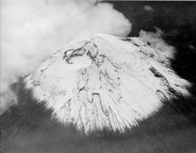 |
Figure 1. An aerial oblique photograph of Tungurahua taken from the W during July 1974 shows the morphology of the snow-and-ice-covered summit crater prior to the current eruption. Courtesy of the Geophysical Institute. |
Table 2. Explosions and other activity at Tungurahua as described in daily reports, 31 October to 30 November 1999. Courtesy of the Geophysical Institute.
| Date | Number of Explosions | Observations |
| 31 Oct 1999 | 28 | Night observations of incandescent emissions falling on upper cone; an ash-bearing plume rose ~3 km about the summit. |
| 01 Nov 1999 | 21 | A 3 km plume deposited ash in Banos and 31 km SW of the summit in Riobamba. |
| 02 Nov 1999 | 22 | On two occasions, plumes rose to ~5 km above the summit; windows vibrated 12 km from the summit. |
| 03 Nov 1999 | 34 | Ash deposited 32 km NW of the summit in Ambato. |
| 04 Nov 1999 | 25 | Plumes up to 5-km tall were produced; vibrations and explosions continued; sulfur smell noted in the city of Banos; harmonic tremor recorded. |
| 05 Nov 1999 | 22 | Weather clouds covered the plumes. |
| 06 Nov 1999 | 32 | Dense, 3-5 km plumes were seen during the day. |
| 07 Nov 1999 | 27 | ~1.5 km plume dispersed to the N and S. |
| 08 Nov 1999 | 24 | Blocky pyroclastic flows with over 1 km runout distances. |
| 09 Nov 1999 | 19 | -- |
| 10 Nov 1999 | 27 | -- |
| 11 Nov 1999 | 29 | Ash columns to 1.5 km height. |
| 12 Nov 1999 | 28 | Ash column to ~10 km altitude (~5 km above the summit); blowing E. |
| 13 Nov 1999 | 15 | Plume to about 2 km produced containing minor ash and directed NW. |
| 14 Nov 1999 | 25 | Plume heights unstated but plume visible to NNW on satellite imagery. |
| 15 Nov 1999 | 37 | Morning eruptions discharged ash plumes that moved NNW. |
| 16 Nov 1999 | 43 | Airborne observations of an ash-rich plume ascending to 5-km above the summit and blowing NW; a satellite image also showed the plume at ~5 km altitude. |
| 17 Nov 1999 | 55 | A consistent 1-km-tall ash plume directed to the N. |
| 18 Nov 1999 | 83 | Loud booming noises; continuous series of ~5-km-tall, W-directed plumes. |
| 19 Nov 1999 | 64 | Morning eruptions, plume blowing SW; in the past few days there was ~0.5 mm of ash deposited in Banos and up to ~2 mm deposited in Runtun (see text). |
| 20 Nov 1999 | 47 | A strong rain produced mud flows; some crossed roads; reports stated one mudflow was 20 m wide (see text). |
| 21 Nov 1999 | 67 | -- |
| 22 Nov 1999 | 55 | A large quantity of blocks and incandescent material found on sides of volcano; 1-2 km plume produced and inclined to the NE. |
| 23 Nov 1999 | 96 | Emissions rose to 1 km over the summit. |
| 24 Nov 1999 | 102 | Up to ~2-km-tall plumes of vapor and ash directed to the E. |
| 25 Nov 1999 | 97 | Taller plumes reached 3-4 km height; ~3,300 tons/day SO2 emitted in an interval with a constant 1-km-tall plume. |
| 26 Nov 1999 | 35 | An explosion of vapor and ash rose 1 km above the summit of the volcano; a ~5-km-tall plume formed; 1 cm ash accumulated in one sector during the past weeks. |
| 27 Nov 1999 | 16 | 4 km ash-bearing column rose after the explosion. |
| 28 Nov 1999 | 13 | A 500-m-tall vapor column was seen. |
| 29 Nov 1999 | 46 | An explosion produced a 4-km-tall column; loud noises heard. |
| 30 Nov 1999 | 62 | Observers noted strong thunder sounds; vibrations felt ~10 km away. |
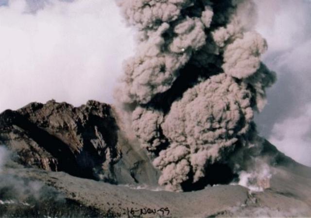 |
Figure 2. A dark ash plume rises from Tungurahua's formerly snow-covered summit crater on 16 November 1999. Courtesy of the Geophysical Institute. |
 |
Figure 3. A histogram indicating the number of daily explosions at Tungurahua during 24 October to 30 December 1999. Explosions were most frequent during 22-25 November. Courtesy of the Geophysical Institute. |
A pronounced peak in monthly earthquakes during August-September diminished rapidly in October and still farther in November (figure 4). The greatest number of monthly earthquakes were volcano-tectonic, in a pattern that became prominent in September 1998 and prevailed until October 1999. The ratio of multiphase to long-period earthquakes showed significant variability. In some months (eg., February, March, May, June, and September 1999) the multiphase events dominated. August 1999 showed the extreme reversal of this pattern with 436 long-period and 58 multiphase events. The last two months shown on figure 4, October and November, portrayed a similar though less pronounced reversal in their relative abundance of the multiphase events. These months also displayed a comparative scarcity of volcano-tectonic events.
 |
Figure 4. A histogram for Tungurahua showing three types of monthly earthquakes occurring between April 1998 and November 1999. For any given month, from left to right the earthquakes shown are long-period (LP), hybrid or multiphase (MP), and volcano-tectonic (VT). All three types plot on the same scale, shown on the left side of the histogram. Courtesy of the Geophysical Institute. |
SO2 flux during the crisis (figure 5) showed wide variability. Comparatively high fluxes were measured prior to the eruption. On the eruptions first day, 5 October, measured SO2-flux values reached 9,000-10,000 metric tons/day (t/d) (BGVN 24:09). The highest fluxes, seen during mid-September through early November, also showed rough, though inexact correlations with the seismic and explosion patterns.
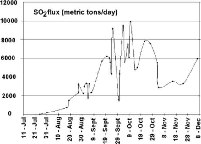 |
Figure 5. SO2 flux measured at Tungurahua during 11 July-8 December 1999. Although error bars were not provided they are typically on the order of plus or minus 10-20%. Courtesy of the Geophysical Institute. |
Two mud flows were reported on 20 November. They occurred after a strong rain that washed large tree trunks and rocks into a main highway in Baños. One of these mudflows was 20 m wide; another earlier in the day blocked part of a different highway in Baños.
1998-99 activity divided into five stages. In January 2000 the Geophysical Institute issued a summary report that divided 1998-99 activity into five stages. The first stage, December-May 1998, included swarms of small predominantly volcano-tectonic earthquakes. Tremor also continued, presumably associated with a phreatic source; this kind of tremor has been detected since 1993 and is thus here referred to as persistent or long-lived tremor.
The second stage, May 1998-15 July 1999, was an interval when seismic swarms (including volcano-tectonic (VT), long period (LP), and hybrid or multiphase (MP) earthquakes) became more energetic. Small explosion signals began to register from greater-than-shallow depths. The preponderance of VT earthquakes was interpreted as a result of stress beneath the edifice due to intruding magma. Stable-frequency tremor at that time underwent a slight increase in amplitude.
In the third stage, which began after 15 July 1999, tremor included higher frequency signals. Geophysicists noted a series of many small earthquakes of all kinds that continued until mid-December. At the end of July came the first reports of strong sulfurous odors in the vicinity of the crater. In the meantime, SO2 fluxes rose from essentially zero to 3,200 t/d (figure 5).
During 24-28 July and 8-10 September LP earthquake swarms struck with significant energy. Seismicity continued to rise considerably during August and early September. An alert was declared on 8 September 1999.
The fourth stage began 14 September 1999 when low-frequency tremor appeared, presumably associated with degassing and ascending magma. The persistent tremor increased in amplitude. On 14 September a column of vapor 2 km tall was observed. On 15 September the alert status rose to yellow. Later and until 25 October tremor reached extraordinarily high amplitudes and contained three dominant frequencies: 1, 1.7, and 2-2.5 Hz.
The first explosive activity was reported on 5 October (BGVN 24:09), when blocks and ash were ejected at 0721, 0738, and 0743 hours. This emission was associated with a comparatively big explosive seismic signal with a reduced displacement of 25 cm2 and high SO2 fluxes. The next day an ash plume rose to 2 km above the summit; small airfall ash deposits were found in Quero, Bilbao (where the thickness was given as 2 mm), and probably in Ambato. Subsequent Geophysical Institute reports described small ash-bearing or "dark" plumes to 0.5-5 km above the summit.
On 13 October observers first noted incandescence. SO2 fluxes rose to over 10,000 t/d (figure 5). Deformation at one of the tilt stations on the SW underwent significant changes. Activity increased on 16 October when an ash plume reached ~5 km above the summit and blew W. During the previous night's darkness observers saw incandescent ash and blocks deposited on the upper flanks of the volcano. On 16 October the alert status was raised from yellow to orange, prompting evacuations of Baños and settlements along Tungurahua's W and SW flanks (see below).
During the fifth stage, which began after 25 October, the persistent tremor remained near the levels seen in the third stage. Low-frequency tremor also continued. SO2 fluxes dropped to 3,500-4,000 tons/day in mid-November. Magmatic explosions became common in this stage. At night observers saw pyroclasts descending 1-2 km below the summit. Ash-charged plumes rose 3-5 km above the summit. During 1999 the Geophysical Institute tallied 2,030 explosions and emissions, 2,542 VT earthquakes, 4,086 LP earthquakes, and 1,038 MP earthquakes.
Geography and hazards. Baños sits in a narrow valley on the N margin of the volcano 75 miles S of Quito and 9 km NE of Tungurahua's summit. Baños lies along the Pastaza river (draining the N flanks) below the Chambo river (draining the W flanks over the NW to SW sector). This geography leaves Baños open to "high hazard for directed blasts and fallback pyroclastic flows" as well as lahars (Hall and others, 1999). Within this hazard zone, ~4.5 km downstream, sits the Agoyan dam, an important source of hydroelectric power.
Tungurahua is very dangerous because it has 3 km of vertical relief, 30°slopes, a record of previous sector collapses and a comparatively high propensity for future collapses, a pre-evacuation at-risk population of ~25,000 people, a major hydroelectric dam on its NNE margin, and a record of relatively violent, sudden andesitic eruptions with pyroclastic flows (Hall and others, 1999). The same authors noted that the volume of magma emitted by Tungurahua during the last 2,300 years has been ~3.45 km3. This gives it a magma flux rate similar to that at Merapi during the last century and 2- to 3-fold larger than the estimated rates seen in the Central Andes during the Late Cenozoic.
Evacuations. The newspaper El Universo reported that on 16 October when Tungurahua's volcanic activity increased and its hazard status first rose to orange, evacuations followed at cities closest to the volcano, including Baños. On 21 October the United Nations (UN) reported that the evacuations relocated "22,000 persons from some 60 locations." El Universo noted that at one point nearing the end of the evacuation one hundred buses were used.
As of late October some of the residents had moved to Ambato, 32 km NW of the volcano. Official sources indicated that 1,200-1,500 evacuees went to temporary shelters in the provinces of Tungurahua, Chimborazo, and Pastaza. Besides Ambato, individual cities that took refugees included Puyo (45 km E of the summit) and Shell (41 km E). About 100 families found shelter in a religious foundation and 200 families on a farm belonging to the Polytechnic Institute of Chimborazo. The UN further reported that ~600 military police and personnel have been deployed to the affected region to protect abandoned property. Access into this area was to be strictly prohibited.
The UN reported that 4,000 livestock, 100,000 fowl, and the animals from the zoological garden in Baños had also been evacuated. According to the Associated Press, a government census found that 40,000 chickens died from respiratory infections during early October.
According to the Associated Press, Baños had been evacuated for two months when on 13 December a caravan of residents briefly returned. During this brief visit, one resident entered his home and found it intact, although most parts of the house lay covered in ash. Residents faced an uncertain future because they did not know exactly when they would be able to return. The governor of Tungurahua province, Ignacio Vargas said, "This won't be permanent. We will have to wait until the eruption ends so that everyone can return to his normal activities."
Because of economic problems associated with leaving their homes and livelihoods, Baños area residents have been bypassing the military to plant crops and tend their farms. According to early January ABC News reports there have even been skirmishes between residents and the military. The eruptions are occurring in the context of tension and conflict between the military and some Unions and other groups as the country's economy has worsened.
Reference.: Hall, M., Robin, C., Beate, B., Mothes, P., Monzier, M., 1999. Tungurahua Volcano, Ecuador: structure, eruptive history and hazards: Journal of Volcanology and Geothermal Research, v. 91, p. 1-21.
Information Contacts: Instituto Geofísico, Escuela Politécnica Nacional, Apartado 17-01-2759, Quito, Ecuador; Embassy of Ecuador, 2535 15th Street NW, Washington, DC 20009 USA (URL: http//www.ecuador.org/); United Nations Office for the Coordination of Humanitarian Affairs (OCHA), Palais des Nations, 1211 Geneva 10, Switzerland; El Universo, Quito, Ecuador (URL: http://www.eluniverso.com/); Associated Press, International Headquarters, 50 Rockefeller Plaza, New York, NY 10020 USA (URL: http://www.ap.org/); ABC News (URL: http://abcnews.go.com/).
More than two-fold increase in long-period earthquakes during December
This report describes activity during December 1999 based on daily reports and other resources from the Geophysical Institute's website.
In comparison to other months, long-period earthquakes grew substantially during December (figure 6). The previous monthly high during the crisis, consisting of 883 events, took place in November 1999. December's count of LP earthquakes reached 1,995 earthquakes, more than double the November high. In addition, the count for December LP earthquakes stood higher than the sum for these events during all the previous months of the crisis.
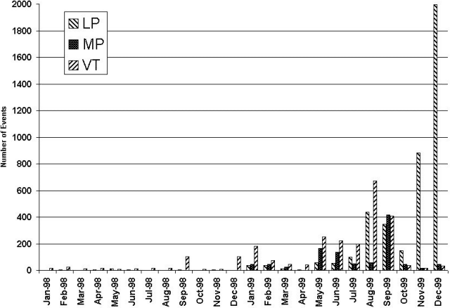 |
Figure 6. Histogram showing three types of monthly earthquakes at Tungurahua between January 1998 and December 1999. For any given month, from left to right the earthquakes shown are long-period (LP), hybrid or multiphase (MP), and volcano-tectonic (VT). All three types plot on the same scale. Data for November 1999 has been revised from that in BGVN 24:11. Courtesy of the Geophysical Institute. |
Intervals of both low-frequency tremor and repeated explosions (often 10 to 25/day) prevailed during the reporting interval. Scientists explained the frequent, ash-bearing explosions in terms of a magmatic system that maintained an open conduit to the surface.
The Instituto's daily reports stated that on the morning of 1 December an ash column from Tungurahua rose to unstated height and moved NW. Ash fell on the city of Ambato and its vicinity. The next day ash blown SW fell on the town of Riobamba.
Modest ash columns, typically under 2 km, were seen almost daily during December. Cannon-like blasts were also widely heard. For example, despite bad weather on 4 December, observers heard explosions and later saw incandescent blocks descending 1 km below the summit. A blast on 5 December was audible 8 km from the crater. An explosion on 10 December discharged a plume that rose to 3 km altitude; that same day drivers discovered small mud flows cutting across three segments of the Baños-Penipe highway. Plumes from explosions on 11-12 December sent ash 4 to 5 km in altitude; in the case of the former, winds carried the plume 20 km laterally.
At 0840 on 16 December members of TAME flight 172 reported an ash plume above Ambato at an altitude of ~8 km. It drifted N at ~30 km/hour. These events correlated with seismic and ground-based visual observations. A second example of an upper-altitude ash-bearing plume took place on 28 December when a TAME flight crew reported a 6.2-km-altitude plume directed SW. A third such report came on 31 December when a TAME crew noted an ash plume at 7.5 km altitude extending SW.
On 26 December, a COSPEC instrument was used to estimate the SO2 flux at 1,700 tons/day. Land surveys with an EDM instrument detected an absence of measurable geodetic changes. That same day, however, it was announced that in the past few days there had been some extended periods of tremor.
By mid-December 1999 the people of Baños became dissatisfied with the military occupation of their town. Some sources claimed that evacuated residents had seen looting of homes on television news. On 5 January several thousand residents of Baños bearing sticks and machetes forcibly drove the military off, re-entered the town, and proclaimed that they would be responsible for their own safety in the event of a threatening eruption. By some estimates, 25% of the town's ~ 16,000-20,000 residents had returned. Tourists, too, have come to enjoy the town's ambiance, hot springs, and resort atmosphere. Baños is located on the N-flank of the volcano, where it is vulnerable to various volcanic hazards.
Correction: In BGVN 24:11 the plot showing monthly earthquakes at Tungurahua presented values that have since been revised. The chief difference lies in the number of long-period earthquakes during November 1999 (now reported at 883 events). Figure 2 shows the corrected values.
Reference. Hall, M., Robin, C., Beate, B., Mothes, P., Monzier, M., 1999. Tungurahua Volcano, Ecuador: structure, eruptive history and hazards: Journal of Volcanology and Geothermal Research, v. 91, p. 1-21.
Information Contacts: Instituto Geofísico, Escuela Politécnica Nacional, Apartado 17-01-2759, Quito, Ecuador; Embassy of Ecuador, 2535 15th Street NW, Washington, DC 20009 USA (URL: http//www.ecuador.org/); United Nations Office for the Coordination of Humanitarian Affairs (OCHA), Palais des Nations, 1211 Geneva 10, Switzerland; El Universo, Quito, Ecuador (URL: http://www.eluniverso.com/); Associated Press, International Headquarters, 50 Rockefeller Plaza, New York, NY 10020 USA (URL: http://www.ap.org/); ABC News (URL: http://abcnews.go.com/).
Frequent early-2000 explosions with loud reports; ash plumes to 10 km altitude
This report covers the interval from 1 January to 18 February 2000. What follows are excerpts of the Geophysical Institute's daily reports. Basically, they disclose a pattern of noisy ash-bearing eruptions, tremor, and elevated seismicity. The alert status remained at Orange. As noted on table 3, some ash columns rose as high as 5-10 km; the sounds from one explosion were heard 75 km N in Quito. Tephra frequently blew towards the W (the major population center, Baños, lies N of the summit).
Table 3. Tungurahua plumes and other activity during 1 January-18 February 2000. Plume composition was further described as follows: dominantly ash plumes (a), dominantly steam plumes (s); and direction blown (e.g., N, S, E, W). Where available, selected comments on active processes also follow. Courtesy of the Geophysical Institute.
| Date | Plume height (km) and Observations |
| 01 Jan 2000 | 2a, W. Banded tremor. |
| 02 Jan 2000 | 0.5 a, W (fines fell on Rio Bamba). Banded tremor. |
| 03 Jan 2000 | "Significant explosions"a, W. Following the explosions there was high-amplitude tremor for 30 minutes. |
| 04 Jan 2000 | 5a, W. |
| 05 Jan 2000 | 2a, N. |
| 06 Jan 2000 | 3a, NE. |
| 07 Jan 2000 | Poor visibility, 1-2 a. |
| 08 Jan 2000 | Poor visibility, 3-4a, SW. |
| 10 Jan 2000 | 6,700-7,000 t/d SO2. High tremor. |
| 11 Jan 2000 | 1.5s, NW. |
| 12 Jan 2000 | ~ 8a, with two plumes seen in satellite imagery, trailing off S and W. 8,400 t/d SO2. |
| 13 Jan 2000 | Restricted visibility but incandescent ash seen falling on upper slopes. 5,000 t/d SO2. |
| 14 Jan 2000 | ~ 0.2a; the plume was highly concentrated in ash, thus the column collapsed soon after it began discharging; later, incandescent tephra fell over the upper sides. |
| 15 Jan 2000 | 2a, strong detonation heard 10 km away; incandescent blocks seen. |
| 16 Jan 2000 | Poor visibility and no explosions detected. |
| 17 Jan 2000 | Small explosion detected. |
| 18 Jan 2000 | One audible explosion heard during poor visibility. |
| 19 Jan 2000 | 1a, continuous discharge blown W to NW. |
| 20 Jan 2000 | Small ash columns. |
| 21 Jan 2000 | Bad weather, falling rocks heard; mudflows noted. |
| 23 Jan 2000 | Observers saw a short, hazy column with a moderate concentration of ash. |
| 24 Jan 2000 | 1a, blown W and SW. |
| 25 Jan 2000 | Seismically detected explosions with 5-8 cm2 reduced displacements. |
| 26 Jan 2000 | Bad weather; small explosions. |
| 27 Jan 2000 | Seismically detected explosions with 8 cm2 reduced displacements. |
| 28 Jan 2000 | Small to moderate explosions. |
| 29 Jan 2000 | Moderate to large explosions; cannon-like sounds reported; two mudflows crossing roads. |
| 30 Jan 2000 | ~ 1a, but American Airlines also reported a plume to ~10 km; moderate-to-large seismically detected explosions, plume blowing NW to W. |
| 01 Feb 2000 | Slight decrease in the number of explosions with respect to previous days. |
| 02 Feb 2000 | 2a, W; 20 min. of tremor. |
| 03 Feb 2000 | 1a, W and SW; incandescent materials descended 0.5 km down flanks. |
| 04 Feb 2000 | ~2.5a, some dense columns; W, NW, and SW. |
| 05 Feb 2000 | 0.6a, W; rains caused mudflows. |
| 06 Feb 2000 | Continued outbursts consisting of sporadic low energy explosions. Tremor episode(s) associated with gas emissions. |
| 07 Feb 2000 | Continual ash emission; S- and W-directed winds. |
| 08 Feb 2000 | 3a, N and NW; explosion at 0438 heard by residents of Quito; ashfall closed airports in Ambato and Riobamba. |
| 12 Feb 2000 | ~8-10a (aviation report); W and SW. |
| 13 Feb 2000 | Cloudy weather; roaring noises heard; fine ash in NW sector of volcano; at 0743, an Avianca flight en-route to Lima-Bogota reported a 7-km-radius cloud of ash over the volcano at 8 km altitude. |
| 14 Feb 2000 | 2a, SW; small amount of ash in Riobamba. |
| 15 Feb 2000 | 2a, W. |
| 16 Feb 2000 | Plumes and emissions not discussed. |
| 17 Feb 2000 | 3a. |
| 18 Feb 2000 | 3a. |
Histograms and plots on the Institute's web site tell a story of increased activity during late 1999, but the data for 2000 were generally absent. For example, BGVN 24:11 included their plot of daily explosions during 24 October-3 December 1999. This plot showed 1 event on 24 October 1999 and 1-39 events during the first half of November. A prominent peak in the latter half of November reached 105 events. The number of daily events subsequently declined for the last data shown, ending with 39 events on 3 December 1999.
Based on a reading of the daily reports for early 2000 this decline continued. An approximate tally of daily explosions suggests 300 during the month of January, an average of about 10/day. Similarly, for the first eighteen days of February, explosions again averaged about 10/day. In addition, a regional earthquake of M 3.3 took place on 12 January centered below the volcano's S flanks.
One of the Institute's plots disclosed a positive correlation between near-term rainfall and tremor during 1993-1999. Notwithstanding that longer-term observation, rainfall decreased during the course of 1999 while tremor escalated strongly, ultimately undergoing more than a 15-fold increase over background by the latter part of 1999.
Epicenters and foci mapped for August 1999 clustered near the summit and also occurred with a much lesser density along a radial band trending NW-SE extending out on either side of the summit. Thus, the main cluster of the August 1999 earthquake swarm lay directly below the summit at less than 10 km depth; with close approach to the surface the cluster appears directed toward the volcano's SE side. A plot of measured SO2 fluxes for the interval July-8 December 1999 peaked in September-October at ~9,000-10,000 tons/day (BGVN 24:11).
On 21 and 29 January, and 6 February, rainy weather caused mudflows to descend drainages blanketed by ash deposits. On many days, explosions caused unusually strong acoustical signals; the most powerful signal was generated on 8 February when the sound of an explosion was heard 75 km N in Quito.
Some of the other noteworthy events and ideas discussed in the daily reports follow. At 1544 on 3 January significant explosions occurred, followed by high-amplitude tremor lasting about 30 minutes. The emissions continued and the columns again blew W. On the 4th, undisclosed satellite images showed a column of ash 5 km tall, again blown W. The daily report for 7 January mentioned two possible eruption scenarios involving escalating eruptive vigor and increased hazards.
At 0614 on 12 January ground observers noted a dark gray column rose 3-5 km over the summit. Thereafter, NOAA satellite technicians noted two ash clouds. One cloud extended from the volcano toward the W reaching a length of 16 km and a width of 15 km; it rose to 3 km over the summit (i.e., ~8 km altitude). A larger ash cloud extended toward the S reaching a length of 75 km; it also reached ~8 km altitude (table 1).
Ash clouds remained obscure from the ground on 13 January but in the morning roars were heard associated with the continual emission of gases and ash. A light rain of fine ash fell in the NW sector of the volcano. Peculiar, very dense clouds vented on 14 January, rising only 200 m before rapidly collapsing.
At 0743 on 13 February, an Avianca flight in route to Lima-Bogotá reported an ash cloud over the volcano at 8 km altitude (table 1). In the morning on 14 February some loud explosions foretold of ash columns; they rose 2-3 km above the summit and blew SW. In the morning the next day satellite images showed an ash cloud that had reached a length of 100-150 km and width of 15 km. This cloud was directed from Tungurahua toward the NNW, passing over the towns of Píllaro, Latacunga, and Salcedo. At 10 km distance, falling ash reached a thickness of 1 mm.
Information Contacts: Geophysical Institute (Instituto Geofísico), Escuela Politécnica Nacional, Apartado 17-01-2759, Quito, Ecuador.
January-July volcanism possibly decreased; lava fountains and many lahars
During January-July 2000 Tungurahua volcano experienced continuous but relatively mild activity with occasional lava fountaining. There were periods (hours to days) of relative calm during June and July.
The volcano continues to generate a variety of seismic events, most events being the long-period (LP) type. Two episodes of volcano-tectonic (VT) events were observed; one between late January and early March, and one less intense event between early May and mid-June. Epicenters for these events were across the top of the volcano's cone with focal depths at 3-13 km. Hybrid events, whose waveforms consist of a short, higher-frequency onset followed by lower-frequency, larger-amplitude signals, were most abundant in January and February (~50 events/week), partially coinciding with the greater VT activity. Subsequently these events diminished to 1-2 events/week, except for a brief swarm in early April.
Events of classical LP waveform were frequent, varying from ~400 events/week in January, ~600 in February, ~400 in March, ~600 in April, ~500 in May, and ~400 in June. A sharp increase to ~950 events/week was observed in July. Some of the LP events (3.7-4.0 Hz) were located tentatively at depths of 7-10 km below the crater. However, the great majority of LP events (1.5-3.3 Hz) were 3-7 km deep. They were often associated with explosion clouds or forceful emissions of ash-and-steam within 1-3 seconds of the seismic onset, suggesting a high-level origin.
Explosions, recognized principally by their impulsive onset, were more frequent during January and February (~80-90 events/week), but in subsequent months dropped to ~20-30 events/week, with many accompanied by a sonic boom. Reduced displacement values for the explosions typically were 5-10 cm2, and occasionally 12-18 cm2.
Low-frequency tremor with spectral frequencies between 0.5-1.6 Hz, but monochromatic at times, were observed in April and May, but only sporadically in June and July. During the period from the 2nd week of April through the 2nd week of May, the low-frequency episode coincided with lava fountaining in the summit crater. The fountains, comprised of the continuous ejection of incandescent material 100-500 m into the air, lasted hours; sustained roaring and surf-like noises heard 12 km away.
The constant glow of incandescent material in the crater, which was observed frequently in late 1999, was seen only occasionally during August, possibly due to unfavorable weather conditions. Better viewing conditions in late June and July confirmed that incandescent lava still remained in the crater or immediately below it.
The emissions have consisted of a permanent, grayish-white to light-gray column of steam with varying amounts of fine-grained ash that commonly rise less than 1 km above the crater. Explosions or strong emissions have consisted of blocks being thrown hundreds of meters into the air and by the formation of Vulcanian-like eruption clouds that are medium-to-dark gray in color and sometimes with a mushroom shape. The clouds have reached as high as 5 km above the summit. Primarily, easterly winds have carried the very fine ash to the W and WSW, but occasionally anywhere in the azimuthal arc between NW and SW. Both national and international flights reported the ash plume. The ash deposits were several centimeters thick on the lower W flank of the cone, but only several millimeters in the agriculturally important lands farther W.
Ballistic blocks were vesicular, black, glassy andesite containing phenocrysts of olivine, plagioclase, augite, and hypersthene, in a glassy matrix with 10-20% microlites. More recent samples had fewer olivines and larger augites. Chemical analyses of these blocks as well as collected ash gave the following typical values: SiO2 ~58.5%, K2O ~1.72%, MgO ~3.9%, Ni ~33 ppm, and Cr ~65 ppm.
COSPEC monitoring since November was hindered by heavy cloud cover. Following the consistently high SO2 flux values of 6,000-8,000 metric tons/day (t/d) during September-October 1999, values decreased to an average of 3,000-4,000 t/d in November-December 1999. Values then rose to ~8,000 t/d in January and subsequently dropped to an average of ~1,000-2,000 t/d in June and July 2000. An exception to this trend was an increase to ~4,000 t/d observed in April-May, 2000, which coincided with the lava fountaining episode. In general, higher SO2 values seem to be associated with greater tremor activity.
Monthly water analyses of hot springs at both the N and S bases of the edifice have not shown any variation in temperature, pH, conductivity, nor in the concentrations of SO4, Cl-, Na+, CO3--, Ca++, Mg++, and K+, since chemical monitoring began in 1992 and since the activity on Tungurahua began in July 1999.
Lahars coincided with the rainy season and became frequent in October and November 1999; they rapidly cut the main highway at every stream crossing along the western half of the cone (the area of greatest ash fall). Occasional rains from December to June generated flows of debris. The main highway to Baños and to the Amazon Basin was frequently blocked for hours due to lahar deposits.
In general, the activity appeared to be subsiding. However, during the 1916-18 eruptive period the volcano experienced 1.5 years of little activity between major eruptions. An orange alert is still in effect. In the past, Tungurahua typically generated both Merapi- and St. Vincent-like nuées ardentes. The W sector of Baños (17,000 inhabitants) lies at the mouth of a canyon that starts near the summit of the volcano, 9 km away and 3,000 m above the town.
Following the evacuation of Baños on 17 October 1999, the town remained abandoned until late December (BGVN 25:01). As of August 2000, about 80% of the population had returned and tourism has re-established itself.
Information Contacts: Geophysical Institute (Instituto Geofísico), Escuela Politécnica Nacional, Apartado 17-01-2759, Quito, Ecuador.
Summary of August 2000-August 2001 eruptive activity
Tungurahua was last discussed in BGVN 25:07, in a report covering the first half of the year 2000. This report was taken chiefly from available updates on the Instituto Geofísico (IG) website. Some of the graphics currently available there and discussed in this report cover the interval 1998-2000.
The subsequent part of this report focuses on activity from August 2000 through 15 August 2001. During this latter interval, aviation reports were issued daily, often several times a day. The final section of this report presents some statistics on Tungurahua's recent human impact from a report issued on 5 September 2001.
Tunguharua's continued eruptions were accompanied by varying SO2 fluxes, tremor, and earthquakes. Hazard concerns remained high, and plume heights reached over 11 km altitude (5 km over the summit) on three days in the first half of August 2001.
Observations during 2000. Between January and October 2000 Tungurahua produced significant discharges and explosions, some of which included impressive ash columns and shows of lava in the crater documenting the presence of shallow magma in the edifice. Seismically inferred magmatic intrusions took place in January, April-May, and August-October 2000. The critical seismicity included intense tremor and swarms of long-period and volcano-tectonic earthquakes.
As shown on figure 7, earthquakes of long-period (LP) and volcano-tectonic (VT) types both underwent progressive increases during the year 2000 but decreased again by November 2000. (More recent data were unavailable at the time of this writing.) Earthquakes attributed to explosions grew in number suddenly during November 1999 and then subsequently proceeded to decrease in number until becoming inconspicuous during late 2000. Elevated numbers of earthquakes, particularly LP earthquakes, correlated with eruptive outbursts (arrows). High numbers of LP earthquakes also persisted between outbursts.
 |
Figure 7. Monthly number of earthquakes registered at Tungurahua during January 1998 to December 2000. High numbers of volcano-tectonic and long-period earthquakes generally occurred starting in middle to late 1999. Around this time, earthquakes with explosion signatures were sometimes abundant as well. Arrows indicate times of seismically inferred magmatic intrusions. Courtesy of Instituto Geofisico. |
Figure 8 illustrates how during September 1999-December 2000 the energy contained in combined harmonic tremor and hydrothermally generated tremor underwent a sudden peak in January 2000, a time when the numbers of earthquakes seen on figure 1 also showed a strong rise. Two subsequent, progressively smaller peaks in tremor energy occurred at roughly 4-month intervals. Intervals of high tremor energy strongly correlated with eruptive outbursts.
 |
Figure 8. At Tungurahua, the energy contained in tremor (both harmonic and hydrothermal types) during September 1999-December 2000. The interval of maximum tremor energy, around January 2000, developed rapidly and then decreased through time at least as late as December 2000. The intervals that included the highest tremor energy were inferred to reflect magmatic intrusions (arrows). Courtesy of Instituto Geofisico. |
SO2 flux climbed to over 10,000 tons/day during late 1999 and early 2000, but dropped thereafter stabilizing in the hundreds of tons per day range in late 2000 (figure 9). A synopsis of SO2 flux has yet to be reported for 2001. A statement discussing the week of 10-16 January 2001 noted that SO2 flux had been in the 1,000 tons/day range but had risen to 2,000-2,400 tons/day. During that same week, new fumaroles were noted at an inaccessible spot on the NW flank above Baños. Plumes that week rose at least one kilometer over the summit (table 4).
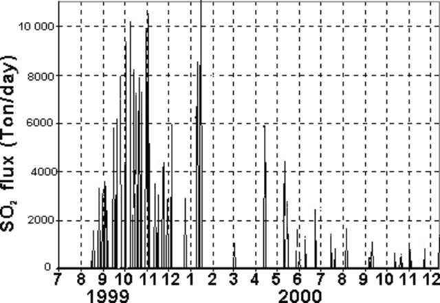 |
Figure 9. SO2 flux measured at Tungurahua during July 1999-December 2000. After the large peaks (~10,000 tons/day) the SO2 values dropped significantly and then tended to decrease through the end of 2000. Courtesy of Instituto Geofisico. |
Table 4. A summary of hazard status and plume height observations for Tungurahua, 1 November 2000 to 21 August 2001. These data were summarized from GVP / USGS WeeklyRreports derived from IG data. Some of the taller plume heights came from the Washington VAAC and were based on satellite imagery and local aviation reports.
| Dates | Description of Activity |
| 01 Nov-07 Nov 2000 | Plumes 0.5 km above crater. |
| 08 Nov-14 Nov 2000 | 13 November small ash cloud near the summit level blown SE. |
| 22 Nov-28 Nov 2000 | 27 November small ash-and-gas discharges reached 0.5 km above the summit. |
| 29 Nov-05 Dec 2000 | Sporadic gas column. Plumes 0.3-0.5 km above crater. |
| 06 Dec-12 Dec 2000 | 9 December ash cloud moving SW at summit height. |
| 13 Dec-19 Dec 2000 | 14 December ash cloud moving NE at 0.5 km above the summit. |
| 20 Dec-26 Dec 2000 | 21 December ash cloud at 1 km above the summit but not seen on GOES-8 imagery. |
| 03 Jan-09 Jan 2001 | Plumes seen several times during this week; no ash visible. Emissions on 3-4 January were moderate sized and ash bearing. 2.9-km maximum plume height. |
| 10 Jan-16 Jan 2001 | Plumes ~ 2 km above crater. |
| 17 Jan-23 Jan 2001 | Plumes ~ 2 km above crater. |
| 14 Feb-20 Feb 2001 | 19 February lahars down NW flank via Cusua Gorge; steam column to 1 km. |
| 21 Feb-27 Feb 2001 | Plumes ~ 4 km above crater. |
| 14 Mar-20 Mar 2001 | 13 March ash cloud moving NW at 4.6 km above the summit. 15 March ash cloud 3.2 km above the summit. 16 March ash cloud 3.8 km above the summit. |
| 21 Mar-27 Mar 2001 | 22 March incandescent eruption column 2 km above the summit; 23 March ash cloud ~2 km above the summit resulting from a half-hour emission. |
| 28 Mar-03 Apr 2001 | 29 March ash cloud moving W at 1 km above the summit; another small eruption on 2 April. |
| 11 Apr-17 Apr 2001 | Plumes ~2 km above crater. |
| 18 Apr-24 Apr 2001 | Incandescent dome followed by small steam columns. |
| 25 Apr-01 May 2001 | 25 April ash cloud at 2 km; more eruptions followed but poor visibility. 29 and 30 April lahars to the Pampas, Cusua, Hacienda, and Achupashal sectors; river levels rose in the Ulba and Mandur sectors. Lahars in Pampas sector blocked the Pelileo-Banos channel during 0710 to 1100 on 29 April and destroyed the highway. |
| 02 May-08 May 2001 | Small steam-and-ash plumes during the week. Possible small lahar on 3 May. |
| 09 May-15 May 2001 | Heavy rainfall caused remobilization of ash deposited on the upper flanks, producing several lahars. Lahars went down the Cusua, Basural, Mandur, Bascun, and Ulba gorges and closed the Banos-Riobamba highway and blocked a route to the town of Banos. |
| 16 May-22 May 2001 | Small 15 May eruptions sent ash up to 3 km above the summit. Light ash fell in the towns of Cotalo and Bilbao. 17 May ash cloud 4 km above the summit drifted SW. Intense activity suggested by seismicity but cloudy conditions. 19 May ash cloud rose to 1.7 km. |
| 23 May-29 May 2001 | 2-km-high ash plume on 26 May, poor visibility. |
| 30 May-05 Jun 2001 | Activity increased. A large number of long-period earthquakes accompanied several small eruptions and near-continuous ash clouds. 31 May eruption sent an ash cloud up to 2.9 km above the summit, which drifted W. Incandescent blocks ejected and a sound like a cannon shot was heard kilometers away. Eruptions on 29 May at 2012 sent ash 2.2 km above the summit, on 30 May at 1211 (ash plume to unknown height), and on 2 June at 1709 with an ash plume 2.9 km above the summit. Incandescent material visible in the crater. |
| 06 Jun-12 Jun 2001 | Several small eruptions. 5 June ash cloud moving W at 2 km above the summit. |
| 13 Jun-19 Jun 2001 | 4.7-7 km maximum plume height. |
| 20 Jun-26 Jun 2001 | 22 June eruptions at 0630 and 0652 sent ash clouds 0.8 and 3.8 km above the summit, respectively. No ash visible on satellite imagery. Small explosions 25 June at 0138 and 1328 produced ash clouds that rose ~1 km above the summit and drifted W. Small amounts of ash deposited in the town of Ambato, ~40 km NW. |
| 27 Jun-03 Jul 2001 | 17 and 28 June ash clouds to 2 km above the summit; ash fell W, damaging crops. 3 July W-drifting ash 0.8-2.6 km above the summit. |
| 04 Jul-10 Jul 2001 | 5 July a larger-than-average ash plume rose to 2.6 km above the summit; however, satellite imagery and additional information suggested that a dense, SE-drifting ash cloud rose to 4 km above the summit. |
| 11 Jul-17 Jul 2001 | 12 July an eruption sent a cloud to ~3.3 km above the summit; it drifted W to NW. |
| 18 Jul-24 Jul 2001 | Heavy rain remobilized ash deposited on the flanks, generating lahars, and several small-to-moderate eruptions produced ash clouds. On 19 July lahars down the W flank reached the Banos-Riobamba highway. Larger eruption on 20 July produced an ash cloud that rose to ~2.9 km above the summit. |
| 25 Jul-31 Jul 2001 | 25 July the highest ash cloud of the week rose ~4 km above the summit and drifted SW. |
| 01 Aug-07 Aug 2001 | 2 August until at least 3 August there was an increase in activity. Continuous tremor began on 3 August; maybe associated with continuous ash emission. Several eruptions during the week; largest on 5 August produced ash cloud to ~7.5 km above the summit. |
| 08 Aug-14 Aug 2001 | Ongoing eruptions since at least 6 August, sending steam-and-ash clouds to 2.5-8 km above the summit. Ash clouds primarily drifted W. On 13 August three particularly strong emissions at about 0630, 1200, and 1315. Two distinct areas of ash visible in satellite imagery; one contained ash from the strong emissions, rose to ~6.6 km above the summit and drifted E; the other ash cloud was fed from continuous emissions and possibly rose to ~5 km above the summit and drifted SW. On 14 August one of about five explosions ascended to 8 km above the summit. It was emitted at 0746 and had a reduced displacement of 13.2 cm2. |
| 15 Aug-21 Aug 2001 | Series of eruptions that began on 6 August continued during the week. Seismicity characterized by many long-period earthquakes and seismic signals that represented ash emissions. Several sporadic explosions occurred, with the largest explosion beginning on 15 August. The eruption produced an ash cloud that rose to 7.2 km above the summit. On 17 August volcanic activity increased slightly and incandescent material was ejected up to 1 km W of the crater. According to news reports, as of 15 August ash affected more than 23,000 people, blanketed approximately 89,000 acres of crops, and killed an undetermined number of livestock. |
Reports noted an inferred intrusion during 9-12 October 2000. On 13 October, a debris flow occurred, but volcanism diminished considerably. The last explosion around this time took place on 23 October.
At the beginning of December 2000, IG survey crews detected a slight swelling in the EDM lines on the volcano's NW flank. An electronic inclinometer that could have helped confirm this deformation was located above the Refugio station. Unfortunately it was damaged when struck by rocks.
Summary of activity during November 2000-August 2001.Variable ash-cloud heights and other activity are summarized in table 1, which covers the time interval 1 November 2000 through 15 August 2001. Stated in terms of height above the summit, ash clouds rose to more than 7 km on two days in August; to 6 km on 1 day in August; and to 2-4 km on 38 days, mostly in June and July. Smaller ash clouds ascended 1-2 km on 28 days in the early months of 2001. Plumes ascended
During 17 October 1999-12 November 2000 ash plume heights exceeded 7 km over the summit on 8 days, chiefly during late 1999 through early 2000. In October 1999 an ash plume rose to ~13 km over the summit.
Observations during 2001. In early January 2001, two volcano-tectonic (VT) events were located 4-5 km below the NW flank. After 3 January, Tungurahua's 300-m-diameter summit crater had an increase in ash emissions, seen visually from the Guadalupe branch observatory, 11 km N of the volcano (table 1).
New fumaroles became apparent in late November 2000 at 4,400 m elevation on the NW flank, in the main drainage that feeds into the town of Baños (population 18,000). The fumaroles were located in a 100- to 150-m-long area.
During 10-12 June 2001, uncommonly intense and prolonged rains fell over the eastern provinces and the Andean foothills of Ecuador. At one pluviometer (rain gauge) that the IG operates on Tungurahua's NW flank, 120 mm of rain fell in two days. The rain-generated lahars that flowed down Tungurahua's flanks were the largest ever recorded, carrying volcanic blocks the size of small cars. The lahars closed the road between Ambato and Baños for hours and totally destroyed the road between Baños and Penipe. Other floods and lahars were recorded in rivers born on the volcano. Along the Vascun and Ulba rivers, some houses on the flood plains were inundated but not destroyed. The Rio Pastaza, on the N flank of Tungurahua, registered a record water flow rate of 1,760 m3/s.
The rains triggered a landslide that overcame two people living downstream of Baños in the vicinity of Rio Negro. Out milking cows, they were swept into the nearby Pastaza river. These two deaths, although in Tungurahua province, were not related to the lahars. As of July 2001, no one had died from the recent lahars. All together, the rainy season left a death toll of ~80 people in Ecuador, including losses from landslides and flooding away from the volcano.
An explosion on 17 June 2001 rose 4.8-7 km above the summit. Owing to clear weather, it was witnessed by many of the region's inhabitants. No pyroclastic flows were produced, and the explosion ceased after about a minute. After that time, the volcano produced about 1 explosion/day. These mid-June explosions were relatively small (their seismic signatures had reduced displacements of 2-5 cm2), but they generally came without warning.
Light ashfalls were also frequent W of the volcano. They affected many crops (including corn, peas, beans, potatoes, tomatoes, blackberries, and squash; as well as orchards of peaches and apples). A 27 August report by the Pan American Health Organization (PAHO) stated that by late August 2001 various areas had received up to 2.5 cm of ash.
Scientists came to believe that a weak seal was forming in the volcano's conduit system. The seal was thought to break under sufficient recharge pressure. In addition, this new spurt of mid-June activity could be attributed to a small injection of magma that was believed to have occurred during 17-18 May. The fresh injection rose up through the conduit and was seen as incandescence on 26 May and when Strombolian fountaining was observed. Later explosions could stem from residual gases and heat.
Earth Probe TOMS (Total Ozone Mapping Spectrometer) detected a weak ash and SO2 plume from Tungurahua on 6 August at around 0630. The plume was directed generally WSW and extended to approximately 4°S, 83°W, containing an estimated SO2mass of
Practice evacuation and maps. On 26 June 2001, 2,000-3,000 people in Baños conducted a simulated evacuation, the first in over a year. It was organized by "Ojos del Volcán" ("Eyes of the Volcano"), a local organization whose members include hotel owners, climbing guides, and tour operators. Other organizers included the IG, local civil defense authorities, the Red Cross, police, firefighters, and health officials. Participants walked to three previously identified zones of temporary refuge. The exercise was successful and revealed some unforseen shortcomings in the local disaster plans. Figures 10 and 11 show maps indicating topography and potential hazard zones.
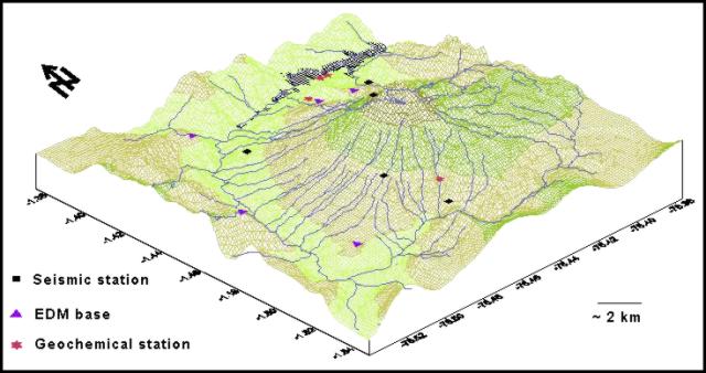 |
Figure 10. Diagram showing Tunguharua's landscape as seen from the SW. Note N arrow along left margin. Courtesy of Instituto Geofisico. |
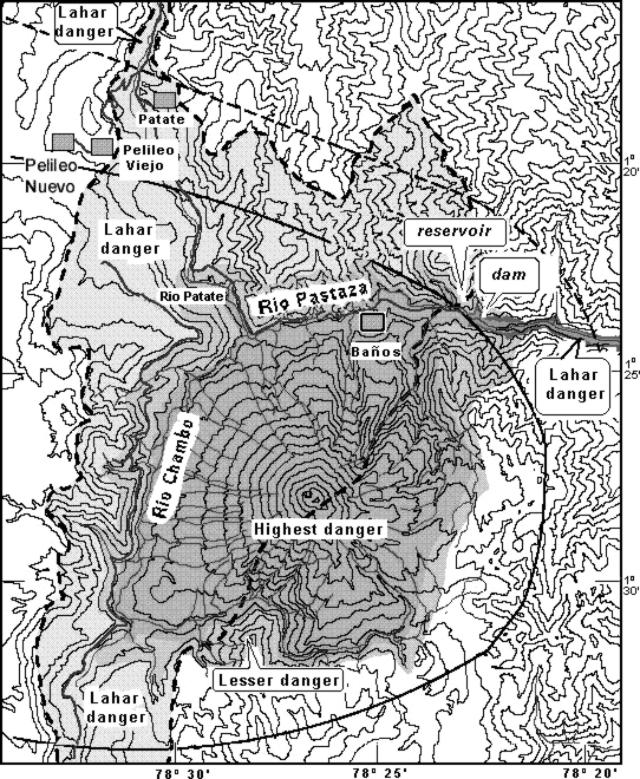 |
Figure 11. Generalized Tunguharua hazards map (N is towards the top) indicating areas of relative risk. The city of Baños lies within the zone of highest potential risk (central, darker shaded area). The town of Patate lies within the zone of lowest potential risk (lightly shaded); Pelileo Nuevo and Pelileo Viejo lie just outside this zone. Lahar risks continue hundreds of kilometers off the map towards the E along the downstream portions of the Rio Pastaza (dark strand intersecting the map's E margin). The Pastaza is confined by a dam ~4 km E of Baños. Solid and dashed curves represent areas with inferred risks from airfall ash. Courtesy of Instituto Geofisico. |
Human impact. A report was issued by the United Nations Office for the Coordination of Humanitarian Affairs on 5 September 2001, following a multi-agency meeting the day before. The report cited updated Civil Defense statistics on Tungurahua's impact.
As of 5 September, no ash had fallen in the previous 10 days; still, 39,000 people (8,000 families) had been affected by the volcano. Respiratory infections had increased. Ash had affected potable water supplies in some rural communities prompting more water-quality monitoring. There were 3,107 houses damaged.
A total of 53,597 hectares (ha) of farmland and pastures have been affected, of which 17,017 ha lie in the province of Tungurahua, 28,580 ha in Chimborazo, and 8,000 ha in Bolivar. Due to stress and new feed, 13,113 cattle developed health problems. Some were evacuated. The report also discussed a system for enlisting and tracking relief contributions.
Information Contacts: Geophysical Institute (Instituto Geofísico), Escuela Politécnica Nacional, Apartado 17-01-2759, Quito, Ecuador; Associated Press; NOAA Operational Significant Events Imagery Support Team (OSEI), NOAA/NESDIS, World Weather Building, Room 510, 5200 Auth Road, Camp Springs, MD 20748 (URL: https://www.nnvl.noaa.gov/); Washington VAAC, Satellite Analysis Branch (SAB), NOAA/NESDIS E/SP23, NOAA Science Center Room 401, 5200 Auth Road, Camp Springs, MD 20746, USA (URL: http://www.ssd.noaa.gov/); Volcano Disaster Assistance Program (VDAP), U.S. Geological Survey, 5400 MacArthur Blvd, Vancouver, WA 98661 (URL: https://volcanoes.usgs.gov/vdap/); Simon Carn and Arlin Krueger, Joint Center for Earth Systems Technology (NASA/UMBC), University of Maryland Baltimore County, Academic IV-/a, Room 114J, 1000 Hilltop Circle, Baltimore, MD 21250; Office for the Coordination of Humanitarian Affairs (OCHA), United Nations, New York, NY 10017 USA (URL: https://reliefweb.int/); Pan American Health Organization (PAHO), United Nations, 525-23rd Street, NW, Washington, DC 20037 USA (URL: http://www.paho.org/).
Powerful tremor, plumes, 600-m-high lava fountains, and lahars during 2001
The first portion of this report discusses some geophysical and geochemical aspects of Tungurahua's behavior during 2001, including further descriptions through August 2001 (BGVN 26:07). The latter portion of this report contains a log of behavioral data for 24 August-30 December 2001 in tabular form, and finally includes field notes from a visitor who watched the summit crater for several weeks in the later months of the year.
Instituto Geofísico (IG) scientists estimated that 10-15 million metric tons of ash were deposited during the 4-26 August 2001 eruption. By the end of 2001 the current eruptive crisis had included 8 inferred intrusive episodes. Some eruptions, including those during 2001, displayed fountaining with jets of lava rising over 500 m. Since 5 September 2000 through at least January 2002, Alert Levels have been set at Yellow for the town of Baños and at Orange for the rest of the high-risk zone.
Seismicity and SO2 flux. Long-period (LP) earthquakes dominated the seismic record since December 1999 (figure 12). Except for the anomalous month of February 2001, this trend continued in 2001, with the number of LP earthquakes largely swamping other kinds. Specifically, at the scale of the histogram hybrid (H) earthquakes are only visible during February and August; volcano-tectonic (VT) earthquakes, only during January, August, September, and December; explosion (EXP) earthquakes, only during June, July, August, and September.
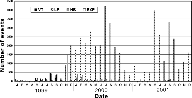 |
Figure 12. Number of Tungurahua earthquakes recorded monthly during 1999-2001. LP earthquakes clearly dominated since December 1999, except for the anomalous month of February 2001. During the year 2001, the peaks seen around May, August, and December may have corresponded to magmatic intrusions. Courtesy of IG. |
During 2001 both the seismicity and SO2 flux underwent intervals of relative quiet and intervals with elevated signals. The most dramatic quiet interval, from late 2000 into May 2001, appears on a plot of reduced displacements (RDs) from explosive events (figure 13). A comparative lull also appeared in overall seismicity (figure 12), provisionally in SO2 flux (figure 15), and to a lesser extent, in tremor energy (figure 14). Although the lull appears more equivocal on figure 14, the peaks in tremor energy during July and August, following the lull, were the largest recorded since the spike seen in January 2000. Elevated SO2 flux values appeared around about the same times as the peaks in tremor energy (figure 15).
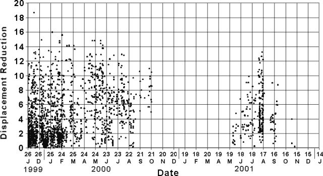 |
Figure 13. Explosion earthquakes at Tungurahua during 26 November 1999-14 January 2002 were quantified as reduced displacements (RDs, unit, cm2) and plotted at roughly 2-day intervals. RDs can be computed from seismic records; larger values indicate larger events. The record used came from station Patacocha. The largest RD shown, ~19 cm2, corresponds to an explosion that took place in December 1999 (upper left-hand corner). Courtesy of IG. |
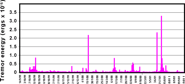 |
Figure 14. At Tungurahua, the energy contained in tremor (including both harmonic and hydrothermal types) during 14 September 1999-30 September 2001. The two largest peaks in tremor energy yet recorded occurred in mid-2001 (July and August). Horizontal axis is labeled as day/month/year. Courtesy of IG. |
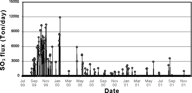 |
Figure 15. SO2 flux measured by COSPEC at Tungurahua during July 1999-November 2001. During 2001, flux highs were measured during May and August. Courtesy of IG. |
During 2001, instruments recorded two pronounced seismic peaks (figures 6 and 7). These swarms of LP events had focal depths of 5-7 km and a wide range of dominant frequencies, 308-1066 Hz. The first peak in LP events took place during May-June and was accompanied by emissions at the summit.
The second peak in LP events took place during August-September and also corresponded to increases in the number of hybrid (HB) and volcano-tectonic (VT) earthquakes, and to summit explosions. This second peak differed from seismicity during September 1998 and October 1999 (see plot, BGVN 26:07). During those earlier times, instruments recorded higher numbers of HB and VT events. More recently, both HB and VT events had been decreasing: the former since July 2000, and the latter since October 2000.
Although during early December comparatively few earthquakes occurred, the type of events recorded, tornillos, merit special discussion (see below). Beginning on 20 December the number of LP events increased from an average of 20 events per day in the first days of the month, to an average of 200 events per day. The LPs maintained that level until 26 December.
The two prominent seismic peaks of 2001 were considered as related to intruding magma. Thus, the intrusion associated with the first peak can be divided into three pulses, the first occurring during 19-20 March, the second, 17-18 May, and the third, 6-7 June (and perhaps into July).
The second intrusion occurred in two pulses, the first during 4-20 August, and the second during 4-25 September. The events related to the second intrusion produced the largest RDs (figure 13). For comparison, in 1999-2000 LP events had larger RDs, 12-19 cm2 (figure 13).
In the first inferred intrusion, the discharge of SO2 amounted to 2,900-3,600 metric tons/day (t/d), decreasing to 677 t/d by the end of June. SO2 fluxes associated with the second inferred intrusion reached 3,585 t/d by mid-August, decreasing to 175 t/d by the end of August (figure 15). The peaks in SO2 flux closely corresponded to the increases in tremor energy (figure 14). Incandescence visible during the end of March and July, during early and mid-August, and during early September confirmed that magma then lay at or near the surface.
The pulses of activity of each intrusion preceded, and in some cases accompanied, the emission of vapor and ash during explosive Strombolian activity. For example, for the first intrusion, the second pulse of seismic activity preceded the explosion of 28 May. In that pulse there was ~1 explosion per day with RDs of 1-3 cm2. During the third pulse, aboutone explosion per day had RDs of 1-7 cm2.
For the second, more energetic intrusion, the first pulse of activity had 7 explosions per day with RDs of 1-13 cm2. The next (second) pulse had ~1 explosion per day with RDs of 1-9 cm2 (figure 13). The last intrusion, during mid-June through July, was preceded by "LP de Juive", events so-named because residents in Juive felt them. These signals could have been caused by clearing of nearby subsurface passages that transport magma.
At the beginning of December the previously mentioned tornillos appeared. Tornillos ("Screw-type" events) are monochromatic LP events characterized by a long, slowly decaying coda. On a seismogram they appear similar to a screw. They may arise from fluid resonance in a cavity. It is noteworthy that they showed up for the first time in December 2001, and arrived with considerable intensity. Where defined farther N in the Andes at Galeras, have been recognized as eruptive precursors.
Although relatively small in number, the tornillo events were considered important. During 3-9 December, 43 occurred, the largest number recognized in the history of monitoring at Tungurahua. During 4-12 December the duration of these event's increased. During 4-10 December they underwent a decrease in their dominant frequency. The latter could stem from increased gas in the fluid. The tornillo signals may thus disclose physical changes in the volcano during early December. For example, the tornillos could be related to shifts in internal pressure.
The LP events began to register on 20 December, suggesting magma ascent. A lack of significant ash emissions or SO2 flux suggested that the conduit was sealed. This could allow internal pressure to rise, resulting in a series of explosions.
Deformation. During 2001, inclinometer data from station RETU, located above the Refuge, showed a drift in the positive direction of 10-15 µrad. These values are not highly anomalous considering the large diurnal variations stemming from effects such as temperature and humidity changes in the air and ground surface. On the other hand, measurements of points on the W flank lacked significant distance changes.
EDM measurements from a fixed base (the El Salado base station) were conducted periodically. They aim at two distinct points on the NE flank (in a region above the Refuge). A gradual decrease in the distance between the base and the two points began during July 2000 and implies a slight inflation of the NE flank of the volcano.
During the course of field studies, new NE-flank fumaroles were sighted at ~4,400 m elevation along fractures. Topographic movements were suspected in this sector.
Chronological observations, August-December 2001. Table 5 summarizes seismicity, and visual and satellite observations of eruptions and explosions and their ash clouds.
Table 5. Summary of activity at Tungurahua during August through December 2001. These data mainly came from IG reports. Some of the higher plume heights came from the Washington VAAC and were based on satellite imagery and local aviation reports. Courtesy of IG.
| Date | Long-period earthquakes | Tremor signals | Observations |
| 24 Aug 2001 | -- | -- | An eruption at 1755 produced an ash cloud that rose ~6-8 km and drifted E to SE. |
| 29 Aug 2001 | 20 | several | A gas-and-ash eruption at 1530. |
| 03 Sep 2001 | 44 | 36 | Ash cloud rose to ~ 5.8 km and drifted W. |
| 05 Sep 2001 | 77 | 46 | Weak emissions with low ash content. |
| 08 Sep 2001 | -- | -- | Ash cloud at 0828 rose ~10.5 km altitude and drifted SW. |
| 11 Sep 2001 | -- | -- | Ashfall to N in Pondoa, Runtun, Banos; ashfall to S in Quero and Penipe; mudflows between Puela and Bilbao. |
| 12 Sep 2001 | 19 | 5 | An explosion at 1632 produced an ash-bearing emission that reached 2 km above the summit and drifted W; an explosion at 1830 produced an emission that reached 0.5 km above the summit and drifted W. |
| 13 Sep 2001 | 63 | 11 | A small explosion at 1106; continuous steam emission with ash reached 0.8-1 km above the summit and drifted W; ashfall to the W in Juive, Cotalo, and Bilbao. |
| 15 Sep 2001 | -- | -- | Incandescent material observed along with ash emissions; ashfall to the SW in Riobamba and Penipe. |
| 16 Sep 2001 | 123 | 37 | Small explosion at 1631; moderate explosion at 1750 (3-km-high column that drifted NW); 2 VT earthquakes. |
| 17 Sep 2001 | 56 | 12 | -- |
| 20 Sep 2001 | 62 | 49 | Moderate explosion at 1044 generated an ash column 2 km high that drifted W-SW; the explosion was preceded by three hours of tremor; ashfall in Pillate, Juive, and Runtun; columns of gas and ash drifted W. |
| 21 Sep 2001 | -- | -- | Moderate explosion at 1625 (3-km-high ash column drifted NW); incandescence observed in the crater. |
| 22 Sep 2001 | 212 | 139 | -- |
| 24 Sep 2001 | 104 | 159 | Moderate explosion at 1500 (ash column drifted WSW); flank rockfalls heard in Juive, Runtun, Pillate, Pondoa. |
| 25 Sep 2001 | 108 | 41 | An explosion at 1230 produced an ash column 5 km high that drifted NW; Strombolian activity, incandescence, and rockfalls observed on the W and NW flanks; ashfall in Cotalo; 2 VT earthquakes registered. |
| 26 Sep 2001 | 36 | 37 | Some ashfall to the S in Quero. |
| 11 Oct 2001 | 30 | -- | -- |
| 14 Oct 2001 | -- | -- | Ash visible ~1 km above the summit at 1736. |
| 20 Oct 2001 | 108 | 6 | Fumarolic activity on the NE side of the crater with intermittent emissions of white clouds that reached 20-500 m. |
| 22 Oct 2001 | 7 | 7 | Fumarolic activity produced clouds with low ash content that reached 0.5 km; at 1758 a gas-and-ash emission reached 0.7 km and drifted W. |
| 23 Oct 2001 | 7 | 1 | Fumarolic activity on the N flank (near Vazcun); ash emissions reached 1 km above the summit. |
| 24 Oct 2001 | 42 | 13 | -- |
| 26 Oct 2001 | -- | -- | Hot spot visible at summit on thermal satellite imagery. |
| 29 Oct 2001 | 24 | 3 | -- |
| 01 Nov 2001 | 42 | 3 | Gas-and-ash emissions reached 1-2 km above the summit and drifted ENE. |
| 03 Nov 2001 | 38 | 1 | -- |
| 06 Nov 2001 | 12 | 1 | -- |
| 11 Nov 2001 | 34 | 22 | Gas-and-ash emissions at 1050 and 1352 reached 1 and 3 km, respectively, both drifted W. |
| 14 Nov 2001 | 10 | 3 | Incandescence and sporadic gas columns observed. |
| 15 Nov 2001 | 38 | 11 | At 1420 a gas-and-ash emission reached 1 km high and drifted W. |
| 19 Nov 2001 | 73 | 15 | Emissions followed by 10-30 minutes of tremor; ash columns rose to 2 km and drifted WNW. |
| 22 Nov 2001 | 30 | -- | New fumarole observed on the W flank; EDM measurements showed swelling of the N flank. |
| 24 Nov 2001 | 21 | 4 | Gas-and-ash column rose to 100 m. |
| 26 Nov 2001 | 28 | 1 | -- |
| 27 Nov 2001 | 18 | -- | -- |
| 01 Dec 2001 | 21 | 1 | Constant gas-and-ash emission reached a few hundred meter's above the summit. |
| 02 Dec 2001 | -- | -- | A small ash emission at 1140 remained near the summit level. |
| 03 Dec 2001 | 23 | 2 | -- |
| 08 Dec 2001 | 42 | -- | -- |
| 10 Dec 2001 | 33 | 2 | -- |
| 12 Dec 2001 | 4 | -- | -- |
| 14 Dec 2001 | 12 | -- | Lahars traveled down the flanks of the volcano. |
| 16 Dec 2001 | 17 | -- | Lahars traveled down the flanks of the volcano; 1 VT earthquake registered. |
| 18 Dec 2001 | -- | -- | A gas-and-ash column reached 1 km above the summit. |
| 19 Dec 2001 | 16 | -- | -- |
| 20 Dec 2001 | 62 | -- | Gas-and-ash columns reached 100-200 m above the summit. |
| 26 Dec 2001 | 82 | 11 | At 1500 a gas-and-ash column reached ~0.3 km above the summit; the continuous gas transmission was accompanied by sporadic pulses of gas and ash. |
| 27 Dec 2001 | 186 | 12 | At 0900 and 1500 white gas-and-ash columns reached ~0.2 km above the summit. At 1006 and 1427 gray gas-and-ash columns reached 2 and 1 km, respectively; 1 VT earthquake registered. |
| 29 Dec 2001 | -- | -- | A mudflow at 2342 in the Juive Grande gorge affected La Pampa and Los Pajaros. |
| 30 Dec 2001 | 202 | -- | An explosion at 0023; at 0027 ash from the explosion rose to ~15 km; until 1500 ashfall was reported in Guadalupe and Patate and other areas W of the volcano. |
IG scientists estimated that 10-15 million tons of ash fell during 4-26 August eruptions. During 6-14 August ash clouds reached the Pacific Ocean, and on 9 August falling ash affected towns 100 km W of the volcano. The Washington Volcanic Ash Advisory Center (VAAC) reported that nearly continuous ash emissions had occurred at Tungurahua beginning on 6 August, but extensive cloudiness prohibited ash-cloud detection in satellite imagery. Officials reported that over 23,000 people were affected by ashfall. The Civil Defense of Ecuador reported that the ashfall reached ~5 cm deep in places. Volcanism also increased during mid-September. Ashfall was reported in adjacent communities during 11-13 September.
The IG reported that on 14 December heavy rain on the upper flanks of Tungurahua resulted in dangerous lahars (table 7). The rain lasted for ~3 hours and the road into Baños was blocked for more than 12 hours in the zone of La Pampa (NW lowermost flank), where the lahars are usually deposited. An emergency bridge was necessary so that traffic could continue to pass. A few cars were almost buried under the flows. Local authorities were alerted within several minutes prior to the event because of an acoustic flow-monitor instrument in the zone.
The minimum total volume of the lahar was ~55,000 m3, making it the seventh-largest recorded by the acoustic flow-monitor since April 2000. The deposit was mainly composed of coarse ash and small pebbles, but it removed blocks up to 2 m in diameter. Similar lahars were reported elsewhere, mostly on the western flank. On 16 December another short rain on the lower flanks removed part of the previous day's lahar in La Pampa, and formed another small flow that again blocked the road for awhile.
Watching the crater during parts of September-December. Jean-Luc Le Pennec of the Institut de Recherche pour le Développement and a collaborator at the IG visited Tungurahua during 10-18 September, 15-22 October, and 26 November-3 December. He made the following observations.
The volcano remained extremely quite, without visible gas escaping the crater, during the day on 10 September. Without clear premonitory signal, at 1915 a powerful lava fountain began. The first pulses of the fountain reached 700 m and progressively declined to 300 m above the crater, before stopping abruptly about 6 minutes after starting. The summit crater then resumed complete quiescence.
In a second episode at 2147, fountaining reached ~600 m above crater and decreased rapidly to ~300 m during the next 5-6 minutes. The crater returned to quiescence and was later obscured by clouds. A seismic swarm of LP events took place during the following hours. During 11-16 September activity was characterized by fluctuating but almost continuous gas-and-ash emissions. Plume height varied between 0.6 to 2 km, depending on gas pressure and wind speed above the crater. The plume usually drifted W (SW to NW). Ashfalls were reported in Guaranda (morning of 11 September), Riobamba (16 September), Pelileo (12 September), and in other localities closer to the volcano. In addition, short-lived explosions occurred at a rate of 0-2 per day, producing ballistic fallouts on the terminal cone, and ash columns reaching ~2-4 km above the crater. They were sometimes accompanied with cannon-like sounds heard 15 km away.
The ejected lava's brightness was particularly intense during the night of 16 September, and a few glowing blocks fell outside of the crater. Periods of rumbling noises were frequently heard all week long, but their intensity increased on 16-17 September. During the night of 17 September lava projections reached 100-300 m above the crater rim. This activity took place around 0300 and started declining very slowly 90 minutes later. The activity continued to decline during the day on 18 September, ending at about 1400 when no sounds were audible as close as 2.5 km from the crater. On 25 September, the volcano produced 1 explosion and Strombolian activity.
During 15-22 October, good weather conditions allowed for frequent observations of the crater. Extremely low activity prevailed, with almost no degassing from the summit crater (except for the permanently active fumaroles of the N crater rim and of the N flank at 4,400 m elevation). Light degassing was observed during the morning of 19 October, after 2 days of increased seismic activity (from ~10 to ~100 events/day). The same day, at 1327, a short-lived outburst sent an ash cloud to ~1 km above the crater. The cloud drifted rapidly to the NNE. Interestingly, the outburst occurred when seismic waves from a regional earthquake arrived at the volcano. Two small ash emissions also occurred, reaching 500-600 m above the crater. In the latter case, a lapse time of 42 seconds was measured between the onset of the seismic signal and the appearance of the ash cloud at the crater level. Light vapor venting was occasionally seen on 20 October. Four ash emissions were witnessed during 2000-2200, with ash columns reaching 0.5-1.0 km above the crater. Few other emissions occurred during the night of 21 October.
During 26 November-3 December activity was low. A fairly continuous pulsating gas plume was emitted from the summit crater. During a 70-minute period on 2 December, five small ash emissions occurred. They rose 0.5-1 km and drifted N. For the third emission, the delay between the onset of the seismic agitation and the appearance of the ash cloud at the crater was 25 seconds, perhaps indicating the release of magma relatively deep in the system.
Information Contacts: Patty Mothes and Daniel Andrade, Geophysical Institute (Instituto Geofísico, IG), Escuela Politécnica Nacional, Apartado 17-01-2759, Quito, Ecuador; Jean-Luc Le Pennec, "Volcanic processes and hazards" research unit, Institut de Recherche pour le Développement (IRD), Whymper 442 y Coruña, A.P. 17-12-857 Quito, Ecuador (URL: http:/www.ird.fr); Washington VAAC, Satellite Analysis Branch (SAB), NOAA/NESDIS E/SP23, NOAA Science Center Room 401, 5200 Auth Road, Camp Springs, MD 20746, USA (URL: http://www.ssd.noaa.gov/); United Nations Office for the Coordination of Humanitarian Affairs (OCHA), United Nations, New York, NY 10017 (URL: https://reliefweb.int/); Associated Press.
High seismicity, lava fountains, and explosions during January-June 2002
This report discusses activity at Tungurahua during January-June 2002. Table 6 provides weekly totals of seismicity, which has decreased since January 2002 (figure 16). Overall seismicity (figure 17) was dominated by long-period (LP) earthquakes, emissions, few volcano-tectonic (VT) earthquakes, and occasional small explosions.
Table 6. Weekly totals of seismicity at Tungurahua during 1 January-30 June 2002. The LP data are also shown plotted on a histogram (figure 17). Courtesy of IG.
| Date | Long-Period | Hybrid |
| 01 Jan-06 Jan 2002 | 687 | 1 |
| 07 Jan-13 Jan 2002 | 306 | 5 |
| 14 Jan-20 Jan 2002 | 112 | 0 |
| 21 Jan-27 Jan 2002 | 715 | 1 |
| 28 Jan-03 Feb 2002 | 1685 | 0 |
| 04 Feb-10 Feb 2002 | 444 | 1 |
| 11 Feb-17 Feb 2002 | 570 | 1 |
| 18 Feb-24 Feb 2002 | 517 | 0 |
| 25 Feb-03 Mar 2002 | 435 | 1 |
| 04 Mar-10 Mar 2002 | 595 | 0 |
| 11 Mar-17 Mar 2002 | 587 | 0 |
| 18 Mar-24 Mar 2002 | 434 | 1 |
| 25 Mar-31 Mar 2002 | 232 | 2 |
| 01 Apr-07 Apr 2002 | 198 | 6 |
| 08 Apr-14 Apr 2002 | 15 | 0 |
| 15 Apr-21 Apr 2002 | 447 | 3 |
| 22 Apr-28 Apr 2002 | 332 | 3 |
| 29 Apr-05 May 2002 | 287 | 0 |
| 06 May-12 May 2002 | 316 | 2 |
| 13 May-19 May 2002 | 184 | 0 |
| 20 May-26 May 2002 | 204 | 0 |
| 27 May-02 Jun 2002 | 248 | 0 |
| 03 Jun-09 Jun 2002 | 110 | 0 |
| 10 Jun-16 Jun 2002 | 112 | 0 |
| 17 Jun-23 Jun 2002 | 37 | 0 |
| 24 Jun-30 Jun 2002 | 248 | 0 |
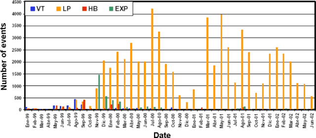 |
Figure 16. An overview of seismic events registered monthly at Tungurahua during January 1999-June 2002. After early 2000, the record was dominated by LP events. Courtesy IG. |
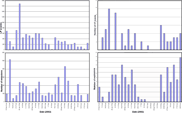 |
Figure 17. Summary of weekly seismicity at Tungurahua during January-June 2002. The number of long-period (LP) seismic events underwent a several-fold decrease later in the year. The number of emission signals was quite variable and remained abundant through the end of June 2002. Although volcano-tectonic (VT) seismic events were variable, the highest number appeared early in the reporting interval (during parts of both January and February). The number of explosion signals varied from 0-18 events/week during the reporting interval and except for a quiet period around late March to early May, continued unabated. Courtesy IG. |
Most of the LP earthquakes were shallow and associated with the exit of gases. Events during February included continuous emissions, intense fumarolic activity, tremor, and clusters of LP events (reaching more than 150 events/day, some with high amplitudes). These events were probably generated by gases associated with a small volume of new magma injected during late January, when VT earthquakes occurred several kilometers below the summit. That injection, like previous ones, accompanied the emission of steam and ash, and the possible formation of a lava lake that showed Strombolian activity. Tungurahua again responded to the injection of magma during March, when a few impressive lava flows occurred.
The Istituto Geofisico reported that shallow and deep events during May probably occurred in response to another small injection of magma beginning in mid-April, when tremor was especially high. Deformation data generally showed some deflation, and SO2 values fluctuated. The Washington VAAC frequently reported plumes and hot spots visible in satellite imagery (table 7). A more detailed description of the activity during January-June follows.
Table 7. Tungurahua plumes and hot spots visible in satellite imagery during January-June 2002. Note that the table only includes reports of plumes and hot spots visible in satellite imagery; IG reported plumes more frequently though clouds often prevented their appearance on satellite imagery. IG also made seismically based estimates of explosions. Times are listed in UTC as originally reported. Courtesy Washington VAAC.
| Date | Time (UTC) | Satellite observation (heights refer to altitude) |
| 03 Jan 2002 | 2300 | Possible small ash cloud near summit. |
| 04 Jan 2002 | 1445 | Hot spot. |
| 16 Jan 2002 | 1330 | Faint ash plume extending 34 km from the summit, estimated up to ~7.6 km. |
| 27 Jan 2002 | 0000 | Small ash cloud SW of the summit. |
| 27 Jan 2002 | 1700 | Ash plume E of the volcano, estimated up to ~9 km. |
| 03 Feb 2002 | 1930 | Faint ash plume, estimated at ~7.9 km. |
| 04 Feb 2002 | 0130 | Continuous faint ash plume extending 20 km N from the summit, estimated at ~7 km. |
| 08 Feb 2002 | 1330 | Narrow plume of ash and steam extending SE from the summit; estimated up to ~5.5 km. |
| 09 Feb 2002 | 1240 | Hot spot and faint narrow plume to the NE of the summit. |
| 09 Feb 2002 | 1600 | Narrow ash-and-steam plume moving SW at a higher level than the previous one. |
| 10 Feb 2002 | 2220 | Possible ash cloud W of the summit. |
| 11 Feb 2002 | 0030 | Eruption around 2230 resulted in a small ash cloud moving SW near ~7.6 km. |
| 13 Feb 2002 | 1815 | Thin plume of ash extended W at ~7 km. |
| 14 Feb 2002 | 1255 | Faint ash plume extending to the W, estimated at ~7 km. |
| 14 Feb 2002 | 2240 | Possible eruption around 1930 resulted in a small ash cloud towards the SE. |
| 15 Feb 2002 | 0450 | Ash no longer visible but hot-spot activity occurred during the previous 6 hours. |
| 15 Feb 2002 | 2230 | New eruption beginning around 2000, ash visible extending NW from the summit. |
| 21 Feb 2002 | 1440 | Very faint ash. |
| 26 Feb 2002 | 1245 | Narrow ash plume extending W, estimated at ~7.6 km. |
| 26 Feb 2002 | 1900 | Narrow ash plume extending W, estimated at ~7 km. |
| 27 Feb 2002 | 1300 | Possible narrow ash-and-steam plume extending to the NW of the volcano, estimated at ~6 km. |
| 10 Mar 2002 | 1645 | Small plume moving W from the volcano. |
| 15 Mar 2002 | 1415 | Ongoing ash-and-steam emission. |
| 17 Mar 2002 | 0430 | Ongoing ash emission and hot-spot activity. |
| 17 Mar 2002 | 1030 | Ongoing ash emission, new ash visible near summit, intermittent hot-spot activity. |
| 19 Mar 2002 | 0248 | Eruption began around 2130. |
| 22 Mar 2002 | 1400 | Narrow ash plume extending to the NW, estimated up to ~6.7 km. |
| 23 Mar 2002 | 2217 | Very narrow ash plume sincerely of summit. |
| 28 Mar 2002 | 0035 | Ash plume extending NW from the summit. |
| 28 Mar 2002 | 2205 | Ash plume moving W from the summit. |
| 12 Apr 2002 | 1440 | Narrow steam-and-ash plume extending to the SE of the summit. |
| 12 Apr 2002 | 2100 | Thin plume moving ESE. |
| 16 Apr 2002 | 1345 | Ash moving SW. |
| 19 Apr 2002 | 1240 | Small ash plume moving NW ~7 km from the summit. |
| 24 Apr 2002 | 1400 | Narrow ash plume extending to the SW, estimated up to ~7.6 km. |
| 28 Apr 2002 | 1430 | Thin ash cloud. |
| 13 May 2002 | 2350 | Ash cloud moving NW. |
| 14 May 2002 | 2230 | Possible ash moving NW. |
| 02 Jun 2002 | 1330 | Thin ash plume moving W. |
| 04 Jun 2002 | 2200 | Very thin line of ash extending to the W. |
| 07 Jun 2002 | 1245 | Narrow ash plume extending to the W. |
| 12 Jun 2002 | 2300 | Very narrow plume of ash extending to the W. |
| 13 Jun 2002 | 0500 | Hot spots. |
| 15 Jun 2002 | 0000 | Faint ash plume moving W from the summit. |
Activity during January-June 2002. During January 2002 steam plumes, sometimes with a little ash, were emitted almost continuously and generally reached less than 1 km high. Emissions and explosions were accompanied by moderate ash reaching 3-5 km. SO2 measurements on 13 January revealed a value of 1,030 tons/day, and a few days later had decreased to 290 tons/day. Beginning on 15 January, incandescence was observed in the crater and roaring sounds were heard from nearby villages. On 22 January, two volcano-tectonic (VT) events occurred at 0622, located at a depth of ~4 km. The VT events preceded a small cluster of long-period (LP) earthquakes and an explosion with a reduced displacement (RD) of 9.5 cm2.
On 24 January two VT events were registered at 0504 and 0605, located at depths of 5 and 4.4 km, respectively. The events preceded the occurrence of an LP cluster with dominant frequencies around 1.8, 2.4, and 3.8 Hz. Roaring sounds accompanied some of the LP earthquakes. Steam was emitted continuously and reached a height of 1 km before drifting W.
A cluster of LP events was registered on 25 January during 0700-1000 (with frequencies of 2.6-3.2 Hz); it was followed by emission signals. About 30 minutes later LP earthquakes increased and the settlements of Juive and Cusua (WNW flank) reported rockfalls. During 1000-1440 a 20-minute-long episode of harmonic tremor occurred followed by another LP cluster.
On 26 January during 1508-1629, two VT events occurred at depths of 5 and 7.5 km. One hour later, at 1739, an explosion took place with a RD of 7.2cm2. After the explosion, tremor was recorded and LP events continued for about 2 hours. For most of the activity, LP events preceded the explosions, and the seismicity was concentrated mostly at 5-7 km depth. VT events were mostly located 4-11 km beneath the summit and were aligned in a NNE direction.
LP earthquakes during late January through early February were associated with banded tremor during 24-28 January. A total of eight episodes of banded tremor were detected in one week, lasting 1-4 hours each. The LP earthquakes continued at an increased intensity at depths of 5-7 km beneath the summit. Small-to-moderate explosions also took place. On 28 January, an explosion occurred with a RD of 8.8 cm2. During these periods of increased tremor and LP events, the crater emitted gases and very little ash.
In early February a small amount of ash was deposited on the city of Ambato. Rain of moderate intensity caused mudflows to occur four times during February, with an especially large flow on 5 February.
On 4 February observations of the summit revealed new episodes of Strombolian activity, characterized by incandescence in the crater and by the ejection of large blocks to several hundred meters above the crater. During 11-18 February strong Strombolian activity was accompanied by pyroclastic flows that traveled part of the way to Juive and Cusua located on the WNW flank. Observers noted rapidly fluctuating incandescence in the crater, possibly due to disruptions in an inferred lava lake there. On 13 February a lava flow descended from the NNW part of the crater and extended 2 km below the summit. Beginning on 14 February both seismicity and incandescence decreased in intensity but ash emissions reached up to 2 km above the crater. During 18-25 February incandescence and roaring sounds decreased.
On 24 February a few large LP earthquakes occurred with 5 km focal depths and with RD values of more than 5 cm2. A tremor episode (with frequencies of 1.2-2.8 Hz) lasted ~25 minutes. During the night impressive Strombolian outbursts generated a flow of incandescent blocks. Banded tremor was associated with emissions of blocks and ash. This was followed by LP earthquakes associated with several hours of low activity. The intensity of the Strombolian activity diminished greatly with the absence of the LP earthquakes. Most of the LP events were located in a column 2-8 km beneath the summit. Some of the tremor episodes were located in the first 5 km beneath the summit. The explosions occurred at depths of 2-10 km.
During the last days of February roaring noises accompanied several cycles of Strombolian activity that were associated with lava fountains, and small ashfalls occurred on the W flank. By the end of February COSPEC measurements revealed an average value of 1,344 tons/day.
During the first weeks of March, most of the LP events were located 2-7 km beneath the summit, while the VT events were located 4-10 km beneath the summit. Some of the occasional explosions were impressive with large plumes, and some were preceded by important LP activity, suggesting the explosions were related to the ascent of gas bubbles that accumulated in the magmatic conduit. March emissions included steam, ash, and lava flows. Roaring sounds occurred almost continuously until the third week. Incandescence was observed in the crater twice during the last week of March, and a steam-and-ash plume was then visible reaching up to 2 km above the crater. Ashfall occurred in the cities of Ambato, Quero, Latacunga, Cusua, Chacauco, Penipe, Puela, Patate, Pelileo, Cotaló, and Pillate. COSPEC measurements revealed an increased average value of SO2 (>2,000 tons/day) compared to February (1,344 tons/day).
April was characterized by low seismicity, and nearly continuous tremor related to emissions of steam and ash. On 3 and 8 April two explosions occurred, with RD values of 7.3 cm2 and 4.5 cm2. Most of the LP events registered during April were small and rather sporadic. On 22 and 23 April, VT events occurred that were located at depths of 7.7 and 5.6 km, presumably related to the movement or evacuation of magmatic fluids. Following the VT events, strong steam-and-ash emissions occurred, accompanied by roaring noises and incandescence in the crater. This activity continued through the end of April and was especially strong during 24-30 April. Tremor energy decreased by the end of April. LP events were located 5-7 km beneath the summit. VT events were located at depths of 5-9 km.
During April a slight deformation was detected in the N flank. COSPEC-measured SO2 revealed low values; the mid-April average was 850 tons/day. A steam-and-ash column frequently reached up to 2 km high and drifted mainly NW. At times ash was deposited on the upper flanks. Lahars were also recorded, with the largest on 7 and 8 April. The number of LP and VT earthquakes, emissions, and tremor gradually increased during mid-May. The upper conduit filled with small volumes of magma so Strombolian activity, roaring noises, and incandescence in the crater was intense and almost continuous. During the last week of May columns of steam and ash were continuously emitted and drifted mainly W, and on 13 May, NW, depositing ash on Ambato and Baños.
During the second half of May noteworthy explosions took place on the 13th and 28th when nine and five explosions occurred, respectively, with RD values up to 7 cm2. Although similar activity continued throughout May, it was most intense during 12-13 and 28-30 May. VT events were located beneath the W-SW part of the crater at depths of 4-10 km. COSPEC-measured SO2 revealed a generally low average value of 950 tons/day during mid-May.
Strombolian activity was observed in early June along with lava fountains and incandescence. During the second week of June, the number of earthquakes and tremor episodes increased slightly and explosions occurred. The explosions were accompanied by loud noises and some by lava fountains that reached ~300 m above the summit. LP events were generally located 5-7 km beneath the summit and were thought to be related to magma injection. The VT events were located below the SW part of the crater at a depth of 4-7 km.
During the last week of June seismicity increased, followed by an important tremor episode. Powerful tremor occurred during a 3-day period (28-30 June) and was noteworthy because of the temporal variation of the frequencies from 1.5-2.7 Hz. The tremor sometimes lasted up to 1 hour with one amplitude that saturated seismograms. Many large LP events accompanied the tremor (RD over 10 cm2). Little surface activity accompanied the tremor and large LP events. The lack of an increase in the volume of ash and gas emitted seems to indicate that the gas is still trapped within the volcano and that it will eventually be released through intermittent activity or explosions. COSPEC-measured SO2 flux revealed a value of 1,800 tons/day. EDM measurements around that time indicated that the volcano inflated slightly.
Information Contacts: Patty Mothes, Geophysical Institute (Instituto Geofísico, IG), Escuela Politécnica Nacional, Apartado 17-01-2759, Quito, Ecuador, Washington Volcanic Ash Advisory Center (VAAC), Satellite Analysis Branch (SAB), NOAA/NESDIS E/SP23, NOAA Science Center Room 401, 5200 Auth Road, Camp Springs, MD 20746, USA (URL: http://www.ospo.noaa.gov/Products/atmosphere/vaac/).
Summary of 2002 activity includes several episodes of intense seismicity
This report presents a summary of activity throughout 2002. During 2002 several episodes of intense seismic activity occurred that shared certain characteristics: clusters of long-period (LP) earthquakes, tremor related to ash emissions, and an increase in VT events on some occasions. Magmatic intrusions during January-March 2002, were generally preceded by LP clusters with dominate frequencies of 3.8 Hz with some oscillating around 1.5-1.6 Hz. Following these clusters, increased tremor occurred, some related to the emission of gas and ash. Eruptive activity included explosions and Strombolian blasts.
In April, activity changed, LP clusters ceased including events with a dominant frequency of 3.8 Hz and began to contain frequencies of ~6 Hz. Since June, VT events seemed to precede LP events or tremor episodes. Precursors of magmatic activity changed slightly. In almost every case, fewer precursory events were registered. Instituto Geofisica (IG) stated that the present eruptive process could be more uncertain than before. In September, the acceleration of processes seemed to indicate variations in internal conditions, such as changes in magma within the conduit, increased temperatures, diminishing percentages of crystals, lower SiO2, and addition of new gases.
During October-November there was none of the intense tremor activity that usually accompanies new magma injections. Energy remained at very low levels. IG stated that a large number of VT events and their decreased influence on volcanic activity could indicate a low contribution of magmatic gases that could be mobilized and released outside the volcano by means of explosions, continuous ash emissions, or Strombolian activity as previously observed. Further details of 2002 activity follow.
Detailed activity. During the first 2 weeks of January 2002 a high number of low-energy LP earthquakes took place. Some of the LP's were associated with emissions of mainly steam with a moderate magmatic gas concentration. During the last 2 weeks of the month the number of LP's increased remarkably. The LP's occurred in clusters, most of which were preceded by VT events at depths of 4-11 km beneath the summit. Beginning on 15 January it was possible to see a glow coming from the crater, accompanied by the emission of gases. While the emissions diminished during the last week of January, explosions increased in number and magnitude. By the end of January sporadic episodes of tremor and light ashfall occurred in Ambato and Baños. These seismic characteristics, along with frequent roaring noises that occurred with the explosions, indicated possible degassing of a small volume of magma that entered the conduit beginning on 15 January.
During February magma injection apparently disturbed the system, and new gases ascended. Steam and ash emissions occurred, as well as the possible formation of a lava lake. Strombolian activity during 4-18 February was so strong that pyroclastic flows (PF's) descended the WNW flank along the Juive and Cusua valleys. Seismicity was characterized by LP's, tremor related to emissions, a few volcano-tectonic events (VT's), and small explosions.
During the first 3 weeks of March there was Strombolian activity with emissions of lava, gas, and ash, and almost-continuous roaring noises. During the third week of March, activity diminished in intensity until it disappeared almost completely by the last week of the month. Although incandescence was observed at night, it was not as intense as that observed in previous months. Ashfall occurred in Ambato, Quero, Latacunga, Cusua, Chacauco, Penipe, Peula, Patate, Pelileo, Cotaló, and Pillate.
Most of the LP's registered during April were small and rather sporadic, but frequency content changed on 17 April from 4-4.8 Hz to 6-8 Hz. On 22 and 23 April, VT events at 6-8 km depths were followed by strong gas-and-ash emissions. These became quite intense during 24-30 April.
Activity was quite intense during 12-13 and 28-30 May. On 13 May a total of 8 explosions took place, preceded by an increase in the number of LP events. The same day ashfall occurred in Ambato and Baños. On 24 May VT activity took place just before an increase in explosive activity. During 17-26 May explosions were preceded by VT events, and by 30 and 31 May were preceded by LP events. As of the second week of May Strombolian activity, roaring noises, and incandescence in the crater was intense and almost constant. Lava was present in the crater, accompanied by tremor and ongoing emissions. During the last week of the month a continuous gas-ash column drifted mainly W.
During the last week of June intense tremor registered. The tremor occurred for 3 days and contained dominant frequencies of 2.2-2.7 and 1.5 Hz. Tremor lasted up to an hour with an amplitude that saturated seismographs. Many LP's and explosions accompanied the tremor. During June VT events (4-7 km deep) occurred just before tremor and LP events. Several LP's and tremor episodes preceded explosive events. On average the LP's and tremor occurred 2-4 hours before an explosion.
Explosions occurred during the first week of July. During the first 2 weeks, deep VT earthquakes (5-10 km deep) occurred at a rate of ~1 per day and there was an increase in the number of LP's and hybrid earthquakes. VT and LP events preceded new cycles of explosions, not immediately as had previously been noticed, but in this case by about 15 days. After the new cycle of explosive activity began, most of the LP events had frequencies of 1.5-2.5 Hz. Some VT's preceded the LP's and had frequencies of 3.8 and 1.5 Hz. During the second week intense roars were heard, and increasing ash emissions mainly drifted W. There was strong persistent incandescence, and frequent explosions produced loud noises and ash columns 2-4 km above the crater.
During the first 2 weeks of July, several episodes of Strombolian activity were observed, along with continuous but light ash emissions that were accompanied by roaring noises. Ash was deposited in a thin N-S strip between Hualcango and San Pedro de Sabañag (S of Quero), extending toward the W and Igualata. Ash accumulated up to 2.5 mm thick in "El Mirador" at Cerro Arrayán. Activity decreased toward the end of the month, when small plumes were emitted.
During 5-13 September, 8-10 VT earthquakes registered. These preceded the harmonic tremor seen during 13-21 September. Strong explosions and ash emissions also occurred. Ashfalls were noted in distant cities such as Píllaro and Riobamba, located ~30 km NW and SW, respectively.
During the first week of October explosions with reduced displacements greater than 10 cm2 took place and ashfall occurred in Pillate, Ambato, Cusua, Penipe, Altar, Bayusig, Matus Alto, and Matus Bajo. During the second and last week of the month VT events preceded explosions. During the last week of the month incandescence and roaring noises were heard. Three ashfalls were noted, two in Guadalupe and one (on 29 October) in Baños (up to 1 mm), Runtún, Pondoa, and Pintitin.
On 10 and 26 November, two peaks of LP activity occurred that were very close to the peaks of VT activity. The first LP peak preceded the first VT peak by two days. This was unusual because the VT peak normally preceded the LP peak. The second LP peak took place around the same time as the VT peak, indicating that the circulation of fluids was almost simultaneous. Incandescence was observed before the VT activity on 26 November. An increase of LP activity seemed to be correlated with the increase of sounds emitted by the volcano. Frequent incandescence in the crater preceded a VT peak.
Magmatic intrusions during 2002. Five magmatic intrusions (figure 18) apparently occurred during (1) 15-29 January, (2) 15-30 April, 12-13, 24-30 May, (3) 28-30 June, (4) 3-13 July, and (5) 5-13 September. Two periods of intense activity also occurred during 8-13 and 21-27 October, and on 10 and 26 November. During April-June magmatic intrusions did not occur along with a peak of seismic activity, but VT's, hybrids, and emissions all occurred, though in smaller numbers than registered in previous years.
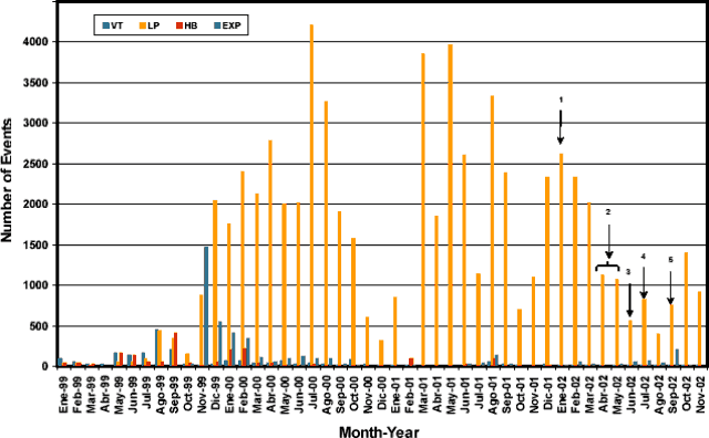 |
Figure 18. Monthly earthquakes at Tungurahua during January 1999-November 2002. Peaks indicated with arrows correspond to periods of inferred magmatic intrusion. Courtesy IG. |
Tremor activity was an essential indicator of these magmatic intrusions (figure 19). Later peaks of tremor activity were always during periods of seismicity related to magmatic intrusions, although it was not clear whether the June peak was related to a possible intrusion. Tremor energy was quite variable.
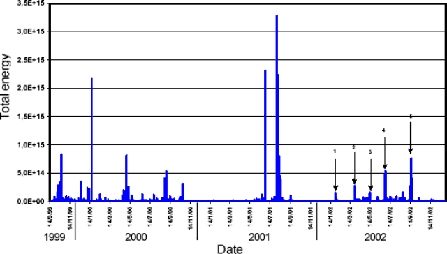 |
Figure 19. Tremor energy at Tungurahua, 14 September 1999 through 14 November 2002. Many of these tremor episodes were related to small emissions of gas or ash. Arrows indicate 2002 peaks. Courtesy IG. |
Deformation measurements. During 2002 EDM measurements on the N flank showed a slight tendency of inflation. This inflation was first noticed during the first half of 2000. During 2002 a shortening of the distance occurred between prisms and reference bases, between -2 and -6 cm with respect to values observed before the reactivation of the volcano. Although there were variations in measurements taken during the year, the overall tendency has been inflation of 4 to 6 cm with respect to that during 1998-2000.
Data from inclinometers RETU and JUIV show a positive drift of the radial axis of station RETU (elevation 4,000 m). The drift would mean a deflation in the NW sector. During September 2002, when numerous explosions occurred, inclinometer movements changed.
During 2002 measurements of the inclinometer at station JUIV5 were stable until October 2002, when there were disturbances in the radial axis and to a greater degree in the tangential axis. Since 10 November both axes showed significant changes of up to 200 µrad. The negative tendency indicated a progressive inflation. This change agreed exactly with the first LP peak on 10 November. The change lasted until 20 November and included the greater peak of VT activity during 2002. After 20 November, both axes became stabilized. The oscillations seen in this slope between September and October occurred simultaneously with other activity, possibly representing slow but continuous magma movement in the lower parts of the volcano.
Geochemistry. SO2 flux measurements determined by COSPEC during 1999-2002 were generally less than 2,000 tons/day (figure 20). The peaks took place during March and October, with values reaching 3,000-5,000 tons/day. These high values seemed to correspond with the magma injections of December 2001and January and September 2002. Other episodes of seismic activity related to magmatic injection seemed to precede the peaks in SO2 emission. The high point in August ("3 y 4" on figure 14), followed increased seismicity during June and July.
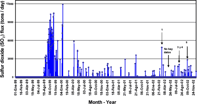 |
Figure 20. COSPEC-measured SO2 emissions at Tungurahua during 1999-2002. The arrows indicate the peaks of SO2 that occurred during May and August 2002. |
Thermal waters generally increased in temperature ~0.5°C. A small reduction in pH occurred, with a tendency toward alkaline values. During 1998-99, when the seismicity increased, pH also increased, probably because of the magmatic unrest at the time. Conductivity did not change, and neither did geochemical characteristics such as abundances of sulfates, chlorides, and bicarbonates. IG stated that it could not yet be explained how an increase in seismicity seemed to shift the pH of thermal waters (figure 21).
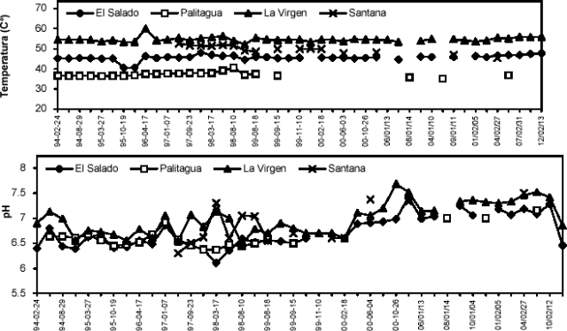 |
Figure 21. Temperature and pH of thermal waters at Tungurahua during 1994-2002. Courtesy IG. |
Future scenarios. Since 1999 Tungurahua has shown frequent, moderate volcanism with occasional lava emissions. This period can be divided into 13 magmatic intrusions of similar characteristics, although the last three injections displayed slight differences. Starting in 1916 Tungurahua displayed intermittent activity until 1918, with periods of tranquility and greater activity than at present.
The present process has been characterized by LP clusters just before and during eruptions. During October and November 2002, VT events usually preceded cycles of increased activity. Strong incandescence on 2 December was not accompanied by strong explosions, Strombolian activity, or lava emissions.
Information Contacts: Patty Mothes and Indira Molina, Geophysical Institute (Instituto Geofísico, IG), Escuela Politécnica Nacional, Apartado 17-01-2759, Quito, Ecuador.
Ash eruptions and other activity throughout 2003, but elevated after August
The Instituto Geofísico (IG) provided Tungurahua reports discussing the year 2003. Ash-bearing eruptions sent plumes as high as 9.4 km altitude, with resulting noticeable ashfall 40 km distant. Lahars were common and occasionally incandescent material descended the upper flanks. Activity was low during January and February, and increased slightly in March and again in June. In August activity increased again, and for the rest of the year it generally remained elevated. IG recognized a new phase of eruptive activity beginning 20 August. That phase consisted of long-period earthquakes followed by emissions reaching up to 3 km above the volcano (~8 km altitude).
Activity during January-February 2003. During these months volcanism generally remained low, with occasional emissions of gas and ash that produced low-level plumes. Incandescence was sometimes visible in the crater at night. Seismicity was low and was characterized by sporadic long-period earthquakes and low intensity emissions. Activity increased slightly beginning 12 February with an emission that rose to low levels and drifted W. A moderate explosion on 19 February deposited a small amount of ash on the ENE flanks (Cerro de Ulba and the Ulba valley). Seismicity increased slightly during the eruption, but returned to low levels afterwards. Volcanic and seismic activity remained low through early March with continuing gas and ash emissions.
Activity during March 2003. Activity began to intensify on 5 March when lahars descended the gorges on Tungurahua's NW flank, obstructing the road between the towns of Baños (~8 km N of the summit) and Pelileo (~13 km NNW of the summit). Around 7 March ash rose to ~7 km altitude and drifted SW. No ash was visible on satellite imagery. By 9 March several low-to-moderate explosions had occurred and this activity continued. On 11 March three small-to-moderate explosions deposited ash in the W-flank village of Pillate (8 km from the summit). That day a pilot reported ash to ~8.2 km altitude.
On 16 March a fine layer of ash accumulated in Baños. Sporadic explosions continued for the rest of the month, with one on 19 March that sent incandescent material ~1 km down the flanks. Explosions during this period were accompanied by Strombolian activity, gas-and-ash emissions, and loud roaring. Seismicity was dominated by tremor and long-period earthquakes, with tremor starting to decrease after 13 March.
Activity during April-May 2003. During early April, explosions occasionally occurred at the volcano. A pilot reported seeing ash at a height of around 2.3 km over Tungurahua on 6 April. No ash was detected on satellite imagery, however. Three explosions occurred on 7 April, with the largest plume rising to ~3 km above the volcano. Very little ash was visible in the plume. Activity dropped slightly for a few days, with sporadic explosions, until a large explosion occurred on 10 April, producing a plume with low ash content to ~2 km above the volcano. Volcanic explosions, generally small, continued the following week; minor vapor columns were also noted. Cloud cover obscured the volcano on some days, but an aviation report on 16 April mentioned that IG staff reported an ash cloud rising up to ~7 km altitude (~2 km above the summit). On 17 April two ash columns rose 1.5 and 2 km above the summit and blew SW and W, respectively. The volcano generally appeared relatively placid, but concern about mudflows and sudden increases in eruptive output remained. Limited visibility often prevailed, but it was noted that Tungurahua's behavior alternated between days of tranquility and those with small to moderate explosions. Few earthquakes occurred.
On 1 May an explosion sent ash to 2 km above the summit; incandescent material fell onto the flanks up to 0.8 km from the crater. Based on information from IG, the Washington VAAC reported that a small 6 May explosion yielded a cloud composed mainly of gas, with some ash. The cloud drifted W and seismic activity decreased after the explosion.
Activity during June-July 2003. Volcanic activity increased in early June. On 6 June, strong Strombolian activity hurled incandescent volcanic blocks ~500 m from the summit; plumes of mainly steam rose to around 2 km above the volcano and drifted W. Ash fell in the settlements of Pillate (8 km W of the summit), San Juan (~40 km WSW of the summit), and Riobamba (32 km SW of the summit), with accumulations of less than 1 mm. There were reports of airborne ash interfering with main flight routes across Ecuador. Emissions on 9 June reached 3-6 km above the volcano. On 10 June vibrations from an explosion were felt in Baños, explosions could be heard in towns near the volcano, and ash fell in several villages.
On 15 June incandescent blocks were hurled to ~150 m above the crater and rolled ~1 km down the N flank. During the evening of 17 June, Strombolian activity was visible at the summit, and an explosion on 18 June deposited ash on the settlements of Cusúa (~8 km NW of the summit), Juive (7 km NNW), and Pillate. Gas emissions with small amounts of ash occurred regularly, and on 19 June observers saw ash rise to 3 km above the summit.
During the last week of June, several explosions produced ash clouds; on 25 June ash fell in Pillate and in the town of Mocha (25 km W). Ash was visible on satellite imagery, with the highest-rising ash cloud reaching ~9.4 km altitude on 27 June. Emissions on 29 June deposited ash in Pillate, and in the towns of Cotaló (8 km NW of summit) and Cevallos.
On 1 and 2 July ash plumes rose to ~2 km above the volcano and ash fell in several towns near the volcano. Strombolian activity also occurred, and ash from the eruptions damaged crops and livestock near the volcano. A state of emergency was declared on 3 July, and food rations were distributed to residents of the town of Chimborazo. After 2 July, eruptive vigor remained relatively low through the rest of the month and into August. Reports noted mainly steam and gas emissions and low plumes.
Activity during August 2003. Tungurahua entered a new phase of activity on 20 August. The new phase was characterized by a short sequence of long-period earthquakes followed by gas-and-ash emissions that reached a maximum height of 3 km above the volcano.
A small amount of ash fell in Cusúa on 20 August. During the evening the volcano hurled incandescent blocks ~300 m above the summit and some traveled ~1 km downslope. On 21 August emissions of mostly steam and small amounts of ash rose ~1 km above the volcano and drifted W; ash fell in the Riobamba, Ambato (~33 km NW), and Santa Fé de Galán areas. On 23 August plumes rose to 0.5-2.5 km above the volcano, and ash fell in the town of Guaranda. On 24 August an explosion, heard in the town of Baños, ejected blocks that traveled ~1 km down the volcano's flanks. An emission on 27 August deposited ash in Ambato and caused flight restrictions to and from the airport there. During this week, volcanic block-and-ash emissions continued, with ash plumes rising to heights of ~4 km above the volcano. These drifted primarily W and SW and deposited ash in several towns.
Activity during September-October 2003. Moderate ash emissions and ashfall continued during September and October, accompanied in mid-September by tremor related to gas discharge. Seismicity ranged from moderate levels in September to a series of long-period earthquakes and explosions in early October.
Incandescence was observed in the crater on the evening of 7 September. On 15 September two emissions produced gas-and-ash plumes that reached a maximum height of 2 km above the volcano; ash fell predominately W of the volcano. On 22 September ash clouds reached a height of 3 km above the volcano and drifted W. On 24 September ash emissions produced plumes that drifted NW, depositing small amounts of ash in the towns of Quero (~20 km WNW of the summit), Puela (~8 km SW), Juive, and Cusúa. Volcanic blocks emitted during the eruption rolled ~1 km down the NW flank.
On 1 October gas-and-ash emissions reached a height of ~4 km and drifted NE and NW, depositing ash in San Juan (~40 km WSW), Pillate, and Valle del Patate. On 9 October ash fell on northerly sectors near the volcano, including Runtún (~6 km NNE of the summit), Juive, and Baños. Strombolian activity was seen during the evening of 12 October. Associated gas-and-ash plumes up to 2 km high drifted NNE and ash fell in Ambato. On the night of 18 October incandescent blocks rolled down the crater's W side. Incandescence and Strombolian activity were observed the following night. Activity decreased slightly on 20 October with fewer explosions and no major gas-and-ash eruptions recorded. Ash plumes were frequently visible on satellite imagery during 15-20 October.
Activity during November-December 2003. Tungurahua maintained generally low activity in early November, increasing towards month's end. Following a week of small-to-moderate eruptions of gas and ash, an eruption on 2 November produced a plume that rose to ~3 km above the volcano and drifted W. Over the next few days, occasional ash-poor plumes rose to less than 1 km above the summit; a few ash-bearing emissions did occur, including ashfalls of low intensity on 5, 6, and 7 November to the E. Also on 6 November seismic stations recorded two larger-than-average explosions, one associated with an ash column rising to 2 km. Seismicity returned to low levels, with relatively few earthquakes, but tremor continued.
During 12-18 November, small-to-moderate eruptions of steam, gas, and some ash continued; plumes rose to ~2.5 km above the volcano, but there were no reports of ashfall in nearby towns. Strombolian activity was visible at the crater and avalanches of incandescent volcanic material rolled ~1 km down the volcano's flanks. Activity increased to high levels beginning 19 November; numerous moderate explosions produced plumes that were frequently visible on satellite imagery and rose up to 2 km above the crater. Ash was dispersed SSW and SW on 19 and 20 November and WNW and NW on 23 and 24 November, respectively. Throughout the week Strombolian activity was visible at night.
During 22 November to 1 December, a large number of emissions of gas, steam, and ash occurred, depositing ash to the SW, W, and NW. Plumes were visible on satellite imagery at a maximum of ~7 km altitude.
During 11-16 December, volcanic activity remained relatively high with several explosions producing ash-and-gas plumes to a maximum of 9 km altitude. There were also many long-period earthquakes, occurring with nearly constant gas-and-ash emissions. Explosions on 11 December deposited ash in the towns of Quero, Santa Fe de Galán, and lesser amounts in Bilbao. Ash-and-gas plumes were visible on satellite imagery several times during the week.
Information Contacts: Geophysical Institute (IG), Escuela Politécnica Nacional, Apartado 17-01-2759, Quito, Ecuador (URL: http://www.igepn.edu.ec/); Washington Volcanic Ash Advisory Center (VAAC), Satellite Analysis Branch (SAB), NOAA/NESDIS E/SP23, NOAA Science Center Room 401, 5200 Auth Road, Camp Springs, MD 20746, USA (URL: http://www.ospo.noaa.gov/Products/atmosphere/vaac/); El Comercio, Quito, Ecuador (URL: http://www.elcomercio. com/); Agence France-Presse.
Frequent ash plumes, prompting occasional ash falls through January 2004
A comprehensive summary of activity at Tungurahua (figure 22) over the period January-16 December 2003 was reported in BGVN 28:11. During 17-23 December, volcanic activity continued at relatively high levels, with 5-19 moderate explosions and 62-83 long-period earthquakes each day. A signal from a lahar was recorded in the Cusúa sector NW of the volcano during the afternoon of 18 December. According to the Washington VAAC, during late 2003-early 2004, plumes from Tungurahua were visible on satellite imagery to a maximum altitude of ~ 7.5 km.
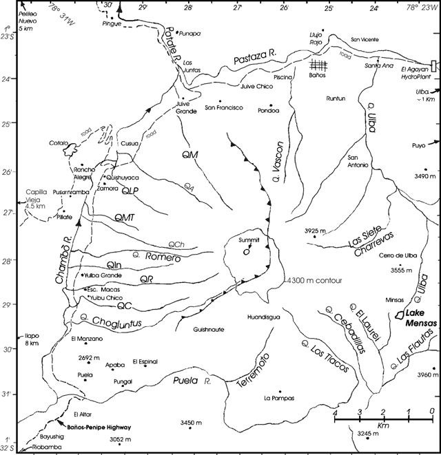 |
Figure 22. A map of Tungurahua emphasizing local roads, settlements, and drainages (quebradas in Spanish). Some of the latter are abbreviated as follows (counterclockwise from N): QA = Quebrada Achupashal, QC = Quebrada Confesionario, QM = Quebrada Mandur, QMT = Quebrada Motilones, QLP = Quebrada La Piramide, QPU = Quebrada Palma Urcu, QR = Quebrada Rea. The map is a composite of various published maps, particularly those by Hall and others in a previously referenced publication. The one contour shown, at 4,300 m elevation on the upper flanks, was the approximate limit of glacial ice when the 1:25,000 Tungurahua topographic map sheet was made for the Instituto Geográfico Militar in 1984. At the time of this report Pete Hall noted that remaining glacial ice was only apparent in restricted regions near the summit crater. |
During 24-30 December the volcano emitted gas, and ash accompanied by low seismicity. On 28 December an emission sent a plume to 1.5 km above the summit, drifting E and NE. Ash fell in the Runtún sector E of the volcano. Emissions on 28 December deposited ash in Runtún and the city of Baños. On 30 December aircraft personnel reported seeing an ash cloud ~ 800 m above the volcano. According to the Washington VAAC, ash was visible on satellite imagery to a maximum altitude of ~ 8 km.
Emissions of gas, and ash, with low-level seismicity (12-14 long-period earthquakes per day), continued over the period 31 December to 5 January. Plumes rose to a maximum height of 3 km above the crater on 31 December and an emission on 4 January caused minor ash fall in the Puela sector (SW). Similar conditions applied in the week 7-13 January. On 8 January, emissions reached ~ 1 km above the volcano, traveling W and SW, and emissions on 12 January deposited ash in the Bilbao, Cusúa, Pillate, Ulba, Pondoa, Baños, Juive, Ambato, and Patate sectors (figure 3 and table 8). Gas, and ash emissions continued over 14-19 January, with emissions to ~ 1 km above the crater containing variable amounts of ash drifting to the N and NE, accompanied by low seismicity. Similar conditions applied over the week 21-26 January. On 22 January at 0626 an explosion sent a plume to ~ 2 km above Tungurahua. On the evening of 24 January ash fell in the areas of Puela and Penipe (~ 8 km SW); and during 24-25 January ash fell in Riobamba (~ 30 km SW). Patricia Mothes of Ecuador's Geophysical Institute reported on 30 January that the volcano was very quiet with no explosions since the previous Saturday, and that a country-wide drought caused extensive fires.
Table 8. A list showing settlements and their approximate distances and bearing from Tungurahua's summit. Many of these have been referred to in previous Bulletin reports with their locations undisclosed. Information sources included various maps, previously cited references, and Patricia Mothes of the Geophysical Institute.
| Town or Location | Distance and Direction |
| Ambato | 31 km NW |
| Banos | 8 km N |
| Bilbao | 8 km W |
| Cevallos | 23 km NW |
| Cotalo | 8 km NW |
| Cusua | 8 km NW |
| Guaranda | 64 km SW |
| Juive | 7 km NNW |
| Latacungo | 63 km NNW |
| Matus | 11 km SSW |
| Macas | 100 km SSE |
| Mocha/Yanayacu | 25 km W |
| Overo | 20 km WNW |
| Pelileo | 8 km N |
| Penipe | ~15 km SW |
| Pillate | 8 km W |
| Puela | 8 km SW |
| Puyo | 50 km E |
| Quero | 22 km NW |
| Riobamba | 30 km S |
| Rio Negro | 26 km ENE |
| Runtun | 6 km NNE |
| San Juan | 40 km WSW |
| San Juan de Pillate | 9 km W |
| Santa Fe de Galan | 15 km WSW |
| Valle del Patate | 15 km NW |
Bulletin editors have compiled a sketch map focused on Tungurahua's geography and a table showing other commonly used place names mentioned in this and previous reports (figure 22 and table 1). Tungurahua, and adjacent Holocene volcanoes El Alfair and Sangay, all lie to the S within Sangay National Park. On maps, roads are absent from Tungurahua's S and E flanks but pass around the W and N flanks. With regard to glacial ice, figure 3 shows the extent of ice depicted in 1984. Regarding the extent of glacial ice at the present time, Pete Hall noted that ice had been retreating from all summits in Ecuador (as in many other places, presumably due to global warming of the atmosphere). In discussing Tungurahua's alpine glacier, Hall made this comment: "The ice cap that was only on the tip top summit of the cone prior to [Tungurahua] entering into activity is still there, but buried under meters of black ash. We can still spot it when explosions in the crater eat away at it from the crater side. Occasionally we see ice on the outer flank, but only at the summit. Thus the ice cap is exceedingly small... ~300 m in diameter...."
Figure 23 shows the vulnerable N-flank town of Baños. It is the largest settlement in close proximity to Tungurahua. A host of gravity-driven processes could bury portions of the town in minutes. Figure 24 shows a satellite image of the E-drifting plume from Tungurahua on 14 January 2004.
 |
Figure 23. Oblique view looking at the town of Baños, 8 km N of Tungurahua's summit on the Pastaza River, June 2003. Copyrighted photo used with permission of Tim Travis. |
 |
Figure 24. Satellite image showing ash plume from Tungurahua on 14 January 2004 (at 1530 UTC). The image came from the Moderate Resolution Imaging Spectroradiometer (MODIS), an instrument aboard the Terra satellite. Photo courtesy NOAA/NASA. |
Information Contacts: Geophysical Institute (IG), Escuela Politécnica Nacional, Apartado 17-01-2759, Quito, Ecuador (URL: http://www.igepn.edu.ec/); Washington Volcanic Ash Advisory Center (VAAC), Satellite Analysis Branch (SAB), NOAA/NESDIS E/SP23, NOAA Science Center Room 401, 5200 Auth Road, Camp Springs, MD 20746, USA (URL: http://www.ospo.noaa.gov/Products/atmosphere/vaac/); Tim Travis [contact information removed by request] (URL: http://www.DownTheRoad.org/).
Ash plumes and LP earthquakes still common in 2004-2005
The eruption of Tungurahua that began at the end of December 2003 (BGVN 28:11) continued through January 2004 (BGVN 29:01). Figure 25 shows an ash plume emitted on January 2004 in a Moderate Resolution Imaging Spectroradiometer (MODIS) image.
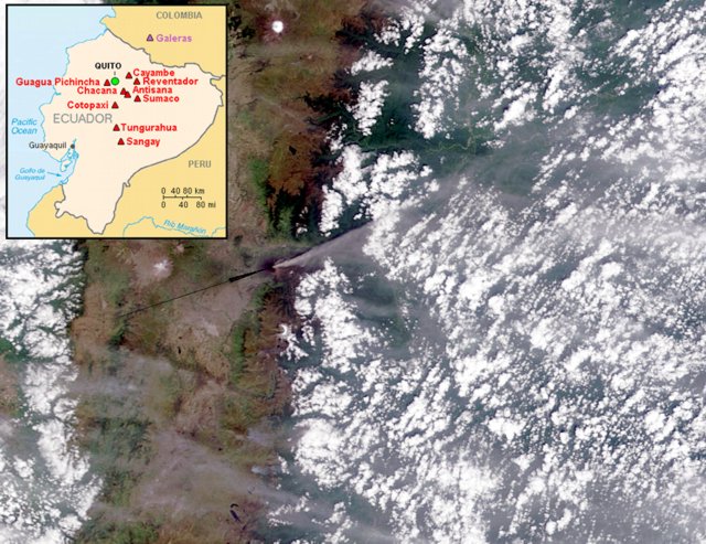 |
Figure 25. A NASA MODIS image showing an ash plume from Tungurahua acquired 14 January 2004. N is up; the plume's height and length were undisclosed. Arrow points to Tungurahua and is along the approximate trend of the densest portion of the plume. The plume blew NE across the Andes and remained visible well over the thickly vegetated lowlands farther E. (Visible Earth v1 ID 26233.) Courtesy of NASA. Inset map showing major active Ecuadorian volcanoes courtesy of the USGS. |
On 5 February 2004 there was a slight increase in seismic activity at Tungurahua; steam emissions rose to low levels, and small lahars traveled down the volcano's W flank via the Achupashal and Chontapamba gorges. On 9 February emissions of steam, gas, and moderate amounts of ash occurred, deposited to the W in the sectors of Pillate and San Juan. During mid February, several avalanches of incandescent volcanic blocks traveled ~ 1 km down the volcano's flank. During late February through mid April 2004, degassing continued at Tungurahua with occasional explosions of steam, gas, and ash, producing plumes to ~ 500 m above the volcano.
On 2, 11, and 15 March lahars traveled through the Pampas sector. During the night of 28-29 March incandescent material was observed avalanching on the upper slopes. From 30 March to 3 April, volcanic activity was at relatively low levels, but emissions of steam and ash occurred, and incandescence was visible in the crater. On 4 April at 1902 an explosion produced a plume containing a moderate amount of ash that rose to 800 m above the crater, and on the evenings of 10 and 11 April, incandescence was visible in the crater.
Sulfur-dioxide flux measurements taken on 11 April were the highest measured for several weeks; 1,600-1,700 metric tons per day. Heavy rain during the afternoon and night of 13 April triggered a lahar that cut the La Pampa section of the Baños-Pelileo road.
Volcanic activity at Tungurahua at the end of April 2004 was at moderate levels. On 21 April, a column of steam, gas, and ash rose to a height of ~ 1 km above the volcano and drifted NW. Ash fell in Bilbao, Cusúa, San Juan, Cotaló, Pillate, and Juive sectors. A plume reached ~ 0.5 km on 22 April and deposited ash in the towns of Ambato (to the NW) and Baños (to the N). During the evening of 24 April, incandescence was visible in the crater, and incandescent blocks rolled a few meters down the volcano's NW flank.
Volcano-tectonic earthquakes on 27 and 28 April preceded a slight increase in the number of sudden explosions at Tungurahua on 30 April. According to news reports, ash fell in the towns of Cotaló, and San Juan (W of the volcano) on 1 and 2 May. The level of seismicity at Tungurahua decreased on 4 May. On 12 May, an explosion produced an ash cloud to ~ 3 km above the volcano that drifted SW, and on 13 May seismicity increased moderately, related to the increased numbers of emissions. Incandescence was visible at the lava dome during some nights.
From mid May through June, small-to-moderate emissions of gas, steam, and ash continued at Tungurahua. The highest rising plume reached ~ 2.5 km above the volcano on 23 May. On the morning of 19 May a mudflow occurred in the Pampas sector, but it did not affect the highway. Strombolian activity was visible in the crater on the evening of 23 May. During 2-8 June, activity remained moderate with several weak to moderate explosions recorded per day. Sporadically observed gas-and-ash and gas-and-steam plumes rose up to 1 km above the summit. A strong explosion on 5 June produced a gas-and-ash plume that rose 2 km above the summit. All plumes drifted W. Seismicity remained at moderate levels. On 3 June, possible lahars were noted on the N and NW flanks.
Several explosions occurred on 10 June, with the largest rising ~ 3 km above Tungurahua's summit and drifting W. A small amount of ash fell in the Pillate area, and a lahar destroyed a bridge in the Bibao zone. During mid to late June, there was a slight increase in volcanic activity at Tungurahua in comparison to the previous weeks. There were several emissions of steam, gas, and moderate amounts of ash, and 5-10 explosions occurred daily. Seismicity was characterized by long-period earthquakes.
From July through December 2004 the level of volcanic and seismic activity diminished at Tungurahua, with sporadic moderate explosions of ash and gas. The highest rising plume reached ~ 1.5 km above the volcano. Seismicity was at relatively low levels. Incandescence in the crater was observed at night on several occasions. Some explosions on 20 September generated plumes with ash, causing ashfall in Bilbao and Pondoa, and on the evening of 21 September, Strombolian activity was seen, with volcanic blocks thrown as high as 200 m above the volcano. On 27 October an explosion produced an ash column to a height of ~ 3.5 km above the volcano. During the evening, ash fell in the towns of Baños, Runtón, and El Salado. Explosions on 31 October also deposited small amounts of ash in Bilbao and Motilone, and on 15 November, incandescence was observed in the crater of the volcano and explosions generated steam columns with moderate ash content that rose ~ 2 km above the crater and drifted S. During 22-27 December, activity at Tungurahua consisted of small-to-moderate explosions, several long- period earthquakes, and episodes of tremor. Emissions of steam, gas, and small amounts of ash rose a maximum of 1.5 km on 22 December.
Increased seismicity and volcanic tremor registered at Tungurahua during early January 2005. There were eleven signals suggesting volcanic emissions and one small explosion. Seismicity then returned to a low level. On 11 January, steam plumes rose ~ 300 m above the volcano and extended WNW, and incandescence was observed emanating from the crater during 12-13 January. On 14 January, a white column of steam-and-gas was observed that reached a height of 500 m above the crater and extended to the NW. A steam- and-gas plume reached a height of 200-300 m above the crater on 16 January, and extended SE.
The Washington Volcanic Ash Advisory Center (VAAC) reported 18 January that an ash plume reached ~ 5.5 km altitude and extended to the E of Tungurahua's summit for ~ 15 km. During 19-24 January 2005, there were several emissions from Tungurahua of steam, gas, and ash. The plumes that were produced rose to a maximum height of ~ 1 km above the volcano and drifted in multiple directions, small amounts of ash falling in the sectors of Agoyán, San Francisco, Runtón, Pondoa, and Baños. Seismicity was at relatively low levels. Ash emission from Tungurahua on the evening of 25 January 2005 deposited a small amount of ash in the sector of Puela; ash was deposited on the volcano's N and W flanks on 26 January. The character of the eruption changed on 30 January to low-energy emissions of predominately steam. This type of activity continued through 31 January.
Volcanic and seismic activity was at low levels at Tungurahua during the period of February-mid July 2005. Low- energy plumes were emitted, and long-period earthquakes were recorded. Ashfall was reported in towns near the volcano, including Puela (SW of the volcano), San Juan de Pillate, Cusúaua, and Quern. On 23 February the daily sulfur-dioxide flux was 1,200 tons/day. On 27 and 28 February, rains generated lahars in the W zone of the volcano into the gorges of Cusúa and Bilbao. A moderate explosion occurred 18 April at 2057 that sent incandescent volcanic blocks rolling down the volcano's flanks. Ash fell S of the city of Ambato. On 20 and 21 April rain generated lahars that traveled down the volcano's W flank near the settlement of Bilbao (8 km W). An emission on 19 May around 1200 produced an ash-and- steam plume to ~ 500 m altitude that drifted N. On 7 June fine ash fell in the Puela sector, ~ 8 km SW of the volcano. On 24 June a narrow plume was identified in multispectal satellite imagery about an hour after an ash eruption was observed by the Instituto Geofisica. The ash plume was at an altitude of ~ 5.5 km and extended 35-45 km W from the summit. On 4 July 2005, low-energy plumes were emitted that rose to a maximum of ~ 5.8 km altitude.
Table 9 gives examples of some seismic statistics for several months during the reporting period from the Instituto Geofísico-Escuela Politécnica Nacional (IG).
Table 9. Summary of available seismicity (number of events) at Tungurahua during January 2004-March 2005 as published in IG monthly reports of March 2004, October 2004, and April 2005. Courtesy of the Instituto Geofísico-Escuela Politécnica Nacional (IG).
| Month/Year | Long-period | Volcano-tectonic | Emission | Explosions | Hybrid |
| Jan 2004 | 365 | 6 | 217 | 28 | 0 |
| Feb 2004 | 255 | 8 | 147 | 16 | 0 |
| Mar 2004 | 123 | 7 | 123 | 2 | 0 |
| Aug 2004 | 620 | 5 | 142 | 22 | 0 |
| Sep 2004 | 674 | 9 | 119 | 43 | 0 |
| Oct 2004 | 390 | 14 | 168 | 53 | 0 |
| Jan 2005 | 138 | 8 | 92 | 6 | 0 |
| Feb 2005 | 113 | 20 | 29 | 0 | 0 |
| Mar 2005 | 54 | 20 | 1 | 0 | 0 |
Information Contacts: Geophysical Institute (IG), Escuela Politécnica Nacional, Apartado 17-01-2759, Quito, Ecuador (URL: http://www.igepn.edu.ec/); Washington Volcanic Ash Advisory Center (VAAC), Satellite Analysis Branch (SAB), NOAA/NESDIS E/SP23, NOAA Science Center Room 401, 5200 Auth Road, Camp Springs, MD 20746, USA (URL: http://www.ospo.noaa.gov/Products/atmosphere/vaac/); Jacques Descloitres, MODIS Rapid Response Team, NASA/GSFC, 8800 Greenbelt Road, Greenbelt, MD 20771, USA (URL: http://earthobservatory.nasa.gov/).
14-15 July 2006 eruption, the strongest since onset of eruption in 1999
This report discusses Tungurahua's behavior during August 2005 through the end of July 2006. Material presented here was chiefly gleaned from a series of special reports issued in Spanish by the Instituto Geofísico of the Escuela Politécnica Nacional (IGEPN, hereafter IG). Daily reports for mid-2005 through early 2006 were dominated by descriptions of small plumes and minor ashfall; the reports also noted occasional small rain-generated lahars. For the most part 2005 was the quietest year since eruptions began in 1999, leading residents and volcanologists to ponder if emissions were terminating. This report omits much discussion of evacuations and hazard-status postings. Large eruptions with a Volcanic Explosivity Index (VEI) of 3 that continued into at least late August 2006 will be the subject of the next Bulletin report.
During late December 2005 seismometers detected sudden clusters of tremor and earthquakes. Intervals of quiet were broken by the arrival of signals with energy over a broad frequency range (figures 26 and 27). These signals and later manifestations at the surface in late March-early April were thought to be related to a new injection of magma. As a consequence, IG began to produce a series of special reports (table 10). Beginning in February 2006 and particularly during May-June 2006, the volcano was the scene of particularly significant events, including the largest detonations heard and seen since eruptions renewed in 1999. Other observations included a shift in eruptive style, and generation of some pyroclastic flows during the 14 July (VEI 2) eruption. Notable also were constant "roars" and vibrations of such strength and duration that they keep residents awake at night and caused some to voluntarily evacuate.
 |
Figure 26. Plots showing daily tallies of Tungurahua's seismicity-volcano-tectonic, long-period, emission, explosion, total number of earthquakes, and total energy release-from 1 January 2003 to end of July 2006. Courtesy of IG. |
 |
Figure 27. (Top) Summary of seismicity recorded at Tungurahua's station RETU during 1 January and into August 2006 (slightly different end points for two plots). Numbers of events appears on left-hand scale; RSAM (line), in appropriate units, on right-hand scale (peak value is ~ 9 x 10¹⁹). (Bottom) Total energy liberated from volcanic tremor and explosions during January 2003 to 1 August 2006. The left-hand scale applies to tremor; the right-hand scale, explosions (reduced displacement). The sharp ascents formed by the "failed eruption" in mid May and the 14 July event are the largest increases since the activity's onset in 1999. Note the pronounced rise in reduced displacement from explosions in months 5-8 (May to August) 2006. Courtesy of IG. |
Table 10. A summary of special reports on Tungurahua issued by the IG during 2006 (reports numbered 1-8; See IG web page-Informes Especiales-Volcanicos).
| Date | Special Report | Key observation(s) |
| 18 Feb 2006 | 1 | Moderate explosions and tephra falls in Puela (SW), Paillate (W), Ambato (NW) and Banos (N). |
| 07 Apr 2006 | 2 | Episodes of strong volcanic tremor and increase in number of long-period seismic events, indicating new magma injection. |
| 25 Apr 2006 | 3 | Notable banded tremor, the inferred product of new injected magma interacting with the hydrothermal system. |
| 12 May 2006 | 4 | 10 May-start of major increase in number of explosions, long-period seismic events and tremor episodes. Very strong detonations (12 per hour). Peak of energy release on 14 May, then decline. Aborted eruption. |
| 30 May 2006 | 5 | Starting 16 May, significant decrease in activity and superficial manifestations. Explosions occur 2-3 times per day; columns of gases (water vapor mainly) with light ash content predominate. |
| 14 Jul 2006 | 6 | Advisory of intensified eruptive activity; notable increase in emissions and strong detonations (at 2210 & 2250 UTC). Incandescent lava flung from crater. Strong ground movements reported on W flank. |
| 14 Jul 2006 | 8 | Very strong detonations, period of calm, then ascent of 15-km-high, dark, ash-laden column. First pyroclastic flow (at 2250 UTC) and others to descend six valleys (quebradas) on the W-NW-N flanks. Intense lava fountaining; moderate ash and scoria fall to the W. |
| 15 Jul 2006 | 8 | Unusually large discharges with a detonation (at 0559 UTC), leading to the largest registered since 1999. Plume rose to ~15 km altitude. The eruptive style later shifted to periodic detonations with intervals of calm. |
A map and table of commonly referred-to locations appeared in a previous issue (BGVN 29:01). Our last report on Tungurahua covered February 2004 to July 2005 (BGVN 30:06), during which time volcanic and seismic activity varied, but included some intervals with comparatively low activity and seismicity such as February to mid-July 2005.
Activity during June to mid-December 2005. From June 2005 through mid-December 2005, volcanic and seismic activity at Tungurahua was at relatively low levels. Low-energy plumes composed of gas, steam, and occasionally small amounts of ash were emitted frequently. Some noteworthy events during this interval follow.
On 7 June 2005, fine ash fell in the Puela sector, ~ 8 km SW. On 24 June, about an hour after an ash eruption, a narrow plume was identified in multispectral satellite imagery. The ash plume was at an altitude of ~ 5.5 km and extended 35-45 km W from the summit.
Ash plumes rose to an altitude of 5.8 km on 4 July. On 21 and 22 August, ash fell in the town of Bilbao, 8 km W of the volcano. On 25 August, ash fell NW of the volcano in the towns of Bilbao and Cusúa. On 1 September, ash fell ~ 8 km SW of the summit in the Puela sector.
On 10 September, a lahar affected an area near the new Baños-Penipe highway. On 14 September, a steam column with little ash reached ~ 300 m above the crater and drifted W; small amounts of ash fell in Puela. A small amount of ash fell in the towns of Cusúa and Bilbao during the morning of 21 September. Fumaroles on the outer edge of the crater were visible from Runtún (6 km NNE of the summit) after not being seen for 6 months. Steam-and-gas plumes rose ~ 1 km and drifted W. A pilot reported an ash plume on 29 September at an altitude of ~ 6.1 km.
During October, and November heavy rain caused lahars to travel down some of the gorges on the volcano's flanks. On 3 and 13 November lahars caused the temporary closure of the Baños-Riobamba highway, and a highway in Pampas. On 15 November ash plumes rose to ~ 9.1 km; on 23 November plumes rose to ~6.7 km.
On 13 December, lahars were generated at Tungurahua that traveled down the Juive (NNW) and Achupashal (W) gorges. On 14 December a steam-and-ash cloud rose ~ 1 km above the volcano. On 17 December, lahars were generated in the NW and W zone of the volcano. There were reports of lahars to the W in the Chontapamba sector that blocked the Baños-Penipe highway, in the Salado sector where the volume of water in the Vazcún increased by 70 percent, and in the NW (La Pampa) sector.
Return, incidence, and significance of broadband seismicity. An important variation in behavior was noted during late December 2005, with the appearance of long-period-earthquake swarms. The swarms preceded emissions and explosions. Such swarms were associated with mid-February 2006 ash-bearing explosions discussed below. After 21 March 2006, the swarms became yet more common and stronger. They were joined by low-frequency harmonic tremor.
Interpreted as related to the motion of magma, the tremor and swarms also seemed closely associated with lava fountains seen in the crater on 25 March 2006. Along with long-period earthquakes there were two episodes of high-amplitude tremor during 4-5 April 2006. Such seismicity had been absent for about a year. Small lava fountains witnessed on the night of 17 April 2006 were again preceded by long-period earthquakes and banded tremor.
As a result, IG distributed two special reports (##2 & 3). The latter contained a spectrogram for late April 2006, illustrating intervals of relative quiet (up to ~ 5 hours long) punctuated by broad-band signals (i.e. coincident earthquakes and tremor) sometimes in tight clusters lasting ~ 90 minutes.
January-May 2006. At the beginning of January 2006, explosions generated moderate amounts of ash, but seismicity remained low. Though clouds obscured the volcano during much of 18-24 January 2006, steam clouds with minor ash content were seen on 20 and 22 January. A discharge of muddy, sediment-laden water along W-flank valleys on 23-24 January blocked the highway. On 25 January light rain caused lahars to flow in the NW sector. The lahars descended a NNW-flank gorge from the village of Juive, causing the closure of the Baños-Penipe highway. Around 28 January, ash fell in the village of Puela. On 31 January, a steam-and-ash plume rose ~1 km above the volcano and drifted W. A small lahar closed a road in Pampas for 2 hours.
On 5 February at 0600, a moderate explosion sent a steam plume, with a small amount of ash, to ~ 1 km above the volcano; the plume drifted SW. Light rainfall on 7 February generated a lahar in the La Pampa area NW of the volcano.
During 6-14 February, several moderate-sized emissions of gas and ash occurred at Tungurahua, with plumes rising to ~ 500 m above the volcano. Long-period earthquakes increased in number on the 6th. An explosion around midnight on 12 February expelled incandescent volcanic material that traveled down the N flank of the volcano. A small amount of ash fell in the town of Puela, SW of the volcano.
IG issued a report (##1; Boletín Especial Volcán Tungurahua) on 18 February 2006 noting slight increases in activity that week. Explosions were moderate; however, ashfall occurred in some settlements bordering the volcano. IG summarized the week with a table similar to one below, with multiple cases of ash fall on local towns (table 11).
Table 11. A summary of Tungurahua's ash falls during an active interval, 13-18 February 2006, and the settlements affected. OVT stands for the Observatorio Volcán Tungurahua, a facility 13 km NW of the summit, down valley from the town of Patate. The report was issued at 1330 on the 18th, explaining why the entries only applied to the first half of that day. Courtesy of IG (special report ##1).
| Date | Number of explosions | Location and comment |
| 13 Feb 2006 | 1 | Puela (~8 km SW of the summit), ashfall during the day. |
| 14 Feb 2006 | 4 | Puela, ashfall during the afternoon. |
| 15 Feb 2006 | 4 | No ashfall reported. |
| 16 Feb 2006 | 9 | Runtun, ashfall at dawn; Observatory (OVT), Pelileo, Banos, and Garcia Moreno subjected to light ashfall in the morning; Bilbao, Cusua, Puela, Humbalo, Bolivar, and Pillate subjected to strong ashfall in the morning. |
| 17 Feb 2006 | 3 | In Chacauco, Cusua, and Juive ash fell at dawn and part of the morning. In Pillate, Cotalo, Cusua, and Huambalo, ash in the morning. In Bilbao, ashfall all day; and Chogluntus, small ashfall during the afternoon. |
| 18 Feb 2006 | 1 | Observations until about 1200. In Banos, OVT, Salasaca, Pondoa, Bilbao, San Juan, and Pelileo, ashfall at dawn. In Banos and Ambato, ashfall in both the morning and afternoon. |
Activity at Tungurahua during 28 February to 6 March consisted of low-level seismicity and emissions of steam and gas, with low ash content. An explosion on the 28th produced a plume composed of steam, gas, and some ash that reached ~ 3 km high.
In addition to the moderate explosions during 8-10 March, light drizzle produced muddy water in the gorges on the volcano's W flank. As a result the Baños-Penipe highway was closed for several hours. On 9 March, ash fell in the zone of Juive on the volcano's NW flank. On 10 March, ash fell in the towns of Pillate, Pondoa, Runtún, and Cusúa (on the W to NW to NNE flanks).
During 16-20 March, small-to-moderate explosions occurred at Tungurahua that consisted of gas, steam, and small amounts of ash. Plumes rose to ~ 3 km above the volcano. During 22-27 March, similar explosions consisted of gas, steam, and small amounts of ash. Plumes rose as high as ~ 1 km above the volcano on several days. An explosion on 26 March was accompanied by incandescent blocks that rolled down the volcano's NW flank.
On 18 February, small amounts of ashfall were reported at the observatory, Cotaló, Cusúa, and other settlements (table 11). On 19 February, rainfall generated a small mudflow SW of the volcano in the Quebrada Rea sector of Puela.
Table 12 summarizes observations associated with plumes and seismicity during 15 February to 8 May 2006. Many observations in that interval noted small-to-moderate explosions or other emissions. Ash plumes to 1-3 km above the volcano (6-8 km altitude) were typical.
Table 12. A compilation of some daily and weekly observations from Tungurahua during 15 February to 8 May 2006. Courtesy of IG.
| Date range | Description of activity (plume heights in kilometers above the summit) |
| 15 Feb-19 Feb 2006 | Ash plume as high as 3 km. |
| 26 Feb-27 Feb 2006 | Steam and gas with low ash content; on the 26th, 1 plume to ~3 km; on the 27th, to 1 km. Both plumes drifted NW. |
| 28 Feb-06 Mar 2006 | Steam and gas with low ash content; on the 28th, 1 plume to ~3 km. Low seismicity. |
| 08 Mar-10 Mar 2006 | Several explosions with low ash content resulting in plumes under 2 km. |
| 16 Mar-20 Mar 2006 | Small-to-moderate explosions consisting of gas, steam, and small amounts of ash. Plumes rose to ~3 km. |
| 22 Mar-27 Mar 2006 | Small-to-moderate explosions consisting of gas, steam, and small amounts of ash. Plumes rose as high as ~1 km above the volcano on several days. |
| 29 Mar-02 Apr 2006 | Small-to-moderate explosions consisting of gas, steam, and small amounts of ash. |
| 04 Apr-10 Apr 2006 | Small-to-moderate explosions at Tungurahua consisting of gas, steam, and small amounts of ash. On the 9th, plumes rose to ~3 km. |
| 11 Apr-17 Apr 2006 | Small-to-moderate explosions produced gas, steam, and small amounts of ash. On the 13th, plumes rose to ~2 km. High seismicity. |
| 19 Apr-23 Apr 2006 | Small-to-moderate explosions produced gas, steam, and small amounts of ash. On the 19th, plumes rose to ~3 km. High seismicity. |
| 28 Apr-01 May 2006 | Small-to-moderate explosions; gas, steam, and small amounts of ash. On the 28th, a plume rose to a maximum height of ~2 km. High seismicity. |
| 04 May-08 May 2006 | Small-to-moderate explosions; gas, steam, and small amounts of ash. High seismicity, dominated by explosions and long-period earthquakes. |
During this 15 February to 8 May time interval ash affected localities as follows. During 29 March to 2 April, ash fell in the Bilbao, Choglontus, Puela, and Manzano sectors, and incandescent blocks rolled down the volcano's NW flank. Around 9 March, ash fell in the Baños, Guadalupe, Chogluntus, Bilbao, and Manzano sectors. Around 1500 on 9 March, several lahars traveled down W-flank gorges, disrupting traffic along the Baños-Penipe highway. An explosion on 26 March was accompanied by incandescent blocks that rolled down the NW flank. During 11-17 April, a small amount of ash fell in the Pondoa sector N of the volcano.
Increased activity starting 10 May 2006. Seismicity for mid-April 2006 to mid-August 2006 appears in figure 28. The figure shows the time sequence of hypocenters with various signal types given separate symbols. Between April and May there was a shallowing of event locations (indicated by the arrow on the left) from -4 km to +2 km. At that point, explosion signals suddenly began to dominate. Those explosion signals came from depths in the range from 0 to over +4 km depth. The 14 May seismic crisis seemingly ended without a large eruption. Explosion signals continued; however, they ceased dominating until around the time of the 14 July eruption when they again became the chief signal (circled area) just prior to the eruption breaking out at the surface.
 |
Figure 28. Temporal evolution of depth for various kinds of hypocenters recorded at Tungurahua between April and August 2006. Left-hand scale, depth, is fixed to sea level (i.e. 0 is at mean sea level.). The legend shows the symbols for the various signal types shown: VT (volcano-tectonic earthquakes), LP (long-period earthquakes), EXP (explosion signals), and EMI (emission signals). Courtesy of IG. |
IG put out special report ##4 with a cautionary tone. In the 48 hours starting around 10 May, there was a very important increase in activity. IG judged the anomalous, high-activity conditions as severe as previous ones during this crisis (specifically, equivalent to those of October-December 1999, August 2001, September 2002, and October 2003). The summary that follows largely omits the discussion of plausible scenarios aimed at public safety; however, the IG noted that if rapid escalation were to occur during the current unstable situation, they might not have time to issue alerts. They also noted that the eruption might calm.
During the roughly two-day interval, seismometers registered over 130 explosion signals, averaging about three explosions per hour, but with a maximum of 12 per hour. The general tendency was towards yet more increases in the number of explosion signals. The activity was accompanied by continuous signals described as harmonic tremor and emission-related tremor, and after 10 May these tremor signals were also more intense and frequent. In spite of the increase in explosion and tremor signals, emissions of magmatic gases (SO2) and ash stayed at relatively low levels.
First-hand observations during 10-12 May described extraordinarily loud explosions heard from 30-40 km away in Pillaro and from~ 31 km NW in Ambato, but absent 30 km SW in Riobamba. In settlements near the volcano, including Cusúa on the volcano's W foot, glass windows shattered. In some areas, roars were sufficiently intense that vibrations in windows and houses kept inhabitants awake at night. The intensities of eruptions from 10 May were reminiscent of the eruption's onset in 1999.
From the observatory in the Guadelupe sector (13 km NW of the cone) night observers saw the ejection and rolling descent of large glowing blocks of lava, and the crater gave off a permanent glow. However, ash emissions were considerably reduced; the chief component venting was steam with few other gases. The resulting outbursts were not continuous and they were too weak to form mushroom clouds. This was in contrast to other periods of high activity (e.g. August 2001, September 2002, and October 2003), when sustained ash-bearing eruption columns and ash falls were common.
IG special report ##4 noted that the tremor signals during a 48-hour interval after 10 May were the strongest recorded since the eruptions renewed in 1999. The number of explosions and their seismic energy were the highest recorded since the end of 2003, but was less than registered during November 1999 and mid-2000.
On 30 May IG issued its next special report (##5), which noted elevated eruptive activity during 8-14 May, but a clear decrease thereafter. During 10-21 May, the following instruments detected the stated numbers of explosions: seismometers, 801; and infrasonic recorders, 682. The peak in these explosions occurred on 14 May, a day when the instrument counts were as follows: seismometers, 221; infrasonic, 204. As in the previous report, inhabitants close to the volcano heard loud roars, and in some cases were sleepless due to vibrations heard or felt in their homes at night. These conditions convinced residents in Cusúa to move during the night. But starting the 16th, the number and intensity of explosions per day decreased drastically, with only 17 explosions recorded on the 16th, dropping in later days to 2 or 3 daily explosions. According to a local mayor, given the lack of noises and relative calm, evacuees from Cusúa returned home.
The lull in explosions coincided with ongoing fluctuations in seismicity. The IG interpreted this as a sign of continued instability linked to the motion of fluids at depth. The lull in explosion signals accompanied increased gas emissions, which gradually came to contain more and more ash. Small, local ash fall again began to occur. Starting 17 May it became common to see ash columns extending to 4 km above the summit, frequently blown NW.
Reports for the week following 17 May by the Washington VAAC also discussed the increasing ash plumes. On 18 May, an ash plume reached an altitude of 5.2 km above the crater and extended NW. The Washington VAAC also noted that on 19 May, the Instituto Geofísico observed an ash plume that reached an altitude of 12 km. On satellite imagery, ash plumes were visible on 20 and 23 May and extended SW. Hotspots were visible on satellite imagery 19, 20 and 23 May. The ash plume and incandescence on 23 May were also observed on the scene by Instituto Geofísico staff. On 25 May a significant meteorological advisory (SIGMET) indicated an ash plume to an altitude of 5 km. On 27 and 30 May, the VAAC reported that the Instituto Geofísico observed ash plumes at altitudes of 7.9 km and 5 km respectively. IG noted that behavior during the last few weeks of May seemed consistent with a gradual decrease from the state of elevated activity seen in mid-May.
Although satellite thermal data produced alerts during 8-14 May, these ceased later in the month. The reduced thermal flux was taken to suggest reduced manifestations in the crater during mid to late May. Coincident with that, deformation data suggested relative stability, particularly compared to the significant variations seen earlier in May.
During 28 June-4 July, small-to-moderate explosions at Tungurahua produced plumes composed of gas, steam, and small amounts of ash that reached 1.5 km above the summit. Light ashfall was reported in nearby localities during 29 June-2 July. On 29 June, reports of ground movement coincided with an explosive eruption that sent blocks of incandescent material as far as 1 km down the W flank.
During 5-11 July, seismic activity indicating explosions increased at Tungurahua. Incandescent blocks were ejected from the crater during 5 to 8 July, when blocks rolled approximately 1 km down the NW flank. Ash-and-steam plumes with moderate to no ash content were observed to reach maximum heights of 2.5 km above the summit and drifted to the W and NW.
Eruptive style changes after powerful discharges of mid-July 2006. On 14 and 15 July, IG issued its next special reports (##6, 7, and 8) documenting events surrounding the strongest eruption yet seen during the entire 1999-2006 eruptive process. The basis for the size assesment was made from the seismic record based on reduced displacement, sometimes called normalized or root-mean-square amplitude (a means to correct seismic data to a common reference point; McNutt, 2000) The largest discharge occurred at 0559 on 15 July.
On 14 July, seismicity was elevated above that seen in the previous several days. IG noted that at 1710 several large explosions were recorded on instruments, as well as heard by people. An eruption column formed, bearing moderate ash. It initially rose several kilometers but later was estimated to have attained ~ 15 km altitude. This was followed by 20 minutes of quiet. At 1733 a huge explosion presumably opened the conduit. Immediately local authorities were contacted and they evacuated people living on the lower NW-W flanks of the cone. Pyroclastic flows and explosion signals are notable in the seismic record (figure 29).
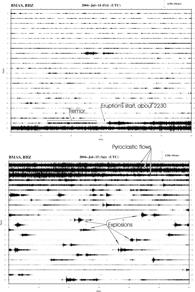 |
Figure 29. Consecutive records for 14-15 July 2006 (upper and lower panels, respectively) observed from the broadband seismic station Mson located on Tungurahua's SW flank at 3.2 km elevation. Time marks on the y-axis show hours (0 to 24) of the day, x-axis marks show minutes (0 to 60). Note the relative quiet on 14 July prior to eruption's onset at 1733. The latter was preceded by ~ 20 minutes of tremor. Courtesy of IG. |
At 0050 on 14 July a pyroclastic flow poured down the NW flank (the Juive Grande drainage). An associated fine ashfall was noted 8 km SW in the town of Puela. Intense Strombolian activity ensued, including glowing blocks tossed 500 m above the crater that bounced downslope for considerable distances. Associated noises were particularly loud and heard widely, including in Ambato (30 km NW). Lookouts described these sounds as distinctive ("bramidos doble golpe;" roughly translated as 'double roars'), a new sound in the suite of those heard since 1999. In the Cusúa area, and up to 13 km NW in the sector of the Observatory of Guadelupe, residents felt intense ground movements.
At 1930 that day pumice fell on the W flank (the sector of Pillate) reaching a thickness of ~ 1 cm. About 10 minutes after the pumice fall, the IG issued the second special report (##7) on the 14 July events. It cautioned residents to remain away from the volcano's W side. The next special report (##8) noted that variations in activity prevailed through the end of 14 July, and that much of the first hour of 15 July brought decreased activity. Tremor continued on 15 July, often in episodes with durations of 4 to 5 minutes, separated by intervening calm intervals of similar duration.
After 0500 on 15 July the eruptive process changed, with the new regime characterized by sequences of abundant large explosions followed by intervals of calm lasting 30-40 minutes. A critical detonation occurred at 0559 on 15 July. On the basis of reduced displacement, it ranked as the largest since the eruption began in 1999. Other detonations with similar character followed the initial one. During 0500-0555 there were 20 large detonations. In assessing the 14-15 July eruptions, satellite analysis by both the Washington Volcanic Ash Advisory Center and the U.S. Air Force Weather Agency confirmed the highest ash-plume tops to altitudes of 15-16 km.
At sunup on 15 July observers found signs that a pyroclastic flow had descended a W-flank drainage (Achupashal valley, between Cusúa and Bilbao). The deposits filled the valley (to 5- to 10-m thickness). Small fires had ignited in the vegetation. A rockfall was also seen in the Bilbao area. Ash falls were reported, containing both ash and scoria fragments, affecting the cities of Penipe, Quero, Cevallo, Mocha, Riobamba, and Guaranda.
Additional fieldwork revealed that pyroclastic flows had traveled down at least six quebradas around the volcano, including Achupasal, Cusúa, Mandur, Hacienda, Juive Grande, and Vascún valleys (the latter, upslope from the western part of the touristic city of Baños).
Figures 30-33 depict the distribution of fresh deposits as well as some photos taken during the 14-15 July eruptions. Tilt and SO2 monitored at Tungurahua appear on figures 34 and 35. Satellite photos from 25 June and 18 July appeared on the NASA Earth Observatory website.
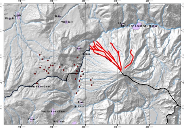 |
Figure 30. Paths where pyroclastic flows descended during Tungurahua's eruption of 14-15 July 2006. The associated ashfall deposits are identified at points W of the volcano's summit (thicknesses in mm). For scale, adjacent E-W grid lines are 4.44 km apart (and Cotalo, on the NW flank is ~8.5 km from the summit). Grid lines are latitude and longitude in degrees (heavy type) and decimal degrees (light type); lines are separated by 0.04 degrees N-S, and 0.05 degrees E-W. Courtesy of IG. |
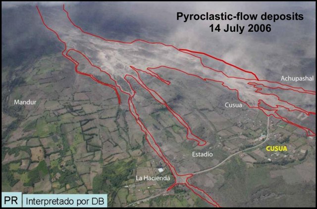 |
Figure 31. Pyroclastic flow routes and deposits on Tungurahua's lower W flank (near Cusúa). Photographed 14 July 2006 Courtesy of IG. |
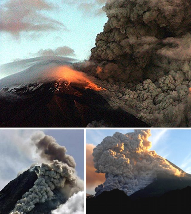 |
Figure 32. Three photos depicting the onset of strong pyroclastic flows on Tungurahua at about 1814 on 14 July 2006. This particular pyroclastic flow descended the Juive Grande river valley. Photo taken from Loma Grande, located about 9 km NNW of the crater. Photographed by L. Gomezjurado; courtesy of IG. |
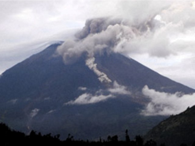 |
Figure 33. At Tungurahua, a pyroclastic flow descending the NW-trending Mandur valley at 0653 on 16 July 2006. Photo by P. Mothes, IG. |
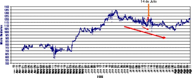 |
Figure 34. Plot showing radial tilt (at station RETU located at 4 km elevation on the N flank), 13 April-11 August 2006. During mid-May to mid-June 2006, tilt at the instrument had been in an inflationary trend. Around 22 June the tilt shifted to deflation, which became strong for a few day just prior to the eruption. The eruption occurred after several hours of sudden inflation. After the eruption, the broad deflationary trend continued until around the beginning of August.Courtesy of IG. |
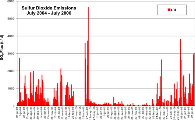 |
Figure 35. SO2 flux at Tungurahua as measured by DOAS, July 2004-July 2006. Courtesy of IG. |
Reference. McNutt, S., 2000, Seismic monitoring, in Encyclopedia of Volcanoes: Academic Press (editor-in-chief, Haraldur Sigurdsson), p. 1095-1119, ISBN 0-12-643140-X.
Information Contacts: Geophysical Institute (IG), Escuela Politécnica Nacional, Apartado 17-01-2759, Quito, Ecuador (URL: http://www.igepn.edu.ec/).
Intense ongoing activity in 2006; new bulge on the N flank
According to the Instituto Geofísico-Escuela Politécnica Nacional (IG), Tungurahua, located 180 km S of the capital Quito, erupted on 14 July 2006 (BGVN 31:07), and again with great intensity in mid-August, resulting in at least five deaths. The 14 July event marked the beginning of a new energetic phase of activity different from that seen since October 1999. This report was taken from the IG's Special Reports and Bulletins (Numbers 7-15) discussing events from mid-July 2006 through early January 2007.
The new phase that began in July 2006 was characterized by highly explosive activity. It was associated with the arrival of a large volume of magma and the expulsion of hot, sometimes incandescent, pyroclastic flows. These flows traveled downslope with speeds of ~ 40 km/hour from the W, NW, and N flanks of the cone and ended at the Chambo river. The primary route of the flows was via the Achupashal, Cusua, La Hacienda, Juive Grande, Mandur, and Vascún gorges (see maps and figures in BGVN 31:07). Some of these flows were sufficiently large and mobile as to reach the Baños-Penipe road. The settlements of Cusúa, Bilbao, and to a lesser extent Juive Grande, were affected by these flows, which devastated pastures, fields, livestock, and basic infrastructure.
Additionally, small-volume pyroclastic flows descended the Vascún valley (upslope from the western part of Baños) but ended 2.5 km upstream from the hot springs of El Salado. The emission of hot incandescent pyroclastic flows ended one week after the explosive eruptions of 14-15 July.
Volcanic activity decreased significantly several weeks after 14 July, as shown by the seismic-based indicator developed for Tungurahua by the IG (figure 36). The daily indicator value decreased after mid-July and remained consistent until a slight increase during 8-13 August.
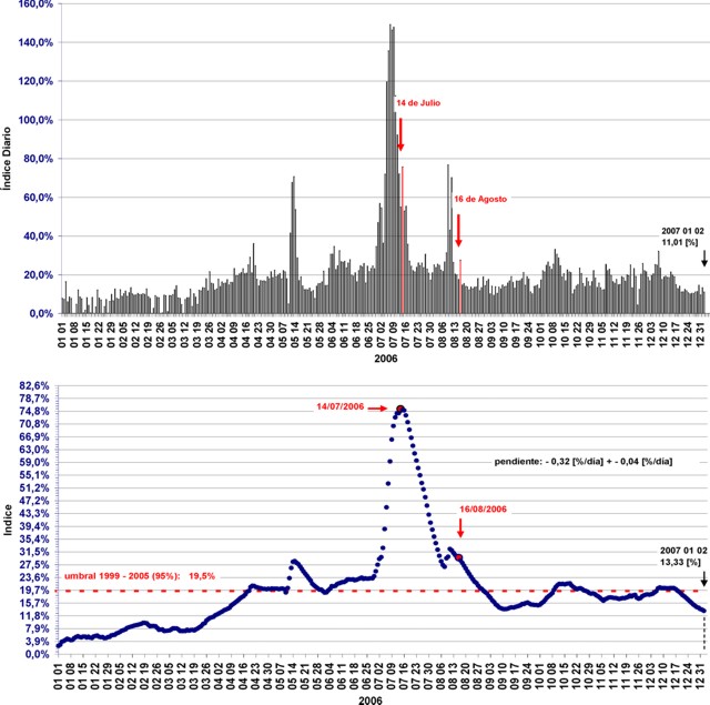 |
Figure 36. Index of daily seismic values (top) and index expressed in percentages (bottom) for Tungurahua from 1 January 2006 to 2 January 2007. Arrows mark the dates of the eruptions mentioned in this report. Courtesy of IG. |
On 1 August, a pyroclastic flow traveled W and SW down the flanks and reached the Rea gorge, where it left deposits an estimated 50 m thick consisting largely of blocks and ash. On 2 August, a small lahar traveled NW and blocked a highway. Strombolian activity was observed at night on 3 August. Small explosions were registered during 3-7 August. On 6 August, light ashfall was reported ~ 8 km SW in the town of Manzano.
During 9-15 August, small-to-moderate explosions produced plumes composed of gas, steam, and small amounts of ash that reached heights of ~ 1 km above the summit. Light ashfall was reported in nearby localities during 9-10 August. On 9 and 13 August, explosions expelled blocks of incandescent material that rolled 100 m down the W flank.
Bulge detected and intense explosive eruptions on 16 August. Clinometer measurements on 16 August indicated a bulge on the N flank as compared to 11 August. Seismic activity increased, as ash-and-gas plumes reached heights of 3 km above the summit and drifted W and NW. About 3,200 people were evacuated from "at-risk" areas. At 1900 on 16 August, a new, intense explosive eruption began that continued throughout the day. A large pyroclastic flow did not reach the road.
The eruption continued through 0145 on 17 August at high levels of intensity, ejecting incandescent rocks and generating pyroclastic flows. Several pyroclastic flows were reported in the Achupashal, Mandur y La Hacienda, Juive and Vascún ravines. On the 17th tephra fall (with pumice clasts ~ 3 cm in diameter) was reported from several areas in a wide zone that extended from Penipe in the SW to ~ 15 km NW. Ash plumes reached estimated heights of 10 km above the summit and covered the central part of Ecuador, forming a cloud ~ 742 km long and ~ 185 km wide trending NNW and SSE.
As of mid-August, about 20 pyroclastic flows had descended the above-mentioned ravines, and possibly others on the SW flank. At 2125 the largest pyroclastic flow of the sequence descended the Achupashal ravine and reached and dammed the Chambo river.
At 0033 on the 18th activity intensified, generating several pyroclastic flows and ashfall in several sectors from Penipe in the SW to the N; hot ashfall was reported in the villages of Pelileo, Cevallos, San Juan, and Cotaló. The large quantity of accumulated ash on roofs in the village of Pillate caused their collapse. The city of Baños lost electrical service. During this period, one of the pyroclastic flows descended near Juive Grande and crossed the Ambato-Baños. A sustained eruption column appeared incandescent and glowing at the base, with an associated ash cloud to 7 km above the crater that was blown W and SW. Continuous sprays and jets of lava rose hundreds of meters above the crater.
The explosive eruption on 16-17 August culminated around 0200 (figure 37), after which time the activity gradually decreased. The IG report stated that on 17 August, although the eruptive activity had ceased, longer lasting events including movement of magma and continuous deformation on the N flank indicated that residual magmatic fluid in the volcanic system was putting pressure on the structure. Additionally, emission of SO2 continued to be detected in moderate amounts. This report (Special Report ##14, 17 August 2006) also reminded authorities that the events of 1918 included five explosive eruptions interspersed with periods of reduced activity and that the entire W flank remained at risk of collapse, which could release a large volume of lava and produce much larger pyroclastic flows. Communities at most risk would be on the NW flank (Juive Grande, Los Pájaros, Cusua, Bilbao), but more distant zones at the bottom of the Chambo and Pastaza valleys (Chacauco, and eventually Puñapí) would also be affected.
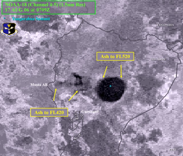 |
Figure 37. An interpreted satellite image of a tall Tungurahua eruption column. The satellite was NOAA-18 (Channel 4-5) (1.5 nautical mile resolution) at 0209 (0709 UTC) on 17 August 2006. Courtesy of the Air Force Weather Agency. |
Dramatic developments. On 18 August, incandescent blocks ejected from the summit descended ~ 1.7 km down the flank. Also that day, based on seismic interpretation, one of the blockages damming part of the Chambo River had been breached.
During 18-19 August, the N flank continued to inflate. During 20-21 August, steam emissions were observed during breaks in the cloud cover and the N flank exhibited deflation. On 23 August, two slow-moving lava flows were identified on the NW slope.
According to news reports, falling ash and debris caused fires and severe damage to five villages. An estimated 20,000 hectares of crops were destroyed. At least five people were dead or missing, and several more were injured. An estimated 4,000 people relocated to shelters.
Relative quiet, late August-October. During 23-27 August, visual observations of Tungurahua were impaired due to inclement weather. Based on seismic interpretation, lava continued to slowly flow NW towards Cusúa and La Hacienda. Seismicity was low and dominated by long-period earthquakes. Inclinometer measurements indicated no additional inflation on the flanks.
During September, seismicity remained low. On 1 September, lava flows on the NW flank were confirmed to have ceased. On 7 September lahars descended the NW gorges of Chontapamba and Mandur. During the month, there were several steam-and-gas plumes with little or no ash content. The emission heights ranged from ~ 0.1 to 2 km above the summit, and the primary wind drift was to the NW and W. Incandescence at the summit was observed at night. On the afternoon of 21 and on 22 September, moderate ash emissions occurred. Three more emissions on 23 September caused ashfall in Penipe; one plume rose 3 km and another 4 km above the summit. Ash plumes were seen again on 25 September.
No ash emissions were reported between 27 September and 2 October; however, on 2 October a slow-moving lava flow was seen descending the NNW flank and some fumarolic activity from the crater was observed. On 3 October an explosion resulted in ash falling in nearby communities to the W. According to the IG and aviation sources, the plume rose to at least 5 km above the summit.
During 4-5 October, Tungurahua's N flank fumaroles were active and steam emissions with minor ash content rose to 1 km above the summit and drifted W. Additional steam plumes possibly originated from the recent lava-flow's front. The IG again reported an increase in emissions and seismicity on 11 and 12 October, when steam plumes with slight to moderate amounts of ash reached 9-12 km altitude. Light ash fell in areas to the NW and W. During 13-17 October, seismicity decreased and plumes reached 7-8 km altitude.
On 16 October a small lava flow spalled off incandescent blocks; gas plumes were observed. Lahars traveled N toward Baños and down the Vazcún and Ulba gorges.
During 18-19 October, ash emissions increased in intensity and seismic tremor was continuous. During the night, lava fountains reached heights of 1 km above the crater rim and blocks rolled 800 m down the flanks. According to the Washington VAAC, around this time a pilot reported an ash plume to an altitude of 8.5 km. Ash plumes drifted NE and E and generated ashfall about 50 km E, in Puyo. According to news articles, about 300 villagers were evacuated.
Emissions continued during 20-24 October, producing plumes to 7-8 km. Ashfall was reported from towns on the N, NW, W, SW, and E flanks. On 28 October, incandescent blocks were expelled from the summit and rolled about 500 m down the W and E flanks. The next day, a lahar traveled NNW down the Mandur drainage and muddy water swelled in the Vazcún drainage. Incandescence from the crater was seen during most of October.
Ash plumes of steam and gas, and moderate ashfalls, were reported from several downwind towns on 5 and 6 November, including Bilbao (8 km W), Cotaló (13 km NW), and Manzano (8 km SW). On 2 November incandescent blocks were expelled from the summit and rolled 700 m down the W and E flanks. Nighttime incandescence was observed during 2-4 November.
On 7 November, a voluminous lahar traveled down gorges to the W and reached as far as the Chambo river, ~ 7 km from the summit. On 8 November, blocks expelled from the summit rolled down the flanks and ashfall was reported from areas including Casúa (7 km NW) and Baños (8 km NE). On 10, 11, and 13 November, ash fall was reported from areas including Penipe (8 km SW). During 12-13 November, lahars traveled down W and NW drainages and the Vazcún river swelled with muddy water.
On 17 November, an ash plume reached an altitude greater than 10 km and drifted NW and NE. During 26-27 November, Strombolian activity propelled incandescent material up to 600 m above the summit. Blocks rolled 2 km down the flanks. Lightning was visible in an ash plume that reached 7 km altitude and ashfall was reported from areas 8 km WSW. On 27 November, an ash plume rose to 9 km and drifted W. These conditions continued on into early December. On 6 December, plumes reached an altitude of 10 km. Ashfall was reported in areas including Cotaló, about 13 km NW, Pillate, about 7 km to the W, and Puela, about 8 km SW. On 9 December, ashfall up to 1 mm thick was reported about 12 km N in Baños.
Around this time seismicity was minimal in both intensity and duration. The plumes drifted in multiple directions. On 14 December, a lahar traveled SW down the Mapayacu gorge. On 21 December, lahars from Tungurahua traveled NW down the Mandur gorge resulting in a road closing and W down the Bilbao gorge. Gas-and-steam emissions produced small plumes on 22, 23, and 25 December. During 27 December-2 January, seismicity at Tungurahua remained moderate to low. On 27 and 28 December, lahars traveled down drainages including Bilbao to the W, Mandur to the NNW, and Mapayacu to the SW. During 3-9 January, seismicity at Tungurahua remained low to moderate.
Information Contacts: Geophysical Institute (IG), Escuela Politécnica Nacional, Apartado 17-01-2759, Quito, Ecuador (URL: http://www.igepn.edu.ec/); Washington Volcanic Ash Advisory Center (VAAC), Satellite Analysis Branch (SAB), NOAA/NESDIS E/SP23, NOAA Science Center Room 401, 5200 Auth Road, Camp Springs, MD 20746, USA (URL: http://www.ospo.noaa.gov/Products/atmosphere/vaac/); International Federation of Red Cross And Red Crescent Societies (IFRC) (URL: https://reliefweb.int/); Agence France-Presse (URL: http://www.afp.com/); Associated Press (URL: http://www.ap.org/).
Post-eruptive quiet spurs return of residents, but activity increases again in 2007
This report covers the time interval early January to 2 March 2007, based on Special Reports of the Ecuadorian Geophysical Institute (IG). This reporting interval was mainly one of relative quiet. In contrast, our previous report (BGVN 32:12), covered IG reports describing energetic eruptions of July and August 2006. Those IG reports also mentioned eruption-related fatalities and the discovery of a new growing bulge on the volcano's N flank. A map and geographic background were tabulated in BGVN 29:01.
Relative quiet prevails and some residents return. As touched on in BGVN 32:12, after August 2006, the volcanic vigor at Tungurahua was minimal and of low energy. The decrease in activity was gradual through mid-December 2006. The vigor remained low until mid-January 2007. Ash emissions did occur but were consistently minor.
IG reports noted that the relative tranquility at Tungurahua could reflect a pattern similar to that seen there in 1918. That was a case when various months of volcanic quiet occurred, only to be followed by explosive eruptions of large size. The latter generated pyroclastic flows.
During the quiet that followed the July and August 2006 eruptions, residents who had evacuated from the margins of the volcano returned to their properties. The IG noted that, unfortunately, these returning residents became more vulnerable to volcanic hazards and made emergency response more difficult.
Vigor increases. Between 20 January and 5 February 2007 internal seismic activity resumed, behavior consisting of a few earthquakes inferred as associated with fractures (volcano-tectonic earthquakes, VTs). On 13 February the volcano emitted an eruptive column with moderate ash content. After 19 February there was a reoccurrence of seismic VTs. These were of shorter duration but higher intensity than those that occurred during the previous period.
During 23-24 February 2007, volcanic tremors and seismic LP's were registered at the Volcanic Observatory of Tungurahua (VOT). At 0310 on 24 February, VOT staff and local observers reported continuous roars of moderate intensity, and discharge of incandescent material that both rose to ~ 800 m above the summit and descended ~ 1000 m down the volcano's flanks.
The emission column headed NW. Fine tephra fell, followed by a thick ashfall that was black in color. It left a deposit 3 mm thick in the towns of Pillate and San Juan. Reports received from Cotaló, Bilbao, Manzano, and Choglontús that indicate a thick, dark ashfall in those spots left a deposit 2 mm thick. Ashfall was also reported in the area of Quero.
Seismic activity decreased on 24 February as well as the intensity and frequency of the roars. As of 2 March, sporadic explosions of ash and incandescent material had been observed. Around this time some bad weather prevented clear views of the upper volcano; however, some reporters noted minor ashfall along the SW portion of the crater. Additionally, the SO2 flux increased to ~ 2,000 metric tons a day for the first time since the beginning of the year. The IG's "Seismic Activity Index" indicated an increase of the volcano's internal activity.
Two scenarios envisioned. Given the available data, the IG concluded that the volcano had received a new influx of magma. They proposed two potential scenarios: (1) the current levels of activity will continue and constant emissions of ash, (potentially more intense) will be generated. Ash clouds will be blown by winds that at this time of the year are predominantly westerly, with occasional S and NW variations. These ash clouds could generate heavy ashfall in the towns downwind from the volcano; or (2) the volume and speed of ascent of the magmatic gases originating from the new magma will increase dramatically, in which case, new explosive eruptions of pyroclastic flows similar to those on 14 July and 16 August could occur.
Information Contacts: Geophysical Institute (IG), Escuela Politécnica Nacional, Apartado 17-01-2759, Quito, Ecuador (URL: http://www.igepn.edu.ec/).
During March-July 2007, many lahars; variable eruptive behavior
Ecuador's Instituto Geofisico (IG) wrote that significant though variable eruptions and lahars occurred at Tungurahua during mid-2007. Our previous report (BGVN 32:04) focused on early January to 2 March 2007, noting some variations in the pace of eruptive activity then. This report summarizes IG reports for March-July 2007. The substantial eruptions of July and August 2006 left abundant pyroclastic-flow deposits on the mountains slopes, potential source materials for new lahars (mudflows). The abundant seismicity during that interval punctuated a longer-term variable pattern (table 13 and figure 38).
Table 13. Summary of Tungurahua seismicity recorded during July 2006 through Mar 2007. Courtesy of IG.
| Time interval | Total earthquakes | Long-period | Volcano-tectonic | Hybrid | Emission signals | Explosion signals |
| Total for Jul 2006 | 3482 | 3475 | 5 | 2 | 1185 | 6442 |
| Daily avg Jul 2006 | 112 | 112 | 0.16 | 0.06 | 38 | 208 |
| Total for Aug 2006 | 2546 | 2518 | 19 | 9 | 467 | 1643 |
| Daily avg Aug 2006 | 82.1 | 81.2 | 0.61 | 0.29 | 15.1 | 53.0 |
| Total for Sep 2006 | 2189 | 2149 | 35 | 5 | 111 | 0 |
| Daily avg Sep 2006 | 73.0 | 71.6 | 1.16 | 0.16 | 3.7 | 0 |
| Total for Oct 2006 | 3159 | 3131 | 20 | 8 | 1023 | 4 |
| Daily avg Oct 2006 | 102 | 101 | 0.64 | 0.25 | 33.0 | 0.12 |
| Total for Nov 2006 | 1849 | 1846 | 3 | 0 | 1049 | 1 |
| Daily avg Nov 2006 | 61.6 | 61.5 | 0.1 | 0 | 35.0 | 0.03 |
| Total for Dec 2006 | 2172 | 2168 | 5 | 0 | 648 | 0 |
| Daily avg Dec 2006 | 70.1 | 69.9 | 0.16 | 0 | 22.8 | 0 |
| Total for Jan 2007 | 829 | 817 | 12 | 0 | 10 | 0 |
| Daily avg Jan 2007 | 26.7 | 26.4 | 0.38 | 0 | 0.32 | 0 |
| Total for Feb 2007 | 983 | 966 | 15 | 2 | 312 | 54 |
| Daily avg Feb 2007 | 35.1 | 34.5 | 0.53 | 0.07 | 11.1 | 1.9 |
| Total for Mar 2007 | 1126 | 1125 | 1 | 0 | 1215 | 334 |
| Daily avg Mar 2007 | 36.3 | 36.3 | 0.03 | 0 | 39.2 | 10.7 |
| 26 Feb-04 Mar 2007 | 427 | 427 | 0 | 0 | 364 | 51 |
| 05 Mar-11 Mar 2007 | 235 | 235 | 0 | 0 | 269 | 87 |
| 12 Mar-18 Mar 2007 | 134 | 133 | 1 | 0 | 203 | 112 |
| 19 Mar-25 Mar 2007 | 241 | 241 | 0 | 0 | 356 | 86 |
| 26 Mar-01 Apr 2007 | 465 | 465 | 0 | 0 | 300 | 47 |
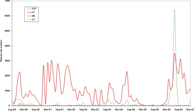 |
Figure 38. Tungurahua seismicity during September 1999 to March 2007 plotting the number of both explosion (EXP) and long-period (LP) earthquakes. Other kinds of earthquakes also took place but after 2001 were rarely seen. Courtesy of IG. |
The IG report for March stated that a relatively energetic eruptive phase began on 24 February 2007 and continued throughout the month. That phase included abundant, ash emissions, sometimes discharging incandescent material, numerous, sometimes large explosions, and frequent noteworthy ashfall. The ash emissions and ashfalls were sometimes sustained. Blocks ejected in Strombolian outbursts fell up to 1 km below the crater rim.
During March, there were rises in both tremor amplitude and the number of long-period (LP) earthquakes (the later during March averaging 36 per day). SO2 gas fluxes averaged ~ 1,050 metric tons/day (t/d). Flank deformation was minimal. March ash falls came from frequent sustained ash plumes 2-6 km over the summit (figure 39). Seismically detected eruptions took place 29 times per day, including some of large size. Tremor nominally took place around 1 Hz, but its frequency remained irregular, non-harmonic, and pulsating. Intervals of pulsing emissions in mid-March had cycle times of ~ 10 minutes.
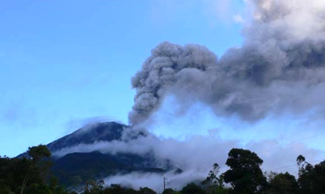 |
Figure 39. Tungurahua emitting an ash plume on 9 March 2007. Sustained plumes were seen during much of the month. Photo taken from Pondoa, on the N flank by Patty Mothes (IG). |
An explosion on 27 March caused an "overflow" of incandescent material that traveled 800 m down from the head of the Mandur drainage. Other similar eruptions may have occurred but cloudy conditions forestalled clear observations. Hot lahars, however, traveled down the Mandur and Chontapampa drainages. Ash falls were common on the cone's N and NW sectors, and in addition, observers noted a small pyroclastic flow.
During the first weeks of April 2007 the IG noted continuous, strong emissions with a very high ash content. These emissions accompanied conspicuous lava fountains, visible at night, and strong roars that made windows vibrate. Ash columns reached 6 km above the crater (~ 11 km altitude). Activity decreased notably during the last 10 days of April (but were even lower in late May). Seismometers recorded an average of ~ 10 daily low-amplitude LP earthquakes. A differential optical absorption spectroscopy (DOAS) instrument measured SO2 fluxes of 3,600 and 3,700 t/d during the last 10 days of April.
During May, seismicity was low (table 13), with the average number of registered earthquakes each day averaging about 20. The Seismic Activity Index at the beginning of the month indicated a level 5 (moderate-high activity), which later on fell to a level 3 (moderate-low activity). This was the lowest Seismic Activity Index registered since February 2007. Ash emissions were low to moderate with a westerly direction. The SO2 levels were approximately 800 t/d. With the exception of the frequent formation of lahars, the level of volcanic activity was low in May.
The vigor of June 2007 eruptions from Tungurahua remained at moderate to low levels. Seismicity at the start of the month was low, chiefly LP earthquakes. Eruptions columns were modest and charged with moderate to low amounts of ash. June SO2 fluxes were comparatively high, ~ 2,900 t/d; observers heard light roaring noises similar to a turbine engine. Seismicity increased slightly towards the end of the month.
June brought prolonged intervals of low intensity rain, but heavy rains also occurred. The result was lahars (mud flows) that were numerous and in some cases large (table 14). The 21st of June was particularly noteworthy (table 14). Figure 40 shows one such lahar, which was partly eroded resulting in extension of lahars farther downslope. The lahars sometimes closed the route along the N side of the volcano between Baños and Pelileo and also the route from Baños around the volcano's W flank to Penipe (~ 15 km SW of the summit). No fatalities were reported.
Table 14. List of Tungurahua's main lahars during June 2007. A map and table of Tungurahua drainages (quebradas) appeared previously (BGVN 29:01). Courtesy of IG.
| Date | Drainage | Relative size and comments |
| 01 Jun 2007 | Bilbao | Small |
| 06 Jun 2007 | Bilbao | Small |
| 07 Jun 2007 | Vazcun | Small |
| 07 Jun 2007 | La Pampa | Small; caused road closure |
| 07 Jun 2007 | Bilbao | Small |
| 07 Jun 2007 | Motilones | Small |
| 07 Jun 2007 | Pingullo | Small |
| 07 Jun 2007 | Rea | Small |
| 07 Jun 2007 | Viejo Minero | Muddy water |
| 11 Jun 2007 | Mandur | Muddy water |
| 11 Jun 2007 | La Pampa | Small |
| 12 Jun 2007 | La Pampa | Muddy water |
| 12 Jun 2007 | Viejo Minero | Muddy water |
| 13 Jun 2007 | La Pampa (2) | Large and medium; a truck remained stuck |
| 13 Jun 2007 | Viejo Minero | Muddy water |
| 14 Jun 2007 | Mandur | Small |
| 14 Jun 2007 | La Pampa | Small |
| 14 Jun 2007 | Bilbao | Small |
| 14 Jun 2007 | Pingullo | Small |
| 14 Jun 2007 | Motilones | Small |
| 15 Jun 2007 | Mandur | Small |
| 15 Jun 2007 | Mapayacu | Small |
| 15 Jun 2007 | Motilones | Small |
| 15 Jun 2007 | Pingullo | Small |
| 15 Jun 2007 | La Pampa | Small |
| 15 Jun 2007 | Rea | Small |
| 15 Jun 2007 | Choglontus | Small |
| 15 Jun 2007 | Cusua | Small |
| 15 Jun 2007 | Vazcun | Small |
| 15 Jun 2007 | Viejo Minero | Muddy water |
| 16 Jun 2007 | La Pampa | Muddy water |
| 20 Jun 2007 | La Pampa | Medium; closing the road |
| 20 Jun 2007 | Mandur | Small |
| 20 Jun 2007 | Viejo Minero | Small |
| 20 Jun 2007 | Achupashal | Small |
| 20 Jun 2007 | Bilbao | Small |
| 20 Jun 2007 | Motilones | Small |
| 21 Jun 2007 | La Pampa | Large, closing the road |
| 21 Jun 2007 | Viejo Minero | Large |
| 21 Jun 2007 | Mandur | Large |
| 21 Jun 2007 | Vazcun | Large |
| 21 Jun 2007 | Nueva Cusua | Large |
| 21 Jun 2007 | Achupashal | Large |
| 21 Jun 2007 | Motilones | Large |
| 21 Jun 2007 | Pingullo | Large |
| 21 Jun 2007 | Bilbao | Large |
| 21 Jun 2007 | Rea | Large |
| 21 Jun 2007 | Confesionario | Large |
| 21 Jun 2007 | Ulba | Growing |
| 22 Jun 2007 | Vazcun | Growing |
| 22 Jun 2007 | Ulba | Growing |
| 22 Jun 2007 | La Pampa | Muddy water |
| 22 Jun 2007 | Viejo Minero | Small |
| 22 Jun 2007 | Mandur | Small |
| 24 Jun 2007 | La Pampa | Muddy water |
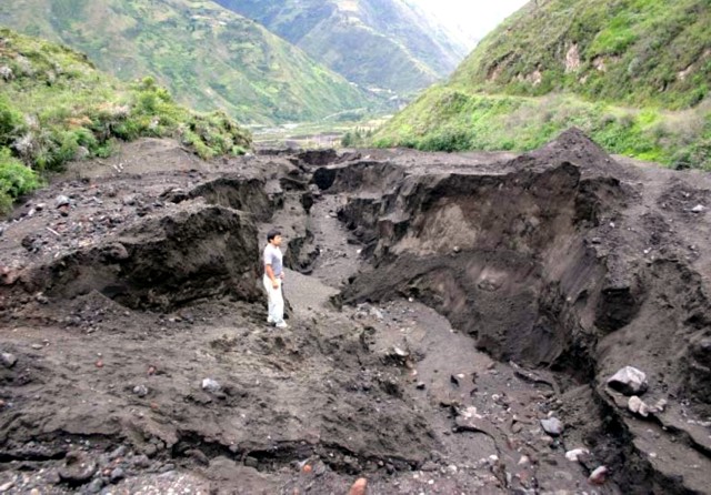 |
Figure 40. A lahar in the La Pampa sector of Tungurahua showing an active, steep sided erosional channel down the axis of the deposit. Photographed 13 June 2007 by P. Ramón (IG). Courtesy IG. |
There was a minor increase in seismicity during the month of July. Distribution of events was variable: 240-330 events per week the first and last week of the month; 50-70 events during each of the other two weeks. They were primarily LPs ~ 2 km below the summit.
The rate of SO2 emission averaged 1,071 t/d with a high of 2,050 t/d. Ashfall was semi-continuous, reaching areas W and SW of the summit, near communities like Bilbao (8 km W of the summit), Chogluntus (SSW of the summit), and El Manzano (7 km WSW). The plume headed toward Manta once the column reached 4 km above the summit.
During July, the road to Baños-Las Juntas was temporarily closed six times due to small-to-moderate lahars.
Information Contacts: Geophysical Institute (IG), Escuela Politécnica Nacional, Apartado 17-01-2759, Quito, Ecuador (URL: http://www.igepn.edu.ec/).
Explosions up to 14 km altitude during July 2007 to February 2008
Our previous report on Tungurahua (BGVN 32:08) discussed the volcano's activity during March-July 2007. During that period, Ecuador's Instituto Geofisico (IG) reported significant, but variable eruptive behavior, along with many lahars, ash plumes that reached 4 km above the summit, and semi-continuous ashfall.
Table 15 presents a brief summary of the weekly activity at Tungurahua between 18 July 2007 and 19 February 2008. The plumes were described variously as ash, ash-and-gas, steam-and-gas, steam, or steam-and-ash. They rose up to 13 or 14 km altitude (25-26 October 2007 and 7 February 2008, respectively) but more typically, for many weeks, to below 8 km altitude. Around December 2007 IG stated a caution. They likened Tungurahua's behavior as similar to after its explosive phase of 14 July 2006. In that case, volcanic activity kept going, and this lead to the most explosive phase on 16 August 2006. That dramatic pattern was not repeated the next month, but the pace of volcanism kept up and led to the vigorous 7 February eruption.
Table 15. Summary of weekly activity at Tungurahua between 18 July 2007 and 19 February 2008. Courtesy of IG.
| Date | Plume altitude | Activity |
| 18 Jul-24 Jul 2007 | 5.2-8 km | Roaring, noises resembling cannon shots or rolling blocks, lahars, ashfall. |
| 25 Jul-31 Jul 2007 | up to 2-3 km above crater | Many small ash-bearing explosions and several unusually large ones, blocks fell up to 0.5 km below crater's rim, ashfall. |
| 01 Aug-07 Aug 2007 | up to 5.5 km | Roaring, explosions, rolling blocks, steam emissions, ashfall. |
| 08 Aug-14 Aug 2007 | up to 6 km | Explosions, incandescent material fell inside the crater and on the flanks, ashfalls, lahars down NW drainage disrupted road traffic between Ambato and Banos. |
| 15 Aug-21 Aug 2007 | 5.5 km | Cannon shot noises, explosions, ash emissions, ashfall. |
| 22 Aug-28 Aug 2007 | 6-9 km | Explosions, incandescent blocks down flanks, lahars in the NW drainage disrupted road traffic, ashfall. |
| 29 Aug-04 Sep 2007 | 7 km | Explosions, roaring and cannon shot noises, incandescent blocks ejected, lahars disrupted road traffic, ashfall. On 4 September incandescence and rolling blocks on the E and N flanks. |
| 05 Sep-11 Sep 2007 | 5.3-8 km | Explosions, incandescent blocks rolled down flanks, ashfall. |
| 12 Sep-18 Sep 2007 | 5.5-8 km | Strombolian eruption, explosions, incandescent material ejected above the summit and blocks rolled 100 m down the flanks, roaring and cannon shot noises, ashfall. |
| 19 Sep-25 Sep 2007 | 5.3-7 km | Explosions, roaring and cannon shot noises, incandescent material ejected above the summit and blocks rolled 500 m down the flanks, ashfall. |
| 26 Sep-02 Oct 2007 | 6-7 km | Roaring and cannon shot noises, 28 September, blocks ejected above the summit and descended 500 m down the flanks, ashfall. |
| 03 Oct-09 Oct 2007 | 6-8 km | Ash plumes, roaring and cannon shot noises, noise of rolling blocks, ashfall. |
| 10 Oct-16 Oct 2007 | 6.2-8 km | Ash plumes. During 11-12 October incandescent blocks ejected and descended 300 m down the W flank; roaring noises from multiple areas on 11, 13, and 14 October. Ashfall. |
| 17 Oct-23 Oct 2007 | 5.5-9 km | Ash plumes. 17 October, roaring, incandescent material erupted from the summit fell onto the flanks. Fumarolic activity on NW flank, lahars closed road on NW drainage. Ashfall SW on 21 October. |
| 24 Oct-30 Oct 2007 | up to 13 km | Ash and steam plumes. 25-26 October, incandescence at summit, roaring and cannon shot noises, blocks rolling down the flanks; ashfall. |
| 31 Oct-06 Nov 2007 | 5.5-8 km | Explosions, roaring, incandescent blocks at summit, lahars closed road, ashfall. |
| 07 Nov-13 Nov 2007 | 6-9 km | Roaring and cannon shot noises, incandescent blocks rolled a few hundred meters (1 km on 12 Nov) down the flanks, fumarolic activity, lahar, ashfall. |
| 14 Nov-20 Nov 2007 | up to 7.3 km | Roaring and cannon shot noises, incandescent blocks rolled down flanks, thermal anomaly detected. |
| 21 Nov-27 Nov 2007 | 6-8 km | Explosions, roaring, incandescent blocks 1 km down the flanks, lahars (4-5 m high in one area) closed road, ashfall. |
| 28 Nov-04 Dec 2007 | 6-8 km | Elevated seismicity, explosions, continuous emissions of steam and ash, roaring and cannon shot noises, incandescent blocks 0.5-1 km down flanks, ashfall. |
| 05 Dec-11 Dec 2007 | 6-8 km | Explosions, roaring and cannon shot noises, incandescent material about 1 km down flanks, ashfall. |
| 12 Dec-18 Dec 2007 | 6-7 km | Explosions, roaring and cannon shot noises, almost constant emission of of ash plumes, incandescent blocks rolled down flanks, ashfall. |
| 19 Dec-25 Dec 2007 | 6-8.5 km | Roaring and cannon shot noises, incandescent blocks hundreds of meters down flanks, ashfall. News reports indicated that 1,200 people from Penipe were evacuated nightly. |
| 26 Dec-01 Jan 2008 | 6-8 km | Explosions, roaring, and cannon-shot noises, incandescent blocks 500 m down flanks, ashfall. |
| 02 Jan-08 Jan 2008 | 5.5-8 km | Explosions, roaring and cannon shot noises, continuous ash emissions, incandescent blocks 500 m down flanks, ashfall. News reports indicated that nearly 1,000 people were evacuated for the night on 6 Jan. |
| 09 Jan-15 Jan 2008 | 6-9 km | Strombolian eruption, roaring and cannon shot noises, incandescent blocks 0.5-1 km down flanks. News reports indicated that residents from two provinces evacuated at night and about 20,000 health masks were distributed in Banos and Quero. |
| 16 Jan-22 Jan 2008 | 5.5-9 km | Strombolian eruption, roaring and cannon shot noises, incandescent blocks 1-2 km down flanks, small pyroclastic flow 400 m down NW side of crater, ashfall. |
| 23 Jan-29 Jan 2008 | 5.5-9 km | Roaring and cannon shot noises, incandescent blocks 500-800 m down flanks, lahars blocked road to Banos, ashfall up to at least 40 km from summit. |
| 30 Jan-06 Feb 2008 | 6-9 km | Explosions (65-208 per day), roaring and cannon shot noises, incandescent blocks rolled 600 m down flanks, lahar, ashfall. |
| 06 Feb 2008 | -- | New phase of eruptions began with a moderate explosion. |
| 07 Feb 2008 | 6-14.3 km | Tremors of variable intensity, ash columns to heights of 3 km beginning a new phase of eruptive activity; satellite images show a hot spot in the crater. Strombolian eruptions, explosions, strong roaring and cannon shot noises, incandescent material rolled 1.2 km down the flanks, tremors followed by pyroclastic flows on the NW and W flank, tephra fall SW, ashfall. News articles stated several hundred to 2,000 people evacuated. |
| 08 Feb 2008 | -- | Internal volcanic activity as well as emissions of ash, incandescent material, and explosions and roaring noises slowly diminished; current eruptive episode should not be considered as finished. |
| 09 Feb-12 Feb 2008 | -- | Strombolian eruptions, explosions, strong roaring and cannon shot noises, incandescent material rolled 1.2 km down the flanks, pyroclastic flows, tephra fall, ashfall. News articles stated several hundred to 2,000 people evacuated. |
| 13 Feb-19 Feb 2008 | 6-9 km | Roaring, noises resembling blocks rolling down flanks, lahar, ashfall. |
Information Contacts: Geophysical Institute (IG), Escuela Politécnica Nacional, Apartado 17-01-2759, Quito, Ecuador (URL: http://www.igepn.edu.ec/); Washington Volcanic Ash Advisory Center, Satellite Analysis Branch (SAB), NOAA/NESDIS E/SP23, NOAA Science Center Room 401, 5200 Auth Rd, Camp Springs, MD 20746, USA (URL: http://www.ospo.noaa.gov/Products/atmosphere/vaac/); Reuters (URL: http://www.reuters.com/); Associated Press (URL: http://www.ap.org/); Pan American Health Organization (PAHO), 525 23rd St. NW, Washington, DC 20037, USA (URL: http://www.paho.org/).
Eruptions in 2008-2009; two fatalities in sudden flood on 22 August 2008
Our previous report on Ecuador's Tungurahua (BGVN 33:06) summarized the ongoing activity through mid-February 2008. This report covers February 2008-July 2009. The Instituto Geofísico-Escuela Politécnica Nacional (IG) has maintained a continuous watch on Tungurahua in order to provide immediate alert of significantly heightened activity to prevent as much damage to property and population as possible. Several pyroclastic flows occurred.
Steam and ash plumes have been continuous since early 2008. These plumes have generally risen to ~8-9 km with occasional higher plumes as a result of increased activity. Ashfalls were frequently associated with the steam, gas and ash emissions, and deposited small layers of the larger particles downwind, sometimes 8-11 km from the crater. On 1 March 2009, an explosion produced a significant plume that rose to an altitude of ~10 km and drifted NW. By 3 March, the ash on the volcano's W side covered at least 2.5 km2 of cropland, and additional cattle-grazing pasture.
Ashfall accumulation (figure 41) was recorded for a time interval slightly before the current reporting interval, but the available later maps were similar. Towns affected on figure 41 included Choglontús, El Manzano, Palitahua, Cahuají, Sabañag, Santa Fe de Galán, Penipe, and Bayushig. Lighter ashfall was also repeatedly noted in Riobamba and Guano.
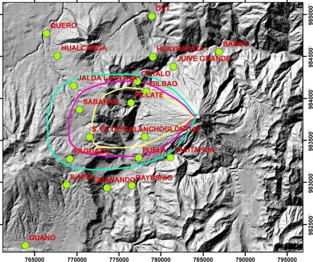 |
Figure 41. Ashfall accumulated from Tungurahua eruptions during 30 January-10 February 2008. N is towards the top and the horizontal scale can be read from to the index marks on the map's margin, which are at 5-km intervals. The three isopachs shown represent thicknesses of 1, 2, and 3 mm (increasing thickness inward). Courtesy of IG. |
On various occasions, incandescence and the ejection of large blocks were Strombolian in character. Roaring, explosions, and "cannon shot" noises were reported almost daily. On 4 August 2008 one explosion was heard as far away as Ambato, 31 km to the NW.
Lahars, floods, and two fatalities. Lahars or mudflows descended drainages to the NW, W, SW, and S repeatedly during the reporting period (many times per week). On 8 March 2008, lahars transported blocks up to 3 m in diameter; in many other cases the largest blocks were around 1 m in diameter. Lahars occasionally affected roads in the Pampas sector to the S and disrupted the access road to Baños.
On 21 August 2008, intense rains prompted the Volcanic Observatory of Tungurahua (OVT) to issue a warning of potential lahars in the Vascún river. A natural dam in that river had been previously identified as a potential hazard.
On 22 August, the dam ruptured and a flood descended. A bridge crossing the river on the outskirts of Baños endured the flooding but was overridden by ~ 20 cm above the railing (figure 42). The flood also destroyed two homes and the El Salado public pools, 1,700-1,800 m downstream of the dam (figure 43). Two people were reported injured and two were reported missing and presumably killed.
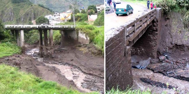 |
Figure 42. (left) A view of a bridge impacted by the Tungurahua flood and lahar of 22 August 2008. A vertical support appears damaged. (right) A smaller bridge showing high water mark about 1 m above the road. On the far bank is scouring near the base, and above that, fresh deposits, including some on the guardrail. The lahar may have caused or contributed to damage on abutment and horizontal support beam, which appears battered and deformed. Courtesy of IG. |
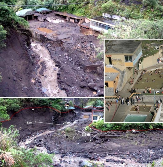 |
Figure 43. Three photos of the El Salado pool facility on the N flank of Tungurahua, where an August 2008 flash flood destroyed significant portions of the buildings and the retaining wall, and gravels swept as high as the roof of some buildings. (top) An overview of the ruined pool facility. (bottom) Measurements help convey the scale of the river's high stand and aftermath. IG authors also sketched a line showing the highest water level. Inset photo was taken when the pool was in use prior to the flood; the river is at right out of view. Courtesy of IG. |
Lahars on 23 October again descended the Vascún river, causing a landslide and rupturing a water pipe that serviced Baños. On 1 November, lahars descended multiple drainages, carrying blocks up to 1 m in diameter to the SW. Residents bordering the Vascún river temporarily evacuated, but returned after the rain stopped.
Pyroclastic flows and explosive activity. Explosive activity continued through the reporting period, including pyroclastic flows. Noteworthy pyroclastic flows occurred on 29 May 2008, when they descended the N and NW flanks of Tungurahua, with deposits observed the next day. In July 2008, a pyroclastic flow was associated with significant ash and tephra fall (with grains up to ~ 3 mm in diameter) reported in the towns of Cahuají, Chazo, Palestina, Santa Fe de Galán, and Guaranda.
Explosions often ejected incandescent blocks that rolled downslope; on 21 June 2009, lava fountains that rose to a height of 500 m above the crater expelled incandescent blocks that were later discovered as far as 2 km downslope. Notable pyroclastic flows, explosions, as well as some lahars and ash plumes were reported (tables 16 and 17).
Table 16. Tungurahua behavior during 19 February-30 December 2008. Only selected examples of near-daily lahars are shown. A map and table of Tungurahua's drainages (quebradas) and surrounding towns appeared previously (BGVN 29:01); locations mentioned include the Mapayacu and Choglontus drainages to the SW; the Pampas sector to the S; Cusúa, 7 km to the NW; Manzano, 8 km to the SW; and the particularly vulnerable city of Baños, 8 km to the N. Courtesy of IG.
| Date | Observations |
| 19, 20, 25 Feb 2008 | Lahars affected roads in Pampas sector |
| 06 and 08 Mar 2008 | Lahars descended W and S drainages; some carried blocks up to 3 m in diameter |
| 25 Mar 2008 | Explosions; incandescent blocks from summit fell on flanks |
| 09, 12, 13 Apr 2008 | Lahars and mudflows on S and NW drainages that disrupted the access road to Banos |
| 21 Apr 2008 | A lahar disrupted the Ambato-Banos road for a few hours |
| 23 Apr 2008 | Blocks rolled 600 m down the flanks |
| 01 May 2008 | Explosions and intense summit incandescence; windows vibrated in areas 6 km NE |
| 11 May 2008 | Blocks rolled ~1 km down the flanks |
| 12 May 2008 | Explosion; rockfalls occurred in an area 8 km to the S |
| 17-18 May 2008 | Explosion similar to that on 12 May; windows rattled in areas to the SW and W |
| 19 May 2008 | Large explosion; numerous incandescent blocks rolled ~1.6 km down the flanks |
| 22, 25-27 May 2008 | Windows vibrated in nearby areas, including at the observatory (OVT) in Guadalupe |
| 23 May 2008 | Marked increase in explosions, ash plumes, and ashfall; summit incandescence at night |
| 29 May 2008 | Pyroclastic flows descended the N and NW flanks, with deposits observed the next day |
| 15 Jun 2008 | Lahars descended the NW and S drainages and resulted in a road closure to the S |
| 19 Jun 2008 | Blocks ejected 500 m above the summit and rolled ~1 km down the flanks |
| 20 Jun 2008 | Mudflow to the SW towards the Puela river carried blocks up to 80 cm in diameter |
| 31 Jul, 03-04 Aug 2008 | Blocks rolled ~1 km downslope; ashfall to SW and W; an explosion on the 4th |
| 19-22 Sep 2008 | Small mudflows in the W and NW; a lahar 50 cm thick to the S |
| 23 Oct 2008 | Muddy waters caused a landslide and a ruptured water pipe that serviced Banos |
| 01 Nov 2008 | Lahars carried blocks ~50-70 cm in diameter in Juive, La Pampas, and Bilbao |
| 04 Nov 2008 | Light ashfall was reported in Pallate and part of Riobamba |
| 15 Dec 2008 | An ash column rose to ~1 km |
| 15-24 Dec 2008 | Ash columns reached a height of ~6 km |
| 17, 21-23 Dec 2008 | Ejecta visible from Guadalupe Observatory |
| 23 Dec 2008 | Incandescent material rolled down flanks |
| 24 Dec 2008 | Small pyroclastic flow on NW flank; incandescent lava flowed down one of the flanks |
| 25-26, 28-30 Dec 2008 | Blocks rolled 500 m downslope on 25 Dec, 1,500 m on 29 Dec, and 800 m on 30 Dec; heavy black ash fell in areas to the SW |
Table 17. Tungurahua behavior during 2 January-7 July 2009. Only selected examples of near-daily lahars are shown. Courtesy of IG.
| Date | Observations |
| 02-04 Jan 2009 | Blocks rolled ~800 m down the flanks; Strombolian activity on 4 Jan |
| 07, 10 Jan 2009 | Incandescent blocks rolled down flanks |
| 08 Jan 2009 | Continuing gas-and-vapor emission; ash columns less than 2 km high drifted W, NW, SW, and NE. Ashfall in El Manzano, Choglontus, Palictahu and Cahuaji |
| 16 Feb 2009 | Ash emissions that generated a plume with altitude of ~8 km and drifted W |
| 01 Mar 2009 | Ash plume that rose to an altitude of ~10 km and drifted NW |
| 03 Mar 2009 | Ashfall covering at least 2.5 km2 of cropland and additional cattle-grazing pasture |
| 21 Mar 2009 | Lahars carried blocks up to 30 cm in diameter to the SW |
| 26 Mar 2009 | Lahar in the Mapayacu drainage carried blocks up to 2 m in diameter |
| 06 Apr 2009 | Fumarolic plumes rose 500-600 m; light ashfall reported 8 km SW |
| 14 Apr 2009 | A steam-and-gas plume containing some ash rose to an altitude of ~7.5 km and drifted N |
| 22 Apr 2009 | Incandescent blocks ejected from the crater and rolled down flanks |
| 06 May 2009 | Ashfall reported in Banos, ~8 km to the N |
| 13, 18 May 2009 | A fine layer of ash fell in Manzano, 8 km to the SW |
| 24-26 May 2009 | Incandescence from the crater seen and blocks rolled 100-500 m down the flanks |
| 27 May-02 Jun 2009 | Strombolian activity |
| 21 Jun 2009 | Lava fountains rising to a height of 500 m above the crater |
| 02, 05-07 Jul 2009 | Lahars descended SW and W drainages carrying blocks up to 40 cm in diameter |
Information Contacts: Geophysical Institute (IG), Escuela Politécnica Nacional, Apartado 17-01-2759, Quito, Ecuador (URL: http://www.igepn.edu.ec/); Washington Volcanic Ash Advisory Center, Satellite Analysis Branch (SAB), NOAA/NESDIS E/SP23, NOAA Science Center Room 401, 5200 Auth Rd, Camp Springs, MD 20746, USA (URL: http://www.ospo.noaa.gov/Products/atmosphere/vaac/).
Vascún River map; lahar concerns; decreased activity in mid-2009
Activity at Tungurahua began to decline in late June 2009 and continued this trend into early September. July and August 2009 were characterized by an absence of explosions, a marked decrease in ash emissions, and weak steam emissions. Although no new pyroclastic material was deposited in July or August 2009, the Instituto Geofísico-Escuela Politécnica Nacional (IG) still warned that heavy rains and the great amount of material on the upper slopes presented a danger of lahars and mudflows.
Update on 22 August flood. Last month's report (BGVN 34:07) discussed a 22 August 2008 flood of the Vascún River (figure 44) after a natural dam failed. The flood destroyed two homes in the district of Las Ilusiones as well as the El Salado swimming pool complex, leaving two people injured and two others missing.
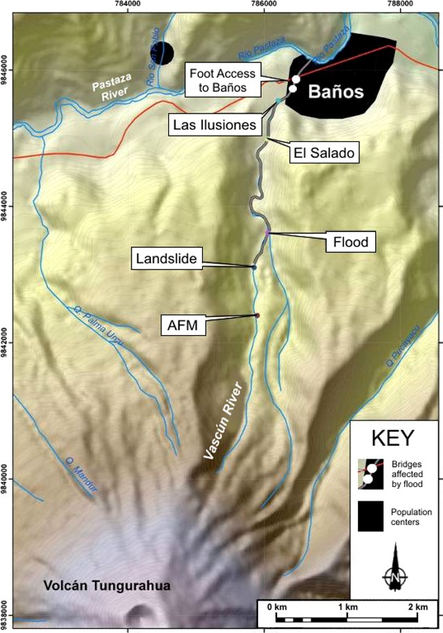 |
Figure 44. Topographic map of the Vascún River on the N flank of Tungurahua, as well as the locations of the dam failure at the landslide and the districts of El Salado and Las Ilusiones, which were affected by the flood waters and associated sediment. "AFM" refers to an acoustical-flow monitor, a device to help detect processes such as mass wasting and pyroclastic flows along the river (Hadley and Lahusen, 1993). The heavy line along the river below the natural dam indicates the portion of the river through which the flood and debris traveled. Courtesy of IG. |
According to a 24 August 2008 article of the newspaper El Universo, strong rains began at approximately 2000 on 22 August and an earthquake was felt by residents in El Salado around 2345. El Universo stated that after the dam's failure, flood waters containing volcaniclastic material reached the El Salado area in ~ 5 minutes. The IG estimated that the flood had traveled at a velocity of 4.7-6.7 m/s.
Two photographs showed bridges that had been visibly damaged by the event (figure 42 in BGVN 34:07). One bridge is located on the main road to Baños, adjacent to the city. The other bridge, 100 m upstream from the first, serves a secondary road. Officials plan on reviewing those bridge structures to determine whether they should be reinforced to avoid any flood-related damage in the future.
El Universo reported that the two missing persons were young children who lived in one of the destroyed houses along the river in Las Ilusiones. Searches were unsuccessful and El Universo reported that the search concluded in September 2008.
References. Hadley, K.C., and Lahusen, R.G., 1993. Technical manual for acoustic flow monitor. US Geol. Surv., Open-file Rep. 93-00, 19 pp.; Lahar-Detection System, USGS scientists create new method for detecting lahars (URL: http://volcanoes.usgs.gov/activity/methods/hydrologic/lahardetection.php).
Information Contacts: Geophysical Institute (IG), Escuela Politécnica Nacional, Apartado 17-01-2759, Quito, Ecuador (URL: http://www.igepn.edu.ec/); El Universo (URL: http://www.eluniverso.com/).
Return of explosions and earthquakes through at least October 2010
As noted in our last report (BGVN 34:08), activity at Tungurahua had started to decline in late June 2009, a trend that continued through mid-December 2009. This report summarizes heightened activity witnessed from 30 December 2009 to 4 February 2010, and again from 26 May to very early August 2010. Seismicity began to increase in mid-December 2009 in prelude to the above-mentioned escalation.
This report is based on reports received from and direct correspondence with staff members of the Instituto Geofísico Politécnica Nacional Casilla ("Instituto Geofísico," IG).
Seismic overview. A plot by IG presented a synthesis of seismicity (figure 45) during the interval of 1 January 2006 to 17 October 2010, and is one way to portray the long-term pace of Tungurahua's eruption. The x-axis shows time with small tick marks every 30 days, and years indicated. The y-axis shows level of seismic activity on a scale indexed to an unstated normalized peak value. During the time period plotted, the number of recorded events assessed had a maximum peak at index value of ~74%. That peak occurred around 14 July 2006 ("2006 07 14" at left on the plot).
 |
Figure 45. A plot of Tungurahua's seismicity versus time for the interval 1 January 2006 to 17 October 2010. The scale on the left (Index value) is in terms of percent of the IG's custom defined index of activity scale (IAS) for Tungurahua. The bar was auto-scaled with 4.6 units between horizontal lines. The X-Y intercept is slightly below zero (-0.3). The Y-axis on the right shows the IG's defined 'level of the IAS.' The horizontal red dots refer to thresholds during 1999-2005, corresponding to index values at 22.8 and 26.6% (95% and 99% confidence intervals, respectively). Modified from a plot by IG. |
During 2010 seismicity rose sharply in January, peaked at index values near 27%, and then descended during February into June 2010. The intervals of low seismicity in late 2009 and early 2010 are some of the lowest index values during the ~5 years displayed on this plot. The second peak during 2010 was sudden and ascended from low index values; it reached maximum values in late May 2010, approaching index values 50%. The downward arrow at the right side of the plot calls attention to the last day on the plot, 17 October 2010, when the index value stood at 11%.
The seismicity shown in figure 45 shows strong correlation with Tungurahua's behavior summarized below.
Renewed activity (and SO2 compilations). After six months of calm that included occasional diffuse emissions of vapor that rose no higher than 100 m, more intense activity resumed on 30 December 2009. On 1 January ash plumes rose to ~6 km altitude, and on 3 and 4 January they rose as high as ~9 km. Similar plume altitudes were seen at times during the rest of January and February. On 11-12 January, Strombolian outbursts ejected material ~1 km above the crater and to distances of ~1.5 km away from the vent. Ash often blew in a broadly westerly direction (see below).
Significant SO2 fluxes were measured in January 2010. On 6 January, SO2 fluxes reached a value of 3,200 metric tons/day (t/d); on 8 January, they reached 7,500 tons/day. In contrast, some recent values during the 6 month lull were between 100 and 200 tons/day.
On the broader subject of Tungurahua SO2 output, more comprehensive assessments and compilations have been captured than ever before, but the details are beyond the scope of this report. One group, NOVAC (Network for Observation of Volcanic and Atmospheric Change) established a global network of stations to measure emissions of SO2 (and BrO) by UV absorption spectroscopy by local instruments. Trained personnel working at various volcanoes and following protocols assured standard practices (DOAS, mini DOAS, Flyspec). The instruments are based at over 21 volcanoes, including Tungurahua. SO2 is also monitored from instruments on satellites (e.g. OMI, GOME 2, and SCIAMACHY). Understanding and possibly reconciling those two set of atmospheric measurements, local (ground- and aircraft-based measurements) and satellite based, has also been the subject of recent papers. Tungurahua and adjacent degassing volcanoes have played a major roles in this effort (McCormick and others, in press, Carn and others, 2008, and Arellano and others, 2008).
Figure 46 shows Tungurahua in a Strombolian eruption on or about 10 January 2010. Incandescent material fell onto the flanks.
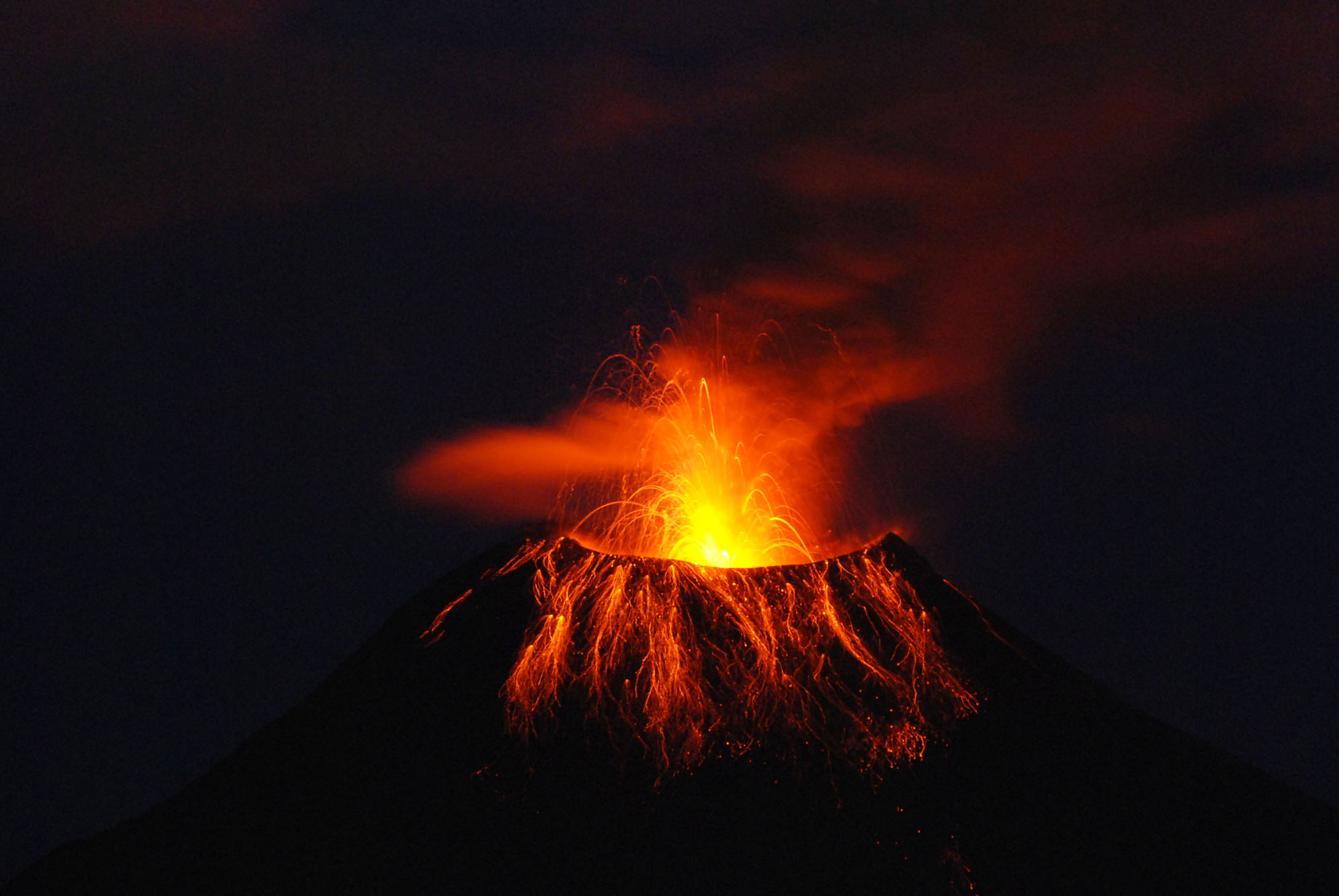 |
Figure 46. After 6 months of comparative quiet, Tungurahua renewed more vigorous eruptions during 30 December 2009 to 1 January 2010. This extended-exposure night photo was taken on or around 10 January 2010. The volcano's profile appears dark, almost black, whereas Strombolian discharges at the summit crater glow a bright red-orange. The extended exposure captured the paths of glowing projectiles arcing out of the crater, and impacting and in many cases bouncing down the upper flanks. An ash cloud in the background reflects a softer more continuous glow across a broad area including, in fainter light, portions of the plume trailing off to the upper right. Photo by Jorge Bustillos A., IG. |
Strong explosions were heard on the evening of 14 January. Small amounts of ash fell nearby and as far away as the Chimborazo glaciers and Guaranda (64 km SW).
The return of ongoing ash plumes initiated a variety of civil responses. In towns close in and on Tungurahua's W to SW flanks (e.g., Choglontús), roofs were inspected and where necessary, ash was removed. This measure was undertaken to prevent ash loading and potential roof collapse. Many building roofs are nearly flat, requiring ash removal with brooms and shovels.
Figure 47 shows an elementary schematic created to address the upsurge in Tungurahua's ash falls, and to broaden understanding and raise public awareness of ash fall processes and hazards from Tungurahua. It shows the progressive shift in the range of grain sizes falling out of ash plumes as they drift, in this idealized case, W to SW with plume tops rising to altitudes approaching 10 km. More complex depositional patterns may develop owing to factors like discharges to variable height, discharges containing differing grain-size distributions, and shifts in wind velocity. Assessment of ashfall often results in maps displaying the thickness or mass of these deposits on the ground (respectively, isopach and isopleth maps). Several isopach maps appear below, describing the Tungurahua's January-February 2010 upsurge in ashfall in more quantitative and technical terms.
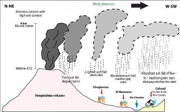 |
Figure 47. An idealization of ash plume evolution emphasizing the expected changes in grain sizes falling from Tungurahua plumes and the range of distance to some settlements. The plume shown is assumed to blow W to SW (common wind directions in this region). Graphics like this help inform the public. Courtesy of IG. |
Tungurahua's ash clouds are also closely monitored out of concern for keeping aircraft out of potentially damaging plumes, some of which extended ~150 km W of the summit during the reporting interval. Ecuador maintains a Meteorological Watch Office (MWO) in the city of Guayaquil, ~180 km SSW of the summit (figure 48; and see inset map showing Guayaquil's location on the coast in figure 25 in BGVN 30:06). The Guayaquil MWO feeds critical data, including observations made by IG at Tungurahua and satellite data they interpret about Tungurahua's plumes, to the Buenos Aires Volcanic Ash Advisory Center. Tungurahua was a frequent subject of aviation reports during the reporting interval. As seen on figure 48, Guayaquil sits just S of the ends of W-directed envelopes around the January 2010 ash clouds.
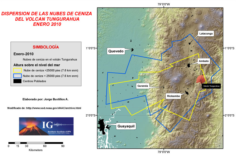 |
Figure 48. Plan view of the overall atmospheric dispersion patterns of Tungurahua ash during January 2010. This is vital information to the aviation community. Although the key is in Spanish, the gist is this: The yellow and blue envelopes apply to ash above and below 7.6 km altitude, respectively (note scale at far left). Courtesy of IG (graphic and key composed by Jorge Bustillos A. after a graphic found at the Washington VAAC). |
Figures 49 and 50 respectively show 1-10 and 11-31 January ash-fall deposits created by plumes that rose to the 5.4-9.1 km altitude range (up to 3 km above the crater). On these maps, the farthest measured isopach, 1 mm in thickness, was as far away as 19 km from the crater. For figure 49, the points where the thickness was measured (yellow) best constrained the deposits maximum extent on the N, NW, and W sides. For that map, ash volumes estimated using conventional approaches (Pyle, 1989; Fierstein and Nathenson, 1992; and Legros, 2000) yielded 313,000 m3 (stated in terms of vesicle-free rock; often abbreviated as DRE, dense-rock equivalent).
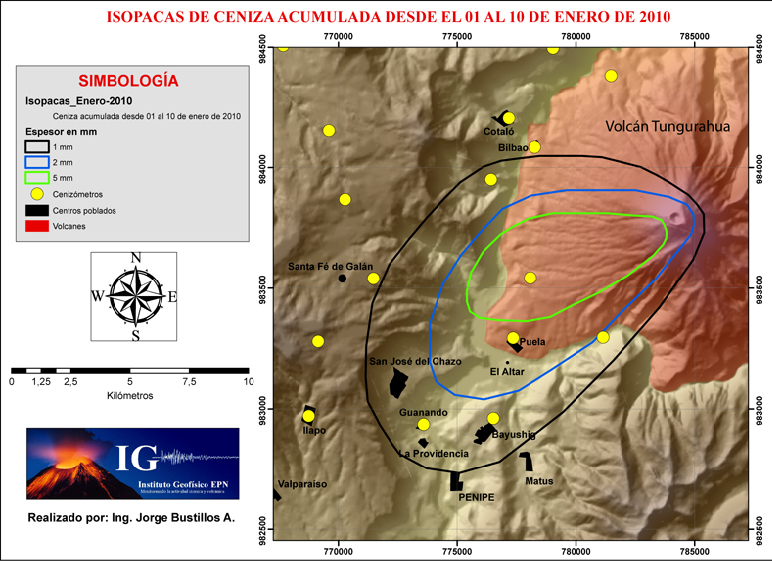 |
Figure 49. The isopach map IG compiled for Tungurahua ash deposited during 1-10 January 2010. Key shows the following (from top): Isopach thicknesses (3 colors), points where the thickness data were collected (yellow dots); population centers (black shaded areas), and Tungurahua (reddish shading). Courtesy of IG (composed by Jorge Bustillos A.). |
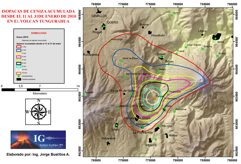 |
Figure 50. The isopach map IG compiled for Tungurahua ash deposited during 11-31 January 2010. The thickest area was inferred to lie ~9 km WSW of the summit at Cahual (where 15 mm fell). Key at left shows isopach thicknesses (9 colors), points where the thickness data were collected (green dots); and population centers (black shaded areas). Courtesy of IG (composed by Jorge Bustillos A.). |
In figure 50, the thickest ash (1.5 cm) was mapped at the town of Cahual (~9 km WSW of the summit), and the mapped pattern suggested lobes trending both WNW and WSW. Such thickening at a spot well away from the summit is unusual but not unprecedented. Future studies considering meteorological or other data may help explain this pattern, which could have public safety implications.
IG's report for 11-31 January noted near constant ash plumes during that interval. Ash had impacted banana plantations and livestock, falling over an area of ~15,000 km2.
The ash volume estimate in DRE for 11-31 January was 806,000 m3 (figure 50). Taken with the earlier (1-10 January) estimate based on figure 49, this made the January total ~1,120,000 m3 (DRE). This is best shown to two significant figures, thus 1.1 x 10⁶ m3. In contrast, the volume for the full month of February was estimated at 1.6 x 10⁶ m3.
Figure 51, an isopach map created for the entire month of February 2010, extends farther outward than either of the two maps representing January. February's 1 mm isopach extends up to 22 km from the summit in the WNW direction. February's map also shows some thicker deposits close to the active summit crater (25 mm thickness at Cahuaji), but it reflects a longer time interval than each of the two January maps. February's elevated deposition of ash conformed with IG's Special Bulletin (No. 6), which explained that after 6 February 2010 they had seen a notable increase in the frequency and magnitude of explosions, and plumes rising 4 km above the summit. People tens of kilometers away heard blasts. Observers noted glowing blocks thrown more than 1.5 km and rolling downslope. Infrasonic microphones recorded signals suggesting four explosions of high energy during 8-9 February.
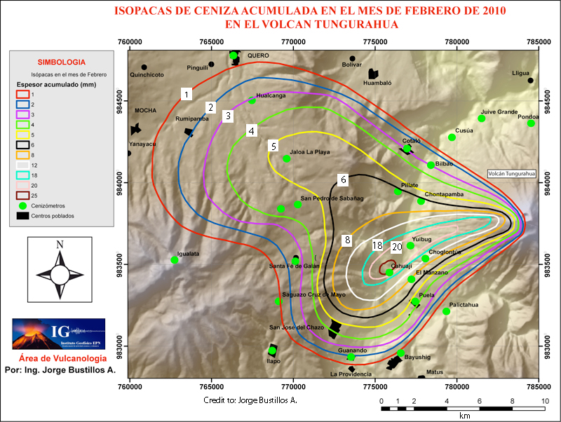 |
Figure 51. An isopach map showing Tungurahua's ash accumulation during February 2010 (thicknesses in millimeters). Courtesy of IG (composed by Jorge Bustillos A.). |
5 February ash plume dynamics. Figure 52 shows intriguing ash plume behavior on 5 February 2010, disclosing complexities infrequently discussed in the literature. At discharge, the plume rises vertically in a thrust phase that appears to be well on its way to farther ascent in a convective phase. The continued rise of earlier emissions (perhaps less energetic or perhaps in gusts of stronger wind) were thwarted by wind having sheared and carried them off. That portion of the plume appears to the right of the crater. As these earlier components progressed downwind and above the lee side of the volcano, their path descended rather than ascended. Farther downwind and away from the volcano the plume appears much broader and its top has risen higher than the original thrust phase. The presence of weather clouds like those in the background could compromise ground-based estimates of the ultimate height for the plume's top.
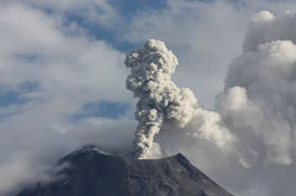 |
Figure 52. Tungurahua discharged this vapor-dominated emission (containing low-to-medium density of ash) at 2200 on 5 February 2010. That day's eruptions were described as rising 1 km above the summit and continuing W to SW. The scene is discussed further in text. Image taken from IG's 1-7 February 2010 report (photo credit to J. Bourquin IG). |
Geometries like this may also complicate reliable estimates of gas-flux, although scanning imaging infrared spectrometers compensate for these problems (e.g. Grutter and others, 2008). Pilots and meteorologists are familiar with these topographic wind-related effects, which they call lee waves. An acclaimed book by Pretor-Pinney (2007) discusses and provides a diagram to explain similar wind-driven topographic effects and lenticular clouds common near tall peaks.
11 February secondary pyroclastic flows. As IG reported (in their Special Bulletin Number 6), on 11 February an M 3.3 volcano-tectonic earthquake struck in vicinity of Tungurahua. Strong explosions ensued, and about 20 minutes later an ash plume rose ~4 km above the summit. About three hours later IG observers at the Tungurahua Volcano Observatory (OVT) in Guadalupe, (11 km N of the summit), photographed the paths and thermal images revealed still hot deposits from small pyroclastic flows. These flows started at the crater rim and descended several kilometers down the upper one-third of the volcano on the N and NNW flanks.
The pyroclastic flows were interpreted as secondary, generated by the gravitational instability of still-hot ejecta that had accumulated at the crater rim and adjacent areas downslope.
February rain brings destructive lahars. Special Bulletin No. 5 of 4 February 2010 contains a detailed set of notes compiled as strong rains fell and caused lahars to descend along gullies and ravines. The Ulba river (on the volcano's E to NE flanks) was strongly impacted. The lahars also closed some recently repaired roads.
At 1100 on 4 February 2010, a large amount of rock debris flowed down the Chinchín river, which flows from the S to the N along the outer NE flank as close as ~10 km from the summit crater. According to the Baños Fire Department, the lahars destroyed or damaged ~18 homes in Chinchín (16 km NE of the summit). Four people were injured (two children, two adults) and four people were missing. The lahars carried debris up to 5 m in diameter. Debris flowed over the brink of Bride's Veil waterfall, disrupting a well-known scenic attraction.
March to June activity. Although poor visibility hampered views in March, seismicity remained high and indicative of explosions with several ash emissions reaching altitudes of 8-9 km. Comparative quiet prevailed during April and the earlier parts of May, although visibility was often compromised. Early May reports noted lahars on the N, W, and S flanks.
Eruptive vigor rose again on 26 May 2010, when an eruption resulted in small (~1 km runout distance) pyroclastic flows and an ash plume that rose to 12 km altitude.
An eruption on 28 May produced a plume that rose to 15 km altitude, resulting in pumice-fall in some inhabited areas. Pyroclastic flows extended as far as 3 km down the NW, N, and SW flanks, distances insufficient to impact inhabited areas. According to news articles, residents from two towns about 8 km NW were evacuated, and ashfall at the airport in Guayaquil temporarily shut it down.
On 2 and 7 June pyroclastic flows traveled 1.5 km down the NW flank; this took place amid the early June seismic low on figure 47.
Clouds often prevented observations during June and July, but when visible, plumes again rose to altitudes of 5-8 and occasionally 9 km. Some intervals of comparative quiet also occurred (e.g., 23 June to 4 July). As had occurred during many intervals of high eruptive vigor, loud booming noises associated with explosions often caused structures to vibrate. For example, on 6 June large windows vibrated at OVT.
During 28 July-2 August steam emissions, often containing ash, 1-2 km above the crater and drifted NW or W. Minor ashfall was reported to the SW in the Choglontus area during 28-29 July.
According to IG's October report, a lull in activity began in late July and continued through all of October. Figure 47 shows that comparatively low seismicity prevailed through at least 17 October 2010.
Online book in Spanish on Tungurahua. Readers searching for background on this restless, dangerous, news-making volcano, will find it summarized in accessible terms in a compact (118 page) well-illustrated book (Le Pennec and others (2005), in Spanish; available free online as a PDF file). Topics include events from Tungurahua's geologic past, the onset of the current eruption in 1999, and approaches to monitoring. The book covers behavior as late as mid-2005. A few important recent eruptions after the book's publication included those in July and August 2006 (respectively, VEI 2 and 3) and in February 2008 (VEI 1-2).
Figure 53 features a map from the book. In the book's digital version (a PDF file), the search function will identify place names on this map, a welcome feature.
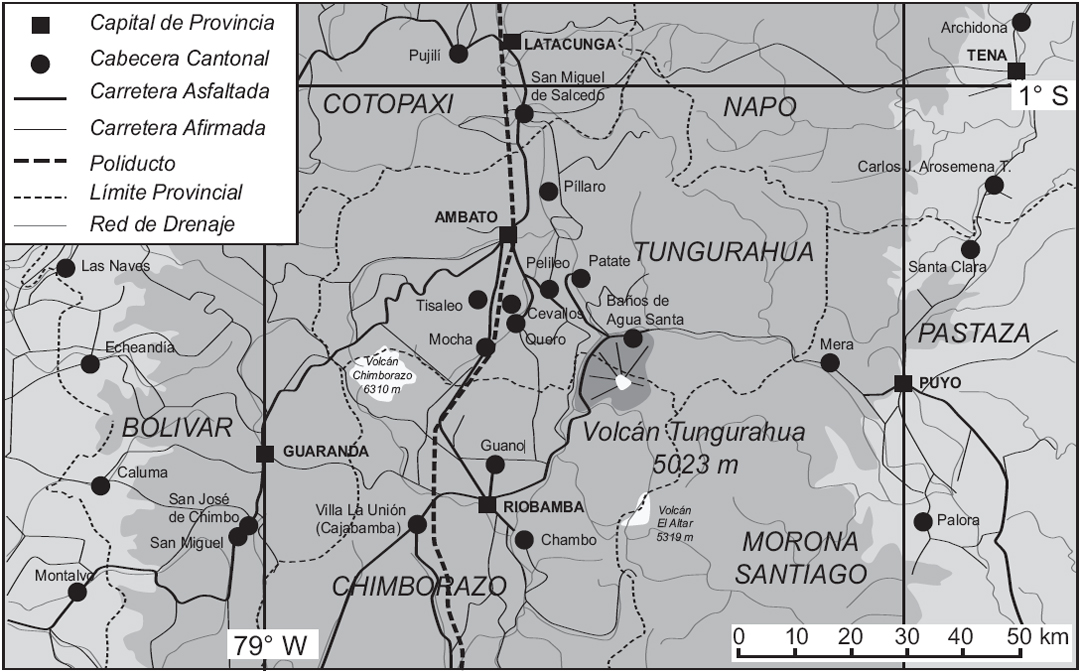 |
Figure 53. Location of Tungurahua and surroundings showing cities and districts, places confronting varying degrees of impacts from the ongoing eruption. Translation of terms in key: province capital, cantonal capital, paved road, dirt road, pipeline, province margin, and drainage network. Taken from Le Pennec and others (2005). |
References. Arellano, S.R., Hall, M., Samaniego, P., Ruiz, A., Molina, I., Palacios, P., Yepes, H., OVTIGEPN staff, 2008. Degassing patterns of Tungurahua volcano (Ecuador) during the 1999-2006 eruptive period, inferred from remote spectroscopic measurements of SO2 emissions. J. of Volcanology and Geothermal Research 176, 151-162.
Carn, S.A., A.J. Krueger, N.A. Krotkov, S. Arellano, and K. Yang, 2008, Daily monitoring of Ecuadorian volcanic degassing from space, J. of Volcanology and Geothermal Research, 176(1), 141-150.
Grutter, M., Basaldud, R., Rivera, C., Harig, R., Junkerman, W., Caetano, E., and Delgado Granados, H., 2008, SO2 emissions from Popocatpetl volcano: emission rates and plume imaging using optical remote sensing techniques, Atmos. Chem. Phys., 8, 6655-6663.
Le Pennec. J-L, Samaniego, P, Eissen, J-P, Hall, MP, Molina, I, Robin, C, Mothes, P, Yepes, H, Ramón, P, Monzier, M, and Egred, J., 2005, Los peligros volcánicos asociados con el Tungurahua, 2nd edición, Serie: Los peligros volcánicos en el Ecuador. Corporación Editora Nacional, ISBN: 9978-84-402-3 (118 pp., in Spanish). [PDF online at http://horizon.documentation.ird.fr/exl doc/pleins_textes/divers11 12/010036187.pdf]
McCormick, B.T., M. Herzog, J. Yiang, M. Edmonds, T.A. Mather, S.A. Carn, S. Hidalgo, and B. Langmann (2013), An integrated study of SO2 emissions from Tungurahua volcano, Ecuador, Journal of Geophysical Research (under review).
Pretor Pinney, G., 2007, The Cloudspotter's Guide: The Science, History, and Culture of Clouds by Gavin, Penguin Group (USA).
Information Contacts: Instituto Geofísico (IG), Escuela Politécnica Nacional, Casilla 1701-2759, Quito, Ecuador; Jorge E. Bustillos A. (IG), Patricia A. Mothes (IG), and Buenos Aires and Washington Volcanic Ash Advisory Centers.
Three periods of intense volcanism during late 2010-2011
Introduction. This Bulletin report covers activity at Tungurahua from November 2010 through December 2011, during which Ecuador's Instituto Geofísico-Escuela Politécnica Nacional (IG) reported three Eruptive Episodes (EE). The last Bulletin (BGVN 38:03) reported explosions and earthquakes at Tungurahua through late July 2010, followed by a lull in activity until October 2010.
This reporting period was characterized by ashfall; lahars; emissions of ash, water vapor, and gases such as SO2; strombolian activity; explosions; various types of earthquakes; and pyroclastic flows (PFs) among other events. Temporally, the majority of these events occurred during EE7 (November-December 2010), EE8 (April-May 2011), and EE9 (November-December 2011). Spatially, the processes such as lahars and PFs followed drainages, the geography of which is partly aided by maps and information in the next section. Intervening periods of low activity occurred during January-March 2011 and June-October 2011. The data presented here was gathered from various types of reports, special bulletins, and announcements published by IG.
Setting. Figure 54 displays a map of Tungurahua that includes ravines on its flanks and nearby inhabited areas. For ravines not seen in figure 54, such as those on the E flank, see figure 22 in BGVN 29:01. Table 8 in BGVN 29:01 gives the distances and direction of towns around Tungurahua, some of which are mentioned in this report. Mapa de Peligros–Tungurahua (Map of Hazards–Tungurahua) can also be viewed on IG's website, for a more general view of Tungurahua and environs.
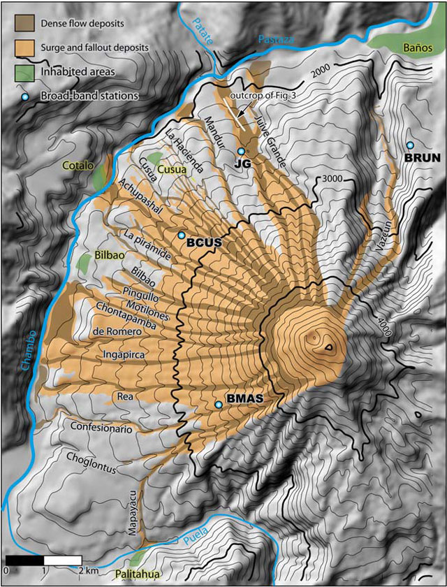 |
Figure 54. Map showing ravines and several inhabited areas around Tungurahua. Part of the network of stations that monitors seismic-acoustic activity is also shown. Deposits (noted in the key) were laid down in the August 2006 eruption. The Chambo and Patate Rivers join to form the Pastaza River, which flows E. Taken from Kelfoun and others (2009). |
Eruptive episodes (EEs). In 2006, IG partnered with Japan's International Cooperation Agency to improve the monitoring of Tungurahua's seismic-acoustic activity, through the deployment of a network of broadband seismic sensors and infrared sensors. By 2008, the network had five stations (BMAS, BPAT, BRUN, BBIL and BULB), each located 5-7 km from Tungurahua's crater (figure 55). The sensors record seismic and acoustic signals propagated by volcanic explosions, emission tremors, booms, and chugging-type events. Information from the sensors and other observations, are used to define each EE. Table 18 shows the nine EEs registered from 2006-2011 based on information from IG's 2011 annual report on Tungurahua's explosive activity.
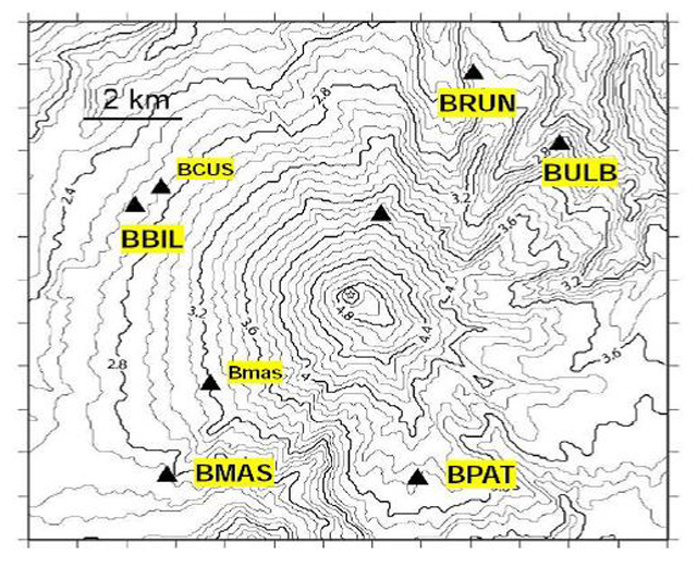 |
Figure 55. Map of the network of stations that monitor seismic-acoustic activity at Tungurahua. Each station is equipped with broadband seismic sensors and infrared sensors. Source: Instituto Geofísico-Escuela Politécnica Nacional (IG). |
Table 18. The nine Explosive Episodes (EEs) recorded by IG at Tungurahua since 2006. The table also shows the number of explosions recorded during each EE. Source: Instituto Geofísico-Escuela Politécnica Nacional (IG).
| Eruptive Episode (EE) | Eruptive Episode Number | Number of explosions |
| 14 July 2006-16 August 2006 | EE1 | 118 |
| 25 February 2007-18 April 2007 | EE2 | 366 |
| 13 July 2007-10 February 2008 | EE3 | 1165 |
| 26 March 2008-27 June 2009 | EE4 | 822 |
| 5 January 2010-19 March 2010 | EE5 | 502 |
| 26 May 2010-28 July 2010 | EE6 | 1331 |
| 22 November 2010-25 December 2010 | EE7 | 110 |
| 22 April 2011-26 May 2011 | EE8 | 64 |
| 27 November 2011-22 December 2011 | EE9 | 55 |
Activity through mid-November 2010. After a four-month lull in activity, Tungurahua revived in November 2010, displaying somewhat elevated seismicity that included a series of volcano-tectonic (VT) earthquakes and a few low-energy explosions. IG's weekly report no.46, detailing activity from 15-21 November, stated that activity remained low with 88 long period (LP) earthquakes; 4 VT earthquakes; weak fumarolic activity; and weak emissions of water vapor and volcanic gases. Rains of varying intensities produced lahars from 15-19 November. On 16 November, the largest lahars of the week descended all of Tungurahua's ravines, with the most significant lahars descending the Mapayacu, Bilbao, and Vazcún ravines (figure 54).
EE7: 22 November-25 December 2010. A sudden increase in activity on 22 November, characterized by explosions in the afternoon and at night, marked the beginning of Tungurahua's EE7, according to IG's 2010 annual report on explosive activity. At 1408, a low-energy explosion was heard around Tungurahua and at the Observatorio del Volcán Tungurahua (OVT), located 14 km to the NW in Guadalupe. Movements of blocks along the upper flanks and an emission of low-to-moderate ash content that moved S accompanied the explosion. At 2235, a sudden large explosion generated an ash plume that rose to more than 7 km in altitude. This explosion triggered the ballistic expulsion of incandescent blocks, which descended ~1.5 km below the crater. Reports of ashfall and falls of gravel were received from communities to the W of Tungurahua, such as Choglontus.
Later, smaller explosions that produced emission columns 2-3 km above the crater were reported. Rains during the late afternoon generated a lahar that descended the Mapayacu ravine and temporarily dammed the Puela River. The Washington Volcanic Ash Advisory Center (VAAC) reported a 7.6 km altitude ash plume, during the night of 22 November, and ash emissions that rose 6.4 km in altitude on the morning of 23 November. EE7 continued until 25 December 2010. Figure 56 shows the number of explosions per day registered during this episode.
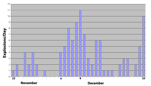 |
Figure 56. Histogram showing the number of explosions per day recorded seismically at Tungurahua from 22 November to 25 December 2010 during EE7. 110 explosions were recorded, with the highest number of explosions occurring on 9 December. Source: Instituto Geofísico-Escuela Politécnica Nacional (IG). |
According to IG's special bulletin no. 20, starting on 24 November 2010, the continuous ash emissions indicated the process of an open system, characterized by the constant generation of emission columns with variable amounts of ash due to an open and unsealed magma ascent path. Ashfall was reported in Ulba, Baños, Juive, Runtún, Bilbao, and Choglontus (settlements located on the NE-SW flanks).
Tungurahua's elevated activity continued through 3 December 2010 with (a) ash emissions, some rising ~3-4 km above the crater; (b) ashfall affecting communities such as Bilbao, Choglontus, El Manzano, and Cahuají; (c) strombolian activity with fountains up to ~1 km above the crater; (d) booming noises of varying magnitude; and (e) the expulsion of incandescent blocks, which rolled as much as ~1 km below the crater. On 29 November, an increase in SO2 was registered by the satellite-based Ozone Monitoring Instrument (OMI). IG also noted an increased SO2 flux through their fixed gas-monitoring stations.
On 4 December 2010, there was a very rapid and sudden increase in Tungurahua's seismic activity after no explosion signals were registered on the preceding days (figure 56). From 0830, the rapid increase in activity was manifested by (a) a speedy rise in the registered internal vibration; (b) an increase in the intensity and duration of booms and explosions; (c) an increase in the volume of emissions with higher ash levels; and (d) blocks moving more than 1.5 km below the crater. Residents in cities on the skirts of the volcano reported feeling vibrations. Due to this sudden increase in activity, the Alert Level was raised to Red by the National Secretariat of Risk Management, and populations around Tungurahua were evacuated.
Around 0939 on 4 December, observers saw pyroclastic flows (PFs) on Tungurahua's W and N flanks. At 0946, several PFs descended the Vazcún ravine. By 1130, PFs were still descending ravines on the W side, such as Mandur, Choglontus, and La Rea. The last PF of the day, at 1404, descended through the Juive sector. All the PFs on 4 December, descended ~2 km from the crater; the largest descended the Vazcún, Juive, and Mandur ravines.
During the afternoon of 4 December, IG noted a reduction in the intensity of activity, although a plume with moderate-to-high ash content rose ~3 km above the crater. Throughout the day, incandescent blocks rolled ~2 km down the flanks. During the evening, the seismic and surface activity continued to decrease. The Alert Level was lowered from Red to Orange.
An IG announcement, released on 4 December 2010, noted that this sudden increase in activity was unexpected in an open system. Special bulletin no. 23, also from 4 December, stated that Tungurahua's increased activity and the generation of PFs were associated with a rapid increase in the volume of magma entering the lower ducts of the volcanic vent and upon finding an open system, the magma was able to quickly rise to the crater and overflow as PFs.
After 4 December 2010, Tungurahua's activity returned to moderate levels. On 5 and 6 December, ashfall occurred in communities to the NW, W and SW. On 7 December, special bulletin no. 24 described activity marked by a constant emission of gases and ash, rising 2-3 km above the crater, occasionally accompanied by incandescent blocks, ejected hundreds of meters above the crater, before falling onto Tungurahua's flanks and rolling 1-2 km. According to that bulletin, secondary transport of ash also affected communities to the W of Tungurahua; crops in that area were reportedly covered by ash, no more than 1 mm thick.
On 9 December 2010, the maximum number of explosions for this EE was recorded (figure 56), and a PF descended also the Cusúa ravine. Tungurahua's explosive activity decreased thereafter. Between 9 and 23 December, activity included: incandescent blocks ejected above the crater rolled down Tungurahua's flanks; plumes containing variable amounts of ash often rose as high as 2-3 km above the crater; ashfall was reported in nearby communities; explosions caused vibrations of windows, "cannon shots", and plumes; and lahars. According to special bulletin no. 26, from 13 December, there was an increase in the number of LP earthquakes and from15 December, several VT earthquakes were recorded.
Between 24 and 25 December 2010, IG registered a series of small-to-moderate-sized explosions. Figure 56 shows 10 explosions were recorded on 25 December, after which explosive activity was reported to have stopped. Special bulletin no. 1, from 5 January 2011, stated Tungurahua's monitoring system had detected: smaller plumes with lower ash content; no explosions since 25 December 2010; fewer LP earthquakes and emission tremors (26 December 2010, 36 LPs and 4 emission tremors were recorded, while on 2 January 2011, 18 LPs and 1 emission tremor); decreased SO2 emissions (26 December, 2,200 tons/day of SO2 were recorded, but days before 5 January, 200 tons/day were recorded); and less pressure in the upper part of the cone. IG also reported 10 small VT earthquakes, interpreted to represent the entrance of new magma into the volcanic system and precursors to an increase in explosive activity.
Lull during January-March 2011. Weekly reports in January described moderate activity until 5 January, after which activity was moderate to low through 18 January. Special bulletin no.2 stated that between 5 and 17 January emissions mainly consisted of water vapor. January ended with activity being low and it remained so for the next two months (figure 57).
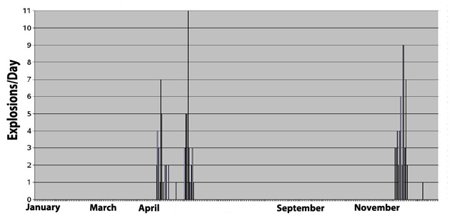 |
Figure 57. Histogram showing the number of explosions recorded per day at Tungurahua from January to December 2011. Source: Instituto Geofísico-Escuela Politécnica Nacional (IG). |
EE8: 22 April-26 May 2011. Tungurahua's monitoring stations began to register an episode of volcanic tremor at 1714 on 20 April 2011. A plume with low-to-moderate ash content rose 3 km above the crater and drifted SW. This was the first major sign of surface activity since the beginning of 2011. An IG announcement from 20 April stated that small seismic fracture events were observed. Deformation observed in the NW quadrant since February 2011 had recently increased. During the night of 20 April, IG personnel witnessed strombolian activity, accompanied by constant booms of moderate intensity. Incandescent blocks also rolled 1 km down the flanks.
At 1512 on 22 April 2011, a moderate-sized explosion signaled the beginning of Tungurahua's EE8, according to the 2011 annual report on explosive activity. EE8 continued until 26 May and was characterized by a total of 64 explosions (figure 58). According to IG's weekly report no. 16, detailing activity from 18-24 April, low-intensity rains produced muddy water in some of Tungurahua's ravines. During this interval, plumes with moderate-to-high ash levels rose 5 km above the crater. On some nights, strombolian activity was observed, and ashfall of varying intensities affected numerous settlements including Choglontus, Bilbao (figure 59), El Manzano, Puela, Cusúa, Guadalupe, Baños, Ulba, and Cevallos. SO2 was measured at 571 tons/day on 19 April and increased each day until it reached a maximum of 6,015 tons/day on 24 April.
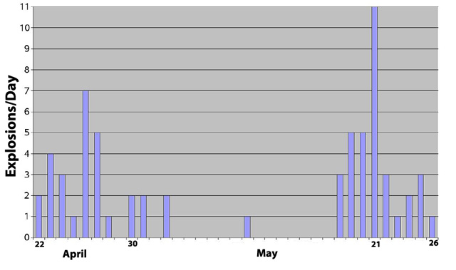 |
Figure 58. Histogram showing the number of explosions recorded per day at Tungurahua from 22 April to 26 May 2011. In total, 64 explosions were recorded, with the maximum number of explosions occurring on 21 May. Source: Instituto Geofísico-Escuela Politécnica Nacional (IG). |
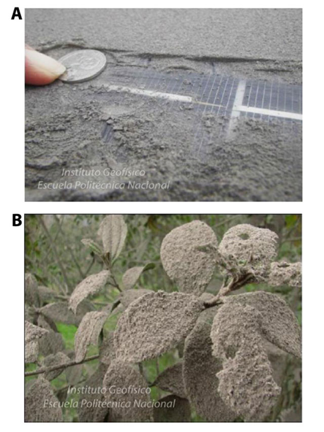 |
Figure 59. (A) Ash covering the surface of a solar panel in Bilbao (8 km W of Tungurahua) on 24 April 2011. (B) Ash covering vegetation in Bilbao on 24 April 2011. In Bilbao, ash accumulated over 12 hours due to constant emissions and reached a thickness of ~3 mm. Source: Instituto Geofísico-Escuela Politécnica Nacional (IG). |
According to special bulletin no. 5 from 26 April 2011, during 20-26 April ash emissions were accompanied by booms of varying intensity, lava fountains, and incandescent blocks rolling down the upper flanks. Data collected by inclinometers showed continued deformation in the NW quadrant.
On 26 April 2011, volcanic activity increased (figure 58), starting around 1245, with ash emissions rising 8-12 km above the crater. Areas to the NW and W experienced ashfall. OVT received reports that activity caused vibrations of the ground in areas close to the volcano. In Baños (8 km N), vibrations of doors and windows were reported. The National Secretariat of Risk Management declared an Orange Alert Level for areas around the volcano and evacuated families in Cusúa, Bilbao, and Chacauco. A widening of the volcanic cone was also detected on 26 April.
Another increase in activity occurred on 29 April 2011 and lasted for 48 hours. At ~0100, an increase in seismic amplitude and the presence of harmonic tremor were registered. Emissions with moderate-to-high ash content were often observed rising 2-3 km above the crater, moving NE. Baños, Runtún, Ulba, Juive and Cusúa received notable ashfall, while in Guadalupe, ash was lightly deposited. Emissions also rose 7 km above the crater and drifted mainly SE toward uninhabited areas. Strombolian eruptions also ejected blocks from the crater.
According to special bulletin no. 7, published on 3 May, the intensity of Tungurahua's emissions started to slowly decrease on 1 May, until returning to levels similar to those observed at the beginning of this EE. Special bulletin no. 7 also stated that Tungurahua's seismic and deformation monitoring systems continued to show evidence of internal pressurization. That bulletin also mentioned that IG and the French Institute for Research and Development (IRD) had estimated that ~1.6x10⁶ m3 to 3x10⁶ m3 of ash was deposited in areas around Tungurahua during an unstated amount of time; the maximum thickness reached 15.5 mm (figure 60).
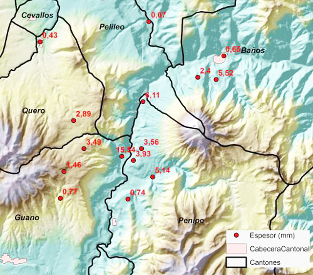 |
Figure 60. Map of accumulated ash thickness in areas around Tungurahua as measured on 2 May 2011. The interval over which the ash accumulated was unstated. Thicknesses were measured in mm. The English translations for the Spanish words in the key are: Espesor, thickness; Cabecera Cantonal, cantonal capital; and Cantones, districts. Source: Instituto Geofísico-Escuela Politécnica Nacional (IG). |
Special bulletin no. 8 from 6 May 2011 stated that since 3 May, surface activity had continued to decrease with respect to the height, frequency, and ash content of the plumes and in the number of explosions. Nevertheless, IG warned that the decrease in emissions did not signal the end of this EE. Evidence of increasing internal pressure, presumably caused by the ascent of a new volume of magma towards the upper volcanic ducts, continued to be registered through deformation recorded by GPS and inclinometers, rock fracture earthquakes, and constant emission of volcanic gases. SO2 fluxes surpassed 2,000 tons/day.
After 6 May, Tungurahua experienced a slight lull in its eruptive activity for ~ 10 days; however, roaring was sometimes still heard, ashfall was reported, and on 10 May an explosion produced an ash plume that rose 5 km above the crater. More consistent and elevated activity resumed at 2222 on 16 May when gas-and-ash plumes rose between 1.5 and 2 km above the crater and drifted NE. At dawn on 17 May, significant ashfall was reported in Río Negro, ~25 km E of Baños. Special bulletin no. 9 (issued 17 May) said that a slight decrease in deformation was recorded by inclinometers as well as a reduction in the gas fluxes (less than 300 tons/day were recorded through 16 May). On the afternoon of 17 May, new fumaroles were also identified ~ 1,000 m below the summit on the W flank.
Through 19 May 2011, Tungurahua continued emitting vapor and gas containing variable amounts of ash. Ashfall affected communities in the NE-E-SE sectors such as Río Negro, Baños, Runtún, Cusúa, and Bilbao. The greatest measured thickness was 3 mm in Trigal, located to the SE. At midday on 19 May, observers witnessed explosions of significant sizes producing ash plumes that rose 3 km above the crater and drifted W and SW.
During 18-25 May 2011, seismic activity was characterized by 37 explosions, the majority of which occurred on 21 May (figure 58). Some of the explosions generated "cannon shots" that vibrated structures in nearby areas. Activity was characterized by high seismicity, including LP events and tremors. On 25 May, surface activity had decreased, but seismicity was moderate-to-high, deformation continued, and SO2 was being still emitted.
Constant rains during 27-28 May generated lahars and the swelling of rivers. On 27 May, a large lahar descended the Pingullo ravine, halting traffic along the road between Baños and Penipe. Muddy water moved down the Juive, Vazcún, Pondoa, Bilbao, Mapayacu, Ulba, and Achupashal ravines. On 28 May, flows of muddy water traveled down the Bilbao, Pondoa, Juive, and La Pirámide ravines; swelling of the Chambo and Puela rivers was reported; and the Ulba River doubled its volume and carried large blocks of rock. At the end of May 2011, activity returned to moderate levels.
Lull from June to October 2011. A second lull in explosive activity occurred (figure 57). On 29 July, 20 landslides took place along the Baños access road, a vital escape route.
On 7 October 2011, the Washington VAAC reported an ash plume that rose ~1 km above Tungurahua's crater and drifted W. On 24 October, another ash plume rose slightly over 2 km above the crater and drifted W. However, IG stated they had not observed any ash emissions since June. On 9 November, the Washington VAAC reported an ash plume, while IG reported only gas-and-steam emissions. On 15 October, IG also reported the reactivation of a fumarole, first observed in May 2011, on Tungurahua's W flank. The fumarole's activity lessened during the following week.
EE9: 27 November-22 December 2011. Three explosions (figure 61) on 27 November marked the beginning of Tungurahua's EE9, which continued to 22 December.
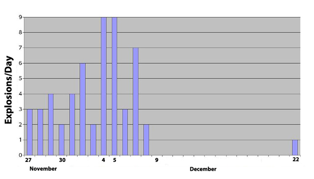 |
Figure 61. Histogram showing the number of explosions recorded per day at Tungurahua from 27 November to 22 December 2011. During this EE, 55 explosions were recorded and the maximum number of explosions was registered on 4 and 5 December. Source: Instituto Geofísico-Escuela Politécnica Nacional (IG). |
On 27 November 2011, seismic activity began steadily increasing at 1540. At 1700, explosions of varying sizes were detected. Booms and "cannon shots" produced by the explosions were heard in areas close to Tungurahua. As activity progressed, explosions generated PFs that descended ravines on the NW and W flanks. The explosions also ejected incandescent blocks that rolled to ~1 km below the crater. Four VT earthquakes were also registered beginning at 1650. IG received reports of ashfall in El Manzano and Bilbao; deposits of coarse-grained ash in Pillate; ash with shards in Cotaló; and only shards in Cusúa. Later, PFs descended the S and SW flanks. Distances traveled by the PFs on the NW, W, S and SW flanks were unstated.
During the last days of November 2011, activity remained high. On 28 November, an explosion ejected incandescent material and generated a PF in the Achupashal ravine. There were also almost constant booms of moderate-to-high intensity, lava fountains, and ejected incandescent blocks that traveled ~1 km down the W and NW flanks. A constant ash plume rose 3 km over the summit. Small PFs descended the S flank, and ash fell in El Manzano, Choglontus, and Runtún. At night, incandescent blocks were observed being ejected above the crater before they descended 400-500 m down the flanks.
On 29 November, two PFs were observed: the first traveled ~500 m down the NW flank; the second traveled ~1 km down the Pingullo ravine. Almost-constant booms of moderate-to-high intensity and muddy water flowing down several ravines on the W side were noted. Ash-and-gas plumes rose up to 4 km above the crater, and tremor was constant. On 30 November, plumes rose to average heights of 2 km and minor ashfall in Baños and Río Verde was reported.
Activity remained high during the beginning of December. On the night of 1 December, a decrease in tremor amplitude coincided with an increase in the number of explosions. Strong "cannon shots" were generated by some of the explosions and incandescent blocks ejected onto the flanks rolling 1 km downslope. Heavy rains during the night led to the descent of lahars in the Mapayacu and La Pampa ravines and the swelling of the Vazcún River. Early on 2 December, an increase in tremor amplitude corresponded with moderate to strong booms. An ash plume later rose 1.5 km above the crater, drifting E.
During the night of 2 December and dawn of 3 December, IG noted two periods with increased tremor amplitude, during which a great volume of incandescent blocks was expelled and high intensity booms resonated through nearby communities. On 3 December, several PFs traveled ~1.5 km in the upper parts of La Rea and Ingapirca ravines and ravines on the NW flank. A plume with high ash content rose 2-3 km above the crater. Ash fell in settlements, including Bilbao, Cusúa, El Manzano, and Penipe.
During 4-5 December, the maximum number of explosions for EE9 was recorded (figure 61). On both days, seismicity consisted of constant tremor intermixed with explosions. On 4 December, strong booms and "cannon shots", both associated with explosive activity, were reported by communities close to Tungurahua. A plume with moderate-to-high ash content rose 4 km high, a small PF was noted, and ash fell in Bilbao, Cusúa, and El Manzano. On 5 December, an ash plume rose 1 km above the crater and drifted N and NE, leading to ashfall in Baños and Runtún. Booms of low to moderate intensity were also reported. On 7 December, explosions generated "cannon shots" of moderate intensity; blocks descended the flanks generating noises; a plume with moderate ash content rose 1.5 km above the crater and drifted W; and Cusúa and Chacauco received ashfall. On 8 December, similar conditions prevailed, but some plumes also rose as high as 4 km above the crater.
Activity declined on 9 December according to special bulletin no. 18. Emissions contained only water vapor. SO2 fluxes had fallen to 500 tons/day, which was significantly less than the maximum 8,000 tons/day measured after 28 November. Special bulletin no. 18 noted that despite these declines, seismic events such as LP and VT earthquakes were still recorded (between 60 and 170 LP earthquakes were registered daily). That special bulletin also remarked that the network for deformation monitoring did not register any evidence of the ascent of a new volume of magma towards the surface. This decline in activity lasted until 21 December.
From about 0830 on 22 December, several seismic events indicated the movement of fluids within Tungurahua's interior. Three explosions produced ash plumes that rose less than 500 m above the crater, the second explosion of which led to a PF that descended 300-400 m down the NW flank. That afternoon, a high-energy explosion generated two PFs that descended the Achupashal and La Hacienda ravines. An ash plume rose 4 km above the crater and drifted NW. The PFs descended to a maximum of 2 km below the crater, without reaching inhabited or cultivated areas. Ashfall was reported in N and W communities. Ash-and-gas plumes continued, and at night strombolian activity ejected blocks ~500 m above the crater, which landed and rolled 500 m below the crater.
For the rest of December 2011, activity was considered moderate. After 22 December, ash was often deposited in areas to the SW of Tungurahua such as El Manzano and Choglontus, where up to 2-4 mm of ash was deposited. On 23 December constant gas-and-ash emissions rose ~200 m above the crater and were carried SW. Ashfall was reported in El Manzano, Choglontus and Chacauco. On 24 December, no surface observations were made, but there were reports of ashfall in El Manzano, Choglontus and Cahuají. On 25 December, an emission with moderate-to-high ash content was observed rising 500 m above the crater and drifted W. Ashfall was reported in El Manzano. From 27 to 29 December, the area around Tungurahua was cloudy and no reports of booms or ashfall were received. On the last day of 2011, small emissions of water vapor and minor rains were reported.
References. Kelfoun, K., Samaniego, P., Palacios, P., Barba, D., 2009. Testing the suitability of frictional behaviour for pyroclastic flow simulation by comparison with a well-constrained eruption at Tungurahua volcano (Ecuador). Bulletin of Volcanology, v. 71(9), p. 1057-1075 (URL: http://dx.doi.org/10.1007/s00445-009-0286-6)
Information Contacts: Instituto Geofísico (IG), Escuela Politécnica Nacional, Apartado 17-01-2759, Quito, Ecuador (URL: http://www.igepn.edu.ec/); Washington Volcanic Ash Advisory Center, Satellite Analysis Branch (SAB), NOAA/NESDIS E/SP23, NOAA Science Center Room 401, 5200 Auth Rd, Camp Springs, MD 20746, USA (URL: http://www.ospo.noaa.gov/Products/atmosphere/vaac/).
Nine ash plumes over 10 km altitude 2011-2014; lava flow in April 2014
Abundant ash emissions, Strombolian activity, pyroclastic flows, lahars, and a few lava flows have all been documented at Tungurahua, which lies in the center of Ecuador. Historic observations are recorded back to 1557, and radiocarbon dates are as old as 7750 BCE. Prior to renewed activity in 1999, the last major eruption had occurred during 1916-1918. Since 1999, there have been numerous eruptive episodes, but only a few with breaks in activity longer than three months. Our last bulletin report (BGVN 40:03) covered the first part of the eruption that began on 22 November 2010. This report details activity from November 2011 through December of 2014. Tungurahua is monitored by the Observatorio del Volcán Tungurahua (OVT) of the Instituto Geofísico (IG) of Ecuador, and aviation alerts are reported by the Washington Volcanic Ash Advisory Center (VAAC).
Summary of November 2010-December 2014 activity. After a period of quiescence from 29 July through 21 November 2010, a new eruption began with a series of ash explosions and Strombolian activity on 22 November. Explosions continued through 25 December 2010 (BGVN 40:03), and emissions containing ash continued through 2 January 2011. A new eruption with tremor and ash emissions began on 20 April 2011; explosions with substantial ash plumes occurred on 22 April. Strombolian activity was frequent, and ashfall affected numerous communities within 10 km for the next five weeks. This episode ended with explosions and ash plumes on 21 May (BGVN 40:03), followed by ashfall reported to the SW through 26 May 2011. After damaging lahars at the end of May, Tungurahua was quiet until November 2011.
Volcanic activity between November 2011 and December 2014 occurred in eight discrete episodes (table 19). The length of these episodes ranged from 3 weeks to 9 months, and the lengths of the breaks between them lasted from 4 weeks to 3 months. Ash plumes rising several kilometers above the 5-km-high summit and ashfall in communities tens of kilometers from the volcano characterized each episode. Strombolian activity also sent incandescent blocks down the flanks hundreds of meters, pyroclastic flows traveled several kilometers down the ravines, and lahars during the wet seasons flooded drainages and frequently damaged roadways. A lava flow several hundred meters long descended the upper W flank in April 2014.
Table 19. Episodes of activity at Tungurahua, November 2011 through December 2014. These episodes are based on reported activity as described in this report, and may not correspond to current or previous "Eruptive Episodes" identified by IG.
| Episode Start | Episode Stop | Approx. Duration | Following Interval of Repose |
| 27 Nov 2011 | 4 Sep 2012 | 40 weeks | 12 weeks |
| 14 Dec 2012 | 24 Jan 2013 | 7 weeks | 5 weeks |
| 01 Mar 2013 | 24 Mar 2013 | 3 weeks | 4 weeks |
| 24 Apr 2013 | 15 May 2013 | 3 weeks | 8 weeks |
| 13 Jul 2013 | 23 Aug 2013 | 6 weeks | 6 weeks |
| 06 Oct 2013 | 12 Nov 2013 | 5 weeks | 11 weeks |
| 30 Jan 2014 | 11 May 2014 | 14 weeks | 11 weeks |
| 17 Jul 2014 | 15 Dec 2014 | 20 weeks | -- |
Hundreds of ash plumes were emitted over this time period. Nine times, the ash plumes were recorded at altitudes over 10 km (more than 5 km above the summit) (table 20), with the highest on 4 April 2014 rising to 15.2 km altitude (50,000 ft).
Table 20. Ash plumes over 10 km altitude recorded at Tungurahua between November 2011 and December 2014.
| Date (local) | Altitude (km) | Drift direction(s) | Distance (km) |
| 27 Nov 2011 | 10.7 | WNW | 100 |
| 03 Dec 2011 | 11.0 | SW | 110 |
| 22 Dec 2011 | 12.2 | NE | -- |
| 04 Feb 2012 | 12.2 | NE | 250 |
| 11 Apr 2012 | 10.7 | NE, W, SE | 170 |
| 16 Dec 2012 | 12.2 | NW, NE | 140 |
| 14 Jul 2013 | 13.7 | NNE, WNW | 370 |
| 01 Feb 2014 | 13.7 | S, SW | -- |
| 04 Apr 2014 | 15.2 | NW, N, NE | 300 |
Activity during May 2011-September 2012. After loud explosions and ash emissions on 21 May 2011, constant rains at the end of May caused lahars and muddy water to descend the ravines of Tungurahua (BGVN 40:03). Ashfall was reported on 26 May, although cloud cover prevented observations of plumes. No further ash emissions or thermal anomalies were confirmed for six months. The Washington VAAC issued a volcanic ash advisory on 7 October based on a report from IG, and two additional reports on 24 October and 9 November from pilot reports. They noted that no ash was visible in satellite imagery at the time of those reports; on 9 November a revised statement from IG stated that no ash emissions had occurred since June.
A new eruption began on 27 November 2011, when three large explosions generated pyroclastic flows and caused ashfall within 10 km in several communities. Ashfall was reported in El Manzano (8 km SW), Bilbao (8 km W), Pailitas (8 km W), Cotaló (8 km NW), and Cusúa (8 km NW) (figure 62). The first Washington VAAC reports after these explosions noted an ash plume at 10.7 km altitude (5.7 km above the summit crater) drifting WNW and extending about 100 km from the summit.
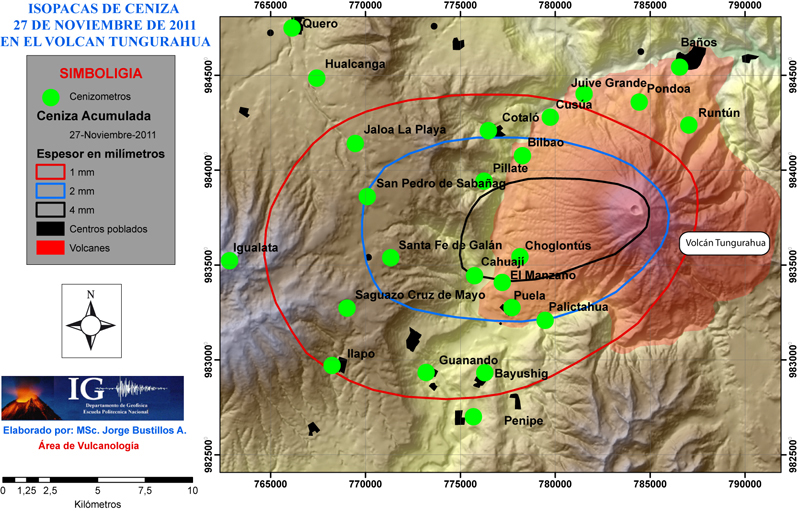 |
Figure 62. Isopach map of ashfall accumulation around Tungurahua on 27 November 2011. Courtesy of IG (Resumen Mensual, Actividad del Volcan Tungurahua, November 2011). |
During the next three weeks, nearly constant ash emissions with plumes as high as 11 km altitude (3 December) deposited ashfall in numerous communities. In addition to those communities mentioned above, Choglontús (13 WSW), Chacauco (17 km NW), Cahuají 8 km SW), Baños (9 km N), and Vazcún also received ashfall during this period. Many residents in Cusúa, Juive (8 km NNW), Palitahua (6 km SSW), and El Manzano evacuated voluntarily. Strombolian activity sent large incandescent blocks 500 m above the crater and 1,000 m down the flanks (figure 63), and pyroclastic flows traveled as far as 2 km down the flanks (BGVN 40:03). MODVOLC thermal alerts were issued on 1 and 4 December. Substantial plumes of SO2 were recorded by NASA's Global Sulfur Dioxide Monitoring system between 28 November and 8 December (figure 64).
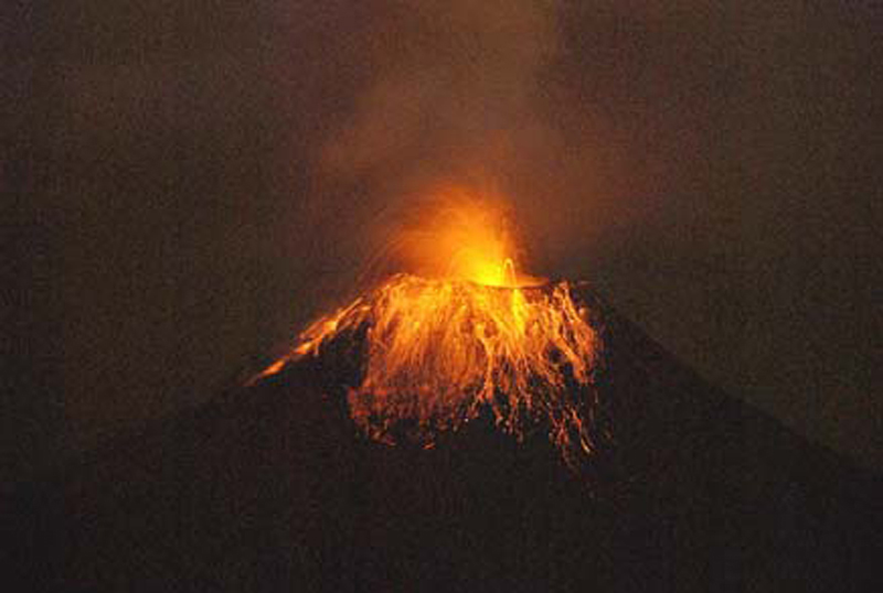 |
Figure 63. Strombolian activity at Tungurahua sometime between 27 and 30 November 2011. Incandescent blocks reached 500 m above the crater, and traveled up to 1,000 m down the flanks. Courtesy of IG; photo by J. Bustillos, IG-EPN (Resumen Mensual, Actividad del Volcan Tungurahua, November 2011). |
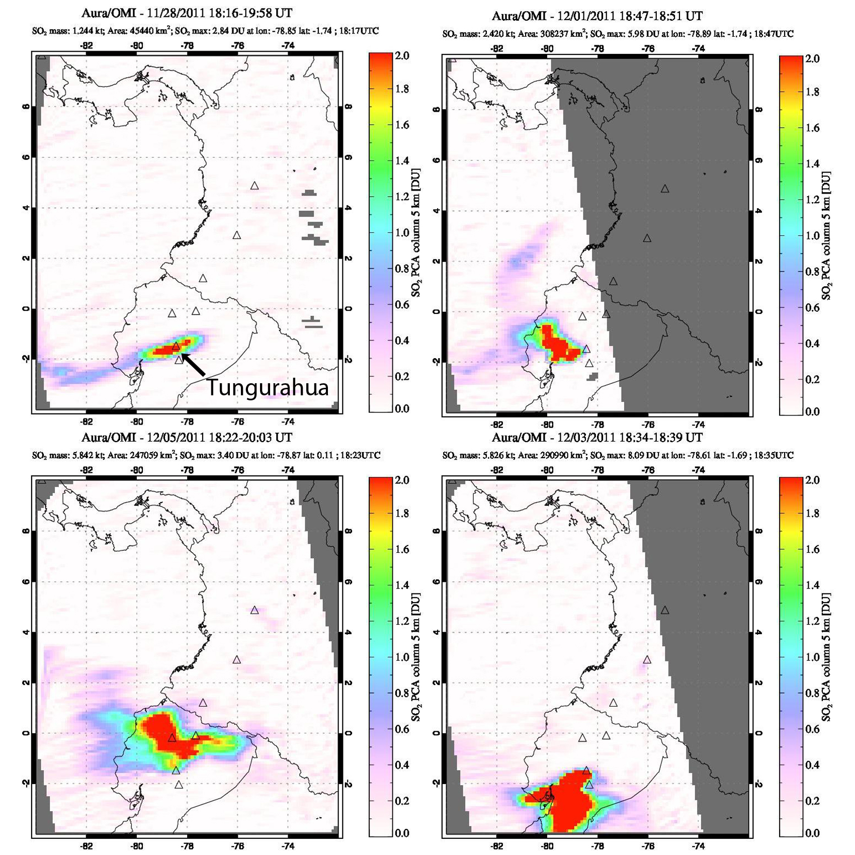 |
Figure 64. Plumes of SO2 at Tungurahua between 28 November and 5 December 2011. The plumes dispersed in multiple directions and were detected as far as 300 km from the volcano. Clockwise from top left: 28 November, 1 December, 3 December, and 5 December. Gas plumes were detected through 8 December 2011. Courtesy of NASA GSFC (Goddard Space Flight Center). |
Another major explosion on 22 December sent ash plumes to 12.2 km (7.2 km above the summit), according to the Washington VAAC. Emissions continued through 28 December. Ashfall from explosions near the end of December accumulated to a depth of 2-4 mm in villages to the SW. After two weeks of quiet, with only steam plumes emitting from the summit, a series of explosions between 12 and 15 January 2012 caused ashfall in communities up to 10 km SW. Ash plumes reported by IG rose to 7 km altitude; weather clouds often prevented satellite observations. Three lahars occurred during this time; one descended the Achupashal drainage on the NW flank carrying blocks up to 1 m in diameter, and the other two descended the Juive and Pondoa drainiages farther N on the NW flank, carrying blocks 10-20 cm in diameter. Another lahar on 21 January traveled down the Pampas drainage.
A large explosion on 4 February 2012, with an ash plume reported by the Washington VAAC at 12.2 km altitude, caused lapilli and ash to fall in communities as far away as Cevallos (23 km NW). Ongoing emissions were reported five hours later; the ash cloud was observed 250 km NE near the Ecuador-Colombia border. A pyroclastic flow also descended the Achupashal drainage, and incandescent blocks traveled 1 km down the flanks. Ash plumes during 17-18 February were reported by IG to rise to 6 km altitude, although weather clouds obscured satellite images. From 23 February to 13 March, numerous ash plumes caused ashfall in most communities NW and SW of the volcano, as far as Choglontus (13 km WSW). The Washington VAAC and IG both reported plumes as high as 8.5 km altitude (3.5 km above the summit crater) drifting W and SW during this time. Strombolian activity ejected material 500 m above the crater and onto the W and NW flanks on 24 February, and another pyroclastic flow was observed in the Achupashal drainage on 4 March. Lahars descended the Chacauco (NW) and Mapayacu (SW) drainages on 11 March.
After a short break, explosions were again detected on 19 March 2012. During brief periods when the crater was visible, observers noted incandescence and a few blocks rolling 200 m down the flank. A single MODVOLC thermal alert pixel was recorded on 20 March. IG and the Washington VAAC reported numerous ash plumes between 20 and 29 March, although weather clouds and precipitation made observations difficult for much of the month. Ashfall was reported in the villages within 10 km in most directions. Heavy rain during 24-25 March generated lahars in the Pampas area to the S and caused flooding in the Puela (8 km SW), Palitahua, and Ulba (10 km NNE) sectors. Additional lahars on 1 April descended the Pingullo and Achupashal (NW) drainages, carrying material 30 cm in diameter and causing a temporary road closure.
Persistent ash emissions rising to 8 km altitude and higher began again on 9 April 2012, and occurred with few breaks until mid-June when they became more intermittent. Ashfall was commonly reported from villages within 10 km during this period. A large plume on 11 April was reported by the Washington VAAC at over 10 km altitude drifting NE and SE (figure 65); rice-sized tephra fell in Pillate (7 km W) on 22 April. Ashfall covered houses and pastures in Bilbao and Pillate on 6 May. Several plumes in early June (3, 5, 10, 11, 13) resulted in ashfall, with noise and vibrations noted, within 10 km. IG staff witnessed an ash emission on 4 June (during an overflight) that rose about 1 km above the crater and drifted E (figure 66). Numerous lahars descended drainages on the W and SW flanks in late April, and again down the W flank on 16 May. On 7 June a lahar caused a temporary closure of the Baños-Penipe highway. Smaller lahars were reported in the same area on 24 June.
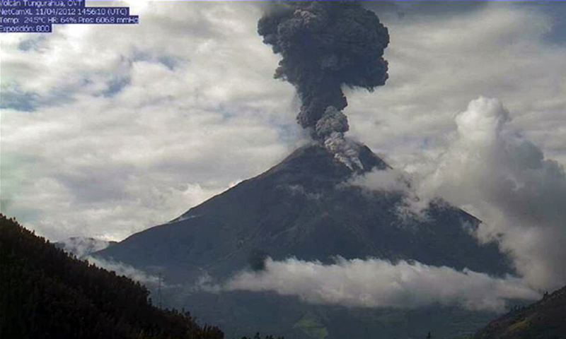 |
Figure 65. A large ash plume at Tungurahua that rose to 10.7 km altitude on 11 April 2012 was seen using the OVT webcam located near Guadalupe, 13 km N of the crater. Two block-and-ash flows are also visible, caused by the rolling of large blocks down the flank that disperse newly fallen ash as they descend the drainage. Courtesy of IG (Informe semanal No. 15-Volcan Tungurahua, 9-15 April 2012). |
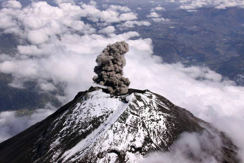 |
Figure 66. Ash emissions and snow on the summit at Tungurahua on 4 June 2012 were observed during an IG overflight. The plume rose about 1 km and drifted E. Courtesy of IG; photo by P. Ramon OVT/IG (Informe semanal No. 23 – Volcan Tungurahua, 4-10 June 2012). |
After an explosion on 27 June 2012 generated an ash plume that rose to 3 km above the crater, only small intermittent explosions with ash plumes occurred during July; steam-and-gas plumes rising up to 1 km above the summit were more common (figure 67). Incandescence at the summit and small explosions were noted on 25 July, and a few days later muddy waters carried blocks 50 cm in diameter down several S and W flank drainages. Surface and seismic activity increased noticeably during the last week of July.
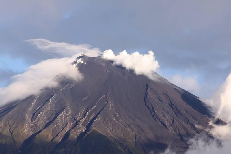 |
Figure 67. Fresh ash covers the snow on 7 July 2012 at Tungurahua, probably from an explosion on 5 July. View is to the south. Courtesy of OVT/IG; photo by P. Ramón OVT/IG, (Informe semanal No. 27 – Volcan Tungurahua, 2-8 July 2012). |
Explosions on 5 August 2012 rattled windows in nearby areas and produced sounds resembling gunshots. A plume rose 3 km above the crater and drifted W. Several periods of continuous ash emissions occurred during the rest of the month; ashfall was reported in villages within 10 km many times. Incandescent blocks that were ejected 100 m above the crater fell 500 m down the flanks on 12-13 August. Activity significantly increased with strong explosions on 17 August. The next day, five small pyroclastic flows descended the NW and NE flanks, stopping 2.5 km from the crater. Numerous explosions continued on 19 and 20 August, with steam-and-ash plumes rising 1.5-2 km above the summit and drifting W and SW. Ash fell in communities farther to the NW than in previous months, including in Igualata (20 km W), El Santuario, Hualpamba, Cevallos (23 km NW), Quero (20 km NW), Mocha (25 km WNW), Santa Anita, and Tisaleo (29 km NW). IG scientists determined that an approximate volume of 400-500,000 cubic meters of ash was deposited within 15 km of the volcano between 10 and 20 August. The maximum deposit thicknesses were 3 mm in Yuibug, 2 mm in Pillate, 1.5 mm in Choglontús and Chontapamba, 1 mm in Cahuají, and 0.5 mm in Puela (figure 68).
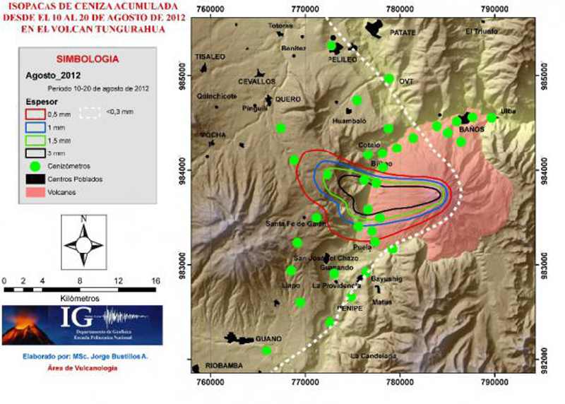 |
Figure 68. Isopach map of ashfall accumulation around Tungurahua during 10-20 August 2012. Courtesy of IG (Boletín Especial del Volcán Tungurahua No. 4, 25 Aug 2012). |
An overflight on 20 August revealed an 80-m-wide inner crater. On 21 August, 16 large explosions caused windows to rattle. Strong "cannon shots" were heard in areas as far away as Ambato (31 km NW) and Riobamba (30 km S), although noises had decreased in intensity and duration compared to the previous few days. Ash plumes rose as high as 9.7 km altitude and drifted W, and a pyroclastic flow traveled 2.5 km down the NW flank that day. MODVOLC thermal alert pixels appeared during 16-23 August. Explosions and ash plumes rising up to 4 km above the crater continued for the rest of August, along with ejected incandescent tephra and ashfall in nearby communities. IG reported that the intensity of seismic tremor and emissions decreased beginning on 21 August.
NASA's Global Sulfur Dioxide Monitoring system captured SO2 plumes during 13-21 August, and again from 31 August to 3 September. An explosion on 3 September produced an ash plume that rose 300 m above the crater; two MODVOLC thermal alerts also appeared that day. A final ash plume was reported by IG on 4 September rising to 6.7 km altitude (1.7 km above the summit), but dense cloud cover prevented satellite observation. No more ash plumes were reported until 14 December 2012.
Activity during December 2012-January 2013. A major rainfall event on 1 December generated a large lahar that descended the Vazcún drainage on the N flank, causing an evacuation of people at the El Salado resort (8 km N) before the 6-m-deep lahar that carried 3-m-diameter blocks reached the area. An increase in seismicity beginning on 12 December preceded a large explosion on 14 December. The explosion created an ash plume, identified in satellite imagery by the Washington VAAC, that rose to 7.9 km altitude. The leading edge of the 10-km-wide, detached plume was 15 km SE of the summit. Pyroclastic flows traveled down the SW flank. A smaller ash plume the next day caused a trace of ashfall in Runtún (6 km NNE).
Three large explosions on 16 December 2012 ejected incandescent blocks and expelled an ash plume, containing lightning, that rose to 12.2 km altitude (7.2 km above the summit) (figure 69). The soundwaves from the explosion reportedly broke the windows of the church of Cusúa. The Washington VAAC identified the plume in satellite imagery extending up to 140 km NW, and 110 km NE at a lower altitude of 7.9 km. Ashfall was reported up to 31 km NW from Tungurahua, in Cotaló (8 km NW), Pondoa (8 km N), Runtún, and Pillate (8 km W). More specifically, coarse-grained ash fell in Baños (9 km N), Vascún, and Ulba (NNE), and medium-to-fine-grained ash fell in Palitahua (S), Choglontús (SW), El Manzano (8 km SW), Capil, Guadalupe Observatory (13 km N), Cevallos (23 km NW), Tisaleo (29 km NW), Ambato (31 km NW), Patate (NW), Píllaro, Pelileo (8 km N), Salcedo, and Pujilí, Latacunga, Rio Verde, Agoyán, and Palora.
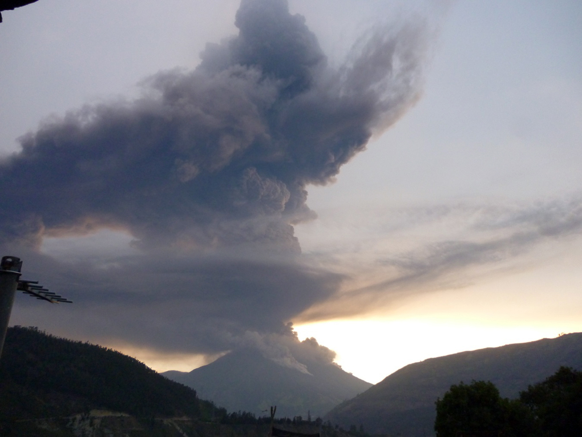 |
Figure 69. Ash plume and pyroclastic flows from explosions at Tungurahua at 0553 on 16 December 2012. View to the south from the OVT webcam, located near Guadalupe, about 13 km N of the crater. Courtesy of IG; photo by V. Valverde (IG-OVT) (Informe Especial del Volcán Tungurahua No. 10, 16 December 2012). |
Explosions and ashfall continued on 17 December; a dense ash plume was observed drifting over 200 km NE at an altitude of 7 km. A seven-pixel MODVOLC thermal alert also appeared. Substantial SO2 plumes were recorded by the OMI satellite instrument between 16 and 29 December. Two pyroclastic flows traveled 3-4 km down the flanks and burned vegetation on 18 December. Explosions shook structures, were often heard by local residents, and generated ashfall in the neighboring communities for several days. The following week, ash plumes decreased in frequency and density, but explosions of incandescent blocks increased. During 21-24 December Strombolian explosions appeared at night; they peaked at over 500 m above the crater, sending blocks more than one kilometer down the W and NW flanks. On the night of 23 December, observers noted intermittent lava fountains rising to 500 m. Another MODVOLC thermal alert pixel was recorded on 24 December. After this, seismicity decreased significantly; the Washington VAAC last reported emissions on 30 December.
Trace amounts of ashfall were reported by IG on 6 and 10 January 2013 in Choglontús (SW) and El Manzano (8 km SW), after small explosions on those days. Explosions, but no ash, were recorded on 21 January; in the evening of 24 January, a column of steam and gas with very low ash content rose less than 1 km and drifted W and SW after reported explosions. The lookout at Palitahua reported black ashfall the following morning. After this, Tungurahua was quiet until the end of February 2013.
Activity during March 2013. IG reported increased seismicity on 28 February 2013. Explosions occurred, and ash emissions rose a few hundred meters above the crater the next day. Ashfall was reported in areas on the SW flank including Choglontús and El Manzano. Multiple VAAC reports were issued daily from 1 to 18 March. Ash plume heights were generally 1-1.5 km above the summit crater (6-6.5 km altitude), but were reported 4 km above the crater on 17 March. Several times during March, IG reported incandescent blocks rolling as far as 500 m down the flanks, and repeated ashfall in communities within 15 km (figure 70). Deformation measurements suggested that a small magma body was rising beneath the NW flank. An SO2 plume first appeared in the OMI satellite data on 2 March, and was visible daily until 12 March. From 10 to 15 March, MODVOLC recorded 15 thermal alert pixels. Pyroclastic flows occurred on 15 and 17 March; lava fountains rose 200-300 m above the crater on 17 March. A notable decline in seismicity began on 21 March, and a low-ash-content plume that rose 1 km above the crater on 24 March was the last ash emission until the end of April.
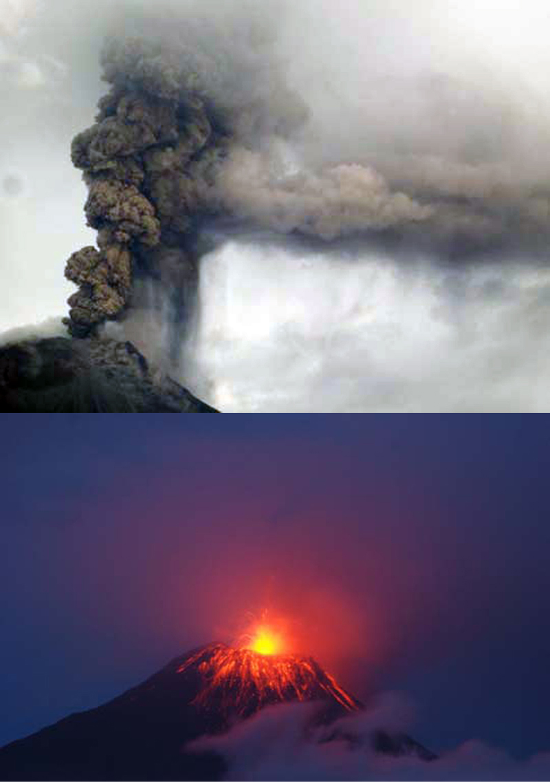 |
Figure 70. Observations of volcanic activity at Tungurahua on 16 March 2013. Top: Detail of an ash column around 1800 local time. Bottom: Strombolian activity a short time later. Courtesy of IG; photos by P. Mothes OVT/IGEPN (Informe Especial del Volcán Tungurahua No.7, 16 March 2013). |
Activity during April-May 2013. The webcam confirmed the minor emission of volcanic ash on 24 April 2013; the Washington VAAC reported an ash plume at 6.7 km altitude extending 50 km WNW from the summit on the same day. A series of large explosions began on 27 April. During the next week, these explosions sent steam-and-ash plumes up to 4.7 km above the summit (9.7 km altitude) which drifted at least 100 km SW and W. Ash plumes reported daily by the Washington VAAC rose 1-3 km above the summit until 15 May, and ash fell in communities across the region up to 30 km away in many directions. Lahars traveled down drainages on the S, N, and NW flanks on 4 May. A pyroclastic flow traveled 2 km down the NW flank on 5 May, and Strombolian activity was visible on most nights. During 9-10 May, lava fountains rose 700 m above the crater. MODVOLC thermal alert pixels appeared on 1, 10, 12, and 13 May. An SO2 plume was recorded in the OMI satellite data on 29 and 30 April, and again from 5 to 12 May. After a slight amount of ash was reported in Choglontus (SW) on 15 May, there were no more reports of ash plumes for two months.
Activity during July-August 2013. IG reported increased seismicity on 13 July 2012 in advance of two large explosions on the morning of 14 July; the first was heard in areas as far away as Guayaquil (about 180 km SW). The Washington VAAC reported the plume from these explosions at 13.7 km altitude (8.7 km above the summit) around midday. They noted that satellite imagery showed a dense ash plume expanding in all directions from the summit, but moving generally N and W. Significant amounts of tephra fell in areas near the volcano including Bilbao (4-cm-diameter), Chacauco (5-cm-diameter), Cotaló, Cahuají, Choglontus, El Manzano, Puela, and Penipe (15 km SW). Thinner deposits were reported in towns including Pelileo, Ambato, Cevallos, Colta (45 km SW), Guanujo (65 km WSW), and Guaranda (65 km WSW), and in the cantons of Guano (30 km SW), Valencia, Empalme, Buena Fé, and areas in the province of Manabi (180 km NW).
Several significant pyroclastic flows also descended drainages on the NW flanks, including the Achupashal and Juive Grande drainages, during the explosions of 14 July. The pyroclastic flows at Juive Grande reached a distance of 6.3 km and stopped a kilometer above the road (figure 71). The temperature measured in the deposit with a thermal camera the next day was 95°C. In the Achupashal stream, the pyroclastic flows reached 6.5 km and crossed the Chambo River. The temperature measured in this deposit was 65°C. According to USA Today, over 200 people were evacuated from Cusua, Chacauco, and Juive.
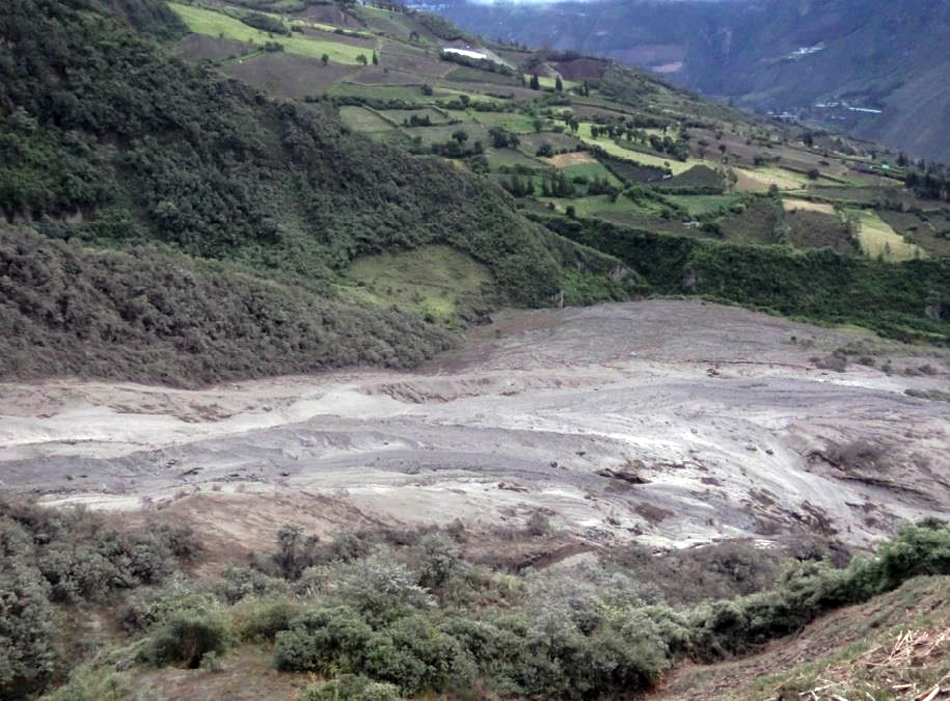 |
Figure 71. Pyroclastic flow deposit from Tungurahua in the Juive Grande ravine, 14 July 2013. Courtesy of IG; photo by P. Mothes, IG-EPN (Informe Especial del Volcán Tungurahua No. 15, 16 July 2013). |
Volcanic ash advisories were issued daily by the Washington VAAC until 1 August 2013. IG reported that on 19 July the geodetic monitoring system indicated an inflationary trend on the N flank and deflation SW of the volcano, a continuing indication of the presence of a magma body about 2 km below the crater. Ash fell in communities up to 30 km away several times during the period, including after large plumes that rose to 9.6 and 9.9 km altitude on 21 and 24 July. Minor amounts of ash were reported in the Guaranda, Salinas, and Guanujo (65 km WSW) areas after explosions on 26 July, one of which also generated a small pyroclastic flow. Strombolian activity occurred throughout the period, with activity including incandescent blocks rolling up to 500 m down the flanks several times. The OMI instrument captured SO2 plumes from 15 July through 2 August. MODVOLC thermal alerts were issued on 27 and 29 July. Seismic and explosive activity decreased during the first week in August. An ash plume on 8 August that rose 2 km above the summit and drifted W caused minor ashfall in Choglontus (SW). Trace ashfall was reported in Choglontús and El Manzano on 23 August.
Activity during October-November 2013. Activity resumed in early October 2013 with increased seismicity, Strombolian activity, ash plumes, and pyroclastic flows. A small explosion on 6 October produced ashfall in nearby areas. A larger high-level ash plume on 11 October was observed by the Washington VAAC rising to 8.5 km altitude; ashfall spread to nearby towns. Pyroclastic flows were reported on 14 October. Daily VAAC reports that began on 11 October continued through 30 October, followed by reports on 3, 7, and 9 November. The near-continuous ash emissions during this time generally rose 2-4 km above the crater, and deposited ash in communities within 30 km. Daily SO2 plumes were captured by OMI between 7 and 22 October, and eight MODVOLC thermal alerts appeared between 19 and 24 October. The last reports of ashfall during this episode were on 12 November when plumes rose 1.5 km from the summit and drifted W, with ashfall reported in El Manzano.
Activity during January-May 2014. The community of Pungal, 40 km SSW of Tungurahua, received ashfall on 30 January from a series of explosions that began after two and a half months of quiet. The Washington VAAC reported the ash plume visible at 8.2 km altitude extending 11 km ESE from the summit. A swarm of VT earthquakes on 1 February was followed by two explosions that generated ash plumes to 2-4 km above the summit, and pyroclastic flows that traveled 500 m down the NE and NW flanks. These explosions were followed a few minutes later by a larger explosion that produced an ash plume reported by IG that rose more than 8 km above the summit (figure 72).
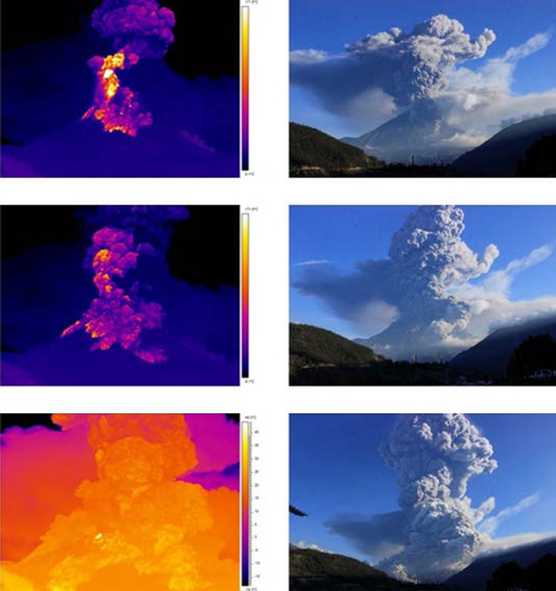 |
Figure 72. Two sequences of images from the OVT webcam, located near Guadalupe, about 13 km N of the crater, of the large explosions and ash emissions at Tungurahua that began at 2239 on 1 February 2014. Pyroclastic flows descended ravines on the NW and NE flanks. The images on the left record thermal activity during the explosions, while the images on the right record the visual activity. Courtesy of IG (Informe No. 728, Sintesis semanal del estado del Volcán Tungurahua, 28 Jan-4 Feb 2014). |
Based on reports from IG, satellite images, pilot observations, web-camera images, and the Guayaquil MWO, the Washington VAAC reported that the ash plume from the 1 February explosions rose to an estimated altitude of 13.7 km, and drifted S at high altitudes and SW at lower altitudes. IG noted that pyroclastic flows traveled 7-8 km, reaching the base of the volcano and crossing over the Achupashal Baños- Penipe highway. Continuous ash-and-gas emissions followed; ash fell in multiple areas and total darkness was reported in Chacauco (NW). Explosions continued every minute and vibrated structures in local towns. Pyroclastic flows descended the SW, W, NW, and NE flanks, but stopped short of towns and infrastructure. Ash emissions were sustained through the rest of the evening, and Strombolian explosions ejected incandescent blocks 800 m above the crater that fell and rolled 500 m down the flanks.
Numerous explosions and ashfall continued in subsequent days; on 3 February 2014 an ash plume rose 4 km above the summit and drifted N, reaching Quito (130 km N) as a mist of suspended very fine material that lingered most of the day. The Washington VAAC issued multiple daily reports of ash plumes from 30 January until 23 February. An eight-pixel thermal alert on 2 February was the beginning of a sequence of MODVOLC thermal alerts that included 10 more during February. SO2 plumes drifting W were captured by the OMI satellite instrument between 7 and 10 February. During 16-18 February, ash plumes again rose to altitudes between 9 and 10 km, dispersing ash to the W and NW. Strombolian activity and loud noises were common during this interval.
Fewer ash plumes were reported during March 2014, at generally lower heights of 1-3 km above the crater; ash fell in communities within 15 km. Only three MODVOLC thermal alerts were recorded: two on 6 March and one on 15 March. On 11 and 21 March rains caused major lahars in the Achupashal drainage which led to traffic disruption on the Baños- Penipe highway. Lahars on 31 March traveled down the Vascún (N) and Mapayacu (SW) drainages, carrying blocks up to 1 m in diameter in the latter drainage.
Explosions and substantial ash plumes increased in April 2014, with multiple daily VAAC reports issued between 2 and 25 April. The largest explosion, on 4 April, lasted five minutes, and generated pyroclastic flows that descended the NW and N flanks. It also caused an ash plume that rose over 10 km above the crater, reported at 15.2 km altitude (50,000 ft) by the Washington VAAC, the highest reported in many years (figure 73). Tephra up to 7 cm in diameter fell in Cusúa and Píllaro.
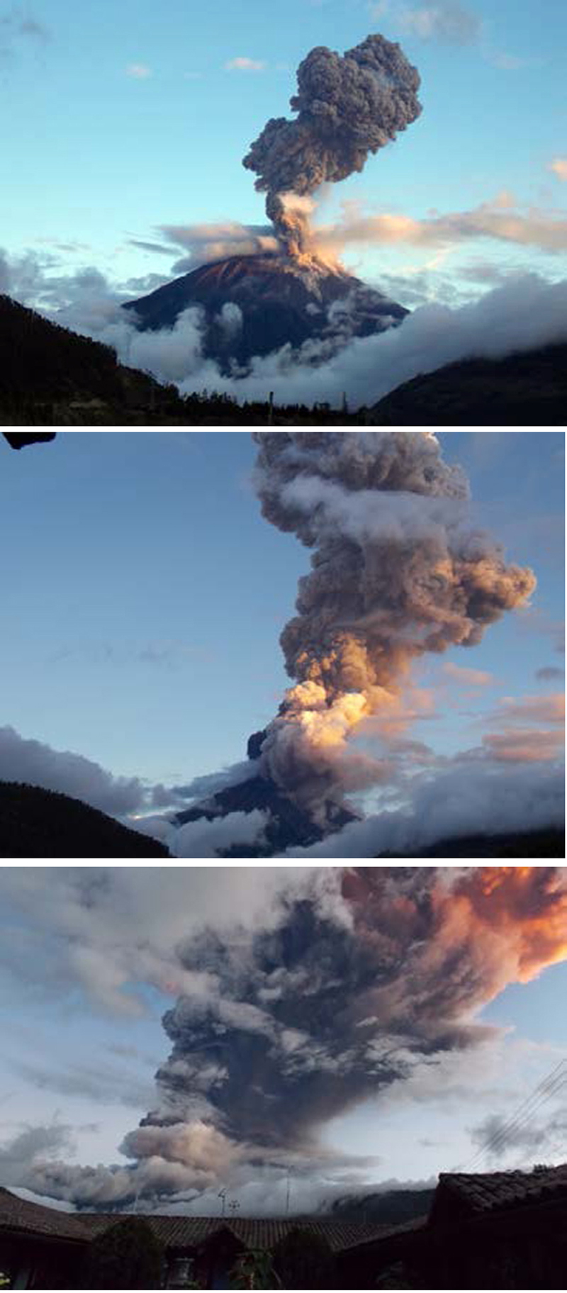 |
Figure 73. A major explosion at Tungurahua on 4 April 2014. Top: The first phase of the explosion at the western edge of the crater, the ash plume reaches at least 8 km above the summit (13 km altitude); pyroclastic flows descend the Achupashal, La Pirámide, and Rea or Romero ravines. Middle: the beginning of the second phase, an explosion on the eastern edge of the crater, which produced a dense plume of ash that reached 10 km above the crater; pyroclastic flows descend the Vazcún and Juive ravines. Bottom: Emission column of at least 10 km above the crater (15 km altitude). Courtesy of IG; photos by F. Vásconez, OVT-IG (Informe No. 737, Sintesis semanal del estado de Volcán Tungurahua, 1-8 April 2014). |
During 5-11 April, SO2 plumes drifting W were detected by the OMI satellite instrument. Large lahars descended the Achupashal (NW) and Confesionario drainages (WSW) on 8 April. On 9 April Strombolian activity caused incandescent blocks to roll 3 km down the flanks (figure 74). The next day a lava flow on the upper W flank, in the Mandur drainage, was estimated to be 2 km long, 100 m wide, and 15 m thick (figure 75). This was likely the cause of the six MODVOLC thermal alerts recorded on 11 April.
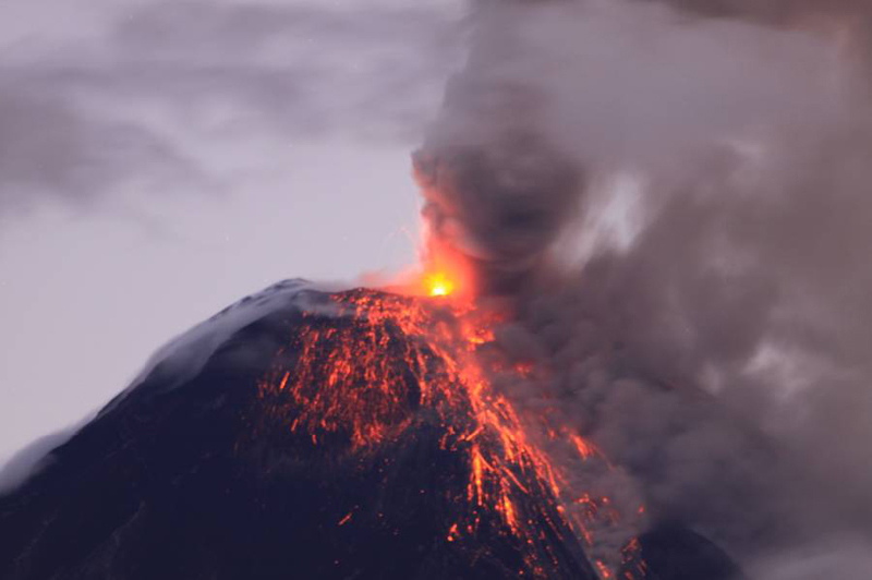 |
Figure 74. At 2243 on 9 April 2014 a lava flow emerged from the crater at Tungurahua; the incandescent material covered the NW and W flanks. Courtesy of IG; photo by P. Ramón, OVT/IG (Sintesis semanal del estado de Volcán Tungurahua, 8-15 April 2014). |
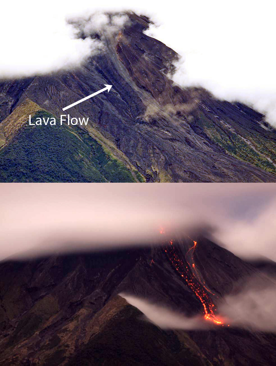 |
Figure 75. The lava flow descending an area between Mandur and Hacienda ravines at Tungurahua. Upper image is from late in the day on 10 April 2014, lower image is a few hours later in the early morning of 11 April. Courtesy of IG; photo by P. Ramón, OVT/IG (Sintesis semanal del estado de Volcán Tungurahua, 8-15 April 2014). |
A significant explosion on 14 April 2014 produced an infrasound signal that was detected at 150 decibels 5.5 km away. Unconfirmed reports indicated that windows in Chacauco and Cusúa shattered. The shock wave was also detected in other locations, including Ambato and Riobamba (30 km S). Although IG reported an ash plume rising to over 5 km above the crater (10 km altitude), the Washington VAAC only reported the plume to 8.5 km. A lahar in the Achupashal drainage on 15 April affected traffic on the main highway. Repeated ashfall was reported for the rest of the month in communities within 30 km; crater incandescence was often observed at night.
OVT reported a gas-and-ash emission to an estimated 9 km altitude on 8 May 2014. Three explosions on 10 May generated ash emissions that rose an estimated 5 km above the crater, with ashfall reported in the communities to the SW. There were no VAAC reports issued for the 10 May explosions. A small plume on 11 May had minor amounts of ash. After this, there were no further reports of ash until the end of July. Intense rains on 10 and 11 May caused lahars to flow down most drainages, and roads crossing the Chontapamba and Romero gorges were washed out (figure 76).
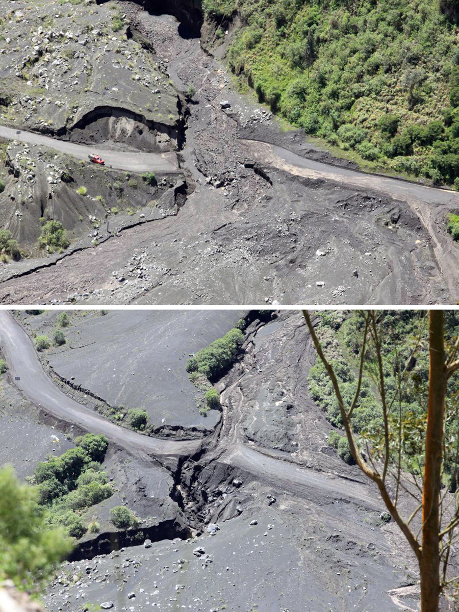 |
Figure 76. Photos taken on 12 May of damage from lahars at Tungurahua from rains on 10 and 11 May 2014. Upper: Lahar that descended the Chontapamba ravine washed out the road and trapped a vehicle. Lower: A large lahar descended the Romero ravine and destroyed the highway in two places. Courtesy of IG; photos by P. Ramón, OVT/IG (Informe No. 742, Sintesis semanal del estado del Volcán Tungurahua, 6-13 May 2014). |
The episodic nature of the activity at Tungurahua is demonstrated well by the plot of MIROVA thermal anomaly data captured between April 2013 and April 2014 (figure 77). While the whole duration of the episode is seldom recorded due to weather and other factors, each set of anomalies based on MODIS satellite data is within the boundaries of each episode listed in table 19.
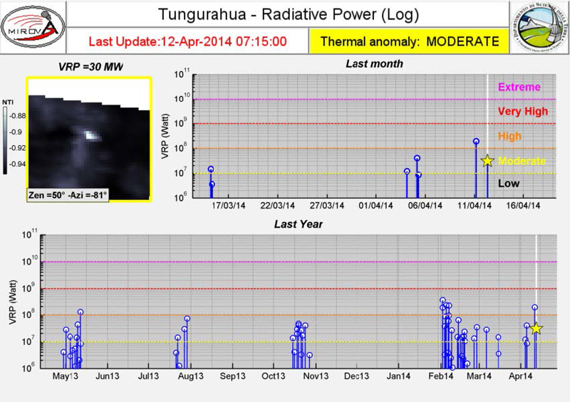 |
Figure 77. MIROVA thermal anomaly data from the year ending on 12 April 2014, showing the episodic nature of activity at Tungurahua. Courtesy of MIROVA, in IG weekly report (Sintesis semanal del estado de Volcán Tungurahua, 8-15 April 2014). |
Activity during June-December 2014. Seasonal rains in June and July 2014 generated numerous lahars, some causing major damage to roads. Otherwise, the volcano was largely quiet with only 100-m-high steam plumes rising from the summit crater on clear days, until seismicity increased once again on 27 July. The seismicity was accompanied by a small ash plume that rose 1 km above the crater and drifted NW. This event was the beginning of a lengthy episode of explosions, ash plumes, Strombolian activity, pyroclastic flows, and lahars that lasted through most of December 2014.
Deformation data revealed additional information about the the activity at Tungurahua (figure 78). The inclinometer of the RETU station is located on the NNE flank at an elevation of 4,000 m. During a 14-month period from 1 June 2013 to 1 August 2014 the radial axis inflation and deflation correlated with four significant explosion events. Periods of gradual inflation were followed by sudden deflation that accompanied an explosion. A new series of explosions began shortly after 24 July 2014 when the last deflation on the graph was detected.
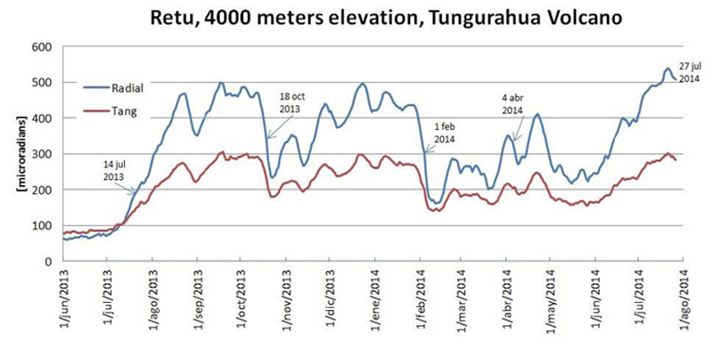 |
Figure 78. Deformation record of the RETU station at Tungurahua. The inclinometer of the RETU station is located on the NNE flank at an elevation of 4,000 m. During a 14-month period from 1 June 2013 to 1 August 2014 the radial axis inflation and deflation correlated with four significant explosion events. Periods of gradual inflation were followed by sudden deflation and an explosion. A new series of explosions began shortly after 24 July 2014 when the last deflation on the graph began. Courtesy of IG-EPN Volcanology (Informe especial del Volcán Tungurahua No. 16, 28 July 2014). |
Seismicity increased on 28 July 2014; a small explosion with an ash plume rose 1 km above the crater and drifted NW with ashfall reported in the Chontapamba area. The Washington VAAC issued multiple daily reports of ash plumes between 1 August and 11 September 2014. They were generally reported at 1-4 km above the summit, or to altitudes of 6-9 km. Ashfall was reported a number of times in communities within 30 km. Strombolian activity sent incandescent blocks as high as 1 km above the crater and up to 1.5 km down the flanks (figure 79). Incandescence appeared on most clear nights. Lahars occurred after rainy episodes during 8-9 and 13 August. On 30 and 31 August, near-constant explosions were detected, and pyroclastic flows traveled 1,500 m down the NW flank. The pyroclastic flows surrounded the lava flow from April 2014, in the La Hacienda, Achupashal, and Mandur drainages. Another pyroclastic flow reported on 3 September descended 500 m from the crater. During 10 August and 7 September, 12 MODVOLC thermal alerts were issued. SO2 plumes reappeared on the OMI satellite instrument on 2 August and were captured daily until 6 September.
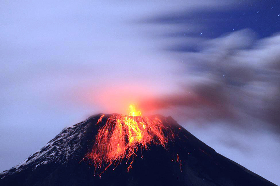 |
Figure 79. Incandescent blocks from Strombolian activity roll down the flank adjacent to snow near the summit of Tungurahua, 7 August 2014. Courtesy of IG; photo by P. Ramón, OVT/IG (Informe No. 755, Sintesis semanal sel estado del Volcán Tugurahua, 5-12 August 2014). |
Activity decreased slightly toward the end of September 2014, although intermittent ash plumes were still reported as high as 2.5 km above the crater; ashfall was recorded in communities up to 25 km away, generally to the W. Rains on 12 and 14 September resulted in lahars within the NW drainages of Achupashal and La Pampa. LP seismic events increased slightly at the end of September along with several low-level ash plumes. The last reports of nighttime incandescence were on 27 September.
Emissions with low to moderate ash content were noted most days in early October. Ashfall was reported from a few communities within 30 km on 1, 3, and 6 October. Trace amounts of ashfall appeared on the SW flank the following week. OVT reported emissions with moderate ash content rising 2-3 km above the summit during 19 and 20 October. Plumes rising to 2 km with low ash content were observed on 25 October. During the end of October and the first few days of November, IG observed only water vapor emissions to 500 m above the crater.
Although quieter, Tungurahua was still active through November and December 2014. Trace amounts of ash in the emissions were observed from El Manzano on 3 November. On 7 and 8 November ash-bearing plumes rose less than 300 m and drifted WSW. For the rest of November, only steam plumes rose to 700 m above the crater. Incandescence was visible at the summit in the early morning hours of 21 November, and again on 4 December. Residents in Choglontus reported a steam-and-ash plume drifting S early on 6 December. A significant lahar on the NW flank washed out the Penipe-Banos road in the Achupashal gorge on 7 December. Low ash content was reported in plumes rising to 500 m above the crater each day from 9-15 December, and magmatic gases and steam emissions were persistent (figure 80). Slight incandescence was seen at night on 11 December. On 14 December, a column consisting of re-suspended ash was seen drifting E. For the remainder of December, weak water vapor plumes rose a few hundred meters above the crater; lahars were reported on 25 December.
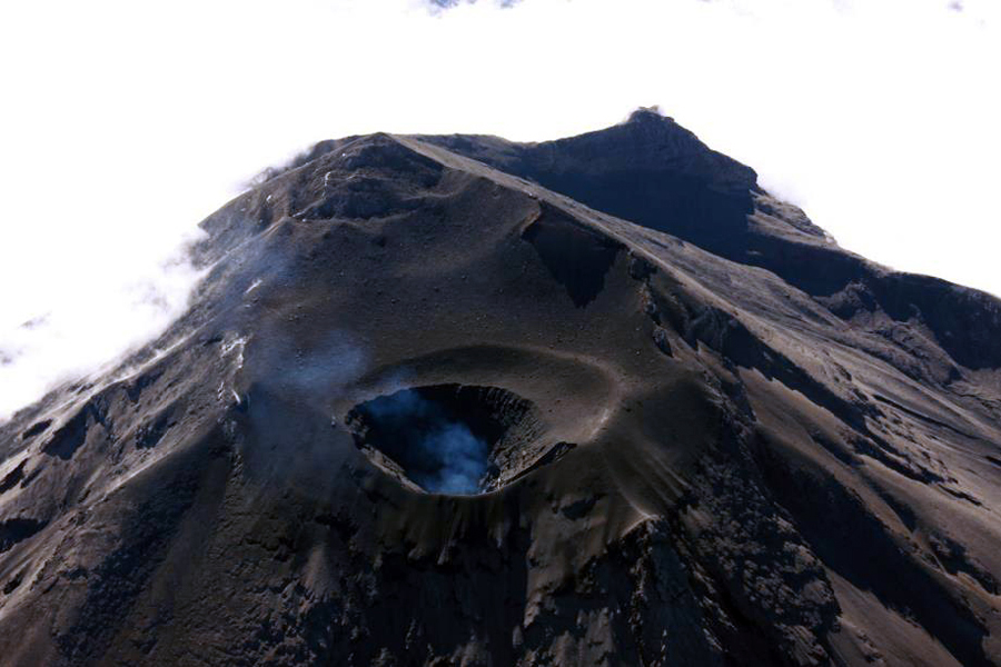 |
Figure 80. A minor plume of magmatic gases rose from the summit crater of Tungurahua on 11 December 2014, as seen from the NW. Courtesy of IG; photo by P. Ramón, OVT/IG (Informe No. 773, Sintesis semanal del estado del Volcan Tungurahua, 9-16 December 2014). |
Information Contacts: Instituto Geofísico (IG), Escuela Politécnica Nacional, Casilla 17-01-2759, Quito, Ecuador (URL: http://www.igepn.edu.ec/); Washington Volcanic Ash Advisory Center (VAAC), Satellite Analysis Branch (SAB), NOAA/NESDIS OSPO, NOAA Science Center Room 401, 5200 Auth Rd, Camp Springs, MD 20746, USA (URL: http://www.ospo.noaa.gov/Products/atmosphere/vaac/, archive at: http://www.ssd.noaa.gov/VAAC/archive.html); Hawai'i Institute of Geophysics and Planetology (HIGP), MODVOLC Thermal Alerts System, School of Ocean and Earth Science and Technology (SOEST), Univ. of Hawai'i, 2525 Correa Road, Honolulu, HI 96822, USA (URL: http://modis.higp.hawaii.edu/); MIROVA (Middle InfraRed Observation of Volcanic Activity), a collaborative project between the Universities of Turin and Florence (Italy) supported by the Centre for Volcanic Risk of the Italian Civil Protection Department (URL: http://www.mirovaweb.it/); NASA Goddard Space Flight Center (NASA/GSFC), Global Sulfur Dioxide Monitoring Page, Atmospheric Chemistry and Dynamics Laboratory, 8800 Greenbelt Road, Goddard, Maryland, USA (URL: https://so2.gsfc.nasa.gov/); USA Today (URL: http://www.usatoday.com/story/news/world/2013/07/14/ecuador-volcano-spews-ash/2516393/).
Eruptive episode during April-May 2015, persistent ash emissions and many lahars
Abundant ash emissions, Strombolian activity, pyroclastic flows, lahars, and a few lava flows have all been documented at Tungurahua, which lies in the center of Ecuador. Historical observations are recorded back to 1557, and radiocarbon dates are as old as 7750 BCE. Prior to renewed activity in 1999, the last major eruption had occurred during 1916-1918. Since 1999, there have been numerous eruptive episodes, but only a few with breaks in activity longer than three months. Eight distinct episodes of activity occurred from November 2011 through December 2014 that included 10-km-high ash plumes, Strombolian activity, pyroclastic flows, lahars and a lava flow (BGVN 42:05).
Another eruptive episode during April and May 2015 is described below based on information provided by the Observatorio del Volcán Tungurahua (OVT) of the Instituto Geofísico (IG-EPN) of Ecuador, and aviation alerts from the Washington Volcanic Ash Advisory Center (VAAC). Seismic activity increased after a few months of quiet in late February 2015. A new eruptive episode began on 6 April with tremors and ash emissions, which persisted for the next two weeks. Activity tapered off at the end of April. Intermittent ash emissions and ashfall were observed during May. Rainfall led to numerous lahars every month from January through June, many in drainages on the W flank; some were large enough to disrupt travel on local roads.
Activity during January-March 2015. Tungurahua remained quiet during January 2015, although weather conditions prevented visual monitoring for much of the month. Intermittent gas emissions reached 300 m above the crater a few times. Several hundred millimeters of rain during the second week led to numerous lahars on 9 January that descended the Ulba, Vazcún, Juive, Hacienda, Achupashal, Pingullo, Chontapamba, Romero and Rea quebradas (ravines). Most of the lahars consisted of only muddy water, but three carried debris up to 30 cm in diameter in flows several feet wide, moving material at several cubic meters per second (Palmahurco (Juive), Achupashal, and Rea quebradas). During the last week of January, incandescence was noted at the crater on clear nights.
A lahar on 1 February 2015 in the Yuibug sector, reported by an observer in Bilbao, briefly closed the Penipe-Baños road. Clearer weather at the summit in early February revealed weak gas emissions rising to 500 m above the summit crater. IG reported a gradual increase in seismicity beginning on 16 February 2015. They noted an increase in the number of long-period (LP) earthquakes associated with fluid movement near the summit. They also recorded constant inflation since the beginning of January, with an increase in the rate of inflation of the N flank during February. A small explosion was reported on 18 February, but no other surface changes were observed. The Washington VAAC issued a report of a small burst of possible ash and gas seen by the volcano observatory (OVT) mid-day on 24 February at 5.2 km altitude drifting slowly W.
Observatorio del Volcan Tungurahua (OVT) personnel noted steam and gas emissions during 3-5 March 2015 rising 200-500 m above the crater, but no ash was reported. Rainfall led to a lahar on 23 March that carried 30-cm-diameter blocks down the Quebrada de Juive. Seismic activity fluctuated throughout March. After several months of inflation, a sudden change to deflational deformation began on 26 March, as recorded at the RETU station near the summit crater.
Activity during April-June 2015. Moderate amplitude tremors began during the early morning of 6 April 2015; nearby residents reported noises from the volcano starting around 0730 local time, and minor ashfall was reported in Chacauco, Manzano, and Punzupal Alto. Residents of Palitahua reported a gray ash plume drifting W up to 2 km above the crater (figure 81). The seismic events recorded during the following days were all located at depths of 1-6 km, directly under the crater. Ashfall was reported from 6 to 9 April SW and W of the volcano, primarily in the Choglontus sector. On 8 April, ashfall was reported in Manzano, Choglontus, Bilbao, Chacauco, Pillate, and Quero, with accumulation rates of 135-200 grams per square meter per day (g/m2/day). Ashfall increased in Choglontus, reaching 1000 g/m2 during 8 and 9 April. Inflation was again observed at the RETU station beginning on 5 April.
 |
Figure 81. Ash-bearing emissions from Tungurahua drift NW on 6 April 2015. Photo by J. Garcia, courtesy of OVT/IG-EPN (Informe No. 789, Síntesis Semanal del Estado del Volcán Tungurahua, del 31 de marzo al 07 de abril del 2015). |
The webcam revealed continuous emissions of ash beginning on 6 April 2015. A plume was reported at 6.1 km altitude moving W until the following day. On 8 April OVT reported dense ash emissions to 5.9 km altitude, drifting NW. Weather clouds prevented observation in satellite imagery during these days. Local aircraft indicated ash present at 6.7 km altitude on 9 April in spite of extensive weather clouds. A swarm of "drumbeat" LP earthquakes on 10-11 April was followed by moderate ash emissions on 12 April. On 11 April, IG reported an ash cloud moving W and NW from the summit at 5.5 km altitude. An emission on 14 April with moderate amounts of ash rose 500 m above the summit and drifted WSW (figure 82).
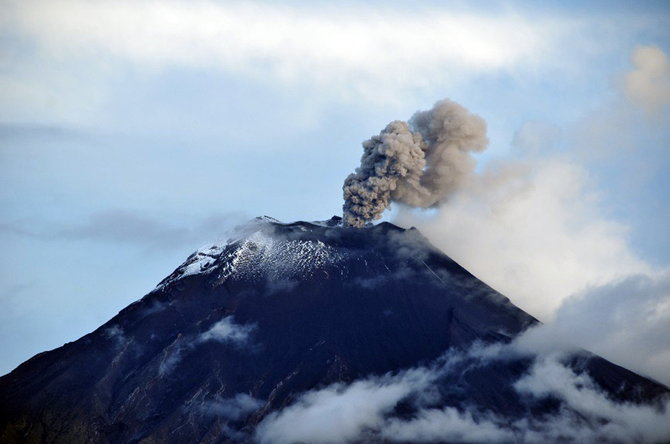 |
Figure 82. An ash emission rises to 500 m above the summit at Tungurahua on 14 April 2015, and drifts WSW. Photo by B. Bernard, Courtesy of OVT/IG-EPN (Informe No. 791, Síntesis Semanal del Estado del Volcán Tungurahua, del 13 al 21 de abril del 2015). |
An explosion on 15 April generated an ash plume that reached 3 km above the summit crater (figure 83). Later in the day ash emissions rose to 2 km above the crater and drifted W. The Washington VAAC reported a continuous ash plume visible in satellite imagery on 15 April moving W from the summit at 6.1 km altitude (1 km above the summit). Although the plume appeared to be almost 100 km long, ashfall reports were limited to areas within 15 km of the summit. Collected ash was mainly composed of dense lithic fragments, euhedral crystals, and oxidized particles, and was not considered juvenile material (from fresh magma). Additional ashfall was reported up through 17 April in Palictahua, El Guanto, El Mirador, El Santuario, Mapayacu, Puela, Chontapamba, and Sabañag.
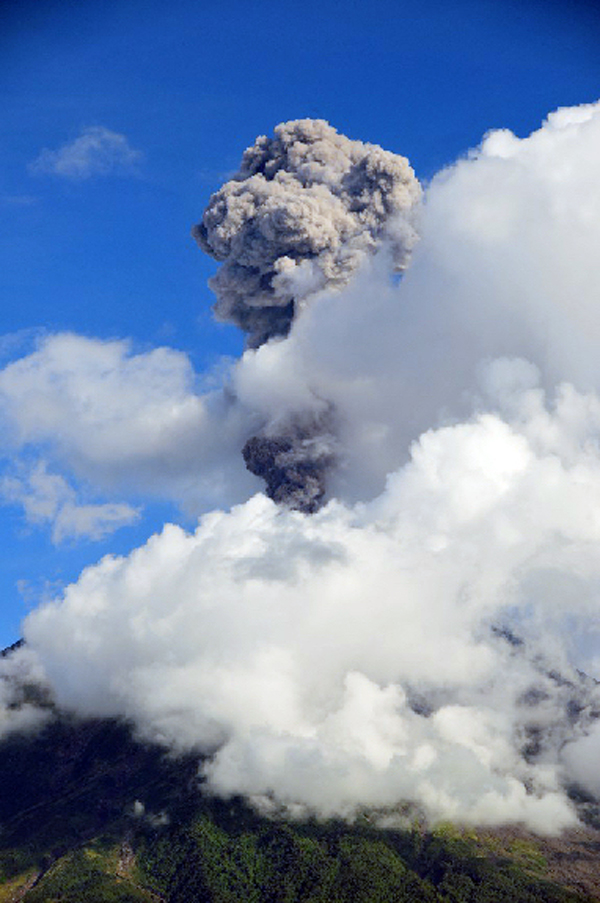 |
Figure 83. An ash plume from an explosion at Tungurahua rises 2 km above the summit crater on 15 April 2015. Photo by B. Bernard, Courtesy of OVT/IG-EPN (Informe No. 791, Síntesis Semanal del Estado del Volcán Tungurahua, del 13 al 21 de abril del 2015). |
Ash emissions continued at a lower level of frequency and energy after 17 April 2015 (figure 84), and seismic activity notably decreased. There were minor emissions coincident with seismic tremors that produced gray to black fine-grained ashfall mainly to the W of the volcano in Bilbao and Chontapamba through 27 April. Deformation changed from inflation to deflation beginning on 21 April, but after five days, switched back to inflation on 26 April. Plumes with moderate ash content were observed rising to 1 or 2 km above the summit on clear days. An emission on 28 April contained modest amounts of ash and drifted NW.
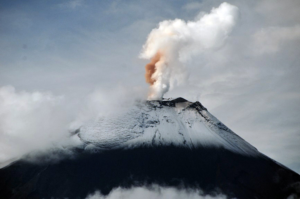 |
Figure 84. A double column of steam and red-brown ash rises 500 m above the crater at Tungurahua and drifts W on 17 April 2015. Photo by B. Bernard, Courtesy of OVT/IG-EPN (Informe No. 791, Síntesis Semanal del Estado del Volcán Tungurahua, del 13 al 21 de abril del 2015). |
Intense rains occurred on 25 and 26 April 2015 that were large enough to generate significant lahars. On 25 April, lahars were reported in the Chontapamba and Romero ravines moving blocks up to 1 m in diameter. Muddy water was observed in the Achupashal ravine. On 26 April, lahars were reported in the Juive, Mapayacu, Romero, and Chontapamba drainages. Lahars caused a high-frequency seismic signal from the Pondoa ravine during the late morning. The flow rates doubled in Vazcún and Puela ravines, which filled with muddy water. A large lahar was also reported in the Quebrada del Pingullo, and debris was reported in the Clementina, Juive Chico, and La Pampa creeks (figure 85).
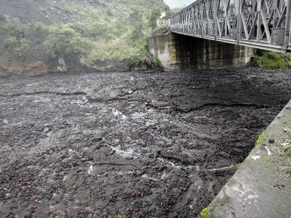 |
Figure 85. Mud and debris filled La Pampa quebrada (ravine) at Tungurahua after heavy rains on 26 April 2015. Photo by S. Aguaiza, courtesy of OVT/IG-EPN (Informe No. 792, Síntesis Semanal del Estado del Volcán Tungurahua, del 21 al 28 de abril del 2015). |
During the first week of May 2015, constant steam emissions rose 1 km above the summit crater. The vapor was characterized by very low amounts of ash. On 4 May, ashfall was reported in the Bilbao sector, but not corroborated from other areas. Steam with low to moderate ash content continued through 12 May, with plumes rising 1 km above the summit, mostly drifting W and SW. As a result, ash falls were reported in Manzano, Choglontús, Yuibug and Bilbao. On 10 and 11 May, intense and prolonged rains led to significant lahars in Q. Romero, Ingapirca, Chontapamba, Achupashal, and Ulba, and smaller lahars in several other ravines. Small mudflows and lahars also occurred in the ravines on the W flank on 12, 14, and 15 May. Cloudy weather mostly prevented views of the summit, but continuous steam emissions were observed when it cleared. Fine-grained gray ashfall was reported in Choglontus on 15 and 20 May.
Minor emissions of steam with no ash to 500 m above the crater, drifting mostly W, persisted throughout June. Intermittent rains resulted in minor lahars and mudflows that caused little damage. Lahars descended ravines on the W flank on 16 and 17 June. The summit was cloudy and rainy for much of the month, and seismic activity remained low.
Information Contacts: Instituto Geofísico (IG), Escuela Politécnica Nacional, Casilla 17-01-2759, Quito, Ecuador (URL: http://www.igepn.edu.ec/); Washington Volcanic Ash Advisory Center (VAAC), Satellite Analysis Branch (SAB), NOAA/NESDIS OSPO, NOAA Science Center Room 401, 5200 Auth Rd, Camp Springs, MD 20746, USA (URL: http://www.ospo.noaa.gov/Products/atmosphere/vaac/, archive at: http://www.ssd.noaa.gov/VAAC/archive.html).
Nearly constant ash emissions and frequent lahars during July-December 2015
Eight distinct episodes of activity occurred at Ecuador's Tungurahua from November 2011 through December 2014 that included 10-km-high ash plumes, Strombolian activity, pyroclastic flows, lahars and a lava flow (BGVN 42:05). Another distinct eruptive episode, during April and May 2015, consisted primarily of persistent ash emissions (BGVN 42:08). Abundant rainfall during the first half of 2015 led to numerous lahars, some of which disrupted travel on local roads. Continuing activity from July through December 2015 is described below based on information provided by the Observatorio del Volcán Tungurahua (OVT) of the Instituto Geofísico (IG-EPN) of Ecuador, and aviation alerts from the Washington Volcanic Ash Advisory Center (VAAC).
After the last ash emissions reported in mid-May 2015, only minor emissions of steam with no ash rising to 500 m above the crater were reported during June. However, activity increased again during July, when ashfall was reported nearly every day at the lookout stations around Tungurahua, and several larger explosions produced ash plumes that rose as high as 7.5 km altitude, about 2.5 km above the summit. Frequent rains during July resulted in lahars in six different drainages. Multiple explosions during August caused ash plumes and ashfall in communities within 20 km several times every week with the highest plume rising to 8.5 km altitude. A similar pattern continued during September 2015, with longer periods of seismic tremor, persistent ash emissions, and Strombolian activity that sent block avalanches down the flanks. The number and intensity of explosions increased in October; multiple explosions every week resulted in ashfall in communities within 25 km, mostly to the NW, and low-energy Strombolian activity persisted throughout the month. The strongest explosions of the period began with a series of seismic tremors on 10 November that persisted for nine days; daily ash plumes rose to between 7 and 8 km altitude, with the highest plume reported rising to at least 9.1 km altitude. Several millimeters of ashfall were reported in the nearby communities and at lookout stations, and the ash plume was recognized in satellite data more than 250 km from the summit before dissipating. Activity tapered off by the end of November, and only weak steam emissions were reported during December 2015.
Activity during July-September 2015. Persistent steam plumes in July rose up to 500 m above the summit crater and drifted generally W, often carrying small quantities of ash. Several lookout stations in communities located within 20 km NW and SW reported ashfall almost every day, including Choglontús (13 km WSW), Bilbao, and El Manzano (8 km SW). Other stations that reported ashfall during the month included Palitahua, Mocha, Chacauco, and Pillate. IG-EPN reported explosions with larger ash plumes on 3, 12, and 14 July that rose as high as 7.5 km (figure 86). Increased seismicity on 21 and 22 July was associated with emissions that caused ashfall in most of the reporting locations.
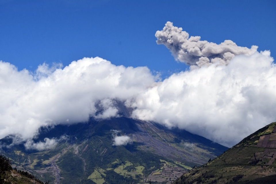 |
Figure 86. An ash plume rises 1 km above the summit crater at Tungurahua on 3 July 2015. Courtesy of OVT, IG-EPN, photo by P. Espin (Informe No. 802, Síntesis seminal del estado del Volcán Tungurahua, Semana: Del 30 de junio al 07 de julio de 2015). |
The Washington VAAC reported the ash plume on 3 July extending 25 km WSW from the summit at 5.2 km altitude (200 m above the crater); they also detected a faint hotspot in satellite imagery. They reported an ash plume extending 35 km WSW late in the day at 6.4 km on 14 July visible in satellite imagery (figure 87). An ash plume reported by the Washington VAAC on 31 July was moving SW at 6.7 km altitude.
 |
Figure 87. One of several explosions on 14 July 2015 at Tungurahua created an ash plume that rose at least 2 km above the summit and drifted W. Courtesy of OVT, IG-EPN, photo by F. Vasconez (Informe No. 803, Síntesis seminal del estado del Volcán Tungurahua, Semana: Del 07 de julio al 14 de julio de 2015). |
Lahars were reported during 5-7, 18-19, 22-23, and 29-30 July in the Chontapamba, Rea, Achupashal, Juive, Pondoa and Puela river drainages. Heavy rain on 18 and 19 July generated mudflows in the Juive, Pondoa and La Pampa ravines. Blocks 40 cm in diameter were reported in the Puela River on 22 July, and blocks 1 meter in diameter were reported in the Chontapamba river on 29 July.
There were fewer events with ash emissions during August compared to July. A lahar sent 40-cm-diameter blocks down the Mapayacu ravine on 14 August. Two explosions on 15-16 August caused ashfall in Choglontus, Manzano, and Chontapamba. Small lahars from the Rea and Romero drainages blocked the Baños-Penipe road on 16 August. An explosion on 18 August sent an ash plume WSW and caused ashfall in Choglontus; the next day reddish ash and steam emissions around 1000 local time caused ashfall again in Choglontus. Black ashfall was reported there on 22 August. Increased seismic activity with several explosions on 25 August was accompanied by ash plumes that caused ashfall in Chontapamba, Pillate, Bilbao, and Juive Grande. Gray ash was reported in Chinchicoto and Yanayacu, and thick black ash was reported in Rumipamba, Pingili and Mocha. Fine-grained gray ash was reported in Mocha on 27 August.
The Washington VAAC reported occasional emissions of gas and minor volcanic ash on 1 August 2015. A pilot report of an ash plume rising to 7 km altitude and drifting W on 15 August was not detected in satellite imagery due to weather clouds, although ashfall was reported within 15 km of the summit. Another pilot report on 20 August noted an ash plume to 8.5 km altitude. The altitude of an ash plume spotted drifting W on 25 August was estimated to be between 7.6 and 9 km. Ongoing emission of gas and possible minor ash was reported on 30 August at 6.7 km altitude moving W; the faint plume later detected in satellite imagery was moving WNW and extended about 50 km from the summit.
Mudflows from substantial rain on 1 and 7 September 2015 affected the Achupashal ravine and again disrupted travel on the Baños-Penipe road (figure 88). An ash plume on 2 September reached 3 km above the crater and drifted NW, causing ashfall in Pillate, Quero, Santuario, La Galera and El Rosario. Asfall was reported the next day in El Manzano and Choglontus. The Washington VAAC reported the ash plume at 8 km altitude on 2 September; the satellite imagery showed it extending 15 km WNW.
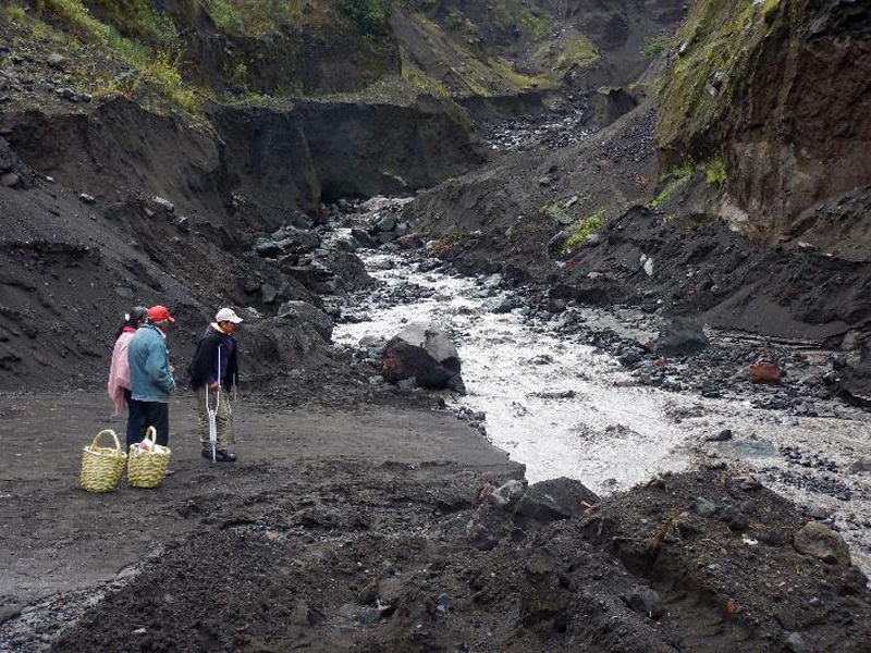 |
Figure 88. The Baños-Penipe road is frequently damaged by lahars in the Quebrada de Achupashal at Tungurahua, making travel difficult. The muddy water on 7 September 2015 washed out the road again. Courtesy of OVT, IG-EPN, photo by B. Bernard at 1359 local time (Informe No. 811, Síntesis seminal del estado del Volcán Tungurahua, Semana: Del 01 de septiembre de 2015 al 08 de septiembre). |
Moderate to high amounts of ash characterized the emissions on 11 September 2015 (figure 89). The plumes rose 2 km above the crater, drifted W and caused slight ashfall in Chonglontus and El Manzano. Only Chonglontus reported additional ashfall the next day. The Washington VAAC initially reported the ash plume at 7.3 km altitude extending 40 km SW on 11 September. About 6 hours later, the leading edge of the plume was dissipating about 170 km SW. This was followed by a new ash plume late in the day that rose to 5.8 km altitude and drifted 15 km WSW from the summit. Slight incandescence was reported on 13 September along with minor ash and steam emissions that were moving W at 7.6 km altitude.
 |
Figure 89. An ash plume drifts W from Tungurahua on 11 September 2015. Courtesy of OVT, IG-EPN, photo by S. Santamaria (Informe No. 811, Síntesis seminal del estado del Volcán Tungurahua, Semana: Del 08 de septiembre de 2015 al 15 de septiembre). |
Constant emission of moderate amounts of ash on 19 September 2015 created an ash plume that rose to 2 km above the crater and drifted NW. Ashfall was reported in El Manzano and Pillate. An explosion late in the day rattled structures in Pondoa, and was followed by observations of incandescence at the crater shortly after midnight. Ashfall was reported to the W in Pillate, El Manzano, Bilbao, Motilones, Chontapamba, and Choglontus the following day. Ongoing emissions were not visible in satellite imagery due to weather clouds. A sudden deflation in the deformation data was recorded on 19 September. Similar deflation events preceded major explosions in July 2013 and February 2014.
Several hours of seismic tremor on 27 September produced an ash-rich plume and incandescent blocks which descended the W flank. This was followed by additional explosions and periods of tremor, some lasting for more than an hour (figure 90), that produced ash plumes drifting SW. Ashfall was reported in the towns of Manzano, Choglontus, Cahuají, and Palictahua. Additional ashfall was reported the next day in Choglontus and Manzano. The Washington VAAC spotted a faint ash plume moving W in multispectral imagery on 27 September, and another plume at 6.7 km altitude moving slowly NW the next day around noon. New fumaroles not previously observed below the W flank of the crater were observed on 29 September for the first time.
 |
Figure 90. Lengthy tremors that registered at the seismic station RETU coincided with ash-rich plumes and incandescent blocks at Tungurahua between midnight and noon local time on 27 September 2015. Courtesy of OVT, IG-EPN (Informe No. 814, Síntesis seminal del estado del Volcán Tungurahua, Semana: Del 22 al 29 de septiembre de 2015). |
Activity during October-December 2015. Tremors were followed by a significant explosion on 4 October 2015 that produced ash emissions and block avalanches that traveled down the W flank. Ashfall reports were issued from the communities of Manzano, Choglontus, and Cahuají, all located to the SW. The Washington VAAC reported the ash plume 35 km WSW of the summit at 9.1 km altitude. Seismic activity increased beginning on 8 October. On 11 October, four explosions produced Strombolian-style activity with incandescent blocks traveling down the Chomtapamba and Achupashal ravines, an ash plume rising 2 km above the crater, and ashfall in regions to the NW and SW including Manzano, Choglontus, Puela and Mocha. The Washington VAAC reported the ash plume extending W from the summit at 7.9 km altitude. Around 2000 local time, the ash plume resembled a large mushroom cloud, and loud noises were reported from Cusua. There were numerous reports of incandescent blocks and explosions heard on the N and E flanks during the evening and overnight into the next morning (figure 91). Ashfall was again reported in Choglontus on 13 October.
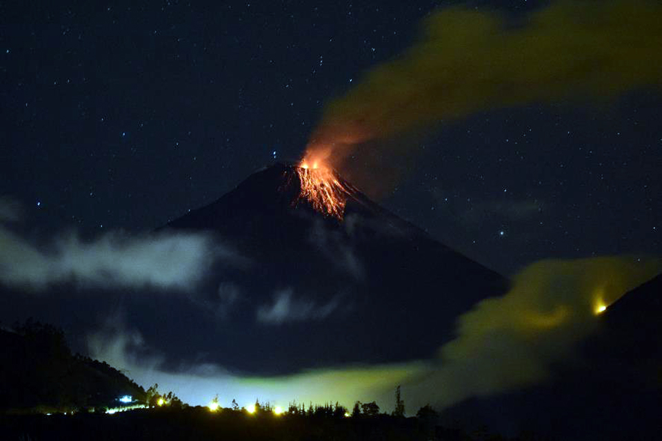 |
Figure 91. Incandescent blocks descend the upper flank of Tungurahua at 1909 local time on 11 October 2015. Courtesy of OVT, IG-EPN, photo by E. Telenchana (Informe No. 816, Síntesis seminal del estado del Volcán Tungurahua, Semana: Del 06 al 13 de octubre de 2015). |
An explosion in the early morning hours of 14 October was heard at all of the stations around the volcano. It was followed by ashfall in Choglontus. An ash emission on 19 October rose 1 km above the crater and drifted W and SW, producing ashfall in Choglontus, Bilbao, Pillate, and Cotaló. The Washington VAAC reported the plume extending 55 km NW of the summit at 6.7 km altitude. The next day, ongoing seismic data suggested frequent diffuse ash emissions. A plume was detected in multispectral data at 7.6 km altitude radiating E and rapidly dissipating. That afternoon (20 October), ashfall was reported in the Punzupala area. Ashfall continued from daily emissions for the next week with the most ashfall reported from Manzano, Choglontus, Bilbao, and Chacauco. Communities with trace amounts of ashfall included Ambato, Quero, Cevallos, Huachi, Chiquicha, Huambaló, Cotaló, and Pillate.
Incandescent material was observed traveling more than 1,000 m down the W flank from an explosion on 25 October. Local television reported ashfall in Ambato, Cevallos, Quero, and parts of Mocha and Tisaleo later that day. Swarms of LP earthquakes followed by episodes of ash emissions and low-energy Strombolian activity continued for the remainder of the month and into early November, causing sporadic ashfall in nearby villages. A small lahar was reported in the La Pampa ravine on 30 October.
An emission on 2 November 2015 created an ash plume that rose about 1.5 km above the crater and drifted E and NE; small quantities of ash were reported in the upper Runtun area. Incandescence at the summit crater from Strombolian activity was observed that night and for several days following. Heavy rains on 7 November caused mudflows in the Romero, Pingullo, and Achupashal ravines, and a larger lahar with meter-size blocks in the Chontapamba ravine. The Washington VAAC noted a dark emission from the volcano drifting W on 8 November at 5.5 km altitude.
A new series of tremors beginning on 10 November, coincided with more than a week of continuous ash emissions which reached 3.5 km above the crater and drifted in several directions. Incandescence was observed at night, and incandescent blocks descended generally up to 500 m down the NW, N, and E flanks during this period (figure 92).The Washington VAAC first reported an ash plume at 7.6 km altitude late in the evening on 10 November and continued with a constant series of reports for the next nine days. Most of the plumes were reported between 7 and 8 km altitude, drifting generally W (figure 93). The ash plumes produced heavy black ashfall in Manzano, Choglontus, Bilbao, Mocha, Quero, Cotaló, Tisaleo, Penipe and Cevallos. An ash plume was visible about 130 km W by midday on 11 November, and the plume had reached 8.2 km altitude. Loud noises were reported numerous times from the nearby communities for several days. On 12 November the Washington VAAC reported volcanic ash observed in satellite data extending 200 km WNW at 9.1 km altitude. Ashfall was heavy enough on 14 November to cause tree branches near Choglontus to bend under the weight of the ash.
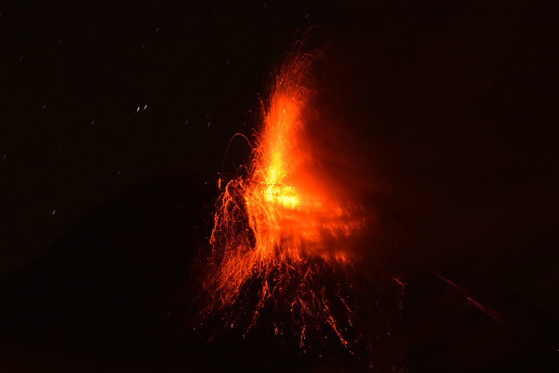 |
Figure 92. Strombolian activity from the summit of Tungurahua causes incandescent blocks to fall 500 m down the flanks of on 14 November 2015. Courtesy of OVT, IG-EPN, photo by V. Valverde (Informe No. 821, Síntesis seminal del estado del Volcán Tungurahua, Semana: 10 al 17 de noviembre de 2015). |
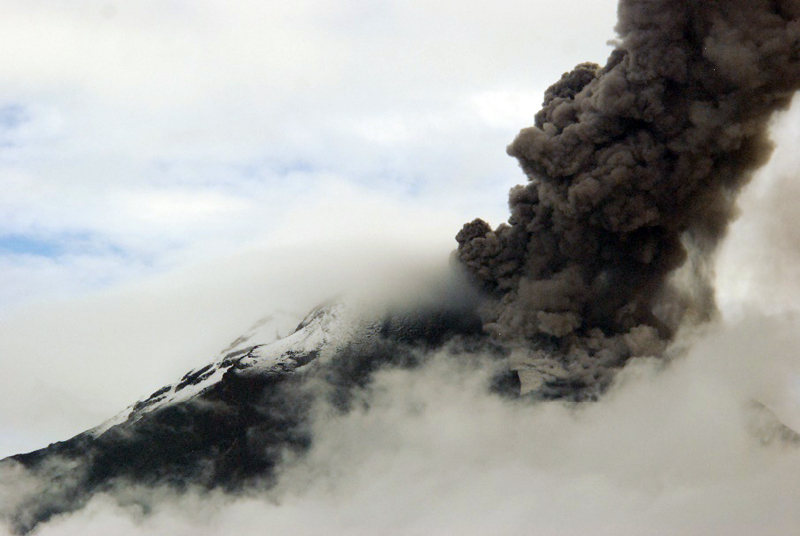 |
Figure 93. A dense ash plume rises from the summit of Tungurahua and drifts W on 17 November 2015. A small pyroclastic flow is visible on the NW flank (right side of image). Courtesy of OVT, IG-EPN, photo by S. Santamaria (Informe No. 822, Síntesis seminal del estado del Volcán Tungurahua, Semana: 17 al 24 de noviembre de 2015). |
A plume on 15 November 2015 rose more than 5 km above the crater (10 km altitude), according to IG-EPN, and sent blocks about 1,000 m down the flanks. On 18 November, the Washington VAAC reported a narrowing plume extending 270 km W from the summit. The largest ashfalls occurred during the night of 18-19 November. Strombolian activity sent blocks 800 m down the flanks during the night, and a strong "jet" was observed in the eastern part of the crater. Incandescent material was observed from two eruptive vents late on 18 November. Five millimeters of ash were reported from the solar panels at the Tablor station on 19 November, deposited in less than 24 hours (figure 94). IG-EPN reported this event as one of the most significant ashfall events since 2010; many crops and livestock animals were affected. Dense ash emissions tapered off after 19 November, and smaller, less dense plumes rose 2 km above the crater on 22-23 November. The University of Hawaii's MODVOLC system issued thermal alerts for Tungurahua on 15 (2) and 19 (3) November, the only time during 2015. Significant sulfur dioxide (SO2) emissions were captured by the OMI instrument on the Aura Satellite during the mid-November episode from 11-19 November (figure 95).
 |
Figure 94. A 5-mm thick layer of ash was deposited on the solar panels of the Tablon station at Tungurahua in less that 24 hours on 19 November 2015. Courtesy of OVT, IG-EPN, photo by S. Santamaria (Informe No. 822, Síntesis seminal del estado del Volcán Tungurahua, Semana: 17 al 24 de noviembre de 2015). |
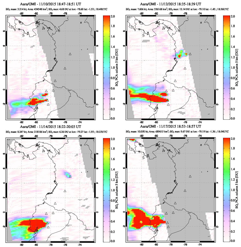 |
Figure 95. Substantial SO2 plumes originating from Tungurahua were recorded by the OMI instrument on the Aura satellite during 10-19 November 2015. Top left: the plume from Tungurahua drifts WSW while a smaller plume from Cotopaxi is visible about 90 km N on 10 November. Top right: the plume from Tungurahua drifts WNW on 12 November at the bottom of the image, a much smaller plume drifts W from Cotopaxi immediately above it, and a third SO2 plume is visible drifting WSW from Nevado del Ruiz in Colombia 750 km NNE. Lower left: a larger plume on 14 November drifts WSW from Tungurahua and probably includes some gas from Cotopaxi. Lower right: a large plume from Tungurahua disperses W on 17 November for well over 500 km. Courtesy of NASA Goddard Space Flight Center. |
A seismic swarm with 33-35 events per hour began on 25 November, and tapered off to 3-5 events per hour by 30 November 2015. There was no increase in surface activity during the swarm, but rather a gradual decrease, with no significant ashfall reported during the last week of November. Activity diminished significantly during December 2015. Weak steam emissions that reached no higher than 500 m above the crater were typical. Seismicity remained low, and there were no reports of ash emissions or ashfall in the area.
Information Contacts: Instituto Geofísico (IG), Escuela Politécnica Nacional, Casilla 17-01-2759, Quito, Ecuador (URL: http://www.igepn.edu.ec ); Washington Volcanic Ash Advisory Center (VAAC), Satellite Analysis Branch (SAB), NOAA/NESDIS OSPO, NOAA Science Center Room 401, 5200 Auth Rd, Camp Springs, MD 20746, USA (URL: www.ospo.noaa.gov/Products/atmosphere/vaac, archive at: http://www.ssd.noaa.gov/VAAC/archive.html); Hawai'i Institute of Geophysics and Planetology (HIGP) - MODVOLC Thermal Alerts System, School of Ocean and Earth Science and Technology (SOEST), Univ. of Hawai'i, 2525 Correa Road, Honolulu, HI 96822, USA (URL: http://modis.higp.hawaii.edu/); NASA Goddard Space Flight Center (NASA/GSFC), Global Sulfur Dioxide Monitoring Page, Atmospheric Chemistry and Dynamics Laboratory, 8800 Greenbelt Road, Goddard, Maryland, USA (URL: https://so2.gsfc.nasa.gov/).
Ash emissions, explosions, and pyroclastic flows 26 February-16 March 2016; no further activity through 2017
Episodic eruptive activity at Ecuador's Tungurahua has persisted since November 2011. Periods of activity over several weeks that included ash plumes, Strombolian activity, pyroclastic flows, and lava flows were often followed by quiescence for a similar time span. This type of activity continued throughout 2015 (BGVN 42:08, 42:12); Strombolian activity, significant ash emissions, and SO2 plumes in mid-November 2015 marked the last significant activity for that year. The next episode began in late February 2016 and is discussed below with information provided by the Observatorio del Volcán Tungurahua (OVT) of the Instituto Geofísico (IG-EPN) of Ecuador, aviation alerts from the Washington Volcanic Ash Advisory Center (VAAC), and other sources of satellite data.
The latest eruptive episode at Tungurahua lasted from 26 February-16 March 2016. Multiple explosions with ash plumes that rose 3-8 km were frequent. Incandescent blocks were ejected up to 1,500 m down most flanks. Pyroclastic flows affected many of the ravines, although no communities reported damage. Significant SO2 emissions were recorded by satellite data between 27 February-8 March. An inflationary trend was recorded from early March through late September 2016, after which a period of deflation began. Tungurahua had occasional seismic swarms after the eruption, but no reported surface activity for the remainder of 2016 and 2017.
IG reported an ash emission on 5 January 2016 that rose 2 km above the crater and drifted NE, causing minor ashfall in the Pondoa and Bilbao sectors. Otherwise, no volcanic activity was reported until a new episode began on 26 February 2016 with a seismic swarm followed by a series of explosions and ash plumes that rose 3-8 km above the crater (figures 96 and 97). Incandescent blocks were ejected up to a kilometer down the NW, W, and SW flanks (figure 98). Pyroclastic flows were also generated that descended through the gorges of Juive, La Hacienda, Mandur and Cusúa, reaching distances of 500-1,500 m (figure 99).
|
Figure 96. An ash emission at Tungurahua observed from OVT on 26 February 2016. Courtesy of IG-EPN, (Explosion en el Volcan Tunguraha, No. 20 [1], Informe especial Tungurahia No. 1). |
|
Figure 97. Ejecta traveled 1,000 m from the crater, an ash plume rose 2 km, and pyroclastic flows traveled down several drainages on the NW flank at Tungurahua on 26 February 2016 in this thermal image taken from the Mandur camera. Courtesy of OVT, IG-EPN (INFORME No. 836, SÍNTESIS SEMANAL DEL ESTADO DEL VOLCÁN TUNGURAHUA, Semana: Del 23 de febrero al 01 de marzo de 2016). |
|
Figure 98. Incandescent blocks descended 1,000 m down the NW, W, and SW flanks of Tungurahua on 26 February 2016, and explosions were audible at OVT. Photo by F. Vásconez, courtesy of OVT, IG-EPN (INFORME No. 836, SÍNTESIS SEMANAL DEL ESTADO DEL VOLCÁN TUNGURAHUA, Semana: Del 23 de febrero al 01 de marzo de 2016). |
|
Figure 99. Pyroclastic flows descended the Mandur, La Hacienda and other ravines on the W flank of Tungurahua on 26 February 2016 as far as 1 km. Photo by F. Vásconez, courtesy of OVT, IG-EPN (INFORME No. 836, SÍNTESIS SEMANAL DEL ESTADO DEL VOLCÁN TUNGURAHUA, Semana: Del 23 de febrero al 01 de marzo de 2016). |
Continuous emissions with low to moderate ash content drifted W and SW on 27 February. The communities most affected by ashfall were Choglontus, Cotaló, El Manzano, Palitahua, Bilbao, Pillate, Juive, Ambato, Tisaleo, Riobamba, and Quero. The ash was mostly fine-grained, except in the area near Pillate and Choglontus, where the grain size reached up to 3 mm and consisted of reddish, black, gray, and beige fragments (figure 100). On the morning of 1 March 2015, several pyroclastic flows were observed descending through the Juive, Mandur, Achupashal, La Hacienda, and Romero ravines; they traveled 1.5-1.7 km (figure 101).
|
Figure 100. Coarse-grained ash fragments from Tungurahua collected in Ambato on 26 February 2016. Photo by Marco Montesdeoca (ECU911 Ambato), Courtesy of OVT, IG-EPN (Explosion en el Volcan Tunguraha, No. 2, Informe especial Tungurahia No. 2, 26 de febrero del 2016 (16h45)). |
|
Figure 101. A pyroclastic flow descended 1.5 km down the Hacienda Ravine on 1 March 2016 at Tungurahua and was captured by the Mandur thermal camera. Courtesy of OVT, IG-EPN (INFORME No. 836, SÍNTESIS SEMANAL DEL ESTADO DEL VOLCÁN TUNGURAHUA, Semana: Del 23 de febrero al 01 de marzo de 2016). |
Ash emissions were constant throughout the first week in March (figures 102 and 103). During 1-5 March they drifted NW, SW and E, with ashfall reported in the towns of Pillate, Manzano, Choglontus, Palictahua and El Altar (figure 104). Incandescent blocks descended most of the flanks (figure 105). Beginning on 6 March, plumes drifted SW and S, with variable ash content. Pyroclastic flows along the W and NW flanks descended the Cusua, Juive, Mandur, Ashupashal, Romero, and Rhea drainages (figure 106), the farthest traveled went 2.2 km down the Ashupashal on 7 March. In addition to ash and other explosive debris, daily sulfur dioxide emissions were identified from 27 February-8 March 2016 by the OMI instrument on the Aura satellite (figure 107).
|
Figure 102. Constant ash emissions rose at least 1 km above the summit of Tungurahua during the first week of March 2016. Photo take on 3 March 2016 by P. Espin. Courtesy of OVT, IG-EPN (INFORME No. 837, SÍNTESIS SEMANAL DEL ESTADO DEL VOLCÁN TUNGURAHUA, Semana: Del 01 al 08 de marzo de 2016). |
|
Figure 103. A dark ash plume formed a mushroom cloud over Tungurahua on 5 March 2016; it rose 2 km above the summit and drifted SW. Photo by E. Telenchana , courtesy of OVT, IG-EPN (INFORME No. 837, SÍNTESIS SEMANAL DEL ESTADO DEL VOLCÁN TUNGURAHUA, Semana: Del 01 al 08 de marzo de 2016). |
|
Figure 104. Ashfall in Choglontus on 6 March 2016 from Tungurahua. Photo by P. Espín, courtesy of OVT, IG-EPN (INFORME No. 837, SÍNTESIS SEMANAL DEL ESTADO DEL VOLCÁN TUNGURAHUA, Semana: Del 01 al 08 de marzo de 2016). |
|
Figure 105. Strombolian explosions send incandescent blocks down the flanks of Tungurahua on 6 March 2016. Photo by E. Gaunt, courtesy of OVT, IG-EPN (INFORME No. 837, SÍNTESIS SEMANAL DEL ESTADO DEL VOLCÁN TUNGURAHUA, Semana: Del 01 al 08 de marzo de 2016). |
|
Figure 106. Visual (upper) and thermal (lower) images of Tungurahua taken from Cotalo showing a pyroclastic flow extending down the Achupashal drainage on 6 March 2016. Photo by E. Gaunt, thermal image by M. Almeida, courtesy of OVT, IG-EPN (INFORME No. 837, SÍNTESIS SEMANAL DEL ESTADO DEL VOLCÁN TUNGURAHUA, Semana: Del 01 al 08 de marzo de 2016). |
|
Figure 107. Substantial SO2 emissions from Tungurahua were measured daily during 27 February-8 March 2016 by the OMI instrument on the Aura satellite. The plumes drifted 300 km or more W on 27 February, 1, 3, and 5 March. Colombia's Nevado del Riuz (upper plume in images) also produced SO2 emissions during this same period. Courtesy of NASA Goddard Space Flight Center. |
Beginning on 28 February, a strong inflationary trend (almost 3 cm) was observed in the GPS data at the Mazón (SW flank) station. Three inclinometers on the NW flank also indicated inflation during 28 February-4 March.
Episodic explosions on 8 March 2016 produced plumes with high ash contents that rose 6 km. Small pyroclastic flows descended the NW flank in the Mandur, Rea, Achupashal, and La Hacienda ravines. Sporadic emissions continued for most of the second week of March, with varying ash contents, reaching between 1.5 and 4 km above the crater and drifting to the SSW. Reports of ashfall were received in the sectors of Choglontús, Manzano, Pillate, El Altar, and Palitahua, and minor ashfall in Juive and Cusúa. Several ash plumes (figure 108) and a small pyroclastic flow were observed on 13 March 2016. The Manzano lookout reported loud noises on 14 March, and ashfall in the afternoon, but weather obscured views of emissions. Rainy weather on 16 March also obscured views, but Manzano, Chacauco, Cusúa, and Juive lookouts reported ashfall and explosions. There were no further reports from the observatory of ash emissions, ashfall, or explosions; only minor steam plumes were observed on clear days after 16 March 2016.
|
Figure 108. An ash emission at Tungurahua on 13 March 2016 was the last photographed for the eruption. Photo by M. Córdova from OVT, courtesy of IG-EPN (INFORME No. 838, SÍNTESIS SEMANAL DEL ESTADO DEL VOLCÁN TUNGURAHUA, Semana: Del 08 al 15 de marzo de 2016). |
The Washington VAAC reported possible ash emissions on 31 March 2016, but information from OVT indicated no surface activity. Intense rain on 28 March generated a small lahar that descended through the La Pampa ravine. Significant rainfall on 2 April caused lahars to affect Vazcun, Juive, Pondoa, Bilbao, Achupashal, Chontapamba and Malpayacu drainages. Seismicity continued to decrease throughout April 2016. A small swarm of Long Period seismic events (LP's) occurred between 1 and 20 May that were associated with fluid movements. The Washington VAAC reported ash emissions on 3, 8, and 13 May, but OVT reported no surface activity during the entire month (figure 109).
|
Figure 109. Clear skies on 31 May 2016 at Tungurahua revealed a snow-covered summit with no evidence of emissions. Photo by M. Córdova, courtesy of OVT, IG-EPN (INFORME No. 849, SÍNTESIS SEMANAL DEL ESTADO DEL VOLCÁN TUNGURAHUA, Semana: Del 24 al 31 de mayo del 2016). |
In a Special Report released on 2 June 2016, IG-EPN noted a clear inflationary trend in data collected from two stations at Tungurahua since the end of the eruption in mid-March. The Retu inclinometer, located N of the crater, showed inflation on the radial axis of about 600 μrad (microradians), and about 200 μrad on the tangential axis. The same axis at the Mandur inclinometer (on the NW flank) had a smaller but distinct (~30 μrad) inflationary signal (figure 110).
|
Figure 110. The pattern of deformation registered at the Retu (Refugio Tungurahua) and Mndr (Mandur) inclinometers from 14 February-30 May 2016 at Tungurahua. The gray area corresponds to the eruption of 26 February -16 March. An inflationary trend is apparent on both axes at the Retu instrument and on the tangential axis of the Mndr site. Courtesy of IG-EPN (Informe Especial Volcán Tungurahua - N°6, 2 de Junio de 2016). |
A Washington VAAC report on 1 June 2016 noted that the Guayaquil Meteorological Weather Office (MWO) reported an ash plume at Tungurahua, but OVT confirmed no surface activity. A very small lahar was recorded in the La Pampa ravine on 2 June. Although there were rains of varying intensity many days during June, they did not generate significant lahars, except one of medium size that occurred on 21 June in the Achupashal ravine. The Washington VAAC noted a report from the Guayaquil MWO of an ash emission on 5 July, but it was not detected in satellite imagery, and the OVT reported no surface activity. There was no surface activity reported by OVT from July to mid-September (figure 111), and internal seismicity remained very low. Occasional rainy periods generated muddy water in the ravines, but no significant lahars were reported.
|
Figure 111. The summit of Tungurahua showed no sign of surface activity on 1 August 2016. Photo by Bernard J., courtesy of OVT, IG-EPN (INFORME No. 858, SÍNTESIS SEMANAL DEL ESTADO DEL VOLCÁN TUNGURAHUA, Semana: Del 26 de julio al 02 de agosto de 2016). |
A significant increase in the number of LP seismic events began on 12 September 2016, and a small seismic swarm was recorded on 18 September (figure 112). Small fumaroles were visible at the edges of the crater on 15 and 16 September (figure 113). At this same time, the inflationary trend that had been ongoing since the eruption earlier in the year switched to deflation as measured at the Retu inclinometer.
|
Figure 112. The number of different types of seismic events and explosions recorded at Tungurahua between 1 January and 18 September 2016. The largest spike between 26 February and 16 March corresponds to the eruption of that period. Other episodes of seismicity were recorded during May and mid-September, but did not result in ash emissions or explosions. Courtesy of IG-EPN (Informe Especial Volcán Tungurahua - N°7, 18 de Septiembre de 2016). |
|
Figure 113. Closeup images of the summit of Tungurahua on 15 (top) and 16 (bottom) September 2016 reveal minor fumarolic activity. Top: Steam rises from two snow free areas on 15 September (INFORME No. 865, SÍNTESIS SEMANAL DEL ESTADO DEL VOLCÁN TUNGURAHUA, Semana: Del 13 al 20 de septiembre de 2016). Bottom: Fumarolic activity was also apparent in this telephoto image taken from OVT on 16 September. Photo by P. Ramón (Informe Especial Volcán Tungurahua - N°7, 18 de Septiembre de 2016). Courtesy of OVT, IG-EPN. |
Another increase in LP seismicity and tremors occurred on 24 September, but there were no reports of surface activity other than minor steam fumaroles. Seismicity remained elevated through early October; a one-hour tremor event was reported on 1 October. Seismicity decreased gradually over the following two weeks. Low-energy steam and gas emissions from fumaroles located on the S and SW flanks were observed during a flyover on 7 October 2016. This corresponded to the warmest areas revealed in the thermal image of the summit (figure 114). with a TMA (maximum apparent temperature) of 47.9°C and 36.5°C.
|
Figure 114. A thermal image of the summit of Tungurahua taken during a flyover on 7 October 2016 showed two areas on the crater rim with slightly elevated temperatures where fumarolic activity was occasionally observed. Image by P. Ramón, courtesy of OVT, IG-EPN (INFORME No. 868, SÍNTESIS SEMANAL DEL ESTADO DEL VOLCÁN TUNGURAHUA, Semana: Del 4 al 11 de octubre de 2016). |
Re-suspended ash from high winds in mid-November 2016 caused several VAAC notices to be issued, but no new emissions were reported by OVT through the end of 2016.
Tungurahua remained quiet throughout 2017. A 90-minute seismic swarm on 8 January 2017 and a minor increase in seismicity in the second half of March were the only seismic events above background levels. There were no emissions except for occasional minor fumarolic activity around the crater rim. Periods of heavy rainfall occasionally produced muddy water in the ravines; the only lahars were reported during 5-6 January, late April and 15 November.
Information Contacts: Instituto Geofísico (IG), Escuela Politécnica Nacional, Casilla 17-01-2759, Quito, Ecuador (URL: http://www.igepn.edu.ec ); NASA Goddard Space Flight Center (NASA/GSFC), Global Sulfur Dioxide Monitoring Page, Atmospheric Chemistry and Dynamics Laboratory, 8800 Greenbelt Road, Goddard, Maryland, USA (URL: https://so2.gsfc.nasa.gov/); Washington Volcanic Ash Advisory Center (VAAC), Satellite Analysis Branch (SAB), NOAA/NESDIS OSPO, NOAA Science Center Room 401, 5200 Auth Rd, Camp Springs, MD 20746, USA (URL: www.ospo.noaa.gov/Products/atmosphere/vaac, archive at: http://www.ssd.noaa.gov/VAAC/archive.html).
This compilation of synonyms and subsidiary features may not be comprehensive. Features are organized into four major categories: Cones, Craters, Domes, and Thermal Features. Synonyms of features appear indented below the primary name. In some cases additional feature type, elevation, or location details are provided.
Synonyms |
| Tunguragua |
|
|
||||||||||||||||||||||||
There is data available for 31 confirmed Holocene eruptive periods.
2012 Dec 14 - 2016 Mar 16 Confirmed Eruption Max VEI: 3
| Episode 1 | Eruption Episode | Summit crater | |||||||||||||||||||||||||||||||||||||||||||||||||||||||||||||||||||||||||||||||||||||||||||||||||||||||||||||||||||||||||||||||||||||||||||
|---|---|---|---|---|---|---|---|---|---|---|---|---|---|---|---|---|---|---|---|---|---|---|---|---|---|---|---|---|---|---|---|---|---|---|---|---|---|---|---|---|---|---|---|---|---|---|---|---|---|---|---|---|---|---|---|---|---|---|---|---|---|---|---|---|---|---|---|---|---|---|---|---|---|---|---|---|---|---|---|---|---|---|---|---|---|---|---|---|---|---|---|---|---|---|---|---|---|---|---|---|---|---|---|---|---|---|---|---|---|---|---|---|---|---|---|---|---|---|---|---|---|---|---|---|---|---|---|---|---|---|---|---|---|---|---|---|---|---|---|---|
| 2012 Dec 14 - 2013 Jan 24 | Evidence from Observations: Reported | |||||||||||||||||||||||||||||||||||||||||||||||||||||||||||||||||||||||||||||||||||||||||||||||||||||||||||||||||||||||||||||||||||||||||||
|
List of 26 Events for Episode 1 at Summit crater
| ||||||||||||||||||||||||||||||||||||||||||||||||||||||||||||||||||||||||||||||||||||||||||||||||||||||||||||||||||||||||||||||||||||||||||||
| Episode 2 | Eruption Episode | Summit crater | |||||||||||||||||||||||||||||||||||||||||||||||||||||||||||||||||||||
|---|---|---|---|---|---|---|---|---|---|---|---|---|---|---|---|---|---|---|---|---|---|---|---|---|---|---|---|---|---|---|---|---|---|---|---|---|---|---|---|---|---|---|---|---|---|---|---|---|---|---|---|---|---|---|---|---|---|---|---|---|---|---|---|---|---|---|---|---|---|---|
| 2013 Mar 1 - 2013 Mar 24 | Evidence from Observations: Reported | |||||||||||||||||||||||||||||||||||||||||||||||||||||||||||||||||||||
|
List of 12 Events for Episode 2 at Summit crater
| ||||||||||||||||||||||||||||||||||||||||||||||||||||||||||||||||||||||
| Episode 3 | Eruption Episode | Summit crater | ||||||||||||||||||||||||||||||||||||||||||||||||||||||||||||||||||||||||||
|---|---|---|---|---|---|---|---|---|---|---|---|---|---|---|---|---|---|---|---|---|---|---|---|---|---|---|---|---|---|---|---|---|---|---|---|---|---|---|---|---|---|---|---|---|---|---|---|---|---|---|---|---|---|---|---|---|---|---|---|---|---|---|---|---|---|---|---|---|---|---|---|---|---|---|---|
| 2013 Apr 24 - 2013 May 15 | Evidence from Observations: Reported | ||||||||||||||||||||||||||||||||||||||||||||||||||||||||||||||||||||||||||
|
List of 13 Events for Episode 3 at Summit crater
| |||||||||||||||||||||||||||||||||||||||||||||||||||||||||||||||||||||||||||
| Episode 4 | Eruption Episode | Summit crater | ||||||||||||||||||||||||||||||||||||||||||||||||||||||||||||||||||||||||||||||||||||||||||||||||||||||||
|---|---|---|---|---|---|---|---|---|---|---|---|---|---|---|---|---|---|---|---|---|---|---|---|---|---|---|---|---|---|---|---|---|---|---|---|---|---|---|---|---|---|---|---|---|---|---|---|---|---|---|---|---|---|---|---|---|---|---|---|---|---|---|---|---|---|---|---|---|---|---|---|---|---|---|---|---|---|---|---|---|---|---|---|---|---|---|---|---|---|---|---|---|---|---|---|---|---|---|---|---|---|---|---|---|---|
| 2013 Jul 13 - 2013 Aug 23 | Evidence from Observations: Reported | ||||||||||||||||||||||||||||||||||||||||||||||||||||||||||||||||||||||||||||||||||||||||||||||||||||||||
|
List of 19 Events for Episode 4 at Summit crater
| |||||||||||||||||||||||||||||||||||||||||||||||||||||||||||||||||||||||||||||||||||||||||||||||||||||||||
| Episode 5 | Eruption Episode | Summit crater | |||||||||||||||||||||||||||||||||||||||||||||||||||||||||||||||||||||||||||||||
|---|---|---|---|---|---|---|---|---|---|---|---|---|---|---|---|---|---|---|---|---|---|---|---|---|---|---|---|---|---|---|---|---|---|---|---|---|---|---|---|---|---|---|---|---|---|---|---|---|---|---|---|---|---|---|---|---|---|---|---|---|---|---|---|---|---|---|---|---|---|---|---|---|---|---|---|---|---|---|---|---|
| 2013 Oct 6 - 2013 Nov 12 | Evidence from Observations: Reported | |||||||||||||||||||||||||||||||||||||||||||||||||||||||||||||||||||||||||||||||
|
List of 14 Events for Episode 5 at Summit crater
| ||||||||||||||||||||||||||||||||||||||||||||||||||||||||||||||||||||||||||||||||
| Episode 6 | Eruption Episode | Summit crater | ||||||||||||||||||||||||||||||||||||||||||||||||||||||||||||||||||||||||||||||||||||||||||||||||||||||||||||||||||||||||||||||||||||||||||||||||||||||||||||||||||||||||||||||||||||||||||||||||||||||||||||||||||||||||||||||||||||||||||||||||||||||||||||||||||||||||
|---|---|---|---|---|---|---|---|---|---|---|---|---|---|---|---|---|---|---|---|---|---|---|---|---|---|---|---|---|---|---|---|---|---|---|---|---|---|---|---|---|---|---|---|---|---|---|---|---|---|---|---|---|---|---|---|---|---|---|---|---|---|---|---|---|---|---|---|---|---|---|---|---|---|---|---|---|---|---|---|---|---|---|---|---|---|---|---|---|---|---|---|---|---|---|---|---|---|---|---|---|---|---|---|---|---|---|---|---|---|---|---|---|---|---|---|---|---|---|---|---|---|---|---|---|---|---|---|---|---|---|---|---|---|---|---|---|---|---|---|---|---|---|---|---|---|---|---|---|---|---|---|---|---|---|---|---|---|---|---|---|---|---|---|---|---|---|---|---|---|---|---|---|---|---|---|---|---|---|---|---|---|---|---|---|---|---|---|---|---|---|---|---|---|---|---|---|---|---|---|---|---|---|---|---|---|---|---|---|---|---|---|---|---|---|---|---|---|---|---|---|---|---|---|---|---|---|---|---|---|---|---|---|---|---|---|---|---|---|---|---|---|---|---|---|---|---|---|---|---|---|---|---|---|---|---|---|---|---|---|---|---|---|---|---|---|
| 2014 Jan 30 - 2014 May 11 | Evidence from Observations: Reported | ||||||||||||||||||||||||||||||||||||||||||||||||||||||||||||||||||||||||||||||||||||||||||||||||||||||||||||||||||||||||||||||||||||||||||||||||||||||||||||||||||||||||||||||||||||||||||||||||||||||||||||||||||||||||||||||||||||||||||||||||||||||||||||||||||||||||
|
List of 51 Events for Episode 6 at Summit crater
| |||||||||||||||||||||||||||||||||||||||||||||||||||||||||||||||||||||||||||||||||||||||||||||||||||||||||||||||||||||||||||||||||||||||||||||||||||||||||||||||||||||||||||||||||||||||||||||||||||||||||||||||||||||||||||||||||||||||||||||||||||||||||||||||||||||||||
| Episode 7 | Eruption Episode | Summit crater | ||||||||||||||||||||||||||||||||||||||||||||||||||||||||||||||||||||||||||||||||||||||||||||||||||||||||||||||||||||||||||||||||||||||||||||||||||||||||||||||||||||||||||||||
|---|---|---|---|---|---|---|---|---|---|---|---|---|---|---|---|---|---|---|---|---|---|---|---|---|---|---|---|---|---|---|---|---|---|---|---|---|---|---|---|---|---|---|---|---|---|---|---|---|---|---|---|---|---|---|---|---|---|---|---|---|---|---|---|---|---|---|---|---|---|---|---|---|---|---|---|---|---|---|---|---|---|---|---|---|---|---|---|---|---|---|---|---|---|---|---|---|---|---|---|---|---|---|---|---|---|---|---|---|---|---|---|---|---|---|---|---|---|---|---|---|---|---|---|---|---|---|---|---|---|---|---|---|---|---|---|---|---|---|---|---|---|---|---|---|---|---|---|---|---|---|---|---|---|---|---|---|---|---|---|---|---|---|---|---|---|---|---|---|---|---|---|---|---|---|---|
| 2014 Jul 27 - 2014 Dec 15 | Evidence from Unknown | ||||||||||||||||||||||||||||||||||||||||||||||||||||||||||||||||||||||||||||||||||||||||||||||||||||||||||||||||||||||||||||||||||||||||||||||||||||||||||||||||||||||||||||||
|
List of 33 Events for Episode 7 at Summit crater
| |||||||||||||||||||||||||||||||||||||||||||||||||||||||||||||||||||||||||||||||||||||||||||||||||||||||||||||||||||||||||||||||||||||||||||||||||||||||||||||||||||||||||||||||
| Episode 8 | Eruption Episode | Summit crater | ||||||||||||||||||||||||||||||||||||||||||||||||||||||||||||||||||||||||||||||||||||||||||||||||||||||||||||||||||||||||||||||||||||||||||||||||||||||||||
|---|---|---|---|---|---|---|---|---|---|---|---|---|---|---|---|---|---|---|---|---|---|---|---|---|---|---|---|---|---|---|---|---|---|---|---|---|---|---|---|---|---|---|---|---|---|---|---|---|---|---|---|---|---|---|---|---|---|---|---|---|---|---|---|---|---|---|---|---|---|---|---|---|---|---|---|---|---|---|---|---|---|---|---|---|---|---|---|---|---|---|---|---|---|---|---|---|---|---|---|---|---|---|---|---|---|---|---|---|---|---|---|---|---|---|---|---|---|---|---|---|---|---|---|---|---|---|---|---|---|---|---|---|---|---|---|---|---|---|---|---|---|---|---|---|---|---|---|---|---|---|---|---|---|---|---|
| 2015 Apr 5 - 2015 May 20 | Evidence from Observations: Reported | ||||||||||||||||||||||||||||||||||||||||||||||||||||||||||||||||||||||||||||||||||||||||||||||||||||||||||||||||||||||||||||||||||||||||||||||||||||||||||
|
List of 29 Events for Episode 8 at Summit crater
| |||||||||||||||||||||||||||||||||||||||||||||||||||||||||||||||||||||||||||||||||||||||||||||||||||||||||||||||||||||||||||||||||||||||||||||||||||||||||||
| Episode 9 | Eruption Episode | Summit crater | ||||||||||||||||||||||||||||||||||||||||||||||||||||||||||||||||||||||||||||||||||||||||||||||||||||||||||||||||||||||||||||||||||||||||||||||||||||||||||||||||||||||||||||||||||||||||||||||||||||||||||||||||||||||||||||||||||||||||||||||||||||||||||||||||||||||||||||||||||||||||||||||||||||||||||||||||||||||||||||||||||||||||||||||||||||||||||||||||||||||||||||||||||||||||||||||||||||||||||||||||||||||||||||||||||||||||||||||||||
|---|---|---|---|---|---|---|---|---|---|---|---|---|---|---|---|---|---|---|---|---|---|---|---|---|---|---|---|---|---|---|---|---|---|---|---|---|---|---|---|---|---|---|---|---|---|---|---|---|---|---|---|---|---|---|---|---|---|---|---|---|---|---|---|---|---|---|---|---|---|---|---|---|---|---|---|---|---|---|---|---|---|---|---|---|---|---|---|---|---|---|---|---|---|---|---|---|---|---|---|---|---|---|---|---|---|---|---|---|---|---|---|---|---|---|---|---|---|---|---|---|---|---|---|---|---|---|---|---|---|---|---|---|---|---|---|---|---|---|---|---|---|---|---|---|---|---|---|---|---|---|---|---|---|---|---|---|---|---|---|---|---|---|---|---|---|---|---|---|---|---|---|---|---|---|---|---|---|---|---|---|---|---|---|---|---|---|---|---|---|---|---|---|---|---|---|---|---|---|---|---|---|---|---|---|---|---|---|---|---|---|---|---|---|---|---|---|---|---|---|---|---|---|---|---|---|---|---|---|---|---|---|---|---|---|---|---|---|---|---|---|---|---|---|---|---|---|---|---|---|---|---|---|---|---|---|---|---|---|---|---|---|---|---|---|---|---|---|---|---|---|---|---|---|---|---|---|---|---|---|---|---|---|---|---|---|---|---|---|---|---|---|---|---|---|---|---|---|---|---|---|---|---|---|---|---|---|---|---|---|---|---|---|---|---|---|---|---|---|---|---|---|---|---|---|---|---|---|---|---|---|---|---|---|---|---|---|---|---|---|---|---|---|---|---|---|---|---|---|---|---|---|---|---|---|---|---|---|---|---|---|---|---|---|---|---|---|---|---|---|---|---|---|---|---|---|---|---|---|---|---|---|---|---|---|---|---|---|---|---|---|---|---|---|---|---|---|---|---|---|---|---|---|---|---|---|---|---|---|---|---|---|---|---|---|---|---|---|---|---|---|---|---|---|---|---|---|---|---|---|---|---|---|---|---|---|
| 2015 Jul 1 - 2015 Nov 23 | Evidence from Observations: Reported | ||||||||||||||||||||||||||||||||||||||||||||||||||||||||||||||||||||||||||||||||||||||||||||||||||||||||||||||||||||||||||||||||||||||||||||||||||||||||||||||||||||||||||||||||||||||||||||||||||||||||||||||||||||||||||||||||||||||||||||||||||||||||||||||||||||||||||||||||||||||||||||||||||||||||||||||||||||||||||||||||||||||||||||||||||||||||||||||||||||||||||||||||||||||||||||||||||||||||||||||||||||||||||||||||||||||||||||||||||
|
List of 85 Events for Episode 9 at Summit crater
| |||||||||||||||||||||||||||||||||||||||||||||||||||||||||||||||||||||||||||||||||||||||||||||||||||||||||||||||||||||||||||||||||||||||||||||||||||||||||||||||||||||||||||||||||||||||||||||||||||||||||||||||||||||||||||||||||||||||||||||||||||||||||||||||||||||||||||||||||||||||||||||||||||||||||||||||||||||||||||||||||||||||||||||||||||||||||||||||||||||||||||||||||||||||||||||||||||||||||||||||||||||||||||||||||||||||||||||||||||
| Episode 10 | Eruption Episode | Summit crater | |||||||||||||||||||||||||||||||||||||||||||||||||||||||||||||||||||||||||||||||||||||||||||||||||||||||||||||||||||||||||||||||||||||||||||||||||||||||||||||||||||||||||||||||||||||||||||||||||||||||||||||||||
|---|---|---|---|---|---|---|---|---|---|---|---|---|---|---|---|---|---|---|---|---|---|---|---|---|---|---|---|---|---|---|---|---|---|---|---|---|---|---|---|---|---|---|---|---|---|---|---|---|---|---|---|---|---|---|---|---|---|---|---|---|---|---|---|---|---|---|---|---|---|---|---|---|---|---|---|---|---|---|---|---|---|---|---|---|---|---|---|---|---|---|---|---|---|---|---|---|---|---|---|---|---|---|---|---|---|---|---|---|---|---|---|---|---|---|---|---|---|---|---|---|---|---|---|---|---|---|---|---|---|---|---|---|---|---|---|---|---|---|---|---|---|---|---|---|---|---|---|---|---|---|---|---|---|---|---|---|---|---|---|---|---|---|---|---|---|---|---|---|---|---|---|---|---|---|---|---|---|---|---|---|---|---|---|---|---|---|---|---|---|---|---|---|---|---|---|---|---|---|---|---|---|---|---|---|---|---|---|---|---|---|
| 2016 Feb 26 - 2016 Mar 16 | Evidence from Unknown | |||||||||||||||||||||||||||||||||||||||||||||||||||||||||||||||||||||||||||||||||||||||||||||||||||||||||||||||||||||||||||||||||||||||||||||||||||||||||||||||||||||||||||||||||||||||||||||||||||||||||||||||||
|
List of 40 Events for Episode 10 at Summit crater
| ||||||||||||||||||||||||||||||||||||||||||||||||||||||||||||||||||||||||||||||||||||||||||||||||||||||||||||||||||||||||||||||||||||||||||||||||||||||||||||||||||||||||||||||||||||||||||||||||||||||||||||||||||
2011 Nov 27 - 2012 Sep 4 Confirmed Eruption Max VEI: 3
| Episode 1 | Eruption Episode | Summit crater | |||||||||||||||||||||||||||||||||||||||||||||||||||||||||||||||||||||||||||||||||||||||||||||||||||||||||||||||||||||||||||||||||||||||||||||||||||||||||||||||||||||||||||||||||||||||||||||||||||||||||||||||||||||||||||||||||||||||||||||||||||||||||||||||||||||||||||||||||||||||||||||||||||||||||||||||||||||||||||||||||||||||||||||||||||||||||||||||||||||||||||||||||||||||||||||||||||||||||||||||||||||||||
|---|---|---|---|---|---|---|---|---|---|---|---|---|---|---|---|---|---|---|---|---|---|---|---|---|---|---|---|---|---|---|---|---|---|---|---|---|---|---|---|---|---|---|---|---|---|---|---|---|---|---|---|---|---|---|---|---|---|---|---|---|---|---|---|---|---|---|---|---|---|---|---|---|---|---|---|---|---|---|---|---|---|---|---|---|---|---|---|---|---|---|---|---|---|---|---|---|---|---|---|---|---|---|---|---|---|---|---|---|---|---|---|---|---|---|---|---|---|---|---|---|---|---|---|---|---|---|---|---|---|---|---|---|---|---|---|---|---|---|---|---|---|---|---|---|---|---|---|---|---|---|---|---|---|---|---|---|---|---|---|---|---|---|---|---|---|---|---|---|---|---|---|---|---|---|---|---|---|---|---|---|---|---|---|---|---|---|---|---|---|---|---|---|---|---|---|---|---|---|---|---|---|---|---|---|---|---|---|---|---|---|---|---|---|---|---|---|---|---|---|---|---|---|---|---|---|---|---|---|---|---|---|---|---|---|---|---|---|---|---|---|---|---|---|---|---|---|---|---|---|---|---|---|---|---|---|---|---|---|---|---|---|---|---|---|---|---|---|---|---|---|---|---|---|---|---|---|---|---|---|---|---|---|---|---|---|---|---|---|---|---|---|---|---|---|---|---|---|---|---|---|---|---|---|---|---|---|---|---|---|---|---|---|---|---|---|---|---|---|---|---|---|---|---|---|---|---|---|---|---|---|---|---|---|---|---|---|---|---|---|---|---|---|---|---|---|---|---|---|---|---|---|---|---|---|---|---|---|---|---|---|---|---|---|---|---|---|---|---|---|---|---|---|---|---|---|---|---|---|---|---|---|---|---|---|---|---|---|---|---|---|---|---|---|---|---|---|---|---|---|---|---|---|---|---|---|---|---|---|---|---|
| 2011 Nov 27 - 2012 Sep 4 | Evidence from Observations: Reported | |||||||||||||||||||||||||||||||||||||||||||||||||||||||||||||||||||||||||||||||||||||||||||||||||||||||||||||||||||||||||||||||||||||||||||||||||||||||||||||||||||||||||||||||||||||||||||||||||||||||||||||||||||||||||||||||||||||||||||||||||||||||||||||||||||||||||||||||||||||||||||||||||||||||||||||||||||||||||||||||||||||||||||||||||||||||||||||||||||||||||||||||||||||||||||||||||||||||||||||||||||||||||
|
List of 80 Events for Episode 1 at Summit crater
| ||||||||||||||||||||||||||||||||||||||||||||||||||||||||||||||||||||||||||||||||||||||||||||||||||||||||||||||||||||||||||||||||||||||||||||||||||||||||||||||||||||||||||||||||||||||||||||||||||||||||||||||||||||||||||||||||||||||||||||||||||||||||||||||||||||||||||||||||||||||||||||||||||||||||||||||||||||||||||||||||||||||||||||||||||||||||||||||||||||||||||||||||||||||||||||||||||||||||||||||||||||||||||
2011 Apr 20 - 2011 May 26 Confirmed Eruption Max VEI: 3
| Episode 1 | Eruption Episode | Summit crater | ||||||||||||||||||||||||||||||||||||||||||||||||||||||||||||||||||||||||||||||||||||||||||||||||||||||||||||||||||||||||||||||||||||||||||||||||||||||||||||||||||||||||||||||||||||||||||||||||||||||||||||||||||||||||||||||||||||||||||||||||||||||||||||||||||||||||||||||||||||||||||||||||||||||||||||||||||||||||||||||||||||
|---|---|---|---|---|---|---|---|---|---|---|---|---|---|---|---|---|---|---|---|---|---|---|---|---|---|---|---|---|---|---|---|---|---|---|---|---|---|---|---|---|---|---|---|---|---|---|---|---|---|---|---|---|---|---|---|---|---|---|---|---|---|---|---|---|---|---|---|---|---|---|---|---|---|---|---|---|---|---|---|---|---|---|---|---|---|---|---|---|---|---|---|---|---|---|---|---|---|---|---|---|---|---|---|---|---|---|---|---|---|---|---|---|---|---|---|---|---|---|---|---|---|---|---|---|---|---|---|---|---|---|---|---|---|---|---|---|---|---|---|---|---|---|---|---|---|---|---|---|---|---|---|---|---|---|---|---|---|---|---|---|---|---|---|---|---|---|---|---|---|---|---|---|---|---|---|---|---|---|---|---|---|---|---|---|---|---|---|---|---|---|---|---|---|---|---|---|---|---|---|---|---|---|---|---|---|---|---|---|---|---|---|---|---|---|---|---|---|---|---|---|---|---|---|---|---|---|---|---|---|---|---|---|---|---|---|---|---|---|---|---|---|---|---|---|---|---|---|---|---|---|---|---|---|---|---|---|---|---|---|---|---|---|---|---|---|---|---|---|---|---|---|---|---|---|---|---|---|---|---|---|---|---|---|---|---|---|---|---|---|---|---|---|---|---|---|---|---|---|---|---|---|---|---|---|---|---|---|---|---|---|---|---|---|---|---|---|---|---|---|---|---|---|---|---|---|
| 2011 Apr 20 - 2011 May 26 | Evidence from Observations: Reported | ||||||||||||||||||||||||||||||||||||||||||||||||||||||||||||||||||||||||||||||||||||||||||||||||||||||||||||||||||||||||||||||||||||||||||||||||||||||||||||||||||||||||||||||||||||||||||||||||||||||||||||||||||||||||||||||||||||||||||||||||||||||||||||||||||||||||||||||||||||||||||||||||||||||||||||||||||||||||||||||||||||
|
List of 63 Events for Episode 1 at Summit crater
| |||||||||||||||||||||||||||||||||||||||||||||||||||||||||||||||||||||||||||||||||||||||||||||||||||||||||||||||||||||||||||||||||||||||||||||||||||||||||||||||||||||||||||||||||||||||||||||||||||||||||||||||||||||||||||||||||||||||||||||||||||||||||||||||||||||||||||||||||||||||||||||||||||||||||||||||||||||||||||||||||||||
2010 Nov 22 - 2011 Jan 2 Confirmed Eruption Max VEI: 3 (?)
| Episode 1 | Eruption Episode | Summit crater | |||||||||||||||||||||||||||||||||||||||||||||||||||||||||||||||||||||||||||||||||||||||||||||||||||||||||||||||||||||||||||||||||||||||||||||||||||||||||||||||||||||||||||||||||||||||||||||||||||||||||||||||||||||||||||||||||||||||||||||||||||||||||||||||||||||||||||||||||||||||||||||||||||||||||||||||||||||||||||||||||||||||||||||||||||||||||||||||||||||||||||||||||
|---|---|---|---|---|---|---|---|---|---|---|---|---|---|---|---|---|---|---|---|---|---|---|---|---|---|---|---|---|---|---|---|---|---|---|---|---|---|---|---|---|---|---|---|---|---|---|---|---|---|---|---|---|---|---|---|---|---|---|---|---|---|---|---|---|---|---|---|---|---|---|---|---|---|---|---|---|---|---|---|---|---|---|---|---|---|---|---|---|---|---|---|---|---|---|---|---|---|---|---|---|---|---|---|---|---|---|---|---|---|---|---|---|---|---|---|---|---|---|---|---|---|---|---|---|---|---|---|---|---|---|---|---|---|---|---|---|---|---|---|---|---|---|---|---|---|---|---|---|---|---|---|---|---|---|---|---|---|---|---|---|---|---|---|---|---|---|---|---|---|---|---|---|---|---|---|---|---|---|---|---|---|---|---|---|---|---|---|---|---|---|---|---|---|---|---|---|---|---|---|---|---|---|---|---|---|---|---|---|---|---|---|---|---|---|---|---|---|---|---|---|---|---|---|---|---|---|---|---|---|---|---|---|---|---|---|---|---|---|---|---|---|---|---|---|---|---|---|---|---|---|---|---|---|---|---|---|---|---|---|---|---|---|---|---|---|---|---|---|---|---|---|---|---|---|---|---|---|---|---|---|---|---|---|---|---|---|---|---|---|---|---|---|---|---|---|---|---|---|---|---|---|---|---|---|---|---|---|---|---|---|---|---|---|---|---|---|---|---|---|---|---|---|---|---|---|---|---|---|---|---|---|---|---|---|---|---|---|---|---|---|---|---|---|---|---|---|---|---|---|---|---|---|---|---|---|---|---|---|---|---|---|---|---|---|---|---|---|---|---|---|
| 2010 Nov 22 - 2011 Jan 2 | Evidence from Observations: Reported | |||||||||||||||||||||||||||||||||||||||||||||||||||||||||||||||||||||||||||||||||||||||||||||||||||||||||||||||||||||||||||||||||||||||||||||||||||||||||||||||||||||||||||||||||||||||||||||||||||||||||||||||||||||||||||||||||||||||||||||||||||||||||||||||||||||||||||||||||||||||||||||||||||||||||||||||||||||||||||||||||||||||||||||||||||||||||||||||||||||||||||||||||
|
List of 72 Events for Episode 1 at Summit crater
| ||||||||||||||||||||||||||||||||||||||||||||||||||||||||||||||||||||||||||||||||||||||||||||||||||||||||||||||||||||||||||||||||||||||||||||||||||||||||||||||||||||||||||||||||||||||||||||||||||||||||||||||||||||||||||||||||||||||||||||||||||||||||||||||||||||||||||||||||||||||||||||||||||||||||||||||||||||||||||||||||||||||||||||||||||||||||||||||||||||||||||||||||||
2010 Jan 1 - 2010 Aug 1 Confirmed Eruption Max VEI: 3
| Episode 1 | Eruption Episode | Summit crater | ||||||||||||||||||||||||||||||||||||||||||||||||||||||||||||||||||||||||||||||||||||||||||||||||||||||||||||||||||||||||||||||||||||||||||||||||||||||||||||||||||||||||||||||||||||||||||||||||||||||||||||||||||||||||||||||||||||||||||||||||||||||||||||||||||||||||||||||||||||||||||||||||||||||||||||||||||||||||||||||||||||||||||||||
|---|---|---|---|---|---|---|---|---|---|---|---|---|---|---|---|---|---|---|---|---|---|---|---|---|---|---|---|---|---|---|---|---|---|---|---|---|---|---|---|---|---|---|---|---|---|---|---|---|---|---|---|---|---|---|---|---|---|---|---|---|---|---|---|---|---|---|---|---|---|---|---|---|---|---|---|---|---|---|---|---|---|---|---|---|---|---|---|---|---|---|---|---|---|---|---|---|---|---|---|---|---|---|---|---|---|---|---|---|---|---|---|---|---|---|---|---|---|---|---|---|---|---|---|---|---|---|---|---|---|---|---|---|---|---|---|---|---|---|---|---|---|---|---|---|---|---|---|---|---|---|---|---|---|---|---|---|---|---|---|---|---|---|---|---|---|---|---|---|---|---|---|---|---|---|---|---|---|---|---|---|---|---|---|---|---|---|---|---|---|---|---|---|---|---|---|---|---|---|---|---|---|---|---|---|---|---|---|---|---|---|---|---|---|---|---|---|---|---|---|---|---|---|---|---|---|---|---|---|---|---|---|---|---|---|---|---|---|---|---|---|---|---|---|---|---|---|---|---|---|---|---|---|---|---|---|---|---|---|---|---|---|---|---|---|---|---|---|---|---|---|---|---|---|---|---|---|---|---|---|---|---|---|---|---|---|---|---|---|---|---|---|---|---|---|---|---|---|---|---|---|---|---|---|---|---|---|---|---|---|---|---|---|---|---|---|---|---|---|---|---|---|---|---|---|---|---|---|---|---|---|---|---|---|---|---|
| 2010 Jan 1 - 2010 Mar 22 | Evidence from Observations: Reported | ||||||||||||||||||||||||||||||||||||||||||||||||||||||||||||||||||||||||||||||||||||||||||||||||||||||||||||||||||||||||||||||||||||||||||||||||||||||||||||||||||||||||||||||||||||||||||||||||||||||||||||||||||||||||||||||||||||||||||||||||||||||||||||||||||||||||||||||||||||||||||||||||||||||||||||||||||||||||||||||||||||||||||||||
|
List of 65 Events for Episode 1 at Summit crater
| |||||||||||||||||||||||||||||||||||||||||||||||||||||||||||||||||||||||||||||||||||||||||||||||||||||||||||||||||||||||||||||||||||||||||||||||||||||||||||||||||||||||||||||||||||||||||||||||||||||||||||||||||||||||||||||||||||||||||||||||||||||||||||||||||||||||||||||||||||||||||||||||||||||||||||||||||||||||||||||||||||||||||||||||
| Episode 2 | Eruption Episode | Summit crater | |||||||||||||||||||||||||||||||||||||||||||||||||||||||||||||||||||||||||||||||||||||||||||||||||||||||||||||||||||||||||||||||||||||||||||||||||||||||||||||||||||||||||||||||||||||||||||||||||||||||||||||||||||||||||||||||||||||||||||||||||||||||||||||||||||||||||||||||||||||||||||||||||||||||||||||||||||||||||||||||||||||||||||||||||||||||||||||
|---|---|---|---|---|---|---|---|---|---|---|---|---|---|---|---|---|---|---|---|---|---|---|---|---|---|---|---|---|---|---|---|---|---|---|---|---|---|---|---|---|---|---|---|---|---|---|---|---|---|---|---|---|---|---|---|---|---|---|---|---|---|---|---|---|---|---|---|---|---|---|---|---|---|---|---|---|---|---|---|---|---|---|---|---|---|---|---|---|---|---|---|---|---|---|---|---|---|---|---|---|---|---|---|---|---|---|---|---|---|---|---|---|---|---|---|---|---|---|---|---|---|---|---|---|---|---|---|---|---|---|---|---|---|---|---|---|---|---|---|---|---|---|---|---|---|---|---|---|---|---|---|---|---|---|---|---|---|---|---|---|---|---|---|---|---|---|---|---|---|---|---|---|---|---|---|---|---|---|---|---|---|---|---|---|---|---|---|---|---|---|---|---|---|---|---|---|---|---|---|---|---|---|---|---|---|---|---|---|---|---|---|---|---|---|---|---|---|---|---|---|---|---|---|---|---|---|---|---|---|---|---|---|---|---|---|---|---|---|---|---|---|---|---|---|---|---|---|---|---|---|---|---|---|---|---|---|---|---|---|---|---|---|---|---|---|---|---|---|---|---|---|---|---|---|---|---|---|---|---|---|---|---|---|---|---|---|---|---|---|---|---|---|---|---|---|---|---|---|---|---|---|---|---|---|---|---|---|---|---|---|---|---|---|---|---|---|---|---|---|---|---|---|---|---|---|---|---|---|---|---|---|---|---|---|---|---|---|---|---|---|---|---|---|---|---|---|---|---|---|---|
| 2010 May 26 - 2010 Aug 1 | Evidence from Observations: Reported | |||||||||||||||||||||||||||||||||||||||||||||||||||||||||||||||||||||||||||||||||||||||||||||||||||||||||||||||||||||||||||||||||||||||||||||||||||||||||||||||||||||||||||||||||||||||||||||||||||||||||||||||||||||||||||||||||||||||||||||||||||||||||||||||||||||||||||||||||||||||||||||||||||||||||||||||||||||||||||||||||||||||||||||||||||||||||||||
|
List of 68 Events for Episode 2 at Summit crater
| ||||||||||||||||||||||||||||||||||||||||||||||||||||||||||||||||||||||||||||||||||||||||||||||||||||||||||||||||||||||||||||||||||||||||||||||||||||||||||||||||||||||||||||||||||||||||||||||||||||||||||||||||||||||||||||||||||||||||||||||||||||||||||||||||||||||||||||||||||||||||||||||||||||||||||||||||||||||||||||||||||||||||||||||||||||||||||||||
1999 Oct 5 - 2009 Jul 8 ± 7 days Confirmed Eruption Max VEI: 3 (?)
| Episode 1 | Eruption Episode | ||||||||||||||||||||||||||||||||||||||||||||||||||||||||||||||||||||||||||||||||||||||||||||||||||||||||||||||||||||||||||||||||||||||||||||
|---|---|---|---|---|---|---|---|---|---|---|---|---|---|---|---|---|---|---|---|---|---|---|---|---|---|---|---|---|---|---|---|---|---|---|---|---|---|---|---|---|---|---|---|---|---|---|---|---|---|---|---|---|---|---|---|---|---|---|---|---|---|---|---|---|---|---|---|---|---|---|---|---|---|---|---|---|---|---|---|---|---|---|---|---|---|---|---|---|---|---|---|---|---|---|---|---|---|---|---|---|---|---|---|---|---|---|---|---|---|---|---|---|---|---|---|---|---|---|---|---|---|---|---|---|---|---|---|---|---|---|---|---|---|---|---|---|---|---|---|---|
| 1999 Oct 5 - 2009 Jul 8 ± 7 days | Evidence from Observations: Reported | |||||||||||||||||||||||||||||||||||||||||||||||||||||||||||||||||||||||||||||||||||||||||||||||||||||||||||||||||||||||||||||||||||||||||||
|
List of 26 Events for Episode 1
| ||||||||||||||||||||||||||||||||||||||||||||||||||||||||||||||||||||||||||||||||||||||||||||||||||||||||||||||||||||||||||||||||||||||||||||
[ 1993 May 6 - 1993 May 6 ] Uncertain Eruption
| Episode 1 | Eruption Episode | |||||||||||||||||||||||||
|---|---|---|---|---|---|---|---|---|---|---|---|---|---|---|---|---|---|---|---|---|---|---|---|---|---|
| 1993 May 6 - 1993 May 6 | Evidence from Unknown | ||||||||||||||||||||||||
|
List of 3 Events for Episode 1
| |||||||||||||||||||||||||
[ 1944 ] Uncertain Eruption
| Episode 1 | Eruption Episode | ||||||||||||||||||||
|---|---|---|---|---|---|---|---|---|---|---|---|---|---|---|---|---|---|---|---|---|
| 1944 - Unknown | Evidence from Unknown | |||||||||||||||||||
|
List of 2 Events for Episode 1
| ||||||||||||||||||||
1916 Mar 3 - 1925 Dec 1 ± 30 days Confirmed Eruption Max VEI: 4
| Episode 1 | Eruption Episode | |||||||||||||||||||||||||||||||||||||||||||||||||||||||||||||||||||||||||||||||||||||
|---|---|---|---|---|---|---|---|---|---|---|---|---|---|---|---|---|---|---|---|---|---|---|---|---|---|---|---|---|---|---|---|---|---|---|---|---|---|---|---|---|---|---|---|---|---|---|---|---|---|---|---|---|---|---|---|---|---|---|---|---|---|---|---|---|---|---|---|---|---|---|---|---|---|---|---|---|---|---|---|---|---|---|---|---|---|
| 1916 Mar 3 - 1925 Dec 1 ± 30 days | Evidence from Observations: Reported | ||||||||||||||||||||||||||||||||||||||||||||||||||||||||||||||||||||||||||||||||||||
|
List of 15 Events for Episode 1
| |||||||||||||||||||||||||||||||||||||||||||||||||||||||||||||||||||||||||||||||||||||
[ 1900 ] Uncertain Eruption
| Episode 1 | Eruption Episode | |||||||||||||||||||||||||
|---|---|---|---|---|---|---|---|---|---|---|---|---|---|---|---|---|---|---|---|---|---|---|---|---|---|
| 1900 - Unknown | Evidence from Unknown | ||||||||||||||||||||||||
|
List of 3 Events for Episode 1
| |||||||||||||||||||||||||
1886 Jan 11 - 1888 ± 1 years Confirmed Eruption Max VEI: 4
| Episode 1 | Eruption Episode | ||||||||||||||||||||||||||||||||||||||||||||||||||
|---|---|---|---|---|---|---|---|---|---|---|---|---|---|---|---|---|---|---|---|---|---|---|---|---|---|---|---|---|---|---|---|---|---|---|---|---|---|---|---|---|---|---|---|---|---|---|---|---|---|---|
| 1886 Jan 11 - 1888 ± 1 years | Evidence from Observations: Reported | |||||||||||||||||||||||||||||||||||||||||||||||||
|
List of 8 Events for Episode 1
| ||||||||||||||||||||||||||||||||||||||||||||||||||
1885 Jan (?) - 1885 Oct 16 Confirmed Eruption Max VEI: 2 (?)
| Episode 1 | Eruption Episode | |||||||||||||||||||||||||
|---|---|---|---|---|---|---|---|---|---|---|---|---|---|---|---|---|---|---|---|---|---|---|---|---|---|
| 1885 Jan (?) - 1885 Oct 16 | Evidence from Observations: Reported | ||||||||||||||||||||||||
|
List of 3 Events for Episode 1
| |||||||||||||||||||||||||
1857 Sep 10 (?) Confirmed Eruption Max VEI: 2 (?)
| Episode 1 | Eruption Episode | ||||||||||||||||||||
|---|---|---|---|---|---|---|---|---|---|---|---|---|---|---|---|---|---|---|---|---|
| 1857 Sep 10 (?) - Unknown | Evidence from Observations: Reported | |||||||||||||||||||
|
List of 2 Events for Episode 1
| ||||||||||||||||||||
[ 1781 ] Uncertain Eruption
| Episode 1 | Eruption Episode | ||||||||||||||||||||
|---|---|---|---|---|---|---|---|---|---|---|---|---|---|---|---|---|---|---|---|---|
| 1781 - Unknown | Evidence from Unknown | |||||||||||||||||||
|
List of 2 Events for Episode 1
| ||||||||||||||||||||
[ 1777 ] Uncertain Eruption
| Episode 1 | Eruption Episode | ||||||||||||||||||||||||||||||
|---|---|---|---|---|---|---|---|---|---|---|---|---|---|---|---|---|---|---|---|---|---|---|---|---|---|---|---|---|---|---|
| 1777 - Unknown | Evidence from Unknown | |||||||||||||||||||||||||||||
|
List of 4 Events for Episode 1
| ||||||||||||||||||||||||||||||
1776 Jan 3 Confirmed Eruption Max VEI: 2
| Episode 1 | Eruption Episode | ||||||||||||||||||||||||||||||
|---|---|---|---|---|---|---|---|---|---|---|---|---|---|---|---|---|---|---|---|---|---|---|---|---|---|---|---|---|---|---|
| 1776 Jan 3 - Unknown | Evidence from Observations: Reported | |||||||||||||||||||||||||||||
|
List of 4 Events for Episode 1
| ||||||||||||||||||||||||||||||
1773 Feb 4 - 1773 Jul (?) Confirmed Eruption Max VEI: 3
| Episode 1 | Eruption Episode | P2 tephra | ||||||||||||||||||||||||||||||||||||||||||||||||||||||
|---|---|---|---|---|---|---|---|---|---|---|---|---|---|---|---|---|---|---|---|---|---|---|---|---|---|---|---|---|---|---|---|---|---|---|---|---|---|---|---|---|---|---|---|---|---|---|---|---|---|---|---|---|---|---|---|
| 1773 Feb 4 - 1773 Jul (?) | Evidence from Observations: Reported | ||||||||||||||||||||||||||||||||||||||||||||||||||||||
|
List of 9 Events for Episode 1 at P2 tephra
| |||||||||||||||||||||||||||||||||||||||||||||||||||||||
[ 1757 ] Uncertain Eruption
| Episode 1 | Eruption Episode | ||||||||||||||||||||
|---|---|---|---|---|---|---|---|---|---|---|---|---|---|---|---|---|---|---|---|---|
| 1757 - Unknown | Evidence from Unknown | |||||||||||||||||||
|
List of 2 Events for Episode 1
| ||||||||||||||||||||
1644 - 1646 (?) Confirmed Eruption Max VEI: 2
| Episode 1 | Eruption Episode | |||||||||||||||||||||||||
|---|---|---|---|---|---|---|---|---|---|---|---|---|---|---|---|---|---|---|---|---|---|---|---|---|---|
| 1644 - 1646 (?) | Evidence from Observations: Reported | ||||||||||||||||||||||||
|
List of 3 Events for Episode 1
| |||||||||||||||||||||||||
1640 - 1641 Confirmed Eruption Max VEI: 3 (?)
| Episode 1 | Eruption Episode | |||||||||||||||||||||||||||||||||||||||||||||
|---|---|---|---|---|---|---|---|---|---|---|---|---|---|---|---|---|---|---|---|---|---|---|---|---|---|---|---|---|---|---|---|---|---|---|---|---|---|---|---|---|---|---|---|---|---|
| 1640 - 1641 | Evidence from Observations: Reported | ||||||||||||||||||||||||||||||||||||||||||||
|
List of 7 Events for Episode 1
| |||||||||||||||||||||||||||||||||||||||||||||
1557 Confirmed Eruption Max VEI: 2
| Episode 1 | Eruption Episode | ||||||||||||||||||||
|---|---|---|---|---|---|---|---|---|---|---|---|---|---|---|---|---|---|---|---|---|
| 1557 - Unknown | Evidence from Observations: Reported | |||||||||||||||||||
|
List of 2 Events for Episode 1
| ||||||||||||||||||||
1350 ± 50 years Confirmed Eruption Max VEI: 3 (?)
| Episode 1 | Eruption Episode | |||||||||||||||||||||||||||||||||||
|---|---|---|---|---|---|---|---|---|---|---|---|---|---|---|---|---|---|---|---|---|---|---|---|---|---|---|---|---|---|---|---|---|---|---|---|
| 1350 ± 50 years - Unknown | Evidence from Isotopic: 14C (calibrated) | ||||||||||||||||||||||||||||||||||
|
List of 5 Events for Episode 1
| |||||||||||||||||||||||||||||||||||
1250 ± 50 years Confirmed Eruption
| Episode 1 | Eruption Episode | |||||||||||||||||||||||||
|---|---|---|---|---|---|---|---|---|---|---|---|---|---|---|---|---|---|---|---|---|---|---|---|---|---|
| 1250 ± 50 years - Unknown | Evidence from Isotopic: 14C (calibrated) | ||||||||||||||||||||||||
|
List of 3 Events for Episode 1
| |||||||||||||||||||||||||
1030 ± 75 years Confirmed Eruption
| Episode 1 | Eruption Episode | Tephra layer F | |||||||||||||||||||||||||||||
|---|---|---|---|---|---|---|---|---|---|---|---|---|---|---|---|---|---|---|---|---|---|---|---|---|---|---|---|---|---|---|
| 1030 ± 75 years - Unknown | Evidence from Isotopic: 14C (uncalibrated) | |||||||||||||||||||||||||||||
|
List of 4 Events for Episode 1 at Tephra layer F
| ||||||||||||||||||||||||||||||
0800 (?) Confirmed Eruption
| Episode 1 | Eruption Episode | |||||||||||||||||||||||||||||||||||
|---|---|---|---|---|---|---|---|---|---|---|---|---|---|---|---|---|---|---|---|---|---|---|---|---|---|---|---|---|---|---|---|---|---|---|---|
| 0800 (?) - Unknown | Evidence from Isotopic: 14C (uncalibrated) | ||||||||||||||||||||||||||||||||||
|
List of 5 Events for Episode 1
| |||||||||||||||||||||||||||||||||||
0730 ± 200 years Confirmed Eruption Max VEI: 4 (?)
| Episode 1 | Eruption Episode | P1 tephra unit | |||||||||||||||||||||||||||||||||||||||
|---|---|---|---|---|---|---|---|---|---|---|---|---|---|---|---|---|---|---|---|---|---|---|---|---|---|---|---|---|---|---|---|---|---|---|---|---|---|---|---|---|
| 0730 ± 200 years - Unknown | Evidence from Isotopic: 14C (uncalibrated) | |||||||||||||||||||||||||||||||||||||||
|
List of 6 Events for Episode 1 at P1 tephra unit
| ||||||||||||||||||||||||||||||||||||||||
0600 (?) Confirmed Eruption Max VEI: 3 (?)
| Episode 1 | Eruption Episode | ||||||||||||||||||||||||||||||||||||||||||||||||||
|---|---|---|---|---|---|---|---|---|---|---|---|---|---|---|---|---|---|---|---|---|---|---|---|---|---|---|---|---|---|---|---|---|---|---|---|---|---|---|---|---|---|---|---|---|---|---|---|---|---|---|
| 0600 (?) - Unknown | Evidence from Isotopic: 14C (uncalibrated) | |||||||||||||||||||||||||||||||||||||||||||||||||
|
List of 8 Events for Episode 1
| ||||||||||||||||||||||||||||||||||||||||||||||||||
0480 ± 75 years Confirmed Eruption
| Episode 1 | Eruption Episode | ||||||||||||||||||||
|---|---|---|---|---|---|---|---|---|---|---|---|---|---|---|---|---|---|---|---|---|
| 0480 ± 75 years - Unknown | Evidence from Isotopic: 14C (uncalibrated) | |||||||||||||||||||
|
List of 2 Events for Episode 1
| ||||||||||||||||||||
0350 (?) Confirmed Eruption Max VEI: 3 (?)
| Episode 1 | Eruption Episode | ||||||||||||||||||||||||||||||||||||||||
|---|---|---|---|---|---|---|---|---|---|---|---|---|---|---|---|---|---|---|---|---|---|---|---|---|---|---|---|---|---|---|---|---|---|---|---|---|---|---|---|---|
| 0350 (?) - Unknown | Evidence from Isotopic: 14C (uncalibrated) | |||||||||||||||||||||||||||||||||||||||
|
List of 6 Events for Episode 1
| ||||||||||||||||||||||||||||||||||||||||
0200 (?) Confirmed Eruption
| Episode 1 | Eruption Episode | ||||||||||||||||||||||||||||||
|---|---|---|---|---|---|---|---|---|---|---|---|---|---|---|---|---|---|---|---|---|---|---|---|---|---|---|---|---|---|---|
| 0200 (?) - Unknown | Evidence from Isotopic: 14C (uncalibrated) | |||||||||||||||||||||||||||||
|
List of 4 Events for Episode 1
| ||||||||||||||||||||||||||||||
0100 (?) Confirmed Eruption Max VEI: 3 (?)
| Episode 1 | Eruption Episode | ||||||||||||||||||||||||||||||
|---|---|---|---|---|---|---|---|---|---|---|---|---|---|---|---|---|---|---|---|---|---|---|---|---|---|---|---|---|---|---|
| 0100 (?) - Unknown | Evidence from Isotopic: 14C (uncalibrated) | |||||||||||||||||||||||||||||
|
List of 4 Events for Episode 1
| ||||||||||||||||||||||||||||||
0050 BCE (?) Confirmed Eruption Max VEI: 3 (?)
| Episode 1 | Eruption Episode | |||||||||||||||||||||||||||||||||||
|---|---|---|---|---|---|---|---|---|---|---|---|---|---|---|---|---|---|---|---|---|---|---|---|---|---|---|---|---|---|---|---|---|---|---|---|
| 0050 BCE (?) - Unknown | Evidence from Isotopic: 14C (uncalibrated) | ||||||||||||||||||||||||||||||||||
|
List of 5 Events for Episode 1
| |||||||||||||||||||||||||||||||||||
0100 BCE (?) Confirmed Eruption Max VEI: 3 (?)
| Episode 1 | Eruption Episode | |||||||||||||||||||||||||||||||||||
|---|---|---|---|---|---|---|---|---|---|---|---|---|---|---|---|---|---|---|---|---|---|---|---|---|---|---|---|---|---|---|---|---|---|---|---|
| 0100 BCE (?) - Unknown | Evidence from Isotopic: 14C (uncalibrated) | ||||||||||||||||||||||||||||||||||
|
List of 5 Events for Episode 1
| |||||||||||||||||||||||||||||||||||
0270 BCE ± 100 years Confirmed Eruption
| Episode 1 | Eruption Episode | |||||||||||||||||||||||||
|---|---|---|---|---|---|---|---|---|---|---|---|---|---|---|---|---|---|---|---|---|---|---|---|---|---|
| 0270 BCE ± 100 years - Unknown | Evidence from Isotopic: 14C (uncalibrated) | ||||||||||||||||||||||||
|
List of 3 Events for Episode 1
| |||||||||||||||||||||||||
0500 BCE (?) Confirmed Eruption Max VEI: 3 (?)
| Episode 1 | Eruption Episode | ||||||||||||||||||||||||||||||
|---|---|---|---|---|---|---|---|---|---|---|---|---|---|---|---|---|---|---|---|---|---|---|---|---|---|---|---|---|---|---|
| 0500 BCE (?) - Unknown | Evidence from Isotopic: 14C (uncalibrated) | |||||||||||||||||||||||||||||
|
List of 4 Events for Episode 1
| ||||||||||||||||||||||||||||||
1010 BCE ± 100 years Confirmed Eruption Max VEI: 5
| Episode 1 | Eruption Episode | |||||||||||||||||||||||||||||||||||||||||||||||||||||||
|---|---|---|---|---|---|---|---|---|---|---|---|---|---|---|---|---|---|---|---|---|---|---|---|---|---|---|---|---|---|---|---|---|---|---|---|---|---|---|---|---|---|---|---|---|---|---|---|---|---|---|---|---|---|---|---|
| 1010 BCE ± 100 years - Unknown | Evidence from Isotopic: 14C (uncalibrated) | ||||||||||||||||||||||||||||||||||||||||||||||||||||||
|
List of 9 Events for Episode 1
| |||||||||||||||||||||||||||||||||||||||||||||||||||||||
7750 BCE (?) Confirmed Eruption Max VEI: 4
| Episode 1 | Eruption Episode | ||||||||||||||||||||||||||||||
|---|---|---|---|---|---|---|---|---|---|---|---|---|---|---|---|---|---|---|---|---|---|---|---|---|---|---|---|---|---|---|
| 7750 BCE (?) - Unknown | Evidence from Isotopic: 14C (uncalibrated) | |||||||||||||||||||||||||||||
|
List of 4 Events for Episode 1
| ||||||||||||||||||||||||||||||
There is data available for 1 deformation periods. Expand each entry for additional details.
| Start Date: 2007 Dec 27 | Stop Date: 2008 Mar 27 | Direction: Uplift | Method: InSAR |
| Magnitude: 18.000 cm | Spatial Extent: 5.00 km | Latitude: -1.000 | Longitude: -78.000 |
Remarks: Uplift of the western flank is coincident with 2008 eruption. | |||
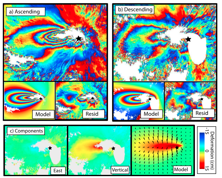 |
ALOS Interferograms spanning December 2007?March 2008. (a) Stack of two independent interferograms from an ascending line of sight. (b) Single interferogram from a descending line of sight. Both interferograms are re?wrapped to 2.8 cm fringes. (c) Deformation decomposed into east and vertical components respectively. The peak is 17.5 cm of uplift with little horizontal motion. Model displacement, from the elastic half?space model?colours represent vertical motion and arrows represent horizontal motion. From: Biggs et al. 2010. |
||
Reference List: Biggs et al. 2010; Fournier et al. 2010.
Full References:
Biggs C J, Mothes P, Ruiz M, Amelung F, Dixon T H, Baker S, Hong S-H, 2010. Stratovolcano growth by co-eruptive intrusion: The 2008 eruption of Tungurahua Ecuador. Geophysical Research Letters, 37, (L21302). https://doi.org/10.1029/2010GL044942
Fournier, T. J., M. E. Pritchard, and S. N. Riddick, 2010. Duration, magnitude, and frequency of subaerial volcano deformation events: New results from Latin America using InSAR and a global synthesis. Geochemistry Geophysics Geosystems, 11: Q01003. https://doi.org/10.1029/2009GC002558
There is data available for 5 emission periods. Expand each entry for additional details.
| Start Date: 2006 Jul 15 | Stop Date: 2006 Jul 15 | Method: Satellite (Aura OMI) |
| SO2 Altitude Min: 12 km | SO2 Altitude Max: 12 km | Total SO2 Mass: 10 kt |
Data Details
| Date Start | Date End | Assumed SO2 Altitude | SO2 Algorithm | SO2 Mass |
| 20060715 | 12.0 | 10.000 |
| Start Date: 2006 Aug 16 | Stop Date: 2006 Aug 16 | Method: Satellite (Aura OMI) |
| SO2 Altitude Min: 16 km | SO2 Altitude Max: 16 km | Total SO2 Mass: 30 kt |
Data Details
| Date Start | Date End | Assumed SO2 Altitude | SO2 Algorithm | SO2 Mass |
| 20060816 | 16.0 | 30.000 |
| Start Date: 2003 Mar 08 | Stop Date: 2003 Mar 08 | Method: Satellite (Earth Probe TOMS) |
| SO2 Altitude Min: 15 km | SO2 Altitude Max: 15 km | Total SO2 Mass: 12 kt |
Data Details
| Date Start | Date End | Assumed SO2 Altitude | SO2 Algorithm | SO2 Mass |
| 20030308 | 15.0 | 12.000 |
| Start Date: 2001 Aug 06 | Stop Date: 2001 Aug 06 | Method: Satellite (Earth Probe TOMS) |
| SO2 Altitude Min: 13 km | SO2 Altitude Max: 13 km | Total SO2 Mass: 32 kt |
Data Details
| Date Start | Date End | Assumed SO2 Altitude | SO2 Algorithm | SO2 Mass |
| 20010806 | 13.0 | 32.000 |
| Start Date: 1999 Nov 16 | Stop Date: 1999 Nov 16 | Method: Satellite (Earth Probe TOMS) |
| SO2 Altitude Min: 15 km | SO2 Altitude Max: 15 km | Total SO2 Mass: 6 kt |
Data Details
| Date Start | Date End | Assumed SO2 Altitude | SO2 Algorithm | SO2 Mass |
| 19991116 | 15.0 | 6.000 |
 Snow-capped Tungurahua, seen from near the town of Baños on its northern flank, rises 3200 m above steep-walled canyons. Historical eruptions, separated by long reposes, have produced powerful explosions, sometimes accompanied by pyroclastic flows and lava flows. All historical eruptions have originated from the summit crater, and have typically lasted for several years. The largest historical eruptions took place in 1886, 1916, and 1918.
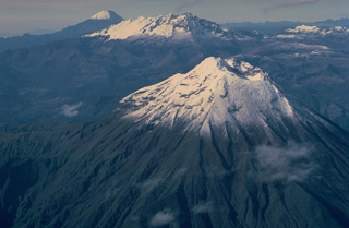 This aerial view looking SSE down Ecuador's Cordillera Real mountain range shows three 5000-m-high stratovolcanoes that have undergone varying degrees of erosion. Tungurahua volcano in the foreground rises more than 3000 m above its northern base and has produced some of Ecuador's most powerful explosive eruptions during historical time. Altar (center) is an extensively eroded volcano of Pleistocene age. Symmetrical, undissected Sangay volcano in the background is Ecuador's most active and has been in continuous eruption since 1934.
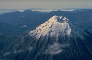 Tungurahua, a steep-sided stratovolcano that towers more than 3 km above its northern base, is one of Ecuador's most active volcanoes. Historical eruptions have frequently modified the morphology of the summit crater, which is now 300-m wide and 200-m deep. They have been accompanied by strong explosions and sometimes by pyroclastic flows and lava flows that reached populated areas at the volcano's base. The last major eruption began in 1916 and lasted until 1925.
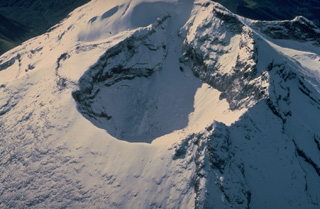 The morphology of the summit crater of Tungurahua volcano, seen from the the NNW in 1983, has frequently been modified by powerful explosive eruptions duinng historical time. In 1873, the crater was 500-m wide and 80-m deep. In 1923, near the end of an eruption that began in 1916, the crater assumed its present dimensions of 300 m in width and 200 m in depth. The SE crater rim is 200 m higher than its NW rim.
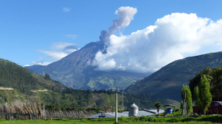 This 21 October 2015 photo shows an ash plume rising from Tungurahua, seen from the Observatorio del Volcán Tungurahua (OVT) to the NNW, near the village of Patate, operated by the Instituto Geofisico de la Escuela Politecnico Nacional (IG-EPN). Activity in 2015 was characterized by frequent ash and gas emissions and a variety of seismicity, including volcano-tectonic and long-period events.
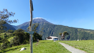 This 3 December 2015 photo shows the Volcán Tungurahua SSW flank from the Casa de Arbol, where IG-EPN operate a seismic station (Runtun). The station is managed by a member of the vigía network, which is a community based monitoring system of volunteers who observe nearby volcanoes and communicate activity to Tungurahua Volcano Observatory volcanologists and local officials. A weak degassing plume is dispersing to the right from the summit, which is also under a small meteorological cloud.
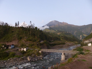 The NE flank of Tungurahua is seen here on 4 December 2015 from the town of Palictahua, near the Iglesia Católica de Cristo del Consuelo. Lahars at Tungurahua frequently travel large distances and occasionally cause road closures around the volcano. The foreground shows a large concrete block in front of the existing bridge that may be remains of an older damaged structure.
The maps shown below have been scanned from the GVP map archives and include the volcano on this page. Clicking on the small images will load the full 300 dpi map. Very small-scale maps (such as world maps) are not included. The maps database originated over 30 years ago, but was only recently updated and connected to our main database. We welcome users to tell us if they see incorrect information or other problems with the maps; please use the Contact GVP link at the bottom of the page to send us email.
There are no samples for Tungurahua in the Smithsonian's NMNH Department of Mineral Sciences Rock and Ore collection.
| Copernicus Browser | The Copernicus Browser replaced the Sentinel Hub Playground browser in 2023, to provide access to Earth observation archives from the Copernicus Data Space Ecosystem, the main distribution platform for data from the EU Copernicus missions. |
| MIROVA | Middle InfraRed Observation of Volcanic Activity (MIROVA) is a near real time volcanic hot-spot detection system based on the analysis of MODIS (Moderate Resolution Imaging Spectroradiometer) data. In particular, MIROVA uses the Middle InfraRed Radiation (MIR), measured over target volcanoes, in order to detect, locate and measure the heat radiation sourced from volcanic activity. |
| MODVOLC Thermal Alerts | Using infrared satellite Moderate Resolution Imaging Spectroradiometer (MODIS) data, scientists at the Hawai'i Institute of Geophysics and Planetology, University of Hawai'i, developed an automated system called MODVOLC to map thermal hot-spots in near real time. For each MODIS image, the algorithm automatically scans each 1 km pixel within it to check for high-temperature hot-spots. When one is found the date, time, location, and intensity are recorded. MODIS looks at every square km of the Earth every 48 hours, once during the day and once during the night, and the presence of two MODIS sensors in space allows at least four hot-spot observations every two days. Each day updated global maps are compiled to display the locations of all hot spots detected in the previous 24 hours. There is a drop-down list with volcano names which allow users to 'zoom-in' and examine the distribution of hot-spots at a variety of spatial scales. |
|
WOVOdat
Single Volcano View Temporal Evolution of Unrest Side by Side Volcanoes |
WOVOdat is a database of volcanic unrest; instrumentally and visually recorded changes in seismicity, ground deformation, gas emission, and other parameters from their normal baselines. It is sponsored by the World Organization of Volcano Observatories (WOVO) and presently hosted at the Earth Observatory of Singapore.
GVMID Data on Volcano Monitoring Infrastructure The Global Volcano Monitoring Infrastructure Database GVMID, is aimed at documenting and improving capabilities of volcano monitoring from the ground and space. GVMID should provide a snapshot and baseline view of the techniques and instrumentation that are in place at various volcanoes, which can be use by volcano observatories as reference to setup new monitoring system or improving networks at a specific volcano. These data will allow identification of what monitoring gaps exist, which can be then targeted by remote sensing infrastructure and future instrument deployments. |
| Volcanic Hazard Maps | The IAVCEI Commission on Volcanic Hazards and Risk has a Volcanic Hazard Maps database designed to serve as a resource for hazard mappers (or other interested parties) to explore how common issues in hazard map development have been addressed at different volcanoes, in different countries, for different hazards, and for different intended audiences. In addition to the comprehensive, searchable Volcanic Hazard Maps Database, this website contains information about diversity of volcanic hazard maps, illustrated using examples from the database. This site is for educational purposes related to volcanic hazard maps. Hazard maps found on this website should not be used for emergency purposes. For the most recent, official hazard map for a particular volcano, please seek out the proper institutional authorities on the matter. |
| IRIS seismic stations/networks | Incorporated Research Institutions for Seismology (IRIS) Data Services map showing the location of seismic stations from all available networks (permanent or temporary) within a radius of 0.18° (about 20 km at mid-latitudes) from the given location of Tungurahua. Users can customize a variety of filters and options in the left panel. Note that if there are no stations are known the map will default to show the entire world with a "No data matched request" error notice. |
| UNAVCO GPS/GNSS stations | Geodetic Data Services map from UNAVCO showing the location of GPS/GNSS stations from all available networks (permanent or temporary) within a radius of 20 km from the given location of Tungurahua. Users can customize the data search based on station or network names, location, and time window. Requires Adobe Flash Player. |
| DECADE Data | The DECADE portal, still in the developmental stage, serves as an example of the proposed interoperability between The Smithsonian Institution's Global Volcanism Program, the Mapping Gas Emissions (MaGa) Database, and the EarthChem Geochemical Portal. The Deep Earth Carbon Degassing (DECADE) initiative seeks to use new and established technologies to determine accurate global fluxes of volcanic CO2 to the atmosphere, but installing CO2 monitoring networks on 20 of the world's 150 most actively degassing volcanoes. The group uses related laboratory-based studies (direct gas sampling and analysis, melt inclusions) to provide new data for direct degassing of deep earth carbon to the atmosphere. |
| Large Eruptions of Tungurahua | Information about large Quaternary eruptions (VEI >= 4) is cataloged in the Large Magnitude Explosive Volcanic Eruptions (LaMEVE) database of the Volcano Global Risk Identification and Analysis Project (VOGRIPA). |
| EarthChem | EarthChem develops and maintains databases, software, and services that support the preservation, discovery, access and analysis of geochemical data, and facilitate their integration with the broad array of other available earth science parameters. EarthChem is operated by a joint team of disciplinary scientists, data scientists, data managers and information technology developers who are part of the NSF-funded data facility Integrated Earth Data Applications (IEDA). IEDA is a collaborative effort of EarthChem and the Marine Geoscience Data System (MGDS). |

