According to a news report the coordinator for the Banda Api observation post stated that the climbing route on the volcano was closed on 18 November due to increased seismicity. The coordinator noted that during 1 August-17 November there were 11 shallow volcanic earthquakes, 541 deep volcanic earthquakes, and 46 local and 250 distant tectonic earthquakes, respectively; three of the events were felt. The average number of earthquakes per day was between 13 and 30 events, though the average was as high as 40 per day. Though the volcano was sometimes obscured by weather conditions, diffuse white plumes were observed rising 20-30 m above the summit. The Alert Level remained at 2 (the second lowest level on a four-level scale) and the public was advised to stay 1 km away from the summit.
Sources: Pusat Vulkanologi dan Mitigasi Bencana Geologi (PVMBG, also known as CVGHM), Antara News
Weak white fumes from summit, N, and S craters
By July 1989, the volcano's activity approached background level. White weak fumes reached 25-35 m above the summit crater and 5-10 m above the N and S craters during the last week in July. Three volcanic A-type, 49 volcanic B-type, one degassing, and 165 tectonic earthquakes were recorded.
Information Contacts: VSI.
According to a news report the coordinator for the Banda Api observation post stated that the climbing route on the volcano was closed on 18 November due to increased seismicity. The coordinator noted that during 1 August-17 November there were 11 shallow volcanic earthquakes, 541 deep volcanic earthquakes, and 46 local and 250 distant tectonic earthquakes, respectively; three of the events were felt. The average number of earthquakes per day was between 13 and 30 events, though the average was as high as 40 per day. Though the volcano was sometimes obscured by weather conditions, diffuse white plumes were observed rising 20-30 m above the summit. The Alert Level remained at 2 (the second lowest level on a four-level scale) and the public was advised to stay 1 km away from the summit.
Sources: Pusat Vulkanologi dan Mitigasi Bencana Geologi (PVMBG, also known as CVGHM); Antara News
PVMBG reported that seismicity at Banda Api had been increasing since the beginning of March, though during 1-4 April seismic patterns were similar to those recorded before an eruption in 1988. The Alert Level was raised to 2 (on a scale of 1-4); visitors and residents were warned not to approach Banda Api within a 1-km radius of the summit area.
Source: Pusat Vulkanologi dan Mitigasi Bencana Geologi (PVMBG, also known as CVGHM)
Reports are organized chronologically and indexed below by Month/Year (Publication Volume:Number), and include a one-line summary. Click on the index link or scroll down to read the reports.
Small plume observed after large earthquake
A M 6.7 tectonic earthquake occurred 150 km SE of Banda Api on 17 June (preliminary epicenter 5.58°S, 130.88°E). Activity consisting of a white plume, reaching 100 m above Banda Api's crater, was reportedly observed after the earthquake. However, photographs taken during a climb to the crater 24-26 April showed no plume or gas emission.
Information Contacts: VSI.
Local seismicity but no change in volcanic activity
On 8 September, eight earthquakes were recorded at the Banda Api observatory post, the first seismic activity there since the 17 June regional earthquake. No change in the activity of the volcano was noted.
Information Contacts: VSI.
Explosions and lava flow; 8,000 evacuated
Banda Api erupted on 9 May at 0630, ejecting a 3-km-high column of gas and tephra that included large incandescent blocks. Explosions continued through 10 May, accompanied by the production of a single lava flow [but see 13:5] that advanced eastward from the summit toward nearby Neira Island. The explosions originated from a line of five craters that probably follow a N-S fissure [but see 13:6] crossing the summit. [The eruption was preceded by several days of increasing seismicity, as follows (date, recorded/felt): 2 May, 11/3; 3 May, 1/0; 4 May, 51/11; 5 May, 110,11; and 6 May, 75/11.] On 8-10 May, earthquakes were felt every few minutes at the village of Neira, ~ 2 km E of the summit.
About 1,800 residents of the island have been evacuated to Neira Island and to the larger Lontar Island to the south. More than 5,000 of Neira city's ~ 6,000 inhabitants have also been evacuated to other locations on Neira and to Lontar Island. VSI operates an observation post at Neira city, equipped with a radio and a seismometer. VSI observers left from headquarters for Banda Api on 10 May.
Information Contacts: VSI.
Explosions and lava flows from several vents; three killed, 700 evacuated from two islands
Banda Api began to erupt on 9 May at 0630. Two simultaneous eruption columns rose 3-5 km, and three lava flows were extruded. Explosions and lava production continued through the day from craters on the N and S flanks, 1.2 km apart. The activity was more explosive on the S flank than on the N flank. At about 1130, the vertical eruption column from the S vent was briefly deflected to the S, thereby blasting or spraying tephra over a wide area of the western tip of Lontar Island (<1 km from the S end of Gunung Api Island). The duration of the directed blast was less than a minute, and eyewitnesses report that "the entire eruption column bent sideways to the S." This deflection was probably caused by slope failure above the vent. Material slumped into the vent and temporarily deflected the eruption column to the S.
A small volume of lava was erupted on the SSW flank at Pintu Kecil (mainly from a vent at 150-200 m elevation) and entered the sea along the S coast. About 50 m E of this flow, a small fissure opened at the coastline and produced a phreatomagmatic deposit of several hundred cubic meters. This deposit was being rapidly eroded when examined on 17 May. Two large lava flows emerged from two fissure craters ~ 400 m apart on the N and NW flanks (at Batu Angus and Pasir Besar). The lower crater was at ~ 150 m elevation, and the upper crater at ~ 200-250 m elevation. The flow at Batu Angus had entered the sea by 1100 on 9 May and continued through 15 May, although most of the volume had already entered by 10 May. The Pasir Besar flow reached the sea on 9 May. A graben developed between the two N-flank vents, causing the two craters to coalesce, probably by late in the day on 9 May. At 2300 on 9 May, activity at the S crater died, and several hours later activity at the N crater also declined.
On 10 May, the principal activity was from the summit crater, with minor lava outflow continuing from the N crater. Explosions continued from the summit crater 10-15 May but at gradually diminishing levels of activity. By 16 May, lava on the N side (Batu Angus) had ceased flowing, although occasional phreatic explosions were occurring where lava had covered the littoral zone and entered the sea. All craters were quiet by 18 May.
The first few minutes of the eruption produced a pumice lapilli of light gray to beige color with prominent dark euhedral phenocrysts of pyroxene. Material erupted later in the day was more scoriaceous and darker in color. Samples of the three 9 May lava flows are similar in hand specimen; dark gray to greasy black plagioclase pyroxene (hypersthene?) phyric lavas. No olivine has been positively identified in hand specimen.
Through 27 May, > 7,000 inhabitants from Gunung Api, Neira, and Lontar Islands have been evacuated to Ambon Island, 200 km NW of Banda Api. Three people were killed during the eruption, two in a boat mishap while evacuating the island.
Information Contacts: VSI.
Steaming and seismicity; many evacuees return
The violent ash explosions and vigorous lava production that began 9 May had subsided by mid-May (13:05). Activity had been concentrated at two vents on the N flank and at numerous vents on the S flank, along a fissure oriented NNE-SSW. Most of the 9.4 x 10⁶ m3 of lava was produced during the first 12-18 hours of the 9-15 May eruption. The flows in order of decreasing volume are: NW flank (Pasir Besar), N flank (Batu Angus), and the two S-flank flows. A persistent white steam plume rose 50 m above the summit vent during June. Approximately eight A-type and eight B-type earthquakes were recorded daily. VSI installed three additional seismometers, including two on Gunung Api.
Through May, a total of 7,000 residents had remained evacuated. On 13 June, VSI reassessed the volcanic activity and recommended that residents return to neighboring Banda Neira and Lontar islands. The 1,800 residents of Pulau Gunung Api remained evacuated to Ambon, Ceram, and Lontar Islands.
Further Reference. Casadevall, T., Pardyanto, L., Abas, H., and Tulus, 1989, The 1988 eruption of Banda Api volcano, Maluku, Indonesia: Geologi Indonesia, v. 12, n. 1, p. 603-635.
Information Contacts: VSI.
Satellite data suggest May cloud to >16 km
Analysis of imagery from Japan's GMS satellite suggested that the eruption clouds reached much higher altitudes than indicated by ground observations. Coldest surface temperatures of eruption clouds measured by the JMA were -78, -79, and -67°C on 29 May at 0700, 0800, and 1100 respectively, corresponding to altitudes of 16-16.5 km above sea level (figure 06ban01f). Aerosol layers were detected at similar altitudes 1-2 months later by lidar in Hawaii and Japan. At Mauna Loa, Hawaii, very small fresh-looking layers were centered at 15.9 and 17.7 km altitude (just above the tropopause) in June, and a thin layer was evident over Fukuoka, Japan at 15.4 km, about 1 km below the tropopause, in early July (see Atmospheric Effects in SEAN 13:06).
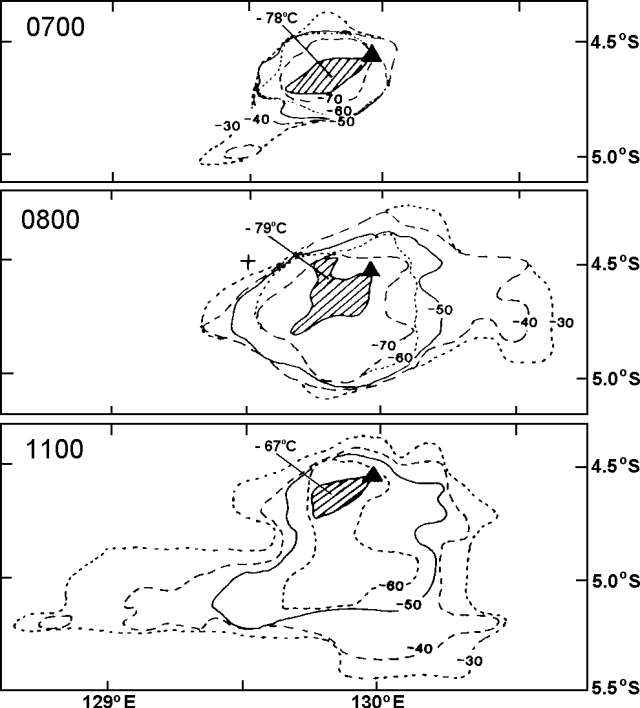 |
Figure 1. Temperature gradients in the eruption cloud from Banda Api (solid triangle) measured from GMS infrared images returned on 29 May at 0700, 0800, and 1100. Courtesy of Y. Sawada. |
Activity at Banda Api declined toward more normal inter-eruptive levels during August. Low-pressure fumes reached 25-50 m above the summit. A daily average of three tectonic and three volcanic events were recorded by seismographs.
Information Contacts: Y. Sawada, JMA; VSI.
Weak white fumes from summit, N, and S craters
By July 1989, the volcano's activity approached background level. White weak fumes reached 25-35 m above the summit crater and 5-10 m above the N and S craters during the last week in July. Three volcanic A-type, 49 volcanic B-type, one degassing, and 165 tectonic earthquakes were recorded.
Information Contacts: VSI.
|
|
||||||||||||||||||||||||||
There is data available for 23 confirmed eruptive periods.
1988 May 9 - 1988 May 17 Confirmed Eruption (Explosive / Effusive) VEI: 3 (?)
| Episode 1 | Eruption (Explosive / Effusive) | Summit, north and south flanks | |||||||||||||||||||||||||||||||||||||||||||||||||||||||||||||||||||||||||||||||||||||||||||||||||||||||
|---|---|---|---|---|---|---|---|---|---|---|---|---|---|---|---|---|---|---|---|---|---|---|---|---|---|---|---|---|---|---|---|---|---|---|---|---|---|---|---|---|---|---|---|---|---|---|---|---|---|---|---|---|---|---|---|---|---|---|---|---|---|---|---|---|---|---|---|---|---|---|---|---|---|---|---|---|---|---|---|---|---|---|---|---|---|---|---|---|---|---|---|---|---|---|---|---|---|---|---|---|---|---|---|---|
| 1988 May 9 - 1988 May 17 | Evidence from Observations: Reported | |||||||||||||||||||||||||||||||||||||||||||||||||||||||||||||||||||||||||||||||||||||||||||||||||||||||
|
List of 19 Events for Episode 1 at Summit, north and south flanks
|
||||||||||||||||||||||||||||||||||||||||||||||||||||||||||||||||||||||||||||||||||||||||||||||||||||||||
[ 1902 Mar 20 ] Uncertain Eruption
| Episode 1 | Eruption (Explosive / Effusive) | ||||||||||||||
|---|---|---|---|---|---|---|---|---|---|---|---|---|---|---|
| 1902 Mar 20 - Unknown | Evidence from Unknown | |||||||||||||
|
List of 1 Events for Episode 1
|
||||||||||||||
1901 May 18 Confirmed Eruption (Explosive / Effusive) VEI: 2
| Episode 1 | Eruption (Explosive / Effusive) | Summit and north flank | ||||||||||||||||||||||||||||||||||||||
|---|---|---|---|---|---|---|---|---|---|---|---|---|---|---|---|---|---|---|---|---|---|---|---|---|---|---|---|---|---|---|---|---|---|---|---|---|---|---|---|
| 1901 May 18 - Unknown | Evidence from Observations: Reported | ||||||||||||||||||||||||||||||||||||||
|
List of 6 Events for Episode 1 at Summit and north flank
|
|||||||||||||||||||||||||||||||||||||||
1890 Nov 23 - 1890 Nov 23 Confirmed Eruption (Explosive / Effusive) VEI: 2
| Episode 1 | Eruption (Explosive / Effusive) | |||||||||||||||||||||||||||||
|---|---|---|---|---|---|---|---|---|---|---|---|---|---|---|---|---|---|---|---|---|---|---|---|---|---|---|---|---|---|
| 1890 Nov 23 - 1890 Nov 23 | Evidence from Observations: Reported | ||||||||||||||||||||||||||||
|
List of 4 Events for Episode 1
|
|||||||||||||||||||||||||||||
[ 1855 Dec 29 - 1855 Dec 30 ] Uncertain Eruption
| Episode 1 | Eruption (Explosive / Effusive) | |||||||||||||||||||
|---|---|---|---|---|---|---|---|---|---|---|---|---|---|---|---|---|---|---|---|
| 1855 Dec 29 - 1855 Dec 30 | Evidence from Unknown | ||||||||||||||||||
|
List of 2 Events for Episode 1
|
|||||||||||||||||||
[ 1835 Oct ] Uncertain Eruption
| Episode 1 | Eruption (Explosive / Effusive) | ||||
|---|---|---|---|---|
| 1835 Oct - Unknown | Evidence from Unknown | |||
1825 (?) - 1831 Confirmed Eruption (Explosive / Effusive) VEI: 1
| Episode 1 | Eruption (Explosive / Effusive) | ||||||||||||||||||||||||
|---|---|---|---|---|---|---|---|---|---|---|---|---|---|---|---|---|---|---|---|---|---|---|---|---|
| 1825 (?) - 1831 | Evidence from Observations: Reported | |||||||||||||||||||||||
|
List of 3 Events for Episode 1
|
||||||||||||||||||||||||
1824 Apr 22 - 1824 Jun 28 Confirmed Eruption (Explosive / Effusive) VEI: 2
| Episode 1 | Eruption (Explosive / Effusive) | North side | |||||||||||||||||||||||||||||||||
|---|---|---|---|---|---|---|---|---|---|---|---|---|---|---|---|---|---|---|---|---|---|---|---|---|---|---|---|---|---|---|---|---|---|---|
| 1824 Apr 22 - 1824 Jun 28 | Evidence from Observations: Reported | |||||||||||||||||||||||||||||||||
|
List of 5 Events for Episode 1 at North side
|
||||||||||||||||||||||||||||||||||
1820 Jun 11 - 1820 Aug 8 Confirmed Eruption (Explosive / Effusive) VEI: 2
| Episode 1 | Eruption (Explosive / Effusive) | Summit, south and NNW flanks | ||||||||||||||||||||||||||||||||||||||||||||||||
|---|---|---|---|---|---|---|---|---|---|---|---|---|---|---|---|---|---|---|---|---|---|---|---|---|---|---|---|---|---|---|---|---|---|---|---|---|---|---|---|---|---|---|---|---|---|---|---|---|---|
| 1820 Jun 11 - 1820 Aug 8 | Evidence from Observations: Reported | ||||||||||||||||||||||||||||||||||||||||||||||||
|
List of 8 Events for Episode 1 at Summit, south and NNW flanks
|
|||||||||||||||||||||||||||||||||||||||||||||||||
1816 Oct 11 - 1816 Dec Confirmed Eruption (Explosive / Effusive) VEI: 2
| Episode 1 | Eruption (Explosive / Effusive) | |||||||||||||||||||
|---|---|---|---|---|---|---|---|---|---|---|---|---|---|---|---|---|---|---|---|
| 1816 Oct 11 - 1816 Dec | Evidence from Observations: Reported | ||||||||||||||||||
|
List of 2 Events for Episode 1
|
|||||||||||||||||||
1778 Confirmed Eruption (Explosive / Effusive) VEI: 2
| Episode 1 | Eruption (Explosive / Effusive) | |||||||||||||||||||
|---|---|---|---|---|---|---|---|---|---|---|---|---|---|---|---|---|---|---|---|
| 1778 - Unknown | Evidence from Observations: Reported | ||||||||||||||||||
|
List of 2 Events for Episode 1
|
|||||||||||||||||||
1775 Confirmed Eruption (Explosive / Effusive) VEI: 2
| Episode 1 | Eruption (Explosive / Effusive) | |||||||||||||||||||
|---|---|---|---|---|---|---|---|---|---|---|---|---|---|---|---|---|---|---|---|
| 1775 - Unknown | Evidence from Observations: Reported | ||||||||||||||||||
|
List of 2 Events for Episode 1
|
|||||||||||||||||||
1773 Feb 6 Confirmed Eruption (Explosive / Effusive) VEI: 2
| Episode 1 | Eruption (Explosive / Effusive) | |||||||||||||||||||
|---|---|---|---|---|---|---|---|---|---|---|---|---|---|---|---|---|---|---|---|
| 1773 Feb 6 - Unknown | Evidence from Observations: Reported | ||||||||||||||||||
|
List of 2 Events for Episode 1
|
|||||||||||||||||||
1765 Apr 19 - 1766 Oct Confirmed Eruption (Explosive / Effusive) VEI: 2
| Episode 1 | Eruption (Explosive / Effusive) | |||||||||||||||||||
|---|---|---|---|---|---|---|---|---|---|---|---|---|---|---|---|---|---|---|---|
| 1765 Apr 19 - 1766 Oct | Evidence from Observations: Reported | ||||||||||||||||||
|
List of 2 Events for Episode 1
|
|||||||||||||||||||
1762 Confirmed Eruption (Explosive / Effusive) VEI: 2
| Episode 1 | Eruption (Explosive / Effusive) | |||||||||||||||||||
|---|---|---|---|---|---|---|---|---|---|---|---|---|---|---|---|---|---|---|---|
| 1762 - Unknown | Evidence from Observations: Reported | ||||||||||||||||||
|
List of 2 Events for Episode 1
|
|||||||||||||||||||
1749 Confirmed Eruption (Explosive / Effusive) VEI: 2
| Episode 1 | Eruption (Explosive / Effusive) | |||||||||||||||||||
|---|---|---|---|---|---|---|---|---|---|---|---|---|---|---|---|---|---|---|---|
| 1749 - Unknown | Evidence from Observations: Reported | ||||||||||||||||||
|
List of 2 Events for Episode 1
|
|||||||||||||||||||
1722 Confirmed Eruption (Explosive / Effusive) VEI: 2
| Episode 1 | Eruption (Explosive / Effusive) | |||||||||||||||||||
|---|---|---|---|---|---|---|---|---|---|---|---|---|---|---|---|---|---|---|---|
| 1722 - Unknown | Evidence from Observations: Reported | ||||||||||||||||||
|
List of 2 Events for Episode 1
|
|||||||||||||||||||
1712 May - 1712 Dec Confirmed Eruption (Explosive / Effusive) VEI: 2
| Episode 1 | Eruption (Explosive / Effusive) | |||||||||||||||||||
|---|---|---|---|---|---|---|---|---|---|---|---|---|---|---|---|---|---|---|---|
| 1712 May - 1712 Dec | Evidence from Observations: Reported | ||||||||||||||||||
|
List of 2 Events for Episode 1
|
|||||||||||||||||||
1690 - 1696 May 22 Confirmed Eruption (Explosive / Effusive) VEI: 3
| Episode 1 | Eruption (Explosive / Effusive) | |||||||||||||||||||||||||||||
|---|---|---|---|---|---|---|---|---|---|---|---|---|---|---|---|---|---|---|---|---|---|---|---|---|---|---|---|---|---|
| 1690 - 1696 May 22 | Evidence from Observations: Reported | ||||||||||||||||||||||||||||
|
List of 4 Events for Episode 1
|
|||||||||||||||||||||||||||||
1683 Confirmed Eruption (Explosive / Effusive) VEI: 3
| Episode 1 | Eruption (Explosive / Effusive) | |||||||||||||||||||
|---|---|---|---|---|---|---|---|---|---|---|---|---|---|---|---|---|---|---|---|
| 1683 - Unknown | Evidence from Observations: Reported | ||||||||||||||||||
|
List of 2 Events for Episode 1
|
|||||||||||||||||||
1635 Nov 18 Confirmed Eruption (Explosive / Effusive) VEI: 1 (?)
| Episode 1 | Eruption (Explosive / Effusive) | ||||||||||||||||||||||||
|---|---|---|---|---|---|---|---|---|---|---|---|---|---|---|---|---|---|---|---|---|---|---|---|---|
| 1635 Nov 18 - Unknown | Evidence from Observations: Reported | |||||||||||||||||||||||
|
List of 3 Events for Episode 1
|
||||||||||||||||||||||||
1632 Dec 16 Confirmed Eruption (Explosive / Effusive) VEI: 3
| Episode 1 | Eruption (Explosive / Effusive) | |||||||||||||||||||||||||||||
|---|---|---|---|---|---|---|---|---|---|---|---|---|---|---|---|---|---|---|---|---|---|---|---|---|---|---|---|---|---|
| 1632 Dec 16 - Unknown | Evidence from Observations: Reported | ||||||||||||||||||||||||||||
|
List of 4 Events for Episode 1
|
|||||||||||||||||||||||||||||
1615 Mar 16 - 1615 Apr (?) Confirmed Eruption (Explosive / Effusive) VEI: 3
| Episode 1 | Eruption (Explosive / Effusive) | |||||||||||||||||||||||||||||||||||||||||||||||||
|---|---|---|---|---|---|---|---|---|---|---|---|---|---|---|---|---|---|---|---|---|---|---|---|---|---|---|---|---|---|---|---|---|---|---|---|---|---|---|---|---|---|---|---|---|---|---|---|---|---|
| 1615 Mar 16 - 1615 Apr (?) | Evidence from Observations: Reported | ||||||||||||||||||||||||||||||||||||||||||||||||
|
List of 8 Events for Episode 1
|
|||||||||||||||||||||||||||||||||||||||||||||||||
[ 1614 ] Uncertain Eruption
| Episode 1 | Eruption (Explosive / Effusive) | ||||
|---|---|---|---|---|
| 1614 - Unknown | Evidence from Unknown | |||
1609 Confirmed Eruption (Explosive / Effusive) VEI: 3
| Episode 1 | Eruption (Explosive / Effusive) | |||||||||||||||||||
|---|---|---|---|---|---|---|---|---|---|---|---|---|---|---|---|---|---|---|---|
| 1609 - Unknown | Evidence from Observations: Reported | ||||||||||||||||||
|
List of 2 Events for Episode 1
|
|||||||||||||||||||
1598 - 1602 Confirmed Eruption (Explosive / Effusive) VEI: 3
| Episode 1 | Eruption (Explosive / Effusive) | |||||||||||||||||||||||||||||
|---|---|---|---|---|---|---|---|---|---|---|---|---|---|---|---|---|---|---|---|---|---|---|---|---|---|---|---|---|---|
| 1598 - 1602 | Evidence from Observations: Reported | ||||||||||||||||||||||||||||
|
List of 4 Events for Episode 1
|
|||||||||||||||||||||||||||||
1586 Apr 17 Confirmed Eruption (Explosive / Effusive) VEI: 3
| Episode 1 | Eruption (Explosive / Effusive) | |||||||||||||||||||
|---|---|---|---|---|---|---|---|---|---|---|---|---|---|---|---|---|---|---|---|
| 1586 Apr 17 - Unknown | Evidence from Observations: Reported | ||||||||||||||||||
| Flames and black or gray smoke ejected on 17 April 1586 (Sapper, 1917). | |||||||||||||||||||
|
List of 2 Events for Episode 1
|
|||||||||||||||||||
This compilation of synonyms and subsidiary features may not be comprehensive. Features are organized into four major categories: Cones, Craters, Domes, and Thermal Features. Synonyms of features appear indented below the primary name. In some cases additional feature type, elevation, or location details are provided.
Craters |
||||
| Feature Name | Feature Type | Elevation | Latitude | Longitude |
| Angus, Batu | Crater | 250 m | ||
| Pasir Besar | Crater | 150 m | ||
| Pintu Kecil | Crater | 200 m | ||
 This 1726 lithograph shows an eruption plume from the summit of Banda Api, possibly from the last previous eruption, which took place in 1722. This sketch shows sailing ships plying the strait between the islands of Lonthur and Neira in the historic Banda Islands, the original Spice Islands of the Dutch East Indies.
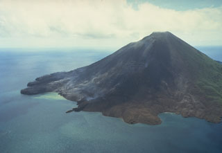 Gunung Api volcano is seen here in an aerial view from the south on May 19, 1988. The narrow peninsula at the left-center is the terminous of a still-steaming lava flow that was erupted from a vent low on the SW flank beginning on May 9. Another flow erupted from a vent at about 150 m elevation on the SW flank also reached the sea immediately to the west. The May 9 vents were located along an arcuate N-SSW-trending fissure that cut across the summit of the volcano.
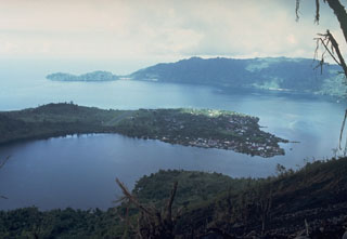 The arcuate islands of Banda Neira and Lonthor, seen here looking E from the summit of Indonesia's Banda Api volcano, are remnants of two largely-submarine calderas that preceded the construction of the Banda Api stratovolcano. The outer caldera has a diameter of 7 km and the nested inner caldera is 3 km wide. Neira, the largest town in the Banda Islands, occupies the southern tip of Banda Neira Island.
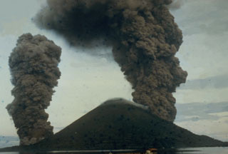 This dramatic photo taken from the SE on May 9, 1988, shows ash-rich eruption plumes rising from vents on the north and south sides of the island. The blue dots are a result of film damage. The eruption occurred from a 3-km-long arcuate fissure that cut the island from the south coast to the 200-m elevation on the north flank. The eruption plume reached a maximum height of 16.5 km. Lava flows reached the north, NW, and south coasts, destroying two villages.
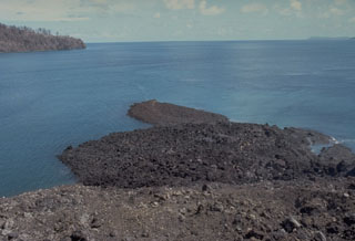 A small lava flow from a vent low on the south flank of Gunung Api flowed into the sea, forming a narrow peninsula. The May 9, 1988 lava flow was erupted from a 100-m-long fissure that produced a tuff cone over the vent. Minor submarine activity occurred at the lower end of the fissure. The western tip of Bantur Island appears in the background.
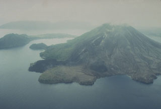 The May 1988 north-flank lava flows reached the sea at two locations. The flows originated from a fissure that can be seen descending diagonally to the left from the summit. The Pasir Besar lava flow was erupted from a vent at about 300-350 m elevation and reached the sea along almost the full length of Pasir Besar bay at the right-center. The Batu Angus lava flow originated from a vent at 200 m elevation and reached the sea at the left-center after overrunning houses in the villages of Kalobi and Batu Angus.
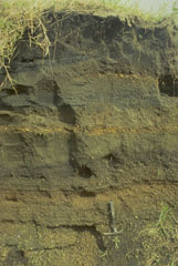 A 2.6-m-thick section at the airport on Neira Island (4.5 km from Banda Api volcano) shows 14 different tephra layers. The uppermost layer originated during an eruption in 1820, when the village was evacuated due to heavy ashfall. The section shows several layers of coarser, lighter-colored pumice and lapilli produced during more vigorous plinian eruptions than occurred in 1988.
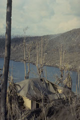 The roof of this house at Pasir Besar on the NW coast of Gunung Api Island collapsed as a result of the loading of ash and the impact of ballistic bombs from the May 9, 1988 eruption of Banda Api volcano. Tephra from the eruption was distributed primarily to the west. The barren slope in the background of this May 19 photo is the surface of the 1988 Pasir Besar lava flow, which descended to the sea from a vent on the northern flank.
 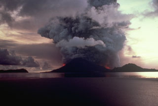 Vigorous explosive eruptions continue from Banda Api volcano at dusk on May 9, 1988. Incandescent lava fountains rise above vents on the northern and southern flanks and the eruption column reaches a height of about 5 km. Activity began at about 6:30 that morning from an eruptive fissure that cut across the volcano. Neira Island is at the right and the western tip of Lonthur Island at the left in this view from the ENE.
 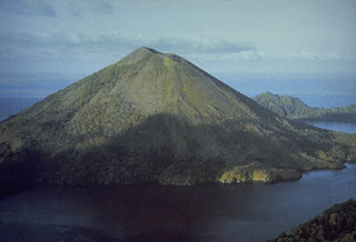 Banda Api volcano is seen here from the SW prior to a major eruption in 1988. The ridge in the right background is Neira Island; at the bottom right is the western tip of Lonthur Island. Both islands are remnants of calderas inside which the conical Gunung Api stratovolcano was constructed. One of many peaks named Gunung Api ("Fire Mountain") in Indonesia, Banda Api is the most active volcano of the Banda arc.
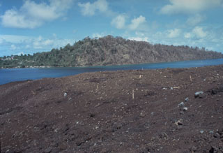 Vegetation in the foreground and on the western tip of Lonthur Island in the background was destroyed and scorched by a directed blast produced by temporary deflection of the vertical plinian eruption column on May 9, 1988. Witnesses reported that at 11:30 am "the entire eruption column bent sidways towards the south," probably as a result of slumping of the uphill slope onto the vent. About 2 cm of tephra was deposited on Lonthur Island, but the village of Lonthur (left) was spared.
 The 640-m-high symmetrical volcano of Banda Api, the most active of a chain of volcanoes in Indonesia's Banda Sea, forms a small 3-km-wide island within a largely submerged 7-km-wide caldera. This May 19, 1988, view from the south shows vegetation damage from the 1988 eruption and the southern half of a prominent arcuate fissure that extended from the south coast through the summit to 200 m above the north coast. The still-steaming narrow black lava flow entering the sea to the left of center is one of four erupted in 1988.
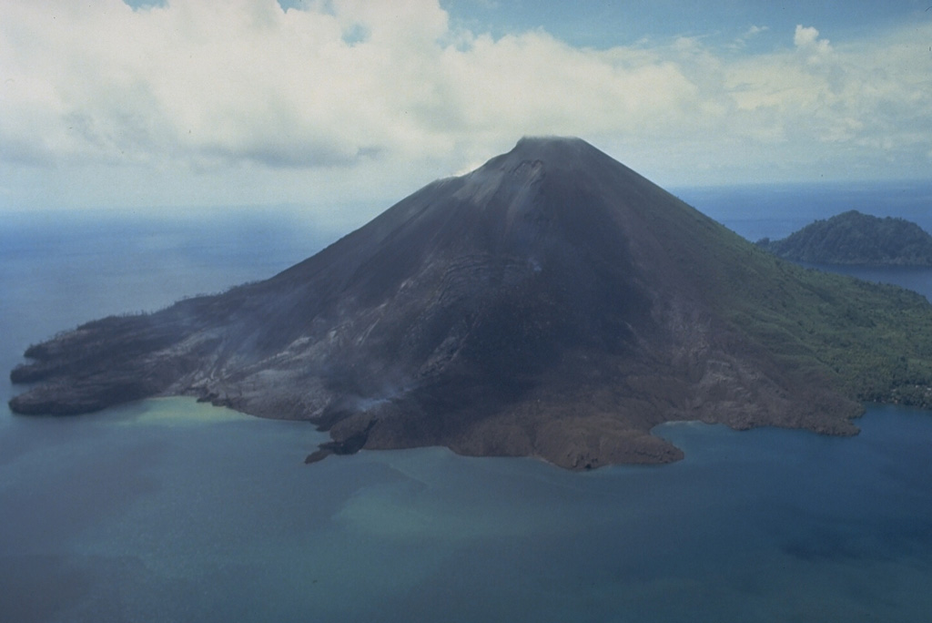
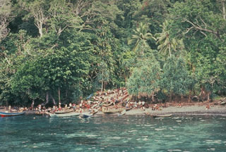 At the onset of the eruption of Banda Api on 9 May 1988, residents of Neira moved to the west side of the island to begin evacuations. Residents of nearby Gunung Api Island, where the eruption occurred, had been evacuated over the previous two days. As many as 10,000 people were evacuated during the eruption; the only people to lose their lives were four who remained in the evacuation zone.
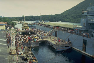 Evacuees on the island of Neira board an Indonesian Navy ship on 20 May 1988, bound for the island of Sulawesi. About 10,000 people of a population of 16,000 living in the Banda Islands were evacuated during the 1988 eruption. During the two days prior to the start of the eruption on the morning of 9 May, about 1800 people on Gunung Api Island (the site of the eruption) evacuated to Neira and Lonthor Islands. On the 9th, people began moving from Neira Island to Lonthur and then to more distant locations. The evacuation remained in effect until 13 June.
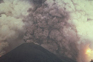 A vigorous plinian eruption column, seen from the ENE side during the afternoon of May 9, rises above an arcuate fissure cutting both sides of Banda Api volcano. The plume reached a maximum height of 16.5 km, depositing blocks, pumice, and scoria primarily to the west.
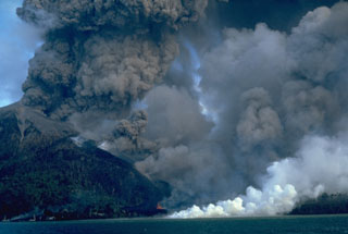 An eruption of Indonesia's Banda Api volcano, seen here on 10 May 1988, took place from a N-SSW-trending fissure that cut across the island. Both explosive activity and lava effusion occurred along the fissure. Billowing, ash-rich eruption plumes rose from vents along the N end of the fissure. Minor lava fountaining can be seen here at the lower-center, near the N coast. White steam marks the entry of the lava flow into the sea after overrunning two villages.
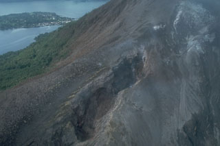 Fissures of vents no. 1 (bottom) and 3 (upper right) cut the northern flank of Banda Api volcano. Ash mantles vegetation adjacent to the fissures, which are about 15-20 m wide at this location. These vents, which began erupting on May 9, 1988, also fed two large lava flows that reached the sea along the northern and NW coasts. Neira Island appears in the background in this May 21, 1988 photo.
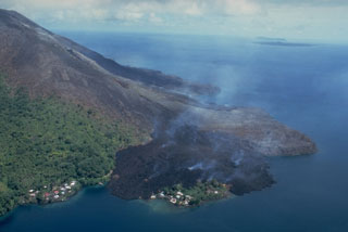 This May 19, 1988, view from the NE shows a still-steaming black lava flow entering the sea along the north coast, partially overrunning the village of Batu Angus. The lava flow originated from a vent at 200 m on the north flank on May 9, and reached the sea the same day. A second steaming lava flow, the Pasir Besar flow, which originated from a vent at 300-350 m elevation, can be seen reaching the NW coast at the center of the photo. The portion of Batu Angus village surrounded by the lava flow sits on an earlier lava flow erupted in 1901.
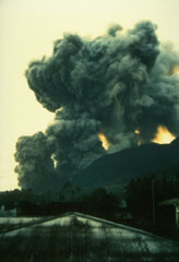 On May 9, 1988, ash columns rise from four eruptive vents along a fissure on the southern flank of Banda Api volcano, observed here from the village of Neira, located across a narrow strait 4.5 km east of the eruptive fissure. An arcuate N-SSW-trending eruptive fissure cut almost entirely across Gunung Api Island during the first day of the eruption and produced both vigorous explosive activity and lava flows. Winds distributed ashfall primarily to west, away from Neira Island.
There are no samples for Banda Api in the Smithsonian's NMNH Department of Mineral Sciences Rock and Ore collection.
| Copernicus Browser | The Copernicus Browser replaced the Sentinel Hub Playground browser in 2023, to provide access to Earth observation archives from the Copernicus Data Space Ecosystem, the main distribution platform for data from the EU Copernicus missions. |
| MIROVA | Middle InfraRed Observation of Volcanic Activity (MIROVA) is a near real time volcanic hot-spot detection system based on the analysis of MODIS (Moderate Resolution Imaging Spectroradiometer) data. In particular, MIROVA uses the Middle InfraRed Radiation (MIR), measured over target volcanoes, in order to detect, locate and measure the heat radiation sourced from volcanic activity. |
| MODVOLC Thermal Alerts | Using infrared satellite Moderate Resolution Imaging Spectroradiometer (MODIS) data, scientists at the Hawai'i Institute of Geophysics and Planetology, University of Hawai'i, developed an automated system called MODVOLC to map thermal hot-spots in near real time. For each MODIS image, the algorithm automatically scans each 1 km pixel within it to check for high-temperature hot-spots. When one is found the date, time, location, and intensity are recorded. MODIS looks at every square km of the Earth every 48 hours, once during the day and once during the night, and the presence of two MODIS sensors in space allows at least four hot-spot observations every two days. Each day updated global maps are compiled to display the locations of all hot spots detected in the previous 24 hours. There is a drop-down list with volcano names which allow users to 'zoom-in' and examine the distribution of hot-spots at a variety of spatial scales. |
|
WOVOdat
Single Volcano View Temporal Evolution of Unrest Side by Side Volcanoes |
WOVOdat is a database of volcanic unrest; instrumentally and visually recorded changes in seismicity, ground deformation, gas emission, and other parameters from their normal baselines. It is sponsored by the World Organization of Volcano Observatories (WOVO) and presently hosted at the Earth Observatory of Singapore.
GVMID Data on Volcano Monitoring Infrastructure The Global Volcano Monitoring Infrastructure Database GVMID, is aimed at documenting and improving capabilities of volcano monitoring from the ground and space. GVMID should provide a snapshot and baseline view of the techniques and instrumentation that are in place at various volcanoes, which can be use by volcano observatories as reference to setup new monitoring system or improving networks at a specific volcano. These data will allow identification of what monitoring gaps exist, which can be then targeted by remote sensing infrastructure and future instrument deployments. |
| Volcanic Hazard Maps | The IAVCEI Commission on Volcanic Hazards and Risk has a Volcanic Hazard Maps database designed to serve as a resource for hazard mappers (or other interested parties) to explore how common issues in hazard map development have been addressed at different volcanoes, in different countries, for different hazards, and for different intended audiences. In addition to the comprehensive, searchable Volcanic Hazard Maps Database, this website contains information about diversity of volcanic hazard maps, illustrated using examples from the database. This site is for educational purposes related to volcanic hazard maps. Hazard maps found on this website should not be used for emergency purposes. For the most recent, official hazard map for a particular volcano, please seek out the proper institutional authorities on the matter. |
| IRIS seismic stations/networks | Incorporated Research Institutions for Seismology (IRIS) Data Services map showing the location of seismic stations from all available networks (permanent or temporary) within a radius of 0.18° (about 20 km at mid-latitudes) from the given location of Banda Api. Users can customize a variety of filters and options in the left panel. Note that if there are no stations are known the map will default to show the entire world with a "No data matched request" error notice. |
| UNAVCO GPS/GNSS stations | Geodetic Data Services map from UNAVCO showing the location of GPS/GNSS stations from all available networks (permanent or temporary) within a radius of 20 km from the given location of Banda Api. Users can customize the data search based on station or network names, location, and time window. Requires Adobe Flash Player. |
| DECADE Data | The DECADE portal, still in the developmental stage, serves as an example of the proposed interoperability between The Smithsonian Institution's Global Volcanism Program, the Mapping Gas Emissions (MaGa) Database, and the EarthChem Geochemical Portal. The Deep Earth Carbon Degassing (DECADE) initiative seeks to use new and established technologies to determine accurate global fluxes of volcanic CO2 to the atmosphere, but installing CO2 monitoring networks on 20 of the world's 150 most actively degassing volcanoes. The group uses related laboratory-based studies (direct gas sampling and analysis, melt inclusions) to provide new data for direct degassing of deep earth carbon to the atmosphere. |
| Large Eruptions of Banda Api | Information about large Quaternary eruptions (VEI >= 4) is cataloged in the Large Magnitude Explosive Volcanic Eruptions (LaMEVE) database of the Volcano Global Risk Identification and Analysis Project (VOGRIPA). |
| EarthChem | EarthChem develops and maintains databases, software, and services that support the preservation, discovery, access and analysis of geochemical data, and facilitate their integration with the broad array of other available earth science parameters. EarthChem is operated by a joint team of disciplinary scientists, data scientists, data managers and information technology developers who are part of the NSF-funded data facility Integrated Earth Data Applications (IEDA). IEDA is a collaborative effort of EarthChem and the Marine Geoscience Data System (MGDS). |

