
The Pusat Vulkanologi dan Mitigasi Bencana Geologi (PVMBG) reported that the eruption at Ibu continued during 24-30 September. Dense gray or white-and-gray ash plumes rose 300-700 m above the summit and drifted in multiple directions. Incandescence at the summit was visible in a few nighttime webcam images. The Alert Level remained at 2 (the second lowest level on a four-level scale) and the public was advised to stay 2 km away from the active crater and 3.5 km away from the N crater wall opening.
Source: Pusat Vulkanologi dan Mitigasi Bencana Geologi (PVMBG, also known as CVGHM)
Eruption continued during June-November 2023, with persistent ash explosions and thermal anomalies
The current eruption period of Ibu, a stratovolcano on Indonesia’s Halmahera Island, began in April 2008 and has primarily consisted of ash plumes and emissions varying from intermittent to daily, along with occasional thermal anomalies (BGVN 43:12, 48:06). This report updates activity through November 2023, based on daily reports from MAGMA Indonesia, advisories issued by the Pusat Vulkanologi dan Mitigasi Bencana Geologi (PVMBG, also known as Indonesian Center for Volcanology and Geological Hazard Mitigation, CVGHM), the Darwin Volcanic Ash Advisory Centre (VAAC), and various satellite data. MAGMA Indonesia is a platform developed by PVMBG to improve timely public access to volcano and earthquake activity.
According to PVMBG, from June to November 2023 daily gray-and-white plumes of variable densities usually rose 200-1,000 m above the nested summit craters and drifted in multiple directions. Occasional larger explosions prompted PVMBG to issue 50 Volcano Observatory Notice for Aviation (VONA) ash plume alerts during the reporting period. VONAs were issued every month, ranging from 5 in June to 14 in October; all described the ash plumes as dense. A few plumes rose as high as 1,500 meters during August-November. Clear Sentinel-2 satellite views showed ash plumes on 8 and 13 August, but webcam images showed intermittent ash plumes similar to those seen in recent years.
The MIROVA satellite volcano hotspot detection system recorded frequent thermal anomalies of low to moderate power throughout the reporting period. Data from imaging spectroradiometers aboard NASA’s Aqua and Terra satellites and processed using the MODVOLC algorithm (MODIS-MODVOLC) recorded hotspots on 6 June, 3 August, 30 September, five days in October (5, 10, 15, 26, 31), and four days in November (5, 12, 13, 26). Sentinel-2 satellite images showed a summit crater hotspot in every clear view, along with thermal anomalies extending S from the crater in a partially obscured view on 21 November. White-to-grayish emissions were also visible on clear days.
Information Contacts: Pusat Vulkanologi dan Mitigasi Bencana Geologi (PVMBG, also known as Indonesian Center for Volcanology and Geological Hazard Mitigation, CVGHM), Jalan Diponegoro 57, Bandung 40122, Indonesia (URL: http://www.vsi.esdm.go.id/); MAGMA Indonesia (Multiplatform Application for Geohazard Mitigation and Assessment in Indonesia), Kementerian Energi dan Sumber Daya Mineral (URL: https://magma.esdm.go.id/v1); Darwin Volcanic Ash Advisory Centre (VAAC), Bureau of Meteorology, Northern Territory Regional Office, PO Box 40050, Casuarina, NT 0811, Australia (URL: http://www.bom.gov.au/info/vaac/); Copernicus Browser, Copernicus Data Space Ecosystem, European Space Agency (URL: https://dataspace.copernicus.eu/browser/); MIROVA (Middle InfraRed Observation of Volcanic Activity), a collaborative project between the Universities of Turin and Florence (Italy) supported by the Centre for Volcanic Risk of the Italian Civil Protection Department (URL: http://www.mirovaweb.it/); Hawai'i Institute of Geophysics and Planetology (HIGP) - MODVOLC Thermal Alerts System, School of Ocean and Earth Science and Technology (SOEST), Univ. of Hawai'i, 2525 Correa Road, Honolulu, HI 96822, USA (URL: http://modis.higp.hawaii.edu/).
2025: January
| February
| March
| April
| May
| June
| July
| August
| September
2024: January
| February
| March
| April
| May
| June
| July
| August
| September
| October
| November
| December
2023: January
| February
| March
| April
| May
| July
| August
| September
| October
| November
| December
2022: February
| March
| April
| May
| June
| July
| August
| September
| October
| November
| December
2021: January
| February
| March
| April
| May
| June
| August
| September
| October
| November
| December
2020: January
| February
| March
| April
| May
| June
| July
| August
| September
| October
| November
| December
2019: February
| March
| April
| May
| June
| July
| August
| September
| October
| November
| December
2018: March
| April
| May
| June
| July
| August
| September
| October
| November
| December
2017: January
| March
| April
| May
| June
| August
2016: March
| August
2015: November
2013: June
| December
2011: September
2009: July
| August
2008: April
The Pusat Vulkanologi dan Mitigasi Bencana Geologi (PVMBG) reported that the eruption at Ibu continued during 24-30 September. Dense gray or white-and-gray ash plumes rose 300-700 m above the summit and drifted in multiple directions. Incandescence at the summit was visible in a few nighttime webcam images. The Alert Level remained at 2 (the second lowest level on a four-level scale) and the public was advised to stay 2 km away from the active crater and 3.5 km away from the N crater wall opening.
Source: Pusat Vulkanologi dan Mitigasi Bencana Geologi (PVMBG, also known as CVGHM)
The Pusat Vulkanologi dan Mitigasi Bencana Geologi (PVMBG) reported that the eruption at Ibu continued during 17-23 September. Dense gray or white-and-gray ash plumes rose 400-700 m above the summit and drifted W, NW, and NE. Incandescence at the summit was visible in several nighttime webcam images. The Alert Level remained at 2 (the second lowest level on a four-level scale) and the public was advised to stay 2 km away from the active crater and 3.5 km away from the N crater wall opening.
Source: Pusat Vulkanologi dan Mitigasi Bencana Geologi (PVMBG, also known as CVGHM)
The Pusat Vulkanologi dan Mitigasi Bencana Geologi (PVMBG) reported that the eruption at Ibu continued during 10-16 September. Daily dense gray or white-and-gray ash plumes rose 300-600 m above the summit and drifted in multiple directions. Incandescence at the summit was visible in a few nighttime webcam images. The Alert Level remained at 2 (the second lowest level on a four-level scale) and the public was advised to stay 2 km away from the active crater and 3.5 km away from the N crater wall opening.
Source: Pusat Vulkanologi dan Mitigasi Bencana Geologi (PVMBG, also known as CVGHM)
The Pusat Vulkanologi dan Mitigasi Bencana Geologi (PVMBG) reported that the eruption at Ibu continued during 3-9 September. Daily dense gray or white-and-gray ash plumes rose 400-1,000 m above the summit and drifted NW, W, and SW. Incandescence at the summit was visible in a few nighttime webcam images. The Alert Level remained at 2 (the second lowest level on a four-level scale) and the public was advised to stay 2 km away from the active crater and 3.5 km away from the N crater wall opening.
Source: Pusat Vulkanologi dan Mitigasi Bencana Geologi (PVMBG, also known as CVGHM)
The Pusat Vulkanologi dan Mitigasi Bencana Geologi (PVMBG) reported that the eruption at Ibu continued during 20-26 August. Daily dense gray or white-and-gray ash plumes rose 300-700 m above the summit and drifted NE and E. Incandescence at the summit was visible in a few nighttime webcam images. The Alert Level remained at 2 (the second lowest level on a four-level scale) and the public was advised to stay 2 km away from the active crater and 3.5 km away from the N crater wall opening.
Source: Pusat Vulkanologi dan Mitigasi Bencana Geologi (PVMBG, also known as CVGHM)
The Pusat Vulkanologi dan Mitigasi Bencana Geologi (PVMBG) reported that the eruption at Ibu continued during 20-26 August. Daily dense gray ash plumes rose 300-700 m above the summit and drifted in multiple directions. Incandescence at the summit was visible in several nighttime webcam images. The Alert Level remained at 2 (the second lowest level on a four-level scale) and the public was advised to stay 2 km away from the active crater and 3.5 km away from the N crater wall opening.
Source: Pusat Vulkanologi dan Mitigasi Bencana Geologi (PVMBG, also known as CVGHM)
The Pusat Vulkanologi dan Mitigasi Bencana Geologi (PVMBG) reported that the eruption at Ibu continued during 13-19 August. Daily dense gray ash plumes rose 400-700 m above the summit and drifted in multiple directions. The Alert Level remained at 2 (the second lowest level on a four-level scale) and the public was advised to stay 2 km away from the active crater and 3.5 km away from the N crater wall opening.
Source: Pusat Vulkanologi dan Mitigasi Bencana Geologi (PVMBG, also known as CVGHM)
The Pusat Vulkanologi dan Mitigasi Bencana Geologi (PVMBG) reported that the eruption at Ibu continued during 23-29 July. Daily dense gray ash plumes rose 300-700 m above the summit and drifted NW, W, and SW. Crater incandescence was visible in a few nighttime webcam images. The Alert Level remained at 2 (the second lowest level on a four-level scale) and the public was advised to stay 2 km away from the active crater and 3.5 km away from the N crater wall opening.
Source: Pusat Vulkanologi dan Mitigasi Bencana Geologi (PVMBG, also known as CVGHM)
The Pusat Vulkanologi dan Mitigasi Bencana Geologi (PVMBG) reported that the eruption at Ibu continued during 30 July-5 August. Daily dense gray or white-to-gray ash plumes rose 300-900 m above the summit and drifted N, NW, and W. Between 109 and 137 daily explosions were noted. Crater incandescence was visible in nighttime webcam images. The Alert Level remained at 2 (the second highest level on a four-level scale) and the public was advised to stay 2 km away from the active crater and 3.5 km away from the N crater wall opening.
Source: Pusat Vulkanologi dan Mitigasi Bencana Geologi (PVMBG, also known as CVGHM)
The Pusat Vulkanologi dan Mitigasi Bencana Geologi (PVMBG) reported that the eruption at Ibu continued during 23-29 July. Daily dense gray or white-to-gray ash plumes rose 200-800 m above the summit and drifted NW, NE, and SE. Crater incandescence was visible in nighttime webcam images. The Alert Level remained at 2 (the second lowest level on a four-level scale) and the public was advised to stay 2 km away from the active crater and 3.5 km away from the N crater wall opening.
Source: Pusat Vulkanologi dan Mitigasi Bencana Geologi (PVMBG, also known as CVGHM)
The Pusat Vulkanologi dan Mitigasi Bencana Geologi (PVMBG) reported that the eruption at Ibu continued during 16-22 July. Daily dense gray or white-to-gray ash plumes rose 200-600 m above the summit and drifted NE and SE. Nighttime crater incandescence was visible in some webcam images. The Alert Level remained at 2 (the second lowest level on a four-level scale) and the public was advised to stay 2 km away from the active crater and 3.5 km away from the N crater wall opening.
Source: Pusat Vulkanologi dan Mitigasi Bencana Geologi (PVMBG, also known as CVGHM)
The Pusat Vulkanologi dan Mitigasi Bencana Geologi (PVMBG) reported that the eruption at Ibu continued during 9-15 July. Almost daily dense gray or white-to-gray ash plumes rose 200-600 m above the summit and drifted NE and SE; weather conditions obscured views on 9 July. Nighttime crater incandescence was visible in some webcam images. The Alert Level remained at 2 (the second lowest level on a four-level scale) and the public was advised to stay 2 km away from the active crater and 3.5 km away from the N crater wall opening.
Source: Pusat Vulkanologi dan Mitigasi Bencana Geologi (PVMBG, also known as CVGHM)
The Pusat Vulkanologi dan Mitigasi Bencana Geologi (PVMBG) reported that the eruption at Ibu continued during 2-8 July. Daily dense gray or white-to-gray ash plumes rose 300-700 m above the summit and drifted in multiple directions. Nighttime crater incandescence was visible in some webcam images. The Alert Level remained at 2 (the second lowest level on a four-level scale) and the public was advised to stay 2 km away from the active crater and 3.5 km away from the N crater wall opening.
Source: Pusat Vulkanologi dan Mitigasi Bencana Geologi (PVMBG, also known as CVGHM)
The Pusat Vulkanologi dan Mitigasi Bencana Geologi (PVMBG) reported that the eruption at Ibu continued during 25 June-1 July. Daily dense gray ash plumes rose 200-600 m above the summit and drifted NE, E, and SE. Nighttime crater incandescence was visible in some webcam images. The Alert Level remained at 2 (the second lowest level on a four-level scale) and the public was advised to stay 2 km away from the active crater and 3.5 km away from the N crater wall opening.
Source: Pusat Vulkanologi dan Mitigasi Bencana Geologi (PVMBG, also known as CVGHM)
The Pusat Vulkanologi dan Mitigasi Bencana Geologi (PVMBG) reported that the eruption at Ibu continued during 18-24 June. Gray or white-to-gray ash plumes rose 300-800 m above the summit and drifted in multiple directions on most days; eruptive events were recorded on 18 June, but visual observations were obscured by weather clouds. Nighttime crater incandescence was visible in some webcam images. The Alert Level remained at 2 (the second lowest level on a four-level scale) and the public was advised to stay 2 km away from the active crater and 3.5 km away from the N crater wall opening.
Source: Pusat Vulkanologi dan Mitigasi Bencana Geologi (PVMBG, also known as CVGHM)
The Pusat Vulkanologi dan Mitigasi Bencana Geologi (PVMBG) reported that the eruption at Ibu continued during 11-17 June. Daily gray or white-to-gray ash plumes rose 300-700 m above the summit and drifted in all directions throughout the week, but primarily to the SW and S. Nighttime crater incandescence was visible in some webcam images. Weather clouds sometimes obscured views. The Alert Level remained at 2 (the second lowest level on a four-level scale) and the public was advised to stay 2 km away from the active crater and 3.5 km away from the N crater wall opening.
Source: Pusat Vulkanologi dan Mitigasi Bencana Geologi (PVMBG, also known as CVGHM)
The Pusat Vulkanologi dan Mitigasi Bencana Geologi (PVMBG) reported that the eruption at Ibu continued during 4-10 June. Daily gray or white-to-gray ash plumes rose 300-700 m above the summit and drifted NE, E, and SE. Nighttime crater incandescence was visible in some webcam images. Weather clouds sometimes obscured views. The Alert Level remained at 2 (the second lowest level on a four-level scale) and the public was advised to stay 2 km away from the active crater and 3.5 km away from the N crater wall opening.
Source: Pusat Vulkanologi dan Mitigasi Bencana Geologi (PVMBG, also known as CVGHM)
The Pusat Vulkanologi dan Mitigasi Bencana Geologi (PVMBG) reported that the eruption at Ibu continued during 28 May-3 June. Daily gray or white-to-brown ash plumes rose as high as 1 km above the summit and drifted S, SW, NW, and NE. Nighttime crater incandescence was visible in some webcam images. The Alert Level remained at 2 (the second lowest level on a four-level scale) and the public was advised to stay 2 km away from the active crater and 3.5 km away from the N crater wall opening.
Source: Pusat Vulkanologi dan Mitigasi Bencana Geologi (PVMBG, also known as CVGHM)
The Pusat Vulkanologi dan Mitigasi Bencana Geologi (PVMBG) reported that the eruption at Ibu continued during 14-20 May. Daily gray, white-to-gray, or white-to-brown ash plumes rose as high as 1 km above the summit and drifted in various directions. Nighttime crater incandescence was visible in some webcam images. The Alert Level remained at 2 (the second lowest level on a four-level scale) and the public was advised to stay 2 km away from the active crater and 3.5 km away from the N crater wall opening.
Source: Pusat Vulkanologi dan Mitigasi Bencana Geologi (PVMBG, also known as CVGHM)
The Pusat Vulkanologi dan Mitigasi Bencana Geologi (PVMBG) reported that the eruption at Ibu continued during 7-13 May. Daily gray, white-to-gray, or white-to-brown ash plumes rose 300-800 m above the summit and drifted in various directions. Nighttime crater incandescence was visible in some webcam images. The Alert Level remained at 2 (the second lowest level on a four-level scale) and the public was advised to stay 2 km away from the active crater and 3.5 km away from the N crater wall opening.
Source: Pusat Vulkanologi dan Mitigasi Bencana Geologi (PVMBG, also known as CVGHM)
The Pusat Vulkanologi dan Mitigasi Bencana Geologi (PVMBG) lowered the Alert Level for Ibu to 2 (the second lowest level on a four-level scale) at 1700 on 1 May, based on visual observations and monitoring data that showed decreasing activity since February. Eruptive activity continued to be recorded, though plumes heights were lower and incandescent material was ejected only as far as 200 m from the crater rim. Seismic activity had decreased, and deformation data showed some signs of decreased pressure, or deflation. Daily gray, white-to-gray, or white-to-brown ash plumes rose 300-700 m above the crater rim and drifted in variable directions. Nighttime crater incandescence was visible in some webcam images. The public was advised to stay 2 km away from the active crater and 3.5 km away from the N crater wall opening.
Source: Pusat Vulkanologi dan Mitigasi Bencana Geologi (PVMBG, also known as CVGHM)
The Pusat Vulkanologi dan Mitigasi Bencana Geologi (PVMBG) reported that the eruption at Ibu continued during 23-29 April. Dense gray ash plumes rose 400-700 m above the summit and drifted E and NE on most days. Eruptive events were recorded by the seismicity network on 24 and 26 April, though weather conditions prevented visual observations. Nighttime crater incandescence was visible in some webcam images. The Alert Level remained at 3 (the second highest level on a four-level scale) and the public was advised to stay 4 km away from the active crater and 5 km away from the N crater wall opening.
Source: Pusat Vulkanologi dan Mitigasi Bencana Geologi (PVMBG, also known as CVGHM)
The Pusat Vulkanologi dan Mitigasi Bencana Geologi (PVMBG) reported that the eruption at Ibu continued during 16-22 April. Daily dense gray ash plumes rose 300-600 m above the summit and drifted in multiple directions. Nighttime crater incandescence was visible in a webcam images on 16, 18, and 21 April. The Alert Level remained at 3 (the second highest level on a four-level scale) and the public was advised to stay 4 km away from the active crater and 5 km away from the N crater wall opening.
Source: Pusat Vulkanologi dan Mitigasi Bencana Geologi (PVMBG, also known as CVGHM)
The Pusat Vulkanologi dan Mitigasi Bencana Geologi (PVMBG) reported that the eruption at Ibu continued during 9-15 April. Daily dense gray ash plumes rose 300-700 m above the summit and drifted in multiple directions. Nighttime crater incandescence was visible in a webcam image on 15 April. The Alert Level remained at 3 (the second highest level on a four-level scale) and the public was advised to stay 4 km away from the active crater and 5 km away from the N crater wall opening.
Source: Pusat Vulkanologi dan Mitigasi Bencana Geologi (PVMBG, also known as CVGHM)
The Pusat Vulkanologi dan Mitigasi Bencana Geologi (PVMBG) reported that the eruption at Ibu continued during 2-7 April. Daily dense gray ash plumes rose 300-1,000 m above the summit and drifted in multiple directions. Incandescence at the summit was visible in several webcam images posted with the reports. The Alert Level remained at 3 (the second highest level on a four-level scale) and the public was advised to stay 4 km away from the active crater and 5 km away from the N crater wall opening.
Source: Pusat Vulkanologi dan Mitigasi Bencana Geologi (PVMBG, also known as CVGHM)
The Pusat Vulkanologi dan Mitigasi Bencana Geologi (PVMBG) reported that the eruption at Ibu continued during 26 March-1 April. Daily dense gray ash plumes rose 300-1,200 m above the summit and drifted in multiple directions. Incandescence at the summit was visible in several webcam images posted with the reports. The Alert Level remained at 3 (the second highest level on a four-level scale) and the public was advised to stay 4 km away from the active crater and 5 km away from the N crater wall opening.
Source: Pusat Vulkanologi dan Mitigasi Bencana Geologi (PVMBG, also known as CVGHM)
The Pusat Vulkanologi dan Mitigasi Bencana Geologi (PVMBG) reported that the eruption at Ibu continued during 12-18 March. Eruptive events were recorded daily though weather conditions sometimes obscured views. Dense gray ash plumes rose 300-700 m above the summit and drifted SW, NW, and E during 19-21 and 24 March. Incandescence at the summit was visible in a few webcam images posted with the reports. The Alert Level remained at 3 (the second highest level on a four-level scale) and the public was advised to stay 4 km away from the active crater and 5 km away from the N crater wall opening.
Source: Pusat Vulkanologi dan Mitigasi Bencana Geologi (PVMBG, also known as CVGHM)
The Pusat Vulkanologi dan Mitigasi Bencana Geologi (PVMBG) reported that the eruption at Ibu continued during 12-18 March. Multiple daily dense gray ash plumes rose as high as 1.2 km above the summit and drifted in multiple directions. Very minor incandescence at the summit was visible in a few webcam images posted with the reports. The Alert Level remained at 3 (the second highest level on a four-level scale) and the public was advised to stay 4 km away from the active crater and 5 km away from the N crater wall opening.
Source: Pusat Vulkanologi dan Mitigasi Bencana Geologi (PVMBG, also known as CVGHM)
The Pusat Vulkanologi dan Mitigasi Bencana Geologi (PVMBG) reported that the eruption at Ibu continued during 5-11 March. Multiple daily gray or white-and-gray ash plumes that were often dense rose as high as 1.5 km above the summit and drifted mainly NW, W, and SW. Minor incandescence at the summit was visible in some webcam images posted with the reports. The Alert Level remained at 3 (the second highest level on a four-level scale) and the public was advised to stay 4 km away from the active crater and 5 km away from the N crater wall opening.
Source: Pusat Vulkanologi dan Mitigasi Bencana Geologi (PVMBG, also known as CVGHM)
The Pusat Vulkanologi dan Mitigasi Bencana Geologi (PVMBG) reported that the eruption at Ibu continued during 19-25 February. Multiple daily gray, white-and-gray, or gray-to-brown ash plumes that were often dense rose as high as 1.5 km above the summit and drifted in multiple directions. Incandescence at the summit was visible in some webcam images posted with the reports. The Alert Level remained at 3 (the second highest level on a four-level scale) and the public was advised to stay 4 km away from the active crater and 5 km away from the N crater wall opening.
Source: Pusat Vulkanologi dan Mitigasi Bencana Geologi (PVMBG, also known as CVGHM)
The Pusat Vulkanologi dan Mitigasi Bencana Geologi (PVMBG) reported that the eruption at Ibu continued during 19-25 February. Multiple daily gray or white-and-gray ash plumes that were often dense rose as high as 1.5 km above the summit and drifted mainly in multiple directions. Incandescence at the summit was visible in some webcam images posted with the reports. The Alert Level remained at 3 (the second highest level on a four-level scale) and the public was advised to stay 4 km away from the active crater and 5 km away from the N crater wall opening.
Source: Pusat Vulkanologi dan Mitigasi Bencana Geologi (PVMBG, also known as CVGHM)
The Pusat Vulkanologi dan Mitigasi Bencana Geologi (PVMBG) reported that the eruption at Ibu continued during 12-18 February. Multiple daily gray or white-and-gray ash plumes that were often dense rose as high as 1.5 km above the summit and drifted mainly in multiple directions. Incandescence at the summit was visible in some webcam images posted with the reports. The Alert Level remained at 3 (the second highest level on a four-level scale) and the public was advised to stay 4 km away from the active crater and 5 km away from the N crater wall opening.
Source: Pusat Vulkanologi dan Mitigasi Bencana Geologi (PVMBG, also known as CVGHM)
The Pusat Vulkanologi dan Mitigasi Bencana Geologi (PVMBG) reported that the eruption at Ibu continued during 5-11 February. Multiple daily gray or white-and-gray ash plumes that were often dense rose as high as 1.2 km above the summit and drifted mainly SE and S. Incandescence at the summit was visible in some webcam images posted with the reports. The Alert Level remained at 3 (the second highest level on a four-level scale) and the public was advised to stay 4 km away from the active crater and 5 km away from the N crater wall opening.
Source: Pusat Vulkanologi dan Mitigasi Bencana Geologi (PVMBG, also known as CVGHM)
The Pusat Vulkanologi dan Mitigasi Bencana Geologi (PVMBG) reported that the eruption at Ibu continued during 29 January-4 February. Multiple daily gray or white-and-gray ash plumes that were often dense rose as high as 1.5 km above the summit and drifted mainly NW, W, SW, and S. Webcam images posted with the reports often showed incandescence at the summit. On 29 January BNPB reported that evacuees will start returning to their homes due to the decrease in the exclusion zone announced the previous day. As many as 541 families, or 1,425 people, that were spread across nine evacuation centers will return home after officials check for safe conditions and that basic needs will be met. The Alert Level remained at 3 (the second highest level on a four-level scale) and the public was advised to stay 4 km away from the active crater and 5 km away from the N crater wall opening.
Sources: Pusat Vulkanologi dan Mitigasi Bencana Geologi (PVMBG, also known as CVGHM); Badan Nacional Penanggulangan Bencana (BNPB)
The Pusat Vulkanologi dan Mitigasi Bencana Geologi (PVMBG) reported that the eruption at Ibu continued during 22-28 January, with a decrease in eruptive activity resulting in the Alert Level being lowered from Level 4 to Level 3 (on a scale of 1 to 4) at 1700 on 28 January. Additionally, the recommended exclusion zone was adjusted in response to the new Alert Level status, with the public now advised to maintain a distance of at least 4 km from the eruption center, except in the N sector, where the distance extends to 5 km from the N crater wall opening. Eruptive events were recorded daily, generating gray and white-to-gray ash plumes that rose at least 1.2 km above the summit and drifted multiple directions. Webcam images posted with the eruption reports showed incandescence at the summit and occasionally incandescent material being ejected above the summit during explosions. In a special report, PVMBG noted that the lava dome growing in the crater had exceeded the crater wall height, resulting in small collapse avalanches onto the N and NW flanks. Deformation monitoring data (Electronic Distance Measurement surveys) showed a deflationary trend between 1 and 27 January.
Source: Pusat Vulkanologi dan Mitigasi Bencana Geologi (PVMBG, also known as CVGHM)
The Pusat Vulkanologi dan Mitigasi Bencana Geologi (PVMBG) reported that the eruption at Ibu continued during 16-22 January. Daily gray or white-and-gray ash plumes that were often dense rose as high as 1.5 km above the summit and drifted mainly NW, W, and SW. Webcam images posted with the reports often showed incandescence at the summit or being ejected above the summit of the inner active cone.
BNPB reported that following the increase in the Alert Level to the highest level the government issued a decree leading to the coordination of an emergency response and a task force, and that would be in effect for a two-week period. An emergency response team implemented the evacuation of resident in five villages that were deemed at a higher risk for impacts from the eruption. A total of 221 people were evacuated during 16-17 January, though more than 3,000 people were in higher risk locations; on 16 January residents were evacuated from Sangaji Nyeku, the closest village to the summit at 3.7 km, and on 17 January residents were evacuated from the villages of Sosangaji, Tuguis, Togoreba Sungi, Borona, and Todoke. Farmers harvesting nutmeg will be allowed to return to their gardens during daytime hours. According to a news report about 644 people had evacuated by 20 January. The Alert Level remained at 4 (the highest level on a four-level scale) and the public was advised to stay 5 km away from the active crater and 6 km away from the N crater wall opening.
Sources: Pusat Vulkanologi dan Mitigasi Bencana Geologi (PVMBG, also known as CVGHM); Badan Nacional Penanggulangan Bencana (BNPB); Antara News; Antara News
The Pusat Vulkanologi dan Mitigasi Bencana Geologi (PVMBG) reported that the eruption at Ibu continued during 8-15 January. Daily gray or white-and-gray ash plumes that were often dense generally rose as high as 2.5 km above the summit and drifted in multiple directions, though ash plumes occasionally rose higher. Webcam images posted with the reports often showed incandescence at the summit or being ejected above the summit of the inner active cone. During 10 and 13-14 January ash plumes rose up to 3 km above the summit. At 1935 on 11 January a dense gray ash plume rose 4 km above the summit and drifted W and, according to BNPB, incandescent lava was ejected as high as 2 km above the summit. The event lasted for three minutes and five seconds based on seismic data. At 0711 on 15 January a dense ash plume rose 4 km above the summit and drifted W and a pyroclastic flow traveled 500 m N. Booming and rumbling sounds were heard at the Ibu Observation Post (9 km W).
In a press release PVMBG noted that taller ash plumes, 3-4 km above the summit, had become more frequent during 1-15 January. Additionally, the number of shallow volcanic earthquakes increased, and deformation data showed inflation on 6 and 13 January. The Alert Level was raised to 4 (the highest level on a four-level scale) at 1000 on 15 January and the public was advised to stay 5 km away from the active crater and 6 km away from the N crater wall opening.
Sources: Pusat Vulkanologi dan Mitigasi Bencana Geologi (PVMBG, also known as CVGHM); Badan Nacional Penanggulangan Bencana (BNPB)
The Pusat Vulkanologi dan Mitigasi Bencana Geologi (PVMBG) reported that the eruption at Ibu continued during 1-7 January. Daily gray or white-and-gray ash plumes that were often dense rose as high as 3 km above the summit and drifted in multiple directions. Webcam images posted with some of the reports showed incandescence at the summit or being ejected above the summit of the inner active cone. The Alert Level remained at 3 (the second highest level on a four-level scale) and the public was advised to stay 4 km away from the active crater and 5.5 km away from the N crater wall opening.
Source: Pusat Vulkanologi dan Mitigasi Bencana Geologi (PVMBG, also known as CVGHM)
The Pusat Vulkanologi dan Mitigasi Bencana Geologi (PVMBG) reported that the eruption at Ibu continued during 18-31 December. Daily gray or white-and-gray ash plumes that were often dense generally rose 100-800 m above the summit and drifted in multiple directions. On occasion dense plumes rose higher: at 0600 on 19 December an ash plume rose 1.5 km above the crater and drifted E; at 2310 on 20 December an ash plume rose 2.5 km above the crater rim and drifted NE; at 1711 and 1835 on 22 December ash plumes rose 1.2 and 2.5 km above the crater rim, respectively, and drifted NE and E; at 1032 on 24 December an ash plume rose 2 km above the crater rim and drifted SE and E; at 1258 on 25 December an ash plume rose 1.5 km above the crater rim and drifted SE; and at 2105 on 29 December and at 0518 on 31 December ash plumes rose 3 km above the crater rim and drifted NE, E and SE. Webcam images posted with some of the reports showed incandescence at the summit or being ejected above the summit of the inner active cone. The Alert Level remained at 3 (the second highest level on a four-level scale) and the public was advised to stay 4 km away from the active crater and 5.5 km away from the N crater wall opening.
Source: Pusat Vulkanologi dan Mitigasi Bencana Geologi (PVMBG, also known as CVGHM)
The Pusat Vulkanologi dan Mitigasi Bencana Geologi (PVMBG) reported that the eruption at Ibu continued during 11-17 December. Gray or white-and-gray ash plumes that were often dense rose 0.3-1.2 km above the summit and drifted in multiple directions on most days; emissions were not reported on 15 December likely due to weather clouds. Webcam images posted with 11 December reports showed incandescence at the summit of the inner active cone. The Alert Level remained at 3 (the second highest level on a four-level scale) and the public was advised to stay 4 km away from the active crater and 5.5 km away from the N crater wall opening.
Source: Pusat Vulkanologi dan Mitigasi Bencana Geologi (PVMBG, also known as CVGHM)
The Pusat Vulkanologi dan Mitigasi Bencana Geologi (PVMBG) reported that the eruption at Ibu continued during 4-10 December. Daily gray or white-and-gray ash plumes that were often dense rose as high as 1.2 km above the summit and drifted NE, SE, and SW. Webcam images posted with the reports showed incandescence at the summit of the inner active cone. the public was advised to stay 4 km away from the active crater in all other directions. The Alert Level remained at 3 (the second highest level on a four-level scale) and the public was advised to stay 4 km away from the active crater and 5.5 km away from the N crater wall opening.
Source: Pusat Vulkanologi dan Mitigasi Bencana Geologi (PVMBG, also known as CVGHM)
The Pusat Vulkanologi dan Mitigasi Bencana Geologi (PVMBG) reported that the eruption at Ibu continued during 27 November-3 December. Daily gray or white-and-gray ash plumes that were often dense rose as high as 1.2 km above the summit and drifted in multiple directions. Daily webcam images posted with the reports showed incandescence at the summit of the inner active cone. According to BNPB an eruptive event at 2144 on 1 December ejected incandescent material 700 m above the summit and lasted about two and a half minutes based on seismic data. The event prompted PVMBG to increase the hazard zone radius to 5.5 km on the N flank; the public was advised to stay 4 km away from the active crater in all other directions. The Alert Level remained at 3 (the second highest level on a four-level scale).
Sources: Pusat Vulkanologi dan Mitigasi Bencana Geologi (PVMBG, also known as CVGHM); Badan Nacional Penanggulangan Bencana (BNPB)
The Pusat Vulkanologi dan Mitigasi Bencana Geologi (PVMBG) reported that the eruption at Ibu continued during 20-26 November. Daily gray or white-and-gray ash plumes that were often dense rose as high as 1.2 km above the summit and drifted mainly SW, W, and NW. Daily webcam images posted with the reports showed incandescence at the summit of the inner active cone. The Alert Level remained at 3 (the second highest level on a four-level scale) and the public was advised to stay 4 km away from the active crater and 5 km away from the N crater wall opening.
Source: Pusat Vulkanologi dan Mitigasi Bencana Geologi (PVMBG, also known as CVGHM)
The Pusat Vulkanologi dan Mitigasi Bencana Geologi (PVMBG) reported that activity at Ibu continued during 13-19 November. Daily gray or white-and-gray ash plumes that were often dense rose as high as 3 km above the summit and drifted in multiple directions. Some webcam images posted with the reports showed incandescence visible above the crater rim. The Alert Level remained at 3 (the second highest level on a four-level scale) and the public was advised to stay 4 km away from the active crater and 5 km away from the N crater wall opening.
Source: Pusat Vulkanologi dan Mitigasi Bencana Geologi (PVMBG, also known as CVGHM)
The Pusat Vulkanologi dan Mitigasi Bencana Geologi (PVMBG) reported that activity at Ibu continued during 6-12 November. Daily gray or white-and-gray ash plumes that were often dense rose 0.5-1 km above the summit and drifted in multiple directions. Most of the webcam images posted with the reports showed incandescence visible above the crater rim. The Alert Level remained at 3 (the second highest level on a four-level scale) and the public was advised to stay 4 km away from the active crater and 5 km away from the N crater wall opening.
Source: Pusat Vulkanologi dan Mitigasi Bencana Geologi (PVMBG, also known as CVGHM)
The Pusat Vulkanologi dan Mitigasi Bencana Geologi (PVMBG) reported that explosive activity continued at Ibu during 30 October-5 November. Emissions were observed daily; white plumes rose as high as 300 m above the summit and ash plumes produced by explosion events rose as high as 800 m above the summit. Seismicity included harmonic tremor episodes, volcanic earthquakes, rockfall events, frequent gas emission signals, tornillo earthquakes, and 67-101 daily explosion events. The Alert Level remained at 3 (the third level on a four-level scale) and the public was advised to stay 4 km away from the active crater and 5 km away from the N crater wall opening.
Source: Pusat Vulkanologi dan Mitigasi Bencana Geologi (PVMBG, also known as CVGHM)
The Pusat Vulkanologi dan Mitigasi Bencana Geologi (PVMBG) reported that activity at Ibu continued during 23-29 October. Daily gray or white-and-gray ash plumes that were often dense rose 0.3-2 km above the summit and drifted W, NW, and NE. Some of the webcam images posted with the reports showed incandescence visible above the crater rim. The Alert Level remained at 3 (the second highest level on a four-level scale) and the public was advised to stay 4 km away from the active crater and 5 km away from the N crater wall opening.
Source: Pusat Vulkanologi dan Mitigasi Bencana Geologi (PVMBG, also known as CVGHM)
The Pusat Vulkanologi dan Mitigasi Bencana Geologi (PVMBG) reported that activity at Ibu continued during 17-22 October. Near daily gray or white-and-gray ash plumes that were sometimes dense generally rose 500-1,500 m above the summit and drifted NE and E; a gray ash plume rose 4 km above the summit and drifted N and NE at 0126 on 16 October and another one rose 3 km above the summit and drifted NE and E at 2315 on 17 October. Nighttime incandescence was visible in a webcam image taken on 16 October. The Alert Level remained at 3 (the second highest level on a four-level scale) and the public was advised to stay 4 km away from the active crater and 5 km away from the N crater wall opening.
Source: Pusat Vulkanologi dan Mitigasi Bencana Geologi (PVMBG, also known as CVGHM)
The Pusat Vulkanologi dan Mitigasi Bencana Geologi (PVMBG) reported that activity at Ibu continued during 9-16 October. Daily gray or white-and-gray ash plumes that were sometimes dense generally rose 0.1-2 km above the summit and drifted NW, W, and SW; only white plumes were visible rising 100-200 m and drifting NE, SW, and W on 12 October. Some of the webcam images posted with the reports showed incandescence visible above the crater rim. At 0126 on 16 October an ash plume rose 4 km above the summit and drifted N and NE. The Alert Level remained at 3 (the second highest level on a four-level scale) and the public was advised to stay 4 km away from the active crater and 5 km away from the N crater wall opening.
Source: Pusat Vulkanologi dan Mitigasi Bencana Geologi (PVMBG, also known as CVGHM)
Pusat Vulkanologi dan Mitigasi Bencana Geologi (PVMBG) reported that activity at Ibu continued during 2-8 October. Gray or white-and-gray ash plumes that were sometimes dense rose 0.5-1 km above the summit and drifted NE, NW, W, and SW during 2-5 October. Webcam images posted with the reports during 3-4 October showed incandescence visible above the crater rim. One eruptive event was recorded on 7 October, although emissions were not observed. The Alert Level remained at 3 (the second highest level on a four-level scale) and the public was advised to stay 4 km away from the active crater and 5 km away from the N crater wall opening.
Source: Pusat Vulkanologi dan Mitigasi Bencana Geologi (PVMBG, also known as CVGHM)
Pusat Vulkanologi dan Mitigasi Bencana Geologi (PVMBG) reported that activity at Ibu continued during 25 September-1 October with multiple daily eruptive events. Daily gray or white-and-gray ash plumes that were sometimes dense rose as high as 1.5 km above the summit and drifted in multiple directions. Webcam images posted with the reports showed incandescence visible above the crater rim. The Alert Level remained at 3 (the second highest level on a four-level scale) and the public was advised to stay 4 km away from the active crater and 5 km away from the N crater wall opening.
Source: Pusat Vulkanologi dan Mitigasi Bencana Geologi (PVMBG, also known as CVGHM)
Pusat Vulkanologi dan Mitigasi Bencana Geologi (PVMBG) reported that activity at Ibu continued during 18-24 September with multiple eruptive events recorded daily. Daily gray or white-and-gray ash plumes that were sometimes dense rose as high as 1.5 km above the summit and drifted in multiple directions. Webcam images posted with the reports showed incandescence visible above the crater rim. The Alert Level remained at 3 (the second highest level on a four-level scale) and the public was advised to stay 4 km away from the active crater and 5 km away from the N crater wall opening.
Source: Pusat Vulkanologi dan Mitigasi Bencana Geologi (PVMBG, also known as CVGHM)
PVMBG reported that activity at Ibu continued during 11-17 September with multiple eruptive events recorded daily. On most days gray or white-and-gray ash plumes that were sometimes dense rose as high as 1.5 km above the summit and drifted in multiple directions. Two eruptive events were recorded on 14 September, though no emissions were visible. Some webcam images posted with the reports showed incandescence visible above the crater rim. The Alert Level remained at 3 (the second highest level on a four-level scale) and the public was advised to stay 4 km away from the active crater and 5 km away from the N crater wall opening.
Source: Pusat Vulkanologi dan Mitigasi Bencana Geologi (PVMBG, also known as CVGHM)
PVMBG reported that activity at Ibu continued during 4-10 September with multiple eruptive events recorded daily. Daily gray or white-and-gray ash plumes that were sometimes dense generally rose as high as 1.5 km above the summit and drifted in multiple directions. At 1756 on 7 September a dense gray ash plume rose as high as 4 km above the crater rim and drifted W. Some webcam images posted with the reports showed incandescence visible above the crater rim. The Alert Level remained at 3 (the second highest level on a four-level scale) and the public was advised to stay 4 km away from the active crater and 5 km away from the N crater wall opening.
Source: Pusat Vulkanologi dan Mitigasi Bencana Geologi (PVMBG, also known as CVGHM)
PVMBG reported that activity at Ibu continued during 28 August-3 September with multiple eruptive events recorded daily. Daily gray or white-and-gray ash plumes that were sometimes dense generally rose as high as 1.5 km above the summit and drifted in multiple directions. Some webcam images posted with the reports showed incandescence visible above the crater rim. At 0118 on 28 August a dense gray-to-black ash plume rose as high as 5 km above the crater rim and drifted SW and W. The Alert Level remained at 3 (the second highest level on a four-level scale) and the public was advised to stay 4 km away from the active crater and 5 km away from the N crater wall opening.
Source: Pusat Vulkanologi dan Mitigasi Bencana Geologi (PVMBG, also known as CVGHM)
PVMBG reported that activity at Ibu continued during 14-20 August with multiple eruptive events recorded daily. Daily gray or white-and-gray ash plumes that were sometimes dense generally rose as high as 2 km above the summit and drifted N, NW, W, and SW. Some webcam images posted with the reports showed incandescence emanating above the crater rim, possibly reflected in the emissions. At 0118 on 28 August a dense gray-to-black ash plume rose as high as 5 km above the crater rim and drifted SW and W. The Alert Level remained at 3 (the second highest level on a four-level scale) and the public was advised to stay 4 km away from the active crater and 5 km away from the N crater wall opening.
Source: Pusat Vulkanologi dan Mitigasi Bencana Geologi (PVMBG, also known as CVGHM)
PVMBG reported that activity at Ibu continued during 14-20 August with multiple eruptive events recorded daily. Daily gray or white-and-gray ash plumes that were sometimes dense rose as high as 1.5 km above the summit and drifted N, NW, W, and SW. Some webcam images posted with the reports showed incandescence emanating above the crater rim, possibly reflected in the emissions. At 0252 an ash plume rose as high as 5 km above the crater rim and drifted W. The Alert Level remained at 3 (the second highest level on a four-level scale) and the public was advised to stay 4 km away from the active crater and 5 km away from the N crater wall opening.
Source: Pusat Vulkanologi dan Mitigasi Bencana Geologi (PVMBG, also known as CVGHM)
PVMBG reported that activity at Ibu continued during 7-13 August and multiple eruptive events were recorded daily. Gray or white-and-gray ash plumes that were sometimes dense rose as high as 1 km above the summit and drifted in multiple directions on most days; weather conditions occasionally obscured views, especially on 8 August. Daily webcam images posted with the reports showed incandescence emanating above the crater rim, possibly reflected in the emissions. The Alert Level remained at 3 (the second highest level on a four-level scale) and the public was advised to stay 4 km away from the active crater and 5 km away from the N crater wall opening.
Source: Pusat Vulkanologi dan Mitigasi Bencana Geologi (PVMBG, also known as CVGHM)
Pusat Vulkanologi dan Mitigasi Bencana Geologi (PVMBG) reported that explosive activity continued at Ibu during 31 July-6 August. Emissions were observed daily; white plumes rose as high as 700 m above the summit and gray plumes produced by explosion events rose as high as 1.5 km above the summit. Seismicity included harmonic tremor episodes, volcanic earthquakes, frequent gas emission signals, and 43-108 daily explosion events. Ashfall was reported at the Ibu Volcano Observation Post (9 km W) on 6 August. The Alert Level remained at 3 (the third level on a four-level scale) and the public was advised to stay 4 km away from the active crater and 5 km away from the N crater wall opening.
Source: Pusat Vulkanologi dan Mitigasi Bencana Geologi (PVMBG, also known as CVGHM)
PVMBG reported that activity at Ibu continued during 24-30 July. Daily white-and-gray ash plumes rose as high as 2.1 km above the summit and drifted in multiple directions. Eruptive events were occasionally not observable. Daily webcam images posted with the reports showed incandescence emanating above the crater rim, possibly reflected in the emissions. The Alert Level remained at 3 (the second highest level on a four-level scale) and the public was advised to stay 4 km away from the active crater and 5 km away from the N crater wall opening.
Source: Pusat Vulkanologi dan Mitigasi Bencana Geologi (PVMBG, also known as CVGHM)
PVMBG reported that activity at Ibu continued during 17-23 July. Daily white-and-gray or white, gray, and black ash plumes rose 100-1,200 m above the summit and drifted in multiple directions. The Alert Level remained at 3 (the second highest level on a four-level scale) and the public was advised to stay 4 km away from the active crater and 5 km away from the N crater wall opening.
Source: Pusat Vulkanologi dan Mitigasi Bencana Geologi (PVMBG, also known as CVGHM)
Pusat Vulkanologi dan Mitigasi Bencana Geologi (PVMBG) reported continuing activity at Ibu during 10-16 July. Emissions were observed daily; white and gray, gray, and sometimes gray-to-black plumes rose as high as 2 km above the summit. Seismicity included harmonic tremor episodes, frequent gas emission signals, and 2-52 daily explosion events. The Alert Level remained at 3 (the second highest level on a four-level scale) and the public was advised to stay 4 km away from the active crater and 5 km away from the N crater wall opening.
Source: Pusat Vulkanologi dan Mitigasi Bencana Geologi (PVMBG, also known as CVGHM)
PVMBG reported that activity at Ibu continued during 3-9 July. Daily white-and-gray or white, gray, and black ash plumes rose as high as 5 km above the summit and drifted in multiple directions. The ash plumes rose 3-4 km above the summit during 3-5 July and as high as 1.2 km during 6-9 July. The Alert Level remained at 3 (the second highest level on a four-level scale) and the public was advised to stay 4 km away from the active crater and 5 km away from the N crater wall opening.
Source: Pusat Vulkanologi dan Mitigasi Bencana Geologi (PVMBG, also known as CVGHM)
PVMBG reported that activity at Ibu continued during 26 June-2 July. Daily white-and-gray or white, gray, and black ash plumes rose as high as 5 km above the summit and drifted in multiple directions, though notably on 28 June ash plumes rose as high as 7 km above the summit. The Alert Level remained at 3 (the second highest level on a four-level scale) and the public was advised to stay 4 km away from the active crater and 5 km away from the N crater wall opening.
Source: Pusat Vulkanologi dan Mitigasi Bencana Geologi (PVMBG, also known as CVGHM)
PVMBG reported decreasing activity at Ibu. Both the number of earthquakes and the height of ash plumes began to decline on 15 June. In addition, the distances of ejected incandescent material also shortened to a radius of 1 km. White, gray, and black ash plumes rose 100-3,000 m above the summit and drifted in multiple directions during 19-21 June. Because of the decreasing activity PVMBG lowered the Alert Level to 3 (the second highest level on a four-level scale) at 1032 on 21 June and advised the public to stay 4 km away from the active crater and 5 km away from the N crater wall opening. On 22 June white-and-gray ash plumes rose as high as 3 km and drifted NW, W, and SW, and on 23 June ash plumes rose as high as 5 km and drifted NW, W, and SW. On 24 June white plumes rose 1 km and drifted W and NW and on 25 June white-and-gray ash plumes rose 400 m and drifted NE, E, and W.
Source: Pusat Vulkanologi dan Mitigasi Bencana Geologi (PVMBG, also known as CVGHM)
PVMBG reported that the eruption at Ibu continued during 12-17 June with occurrences of tall ash plumes. Daily white, gray, brown, and black ash plumes rose as high as 5 km above the crater rim and drifted in multiple directions. The Alert Level remained at 4 (the highest level on a four-level scale) and the public was advised to stay 4 km away from the active crater and 7 km away from the N crater wall opening.
Source: Pusat Vulkanologi dan Mitigasi Bencana Geologi (PVMBG, also known as CVGHM)
PVMBG reported that the eruption at Ibu continued during 5-11 June with occurrences of tall ash plumes. White, gray, and black ash plumes rose as high as 5 km above the crater rim and drifted in multiple directions during 5-6 and 9 June. White steam-and-gas plumes rose 200-1,000 m above the crater rim and drifted in multiple directions during on 29 May and 3 June. White-and-gray ash plumes rose as high as 4 km and drifted in multiple directions on 11 June. The Alert Level remained at 4 (the highest level on a four-level scale) and the public was advised to stay 4 km away from the active crater and 7 km away from the N crater wall opening.
Source: Pusat Vulkanologi dan Mitigasi Bencana Geologi (PVMBG, also known as CVGHM)
PVMBG reported that the eruption at Ibu continued during 22-28 May. White steam-and-gas plumes rose 200-600 m above the crater rim and drifted in multiple directions during on 29 May and 3 June. White-and-gray ash plumes rose 200-800 m and drifted in multiple directions during 30-31 May and 3 June. Taller plumes were visible during 1-2 June. At 0323 on 1 June a dense gray-to-black ash plume rose 6 km above the summit and drifted SW and at 1103 on that same day a dense gray plume rose 5 km and drifted SW. A 10-minute-long eruption that began at 1235 on 2 June produced a dense gray-to-black ash plume that rose 7 km above the summit and drifted W. BNPB noted that tephra fell in areas to the W including at the Ibu observation post (9 km W) and in Gam Ici (8.5 km W). At 0303 on 27 May an eruptive event produced a white, gray, and black ash plume that rose 6 km above the crater rim and drifted SW and W. According to a news article ash fell in residential areas and at the Ibu observation post (9 km W). Incandescent material was ejected as far as 1 km from the vent onto the NW, W, SW, and S flanks. The Alert Level remained at 4 (the highest level on a four-level scale) and the public was advised to stay 4 km away from the active crater and 7 km away from the N crater wall opening.
Source: Pusat Vulkanologi dan Mitigasi Bencana Geologi (PVMBG, also known as CVGHM)
PVMBG reported that the eruption at Ibu continued during 22-28 May. White steam-and-gas plumes rose 200-600 m above the crater rim and drifted in multiple directions during 22-25 and 28 May. White-and-gray ash plumes rose 200-500 m and drifted SW, W, and N on 26 May. At 0303 on 27 May an eruptive event produced a white, gray, and black ash plume that rose 6 km above the crater rim and drifted SW and W. According to a news article ash fell in residential areas and at the Ibu observation post (9 km W). Incandescent material was ejected as far as 1 km from the vent onto the NW, W, SW, and S flanks. The Alert Level remained at 4 (the highest level on a four-level scale) and the public was advised to stay 4 km away from the active crater and 7 km away from the N crater wall opening.
Sources: Pusat Vulkanologi dan Mitigasi Bencana Geologi (PVMBG, also known as CVGHM); Antara News
PVMBG reported that the eruption at Ibu continued to intensify during 11-21 May, with ash plumes rising higher and having denser ash content. Seismicity was also high and increasing. Beginning on 11 May the ash plumes began rising 4-5 km above the summit; the plumes were dense and gray and drifted N and NW, and incandescent ejecta was visible. Eruptive events were recorded on 12 and 14 May, though weather conditions prevented visual observations. During 13-16 May gray-to-black ash plumes rose as high as 5 km and drifted multiple directions. Roaring and banging noises were heard in areas as far away as the Ibu observation post (9 km W). At 1500 on 16 May the Alert Level was raised to 4 (the highest level on a four-level scale) and the public was advised to stay 4 km away from the active crater and 7 km away from the N crater wall opening. BNPB reported that 263 residents evacuated from three villages, Gam Ici, Goin, and Sangaji Nyeku.
White-and-gray ash plumes with variable densities rose 4-5 km above the summit and drifted multiple directions during 17-18 and 20-21 May. Photos from just after 2000 on 18 May showed lightning in the dense ash plumes. Only white steam-and-gas plumes were visible on 19 May, rising 200-300 m above the summit and drifting N, NE, and E. According to a news report the total number of evacuees rose to more than 400 by 19 May; the residents were from seven villages in the West Halmahera District.
Sources: Pusat Vulkanologi dan Mitigasi Bencana Geologi (PVMBG, also known as CVGHM); Badan Nacional Penanggulangan Bencana (BNPB); Antara News
PVMBG reported that the eruption at Ibu was intensifying. At 0158 on 8 May a dense gray ash plume rose 2 km above the summit, produced lightning in the plume, and drifted E and SE. Incandescence from the crater was visible and roaring could be heard in areas as far away as the Ibu observation post (9 km W). Seismicity was at high levels. The Alert Level was raised to 3 (the second highest level on a four-level scale) and the public was advised to stay 3 km away from the active crater and 5 km away from the N crater wall opening. Additional ash plumes that same day were gray-to-white or gray-to-black, rose 1.5-2 km, and drifted NE, E, and SE. Dense gray ash plumes rose 1.2-1.5 km and drifted E on 9 May. At 0024 on 11 May a dense gray ash plume rose 4 km and drifted N and NW and at 0912 a dense gray-to-black ash plume rose 5 km and drifted W.
Source: Pusat Vulkanologi dan Mitigasi Bencana Geologi (PVMBG, also known as CVGHM)
PVMBG reported that Ibu continued to erupt. A few notable eruptive events occurred during 24-29 April. On 24 April ash plumes rose 800-1,500 m above the summit and roaring was heard at the Ibu observation post (9 km W). On 26 April an eruptive event produced a dense gray ash plume that rose 2 km and drifted SW and W, incandescence that emanated about 700 m from the summit, a boom followed by a roaring noise, and ashfall in residential areas downwind. At 0037 on 28 April an ash plume rose 3.5 km and produced lightning in the plume. Booming and roaring was heard at the observation post and ash fell in residential areas to the W. At 2137 on 29 April a dense gray ash plume rose around 1 km and drifted W and NW; incandescent material was ejected 500 m NW, W, and SW. Booming and rumbling was heard at the observation post. During 1-2 and 5 May dense gray or gray-and-white ash plumes rose as high as 2 km and drifted in multiple directions. White steam-and-gas plumes rose as high as 300 m and drifted E, SE, and S on 4 May. An eruptive event was recorded by the seismic network on 6 May but was not visually confirmed. The Alert Level remained at 2 (the second highest level on a four-level scale) and the public was advised to stay 3.5 km away from the active crater.
Source: Pusat Vulkanologi dan Mitigasi Bencana Geologi (PVMBG, also known as CVGHM)
PVMBG reported that Ibu continued to erupt during 24-30 April. Daily white-and-gray ash plumes generally rose as high as 2 km above the summit and drifted in multiple directions. According to a social media post a loud boom followed by a roar accompanied the eruptive event on 26 April. Ash plumes rose as high as 2 km and incandescence emanated in the plume up to 700 m. At 0037 on 28 April a dense gray-to-black plume rose as high as 3.5 km and drifted W. Incandescence emanated from the summit was visible in a webcam image from 29 April. The Alert Level remained at 2 (the second highest level on a four-level scale), with the public advised to stay outside of the 2 km hazard zone and 3.5 km away from the N area of the active crater.
Sources: Pusat Vulkanologi dan Mitigasi Bencana Geologi (PVMBG, also known as CVGHM); FPMKI
PVMBG reported that Ibu continued to erupt during 17-23 April. White-and-gray ash plumes rose 200-2,500 m above the summit and drifted in multiple directions on 17 and 21 April. White steam-and-gas plumes rose 200-600 m above the summit and drifted in multiple directions on the other days. The Alert Level remained at 2 (the second highest level on a four-level scale), with the public advised to stay outside of the 2 km hazard zone and 3.5 km away from the N area of the active crater.
Source: Pusat Vulkanologi dan Mitigasi Bencana Geologi (PVMBG, also known as CVGHM)
PVMBG reported that Ibu continued to erupt during 10-16 April. White-and-gray ash plumes rose 200-2,000 m above the summit and drifted in multiple directions almost daily; white plumes rose 200-500 m above the summit and drifted SE, W, and NW on 15 April. The Alert Level remained at 2 (the second highest level on a four-level scale), with the public advised to stay outside of the 2 km hazard zone and 3.5 km away from the N area of the active crater.
Source: Pusat Vulkanologi dan Mitigasi Bencana Geologi (PVMBG, also known as CVGHM)
PVMBG reported that Ibu continued to erupt during 26 March-2 April. White-and-gray ash plumes rose 200-2,800 m above the summit and drifted NE, NW, W, and SW on most days. There was no observatory report issued for 28 March, though the Darwin VAAC reported that an ash plume identified in satellite images rose to 3.7 km (12,000 ft) a.s.l., or 2.3 km above the summit, and drifted W. The Alert Level remained at 2 (the second highest level on a four-level scale), with the public advised to stay outside of the 2 km hazard zone and 3.5 km away from the N area of the active crater.
Sources: Pusat Vulkanologi dan Mitigasi Bencana Geologi (PVMBG, also known as CVGHM); Darwin Volcanic Ash Advisory Centre (VAAC)
PVMBG reported that Ibu continued to erupt during 28 February-5 March. White-and-gray ash plumes rose 200-1,500 m above the summit and drifted NW, W, and SW. Ashfall was reported in residential areas to the W on 2 March. The Alert Level remained at 2 (the second highest level on a four-level scale), with the public advised to stay outside of the 2 km hazard zone and 3.5 km away from the N area of the active crater.
Source: Pusat Vulkanologi dan Mitigasi Bencana Geologi (PVMBG, also known as CVGHM)
PVMBG reported that Ibu continued to erupt during 7-13 February. White and gray emissions rose 200-1500 m above the summit daily. Eruptive events were detected by a seismograph on 8 and 10 February. Dense, gray ash emissions rose as high as 1.5 km above the summit and drifted E, SW, and W. Eruption column heights were not observed during 12 February. The Alert Level remained at 2 (the second highest level on a four-level scale), with the public advised to stay outside of the 2 km radius hazard zone and 3.5 km away from the N area of the active crater.
Source: Pusat Vulkanologi dan Mitigasi Bencana Geologi (PVMBG, also known as CVGHM)
PVMBG reported that Ibu continued to erupt during 17-23 January. White-and-gray ash emissions rose 200-1,500 m above the summit and drifted in multiple directions. An eruptive event at 2200 on 2 February produced a white, gray, and black ash plume that rose as high as 2 km above the summit and drifted mainly SW. Booming noises were heard at the observation post. According to a news article, incandescent material was ejected 600 m above the summit and as far as 1 km to the N, NW, W, and S. The Alert Level remained at 2 (the second highest level on a four-level scale), with the public advised to stay outside of the 2 km hazard zone and 3.5 km away from the N area of the active crater.
Sources: Pusat Vulkanologi dan Mitigasi Bencana Geologi (PVMBG, also known as CVGHM); Antara News
PVMBG reported that Ibu continued to erupt during 17-23 January. Daily white-and-gray or gray-to-brown ash emissions rose 200-1,300 m above the summit and drifted S, SW, and W. On 17 January banging and rumbling sounds were heard at the observation post and glass in the building shook. Minor amounts of ash fell in local areas to the NW, W, and SW of the volcano during 17-19 January. The Alert Level remained at a 2 (the second highest level on a four-level scale), with the public advised to stay outside of the 2 km hazard zone and 3.5 km away from the N area of the active crater.
Source: Pusat Vulkanologi dan Mitigasi Bencana Geologi (PVMBG, also known as CVGHM)
PVMBG reported that Ibu continued to erupt during 27-31 December. Daily white-and-gray ash emissions that were sometimes dense rose 200-800 m above the summit and drifted SE and S. The Alert Level remained at a 2 (the second highest level on a four-level scale), with the public advised to stay outside of the 2 km hazard zone and 3.5 km away from the N area of the active crater.
Source: Pusat Vulkanologi dan Mitigasi Bencana Geologi (PVMBG, also known as CVGHM)
PVMBG reported that Ibu continued to erupt during 13-19 December. Daily white-and-gray ash emissions that were sometimes dense rose 200-1,300 m above the summit and drifted in multiple directions during 13-16 December. The Alert Level remained at a 2 (the second highest level on a four-level scale), with the public advised to stay outside of the 2 km hazard zone and 3.5 km away from the N area of the active crater.
Source: Pusat Vulkanologi dan Mitigasi Bencana Geologi (PVMBG, also known as CVGHM)
PVMBG reported that Ibu continued to erupt during 15-21 November. White-and-gray ash emissions that were sometimes dense rose 200-1,000 m above the summit and drifted E, SE, and S during 15-17 and 21 November. The Alert Level remained at a 2 (the second highest level on a four-level scale), with the public advised to stay outside of the 2 km hazard zone and 3.5 km away from the N area of the active crater.
Source: Pusat Vulkanologi dan Mitigasi Bencana Geologi (PVMBG, also known as CVGHM)
PVMBG reported that Ibu continued to erupt during 25-31 October. Daily white-and-gray ash emissions rose 200-1,000 m above the summit and drifted NW, NE, E, and SE. The Alert Level remained at a 2 (the second highest level on a four-level scale), with the public advised to stay outside of the 2 km hazard zone and 3.5 km away from the N area of the active crater.
Source: Pusat Vulkanologi dan Mitigasi Bencana Geologi (PVMBG, also known as CVGHM)
PVMBG reported that Ibu continued to erupt during 4-10 October. White-and-gray ash emissions rose as high as 1.1 km above the summit during 4-6 October and drifted in multiple directions. The Alert Level remained at a 2 (the second highest level on a four-level scale), with the public advised to stay outside of the 2 km hazard zone and 3.5 km away from the N area of the active crater.
Source: Pusat Vulkanologi dan Mitigasi Bencana Geologi (PVMBG, also known as CVGHM)
PVMBG reported that Ibu continued to erupt during 20-26 September. Daily white-and-gray ash emissions of variable densities generally rose as high as 800 m above the summit and drifted NE, N, and W. At 0712 on 25 September a dense gray ash plume rose 1.5 km and drifted NE. The Alert Level remained at a 2 (the second highest level on a four-level scale), with the public advised to stay outside of the 2 km hazard zone and 3.5 km away from the N area of the active crater.
Source: Pusat Vulkanologi dan Mitigasi Bencana Geologi (PVMBG, also known as CVGHM)
PVMBG reported that Ibu continued to erupt during 30 August-4 September. Daily white-and-gray ash emissions generally rose as high as 800 m above the summit and drifted E, NE, N, and SW. Gray ash plumes rose as high as 1.5 km on 31 August that drifted N and NE, and as high as 1 km on 5 September and drifted W and NW. The Alert Level remained at a 2 (the second highest level on a four-level scale), and the public was advised to stay outside of the 2 km hazard zone, and to stay 3.5 km away from the N area of the active crater.
Source: Pusat Vulkanologi dan Mitigasi Bencana Geologi (PVMBG, also known as CVGHM)
PVMBG reported that Ibu continued to erupt during 9-15 August. Daily white-and-gray ash emissions generally rose as high as 600 m above the summit and drifted N and NE. Gray ash plumes rose to 1 km on 9 August and as high as 1.5 km on 11 August that drifted N and NE. The Alert Level remained at a 2 (the second highest level on a four-level scale), and the public was advised to stay outside of the 2 km hazard zone, and to stay 3.5 km away from the N area of the active crater.
Source: Pusat Vulkanologi dan Mitigasi Bencana Geologi (PVMBG, also known as CVGHM)
PVMBG reported that Ibu continued to erupt during 26 July through 1 August. Near daily white-and-gray ash emissions rose 200-800 m above the summit and drifted in various directions. A gray ash plume rose 500 m above the summit and drifted N at 0913 on 27 July, according to ground observations. The Alert Level remained at a 2 (the second highest level on a four-level scale), and the public was advised to stay outside of the 2 km hazard zone, and to stay 3.5 km away from the N area of the active crater.
Source: Pusat Vulkanologi dan Mitigasi Bencana Geologi (PVMBG, also known as CVGHM)
PVMBG reported that Ibu continued to erupt during 12-18 July. White-and-gray ash plumes of variable densities rose as high as 800 m above the summit and drifted N and E. The Alert Level remained at a 2 (the second highest level on a four-level scale), and the public was advised to stay outside of the 2 km hazard zone, and to stay 3.5 km away from the N area of the active crater.
Source: Pusat Vulkanologi dan Mitigasi Bencana Geologi (PVMBG, also known as CVGHM)
PVMBG reported that Ibu continued to erupt during 31 May-6 June. White-and-gray ash plumes of variable densities rose as high as 1 km above the summit and drifted in multiple directions during 31 May-1 June [correction: 31 May-6 June]. According to the Darwin VAAC ash plume rose 2.1-2.4 km (7,000-8,000 ft) a.s.l. and drifted SE, E, and NE on 2 and 5 June. The Alert Level remained at a 2 (the second highest level on a four-level scale), and the public was advised to stay outside of the 2 km hazard radius, and to stay 3.5 km away from the N area of the active crater.
Sources: Pusat Vulkanologi dan Mitigasi Bencana Geologi (PVMBG, also known as CVGHM); Darwin Volcanic Ash Advisory Centre (VAAC)
PVMBG reported that Ibu continued to erupt during 18-23 May. An average of approximately 80 eruption-related earthquakes were recorded by the seismic network during 18-22 May. White-and-gray emissions of variable densities rose as high as 1 km above the summit and drifted N, E, SE, and W. At 2021 and 2140 on 21 May dense gray ash plumes rose 600 m and 1 km above the summit, respectively, and drifted W. The Alert Level remained at a 2 (the second highest level on a four-level scale), and the public was advised to stay outside of the 2 km hazard radius, and to stay 3.5 km away from the N area of the active crater.
Source: Pusat Vulkanologi dan Mitigasi Bencana Geologi (PVMBG, also known as CVGHM)
PVMBG reported that the eruption at Ibu continued during 3-9 May. White-and-gray plumes of variable densities rose as high as 800 m above the summit and drifted in several directions. The Alert Level remained at a 2 (on a scale of 1-4), and the public was warned to stay at least 2 km away from the active crater and 3.5 km away on the N side.
Source: Pusat Vulkanologi dan Mitigasi Bencana Geologi (PVMBG, also known as CVGHM)
PVMBG reported that the eruption at Ibu continued during 12-18 April. White-and-gray plumes of variable densities rose as high as 800 m above the summit and drifted NE, S, SW, and NW. The Alert Level remained at a 2 (on a scale of 1-4), and the public was warned to stay at least 2 km away from the active crater and 3.5 km away on the N side.
Source: Pusat Vulkanologi dan Mitigasi Bencana Geologi (PVMBG, also known as CVGHM)
PVMBG reported that the eruption at Ibu continued during 15-18 March. White-and-gray plumes of variable densities rose as high as 800 m above the summit and drifted N, SE, SW, and W. The Darwin VAAC reported that on 20 March ash plumes rose to 2.1 km (7,000 ft) a.s.l., or about 800 m above the summit, and drifted SW based on satellite images. The Alert Level remained at a 2 (on a scale of 1-4), and the public was warned to stay at least 2 km away from the active crater and 3.5 km away on the N side.
Sources: Pusat Vulkanologi dan Mitigasi Bencana Geologi (PVMBG, also known as CVGHM); Darwin Volcanic Ash Advisory Centre (VAAC)
PVMBG reported that the eruption at Ibu continued during 7-14 February. White-and-gray plumes of variable densities rose as high as 800 m above the summit and drifted NE and NW during 6-7 February. The Alert Level remained at a 2 (on a scale of 1-4), and the public was warned to stay at least 2 km away from the active crater and 3.5 km away on the N side.
Source: Pusat Vulkanologi dan Mitigasi Bencana Geologi (PVMBG, also known as CVGHM)
PVMBG reported that the eruption at Ibu continued during 17-24 January. Daily white-and-gray plumes of variable densities rose 200-1,000 m above the summit and drifted in multiple directions. The Alert Level remained at a 2 (on a scale of 1-4), and the public was warned to stay at least 2 km away from the active crater and 3.5 km away on the N side.
Source: Pusat Vulkanologi dan Mitigasi Bencana Geologi (PVMBG, also known as CVGHM)
PVMBG reported that the eruption at Ibu continued during 28 December 2022-2 January 2023. Daily white-and-gray emissions of variable densities rose 200-800 m above the summit and drifted in multiple directions. The Alert Level remained at a 2 (on a scale of 1-4), and the public was warned to stay at least 2 km away from the active crater and 3.5 km away on the N side.
Source: Pusat Vulkanologi dan Mitigasi Bencana Geologi (PVMBG, also known as CVGHM)
PVMBG reported that the eruption at Ibu continued during 9-15 November. Daily white and gray gas-and-steam emissions rose 200-1,000 m above the summit and drifted S, SW, and NW. On 11 November similar emissions rose as high as 1.5 km above the summit and drifted SW and NW. The Darwin VAAC reported that discrete ash emissions rose to 2.1 km altitude and drifted W on 13 November. A possible weak thermal anomaly was observed in satellite imagery. On 15 November a hotspot was visible, accompanied by multiple ash emissions that rose to 2.7 km altitude and drifted NE. The Alert Level remained at a 2 (on a scale of 1-4), and the public was warned to stay at least 2 km away from the active crater and 3.5 km away on the N side.
Sources: Pusat Vulkanologi dan Mitigasi Bencana Geologi (PVMBG, also known as CVGHM); Darwin Volcanic Ash Advisory Centre (VAAC)
PVMBG reported that the eruption at Ibu continued during 4-11 October. Daily gray-and-white ash plumes of variable densities rose as high as 1 km above the summit and drifted in multiple directions. The Alert Level remained at a 2 (on a scale of 1-4), and the public was warned to stay at least 2 km away from the active crater and 3.5 km away on the N side.
Source: Pusat Vulkanologi dan Mitigasi Bencana Geologi (PVMBG, also known as CVGHM)
PVMBG reported that the eruption at Ibu continued during 14-20 September. Gray-and-white ash plumes of variable densities rose as high as 800 m above the summit and drifted in multiple directions. The Alert Level remained at a 2 (on a scale of 1-4), and the public was warned to stay at least 2 km away from the active crater and 3.5 km away on the N side
Source: Pusat Vulkanologi dan Mitigasi Bencana Geologi (PVMBG, also known as CVGHM)
PVMBG reported that the eruption at Ibu continued during 9-16 August. Gray-and-white ash plumes of variable densities generally rose as high as 1.5 km above the summit and drifted in multiple directions. The Alert Level remained at a 2 (on a scale of 1-4), and the public was warned to stay at least 2 km away from the active crater and 3.5 km away on the N side
Source: Pusat Vulkanologi dan Mitigasi Bencana Geologi (PVMBG, also known as CVGHM)
PVMBG reported that the eruption at Ibu continued during 21-25 July. Gray-and-white ash plumes of variable densities generally rose as high as 2 km above the summit and drifted in multiple directions. The Alert Level remained at a 2 (on a scale of 1-4), and the public was warned to stay at least 2 km away from the active crater and 3.5 km away on the N side.
Source: Pusat Vulkanologi dan Mitigasi Bencana Geologi (PVMBG, also known as CVGHM)
PVMBG reported that the eruption at Ibu continued during 31 May-7 June. Daily gray-and-white ash plumes of variable densities generally rose 200-800 m above the summit and drifted in multiple directions. An eruptive event at 1116 on 6 June produced a dense gray ash plume that rose 4 km above the summit and drifted W. The Alert Level remained at a 2 (on a scale of 1-4), and the public was warned to stay at least 2 km away from the active crater and 3.5 km away on the N side.
Source: Pusat Vulkanologi dan Mitigasi Bencana Geologi (PVMBG, also known as CVGHM)
PVMBG reported that the eruption at Ibu continued during 17-24 May. Daily gray-and-white ash plumes of variable densities generally rose 200-1,500 m above the summit and drifted in multiple directions. The Alert Level remained at a 2 (on a scale of 1-4), and the public was warned to stay at least 2 km away from the active crater and 3.5 km away on the N side.
Source: Pusat Vulkanologi dan Mitigasi Bencana Geologi (PVMBG, also known as CVGHM)
PVMBG reported that the eruption at Ibu continued during 11-17 May. Daily gray-and-white ash plumes of variable densities generally rose 200-800 m above the summit and drifted mainly W and N. Eruptive events at 0903 and 1807 on 14 May and at 1759 on 15 May produced ash plumes that rose 0.8-1 km above the summit and drifted W and SW. At 1646 on 16 May dense gray ash plumes rose around 2.5 km and drifted W. The Alert Level remained at a 2 (on a scale of 1-4), and the public was warned to stay at least 2 km away from the active crater and 3.5 km away on the N side.
Source: Pusat Vulkanologi dan Mitigasi Bencana Geologi (PVMBG, also known as CVGHM)
PVMBG reported that the eruption at Ibu continued during 22-26 April. Daily dense gray ash plumes generally rose 400-1,500 m above the summit and drifted W and NE, though at 0948 on 25 April ash plumes rose up to 3 km above the summit and drifted W. The Alert Level remained at a 2 (on a scale of 1-4), and the public was warned to stay at least 2 km away from the active crater and 3.5 km away on the N side.
Source: Pusat Vulkanologi dan Mitigasi Bencana Geologi (PVMBG, also known as CVGHM)
PVMBG reported that the eruption at Ibu continued during 25-31 March. On 30 March at 1048 an ash plume rose 1 km above the summit that drifted S. Roughly 58 avalanches traveled 100-400 m N and NW. The Alert Level remained at a 2 (on a scale of 1-4), and the public was warned to stay at least 2 km away from the active crater and 3.5 km away on the N side.
Source: Pusat Vulkanologi dan Mitigasi Bencana Geologi (PVMBG, also known as CVGHM)
PVMBG reported that the eruption at Ibu continued during 9-15 March. Gray-and-white ash plumes rose 200-1,000 m above the summit and drifted N and NE. Avalanches traveled 100-400 m N and NW during 14-15 March. The Alert Level remained at a 2 (on a scale of 1-4), and the public was warned to stay at least 2 km away from the active crater and 3.5 km away on the N side.
Source: Pusat Vulkanologi dan Mitigasi Bencana Geologi (PVMBG, also known as CVGHM)
PVMBG reported that the eruption at Ibu continued during 9-15 January. Gray-and-white ash plumes rose 200-1,000 m above the summit and drifted W and E. Strong rumbling sounds were heard during 8-9 January and minor ashfall was reported in a populated area just W of the volcano. The Alert Level remained at a 2 (on a scale of 1-4), and the public was warned to stay at least 2 km away from the active crater and 3.5 km away on the N side.
Source: Pusat Vulkanologi dan Mitigasi Bencana Geologi (PVMBG, also known as CVGHM)
PVMBG reported that during 31 December 2021 to 4 January 2022 gray-and-white ash plumes from Ibu rose 200-1,000 m above the summit. Avalanches were detected daily, though not visually observed. The Alert Level remained at a 2 (on a scale of 1-4), and the public was warned to stay at least 2 km away from the active crater and 3.5 km away on the N side.
Source: Pusat Vulkanologi dan Mitigasi Bencana Geologi (PVMBG, also known as CVGHM)
PVMBG reported that during 10-11 and 14-16 November gray-and-white ash plumes from Ibu rose 200-800 m above the summit. During 10-11 November the ash plumes drifted S and W, causing minor ashfall in villages to the W. The Alert Level remained at a 2 (on a scale of 1-4), and the public was warned to stay at least 2 km away from the active crater and 3.5 km away on the N side.
Source: Pusat Vulkanologi dan Mitigasi Bencana Geologi (PVMBG, also known as CVGHM)
PVMBG reported that during 26 October-2 November gray-and-white ash plumes from Ibu rose 200-800 m above the summit and drifted N, W, and S. There were at least 151 eruptive events observed during 28-30 October. The Alert Level remained at a 2 (on a scale of 1-4), and the public was warned to stay at least 2 km away from the active crater and 3.5 km away on the N side.
Source: Pusat Vulkanologi dan Mitigasi Bencana Geologi (PVMBG, also known as CVGHM)
PVMBG reported that during 7-12 September gray-and-white ash plumes from Ibu rose 200-800 m above the summit and drifted N and W. The Alert Level remained at a 2 (on a scale of 1-4), and the public was warned to stay at least 2 km away from the active crater and 3.5 km away on the N side.
Source: Pusat Vulkanologi dan Mitigasi Bencana Geologi (PVMBG, also known as CVGHM)
PVMBG reported that during 18-24 August gray-and-white ash plumes from Ibu rose 200-800 m above the summit and drifted N, W, and NW. On 18 August at 0810 an ash plume rose 800 m above the summit and drifted W. A thermal anomaly was visible in satellite images during 22-23 August, according to the Darwin VAAC. The Alert Level remained at a 2 (on a scale of 1-4), and the public was warned to stay at least 2 km away from the active crater and 3.5 km away on the N side.
Source: Pusat Vulkanologi dan Mitigasi Bencana Geologi (PVMBG, also known as CVGHM)
PVMBG reported that during 15-21 June gray-and-white ash plumes from Ibu rose 200-800 m above the summit and drifted N, E, and S. As many as 63 eruptive events per day were recorded during 18-20 June. The Alert Level remained at 2 (on a scale of 1-4), and the public was warned to stay at least 2 km away from the active crater and 3.5 km away on the N side.
Source: Pusat Vulkanologi dan Mitigasi Bencana Geologi (PVMBG, also known as CVGHM)
PVMBG reported that during 9-15 June gray-and-white ash plumes from Ibu rose 200-800 m above the summit and drifted mainly N and E. Rock avalanches were recorded during 11-13 June, though they were not visually confirmed. The Alert Level remained at 2 (on a scale of 1-4), and the public was warned to stay at least 2 km away from the active crater and 3.5 km away on the N side.
Source: Pusat Vulkanologi dan Mitigasi Bencana Geologi (PVMBG, also known as CVGHM)
PVMBG reported that during 11-12 and 15-17 gray-and-white ash plumes from Ibu rose 200-800 m above the summit and drifted mainly N, W, and S. Inclement weather sometimes prevented visual observations, especially during 13-14 May. The Alert Level remained at 2 (on a scale of 1-4), and the public was warned to stay at least 2 km away from the active crater and 3.5 km away on the N side.
Source: Pusat Vulkanologi dan Mitigasi Bencana Geologi (PVMBG, also known as CVGHM)
PVMBG reported that during 6-13 April gray-and-white ash plumes from Ibu rose 200-1,000 m above the summit and drifted mainly N, E, and S. The Alert Level remained at 2 (on a scale of 1-4), and the public was warned to stay at least 2 km away from the active crater and 3.5 km away on the N side.
Source: Pusat Vulkanologi dan Mitigasi Bencana Geologi (PVMBG, also known as CVGHM)
PVMBG reported that on 25 March at 1814 a gray ash plume from Ibu rose to 2.3 km (7,500 ft) a.s.l. and drifted W. White-and-gray emissions rose 200-1,000 m above the crater drifting N, S, E, and W during 25-26, 28, and 30 March. The Alert Level remained at 2 (on a scale of 1-4), and the public was warned to stay at least 2 km away from the active crater and 3.5 km away on the N side.
Source: Pusat Vulkanologi dan Mitigasi Bencana Geologi (PVMBG, also known as CVGHM)
PVMBG reported that during 24 February-2 March gray-and-white ash plumes from Ibu rose 200-800 m above the summit and drifted in multiple directions. The Alert Level remained at 2 (on a scale of 1-4), and the public was warned to stay at least 2 km away from the active crater and 3.5 km away on the N side.
Source: Pusat Vulkanologi dan Mitigasi Bencana Geologi (PVMBG, also known as CVGHM)
PVMBG reported that on most days during 17-23 February gray-and-white ash plume from Ibu were seen rising 200-800 m above the summit and drifting in multiple directions. Weather conditions sometimes hindered observations. The report stated that during 16-17 February there were a total of 88 eruptive events. The Alert Level remained at 2 (on a scale of 1-4), and the public was warned to stay at least 2 km away from the active crater and 3.5 km away on the N side.
Source: Pusat Vulkanologi dan Mitigasi Bencana Geologi (PVMBG, also known as CVGHM)
PVMBG reported that during 3-9 February gray-and-white ash plume from Ibu rose 200-800 m above the summit and drifted in multiple directions. The Alert Level remained at 2 (on a scale of 1-4), and the public was warned to stay at least 2 km away from the active crater and 3.5 km away on the N side.
Source: Pusat Vulkanologi dan Mitigasi Bencana Geologi (PVMBG, also known as CVGHM)
PVMBG reported that during 20-26 January gray-and-white ash plume from Ibu rose 200-800 m above the summit and drifted N, W, and S. The Alert Level remained at 2 (on a scale of 1-4), and the public was warned to stay at least 2 km away from the active crater and 3.5 km away on the N side.
Source: Pusat Vulkanologi dan Mitigasi Bencana Geologi (PVMBG, also known as CVGHM)
PVMBG reported that at 1058 on 7 January an ash plume from Ibu rose 500 m above the summit and drifted N. The Alert Level remained at 2 (on a scale of 1-4), and the public was warned to stay at least 2 km away from the active crater, and 3.5 km away on the N side.
Source: Pusat Vulkanologi dan Mitigasi Bencana Geologi (PVMBG, also known as CVGHM)
PVMBG reported that at 1826 on 19 December an ash plume from Ibu rose 400 m above the summit and drifted N. The Alert Level remained at 2 (on a scale of 1-4), and the public was warned to stay at least 2 km away from the active crater, and 3.5 km away on the N side.
Source: Pusat Vulkanologi dan Mitigasi Bencana Geologi (PVMBG, also known as CVGHM)
PVMBG reported that during 2-8 December gray-and-white ash plume from Ibu rose 200-800 m above the summit and drifted N and E. There were 70-81 eruptive events per day recorded during 2-4 and 6-8 December. The Alert Level remained at 2 (on a scale of 1-4), and the public was warned to stay at least 2 km away from the active crater and 3.5 km away on the N side.
Sources: Pusat Vulkanologi dan Mitigasi Bencana Geologi (PVMBG, also known as CVGHM); Darwin Volcanic Ash Advisory Centre (VAAC)
PVMBG reported that at 1818 on 27 November a gray ash plume from Ibu rose 800 m and drifted W. The Alert Level remained at 2 (on a scale of 1-4), and the public was warned to stay at least 2 km away from the active crater, and 3.5 km away on the N side.
Sources: Pusat Vulkanologi dan Mitigasi Bencana Geologi (PVMBG, also known as CVGHM); Darwin Volcanic Ash Advisory Centre (VAAC)
PVMBG and the Darwin VAAC reported that on 19 and 22 November ash plumes from Ibu were identified in satellite images rising to 2.1 km (7,000 ft) a.s.l. and drifting SW and W. The Alert Level remained at 2 (on a scale of 1-4), and the public was warned to stay at least 2 km away from the active crater, and 3.5 km away on the N side.
Sources: Pusat Vulkanologi dan Mitigasi Bencana Geologi (PVMBG, also known as CVGHM); Darwin Volcanic Ash Advisory Centre (VAAC)
PVMBG reported that on most days during 10-16 November ash plumes were visible rising 200-800 m above Ibu’s summit and drifting in multiple directions. The Alert Level remained at 2 (on a scale of 1-4), and the public was warned to stay at least 2 km away from the active crater, and 3.5 km away on the N side.
Sources: Pusat Vulkanologi dan Mitigasi Bencana Geologi (PVMBG, also known as CVGHM); Darwin Volcanic Ash Advisory Centre (VAAC)
The Darwin VAAC reported that during 4-5 November intermittent, discrete ash plumes from Ibu rose to 1.8 km (6,000 ft) a.s.l. and drifted S and SSW. The Alert Level remained at 2 (on a scale of 1-4), and the public was warned to stay at least 2 km away from the active crater, and 3.5 km away on the N side.
Sources: Pusat Vulkanologi dan Mitigasi Bencana Geologi (PVMBG, also known as CVGHM); Darwin Volcanic Ash Advisory Centre (VAAC)
PVMBG reported that during 21-26 October ash plumes rose 200-800 m above Ibu’s summit and drifted N, NE, and E. The Alert Level remained at 2 (on a scale of 1-4), and the public was warned to stay at least 2 km away from the active crater, and 3.5 km away on the N side.
Sources: Pusat Vulkanologi dan Mitigasi Bencana Geologi (PVMBG, also known as CVGHM); Darwin Volcanic Ash Advisory Centre (VAAC)
PVMBG reported that during 7-13 October white-to-gray ash plume rose 200-800 m above Ibu’s summit and drifted N and E. The Alert Level remained at 2 (on a scale of 1-4), and the public was warned to stay at least 2 km away from the active crater, and 3.5 km away on the N side.
Source: Pusat Vulkanologi dan Mitigasi Bencana Geologi (PVMBG, also known as CVGHM)
PVMBG reported that at 0554 on 26 September a white-to-gray ash plume from Ibu rose 600 m and drifted S. At 0641 on 27 September and at 0554 on 28 September ash plumes rose 500 m and drifted N. The Alert Level remained at 2 (on a scale of 1-4), and the public was warned to stay at least 2 km away from the active crater, and 3.5 km away on the N side.
Source: Pusat Vulkanologi dan Mitigasi Bencana Geologi (PVMBG, also known as CVGHM)
PVMBG reported that during 15-22 September white-and-gray ash plumes rose 200-800 m above Ibu’s summit and drifted in multiple directions. The Alert Level remained at 2 (on a scale of 1-4), and the public was warned to stay at least 2 km away from the active crater, and 3.5 km away on the N side.
Source: Pusat Vulkanologi dan Mitigasi Bencana Geologi (PVMBG, also known as CVGHM)
PVMBG reported that during 18-29 August white and gray ash plumes rose 200-800 m above Ibu’s summit and drifted in multiple directions; weather conditions prevented observations on 27 August. The Darwin VAAC noted a thermal anomaly over the volcano on 23 August. Emissions were brown and white on 30 August. The Alert Level remained at 2 (on a scale of 1-4), and the public was warned to stay at least 2 km away from the active crater, and 3.5 km away on the N side.
Sources: Pusat Vulkanologi dan Mitigasi Bencana Geologi (PVMBG, also known as CVGHM); Darwin Volcanic Ash Advisory Centre (VAAC)
PVMBG reported that during 12-14 and 16-17 August ash plumes rose 200-800 m above Ibu’s summit and drifted N, W, and S. Weather conditions sometimes prevented visual observations of the summit. The Alert Level remained at 2 (on a scale of 1-4), and the public was warned to stay at least 2 km away from the active crater, and 3.5 km away on the N side.
Sources: Pusat Vulkanologi dan Mitigasi Bencana Geologi (PVMBG, also known as CVGHM); Darwin Volcanic Ash Advisory Centre (VAAC)
PVMBG reported that on 5 August an ash plume rose 500 m above Ibu’s summit and drifted N. A few hours later the Darwin VAAC reported that an ash plume rose to 4.3 km (14,000 ft) a.s.l., or 2.9 km above the summit. The Alert Level remained at 2 (on a scale of 1-4), and the public was warned to stay at least 2 km away from the active crater, and 3.5 km away on the N side.
Sources: Pusat Vulkanologi dan Mitigasi Bencana Geologi (PVMBG, also known as CVGHM); Darwin Volcanic Ash Advisory Centre (VAAC)
PVMBG reported that during 29-30 July white-to-gray plumes rose 200-800 m above Ibu’s summit and drifted NW; weather conditions prevented visual observations during 31 July-1 August. The Darwin VAAC reported a thermal anomaly in satellite images on 31 July. The Alert Level remained at 2 (on a scale of 1-4), and the public was warned to stay at least 2 km away from the active crater, and 3.5 km away on the N side.
Sources: Pusat Vulkanologi dan Mitigasi Bencana Geologi (PVMBG, also known as CVGHM); Darwin Volcanic Ash Advisory Centre (VAAC)
PVMBG reported that during 15-20 July white and gray plumes with variable densities rose 200-800 m above Ibu’s summit and drifted in multiple directions; weather conditions prevented visual observations on 17 July. The Alert Level remained at 2 (on a scale of 1-4), and the public was warned to stay at least 2 km away from the active crater, and 3.5 km away on the N side.
Sources: Pusat Vulkanologi dan Mitigasi Bencana Geologi (PVMBG, also known as CVGHM); Darwin Volcanic Ash Advisory Centre (VAAC)
The Darwin VAAC reported that during 20-21 June ash plumes from Ibu rose to 1.8 km (6,000 ft) a.s.l. and drifted NW and W based on satellite images and weather models. The Alert Level remained at 2 (on a scale of 1-4), and the public was warned to stay at least 2 km away from the active crater, and 3.5 km away on the N side.
Sources: Darwin Volcanic Ash Advisory Centre (VAAC); Pusat Vulkanologi dan Mitigasi Bencana Geologi (PVMBG, also known as CVGHM)
The Darwin VAAC reported that on 15 June ash plumes from Ibu rose to 1.8 km (6,000 ft) a.s.l. and drifted NW and W based on satellite images and weather models. The Alert Level remained at 2 (on a scale of 1-4), and the public was warned to stay at least 2 km away from the active crater, and 3.5 km away on the N side.
Sources: Darwin Volcanic Ash Advisory Centre (VAAC); Pusat Vulkanologi dan Mitigasi Bencana Geologi (PVMBG, also known as CVGHM)
The Darwin VAAC reported that on 20 May an ash plume from Ibu rose to 1.8 km (6,000 ft) a.s.l., or 500 m above the crater rim, based on information from PVMBG. Weather clouds prevented satellite views of the event. The Alert Level remained at 2 (on a scale of 1-4), and the public was warned to stay at least 2 km away from the active crater, and 3.5 km away on the N side.
Sources: Darwin Volcanic Ash Advisory Centre (VAAC); Pusat Vulkanologi dan Mitigasi Bencana Geologi (PVMBG, also known as CVGHM)
The Darwin VAAC reported that on 16 May an ash plume from Ibu rose to 1.8 km (6,000 ft) a.s.l. and drifted NW based on satellite images and weather models. Later that day an ash plume rose to 13.7 km (45,000 ft) a.s.l., detached from the volcano and drifted S, and quickly dissipated. Ash plumes rose to 4.3 (14,000 ft) a.s.l. and drifted W during 17-18 May. The Alert Level remained at 2 (on a scale of 1-4), and the public was warned to stay at least 2 km away from the active crater, and 3.5 km away on the N side.
Sources: Darwin Volcanic Ash Advisory Centre (VAAC); Pusat Vulkanologi dan Mitigasi Bencana Geologi (PVMBG, also known as CVGHM)
The Darwin VAAC reported that on 9 May an ash plume from Ibu rose to 2.1 km (7,000 ft) a.s.l. and drifted SE based on satellite images and weather models. On 12 May an ash plume rose to 2.1 km a.s.l. and drifted N. The Alert Level remained at 2 (on a scale of 1-4), and the public was warned to stay at least 2 km away from the active crater, and 3.5 km away on the N side.
Sources: Darwin Volcanic Ash Advisory Centre (VAAC); Pusat Vulkanologi dan Mitigasi Bencana Geologi (PVMBG, also known as CVGHM)
PVMBG reported that at 1853 on 2 May and 1022 on 4 May ash plumes rose 800 m above Ibu’s summit and drifted N. During 4-5 May the Darwin VAAC noted intermittent ash plumes rising to around 800 m and drifting E. The Alert Level remained at 2 (on a scale of 1-4), and the public was warned to stay at least 2 km away from the active crater, and 3.5 km away on the N side.
Sources: Pusat Vulkanologi dan Mitigasi Bencana Geologi (PVMBG, also known as CVGHM); Darwin Volcanic Ash Advisory Centre (VAAC)
The Darwin VAAC reported that during 8-10 and 13 April ash plumes from Ibu rose 1.8-2.1 km (6,000-7,000 ft) a.s.l. and drifted N, SE, and S based on satellite images and weather models. The Alert Level remained at 2 (on a scale of 1-4), and the public was warned to stay at least 2 km away from the active crater, and 3.5 km away on the N side.
Sources: Darwin Volcanic Ash Advisory Centre (VAAC); Pusat Vulkanologi dan Mitigasi Bencana Geologi (PVMBG, also known as CVGHM)
The Darwin VAAC reported that on 2 April an ash plume from Ibu rose to 2.1 km (7,000 ft) a.s.l. and drifted SW based on satellite images and weather models. On 7 April an ash plume rose to 1.8 km (6,000 ft) a.s.l. and drifted S. The Alert Level remained at 2 (on a scale of 1-4), and the public was warned to stay at least 2 km away from the active crater, and 3.5 km away on the N side.
Sources: Darwin Volcanic Ash Advisory Centre (VAAC); Pusat Vulkanologi dan Mitigasi Bencana Geologi (PVMBG, also known as CVGHM)
PVMBG reported that at 1730 on 26 March, at 0642 on 28 March, and at 0855 on 29 March gray ash plumes rose 600 m above Ibu’s summit and drifted W and N. The Darwin VAAC stated that on 30 March an ash plume rose to 2.1 km (7,000 ft) a.s.l. and drifted NE based on satellite images and weather models. The Alert Level remained at 2 (on a scale of 1-4), and the public was warned to stay at least 2 km away from the active crater, and 3.5 km away on the N side.
Sources: Pusat Vulkanologi dan Mitigasi Bencana Geologi (PVMBG, also known as CVGHM); Darwin Volcanic Ash Advisory Centre (VAAC)
The Darwin VAAC reported that during 18-19 March ash plumes from Ibu rose to 2.1 km (7,000 ft) a.s.l. and drifted W based on satellite images and weather models. The Alert Level remained at 2 (on a scale of 1-4), and the public was warned to stay at least 2 km away from the active crater, and 3.5 km away on the N side.
Sources: Darwin Volcanic Ash Advisory Centre (VAAC); Pusat Vulkanologi dan Mitigasi Bencana Geologi (PVMBG, also known as CVGHM)
The Darwin VAAC reported that on 17 March multiple discrete ash plumes from Ibu rose to 2.1 km (7,000 ft) a.s.l. and drifted SW based on satellite images and weather models. The Alert Level remained at 2 (on a scale of 1-4), and the public was warned to stay at least 2 km away from the active crater, and 3.5 km away on the N side.
Sources: Darwin Volcanic Ash Advisory Centre (VAAC); Pusat Vulkanologi dan Mitigasi Bencana Geologi (PVMBG, also known as CVGHM)
The Darwin VAAC reported that on 10 March multiple discrete ash plumes from Ibu rose to 2.1 km (7,000 ft) a.s.l. and drifted SE based on satellite images, weather models, and information from PVMBG. The Alert Level remained at 2 (on a scale of 1-4), and the public was warned to stay at least 2 km away from the active crater, and 3.5 km away on the N side.
Sources: Darwin Volcanic Ash Advisory Centre (VAAC); Pusat Vulkanologi dan Mitigasi Bencana Geologi (PVMBG, also known as CVGHM)
The Darwin VAAC reported that on 27 February an ash plume from Ibu rose to 2.1 km (7,000 ft) a.s.l. and drifted SW based on satellite images and weather models. The Alert Level remained at 2 (on a scale of 1-4), and the public was warned to stay at least 2 km away from the active crater, and 3.5 km away on the N side.
Source: Darwin Volcanic Ash Advisory Centre (VAAC)
The Darwin VAAC reported that on 18, 20, and 22 February ash plumes from Ibu rose to 1.8-2.1 km (6,000-7,000 ft) a.s.l. and drifted SE, S, and SW. PVMBG stated that at 1113 on 20 February a white-to-gray ash plume rose at least 400 m above the summit (6,800 ft a.s.l.) and drifted SE. The Alert Level remained at 2 (on a scale of 1-4), and the public was warned to stay at least 2 km away from the active crater, and 3.5 km away on the N side.
Source: Pusat Vulkanologi dan Mitigasi Bencana Geologi (PVMBG, also known as CVGHM)
PVMBG reported that on 16 February an ash plume from Ibu rose at least 800 m above the summit (6,800 ft a.s.l.) and drifted W. The Darwin VAAC stated that on 17 February an ash plume rose to 2.1 km (7,000 ft) a.s.l. and drifted SE. The Alert Level remained at 2 (on a scale of 1-4), and the public was warned to stay at least 2 km away from the active crater, and 3.5 km away on the N side.
Source: Pusat Vulkanologi dan Mitigasi Bencana Geologi (PVMBG, also known as CVGHM)
The Darwin VAAC reported that during 5-6 February multiple discrete ash plumes from Ibu, identified in satellite images, rose to 1.8-2.1 km (6,000-7,000 ft) a.s.l. and drifted SE and E. An ongoing thermal anomaly was also visible. The Alert Level remained at 2 (on a scale of 1-4), and the public was warned to stay at least 2 km away from the active crater, and 3.5 km away on the N side.
Sources: Pusat Vulkanologi dan Mitigasi Bencana Geologi (PVMBG, also known as CVGHM); Darwin Volcanic Ash Advisory Centre (VAAC)
PVMBG reported that during 29 January-2 February white-to-gray plumes rose 200-800 m above Ibu’s summit; plumes drifted S on 2 February. Weather clouds prevented visual observations during 3-4 February. The Alert Level remained at 2 (on a scale of 1-4), and the public was warned to stay at least 2 km away from the active crater, and 3.5 km away on the N side.
Sources: Pusat Vulkanologi dan Mitigasi Bencana Geologi (PVMBG, also known as CVGHM); Darwin Volcanic Ash Advisory Centre (VAAC)
The Darwin VAAC reported that on 26 December discrete ash puffs from Ibu were identified in satellite images rising to 2.1 km (7,000 ft) a.s.l. and drifting S. The Alert Level remained at 2 (on a scale of 1-4), and the public was warned to stay at least 2 km away from the active crater, and 3.5 km away on the N side.
Source: Darwin Volcanic Ash Advisory Centre (VAAC)
Based on PVMBG observations and satellite images, the Darwin VAAC reported that on 3 December an ash plume from Ibu rose to 2.1 km (7,000 ft) a.s.l. and drifted NE. A thermal anomaly was visible in satellite images.
Source: Darwin Volcanic Ash Advisory Centre (VAAC)
Based on PVMBG observations, satellite images, and wind data, the Darwin VAAC reported that during 20-21 and 23-25 November ash plumes from Ibu rose 1.8-2.1 km (6,000-7,000 ft) a.s.l. and drifted in multiple directions. A thermal anomaly was visible in satellite images on 21 November.
Source: Darwin Volcanic Ash Advisory Centre (VAAC)
PVMBG reported that during 1-5 November white-and-gray plumes from Ibu rose 200-800 m above the summit and drifted E and N. The Alert Level remained at 2 (on a scale of 1-4), and the public was warned to stay at least 2 km away from the active crater, and 3.5 km away on the N side.
Source: Pusat Vulkanologi dan Mitigasi Bencana Geologi (PVMBG, also known as CVGHM)
PVMBG reported that at 0829 on 20 October an ash plume from Ibu rose at least 400 m above the summit and drifted W. The Alert Level remained at 2 (on a scale of 1-4), and the public was warned to stay at least 2 km away from the active crater, and 3.5 km away on the N side.
Source: Pusat Vulkanologi dan Mitigasi Bencana Geologi (PVMBG, also known as CVGHM)
PVMBG reported that at 0707 on 15 October an ash plume from Ibu rose at least 400 m above the summit and drifted S. The Alert Level remained at 2 (on a scale of 1-4), and the public was warned to stay at least 2 km away from the active crater, and 3.5 km away on the N side.
Source: Pusat Vulkanologi dan Mitigasi Bencana Geologi (PVMBG, also known as CVGHM)
The Darwin VAAC reported that during 6-7 October ash plumes from Ibu rose to altitudes of 2.1-2.7 km (7,000-9,000 ft) a.s.l. and drifted S and N based on satellite images and weather models. The Alert Level remained at 2 (on a scale of 1-4), and the public was warned to stay at least 2 km away from the active crater, and 3.5 km away on the N side.
Sources: Darwin Volcanic Ash Advisory Centre (VAAC); Pusat Vulkanologi dan Mitigasi Bencana Geologi (PVMBG, also known as CVGHM)
The Darwin VAAC reported that on 28 September ash plumes from Ibu rose to altitudes of 1.8-2.1 km (6,00-7,000 ft) a.s.l. and drifted WNW based on satellite images and weather models. PVMBG reported that at 1806 on 30 September an ash plume rose about 800 m above the crater rim and drifted N. The Alert Level remained at 2 (on a scale of 1-4), and the public was warned to stay at least 2 km away from the active crater, and 3.5 km away on the N side.
Source: Darwin Volcanic Ash Advisory Centre (VAAC)
PVMBG reported that at 0936 on 4 September a gray ash plume from Ibu rose at least 300 m above the summit and drifted S. The Alert Level remained at 2 (on a scale of 1-4), and the public was warned to stay at least 2 km away from the active crater, and 3.5 km away on the N side.
Source: Pusat Vulkanologi dan Mitigasi Bencana Geologi (PVMBG, also known as CVGHM)
PVMBG reported that at 1847 on 31 August an ash plume from Ibu rose at least 800 m above the summit and drifted N. Seismicity was characterized by an explosion signal and earthquakes indicating rock avalanches. The Alert Level remained at 2 (on a scale of 1-4), and the public was warned to stay at least 2 km away from the active crater, and 3.5 km away on the N side.
Source: Pusat Vulkanologi dan Mitigasi Bencana Geologi (PVMBG, also known as CVGHM)
PVMBG reported that at 0704 on 22 August an ash plume from Ibu rose at least 800 m above the summit and drifted W. Seismicity was characterized by an explosion signal and earthquakes indicating rock avalanches. The Alert Level remained at 2 (on a scale of 1-4), and the public was warned to stay at least 2 km away from the active crater, and 3.5 km away on the N side.
Source: Pusat Vulkanologi dan Mitigasi Bencana Geologi (PVMBG, also known as CVGHM)
PVMBG reported that at 1107 on 14 August an ash plume from Ibu rose at least 800 m above the summit and drifted N. Seismicity was characterized by an explosion signal and earthquakes indicating rock avalanches. The Alert Level remained at 2 (on a scale of 1-4), and the public was warned to stay at least 2 km away from the active crater, and 3.5 km away on the N side.
Source: Pusat Vulkanologi dan Mitigasi Bencana Geologi (PVMBG, also known as CVGHM)
PVMBG reported that during 7-12 August white-to-gray plumes rose 200-800 m above Ibu’s crater rim. The Alert Level remained at 2 (on a scale of 1-4), and the public was warned to stay at least 2 km away from the active crater, and 3.5 km away on the N side.
Source: Pusat Vulkanologi dan Mitigasi Bencana Geologi (PVMBG, also known as CVGHM)
The Darwin VAAC reported that on 15 July an ash plume from Ibu rose to 2.1 km (7,000 ft) a.s.l. and drifted NE based on satellite images and weather models. The Alert Level remained at 2 (on a scale of 1-4), and the public was warned to stay at least 2 km away from the active crater, and 3.5 km away on the N side.
Source: Darwin Volcanic Ash Advisory Centre (VAAC)
The Darwin VAAC reported that on 6 July an ash plume from Ibu rose to 2.1 km (7,000 ft) a.s.l. and drifted N, based on satellite images and weather models. An intermittent thermal anomaly was also visible. The Alert Level remained at 2 (on a scale of 1-4), and the public was warned to stay at least 2 km away from the active crater, and 3.5 km away on the N side.
Source: Darwin Volcanic Ash Advisory Centre (VAAC)
The Darwin VAAC reported that on 21 June ash plumes from Ibu rose to 1.8 km (6,000 ft) a.s.l. and drifted N and NE based on satellite images and weather models. During 24-25 June ash plumes rose to 1.5-2.4 km (5,000-8,000 ft) a.s.l. and drifted SE and ESE. The Alert Level remained at 2 (on a scale of 1-4), and the public was warned to stay at least 2 km away from the active crater, and 3.5 km away on the N side.
Source: Darwin Volcanic Ash Advisory Centre (VAAC)
The Darwin VAAC reported that on 31 May multiple ash plumes from Ibu rose to an altitude of 2.1 km (7,000 ft) a.s.l. and drifted W based on satellite data. On 2 June ash plumes rose to an altitude of 3 (10,000 ft) a.s.l. and drifted W. The Alert Level remained at 2 (on a scale of 1-4), and the public was warned to stay at least 2 km away from the active crater, and 3.5 km away on the N side.
Sources: Darwin Volcanic Ash Advisory Centre (VAAC); Pusat Vulkanologi dan Mitigasi Bencana Geologi (PVMBG, also known as CVGHM)
The Darwin VAAC reported that during 23-24 May ash plumes from Ibu rose to altitudes of 2.4-2.7 km (8,000-9,000 ft) a.s.l. and drifted SE based on satellite data. The Alert Level remained at 2 (on a scale of 1-4), and the public was warned to stay at least 2 km away from the active crater, and 3.5 km away on the N side.
Sources: Darwin Volcanic Ash Advisory Centre (VAAC); Pusat Vulkanologi dan Mitigasi Bencana Geologi (PVMBG, also known as CVGHM)
The Darwin VAAC reported that during 14-16 and 18-19 May ash plumes from Ibu rose to 2.1-3 km (7,000-10,000 ft) a.s.l. and drifted NW, N, ENE, and SE based on satellite data. The Alert Level remained at 2 (on a scale of 1-4), and the public was warned to stay at least 2 km away from the active crater, and 3.5 km away on the N side.
Sources: Darwin Volcanic Ash Advisory Centre (VAAC); Pusat Vulkanologi dan Mitigasi Bencana Geologi (PVMBG, also known as CVGHM)
The Darwin VAAC reported that on 8 May an ash plume from Ibu rose to 2.4 km (8,000 ft) a.s.l. and drifted ESE based on satellite data. PVMBG noted that at 1821 on 9 May an ash plume rose 600 m above the crater rim and drifted S. Seismic activity was characterized by explosions, tremor, and signals indicating rock avalanches. According to the VAAC an ash plume drifted ESE at an altitude of 1.8 (6,000 ft) a.s.l. on 10 May. A 14 May VONA stated that at 1846 an ash plume rose 800 m and drifted N. The Alert Level remained at 2 (on a scale of 1-4), and the public was warned to stay at least 2 km away from the active crater, and 3.5 km away on the N side.
Sources: Darwin Volcanic Ash Advisory Centre (VAAC); Pusat Vulkanologi dan Mitigasi Bencana Geologi (PVMBG, also known as CVGHM)
The Darwin VAAC reported that on 7 May an ash plume from Ibu was visible in satellite data rising to an altitude of 2.4 km (8,000 ft) a.s.l. and drifting ESE. The Alert Level remained at 2 (on a scale of 1-4), and the public was warned to stay at least 2 km away from the active crater, and 3.5 km away on the N side.
Source: Darwin Volcanic Ash Advisory Centre (VAAC)
The Darwin VAAC reported that on 18 April an ash plume from Ibu was identified in satellite images drifting E at an altitude of 2.1 km (7,000 ft) a.s.l. The Alert Level remained at 2 (on a scale of 1-4), and the public was warned to stay at least 2 km away from the active crater, and 3.5 km away on the N side.
Sources: Pusat Vulkanologi dan Mitigasi Bencana Geologi (PVMBG, also known as CVGHM); Darwin Volcanic Ash Advisory Centre (VAAC)
The Darwin VAAC reported that on 10 April ash plumes from Ibu were identified in satellite images drifting N at an altitude of 2.1 km (7,000 ft) a.s.l. During 15-16 April ash plumes drifted N and NE at an altitude of 2.4 km (8,000 ft) a.s.l. The Alert Level remained at 2 (on a scale of 1-4), and the public was warned to stay at least 2 km away from the active crater, and 3.5 km away on the N side.
Source: Darwin Volcanic Ash Advisory Centre (VAAC)
The Darwin VAAC reported that on 28 March multiple ash plumes from Ibu were identified in satellite images drifting SE at an altitude of 2.1 km (7,000 ft) a.s.l. The Alert Level remained at 2 (on a scale of 1-4), and the public was warned to stay at least 2 km away from the active crater, and 3.5 km away on the N side.
Sources: Darwin Volcanic Ash Advisory Centre (VAAC); Pusat Vulkanologi dan Mitigasi Bencana Geologi (PVMBG, also known as CVGHM)
The Darwin VAAC reported that on 28 March multiple ash plumes from Ibu were identified in satellite images drifting SE at an altitude of 2.1 km (7,000 ft) a.s.l. The Alert Level remained at 2 (on a scale of 1-4), and the public was warned to stay at least 2 km away from the active crater, and 3.5 km away on the N side.
Source: Darwin Volcanic Ash Advisory Centre (VAAC)
The Darwin VAAC reported that a minor ash plume from Ibu rose to an altitude of 2.4 km (8,000 ft) a.s.l., drifted about 17 km NE, and dissipated. An ash plume rose to an altitude of 2.1 km (7,000 ft) a.s.l. later that day, and to 2.4 km on 23 March; both plumes drifted E. The Alert Level remained at 2 (on a scale of 1-4), and the public was warned to stay at least 2 km away from the active crater, and 3.5 km away on the N side.
Sources: Darwin Volcanic Ash Advisory Centre (VAAC); Pusat Vulkanologi dan Mitigasi Bencana Geologi (PVMBG, also known as CVGHM)
The Darwin VAAC reported that on 28 February an ash plume from Ibu was identified in satellite images drifting N at an altitude of 2.1 km (7,000 ft) a.s.l. The Alert Level remained at 2 (on a scale of 1-4), and the public was warned to stay at least 2 km away from the active crater, and 3.5 km away on the N side.
Source: Darwin Volcanic Ash Advisory Centre (VAAC)
Based on satellite and wind model data, the Darwin VAAC reported that during 25-26 February ash plumes from Ibu rose to altitudes of 2.4-3 km (8,000-10,000 ft) a.s.l. and drifted NE and ENE. A thermal anomaly was also visible. The Alert Level remained at 2 (on a scale of 1-4), and the public was warned to stay at least 2 km away from the active crater, and 3.5 km away on the N side.
Sources: Darwin Volcanic Ash Advisory Centre (VAAC); Pusat Vulkanologi dan Mitigasi Bencana Geologi (PVMBG, also known as CVGHM)
PVMBG reported that during 5-12 February dense white-to-gray plumes from Ibu rose 200-800 m above the summit and drifted E, S, and W. Foggy conditions occasionally prevented visual observations. The Alert Level remained at 2 (on a scale of 1-4), and the public was warned to stay at least 2 km away from the active crater, and 3.5 km away on the N side.
Source: Pusat Vulkanologi dan Mitigasi Bencana Geologi (PVMBG, also known as CVGHM)
PVMBG reported that on 11 December an ash plume from Ibu rose to 1.8 km (6,000 ft) a.s.l., according to the Darwin VAAC. Weather clouds prevented views of the plume in satellite data. The Alert Level remained at 2 (on a scale of 1-4), and the public was warned to stay at least 2 km away from the active crater, and 3.5 km away on the N side.
Sources: Darwin Volcanic Ash Advisory Centre (VAAC); Pusat Vulkanologi dan Mitigasi Bencana Geologi (PVMBG, also known as CVGHM)
The Darwin VAAC reported that on 26 November an ash plume from Ibu was identified in satellite images rising to 1.8 km (6,000 ft) a.s.l. and drifting SE. The Alert Level remained at 2 (on a scale of 1-4), and the public was warned to stay at least 2 km away from the active crater, and 3.5 km away on the N side.
Sources: Darwin Volcanic Ash Advisory Centre (VAAC); Pusat Vulkanologi dan Mitigasi Bencana Geologi (PVMBG, also known as CVGHM)
PVMBG reported that at 1223 on 19 October an event at Ibu generated an ash plume that rose 400 m above the crater rim and drifted E. Another event at 1809 on 22 October generated an ash plume that rose 400 m above the crater rim and drifted N. On both days seismic signals indicated explosions and rock avalanches. The Alert Level remained at 2 (on a scale of 1-4), and the public was warned to stay at least 2 km away from the active crater, and 3.5 km away on the N side.
Source: Pusat Vulkanologi dan Mitigasi Bencana Geologi (PVMBG, also known as CVGHM)
Based on satellite images and model data, the Darwin VAAC reported that on 6 October an ash plume from Ibu rose to 1.8 km (6,000 ft) a.s.l. and drifted WSW.
Source: Darwin Volcanic Ash Advisory Centre (VAAC)
Based on satellite images and wind model data, the Darwin VAAC reported that on 28 and 30 September ash plumes from Ibu rose to 1.8 km (6,000 ft) a.s.l. and drifted NE and N.
Source: Darwin Volcanic Ash Advisory Centre (VAAC)
PVMBG reported that at 0838 on 24 August an event at Ibu generated an ash plume that rose 800 m above the crater rim and drifted S. Seismicity was characterized by explosions and rock avalanches. The Alert Level remained at 2 (on a scale of 1-4), and the public was warned to stay at least 2 km away from the active crater, and 3.5 km away on the N side.
Source: Pusat Vulkanologi dan Mitigasi Bencana Geologi (PVMBG, also known as CVGHM)
PVMBG reported that at 1742 on 20 August an event at Ibu generated an ash plume that rose 1.2 km above the crater rim. The Alert Level remained at 2 (on a scale of 1-4), and the public was warned to stay at least 2 km away from the active crater, and 3.5 km away on the N side.
Source: Pusat Vulkanologi dan Mitigasi Bencana Geologi (PVMBG, also known as CVGHM)
PVMBG reported that at 0259 on 13 August an event at Ibu generated an ash plume that rose 600 m above the crater rim. The Alert Level remained at 2 (on a scale of 1-4), and the public was warned to stay at least 2 km away from the active crater, and 3.5 km away on the N side.
Source: Pusat Vulkanologi dan Mitigasi Bencana Geologi (PVMBG, also known as CVGHM)
PVMBG reported that at 1852 on 28 July an event at Ibu generated an ash plume that rose 5.5 km above the crater rim and drifted SE. An event at 1612 on 29 July produced an ash plume that rose 4.8 km and drifted N. Ash plumes later drifted SE. Seismic signals for both events were characterized by explosions and avalanches. The Alert Level remained at 2 (on a scale of 1-4), and the public was warned to stay at least 2 km away from the active crater, and 3.5 km away on the N side.
Source: Pusat Vulkanologi dan Mitigasi Bencana Geologi (PVMBG, also known as CVGHM)
PVMBG reported that during 10-15 July white-to-gray plumes rose 200-800 m above Ibu’s crater rim. The Alert Level remained at 2 (on a scale of 1-4), and the public was warned to stay at least 2 km away from the active crater, and 3.5 km away on the N side.
Source: Pusat Vulkanologi dan Mitigasi Bencana Geologi (PVMBG, also known as CVGHM)
Based on satellite images and PVMBG (a ground observer) notices, the Darwin VAAC reported that on 6 July an ash plume from Ibu rose to 2.1 km (7,000 ft) a.s.l. and drifted N. The Alert Level remained at 2 (on a scale of 1-4), and the public was warned to stay at least 2 km away from the active crater, and 3.5 km away on the N side.
Sources: Darwin Volcanic Ash Advisory Centre (VAAC); Pusat Vulkanologi dan Mitigasi Bencana Geologi (PVMBG, also known as CVGHM)
Based on satellite images and model data, the Darwin VAAC reported that on 27 June an ash plume from Ibu rose to 1.8 km (6,000 ft) a.s.l. and drifted W. The Alert Level remained at 2 (on a scale of 1-4), and the public was warned to stay at least 2 km away from the active crater, and 3.5 km away on the N side.
Source: Darwin Volcanic Ash Advisory Centre (VAAC)
PVMBG reported that at 0857 on 21 June an event at Ibu generated an ash plume that rose at least 600 m above the crater rim and drifted N. Signals indicating an explosion and rock avalanches were detected in seismic data. During 22-26 June ash plumes rose as high as 850 m and drifted WNW and W. The Alert Level remained at 2 (on a scale of 1-4), and the public was warned to stay at least 2 km away from the active crater, and 3.5 km away on the N side.
Source: Pusat Vulkanologi dan Mitigasi Bencana Geologi (PVMBG, also known as CVGHM)
PVMBG reported that during 14-19 June white-to-gray plumes rose 200-600 m above Ibu’s crater rim. The Alert Level remained at 2 (on a scale of 1-4), and the public was warned to stay at least 2 km away from the active crater, and 3.5 km away on the N side.
Source: Pusat Vulkanologi dan Mitigasi Bencana Geologi (PVMBG, also known as CVGHM)
PVMBG reported that at 1206 on 6 June an eruption at Ibu generated an ash plume that rose at least 500 m above the crater rim and drifted N. An event at 1750 on 12 June produced an ash plume that rose 600 m and drifted N. The Alert Level remained at 2 (on a scale of 1-4), and the public was warned to stay at least 2 km away from the active crater, and 3.5 km away on the N side.
Source: Pusat Vulkanologi dan Mitigasi Bencana Geologi (PVMBG, also known as CVGHM)
At 0622 on 5 May an eruption at Ibu generated an ash plume that rose at least 600 m above the crater rim and drifted N and NE, based on information from the Darwin VAAC and PVMBG. The Alert Level remained at 2 (on a scale of 1-4), and the public was warned to stay at least 2 km away from the active crater, and 3.5 km away on the N side.
Source: Pusat Vulkanologi dan Mitigasi Bencana Geologi (PVMBG, also known as CVGHM)
PVMBG reported that at 1822 on 30 April an eruption at Ibu generated a dark gray ash plume that rose at least 500 m above the crater rim and drifted E. The Alert Level remained at 2 (on a scale of 1-4), and the public was warned to stay at least 2 km away from the active crater, and 3.5 km away on the N side.
Source: Pusat Vulkanologi dan Mitigasi Bencana Geologi (PVMBG, also known as CVGHM)
PVMBG reported that at 0637 on 20 April an eruption at Ibu generated a gray-white ash plume that rose at least 600 m above the crater rim and drifted S. The Alert Level remained at 2 (on a scale of 1-4), and the public was warned to stay at least 2 km away from the active crater, and 3.5 km away on the N side.
Source: Pusat Vulkanologi dan Mitigasi Bencana Geologi (PVMBG, also known as CVGHM)
PVMBG reported that although foggy conditions often prevailed at Ibu ash plumes were observed rising 300-600 m above the carter rim and drifting W and S. The Alert Level remained at 2 (on a scale of 1-4), and the public was warned to stay at least 2 km away from the active crater, and 3.5 km away on the N side.
Source: Pusat Vulkanologi dan Mitigasi Bencana Geologi (PVMBG, also known as CVGHM)
Based on satellite images and model data, the Darwin VAAC reported that on 24 and 28 August ash plumes from Ibu rose 1.5-1.8 km (5,000-6,000 ft) a.s.l. and drifted W.
Source: Darwin Volcanic Ash Advisory Centre (VAAC)
Based on PVMBG observations, the Darwin VAAC reported that on 15 August an ash plume from Ibu rose to an altitude of 1.8 km (6,000 ft) a.s.l. and drifted N.
Source: Darwin Volcanic Ash Advisory Centre (VAAC)
Based on PVMBG observations, satellite images, and wind data, the Darwin VAAC reported that during 14 and 17-19 June ash plumes from Ibu rose 1.5-1.8 km (5,000-6,000 ft) a.s.l. and drifted S, SW, W, and N.
Source: Darwin Volcanic Ash Advisory Centre (VAAC)
Based on PVMBG observations, webcam and satellite images, and wind data, the Darwin VAAC reported that during 9-12 and 14 June ash plumes from Ibu rose 1.5-1.8 km (4,800-6,000 ft) a.s.l. and drifted N, W, and SSW.
Source: Darwin Volcanic Ash Advisory Centre (VAAC)
PVMBG reported that eruptions at Ibu on 1 and 5 June generated ash plumes that rose 150-250 m above the crater and drifted N and SE, respectively.
Source: Pusat Vulkanologi dan Mitigasi Bencana Geologi (PVMBG, also known as CVGHM)
Based on analyses of satellite imagery and information from PVMBG, the Darwin VAAC reported that during 19-20 and 23 May ash plumes from Ibu rose 1.5-1.8 km (5,000-6,000 ft) a.s.l. and drifted NE, E, and S.
Source: Darwin Volcanic Ash Advisory Centre (VAAC)
Based on analyses of satellite imagery and information from PVMBG, the Darwin VAAC reported that during 10-11 May ash plumes from Ibu rose to an altitude of 1.8 km (6,000 ft) a.s.l. and drifted E and SW. An ash plume on 16 May rose to 1.5 km (5,000 ft) a.s.l.
Source: Darwin Volcanic Ash Advisory Centre (VAAC)
Based on PVMBG observations and satellite images the Darwin VAAC reported that during 26-27 and 29-30 April ash plumes from Ibu rose 1.5-1.8 km (5,000-6,000 ft) a.s.l. and drifted E, NE, and N.
Source: Darwin Volcanic Ash Advisory Centre (VAAC)
Based on PVMBG observations the Darwin VAAC reported that during 19-21 April ash plumes from Ibu rose 1.5-1.8 km (5,000-6,000 ft) a.s.l. and drifted E and N.
Source: Darwin Volcanic Ash Advisory Centre (VAAC)
Based on ground and satellite observations, PVMBG and the Darwin VAAC reported that during 12-13 and 17 April ash plumes from Ibu rose 1.5-1.8 km (4,900-5,900 ft) a.s.l. and drifted S and SW.
Source: Darwin Volcanic Ash Advisory Centre (VAAC)
Based on ground observations, PVMBG reported that during 7-8 April ash plumes from Ibu rose to an altitude of 1.7 km (5,500 ft) a.s.l. and drifted N. During 10-11 April ash plumes rose to altitudes of 1.5-1.6 km (4,900-5,200 ft) a.s.l. and drifted S.
Source: Pusat Vulkanologi dan Mitigasi Bencana Geologi (PVMBG, also known as CVGHM)
PVMBG reported that an eruption at Ibu at 0058 on 29 March generated an ash plume that rose to an altitude of 1.8 km (5,800 ft) a.s.l. and drifted N. Another event at 0757 on 3 April produced an ash plume that rose to an altitude of 1.7 km (5,500 ft) a.s.l. and drifted S. Seismicity on both days was characterized by events indicating explosions and avalanches.
Source: Pusat Vulkanologi dan Mitigasi Bencana Geologi (PVMBG, also known as CVGHM)
Based on analyses of satellite imagery, the Darwin VAAC reported that on 15 January a minor ash plume from Ibu rose to an altitude of 2.4 km (8,000 ft) a.s.l. and drifted almost 30 km E. On 17 January PVMBG noted that an ash plume rose to an altitude of 1.5 km (5,000 ft) a.s.l., or 200 m above the summit, and drifted E.
Source: Darwin Volcanic Ash Advisory Centre (VAAC)
PVMBG reported that during 1 June-22 August white-to-medium-gray plumes rose as high as 800 m above Ibu’s summit crater and drifted E, although inclement weather often prevented visual observations. Seismicity was dominated by signals indicating surface or near-surface activity, and the continued growth of the lava dome in the N part of the crater. The Alert Level remained at 2 (on a scale of 1-4). The public was warned to stay at least 2 km away from the active crater, and 3.5 km away on the N side.
Source: Pusat Vulkanologi dan Mitigasi Bencana Geologi (PVMBG, also known as CVGHM)
PVMBG reported that during 7-22 March gray-to-gray-black plumes rose as high as 700 m above Ibu’s summit crater, although inclement weather often prevented visual observations. Seismicity was dominated by signals indicating surface or near-surface activity, and the continued growth of the lava dome in the N part of the crater. The Alert Level remained at 2 (on a scale of 1-4). The public was warned to stay at least 2 km away from the active crater, and 3.5 km away on the N side.
Source: Pusat Vulkanologi dan Mitigasi Bencana Geologi (PVMBG, also known as CVGHM)
PVMBG reported that during 1 January-7 March white-to-gray plumes rose as high as 500 m above Ibu’s summit crater, although inclement weather often prevented visual observations. Seismicity was dominated by signals indicating surface or near-surface activity, and the continued growth of the lava dome in the N part of the crater. The Alert Level remained at 2 (on a scale of 1-4). The public was warned to stay at least 2 km away from the active crater, and 3.5 km away on the N side.
Source: Pusat Vulkanologi dan Mitigasi Bencana Geologi (PVMBG, also known as CVGHM)
PVMBG reported that during 1-17 November white-to-gray plumes rose as high as 450 m above Ibu’s summit crater. Seismicity was dominated by signals indicating surface or near-surface activity, and the continued growth of the lava dome. The Alert Level remained at 2 (on a scale of 1-4). The public was warned to stay at least 2 km away from the active crater, and 3.5 km away on the N side.
Source: Pusat Vulkanologi dan Mitigasi Bencana Geologi (PVMBG, also known as CVGHM)
PVMBG reported that during 1 August-3 November white-to-gray plumes rose as high as 500 m above Ibu’s craters. Seismicity was dominated by signals indicating surface or near-surface activity, and the continued growth of the lava dome. The Alert Level remained at 2 (on a scale of 1-4). The public was warned to stay at least 2 km away from the active crater, and 3.5 km away from the N side.
Source: Pusat Vulkanologi dan Mitigasi Bencana Geologi (PVMBG, also known as CVGHM)
PVMBG reported that during 7 June-9 December white-to-gray plumes rose from Ibu’s craters. Observers in Goin (7 km NNW) noted that the lava dome, which had grown taller than the N crater rim in June, continued to grow; incandescent material from the dome filled the river valley in the direction of the Duono Village, about 5 km NW. Seismicity remained relatively stable. On 10 December the Alert Level was lowered to 2 (on a scale of 1-4). The public was warned to stay at least 2 km away from the active crater, and 3.5 km away from the N part.
Source: Pusat Vulkanologi dan Mitigasi Bencana Geologi (PVMBG, also known as CVGHM)
CVGHM reported that during May through 6 June white-to-gray plumes rose 200-450 m above Ibu's crater rim. Seismicity increased and volcanic tremor was detected. The lava dome contained to grow, especially the N part, and in early June had grown taller than the N crater rim. Based on visual and instrumental observations, as well as the hazard potential, CVGHM increased the Alert Level to 3 (on a scale of 1-4) on 7 June. The public was warned to stay at least 3 km away from the active crater.
Source: Pusat Vulkanologi dan Mitigasi Bencana Geologi (PVMBG, also known as CVGHM)
CVGHM reported mostly clear conditions at Ibu during January-8 September and that white-to-gray plumes were observed rising 200-400 m above the craters. On 20 August observers from the nearby villages of Goin and Duono noted multiple eruptions from the S, E, and N craters. Eruption "smoke" rose 50-250 m above the craters and an avalanche traveled 300 m. Seismicity indicating avalanches occurred on average 45 times per day during January-8 September. Other types of seismic signals fluctuated during the time period but stabilized or decreased towards September. Based on visual observations and seismicity, CVGHM lowered the Alert Level to 2 (on a scale of 1-4) on 8 September.
Source: Pusat Vulkanologi dan Mitigasi Bencana Geologi (PVMBG, also known as CVGHM)
CVGHM reported that white and gray plumes from Ibu rose 300-400 m above the crater rim during 15 July-4 August, and that earthquakes became more frequent during 27 July-4 August. Lava flows were seen on 2 August. Later that day, a thunderous sound was followed by incandescence at the summit. On 3 August, incandescent material was ejected as high as 20 m above the crater. On 5 August, the Alert Level was increased to 3 (on a scale of 1-4). The growing lava dome had reached a height so that it was visible from Duono Village, about 5 km NW. Residents and tourists were not permitted within 2 km of the crater.
Source: Pusat Vulkanologi dan Mitigasi Bencana Geologi (PVMBG, also known as CVGHM)
CVGHM reported that white and gray plumes from Ibu rose 600 m above the crater rim prior to 11 July and 400 m above the crater afterwards. Ashfall was reported in nearby areas, within a 3-km-radius of Ibu. Based on information from the Gamsungi observation post and seismic data, CVGHM lowered the Alert Level on 16 July from 3 to 2 (on a scale of 1-4). Residents and tourists were not permitted within 2 km of the crater.
Source: Pusat Vulkanologi dan Mitigasi Bencana Geologi (PVMBG, also known as CVGHM)
CVGHM reported that seismicity from Ibu increased during 6-14 April and remained elevated during 15-20 April. Plumes described as "eruption smoke" rose to altitude of 1.8-2.1 km (5,900-6,900 ft) a.s.l. during 12-21 April and were gray during 18-21 April. The Alert Level was increased to 3 (on a scale of 1-4) on 21 April. Residents and tourists were not permitted within 2 km of the crater.
Source: Pusat Vulkanologi dan Mitigasi Bencana Geologi (PVMBG, also known as CVGHM)
CVGHM reported that white plumes from Ibu rose to an altitude of 1.5 km (5,000 ft) a.s.l. during 17-31 March and were spotted "often." The plume altitudes increased to 1.6 km (5,200 ft) a.s.l. on 31 March. During 4-5 April, seismicity increased in amplitude and plume altitude increased to 1.8-2.0 km (5,900-6,600 ft) a.s.l. On 5 April, the eruption plume was gray and material fell onto the crater. The Alert Level remained at 2 (on a scale of 1-4). The community was not permitted to climb or approach the crater.
Source: Pusat Vulkanologi dan Mitigasi Bencana Geologi (PVMBG, also known as CVGHM)
Reports are organized chronologically and indexed below by Month/Year (Publication Volume:Number), and include a one-line summary. Click on the index link or scroll down to read the reports.
First eruption since 1911 is being monitored
Ibu volcano on Halmahera island started erupting on 31 December 1998. A plume rose to 1,000 m above the summit as a result of mild explosions. On 2 January, personnel from the Volcanological Survey of Indonesia (VSI) who went to the island to take COSPEC measurements observed an eruption. Ashes were deposited to ~3 mm depth in surrounding villages. On 5 January another eruption lasted for 60 minutes. Local people reported that a lava flow reached the lower lip of the crater on 16 January.
Information Contacts: R. Sukhyar and Dali Ahmad Volcanological Survey of Indonesia (VSI), Jalan Diponegoro No.57, Bandung 40122, Indonesia (URL: http://www.vsi.esdm.go.id/).
Eruptions that began on 18 December 1998 continued in January 1999
Local residents first noticed thick gray ash emissions from the summit on 18 December 1998 (corrected from BGVN 24:01); this information reached the Volcanological Survey of Indonesia (VSI) Gamkonora volcano observatory on the 31st. On 2 January personnel from VSI who went to the island to take COSPEC measurements of the SO2 release observed a loud eruption that caused up to 3 mm of ashfall in and around Tugure Batu Village. The eruption lasted 35 minutes and generated a plume 1,000 m high. Another eruption observed on 5 January 1999 lasted for 60 minutes. Thunderclaps from the summit were heard on 16 January and a night glow from ejecta was evident above the summit area. Residents also reportedly saw lava at the crater rim. The seismometer from Gamkonora (an RTS PS-2) was installed ~2 km from the summit of Ibu on 3 February along with an ARGOS satellite system tiltmeter.
Field observations on 11 March revealed continuing eruptions and rumbling noises, but the larger eruptions (accompanied by booming and thick ash ejection) had decreased to a rate of one every 15-20 minutes. When observed on 2 February larger eruptions occurred every 5 minutes. Seismograph records are still dominated by explosion events; during 9-15 March there were 779 events, increased from 673 events the previous week.
Information Contacts: R. Sukhyar and Dali Ahmad, Volcanological Survey of Indonesia (VSI), Jalan Diponegoro No. 57, Bandung 40122, Indonesia (URL: http://www.vsi.esdm.go.id/).
March-May ash plumes are white and rise up to 700 m above crater rim
"White ash emissions" were noted between 9 March and 24 May, rising as high as 700 m above the crater rim but more often 100-200 m. On 11 March it was noted that larger eruptions, accompanied by booming noises and thick ash emission, had decreased to every 10-15 minutes from every 5 minutes during the previous observations on 2 February. Signals from seismic events were dominated by those from the eruptive events, which occurred at a rate of over 100 per day in March and reduced to half that number in April and May.
Information Contacts: Volcanological Survey of Indonesia (VSI), Jalan Diponegoro No. 57, Bandung 40122, Indonesia (URL: http://www.vsi.esdm.go.id/).
Infrared satellite data indicates activity during May-October 2001
The last reported activity at Ibu included ash emission and mild ash explosions in September 1999. A May 2000 photo showed a lava dome covering the crater floor. MODIS data after May 2000 indicated thermal alerts during 28 May-3 October 2001 (figure 1). The series of alerts was consistent with continued inflation of, or extrusion onto, this dome. Note that the alert was barely above threshold, and it is likely that Ibu was just below detection threshold through 2002. A discussion of the MODIS technique was included in BGVN 28:01.
 |
Figure 1. MODIS thermal alerts on Ibu during 2001. Thermal alerts collated by Diego Coppola and David Rothery; data courtesy of the Hawaii Institute of Geophysics and Planetology's MODIS Thermal Alert Team. |
Information Contacts: Diego Coppola and David A. Rothery, Department of Earth Sciences, The Open University, Milton Keynes, MK7 6AA, UK. Thermal alerts courtesy of the HIGP MODIS Thermal Alerts Team (URL: http://modis.higp.hawaii.edu/).
Periodic ash emissions during June-August 2004 and inferred dome growth
The Directorate of Volcanology and Geological Hazard Mitigation (DVGHM) released ten nearly identical weekly reports on Ibu during 31 May-29 August 2004. They noted that Ibu emitted "white ash" (steam plumes) reaching ~ 50-150 m above the crater rim. Continued growth of the intracrater lava dome was either recognized or assumed. Ibu lacked a working seismic instrument. Its hazard status remained at Level II (Yellow, a condition meaning 'caution or on guard' ('waspada' in Indonesian).
Information Contacts: Directorate of Volcanology and Geological Hazard Mitigation (DVGHM), Jalan Diponegoro No. 57, Bandung 40122, Indonesia (URL: http://www.vsi.esdm.go.id/).
Minor ash emissions during June-August 2008 and inferred dome growth
During late March through late April 2008, the Center of Volcanology and Geological Hazard Mitigation (CVGHM) described mainly white plumes emitted from Ibu. On at least five days, however, the plumes were gray. During 17-31 March, frequent white plumes rose to an altitude of 1.5 km. On 31 March the plume altitudes increased to 1.6 km.
During 4-5 April 2008, seismicity increased in amplitude and plume altitude increased to 1.8-2.0 km. On 5 April, the eruption plume was gray and material fell around the crater. Residents of nearby communities were not permitted to climb or approach the crater.
Plumes that were possibly gray rose to altitudes between 1.6 and 1.9 km during 6-17 April. Gray plumes rose to altitudes of 2-2.1 km during 18-21 April. On 21 April, CVGHM warned that residents and tourists were not permitted within 2 km of the crater.
Steam plumes rose above the crater during late May to late August 2004 (BGVN 30:03). Thermal anomalies detected by the MODIS instruments triggered MODVOLC thermal alerts (table 1) during that interval and the last quarter of 2004; alerts were also noted during February 2005, but not in 2006 and 2007. Thermal anomalies were again measured by the MODIS instrument in mid-May 2008 and continued to be detected through late October.
Table 1. MODVOLC thermal anomalies over Ibu from late August 2004 to 20 October 2008. Courtesy of the HIGP Thermal Alerts System.
| Date | Time (UTC) | Pixels | Satellite |
| 24 Aug 2004 | 1355 | 1 | Terra |
| 31 Aug 2004 | 1655 | 1 | Aqua |
| 30 Sep 2004 | 1710 | 1 | Aqua |
| 02 Oct 2004 | 1655 | 1 | Aqua |
| 04 Oct 2004 | 1350 | 1 | Terra |
| 09 Oct 2004 | 0440 | 1 | Aqua |
| 18 Oct 2004 | 1655 | 1 | Aqua |
| 20 Oct 2004 | 1350 | 1 | Terra |
| 25 Oct 2004 | 1705 | 1 | Aqua |
| 29 Oct 2004 | 1345 | 1 | Terra |
| 03 Nov 2004 | 1655 | 1 | Aqua |
| 10 Nov 2004 | 1700 | 1 | Aqua |
| 12 Dec 2004 | 1700 | 1 | Aqua |
| 21 Dec 2004 | 1400 | 1 | Terra |
| 21 Dec 2004 | 1655 | 1 | Aqua |
| 30 Dec 2004 | 1355 | 1 | Terra |
| 16 Feb 2005 | 1355 | 1 | Terra |
| 21 Feb 2005 | 1710 | 1 | Aqua |
| 15 May 2008 | 1355 | 1 | Terra |
| 20 May 2008 | 1710 | 1 | Aqua |
| 07 Jul 2008 | 1405 | 1 | Terra |
| 07 Jul 2008 | 1700 | 1 | Aqua |
| 06 Sep 2008 | 1345 | 1 | Terra |
| 11 Sep 2008 | 1700 | 1 | Aqua |
| 13 Sep 2008 | 1350 | 1 | Terra |
| 20 Sep 2008 | 1355 | 1 | Terra |
| 25 Sep 2008 | 1710 | 1 | Aqua |
| 04 Oct 2008 | 1705 | 1 | Aqua |
| 06 Oct 2008 | 1355 | 1 | Terra |
| 20 Oct 2008 | 1705 | 1 | Aqua |
Information Contacts: Center of Volcanology and Geological Hazard Mitigation (CVGHM), Saut Simatupang, 57, Bandung 40122, Indonesia (URL: http://vsi.esdm.go.id/); Hawai'i Institute of Geophysics and Planetology (HIGP) Thermal Alerts System, School of Ocean and Earth Science and Technology (SOEST), Univ. of Hawai'i, 2525 Correa Road, Honolulu, HI 96822, USA (URL: http://modis.higp.hawaii.edu/).
Thermal data suggest dome growth continued into mid-2009
Our last report on Ibu summarized MODVOLC thermal alerts (satellite thermal anomalies) from mid-May through late October 2008 (BGVN 33:09); those anomalies continued to be recorded almost monthly through June 2009. The anomalies suggest continued growth of a lava dome in the crater, an event previously documented by a photograph taken May 2000 and mentioned in BGVN 28:03. Authorities raised the hazard alert to Level 3 during June 2008. Several photos of Ibu in 2007 were taken by Arnold Binas (figure 2).
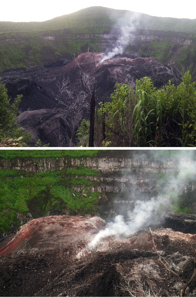 |
Figure 2. Photos of Ibu taken on 27 July 2007 from a point on the NW crater rim, looking approximately SE. The top photo shows the location of the dome in the steep-walled crater. The bottom photo shows a close-up view of the dome. Courtesy of Arnold Binas. |
Information Contacts: Center of Volcanology and Geological Hazard Mitigation (CVGHM), Saut Simatupang, 57, Bandung 40122, Indonesia (URL: http://vsi.esdm.go.id/); Hawai'i Institute of Geophysics and Planetology (HIGP) Thermal Alerts System, School of Ocean and Earth Science and Technology (SOEST), Univ. of Hawai'i, 2525 Correa Road, Honolulu, HI 96822, USA (URL: http://modis.higp.hawaii.edu/); Arnold Binas, Toronto, Canada (URL: http://www.summitpost.org/user_page.php?user_id=42443, http://www.flickr.com/photos/hshdude/collections/72157600584144439/).
Ongoing dome growth during July-August 2009
Thermal anomalies detected by satellites (MODVOLC thermal alerts) through June 2009 suggested continued growth of a lava dome in the crater (BGVN 34:05). The Center of Volcanology and Geological Hazard Mitigation (CVGHM) reported that prior to 11 July 2009, white and gray plumes from Ibu rose ~ 600 m above the crater rim. After 11 July, the plumes were gray and rose only ~ 400 m above the crater rim. Ash from the gray plumes fell on areas within a 3-km radius of Ibu.
Observers noted an increase of eruptive activity after mid-July. During the period 27 July to 3 August, the total number of eruptive events showed a tendency to increase. Each eruptive earthquake was then followed by the expulsion of lava that reached the upper slopes. Plumes seen during 15 July to 4 August 2009 were grayish-white and reached a height of ~ 300-400 m above the crater rim. The lava extrusions accompanied rather strong rumbling noises on five occasions. The incandescent material was seen coming from the summit on 2 August 2009, and lava flows were seen. Later that day, a thunderous sound was followed by incandescence at the summit.
On 3 August, incandescent material was ejected as high as 20 m above the crater. The total of explosion earthquakes increased from the 20-49 events of mid-July to 50-80 events during 27 July to 4 August. Villagers in Desa Duono, Going, and Sanghaji noted strong rumbling sounds. No volcanic earthquakes were recorded during that time frame. On 4 August 2009, 82 volcanic earthquakes were recorded. Each eruptive earthquake was followed by the expulsion of lava which reached the upper slopes.
The observation post in the village of Duono, 5 km NW of Ibu, reported that the lava dome continued to grow. As a result, local residents were advised to prepare for times when they needed to wear masks that cover both the nose and the mouth. Visitors and tourists were asked to remain at least 2 km from the crater.
Information Contacts: Center of Volcanology and Geological Hazard Mitigation (CVGHM), Saut Simatupang, 57, Bandung 40122, Indonesia (URL: http://vsi.esdm.go.id/); Hawai'i Institute of Geophysics and Planetology (HIGP) Thermal Alerts System, School of Ocean and Earth Science and Technology (SOEST), Univ. of Hawai'i, 2525 Correa Road, Honolulu, HI 96822, USA (URL: http://modis.higp.hawaii.edu/).
Dome growth and small explosions continue in 2010
Activity at Ibu (figure 3) has been frequent since December 1998; the current eruption began in April 2008. Thermal alerts (MODIS/MODVOLC) continued into June 2009, and incandescent ejections were seen in early August (BGVN 34:10).
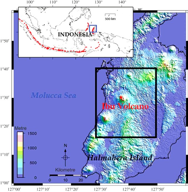 |
Figure 3. Location map of Ibu volcano on Halmahera Island. Insert map shows the locations of other active Indonesian volcanoes with triangles. Courtesy of Agustan and others (2010). |
Between July 2009 and June 2010, thermal alerts at Ibu were detected by MODVOLC on an average of about five or more days every month (normally one pixel per pass?at least one alert each 55 days during the 1-year period), about the same frequency as those measured during the first half of 2009 and far more frequent than that for the 4-year period October 2004-October 2008 (BGVN 33:09). Ground observations reported below in August-September 2009 and January 2010 confirm continued doem growth.
The Center of Volcanology and Geological Hazard Mitigation (CVGHM) reported that white and gray plumes rose 300-400 m above the crater rim during 15 July-4 August 2009 and that earthquakes became more frequent during 27 July-4 August 2009. Lava flows were seen on 2 August. Later that day, a thunderous sound was followed by incandescence at the summit. On 3 August, incandescent material was ejected about 20 m above the crater. The lava dome had reached a height sufficient to be seen from Duono Village, about 5 km NW.
Martin Rietze and Alain de Toffoli took some photographs of Ibu during a 31 August-7 September 2009 visit (figures 4-7), posted on the website of Th. Boeckel. The travelers noted that during the last 10 years the crater has been filled with a lava dome. The volcano has several vents that discharge ash and gas, along with Strombolian ejections. Only two vents were active during the visit.
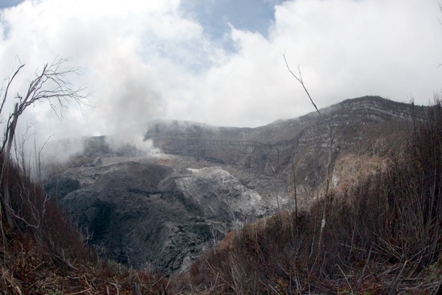 |
Figure 4. Photo of the edge of the Ibu crater, taken during 25 August-8 September 2009. The vegetation near the rim was partially charred, and lava from the dome caused small bush fires. Photo taken from the W rim looking toward the E rim. Courtesy of Alain de Toffoli and M. Rietze. |
 |
Figure 5. Gas and ash emissions from the growing dome at Ibu, taken during 25 August-8 September 2009. Photo taken from the W rim looking E. Courtesy of Alain de Toffoli and M. Rietze. |
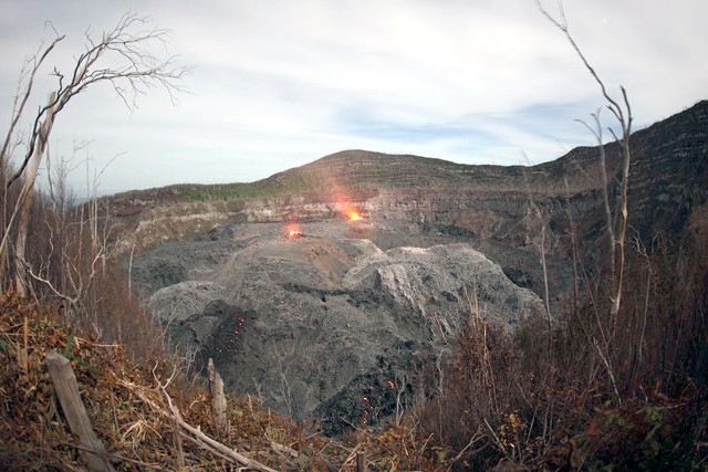 |
Figure 6. Two active vents in Ibu's crater, taken during 25 August-8 September 2009. Photo taken from the W rim looking E. Courtesy of Alain de Toffoli and M. Rietze. |
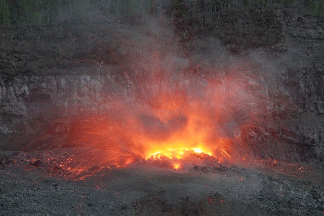 |
Figure 7. Dome growth in Ibu's crater with Strombolian ejections, taken during 25 August-8 September 2009. Photo taken from the W rim looking E. Courtesy of Alain de Toffoli and M. Rietze. |
Arnold Binas posted some photos that demonstrated rapid dome growth (figure 8). Before 1998, the crater was vegetated down to the bottom. The dome was distinctly lower in 2007 (BGVN 34:05). Binas commented that "After a period of no steam emissions at all, [the dome vent] would start steaming slightly to announce it's next eruption. After being done emitting rocks and ash, it would steam vigorously for a while before quieting down again." Binas was also told that material had started to go through a breach in the N side of the crater.
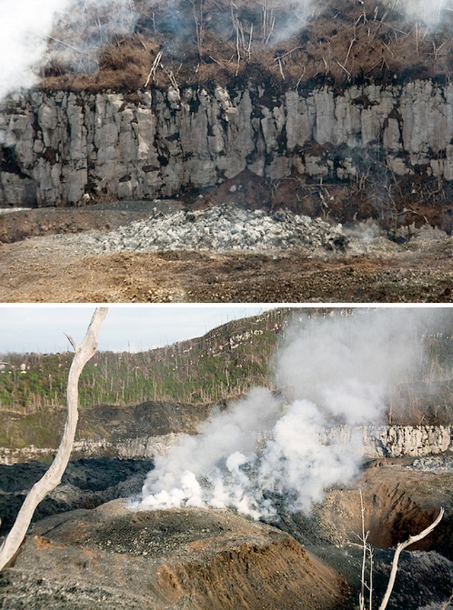 |
Figure 8. Growth in a single day at Ibu's dome from one of the two vents erupting around 21 January 2010. The top photo was taken during a moment of quiet, and is the older image. Both photos taken from the W rim looking E. Courtesy of Arnold Binas. |
A recent article by Agustan and others (2010) used radar to measure ground deformation related to volcanic activity on Ibu. Specifically, they used longer wavelength (L-band) differential interferometry to identify an inflation-deflation region, especially in the crater area before the March-April 2008 eruption (BGVN 33:09).
Reference. Agustan, Kimata, F., Abidin, H.Z., and Pamitro, Y.E., 2010, Measuring ground deformation of the tropical volcano, Ibu, using ALOS-PALSAR data, Remote Sensing Letters, v. 1, issue 1, p. 37-44, DOI: 1080/01431160903246717.
Information Contacts: Center of Volcanology and Geological Hazard Mitigation (CVGHM), Saut Simatupang, 57, Bandung 40122, Indonesia (URL: http://vsi.esdm.go.id/); Hawai'i Institute of Geophysics and Planetology (HIGP) Thermal Alerts System, School of Ocean and Earth Science and Technology (SOEST), Univ. of Hawai'i, 2525 Correa Road, Honolulu, HI 96822, USA (URL: http://modis.higp.hawaii.edu/); Martin Rietze (URL: http://www.mrietze.com/info.htm); Arnold Binas, Toronto, Canada (URL: http://www.flickr.com/photos/hshdude/).
Frequent minor white-to-gray plumes and small avalanches
Ibu (figure 9) has been intermittently active since 1998. Small explosions were noted during 2009 through January 2010 (BGVN 35:05). This report discuss seismic events from January 2011 to September 2011.
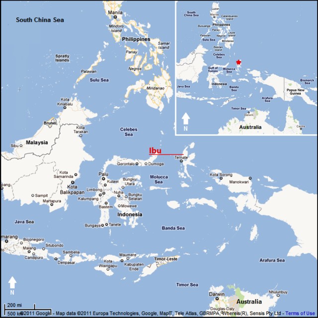 |
Figure 9. Map showing Ibu volcano, on the island of Halmahera, Indonesia. Courtesy of Google Maps (prepared by GVP editor Jeff Jessens). |
According to the Center of Volcanology and Geological Hazard Mitigation (CVGHM), during January 2011 to 8 September 2011, white-to-gray plumes rose 200-400 m above the craters. For 2011, CVGHM reported seismically detected avalanches, which on average occurred 45 times/day during January-April, 60 times/day during May-July, and 46 times/day during the first week of September. During much of 2011 seismicity fluctuated, but decreased towards September, prompting CVGHM to lower the Alert Level to 2 (on a scale of 1-4) on 8 September.
On 20 August 2011, observers from the nearby villages of Goin (exact location undisclosed) and Duono (5 km NW of Ibu) noted multiple eruptions from the S, E, and N craters. Plumes rose 50-250 m above the craters and an avalanche traveled 300 m in undisclosed direction.
During 2010, MODVOLC thermal alerts appeared about once per week on average, whereas, during 1 January 2011 through 13 September 2011, these alerts only appeared about once every 2.4 weeks on average. (Those alerts are derived from satellite data collected by the MODIS instrument and processed by the Hawai'i Institute of Geophysics and Planetology.)
Information Contacts: Center of Volcanology and Geological Hazard Mitigation (CVGHM), Saut Simatupang, 57, Bandung 40122, Indonesia (URL: http://vsi.esdm.go.id/); Hawai'i Institute of Geophysics and Planetology (HIGP) MODVOLC Thermal Alerts System, School of Ocean and Earth Science and Technology (SOEST), Univ. of Hawai'i, 2525 Correa Road, Honolulu, HI 96822, USA (URL: http://modis.higp.hawaii.edu/).
Growing lava dome; numerous thermal alerts September 2011-March 2014
In the first nine months of 2011, Ibu was the scene of frequent avalanches and at least one weak explosion that generated minor white-to-gray plumes (BGVN 36:08). Seismic activity decreased during September 2011, prompting the Center of Volcanology and Geological Hazard Mitigation (CVGHM) to lower the Alert Level to 2 (on a scale of 1-4) on 8 September (the Level rose again later). This report discusses activity from 9 September 2011 through March 2014. The location of Ibu is shown in BGVN 36:08.
According to CVGHM, seismicity increased and volcanic tremor was detected during May through 6 June 2013. The lava dome grew, especially the N part, and by early June had grown taller than the N crater rim. White-to-gray plumes rose 200-450 m above the crater rim. Based on visual and instrumental observations, as well as the hazard potential, CVGHM increased the Alert Level to 3 on 7 June. The public was warned to stay at least 3 km away from the active crater.
CVGHM reported that during 7 June-9 December 2013, the lava dome continued to grow, and incandescent material from the dome filled the river valley in the direction of Duono village, about 5 km NW. The seismicity remained relatively stable. Observers saw occasional weak white-to-gray plumes. On 10 December 2013, the Alert Level was lowered to 2; however, the public was warned to stay at least 2 km away from the active crater, and 3.5 km away from the N part.
Between 1 September 2011 and March 2014, MODVOLC thermal alerts were issued on 70 days, or an average of almost one day every two weeks. Such alerts are consistent with dome growth such as that noted above. (Those alerts are derived from satellite data collected by the MODIS instrument and processed by the Hawai'i Institute of Geophysics and Planetology.) For comparison, between 1 January 2011 and 13 September 2011, these alerts only appeared about once every 2.4 weeks on average.
Information Contacts: Center of Volcanology and Geological Hazard Mitigation (CVGHM), Saut Simatupang, 57, Bandung 40122, Indonesia (URL: http://vsi.esdm.go.id/); Hawai'i Institute of Geophysics and Planetology (HIGP) MODVOLC Thermal Alerts System, School of Ocean and Earth Science and Technology (SOEST), Univ. of Hawai'i, 2525 Correa Road, Honolulu, HI 96822, USA (URL: http://modis.higp.hawaii.edu/).
Continued lava dome growth with occasional weak plumes through November 2015
During the latter half of 2013, Ibu's lava dome continued to grow, and observers noted incandescent material and occasional weak white-to-gray plumes (BGVN 38:11). This report discusses activity between March 2014 and November 2015.
Reports from the Center of Volcanology and Geological Hazard Mitigation (CVGHM) indicated that during 1 August-17 November 2015 white-to-gray plumes rose as high as 500 m above the craters. Seismicity during this period was dominated by signals indicating surface or near-surface activity, and continuing lava dome growth in the N part of the crater. The Alert Level remained at 2 (on a scale of 1-4). The public was warned to stay at least 2 km away from the active crater, and 3.5 km away on the N side.
Thermal anomalies, based on MODIS satellite instruments analyzed using the MODVOLC algorithm, were observed frequently, and ranged from 1/month (February 2016) to 11/month (July 2014, April 2015, May 2015). Most were one pixel, but three pixels were observed on 5 September 2014 and 22 November 2014. The MIROVA (Middle InfraRed Observation of Volcanic Activity) volcano hotspot detection system, also based on analysis of MODIS data, detected numerous, almost continuous anomalies during the past year, though the frequency decreased from almost daily to averaging a few anomalies per week starting in late October 2015.
Information Contacts: Center of Volcanology and Geological Hazard Mitigation (CVGHM, also known as PVMBG), Saut Simatupang, 57, Bandung 40122, Indonesia (URL: http://vsi.esdm.go.id/); Hawai'i Institute of Geophysics and Planetology (HIGP) MODVOLC Thermal Alerts System, School of Ocean and Earth Science and Technology (SOEST), Univ. of Hawai'i, 2525 Correa Road, Honolulu, HI 96822, USA (URL: http://modis.higp.hawaii.edu/); MIROVA, a collaborative project between the Universities of Turin and Florence (Italy) supported by the Centre for Volcanic Risk of the Italian Civil Protection Department (URL: http://www.mirovaweb.it/).
Dome growth and ash plumes continue during December 2015-March 2017
Previously reported activity at Ibu through November 2015 included shallow seismicity, lava dome growth on the N part of the crater, and occasional white-to-gray plumes rising as high as 500 m above the summit (BGVN 40:11). This report, describing activity through early March 2017, is based on information from the Pusat Vulkanologi dan Mitigasi Bencana Geologi (PVMBG) and the Darwin Volcanic Ash Advisory Centre (VAAC).
During the reporting period (at least through 22 Aug 2016), the Alert Level remained at 2 (on a scale of 1-4) and the public was warned to stay at least 2 km away from the active crater, and 3.5 km away on the N side. Inclement weather often prevented visual observation.
According to PVMBG reports, similar activity to that previously described in 2013-2015 continued through at least 22 August 2016. Seismicity was dominated by signals indicating surface or near-surface activity, and the lava dome in the N part of the crater continued to grow. Occasional plumes (described variously as white-to-medium gray, gray-to-gray black, and ash) rose to altitudes of 1.5-2.4 km (200-1,100 m above the summit crater).
Thermal anomalies, based on MODIS satellite instruments analyzed using the MODVOLC algorithm, were observed infrequently during the reporting period. Hotspots were observed on seven days in December 2015, but only 1-3 days per month for subsequent months through March 2017. No hotspots were recorded during December 2016 and February 2017. In contrast, the MIROVA detection system recorded numerous anomalies between April 2016 and March 2017 (figure 10), almost all of which were at least 1 km from the volcano and of low power output.
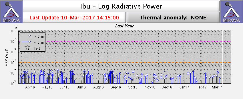 |
Figure 10. Thermal anomalies recorded at Ibu by the MIROVA system using MODIS infrared satellite data for the year ending 10 March 2017. Courtesy of MIROVA. |
Information Contacts: Pusat Vulkanologi dan Mitigasi Bencana Geologi (PVMBG, also known as Indonesian Center for Volcanology and Geological Hazard Mitigation, CVGHM), Jalan Diponegoro 57, Bandung 40122, Indonesia (URL: http://www.vsi.esdm.go.id/); Darwin Volcanic Ash Advisory Centre (VAAC), Bureau of Meteorology, Northern Territory Regional Office, PO Box 40050, Casuarina, NT 0811, Australia (URL: http://www.bom.gov.au/info/vaac/); Hawai'i Institute of Geophysics and Planetology (HIGP), MODVOLC Thermal Alerts System, School of Ocean and Earth Science and Technology (SOEST), Univ. of Hawai'i, 2525 Correa Road, Honolulu, HI 96822, USA (URL: http://modis.higp.hawaii.edu/); MIROVA (Middle InfraRed Observation of Volcanic Activity), a collaborative project between the Universities of Turin and Florence (Italy) supported by the Centre for Volcanic Risk of the Italian Civil Protection Department (URL: http://www.mirovaweb.it/).
Occasional weak ash explosions and thermal anomalies during April-August 2017
During March 2014-March 2017, activity at Ibu consisted of lava-dome growth, occasional weak emissions containing ash (figure 11), and frequent thermal anomalies (BGVN 40:11 and 42:05). Ongoing activity between April and August 2017 consisted primarily of intermittent ash explosions. Data come from Pusat Vulkanologi dan Mitigasi Bencana Geologi (PVMBG, also known as CVGHM) and the Darwin Volcanic Ash Advisory Centre (VAAC).
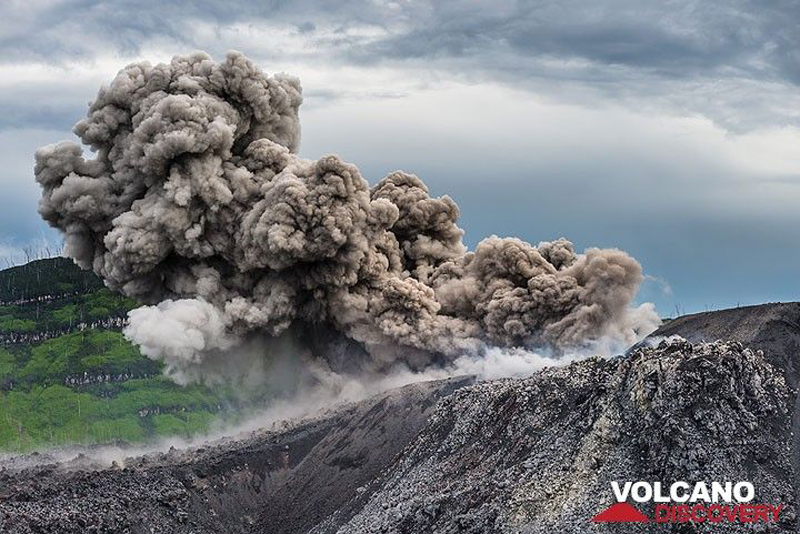 |
Figure 11. Photo of an ash explosion from Ibu's central vent in November 2014. Courtesy of Tom Pfeiffer, Volcano Discovery. |
On 3 April 2017, at 0757 (local), an explosion produced an ash plume that rose to an altitude of 1.7 km and drifted S. Seismic signals indicated explosions and avalanches. During the rest of April through August, occasional explosions generated weak ash plumes that generally rose to altitudes of 1.5-1.8 km (0.2-0.5 km above the volcano) and drifted in various directions (table 2).
Table 2. Ash plume data for Ibu, April-August 2017. Courtesy of PVMBG and Darwin VAAC.
| Date | Maximum plume altitude (km) | Plume drift direction |
| 03 Apr 2017 | 1.7 | S |
| 07-08 Apr 2017 | 1.7 | N |
| 10-11 Apr 2017 | 1.5-1.6 | S |
| 12-13, 17 Apr 2017 | 1.5-1.8 | S, SW |
| 19-21 Apr 2017 | 1.5-1.8 | E, N |
| 26-27, 29-30 Apr 2017 | 1.5-1.8 | E, NE, N |
| 10-11 May 2017 | 1.8 | E, SW |
| 16 May 2017 | 1.5 | -- |
| 19-20, 23 May 2017 | 1.5-1.8 | E, NE, S |
| 01, 05 Jun 2017 | 0.15-0.25 | N, SE |
| 09-12, 14 Jun 2017 | 1.5-1.8 | N, W, SSW |
| 14, 17-19 Jun 2017 | 1.5-1.8 | S, SW, W, N |
| 15 Aug 2017 | 1.8 | N |
| 24, 28 Aug 2017 | 1.5-1.8 | W |
Between April and August 2017, thermal anomalies (based on MODIS satellite instruments analyzed using the MODVOLC algorithm) were recorded 2-5 days per month, with no monthly trend. The MIROVA (Middle InfraRed Observation of Volcanic Activity) system detected numerous hotspots each month; all except one were within 3 km of the volcano, and all were of low or moderately-low power.
Information Contacts: Pusat Vulkanologi dan Mitigasi Bencana Geologi (PVMBG, also known as Indonesian Center for Volcanology and Geological Hazard Mitigation, CVGHM), Jalan Diponegoro 57, Bandung 40122, Indonesia (URL: http://www.vsi.esdm.go.id/); Darwin Volcanic Ash Advisory Centre (VAAC), Bureau of Meteorology, Northern Territory Regional Office, PO Box 40050, Casuarina, NT 0811, Australia (URL: http://www.bom.gov.au/info/vaac/); MIROVA (Middle InfraRed Observation of Volcanic Activity), a collaborative project between the Universities of Turin and Florence (Italy) supported by the Centre for Volcanic Risk of the Italian Civil Protection Department (URL: http://www.mirovaweb.it/); Hawai'i Institute of Geophysics and Planetology (HIGP) - MODVOLC Thermal Alerts System, School of Ocean and Earth Science and Technology (SOEST), Univ. of Hawai'i, 2525 Correa Road, Honolulu, HI 96822, USA (URL: http://modis.higp.hawaii.edu/); Tom Pfeiffer, Volcano Discovery (URL: http://www.volcanodiscovery.com/).
Ongoing thermal anomalies from dome growth in the summit crater through April 2018
Ongoing activity at Ibu volcano from April through August 2017 consisted primarily of intermittent ash explosions (BGVN 42:10). Based on data and reports through April 2018, the eruption that began on 5 April 2008 appeared to be continuing. Monitoring of the volcano is the responsibility of the Pusat Vulkanologi dan Mitigasi Bencana Geologi (PVMBG), also known as the Center for Volcanology and Geological Hazard Mitigation (CVGHM). Additional data below come from the Darwin Volcanic Ash Advisory Centre (VAAC) notices, with infrared MODIS data analyzed by the MODVOLC and MIROVA systems.
There were no reports of ash plumes from September 2017 through early March 2018. Although the summit area is often covered in fog, on 7-8 March ash plumes were observed rising 300-600 m above the crater rim and drifting W and S (table 3). Additional eruption plumes with ash were reported on 20 and 30 April. The Alert Level remained at 2 (on a scale of 1-4) and the public was warned to stay at least 2-3.5 km away from the active crater.
Table 3. Monthly summary of reported ash plumes and MODIS thermal anomalies from Ibu for August 2017-April 2018. The direction of drift for the ash plume through each month is highly variable. Data from Darwin VAAC, PVMBG, and MODVOLC.
| Month | Plume Altitude (km) | Plume Drift | Days with MODVOLC Alert Pixels |
| Sep 2017 | -- | -- | 4 |
| Oct 2017 | -- | -- | 5 |
| Nov 2017 | -- | -- | 4 |
| Dec 2017 | -- | -- | 4 |
| Jan 2018 | -- | -- | 4 |
| Feb 2018 | -- | -- | 2 |
| Mar 2018 | 1.6-1.9 | W, S | 2 |
| Apr 2018 | 1.8-1.9 | E, S | 3 |
Thermal anomalies identified by the MIROVA system using MODIS satellite data (figure 12) show that activity has been ongoing and almost continuous during May 2017-April 2018. Anomalies for the same time period detected and mapped using MODVOLC (figure 13, table 3) appear to be centered towards the north part of the crater and possibly extending down the N flank. This may indicate eruptive activity similar to that reported by PVMBG in June-December 2013 (BGVN 38:11) where the lava dome grew above the crater rim and sent incandescent material over a low notch in the rim and down a river valley towards Duono village, about 5 km NW.
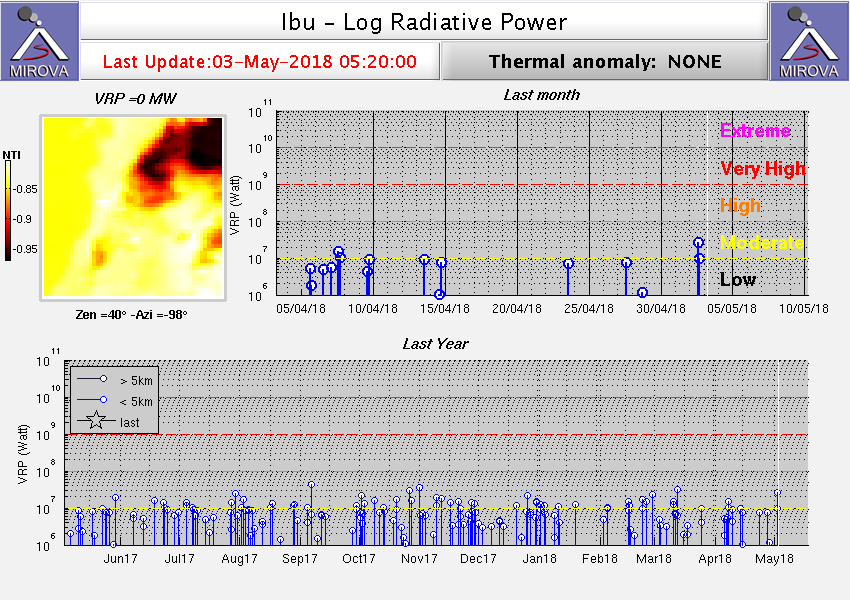 |
Figure 12. Thermal anomalies at Ibu shown on a MIROVA plot (Log Radiative Power) for the year ending 3 May 2018. Courtesy of MIROVA. |
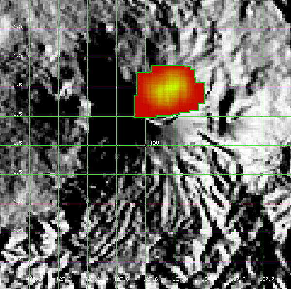 |
Figure 13. A contour map showing MODVOLC thermal alert pixels at Ibu for the year ending 3 May 2018. Pixels are centered at the north crater rim and down the N flank. Courtesy of Hawai'i Institute of Geophysics and Planetology (HIGP) - MODVOLC Thermal Alerts System. |
Information Contacts: Pusat Vulkanologi dan Mitigasi Bencana Geologi (PVMBG, also known as Indonesian Center for Volcanology and Geological Hazard Mitigation, CVGHM), Jalan Diponegoro 57, Bandung 40122, Indonesia (URL: http://www.vsi.esdm.go.id/); Darwin Volcanic Ash Advisory Centre (VAAC), Bureau of Meteorology, Northern Territory Regional Office, PO Box 40050, Casuarina, NT 0811, Australia (URL: http://www.bom.gov.au/info/vaac/); Hawai'i Institute of Geophysics and Planetology (HIGP) - MODVOLC Thermal Alerts System, School of Ocean and Earth Science and Technology (SOEST), Univ. of Hawai'i, 2525 Correa Road, Honolulu, HI 96822, USA (URL: http://modis.higp.hawaii.edu/); MIROVA (Middle InfraRed Observation of Volcanic Activity), a collaborative project between the Universities of Turin and Florence (Italy) supported by the Centre for Volcanic Risk of the Italian Civil Protection Department (URL: http://www.mirovaweb.it/).
Thermal anomalies and ash explosions from the crater continue during May-November 2018
Continuing activity at Ibu has consisted of numerous thermal anomalies and, except apparently for the period from September 2017 through early March 2018, intermittent ash explosions (BGVN 43:05). This activity continued through November 2018. The Alert Level has remained at 2 (on a scale of 1-4), and the public was warned to stay at least 2 km away from the active crater, and 3.5 km away on the N side.
Ash plumes were seen frequently during May-November 2018 (table 4). Plume heights above the crater were generally 400-80 m. However, ash plumes on 28 and 29 July rose 5.5 and 4.8 km, respectively. Seismicity associated with ash plumes were characterized by explosion and avalanche signals.
Table 4. Ash explosions reported at Ibu, May-November 2018. Data courtesy of PVMBG and Darwin VAAC.
| Date | Time | Ash plume (height above crater rim) | Plume Drift |
| 05 May 2018 | 0622 | 600 m | N, NE |
| 06 Jun 2018 | 1206 | 500 m | N |
| 12 Jun 2018 | 1750 | 600 m | N |
| 14-19 Jun 2018 | -- | 200-600 m | N |
| 21 Jun 2018 | 0857 | 600 m | N |
| 22-26 Jun 2018 | -- | 850 m | WNW, W |
| 27 Jun 2018 | -- | 500 m | W |
| 06 Jul 2018 | -- | 800 m | N |
| 10-15 Jul 2018 | -- | 200-800 m | -- |
| 28 Jul 2018 | 1852 | 5.5 km | SE |
| 29 Jul 2018 | 1612 | 4.8 km | N, SE |
| 13 Aug 2018 | 0259 | 600 m | -- |
| 20 Aug 2018 | 1742 | 1.2 km | -- |
| 24 Aug 2018 | 0838 | 800 m | S |
| 28, 30 Sep 2018 | -- | 500 m | N, NE |
| 06 Oct 2018 | -- | 500 m | WSW |
| 19 Oct 2018 | 1223 | 400 m | N |
| 26 Nov 2018 | -- | 500 m | SE |
The number of thermal anomalies during this time, based on MODIS satellite instruments analyzed using the MODVOLC algorithm, ranged from 2 days/month (July) to 9 days/month (September); some events were two pixels. Days with anomalies and ash explosions were not well correlated. The MIROVA (Middle InfraRed Observation of Volcanic Activity) volcano hotspot detection system, also based on analysis of MODIS data, detected numerous hotspots every month of the reporting period, almost all of which were within 5 km of the volcano and of low-to-moderate power. Infrared satellite imagery showed that the volcano had at least two, and sometimes three, active dome or vent locations (figure 14).
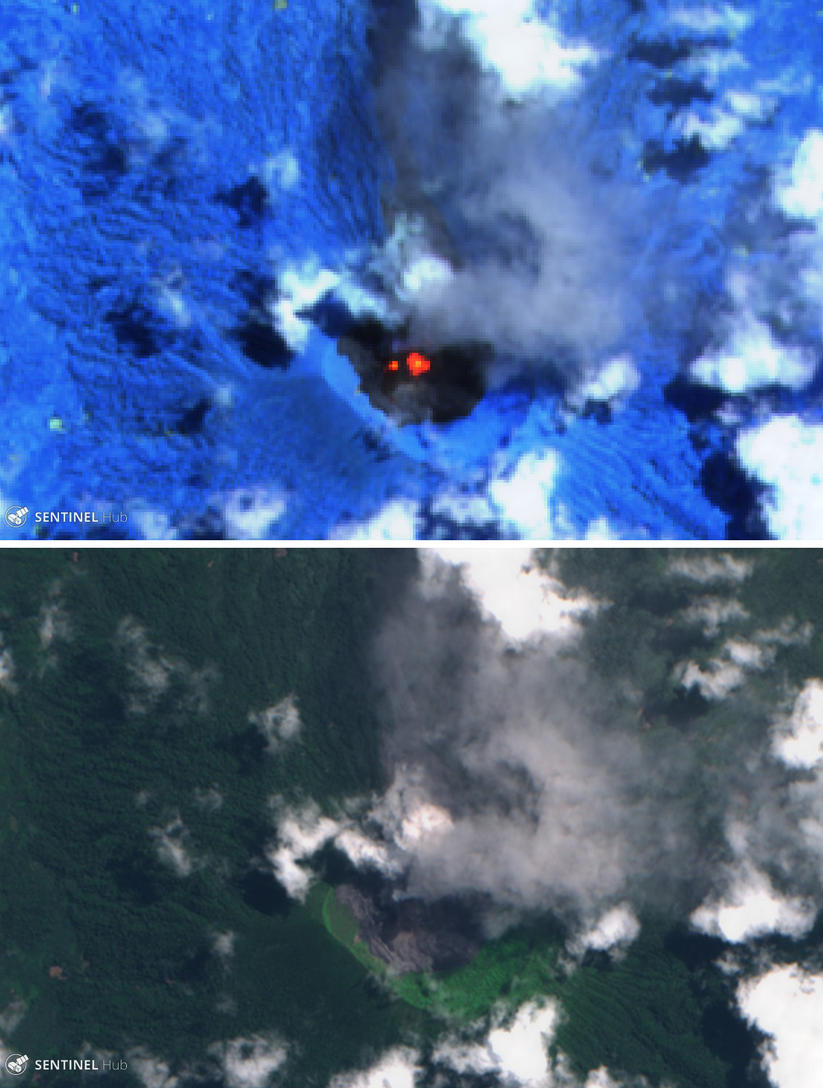 |
Figure 14. Sentinel-2 satellite images of Ibu on 19 August 2018. Top image (infrared, bands 12, 11, 8A) shows a large central hotspot and a smaller thermal area immediately to the west. Bottom image (natural color, bands 8, 4, 3) shows both an ash plume (gray) and steam plume (white), along with fresh and older lava in the crater. Courtesy of Sentinel Hub Playground. |
Information Contacts: Pusat Vulkanologi dan Mitigasi Bencana Geologi (PVMBG, also known as Indonesian Center for Volcanology and Geological Hazard Mitigation, CVGHM), Jalan Diponegoro 57, Bandung 40122, Indonesia (URL: http://www.vsi.esdm.go.id/); Darwin Volcanic Ash Advisory Centre (VAAC), Bureau of Meteorology, Northern Territory Regional Office, PO Box 40050, Casuarina, NT 0811, Australia (URL: http://www.bom.gov.au/info/vaac/); Hawai'i Institute of Geophysics and Planetology (HIGP) - MODVOLC Thermal Alerts System, School of Ocean and Earth Science and Technology (SOEST), Univ. of Hawai'i, 2525 Correa Road, Honolulu, HI 96822, USA (URL: http://modis.higp.hawaii.edu/); MIROVA (Middle InfraRed Observation of Volcanic Activity), a collaborative project between the Universities of Turin and Florence (Italy) supported by the Centre for Volcanic Risk of the Italian Civil Protection Department (URL: http://www.mirovaweb.it/); Sentinel Hub Playground (URL: https://www.sentinel-hub.com/explore/sentinel-playground).
Frequent ash plumes and small lava flows active in the crater through June 2019
Ibu volcano on Halmahera island in Indonesia began the current eruption episode on 5 April 2008. Since then, activity has largely consisted of small ash plumes with less frequent lava flows, lava dome growth, avalanches, and larger ash plumes up to 5.5 km above the crater. This report summarizes activity during December 2018 through June 2019 and is based on Volcano Observatory Notice for Aviation (VONA) reports by MAGMA Indonesia, reports by Pusat Vulkanologi dan Mitigasi Bencana Geologi (PVMBG) and Badan Nasional Penanggulangan Bencana (BNPB), and various satellite data.
During December PVMBG reported ash plumes ranging from 200 to 800 m above the crater. There were 11 MODVOLC thermal alerts that registered during 1-12 December. An explosion on 12 January 2019 produced an ash plume that reached 800 m above the crater and dispersed to the S (figure 15). A report released for this event by Sutopo at BNPB said that Ibu had erupted almost every day over the past three months; an example given was of activity on 10 January consisting of 80 explosions. There were four MODVOLC thermal alerts through the month.
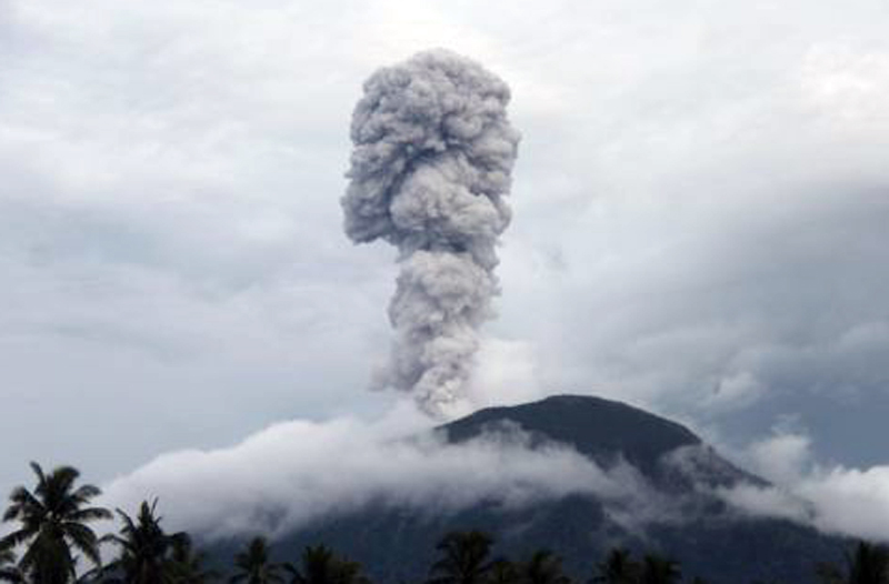 |
Figure 15. An eruption at Ibu at 1712 on 21 January 2019 produced an ash plume that rose to 800 m above the crater. Courtesy of BNPB (color adjusted). |
Throughout February explosions frequently produced ash plumes as high as 800 m above the crater, and nine MODVOLC thermal alerts were issued. Daily reports showed variable plume heights of 200-800 m most days throughout the month. Wind directions varied and dispersed the plumes in all directions. A VONA released at 1850 on 6 February reported an ash plume that rose to 1,925 m altitude (around 600 m above the summit) and dispersed S. Activity continued through March with the Darwin VAAC and PVMBG reporting explosions producing ash plumes to heights of 200-800 m above the crater and dispersing in various directions. There were ten MODVOLC alerts through the month.
Similar activity continued through April, May, and June, with ash plumes reaching 200-800 m above the crater. There were 12, 6, and 15 MODVOLC Alerts in April, May, and June, respectively.
Planet Scope satellite images show activity at a two vents near the center of the crater that were producing small lava flows from February through June (figure 16). Thermal anomalies were frequent during December 2018 through June 2019 across MODVOLC, MIROVA, and Sentinel-2 infrared data (figures 17 and 18). Sentinel-2 data showed minor variation in the location of thermal anomalies within the crater, possibly indicating lava flow activity, and MIROVA data showed relatively constant activity with a few reductions in thermal activity during January and February.
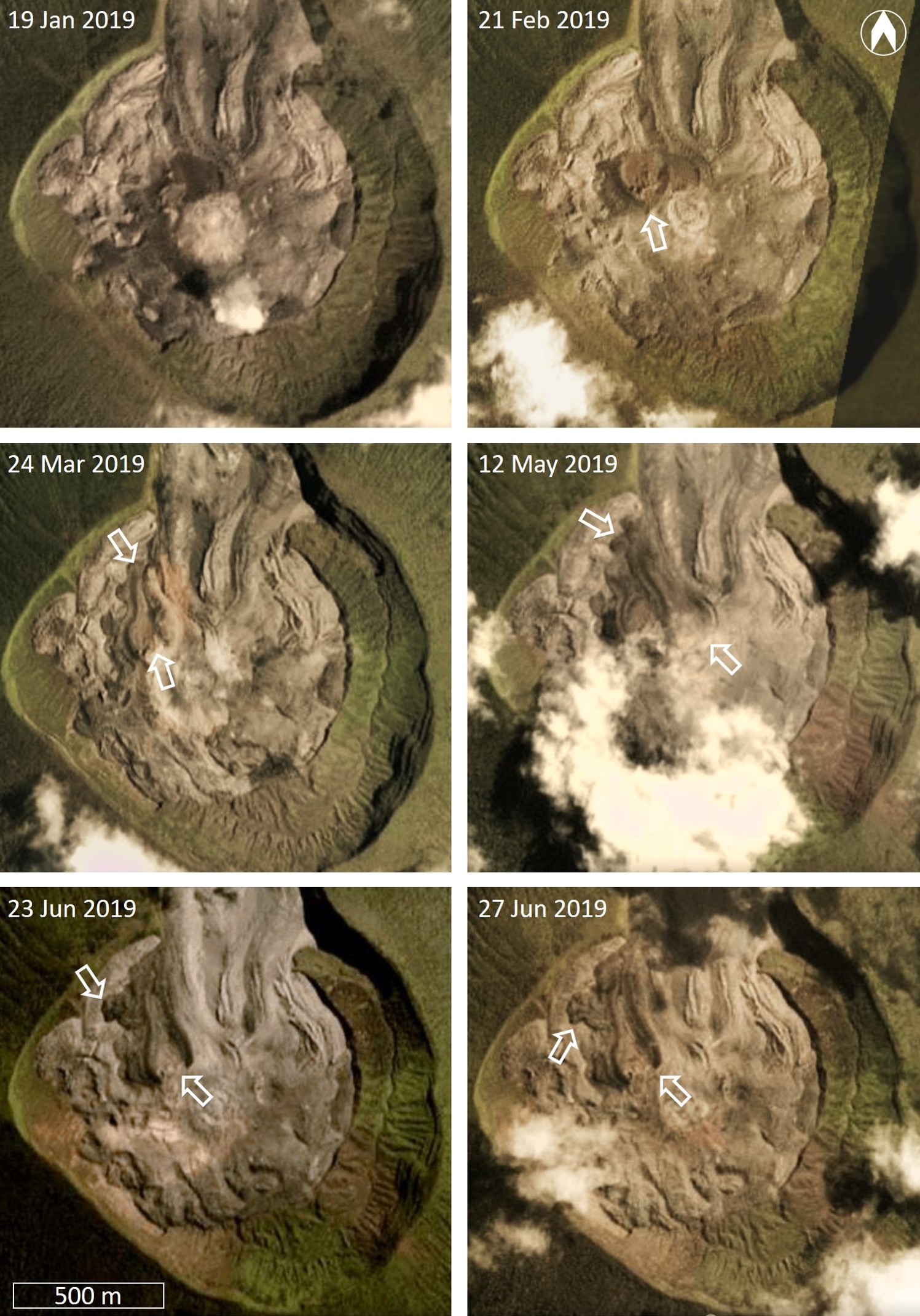 |
Figure 16. Planet Scope natural color satellite images showing activity in the Ibu crater during January through June 2019, with white arrows indicating sites of activity. One vent is visible in the 21 February image, and a 330-m-long (from the far side of the vent) lava flow with flow ridges had developed by 24 March. A second vent was active by 12 May with a new lava flow reaching a maximum length of 520 m. Activity was centered back at the previous vent by 23-27 June. Natural color Planet Scope Imagery, copyright 2019 Planet Labs, Inc. |
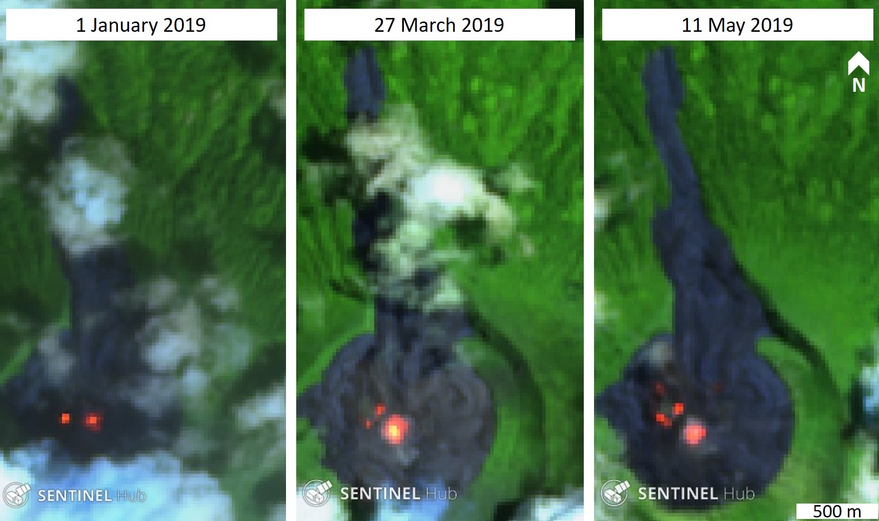 |
Figure 17. Examples of thermal activity in the Ibu crater during January through May 2019. These Sentinel-2 satellite images show variations in hot areas in the crater due to a vent producing a small lava flow. Sentinel-2 false color (urban) images (bands 12, 11, 4) courtesy of Sentinel Hub Playground. |
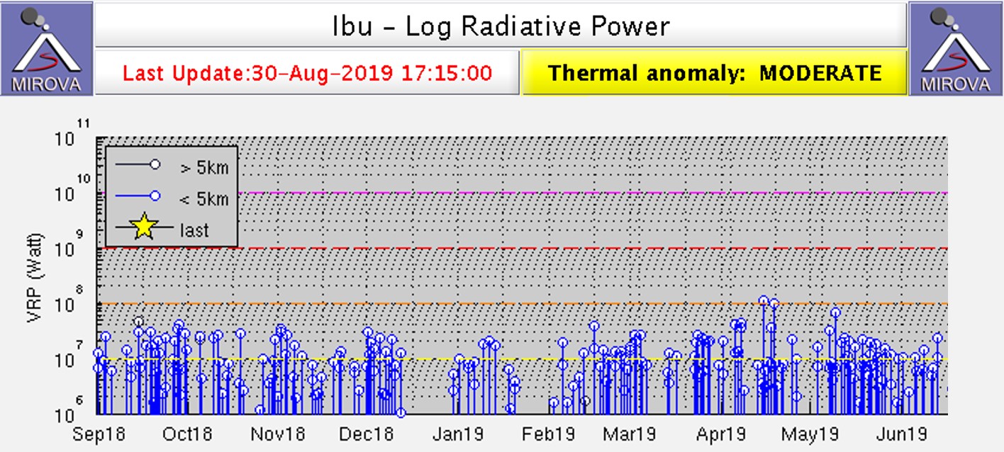 |
Figure 18. MIROVA log radiative power plot of MODIS thermal infrared at Ibu from September 2018 through June 2019. The registered energy was relatively stable through December, with breaks in January and February. Regular thermal anomalies continued with slight variation through to the end of June. Courtesy of MIROVA. |
Information Contacts: Pusat Vulkanologi dan Mitigasi Bencana Geologi (PVMBG, also known as Indonesian Center for Volcanology and Geological Hazard Mitigation, CVGHM), Jalan Diponegoro 57, Bandung 40122, Indonesia (URL: http://www.vsi.esdm.go.id/); Badan Nasional Penanggulangan Bencana (BNPB), National Disaster Management Agency, Graha BNPB - Jl. Scout Kav.38, East Jakarta 13120, Indonesia (URL: http://www.bnpb.go.id/); MAGMA Indonesia, Kementerian Energi dan Sumber Daya Mineral (URL: https://magma.vsi.esdm.go.id/); Darwin Volcanic Ash Advisory Centre (VAAC), Bureau of Meteorology, Northern Territory Regional Office, PO Box 40050, Casuarina, NT 0811, Australia (URL: http://www.bom.gov.au/info/vaac/); Hawai'i Institute of Geophysics and Planetology (HIGP) - MODVOLC Thermal Alerts System, School of Ocean and Earth Science and Technology (SOEST), Univ. of Hawai'i, 2525 Correa Road, Honolulu, HI 96822, USA (URL: http://modis.higp.hawaii.edu/); MIROVA (Middle InfraRed Observation of Volcanic Activity), a collaborative project between the Universities of Turin and Florence (Italy) supported by the Centre for Volcanic Risk of the Italian Civil Protection Department (URL: http://www.mirovaweb.it/); Sentinel Hub Playground (URL: https://www.sentinel-hub.com/explore/sentinel-playground); Planet Labs, Inc. (URL: https://www.planet.com/).
Frequent ash plumes and small lava flows in the crater through December 2019
Heightened continuing activity at Ibu since March 2018 has been dominated by frequent ash explosions with weak ash plumes, and numerous thermal anomalies reflecting one or more weak lava flows (BGVN 43:05, 43:12, and 44:07). This report summarizes activity through December 2019, and is based on data from the Pusat Vulkanologi dan Mitigasi Bencana Geologi (PVMBG, also known as Indonesian Center for Volcanology and Geological Hazard Mitigation, CVGHM), Darwin Volcanic Ash Advisory Centre (VAAC), and various satellites.
Typical ash plumes during the reporting period of July-December 2019 rose 800 m above the crater, with the highest reported to 1.4 km in early October (table 5). They were usually noted a few times each month. According to MAGMA Indonesia, explosive activity caused the Aviation Color Code to be raised to ORANGE (second highest of four) on 14, 22, and 31 August, 4 and 30 September, and 15 and 20 October.
Table 5. Ash plumes and other volcanic activity reported at Ibu during December 2018-December 2019. Plume heights are reported above the crater rim. Data courtesy of PVMBG and Darwin VAAC.
| Date | Time | Ash Plume Height | Plume Drift | Remarks |
| 11 Dec 2018 | -- | 500 m | -- | Weather clouds prevented views in satellite data. |
| 12 Jan 2019 | 1712 | 800 m | S | -- |
| 13 Jan 2019 | 0801 | 800 m | S | -- |
| 05-12 Feb 2019 | -- | 200-800 m | E, S, W | Weather conditions occasionally prevented observations. |
| 25-26 Feb 2019 | -- | 1.1-1.7 km | NE, ENE | Thermal anomaly. |
| 28 Feb 2019 | -- | 800 m | N | -- |
| 18 Mar 2019 | -- | 1.1 km | E | Plume drifted about 17 km NE. |
| 23 Mar 2019 | -- | 1.1 km | E | -- |
| 28 Mar 2019 | -- | 800 m | SE | -- |
| 10 Apr 2019 | -- | 800 m | N | -- |
| 15-16 Apr 2019 | -- | 1.1 km | N, NE | -- |
| 18 Apr 2019 | -- | 800 m | E | -- |
| 07 May 2019 | -- | 1.1 km | ESE | -- |
| 08 May 2019 | -- | 1.1 km | ESE | -- |
| 09 May 2019 | 1821 | 600 m | S | Seismicity characterized by explosions, tremor, and rock avalanches. |
| 10 May 2019 | -- | 500 m | ESE | -- |
| 14 May 2019 | 1846 | 800 m | N | -- |
| 14-16, 18-19 May 2019 | -- | 0.8-1.7 km | NW, N, ENE | -- |
| 23-24 May 2019 | -- | 1.1-1.4 km | SE | -- |
| 31 May 2019 | -- | 800 m | W | -- |
| 02 Jun 2019 | -- | 1.7 km | W | -- |
| 21 Jun 2019 | -- | 500 m | N, NE | -- |
| 24-25 Jun 2019 | -- | 0.2-1.1 km | SE, ESE | -- |
| 06 Jul 2019 | -- | 800 m | N | Intermittent thermal anomaly. |
| 15 Jul 2019 | -- | 800 m | NE | -- |
| 07-12 Aug 2019 | -- | 200-800 m | -- | Plumes were white-to-gray. |
| 14 Aug 2019 | 1107 | 800 m | N | Seismicity characterized by explosions and rock avalanches. |
| 22 Aug 2019 | 0704 | 800 m | W | Seismicity characterized by explosions and rock avalanches. |
| 31 Aug 2019 | 1847 | 800 m | N | Seismicity characterized by explosions and rock avalanches. |
| 04 Sep 2019 | 0936 | 300 m | S | -- |
| 28 Sep 2019 | -- | 500-800 m | WNW | -- |
| 30 Sep 2019 | 1806 | 800 m | N | -- |
| 06-07 Oct 2019 | -- | 0.8-1.4 km | S, N | -- |
| 15 Oct 2019 | 0707 | 400 m | S | -- |
| 20 Oct 2019 | 0829 | 400 m | W | -- |
| 01-05 Nov 2019 | -- | 200-800 m | E, N | Plumes were white-and-gray. |
| 20-21, 23-25 Nov 2019 | -- | 500-800 m | Multiple | Thermal anomaly on 21 Nov. |
| 03 Dec 2019 | -- | 800 m | NE | Thermal anomaly. |
| 26 Dec 2019 | -- | 800 m | S | Discrete ash puffs in satellite imagery. |
Thermal anomalies were sometimes noted by PVMBG, and were also frequently obvious in infrared satellite imagery suggesting lava flows and multiple active vents, as seen on 22 November 2019 (figure 19). Thermal anomalies using MODIS satellite instruments processed by the MODVOLC algorithm were recorded 2-4 days every month from July to December 2019. In contrast, the MIROVA (Middle InfraRed Observation of Volcanic Activity) system detected numerous hotspots on most days (figure 20).
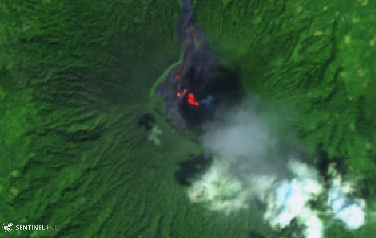 |
Figure 19. Example of thermal activity in the Ibu crater on 22 November 2019, along with a plume drifting SE. One or more vents in the crater are producing small lava flows, an observation common throughout the reporting period. Sentinel-2 false color (urban) images (bands 12, 11, 4), courtesy of Sentinel Hub Playground. |
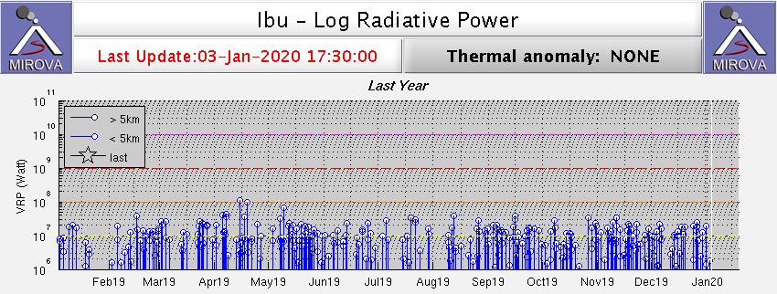 |
Figure 20. Thermal anomalies recorded at Ibu by the MIROVA system using MODIS infrared satellite data for the year 2019. Courtesy of MIROVA. |
Information Contacts: Pusat Vulkanologi dan Mitigasi Bencana Geologi (PVMBG, also known as Indonesian Center for Volcanology and Geological Hazard Mitigation, CVGHM), Jalan Diponegoro 57, Bandung 40122, Indonesia (URL: http://www.vsi.esdm.go.id/); MAGMA Indonesia, Kementerian Energi dan Sumber Daya Mineral (URL: https://magma.vsi.esdm.go.id/); Badan Nasional Penanggulangan Bencana (BNPB), National Disaster Management Agency, Graha BNPB - Jl. Scout Kav.38, East Jakarta 13120, Indonesia (URL: http://www.bnpb.go.id/); Darwin Volcanic Ash Advisory Centre (VAAC), Bureau of Meteorology, Northern Territory Regional Office, PO Box 40050, Casuarina, NT 0811, Australia (URL: http://www.bom.gov.au/info/vaac/); Hawai'i Institute of Geophysics and Planetology (HIGP) - MODVOLC Thermal Alerts System, School of Ocean and Earth Science and Technology (SOEST), Univ. of Hawai'i, 2525 Correa Road, Honolulu, HI 96822, USA (URL: http://modis.higp.hawaii.edu/); MIROVA (Middle InfraRed Observation of Volcanic Activity), a collaborative project between the Universities of Turin and Florence (Italy) supported by the Centre for Volcanic Risk of the Italian Civil Protection Department (URL: http://www.mirovaweb.it/); Sentinel Hub Playground (URL: https://www.sentinel-hub.com/explore/sentinel-playground).
Frequent ash emissions and summit incandescence; Strombolian explosions in March 2020
Ibu is an active stratovolcano located along the NW coast of Halmahera Island in Indonesia. Volcanism has recently been characterized by frequent ash explosions, ash plumes, and small lava flows within the crater throughout 2019 (BGVN 45:01). Activity continues, consisting of frequent white-and-gray emissions, ash explosions, ash plumes, and lava flows. This report updates activity through June 2020, using data from the Pusat Vulkanologi dan Mitigasi Bencana Geologi (PVMBG, also known as Indonesian Center for Volcanology and Geological Hazard Mitigation, CVGHM), Darwin Volcanic Ash Advisory Centre (VAAC), and various satellites.
Volcanism during the entire reporting period dominantly consisted of white-and-gray emissions that rose 200-800 m above the summit drifting in multiple directions. The ash plume with the maximum altitude of 13.7 km altitude occurred on 16 May 2020. Sentinel-2 thermal satellite imagery detected multiple smaller hotspots within the crater throughout the reporting period.
Continuous ash emissions were reported on 6 February rising to 2.1 km altitude drifting E, accompanied by a hotspot visible in infrared satellite imagery. On 16 February, a ground observer reported an eruption that produced an ash plume rising 800 m above the summit drifting W, according to a Darwin VAAC notice. Ash plumes continued through the month, drifting in multiple directions and rising up to 2.1 km altitude. During 8-10 March, video footage captured multiple Strombolian explosions that ejected incandescent material and produced ash plumes from the summit (figures 21 and 22). Occasionally volcanic lightning was observed within the ash column, as recorded in video footage by Martin Rietze. This event was also documented by a Darwin VAAC notice, which stated that multiple ash emissions rose 2.1 km altitude drifting SE. PVMBG published a VONA notice on 10 March at 1044 reporting ash plumes rising 400 m above the summit. PVMBG and Darwin VAAC notices described intermittent eruptions on 26, 28, and 29 March, all of which produced ash plumes rising 300-800 m above the summit.
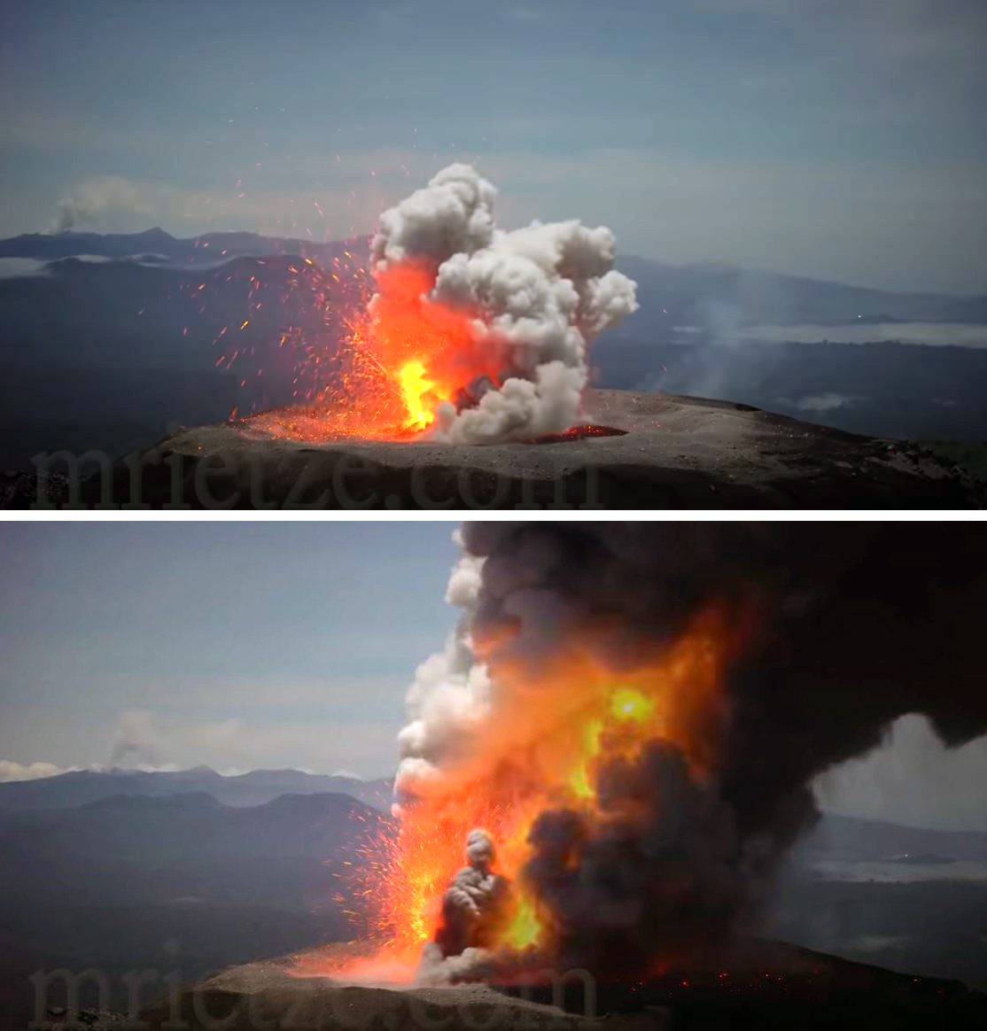 |
Figure 21. Strombolian explosions recorded at the crater summit of Ibu during 8-10 March 2020 ejected incandescent ejecta and a dense ash plume. Video footage copyright by Martin Rietze, used with permission. |
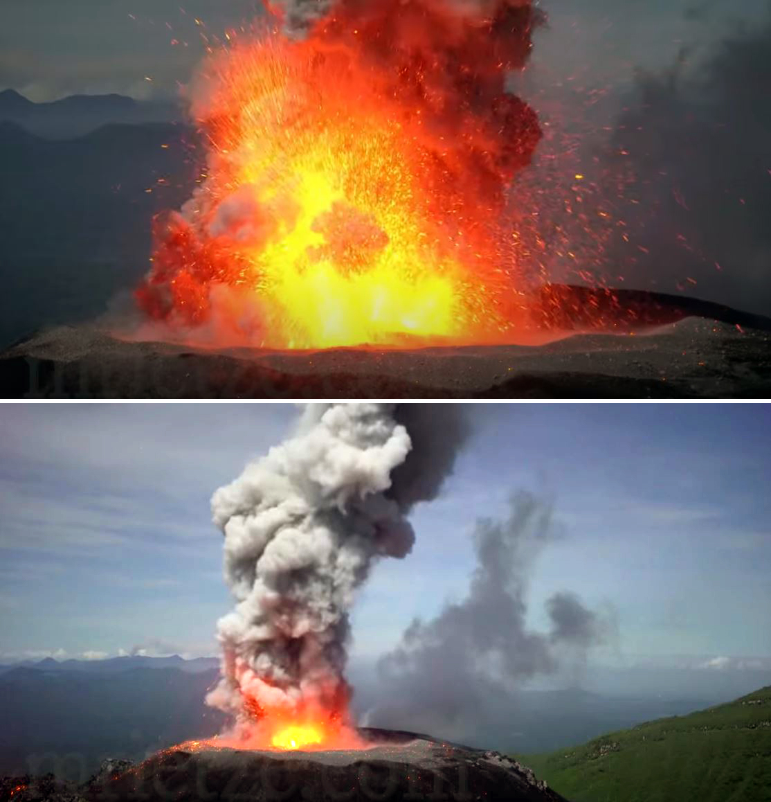 |
Figure 22. Strombolian explosions recorded at the crater summit of Ibu during 8-10 March 2020 ejected incandescent ejecta and ash. Frequent volcanic lightning was also observed. Video footage copyright by Martin Rietze, used with permission. |
A majority of days in April included white-and-gray emissions rising up to 800 m above the summit. A ground observer reported an eruption on 9 April, according to a Darwin VAAC report, and a hotspot was observed in HIMAWARI-8 satellite imagery. Minor eruptions were reported intermittently during mid-April and early to mid-May. On 12 May at 1052 a VONA from PVMBG reported an ash plume 800-1,100 m above the summit. A large short-lived eruption on 16 May produced an ash plume that rose to a maximum of 13.7 km altitude and drifted S, according to the Darwin VAAC report. By June, volcanism consisted predominantly of white-and-gray emissions rising 800 m above the summit, with an ash eruption on 15 June. This eruptive event resulted in an ash plume that rose 1.8 km altitude drifting WNW and was accompanied by a hotspot detected in HIMAWARI-8 satellite imagery, according to a Darwin VAAC notice.
The MIROVA (Middle InfraRed Observation of Volcanic Activity) system detected frequent hotspots during July 2019 through June 2020 (figure 23). In comparison, the MODVOLC thermal alerts recorded a total of 24 thermal signatures over the course of 19 different days between January and June. Many thermal signatures were captured as small thermal hotspots in Sentinel-2 thermal satellite imagery within the crater (figure 24).
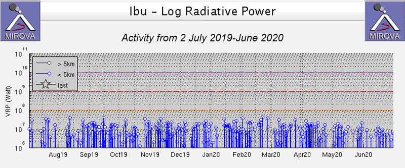 |
Figure 23. Thermal anomalies recorded at Ibu from 2 July 2019 through June 2020 as recorded by the MIROVA system (Log Radiative Power) were frequent and consistent in power. Courtesy of MIROVA. |
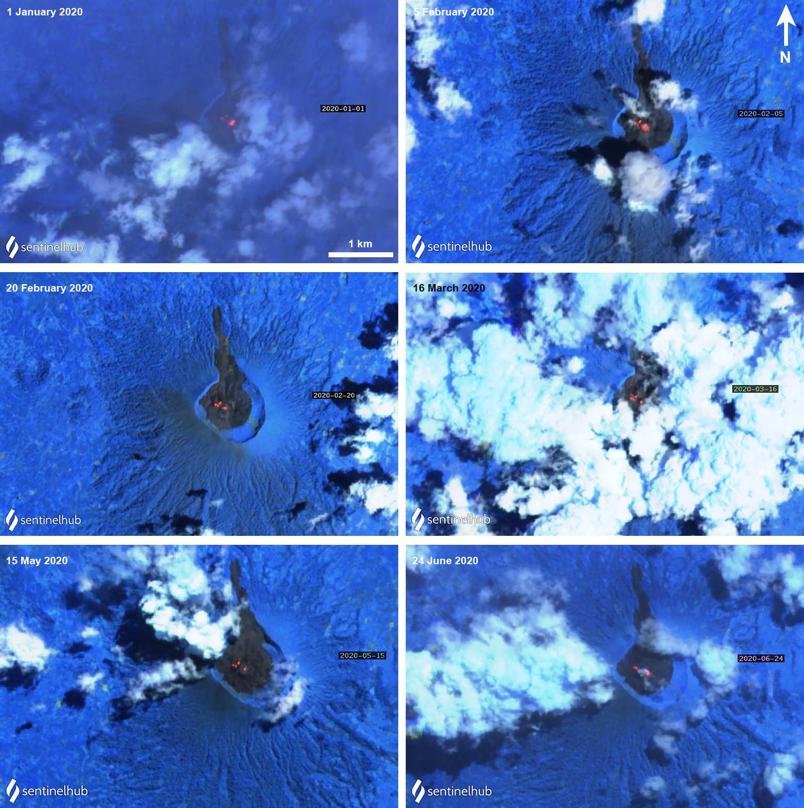 |
Figure 24. Sentinel-2 thermal satellite imagery (bands 12, 11, 8A) showed occasional thermal hotspots (bright orange) in the Ibu summit crater during January through June 2020. Courtesy of Sentinel Hub Playground. |
Information Contacts: Pusat Vulkanologi dan Mitigasi Bencana Geologi (PVMBG, also known as Indonesian Center for Volcanology and Geological Hazard Mitigation, CVGHM), Jalan Diponegoro 57, Bandung 40122, Indonesia (URL: http://www.vsi.esdm.go.id/); MIROVA (Middle InfraRed Observation of Volcanic Activity), a collaborative project between the Universities of Turin and Florence (Italy) supported by the Centre for Volcanic Risk of the Italian Civil Protection Department (URL: http://www.mirovaweb.it/); Hawai'i Institute of Geophysics and Planetology (HIGP) - MODVOLC Thermal Alerts System, School of Ocean and Earth Science and Technology (SOEST), Univ. of Hawai'i, 2525 Correa Road, Honolulu, HI 96822, USA (URL: http://modis.higp.hawaii.edu/); Sentinel Hub Playground (URL: https://www.sentinel-hub.com/explore/sentinel-playground); Martin Rietze, Taubenstr. 1, D-82223 Eichenau, Germany (URL: https://mrietze.com/, https://www.youtube.com/channel/UC5LzAA_nyNWEUfpcUFOCpJw/videos, video at https://www.youtube.com/watch?v=qMkfT1e4HQQ).
Persistent daily ash emissions and thermal anomalies, July-December 2020
Mount Ibu is an active stratovolcano located along the NW coast of Halmahera Island in Indonesia. After a two-day eruption in 1911, Ibu was quiet until 1998-1999 when explosions produced ash emissions, a lava flow and dome growth began inside the summit crater. Although possible dome growth occurred in 2001 and 2004, little activity was reported until ash emissions began in April 2008. These were followed by thermal anomalies beginning the next month; ash emissions and dome growth have continued for 12 years and the dome now fills the summit crater (BGVN 45:07). Activity continued throughout 2020, consisting of frequent white-and-gray emissions, ash explosions, ash plumes, and small lava flows. This report updates activity through December 2020, using data from the Pusat Vulkanologi dan Mitigasi Bencana Geologi (PVMBG, also known as Indonesian Center for Volcanology and Geological Hazard Mitigation, CVGHM), Darwin Volcanic Ash Advisory Centre (VAAC), and various satellite instruments.
Activity throughout July-December 2020 was very consistent and similar to activity reported earlier in the year. Tens of daily explosions produced white and gray ash emissions that rose 200-800 m above the summit (figure 25). Occasional larger explosions were reported in VONAs and VAAC notices. The MIROVA graph of log radiative power for the period shows consistent thermal anomalies the entire time (figure 26). Satellite imagery from Sentinel-2 identified thermal anomalies inside the summit crater every month, usually a larger central one and a smaller one to the NW, suggesting continued dome growth and lava flow activity (figure 27).
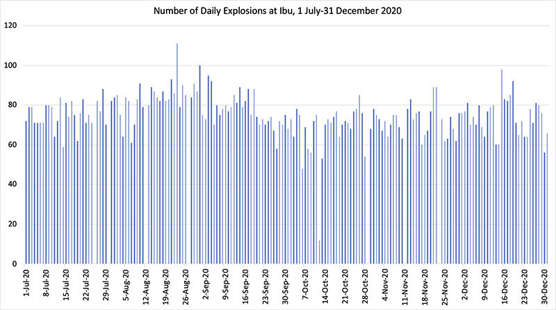 |
Figure 25. Between 60 and 90 explosions occurred most days at Ibu during 1 July-31 December 2020. White and gray plumes rose 200-800 m above the summit crater every day. Data courtesy of PVMBG daily reports. |
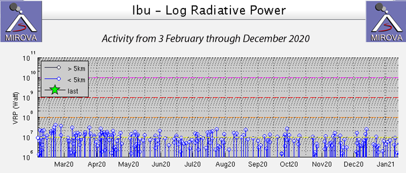 |
Figure 26. The MIROVA graph of Log Radiative Power at Ibu from 3 February through December 2020 indicated a constant ongoing heat source from the summit of the crater. Courtesy of MIROVA. |
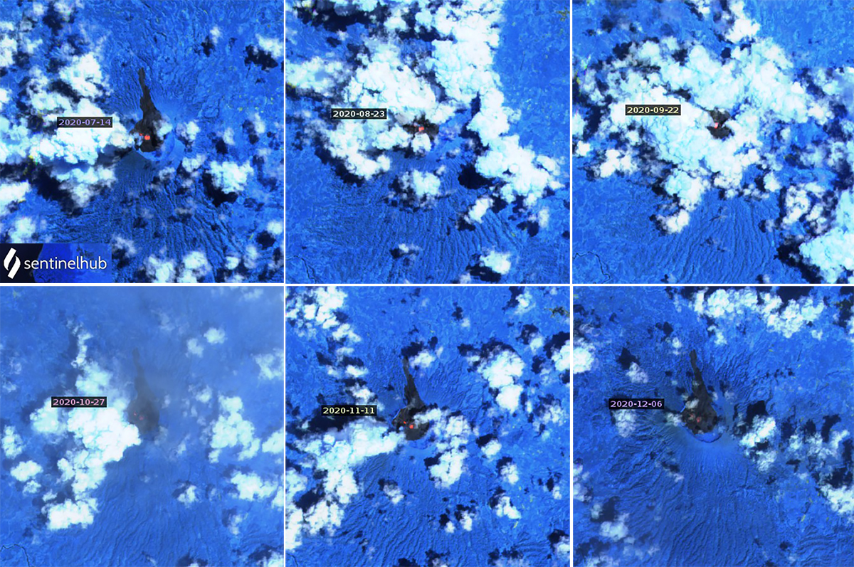 |
Figure 27. Thermal anomalies persisted at the summit of Ibu throughout July-December 2020. One central anomaly was usual accompanied by a smaller one slightly NW of the central spot. Atmospheric penetration rendering (bands 12, 11a, and 8), courtesy of Sentinel Hub Playground. |
The Darwin VAAC observed multiple minor ash emissions in satellite imagery drifting W on 6 July 2020 at 1.8 km altitude. A series of discrete puffs of ash were observed on 15 July also at 1.8 km altitude drifting W. Ongoing minor emissions were discernible on visible and RGB imagery at 2.1 km altitude drifting W on 20 July. On 30 July ash plumes rose to 1.8 km altitude drifted NW and a hotspot was present at the summit. A single MODVOLC alert was issued on 8 July. Single MODVOLC alerts were also issued on 11, 18, and 27 August 2020. PVMBG issued a VONA on 5 August, reporting an ash cloud that rose to 1.8 km altitude and drifted N (figure 28). The Darwin VAAC reported an ash emission later that day that rose to 4.3 km altitude and drifted NW for several hours before dissipating. Multiple discrete emissions were identified in satellite imagery drifting N at 2.1 km altitude on 11 August; they dissipated quickly. During 22-25 August intermittent ash emissions rose to 1.5-1.8 km altitude and drifted NW and W. Minor continuous emissions were again reported on 28 August.
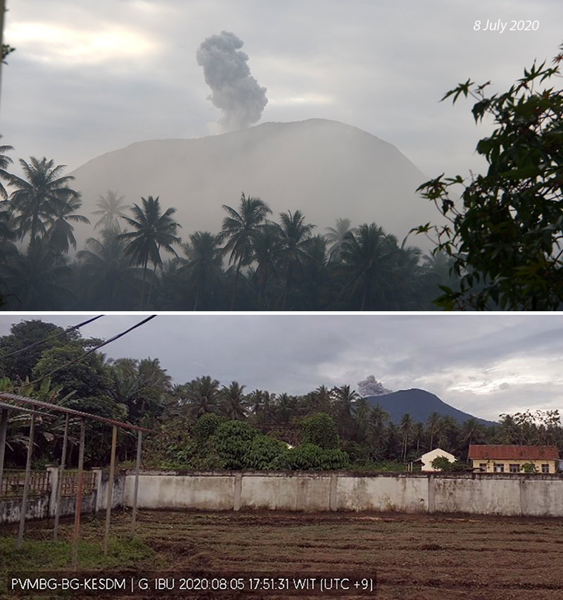 |
Figure 28. Ash plumes rose from the summit of Ibu many days during July and August 2020, including on 8 July (top) and 5 August (bottom). Courtesy of PVMBG. |
Many ash emissions during September and October 2020 were not accompanied by VONAs or VAAC advisories (figure 29). PVMBG issued a VONA on 20 September for an ash emission that rose to 1.5 km altitude and drifted N. Continuous discrete ash emissions over several days drifted SW to NW during 25-29 September at 1.8-2.1 km altitude, as reported in multiple VONAs and VAAC advisories. Single MODVOLC alerts were issued on 26 and 30 September. The Darwin VAAC issued an ash advisory on 8 October for intermittent ash emissions rising to 2.1 km altitude and drifting NW. A single MODVOLC alert was issued the next day. On 20 October ash emissions again rose to 2.1 km altitude and drifted NE.
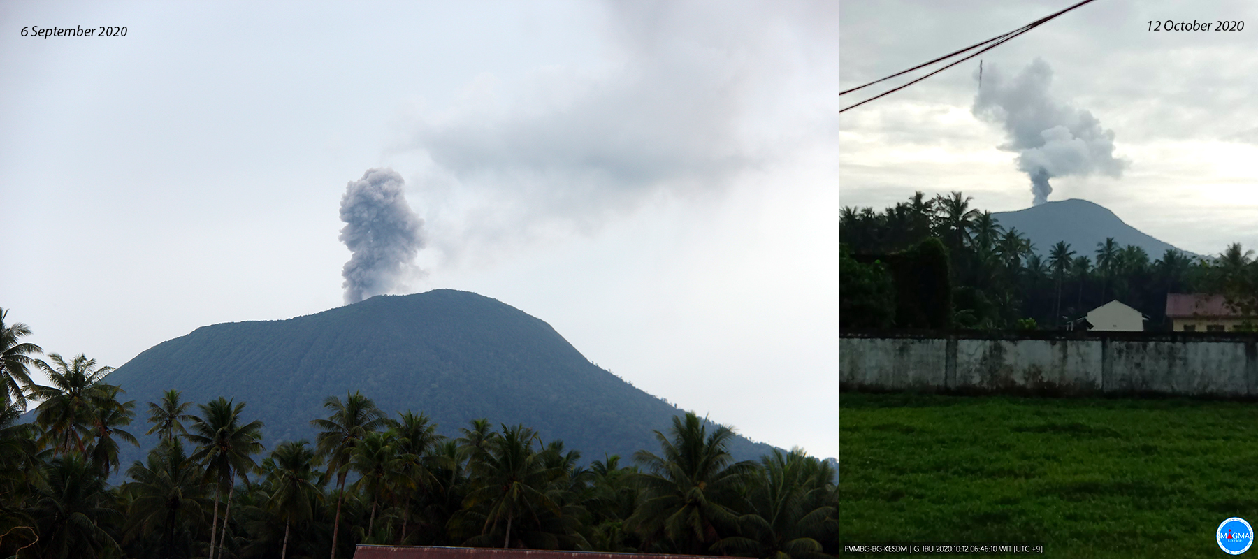 |
Figure 29. Ash emissions at Ibu were photographed in webcams on 6 September (left) and 12 October (right) 2020. Courtesy of PVMBG. |
The Darwin VAAC reported intermittent ash emissions to 1.8 km altitude during 3-5, 12-13, 18-19, and 22 November 2020 that drifted SSW for several hours before dissipating. PVMBG also issued a VONA for an ash cloud on 27 November that rose to 2.1 km altitude and drifted W. They reported faint rumbling at the PGA Ibu station on 10 November and loud rumbling on 16 and 18 November. During December, minor ash emissions rose to 1.8-2.1 km altitude and drifted E on 4 and 6 December, SW on 11 December, and SE on 12-13 December. PVMBG issued a VONA on 19 December for a white to gray ash cloud drifting N at 1.7 km altitude. Single MODVOLC alerts were issued on 10, 13, and 22 December. Numerous ash emissions were captured by the webcams (figure 30).
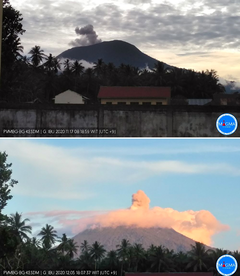 |
Figure 30. Ash emissions at Ibu were recorded in webcams on 17 November (top) and 5 December (bottom) 2020. Courtesy of PVMBG. |
Information Contacts: Pusat Vulkanologi dan Mitigasi Bencana Geologi (PVMBG, also known as Indonesian Center for Volcanology and Geological Hazard Mitigation, CVGHM), Jalan Diponegoro 57, Bandung 40122, Indonesia (URL: http://www.vsi.esdm.go.id/); Darwin Volcanic Ash Advisory Centre (VAAC), Bureau of Meteorology, Northern Territory Regional Office, PO Box 40050, Casuarina, NT 0811, Australia (URL: http://www.bom.gov.au/info/vaac/); Hawai'i Institute of Geophysics and Planetology (HIGP) - MODVOLC Thermal Alerts System, School of Ocean and Earth Science and Technology (SOEST), Univ. of Hawai'i, 2525 Correa Road, Honolulu, HI 96822, USA (URL: http://modis.higp.hawaii.edu/); MIROVA (Middle InfraRed Observation of Volcanic Activity), a collaborative project between the Universities of Turin and Florence (Italy) supported by the Centre for Volcanic Risk of the Italian Civil Protection Department (URL: http://www.mirovaweb.it/); Sentinel Hub Playground (URL: https://www.sentinel-hub.com/explore/sentinel-playground).
Intermittent low-level ash plumes, light ashfall, and thermal anomalies during January-August 2021
Ibu is located along the NW coast of Halmahera Island in Indonesia and contains an inner crater measuring 1-km-wide and 400 m deep, an outer crater that measures 1.2-km-wide, and is breached on the N side. The first observed and recorded eruption occurred in 1911 and consisted of a small explosion in the summit crater. The current eruption period began in April 2008 and has recently been characterized by daily ash emissions, explosions, and thermal anomalies (BGVN 46:01). This report covers similar activity of white-and-gray emissions, ash plumes, and light ashfall during January through August 2021 using information from the Pusat Vulkanologi dan Mitigasi Bencana Geologi (PVMBG, also known as Indonesian Center for Volcanology and Geological Hazard Mitigation, CVGHM), Darwin Volcanic Ash Advisory Centre (VAAC), and various satellite data. The Volcano Alert Level remained at a 2 (on a scale of 1-4), and the public was warned to stay at least 2 km away from the active crater and 3.5 km away on the N side.
Activity throughout January-August 2021 was consistent and similar to that of the previous year. Between 35 and 115 daily explosions were detected during the reporting period, the latter of which occurred on 7 February, and produced white-and-gray emissions that rose 200-1,000 m above the crater and drifted in different directions, according to PVMBG. Occasional larger explosions were reported in VONA and VAAC notices. According to the MIROVA plot (Log Radiative Power), thermal activity was consistent, yet low in power from January through August; during May, the anomalies were at their lowest strength (figure 31). The MODVOLC algorithm detected ten thermal alerts during this period, with one each on 1 February, 9 March, 22 April, 2 and 27 June, 29 July, and 12 August, and three on 23 August 2021. Some of this thermal activity was detected in Sentinel-2 infrared satellite images on clear weather days (figure 32).
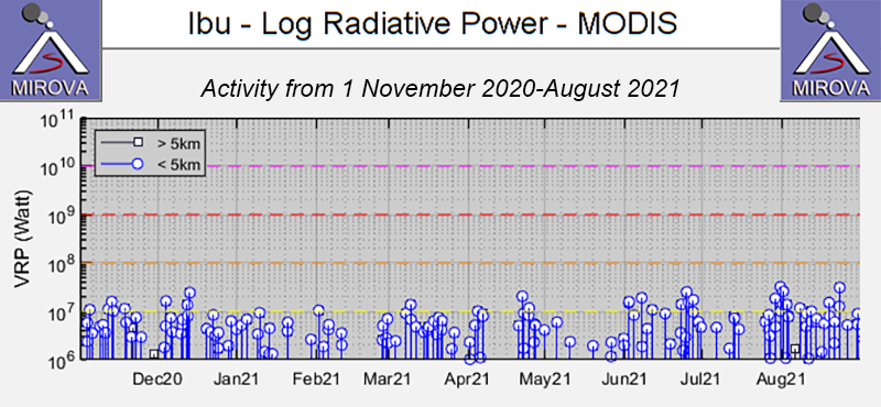 |
Figure 31. Constant low-power thermal anomalies were detected at the summit crater of Ibu during January through August 2021, as shown by the MIROVA graph (Log Radiative Power). Courtesy of MIROVA. |
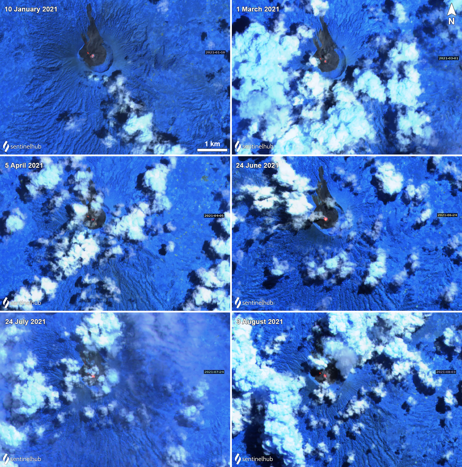 |
Figure 32. Thermal anomalies persisted in the summit crater of Ibu during January through August 2021. One strong central anomaly was commonly accompanied by a smaller one slightly to the NW, as shown on 10 January (top left), 1 March (top right), 5 April (middle left), and 8 August (bottom right) 2021. Images using “Atmospheric penetration” (bands 12, 11, 8A) rendering. Courtesy of Sentinel Hub Playground. |
The Darwin VAAC detected a single minor ash plume on 7 January that rose to 1.8 km altitude, or about 500 m above the summit, and drifted N, based on a ground report. This information was also reported in a PVMBG VONA notice that stated the ash plume occurred at 1055. Similar low-level ash plumes persisted in February; during 5-6 February ash plumes rose to 1.8-2.4 km and drifted W and SW, based on HIMAWARI-8 satellite imagery. An ash plume rose 800 m above the crater on 8 February on 1101, according to a VONA notice. PVMBG reported that during 16-17 February a total of 88 eruptive events occurred. Consecutive ash plumes on 24, 25, and 26 February rose 500, 800, and 800 m above the crater, respectively (figure 33).
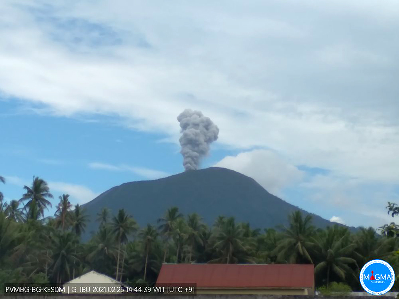 |
Figure 33. An ash plume rose from the summit of Ibu on 25 February 2021 to a height of 800 m. Courtesy of MAGMA Indonesia. |
Similar intermittent ash emissions continued during March and April. On 3, 9, and 12 March an ash plume rose to 2.1 km and drifted S, according to Darwin VAAC notices (figure 34). During 14, 21, 25, and 31 March ash plumes rose 600-1,000 m above the crater, based on VONA notices and PVMBG daily reports. A thermal anomaly was detected in satellite imagery near the summit on 22 March and 6-7 April, according to a Darwin VAAC report. Accompanying the latter thermal anomaly, at 1812 a VONA notice reported an ash plume rose 400 m above the crater. An ash plume rose 800 m above the crater on 20 April at 1819 and another detected on 22 April at 1258 rose 1,000 m above the crater. On 26 April an ash plume rose 600 m above the crater and drifted N.
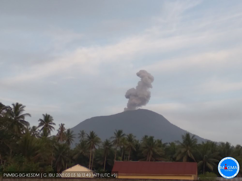 |
Figure 34. Intermittent ash plumes rising above the summit of Ibu were recorded multiple times in webcam images during March and April 2021, as shown here on 3 March 2021 rising to 2.1 km altitude and drifting S. Courtesy of MAGMA Indonesia. |
During May and June, activity remained consistent with intermittent ash emissions. On 3 and 12 May an ash plume rose to 1.8 km altitude and drifted W and NW, based on HIMAWARI-8 satellite imagery. Ash plumes were visible during 16 (figure 35) and 17 May, the latter of which occurred at 1039 and rose ~750 m above the crater and drifted N. During the afternoon and evening of 19 May, light ashfall was reported in residential areas from the Naga village (4.8 km SW) to the Tongute village of Ternate (10 km W). On 6 and 10 June ash emissions rose to 1.8 km altitude and extended N. Rock avalanches were recorded through seismic data during 11-13 June, though they were not visually confirmed, according to PVMBG. During 18-20 June 63 eruptive events per day were detected.
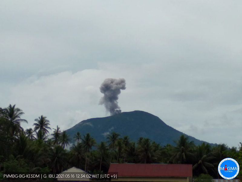 |
Figure 35. Ash plumes from the summit of Ibu continued during May and June 2021, as seen here on 16 May 2021. Courtesy of MAGMA Indonesia. |
Low ash emissions continued during July and August; on 10 July at 0719 an ash plume rose 800 m above the crater and the next day, light ashfall was reported in residential areas to the W of the volcano, though it was not specified how far. During 14-15 and 17 July white-and-gray emissions rose 200-800 m above the crater and drifted N, S, and W; light ashfall was again observed in residential areas to the W, and loud rumblings were heard as far as the Ibu observation post. On 28 July an ash plume rose to 2.4 km altitude and extended NE. During 1-2 August an ash plume rose to 1.8-2.1 km altitude. An ash plume on 18 August was reported at 0810 rising 800 m above the crater and drifting W. An ash plume on 22 August rose to 1.8 km altitude and was accompanied by a thermal anomaly that was identified in satellite imagery.
Information Contacts: Pusat Vulkanologi dan Mitigasi Bencana Geologi (PVMBG, also known as Indonesian Center for Volcanology and Geological Hazard Mitigation, CVGHM), Jalan Diponegoro 57, Bandung 40122, Indonesia (URL: http://www.vsi.esdm.go.id/); MAGMA Indonesia, Kementerian Energi dan Sumber Daya Mineral (URL: https://magma.esdm.go.id/v1); Darwin Volcanic Ash Advisory Centre (VAAC), Bureau of Meteorology, Northern Territory Regional Office, PO Box 40050, Casuarina, NT 0811, Australia (URL: http://www.bom.gov.au/info/vaac/); MIROVA (Middle InfraRed Observation of Volcanic Activity), a collaborative project between the Universities of Turin and Florence (Italy) supported by the Centre for Volcanic Risk of the Italian Civil Protection Department (URL: http://www.mirovaweb.it/); Hawai'i Institute of Geophysics and Planetology (HIGP) - MODVOLC Thermal Alerts System, School of Ocean and Earth Science and Technology (SOEST), Univ. of Hawai'i, 2525 Correa Road, Honolulu, HI 96822, USA (URL: http://modis.higp.hawaii.edu/); Sentinel Hub Playground (URL: https://www.sentinel-hub.com/explore/sentinel-playground).
Intermittent ash plumes and thermal activity during September 2021-February 2022
Ibu is located along the NW coast of Halmahera Island in Indonesia and contains an inner crater measuring 1-km-wide and 400 m deep, and an outer crater that measures 1.2-km-wide breached on the N side. The first observed and recorded eruption occurred in 1911 and consisted of a small explosion in the summit crater. The current eruption period began in April 2008 and has recently been characterized by intermittent low-level ash plumes, light ashfall, and thermal anomalies (BGVN 46:09). This report covers similar activity of low-level ash plumes, minor ashfall, and thermal activity during September 2021 through February 2022 using information from the Pusat Vulkanologi dan Mitigasi Bencana Geologi (PVMBG, also known as Indonesian Center for Volcanology and Geological Hazard Mitigation, CVGHM), Darwin Volcanic Ash Advisory Centre (VAAC), and various satellite data. The Volcano Alert Level remained at 2 (on a scale of 1-4), and the public was warned to stay at least 2 km away from the active crater and 3.5 km away on the N side.
Activity during this reporting period was relatively low, primarily consisting of occasional ash plumes rising to 2.4 km altitude, minor ashfall, and thermal activity. Daily explosions ranged from 55-102; the greatest number of eruption events was detected on 8 September 2021. Frequent white-and-gray emissions rose 200-1,000 m above the summit and drifted in different directions, according to PVMBG. Data from the MIROVA plot (Log Radiative Power) showed intermittent low-to-moderate thermal anomalies during September 2021 through mid-February 2022, including a short break in activity during late November to mid-December 2021 (figure 36). According to MODIS data from MODVOLC, a total of 10 thermal alerts were detected on 28 September, 15 and 19 October, 13, 16, and 27 November 2021, 28 January 2022, and 4 February. Thermal anomalies were also captured in Sentinel-2 infrared satellite images on 2 September and 12 October 2021, and again on 5 January and 14 February 2022 (figure 37).
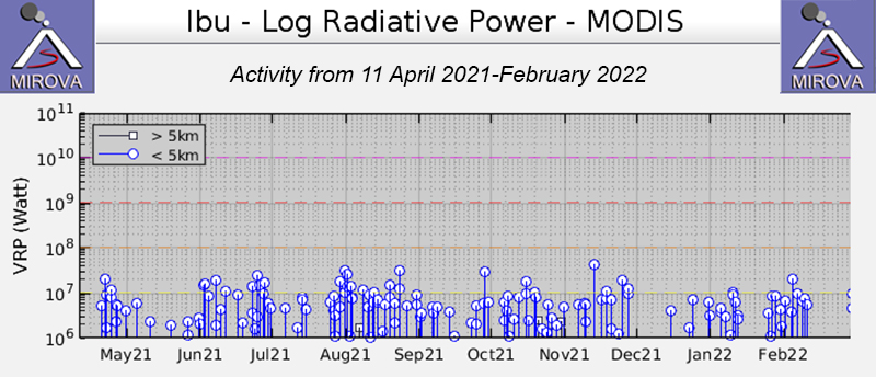 |
Figure 36. Persistent low- to- moderate-power thermal anomalies were detected at the summit crater of Ibu during September 2021 through mid-February 2022, though a short break in activity occurred during late November to mid-December 2021, as shown by the MIROVA graph (Log Radiative Power). Courtesy of MIROVA. |
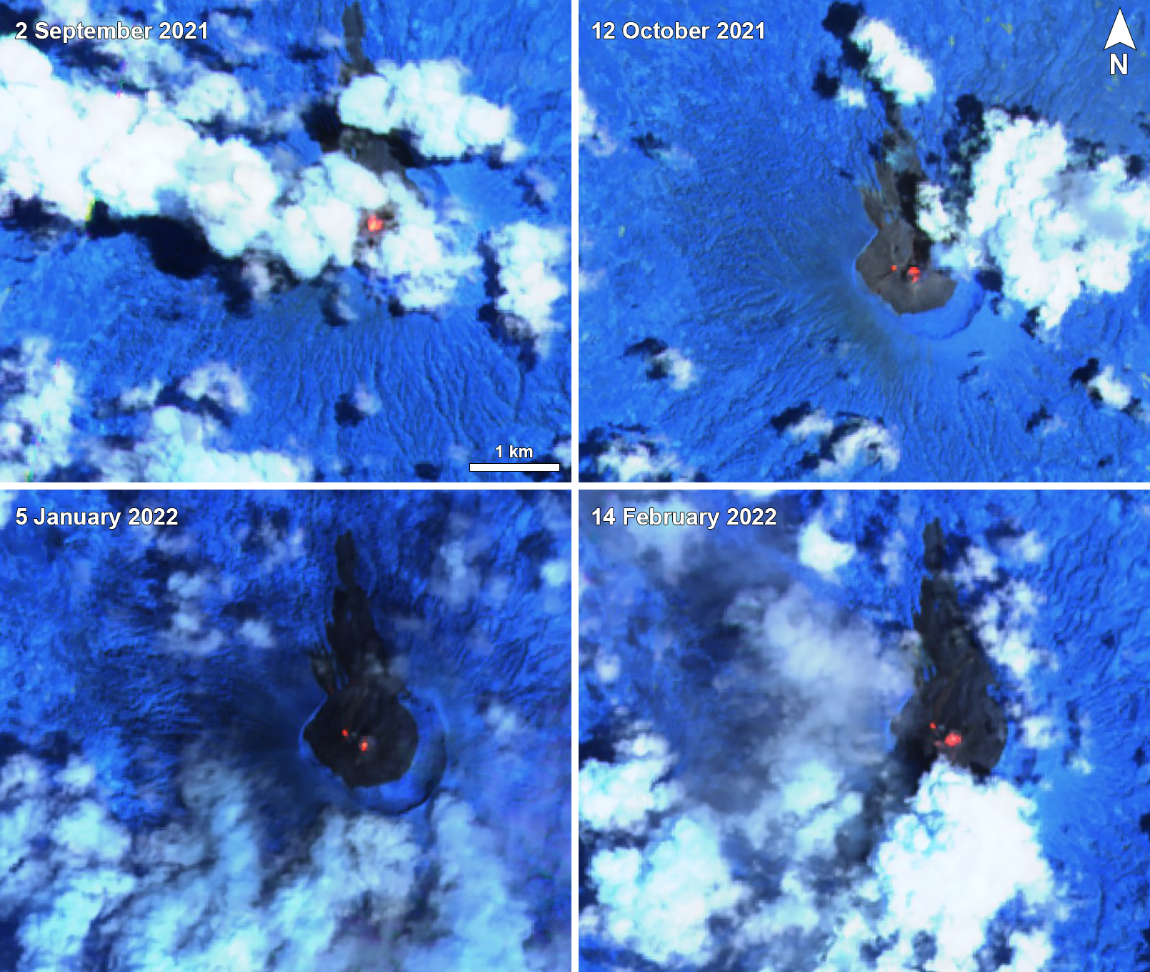 |
Figure 37. Thermal anomalies of varying intensity were visible in the summit crater of Ibu on 2 September 2021 (top left), 12 October 2021 (top right), 5 January 2022 (bottom left), and 14 February 2022 (bottom right). Two anomalies, one in the summit crater and a smaller one to the NW of it, appeared on 12 October, 5 January, and 14 February. Images using “Atmospheric penetration” (bands 12, 11, 8A) rendering. Courtesy of Sentinel Hub Playground. |
Intermittent ash plumes were reported during September 2021 while white-and-gray emissions rose 200-800 m above the summit each day. Daily eruption events ranged from 55-102, the higher number occurring on 8 September, according to PVMBG daily reports. On 6 September an ash plume rose 400 m above the summit at 0916 and drifted N. Another ash plume on 18 September rose 1 km above the summit at 1135 and drifted W (figure 38). Two avalanches were reported on 30 September traveling 1 km to the W.
 |
Figure 38. Images of various ash plumes rising above Ibu on 18 September (top left), 11 November (top right), 18 December (bottom left) 2021, and 16 February (bottom right) 2022 and drifting in different directions. The ash plume on 18 September rose 1 km above the summit and drifted W. The ash plume on 16 February rose to 2.1 km altitude and drifted S. Courtesy of MAGMA Indonesia. |
White-and-gray emissions persisted every day during October, rising 200-800 m above the summit. Daily eruption events ranged from 0-81, the most of which occurred on 28 October. Some light ashfall was reported in the towns to the W of the volcano on 1 October. On 7 and 19 October an explosion generated an ash plume that rose 800 m above the summit. According to a VONA issued on 9 October, an ash plume rose to 1.7 km altitude at 1651 and drifted NE. Another VONA published on 16 October described an ash plume that rose 600 m above the summit at 0838 and drifted N. On 31 October, an ash plume rose 500 m above the summit at 0818.
Similar low activity continued in November; white-and-gray emissions rose 200-800 m above the summit and intermittent ash plumes rose as high as 2.3 km altitude. Daily eruption events ranged from 1-87, the most of which occurred on 26 November. On 6 November an ash plume rose to 2.3 km altitude at 0637 and drifted W and S. Two days later, on 8 November, an ash plume rose 1 km above the summit at 0957 and drifted S. During 10-11 November, ash plumes drifted W, causing some light ashfall in communities to the W of the volcano. VONAs issued on 16 and 19 November described ash plumes rising 1-8-2.3 km altitude that drifted N and S.
During December, the primary form of activity was white-and-gray emissions rising 200-1,000 m above the summit. Daily eruption events ranged from 56-87, the most of which occurred on 18 December. On 20 December, an avalanche traveled 100-400 m to the NW.
Low activity during January 2022 consisted of daily white-and-gray emissions that rose 200-1,000 m above the summit. During 1-4 January, avalanches were detected each day, but they were not visually observed. Daily eruption events ranged from 66-94, the most of which occurred on 17 January. During 8-9 January, strong rumbling sounds were heard and minor ashfall was reported to the W of the volcano.
During February, white-and-gray emissions persisted, rising 200-1,000 m above the summit, while intermittent ash plumes rose to 2.3 km altitude. Daily eruption events ranged from 46-82, the most of which occurred on 2 and 4 February. Ash plumes were reported on 14, 16, 18, and 23 February, according to VONA notices, rising to 2.1-2.3 km altitude and drifting W, S, and SW (figure 38).
Information Contacts: Pusat Vulkanologi dan Mitigasi Bencana Geologi (PVMBG, also known as Indonesian Center for Volcanology and Geological Hazard Mitigation, CVGHM), Jalan Diponegoro 57, Bandung 40122, Indonesia (URL: http://www.vsi.esdm.go.id/); MAGMA Indonesia, Kementerian Energi dan Sumber Daya Mineral (URL: https://magma.esdm.go.id/v1); Darwin Volcanic Ash Advisory Centre (VAAC), Bureau of Meteorology, Northern Territory Regional Office, PO Box 40050, Casuarina, NT 0811, Australia (URL: http://www.bom.gov.au/info/vaac/); MIROVA (Middle InfraRed Observation of Volcanic Activity), a collaborative project between the Universities of Turin and Florence (Italy) supported by the Centre for Volcanic Risk of the Italian Civil Protection Department (URL: http://www.mirovaweb.it/); Hawai'i Institute of Geophysics and Planetology (HIGP) - MODVOLC Thermal Alerts System, School of Ocean and Earth Science and Technology (SOEST), Univ. of Hawai'i, 2525 Correa Road, Honolulu, HI 96822, USA (URL: http://modis.higp.hawaii.edu/); Sentinel Hub Playground (URL: https://www.sentinel-hub.com/explore/sentinel-playground).
Eruption continues with almost daily ash plumes through September 2022
Recent activity at Ibu, an Indonesian stratovolcano about 35 km SW of Dukono volcano, has included occasional low-level ash plumes, light ashfall, and thermal anomalies. This report covers similar activity during March-September 2022, using information from the Pusat Vulkanologi dan Mitigasi Bencana Geologi (PVMBG, also known as Indonesian Center for Volcanology and Geological Hazard Mitigation, CVGHM) and various satellite data. The Volcano Alert Level remained at 2 (on a scale of 1-4), and the public was warned to stay at least 2 km away from the active crater and 3.5 km away on the N side.
According to daily reports from MAGMA Indonesia (a platform developed by PVMBG), gray-and-white ash plumes rising 200-1,000 m above the summit were observed almost every day during the reporting period, with a few plumes reaching up to 3 km above the summit (figure 39). Plume heights were variable, though higher plumes were noted during 21-29 April.
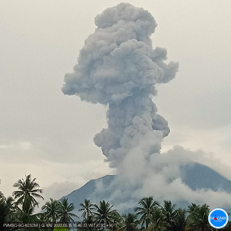 |
Figure 39. Webcam photo of Ibu on 16 May 2022 at 1646 local time showing an ash plume that might have risen as high as 2.5 km above the summit. Photo has been color corrected. Courtesy of MAGMA Indonesia. |
Frequent thermal hotspots were detected by the MIROVA system during the reporting period (figure 40). In contrast, only a few scattered hotspots were identified by the MODIS-MODVOLC thermal alert system, and none in March or June. Satellite imagery continued to show thermal anomalies at both summit craters (figure 41), though the volcano was obscured by weather clouds on all but a few days.
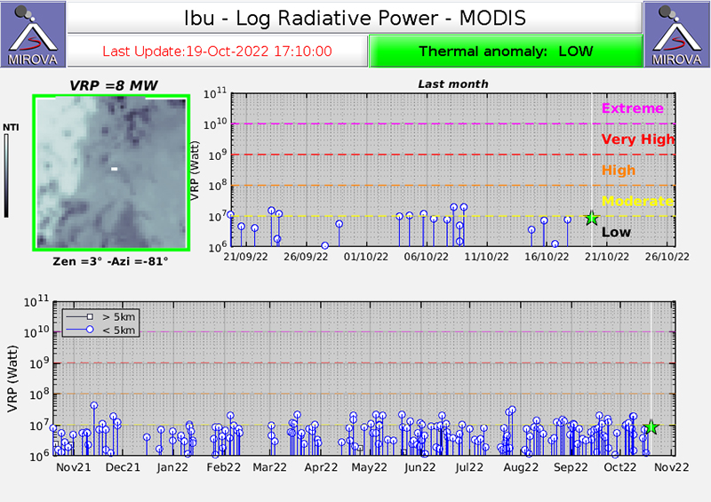 |
Figure 40. The MIROVA (Log Radiative Power) thermal data for Ibu during the year ending in October 2022 showed numerous low-power thermal signals during March-September 2022, except for early April. Courtesy of MIROVA. |
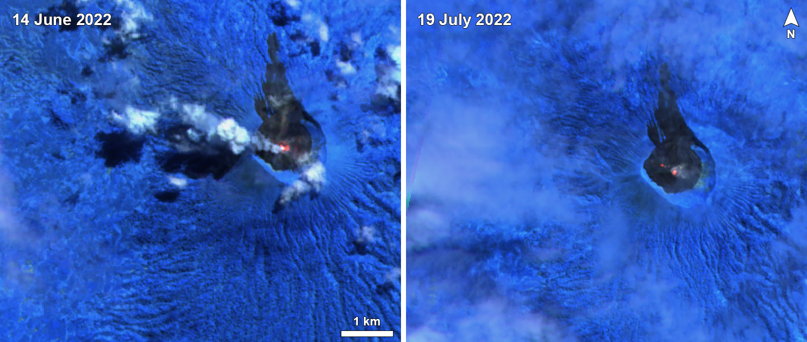 |
Figure 41. Sentinel-2 infrared satellite images of Ibu taken on 14 June (left) and 19 July 2022 (right) showing gray-and-white ash plume drifting W (top) and thermal signals from summit craters. Images taken with Atmospheric penetration rendering (bands 12, 11, 8A). Courtesy of Sentinel Hub Playground. |
Information Contacts: Pusat Vulkanologi dan Mitigasi Bencana Geologi (PVMBG, also known as Indonesian Center for Volcanology and Geological Hazard Mitigation, CVGHM), Jalan Diponegoro 57, Bandung 40122, Indonesia (URL: http://www.vsi.esdm.go.id/); MAGMA Indonesia (Multiplatform Application for Geohazard Mitigation and Assessment in Indonesia), Kementerian Energi dan Sumber Daya Mineral (URL: https://magma.esdm.go.id/v1); MIROVA (Middle InfraRed Observation of Volcanic Activity), a collaborative project between the Universities of Turin and Florence (Italy) supported by the Centre for Volcanic Risk of the Italian Civil Protection Department (URL: http://www.mirovaweb.it/); Hawai'i Institute of Geophysics and Planetology (HIGP) - MODVOLC Thermal Alerts System, School of Ocean and Earth Science and Technology (SOEST), Univ. of Hawai'i, 2525 Correa Road, Honolulu, HI 96822, USA (URL: http://modis.higp.hawaii.edu/); Sentinel Hub Playground (URL: https://www.sentinel-hub.com/explore/sentinel-playground).
Daily ash explosions continue, along with thermal anomalies in the crater, October 2022-May 2023
Persistent eruptive activity since April 2008 at Ibu, a stratovolcano on Indonesian’s Halmahera Island, has consisted of daily explosive ash emissions and plumes, along with observations of thermal anomalies (BGVN 47:04). The current eruption continued during October 2022-May 2023, described below, based on advisories issued by the Pusat Vulkanologi dan Mitigasi Bencana Geologi (PVMBG, also known as Indonesian Center for Volcanology and Geological Hazard Mitigation, CVGHM), daily reports by MAGMA Indonesia (a PVMBG platform), and the Darwin Volcanic Ash Advisory Centre (VAAC), and various satellite data. The Alert Level during the reporting period remained at 2 (on a scale of 1-4), except raised briefly to 3 on 27 May, and the public was warned to stay at least 2 km away from the active crater and 3.5 km away on the N side of the volcano.
According to MAGMA Indonesia, during October 2022-May 2023, daily gray-and-white ash plumes of variable densities rose 200-1,000 m above the summit and drifted in multiple directions. On 30 October and 11 November, plumes rose a maximum of 2 km and 1.5 km above the summit, respectively (figures 42 and 43). According to the Darwin VAAC, discrete ash emissions on 13 November rose to 2.1 km altitude, or 800 m above the summit, and drifted W, and multiple ash emissions on 15 November rose 1.4 km above the summit and drifted NE. Occasional larger ash explosions through May 2023 prompted PVMBG to issue Volcano Observatory Notice for Aviation (VONA) alerts (table 6); the Aviation Color Code remained at Orange throughout this period.
 |
Figure 42. Larger explosion from Ibu’s summit crater on 30 October 2022 that generated a plume that rose 2 km above the summit. Photo has been color corrected. Courtesy of MAGMA Indonesia. |
 |
Figure 43. Larger explosion from Ibu’s summit crater on 11 November 2022 that generated a plume that rose 1.5 km above the summit. Courtesy of MAGMA Indonesia. |
Table 6. Volcano Observatory Notice for Aviation (VONA) ash plume alerts for Ibu issued by PVMBG during October 2022-May 2023. Maximum height above the summit was estimated by a ground observer. VONAs in January-May 2023 all described the ash plumes as dense.
| Date | Time (local) | Max height above summit | Direction |
| 17 Oct 2022 | 0858 | 800 m | SW |
| 18 Oct 2022 | 1425 | 800 m | S |
| 19 Oct 2022 | 2017 | 600 m | SW |
| 21 Oct 2022 | 0916 | 800 m | NW |
| 16 Jan 2023 | 1959 | 600 m | NE |
| 22 Jan 2023 | 0942 | 1,000 m | E |
| 29 Jan 2023 | 2138 | 1,000 m | E |
| 10 May 2023 | 0940 | 800 m | NW |
| 10 May 2023 | 2035 | 600 m | E |
| 21 May 2023 | 2021 | 600 m | W |
| 21 May 2023 | 2140 | 1,000 m | W |
| 29 May 2023 | 1342 | 800 m | N |
| 31 May 2023 | 1011 | 1,000 m | SW |
Sentinel-2 L1C satellite images throughout the reporting period show two, sometimes three persistent thermal anomalies in the summit crater, with the most prominent hotspot from the top of a cone within the crater. Clear views were more common during March-April 2023, when a vent and lava flows on the NE flank of the intra-crater cone could be distinguished (figure 44). White-to-grayish emissions were also observed during brief periods when weather clouds allowed clear views.
 |
Figure 44. Sentinel-2 L2A satellite images of Ibu on 10 April 2023. The central cone within the summit crater (1.3 km diameter) and lava flows (gray) can be seen in the true color image (left, bands 4, 3, 2). Thermal anomalies from the small crater of the intra-crater cone, a NE-flank vent, and the end of the lava flow are apparent in the infrared image (right, bands 12, 11, 8A). Courtesy of Copernicus Browser. |
The MIROVA space-based volcano hotspot detection system recorded almost daily thermal anomalies throughout the reporting period, though cloud cover often interfered with detections. Data from imaging spectroradiometers aboard NASA’s Aqua and Terra satellites and processed using the MODVOLC algorithm (MODIS-MODVOLC) recorded hotspots on one day during October 2022 and December 2022, two days in April 2023, three days in November 2022 and May 2023, and four days in March 2023.
Information Contacts: Pusat Vulkanologi dan Mitigasi Bencana Geologi (PVMBG, also known as Indonesian Center for Volcanology and Geological Hazard Mitigation, CVGHM), Jalan Diponegoro 57, Bandung 40122, Indonesia (URL: http://www.vsi.esdm.go.id/); MAGMA Indonesia (Multiplatform Application for Geohazard Mitigation and Assessment in Indonesia), Kementerian Energi dan Sumber Daya Mineral (URL: https://magma.esdm.go.id/v1); Copernicus Browser, Copernicus Data Space Ecosystem, European Space Agency (URL: https://dataspace.copernicus.eu/browser/); MIROVA (Middle InfraRed Observation of Volcanic Activity), a collaborative project between the Universities of Turin and Florence (Italy) supported by the Centre for Volcanic Risk of the Italian Civil Protection Department (URL: http://www.mirovaweb.it/); Hawai'i Institute of Geophysics and Planetology (HIGP) - MODVOLC Thermal Alerts System, School of Ocean and Earth Science and Technology (SOEST), Univ. of Hawai'i, 2525 Correa Road, Honolulu, HI 96822, USA (URL: http://modis.higp.hawaii.edu/).
Eruption continued during June-November 2023, with persistent ash explosions and thermal anomalies
The current eruption period of Ibu, a stratovolcano on Indonesia’s Halmahera Island, began in April 2008 and has primarily consisted of ash plumes and emissions varying from intermittent to daily, along with occasional thermal anomalies (BGVN 43:12, 48:06). This report updates activity through November 2023, based on daily reports from MAGMA Indonesia, advisories issued by the Pusat Vulkanologi dan Mitigasi Bencana Geologi (PVMBG, also known as Indonesian Center for Volcanology and Geological Hazard Mitigation, CVGHM), the Darwin Volcanic Ash Advisory Centre (VAAC), and various satellite data. MAGMA Indonesia is a platform developed by PVMBG to improve timely public access to volcano and earthquake activity.
According to PVMBG, from June to November 2023 daily gray-and-white plumes of variable densities usually rose 200-1,000 m above the nested summit craters and drifted in multiple directions. Occasional larger explosions prompted PVMBG to issue 50 Volcano Observatory Notice for Aviation (VONA) ash plume alerts during the reporting period. VONAs were issued every month, ranging from 5 in June to 14 in October; all described the ash plumes as dense. A few plumes rose as high as 1,500 meters during August-November. Clear Sentinel-2 satellite views showed ash plumes on 8 and 13 August, but webcam images showed intermittent ash plumes similar to those seen in recent years.
The MIROVA satellite volcano hotspot detection system recorded frequent thermal anomalies of low to moderate power throughout the reporting period. Data from imaging spectroradiometers aboard NASA’s Aqua and Terra satellites and processed using the MODVOLC algorithm (MODIS-MODVOLC) recorded hotspots on 6 June, 3 August, 30 September, five days in October (5, 10, 15, 26, 31), and four days in November (5, 12, 13, 26). Sentinel-2 satellite images showed a summit crater hotspot in every clear view, along with thermal anomalies extending S from the crater in a partially obscured view on 21 November. White-to-grayish emissions were also visible on clear days.
Information Contacts: Pusat Vulkanologi dan Mitigasi Bencana Geologi (PVMBG, also known as Indonesian Center for Volcanology and Geological Hazard Mitigation, CVGHM), Jalan Diponegoro 57, Bandung 40122, Indonesia (URL: http://www.vsi.esdm.go.id/); MAGMA Indonesia (Multiplatform Application for Geohazard Mitigation and Assessment in Indonesia), Kementerian Energi dan Sumber Daya Mineral (URL: https://magma.esdm.go.id/v1); Darwin Volcanic Ash Advisory Centre (VAAC), Bureau of Meteorology, Northern Territory Regional Office, PO Box 40050, Casuarina, NT 0811, Australia (URL: http://www.bom.gov.au/info/vaac/); Copernicus Browser, Copernicus Data Space Ecosystem, European Space Agency (URL: https://dataspace.copernicus.eu/browser/); MIROVA (Middle InfraRed Observation of Volcanic Activity), a collaborative project between the Universities of Turin and Florence (Italy) supported by the Centre for Volcanic Risk of the Italian Civil Protection Department (URL: http://www.mirovaweb.it/); Hawai'i Institute of Geophysics and Planetology (HIGP) - MODVOLC Thermal Alerts System, School of Ocean and Earth Science and Technology (SOEST), Univ. of Hawai'i, 2525 Correa Road, Honolulu, HI 96822, USA (URL: http://modis.higp.hawaii.edu/).
|
|
||||||||||||||||||||||||||
There is data available for 5 confirmed eruptive periods.
2008 Apr 5 - 2025 Sep 19 (continuing) Confirmed Eruption (Explosive / Effusive) VEI: 1
| Episode 1 | Eruption (Explosive / Effusive) | ||||||||||||||||||||||||||||||||||
|---|---|---|---|---|---|---|---|---|---|---|---|---|---|---|---|---|---|---|---|---|---|---|---|---|---|---|---|---|---|---|---|---|---|---|
| 2008 Apr 5 - 2025 Sep 19 (continuing) | Evidence from Observations: Reported | |||||||||||||||||||||||||||||||||
|
List of 5 Events for Episode 1
|
||||||||||||||||||||||||||||||||||
2004 May 16 (?) ± 15 days - 2005 Feb 22 (?) Confirmed Eruption (Explosive / Effusive) VEI: 0 (?)
| Episode 1 | Eruption (Explosive / Effusive) | |||||||||||||||||||
|---|---|---|---|---|---|---|---|---|---|---|---|---|---|---|---|---|---|---|---|
| 2004 May 16 (?) ± 15 days - 2005 Feb 22 (?) | Evidence from Observations: Reported | ||||||||||||||||||
|
List of 2 Events for Episode 1
|
|||||||||||||||||||
2001 May 28 (?) - 2001 Oct 3 (?) Confirmed Eruption (Explosive / Effusive) VEI: 0
| Episode 1 | Eruption (Explosive / Effusive) | |||||||||||||||||||
|---|---|---|---|---|---|---|---|---|---|---|---|---|---|---|---|---|---|---|---|
| 2001 May 28 (?) - 2001 Oct 3 (?) | Evidence from Observations: Reported | ||||||||||||||||||
|
List of 2 Events for Episode 1
|
|||||||||||||||||||
1998 Dec 18 - 1999 Sep 16 (on or after) ± 15 days Confirmed Eruption (Explosive / Effusive) VEI: 2
| Episode 1 | Eruption (Explosive / Effusive) | |||||||||||||||||||||||||||||||||||||||||||||||||
|---|---|---|---|---|---|---|---|---|---|---|---|---|---|---|---|---|---|---|---|---|---|---|---|---|---|---|---|---|---|---|---|---|---|---|---|---|---|---|---|---|---|---|---|---|---|---|---|---|---|
| 1998 Dec 18 - 1999 Sep 16 (on or after) ± 15 days | Evidence from Observations: Reported | ||||||||||||||||||||||||||||||||||||||||||||||||
|
List of 8 Events for Episode 1
|
|||||||||||||||||||||||||||||||||||||||||||||||||
1911 Aug 30 - 1911 Sep 1 Confirmed Eruption (Explosive / Effusive) VEI: 2
| Episode 1 | Eruption (Explosive / Effusive) | |||||||||||||||||||||||||||||
|---|---|---|---|---|---|---|---|---|---|---|---|---|---|---|---|---|---|---|---|---|---|---|---|---|---|---|---|---|---|
| 1911 Aug 30 - 1911 Sep 1 | Evidence from Observations: Reported | ||||||||||||||||||||||||||||
|
List of 4 Events for Episode 1
|
|||||||||||||||||||||||||||||
This compilation of synonyms and subsidiary features may not be comprehensive. Features are organized into four major categories: Cones, Craters, Domes, and Thermal Features. Synonyms of features appear indented below the primary name. In some cases additional feature type, elevation, or location details are provided.
Synonyms |
||||
| Iboe | Tobaru | Tubaru | Toebaroe | ||||
Craters |
||||
| Feature Name | Feature Type | Elevation | Latitude | Longitude |
| Bitjara, Lake | Maar | |||
| Gam Itji, Lake | Maar | |||
| Mati, Lake | Maar | |||
| Moro | Crater | |||
| Todoke, Lake | Maar | |||
| Toduoko, Lake | Maar | |||
 This view from the summit of Ternate Island shows the Halmahera Island volcanoes of Jailolo in the foreground, Gamkonora on the left, and flat-topped Ibu volcano on the right. Jailolo volcano has no known historical eruptions, but youthful lava flows are located on the eastern flank. Gamkonora is one of Halmahera's most active volcanoes, while Ibu, with its nested summit craters, one of which has a crater lake, has erupted only once in historical time, in 1911.
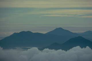 Three Halmahera Island volcanoes are visible in this view from the SW at the summit of Gamalama volcano on Ternate Island. The twin caldera complex of Todoku-Ranu is on the left, the historically active volcano of Gamkonora is on the skyline at the right center, and Jailolo volcano rises above the clouds at the lower right. These volcanoes are part of a N-S chain extending along the western coast of northern Halmahera Island.
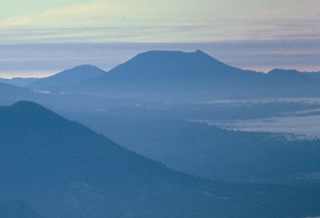 The truncated summit of Gunung Ibu stratovolcano along the NW coast of Halmahera is seen here from the SW at the summit of Gamalama volcano. The broad summit of Gunung Ibu has nested summit craters. The inner crater, 1 km wide and 400 m deep, contains several small crater lakes. Only two eruptions are known from Ibu in historical time, a small explosive eruption from the summit crater in 1911, and another beginning in December 1998.
  Gunung Ibu volcano on the NW coast of Halmahera Island rises beyond a small village on its WNW flank. The summit of the stratovolcano is truncated by nested craters; the inner crater, 1 km wide and 400 m deep, contains several small crater lakes. The outer crater is breached on the north side, forming the deep valley seen here on the left side of the summit ridge. Few eruptions are known in historical time from Ibu, although it was erupting at the time of this February 1999 photo.
There are no samples for Ibu in the Smithsonian's NMNH Department of Mineral Sciences Rock and Ore collection.
| Copernicus Browser | The Copernicus Browser replaced the Sentinel Hub Playground browser in 2023, to provide access to Earth observation archives from the Copernicus Data Space Ecosystem, the main distribution platform for data from the EU Copernicus missions. |
| MIROVA | Middle InfraRed Observation of Volcanic Activity (MIROVA) is a near real time volcanic hot-spot detection system based on the analysis of MODIS (Moderate Resolution Imaging Spectroradiometer) data. In particular, MIROVA uses the Middle InfraRed Radiation (MIR), measured over target volcanoes, in order to detect, locate and measure the heat radiation sourced from volcanic activity. |
| MODVOLC Thermal Alerts | Using infrared satellite Moderate Resolution Imaging Spectroradiometer (MODIS) data, scientists at the Hawai'i Institute of Geophysics and Planetology, University of Hawai'i, developed an automated system called MODVOLC to map thermal hot-spots in near real time. For each MODIS image, the algorithm automatically scans each 1 km pixel within it to check for high-temperature hot-spots. When one is found the date, time, location, and intensity are recorded. MODIS looks at every square km of the Earth every 48 hours, once during the day and once during the night, and the presence of two MODIS sensors in space allows at least four hot-spot observations every two days. Each day updated global maps are compiled to display the locations of all hot spots detected in the previous 24 hours. There is a drop-down list with volcano names which allow users to 'zoom-in' and examine the distribution of hot-spots at a variety of spatial scales. |
|
WOVOdat
Single Volcano View Temporal Evolution of Unrest Side by Side Volcanoes |
WOVOdat is a database of volcanic unrest; instrumentally and visually recorded changes in seismicity, ground deformation, gas emission, and other parameters from their normal baselines. It is sponsored by the World Organization of Volcano Observatories (WOVO) and presently hosted at the Earth Observatory of Singapore.
GVMID Data on Volcano Monitoring Infrastructure The Global Volcano Monitoring Infrastructure Database GVMID, is aimed at documenting and improving capabilities of volcano monitoring from the ground and space. GVMID should provide a snapshot and baseline view of the techniques and instrumentation that are in place at various volcanoes, which can be use by volcano observatories as reference to setup new monitoring system or improving networks at a specific volcano. These data will allow identification of what monitoring gaps exist, which can be then targeted by remote sensing infrastructure and future instrument deployments. |
| Volcanic Hazard Maps | The IAVCEI Commission on Volcanic Hazards and Risk has a Volcanic Hazard Maps database designed to serve as a resource for hazard mappers (or other interested parties) to explore how common issues in hazard map development have been addressed at different volcanoes, in different countries, for different hazards, and for different intended audiences. In addition to the comprehensive, searchable Volcanic Hazard Maps Database, this website contains information about diversity of volcanic hazard maps, illustrated using examples from the database. This site is for educational purposes related to volcanic hazard maps. Hazard maps found on this website should not be used for emergency purposes. For the most recent, official hazard map for a particular volcano, please seek out the proper institutional authorities on the matter. |
| IRIS seismic stations/networks | Incorporated Research Institutions for Seismology (IRIS) Data Services map showing the location of seismic stations from all available networks (permanent or temporary) within a radius of 0.18° (about 20 km at mid-latitudes) from the given location of Ibu. Users can customize a variety of filters and options in the left panel. Note that if there are no stations are known the map will default to show the entire world with a "No data matched request" error notice. |
| UNAVCO GPS/GNSS stations | Geodetic Data Services map from UNAVCO showing the location of GPS/GNSS stations from all available networks (permanent or temporary) within a radius of 20 km from the given location of Ibu. Users can customize the data search based on station or network names, location, and time window. Requires Adobe Flash Player. |
| DECADE Data | The DECADE portal, still in the developmental stage, serves as an example of the proposed interoperability between The Smithsonian Institution's Global Volcanism Program, the Mapping Gas Emissions (MaGa) Database, and the EarthChem Geochemical Portal. The Deep Earth Carbon Degassing (DECADE) initiative seeks to use new and established technologies to determine accurate global fluxes of volcanic CO2 to the atmosphere, but installing CO2 monitoring networks on 20 of the world's 150 most actively degassing volcanoes. The group uses related laboratory-based studies (direct gas sampling and analysis, melt inclusions) to provide new data for direct degassing of deep earth carbon to the atmosphere. |
| Large Eruptions of Ibu | Information about large Quaternary eruptions (VEI >= 4) is cataloged in the Large Magnitude Explosive Volcanic Eruptions (LaMEVE) database of the Volcano Global Risk Identification and Analysis Project (VOGRIPA). |
| EarthChem | EarthChem develops and maintains databases, software, and services that support the preservation, discovery, access and analysis of geochemical data, and facilitate their integration with the broad array of other available earth science parameters. EarthChem is operated by a joint team of disciplinary scientists, data scientists, data managers and information technology developers who are part of the NSF-funded data facility Integrated Earth Data Applications (IEDA). IEDA is a collaborative effort of EarthChem and the Marine Geoscience Data System (MGDS). |

