
No seismicity triggered by M 7.5 earthquake hundreds of kilometers away
Southern California's largest earthquake since 1952, M 7.5 on 28 June, appeared to trigger seismicity at several volcanic centers in California. It was centered roughly 200 km E of Los Angeles. In the following, David Hill describes post-earthquake activity at Long Valley caldera, and Stephen Walter discusses the USGS's seismic network, and the changes it detected at Lassen, Shasta, Medicine Lake, and the Geysers.
In recent years, the USGS northern California seismic network has relied upon Real-Time Processors (RTPs) to detect, record, and locate earthquakes. However, a film recorder (develocorder) collects data from 18 stations in volcanic areas, primarily to detect long-period earthquakes missed by RTPs. The film recorders proved useful in counting the post-M 7.5 earthquakes, most of which were too small to trigger the RTPs.
The film record was scanned for the 24 hours after the M 7.5 earthquake, noting the average coda duration for each identified event. Some events may have been missed because of seismogram saturation by the M 7.5 earthquake. Marked increases in microseismicity were observed at Lassen Peak, Medicine Lake caldera, and the Geysers (table 1). No earthquakes were observed at Shasta, but the lack of operating stations on the volcano limited the capability to observe small events.
Table 1. Number of earthquakes at northern California volcanic centers during 24-hour periods following major earthquakes on 25 April (40.37°N, 124.32°W; M 7.0) and 28 June (34.18°N, 116.47°W; M 7.5) 1992. Events with coda durations less than or equal to 10 seconds and greater than 10 seconds are tallied separately. Earthquakes were identified from film records of seismograms from nearby stations. Courtesy of Stephen Walter.
| Date | Lassen | Shasta | Medicine Lake | Geysers | ||||
| Codas (seconds) | <= 10 | > 10 | <= 10 | > 10 | <= 10 | > 10 | <= 10 | > 10 |
| 25 Apr 1992 | 0 | 0 | 0 | 1 | 0 | 0 | 7 | 2 |
| 28 Jun 1992 | 8 | 14 | 1 | 5 | 12 | 0 | 46 | 4 |
Film was also scanned for the 24 hours following the M 7.0 earthquake at 40.37°N, 124.32°W (near Cape Mendocino) on 25 April. Although smaller than the 28 June earthquake, its epicenter was only 20-25% as far from the volcanoes. Furthermore, both the 25 April main shock and a M 6.5 aftershock were felt at the volcanic centers, but no felt reports were received from these areas after the 28 June earthquake. Only the Geysers showed any possible triggered events after the 25 April shock. However, background seismicity at the Geysers is higher than at the other centers, and is influenced by fluid injection and withdrawal associated with intensive geothermal development.
Shasta report. The film record showed no earthquake activity beneath Shasta (~900 km NNW of the epicenter), although telemetry problems limited the ability to detect events below M 2. Of the six earthquakes in the 24 hours following the M 7.5 shock, two were large enough to be recorded by the RTP system. These were centered about 60 km SE of Shasta and about equidistant from Lassen (figure 1). Because the arrival times and S-P sequences of the other four events were similar to those of the two located shocks, it is likely that all had similar epicenters. Occasional M 2 earthquakes have previously occurred in this area, which includes several mapped N-trending normal faults with Quaternary movement. Three days after the M 7.5 earthquake, a M 2.0 shock occurred beneath Shasta's SE flank, followed by a M 2.7 event the next day. Both were centered at about 15 km depth, similar to most earthquakes beneath Shasta in the last decade.
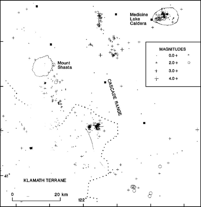 |
Figure 1. Seismic events in the Shasta/Medicine Lake area that were apparently triggered by the M 7.5 southern California earthquake of 28 June 1992 (circles) compared to 1978-90 seismicity in the region (crosses). Squares mark seismic stations. Courtesy of Stephen Walter. |
Information Contacts: Stephen Walter and David Hill, MS 977, U.S. Geological Survey, 345 Middlefield Road, Menlo Park, California 94025 USA.
The Global Volcanism Program has no Weekly Reports available for Shasta.
Reports are organized chronologically and indexed below by Month/Year (Publication Volume:Number), and include a one-line summary. Click on the index link or scroll down to read the reports.
Earthquake swarm; maximum M 4.2
An earthquake swarm in the vicinity of Mt. Shasta began at 0202 on 1 August. The first event, M 4.2, was followed by six M 3-4 events in the next 45 minutes. Between 35 and 40 shocks (M greater than or equal to 2) were recorded on 1 August. The number of events declined slightly the next day and only about ten had been recorded by midday on 3 August. About 20 of the total had M greater than or equal to 3. Permanent seismographs were too distant for precise hypocenter determinations, but USGS personnel were bringing portable seismographs into the area.
An ash eruption, probably from Shasta, was sighted from a ship off the California coast in 1786.
Information Contacts: R. Lester, USGS, Menlo Park, CA.
Earthquakes decline to few a day
The number of earthquakes declined to only a few events per day (M greater than or equal to 2) by 11 August. However, on 12 August a M 4.3-4.5 shock was followed by several similar events (approximately M 4), and others in the M 3.5-4 range occurred on the 13th. Activity then declined again; on 23 August only 13 events of M 2-2.5 were recorded, and by the end of August only about six events greater than M 2 were being recorded daily.
Epicenters have been located along about 2 km of a pre-existing N-S-trending fault zone 28 km E of the summit. Uncertain crustal velocities for the area have made depth determinations difficult, but all events have been shallow, probably less than 5 km, and some may have been less that 1 km deep. No migration of events has been observed. New tensional fissures have been found in the epicentral area, but were not growing as of late August. Leveling, microearthquake studies, and gravity profiles are planned.
Information Contacts: R. Sherburne, California Division of Mines & Geology; A. Walter, USGS, Menlo Park, CA.
Daily seismcity declines; no evidence of volcanic activity
Seismic activity E of Mt. Shasta had declined by late September to about six locatable events per day, most stronger than M 2. Hypocenters extended E from surface fissures 28 km E of Shasta, along a pre-existing N-S-trending fault zone. Focal depths were very shallow near the surface fissures, but increased to 4-6 km along an inclined seismic zone dipping 35-45° E. The events have not been migrating, nor has there been any evidence of volcanic activity associated with the swarm.
Further Reference. Bennett, J.H., et al., 1979, Stephens Pass earthquakes, Mount Shasta—August 1978; California Geology, February, 1979, p. 27-33.
Information Contacts: R. Sherburne, California Division of Mines & Geology.
No seismicity triggered by M 7.5 earthquake hundreds of kilometers away
Southern California's largest earthquake since 1952, M 7.5 on 28 June, appeared to trigger seismicity at several volcanic centers in California. It was centered roughly 200 km E of Los Angeles. In the following, David Hill describes post-earthquake activity at Long Valley caldera, and Stephen Walter discusses the USGS's seismic network, and the changes it detected at Lassen, Shasta, Medicine Lake, and the Geysers.
In recent years, the USGS northern California seismic network has relied upon Real-Time Processors (RTPs) to detect, record, and locate earthquakes. However, a film recorder (develocorder) collects data from 18 stations in volcanic areas, primarily to detect long-period earthquakes missed by RTPs. The film recorders proved useful in counting the post-M 7.5 earthquakes, most of which were too small to trigger the RTPs.
The film record was scanned for the 24 hours after the M 7.5 earthquake, noting the average coda duration for each identified event. Some events may have been missed because of seismogram saturation by the M 7.5 earthquake. Marked increases in microseismicity were observed at Lassen Peak, Medicine Lake caldera, and the Geysers (table 1). No earthquakes were observed at Shasta, but the lack of operating stations on the volcano limited the capability to observe small events.
Table 1. Number of earthquakes at northern California volcanic centers during 24-hour periods following major earthquakes on 25 April (40.37°N, 124.32°W; M 7.0) and 28 June (34.18°N, 116.47°W; M 7.5) 1992. Events with coda durations less than or equal to 10 seconds and greater than 10 seconds are tallied separately. Earthquakes were identified from film records of seismograms from nearby stations. Courtesy of Stephen Walter.
| Date | Lassen | Shasta | Medicine Lake | Geysers | ||||
| Codas (seconds) | <= 10 | > 10 | <= 10 | > 10 | <= 10 | > 10 | <= 10 | > 10 |
| 25 Apr 1992 | 0 | 0 | 0 | 1 | 0 | 0 | 7 | 2 |
| 28 Jun 1992 | 8 | 14 | 1 | 5 | 12 | 0 | 46 | 4 |
Film was also scanned for the 24 hours following the M 7.0 earthquake at 40.37°N, 124.32°W (near Cape Mendocino) on 25 April. Although smaller than the 28 June earthquake, its epicenter was only 20-25% as far from the volcanoes. Furthermore, both the 25 April main shock and a M 6.5 aftershock were felt at the volcanic centers, but no felt reports were received from these areas after the 28 June earthquake. Only the Geysers showed any possible triggered events after the 25 April shock. However, background seismicity at the Geysers is higher than at the other centers, and is influenced by fluid injection and withdrawal associated with intensive geothermal development.
Shasta report. The film record showed no earthquake activity beneath Shasta (~900 km NNW of the epicenter), although telemetry problems limited the ability to detect events below M 2. Of the six earthquakes in the 24 hours following the M 7.5 shock, two were large enough to be recorded by the RTP system. These were centered about 60 km SE of Shasta and about equidistant from Lassen (figure 1). Because the arrival times and S-P sequences of the other four events were similar to those of the two located shocks, it is likely that all had similar epicenters. Occasional M 2 earthquakes have previously occurred in this area, which includes several mapped N-trending normal faults with Quaternary movement. Three days after the M 7.5 earthquake, a M 2.0 shock occurred beneath Shasta's SE flank, followed by a M 2.7 event the next day. Both were centered at about 15 km depth, similar to most earthquakes beneath Shasta in the last decade.
|
Figure 1. Seismic events in the Shasta/Medicine Lake area that were apparently triggered by the M 7.5 southern California earthquake of 28 June 1992 (circles) compared to 1978-90 seismicity in the region (crosses). Squares mark seismic stations. Courtesy of Stephen Walter. |
Information Contacts: Stephen Walter and David Hill, MS 977, U.S. Geological Survey, 345 Middlefield Road, Menlo Park, California 94025 USA.
|
|
||||||||||||||||||||||||||||
There is data available for 22 confirmed eruptive periods.
[ 1786 ] Discredited Eruption
The original ships map inspected by William Miesse, along with reviews and analysis by US Geological and Smithsonian volcanologists, showed that the "smoke" reported during a 1786 voyage by La Perouse was due to a grass fire along the California coast (see summary by Leman, 2019). Fieldwork in 2019 found no evidence of an eruption from that time period.
1250 (?) Confirmed Eruption (Explosive / Effusive)
| Episode 1 | Eruption (Explosive / Effusive) | |||||||||||||||||||||||||||||
|---|---|---|---|---|---|---|---|---|---|---|---|---|---|---|---|---|---|---|---|---|---|---|---|---|---|---|---|---|---|
| 1250 (?) - Unknown | Evidence from Isotopic: 14C (uncalibrated) | ||||||||||||||||||||||||||||
|
List of 4 Events for Episode 1
|
|||||||||||||||||||||||||||||
1200 (?) Confirmed Eruption (Explosive / Effusive)
| Episode 1 | Eruption (Explosive / Effusive) | |||||||||||||||||||
|---|---|---|---|---|---|---|---|---|---|---|---|---|---|---|---|---|---|---|---|
| 1200 (?) - Unknown | Evidence from Isotopic: 14C (uncalibrated) | ||||||||||||||||||
|
List of 2 Events for Episode 1
|
|||||||||||||||||||
0850 (?) Confirmed Eruption (Explosive / Effusive)
| Episode 1 | Eruption (Explosive / Effusive) | ||||||||||||||||||||||||
|---|---|---|---|---|---|---|---|---|---|---|---|---|---|---|---|---|---|---|---|---|---|---|---|---|
| 0850 (?) - Unknown | Evidence from Isotopic: 14C (uncalibrated) | |||||||||||||||||||||||
|
List of 3 Events for Episode 1
|
||||||||||||||||||||||||
0150 (?) Confirmed Eruption (Explosive / Effusive)
| Episode 1 | Eruption (Explosive / Effusive) | |||||||||||||||||||||||||||||
|---|---|---|---|---|---|---|---|---|---|---|---|---|---|---|---|---|---|---|---|---|---|---|---|---|---|---|---|---|---|
| 0150 (?) - Unknown | Evidence from Isotopic: 14C (uncalibrated) | ||||||||||||||||||||||||||||
|
List of 4 Events for Episode 1
|
|||||||||||||||||||||||||||||
0050 (?) Confirmed Eruption (Explosive / Effusive) VEI: 0
| Episode 1 | Eruption (Explosive / Effusive) | |||||||||||||||||||
|---|---|---|---|---|---|---|---|---|---|---|---|---|---|---|---|---|---|---|---|
| 0050 (?) - Unknown | Evidence from Correlation: Tephrochronology | ||||||||||||||||||
|
List of 2 Events for Episode 1
|
|||||||||||||||||||
0150 BCE (?) Confirmed Eruption (Explosive / Effusive)
| Episode 1 | Eruption (Explosive / Effusive) | ||||||||||||||||||||||||
|---|---|---|---|---|---|---|---|---|---|---|---|---|---|---|---|---|---|---|---|---|---|---|---|---|
| 0150 BCE (?) - Unknown | Evidence from Isotopic: 14C (uncalibrated) | |||||||||||||||||||||||
|
List of 3 Events for Episode 1
|
||||||||||||||||||||||||
0550 BCE ± 500 years Confirmed Eruption (Explosive / Effusive)
| Episode 1 | Eruption (Explosive / Effusive) | |||||||||||||||||||||||||||||||||||||||
|---|---|---|---|---|---|---|---|---|---|---|---|---|---|---|---|---|---|---|---|---|---|---|---|---|---|---|---|---|---|---|---|---|---|---|---|---|---|---|---|
| 0550 BCE ± 500 years - Unknown | Evidence from Correlation: Tephrochronology | ||||||||||||||||||||||||||||||||||||||
|
List of 6 Events for Episode 1
|
|||||||||||||||||||||||||||||||||||||||
0650 BCE ± 800 years Confirmed Eruption (Explosive / Effusive)
| Episode 1 | Eruption (Explosive / Effusive) | ||||||||||||||||||||||||||||||||||
|---|---|---|---|---|---|---|---|---|---|---|---|---|---|---|---|---|---|---|---|---|---|---|---|---|---|---|---|---|---|---|---|---|---|---|
| 0650 BCE ± 800 years - Unknown | Evidence from Isotopic: 14C (uncalibrated) | |||||||||||||||||||||||||||||||||
|
List of 5 Events for Episode 1
|
||||||||||||||||||||||||||||||||||
0850 BCE (?) Confirmed Eruption (Explosive / Effusive)
| Episode 1 | Eruption (Explosive / Effusive) | ||||||||||||||||||||||||
|---|---|---|---|---|---|---|---|---|---|---|---|---|---|---|---|---|---|---|---|---|---|---|---|---|
| 0850 BCE (?) - Unknown | Evidence from Isotopic: 14C (uncalibrated) | |||||||||||||||||||||||
|
List of 3 Events for Episode 1
|
||||||||||||||||||||||||
1150 BCE (?) Confirmed Eruption (Explosive / Effusive)
| Episode 1 | Eruption (Explosive / Effusive) | |||||||||||||||||||
|---|---|---|---|---|---|---|---|---|---|---|---|---|---|---|---|---|---|---|---|
| 1150 BCE (?) - Unknown | Evidence from Isotopic: 14C (uncalibrated) | ||||||||||||||||||
|
List of 2 Events for Episode 1
|
|||||||||||||||||||
2050 BCE (?) Confirmed Eruption (Explosive / Effusive)
| Episode 1 | Eruption (Explosive / Effusive) | |||||||||||||||||||
|---|---|---|---|---|---|---|---|---|---|---|---|---|---|---|---|---|---|---|---|
| 2050 BCE (?) - Unknown | Evidence from Isotopic: 14C (uncalibrated) | ||||||||||||||||||
|
List of 2 Events for Episode 1
|
|||||||||||||||||||
2550 BCE (?) Confirmed Eruption (Explosive / Effusive)
| Episode 1 | Eruption (Explosive / Effusive) | |||||||||||||||||||
|---|---|---|---|---|---|---|---|---|---|---|---|---|---|---|---|---|---|---|---|
| 2550 BCE (?) - Unknown | Evidence from Isotopic: 14C (uncalibrated) | ||||||||||||||||||
|
List of 2 Events for Episode 1
|
|||||||||||||||||||
3050 BCE ± 1000 years Confirmed Eruption (Explosive / Effusive) VEI: 0
| Episode 1 | Eruption (Explosive / Effusive) | |||||||||||||||||||
|---|---|---|---|---|---|---|---|---|---|---|---|---|---|---|---|---|---|---|---|
| 3050 BCE ± 1000 years - Unknown | Evidence from Correlation: Tephrochronology | ||||||||||||||||||
|
List of 2 Events for Episode 1
|
|||||||||||||||||||
4050 BCE (?) Confirmed Eruption (Explosive / Effusive)
| Episode 1 | Eruption (Explosive / Effusive) | ||||||||||||||||||||||||||||||||||
|---|---|---|---|---|---|---|---|---|---|---|---|---|---|---|---|---|---|---|---|---|---|---|---|---|---|---|---|---|---|---|---|---|---|---|
| 4050 BCE (?) - Unknown | Evidence from Isotopic: 14C (uncalibrated) | |||||||||||||||||||||||||||||||||
|
List of 5 Events for Episode 1
|
||||||||||||||||||||||||||||||||||
6050 BCE (?) Confirmed Eruption (Explosive / Effusive)
| Episode 1 | Eruption (Explosive / Effusive) | ||||||||||||||||||||||||
|---|---|---|---|---|---|---|---|---|---|---|---|---|---|---|---|---|---|---|---|---|---|---|---|---|
| 6050 BCE (?) - Unknown | Evidence from Isotopic: 14C (uncalibrated) | |||||||||||||||||||||||
|
List of 3 Events for Episode 1
|
||||||||||||||||||||||||
6650 BCE (?) Confirmed Eruption (Explosive / Effusive)
| Episode 1 | Eruption (Explosive / Effusive) | ||||||||||||||||||||||||||||||||||
|---|---|---|---|---|---|---|---|---|---|---|---|---|---|---|---|---|---|---|---|---|---|---|---|---|---|---|---|---|---|---|---|---|---|---|
| 6650 BCE (?) - Unknown | Evidence from Correlation: Tephrochronology | |||||||||||||||||||||||||||||||||
|
List of 5 Events for Episode 1
|
||||||||||||||||||||||||||||||||||
7250 BCE (?) Confirmed Eruption (Explosive / Effusive)
| Episode 1 | Eruption (Explosive / Effusive) | ||||||||||||||||||||||||
|---|---|---|---|---|---|---|---|---|---|---|---|---|---|---|---|---|---|---|---|---|---|---|---|---|
| 7250 BCE (?) - Unknown | Evidence from Correlation: Tephrochronology | |||||||||||||||||||||||
|
List of 3 Events for Episode 1
|
||||||||||||||||||||||||
7350 BCE (?) Confirmed Eruption (Explosive / Effusive) VEI: 0
| Episode 1 | Eruption (Explosive / Effusive) | Summit, north and west flanks | ||||||||||||||||||
|---|---|---|---|---|---|---|---|---|---|---|---|---|---|---|---|---|---|---|---|
| 7350 BCE (?) - Unknown | Evidence from Correlation: Tephrochronology | ||||||||||||||||||
|
List of 2 Events for Episode 1 at Summit, north and west flanks
|
|||||||||||||||||||
7420 BCE ± 300 years Confirmed Eruption (Explosive / Effusive)
| Episode 1 | Eruption (Explosive / Effusive) | Shastina and Black Butte | |||||||||||||||||||||||
|---|---|---|---|---|---|---|---|---|---|---|---|---|---|---|---|---|---|---|---|---|---|---|---|---|
| 7420 BCE ± 300 years - Unknown | Evidence from Isotopic: 14C (uncalibrated) | |||||||||||||||||||||||
|
List of 3 Events for Episode 1 at Shastina and Black Butte
|
||||||||||||||||||||||||
7650 BCE ± 100 years Confirmed Eruption (Explosive / Effusive) VEI: 4
| Episode 1 | Eruption (Explosive / Effusive) | Summit, S flank (Red Banks), and Shastina | |||||||||||||||||||||||||||||||||||||||||||
|---|---|---|---|---|---|---|---|---|---|---|---|---|---|---|---|---|---|---|---|---|---|---|---|---|---|---|---|---|---|---|---|---|---|---|---|---|---|---|---|---|---|---|---|---|
| 7650 BCE ± 100 years - Unknown | Evidence from Isotopic: 14C (uncalibrated) | |||||||||||||||||||||||||||||||||||||||||||
|
List of 7 Events for Episode 1 at Summit, S flank (Red Banks), and Shastina
|
||||||||||||||||||||||||||||||||||||||||||||
7750 BCE (?) Confirmed Eruption (Explosive / Effusive)
| Episode 1 | Eruption (Explosive / Effusive) | |||||||||||||||||||||||||||||||||||||||
|---|---|---|---|---|---|---|---|---|---|---|---|---|---|---|---|---|---|---|---|---|---|---|---|---|---|---|---|---|---|---|---|---|---|---|---|---|---|---|---|
| 7750 BCE (?) - Unknown | Evidence from Isotopic: 14C (uncalibrated) | ||||||||||||||||||||||||||||||||||||||
|
List of 6 Events for Episode 1
|
|||||||||||||||||||||||||||||||||||||||
8050 BCE (?) Confirmed Eruption (Explosive / Effusive)
| Episode 1 | Eruption (Explosive / Effusive) | |||||||||||||||||||
|---|---|---|---|---|---|---|---|---|---|---|---|---|---|---|---|---|---|---|---|
| 8050 BCE (?) - Unknown | Evidence from Correlation: Tephrochronology | ||||||||||||||||||
|
List of 2 Events for Episode 1
|
|||||||||||||||||||
This compilation of synonyms and subsidiary features may not be comprehensive. Features are organized into four major categories: Cones, Craters, Domes, and Thermal Features. Synonyms of features appear indented below the primary name. In some cases additional feature type, elevation, or location details are provided.
Synonyms |
||||
| Shasta Butte | ||||
Cones |
||||
| Feature Name | Feature Type | Elevation | Latitude | Longitude |
| Cinder Cone | Pyroclastic cone | 1670 m | 41° 29' 0.00" N | 122° 17' 0.00" W |
| Everitt Hill | Shield volcano | 1740 m | 41° 18' 0.00" N | 122° 13' 0.00" W |
| Signal Butte | Cone | 1415 m | 41° 17' 0.00" N | 122° 10' 0.00" W |
| Spring Hill | Cone | 1290 m | 41° 20' 0.00" N | 122° 19' 0.00" W |
Domes |
||||
| Feature Name | Feature Type | Elevation | Latitude | Longitude |
| Black Butte | Dome | 2080 m | 41° 22' 0.00" N | 122° 21' 0.00" W |
| Gray Butte | Dome | 2475 m | 41° 21' 0.00" N | 122° 12' 0.00" W |
| Mckenzie Butte | Dome | 1840 m | 41° 19' 0.00" N | 122° 12' 0.00" W |
| Shastina | Dome | 3758 m | 41° 24' 0.00" N | 122° 13' 0.00" W |
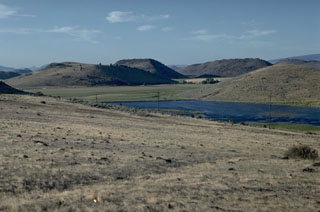 These hills below the north flank of Mount Shasta are hummocks resulting from the massive Shasta Valley debris avalanche deposit, which formed during a major volcanic flank collapse event in the Pleistocene. Individual hummocks, composed of remnants of the ancestral Shasta volcano, are up to 200 m high and some are more than 1 km long.
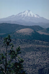 Mount Shasta one of the largest volcanoes of the Cascade Range, is located in northern California at the southern end of the Cascades. It is seen here beyond the Little Glass Mountain obsidian flow from Medicine Lake volcano to the NE.
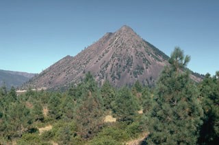 Black Buttes is a group of overlapping lava domes on the lower western flank of Mount Shasta that formed during the early Holocene, around the same time as the formation of Shastina on the upper west flank. Block-and-ash flows accompanying dome growth traveled over 10 km S. The notches on the western flank (left) mark the tops of several individual domes.
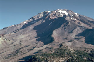 The extensively eroded Sargents Ridge (right of center), on the south side of Mount Shasta, is a remnant of the oldest of four major edifices that were constructed following the collapse of ancestral Mount Shasta. The Sargents Ridge cone formed during the Pleistocene, less than 250,000 years ago. Mount Misery was constructed less than 130,000 years ago and forms much of the upper part of the cone above the Sargents Ridge cone.
 Shastina forms the west flank of Mount Shasta with Whitney Glacier at its base. It is composed of overlapping lava flows and domes. Emplacement of the Shastina domes about 9,700-9,400 years ago was accompanied by pyroclastic flows and lava flows that traveled long distances down its flanks.
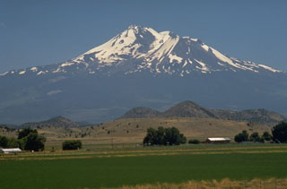 The foreground hills are part of the Shasta Valley debris avalanche deposit produced by one of the largest known Quaternary volcanic landslides. Roughly 46 km3 of an ancestral Mount Shasta collapsed about 350,000 year ago, producing a massive debris avalanche that swept some 50 km to the north, filling the broad Shasta Valley with hummocky debris.
 The prominent lava dome of Shastina, seen here on the right from the north, formed on the west flank of Shasta between about 9,700 and 9,400 years ago. The Shastina summit contains several overlapping domes. Hotlum cone to the left forms the main summit of Shasta and is likely younger than Shastina.
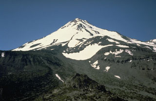 Hotlum cone, seen here from the NW, forms the main summit of Mount Shasta and is one of the largest Cascade Range volcanoes. Hotlum is composed of several overlapping edifices and formed during the Holocene.
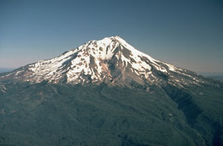 Mount Shasta in northern California, seen here from the SE, is one of the largest of the Cascades volcanoes and is constructed of at least four overlapping edifices. Hotlum cone (forming the summit), along with the Shastina and Black Buttes lava domes, were all constructed during the Holocene.
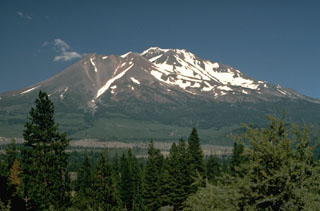 Shastina forms the largely snow-free ridge to the left of the summit of Shasta. During the growth of Shastina in the early Holocene, andesite lava flows traveled out to 14 km and pyroclastic flows swept down its flanks, covering much of the areas that are now the sites of the towns of Weed and Mt. Shasta.
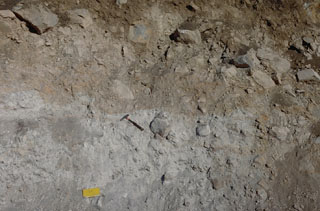 A roadcut exposes the internal structure of the debris avalanche deposit that formed during collapse of Mount Shasta during the Pleistocene. This deposit contains large angular sections composed of rock and crushed matrix of similar material (like the light-gray area in this photo), in direct contact with other lithologies (brown) from other areas of the pre-collapse volcano. This is due to different sections mixing as the debris avalanche traveled across the landscape.
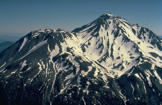 Mount Shasta in northern California, the largest volcano of the Cascade Range, is a complex stratovolcano composed of at least four overlapping volcanoes. From the SW, Shasta's prominent west flank lava dome, Shastina, appears at the left. Both it and the summit Hotlum cone were formed during the Holocene. The only historical eruption of Shasta occurred in 1786 and was observed from off the coast of California by the French explorer La Perouse.
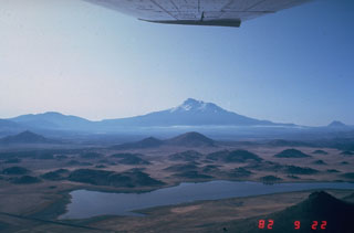 The hilly topography in the foreground is part of the massive debris avalanche deposit produced by collapse of Mount Shasta (center horizon). The roughly 46 km3, rapidly-moving debris avalanche swept some 50 km N. The hummocky area represents relatively intact segments of the volcano that were carried within a more fluidized, mixed bulk of the avalanche. Individual hummocks range up to a few hundred meters in height and roughly 1 km in length.
 Hotlum cone forms the current Shasta summit and was constructed during the early Holocene.
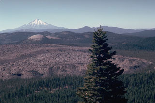 The Little Glass Mountain obsidian flow is seen from Little Mount Hoffman on the western rim of Medicine Lake caldera with Mount Shasta in the background. The flow was erupted on the SW flank of Medicine Lake volcano a little more than 950 years ago. The light-colored rounded peak in line with Mount Shasta is Pumice Stone Mountain, which is overlain by pumice from the Little Glass Mountain eruption. A series of smaller flows to the NE known as the Crater Glass Flows were erupted at about the same time.
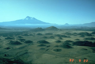 The hilly topography in the foreground is part of the massive debris avalanche deposit produced by collapse of Mount Shasta (in the background) during the Pleistocene. These hummocks represent relatively intact blocks of the volcano that were carried within a more mobile landslide matrix (smaller blocks and grains, snow and ice, and anything entrained during transportation). The debris avalanche covered an area of about 675 km2, reaching at least 45 km NNE.
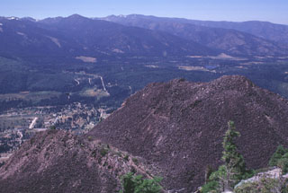 Four overlapping dacite domes form the Black Buttes lava dome on the lower western flank of Mount Shasta. This view looks NW from the summit of Black Buttes, at the tops of two of the domes with the outskirts of the town of Weed below. Pyroclastic flows accompanying formation of Black Buttes extend 10 km S and 5 km N, and underlie currently populated areas.
 The forested hills and rolling pasture lands near the town of Montague are part of a massive debris avalanche deposit that originated from Mount Shasta during the Pleistocene. The hills consist of remnants of the former edifice of Mount Shasta that were transported relatively intact to this point, about 40 km NW of the volcano. The origin of the hills remained enigmatic until volcanologists noticed the resemblance to the avalanche deposit produced at Mount St. Helens in 1980.
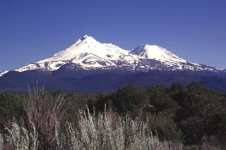 Massive Mount Shasta, the largest-volume volcano of the Cascade Range in northern California. It is seen here from the north, with Hotlum cone forming the summit and Shastina on the western flank. It is composed of at least four main edifices, of which the last two, Hotlum and Shastina, are of Holocene age.
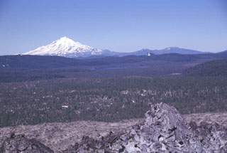 The broad partially forested lava flow extending across the center of the photo into Medicine Lake caldera is the Hoffman lava flow, which erupted about 1,170 years ago. The massive rhyolite lava flow and an adjacent smaller one were erupted from vents on the NE rim of the caldera. The larger of the two flows, seen here with the unvegetated Glass Mountain flow in the foreground, was erupted near the caldera rim and flowed both west into the caldera and down the east flank. Snow-capped Mount Shasta rises to the west.
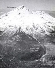 An aerial view shows the Military Pass lava flow on NE side of Mount Shasta, the longest known lava flow from the volcano, erupted about 9,200 years ago. It originated near the summit of the Hotlum cone and reached about 9 km, with a thickness of about 150 m thick near its terminus. The flow overlies the Red Banks pumice and a broad fan of pyroclastic flow deposits that were formed around 9,700 years ago.
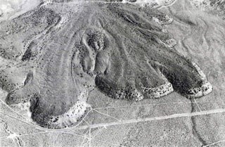 The Lava Park lava flow erupted about 9,300 years ago from a vent on the flank of Shastina, on the NW flank of Mount Shasta. The basaltic andesite flow is about 6 km long and 110 m thick at the terminus. It overlies a wide apron of pyroclastic flow deposits emplaced about 9,700 years ago. The area shown is about 2 km wide and Highway 97 is seen near the bottom.
The following 16 samples associated with this volcano can be found in the Smithsonian's NMNH Department of Mineral Sciences collections, and may be availble for research (contact the Rock and Ore Collections Manager). Catalog number links will open a window with more information.
| Catalog Number | Sample Description | Lava Source | Collection Date |
|---|---|---|---|
| NMNH 111123-1441 | Hypersthene Andesite | -- | -- |
| NMNH 111123-84 | Hornblende Andesite | -- | -- |
| NMNH 111123-84 | Hornblende Andesite | -- | -- |
| NMNH 111123-87 | Hypersthene Andesite | -- | -- |
| NMNH 111123-87 | Hypersthene Andesite | -- | -- |
| NMNH 112598 | Andesite | -- | -- |
| NMNH 116140-1 | Andesite | -- | -- |
| NMNH 2008 | Andesite | -- | -- |
| NMNH 2010 | Hornblende Andesite | -- | -- |
| NMNH 2014 | Pumice | -- | -- |
| NMNH 36977 | Hornblende Andesite | -- | -- |
| NMNH 36978 | Hypersthene Andesite | -- | -- |
| NMNH 36979 | Hornblende Andesite | -- | -- |
| NMNH 38362 | Hornblende Andesite | -- | -- |
| NMNH 38363 | Hornblende Andesite | -- | -- |
| NMNH 77152 | Hornblende Andesite | -- | -- |
| Copernicus Browser | The Copernicus Browser replaced the Sentinel Hub Playground browser in 2023, to provide access to Earth observation archives from the Copernicus Data Space Ecosystem, the main distribution platform for data from the EU Copernicus missions. |
| MIROVA | Middle InfraRed Observation of Volcanic Activity (MIROVA) is a near real time volcanic hot-spot detection system based on the analysis of MODIS (Moderate Resolution Imaging Spectroradiometer) data. In particular, MIROVA uses the Middle InfraRed Radiation (MIR), measured over target volcanoes, in order to detect, locate and measure the heat radiation sourced from volcanic activity. |
| MODVOLC Thermal Alerts | Using infrared satellite Moderate Resolution Imaging Spectroradiometer (MODIS) data, scientists at the Hawai'i Institute of Geophysics and Planetology, University of Hawai'i, developed an automated system called MODVOLC to map thermal hot-spots in near real time. For each MODIS image, the algorithm automatically scans each 1 km pixel within it to check for high-temperature hot-spots. When one is found the date, time, location, and intensity are recorded. MODIS looks at every square km of the Earth every 48 hours, once during the day and once during the night, and the presence of two MODIS sensors in space allows at least four hot-spot observations every two days. Each day updated global maps are compiled to display the locations of all hot spots detected in the previous 24 hours. There is a drop-down list with volcano names which allow users to 'zoom-in' and examine the distribution of hot-spots at a variety of spatial scales. |
|
WOVOdat
Single Volcano View Temporal Evolution of Unrest Side by Side Volcanoes |
WOVOdat is a database of volcanic unrest; instrumentally and visually recorded changes in seismicity, ground deformation, gas emission, and other parameters from their normal baselines. It is sponsored by the World Organization of Volcano Observatories (WOVO) and presently hosted at the Earth Observatory of Singapore.
GVMID Data on Volcano Monitoring Infrastructure The Global Volcano Monitoring Infrastructure Database GVMID, is aimed at documenting and improving capabilities of volcano monitoring from the ground and space. GVMID should provide a snapshot and baseline view of the techniques and instrumentation that are in place at various volcanoes, which can be use by volcano observatories as reference to setup new monitoring system or improving networks at a specific volcano. These data will allow identification of what monitoring gaps exist, which can be then targeted by remote sensing infrastructure and future instrument deployments. |
| Volcanic Hazard Maps | The IAVCEI Commission on Volcanic Hazards and Risk has a Volcanic Hazard Maps database designed to serve as a resource for hazard mappers (or other interested parties) to explore how common issues in hazard map development have been addressed at different volcanoes, in different countries, for different hazards, and for different intended audiences. In addition to the comprehensive, searchable Volcanic Hazard Maps Database, this website contains information about diversity of volcanic hazard maps, illustrated using examples from the database. This site is for educational purposes related to volcanic hazard maps. Hazard maps found on this website should not be used for emergency purposes. For the most recent, official hazard map for a particular volcano, please seek out the proper institutional authorities on the matter. |
| IRIS seismic stations/networks | Incorporated Research Institutions for Seismology (IRIS) Data Services map showing the location of seismic stations from all available networks (permanent or temporary) within a radius of 0.18° (about 20 km at mid-latitudes) from the given location of Shasta. Users can customize a variety of filters and options in the left panel. Note that if there are no stations are known the map will default to show the entire world with a "No data matched request" error notice. |
| UNAVCO GPS/GNSS stations | Geodetic Data Services map from UNAVCO showing the location of GPS/GNSS stations from all available networks (permanent or temporary) within a radius of 20 km from the given location of Shasta. Users can customize the data search based on station or network names, location, and time window. Requires Adobe Flash Player. |
| DECADE Data | The DECADE portal, still in the developmental stage, serves as an example of the proposed interoperability between The Smithsonian Institution's Global Volcanism Program, the Mapping Gas Emissions (MaGa) Database, and the EarthChem Geochemical Portal. The Deep Earth Carbon Degassing (DECADE) initiative seeks to use new and established technologies to determine accurate global fluxes of volcanic CO2 to the atmosphere, but installing CO2 monitoring networks on 20 of the world's 150 most actively degassing volcanoes. The group uses related laboratory-based studies (direct gas sampling and analysis, melt inclusions) to provide new data for direct degassing of deep earth carbon to the atmosphere. |
| Large Eruptions of Shasta | Information about large Quaternary eruptions (VEI >= 4) is cataloged in the Large Magnitude Explosive Volcanic Eruptions (LaMEVE) database of the Volcano Global Risk Identification and Analysis Project (VOGRIPA). |
| EarthChem | EarthChem develops and maintains databases, software, and services that support the preservation, discovery, access and analysis of geochemical data, and facilitate their integration with the broad array of other available earth science parameters. EarthChem is operated by a joint team of disciplinary scientists, data scientists, data managers and information technology developers who are part of the NSF-funded data facility Integrated Earth Data Applications (IEDA). IEDA is a collaborative effort of EarthChem and the Marine Geoscience Data System (MGDS). |

