According to the Universidad de El Salvador a hydrothermal explosion occurred at Agua Shuca, a fumarolic field and lake (roughly 30 x 60 m) in the SW part of the Ahuachapán Geothermal Field in the Apaneca Range, on 10 July. Video of the event showed steam-and-gas plumes expanding from the lake area, ejections of boiling sediment and water, and waves of muddy water flowing over the surrounding land; a few people were seen running from the area, with one person taking shelter behind a wall. A team from the Universidad de El Salvador traveled to the area the next day to assess the event and the impacts, to take measurements, and to provide information to the nearby residents. The explosion created a crater about 70 m in diameter and 20 m deep. Photos indicated that mud and water were ejected mainly to the SE, covering an extending beyond a road, but deposits were seen around the margins of the lake in most directions. Gas emissions were low, suggesting that activity had returned to baseline levels; Agua Shuca does not have a monitoring network.
Sources: Universidad de El Salvador, El Universitario (Universidad de El Salvador), hoycomsv, Canal 12
October explosion deaths rise to 26; new crater described
The 13 October blast of steam and mud roared continuously (like a geyser) for 10-20 minutes, decreasing in intensity following the initial explosion (reported by a survivor to be around 20 seconds long). No seismic signals were recorded before or during the event by seismometers 4 and 30 km away. A portable seismometer, operated for a few days following the blast, also recorded no signals.
The 30-m-diameter, 15-m-deep crater produced by the blast was partially filled by a continuously boiling muddy lake during a 27 October visit. A sulfurous "rotten egg" smell was noted. Prior to the blast, the site was an area of steaming ground, with two small hot springs (1-2 m across) and 1 mudpot (1 m across) much smaller than the present crater.
The blast was laterally oblique to the N and its effects abruptly ended at a maximum of 130 m. Damage included downed trees and limbs, collapsed walls of buildings, and missing roofs. The massive, non-sorted deposits were clay-rich and composed of light-colored highly altered rock fragments. Deposits were thickest to the N where they ranged from 1 m on the crater rim to 30 cm at 20 m from the rim. The death toll increased to 26 after 13 people died in hospitals.
Information Contacts: C. Dan Miller, USGS.
2025: July
According to the Universidad de El Salvador a hydrothermal explosion occurred at Agua Shuca, a fumarolic field and lake (roughly 30 x 60 m) in the SW part of the Ahuachapán Geothermal Field in the Apaneca Range, on 10 July. Video of the event showed steam-and-gas plumes expanding from the lake area, ejections of boiling sediment and water, and waves of muddy water flowing over the surrounding land; a few people were seen running from the area, with one person taking shelter behind a wall. A team from the Universidad de El Salvador traveled to the area the next day to assess the event and the impacts, to take measurements, and to provide information to the nearby residents. The explosion created a crater about 70 m in diameter and 20 m deep. Photos indicated that mud and water were ejected mainly to the SE, covering an extending beyond a road, but deposits were seen around the margins of the lake in most directions. Gas emissions were low, suggesting that activity had returned to baseline levels; Agua Shuca does not have a monitoring network.
Sources: Universidad de El Salvador; El Universitario (Universidad de El Salvador); hoycomsv; Canal 12
Reports are organized chronologically and indexed below by Month/Year (Publication Volume:Number), and include a one-line summary. Click on the index link or scroll down to read the reports.
Phreatic blast at hot springs; 14 people dead
At approximately 0130 on 13 October a small phreatic blast occurred in the village of El Barro, in the SW portion of the Ahuachapán Geothermal Field. Agua Shuca (an area 2-3 m in diameter of fumaroles, mud pots, and altered ground at 13.90°N, 89.82°W) erupted violently, producing a "blast of wind, stones, and boiling water" that destroyed several small dwellings and affected an area with a 100-m radius. Fourteen people were reported killed and 21 injured [but see 15:11]. The explosion was reportedly directed and lasted about 20 seconds according to survivors. By 15 October, a quiet pond (below the boiling point), 10 m in diameter [but see 15:11], had formed in the explosion crater and the surrounding area was covered with mud.
The Ahuachapán geothermal field has been an extensively developed source of energy for more than 15 years. It is located in a highly fractured zone at the N base of Laguna Verde, an eroded stratovolcano with Pleistocene and possibly Holocene activity (figure 1). Agua Shuca is situated on a fault, 2 km S of the Ahuachapán power plant (figure 2), and is outside of the geothermal field drawdown area. A well drilled 100 m N of Agua Shuca in 1971 (AH-9), was not developed due to the low permeability of the rocks at the site. A large landslide in 1981, 1/2 km NE of Agua Shuca and along the same fault, occurred shortly after a test of the reservoir at the maximum rate of power extraction, stopped because of a dramatic pressure decline.
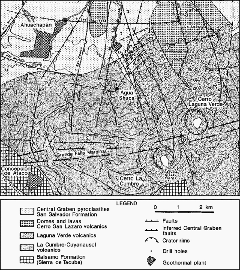 |
Figure 1. Portion of a geologic/structural map of Ahuachapán Geothermal Field and vicinity, prepared by the Comisión Executiva Hidroeléctrica del Río Lempa. Courtesy of Dina López. |
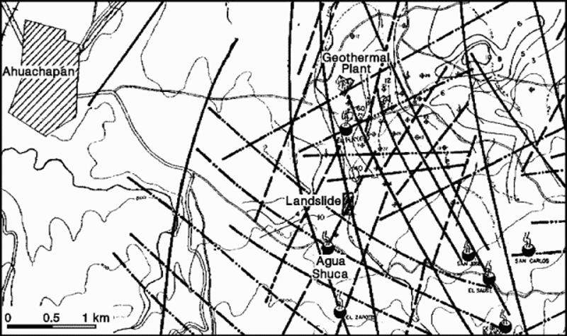 |
Figure 2. Detailed structural map of the Ahuachapán Geothermal Field, prepared by the Comisión Executiva Hidroeléctrica del Río Lempa. Heavy lines mark faults, large "steaming" circles indicate hot springs, and small circles with crosses show individual geothermal wells. Courtesy of Dina López. |
Information Contacts: Rodolfo Caceres, División Geotermía, Comisión Executiva Hidroeléctrica del Río Lempa, Santa Tecla, La Libertad, El Salvador; Marshall Reed, US Dept of Energy; Marcelo Lippmann, Lawrence Berkeley Laboratory, Univ of California; Grant Heiken, Los Alamos National Laboratory; Dina López, Louisiana State Univ.
October explosion deaths rise to 26; new crater described
The 13 October blast of steam and mud roared continuously (like a geyser) for 10-20 minutes, decreasing in intensity following the initial explosion (reported by a survivor to be around 20 seconds long). No seismic signals were recorded before or during the event by seismometers 4 and 30 km away. A portable seismometer, operated for a few days following the blast, also recorded no signals.
The 30-m-diameter, 15-m-deep crater produced by the blast was partially filled by a continuously boiling muddy lake during a 27 October visit. A sulfurous "rotten egg" smell was noted. Prior to the blast, the site was an area of steaming ground, with two small hot springs (1-2 m across) and 1 mudpot (1 m across) much smaller than the present crater.
The blast was laterally oblique to the N and its effects abruptly ended at a maximum of 130 m. Damage included downed trees and limbs, collapsed walls of buildings, and missing roofs. The massive, non-sorted deposits were clay-rich and composed of light-colored highly altered rock fragments. Deposits were thickest to the N where they ranged from 1 m on the crater rim to 30 cm at 20 m from the rim. The death toll increased to 26 after 13 people died in hospitals.
Information Contacts: C. Dan Miller, USGS.
|
|
||||||||||||||||||||||||||
The Global Volcanism Program is not aware of any Holocene eruptions from Apaneca Range. If this volcano has had large eruptions (VEI >= 4) prior to 12,000 years ago, information might be found on the Apaneca Range page in the LaMEVE (Large Magnitude Explosive Volcanic Eruptions) database, a part of the Volcano Global Risk Identification and Analysis Project (VOGRIPA).
This compilation of synonyms and subsidiary features may not be comprehensive. Features are organized into four major categories: Cones, Craters, Domes, and Thermal Features. Synonyms of features appear indented below the primary name. In some cases additional feature type, elevation, or location details are provided.
Synonyms |
||||
| Cuyanausul | Ahuachapán | ||||
Cones |
||||
| Feature Name | Feature Type | Elevation | Latitude | Longitude |
| Aguila, Cerro el | Stratovolcano | 2028 m | 13° 53' 34.00" N | 89° 42' 2.00" W |
| Apaneca, Cerro de
Chichicastepec |
Stratovolcano | 1827 m | 13° 50' 19.00" N | 89° 48' 16.00" W |
| Cachio, Cerro | Stratovolcano | 1827 m | 13° 54' 4.00" N | 89° 44' 32.00" W |
| Cerrito, El | Pyroclastic cone | 1615 m | 13° 51' 20.00" N | 89° 47' 48.00" W |
| Cumbre del Triunfo, Cerro | Pyroclastic cone | 1716 m | 13° 52' 15.00" N | 89° 48' 45.00" W |
| Cuyanausul, Cerro | Stratovolcano | 1843 m | 13° 54' 0.00" N | 89° 44' 56.00" W |
| Cuyotepe
Savana, Volcán de la |
Cone | 1517 m | 13° 50' 54.00" N | 89° 46' 26.00" W |
| Laguna Ranas, Cerro de la | Stratovolcano | 1956 m | 13° 54' 2.00" N | 89° 43' 36.00" W |
| Laguna Verde, Cerro | Stratovolcano | 1819 m | 13° 53' 25.00" N | 89° 46' 54.00" W |
| Naranjos, Cerro los
Pilón, El |
Stratovolcano | 1973 m | 13° 52' 22.00" N | 89° 41' 15.00" W |
| Ninfas, Cerro las | Stratovolcano | 1745 m | 13° 52' 50.00" N | 89° 47' 46.00" W |
| Ojo de Agua de la Virgen, Cerro el
Cerro Peña Blanca Cerro Piedra Sellada |
Stratovolcano | 1945 m | 13° 54' 11.00" N | 89° 41' 28.00" W |
| Ranas, Cerro las | Stratovolcano | 1957 m | 13° 54' 2.00" N | 89° 43' 2.00" W |
Craters |
||||
| Feature Name | Feature Type | Elevation | Latitude | Longitude |
| Concepción de Ataco | Pleistocene caldera | 1200 m | 13° 53' 0.00" N | 89° 50' 24.00" W |
| Hoyo de Cuajuste | Crater | 1492 m | 13° 53' 10.00" N | 89° 47' 33.00" W |
| Ninfas, Laguna las
Lagunita, La |
Crater | 1643 m | 13° 52' 38.00" N | 89° 47' 58.00" W |
Domes |
||||
| Feature Name | Feature Type | Elevation | Latitude | Longitude |
| Himalaya, Cerro | Dome | |||
| San Lázaro, Cerro | Dome | |||
Thermal |
||||
| Feature Name | Feature Type | Elevation | Latitude | Longitude |
| Agua Shuca | Thermal | |||
| Amaya, Ausoles de | Thermal | |||
| Chipilapa | Thermal | |||
| Cuyanausul, Ausoles de | Thermal | |||
| Labor, Ausoles de la | Thermal | |||
| Playón de Ahuachapán
Akhuachapán |
Thermal | |||
| San Carlos | Thermal | |||
| San José | Thermal | |||
| Sauce, El | Thermal | |||
| Termópilas, Las | Thermal | |||
 The Ahuachapán geothermal area on the NW flank of Laguna Verde has been used for power generation since 1975. It is one of the most recent manifestations of activity in a group of Pleistocene and Holocene volcanoes comprising the Cuyanausul Range. The Cerro El Aguila and Cerro Los Naranjos volcanoes at the eastern end are Holocene in age. A 1990 steam explosion from the Ahuachapán thermal area resulted in fatalities.
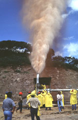 A plume rises from well CH-D during its opening in 1996. The Ahuachapán geothermal field was the first major field to be developed in El Salvador and has been operating since 1975. The geothermal field is located mostly in permeable, highly fractured Pliocene-Pleistocene volcanic rocks of the San Salvador formation that are capped by a series of young pyroclastic rocks and lava flows. A younger system of NW-trending faults localizes hydrothermal features within a series of step faults dropping to the north at the margin of the Central Salvadoran Graben.
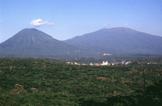 Two volcanoes rise above the town of Juayua in western El Salvador. The peak to the left is Cerro los Naranjos, one of the youngest peaks of the Apaneca Range volcanic complex. The broader peak to the right is Santa Ana. Santa Ana has produced recent eruptions from both summit and flank vents.
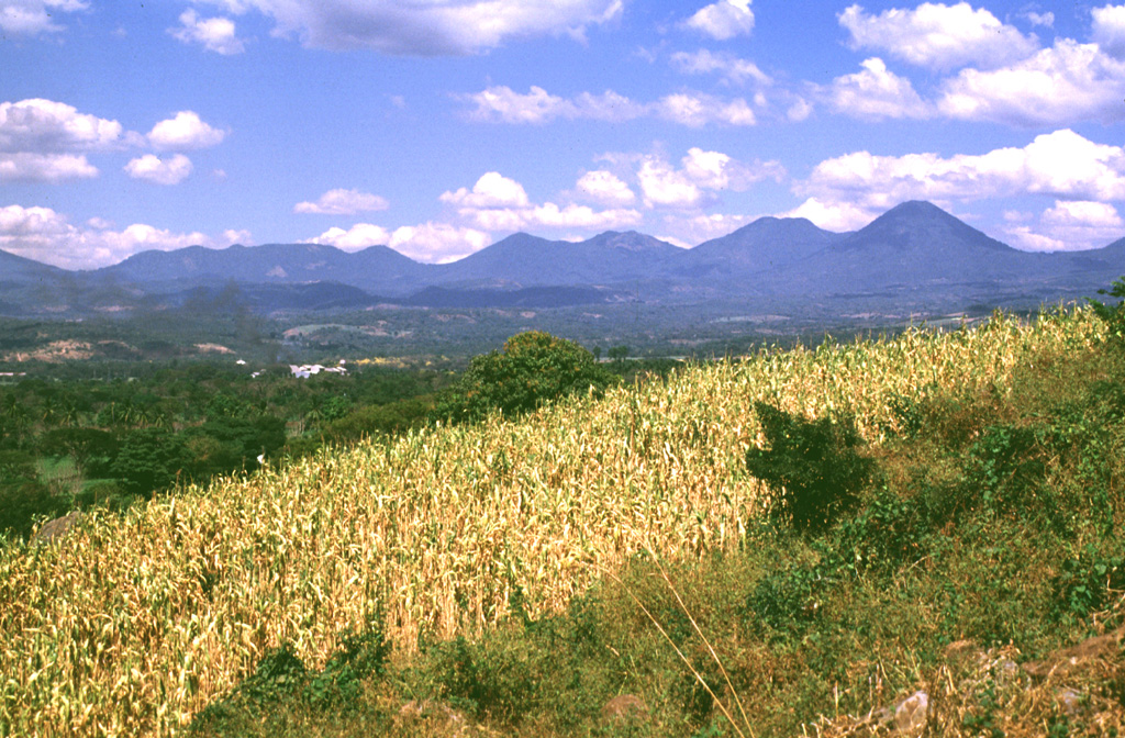
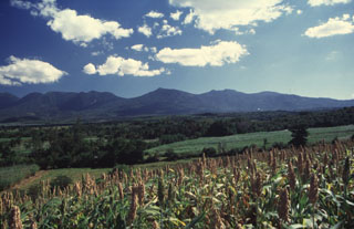 The northern side of the broad Apaneca Range is seen here from El Rodeo. From left to right are Cerro Cuyanausul, Laguna Verde (the center peak), Las Ninfas, and the Cerro La Cumbre complex. The E-W-trending chain of overlapping Pleistocene and Holocene volcanoes of the Apaneca Range forms a major topographic barrier in western El Salvador.
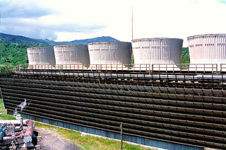 The cooling towers of the Ahuachapán-3 power plant are part of a geothermal field that has been producing for more than a quarter century. The liquid-dominated geothermal reservoir has a base temperature of about 240 degrees centigrade. It is located on the northern flank of the Apaneca (Cuyanausul) Range along the southern margin of the Salvadoran central graben. Consequently it is lower to the north and NW, where it has been affected by graben subsidence.
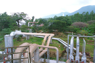 Steam lines going to the power plant snake across the surface of the Ahuachapán-Chipilapa geothermal field in western El Salvador. The field is located on the northern flank of the Sierra de Apaneca range 15 km from the Guatemala border. The Ahuachapán-Chipilapa field was the first to be developed in El Salvador and began production in 1975.
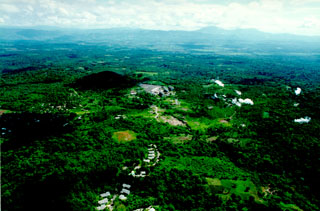 This aerial view shows the Ahuachapán-3 geothermal power plant. The Ahuachapán-Chipilapa geothermal field has an installed capacity of 95 MW and a potential of 95-150 MW. It covers an area of 200 km2 in the counties of Santa Ana, Ahuachapán, and Sonsonate. The field was the first developed in El Salvador, and the first plants came on line in 1975. During the 1980s the field was over-exploited and generated more than 40% of the country's electricity. After the reservoir pressure dropped rapidly, generation was stabilized at 48 MW.
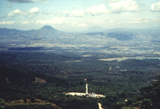 This view from the Apaneca Range shows the CH-A well and drill rig of the Ahuachapán geothermal field in the foreground. The peak on the left horizon across the lowlands of El Salvador's interior valley is Volcán Chingo, along the El Salvador/Guatemala border. The flatter peak to the far right is Volcán Suchitán in Guatemala.
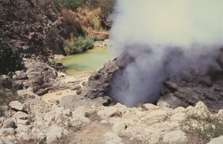 Ausoles de la Labor fumaroles and hot pools form one of the largest geothermal areas in the Ahuachapán geothermal field. The area is located near the SW base of the Cerro San Lazaro lava dome, about 5 km N of Laguna Verde volcano. The Ahuachapán geothermal field contains fumaroles, mud volcanoes, or hot springs, throughout a roughly 80 km2 area on the northern flank of the Apaneca Range.
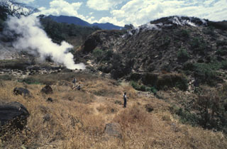 Ausoles de la Labor geothermal field on the flank of Laguna Verde volcano is within the Ahuachapán geothermal field. The fumaroles typically attain temperatures of about 100°C. In addition to those at La Labor, fumaroles are also located at El Playón, Agua Shuca, El Sauce, and higher up at Laguna Verde and Ausoles de Cuyanausul, and numerous hot springs are found in the Ahuachapán geothermal area.
  Laguna Verde is a 500-m-wide lake that partially fills the 1-km-wide summit crater of Cerro Laguna Verde in the Apaneca Range. Laguna Verde is a Pleistocene-age edifice within the Concepción de Ataco caldera. Flank craters on Laguna Verde volcano are among the youngest volcanic centers of the Apaneca Range.
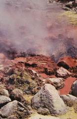 Bubbling mudpools at Ausoles de la Labor fumaroles on the northern flank of Laguna Verde volcano eject reddish oxidized mud onto the surrounding area. This is one of several prominent geothermal areas in the Apaneca Range. Hot springs are also found north of the Apaneca Range, particularly along the Agua Caliente and Escalante rivers.
 The Laguna Las Ninfas-Laguna Verde volcanic complex is seen here from the NW with steam plumes of the Ahuachapán geothermal field in the midground. The 5-km-wide Concepción de Ataco caldera formed during the late Pleistocene following the eruption of about 70 km3 of pyroclastic flows and airfall tephra. Flat-topped Laguna Verde at the center of the photo and Las Ninfas at the right are post-caldera cones. Cerro Cuyanausul (left) was constructed prior to caldera formation and lies to the east of the caldera.
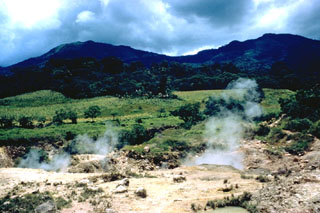
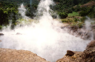 Steam rises above a hot pool at Agua Shuca, one of many thermal areas of the Ahuachapán geothermal field. A sudden hydrothermal explosion at Agua Shuca in October 1990 ejected steam and debris within a 200-m-radius, and 26 people living adjacent to the thermal area were killed. The Agua Shuca thermal area ESE of Laguna Verde volcano had historically been one of the most frequently visited areas at Ahuachapán. A previous explosion apparently took place in 1868.
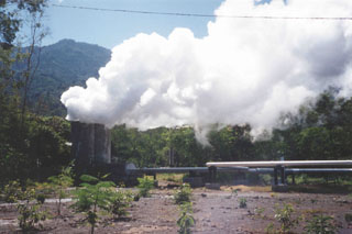 Steam plumes rise from the AH-16 production well at the Ahuachapán geothermal field. The Ahuachapán field, producing since 1975, is a high-temperature initially water-dominated system located on the flank of Laguna Verde volcano about 2 km NW of the summit.
 The Apaneca Range is seen here from the SE. This elongated group of Pleistocene and Holocene edifices lies in western El Salvador, between the Santa Ana complex and the Guatemala border. The 5-km-wide Pleistocene Concepción de Ataco caldera lies beyond the flat ridge to the left; to its right are Cerro Cachio, Cerro de las Rana, Cerro el Aguila, and conical Cerro los Naranjos. The Apaneca Range is the site of the major geothermal field of Ahuachapán.
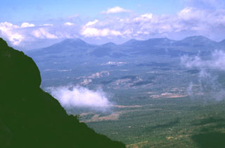 The summit of Izalco provides a view of the adjacent Apaneca Range volcanic complex to the west. The flat-topped edifice to the far-left is Cerro de Apaneca. The city of Juayua can be seen in the center of the photo. Above it is the small El Cerrito peak, and to its right is Cerro la Cumbre and the Cerro las Ninfas-Laguna Verde complex.
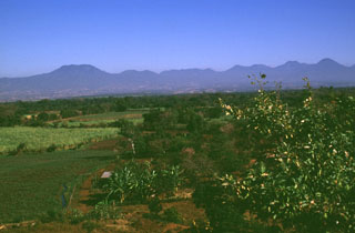 The broad E-W-trending Apaneca Range is seen here from the south with flat-topped Cerro de Apaneca on the left. The Laguna Las Ninfas -Laguna Verde complex is in the center, and to its right are Cerro Cuyanausul, Cerro los Ranas, Cerro el Aguila, and Cerro los Naranjos. The Concepción de Ataco caldera lies beyond the center horizon, behind post-caldera cones. The photo is taken from the top of a hummock on the surface of the massive Acajutla debris avalanche deposit that originated from Santa Ana volcano, which is out of view to the right.
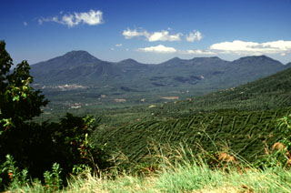 Cerro de Apaneca is to the left above the city of Juayua. To its right is Cerro la Cumbre and the Cerro las Ninfas-Laguna Verde complex. Construction of the latter post-dated major Pleistocene explosive eruptions that resulted in formation of the Pleistocene Concepción de Ataco caldera.
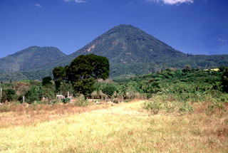 Cerro los Naranjos volcano is at the SE end of the Sierra de Apaneca. Cerro el Aguila ("Eagle Peak") lies on the left horizon to the NW of Los Naranjos.
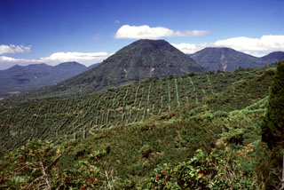 The escarpment across the middle of the photo with vertical rows of coffee plantation trees across the scarp in is the NW wall of a large caldera formed by edifice collapse of Santa Ana volcano during the late Pleistocene. About 5 km of the scarp is exposed; the remainder is buried beneath ejecta and lava flows from modern Santa Ana volcano. Cerro los Naranjos volcano rises beyond the scarp, and other peaks of the Apaneca range form the horizon on either side.
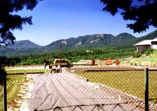 Coffee beans dry in the sun at a finca near the town of San José la Majada in the SE part of the Apaneca range. Coffee is the primary crop in this portion of El Salvador; fertile volcanic soil and abundant rainfall provide excellent habitat for coffee trees across the flanks of the volcanoes of the Apaneca range and Santa Ana massif. The Cerro las Ninfas-Laguna Verde complex forms the ridge on the horizon.
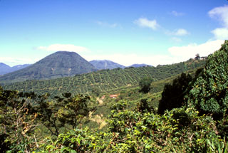 The escarpment cutting diagonally downward across the middle of the photo in front of conical Cerro los Naranjos volcano is the NW wall of a large late-Pleistocene caldera formed by edifice collapse of Santa Ana volcano. The exposed portion of the collapse scarp is up to about 200 m high along a roughly 5 km segment of the arcuate avalanche caldera. Pyroclastic ejecta and lava flows from modern Santa Ana volcano have filled in much of the scarp in the foreground and have buried it completely on the northern and eastern sides.
 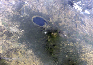 Lake-filled Coatepeque caldera is prominent in this International Space Station image with north to the lower left. A post-caldera lava dome forms an island at the SW side of the lake. The nested summit craters of Santa Ana volcano are visible below and to the right of Coatepeque, and the unvegetated cone of Izalco volcano is to the right of Santa Ana. Small stratovolcanoes of the Sierra de Apaneca form the forested ridge at the bottom right. The light-colored area at the left-center is the city of Santa Ana, the second largest in El Salvador.
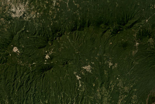 The E-W trending Apaneca Range is across the middle of this November 2019 Planet Labs satellite image monthly mosaic (N is at the top; this image is approximately 25 km across). The range includes the roughly E-W ridge along the upper half of this image, and the two cones below it – the linear Cerro de Apaneca and Cuyotepe just E of it. The crater on the western end of the ridge is Laguna las Ninfas, and the small lake NE is Cerro Laguna Verde. West of those is the Concepción de Ataco caldera.
There are no samples for Apaneca Range in the Smithsonian's NMNH Department of Mineral Sciences Rock and Ore collection.
| Copernicus Browser | The Copernicus Browser replaced the Sentinel Hub Playground browser in 2023, to provide access to Earth observation archives from the Copernicus Data Space Ecosystem, the main distribution platform for data from the EU Copernicus missions. |
| MIROVA | Middle InfraRed Observation of Volcanic Activity (MIROVA) is a near real time volcanic hot-spot detection system based on the analysis of MODIS (Moderate Resolution Imaging Spectroradiometer) data. In particular, MIROVA uses the Middle InfraRed Radiation (MIR), measured over target volcanoes, in order to detect, locate and measure the heat radiation sourced from volcanic activity. |
| MODVOLC Thermal Alerts | Using infrared satellite Moderate Resolution Imaging Spectroradiometer (MODIS) data, scientists at the Hawai'i Institute of Geophysics and Planetology, University of Hawai'i, developed an automated system called MODVOLC to map thermal hot-spots in near real time. For each MODIS image, the algorithm automatically scans each 1 km pixel within it to check for high-temperature hot-spots. When one is found the date, time, location, and intensity are recorded. MODIS looks at every square km of the Earth every 48 hours, once during the day and once during the night, and the presence of two MODIS sensors in space allows at least four hot-spot observations every two days. Each day updated global maps are compiled to display the locations of all hot spots detected in the previous 24 hours. There is a drop-down list with volcano names which allow users to 'zoom-in' and examine the distribution of hot-spots at a variety of spatial scales. |
|
WOVOdat
Single Volcano View Temporal Evolution of Unrest Side by Side Volcanoes |
WOVOdat is a database of volcanic unrest; instrumentally and visually recorded changes in seismicity, ground deformation, gas emission, and other parameters from their normal baselines. It is sponsored by the World Organization of Volcano Observatories (WOVO) and presently hosted at the Earth Observatory of Singapore.
GVMID Data on Volcano Monitoring Infrastructure The Global Volcano Monitoring Infrastructure Database GVMID, is aimed at documenting and improving capabilities of volcano monitoring from the ground and space. GVMID should provide a snapshot and baseline view of the techniques and instrumentation that are in place at various volcanoes, which can be use by volcano observatories as reference to setup new monitoring system or improving networks at a specific volcano. These data will allow identification of what monitoring gaps exist, which can be then targeted by remote sensing infrastructure and future instrument deployments. |
| Volcanic Hazard Maps | The IAVCEI Commission on Volcanic Hazards and Risk has a Volcanic Hazard Maps database designed to serve as a resource for hazard mappers (or other interested parties) to explore how common issues in hazard map development have been addressed at different volcanoes, in different countries, for different hazards, and for different intended audiences. In addition to the comprehensive, searchable Volcanic Hazard Maps Database, this website contains information about diversity of volcanic hazard maps, illustrated using examples from the database. This site is for educational purposes related to volcanic hazard maps. Hazard maps found on this website should not be used for emergency purposes. For the most recent, official hazard map for a particular volcano, please seek out the proper institutional authorities on the matter. |
| IRIS seismic stations/networks | Incorporated Research Institutions for Seismology (IRIS) Data Services map showing the location of seismic stations from all available networks (permanent or temporary) within a radius of 0.18° (about 20 km at mid-latitudes) from the given location of Apaneca Range. Users can customize a variety of filters and options in the left panel. Note that if there are no stations are known the map will default to show the entire world with a "No data matched request" error notice. |
| UNAVCO GPS/GNSS stations | Geodetic Data Services map from UNAVCO showing the location of GPS/GNSS stations from all available networks (permanent or temporary) within a radius of 20 km from the given location of Apaneca Range. Users can customize the data search based on station or network names, location, and time window. Requires Adobe Flash Player. |
| DECADE Data | The DECADE portal, still in the developmental stage, serves as an example of the proposed interoperability between The Smithsonian Institution's Global Volcanism Program, the Mapping Gas Emissions (MaGa) Database, and the EarthChem Geochemical Portal. The Deep Earth Carbon Degassing (DECADE) initiative seeks to use new and established technologies to determine accurate global fluxes of volcanic CO2 to the atmosphere, but installing CO2 monitoring networks on 20 of the world's 150 most actively degassing volcanoes. The group uses related laboratory-based studies (direct gas sampling and analysis, melt inclusions) to provide new data for direct degassing of deep earth carbon to the atmosphere. |
| Large Eruptions of Apaneca Range | Information about large Quaternary eruptions (VEI >= 4) is cataloged in the Large Magnitude Explosive Volcanic Eruptions (LaMEVE) database of the Volcano Global Risk Identification and Analysis Project (VOGRIPA). |
| EarthChem | EarthChem develops and maintains databases, software, and services that support the preservation, discovery, access and analysis of geochemical data, and facilitate their integration with the broad array of other available earth science parameters. EarthChem is operated by a joint team of disciplinary scientists, data scientists, data managers and information technology developers who are part of the NSF-funded data facility Integrated Earth Data Applications (IEDA). IEDA is a collaborative effort of EarthChem and the Marine Geoscience Data System (MGDS). |

