Seismicity apparently triggered by M 7.5 earthquake hundreds of kilometers away
Southern California's largest earthquake since 1952, M 7.5 on 28 June, appeared to trigger seismicity at several volcanic centers in California. It was centered roughly 200 km E of Los Angeles. In the following, David Hill describes post-earthquake activity at Long Valley caldera, and Stephen Walter discusses the USGS's seismic network, and the changes it detected at Lassen, Shasta, Medicine Lake, and the Geysers.
In recent years, the USGS northern California seismic network has relied upon Real-Time Processors (RTPs) to detect, record, and locate earthquakes. However, a film recorder (develocorder) collects data from 18 stations in volcanic areas, primarily to detect long-period earthquakes missed by RTPs. The film recorders proved useful in counting the post-M 7.5 earthquakes, most of which were too small to trigger the RTPs.
The film record was scanned for the 24 hours after the M 7.5 earthquake, noting the average coda duration for each identified event. Some events may have been missed because of seismogram saturation by the M 7.5 earthquake. Marked increases in microseismicity were observed at Lassen Peak, Medicine Lake caldera, and the Geysers (table 1). No earthquakes were observed at Shasta, but the lack of operating stations on the volcano limited the capability to observe small events.
Table 1. Number of earthquakes at northern California volcanic centers during 24-hour periods following major earthquakes on 25 April (40.37°N, 124.32°W; M 7.0) and 28 June (34.18°N, 116.47°W; M 7.5) 1992. Events with coda durations less than or equal to 10 seconds and greater than 10 seconds are tallied separately. Earthquakes were identified from film records of seismograms from nearby stations. Courtesy of Stephen Walter.
| Date | Lassen | Shasta | Medicine Lake | Geysers | ||||
| Codas (seconds) | <= 10 | > 10 | <= 10 | > 10 | <= 10 | > 10 | <= 10 | > 10 |
| 25 Apr 1992 | 0 | 0 | 0 | 1 | 0 | 0 | 7 | 2 |
| 28 Jun 1992 | 8 | 14 | 1 | 5 | 12 | 0 | 46 | 4 |
Film was also scanned for the 24 hours following the M 7.0 earthquake at 40.37°N, 124.32°W (near Cape Mendocino) on 25 April. Although smaller than the 28 June earthquake, its epicenter was only 20-25% as far from the volcanoes. Furthermore, both the 25 April main shock and a M 6.5 aftershock were felt at the volcanic centers, but no felt reports were received from these areas after the 28 June earthquake. Only the Geysers showed any possible triggered events after the 25 April shock. However, background seismicity at the Geysers is higher than at the other centers, and is influenced by fluid injection and withdrawal associated with intensive geothermal development.
Medicine Lake Report. Twelve events were detected in the Medicine Lake area (~900 km NNW of the epicenter) in the 30 minutes after the M 7.5 earthquake. All had coda durations less than or equal to 10 seconds. The lack of any S-P separation indicated that they were centered very close to the single seismic station, near the center of the caldera. All known historical seismicity had occurred in the central caldera as part of a mainshock/aftershock sequence during the fall and winter of 1988-89.
Information Contacts: S. Walter and D. Hill, USGS Menlo Park.
The Global Volcanism Program has no Weekly Reports available for Medicine Lake.
Reports are organized chronologically and indexed below by Month/Year (Publication Volume:Number), and include a one-line summary. Click on the index link or scroll down to read the reports.
Earthquake swarm but no inflation
The quoted material is a report from Steve Walter. "On 29 September, 47 earthquakes were detected at Medicine Lake volcano, a large shield (50 km E of Mt. Shasta) that has experienced only 1 earthquake in the past eight years. The largest event (M 3.1) was located in the SW region of the caldera at a depth of 3.3 km (figure 1). Activity increased on 30 September when a total of 146 earthquakes were registered, 66 during a l-hour period. Four of these events (largest M 4.1) were located near the 29 September earthquake. After 30 September, seismicity declined to ~10 events/day until 4 October when there were 33 events, including a M 3.1 earthquake. Activity again declined with sporadic events (up to 5/day, M less than 2.0) continuing through 16 October. Most of the seismicity was recorded on the nearest instrument at Little Mt. Hoffman, ~4 km W of the epicentral zone. The next nearest stations are over 30 km from Medicine Lake in the Mt. Shasta network. On 3 October, a station was removed from the Mt. Shasta net and established at Medicine Mountain, ~1 km S of the epicentral zone on the S rim of the caldera. Although seismicity has declined, the USGS has selected six sites around the caldera for installation of one 3-component, low-gain, and six 1-component seismometers, scheduled for late October."
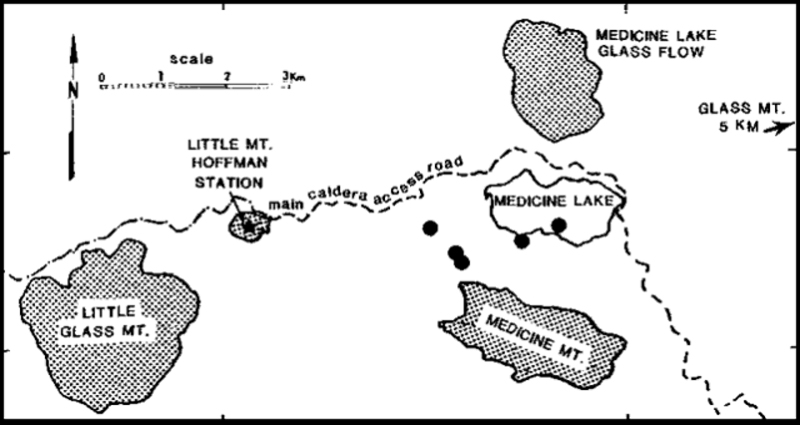 |
Figure 1. Map showing geologic features, earthquake locations (M 3.1), and the road where the levelling survey was conducted. Filled circles are late September-early October events reported in BGVN 13:09. Open circles are post-29 October events. The M 2.0 event is ESE of Medicine Lake Glass Flow. Triangles represent three of the six new sites installed 22 October. LMD is a 3-component site.Epicenter locations courtesy of Steve Walter. |
A levelling line, measured along the main caldera access road (figure 1) by Dan Dzurisin in August 1988, indicated at least 18 cm of deflation relative to a 1954 survey. Re-measurements of the same line in early October showed little or no additional deformation. Dzurisin and Phil Dawson attributed recent ground cracks, outside of the epicentral area and circumferential to Little Medicine Lake, as slumping possibly caused by the seismicity. No cracks were observed within the epicentral area, but recent tree falls were evident. Pre-existing weak fumarolic activity had not changed, although not all fumarolic areas were visited.
Information Contacts: S. Walter, USGS Menlo Park; D. Dzurisin, CVO.
Occasional seismicity; caldera subsides
"Seismicity... continued sporadically throughout October. As of 15 November, seismicity had declined to several locatable events/week. Most were of M less than 1 with the exception of a M 2 event on 29 October. The installation of a tightly spaced seismic network on 22 October permits even small events to be located. Three well-constrained earthquakes have been located since 29 October in the E, central, and S portions of Medicine Lake glass flow in the NW part of the caldera (figure 1). Depths of recent events are shallow, between 0.5 and 1.5 km. The locations of the recent events show a northward shift from those of the late September swarm. Seismologists are uncertain whether this shift is real or the result of improved locations from the new network."
A levelling line (~16 benchmarks spaced 1.5-2.25 km apart along the main caldera access road through the W, center, and SE portions of the caldera) was reoccupied on three occasions. Relative to a 1954 National Geodetic Survey, August 1988 measurements showed 175 ± 11 mm of central caldera subsidence with respect to the W and S rims, although subsidence extended outside the caldera. An October 1988 survey indicated 8 ± 5 mm of additional subsidence which is within 2-3 standard errors of noise levels. However, the shapes of the long- and short-term deformation curves are similar, with maximum subsidence occurring at the central caldera benchmark, suggesting to geologists that the deformation is real. The line will be relevelled in the spring when snow conditions permit.
Information Contacts: S. Walter, USGS Menlo Park; D. Dzurisin, CVO.
Small seismic swarm
Small events recorded late November-early December were attributed to freezing phenomena as winter came to N California. On 13 December at 2035, an M 1.9 earthquake, ~0.25 km SW of Medicine Lake glass flow, was recorded. During the next 75 minutes, nine events (M less than 1.9) were detected, followed by seven events on 14 December from 0121 to 0129. Seismicity was shallow (below 1 km) and had a high-frequency character. The 3-component station (LMD) is not currently operating.
Information Contacts: S. Walter, USGS Menlo Park.
Seismicity apparently triggered by M 7.5 earthquake hundreds of kilometers away
Southern California's largest earthquake since 1952, M 7.5 on 28 June, appeared to trigger seismicity at several volcanic centers in California. It was centered roughly 200 km E of Los Angeles. In the following, David Hill describes post-earthquake activity at Long Valley caldera, and Stephen Walter discusses the USGS's seismic network, and the changes it detected at Lassen, Shasta, Medicine Lake, and the Geysers.
In recent years, the USGS northern California seismic network has relied upon Real-Time Processors (RTPs) to detect, record, and locate earthquakes. However, a film recorder (develocorder) collects data from 18 stations in volcanic areas, primarily to detect long-period earthquakes missed by RTPs. The film recorders proved useful in counting the post-M 7.5 earthquakes, most of which were too small to trigger the RTPs.
The film record was scanned for the 24 hours after the M 7.5 earthquake, noting the average coda duration for each identified event. Some events may have been missed because of seismogram saturation by the M 7.5 earthquake. Marked increases in microseismicity were observed at Lassen Peak, Medicine Lake caldera, and the Geysers (table 1). No earthquakes were observed at Shasta, but the lack of operating stations on the volcano limited the capability to observe small events.
Table 1. Number of earthquakes at northern California volcanic centers during 24-hour periods following major earthquakes on 25 April (40.37°N, 124.32°W; M 7.0) and 28 June (34.18°N, 116.47°W; M 7.5) 1992. Events with coda durations less than or equal to 10 seconds and greater than 10 seconds are tallied separately. Earthquakes were identified from film records of seismograms from nearby stations. Courtesy of Stephen Walter.
| Date | Lassen | Shasta | Medicine Lake | Geysers | ||||
| Codas (seconds) | <= 10 | > 10 | <= 10 | > 10 | <= 10 | > 10 | <= 10 | > 10 |
| 25 Apr 1992 | 0 | 0 | 0 | 1 | 0 | 0 | 7 | 2 |
| 28 Jun 1992 | 8 | 14 | 1 | 5 | 12 | 0 | 46 | 4 |
Film was also scanned for the 24 hours following the M 7.0 earthquake at 40.37°N, 124.32°W (near Cape Mendocino) on 25 April. Although smaller than the 28 June earthquake, its epicenter was only 20-25% as far from the volcanoes. Furthermore, both the 25 April main shock and a M 6.5 aftershock were felt at the volcanic centers, but no felt reports were received from these areas after the 28 June earthquake. Only the Geysers showed any possible triggered events after the 25 April shock. However, background seismicity at the Geysers is higher than at the other centers, and is influenced by fluid injection and withdrawal associated with intensive geothermal development.
Medicine Lake Report. Twelve events were detected in the Medicine Lake area (~900 km NNW of the epicenter) in the 30 minutes after the M 7.5 earthquake. All had coda durations less than or equal to 10 seconds. The lack of any S-P separation indicated that they were centered very close to the single seismic station, near the center of the caldera. All known historical seismicity had occurred in the central caldera as part of a mainshock/aftershock sequence during the fall and winter of 1988-89.
Information Contacts: S. Walter and D. Hill, USGS Menlo Park.
|
|
||||||||||||||||||||||||||||
There is data available for 9 confirmed eruptive periods.
[ 1910 Jan ] Uncertain Eruption
| Episode 1 | Eruption (Explosive / Effusive) | East flank (Glass Mountain ?) | ||||||||||||||||||||||||||||
|---|---|---|---|---|---|---|---|---|---|---|---|---|---|---|---|---|---|---|---|---|---|---|---|---|---|---|---|---|---|
| 1910 Jan - Unknown | Evidence from Unknown | ||||||||||||||||||||||||||||
|
List of 4 Events for Episode 1 at East flank (Glass Mountain ?)
|
|||||||||||||||||||||||||||||
1060 (?) Confirmed Eruption (Explosive / Effusive) VEI: 3 (?)
| Episode 1 | Eruption (Explosive / Effusive) | Upper east flank (Glass Mountain) | ||||||||||||||||||||||||||||||||||||||
|---|---|---|---|---|---|---|---|---|---|---|---|---|---|---|---|---|---|---|---|---|---|---|---|---|---|---|---|---|---|---|---|---|---|---|---|---|---|---|---|
| 1060 (?) - Unknown | Evidence from Isotopic: 14C (calibrated) | ||||||||||||||||||||||||||||||||||||||
|
List of 6 Events for Episode 1 at Upper east flank (Glass Mountain)
|
|||||||||||||||||||||||||||||||||||||||
1010 (?) Confirmed Eruption (Explosive / Effusive) VEI: 3
| Episode 1 | Eruption (Explosive / Effusive) | SW flank (Little Glass Mountain) | ||||||||||||||||||||||||||||||||||||||||||||||||
|---|---|---|---|---|---|---|---|---|---|---|---|---|---|---|---|---|---|---|---|---|---|---|---|---|---|---|---|---|---|---|---|---|---|---|---|---|---|---|---|---|---|---|---|---|---|---|---|---|---|
| 1010 (?) - Unknown | Evidence from Isotopic: 14C (calibrated) | ||||||||||||||||||||||||||||||||||||||||||||||||
|
List of 8 Events for Episode 1 at SW flank (Little Glass Mountain)
|
|||||||||||||||||||||||||||||||||||||||||||||||||
0840 (?) Confirmed Eruption (Explosive / Effusive)
| Episode 1 | Eruption (Explosive / Effusive) | SW flank (Paint Pot Crater) | |||||||||||||||||||||||
|---|---|---|---|---|---|---|---|---|---|---|---|---|---|---|---|---|---|---|---|---|---|---|---|---|
| 0840 (?) - Unknown | Evidence from Isotopic: 14C (calibrated) | |||||||||||||||||||||||
|
List of 3 Events for Episode 1 at SW flank (Paint Pot Crater)
|
||||||||||||||||||||||||
0830 (?) Confirmed Eruption (Explosive / Effusive)
| Episode 1 | Eruption (Explosive / Effusive) | North flank, Callahan lava flow | |||||||||||||||||||||||
|---|---|---|---|---|---|---|---|---|---|---|---|---|---|---|---|---|---|---|---|---|---|---|---|---|
| 0830 (?) - Unknown | Evidence from Isotopic: 14C (calibrated) | |||||||||||||||||||||||
|
List of 3 Events for Episode 1 at North flank, Callahan lava flow
|
||||||||||||||||||||||||
0780 (?) Confirmed Eruption (Explosive / Effusive)
| Episode 1 | Eruption (Explosive / Effusive) | NE caldera rim (Mt. Hoffman area) | |||||||||||||||||||||||
|---|---|---|---|---|---|---|---|---|---|---|---|---|---|---|---|---|---|---|---|---|---|---|---|---|
| 0780 (?) - Unknown | Evidence from Isotopic: 14C (calibrated) | |||||||||||||||||||||||
|
List of 3 Events for Episode 1 at NE caldera rim (Mt. Hoffman area)
|
||||||||||||||||||||||||
1000 BCE (?) Confirmed Eruption (Explosive / Effusive)
| Episode 1 | Eruption (Explosive / Effusive) | SE flank, Burnt Lava flow | ||||||||||||||||||||||||||||
|---|---|---|---|---|---|---|---|---|---|---|---|---|---|---|---|---|---|---|---|---|---|---|---|---|---|---|---|---|---|
| 1000 BCE (?) - Unknown | Evidence from Isotopic: 14C (calibrated) | ||||||||||||||||||||||||||||
|
List of 4 Events for Episode 1 at SE flank, Burnt Lava flow
|
|||||||||||||||||||||||||||||
1130 BCE (?) Confirmed Eruption (Explosive / Effusive) VEI: 0
| Episode 1 | Eruption (Explosive / Effusive) | Lower north flank (Black Crater) | ||||||||||||||||||
|---|---|---|---|---|---|---|---|---|---|---|---|---|---|---|---|---|---|---|---|
| 1130 BCE (?) - Unknown | Evidence from Isotopic: 14C (calibrated) | ||||||||||||||||||
|
List of 2 Events for Episode 1 at Lower north flank (Black Crater)
|
|||||||||||||||||||
3090 BCE Confirmed Eruption (Explosive / Effusive)
| Episode 1 | Eruption (Explosive / Effusive) | SE caldera rim | |||||||||||||||||||||||
|---|---|---|---|---|---|---|---|---|---|---|---|---|---|---|---|---|---|---|---|---|---|---|---|---|
| 3090 BCE - Unknown | Evidence from Isotopic: 14C (calibrated) | |||||||||||||||||||||||
|
List of 3 Events for Episode 1 at SE caldera rim
|
||||||||||||||||||||||||
3190 BCE (?) Confirmed Eruption (Explosive / Effusive) VEI: 0
| Episode 1 | Eruption (Explosive / Effusive) | NW caldera floor (Medicine Lake Glass flow) | |||||||||||||||||||||||
|---|---|---|---|---|---|---|---|---|---|---|---|---|---|---|---|---|---|---|---|---|---|---|---|---|
| 3190 BCE (?) - Unknown | Evidence from Isotopic: 14C (calibrated) | |||||||||||||||||||||||
|
List of 3 Events for Episode 1 at NW caldera floor (Medicine Lake Glass flow)
|
||||||||||||||||||||||||
This compilation of synonyms and subsidiary features may not be comprehensive. Features are organized into four major categories: Cones, Craters, Domes, and Thermal Features. Synonyms of features appear indented below the primary name. In some cases additional feature type, elevation, or location details are provided.
Synonyms |
||||
| Modoc-Medicine Lake Field | Medicine Lake Highland | ||||
Cones |
||||
| Feature Name | Feature Type | Elevation | Latitude | Longitude |
| Badger Peak | Cone | 2241 m | 41° 36' 0.00" N | 121° 38' 0.00" W |
| Bearpaw Butte | Cone | 1628 m | 41° 43' 0.00" N | 121° 33' 0.00" W |
| Big Sand Butte | Cone | 41° 42' 0.00" N | 121° 25' 0.00" W | |
| Black Mountain | Cone | 2135 m | 41° 32' 0.00" N | 121° 29' 0.00" W |
| Bonita Butte | Cone | 1526 m | 41° 44' 0.00" N | 121° 40' 0.00" W |
| Border Mountain | Cone | 1912 m | 41° 30' 0.00" N | 121° 28' 0.00" W |
| Buck Butte | Cone | 41° 28' 0.00" N | 121° 28' 0.00" W | |
| Caldwell Butte | Cone | 1582 m | 41° 42' 0.00" N | 121° 29' 0.00" W |
| Cinder Butte | Cone | 1885 m | 41° 41' 0.00" N | 121° 36' 0.00" W |
| Cinder Cone | Pyroclastic cone | 1927 m | 41° 32' 0.00" N | 121° 39' 0.00" W |
| Cougar Butte | Cone | 41° 39' 0.00" N | 121° 28' 0.00" W | |
| Crescent Butte | Cone | 1524 m | 41° 43' 0.00" N | 121° 31' 0.00" W |
| Doe Peak | Cone | 1875 m | 41° 30' 0.00" N | 121° 45' 0.00" W |
| East Sand Butte | Cone | 41° 41' 0.00" N | 121° 23' 0.00" W | |
| Fourmile Hill | Cone | 2153 m | 41° 39' 0.00" N | 121° 37' 0.00" W |
| Hardin Butte | Cone | 1347 m | 41° 46' 0.00" N | 121° 32' 0.00" W |
| Hippo Butte | Cone | 1674 m | 41° 43' 0.00" N | 121° 32' 0.00" W |
| Indian Butte | Cone | 2078 m | 41° 38' 0.00" N | 121° 30' 0.00" W |
| Little Mount Hoffman | Cone | 2235 m | 41° 35' 0.00" N | 121° 39' 0.00" W |
| Little Sand Butte | Cone | 41° 40' 0.00" N | 121° 25' 0.00" W | |
| Lookout Butte | Cone | 1969 m | 41° 39' 0.00" N | 121° 37' 0.00" W |
| Lyons Peak | Cone | 2409 m | 41° 35' 0.00" N | 121° 30' 0.00" W |
| Papoose Hill | Cone | 1792 m | 41° 30' 0.00" N | 121° 39' 0.00" W |
| Powder Hill | Cone | 1744 m | 41° 29' 0.00" N | 121° 38' 0.00" W |
| Pumice Stone Mountain | Cone | 2126 m | 41° 34' 0.00" N | 121° 43' 0.00" W |
| Red Cap Mountain | Cone | 2146 m | 41° 33' 0.00" N | 121° 45' 0.00" W |
| Red Hill | Cone | 1978 m | 41° 33' 0.00" N | 121° 39' 0.00" W |
| Red Shale Butte | Cone | 2377 m | 41° 35' 0.00" N | 121° 32' 0.00" W |
| Schonchin Butte | Pyroclastic cone | 1601 m | 41° 44' 0.00" N | 121° 32' 0.00" W |
| Shotgun Peak | Cone | 2025 m | 41° 32' 0.00" N | 121° 33' 0.00" W |
| Six Shooter Butte | Cone | 1945 m | 41° 31' 0.00" N | 121° 37' 0.00" W |
| Snag Hill | Cone | 1727 m | 41° 28' 0.00" N | 121° 39' 0.00" W |
| Three Sisters | Cone | 1614 m | 41° 43' 0.00" N | 121° 44' 0.00" W |
| Whitney Butte | Cone | 1525 m | 41° 44' 0.00" N | 121° 35' 0.00" W |
Craters |
||||
| Feature Name | Feature Type | Elevation | Latitude | Longitude |
| Burnt Lava Flow | Crater - Cone | 41° 31' 0.00" N | 121° 32' 0.00" W | |
| Deep Crater | Crater - Cone | 41° 27' 0.00" N | 121° 33' 0.00" W | |
| Double Hole Crater | Crater | |||
| Giant Crater | Crater | 1743 m | 41° 30' 0.00" N | 121° 38' 0.00" W |
| High Hole Crater | Crater - Cone | 1885 m | 41° 31' 0.00" N | 121° 32' 0.00" W |
| Mammoth Crater | Crater | 1615 m | 41° 42' 0.00" N | 121° 33' 0.00" W |
| Paint Pot Crater | Crater | 1926 m | 41° 33' 0.00" N | 121° 42' 0.00" W |
| Semi Crater | Crater | 1420 m | 41° 45' 0.00" N | 121° 32' 0.00" W |
Domes |
||||
| Feature Name | Feature Type | Elevation | Latitude | Longitude |
| Glass Mountain
Big Glass Mountain |
Dome | 2331 m | 41° 36' 0.00" N | 121° 30' 0.00" W |
| Hoffman, Mount | Dome | 2412 m | 41° 37' 0.00" N | 121° 33' 0.00" W |
| Little Glass Mountain
Stone Mountain |
Dome | 2089 m | 41° 34' 0.00" N | 121° 41' 0.00" W |
 The Little Glass Mountain obsidian flow is seen from Little Mount Hoffman on the western rim of Medicine Lake caldera with Mount Shasta in the background. The flow was erupted on the SW flank of Medicine Lake volcano a little more than 950 years ago. The light-colored rounded peak in line with Mount Shasta is Pumice Stone Mountain, which is overlain by pumice from the Little Glass Mountain eruption. A series of smaller flows to the NE known as the Crater Glass Flows were erupted at about the same time.
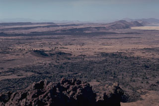 The summit of Schonchin Butte in Lava Beds National Monument provides a view of step-like Basin-and-Range faulting to the NW. The dark lava flow at the base of the closest scarp is the late-Pleistocene Devils Homestead lava flow. Parallel to, and just in front, of that are 3,000-year-old lava flows from fissures at Black Crater and Ross Chimneys.
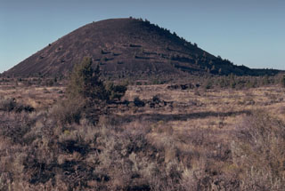 Schonchin Butte, a late-Pleistocene scoria cone on the north flank of Medicine Lake volcano, is one of the prominent landmarks of Lava Beds National Monument. A large number of lava tubes in the area fed late-Pleistocene and Holocene lava flows.
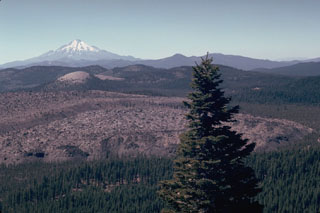
 The massive Medicine Lake volcano in NE California, seen here from the NE, encompasses a 50 x 80 km wide area. Holocene eruptions included obsidian flows from summit and flank vents, and voluminous basaltic lava flows from vents on the north and south flanks. Recent eruptions took place about 900 years ago. The summit area includes a 7 x 11 km caldera.
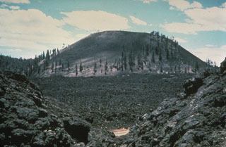 Medicine Lake Volcano's summit caldera is seen here from the east rim, with Mount Shasta in the background. The 7 x 12 km caldera, the source of Medicine Lakes largest eruption, (~180 ka) is partially filled by Medicine Lake, Medicine Lake Glass Flow (on the right) that erupted ~5,200 years ago, and the older Lake Basalt flow (~89 ka; in the foreground). During the Holocene several obsidian flows have erupted inside and along the rim of the caldera with large pumice deposits, and voluminous basalts have erupted on the flanks.
 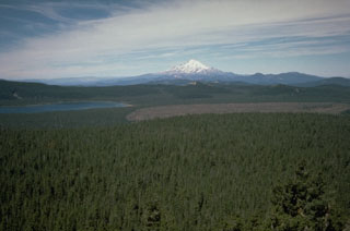 Medicine Lake volcano is seen here looking over the summit crater from the east with Mount Shasta in the background. The barren Medicine Glass Flow on the right was erupted about 5,200 years ago. During the Holocene, obsidian flows were erupted from summit and flank vents, and voluminous basaltic lava flows originated from vents on the north and south flanks.
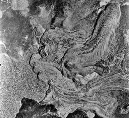 This aerial photo shows the lobate morphology of the Glass Mountain obsidian flow, which erupted around 950 years ago from a series of vents near the buried east rim of Medicine Lake caldera. The eruption originated from a series of NW-SE-trending vents, seen here diagonally across the photo from the upper left. Three dacite flows to the east are overlain by rhyolite flows towards the west. The flow at lower left is the dacitic Hoffman flow, erupted only a few hundred years prior to the Glass Mountain flow.
 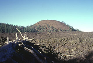 The andesitic Burnt Lava flow covering about 37 km2 of the SE flank of Medicine Lake volcano was erupted from the High Hole Crater cinder cone. The Burnt Lava flow was the largest from Medicine Lake during the Holocene and had a volume of 0.45 cu km. The symmetrical High Hole Crater contains a double summit crater. The Burnt Lava flow, which was erupted from both High Hole Crater and adjacent fissures, surrounded two older cinder cones, one of which forms the forested ridge at the left.
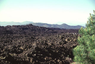 The most voluminous Holocene lava flow on the southern flank of Medicine Lake volcano is known as the Burnt Lava flow. The flow, which originated from High Hole Crater and nearby fissure vents, covers 37 km2. The flow is dominantly aa lava, but also includes some pahoehoe. This photo shows the NW margin of the flow, which was erupted about 2750 years ago.
 The broad 50-km-wide Medicine Lake volcano in the southern Cascade Range, seen here from the NE, is an example of a shield volcano in a continental margin setting. Its chemistry is more diverse than Hawaiian shield volcanoes and it has produced both basaltic lava flows, rhyolitic tephra, and obsidian flows during the Holocene. Eruptions have occurred during the past 6,000 years from vents within a 7 x 11 km summit caldera and from other vents on its flanks.
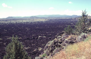 Despite its youthful appearance, the Devils Homestead lava flow in the foreground is slightly more than 10,000 years old. Erosional modification of lava flow surfaces proceeds slowly in arid regions. The Devils Homestead flow is one of the largest on the north flank of Medicine Lake volcano, the broad shield volcano on the horizon. Flank cinder cones dot the slopes of the chemically diverse shield volcano, which has produced both the basaltic cinder cones and lava flows seen here, and dacitic and rhyolitic pumice and lava flows.
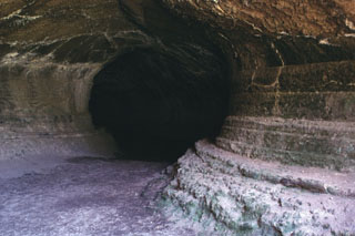 Lava Beds National Monument contains nearly 300 lava-tube caves associated with fluid basaltic lava flows on the flanks of Medicine Lake volcano in northern California. The sides of this large lava tube, known as Valentine Cave, show the pronounced "bathtub rings" left by lava flowing through the tube. Valentine Cave is an example of a lava tube from which lava almost completely drained. The Valentine lava flow was erupted about 10,850 radiocarbon years ago, and is one of the largest flows on the northern flank of Medicine Lake caldera.
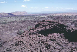 Minor amounts of basaltic lava were erupted about 3000 years ago from spatter cones at Black Crater and Ross Chimneys on the lower northern flank of Medicine Lake volcano. The spatter cone in the foreground was the vent for the sparsely vegetated small overlapping pahoehoe lava flows in the middle part of the photo. The dark lava flow in the distance in front of a fault block of older lavas, is the late-Pleistocene Devils Homestead lava flow.
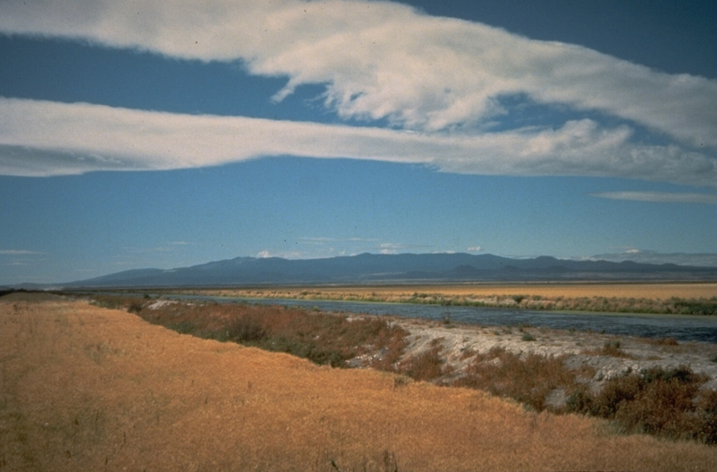
 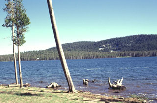 Medicine Lake, a popular camping and recreation destination in northern California, is a small 2-km-long lake that occupies the SW side of Medicine Lake caldera. The forested southern rim of the 7 x 11 km caldera forms the horizon. Medicine Lake volcano is known for its young obsidian flows within the caldera and on its flanks.
 Cinder Butte (upper left) on the north side of massive Medicine Lake volcano was the source of a voluminous lava flow that is the most recent on the volcano's north flank. The cone is seen here from the east from the rim of Mammoth Crater in Lava Beds National Monument. Cinder Butte was formed during an eruption about 800 CE that also produced the sparsely vegetated Callahan lava flow, which can be seen extending down the north flank to the right.
 The basaltic Callahan lava flow, erupted from the Cinder Butte cone, is the largest Holocene lava flow on the north flank of Medicine Lake volcano. The broad Callahan flow is seen here from the reddish oxidized rim of Cinder Butte diverging around an older cinder cone to the north. The flow was dated from radiometric and paleomagnetic evidence at about 800 CE. The Callahan flow is chemically zone, with initial lavas being andesitic and later lavas basaltic.
 The Glass Mountain obsidian flow, seen here from Lyons Peak on the east rim of Medicine Lake caldera, was erupted from a series of vents just outside the buried inferred eastern rim of the caldera. The youthful, steep-sided rhyolitic and dacitic flow is both the largest and youngest of a series of Holocene rhyolitic and dacitic flows at Medicine Lake. The 1 cu km flow was erupted about 900 years ago. The flow traveled a short distance west (left) into the caldera, but mostly flowed down the eastern flank, reaching a point about 6 km from its source.
 The Glass Mountain obsidian flow buries much of the eastern rim of Medicine Lake caldera. The massive 1 cu km flow traveled south towards Lyons Peak (upper right) before the bulk of the flow was diverted to the east and descended the caldera's outer flank. The latest event at Glass Mountain produced the craggy rhyolitic obsidian dome seen in the foreground. The roughly 900-year-old flow is the youngest and largest of a series of Holocene rhyolitic and dacitic lava flows at Medicine Lake.
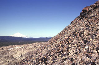 Blocks of glassy obsidian reflect sunlight from the surface of a rhyolitic lava dome marking the latest eruptive event during extrusion of the Glass Mountain lava flow. The composite flow originated from more than a dozen NW-SE-trending vents near the eastern rim of the Medicine Lake caldera. Part of the massive obsidian flow seen on the left side of the photo traveled west into the caldera. Snow-capped Mount Shasta towers above the forested caldera rim to the west.
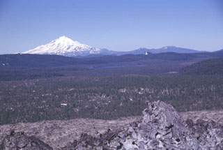 The broad partially forested lava flow extending across the center of the photo into Medicine Lake caldera is the Hoffman lava flow, which erupted about 1,170 years ago. The massive rhyolite lava flow and an adjacent smaller one were erupted from vents on the NE rim of the caldera. The larger of the two flows, seen here with the unvegetated Glass Mountain flow in the foreground, was erupted near the caldera rim and flowed both west into the caldera and down the east flank. Snow-capped Mount Shasta rises to the west.
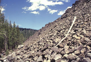 The western terminus of the Hoffman dacite lava flow forms a steep blocky slope up to about 50 m in height. The flows originated from six or more NW-SE-trending vents. The larger of the two flows (seen here) was erupted near the eastern caldera rim and flowed primarily west into the caldera, although a smaller portion traveled to the east.
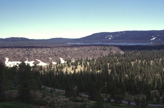 The Medicine Lake lava flow, seen here from the NW with Medicine Lake in the background, was erupted onto the caldera floor from a vent near the northern caldera rim. The flat-lying, viscous 0.08 km3 lava flow is not precisely dated, but is known from stratigraphic evidence to have been emplaced sometime between the roughly 780 BCE Burnt Lava flow and the roughly 720 CE Hoffman flow.
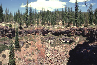 This crater on the SE rim of Medicine Lake caldera formed around 5,100 years ago. The eruption produced tephra and spatter with localized lava flows from a NE-trending alignment of pit craters.
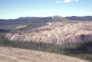 The Little Glass Mountain obsidian flow is seen here from Pumice Stone Mountain, named for the mantle of white pumice (foreground) from Little Glass Mountain. The 0.4 km3 obsidian flow was erupted from a currently buried vent below the Little Mt. Hoffman cone seen here behind the flow. The Little Glass Mountain pumice eruption and obsidian flow occurred about 950 years ago during one of the more recent eruptions from Medicine Lake.
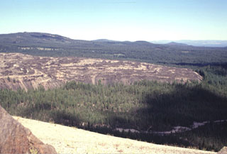 The steep-sided SW margin of the Little Glass Mountain obsidian flow rises above the surrounding forested flanks of Medicine Lake volcano. Eruption of the rhyolitic lava flow was preceded by a pumice eruption that mantled the surrounding area (including the basaltic cone of Pumice Stone Mountain in the foreground) with white pumice. The 0.4 km3 Little Glass Mountain lava flow is the second largest silicic lava flow at Medicine Lake.
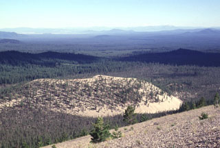 The back side of light-colored Paint Pot Crater and Pumice Stone Mountain, from where the photo was taken, are mantled by white pumice from the eruption that preceded the extrusion of the nearby Little Glass Mountain obsidian flow. The formation of Paint Pot Crater and the associated extrusion of the lava flow that forms the sparsely vegetated area south (right) of the cone occurred about 1100-1150 years ago, only shortly before the major Little Glass Mountain eruption.
 Paint Pot Crater on the lower SW flank of Medicine Lake volcano derives its name from the mantle of white pumice from nearby Little Glass Mountain that covers the reddish oxidized scoria of the cinder cone. Paint Pot Crater emitted a lava flow from its breached crater that traveled to the south, where it forms the sparsely vegetated area seen in the photo beyond the far rim of the cone. The crater and lava flow are among the youngest products of Medicine Lake volcano, and were erupted about 1100-1150 years ago.
  The broad Medicine Lake shield volcano, seen here on the horizon from Soldier Mountain to its south, is truncated by a 7 x 11 km caldera. Medicine Lake volcano has erupted lavas of widely varying composition ranging from basalt to rhyolite. The largest eruption of Medicine Lake during the past 11,000 years produced a massive basaltic lava flow from Giant Crater about 10,600 years ago. The flow traveled a distance of 45 km down the broad valley in the center of the photo from its vent on the SSW flank.
 The Medicine Lake volcanic center covers around 2,200 km2, with recent lava flows shown in this August 2019 Planet Labs satellite image monthly mosaic (N is at the top; this image is approximately 10 km across). These lava flows at Big Glass Mountain erupted along the eastern caldera rim and ten lava domes formed in a NW trend, with one lava dome to the south. The western lava flow in this view flowed into the caldera and the eastern flows traveled down the flank.
The following 48 samples associated with this volcano can be found in the Smithsonian's NMNH Department of Mineral Sciences collections, and may be availble for research (contact the Rock and Ore Collections Manager). Catalog number links will open a window with more information.
| Catalog Number | Sample Description | Lava Source | Collection Date |
|---|---|---|---|
| NMNH 110060-1 | Rhyolitic Obsidian | BIG GLASS MOUNTAIN | -- |
| NMNH 110060-2 | Rhyolitic Obsidian | BIG GLASS MOUNTAIN | -- |
| NMNH 110060-3 | Rhyolitic Obsidian | BIG GLASS MOUNTAIN | -- |
| NMNH 110060-4 | Obsidian | BIG GLASS MOUNTAIN | -- |
| NMNH 110060-5 | Obsidian | BIG GLASS MOUNTAIN | -- |
| NMNH 110060-6 | Rhyolitic Obsidian | BIG GLASS MOUNTAIN | -- |
| NMNH 110060-7 | Rhyolitic Obsidian | BIG GLASS MOUNTAIN | -- |
| NMNH 113026-1 | Basalt | -- | -- |
| NMNH 113026-10 | Basalt | -- | -- |
| NMNH 113026-11 | Basalt | -- | -- |
| NMNH 113026-12 | Basalt | -- | -- |
| NMNH 113026-13 | Basalt | -- | -- |
| NMNH 113026-14 | Basalt | -- | -- |
| NMNH 113026-15 | Basalt | -- | -- |
| NMNH 113026-16 | Basalt | -- | -- |
| NMNH 113026-17 | Basalt | -- | -- |
| NMNH 113026-18 | Basalt | -- | -- |
| NMNH 113026-19 | Basalt | -- | -- |
| NMNH 113026-2 | Basalt | -- | -- |
| NMNH 113026-20 | Basalt | -- | -- |
| NMNH 113026-21 | Basalt | -- | -- |
| NMNH 113026-22 | Basalt | -- | -- |
| NMNH 113026-23 | Basalt | -- | -- |
| NMNH 113026-24 | Basalt | -- | -- |
| NMNH 113026-25 | Basalt | -- | -- |
| NMNH 113026-26 | Basalt | -- | -- |
| NMNH 113026-27 | Basalt | -- | -- |
| NMNH 113026-28 | Basalt | -- | -- |
| NMNH 113026-29 | Basalt | -- | -- |
| NMNH 113026-3 | Basalt | -- | -- |
| NMNH 113026-30 | Basalt | -- | -- |
| NMNH 113026-31 | Basalt | -- | -- |
| NMNH 113026-4 | Basalt | -- | -- |
| NMNH 113026-5 | Basalt | -- | -- |
| NMNH 113026-6 | Basalt | -- | -- |
| NMNH 113026-7 | Basalt | -- | -- |
| NMNH 113026-8 | Basalt | -- | -- |
| NMNH 113026-9 | Basalt | -- | -- |
| NMNH 115401-2 | Obsidian | GLASS MT | -- |
| NMNH 115401-3 | Obsidian | GLASS MT | -- |
| NMNH 115401-4 | Obsidian | GLASS MT | -- |
| NMNH 115401-5 | Obsidian | GLASS MT | -- |
| NMNH 115401-6 | Obsidian | GLASS MT | -- |
| NMNH 116700-18 | Dacite | THREE SISTERS | -- |
| NMNH 117460-36 | Obsidian | Hoffman flow; Hoffman, Mt. | -- |
| NMNH 117460-37 | Obsidian | Hoffman flow; Hoffman, Mt. | -- |
| NMNH 117460-38 | Obsidian | Hoffman, Mt. | -- |
| NMNH 117460-39 | Obsidian | Hoffman, Mt. | -- |
| Copernicus Browser | The Copernicus Browser replaced the Sentinel Hub Playground browser in 2023, to provide access to Earth observation archives from the Copernicus Data Space Ecosystem, the main distribution platform for data from the EU Copernicus missions. |
| MIROVA | Middle InfraRed Observation of Volcanic Activity (MIROVA) is a near real time volcanic hot-spot detection system based on the analysis of MODIS (Moderate Resolution Imaging Spectroradiometer) data. In particular, MIROVA uses the Middle InfraRed Radiation (MIR), measured over target volcanoes, in order to detect, locate and measure the heat radiation sourced from volcanic activity. |
| MODVOLC Thermal Alerts | Using infrared satellite Moderate Resolution Imaging Spectroradiometer (MODIS) data, scientists at the Hawai'i Institute of Geophysics and Planetology, University of Hawai'i, developed an automated system called MODVOLC to map thermal hot-spots in near real time. For each MODIS image, the algorithm automatically scans each 1 km pixel within it to check for high-temperature hot-spots. When one is found the date, time, location, and intensity are recorded. MODIS looks at every square km of the Earth every 48 hours, once during the day and once during the night, and the presence of two MODIS sensors in space allows at least four hot-spot observations every two days. Each day updated global maps are compiled to display the locations of all hot spots detected in the previous 24 hours. There is a drop-down list with volcano names which allow users to 'zoom-in' and examine the distribution of hot-spots at a variety of spatial scales. |
|
WOVOdat
Single Volcano View Temporal Evolution of Unrest Side by Side Volcanoes |
WOVOdat is a database of volcanic unrest; instrumentally and visually recorded changes in seismicity, ground deformation, gas emission, and other parameters from their normal baselines. It is sponsored by the World Organization of Volcano Observatories (WOVO) and presently hosted at the Earth Observatory of Singapore.
GVMID Data on Volcano Monitoring Infrastructure The Global Volcano Monitoring Infrastructure Database GVMID, is aimed at documenting and improving capabilities of volcano monitoring from the ground and space. GVMID should provide a snapshot and baseline view of the techniques and instrumentation that are in place at various volcanoes, which can be use by volcano observatories as reference to setup new monitoring system or improving networks at a specific volcano. These data will allow identification of what monitoring gaps exist, which can be then targeted by remote sensing infrastructure and future instrument deployments. |
| Volcanic Hazard Maps | The IAVCEI Commission on Volcanic Hazards and Risk has a Volcanic Hazard Maps database designed to serve as a resource for hazard mappers (or other interested parties) to explore how common issues in hazard map development have been addressed at different volcanoes, in different countries, for different hazards, and for different intended audiences. In addition to the comprehensive, searchable Volcanic Hazard Maps Database, this website contains information about diversity of volcanic hazard maps, illustrated using examples from the database. This site is for educational purposes related to volcanic hazard maps. Hazard maps found on this website should not be used for emergency purposes. For the most recent, official hazard map for a particular volcano, please seek out the proper institutional authorities on the matter. |
| IRIS seismic stations/networks | Incorporated Research Institutions for Seismology (IRIS) Data Services map showing the location of seismic stations from all available networks (permanent or temporary) within a radius of 0.18° (about 20 km at mid-latitudes) from the given location of Medicine Lake. Users can customize a variety of filters and options in the left panel. Note that if there are no stations are known the map will default to show the entire world with a "No data matched request" error notice. |
| UNAVCO GPS/GNSS stations | Geodetic Data Services map from UNAVCO showing the location of GPS/GNSS stations from all available networks (permanent or temporary) within a radius of 20 km from the given location of Medicine Lake. Users can customize the data search based on station or network names, location, and time window. Requires Adobe Flash Player. |
| DECADE Data | The DECADE portal, still in the developmental stage, serves as an example of the proposed interoperability between The Smithsonian Institution's Global Volcanism Program, the Mapping Gas Emissions (MaGa) Database, and the EarthChem Geochemical Portal. The Deep Earth Carbon Degassing (DECADE) initiative seeks to use new and established technologies to determine accurate global fluxes of volcanic CO2 to the atmosphere, but installing CO2 monitoring networks on 20 of the world's 150 most actively degassing volcanoes. The group uses related laboratory-based studies (direct gas sampling and analysis, melt inclusions) to provide new data for direct degassing of deep earth carbon to the atmosphere. |
| Large Eruptions of Medicine Lake | Information about large Quaternary eruptions (VEI >= 4) is cataloged in the Large Magnitude Explosive Volcanic Eruptions (LaMEVE) database of the Volcano Global Risk Identification and Analysis Project (VOGRIPA). |
| EarthChem | EarthChem develops and maintains databases, software, and services that support the preservation, discovery, access and analysis of geochemical data, and facilitate their integration with the broad array of other available earth science parameters. EarthChem is operated by a joint team of disciplinary scientists, data scientists, data managers and information technology developers who are part of the NSF-funded data facility Integrated Earth Data Applications (IEDA). IEDA is a collaborative effort of EarthChem and the Marine Geoscience Data System (MGDS). |

