
The Global Volcanism Program has no activity reports available for Santorini.
The Global Volcanism Program has no Weekly Reports available for Santorini.
The Global Volcanism Program has no Bulletin Reports available for Santorini.
|
|
||||||||||||||||||||||||||||
There is data available for 11 confirmed Holocene eruptive periods.
1950 Jan 10 - 1950 Feb 2 Confirmed Eruption (Explosive / Effusive) VEI: 2
| Episode 1 | Eruption (Explosive / Effusive) | Nea Kameni (Liatsikas dome) | |||||||||||||||||||||||||||||||||||||||
|---|---|---|---|---|---|---|---|---|---|---|---|---|---|---|---|---|---|---|---|---|---|---|---|---|---|---|---|---|---|---|---|---|---|---|---|---|---|---|---|---|
| 1950 Jan 10 - 1950 Feb 2 | Evidence from Observations: Reported | |||||||||||||||||||||||||||||||||||||||
| Phreatic explosions began on the east flank of Georgios dome on 10 January 1950, followed by formation of the small Liatsikas lava dome and effusion of small lava flows. | ||||||||||||||||||||||||||||||||||||||||
|
List of 6 Events for Episode 1 at Nea Kameni (Liatsikas dome)
|
||||||||||||||||||||||||||||||||||||||||
1939 Aug 20 - 1941 Jul 2 ± 1 days Confirmed Eruption (Explosive / Effusive) VEI: 2
| Episode 1 | Eruption (Explosive / Effusive) | Nea Kameni (Triton, Ktenas, Fouque domes) | |||||||||||||||||||||||||||||||||||||||||||||||||||||||||||
|---|---|---|---|---|---|---|---|---|---|---|---|---|---|---|---|---|---|---|---|---|---|---|---|---|---|---|---|---|---|---|---|---|---|---|---|---|---|---|---|---|---|---|---|---|---|---|---|---|---|---|---|---|---|---|---|---|---|---|---|---|
| 1939 Aug 20 - 1941 Jul 2 ± 1 days | Evidence from Observations: Reported | |||||||||||||||||||||||||||||||||||||||||||||||||||||||||||
|
List of 10 Events for Episode 1 at Nea Kameni (Triton, Ktenas, Fouque domes)
|
||||||||||||||||||||||||||||||||||||||||||||||||||||||||||||
1928 Jan 23 - 1928 Mar 17 Confirmed Eruption (Explosive / Effusive) VEI: 2
| Episode 1 | Eruption (Explosive / Effusive) | Nea Kameni (Naftilos dome) | ||||||||||||||||||||||||||||||||||
|---|---|---|---|---|---|---|---|---|---|---|---|---|---|---|---|---|---|---|---|---|---|---|---|---|---|---|---|---|---|---|---|---|---|---|---|
| 1928 Jan 23 - 1928 Mar 17 | Evidence from Observations: Reported | ||||||||||||||||||||||||||||||||||
|
List of 5 Events for Episode 1 at Nea Kameni (Naftilos dome)
|
|||||||||||||||||||||||||||||||||||
1925 Aug 11 - 1926 May Confirmed Eruption (Explosive / Effusive) VEI: 2
| Episode 1 | Eruption (Explosive / Effusive) | Nea Kameni (Dafni dome) | |||||||||||||||||||||||||||||||||||||||||||||||||
|---|---|---|---|---|---|---|---|---|---|---|---|---|---|---|---|---|---|---|---|---|---|---|---|---|---|---|---|---|---|---|---|---|---|---|---|---|---|---|---|---|---|---|---|---|---|---|---|---|---|---|
| 1925 Aug 11 - 1926 May | Evidence from Observations: Reported | |||||||||||||||||||||||||||||||||||||||||||||||||
|
List of 8 Events for Episode 1 at Nea Kameni (Dafni dome)
|
||||||||||||||||||||||||||||||||||||||||||||||||||
1866 Jan 26 - 1870 Oct 15 Confirmed Eruption (Explosive / Effusive) VEI: 2
| Episode 1 | Eruption (Explosive / Effusive) | Georgios, Afroessa and Reka domes | |||||||||||||||||||||||||||||||||||||||||||||||||||||||||||
|---|---|---|---|---|---|---|---|---|---|---|---|---|---|---|---|---|---|---|---|---|---|---|---|---|---|---|---|---|---|---|---|---|---|---|---|---|---|---|---|---|---|---|---|---|---|---|---|---|---|---|---|---|---|---|---|---|---|---|---|---|
| 1866 Jan 26 - 1870 Oct 15 | Evidence from Observations: Reported | |||||||||||||||||||||||||||||||||||||||||||||||||||||||||||
|
List of 10 Events for Episode 1 at Georgios, Afroessa and Reka domes
|
||||||||||||||||||||||||||||||||||||||||||||||||||||||||||||
1707 May 23 - 1711 Sep 14 Confirmed Eruption (Explosive / Effusive) VEI: 3
| Episode 1 | Eruption (Explosive / Effusive) | Nea Kameni | |||||||||||||||||||||||||||||||||||||||||||||||||||||||||||
|---|---|---|---|---|---|---|---|---|---|---|---|---|---|---|---|---|---|---|---|---|---|---|---|---|---|---|---|---|---|---|---|---|---|---|---|---|---|---|---|---|---|---|---|---|---|---|---|---|---|---|---|---|---|---|---|---|---|---|---|---|
| 1707 May 23 - 1711 Sep 14 | Evidence from Observations: Reported | |||||||||||||||||||||||||||||||||||||||||||||||||||||||||||
|
List of 10 Events for Episode 1 at Nea Kameni
|
||||||||||||||||||||||||||||||||||||||||||||||||||||||||||||
1570 - 1573 Confirmed Eruption (Explosive / Effusive) VEI: 3
| Episode 1 | Eruption (Explosive / Effusive) | Mikri Kameni | ||||||||||||||||||||||||||||||||||||||||||||
|---|---|---|---|---|---|---|---|---|---|---|---|---|---|---|---|---|---|---|---|---|---|---|---|---|---|---|---|---|---|---|---|---|---|---|---|---|---|---|---|---|---|---|---|---|---|
| 1570 - 1573 | Evidence from Observations: Reported | ||||||||||||||||||||||||||||||||||||||||||||
|
List of 7 Events for Episode 1 at Mikri Kameni
|
|||||||||||||||||||||||||||||||||||||||||||||
0726 Jul 15 ± 45 days Confirmed Eruption (Explosive / Effusive) VEI: 4 (?)
| Episode 1 | Eruption (Explosive / Effusive) | NE side of Thia Island | |||||||||||||||||||||||||||||||||||||||||||||||||
|---|---|---|---|---|---|---|---|---|---|---|---|---|---|---|---|---|---|---|---|---|---|---|---|---|---|---|---|---|---|---|---|---|---|---|---|---|---|---|---|---|---|---|---|---|---|---|---|---|---|---|
| 0726 Jul 15 ± 45 days - Unknown | Evidence from Observations: Reported | |||||||||||||||||||||||||||||||||||||||||||||||||
|
List of 8 Events for Episode 1 at NE side of Thia Island
|
||||||||||||||||||||||||||||||||||||||||||||||||||
0046 Dec 31 - 0047 Feb 1 ± 30 days Confirmed Eruption (Explosive / Effusive) VEI: 3
| Episode 1 | Eruption (Explosive / Effusive) | Thia Island | ||||||||||||||||||||||||||||||||||||||||||||
|---|---|---|---|---|---|---|---|---|---|---|---|---|---|---|---|---|---|---|---|---|---|---|---|---|---|---|---|---|---|---|---|---|---|---|---|---|---|---|---|---|---|---|---|---|---|
| 0046 Dec 31 - 0047 Feb 1 ± 30 days | Evidence from Observations: Reported | ||||||||||||||||||||||||||||||||||||||||||||
|
List of 7 Events for Episode 1 at Thia Island
|
|||||||||||||||||||||||||||||||||||||||||||||
[ 0019 ] Discredited Eruption
CAVW lists formation of Thia Island (Palaea Kameni) in this year, but Stothers and Rampino (1983) state that the abundant testimony of ancient authors indicates only two eruptions recorded in the Greco-Roman period, in 197 BCE and 46 CE. Fytikas et al. (1990) concur that Palaea Kameni formed in 46 CE rather than 19 CE.
0197 BCE Confirmed Eruption (Explosive / Effusive) VEI: 3
| Episode 1 | Eruption (Explosive / Effusive) | Hiera Island | |||||||||||||||||||||||||||||
|---|---|---|---|---|---|---|---|---|---|---|---|---|---|---|---|---|---|---|---|---|---|---|---|---|---|---|---|---|---|---|
| 0197 BCE - Unknown | Evidence from Observations: Reported | |||||||||||||||||||||||||||||
|
List of 4 Events for Episode 1 at Hiera Island
|
||||||||||||||||||||||||||||||
1610 BCE ± 14 years Confirmed Eruption (Explosive / Effusive) VEI: 7 (?)
| Episode 1 | Eruption (Explosive / Effusive) | ||||||||||||||||||||||||||||||||||||||||||||||||||||||||||||||||||||||
|---|---|---|---|---|---|---|---|---|---|---|---|---|---|---|---|---|---|---|---|---|---|---|---|---|---|---|---|---|---|---|---|---|---|---|---|---|---|---|---|---|---|---|---|---|---|---|---|---|---|---|---|---|---|---|---|---|---|---|---|---|---|---|---|---|---|---|---|---|---|---|
| 1610 BCE ± 14 years - Unknown | Evidence from Isotopic: 14C (calibrated) | |||||||||||||||||||||||||||||||||||||||||||||||||||||||||||||||||||||
|
List of 12 Events for Episode 1
|
||||||||||||||||||||||||||||||||||||||||||||||||||||||||||||||||||||||
This compilation of synonyms and subsidiary features may not be comprehensive. Features are organized into four major categories: Cones, Craters, Domes, and Thermal Features. Synonyms of features appear indented below the primary name. In some cases additional feature type, elevation, or location details are provided.
Synonyms |
||||
| Thera | Thira | ||||
Cones |
||||
| Feature Name | Feature Type | Elevation | Latitude | Longitude |
| Aspronisi | Tuff ring | |||
| Cape Balos | Pyroclastic cone | |||
| Cape Columbos | Tuff ring | |||
| Cape Kokkinopetra | Pyroclastic cone | |||
| Cape Mavrorachidi | Pyroclastic cone | |||
| Kokkino Vouno | Pyroclastic cone | 292 m | ||
| Megalo Vouno | Pyroclastic cone | 329 m | ||
| Peristerria | Shield volcano | 300 m | ||
| Skaros | Shield volcano | 300 m | ||
Craters |
||||
| Feature Name | Feature Type | Elevation | Latitude | Longitude |
| Bm-caldera | Pleistocene caldera | |||
| Bu-caldera | Pleistocene caldera | |||
| Minoan caldera | Caldera | |||
| Riva
Stronghyle |
Pleistocene caldera | |||
Domes |
||||
| Feature Name | Feature Type | Elevation | Latitude | Longitude |
| Dafni | Dome | |||
| Fouque | Dome | |||
| Georgios | Dome | |||
| Kamenae | Dome | |||
| Ktenas | Dome | |||
| Liatsikas | Dome | |||
| Naftilos | Dome | |||
| Niki | Dome | |||
| Reck | Dome | |||
| Smith | Dome | |||
| Triton | Dome | |||
Other |
||||
| Feature Name | Feature Type | Elevation | Latitude | Longitude |
| Nea Kameni | Island - Composite | |||
| Palea Kameni | Island - Composite | |||
| Thera | Island - Caldera rim fragment | |||
| Therasia
Thirasia-Oia |
Island - Caldera rim fragment | 295 m | ||
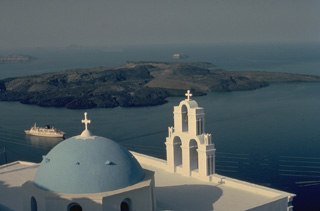 A volcanic cone forms low islands within the largely submerged, 7.5 x 11 km caldera of Santorini (Thera), as viewed from the town of Firá, on the east rim of the caldera. Santorini volcano consists of four partially overlapping calderas, the youngest of which was produced by a major eruption during the Minoan period about 3500 years ago. The Akrotíri Peninsula (upper right) and the small island in the middle distance are parts of the opposite caldera wall. Eruptions from the post-caldera cone have been recorded from 197 BCE until 1950.
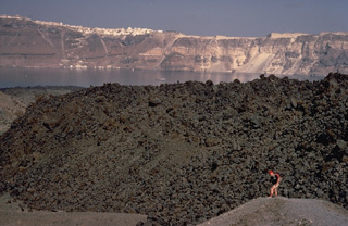 The small, blocky lava dome in the foreground is the product of an eruption of Santorini volcano during 1939-1941. This eruption, smaller than previous post-Minoan eruptions of Santorini, began with phreatic explosions, and concluded with the effusion of the dome and small lava flows. French volcanologist Maurice Krafft provides scale in the foreground, and the steep walls of Santorini's largely submerged caldera, capped by the whitewashed village of Firá, rise to the NE across the caldera bay.
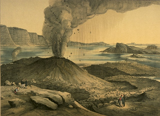 An eruption from 1866 to 1870 at Nea Kameni Island in the center of Santorini caldera began with quiet submarine effusion of lava that built a dome above sea level. During the course of the eruption, three volcanic centers were formed, which issued lava flows, sometimes accompanied by explosive activity, such as depicted in this sketch, viewed form the NE. Lava flows from this eruption underlie more than half of the island of Nea Kameni. The island of Palea Kameni, which formed in 46-47 CE, is visible at the right.
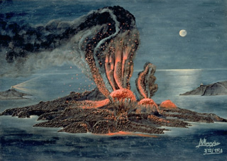 An eruption from 1939 to 1941 began with submarine explosions and lava effusion on the west coast of Nea Kameni Island, seen in this painting viewed from the NE. Over the next two years lava effusion near the center of the island, sometimes accompanied by explosive activity, produced a group of small lava domes and lava flows that traveled dominantly to the east and west. This marked the last major stage in the growth of Nea Kameni Island.
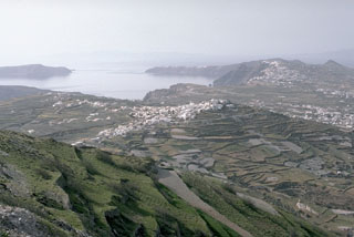 The outer flanks of the Santorini caldera, mantled by deposits of the 3,500-year-old Minoan eruption, provide a setting for croplands and island villages. This view looks NW from Mt. Profitis Ilias, a limestone peak forming the high point of the island of Thera, shows the northern half of the 7.5 x 11 km caldera. The northern rim drops below sea level, leaving a channel between the tip of Thera and the island of Therasia to the left.
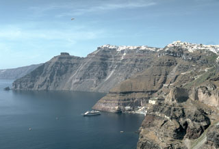 The steep inner walls of Santorini drop steeply into the caldera bay. Pyroclastic flow deposits from four caldera-forming eruptions dating back to 100,000 years ago are exposed in the caldera walls in this N-looking view. The youngest caldera was formed about 3,500 years ago during the Minoan eruption of Santorini. The flat-topped peak on the left skyline is Skaros, a remnant of a shield volcano constructed within a previous caldera.
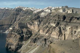 The steep eastern caldera walls of Santorini are draped by the town of Firá, many of which were built within deposits of the Minoan eruption that took place about 3,500 years ago. The most prominent unit in the caldera wall at this location is the Middle Tuff Sequence, the lighter-colored, cliff-forming unit halfway up the wall that is composed of a basal pumice deposit overlain by breccia and pyroclastic flow deposits. The Middle Tuff and the darker bedded layers overlying it were deposited during late-Pleistocene eruptions.
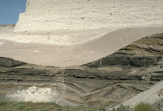 This outcrop shows light-colored deposits from the 3,500-year-old Minoan eruption of Santorini filling a valley that eroded into darker tephra layers of Pleistocene age. The lower beige-colored unit filling the valley is a pumice-fall deposit from early in the eruption. It is overlain by laminated pyroclastic surge deposits that were produced when water came into contact with the magma reservoir as the volcano collapsed into the sea. The upper lighter-colored layer truncating both these deposits is a pyroclastic flow deposit.
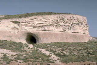 The course of the Minoan eruption of Santorini is recorded in this roughly 10-m-thick exposure of deposits produced by the 3,500-year-old eruption. The loosely-compacted basal pinkish layer is composed of early pumice deposited from powerful vertical eruption plumes. It is overlain by lighter-colored, laminated pyroclastic surge deposits that were produced when water was incorporated into the eruption column as caldera collapse began. The thicker, upper unit consists of pyroclastic flow deposits.
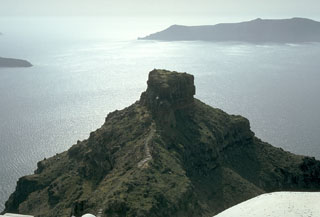 During Medieval times the Skaros promontory, formed of lavas of the Skaros shield volcano, was a densely populated catholic fortress bristling with buildings. The fortress was constructed because it offered protection from pirates, but following a series of strong earthquakes accompanying the 1707-1711 and other eruptions, it was progressively abandoned, and few building remnants remain. Therasia Island lies across the caldera at the upper right, and the tip of Nea Kameni Island in the center of the caldera appears at the left.
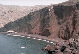 Wave erosion has exposed a cross section through bedded scoria units of the Cape Mavrorachidi scoria cone on the SW side of Thera Island. Behind the cone to the left are exposures of light-colored rhyodacitic tuffs of the Akrotiri Peninsula. A 451,000 ± 27,000 BP (before present) Argon-Argon date was obtained from a lava flow from the Cape Mavrorachidi cone.
 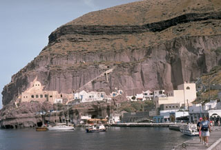 The headland of Cape Thera above Phira harbor. The light-brown, cliff-forming unit above the harbor is the Cape Thera Ignimbrite. Above the cliffs is a sequence of sloping pyroclastic deposits and paleosols, which underlies the prominent thinner dark-colored layer at the top of the photo. This is the Middle Pumice unit, a welded Plinian pumice-fall deposit erupted about 100,000 years ago and thought to originate from a vent west of Phira. The lower-angle slopes above it are lithic breccias of the Middle Pumice eruption.
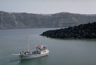 The dacitic lava flow at the right is part of the Dafni lavas, erupted early in the course of an eruption that lasted from 1925 to 1926. Like many other of Santorini's post-caldera eruptions, this eruption began with submarine explosions and lava extrusion. Explosive activity produced eruption plumes up to 3.2 km high. The east wall of Santorini caldera hosts the town of Firá across the caldera bay.
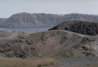 The dark-colored lava flow at the right center of the photo, and the crater in the foreground, were formed during an eruption from 1939 to 1941. The lava flows traveled to the E and W, reaching almost to the sea on the E side and extending into the caldera bay at several locations on the W side on Nea Kameni island. A chain of N-S-trending craters was formed during the eruption. The crater seen in this photo cut lava flows of an earlier 1866-1870 eruption.
 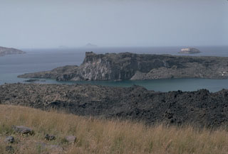 Palaea Kameni (Thia) Island (center) was formed by the extrusion of lava flows during a 46-47 CE eruption. This was the second documented eruption producing a new island in the caldera bay. The black lava flows in the foreground on Nea Kameni island were emplaced during an 1866-1870 eruption. The small island in the right distance to the SW, capped by light-colored rocks of the 3,600-year-old Minoan eruption, is part of the caldera wall that extends beneath the sea surface to the Akrotíri Peninsula on the extreme left.
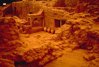 Excavations at Akrotíri have provided insights into life in a Minoan city that was buried by the catastrophic Late Bronze Age eruption of Santorini about 3500 years ago. Strong earthquakes prompted the residents of Akrotíri to evacuate the city between the time of the first minor ash falls and the devastating eruption that followed. The city was partially buried by heavy falls of ash and pumice, and then overtopped by pyroclastic flows.
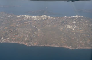 An aerial view from the east overlooks the outer flanks of Santorini's 7.5 x 11 km caldera. The far caldera rim, part of which is flooded by the sea, appears at the upper left and right. The towns of Firá and Merovígli sit on the caldera rim and farms drape the outer flanks of the volcano, which are underlain by deposits from the cataclysmic Minoan-age eruption about 3,500 years ago. The post-caldera islands of Nea and Palaea Kameni (upper-center) were constructed in the middle of the caldera during eruptions dating back to 197 BCE.
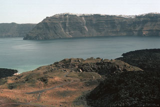 The crater in the foreground was formed during an eruption from 1570-1573 CE. Initially submarine eruptions were followed by the formation of the new island of Mikri Kameni (Little Burnt Island) NE of Palaea Kameni Island. The 1570-73 eruption created a small island with a diameter of about 400 m and a height of 70 m, topped by a 20-m-deep crater. The western wall of Santorini's caldera appears in the background, capped by the houses of the village of Merovígli.
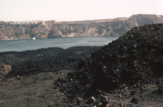 The black lava flows that descend into Santorini's caldera bay are the Dafni lavas, erupted during 1925-26. During this eruption, which began in August 1925 and lasted until January 1926, Nea Kameni became a single island as the Dafni lavas united Mikra Kameni, Nea Kameni, and the Georgios domes. Eruptions resumed in May 1926, producing small pyroclastic flows. The steep-sided eastern caldera wall rises in the distance, capped by the town of Fira and the smooth-textured pyroclastic-flow deposits of the Minoan eruption.
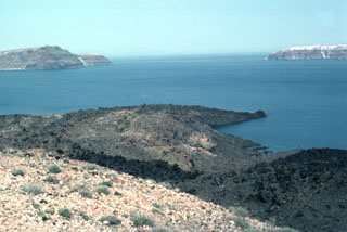 The lava flow forming the peninsula (center) dates back to an eruption during 1707-1711. Nea Kameni Island was formed between Palaea and Mikri Kameni islands during alternating explosive and effusive activity that began with uplift of a small islet called Aspronisi (White Island). The islands of Thirasia (left) and Thira (right) along the caldera rim can be seen in the distance to the NW.
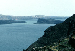 Palaea Kameni Island (right-center) rises from Santorini's caldera bay SE of the foreground cliffs of Thirasia Island. The higher, flat-topped part of the island was formed during 46-47 CE, and the slopes in front of it date back to 726 CE. The highly explosive eruption of the summer of 726 produced great quantities of pumice and ash that were transported as far as the islands of Abydos and Lesbos, Asia Minor, and Macedonia. Extrusion of the Ayios Nikolaos lavas followed, which eventually joined the NE tip of Thia (Palaea Kameni) Island.
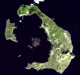 The mostly-submerged caldera of Santorini volcano is seen from space in this NASA satellite image. The 7.5 x 11 km caldera was formed during at least four major explosive eruptions, the last of which occurred about 1,650 BCE. The arcuate islands of Thira (right) and Therasia (left) form the outer flanks of the caldera. Nea Kameni Island is near the center of the caldera, which along with Palea Kameni Island to its left, is part of a post-caldera cone formed during historical eruptions dating back to 197 BCE.
The following 34 samples associated with this volcano can be found in the Smithsonian's NMNH Department of Mineral Sciences collections, and may be availble for research (contact the Rock and Ore Collections Manager). Catalog number links will open a window with more information.
| Catalog Number | Sample Description | Lava Source | Collection Date |
|---|---|---|---|
| NMNH 111123-862 | Augite Andesite | -- | -- |
| NMNH 111123-863 | Augite Andesite | -- | -- |
| NMNH 111123-864 | Augite Andesite | -- | -- |
| NMNH 111123-865 | Augite Andesite | -- | -- |
| NMNH 111123-866 | Glaucophane Schist | -- | -- |
| NMNH 112461 | Basalt | -- | -- |
| NMNH 112462 | Basalt | -- | -- |
| NMNH 113084 | Dacite | KAMENAE | -- |
| NMNH 115999 | Dacitic Pumice | -- | -- |
| NMNH 116000 | Dacitic Pumice | -- | -- |
| NMNH 116001 | Dacitic Pumice | -- | -- |
| NMNH 116710-1 | Pumice | -- | -- |
| NMNH 116710-2 | Pyroclastic Rock | -- | -- |
| NMNH 116710-3 | Pyroclastic Rock | -- | -- |
| NMNH 62893-1 | Lava | -- | -- |
| NMNH 98686 | Andesite | -- | -- |
| NMNH 98687 | Pyroxene Andesite | -- | -- |
| NMNH 98688 | Pyroxene Andesite | -- | -- |
| NMNH 98689 | Pyroxene Andesite | -- | -- |
| NMNH 98690 | Pyroxene Andesite | -- | -- |
| NMNH 98691 | Pyroxene Andesite | -- | -- |
| NMNH 98693 | Lava | -- | -- |
| NMNH 98694 | Lava | -- | -- |
| NMNH 98695 | Lava | MIKRA KAMENI DOME | -- |
| NMNH 98696 | Lava | MIKRA KAMENI DOME | -- |
| NMNH 98697 | Lava | NEA KAMENI DOME | -- |
| NMNH 98698 | Lava | NEA KAMENI DOME | -- |
| NMNH 98699 | Lava | NEA KAMENI DOME | -- |
| NMNH 98700 | Lava | -- | -- |
| NMNH 98702 | Lava | GEORGIOS DOME | -- |
| NMNH 98703 | Lava | -- | -- |
| NMNH 98704 | Lava | -- | -- |
| NMNH 98705 | Lava | -- | -- |
| NMNH 98706 | Schist | -- | -- |
| Copernicus Browser | The Copernicus Browser replaced the Sentinel Hub Playground browser in 2023, to provide access to Earth observation archives from the Copernicus Data Space Ecosystem, the main distribution platform for data from the EU Copernicus missions. |
| MIROVA | Middle InfraRed Observation of Volcanic Activity (MIROVA) is a near real time volcanic hot-spot detection system based on the analysis of MODIS (Moderate Resolution Imaging Spectroradiometer) data. In particular, MIROVA uses the Middle InfraRed Radiation (MIR), measured over target volcanoes, in order to detect, locate and measure the heat radiation sourced from volcanic activity. |
| MODVOLC Thermal Alerts | Using infrared satellite Moderate Resolution Imaging Spectroradiometer (MODIS) data, scientists at the Hawai'i Institute of Geophysics and Planetology, University of Hawai'i, developed an automated system called MODVOLC to map thermal hot-spots in near real time. For each MODIS image, the algorithm automatically scans each 1 km pixel within it to check for high-temperature hot-spots. When one is found the date, time, location, and intensity are recorded. MODIS looks at every square km of the Earth every 48 hours, once during the day and once during the night, and the presence of two MODIS sensors in space allows at least four hot-spot observations every two days. Each day updated global maps are compiled to display the locations of all hot spots detected in the previous 24 hours. There is a drop-down list with volcano names which allow users to 'zoom-in' and examine the distribution of hot-spots at a variety of spatial scales. |
|
WOVOdat
Single Volcano View Temporal Evolution of Unrest Side by Side Volcanoes |
WOVOdat is a database of volcanic unrest; instrumentally and visually recorded changes in seismicity, ground deformation, gas emission, and other parameters from their normal baselines. It is sponsored by the World Organization of Volcano Observatories (WOVO) and presently hosted at the Earth Observatory of Singapore.
GVMID Data on Volcano Monitoring Infrastructure The Global Volcano Monitoring Infrastructure Database GVMID, is aimed at documenting and improving capabilities of volcano monitoring from the ground and space. GVMID should provide a snapshot and baseline view of the techniques and instrumentation that are in place at various volcanoes, which can be use by volcano observatories as reference to setup new monitoring system or improving networks at a specific volcano. These data will allow identification of what monitoring gaps exist, which can be then targeted by remote sensing infrastructure and future instrument deployments. |
| Volcanic Hazard Maps | The IAVCEI Commission on Volcanic Hazards and Risk has a Volcanic Hazard Maps database designed to serve as a resource for hazard mappers (or other interested parties) to explore how common issues in hazard map development have been addressed at different volcanoes, in different countries, for different hazards, and for different intended audiences. In addition to the comprehensive, searchable Volcanic Hazard Maps Database, this website contains information about diversity of volcanic hazard maps, illustrated using examples from the database. This site is for educational purposes related to volcanic hazard maps. Hazard maps found on this website should not be used for emergency purposes. For the most recent, official hazard map for a particular volcano, please seek out the proper institutional authorities on the matter. |
| IRIS seismic stations/networks | Incorporated Research Institutions for Seismology (IRIS) Data Services map showing the location of seismic stations from all available networks (permanent or temporary) within a radius of 0.18° (about 20 km at mid-latitudes) from the given location of Santorini. Users can customize a variety of filters and options in the left panel. Note that if there are no stations are known the map will default to show the entire world with a "No data matched request" error notice. |
| UNAVCO GPS/GNSS stations | Geodetic Data Services map from UNAVCO showing the location of GPS/GNSS stations from all available networks (permanent or temporary) within a radius of 20 km from the given location of Santorini. Users can customize the data search based on station or network names, location, and time window. Requires Adobe Flash Player. |
| DECADE Data | The DECADE portal, still in the developmental stage, serves as an example of the proposed interoperability between The Smithsonian Institution's Global Volcanism Program, the Mapping Gas Emissions (MaGa) Database, and the EarthChem Geochemical Portal. The Deep Earth Carbon Degassing (DECADE) initiative seeks to use new and established technologies to determine accurate global fluxes of volcanic CO2 to the atmosphere, but installing CO2 monitoring networks on 20 of the world's 150 most actively degassing volcanoes. The group uses related laboratory-based studies (direct gas sampling and analysis, melt inclusions) to provide new data for direct degassing of deep earth carbon to the atmosphere. |
| Large Eruptions of Santorini | Information about large Quaternary eruptions (VEI >= 4) is cataloged in the Large Magnitude Explosive Volcanic Eruptions (LaMEVE) database of the Volcano Global Risk Identification and Analysis Project (VOGRIPA). |
| EarthChem | EarthChem develops and maintains databases, software, and services that support the preservation, discovery, access and analysis of geochemical data, and facilitate their integration with the broad array of other available earth science parameters. EarthChem is operated by a joint team of disciplinary scientists, data scientists, data managers and information technology developers who are part of the NSF-funded data facility Integrated Earth Data Applications (IEDA). IEDA is a collaborative effort of EarthChem and the Marine Geoscience Data System (MGDS). |

