The Pusat Vulkanologi dan Mitigasi Bencana Geologi (PVMBG) reported that eruptive activity at Marapi (on Sumatra) continued during 31 December 2025-7 January 2026. An eruptive event at 0458 on 6 January produced a dense white-to-gray ash plume that rose to around 250 m above the summit and drifted SE. An eruptive event was recorded at 1323 on 7 January, though weather conditions prevented visual confirmation. The Alert Level remained at 2 (on a scale of 1-4) and the public was warned to stay 3 km away from the active crater.
Source: Pusat Vulkanologi dan Mitigasi Bencana Geologi (PVMBG, also known as CVGHM)
New explosive eruption with ash emissions during January-March 2023
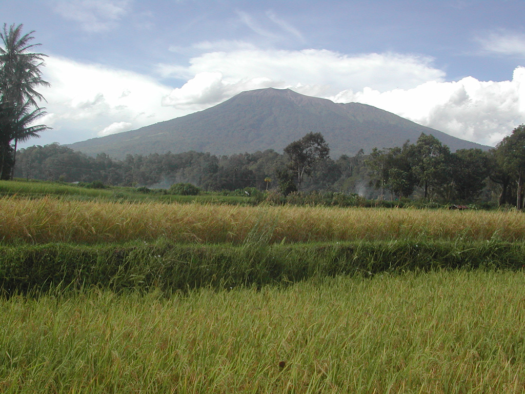
Marapi in Sumatra, Indonesia, is a massive stratovolcano that rises 2 km above the Bukittinggi Plain in the Padang Highlands. A broad summit contains multiple partially overlapping summit craters constructed within the small 1.4-km-wide Bancah caldera and trending ENE-WSW, with volcanism migrating to the west. Since the end of the 18th century, more than 50 eruptions, typically characterized by small-to-moderate explosive activity, have been recorded. The previous eruption consisted of two explosions during April-May 2018, which caused ashfall to the SE (BGVN 43:06). This report covers a new eruption during January-March 2023, which included explosive events and ash emissions, as reported by Pusat Vulkanologi dan Mitigasi Bencana Geologi (PVMBG, also known as Indonesian Center for Volcanology and Geological Hazard Mitigation, CVGHM) and MAGMA Indonesia.
According to a press release issued by PVMBG and MAGMA Indonesia on 26 December, primary volcanic activity at Marapi consisted of white gas-and-steam puffs that rose 500-100 m above the summit during April-December 2022. On 25 December 2022 there was an increase in the number of deep volcanic earthquakes and summit inflation. White gas-and-steam emissions rose 80-158 m above the summit on 5 January. An explosive eruption began at 0611 on 7 January 2023, which generated white gas-and-steam emissions and gray ash emissions mixed with ejecta that rose 300 m above the summit and drifted SE (figure 10). According to ground observations, white-to-gray ash clouds during 0944-1034 rose 200-250 m above the summit and drifted SE and around 1451 emissions rose 200 m above the summit. Seismic signals indicated that eruptive events also occurred at 1135, 1144, 1230, 1715, and 1821, but no ash emissions were visually observed. On 8 January white-and-gray emissions rose 150-250 m above the summit that drifted E and SE. Seismic signals indicated eruptive events at 0447, 1038, and 1145, but again no ash emissions were visually observed on 8 January. White-to-gray ash plumes continued to be observed on clear weather days during 9-15, 18-21, 25, and 29-30 January, rising 100-1,000 m above the summit and drifted generally NE, SE, N, and E, based on ground observations (figure 11).
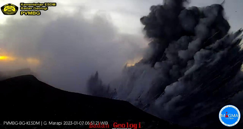 |
Figure 10. Webcam image of the start of the explosive eruption at Marapi at 0651 on 7 January 2023. White gas-and-steam emissions are visible to the left and gray ash emissions are visible on the right, drifting SE. Distinct ejecta was also visible mixed within the ash cloud. Courtesy of PVMBG and MAGMA Indonesia. |
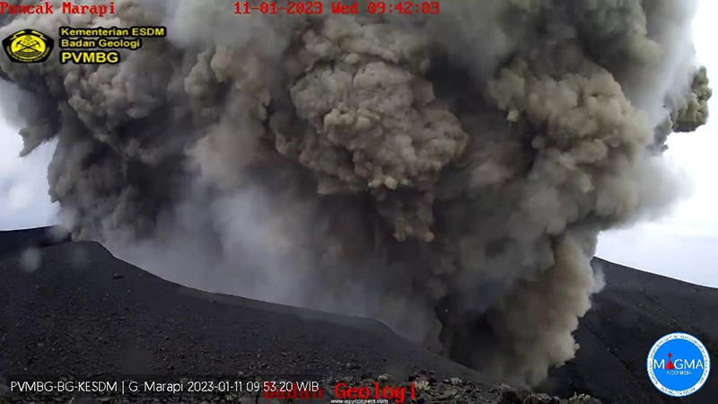 |
Figure 11. Webcam image showing thick, gray ash emissions rising 500 m above the summit of Marapi and drifting N and NE at 0953 on 11 January 2023. Courtesy of PVMBG and MAGMA Indonesia. |
White-and-gray and brown emissions persisted in February, rising 50-500 m above the summit and drifting E, S, SW, N, NE, and W, though weather sometimes prevented clear views of the summit. An eruption at 1827 on 10 February produced a black ash plume that rose 400 m above the summit and drifted NE and E (figure 12). Similar activity was reported on clear weather days, with white gas-and-steam emissions rising 50 m above the summit on 9, 11-12, 20, and 27 March and drifted E, SE, SW, NE, E, and N. On 17 March white-and-gray emissions rose 400 m above the summit and drifted N and E.
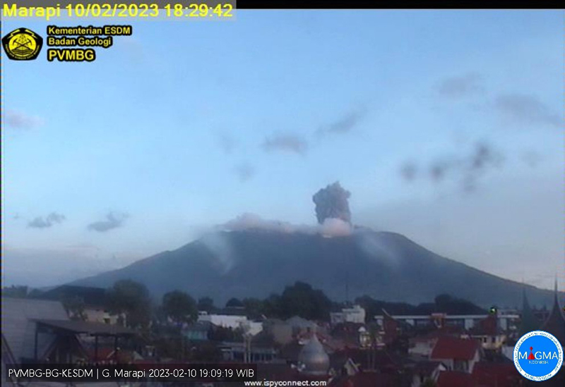 |
Figure 12. Webcam image showing an eruptive event at 1829 on 10 February 2023 with an ash plume rising 400 m above the summit and drifting NE and E. Courtesy of PVMBG and MAGMA Indonesia. |
Information Contacts: Pusat Vulkanologi dan Mitigasi Bencana Geologi (PVMBG, also known as Indonesian Center for Volcanology and Geological Hazard Mitigation, CVGHM), Jalan Diponegoro 57, Bandung 40122, Indonesia (URL: http://www.vsi.esdm.go.id/); MAGMA Indonesia, Kementerian Energi dan Sumber Daya Mineral (URL: https://magma.esdm.go.id/v1).
2026: January
2025: January
| February
| March
| April
| May
| June
| July
| August
| September
| November
| December
2024: January
| February
| March
| April
| May
| June
| July
| August
| September
| October
| November
| December
2023: January
| February
| March
| November
| December
2022: August
| September
| December
2018: April
| May
2017: May
2016: January
2015: May
| November
2014: February
2012: March
| May
| September
2011: July
| August
| October
2005: July
2004: August
2001: April
| May
The Pusat Vulkanologi dan Mitigasi Bencana Geologi (PVMBG) reported that eruptive activity at Marapi (on Sumatra) continued during 31 December 2025-7 January 2026. An eruptive event at 0458 on 6 January produced a dense white-to-gray ash plume that rose to around 250 m above the summit and drifted SE. An eruptive event was recorded at 1323 on 7 January, though weather conditions prevented visual confirmation. The Alert Level remained at 2 (on a scale of 1-4) and the public was warned to stay 3 km away from the active crater.
Source: Pusat Vulkanologi dan Mitigasi Bencana Geologi (PVMBG, also known as CVGHM)
The Pusat Vulkanologi dan Mitigasi Bencana Geologi (PVMBG) reported that eruptive activity at Marapi (on Sumatra) continued during 24-30 December. An eruptive event was recorded at 0541 on 25 December though weather conditions or darkness prevented visual confirmation. An eruptive event at 2333 on 28 December produced a gray ash plume that rose to around 900 m above the summit and drifted N. The Alert Level remained at 2 (on a scale of 1-4) and the public was warned to stay 3 km away from the active crater.
Source: Pusat Vulkanologi dan Mitigasi Bencana Geologi (PVMBG, also known as CVGHM)
The Pusat Vulkanologi dan Mitigasi Bencana Geologi (PVMBG) reported that eruptive activity at Marapi (on Sumatra) continued during 17-23 December. White emissions rose as high as 150 m above the summit and drifted E and SE during 17 and 20-21 December; weather conditions sometimes prevented visual observations. Eruptive events were recorded at 2115 on 18 December and at 1247 on 19 December though weather conditions prevented visual confirmation. The Alert Level remained at 2 (on a scale of 1-4) and the public was warned to stay 3 km away from the active crater.
Source: Pusat Vulkanologi dan Mitigasi Bencana Geologi (PVMBG, also known as CVGHM)
The Pusat Vulkanologi dan Mitigasi Bencana Geologi (PVMBG) reported that eruptive events at Marapi (on Sumatra) were recorded at 0445 on 11 December and at 1654 on 15 December, but were not visually observed due to weather conditions. At 1637 on 14 December an ash plume rose 1.2 km above the crater rim and drifted N. The Alert Level remained at 2 (on a scale of 1-4) and the public was warned to stay 3 km away from the active crater.
Source: Pusat Vulkanologi dan Mitigasi Bencana Geologi (PVMBG, also known as CVGHM)
The Pusat Vulkanologi dan Mitigasi Bencana Geologi (PVMBG) reported that an eruptive event at Marapi (on Sumatra) was recorded at 1616 on 4 December. Emissions were not observed due to weather clouds. The Alert Level remained at 2 (on a scale of 1-4) and the public was warned to stay 3 km away from the active crater.
Source: Pusat Vulkanologi dan Mitigasi Bencana Geologi (PVMBG, also known as CVGHM)
The Pusat Vulkanologi dan Mitigasi Bencana Geologi (PVMBG) reported that an eruptive event at Marapi (on Sumatra) was recorded at 2234 on 2 December. Emissions were not observed. The Alert Level remained at 2 (on a scale of 1-4) and the public was warned to stay 3 km away from the active crater.
Source: Pusat Vulkanologi dan Mitigasi Bencana Geologi (PVMBG, also known as CVGHM)
The Pusat Vulkanologi dan Mitigasi Bencana Geologi (PVMBG) reported that eruptive activity at Marapi (on Sumatra) continued during 13-18 November. An eruptive event at 0441 on 12 November produced a dense white-and-gray ash plume that rose 400 m above the summit and drifted E. White plumes rose 100 m above the summit and drifted SE during 13-14 November. Weather conditions prevented visual observations during the rest of the week. The Alert Level remained at 2 (on a scale of 1-4) and the public was warned to stay 3 km away from the active crater.
Source: Pusat Vulkanologi dan Mitigasi Bencana Geologi (PVMBG, also known as CVGHM)
The Pusat Vulkanologi dan Mitigasi Bencana Geologi (PVMBG) reported that eruptive activity at Marapi (on Sumatra) continued during 24-30 September. Eruptive events at 1959 on 24 September and at 2116 on 26 September were recorded but weather conditions prevented visual confirmation. An eruptive event at 1831 on 26 September produced a dense white-and-gray ash plume that rose 1 km above the summit and drifted E. The Alert Level remained at 2 (on a scale of 1-4) and the public was warned to stay 3 km away from the active crater.
Source: Pusat Vulkanologi dan Mitigasi Bencana Geologi (PVMBG, also known as CVGHM)
The Pusat Vulkanologi dan Mitigasi Bencana Geologi (PVMBG) reported that eruptive activity at Marapi (on Sumatra) continued during 17-23 September. Almost daily white steam-and-gas plumes rose as high as 200 m above the crater rim and drifted in multiple directions. Eruptive events were recorded on 17, 22, and 23 September, but weather conditions prevented visual confirmation. Dense gray ash plumes rose 1 km above the summit and drifted S and SW during 20-21 September. The Alert Level remained at 2 (on a scale of 1-4) and the public was warned to stay 3 km away from the active crater.
Source: Pusat Vulkanologi dan Mitigasi Bencana Geologi (PVMBG, also known as CVGHM)
The Pusat Vulkanologi dan Mitigasi Bencana Geologi (PVMBG) reported that eruptive activity at Marapi (on Sumatra) continued during 10-16 September. Almost daily white steam-and-gas plumes rose as high as 200 m above the crater rim and drifted in multiple directions. Eruptive events were recorded at 2205 on 11 September and at 0823 on 16 September, but weather conditions prevented visual confirmation. The Alert Level remained at 2 (on a scale of 1-4) and the public was warned to stay 3 km away from the active crater.
Source: Pusat Vulkanologi dan Mitigasi Bencana Geologi (PVMBG, also known as CVGHM)
The Pusat Vulkanologi dan Mitigasi Bencana Geologi (PVMBG) reported that eruptive activity at Marapi (on Sumatra) continued during 3-9 September. An eruptive event was recorded on 4 September, but weather conditions prevented visual confirmation. A dense gray ash plume rose 1.2 m above the crater rim ana drifted NE on 7 September and a dense gray-to-white ash plumes rose 1 km above the crater rim and drifted E on 8 September. The Alert Level remained at 2 (on a scale of 1-4) and the public was warned to stay 3 km away from the active crater.
Source: Pusat Vulkanologi dan Mitigasi Bencana Geologi (PVMBG, also known as CVGHM)
The Pusat Vulkanologi dan Mitigasi Bencana Geologi (PVMBG) reported that eruptive activity at Marapi (on Sumatra) continued during 27 August-2 September. Gray-to-white ash plumes rose as high as 800 m above the crater rim and drifted N, NE, and SE on 27, 29, and 31 August. Two eruptive events recorded on 27 and 29 August were not visually observed. The Alert Level remained at 2 (on a scale of 1-4) and the public was warned to stay 3 km away from the active crater.
Source: Pusat Vulkanologi dan Mitigasi Bencana Geologi (PVMBG, also known as CVGHM)
The Pusat Vulkanologi dan Mitigasi Bencana Geologi (PVMBG) reported that eruptive activity at Marapi (on Sumatra) continued during 13-19 August. At 1202 on 13 August an eruptive event generated a white-and-gray ash plume that rose 500 m above the summit and drifted NE. An eruptive event was recorded at 0119 on 16 August but not visually observed. The Alert Level remained at 2 (on a scale of 1-4) and the public was warned to stay 3 km away from the active crater.
Source: Pusat Vulkanologi dan Mitigasi Bencana Geologi (PVMBG, also known as CVGHM)
The Pusat Vulkanologi dan Mitigasi Bencana Geologi (PVMBG) reported that eruptive activity at Marapi (on Sumatra) continued during 6-12 August. An eruptive event was recorded at 0710 on 12 August but not visually observed. At 0839 that same day an eruptive event generated a dense white-and-gray ash plume that rose 1.6 km above the summit and drifted NE. The Alert Level remained at 2 (on a scale of 1-4) and the public was warned to stay 3 km away from the active crater.
Source: Pusat Vulkanologi dan Mitigasi Bencana Geologi (PVMBG, also known as CVGHM)
The Pusat Vulkanologi dan Mitigasi Bencana Geologi (PVMBG) reported that eruptive activity at Marapi (on Sumatra) continued during 30 July-5 August. There were two explosions on 31 July, at 0100 and 0741. Only the 0741 event was observed, with a plume that rose 400 m above the summit and dispersed to the N. Another eruption was detected seismically on 2 August at 1233 but was not witnessed due to cloudy weather. The Alert Level remained at 2 (on a scale of 1-4) and the public was warned to stay 3 km away from the active crater.
Source: Pusat Vulkanologi dan Mitigasi Bencana Geologi (PVMBG, also known as CVGHM)
The Pusat Vulkanologi dan Mitigasi Bencana Geologi (PVMBG) reported that eruptive activity at Marapi (on Sumatra) continued during 23-29 July. An explosion at 0723 on 23 July produced a dense white-and-gray ash plume that rose around 1.6 km and drifted SE. According to a news report residents in the Ampek Angkek District (12 km NNW) heard a loud explosion and felt their houses shake. Eruptive events were recorded by the seismic network at 1730 on 25 July and at 1344 on 27 July, but weather clouds obscured visual confirmation. The Alert Level remained at 2 (on a scale of 1-4) and the public was warned to stay 3 km away from the active crater.
Sources: Pusat Vulkanologi dan Mitigasi Bencana Geologi (PVMBG, also known as CVGHM); Antara News
The Pusat Vulkanologi dan Mitigasi Bencana Geologi (PVMBG) reported that eruptive activity at Marapi (on Sumatra) continued during 16-23 July. At 1042 on 16 July a dense gray ash plume rose 1.2 km above the summit and drifted NE. At 1851 on 18 July a dense gray-to-brown ash plume rose 1 km above the summit and drifted NE. White plumes rose as high as 200 m and drifted NE and E on the other days. An eruptive event at 0723 on 23 July produced a dense white-and-gray ash plume that rose around 1.6 km and drifted SE. The eruptive event lasted for one minute and 18 seconds based on seismic data. The Alert Level remained at 2 (on a scale of 1-4) and the public was warned to stay 3 km away from the active crater.
Source: Pusat Vulkanologi dan Mitigasi Bencana Geologi (PVMBG, also known as CVGHM)
The Pusat Vulkanologi dan Mitigasi Bencana Geologi (PVMBG) reported that eruptive activity at Marapi (on Sumatra) continued during 9-15 July. Eruptive events were recorded at 0022 and 0045 on 11 July and at 0318 and 1915 on 14 July, though not visually observed. The Darwin VAAC stated that an ash plume was visible in a satellite image at 0054 on 11 July rising to 4.3 km (14,000 ft) a.s.l. (about 1.4 km above the summit) and drifting NE. The Alert Level remained at 2 (on a scale of 1-4) and the public was warned to stay 3 km away from the active crater.
Sources: Pusat Vulkanologi dan Mitigasi Bencana Geologi (PVMBG, also known as CVGHM); Darwin Volcanic Ash Advisory Centre (VAAC)
The Pusat Vulkanologi dan Mitigasi Bencana Geologi (PVMBG) reported that eruptive activity at Marapi (on Sumatra) continued during 2-8 July. Daily white plumes rose as high as 150 m above the summit and drifted NE, E, and SE. An eruptive event was recorded at 1359 om 6 July though not visually observed. The Alert Level remained at 2 (on a scale of 1-4) and the public was warned to stay 3 km away from the active crater.
Source: Pusat Vulkanologi dan Mitigasi Bencana Geologi (PVMBG, also known as CVGHM)
The Pusat Vulkanologi dan Mitigasi Bencana Geologi (PVMBG) reported that eruptive activity at Marapi (on Sumatra) continued during 18-24 June. At 1532 on 18 June a gray ash plume rose to around 450 m above the summit and drifted NE. Later that day, at 2009, a gray ash plume to rose around 700 m above the summit and drifted E. According to a news report the second event was accompanied by loud banging and rumbling noises, felt vibrations, and incandescence visible at the summit. The Alert Level remained at 2 (on a scale of 1-4) and the public was warned to stay 3 km away from the active crater.
Sources: Pusat Vulkanologi dan Mitigasi Bencana Geologi (PVMBG, also known as CVGHM); Antara News
The Pusat Vulkanologi dan Mitigasi Bencana Geologi (PVMBG) reported that activity at Marapi (on Sumatra) continued during 11-17 June. An eruptive event at 0745 on 17 June was recorded by the seismic network, though a plume was not visible. The Alert Level remained at 2 (on a scale of 1-4) and the public was warned to stay 3 km away from the active crater.
Source: Pusat Vulkanologi dan Mitigasi Bencana Geologi (PVMBG, also known as CVGHM)
The Pusat Vulkanologi dan Mitigasi Bencana Geologi (PVMBG) reported that eruptive activity at Marapi (on Sumatra) continued during 28 May-3 June. White plumes rose 100-400 m above the summit and drifted in multiple directions on most days. An eruptive event at 2236 on 30 May was recorded by the seismic network, though a plume was not visible. White-and-gray plumes rose 150-300 m above the summit and drifted E and SE on 31 May. The Alert Level remained at 2 (on a scale of 1-4) and the public was warned to stay 3 km away from the active crater.
Source: Pusat Vulkanologi dan Mitigasi Bencana Geologi (PVMBG, also known as CVGHM)
The Pusat Vulkanologi dan Mitigasi Bencana Geologi (PVMBG) reported that eruptive activity at Marapi (on Sumatra) continued during 21-27 May, characterized by occasional dense ash plumes. White plumes rose 100-200 m above the summit and drifted in multiple directions during 21-22 and 24 May. Eruptive events were recorded at 1227 on 23 May and at 1457 on 26 May, though weather conditions prevented visual confirmation. On 25 May white-and-brown plumes rose 100-250 m above the summit and drifted E and SE. At 0822 on 27 May a dense white-and-gray ash plume rose 1.2 km above the summit and drifted SE. The Alert Level remained at 2 (on a scale of 1-4) and the public was warned to stay 3 km away from the active crater.
Source: Pusat Vulkanologi dan Mitigasi Bencana Geologi (PVMBG, also known as CVGHM)
The Pusat Vulkanologi dan Mitigasi Bencana Geologi (PVMBG) reported that eruptive activity from Verbeek Crater at Marapi (on Sumatra) continued during 14-20 May, characterized by occasional dense gray ash plumes. The tallest ash plume rose 1.6 km above the crater rim at 0942 on 14 May and drifted NE. At 1939 on 15 May an ash plume rose 800 m and drifted E. Ash plumes at 0947 and 0954 on 17 May rose 1 km and 600 m above the crater rim, respectively, and drifted N and NE. The Alert Level remained at 2 (on a scale of 1-4) and the public was warned to stay 3 km away from the active crater.
Source: Pusat Vulkanologi dan Mitigasi Bencana Geologi (PVMBG, also known as CVGHM)
The Pusat Vulkanologi dan Mitigasi Bencana Geologi (PVMBG) reported that eruptive activity from Verbeek Crater at Marapi (on Sumatra) continued during 7-13 May. On 7 May dense gray-and-white ash plumes rose as high as 500 m above the crater rim and drifted N and NE. On 8 May white-and-brown ash plumes rose 250-400 m above the crater rim and drifted NE, E, and SE. White plumes were visible rising as high as 150 m above the crater rim during 9-11 May and drifted E, SE, and S. At 0310 on 12 May a dense gray ash plume rose 600 m above the crater rim and drifted SE. The Alert Level remained at 2 (on a scale of 1-4) and the public was warned to stay 3 km away from the active crater.
Source: Pusat Vulkanologi dan Mitigasi Bencana Geologi (PVMBG, also known as CVGHM)
The Pusat Vulkanologi dan Mitigasi Bencana Geologi (PVMBG) reported that eruptive activity from Verbeek Crater at Marapi (on Sumatra) continued during 30 April-6 May. Eruptive events were detected at 1816 on 30 April and at 1438 on 1 May, though the events were not visually observed. At 1812 on 3 May an ash plume rose 800 m above the summit and drifted NE. An eruptive event was detected at 1331 on 4 May, though not visually observed. At 2209 on 4 May a dense gray ash plume rose 1 km above the summit and drifted E. Incandescence at the summit was visible in an image from 2226 that same day. The Alert Level remained at 2 (on a scale of 1-4) and the public was warned to stay 3 km away from the active crater.
Source: Pusat Vulkanologi dan Mitigasi Bencana Geologi (PVMBG, also known as CVGHM)
The Pusat Vulkanologi dan Mitigasi Bencana Geologi (PVMBG) reported that eruptive activity from Verbeek Crater at Marapi (on Sumatra) continued during 23-29 April. Dense gray ash plumes rose 350-1,000 m above the summit and drifted N during 25 and 27-28 April. Two more eruptive events were recorded on 28 April but not visually observed due to weather conditions. The Alert Level remained at 2 (on a scale of 1-4) and the public was warned to stay 3 km away from the active crater.
Source: Pusat Vulkanologi dan Mitigasi Bencana Geologi (PVMBG, also known as CVGHM)
The Pusat Vulkanologi dan Mitigasi Bencana Geologi (PVMBG) reported that eruptive activity from Verbeek Crater at Marapi (on Sumatra) continued during 16-22 April. Ash plumes rose 200-1,000 m above the summit and drifted NE, E, SE, and S on 16, 19, and 21 April. An explosion was recorded at 2141 on 21 April but was not visually confirmed due to weather cloud cover. According to a news report a resident Padang Panjang City (11 km SW) said that the explosion was so loud that it shook the windows. A webcam image at 2212 on 21 April showed incandescent material being ejected above the summit. The Alert Level remained at 2 (on a scale of 1-4) and the public was warned to stay 3 km away from the active crater.
Sources: Pusat Vulkanologi dan Mitigasi Bencana Geologi (PVMBG, also known as CVGHM); Antara News
The Pusat Vulkanologi dan Mitigasi Bencana Geologi (PVMBG) reported that eruptive activity at Marapi’s Verbeek Crater (on Sumatra) continued during 9-15 April. At 0750 on 9 April the Darwin VAAC reported an ash plume that rose to 4.3 km (14,000 ft) a.s.l. and drifted W, according to a ground observer. White gas-and-steam emissions rose 100-200 m above the summit and drifted in multiple directions on 9, 10, 13, and 14 April. The Alert Level remained at 2 (on a scale of 1-4) and the public was warned to stay 3 km away from the active crater.
Sources: Pusat Vulkanologi dan Mitigasi Bencana Geologi (PVMBG, also known as CVGHM); Darwin Volcanic Ash Advisory Centre (VAAC)
The Pusat Vulkanologi dan Mitigasi Bencana Geologi (PVMBG) reported that eruptive activity at Marapi’s Verbeek Crater (on Sumatra) continued during 2-8 April. An eruptive event at 2233 on 1 April was recorded by the seismic network but not observed. At 0625 on 2 April a gray ash plume rose 350 m above the summit and drifted NE and at 1604 a dense gray ash plume rose 1 km above the summit and drifted E. On 3 April at 1804 a dense gray ash plume rose 400 m and drifted E. At 0712 on 3 April an eruptive event that lasted one minute and nine seconds produced an ash plume that rose 1.5 km above the summit and drifted E. The Alert Level remained at 2 (on a scale of 1-4) and the public was warned to stay 3 km away from the active crater.
Source: Pusat Vulkanologi dan Mitigasi Bencana Geologi (PVMBG, also known as CVGHM)
The Pusat Vulkanologi dan Mitigasi Bencana Geologi (PVMBG) reported that eruptive activity at Marapi (on Sumatra) continued during 19-25 March. Daily white plumes generally rose as high as 250 m above the summit and drifted in multiple directions. At 0229 on 20 March a dense gray ash plume rose 1 km above the summit and drifted S. An eruptive event was recorded at 0842 on 22 March but not visually observed due to weather conditions. According to a news report the event produced a loud bang heard in several areas including Padang Panjang City (11 km SW), Koto Baru (15 km NNW), Sungai Pua Village (7 km NW), and Bukittinggi City (13 km NW). One resident in Bukittinggi City noted that loud bangs had been heard quite often over the previous few months. The Alert Level remained at 2 (on a scale of 1-4) and the public was warned to stay 3 km away from the active crater.
Sources: Pusat Vulkanologi dan Mitigasi Bencana Geologi (PVMBG, also known as CVGHM); Antara News
The Pusat Vulkanologi dan Mitigasi Bencana Geologi (PVMBG) reported that eruptive activity at Marapi (on Sumatra) continued during 12-18 March. White plumes generally rose as high as 300 m above the summit and drifted in multiple directions on most days. An eruptive event was recorded at 0755 on 13 March but not visually observed due to weather conditions. At 0700 on 16 March and at 1120 on 17 March dense gray ash plumes rose 800 m and 600 m above the summit and drifted N and NW, respectively. The Alert Level remained at 2 (on a scale of 1-4) and the public was warned to stay 3 km away from the active crater.
Source: Pusat Vulkanologi dan Mitigasi Bencana Geologi (PVMBG, also known as CVGHM)
The Pusat Vulkanologi dan Mitigasi Bencana Geologi (PVMBG) reported that eruptive activity at Marapi continued during 5-11 March. At 0245 on 7 March a gray dense ash plume rose 1.2 km above the summit and drifted N. Almost two hours later, at 0431, a webcam image showed crater incandescence. An eruptive event at 1041 on 8 March was recorded by the seismic network but not visually observed. The Alert Level remained at 2 (on a scale of 1-4) and the public was warned to stay 3 km away from the active crater.
Source: Pusat Vulkanologi dan Mitigasi Bencana Geologi (PVMBG, also known as CVGHM)
The Pusat Vulkanologi dan Mitigasi Bencana Geologi (PVMBG) reported that eruptive activity at Marapi continued during 26 Febraury-4 March. Eruptive events were recorded at 1430 on 1 March and at 0833 on 5 March, though no emissions were visually observed due to weather clouds. The Alert Level remained at 2 (on a scale of 1-4) and the public was warned to stay 3 km away from the active crater.
Source: Pusat Vulkanologi dan Mitigasi Bencana Geologi (PVMBG, also known as CVGHM)
The Pusat Vulkanologi dan Mitigasi Bencana Geologi (PVMBG) reported that the seismic network at Marapi (on Sumatra) recorded an increase in volcanic earthquakes and tremors during early to mid-February. On 19 February white-and-gray ash plumes rose 200-700 m above the summit and drifted E. Webcam images at 0321 and 2056 showed incandesce at the summit. An eruptive event was recorded on 23 February, though no emissions were observed. On 24 February a dense gray ash plume rose 500 m above the summit and drifted E. The Alert Level remained at 2 (on a scale of 1-4) and the public was warned to stay 3 km away from the active crater.
Source: Pusat Vulkanologi dan Mitigasi Bencana Geologi (PVMBG, also known as CVGHM)
The Pusat Vulkanologi dan Mitigasi Bencana Geologi (PVMBG) reported that white plumes rose 100-200 m above the summit of Marapi (on Sumatra) during 5-10 February and drifted in multiple directions. An eruptive event was recorded at 1820 on 7 February but emission heights were unknown. The Darwin VAAC reported that an ash plume was visible in a satellite image at 0620 on 8 February drifting E at an estimated altitude of 3 km (10,000 ft) a.s.l. The Alert Level remained at 2 (on a scale of 1-4) and the public was warned to stay 3 km away from the active crater.
Sources: Pusat Vulkanologi dan Mitigasi Bencana Geologi (PVMBG, also known as CVGHM); Darwin Volcanic Ash Advisory Centre (VAAC)
The Pusat Vulkanologi dan Mitigasi Bencana Geologi (PVMBG) reported that eruptive activity at Marapi (on Sumatra) was ongoing during 22-28 January. White and gray gas-and-ash plumes rose as high as 750 m above the summit on 22, 26, and 28 January. White gas-and-steam emissions rose as high as 200 m above the summit on 25 and 27 January; no emissions were observed during 23-24 January. The Alert Level remained at 2 (on a scale of 1-4) and the public was warned to stay 3 km away from the active crater.
Source: Pusat Vulkanologi dan Mitigasi Bencana Geologi (PVMBG, also known as CVGHM)
The Pusat Vulkanologi dan Mitigasi Bencana Geologi (PVMBG) reported that eruptive activity at Marapi (on Sumatra) was ongoing during 1-7 January. White steam-and-gas plumes generally rose as high as 400 m above the summit during most of the week; emissions were not observed during 6-7 January. At 0943 on 4 January a dense gray ash plume rose around 1 km above the summit and drifted N and NE. The emission lasted one minute and 40 seconds based on seismic data. The Alert Level remained at 2 (on a scale of 1-4) and the public was warned to stay 3 km away from the active crater.
Sources: Pusat Vulkanologi dan Mitigasi Bencana Geologi (PVMBG, also known as CVGHM); Antara News
The Pusat Vulkanologi dan Mitigasi Bencana Geologi (PVMBG) reported that eruptive activity at Marapi (on Sumatra) was ongoing during 20-31 December. Eruptive events were recorded at 1958 on 20 December and at 1855 on 29 December, though emissions were not observed, possibly due to viewing conditions. A webcam image from 2010 on 20 December possibly showed incandescence at the summit. An eruptive event at 1908 on 31 December generated an ash plume that rose around 500 m above the summit and drifted NE. The Alert Level remained at 2 (on a scale of 1-4) and the public was warned to stay 3 km away from the active crater.
Source: Pusat Vulkanologi dan Mitigasi Bencana Geologi (PVMBG, also known as CVGHM)
The Pusat Vulkanologi dan Mitigasi Bencana Geologi (PVMBG, also known as CVGHM) reported declining activity at Marapi. During 23-30 November white plumes rose 100-150 m above the summit. Two eruptive events were recorded by the seismic network on 29 November, but weather clouds prevented visual observations; any ejecta likely fell near the crater. Earthquake signals indicating eruption events were rarely being recorded and signals indicating emissions were declining. The number of deep volcanic earthquakes was lower compared to the previous week and other seismic indicators showed stability. RSAM values fluctuated around baseline levels. No deformation during 15-27 November was detected using InSAR or data from the Batupalano Station tiltmeter. Sulfur dioxide emissions measured from satellite were low at 57 tons per day on 24 November. In general monitoring data and activity levels fluctuated but declined overall. The Alert Level was lowered to 2 (on a scale of 1-4) at 1500 on 1 December, and the public was warned to stay 3 km away from the active crater.
Source: Pusat Vulkanologi dan Mitigasi Bencana Geologi (PVMBG, also known as CVGHM)
The Pusat Vulkanologi dan Mitigasi Bencana Geologi (PVMBG) reported that unrest at Marapi (on Sumatra) was ongoing during 13-19 November. No emissions were observed during 13-15 November possibly due to weather clouds obscuring views. White emissions were observed rising 100-300 m above the crater rim and drifting in multiple directions during 16-17 November. The Alert Level remained at 3 (on a scale of 1-4), and the public was warned to stay 4.5 km away from the active crater.
Source: Pusat Vulkanologi dan Mitigasi Bencana Geologi (PVMBG, also known as CVGHM)
The Pusat Vulkanologi dan Mitigasi Bencana Geologi (PVMBG) reported that eruptive activity at Marapi (on Sumatra) was ongoing during 6-12 November. Almost daily white-to-gray emissions rose as high as 800 m above the summit and drifted several directions. The Alert Level remained at 3 (on a scale of 1-4) and the public was warned to stay 4.5 km from the summit crater.
Source: Pusat Vulkanologi dan Mitigasi Bencana Geologi (PVMBG, also known as CVGHM)
The Pusat Vulkanologi dan Mitigasi Bencana Geologi (PVMBG) reported that eruptive activity at Marapi (on Sumatra) was ongoing during 30 October-6 November. During 30 October-5 November daily white emissions rose as high as 300 m above the summit and drifted several directions. At 0544 on 6 November ash emissions rose 1.5 km above the summit. At 1500 that day the Alert Level was raised from 2 to 3 (on a scale of 1-4) due to increased seismicity and emissions and the public was warned to stay 4.5 km from the summit crater.
Source: Pusat Vulkanologi dan Mitigasi Bencana Geologi (PVMBG, also known as CVGHM)
The Pusat Vulkanologi dan Mitigasi Bencana Geologi (PVMBG) reported that eruptive activity at Marapi (on Sumatra) was ongoing during 23-29 October. At 0139 on 23 October a dense gray ash plume rose 800 m above the summit and drifted NW. On 26 October a dense gray ash plume rose 800 m above the summit and drifted NE at 1305, and at 1710 that same day a loud booming sound was accompanied by a dense gray ash plume that rose 1 km and drifted NW. Dense gray ash plumes from eruptive events at 0700, 0736, 0956, and 1601 on 27 October rose 800-2,000 m above the summit and drifted NW and NE. According to a 28 October news article an Early Warning System (EWS) to detect lahars on the flanks became operational after final testing by BNPB. The EWS was comprised of sensor devices to detect river water levels in drainages, surveillance cameras (CCTV), and siren towers to notify the public to evacuate, spread across 23 installation locations. The locations were selected based on the results of a field mapping survey and evaluation of lahars that occurred in mid-May. The Alert Level remained at 2 (on a scale of 1-4), and the public was warned to stay 3 km away from the active crater.
Sources: Pusat Vulkanologi dan Mitigasi Bencana Geologi (PVMBG, also known as CVGHM); Antara News; Antara News
The Pusat Vulkanologi dan Mitigasi Bencana Geologi (PVMBG) reported that eruptive activity at Marapi (on Sumatra) was ongoing during 16-22 October. Daily white emissions rose 50-400 m above the summit and drifted in multiple directions. On 22 October at 0139 an ash emission rose 800 m above the summit and drifted NW. The Alert Level remained at 2 (on a scale of 1-4), and the public was warned to stay 3 km away from the active crater.
Source: Pusat Vulkanologi dan Mitigasi Bencana Geologi (PVMBG, also known as CVGHM)
PVMBG reported that eruptive activity at Marapi (on Sumatra) was ongoing during 11-17 September. On 11 and 13 September white emissions rose 100-150 m above the summit and drifted E. White-and-gray ash plumes rose 100-300 m above the summit and drifted E and NE. The Alert Level remained at 2 (on a scale of 1-4), and the public was warned to stay 3 km away from the active crater.
Source: Pusat Vulkanologi dan Mitigasi Bencana Geologi (PVMBG, also known as CVGHM)
PVMBG reported that eruptive activity at Marapi (on Sumatra) was ongoing during 28 August-3 September. On 30 August and 3 September white emissions rose 200-300 m above the summit and drifted N, E, and SE. At 0823 on 31 August a dense white-and-gray ash plume rose 400 m above the summit and drifted N. Emissions were not reported on the other days of the week. The Alert Level remained at 2 (on a scale of 1-4), and the public was warned to stay 3 km away from the active crater.
Source: Pusat Vulkanologi dan Mitigasi Bencana Geologi (PVMBG, also known as CVGHM)
PVMBG reported that eruptive activity at Marapi (on Sumatra) was ongoing during 21-17 August. Gray ash plumes rose 100-350 m above the summit and drifted in multiple directions during 21-22 and 25 August. Emissions were not observed on the other days. The Alert Level remained at 2 (on a scale of 1-4), and the public was warned to stay 3 km away from the active crater.
Source: Pusat Vulkanologi dan Mitigasi Bencana Geologi (PVMBG, also known as CVGHM)
PVMBG reported that eruptive activity at Marapi (on Sumatra) was ongoing during 17-23 July. White gas-and-steam plumes rose 100-250 m above the summit and drifted NE, E, and S during 17-18 and 20 July. Gray ash plumes rose 150 m above the summit and drifted NE and E on 19 July. Emissions were not observed on the other days. The Alert Level remained at 2 (on a scale of 1-4), and the public was warned to stay 3 km away from the active crater.
Source: Pusat Vulkanologi dan Mitigasi Bencana Geologi (PVMBG, also known as CVGHM)
Pusat Vulkanologi dan Mitigasi Bencana Geologi (PVMBG) reported that eruptive activity at Marapi (on Sumatra) was ongoing during 10-16 July. On 10 July at 1656 a VONA was issued. Gray emissions rose 1,000 m above the summit and drifted NE. White gas-and-steam plumes rose 100-300 m above the summit and drifted multiple directions during 11, 13, and 16 July. Emissions were not observed on the other days. The Alert Level remained at 2 (on a scale of 1-4), and the public was warned to stay 3 km away from the active crater.
Source: Pusat Vulkanologi dan Mitigasi Bencana Geologi (PVMBG, also known as CVGHM)
PVMBG reported that eruptive activity at Marapi (on Sumatra) was ongoing during 3-9 July. White gas-and-steam plumes rose 200-800 m above the summit and drifted in multiple directions during 4-5 and 8 July. Emissions were not observed on the other days. The Alert Level remained at 2 (on a scale of 1-4), and the public was warned to stay 3 km away from the active crater.
Source: Pusat Vulkanologi dan Mitigasi Bencana Geologi (PVMBG, also known as CVGHM)
PVMBG reported that eruptive activity at Marapi (on Sumatra) was ongoing during 26 June-2 July. White gas-and-steam plumes rose as high as 300 m above the summit and drifted in multiple directions on 26 and 29 June and 2 July. Gray ash plumes rose 500 m above the summit and drifted SW on 28 June based on a Darwin VAAC report. Emissions were not observed on the other days. PVMBG noted that activity had generally declined during the previous two weeks. Seismic signals indicating eruptive events were at low levels, deformation data indicated deflation, and sulfur dioxide emissions were at low levels. At 1500 on 1 July the Alert Level was lowered to 2 (on a scale of 1-4), and the public was warned to stay 3 km away from the active crater.
Sources: Pusat Vulkanologi dan Mitigasi Bencana Geologi (PVMBG, also known as CVGHM); Darwin Volcanic Ash Advisory Centre (VAAC)
PVMBG reported that eruptive activity at Marapi (on Sumatra) was ongoing during 19-25 June. White gas-and-steam plumes rose as high as 300 m above the summit and drifted in multiple directions during most days. Gray ash plumes that were sometimes dense rose 300-500 m above the summit and drifted N, NE, and SE during 22-23 June. The Alert Level remained at 3 (on a scale of 1-4), and the public was warned to stay 4.5 km away from the active crater.
Source: Pusat Vulkanologi dan Mitigasi Bencana Geologi (PVMBG, also known as CVGHM)
PVMBG reported that eruptive activity at Marapi (on Sumatra) was ongoing during 12-18 June. White gas-and-steam plumes rose 200-300 m above the summit and drifted S, SW, W, and NE during 12-13 and 16 June. A dense gray ash plume rose 500 m above the summit and drifted NW on 17 June. Emissions were not visible on the other days; eruptive events were recorded during 12-13 and 15-17 June, though no emissions were observed. The Alert Level remained at 3 (on a scale of 1-4), and the public was warned to stay 4.5 km away from the active crater.
Source: Pusat Vulkanologi dan Mitigasi Bencana Geologi (PVMBG, also known as CVGHM)
PVMBG reported that eruptive activity at Marapi (on Sumatra) was ongoing during 5-11 June. White gas-and-steam plumes rose 200-300 m above the summit and drifted in multiple directions during 5-6 and 8 June. White-and-gray ash plumes rose 300-750 m above the summit and drifted multiple directions during 7 and 9-10 June. One of the ash plumes, recorded at 0810 on 9 June, was gray-to-brown and rose 300 m and drifted SE. Emissions were not visible on 11 June. The Alert Level remained at 3 (on a scale of 1-4), and the public was warned to stay 4.5 km away from the active crater.
Source: Pusat Vulkanologi dan Mitigasi Bencana Geologi (PVMBG, also known as CVGHM)
PVMBG reported that eruptive activity at Marapi (on Sumatra) was ongoing during 29 May-4 June. White gas-and-steam plumes rose 150-400 m above the summit and drifted in multiple directions during 29 May-1 June and on 3 June. An eruptive event at 1304 on 30 May produced a dense gray ash plume that rose 2 km and drifted NW. BNPB noted that a booming noise from the event was heard in areas as far as the Marapi Volcano Observation post in Bukittinggi (12 km NW). White-and-gray ash plumes rose 200-1,000 m above the summit and drifted S, SW, W, and NW on 2 June. The Alert Level remained at 3 (on a scale of 1-4), and the public was warned to stay 4.5 km away from the active crater.
Sources: Pusat Vulkanologi dan Mitigasi Bencana Geologi (PVMBG, also known as CVGHM); Badan Nacional Penanggulangan Bencana (BNPB)
PVMBG reported that eruptive activity at Marapi (on Sumatra) was ongoing during 22-28 May. White gas-and-steam plumes rose 200-300 m above the summit and drifted SW, S, and SE on most days; no emissions were visible on 22 May. At 0350 on 26 May a dense gray ash plume rose around 1 km above the summit and drifted S. A webcam image showed incandescence at the crater. The Alert Level remained at 3 (on a scale of 1-4), and the public was warned to stay 4.5 km away from the active crater.
Source: Pusat Vulkanologi dan Mitigasi Bencana Geologi (PVMBG, also known as CVGHM)
PVMBG reported that eruptive activity at Marapi (on Sumatra) was ongoing during 15-21 May. White gas-and-steam plumes rose 200-300 m above the summit and drifted in multiple directions on most days; no emissions were visible on 16 and 20 May. White-and-gray ash plumes rose 400-550 above the summit and drifted NW on 18 May.
The 11 May lahars that caused several fatalities, evacuations, and widespread damage in the Agam Regency continued to impact the area. As of 1700 on 16 May BNBP reported that the death toll had reached 67 people, while 20 remained missing and 40-44 had been injured; overall 989 families were impacted by the lahars. The Alert Level remained at 3 (on a scale of 1-4), and the public was warned to stay 4.5 km away from the active crater.
Sources: Pusat Vulkanologi dan Mitigasi Bencana Geologi (PVMBG, also known as CVGHM); Badan Nacional Penanggulangan Bencana (BNPB)
PVMBG reported that unrest at Marapi (on Sumatra) was ongoing during 8-14 May. White gas-and-steam plumes rose 200-300 m above the summit and drifted in multiple directions on most days; no emissions were visible on 10 May. An eruptive event was recorded on 10 May, though plumes were not visible.
Lahars generated by intense rainfall occurred around 2100 on 11 May and caused several fatalities, evacuations, and widespread damage in the Agam Regency. The lahars originated in the Malana or Lona drainage on Marapi’s flank and significantly impacted several areas including in the Agam, Tanah Datar, Padang Panjang, and Padang Pariaman districts. Aid efforts were delayed by damage to bridges and several sections of roads between villages. Close to 200 homes were damaged or missing, around 72 hectares of fields were affected, and mosques were damaged. Search-and-rescue efforts were suspended overnight during 11-12 May due to lack of light and continuing flooding in upstream areas. As of 1300 on 13 May there were 15 people that remained missing. The number of evacuees totaled 1,159 in the Agam Regency and 2,039 in the Tanah Datar Regency. Accordion to a news report the death toll reached 43 people on 15 May. The Alert Level remained at 3 (on a scale of 1-4), and the public was warned to stay 4.5 km away from the active crater.
Sources: Pusat Vulkanologi dan Mitigasi Bencana Geologi (PVMBG, also known as CVGHM); Badan Nacional Penanggulangan Bencana (BNPB); Antara News; Antara News
PVMBG reported that eruptive activity at Marapi (on Sumatra) was ongoing during 1-7 May. White steam-and-gas plumes rose 200-300 m above the summit and drifted multiple directions almost every day. White-and-gray ash plumes rose 250-300 m above the summit and drifted E and SE on 6 May. The Alert Level remained at 3 (on a scale of 1-4), and the public was warned to stay 4.5 km away from the active crater.
Source: Pusat Vulkanologi dan Mitigasi Bencana Geologi (PVMBG, also known as CVGHM)
PVMBG reported that eruptive activity at Marapi (on Sumatra) was ongoing during 24-30 April. White-and-gray ash plumes rose 300-1,000 m above the summit and drifted N, NW, and W on 24, 27, and 29 April. White steam-and-gas plumes rose 300 m above the summit and drifted NW on 26 April; emissions were not visible on the other days, though an eruptive event was recorded on 25 April. The Alert Level remained at 3 (on a scale of 1-4), and the public was warned to stay 4.5 km away from the active crater.
Source: Pusat Vulkanologi dan Mitigasi Bencana Geologi (PVMBG, also known as CVGHM)
PVMBG reported that eruptive activity at Marapi (on Sumatra) was ongoing during 17-22 April. White-and-gray ash plumes rose 250-300 m above the summit and drifted SE and W on 21 April. White steam-and-gas plumes rose 250-300 m above the summit and drifted in multiple directions on 17, 19, and 22 April. The Alert Level remained at 3 (on a scale of 1-4), and the public was warned to stay 4.5 km away from the active crater.
Source: Pusat Vulkanologi dan Mitigasi Bencana Geologi (PVMBG, also known as CVGHM)
PVMBG reported that eruptive activity at Marapi (on Sumatra) was ongoing during 10-16 April. White-and-gray ash plumes rose 200-600 m above the summit and drifted N and NW on 14 April. White steam-and-gas plumes rose 250-500 m above the summit and drifted in multiple directions on the other days. The Alert Level remained at 3 (on a scale of 1-4), and the public was warned to stay 4.5 km away from the active crater.
Source: Pusat Vulkanologi dan Mitigasi Bencana Geologi (PVMBG, also known as CVGHM)
PVMBG reported that eruptive activity at Marapi (on Sumatra) was ongoing during 3-9 April. White-and-gray ash plumes rose 250-1,500 m above the summit and drifted in multiple directions during 3-5 and 8-9 April. White steam-and-gas plumes rose 250-300 m above the summit and drifted E and SE during 6-7 April.
Lahars generated by intense rainfall were detected by the seismic network during 1400-1530 on 5 April. The lahars originated in multiple drainages on Marapi and damaged homes and infrastructure in parts of the Agam and Tanah Datar regencies including Bukik Batabuah and Aia Angek, and villages in the districts of Sungai Pua, Candung, and Batipuah. According to news articles at least two pulses of lahars damaged the Bukittinggi-Padang highway, causing it to be impassible for several hours. The lahars infiltrated about 65 hectares of rice fields, damaged 72 houses, and affected 38 businesses. In some areas, cars were stranded and some motorists were trapped, smaller roads were blocked, gas stations were impacted, and a few farm animals were swept away. About 270 residents were affected, and at least 68 were evacuated. Some residents were taken to the hospital, but no fatalities were reported. Based on field observations during 5-6 April authorities identified several rivers that had shallowed due to deposited material from the lahars and needed to be dredged so that they could flow normally and not cause further flooding. Efforts to remove the lahar and debris deposits such as tree trunks and branches was underway. The Alert Level remained at 3 (on a scale of 1-4), and the public was warned to stay 4.5 km away from the active crater.
Sources: Pusat Vulkanologi dan Mitigasi Bencana Geologi (PVMBG, also known as CVGHM); Antara News; Antara News; Antara News; Antara News; Antara News; Antara News
Badan Nacional Penanggulangan Bencana (BNPB) reported that a more notable eruption occurred at Marapi (on Sumatra) on 27 March. An eruptive event at 0013 generated roaring and an ash plume that rose 1.5 km above the summit and drifted W, causing minor ashfall in several areas downwind including in the Tanah Datar (SE) and Agam (NW) regencies and in Bukittinggi City (13 km NW). Several flights were canceled, and the Minangkabau International Airport (50 km SSW) closed during 1021-1400, according to a news article. Pusat Vulkanologi dan Mitigasi Bencana Geologi (PVMBG) reported that eruptive events at 0849, 1122, and 2054 produced dense gray ash plumes that rose 1.5 km above the summit and drifted W. An event at 2157 generated a dense gray ash plume that rose 1 km above the summit and drifted W. The ash plumes were the highest recorded since the eruption began on 3 December 2023, when plumes rose as high as 3 km. White-and-gray ash plumes rose to 1 km and drifted SW and W on 28 March; they rose as high as 500 m and drifted NW, W, and SW on 29 March, 31 March, and 1 April. Plumes were not visible on 30 March or 2 April. The Alert Level remained at 3 (on a scale of 1-4), and the public was warned to stay 4.5 km away from the active crater.
Sources: Badan Nacional Penanggulangan Bencana (BNPB); Pusat Vulkanologi dan Mitigasi Bencana Geologi (PVMBG, also known as CVGHM); Tempo
PVMBG reported that eruptive activity at Marapi (on Sumatra) was ongoing during 20-26 March. White and gray ash plumes rose 200-500 m above the summit and drifted multiple directions on 20 and 24 March. White steam and gas plumes rose 200-250 m above the summit and drifted N, NE, and NW on 21 and 25 March. The Alert Level remained at 3 (on a scale of 1-4), and the public was warned to stay 4.5 km away from the active crater.
Source: Pusat Vulkanologi dan Mitigasi Bencana Geologi (PVMBG, also known as CVGHM)
PVMBG reported that eruptive activity at Marapi (on Sumatra) was ongoing during 13-19 March. White-and-gray ash plumes rose 150-1,000 m above the summit and drifted E, SE, and SW during 13-14 and 16 March. White steam-and-gas plumes rose 100-200 m above the summit and drifted NE, E, and SE on 15, 17, and 19 March. The Alert Level remained at 3 (on a scale of 1-4), and the public was warned to stay 4.5 km away from the active crater.
Source: Pusat Vulkanologi dan Mitigasi Bencana Geologi (PVMBG, also known as CVGHM)
PVMBG reported that eruptive activity at Marapi (on Sumatra) was ongoing during 6-12 March. White-and-gray ash plumes rose 250-700 m above the summit and drifted in multiple directions during 6-8 March. White steam-and-gas plumes rose 150-250 m above the summit and drifted NE, E, and SE during 9-12 March. The Alert Level remained at 3 (on a scale of 1-4), and the public was warned to stay 4.5 km away from the active crater.
Source: Pusat Vulkanologi dan Mitigasi Bencana Geologi (PVMBG, also known as CVGHM)
PVMBG reported that eruptive activity at Marapi (on Sumatra) was ongoing during 28 February-5 March. White-and-gray gas-and-ash plumes rose 200-500 m above the summit and drifted in multiple directions on most days; emissions were not observed on 28 February and 5 March. Crater incandescence was visible to residents from multiple directions during the evening of 29 February. The Alert Level remained at 3 (on a scale of 1-4), and the public was warned to stay 4.5 km away from the active crater.
Sources: Pusat Vulkanologi dan Mitigasi Bencana Geologi (PVMBG, also known as CVGHM); Badan Nacional Penanggulangan Bencana (BNPB)
PVMBG reported that eruptive activity at Marapi (on Sumatra) was ongoing during 21-27 February. White-and-gray gas-and-ash plumes rose 200-600 m above the summit and drifted in multiple directions on most days; white plumes rose 250 m and drifted SW, W, and NW on 27 February. The Alert Level remained at 3 (on a scale of 1-4), and the public was warned to stay 4.5 km away from the active crater.
Source: Pusat Vulkanologi dan Mitigasi Bencana Geologi (PVMBG, also known as CVGHM)
PVMBG reported that eruptive activity at Marapi (on Sumatra) was ongoing during 14-20 February. White-and-gray ash plumes rose 200-900 m above them summit and drifted in multiple directions during 14-15, 18, and 20 February. White steam-and-gas plumes rose 400 m and drifted SW, W, and NE on 17 February; no emissions were observed on 16 and 19 February. The Alert Level remained at 3 (on a scale of 1-4), and the public was warned to stay 4.5 km away from the active crater.
Source: Pusat Vulkanologi dan Mitigasi Bencana Geologi (PVMBG, also known as CVGHM)
PVMBG reported that eruptive activity at Marapi (on Sumatra) was ongoing during 7-13 February. White and gray gas-and-ash plumes rose as high as 700 m above the summit and drifted in multiple directions. On 10 February at 1651, PVMBG reported that an ash plume rose 700 m above the summit and drifted SW. According to the Darwin VAAC ash plumes rose over 700 m above the crater on most days and drifted N, E, SSW, and SW, though weather conditions sometimes prevented identification in satellite data. The Alert Level remained at 3 (on a scale of 1-4), and the public was warned to stay 4.5 km away from the active crater.
Sources: Pusat Vulkanologi dan Mitigasi Bencana Geologi (PVMBG, also known as CVGHM); Darwin Volcanic Ash Advisory Centre (VAAC)
PVMBG reported that eruptive activity at Marapi (on Sumatra) was ongoing during 31 January-6 February. White gas-and-steam plumes rose as high as 400 m above the summit and drifted in multiple directions during 31 January-4 February. According to the Darwin VAAC an ash plume rose 400 m above the crater at 0430 on 3 February, though weather conditions prevented identification in satellite data. PVMBG noted that white-and-gray ash plumes rose 100-500 m above the summit and drifted S, SW, and W on 5 February. According to a news source, residents reported vibrations and noises from the volcano from an eruptive event at 1516 on 5 February. The Darwin VAAC reported that at 1528 and 1702 on 6 February ash plumes were identified in satellite images rising as high as 800 m above the summit and drifting S. The Alert Level remained at 3 (on a scale of 1-4), and the public was warned to stay 4.5 km away from the active crater.
Sources: Pusat Vulkanologi dan Mitigasi Bencana Geologi (PVMBG, also known as CVGHM); Darwin Volcanic Ash Advisory Centre (VAAC); FPMKI
PVMBG reported that eruptive activity at Marapi (on Sumatra) was ongoing during 24-30 January. White-and-gray ash plumes rose 300 m above the summit and drifted N and NE on 25 January. White gas-and-steam plumes rose 150-250 m above the summit and drifted in multiple directions during 28-30 January. Emissions were not observed on the other days. The Alert Level remained at 3 (on a scale of 1-4), and the public was warned to stay 4.5 km away from the active crater.
Source: Pusat Vulkanologi dan Mitigasi Bencana Geologi (PVMBG, also known as CVGHM)
PVMBG reported that eruptive activity at Marapi (on Sumatra) was ongoing during 10-16 January. Plumes were not observed during 17-18 January. White-and-gray ash plumes rose 300-600 m above the summit and drifted in multiple directions during 19-22 January. The Alert Level remained at 3 (on a scale of 1-4), and the public was warned to stay 4.5 km away from the active crater.
Source: Pusat Vulkanologi dan Mitigasi Bencana Geologi (PVMBG, also known as CVGHM)
PVMBG reported that eruptive activity at Marapi (on Sumatra) was ongoing at Verbeek Crater during 10-16 January. Dense, white-and-gray ash plumes rose as high as 1.5 km above the summit and drifted NW, W, and SW during 11-15 January. Weather conditions sometimes prevented views of the volcano. The Alert Level remained at 3 (on a scale of 1-4), and the public was warned to stay 4.5 km away from Verbeek Crater.
Source: Pusat Vulkanologi dan Mitigasi Bencana Geologi (PVMBG, also known as CVGHM)
PVMBG reported that eruptive activity at Marapi (on Sumatra) was ongoing at Verbeek Crater during 3-9 January. White plumes rose 300-350 m above the summit and drifted S and SW on 4 January. White-and-gray ash plumes rose 150-600 m above the summit and drifted S, SW, N, and NE during 5-8 January.
PVMBG reevaluated instrumental data and visual observations at Marapi and concluded that activity was continuing at high levels; at 1800 on 9 January they raised the Alert Level to 3 (on a scale of 1-4) and warned the public to stay 4.5 km away from Verbeek Crater. They noted that ongoing high seismicity and increasing numbers of low-frequency and deep volcanic earthquakes indicated that magma continued to be supplied at depth. Incandescence at the crater and the ejection of incandescent material after the 3 December eruption indicated that the eruption style had change from phreatic to magmatic; sulfur dioxide emissions measured from satellite were at high levels.
Source: Pusat Vulkanologi dan Mitigasi Bencana Geologi (PVMBG, also known as CVGHM)
PVMBG reported that eruptive activity at Marapi (on Sumatra) was ongoing during 27 December 2023-2 January 2024, though fog and rain occasionally prevented visual observations of the summit. At 1205 on 27 December a dense gray ash plume rose 1.5 km above the summit and drifted SW and W. Ash plumes rose 500-700 m above the summit and drifted S, SW, and W during 31 December 2023-1 January 2024. The Alert Level remained at 2 (on a scale of 1-4), and the public was warned to stay 3 km away from the summit crater.
Source: Pusat Vulkanologi dan Mitigasi Bencana Geologi (PVMBG, also known as CVGHM)
PVMBG reported that eruptive activity at Marapi (on Sumatra) was ongoing during 20-26 December, though fog and rain occasionally prevented visual observations of the summit. White-and-gray ash plumes that were often dense rose as high as 1 km above the summit and drifted in multiple directions during 22-26 December. The Alert Level remained at 2 (on a scale of 1-4), and the public was warned to stay 3 km away from the summit crater.
Source: Pusat Vulkanologi dan Mitigasi Bencana Geologi (PVMBG, also known as CVGHM)
PVMBG reported that eruptive activity at Marapi (on Sumatra) was ongoing during 13-19 December, though foggy and raining weather conditions often prevented visual observations of the summit. White-and-gray ash plumes that were sometimes dense rose 400-600 m and drifted S, SW, NW, and NE during 13-15 and 18 December. The Alert Level remained at 2 (on a scale of 1-4), and the public was warned to stay 3 km away from the summit crater.
Source: Pusat Vulkanologi dan Mitigasi Bencana Geologi (PVMBG, also known as CVGHM)
PVMBG reported that eruptive activity at Marapi was ongoing during 6-12 December, though foggy and raining weather conditions often prevented visual observations of the summit. White-and-gray ash plumes rose 400-500 m and drifted NE, E, and W on 6 December. Eruptive events were recorded by the seismic network at 1009 on 6 December and at 0141 on 7 December though no ash emissions were observed. On 11 December white-and-gray ash plumes rose 200-400 m above the summit and drifted E and S. At 0805 that same day a dense gray ash plume rose 400 m above the summit and drifted N. The Alert Level remained at 2 (on a scale of 1-4), and the public was warned to stay 3 km away from the summit crater.
Source: Pusat Vulkanologi dan Mitigasi Bencana Geologi (PVMBG, also known as CVGHM)
An explosive eruption from Marapi (on Sumatra) began at 1454 local time (Western Indonesian Time, or WIB; 0754 UTC) on 3 December, as reported by PVMBG and the National Disaster Management Agency’s (BNPB) Operations and Control Center (Pusdalops). At that time 75 people were known to be hiking on the volcano, having registered at either the Batu Palano entrance in Agam Regency or the Koto Baru entrance in Tanah Dara Regency. News reports late on the evening of 5 December indicated that rescue teams had accounted for all of the climbers, with officials reporting 23 deaths and 52 survivors, most of whom had suffered burns along with other injuries.
PVMBG reports and Volcano Observatory Notices for Aviation (VONAs) stated that the initial eruption lasted 4 minutes and 41 seconds, producing a dense dark gray ash plume that rose 3 km above the vent (5.9 km a.s.l.) and drifted E. The eruption was also accompanied by a roaring sound and a pyroclastic flow near the N flank that descended as far as 3 km. The Aviation Color Code was raised from Orange to Red. Tephra fall was reported within 6 km from the vent, and ash as far as 13 km away. Thick ashfall was reported as of 1742 WIB in the Nagari Lasi area within the Canduang District of Agam Regency, and less intense ashfall was reported in the Sungai Pua District. By 0728 WIB on 4 December, tephra consisting of mainly ash and some larger clasts described as “gravel or stones” had been reported in the Canduang, Sungai Pua, Ampek-Ampek, Malalak, Banuhampu, Tilatang Kamang, Baso, Tanjung Raya, Lubuk Basung, IV Koto, Matur, Tanjung Mutiara, Palembayan, and Kamang Magek subdistricts.
Prior to the eruption, during 29 November-2 December, summit views were blocked by weather clouds and recorded seismicity consisted of typical volcano-tectonic (VT) earthquakes; the eruption was not preceded by increased seismicity. Overall on 3 December the seismic network recorded 36 eruption events starting with the 1454 WIB activity. Another 10 eruption events were recorded on 4 December, including an explosion at 0822 that produced a dense gray-to-black ash plume that rose as high as 800 m above the vent and drifted SW. The Aviation Color Code was lowered from Red to Orange. The seismic network recorded six additional eruption signals during 5 December, though summit views were often blocked by weather clouds.
The Alert Level remained at 2 (on a scale of 1-4) and the public was warned to stay at least 3 km away from the crater in all directions. There were no evacuations, but people within the Canduang, Sungai Pua, Ampek Angkek, and Malalak districts were advised to avoid outdoor activities and wear masks. With support from the West Sumatra Provincial Government, the Agam Regency government activated health centers to help those affected by ashfall.
Sources: Pusat Vulkanologi dan Mitigasi Bencana Geologi (PVMBG, also known as CVGHM); Badan Nacional Penanggulangan Bencana (BNPB); Antara News; Channelnewsasia.com
PVMBG reported that on 17 March a white-and-gray plume from Marapi (on Sumatra) rose as high as 400 m above the summit and drifted N and E. Emissions were not observed on other days during 15-19 March, though some of the days were cloudy. White gas plumes rose 50 m above the summit on 20 March. The Alert Level remained at 2 (on a scale of 1-4) and the public was warned to stay 3 km away from the crater.
Source: Pusat Vulkanologi dan Mitigasi Bencana Geologi (PVMBG, also known as CVGHM)
PVMBG reported that the eruption at Marapi (on Sumatra) continued during 1-7 March. On 2 March white steam-and-gas plumes rose 100 m from the summit and drifted NW, SW, and E, and on 4 March white-and-gray plumes rose 200 m and drifted N and NE; weather clouds prevented visual observations on the other days. The Alert Level remained at 2 (on a scale of 1-4) and the public was warned to stay 3 km away from the crater.
Source: Pusat Vulkanologi dan Mitigasi Bencana Geologi (PVMBG, also known as CVGHM)
PVMBG reported that the eruption at Marapi (on Sumatra) continued during 15-21 February. White steam-and-gas plumes were visible almost daily rising as high as 100 m from the summit; weather clouds prevented visual observations on 16 February. White-and-gray ash plume rose around 500 m from the summit and drifted E, SE, and SW on 20 February. The Alert Level remained at 2 (on a scale of 1-4) and the public was warned to stay 3 km away from the crater.
Source: Pusat Vulkanologi dan Mitigasi Bencana Geologi (PVMBG, also known as CVGHM)
PVMBG reported that the eruption at Marapi continued during 8-14 February. White, gray, and black plumes rose as high as 400 m and drifted SW and S on 10 February. At 1827 a dense black ash plume rose 400 m and drifted NE and E. White-and-gray plumes that were sometimes dense rose as high as 200 m and drifted E and SE on 12 February. Diffuse white-and-gray plumes rose 100 m and drifted N and S on 13 February. The Alert Level remained at 2 (on a scale of 1-4) and the public was warned to stay 3 km away from the crater.
Source: Pusat Vulkanologi dan Mitigasi Bencana Geologi (PVMBG, also known as CVGHM)
PVMBG reported that the eruption at Marapi continued during 1-7 February. White-and-gray emissions rose as high as 200 m and drifted in various directions during 1-2 and 4 February; white steam plumes were visible on 3 February. White-and-brown plumes rose as high as 400 m on 6 February. Weather clouds sometimes prevented views of the volcano. The Alert Level remained at 2 (on a scale of 1-4) and the public was warned to stay 3 km away from the crater.
Source: Pusat Vulkanologi dan Mitigasi Bencana Geologi (PVMBG, also known as CVGHM)
PVMBG reported that the eruption at Marapi continued during 17-24 January. White-and-gray emissions rose as high as 500 m and drifted in various directions during 17-21 January; white steam plumes were visible on the other days. The Alert Level remained at 2 (on a scale of 1-4) and the public was warned to stay 3 km away from the crater.
Source: Pusat Vulkanologi dan Mitigasi Bencana Geologi (PVMBG, also known as CVGHM)
PVMBG reported that the explosive eruption at Marapi continued during 10-17 January with daily dense ash plumes rising above the crater rim and drifting in various directions. White-and-gray ash plumes at 0900 and 0912 on 10 January rose 200-300 m and drifted NE and SE. Gray ash plumes rose 400-800 m at 0825, 0941, and 1133 on 11 January and drifted N, NE, E, and SE. Multiple gray ash plumes visible on 12 January (0640, 0936, 1042, 1058, 1217, 1824) rose as high as 1 km and drifted NE, E, and SE. White-and-gray ash plumes rose 200-600 m and drifted NE, SE, and SW during 13-15 January; rainy weather conditions prevented visual observations on 16 January. The Alert Level remained at 2 (on a scale of 1-4) and the public was warned to stay 3 km away from the crater.
Source: Pusat Vulkanologi dan Mitigasi Bencana Geologi (PVMBG, also known as CVGHM)
PVMBG reported that an explosive eruption at Marapi began at 0611 on 7 January, generating a dense white-and-gray ash plume that rose 300 m above the summit and drifted SE. Images posted with the report showed jets of dark material rising from the crater. Emissions continued to periodically rise form the crater; at 0944, 1034, and 1451 dense white or white-to-gray ash plumes rose 200-250 m above the summit and drifted SE. Seismic signals indicated that eruptive events also occurred at 1135, 1144, 1230, 1715, and 1821, but no ash emissions were visually observed. At 1250 on 8 January a dense white ash plume rose 150 m and drifted SE and at 1300 a dense white-to-gray ash plume rose 200 m and drifted E. Seismic signals indicated eruptive events at 0447, 1038, and 1145, but again no ash emissions were visually observed. At 0634 on 9 January a dense white ash plume rose around 250 m and drifted E and SE. The eruption was preceded by an increase in the number of deep volcanic earthquakes beginning on 25 December 2022 and summit inflation. The Alert Level remained at 2 (on a scale of 1-4).
Source: Pusat Vulkanologi dan Mitigasi Bencana Geologi (PVMBG, also known as CVGHM)
In a special report posted on 27 December PVMBG reported that seismicity at Marapi increased during 25-26 December, characterized by an increase in the number of deep volcanic earthquakes, tornillo-type events, and shallow volcanic earthquakes associated with hydrothermal activity. Surficial activity showed no changes; diffuse white plumes rose as high as 100 m above the summit during the previous eight months. The Alert Level remained at 2 (on a scale of 1-4).
Source: Pusat Vulkanologi dan Mitigasi Bencana Geologi (PVMBG, also known as CVGHM)
PVMBG reported that seismicity at Marapi increased on 29 September, with 146 deep volcanic earthquakes recorded by the seismic network. Surficial activity showed no changes. The Alert Level remained at 1 (on a scale of 1-4).
Source: Pusat Vulkanologi dan Mitigasi Bencana Geologi (PVMBG, also known as CVGHM)
In a special notice posted on 2 September PVMBG reported that tiltmeter deformation data for Marapi showed a trend of inflation at the summit and deflation along the flanks. Seismicity continued to fluctuate with the dominating signal indicating hydrothermal activity. A phreatic eruption was the most likely kind of volcanic activity that could occur at the volcano, based on the recent data, and it could occur without warning; PVMBG reminded the public to stay at least 3 km away from the summit. The Alert Level remained at 2 (on a scale of 1-4).
Source: Pusat Vulkanologi dan Mitigasi Bencana Geologi (PVMBG, also known as CVGHM)
On 2 May at 0703 an eruption at Marapi produced a dense, gray ash plume that rose 4 km above the crater rim and drifted SE. The Alert Level remained at 2 (on a scale of 1-4). Residents and visitors were advised not to enter an area within 3 km of the summit.
Sources: Pusat Vulkanologi dan Mitigasi Bencana Geologi (PVMBG, also known as CVGHM); Badan Nacional Penanggulangan Bencana (BNPB)
On 27 April a phreatic eruption at Marapi produced an ash plumes that rose 300 m above the crater rim. The Alert Level remained at 2 (on a scale of 1-4). Residents and visitors were advised not to enter an area within 3 km of the summit.
Sources: Badan Nacional Penanggulangan Bencana (BNPB); Pusat Vulkanologi dan Mitigasi Bencana Geologi (PVMBG, also known as CVGHM)
PVMBG reported four explosions at Marapi on 4 June, each lasting less than one minute. The explosions occurred at 1001, 1011, 1256, and 1550, and produced dense ash-and-steam plumes that rose 300 m, at least 700 m, 200 m, and 250 m above the crater, respectively. The plumes drifted E. Ejected bombs were deposited around the crater. Seismicity increased after the explosions. Minor ashfall was reported in the Pariangan District (8 km SSE), Tanah Datar Regency. The Alert Level remained at 2 (on a scale of 1-4). Residents and visitors were advised not to enter an area within 3 km of the summit.
Source: Pusat Vulkanologi dan Mitigasi Bencana Geologi (PVMBG, also known as CVGHM)
PVMBG reported that on most days during periods of clear weather from 1 November 2015 to 19 January 2016 white plumes rose above Marapi as high as 250 m above the crater. A phreatic explosion at 2233 on 14 November generated an ash plume, and ashfall was noted in Panyalaian and Aia Angek on the SW flank. Seismicity fluctuated during 1-18 January; earthquakes indicating emissions, tornillo-type events, and shallow volcanic signals slightly increased. The Alert Level remained at 2 (on a scale of 1-4). Residents and visitors were advised not to enter an area within 3 km of the summit.
Source: Pusat Vulkanologi dan Mitigasi Bencana Geologi (PVMBG, also known as CVGHM)
PVMBG reported that during 1 August-16 November diffuse white plumes rose as high as 150 m above Marapi, inclement weather prevented observations during October and periodically during the other months. Seismicity fluctuated; the number of tremor, tornillo-type, and signals indicating emissions increased. The Alert Level remained at 2 (on a scale of 1-4). Residents and visitors were advised not to enter an area within 3 km of the summit.
Source: Pusat Vulkanologi dan Mitigasi Bencana Geologi (PVMBG, also known as CVGHM)
PVMBG reported that during February-25 May diffuse white plumes rose as high as 300 m above Marapi, although inclement weather often prevented observations. Seismicity fluctuated. The Alert Level remained at 2 (on a scale of 1-4). Residents and visitors were advised not to enter an area within 3 km of the summit.
Source: Pusat Vulkanologi dan Mitigasi Bencana Geologi (PVMBG, also known as CVGHM)
According to news articles, an explosion at Marapi on 26 February produced an ash plume that caused ashfall in areas as far as 10 km S. According to PVMBG the Alert Level remained at 2 (on a scale of 1-4).
Sources: Pusat Vulkanologi dan Mitigasi Bencana Geologi (PVMBG, also known as CVGHM); The Free Press Journal
According to a news article from 5 February four explosions from Marapi occurred in early February. One of the explosions was followed by ashfall in the Tarab River area and Batu Sangkar (17 km SE).
Source: Metro TV News
According to news articles, an eruption from Marapi on 26 September produced an ash plume that rose 1.5 km above the crater.
Source: Big Pond News
According to a news article, an approximately 10-minute-long eruption from Marapi produced an ash plume that rose 600 m on 18 May. The article noted that the Alert Level remained at 2 (on a scale of 1-4).
Source: MI News 26
According to a news article from 5 March, several eruptions from Marapi produced ash plumes during the previous week. An ash plume rose 1 km above the crater on 4 March and drifted 10 km S. A representative from CVGHM noted that the Alert Level remained at 2 (on a scale of 1-4).
Source: BNO News
Based on information from CVGHM, the Darwin VAAC reported that on 12 October an eruption from Marapi produced an ash plume that rose to an altitude of 3 km (10,000 ft) a.s.l. and drifted E.
Source: Darwin Volcanic Ash Advisory Centre (VAAC)
Based on a pilot report, the Darwin VAAC reported that on 11 October an ash plume from Marapi rose to an altitude of 3.7 km (12,000 ft) a.s.l. Ash was not identified in satellite imagery.
Source: Darwin Volcanic Ash Advisory Centre (VAAC)
According to a news article, two eruptions from Marapi occurred on 9 August. The article also noted that the Alert Level remained at 2 (on a scale of 1-4).
Source: Metro TV News
CVGHM reported increased seismicity from Marapi during 21 June-3 August. Observers noted that during June and July white plumes rose 15-75 m above the summit craters. On 1 August white plumes rose 15 m above the main crater; fog prevented observations the next day. On 3 August dense gray plumes rose 300-1,000 m above the crater on eight occasions. That same day CVGHM raised the Alert Level to 2 (on a scale of 1-4). Visitors and residents were prohibited from going within a 3-km radius of the summit.
Source: Pusat Vulkanologi dan Mitigasi Bencana Geologi (PVMBG, also known as CVGHM)
DVGHM raised the Alert Level at Marapi from 1 to 2 on 18 July after the number of earthquakes increased dramatically during 8-14 July. During this period, the volcano's seismic network recorded 112 deep volcanic earthquakes. Normally, an average of 7 deep volcanic earthquakes occur in 1 week. No significant activity changes were seen at the volcano; gas emissions rose ~50 m above the summit (9,650 ft a.s.l.) and fumarole temperatures were normal.
Source: Pusat Vulkanologi dan Mitigasi Bencana Geologi (PVMBG, also known as CVGHM)
Increased volcanic activity at Marapi during early August led DVGHM to raise the Alert Level to 2 from 1 (on a scale of 1-4) on 5 August. Ash explosions rose 500-1,000 m above the summit and no seismic data were available. Visitors and villagers in the Tanah Datar and Padang Panjang districts were advised not to climb the volcano.
Source: Pusat Vulkanologi dan Mitigasi Bencana Geologi (PVMBG, also known as CVGHM)
VSI reported that volcanic activity continued at Marapi at a decreased level in comparison to the previous week. Thirty explosions were observed and an ash plume rose 3 km above the summit. Tephra fell up to 4 km in radius from the crater. Marapi remained at Alert Level 2 (on a scale of 1-4).
Source: Pusat Vulkanologi dan Mitigasi Bencana Geologi (PVMBG, also known as CVGHM)
VSI reported that the Marapi eruption at 0814 on 16 April produced a cauliflower-shaped black ash plume that rose 2 km above the summit. Ash, lapilli, and volcanic bombs were ejected during the eruption and fell within the crater. In addition, ash fell in many villages on the S and SW flanks of the volcano. Within 1-4 km from the summit the thickness of the ash deposits was between 2 and 3 cm. Until 18 April approximately 150 smaller explosions continuously occurred. The 16 April eruption was preceded by shallow volcanic earthquakes that began on 7 April and by continuous volcanic tremor recorded on 9 April. Small eruptions occurred at 1283 and 1600 on 13 April. VSI had increased the Alert Level at Marapi from 1 to 2 following the minor activity that began on 13 April.
Source: Pusat Vulkanologi dan Mitigasi Bencana Geologi (PVMBG, also known as CVGHM)
Based on information from VSI, the Darwin VAAC reported that after increased volcanic activity occurred over the preceding two weeks VSI raised the Alert Level at Marapi from 1 to 2. The increased activity included an eruption on 16 April that sent an ash cloud up to 2 km above the summit. In addition, an eruption on about 23 April produced an ash cloud that rose up to ~6 km a.s.l. and drifted to the E.
Sources: Pusat Vulkanologi dan Mitigasi Bencana Geologi (PVMBG, also known as CVGHM); Darwin Volcanic Ash Advisory Centre (VAAC)
Reports are organized chronologically and indexed below by Month/Year (Publication Volume:Number), and include a one-line summary. Click on the index link or scroll down to read the reports.
Ash emission from summit area
At 1830 on 8 September Marapi ejected a thick blackish-gray cauliflower-shaped cloud to 1500 m above the crater, accompanied by glow and a roaring noise. Andesitic ash and lapilli fell on a 30 km2 area. This explosion was preceded by a number of smaller ones that produced 300-500-m-high clouds. Fumarolic emissions, rising as much as 700 m and containing some ash, were continuing as of 18 September. No seismicity was felt in villages around the volcano. The activity originated from the lateral extension of a small, pre-existing, summit area crater (figure 1), ~300 m E of the central crater. When visited on 13 September the active crater was an elongate feature 95 m long, 50 m wide, and ~50 m deep.
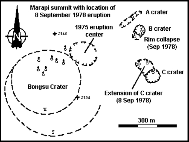 |
Figure 1. Sketch map showing Marapi's summit area and the 1978 eruption crater. Courtesy of VSI. |
Information Contacts: F. Suparban Mitrohartono, VSI.
60 killed by air fall of coarse tephra
According to press reports, 60 persons were killed by an eruption of Marapi during the morning of 30 April [but see below], and rescue workers searched for 19 others believed trapped by "landslides." The volcano was said to have ejected "stones" and "mud" or "lava," causing damage in at least five villages. The deaths were apparently caused by large airfall tephra.
Information Contacts: AFP; Kompas, Jakarta.
Landslide, not eruption, caused fatalities on 30 April
Press reports describing a tephra eruption of Marapi on 30 April were incorrect. About 300 mm of rainfall remobilized an old lahar and other volcanic material on Marapi's N and E flanks, producing several landslides. The largest began at 2,400 m altitude on 30 April, and traveled as much as 20 km downslope to ~70 m altitude, leaving a deposit 20-150 m wide and 1-3 m thick. Eighty people were killed, five villages were damaged, and several acres of farmland were destroyed.
A VSI team inspected Marapi's crater on 8 May. Fumaroles emitted thin white vapor columns that had a slight sulfur odor and a temperature of 90-104°C.
Information Contacts: F. Suparban Mitrohartono and A. Sudradjat, VSI.
Small ash eruption
A small eruption of Marapi occurred on 11 September. The eruption column rose 700 m and deposited ash to ~3 km W of the volcano. An inspection revealed that three summit-area craters (Verbeek, C, and Tuo) had been active. No activity has been reported since then.
Information Contacts: A. Sudradjat, VSI.
Two small plumes
Plumes rose 700 m from Marapi at 0627 and 0755 on 29 March, then were blown S by the wind. No further activity had occurred as of 2 April.
Information Contacts: A. Sudradjat and L. Pardyanto, VSI.
30-minute ash ejection
Indonesian newspapers reported that Marapi ejected a black eruption column for about 30 minutes beginning at 0700 on 10 March. The governor of West Sumatra noted that there have been two previous small eruptions in 1982. Camps have been prepared to receive evacuees if a large eruption occurs.
Information Contacts: M. Krafft, Cernay, France.
Small plumes
On 15 November at 0500 Marapi emitted a white to brownish plume. A small, possibly phreatic, eruption occurred at 0830, ejecting a blackish plume to about 400 m height. No additional activity was reported. No residents were evacuated.
Information Contacts: A. Sudradjat, VSI.
Small explosions; ashfall on two cities
Small explosions occurred on 25 and 30 May, and 1, 5, 7, 9, 10, and 11 June, with column heights reaching 1 km above the summit. A light dusting of ash fell on Bukittinggi, [15] km NW [of the summit], and Padang, [65] km [SSW]. The previous activity at Marapi occurred 15 January.
Information Contacts: VSI.
Many small explosions; light ashfall over W part of island
At least 17 small explosions were recorded during December. One of the largest, on 7 December at 0648, sent a plume from the summit area's Verbeek Crater to ~900 m height. Additional larger explosions occurred on 24 December at 0625 (plume to 1,000 m) and on 27 December at 0007 (plume not visible). Other plumes from December explosions reached 700-1,000 m above the crater. Light ashfall was reported from a wide area of W Sumatra.
Information Contacts: VSI.
Eruption with ashfall
Ash from an eruption around midnight on 28-29 January was carried S toward Padang city. Three millimeters of ash fell in Padangpanjang, [12] km [SW] of [the summit].
Information Contacts: VSI.
More explosions
Marapi erupted again on 19, 20, and 24 February, and 1 March. Fresh, unaltered rock has been found in the tephra from the 1988 explosions.
Information Contacts: VSI.
Explosion and light ashfall
On 1 March at 1311, a single explosion occurred from the summit crater, depositing as much as 1 mm of ash to 9 km of the summit.
Information Contacts: VSI.
Two ash explosions
Single explosions ejected ash-laden eruption columns to 1 km above the vent on 7 and 8 July [see also 13:7].
Information Contacts: VSI.
Intermittent ash ejections continue
Small explosions occurred 1 July at 1420 and 8 July at 1900, depositing 0.5 mm of ash in Bukittinggi.
Information Contacts: VSI.
Explosion kills one person and injures five others
An explosion on 5 July killed one person and injured five others. Marapi has been erupting since 1987, with explosions typically occurring about once every 1-7 days. Material ejected by the smaller explosions rises 100-800 m, whereas ejecta from larger explosions reach 800-2,000 m above the summit. The recent explosions, which produce ash and lapilli, have originated from Verbeek Crater in the summit complex. Ashfalls have been frequent NW of the volcano in Bukittinggi (roughly 15 km NW of the summit), Sungai Puar (30 km NW), and the Agam district (>30 km NW), depending on wind direction. Fluctuations in Marapi's explosions seem to parallel shallow volcanic earthquakes (figure 2), suggesting that the activity is primarily caused by degassing from a relatively shallow source through an open vent.
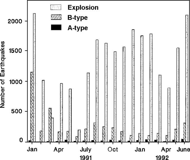 |
Figure 2. Number of explosion, A-, and B-type earthquakes at Marapi, January 1991-June 1992. Courtesy of VSI. |
Activity in June began with an explosion on the 1st. Continuous tremor followed, and on 6 June at 0227 another explosion occurred. Repeated explosions then deposited ~0.5 mm of ash on Bukittinggi. On 25 June, witnesses 2 km from the volcano (at the Batu Palano Volcano Observatory) heard a detonation and saw glow. A brownish-black cauliflower-shaped plume rose 1,800 m above the summit. During June, 45 deep and 312 shallow volcanic earthquakes, 108 volcanic tremor episodes, and 2,104 explosion earthquakes were recorded.
The strongest explosion occurred on 5 July at 0912. Bukittinggi and vicinity were covered by 0.5-1.5 mm of ash several hours later, with ash in some areas reaching 2 mm thickness. Ash also extended to Padang, ~10 km SW of the crater. Bombs killed one person, seriously injured three, and caused minor injuries to two others. The victims had climbed to the summit without consultation with the Mt. Marapi Volcano Observatory or local authorities, although a hazard warning had been in effect since 1987.
Information Contacts: W. Modjo, VSI.
Eruption sends ash column to ~6 km above sea level; summary of 1993 activity
An eruption at 0016 on 12 August 1994 sent an ash column to ~6 km altitude, a height of 3,200 m above the summit. Another explosion at 0046 ejected ash 280 m high. From the observatory ~7 km from the crater, observers noted incandescent projections as high as 300 m above the crater rim, accompanied by explosion sounds and vibrations. Ashfall in and around the city of Bukittinggi . . . ranged from 0.5 to 1 mm thick. Shallow volcanic earthquakes were recorded after the explosions, but gradually decreased.
Eruptions during the first half of 1993 (VSI, 1993a) produced lapilli and ash that were deposited in a radius of 1.5-3 km from the active crater. A dark gray column rose as high as 1,200 m above the summit . . . , but was usually in the 400-500 m range. Explosion earthquakes from January to July 1993 fluctuated between 1 and 77 events/day. The frequency of explosions increased in July 1993, but then decreased from August through December (VSI, 1993b). These explosions during Jul-Dec 1993 deposited lapilli and ash within a 750-m-radius of the active crater. Incandescent material fell within a few tens of meters of the crater rim. Average plume height in the second half of 1993 was 400-800 m, reaching a maximum of 3,200 m above the summit. Throughout 1993, deep volcanic earthquakes (A-type) were detected at a rate of 6-41/month. Between 42 and 338 shallow (B-type) events were recorded each month.
Information Contacts: VSI.
Declining activity and weak ash emissions
Activity of Marapi volcano was subdued during the period from late April to late May. From 27 April-3 May, only the emissions events increased (from 21 to 30) from the previous week; volcanic type-A, type-B, and tectonic events, along with eruptions, all decreased. During 4-17 May observed activity was limited to thin white-gray ash emissions that rose 100-400 m above the summit.
Information Contacts: Volcanological Survey of Indonesia (VSI), Jalan Diponegoro No. 57, Bandung 40122, Indonesia (URL: http://www.vsi.esdm.go.id/).
Strong explosions within moderate background activity during June-September
Moderate eruptive activity at Marapi during June-September was interrupted by a few isolated powerful explosions. On 1 June a loud detonation was heard and earthquakes were felt in Bukittinggi village near the volcano. These phenomena were followed by an outpouring of thick dark ash from the crater forming a billowing cloud reaching 3,200 m above the summit. Events soon returned to more typical emissions of white or gray ash rising a few hundred meters and not accompanied by detonations. During 3-9 August white and sometimes black ash plumes reached 200-1,200 m above the peak. There were also increases in the number of volcanic and small explosive seismic events recorded that week.
J. Bardintzeff reported that at 0720 on 5 August a violent explosion sent an ash column, at first black but later gray in color, ~1,000 m above the summit. Fine ash fell at distances of up to 1 km E of the volcano at 0745. Two groups of people were standing near the crater at the time of the explosion. A group near the west side was safe, but three people of another group standing at the eastern crater rim were injured. Witnessed said that they were knocked down by the force of the explosion in which several 10-cm-diameter bombs were ejected. The injuries included cuts from debris and burns about the face, head, arms, and hands. Several people have been killed or injured at Marapi during the past ten years.
Information Contacts: Volcanological Survey of Indonesia (VSI), Jalan Diponegoro No. 57, Bandung 40122, Indonesia (URL: http://www.vsi.esdm.go.id/); Jacques-Marie Bardintzeff, Laboratoire de Petrographie-Volcanologie, bat 504, Universite Paris-Sud, 91405, Orsay, France.
Large explosions in March 2000 eject ash
At 0553 on 11 March 2000, a significant explosion ejected thick black ash that rose 1,400 m above the summit. Explosions and ash emissions continued and increased in magnitude. At 0944 on the following day, a large explosion was heard more than 25 km away in the community of Bukittinggi. The explosion sent thick, black ash to a height of 3,000 m. Ashfall was reported ~350 km N of Marapi on the Lima Kaun District of Tanah Datar. Both major explosions were immediately preceded by shallow volcanic (B-type) earthquakes, while heightened seismicity, especially A- and B-type earthquakes, occurred up to a week before the explosions.
By 14 March explosions and ash emissions were continuing with decreased intensity. The gray-black plume rose 200 m above the crater rim. The following week seismicity increased notably with all earthquakes types increasing in number. During the [week of 28 March-3 April], black ash emissions continued to rise 100-200 m. Seismicity increased slightly compared to the previous week, but remained much lower than when the explosions initiated.
Information Contacts: Dali Ahmad, Volcanological Survey of Indonesia (VSI), Jalan Diponegoro No. 57, Bandung 40122, Indonesia (URL: http://www.vsi.esdm.go.id/).
Explosions during 2001; April ash plume reaches 2.0 km above the summit
On 11 March 2000, an explosion at Marapi ejected thick black ash that rose 1.4 km above the summit (BGVN 25:11). Explosive activity occurred again in 2001, peaking during 13-18 April, when a total of 150 explosions occurred that sent ash plumes to 2 km above the summit.
From January to February 2001, monthly A-type earthquakes had decreased from 15 to 8, and B-type earthquakes had decreased from 24 to 14. Gas-and-steam emissions, however, had increased from 11 events during January to 41 times during February. B-type earthquakes were registered on 7 April and continuous volcanic tremor occurred on 9 April.
On 14 April at 1600 a thick dark ash plume was visible from Bukittinggi, 15 km NW of Marapi's summit. On 16 April at 0600 an explosion sent a thick black ash plume to 700 m above the summit. At 0814 the same day a loud explosion was heard 8 km from the volcano, and a black mushroom-shaped ash plume rose to 2 km above the summit. Ejected incandescent fragments were seen clearly from Bukittinggi and then fell back to the crater rim. Ash fell over the villages of Sungai Puah, Air Angeh, and Andala, and in District X Koto, District Batipuh, District V Koto, Tanah Datar Regency, and Padang Panjang City in the zone S and SW of the summit. Ash deposits 1-4 km from the summit were 2-3 cm thick.
The Marapi Volcano Observatory increased the Alert Level from 1 to 2 following the activity that began on 13 April and a recommendation was issued by the local government to prevent people from traveling to the summit area.
Volcanic activity at Marapi continued through at least June 2001 (table 1). On 8 May at 2240, an explosion was accompanied by a moderate booming sound heard from the Tandikat observatory. Ash from the explosion spread to the NW, to Kota Bary, Padangpanjang, Lo Koto, and around the Tandikat observatory.
Table 1. Earthquakes and plumes reported at Marapi during 23 April-10 June 2001. Courtesy of VSI.
| Date | Deep volcanic (A-type) | Shallow volcanic (B-type) | Explosion | Tectonic | Observation (plume heights are above summit) |
| 23 Apr-29 Apr 2001 | 58 | -- | 30 | -- | Gray-black plume to 3.0 km; volcanic materials fell 4.0 km from volcano. Five explosion earthquakes were accompanied by loud noise. |
| 30 Apr-06 May 2001 | 27 | 22 | 4 | -- | Gray plume to 1.2 km above summit. |
| 07 May-13 May 2001 | 16 | 46 | 14 | 1 | Whitish-gray thick plume to 1.5 km above summit. |
| 04 Jun-10 Jun 2001 | 2 | -- | 2 | 2 | Explosion earthquakes had 33.6 mm maximum amplitudes. |
An explosion that began at 0445 on 5 June sent ash to the SSW. The ash was 0.5-2 mm thick in places. Merapi remained at Alert Level 2 through at least 10 June 2001.
Information Contacts: Dali Ahmad, Volcanological Survey of Indonesia (VSI) (URL: http://www.vsi.esdm.go.id/).
Small eruptions and seismicity during August to October 2004
The most recent previous explosive activity at Marapi peaked during 13-18 April 2001, when a total of 150 explosions occurred that sent ash plumes to 2 km above the summit (BGVN 27:01). This report covers the interval 5 August to 10 October 2004. On 5 August 2004 Marapi generated a small eruption with a gray to black ash cloud that rose to 500-1,000 m above the summit. Its hazard status was raised to Alert Level II (yellow), where it remained throughout this period.
Total numbers of seismic events from 2 August through 10 October 2004 are listed in table 2. During some weeks in August the number of earthquakes increased markedly. A thin white plume rose to 50 m above the summit on 10 August. During 16-29 August a thin white-gray plume rose to ~ 75-100 m. Similar plumes rose to ~ 50 m during 27 September-3 October and to ~ 300 m during 4-10 October. Seismic signals inferred to be related to emissions were elevated during several weeks of the reporting interval, particularly in August (table 2).
Table 2. A summary of volcanic seismicity at Marapi during 2 August to 10 October 2004. Courtesy of DVGHM.
| Date | Volc A | Volc B | Tremor | Emission |
| 02 Aug-08 Aug 2004 | 1 | 11 | -- | -- |
| 09 Aug-15 Aug 2004 | 2 | 6 | -- | 20 |
| 16 Aug-22 Aug 2004 | -- | 3 | -- | 21 |
| 23 Aug-29 Aug 2004 | -- | 3 | 2 | 14 |
| 20 Sep-26 Sep 2004 | -- | -- | -- | -- |
| 27 Sep-03 Oct 2004 | 1 | -- | -- | -- |
| 04 Oct-10 Oct 2004 | 3 | -- | -- | 8 |
There were no MODIS-MODVOLC alerts at Marapi during 2004.
Information Contacts: Directorate of Volcanology and Geological Hazard Mitigation (DVGHM), Jalan Diponegoro 57, Bandung 40122, Indonesia (URL: http://www.vsi.esdm.go.id/); Darwin Volcanic Ash Advisory Center (VAAC), Bureau of Meteorology, Northern Territory Regional Office, PO Box 40050, Casuarina, NT 0811, Australia (URL: http://www.bom.gov.au/info/vaac/).
Increased seismicity in 2004; small ash-bearing eruptions in 2011
This report first describes a 2005 increase in seismicity at Marapi, then presents a 2010 field map of Marapi's active crater area, and notes several plumes seen in 2011 to 1 km above the vent, some bearing ash. As previously noted, Marapi had generated explosions in 2000 and 2001, and a small ash-bearing eruption in 2004 (BGVN 25:11, 27:01, and 30:01).
Activity during 2005. During the week 8-14 July 2005, the number of earthquakes at Marapi increased dramatically. The seismic network recorded 112 deep volcanic earthquakes, compared to a normal average of 7 per week. Other changes were absent at the volcano, for example, fumarole temperatures were normal and gas emissions typically rose ~ 50 m above the summit. As a result of the increased seismicity, the Center of Volcanology and Geological Hazard Mitigation (CVGHM) raised the Alert Level from 1 to 2 (on a scale of 1-4).
Activity during 2010. During a 4-day visit to Marapi in July 2010, volcanologist Mary-Ann del Marmol created a sketch map of the area (figure 3). More detailed mapping and rock observations of the old crater side of the volcano were thwarted by dense vegetation there.
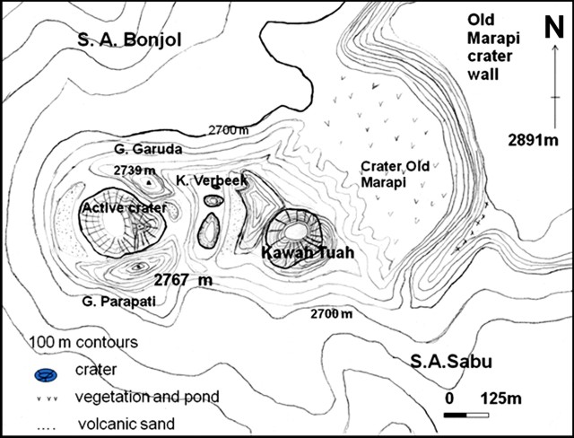 |
Figure 3. A sketch map of Marapi's active crater and vicinity prepared in the course of fieldwork during July 2010. The labels "S.A. Bonjol" and "S.A. Sabu" identify drainages. Courtesy of Mary-Ann del Marmol (University of Ghent, Belgium). |
Activity during 2011. According to CVGHM, seismicity increased during 21 June-3 August 2011. Observers noted that during June, July, and the first day of August white plumes rose 15-75 m above the summit craters. On 3 August dense gray plumes rose 300-1,000 m above the crater on eight occasions. That same day CVGHM raised the Alert Level again to 2. Visitors and residents were prohibited from going within a 3 km radius of the summit.
According to a news article, two eruptions from Marapi occurred on 9 August 2011.
Information Contacts: Center of Volcanology and Geological Hazard Mitigation (CVGHM), Jalan Diponegoro 57, Bandung 40122, Indonesia (URL: http://vsi.esdm.go.id/); Mary-Ann del Marmol, Geology and Soil Science Department, University of Ghent, Krijgslaan, 281 S8/A.326, B-9000 Gent, Belgium (URL: http://www.volcanology.ugent.be/delmarmol.htm); Metro TV News (URL: http://www.metrotvnews.com/).
Ash plumes in August and October 2011, March 2012, and February 2014
Eruptive activity at Marapi was absent for seven years following a short ash explosion in August 2004 (BGVN 30:01). Intermittent activity began again with eruptions in August and October 2011, followed by ash plumes during February-March 2012 and February 2014. The only additional information after the February 2014 activity was a Center of Volcanology and Geological Hazard Mitigation (CVGHM) report that during February-25 May 2015 diffuse white plumes rose as high as 300 m and seismicity fluctuated. The CVGHM kept the Alert Level at 2 (on a scale of 1-4), a status where residents and visitors are advised not to enter an area within 3 km of the summit.
Activity during 2011. Ash eruptions on 3 August 2011 had been preceded by increased seismicity and white plumes since 21 June (BGVN 36:07). Dense gray plumes rose 300-1,000 m above the crater on eight occasions that day; two more eruptions occurred on 9 August. No further activity was noted until the Darwin Volcanic Ash Advisory Centre (VAAC) reported that a pilot on 11 October saw a plume rising to an altitude of 3.7 km, though ash was not identified in satellite imagery. However, based on information from CVGHM, the VAAC reported that on 12 October 2011 an ash plume rose to an altitude of 3 km and drifted E.
Activity during 2012. According to a BNO News article from 5 March 2012, several eruptions had produced ash plumes during the previous week (approximately 27 February-4 March), with one that rose 1 km above the crater on 4 March and drifted 10 km S. An approximately 10-minute-long eruption produced an ash plume that rose 600 m on 18 May which was described in an MI News article. Media reports (Big Pond News) noted another eruption on 26 September with an ash plume that rose 1.5 km above the crater.
Activity during 2014. According to a news article from 5 February 2014 (Metro TV), four explosions occurred in early February. One was followed by ashfall in the Tarab River area and Batu Sangkar (17 km SE). News media reported an explosion on 26 February that caused ashfall in areas as far as 10 km S.
Information Contacts: Indonesian Center of Volcanology and Geological Hazard Mitigation, Pusat Vulkanologi dan Mitigasi Bencana Geologi (PVMBG, also known as CVGHM), Jalan Diponegoro 57, Bandung 40122, Indonesia (URL: http://www.vsi.esdm.go.id/); Darwin Volcanic Ash Advisory Centre (VAAC), Bureau of Meteorology, Northern Territory Regional Office, PO Box 40050, Casuarina, NT 0811, Australia (URL: http://www.bom.gov.au/info/vaac/); Metro TV News (URL: http://www.metrotvnews.com/read/newsvideo/2011/08/10/133771/Gunung-Marapi-Masih-Waspada); BNO News (URL: http://channel6newsonline.com/2012/03/indonesias-mount-marapi-still-highly-active/); MI News 26 (URL: http://www.minews26.com/content/?p=16895); Big Pond News (URL: http://bigpondnews.com/articles/World/2012/09/27/Volcano_erupts_with_smoke_on_Sumatra_799600.html); Metro TV (URL: http://www.metrotvnews.com/); The Free Press Journal (URL: http://freepressjournal.in/volcano-erupts-in-indonesia-2/).
Phreatic explosion on 14 November 2015 causes ashfall on the SW flank
Explosions occurred at Marapi (not to be confused with the better known Merapi on Java) during August 2011; March, May, and September 2012; and February 2014 (BGVN 40:05). This report discusses activity during 2015 and 2016. All information was provided by the Indonesian Center of Volcanology and Geological Hazard Mitigation (PVMBG, also known as CVGHM). During the reporting period, the Alert Level remained at 2 (on a scale of 1-4); residents and visitors were advised not to enter an area within 3 km of the summit.
According to PVMBG, diffuse white plumes rose as high as 300 above Marapi's crater during February-25 May 2015, 150 m above the crater during 1 August-16 November 2015, and 250 m above the crater during 1 November 2015-19 January 2016. Inclement weather often prevented observations.
Seismicity fluctuated during this time, dominated by earthquakes centered a long distance from the volcano. However, tremor increased significantly during August 2015 through at least the middle of January 2016 (figure 4). A phreatic explosion at 2233 on 14 November 2015, generated an ash plume, and ashfall was noted in Panyalaian and Aia Angek on the SW flank.
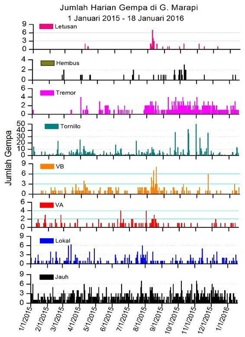 |
Figure 4. Types and daily number of earthquakes recorded at Marapi during 1 January 2015-18 January 2016. Key: eruptive earthquakes (Letusan), emission-type "blowing" earthquakes (Hembus), shallow earthquakes (VB), deep earthquakes (VA), local earthquakes (Lokal), and long-distance earthquakes (Jauh). The terms shallow and deep were not quantified. Courtesy of PVMBG (23 January 2016 report). |
Information Contacts: Pusat Vulkanologi dan Mitigasi Bencana Geologi (PVMBG, also known as Indonesian Center for Volcanology and Geological Hazard Mitigation, CVGHM), Jalan Diponegoro 57, Bandung 40122, Indonesia (URL: http://www.vsi.esdm.go.id/).
Four short ash explosions on 4 June 2017
Recent activity at the large Gunung Marapi stratovolcano on Sumatra has consisted of small ash plumes, with eruptions of a single day to periods of a few months. Ashfall around the active crater rim (figure 5) and thin layers of ash deposits seen in the crater wall (figure 6) provide evidence of both the recent and very long history of explosive activity. Since 2011 there have been eruptive episodes during August-October 2011, March-May 2012, 26 September 2012, February 2014, and 14 November 2015. As reported by the Indonesian Center of Volcanology and Geological Hazard Mitigation (PVMBG), another series of explosions took place on 4 June 2017.
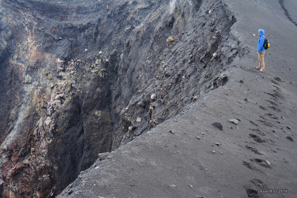 |
Figure 5. Photo taken at the rim of the active Verbeek Crater at Marapi on 17 April 2014. The most recent eruption prior to this photo was during 3-26 February 2014. Courtesy of Axel Drainville. |
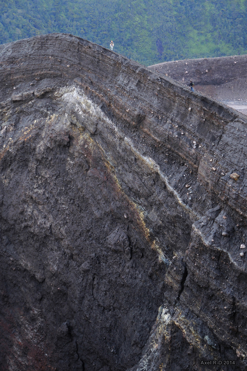 |
Figure 6. Photo showing the rim and interior wall of the Verbeek Crater at Marapi on 17 April 2014. Courtesy of Axel Drainville. |
Four explosions on 4 June lasted less than one minute each, and generated ash plumes above the summit (figure 7) and drifted E. The explosions occurred at 1001 local time (0301 UTC), 1011, 1256, and 1550. Dense ash-and-steam plumes from each explosion rose 300 m, at least 700 m, 200 m, and 250 m above the crater, respectively. The Darwin VAAC reported ash at about 3.6 km altitude extending 37 km ENE, based on satellite imagery. Ejected bombs were deposited around the crater, and minor ashfall was reported in the Pariangan District (8 km SSE), Tanah Datar Regency. Seismicity increased after the explosions. The Alert Level remained at 2 (on a scale of 1-4); residents and visitors were advised not to enter an area within 3 km of the summit.
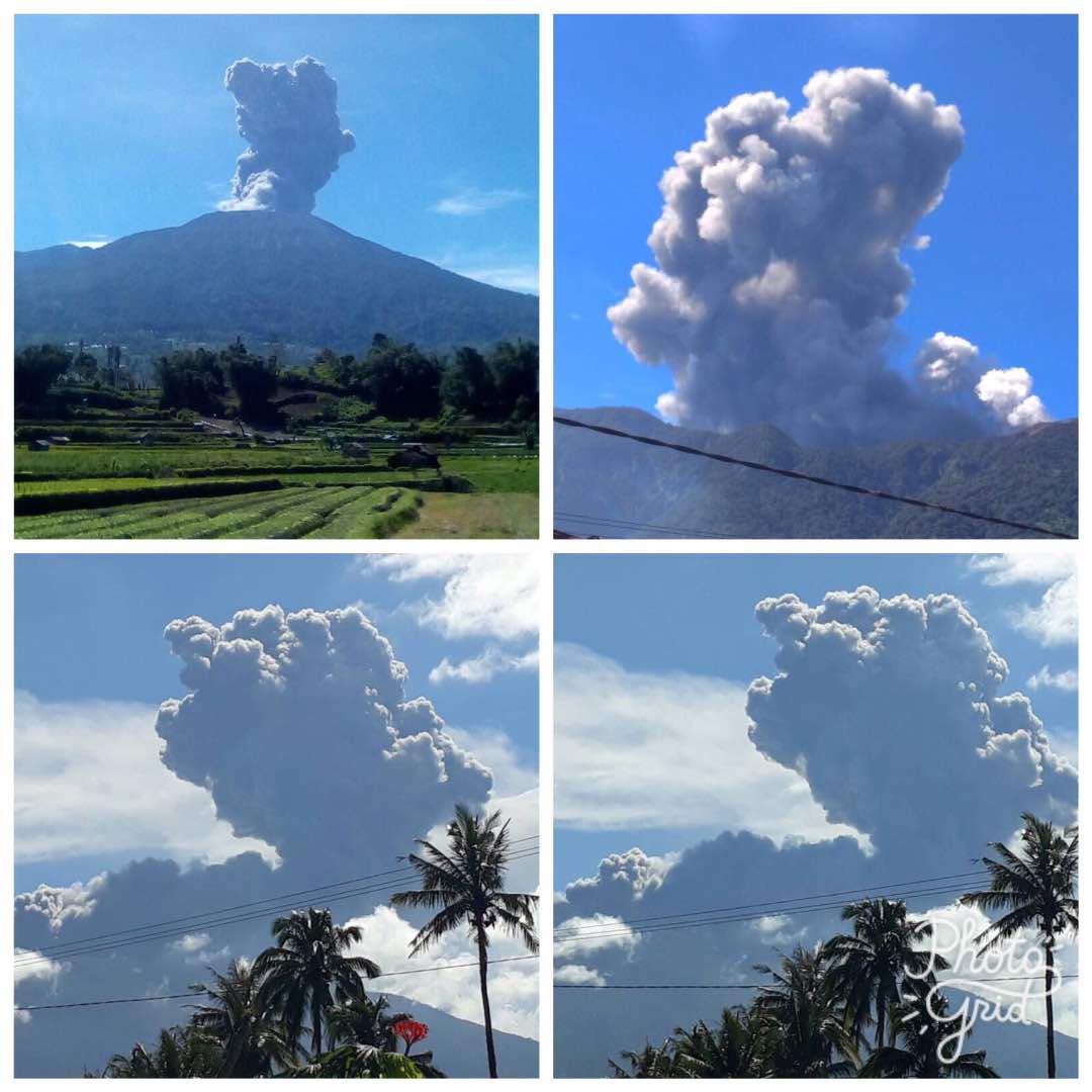 |
Figure 7. Photos of ash plumes rising from Marapi on 4 June 2017. The upper right image appears to show a smaller white plume to the right. Photos by PVMBG, posted to Twitter by Sutopo Purwo Nugroho (BNPB). |
The broad summit area with multiple craters is a popular destination for hiking expeditions. A video posted by YouTube user "SiGiTZ" documented the experience of one group during visits on 30 April 2016 and on 11 May 2017. The video provides excellent views from 2016 of the entire crater complex and of the Verbeek Crater, from which a steam-and-gas plume appears to be rising. A video posted by YouTube user "yogi antula" included a television broadcast from the Anak Borneo Channel of a video from climbers in the crater area during the 4 June explosions, taken from approximately 400-500 m away. In that video, a significant dark ash plume can be seen rising from Bungsu-Verbeek crater complex, along with a smaller white plume from a closer location. The news report was concerned with 16 hikers known to be on the mountain; there were no later reports of anyone being injured.
References: SiGiTZ, 1 August 2017, Expedisi puncak Gunung Marapi Bukittingi Sumbar Mei 2017 (URL: https://www.youtube.com/watch?v=pVxhWAbo2VA).
yogi antula, 5 June 2017, Video amatir pendakian saat Gunung Marapi Erupsi – 4 Juni 2017 (by Anak Borneo Channel) (URL: https://www.youtube.com/watch?v=8GAY6lsTLEE).
Information Contacts: Pusat Vulkanologi dan Mitigasi Bencana Geologi (PVMBG, also known as Indonesian Center for Volcanology and Geological Hazard Mitigation, CVGHM), Jalan Diponegoro 57, Bandung 40122, Indonesia (URL: http://www.vsi.esdm.go.id/); Badan Nasional Penanggulangan Bencana (BNPB), National Disaster Management Agency, Graha BNPB - Jl. Scout Kav.38, East Jakarta 13120, Indonesia (URL: http://www.bnpb.go.id/); Sutopo Purwo Nugroho, Badan Nasional Penanggulangan Bencana (BNPB) (URL: https://twitter.com/Sutopo_BNPB); Axel Drainville, Flickr.com, with Creative Commons license Attribution-NonCommercial 2.0 Generic (CC BY-NC 2.0, https://creativecommons.org/licenses/by-nc/2.0/) (URL: https://www.flickr.com/photos/axelrd/).
Two explosions during April-May 2018 cause ashfall to the southeast
The Marapi volcano on Sumatra (not to be confused with the better known Merapi volcano on Java) previously erupted on 4 June 2017, generating dense ash-and-steam plumes that rose as high as 700 m above the crater and caused minor ashfall in a nearby district (BGVN 42:10). The volcano is monitored by the Pusat Vulkanologi dan Mitigasi Bencana Geologi (PVMBG, also known as Centre for Volcanology and Geological Hazard Mitigation or CVGHM).
On 27 April 2018, a phreatic explosion produced an ash plume that rose 300 m above the crater rim (figure 8); a thin ash deposit was reported in the Cubadak area (Tanah Datar Regency), about 12 km SE. Another explosion at 0703 on 2 May 2018 (figure 9) produced a voluminous dense gray ash plume that rose 4 km above the crater rim and drifted SE; seismic data recorded by PVMBG indicated that the event lasted just over 8 minutes (485 seconds).
The Alert Level has remained at 2 (on a scale of 1-4), where it has been since August 2011. Residents and visitors have been advised not to enter an area within 3 km of the summit.
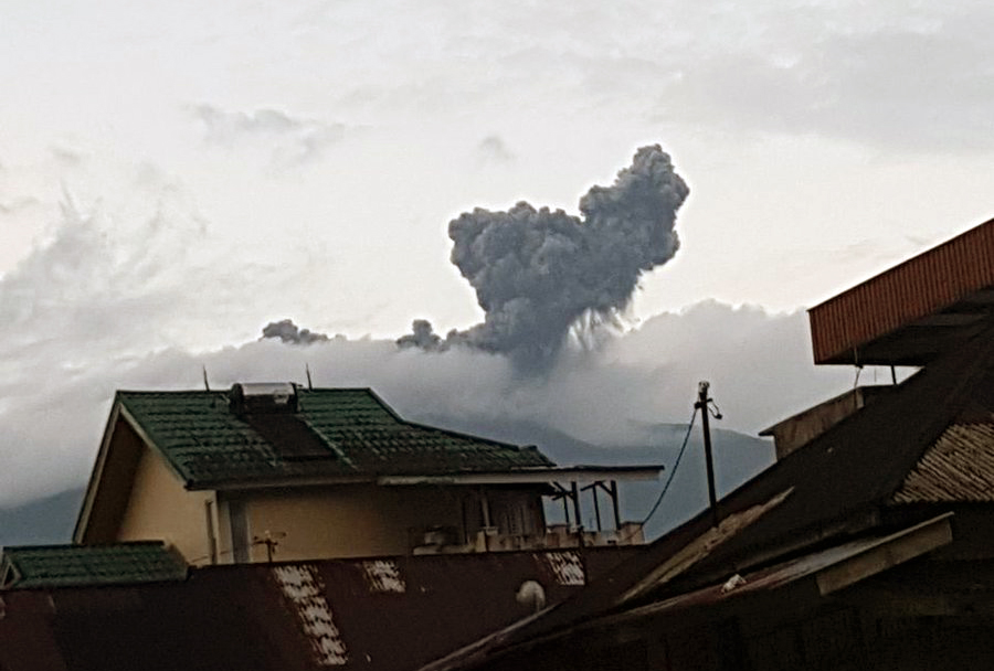 |
Figure 8. Ash plume from a phreatic explosion at Marapi on 27 April 2018. Courtesy of Sutopo Purwo Nugroho (BNPB). |
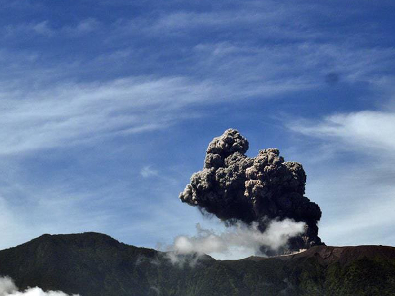 |
Figure 9. An explosion from Marapi on 2 May 2018 sent an ash plume to a height of 4 km. Courtesy of PVMBG. |
Information Contacts: Pusat Vulkanologi dan Mitigasi Bencana Geologi (PVMBG, also known as Indonesian Center for Volcanology and Geological Hazard Mitigation, CVGHM), Jalan Diponegoro 57, Bandung 40122, Indonesia (URL: http://www.vsi.esdm.go.id/); Badan Nasional Penanggulangan Bencana (BNPB), National Disaster Management Agency, Graha BNPB - Jl. Scout Kav.38, East Jakarta 13120, Indonesia (URL: http://www.bnpb.go.id/).
New explosive eruption with ash emissions during January-March 2023
Marapi in Sumatra, Indonesia, is a massive stratovolcano that rises 2 km above the Bukittinggi Plain in the Padang Highlands. A broad summit contains multiple partially overlapping summit craters constructed within the small 1.4-km-wide Bancah caldera and trending ENE-WSW, with volcanism migrating to the west. Since the end of the 18th century, more than 50 eruptions, typically characterized by small-to-moderate explosive activity, have been recorded. The previous eruption consisted of two explosions during April-May 2018, which caused ashfall to the SE (BGVN 43:06). This report covers a new eruption during January-March 2023, which included explosive events and ash emissions, as reported by Pusat Vulkanologi dan Mitigasi Bencana Geologi (PVMBG, also known as Indonesian Center for Volcanology and Geological Hazard Mitigation, CVGHM) and MAGMA Indonesia.
According to a press release issued by PVMBG and MAGMA Indonesia on 26 December, primary volcanic activity at Marapi consisted of white gas-and-steam puffs that rose 500-100 m above the summit during April-December 2022. On 25 December 2022 there was an increase in the number of deep volcanic earthquakes and summit inflation. White gas-and-steam emissions rose 80-158 m above the summit on 5 January. An explosive eruption began at 0611 on 7 January 2023, which generated white gas-and-steam emissions and gray ash emissions mixed with ejecta that rose 300 m above the summit and drifted SE (figure 10). According to ground observations, white-to-gray ash clouds during 0944-1034 rose 200-250 m above the summit and drifted SE and around 1451 emissions rose 200 m above the summit. Seismic signals indicated that eruptive events also occurred at 1135, 1144, 1230, 1715, and 1821, but no ash emissions were visually observed. On 8 January white-and-gray emissions rose 150-250 m above the summit that drifted E and SE. Seismic signals indicated eruptive events at 0447, 1038, and 1145, but again no ash emissions were visually observed on 8 January. White-to-gray ash plumes continued to be observed on clear weather days during 9-15, 18-21, 25, and 29-30 January, rising 100-1,000 m above the summit and drifted generally NE, SE, N, and E, based on ground observations (figure 11).
|
Figure 10. Webcam image of the start of the explosive eruption at Marapi at 0651 on 7 January 2023. White gas-and-steam emissions are visible to the left and gray ash emissions are visible on the right, drifting SE. Distinct ejecta was also visible mixed within the ash cloud. Courtesy of PVMBG and MAGMA Indonesia. |
|
Figure 11. Webcam image showing thick, gray ash emissions rising 500 m above the summit of Marapi and drifting N and NE at 0953 on 11 January 2023. Courtesy of PVMBG and MAGMA Indonesia. |
White-and-gray and brown emissions persisted in February, rising 50-500 m above the summit and drifting E, S, SW, N, NE, and W, though weather sometimes prevented clear views of the summit. An eruption at 1827 on 10 February produced a black ash plume that rose 400 m above the summit and drifted NE and E (figure 12). Similar activity was reported on clear weather days, with white gas-and-steam emissions rising 50 m above the summit on 9, 11-12, 20, and 27 March and drifted E, SE, SW, NE, E, and N. On 17 March white-and-gray emissions rose 400 m above the summit and drifted N and E.
|
Figure 12. Webcam image showing an eruptive event at 1829 on 10 February 2023 with an ash plume rising 400 m above the summit and drifting NE and E. Courtesy of PVMBG and MAGMA Indonesia. |
Information Contacts: Pusat Vulkanologi dan Mitigasi Bencana Geologi (PVMBG, also known as Indonesian Center for Volcanology and Geological Hazard Mitigation, CVGHM), Jalan Diponegoro 57, Bandung 40122, Indonesia (URL: http://www.vsi.esdm.go.id/); MAGMA Indonesia, Kementerian Energi dan Sumber Daya Mineral (URL: https://magma.esdm.go.id/v1).
|
|
||||||||||||||||||||||||||
There is data available for 68 confirmed eruptive periods.
2023 Dec 3 - 2025 Dec 17 (continuing) Confirmed Eruption (Explosive / Effusive) VEI: 2
| Episode 1 | Eruption (Explosive / Effusive) | |||||||||||||||||||||||||||||||||||||||||||||||||||||||||||
|---|---|---|---|---|---|---|---|---|---|---|---|---|---|---|---|---|---|---|---|---|---|---|---|---|---|---|---|---|---|---|---|---|---|---|---|---|---|---|---|---|---|---|---|---|---|---|---|---|---|---|---|---|---|---|---|---|---|---|---|
| 2023 Dec 3 - 2025 Dec 17 (continuing) | Evidence from Observations: Reported | ||||||||||||||||||||||||||||||||||||||||||||||||||||||||||
|
List of 10 Events for Episode 1
|
|||||||||||||||||||||||||||||||||||||||||||||||||||||||||||
2023 Jan 7 - 2023 Mar 17 Confirmed Eruption (Explosive / Effusive) VEI: 1
| Episode 1 | Eruption (Explosive / Effusive) | ||||||||||||||||||||||||
|---|---|---|---|---|---|---|---|---|---|---|---|---|---|---|---|---|---|---|---|---|---|---|---|---|
| 2023 Jan 7 - 2023 Mar 17 | Evidence from Observations: Reported | |||||||||||||||||||||||
|
List of 3 Events for Episode 1
|
||||||||||||||||||||||||
2018 Apr 27 - 2018 May 2 Confirmed Eruption (Explosive / Effusive) VEI: 2
| Episode 1 | Eruption (Explosive / Effusive) | Verbeek Crater | ||||||||||||||||||||||||||||||||||||||||||||||||
|---|---|---|---|---|---|---|---|---|---|---|---|---|---|---|---|---|---|---|---|---|---|---|---|---|---|---|---|---|---|---|---|---|---|---|---|---|---|---|---|---|---|---|---|---|---|---|---|---|---|
| 2018 Apr 27 - 2018 May 2 | Evidence from Observations: Reported | ||||||||||||||||||||||||||||||||||||||||||||||||
|
List of 8 Events for Episode 1 at Verbeek Crater
|
|||||||||||||||||||||||||||||||||||||||||||||||||
2017 Jun 4 - 2017 Jun 4 Confirmed Eruption (Explosive / Effusive) VEI: 1
| Episode 1 | Eruption (Explosive / Effusive) | Verbeek Crater | |||||||||||||||||||||||||||||||||||||||||||||||||||||
|---|---|---|---|---|---|---|---|---|---|---|---|---|---|---|---|---|---|---|---|---|---|---|---|---|---|---|---|---|---|---|---|---|---|---|---|---|---|---|---|---|---|---|---|---|---|---|---|---|---|---|---|---|---|---|
| 2017 Jun 4 - 2017 Jun 4 | Evidence from Observations: Reported | |||||||||||||||||||||||||||||||||||||||||||||||||||||
|
List of 9 Events for Episode 1 at Verbeek Crater
|
||||||||||||||||||||||||||||||||||||||||||||||||||||||
2015 Nov 14 - 2015 Nov 14 Confirmed Eruption (Explosive / Effusive) VEI: 1
| Episode 1 | Eruption (Explosive / Effusive) | Verbeek Crater | ||||||||||||||||||||||||||||
|---|---|---|---|---|---|---|---|---|---|---|---|---|---|---|---|---|---|---|---|---|---|---|---|---|---|---|---|---|---|
| 2015 Nov 14 - 2015 Nov 14 | Evidence from Observations: Reported | ||||||||||||||||||||||||||||
|
List of 4 Events for Episode 1 at Verbeek Crater
|
|||||||||||||||||||||||||||||
2014 Feb 3 ± 2 days - 2014 Feb 26 Confirmed Eruption (Explosive / Effusive) VEI: 1
| Episode 1 | Eruption (Explosive / Effusive) | Verbeek Crater | ||||||||||||||||||||||||||||||||||||||
|---|---|---|---|---|---|---|---|---|---|---|---|---|---|---|---|---|---|---|---|---|---|---|---|---|---|---|---|---|---|---|---|---|---|---|---|---|---|---|---|
| 2014 Feb 3 ± 2 days - 2014 Feb 26 | Evidence from Observations: Reported | ||||||||||||||||||||||||||||||||||||||
|
List of 6 Events for Episode 1 at Verbeek Crater
|
|||||||||||||||||||||||||||||||||||||||
2012 Sep 26 - 2012 Sep 26 Confirmed Eruption (Explosive / Effusive) VEI: 1
| Episode 1 | Eruption (Explosive / Effusive) | Summit crater area | ||||||||||||||||||
|---|---|---|---|---|---|---|---|---|---|---|---|---|---|---|---|---|---|---|---|
| 2012 Sep 26 - 2012 Sep 26 | Evidence from Observations: Reported | ||||||||||||||||||
|
List of 2 Events for Episode 1 at Summit crater area
|
|||||||||||||||||||
2012 Mar 1 ± 3 days - 2012 May 18 Confirmed Eruption (Explosive / Effusive) VEI: 1
| Episode 1 | Eruption (Explosive / Effusive) | Verbeek Crater (?) | ||||||||||||||||||||||||||||
|---|---|---|---|---|---|---|---|---|---|---|---|---|---|---|---|---|---|---|---|---|---|---|---|---|---|---|---|---|---|
| 2012 Mar 1 ± 3 days - 2012 May 18 | Evidence from Observations: Reported | ||||||||||||||||||||||||||||
|
List of 4 Events for Episode 1 at Verbeek Crater (?)
|
|||||||||||||||||||||||||||||
2011 Aug 3 - 2011 Oct 12 Confirmed Eruption (Explosive / Effusive) VEI: 1
| Episode 1 | Eruption (Explosive / Effusive) | Summit Crater | |||||||||||||||||||||||||||||||||
|---|---|---|---|---|---|---|---|---|---|---|---|---|---|---|---|---|---|---|---|---|---|---|---|---|---|---|---|---|---|---|---|---|---|---|
| 2011 Aug 3 - 2011 Oct 12 | Evidence from Observations: Reported | |||||||||||||||||||||||||||||||||
|
List of 5 Events for Episode 1 at Summit Crater
|
||||||||||||||||||||||||||||||||||
2004 Aug 5 - 2004 Aug 5 (?) Confirmed Eruption (Explosive / Effusive) VEI: 2
| Episode 1 | Eruption (Explosive / Effusive) | |||||||||||||||||||||||||||||||||||||||
|---|---|---|---|---|---|---|---|---|---|---|---|---|---|---|---|---|---|---|---|---|---|---|---|---|---|---|---|---|---|---|---|---|---|---|---|---|---|---|---|
| 2004 Aug 5 - 2004 Aug 5 (?) | Evidence from Observations: Reported | ||||||||||||||||||||||||||||||||||||||
|
List of 6 Events for Episode 1
|
|||||||||||||||||||||||||||||||||||||||
2001 Apr 13 - 2001 Jun 5 Confirmed Eruption (Explosive / Effusive) VEI: 2
| Episode 1 | Eruption (Explosive / Effusive) | Verbeek Crater | ||||||||||||||||||||||||||||||||||||||||||||||||
|---|---|---|---|---|---|---|---|---|---|---|---|---|---|---|---|---|---|---|---|---|---|---|---|---|---|---|---|---|---|---|---|---|---|---|---|---|---|---|---|---|---|---|---|---|---|---|---|---|---|
| 2001 Apr 13 - 2001 Jun 5 | Evidence from Observations: Reported | ||||||||||||||||||||||||||||||||||||||||||||||||
|
List of 8 Events for Episode 1 at Verbeek Crater
|
|||||||||||||||||||||||||||||||||||||||||||||||||
2000 Mar 11 - 2000 Apr 3 (on or after) Confirmed Eruption (Explosive / Effusive) VEI: 2
| Episode 1 | Eruption (Explosive / Effusive) | ||||||||||||||||||||||||||||||||||
|---|---|---|---|---|---|---|---|---|---|---|---|---|---|---|---|---|---|---|---|---|---|---|---|---|---|---|---|---|---|---|---|---|---|---|
| 2000 Mar 11 - 2000 Apr 3 (on or after) | Evidence from Observations: Reported | |||||||||||||||||||||||||||||||||
|
List of 5 Events for Episode 1
|
||||||||||||||||||||||||||||||||||
1999 Apr 16 (on or before) ± 15 days - 1999 Sep 16 (on or after) ± 15 days Confirmed Eruption (Explosive / Effusive) VEI: 2
| Episode 1 | Eruption (Explosive / Effusive) | ||||||||||||||||||||||||||||||||||
|---|---|---|---|---|---|---|---|---|---|---|---|---|---|---|---|---|---|---|---|---|---|---|---|---|---|---|---|---|---|---|---|---|---|---|
| 1999 Apr 16 (on or before) ± 15 days - 1999 Sep 16 (on or after) ± 15 days | Evidence from Observations: Reported | |||||||||||||||||||||||||||||||||
|
List of 5 Events for Episode 1
|
||||||||||||||||||||||||||||||||||
1987 Jan 15 - 1994 Aug 12 (on or after) Confirmed Eruption (Explosive / Effusive) VEI: 2
| Episode 1 | Eruption (Explosive / Effusive) | Verbeek Crater | ||||||||||||||||||||||||||||||||||||||||||||||||
|---|---|---|---|---|---|---|---|---|---|---|---|---|---|---|---|---|---|---|---|---|---|---|---|---|---|---|---|---|---|---|---|---|---|---|---|---|---|---|---|---|---|---|---|---|---|---|---|---|---|
| 1987 Jan 15 - 1994 Aug 12 (on or after) | Evidence from Observations: Reported | ||||||||||||||||||||||||||||||||||||||||||||||||
|
List of 8 Events for Episode 1 at Verbeek Crater
|
|||||||||||||||||||||||||||||||||||||||||||||||||
1984 Nov 15 - 1984 Nov 15 Confirmed Eruption (Explosive / Effusive) VEI: 1
| Episode 1 | Eruption (Explosive / Effusive) | Kepundan Tuo, Kepundan B | ||||||||||||||||||
|---|---|---|---|---|---|---|---|---|---|---|---|---|---|---|---|---|---|---|---|
| 1984 Nov 15 - 1984 Nov 15 | Evidence from Observations: Reported | ||||||||||||||||||
|
List of 2 Events for Episode 1 at Kepundan Tuo, Kepundan B
|
|||||||||||||||||||
1983 Jul 2 ± 182 days Confirmed Eruption (Explosive / Effusive) VEI: 1
| Episode 1 | Eruption (Explosive / Effusive) | Kepundan Tuo and Kepundan Verbeek | ||||||||||||||||||||||||||||
|---|---|---|---|---|---|---|---|---|---|---|---|---|---|---|---|---|---|---|---|---|---|---|---|---|---|---|---|---|---|
| 1983 Jul 2 ± 182 days - Unknown | Evidence from Observations: Reported | ||||||||||||||||||||||||||||
|
List of 4 Events for Episode 1 at Kepundan Tuo and Kepundan Verbeek
|
|||||||||||||||||||||||||||||
1982 Dec 16 ± 15 days - 1982 Dec 16 ± 15 days Confirmed Eruption (Explosive / Effusive) VEI: 1
| Episode 1 | Eruption (Explosive / Effusive) | ||||||||||||||||||||||||
|---|---|---|---|---|---|---|---|---|---|---|---|---|---|---|---|---|---|---|---|---|---|---|---|---|
| 1982 Dec 16 ± 15 days - 1982 Dec 16 ± 15 days | Evidence from Observations: Reported | |||||||||||||||||||||||
|
List of 3 Events for Episode 1
|
||||||||||||||||||||||||
1982 Mar 10 (on or before) - 1982 May 16 ± 15 days Confirmed Eruption (Explosive / Effusive) VEI: 1
| Episode 1 | Eruption (Explosive / Effusive) | ||||||||||||||||||||||||
|---|---|---|---|---|---|---|---|---|---|---|---|---|---|---|---|---|---|---|---|---|---|---|---|---|
| 1982 Mar 10 (on or before) - 1982 May 16 ± 15 days | Evidence from Observations: Reported | |||||||||||||||||||||||
|
List of 3 Events for Episode 1
|
||||||||||||||||||||||||
1980 Mar 29 Confirmed Eruption (Explosive / Effusive) VEI: 1
| Episode 1 | Eruption (Explosive / Effusive) | |||||||||||||||||||||||||||||
|---|---|---|---|---|---|---|---|---|---|---|---|---|---|---|---|---|---|---|---|---|---|---|---|---|---|---|---|---|---|
| 1980 Mar 29 - Unknown | Evidence from Observations: Reported | ||||||||||||||||||||||||||||
|
List of 4 Events for Episode 1
|
|||||||||||||||||||||||||||||
1975 Jan 16 ± 15 days - 1979 Sep 11 Confirmed Eruption (Explosive / Effusive) VEI: 2
| Episode 1 | Eruption (Explosive / Effusive) | Verbeek Crater, B and C Craters | |||||||||||||||||||||||||||||||||||||||||||||||||||||
|---|---|---|---|---|---|---|---|---|---|---|---|---|---|---|---|---|---|---|---|---|---|---|---|---|---|---|---|---|---|---|---|---|---|---|---|---|---|---|---|---|---|---|---|---|---|---|---|---|---|---|---|---|---|---|
| 1975 Jan 16 ± 15 days - 1979 Sep 11 | Evidence from Observations: Reported | |||||||||||||||||||||||||||||||||||||||||||||||||||||
|
List of 9 Events for Episode 1 at Verbeek Crater, B and C Craters
|
||||||||||||||||||||||||||||||||||||||||||||||||||||||
1973 Jul 24 - 1973 Jul 24 Confirmed Eruption (Explosive / Effusive) VEI: 2
| Episode 1 | Eruption (Explosive / Effusive) | Verbeek Crater | |||||||||||||||||||||||
|---|---|---|---|---|---|---|---|---|---|---|---|---|---|---|---|---|---|---|---|---|---|---|---|---|
| 1973 Jul 24 - 1973 Jul 24 | Evidence from Observations: Reported | |||||||||||||||||||||||
|
List of 3 Events for Episode 1 at Verbeek Crater
|
||||||||||||||||||||||||
1970 Jul 26 ± 5 days - 1971 Aug 20 Confirmed Eruption (Explosive / Effusive) VEI: 2
| Episode 1 | Eruption (Explosive / Effusive) | Bungo, Bongsu, Tuo, B and C Craters | ||||||||||||||||||||||||||||
|---|---|---|---|---|---|---|---|---|---|---|---|---|---|---|---|---|---|---|---|---|---|---|---|---|---|---|---|---|---|
| 1970 Jul 26 ± 5 days - 1971 Aug 20 | Evidence from Observations: Reported | ||||||||||||||||||||||||||||
|
List of 4 Events for Episode 1 at Bungo, Bongsu, Tuo, B and C Craters
|
|||||||||||||||||||||||||||||
[ 1968 Dec 16 ± 15 days - 1968 Dec 16 ± 15 days ] Uncertain Eruption
| Episode 1 | Eruption (Explosive / Effusive) | Craters B and C | ||||||||||||||||||
|---|---|---|---|---|---|---|---|---|---|---|---|---|---|---|---|---|---|---|---|
| 1968 Dec 16 ± 15 days - 1968 Dec 16 ± 15 days | Evidence from Unknown | ||||||||||||||||||
|
List of 2 Events for Episode 1 at Craters B and C
|
|||||||||||||||||||
1967 Apr 16 ± 15 days - 1967 Jul 16 ± 15 days Confirmed Eruption (Explosive / Effusive) VEI: 1
| Episode 1 | Eruption (Explosive / Effusive) | Crater C, Bungsu Crater | ||||||||||||||||||
|---|---|---|---|---|---|---|---|---|---|---|---|---|---|---|---|---|---|---|---|
| 1967 Apr 16 ± 15 days - 1967 Jul 16 ± 15 days | Evidence from Observations: Reported | ||||||||||||||||||
|
List of 2 Events for Episode 1 at Crater C, Bungsu Crater
|
|||||||||||||||||||
1966 Mar 16 ± 15 days - 1966 Jun 16 ± 15 days Confirmed Eruption (Explosive / Effusive) VEI: 1
| Episode 1 | Eruption (Explosive / Effusive) | B and C Craters, Kebun Bungo | |||||||||||||||||||||||
|---|---|---|---|---|---|---|---|---|---|---|---|---|---|---|---|---|---|---|---|---|---|---|---|---|
| 1966 Mar 16 ± 15 days - 1966 Jun 16 ± 15 days | Evidence from Observations: Reported | |||||||||||||||||||||||
|
List of 3 Events for Episode 1 at B and C Craters, Kebun Bungo
|
||||||||||||||||||||||||
1958 Oct 17 - 1958 Oct 25 Confirmed Eruption (Explosive / Effusive) VEI: 1
| Episode 1 | Eruption (Explosive / Effusive) | ||||||||||||||||||||||||
|---|---|---|---|---|---|---|---|---|---|---|---|---|---|---|---|---|---|---|---|---|---|---|---|---|
| 1958 Oct 17 - 1958 Oct 25 | Evidence from Observations: Reported | |||||||||||||||||||||||
|
List of 3 Events for Episode 1
|
||||||||||||||||||||||||
1958 Jun 23 - 1958 Jun 23 (?) Confirmed Eruption (Explosive / Effusive) VEI: 1
| Episode 1 | Eruption (Explosive / Effusive) | ||||||||||||||||||||||||
|---|---|---|---|---|---|---|---|---|---|---|---|---|---|---|---|---|---|---|---|---|---|---|---|---|
| 1958 Jun 23 - 1958 Jun 23 (?) | Evidence from Observations: Reported | |||||||||||||||||||||||
|
List of 3 Events for Episode 1
|
||||||||||||||||||||||||
1954 Aug 16 ± 15 days - 1957 Dec 16 (on or after) ± 15 days Confirmed Eruption (Explosive / Effusive) VEI: 2 (?)
| Episode 1 | Eruption (Explosive / Effusive) | Kepundan Bongsu, B and C Craters | |||||||||||||||||||||||||||||||||||||||||||
|---|---|---|---|---|---|---|---|---|---|---|---|---|---|---|---|---|---|---|---|---|---|---|---|---|---|---|---|---|---|---|---|---|---|---|---|---|---|---|---|---|---|---|---|---|
| 1954 Aug 16 ± 15 days - 1957 Dec 16 (on or after) ± 15 days | Evidence from Observations: Reported | |||||||||||||||||||||||||||||||||||||||||||
|
List of 7 Events for Episode 1 at Kepundan Bongsu, B and C Craters
|
||||||||||||||||||||||||||||||||||||||||||||
1950 Sep 27 - 1952 Jun 14 Confirmed Eruption (Explosive / Effusive) VEI: 2 (?)
| Episode 1 | Eruption (Explosive / Effusive) | Kepundan Bongsu, Kuniang, Jinggo | |||||||||||||||||||||||||||||||||||||||||||
|---|---|---|---|---|---|---|---|---|---|---|---|---|---|---|---|---|---|---|---|---|---|---|---|---|---|---|---|---|---|---|---|---|---|---|---|---|---|---|---|---|---|---|---|---|
| 1950 Sep 27 - 1952 Jun 14 | Evidence from Observations: Reported | |||||||||||||||||||||||||||||||||||||||||||
|
List of 7 Events for Episode 1 at Kepundan Bongsu, Kuniang, Jinggo
|
||||||||||||||||||||||||||||||||||||||||||||
1949 Oct 15 ± 5 days - 1949 Oct 22 ± 5 days Confirmed Eruption (Explosive / Effusive) VEI: 2
| Episode 1 | Eruption (Explosive / Effusive) | |||||||||||||||||||
|---|---|---|---|---|---|---|---|---|---|---|---|---|---|---|---|---|---|---|---|
| 1949 Oct 15 ± 5 days - 1949 Oct 22 ± 5 days | Evidence from Observations: Reported | ||||||||||||||||||
|
List of 2 Events for Episode 1
|
|||||||||||||||||||
1949 Apr 29 - 1949 Apr 30 Confirmed Eruption (Explosive / Effusive) VEI: 2
| Episode 1 | Eruption (Explosive / Effusive) | Kepundan Bongsu | |||||||||||||||||||||||||||||||||
|---|---|---|---|---|---|---|---|---|---|---|---|---|---|---|---|---|---|---|---|---|---|---|---|---|---|---|---|---|---|---|---|---|---|---|
| 1949 Apr 29 - 1949 Apr 30 | Evidence from Observations: Reported | |||||||||||||||||||||||||||||||||
|
List of 5 Events for Episode 1 at Kepundan Bongsu
|
||||||||||||||||||||||||||||||||||
1943 ± 5 years Confirmed Eruption (Explosive / Effusive)
| Episode 1 | Eruption (Explosive / Effusive) | Kepundan Kuniang, Kepundan Jinggo | |||||||||||||||||||||||
|---|---|---|---|---|---|---|---|---|---|---|---|---|---|---|---|---|---|---|---|---|---|---|---|---|
| 1943 ± 5 years - Unknown | Evidence from Observations: Reported | |||||||||||||||||||||||
|
List of 3 Events for Episode 1 at Kepundan Kuniang, Kepundan Jinggo
|
||||||||||||||||||||||||
1932 Confirmed Eruption (Explosive / Effusive) VEI: 2 (?)
| Episode 1 | Eruption (Explosive / Effusive) | ||||||||||||||||||||||||
|---|---|---|---|---|---|---|---|---|---|---|---|---|---|---|---|---|---|---|---|---|---|---|---|---|
| 1932 - Unknown | Evidence from Observations: Reported | |||||||||||||||||||||||
|
List of 3 Events for Episode 1
|
||||||||||||||||||||||||
1930 Apr 9 (on or before) - 1930 Dec 7 Confirmed Eruption (Explosive / Effusive) VEI: 2 (?)
| Episode 1 | Eruption (Explosive / Effusive) | ||||||||||||||||||||||||||||||||||
|---|---|---|---|---|---|---|---|---|---|---|---|---|---|---|---|---|---|---|---|---|---|---|---|---|---|---|---|---|---|---|---|---|---|---|
| 1930 Apr 9 (on or before) - 1930 Dec 7 | Evidence from Observations: Reported | |||||||||||||||||||||||||||||||||
|
List of 5 Events for Episode 1
|
||||||||||||||||||||||||||||||||||
1929 Jun 22 - 1929 Jun 22 Confirmed Eruption (Explosive / Effusive) VEI: 2
| Episode 1 | Eruption (Explosive / Effusive) | Kepundan Bongsu | |||||||||||||||||||||||
|---|---|---|---|---|---|---|---|---|---|---|---|---|---|---|---|---|---|---|---|---|---|---|---|---|
| 1929 Jun 22 - 1929 Jun 22 | Evidence from Observations: Reported | |||||||||||||||||||||||
|
List of 3 Events for Episode 1 at Kepundan Bongsu
|
||||||||||||||||||||||||
1927 Feb 5 - 1927 Aug 3 Confirmed Eruption (Explosive / Effusive) VEI: 2
| Episode 1 | Eruption (Explosive / Effusive) | Kepundan Bongsu | |||||||||||||||||||||||
|---|---|---|---|---|---|---|---|---|---|---|---|---|---|---|---|---|---|---|---|---|---|---|---|---|
| 1927 Feb 5 - 1927 Aug 3 | Evidence from Observations: Reported | |||||||||||||||||||||||
|
List of 3 Events for Episode 1 at Kepundan Bongsu
|
||||||||||||||||||||||||
1925 Apr (?) Confirmed Eruption (Explosive / Effusive) VEI: 0
| Episode 1 | Eruption (Explosive / Effusive) | |||||||||||||||||||
|---|---|---|---|---|---|---|---|---|---|---|---|---|---|---|---|---|---|---|---|
| 1925 Apr (?) - Unknown | Evidence from Observations: Reported | ||||||||||||||||||
|
List of 2 Events for Episode 1
|
|||||||||||||||||||
1919 Feb 28 - 1919 Mar 1 Confirmed Eruption (Explosive / Effusive) VEI: 2 (?)
| Episode 1 | Eruption (Explosive / Effusive) | |||||||||||||||||||
|---|---|---|---|---|---|---|---|---|---|---|---|---|---|---|---|---|---|---|---|
| 1919 Feb 28 - 1919 Mar 1 | Evidence from Observations: Reported | ||||||||||||||||||
|
List of 2 Events for Episode 1
|
|||||||||||||||||||
1918 Aug 15 ± 5 days - 1918 Aug 15 ± 5 days Confirmed Eruption (Explosive / Effusive) VEI: 2 (?)
| Episode 1 | Eruption (Explosive / Effusive) | |||||||||||||||||||
|---|---|---|---|---|---|---|---|---|---|---|---|---|---|---|---|---|---|---|---|
| 1918 Aug 15 ± 5 days - 1918 Aug 15 ± 5 days | Evidence from Observations: Reported | ||||||||||||||||||
|
List of 2 Events for Episode 1
|
|||||||||||||||||||
1918 Mar 8 - 1918 Mar 10 Confirmed Eruption (Explosive / Effusive) VEI: 2 (?)
| Episode 1 | Eruption (Explosive / Effusive) | |||||||||||||||||||
|---|---|---|---|---|---|---|---|---|---|---|---|---|---|---|---|---|---|---|---|
| 1918 Mar 8 - 1918 Mar 10 | Evidence from Observations: Reported | ||||||||||||||||||
|
List of 2 Events for Episode 1
|
|||||||||||||||||||
1917 Jun 16 - 1917 Sep 16 Confirmed Eruption (Explosive / Effusive) VEI: 2 (?)
| Episode 1 | Eruption (Explosive / Effusive) | |||||||||||||||||||
|---|---|---|---|---|---|---|---|---|---|---|---|---|---|---|---|---|---|---|---|
| 1917 Jun 16 - 1917 Sep 16 | Evidence from Observations: Reported | ||||||||||||||||||
|
List of 2 Events for Episode 1
|
|||||||||||||||||||
1916 May 5 - 1916 Jul 7 Confirmed Eruption (Explosive / Effusive) VEI: 1
| Episode 1 | Eruption (Explosive / Effusive) | |||||||||||||||||||
|---|---|---|---|---|---|---|---|---|---|---|---|---|---|---|---|---|---|---|---|
| 1916 May 5 - 1916 Jul 7 | Evidence from Observations: Reported | ||||||||||||||||||
|
List of 2 Events for Episode 1
|
|||||||||||||||||||
1915 Dec Confirmed Eruption (Explosive / Effusive) VEI: 2 (?)
| Episode 1 | Eruption (Explosive / Effusive) | |||||||||||||||||||
|---|---|---|---|---|---|---|---|---|---|---|---|---|---|---|---|---|---|---|---|
| 1915 Dec - Unknown | Evidence from Observations: Reported | ||||||||||||||||||
|
List of 2 Events for Episode 1
|
|||||||||||||||||||
1914 Jul 1 Confirmed Eruption (Explosive / Effusive) VEI: 2 (?)
| Episode 1 | Eruption (Explosive / Effusive) | |||||||||||||||||||
|---|---|---|---|---|---|---|---|---|---|---|---|---|---|---|---|---|---|---|---|
| 1914 Jul 1 - Unknown | Evidence from Observations: Reported | ||||||||||||||||||
|
List of 2 Events for Episode 1
|
|||||||||||||||||||
1913 Jun 23 - 1913 Jul 31 Confirmed Eruption (Explosive / Effusive) VEI: 2 (?)
| Episode 1 | Eruption (Explosive / Effusive) | |||||||||||||||||||
|---|---|---|---|---|---|---|---|---|---|---|---|---|---|---|---|---|---|---|---|
| 1913 Jun 23 - 1913 Jul 31 | Evidence from Observations: Reported | ||||||||||||||||||
|
List of 2 Events for Episode 1
|
|||||||||||||||||||
1911 Nov 2 Confirmed Eruption (Explosive / Effusive) VEI: 2 (?)
| Episode 1 | Eruption (Explosive / Effusive) | |||||||||||||||||||
|---|---|---|---|---|---|---|---|---|---|---|---|---|---|---|---|---|---|---|---|
| 1911 Nov 2 - Unknown | Evidence from Observations: Reported | ||||||||||||||||||
|
List of 2 Events for Episode 1
|
|||||||||||||||||||
1910 Confirmed Eruption (Explosive / Effusive) VEI: 2 (?)
| Episode 1 | Eruption (Explosive / Effusive) | |||||||||||||||||||
|---|---|---|---|---|---|---|---|---|---|---|---|---|---|---|---|---|---|---|---|
| 1910 - Unknown | Evidence from Observations: Reported | ||||||||||||||||||
|
List of 2 Events for Episode 1
|
|||||||||||||||||||
1907 Dec 17 - 1908 Sep Confirmed Eruption (Explosive / Effusive) VEI: 2 (?)
| Episode 1 | Eruption (Explosive / Effusive) | |||||||||||||||||||
|---|---|---|---|---|---|---|---|---|---|---|---|---|---|---|---|---|---|---|---|
| 1907 Dec 17 - 1908 Sep | Evidence from Observations: Reported | ||||||||||||||||||
|
List of 2 Events for Episode 1
|
|||||||||||||||||||
1905 Nov 1 Confirmed Eruption (Explosive / Effusive) VEI: 2 (?)
| Episode 1 | Eruption (Explosive / Effusive) | |||||||||||||||||||
|---|---|---|---|---|---|---|---|---|---|---|---|---|---|---|---|---|---|---|---|
| 1905 Nov 1 - Unknown | Evidence from Observations: Reported | ||||||||||||||||||
|
List of 2 Events for Episode 1
|
|||||||||||||||||||
1904 Apr 18 - 1904 Apr 18 Confirmed Eruption (Explosive / Effusive) VEI: 1
| Episode 1 | Eruption (Explosive / Effusive) | |||||||||||||||||||
|---|---|---|---|---|---|---|---|---|---|---|---|---|---|---|---|---|---|---|---|
| 1904 Apr 18 - 1904 Apr 18 | Evidence from Observations: Reported | ||||||||||||||||||
|
List of 2 Events for Episode 1
|
|||||||||||||||||||
1889 Mar 27 - 1889 Apr 17 (?) Confirmed Eruption (Explosive / Effusive) VEI: 2 (?)
| Episode 1 | Eruption (Explosive / Effusive) | ||||||||||||||||||||||||
|---|---|---|---|---|---|---|---|---|---|---|---|---|---|---|---|---|---|---|---|---|---|---|---|---|
| 1889 Mar 27 - 1889 Apr 17 (?) | Evidence from Observations: Reported | |||||||||||||||||||||||
|
List of 3 Events for Episode 1
|
||||||||||||||||||||||||
1888 Feb 19 - 1888 Mar 19 Confirmed Eruption (Explosive / Effusive) VEI: 2 (?)
| Episode 1 | Eruption (Explosive / Effusive) | ||||||||||||||||||||||||
|---|---|---|---|---|---|---|---|---|---|---|---|---|---|---|---|---|---|---|---|---|---|---|---|---|
| 1888 Feb 19 - 1888 Mar 19 | Evidence from Observations: Reported | |||||||||||||||||||||||
|
List of 3 Events for Episode 1
|
||||||||||||||||||||||||
1886 Mar 31 - 1886 May 3 Confirmed Eruption (Explosive / Effusive) VEI: 2
| Episode 1 | Eruption (Explosive / Effusive) | |||||||||||||||||||||||||||||
|---|---|---|---|---|---|---|---|---|---|---|---|---|---|---|---|---|---|---|---|---|---|---|---|---|---|---|---|---|---|
| 1886 Mar 31 - 1886 May 3 | Evidence from Observations: Reported | ||||||||||||||||||||||||||||
|
List of 4 Events for Episode 1
|
|||||||||||||||||||||||||||||
1885 Nov 12 Confirmed Eruption (Explosive / Effusive) VEI: 2 (?)
| Episode 1 | Eruption (Explosive / Effusive) | |||||||||||||||||||
|---|---|---|---|---|---|---|---|---|---|---|---|---|---|---|---|---|---|---|---|
| 1885 Nov 12 - Unknown | Evidence from Observations: Reported | ||||||||||||||||||
|
List of 2 Events for Episode 1
|
|||||||||||||||||||
1883 Dec - 1883 Dec Confirmed Eruption (Explosive / Effusive) VEI: 1
| Episode 1 | Eruption (Explosive / Effusive) | |||||||||||||||||||
|---|---|---|---|---|---|---|---|---|---|---|---|---|---|---|---|---|---|---|---|
| 1883 Dec - 1883 Dec | Evidence from Observations: Reported | ||||||||||||||||||
|
List of 2 Events for Episode 1
|
|||||||||||||||||||
1883 Jun 25 - 1883 Aug 27 Confirmed Eruption (Explosive / Effusive) VEI: 1
| Episode 1 | Eruption (Explosive / Effusive) | |||||||||||||||||||
|---|---|---|---|---|---|---|---|---|---|---|---|---|---|---|---|---|---|---|---|
| 1883 Jun 25 - 1883 Aug 27 | Evidence from Observations: Reported | ||||||||||||||||||
|
List of 2 Events for Episode 1
|
|||||||||||||||||||
[ 1878 Dec ] Uncertain Eruption
| Episode 1 | Eruption (Explosive / Effusive) | ||||||||||||||||||||||||
|---|---|---|---|---|---|---|---|---|---|---|---|---|---|---|---|---|---|---|---|---|---|---|---|---|
| 1878 Dec - Unknown | Evidence from Unknown | |||||||||||||||||||||||
|
List of 3 Events for Episode 1
|
||||||||||||||||||||||||
1876 Aug - 1877 Jun Confirmed Eruption (Explosive / Effusive) VEI: 2 (?)
| Episode 1 | Eruption (Explosive / Effusive) | |||||||||||||||||||
|---|---|---|---|---|---|---|---|---|---|---|---|---|---|---|---|---|---|---|---|
| 1876 Aug - 1877 Jun | Evidence from Observations: Reported | ||||||||||||||||||
|
List of 2 Events for Episode 1
|
|||||||||||||||||||
1876 Apr 4 Confirmed Eruption (Explosive / Effusive) VEI: 2 (?)
| Episode 1 | Eruption (Explosive / Effusive) | |||||||||||||||||||
|---|---|---|---|---|---|---|---|---|---|---|---|---|---|---|---|---|---|---|---|
| 1876 Apr 4 - Unknown | Evidence from Observations: Reported | ||||||||||||||||||
|
List of 2 Events for Episode 1
|
|||||||||||||||||||
1871 Sep 24 Confirmed Eruption (Explosive / Effusive) VEI: 2 (?)
| Episode 1 | Eruption (Explosive / Effusive) | |||||||||||||||||||
|---|---|---|---|---|---|---|---|---|---|---|---|---|---|---|---|---|---|---|---|
| 1871 Sep 24 - Unknown | Evidence from Observations: Reported | ||||||||||||||||||
|
List of 2 Events for Episode 1
|
|||||||||||||||||||
1871 Apr 24 Confirmed Eruption (Explosive / Effusive) VEI: 2 (?)
| Episode 1 | Eruption (Explosive / Effusive) | ||||||||||||||||||||||||
|---|---|---|---|---|---|---|---|---|---|---|---|---|---|---|---|---|---|---|---|---|---|---|---|---|
| 1871 Apr 24 - Unknown | Evidence from Observations: Reported | |||||||||||||||||||||||
|
List of 3 Events for Episode 1
|
||||||||||||||||||||||||
1863 May 23 Confirmed Eruption (Explosive / Effusive) VEI: 2 (?)
| Episode 1 | Eruption (Explosive / Effusive) | |||||||||||||||||||
|---|---|---|---|---|---|---|---|---|---|---|---|---|---|---|---|---|---|---|---|
| 1863 May 23 - Unknown | Evidence from Observations: Reported | ||||||||||||||||||
|
List of 2 Events for Episode 1
|
|||||||||||||||||||
1861 Apr Confirmed Eruption (Explosive / Effusive) VEI: 2 (?)
| Episode 1 | Eruption (Explosive / Effusive) | |||||||||||||||||||
|---|---|---|---|---|---|---|---|---|---|---|---|---|---|---|---|---|---|---|---|
| 1861 Apr - Unknown | Evidence from Observations: Reported | ||||||||||||||||||
|
List of 2 Events for Episode 1
|
|||||||||||||||||||
1855 Oct 2 - 1856 Jan Confirmed Eruption (Explosive / Effusive) VEI: 2
| Episode 1 | Eruption (Explosive / Effusive) | ||||||||||||||||||||||||||||||||||
|---|---|---|---|---|---|---|---|---|---|---|---|---|---|---|---|---|---|---|---|---|---|---|---|---|---|---|---|---|---|---|---|---|---|---|
| 1855 Oct 2 - 1856 Jan | Evidence from Observations: Reported | |||||||||||||||||||||||||||||||||
|
List of 5 Events for Episode 1
|
||||||||||||||||||||||||||||||||||
1854 Aug 29 (on or after) Confirmed Eruption (Explosive / Effusive) VEI: 2
| Episode 1 | Eruption (Explosive / Effusive) | ||||||||||||||||||||||||
|---|---|---|---|---|---|---|---|---|---|---|---|---|---|---|---|---|---|---|---|---|---|---|---|---|
| 1854 Aug 29 (on or after) - Unknown | Evidence from Observations: Reported | |||||||||||||||||||||||
|
List of 3 Events for Episode 1
|
||||||||||||||||||||||||
1845 Nov 16 - 1845 Nov 18 Confirmed Eruption (Explosive / Effusive) VEI: 2 (?)
| Episode 1 | Eruption (Explosive / Effusive) | |||||||||||||||||||
|---|---|---|---|---|---|---|---|---|---|---|---|---|---|---|---|---|---|---|---|
| 1845 Nov 16 - 1845 Nov 18 | Evidence from Observations: Reported | ||||||||||||||||||
|
List of 2 Events for Episode 1
|
|||||||||||||||||||
1833 - 1834 Confirmed Eruption (Explosive / Effusive) VEI: 2 (?)
| Episode 1 | Eruption (Explosive / Effusive) | |||||||||||||||||||
|---|---|---|---|---|---|---|---|---|---|---|---|---|---|---|---|---|---|---|---|
| 1833 - 1834 | Evidence from Observations: Reported | ||||||||||||||||||
|
List of 2 Events for Episode 1
|
|||||||||||||||||||
1822 Jul 23 - 1822 Jul 31 Confirmed Eruption (Explosive / Effusive) VEI: 2
| Episode 1 | Eruption (Explosive / Effusive) | |||||||||||||||||||||||||||||
|---|---|---|---|---|---|---|---|---|---|---|---|---|---|---|---|---|---|---|---|---|---|---|---|---|---|---|---|---|---|
| 1822 Jul 23 - 1822 Jul 31 | Evidence from Observations: Reported | ||||||||||||||||||||||||||||
|
List of 4 Events for Episode 1
|
|||||||||||||||||||||||||||||
1807 Confirmed Eruption (Explosive / Effusive) VEI: 2
| Episode 1 | Eruption (Explosive / Effusive) | |||||||||||||||||||
|---|---|---|---|---|---|---|---|---|---|---|---|---|---|---|---|---|---|---|---|
| 1807 - Unknown | Evidence from Observations: Reported | ||||||||||||||||||
|
List of 2 Events for Episode 1
|
|||||||||||||||||||
1770 Confirmed Eruption (Explosive / Effusive) VEI: 2
| Episode 1 | Eruption (Explosive / Effusive) | |||||||||||||||||||
|---|---|---|---|---|---|---|---|---|---|---|---|---|---|---|---|---|---|---|---|
| 1770 - Unknown | Evidence from Observations: Reported | ||||||||||||||||||
|
List of 2 Events for Episode 1
|
|||||||||||||||||||
This compilation of synonyms and subsidiary features may not be comprehensive. Features are organized into four major categories: Cones, Craters, Domes, and Thermal Features. Synonyms of features appear indented below the primary name. In some cases additional feature type, elevation, or location details are provided.
Synonyms |
||||
| Merapi | Berapi | Fort De Kock | ||||
Craters |
||||
| Feature Name | Feature Type | Elevation | Latitude | Longitude |
| Bancah Caldera
Bantjah Caldera |
Caldera | |||
| Bongsu, Kepundan
Bungsu, Kapundan |
Crater | 2730 m | 0° 23' 29.00" S | 100° 27' 18.00" E |
| Jinggo, Kepundan
Djinggo, Kapundan |
Crater | |||
| Kebun Bungo
Kabun Bungo |
Crater | |||
| Kuniang, Kepundan
Kuniang, Kapundan |
Crater | |||
| Tuo, Kepundan
Tuo, Kapundan |
Crater | |||
| Verbeek, Kawah
Tenga, Kepundan |
Crater | 2730 m | 0° 23' 28.00" S | 100° 27' 26.00" E |
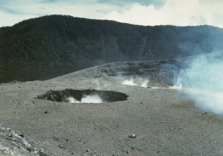 Plumes rise from two small craters near the center of Marapi's broad E-W-trending summit. The background ridge in the shadow is the eastern rim of a larger crater, Kebun Bungo.
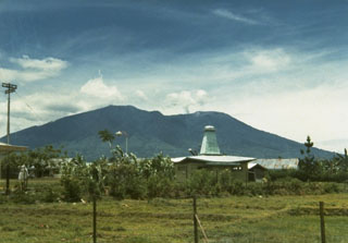 Marapi, seen here from the W, has multiple summit craters along an E-W line. Marapi has produced frequent small-to-moderate explosive eruptions since the end of the 18th century. Gunung Marapi is not to be confused with the more well-known Merapi volcano on Java.
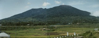 The composite volcano Marapi rises 2,000 m above the Padang Highlands of central Sumatra in this view from Padankuda. Marapi has frequent historical eruptions from the broad E-W-trending line of summit craters.
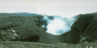 Kawah Verbeek, also known as Kapundan Tenga or Kepundan Tenga, is located at the western end of a chain of several historically active craters along an E-W line at the summit of Sumatra's Marapi volcano.
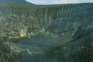 The 325-m-wide Kepundan Bongsu, one of several historically active craters at the summit of Sumatra's Marapi volcano, is the largest and westernmost of a chain of craters covering a 1.2-km-long E-W line. Marapi is one of Sumatra's most active volcanoes, producing numerous small-to-moderate explosive eruptions since the end of the 18th century.
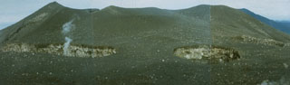 Three small craters, Kepundan A, B, and C, seen here right-to-left, respectively, from the E, are oriented transverse to the elongated E-W-trending summit of Marapi volcano in Sumatra. A plume rises from Kepundan C. The craters are among the many vents at Marapi that have been active during historical time.
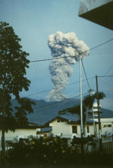 An ash-rich eruption column rises above a town at the western foot of Sumatra's Marapi volcano on 10 May 1992. The activity was part of an ongoing eruption that began in January 1987 from Verbeek crater. The explosions frequently produced light ashfall in surrounding areas, but did not cause damage. The eruption included growth of a lava dome in the summit crater.
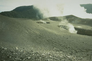 The small craters Kepundan B and C in the foreground, seen here from the N, are two of many historically active craters along the elongated summit of Marapi volcano on Sumatra. A thick plume in the background rises above the westernmost summit crater, Kawah Bongsu.
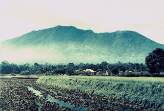 Marapi above rice fields below its western flank between Bukittinggi and Kotabaru, is Sumatra's most active volcano. More than 50 small-to-moderate explosive eruptions have occurred since the end of the 18th century. Marapi, not to be confused with the more well-known Merapi volcano on Java, has multiple summit craters and reaches 2,000 m above the Padang Highlands in central Sumatra.
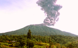 An ash plume rises from the summit crater of Marapi volcano in this undated photo, perhaps from the late 1980s or early 1990s. Marapi produces frequent small-to-moderate explosive eruptions that have been recorded since the 18th century.
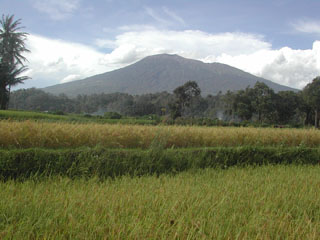 Marapi, seen here in front of above rice fields, is Sumatra's most active volcano. More than 50 small-to-moderate explosive eruptions have occurred since the end of the 18th century. Marapi, not to be confused with the more well-known Merapi volcano on Java, has multiple summit craters and reaches 2,000 m above the Padang Highlands in central Sumatra.
The following 8 samples associated with this volcano can be found in the Smithsonian's NMNH Department of Mineral Sciences collections, and may be availble for research (contact the Rock and Ore Collections Manager). Catalog number links will open a window with more information.
| Catalog Number | Sample Description | Lava Source | Collection Date |
|---|---|---|---|
| NMNH 101680 | Unidentified | -- | -- |
| NMNH 101681 | Unidentified | -- | -- |
| NMNH 101682 | Unidentified | -- | -- |
| NMNH 101683 | Unidentified | -- | -- |
| NMNH 101684 | Unidentified | -- | -- |
| NMNH 101685 | Unidentified | -- | -- |
| NMNH 101686 | Unidentified | -- | -- |
| NMNH 117455-23 | Obsidian | -- | -- |
| Copernicus Browser | The Copernicus Browser replaced the Sentinel Hub Playground browser in 2023, to provide access to Earth observation archives from the Copernicus Data Space Ecosystem, the main distribution platform for data from the EU Copernicus missions. |
| MIROVA | Middle InfraRed Observation of Volcanic Activity (MIROVA) is a near real time volcanic hot-spot detection system based on the analysis of MODIS (Moderate Resolution Imaging Spectroradiometer) data. In particular, MIROVA uses the Middle InfraRed Radiation (MIR), measured over target volcanoes, in order to detect, locate and measure the heat radiation sourced from volcanic activity. |
| MODVOLC Thermal Alerts | Using infrared satellite Moderate Resolution Imaging Spectroradiometer (MODIS) data, scientists at the Hawai'i Institute of Geophysics and Planetology, University of Hawai'i, developed an automated system called MODVOLC to map thermal hot-spots in near real time. For each MODIS image, the algorithm automatically scans each 1 km pixel within it to check for high-temperature hot-spots. When one is found the date, time, location, and intensity are recorded. MODIS looks at every square km of the Earth every 48 hours, once during the day and once during the night, and the presence of two MODIS sensors in space allows at least four hot-spot observations every two days. Each day updated global maps are compiled to display the locations of all hot spots detected in the previous 24 hours. There is a drop-down list with volcano names which allow users to 'zoom-in' and examine the distribution of hot-spots at a variety of spatial scales. |
|
WOVOdat
Single Volcano View Temporal Evolution of Unrest Side by Side Volcanoes |
WOVOdat is a database of volcanic unrest; instrumentally and visually recorded changes in seismicity, ground deformation, gas emission, and other parameters from their normal baselines. It is sponsored by the World Organization of Volcano Observatories (WOVO) and presently hosted at the Earth Observatory of Singapore.
GVMID Data on Volcano Monitoring Infrastructure The Global Volcano Monitoring Infrastructure Database GVMID, is aimed at documenting and improving capabilities of volcano monitoring from the ground and space. GVMID should provide a snapshot and baseline view of the techniques and instrumentation that are in place at various volcanoes, which can be use by volcano observatories as reference to setup new monitoring system or improving networks at a specific volcano. These data will allow identification of what monitoring gaps exist, which can be then targeted by remote sensing infrastructure and future instrument deployments. |
| Volcanic Hazard Maps | The IAVCEI Commission on Volcanic Hazards and Risk has a Volcanic Hazard Maps database designed to serve as a resource for hazard mappers (or other interested parties) to explore how common issues in hazard map development have been addressed at different volcanoes, in different countries, for different hazards, and for different intended audiences. In addition to the comprehensive, searchable Volcanic Hazard Maps Database, this website contains information about diversity of volcanic hazard maps, illustrated using examples from the database. This site is for educational purposes related to volcanic hazard maps. Hazard maps found on this website should not be used for emergency purposes. For the most recent, official hazard map for a particular volcano, please seek out the proper institutional authorities on the matter. |
| IRIS seismic stations/networks | Incorporated Research Institutions for Seismology (IRIS) Data Services map showing the location of seismic stations from all available networks (permanent or temporary) within a radius of 0.18° (about 20 km at mid-latitudes) from the given location of Marapi. Users can customize a variety of filters and options in the left panel. Note that if there are no stations are known the map will default to show the entire world with a "No data matched request" error notice. |
| UNAVCO GPS/GNSS stations | Geodetic Data Services map from UNAVCO showing the location of GPS/GNSS stations from all available networks (permanent or temporary) within a radius of 20 km from the given location of Marapi. Users can customize the data search based on station or network names, location, and time window. Requires Adobe Flash Player. |
| DECADE Data | The DECADE portal, still in the developmental stage, serves as an example of the proposed interoperability between The Smithsonian Institution's Global Volcanism Program, the Mapping Gas Emissions (MaGa) Database, and the EarthChem Geochemical Portal. The Deep Earth Carbon Degassing (DECADE) initiative seeks to use new and established technologies to determine accurate global fluxes of volcanic CO2 to the atmosphere, but installing CO2 monitoring networks on 20 of the world's 150 most actively degassing volcanoes. The group uses related laboratory-based studies (direct gas sampling and analysis, melt inclusions) to provide new data for direct degassing of deep earth carbon to the atmosphere. |
| Large Eruptions of Marapi | Information about large Quaternary eruptions (VEI >= 4) is cataloged in the Large Magnitude Explosive Volcanic Eruptions (LaMEVE) database of the Volcano Global Risk Identification and Analysis Project (VOGRIPA). |
| EarthChem | EarthChem develops and maintains databases, software, and services that support the preservation, discovery, access and analysis of geochemical data, and facilitate their integration with the broad array of other available earth science parameters. EarthChem is operated by a joint team of disciplinary scientists, data scientists, data managers and information technology developers who are part of the NSF-funded data facility Integrated Earth Data Applications (IEDA). IEDA is a collaborative effort of EarthChem and the Marine Geoscience Data System (MGDS). |

